the highland council contaminated land inspection strategy
TRANSCRIPT

1
Contaminated Land Inspection Strategy
Reviewed and Updated
August 2009 Transport, Environmental and Community Services Glenurquhart Road Inverness IV3 5NX [email protected]

2
Contents Page The Highland Council’s Contaminated Land Inspection Strategy, Reviewed and Updated 2009
6
The Strategy 8 Chapter 1 Contaminated Land – Important Definitions
11
Chapter 2 Contaminated Land Legislation
14
Background to the legislation The Objectives of the Contaminated Land System The Scottish Government’s Objectives Contaminated Land and Sustainable Development The “Suitable for Use” Approach 15 Redevelopment of Contaminated Land : Making it Happen The Policy and Legal Framework for Contaminated Land 16 Voluntary Remediation Highland Council’s Objectives : Strengthening the Highlands Highland Council’s Single Outcome Agreement 2009 Chapter 3 Links to Other Legislation
18
Part IIA State of Contaminated Land Report The Soil Framework Directive / The Scottish Soil Framework
19
The Environmental Liability Directive The Water Framework Directive The Groundwater Directive and Priority Substances Directive
20
The Waste Framework Directive 21 Chapter 4 Who Regulates Contaminated Land?
22
Highland Council Who within Highland Council is responsible for contaminated land? Scottish Environment Protection Agency (SEPA) 23 Chapter 5 Identifying and Prioritising Sites for Inspection
24
Highland Council’s Approach Areas of High Priority Chapter 6 Using and Managing Information
25

3 Sources of Information Internal sources Maps Known Contamination / Previous Site Investigation Reports Highland Archives Staff Experience 26 External Sources External Organisations Research Geology and Hydrology Information Provided by the Public Encouraging Provision of Information Integrity of Information 27 Anonymous Sources of Information Information in the Public Domain Information Requests The Council’s Contaminated Land Information Management System (CLIMS)
Identifying and Prioritising Sites – the Staged Approach 28 Chapter 7 Roles of The Highland Council Services within the Inspection Strategy
30
Development and Implementation of the Inspection Strategy Corporate Contaminated Land Working Group Interaction with Planning and Building Control Regimes The Highland Council Structure Plan 31 Regional and Local Development Plans Dealing with Major Developments Planning Applications and Potentially Contaminated Land 32 The Highland Council’s Allotments Policy Contaminated Land and the Building Standards Service 33 Chapter 8 The Contaminated Land Register
34
The Statutory Register of Contaminated Land Where is the Register Kept? Inspecting the Register Chapter 9 The Highland Council Area
35
The Highland Council Area General Geography Neighbouring Local Authorities Influence on Strategy Chapter 10 History
37

4 Early History Early Settlers Industrialisation 38 Economic Restructuring Influence on Strategy 39 Chapter 11 Geology
40
Solid Geology Superficial Deposits, Drift 41 Influence on Strategy 42 Chapter 12 Community
43
Population Settlements Housing 44 Recreation 45 Influence on Strategy 46 Chapter 13 Economy
47
Business & Industry Agriculture & Crofting Forestry 48 Fisheries & Aquaculture Tourism Integrated Rural Development 49 Influence on Strategy Chapter 14 Land
51
Land Cover Land Ownership Local Authority Estate 52 Waste Disposal Potentially Contaminative Land Uses 53 Influence on Strategy 54 Chapter 15 The Water Environment
55
The Water Environment Surface Waters 56 Groundwater The Water Environment – Protected Areas
57
Water Supplies 58 Influence on Strategy
5 Chapter 16 Ecology
59
Background International Sites National Sites Sites Outwith Protection under Part IIA Influence on Strategy 60 Chapter 17 Pollutant Linkages
61
Sources of Contamination Pathways 62 Receptors 63 Evidence of Harm Evidence of Pollution of the Water Environment 64 Chapter 18 Internal Procedures
65
Complaints and Service Requests Personal Details Communications Consultation 66 Chapter 19 Significant Harm, and the Significant Possibility of Significant Harm
67
Glossary and Acronyms 74 References and Bibliography 76

6
The Highland Council’s Contaminated Land Inspection Strategy, Reviewed and Updated 2009
This Strategy document sets out what we will continue to do to carry out our statutory duties to identify and deal with contaminated land under Part IIA of the Environmental Protection Act 1990. The original Strategy was published in 2001 and, since then, changes have been made to contaminated land law and to the huge volume of guidance which goes with it. A formal review and update of the Strategy has therefore been undertaken, and includes a summary of works undertaken since 2000, when the contaminated land statutory regime came into being. Achievements To Date The Council’s Contaminated Land Team, based in TEC Services, is responsible for the implementation of the contaminated land statutory regime across the whole Highland Council area. The region’s long and varied history has resulted in a legacy of potentially contaminated sites. An individual site investigation, involving detailed sampling at many locations and over extended periods of time, can take a significant length of time to complete. All the data generated during the investigation must be analysed in accordance with detailed scientific risk assessment processes. Since July 2000, 30 sites have been subject to a full investigation and risk assessment through Part IIA by the Contaminated Land Team. In terms of the planning system, the Contaminated Land Team reviews around 400 planning applications every month to determine whether detailed investigation of possible contamination may be required. In 2008-9 a total of 576 planning applications were examined in detail, and for 236 of these, planning conditions were recommended requiring site investigation and risk assessment before the permitted use could go ahead. Contaminated Land at Joss Street, Invergordon In June 2006, land at Joss Street, Invergordon, was identified as being contaminated. Twenty four flats had been built on the site of an old gasworks, and the ground was found to be contaminated with a number of contaminants and was identified on the basis of the presence of the carcinogen benzo[a]pyrene. Joss Street was the first site in Scotland to be identified as contaminated land on the grounds of risk to human health. As a consequence, residents were moved out and re-accommodated, the flats were demolished, and contaminated soils were excavated as part of the programme of site remediation. In February 2009, following completion of the works, Highland Council published the legal remediation statement setting out the history of the site investigation, together with details of the remediation work. The Contaminated Land Information Management System (CLIMS) In response to the statutory regime and the need to manage a huge amount of site data, Highland Council’s Contaminated Land Team designed and, together with colleagues in

7 other services, set up the computerised Contaminated Land Information Management System (CLIMS for short). This was a significant piece of work undertaken by the CL Team and a unique achievement. CLIMS is essential to the implementation of this Strategy, and has received a high degree of acknowledgement and praise from both consultants and other authorities. The Way Forward The Highland Council will, in accordance with this Strategy, continue to carry out our duties under the statutory contaminated land regime in order to protect the health of present and future generations from the pollution legacy of the past, and to safeguard Scotland’s valuable water environment. As the Local Authority for the Highlands, we have a wide range of sites to investigate, and we must also adapt to on-going changes in legislation and guidance. We must also work closely with the Council’s Planning and Development Service in order to ensure that we do everything we can to help sustainable development.

8
The Strategy
This is the reviewed and updated Contaminated Land Inspection Strategy, originally adopted by The Highland Council in October 2001, for meeting our responsibilities for dealing with the contaminated land statutory regime.
This Strategy sets out how Highland Council deals with potentially contaminated
land under Part IIA of the Environmental Protection Act 1990, the Contaminated Land (Scotland) Regulations 2000 and 2005, and associated guidance documents, both statutory and non-statutory.
In the context of sustainable development The Scottish Government has three
objectives with respect to contaminated land, which underlie the suitable for use approach:
1. to identify and remove unacceptable risks to human health and the
environment;
2. to seek to bring damaged land back into beneficial use; and
3. to seek to ensure that the cost burdens faced by individuals, companies and society as a whole are proportionate, manageable and economically sustainable.
To achieve the Scottish Government’s three objectives above, The Highland
Council will ensure risks are assessed, in order to:
1. demonstrate that land is suitable for its current use;
2. ensure land is made suitable for any new use, as planning permission is given for that new use, and;
3. oversee any remediation requirements necessary to prevent unacceptable risks to human health or the environment in relation to the current use or future use of the land for which planning permission is sought.
Risk assessments carried out by, and for, The Highland Council in accordance with
our duties under the contaminated land statutory regime will be site-specific.
There are many potentially contaminated sites within The Highland Council’s area, and sites are therefore prioritised for inspection.
High priority is given to sites where there may be a risk to human health.
The Council’s scheme for identifying, prioritising and inspecting areas of land involves:

9
1. Gathering information 2. Identifying potential sources of contamination
3. Screening of potential sources against “receptors”
4. Assessing possible “pollutant linkages”
5. Allocating inspection priority
6. Inspecting land
7. Deciding if land is contaminated
8. Where land is designated as being contaminated, ensuring that it is cleaned up
to a standard suitable for its current use
A close working relationship will be maintained between the Council’s Contaminated Land Team and Planning & Development Service regarding development of potentially contaminated land.
The Contaminated Land Team will work with all Council Services with potential
contaminated land liabilities and interests through a Corporate Contaminated Land Working Group.
The Council will maintain close working contact with the Scottish Environment
Protection Agency (SEPA) and other relevant organisations regarding the contaminated land regime.
The Council will work with SEPA regarding future land contamination legislation,
including changes resulting from the EU Directives on the water environment, waste, soil and environmental damage.
The Council uses, and will seek to continue to develop, information management
systems to ensure the most effective and efficient use of site information.
The Council utilises a variety of sources of information in identifying receptors, sources and pathways, and assessing pollutant linkages.
The Council will continue to utilise a variety of sources of information to identify
previously unknown sites.
The Council will work constructively with suitably qualified and accredited companies regarding site investigation, risk assessment and remediation in order to ensure that The Highland Council carries out our duties in full accordance with the law, statutory and non-statutory guidance, and with the Council’s objectives.

10
This Strategy, and the procedures used for prioritising sites for inspection, will be reviewed at least annually, and as appropriate in response to changes in legislation and / or guidance, statutory or non-statutory.

11
CHAPTER 1 CONTAMINATED LAND – IMPORTANT DEFINITIONS
1.1 “Contaminated Land” Contaminated land is defined in Section 78A(2) of the Environmental Protection Act 1990
(EPA) as;
“any land which appears to the local authority in whose area it is situated to be in such a condition, by reason of substances in, on or under the land, that a) significant harm is being caused or there is a significant possibility of such harm
being caused; or b) significant pollution of the water environment is being caused, or there is a significant possibility of such pollution being caused;”
The legislation is known by its abbreviation “Part IIA” because it forms Part IIA of the EPA. 1.2 “Significant Harm” The definition of significant harm is set out in the statutory guidance published by the Scottish Government, and the exact definition depends on the receptor experiencing such harm. For example, for human beings, significant harm is defined as “death, disease, serious injury, genetic mutation, birth defects or the impairment of reproductive functions”. The definition of significant harm is reproduced in full in Chapter 19. 1.3 “Significant Pollution” The definition of significant pollution is set out in the statutory guidance published by the Scottish Government:
Measures of significant pollution
Whether there is a breach of, or failure to meet, any statutory quality standard for the water environment at an appropriate pollution assessment point. In the absence of any suitable UK or EU standard, other international standards can be used where demonstrated to be appropriate;
Whether there is a breach of, or a failure to meet, any operational standard adopted by SEPA for the protection of the water environment;
Whether the pollution results in an increased level of treatment for an existing drinking water supply to ensure it is suitable for use, and to comply with the requirements of Council Directive 98/83/EC on the quality of water intended for human consumption. The potential for an increased level of treatment must also be considered for future use in drinking water
12 protected areas as defined in sections 6 and 7 of the Water Environment and Water Services (Scotland) Act 2003;
Whether the pollution results in an increased level of pre-treatment of water abstracted for industrial purposes;
Whether the pollution results in:-
deterioration in the status of a water body or failure to meet good status objectives, as defined in the Water Framework Directive 2000/60/EC; and/or
the failure of a Protected Area to meet its objectives, as defined in the Water Framework Directive 2000/60/EC;
Whether there is a significant and sustained upward trend in the concentration of pollutants in groundwater being affected by the land in question;
Whether there is a material and adverse impact on the economic, social and/or amenity use associated with a particular water environment.
1.4 “The Water Environment” The water environment is defined in Section 3 of the Water Environment and Water Services (Scotland) Act 2003 as “all surface water, groundwater and wetlands”. A more detailed explanation is to be found in Chapter 15. 1.5 “Pollutant Linkages” This definition of contaminated land is based upon the principles of risk assessment, which requires that a pollutant linkage is identified and the significance of this linkage is assessed. A pollutant linkage means the relationship between a contaminant (a substance, the “pollutant”), a receptor (a person or an ecosystem which could be harmed by the contaminant), and a pathway by which the contaminant comes into contact with the receptor. 1.6 “Significant Pollutant Linkages” A significant pollutant linkage results in significant harm, the significant possibility of significant harm (SPOSH), significant pollution of the water environment or the significant possibility of such harm, and only when the existence of such a linkage is established can a piece of land be designated as contaminated land. The assessment of pollutant linkages is done in accordance with the Scottish Government’s Contaminated Land Statutory Guidance. Pollutant linkages, together with details of the sources, pathways and receptors which will be considered as part of this Strategy, are discussed in Chapter 17.

13 1.7 “Risk Assessment” The principles of risk assessment are fundamental to the definition of contaminated land. Risk is considered for the purposes of statutory guidance (Contaminated Land Statutory Guidance, Edition 2, June 2006) as a combination of:
(a) the probability, or frequency , of occurrence of a defined hazard (for example, exposure to a property of a substance with the potential to cause harm); and
(b) the magnitude (including the seriousness) of the consequences.
From this definition it can be clearly seen that the regime is targeted at those sites which give rise to unacceptable risk to human health, property, the environment or the water environment, rather than all land which is subject to contamination. It should be stressed here that what may be “acceptable” or “unacceptable” in terms of risk is ultimately a matter of judgement – there are no definitive levels of contaminants below which risk is acceptable and above unacceptable. In an attempt to address this, in 2008 the Department of Environment, Food and Rural Affairs (DEFRA) published guidance on the legal definition of contaminated land, which set out quite plainly that local authorities were to make this judgement, requiring only that such a judgement be “reasonable”. To date there has been no similar advice note specific to Scotland. Risk assessment carried out by The Highland Council in accordance with our duties under the contaminated land statutory regime will be site-specific. 1.8 “Special Sites” Land can only be designated a special site once it has been identified as contaminated land by the local authority. Local authorities can designate as special sites contaminated land which is associated with the following:
pollution of the water environment. waste acid tars. refining and purification of oils and petroleum activities regulated under Pollution Prevention and Control legislation manufacture or processing of explosives land within a nuclear site Ministry of Defence land manufacture, production and disposal of chemical or biological weapons
The Scottish Environment Protection Agency (SEPA) is the enforcing authority for special sites. More details are given in Chapter 4 “Who Regulates the Contaminated Land regime?” Full definitions are set out in Regulations 2 & 3 and Schedule 1 of the Contaminated Land (Scotland) Regulations 2000 (as amended).

14
CHAPTER 2 CONTAMINATED LAND LEGISLATION
2.1 Background to the legislation The pollution of soils and water is a legacy of our industrial history. Contaminants from a wide variety of activities and processes including the manufacture, use and storage of chemicals, mining, waste disposal and some agricultural activities, has escaped, or has been deliberately dumped, onto and into land and waterways. The consequence of this has been a degradation of land quality. This has led not only to some land being unsatisfactory for further use or development, but may have also resulted in the land being unsuitable for its current use. This legacy of land pollution has become both an economic and environmental issue. Concerns regarding contaminated land range from its adverse effects on human health, property, the water environment and ecosystems, to issues of development and the reuse of “brownfield” sites. Successive governments have supported research, development and regulation in this field. Although provision was originally made for the contaminated land regime in Section 143 of the Environmental Protection Act 1990, this was abandoned and eventually replaced when Section 57 of the Environment Act 1995 inserted Part IIA into the Environmental Protection Act. The Contaminated Land (Scotland) Regulations 2000 followed, and has since been modified and reviewed, with the Contaminated Land (Scotland) Regulations 2005, the publication of new statutory guidance in June 2006, and the Radioactive Contaminated Land (Scotland) Regulations 2007. The aim of the legislation is addressed below through further consideration of what the Scottish Government and Highland Council want to achieve. 2.2 The Objectives of the Contaminated Land Regime 2.2.1 The Scottish Government’s Objectives The Scottish Government aims to maintain the quality of land in Scotland, and to regenerate land where it has been degraded in the past. It is determined to limit green-field development and to favour the reuse of derelict and vacant land. This will be achieved through the implementation of the statutory contaminated land regime set out in Part IIA of the EPA. As well as acting to prevent new contamination, we have also to deal with a substantial legacy of land which is already contaminated.

15 2.2.2 Contaminated Land and Sustainable Development The Scottish Government has identified contaminated land as an example of a failure of our society to move towards sustainable development. In Contaminated Land Statutory Guidance, Edition 2, June 2006, the Scottish Government identifies a two pronged approach to dealing with this issue: to prevent the creation of new contaminated land, through regulation and licensing, and to deal with land already contaminated. With regard to historical contamination and sustainable development the Scottish Government’s objectives are:
to identify and remove unacceptable risks to human health and the environment; to seek to bring damaged land back into beneficial use; and
to seek to ensure that the cost burdens faced by individuals, companies and
society as a whole are proportionate, manageable and economically sustainable.
2.2.3 The “Suitable for Use” Approach The three objectives set out above underlie the “suitable for use” approach of the regime. This approach involves the assessment of risks on a site-by-site basis, and consists of three elements:
ensuring that land is suitable for its current use; ensuring that land is made suitable for any new use, as planning permission is
given for that new use, and;
limiting requirements for remediation to the work necessary to prevent unacceptable risks to human health or the environment in relation to the current use or future use of the land for which planning permission is being sought.
Ensuring that land is suitable for its current use is achieved through Part IIA and the provisions of this Inspection Strategy. The planning process is aimed to ensure that land is made suitable for its intended use, in accordance with Planning Advice Notice 33, “Development of Contaminated Land”, Scottish Planning Policy 3 (SPP3) “Planning for Homes” and other guidance notes. SPP3, revised in 2008, recommends that “redevelopment of brownfield sites for housing should be preferred to development of greenfield sites, particularly where it supports the strategy of the development plan”.

16 2.2.4 Redevelopment of Contaminated Land: Making it Happen The Scottish Government proposes three specific ways to overcome the potential obstacles to the redevelopment of land affected by contamination, by:
providing public subsidy (funding can be made available through Highlands and Islands Enterprise (HIE) to support site redevelopment costs for projects aimed at particular social and economic regeneration objectives, but it is recognised by HIE that market failure may be significant, resulting in an impact on public finances)
promoting research and development, and;
providing an appropriate policy and legal framework.
2.2.5 The Policy and Legal Framework for Contaminated Land The contaminated land regime provides the appropriate policy and legal framework for local authorities to deal with historical contamination. The regime aims to provide a system for the identification and remediation of land where contamination is causing unacceptable risks to human health or the wider environment, assessed in the context of the current use of the land. This objective incorporates a number of components:
ensuring that regulators deal with land contamination strategically; allowing all contamination problems to be dealt with by a single regulatory
process;
increasing consistency in investigation and decision making; and
providing a regulatory mechanism which deals with land in a site-by-site basis. 2.2.6 Voluntary Remediation The regime also aims to encourage “voluntary” remediation of land, meaning remediation which does not involve legal enforcement or service of notices. The Scottish Government considers that the regime will allow this to happen. However, it is important to stress that “voluntary remediation” must still meet the objective of the statutory regime in bringing the site to a standard suitable for use, taking into account all the statutory and technical guidance. Anyone carrying out remediation work without liaison with The Highland Council may not achieve this, and may remain liable for further remediation works, and possible enforcement action, in the future.

17 2.3 The Highland Council’s Objectives : Strengthening the Highlands
On August 28th 2008 The Highland Council unveiled “Strengthening the Highlands”, a programme of action for 2009-2011 for making the Highlands one of Europe’s leading regions.
The Council aims to create sustainable communities with more balanced population growth and economic development across the Highlands and to build a fairer and healthier Highlands.
The Programme contains a total of 93 commitments across five main themes and a further 18 actions to work with the Scottish and UK Governments. It includes 45 new or enhanced actions and six new commitments, one of which is
What we will do for our environment;
The Programme includes a commitment to work in partnership with the Scottish Government, local partners and the private sector to enable 6,000 new houses, with appropriate amenities, to be built in the Highlands between 2007-8 and 2010-11, with 2,000 of these being affordable houses for rent and low cost home ownership of which 600 will be for older people and people with disabilities. The Highland Council’s Contaminated Land Team will work to ensure that all sites used for house construction are suitable for use in accordance with the requirements of Part IIA of the EPA. 2.4 Highland Council’s Single Outcome Agreement 2009 On 14 May 2009 a Single Outcome Agreement was made between the Highland Community Planning Partners and the Scottish Government.
The purpose of Agreement (referred to as the SOA or Agreement) is to identify areas for improvement and to deliver better outcomes for the people of the Highlands.
The document sets out the joint commitments made by the Highland Community Planning Partnership and the Scottish Government to an agreed set of outcomes. 15 Local Outcomes have been agreed by the Community Planning Partnership based on the needs and issues identified for the Highland Area. These are cast against 15 National Outcomes.
Of these, National Outcome 10 is relevant to the contaminated land statutory regime:
“We live in well-designed, sustainable places where we are able to access the amenities and services we need”
and linked to this is Local Outcome 10E:
“Our national heritage is protected and enhanced, enabling it to deliver economic, health and learning benefits”
The relevant indicator for progress is “hectares [of land] reclaimed [for redevelopment]”.

18
CHAPTER 3
LINKS TO OTHER LEGISLATION 3.1 Part IIA State of Contaminated Land Report
SEPA is required to prepare and publish a report on the State of Contaminated Land in Scotland, based on information supplied by local authorities, and as directed by Scottish Ministers. The aims of the report are to:
determine the nature, extent and distribution of contaminated land;
assess the environmental impact of contaminated land and highlight where Part IIA is reducing it;
summarise regulatory activity under Part IIA, and
to assess the effectiveness of Part IIA, in particular the impact of the reasonableness and hardship provisions on remediation.
On 26 May 2009 the Scottish Government released SEPA’s State of Contaminated Land report “Dealing with land contamination in Scotland – A review of progress 2000-2008”. The report lists the following conclusions:
The introduction of the Part IIA statutory regime has benefited Scotland’s people and its environment.
The regime has raised the profile of the issues associated with land contamination,
and has encouraged the investigation and remediation of land, both voluntarily and within the planning / development management system.
Of 67,000 sites, estimated from previous local authority returns as requiring
inspection, 13,396 (20%) have been, or are in the process of being, inspected under Part IIA.
Previous local authority returns suggest that it is possible that a further 13,400 sites
(20%) are likely to have been inspected as a result of a planning application rather than directly as part of the site prioritisation process.
Around 67,000 sites (60%) still require inspection.
An average of 3,200 site inspections per year are being carried out in Scotland.

19 13 sites (covering a total area of 53 hectares) have been statutorily determined as
being contaminated land (including one site in Highland on Joss Street, Invergordon).
An estimated 807 sites have been remediated through the development
management process.
The report provides a baseline from which it will be possible to measure progress in the implementation of the regime.
Current economic conditions indicate that there will be a reduction in the rate of
redevelopment of land.
The planning system is currently the predominant mechanism for dealing with land contamination, although improvements could be made to the data collection process in order to make possible more detailed analysis.
Remediation under Part IIA can be a slow process, and work is underway to identify
where, and how, improvements may be made. 3.2 The Soil Framework Directive / The Scottish Soil Framework The EU Soil Framework Directive is, at the time of writing, currently in draft form and under much discussion at European level. The Directive will require Member States to protect soils through a system of risk assessment and remediation, similar in principle to Part IIA, but with an emphasis on “adverse effects” on human health, and considering harmful organisms in addition to substances. On 21 May 2009 The Scottish Government published the Scottish Soil Framework (SSF), with a vision that soils are recognised as a vital part of our economy, environment and heritage, to be safeguarded for existing and future generations. Within the SSF are a wide range of activities, the aim of which is to result in 13 Soil Outcomes (SO). Of these, SO10 relates to the development of previously used, and therefore potentially contaminated, land: “SO10 - Reduced pressure on soils by using brownfield sites in preference to greenfield”. The Highland Council will participate fully in future Scottish Government consultations regarding transposition of the Soil Framework Directive into law. 3.3 Environmental Liability Directive The Environmental Liability Directive sets out a Europe-wide system of remediation of “environmental damage” (including damage to land through contamination), in accordance with the “polluter pays” principle. The Directive will not cover environmental damage which occurred before it is transposed into Scottish law. It is likely that this will require a good working relationship with SEPA as set out in this Strategy.

20 The Environmental Damage (Prevention and Remediation) (Scotland) Regulations are due to be enacted by summer 2009. 3.4 The Water Framework Directive The Water Framework Directive (WFD) is a complex and comprehensive piece of legislation which seeks to protect and enhance wetlands and aquatic ecosystems, to promote the sustainable use of water, and to reduce water pollution. The Water Environment and Water Services (Scotland) Act 2003 brought the WFD into Scottish law. River Basin Management Plans In Scotland the objective of the WFD is to be achieved by the preparation and implementation of River Basin Management Plans (RBMPs). The objective is to protect and enhance rivers, lochs, wetlands and groundwater so that they are all of “good status” (clean). The RBMP process is scheduled to run in six-year cycles, from 2009 to 2015, 2015 to 2021, and 2021 to 2027. The aims of the RBMP process are to:
Protect and improve the water environment in Scotland; Ensure that sustainable economic development happens; and Protect the interests of everyone who depends on the water environment.
The main RBMP is for Scotland as a whole, and identifies a number of water management issues, two of which involve contaminated land:
Diffuse pollution from rural and urban land, and Point source pollution from sewage, mining and quarrying and aquaculture
The Scotland River Basin District is split into smaller River Basin Management areas, each with its own Area Plan (ARBMP) - there are 5 ARBMPs which fall within The Highland Council’s area: North Highland, West Highland, North-East Scotland, Tay and Argyll. SEPA is the leading authority for River Basin Management, but, under the Water Environment and Water Services (Scotland) Act 2003, “the Scottish Ministers and every public body and office holder must, in exercising any functions, have regard to the desirability of protecting the water environment”. The Highland Council will work with all of our partners in the RBMP process. In practice this is will be, primarily, SEPA. The Council’s main role is likely to be in the provision of monitoring data and other information to SEPA. 3.5 The Groundwater Daughter Directive and the Priority Substances Directive Under the WFD, two so-called “Daughter Directives” have been published. These are the Priority Substances Directive 2008 (PSD) and the Groundwater Directive 2006 (GWD). GWD is concerned with the protection of groundwater.

21 GWD, made under the WFD, sets out a system for the protection, enhancement, and reduction in pollution of, groundwater. As set out in the definitions in 1.3 above, the water environment (a receptor under Part IIA of the Environmental Protection Act 1990) includes all surface water, wetlands and groundwater. PSD deals with identifying and setting standards for substances which could cause surface water pollution. The Scottish Government intends to enact a set of Regulations to bring the PSD and GWD into Scottish law. These will, amongst other things, oblige local authorities to take account of the GWD when carrying out their duties. In practice, this legislative change will not affect the way the Highland Council investigates contaminated land. Under the statutory guidance which accompanies Part IIA, local authorities already consider if pollution of groundwater and the wider water environment is occurring or if it is likely to occur. In fact, the Scottish Government considers that Part IIA already complies with the GWD, as set out in the consultation document. 3.6 The Waste Framework Directive Contaminated soils which need to be remediated during the redevelopment or Part IIA clean-up of a site are considered as waste under the terms of the revised Directive on Waste 2008/98/EEC (as amended), and so any activities to treat such soils, and the use on the site of any treated material, must be regulated under waste management legislation. As this Strategy update is being prepared and published, a SEPA consultation is underway, entitled “Land Remediation and Waste Management Guidelines”, setting out SEPA’s proposals for implementing waste management legislation as part of site remediation works. This has the potential to result in the presence of two regulators working on the same site: the local authority as the regulator under Part IIA, and SEPA under waste management legislation. It is therefore essential that there are close working relationships between local authorities and SEPA, and it is likely that this will be the central thrust of The Highland Council’s response to the consultation.

22 CHAPTER 4
WHO REGULATES THE CONTAMINATED LAND REGIME? Regulation of the Contaminated Land regime is the responsibility of local authorities and the Scottish Environment Protection Agency (SEPA), but we play different roles. 4.1 Highland Council Local authorities are the primary regulators under the contaminated land regime. The Highland Council is responsible for:
Developing, publishing and reviewing this Strategy.
inspecting our area to identify potentially contaminated land.
determining such sites as contaminated land and, where appropriate, as “special sites”.
acting as the enforcing authority for sites identified as contaminated land but
which are not special sites.
establishing who should bear responsibility for the remediation of contaminated land.
deciding on remediation measures required and ensuring that such remediation
is undertaken, either by agreement or where necessary by serving a remediation notice. Under certain circumstances it may be necessary for the Council to carry out the remediation works itself.
apportioning costs of works either subject to notice, or carried out by the
Council, depending on liability.
to record certain prescribed information on a public register. 4.2 Who within The Highland Council is responsible for the inspection of potentially contaminated land? The inspection of potentially contaminated land and the implementation of the contaminated land regime is the responsibility of the Principal Contaminated Land Officer (PCLO) and the Contaminated Land Team based at TEC Services, Council Headquarters, Glenurquhart Road, Inverness IV3 5NX. The PCLO will manage the Council’s duties under the statutory contaminated land regime, work on the development of internal procedures, and chair the Council’s Corporate Contaminated Land Working Group.

23 In carrying out its responsibilities, the Council will be required to consult and liaise with organisations and individuals including other regulatory bodies, organisations representing special interests, and individuals who are site owners, appropriate persons or members of the public. The Highland Council will adopt formal liaison procedures as necessary, and we will try as hard as we can to secure remediation of sites through agreement. We will answer queries as fully as we can, and in making decisions the Council will reflect its strategic responsibilities and display openness and transparency. 4.3 Scottish Environment Protection Agency (SEPA) SEPA is responsible for:
providing local authorities with assistance and advice in identifying contaminated land, including site specific guidance.
acting as the enforcing authority for “special sites”. Preparing and publishing the State of Contaminated Land Report (page 14).
SEPA will require information from local authorities on their activities within the contaminated land regime. Liaison between the council and SEPA will determine the extent and nature of such information. The Highland Council will ensure that there is close liaison with SEPA concerning the inspection of potentially contaminated land.

24
CHAPTER 5 IDENTIFYING AND PRIORITISING SITES FOR INSPECTION
There are many sites across the Highland region which, historically, have been used in ways which may have led to contamination. In order for us to continue to carry out our work in identifying and dealing with contaminated land according to the law and its accompanying guidance, we have prioritised these sites for inspection. 5.1 Highland Council’s Approach The Highland Council’s approach to site investigation and prioritisation will continue to:
be rational, ordered and efficient;
be proportionate to the seriousness of any actual or potential risk;
seek to ensure that the most pressing and serious problems are located first;
ensure that resources are concentrated on investigating in areas where we are
most likely to identify contaminated land; and
ensure that we efficiently identify requirements for the investigation of land.
5.2 Areas of High Priority High priority will be given to sites where there may be a risk to human health. Areas to be prioritised for inspection within the Strategy are those:
with historic uses which may have caused contamination, which are populated,
containing high value environmental receptors, such as important ecosystems,
associated with valuable and vulnerable water resources, with important established pathways,
highlighted by external agencies (Health & Safety Executive, SEPA, Food
Standards Agency and others) in the performance of their duties within other regulatory regimes.
25 CHAPTER 6
USING AND MANAGING INFORMATION At the heart of the Council’s duty to inspect land and identify contaminated sites is the use and management of a considerable volume of information, and this part of the Strategy sets out details of the sources of this information and how it is being used. 6.1 Sources of Information 6.1.1 Internal sources 6.1.1.1 Maps We use current and historical maps to identify possible sites for inspection, some on paper and some “digitised” onto computer. These digital maps help us to carry out examination of historic land use information, and can be formatted to integrate directly with our Geographical Information System. Data and information on sites, arising from a number of sources, are currently held on both paper based and electronic systems within the Council. The Council, in its many functions, holds a variety of registers, lists and databases which contain information relevant to the Inspection Strategy. The Highland Council has also inherited a variety of historical information and records which were held by the authorities which were merged when The Highland Council was formed. 6.1.1.2 Known Contamination / Previous Site Investigation Reports The Council will make use of any information we hold on known contamination, previous site redevelopment and actions already taken to deal with land contamination within The Highland Council area. There may also be information associated with site remediation following pollution incidents, site rehabilitation and sites considered within the Development Control process, prior to the Contaminated Land (Scotland) Regulations coming into force. Identification of such sites may be highlighted within the data gathering exercise and examination of land use in historic maps. However liaison within the Council, with development and industrial interests and other regulatory bodies, will be necessary to identify the extent of such remediation and the priority given to such sites for inspection. 6.1.1.3 Highland Archives The Highland Council Archives are an invaluable source of historic information for The Highland Council region, and the Contaminated Land Team have set up and developed links with the Highland Council Archive Service in order to make the most of iall the information they hold.

26 6.1.1.4 Staff Experience Many current and previous staff members have a wide knowledge of local and historic land use, which is invaluable in identifying potentially contaminated sites. Current and, where appropriate and practicable, former staff will be encouraged to contribute such information through a number of internal channels. All such information utilised in implementation of the contaminated land regime is integrated directly or cross-referenced with the Council’s Contaminated Land Information Management System (CLIMS), which is described in greater detail in 6.7 below. 6.1.2 External Sources 6.1.2.1 External Organisations Other external organisations hold registers and information, which is invaluable in enabling The Highland Council to identify potentially contaminated sites. These include SEPA, the Scottish Government, Scottish Natural Heritage, Historic Scotland, Defence Estates and owners of large estates such as the utility companies, Forestry Enterprise, and Statutory Enterprise Bodies. Appropriate links have been established with such organisations to continue to ensure efficient liaison, consultation and transfer of information. 6.1.2.2 Research Contaminated land is a vibrant and constantly changing field, with a rapidly expanding body of knowledge. The Highland Council will work to continue to forge and maintain links with organisations involved in contaminated land research. 6.1.2.3 Geology and Hydrology Spatial information on the geology and hydrology of The Highland Council area is vital in determining pollutant linkages and assessing potentially contaminated sites. The Contaminated Land Team will work to ensure that we continue have a comprehensive and up-to-date body of such information. 6.1.2.4 Information Provided by the Public This is recognised as being an important source of information, as certain members of the public will be in possession of information that is not likely to be common knowledge. Information on unauthorised or historic land uses may be well known within the immediate locality but be completely unknown within the local authority. History groups and amateur historians may also be able to provide information on the development of their local areas. 6.2 Encouraging Provision of Information The Council will encourage the participation of the public within the implementation process, and will welcome information they provide. In order to encourage this, the

27 Contaminated Land Team will continue to develop the pages of the Council’s website to facilitate the provision of information. All information providers will be requested to supply their names and contact details. Their identities will, as far as practicable, remain confidential. 6.3 Integrity of Information The Highland Council welcomes information from all sources, internal and external, but it should be noted that we can only act on information that can be verified or withstand robust scrutiny. Anecdotal information will be noted and assessed by the Contaminated Land Team. 6.4 Anonymous Sources of Information Any anonymous complaint or information received relating to contaminated land will be processed to a degree considered necessary according to the circumstances. No extensive investigations will be undertaken unless there is supporting evidence of contamination from historical or other sources. 6.5 Information in the Public Domain Information, consultants’ reports and other supporting documentation submitted with planning applications are available in the public domain. Such information cannot therefore be treated as confidential and will be used within Part IIA investigations . 6.6 Requests for Information The Highland Council holds a variety of sources of information and, in the process of Strategy implementation, will generate a considerable amount of further information, regarding land condition. Some of this relates to the implementation of the contaminated land regime, including the register of contaminated land, whilst much of it relates to the Council’s involvement in other statutory regimes. The Council receives requests for such information on land use and land condition from the commercial sector, interested groups and organisations, and members of the public. The Council is committed to being open and to providing information in response to requests (subject to the provisions of the Environmental Information (Scotland) Regulations 2004, the Data Protection Act 1998, and other relevant legislation) and will meet any resource implication with an appropriate charge in accordance with agreed Council policies. 6.7 The Council’s Contaminated Land Information Management System (CLIMS) A Geographical Information System (GIS) has been developed within the service. The Contaminated Land Information Management System (CLIMS), uses digital maps linked to a database to be used for the management of data generated for use in the contaminated land regime.

28 CLIMS is used in generating reports, and incorporates a risk rating system to help with the prioritisation of sites for inspection, termed STEAMIN – brief description?. Access to CLIMS will be limited to the Contaminated Land Team, plus GIS support and management staff. As the system is developed access may be widened to other staff as appropriate. 6.8 Identifying and Prioritising Sites – the Staged Approach The Council’s scheme for identifying and prioritising areas of land for inspection incorporates the following stages : Stage 1 Information gathering This stage involves the collection and collation of site information, and its input and incorporation within CLIMS. Stage 2. Identification of potential sources of contamination This stage involves identification of potential sources of contamination within information gathered in Stage 1, and scoring these with regard to the risks and hazards they represent. Stage 3. Screening of potential sources against receptors This stage involves a screening of land categorised in Stage 2 against receptors specified in the statutory guidance, and incorporated in the GIS at Stage 1. This will be carried out using a proximity screening tool in the GIS. Stage 4. Assessment of pollutant linkages. In this stage the existence of potential pollutant linkage is evaluated in relation sources and receptors occurring within proximity identified in Stage 3 using information on possible pathways. Stage 5. Allocation of priority Within this stage, areas of land identified in Stage 3 as having a potential pollutant linkage, demonstrated in Stage 4, have the significance of this linkage assessed for priority consideration. A methodology for such assessment will either be purchased as a software package or developed in-house, for use within the GIS. This will incorporate:
Classification of potential sources; the index of perceived risk allocated to sources in Stage 2, (or its adopted equivalent)
Classification of priority allocated to receptors. The potential existence of pollutant linkage highlighted in Stage 4
Stage 6. Inspection and decision When priority has been allocated through Stage 5 to areas of land, decisions regarding land inspections are made at this stage.

29 Once adequate information has been gathered with regard to priority sites, site specific risk assessment is applied to enable ultimate decisions on whether sites can be considered as contaminated land to be made. In carrying out this final step The Highland Council has regard to the following:
Environmental Protection Act 1990, Part IIA, Contaminated Land Statutory Guidance, Edition 2, June 2006.
a number of frameworks and standards for the investigation of contaminated
land *, and available and anticipated risk based methodologies for the assessment of
contamination *. (* for examples see bibliography)
Areas of land identified outwith this procedure by The Highland Council, or brought to the Council’s attention by complaint or by external organisations will be considered within the appropriate stage of this procedure, depending on the extent of existing information, or information provided.

30 CHAPTER 7
ROLES OF THE HIGHLAND COUNCIL SERVICES WITHIN THE INSPECTION STRATEGY
In order to carry out our duties effectively and efficiently, it is vitally important that all Council services with an interest in contaminated land work together. Of prime importance is the interface between the contaminated land regime and the planning process. 7.1 Development and Implementation of the Inspection Strategy Transport, Environmental and Community (TEC) Services are responsible for the development and implementation of the Inspection Strategy, through the Principal Contaminated Land Officer (PCLO). The PCLO will oversee information management within the regime, carry out procedures to identify priority sites, liaise with external organisations and appropriate persons where identification of contaminated land is likely, and ensure remediation through voluntary agreement, formal designation or direct intervention. The PCLO will be responsible for reviewing this Inspection Strategy, for ensuring that objectives are met within appropriate timescales, and for advising The Highland Council on land contamination issues. 7.2 Corporate Contaminated Land Working Group A Corporate Contaminated Land Working Group has been established to consider corporate issues arising as a result of the development and implementation of the contaminated land regime. Importantly, the Working Group’s remit includes, in relation to this regime, a review of the impact on, and interaction with existing service functions. The PCLO chairs this Working Group. The Working Group meets quarterly as a matter of routine, but may meet at other times according to need. The Membership of the Working Group is drawn from Council services with an interest in contaminated land, including TEC, Legal Services, Planning & Development, Housing & Property Services, and the Policy Unit within the Chief Executive’s Department. Membership of the Working Group may change over time according to changes in legislation and other factors. 7.3 Interaction with Planning and Building Standards Regimes Land contamination can be addressed by the planning system in terms of its strategic policy framework and when individual applications are considered as part of the development management process. Guidance regarding issues of land contamination and the planning process is available for planning authorities in Planning Advice Note 33 (revised 2000) “Development of Contaminated Land”.
31 7.4 The Highland Council Structure Plan Policy G2 of The Highland Council Structure Plan states that: “Proposed developments will be assessed on the extent to which they …. make use of brownfield sites, existing buildings and recycled materials”. Policy G2 of the Structure Plan feeds in to The Highland Council’s Local Plans, constituting a “proactive approach to the wise use of the natural environment”. 7.5 Regional and Local Development Plans There are currently 8 Local Plans covering The Highland Council’s area:
Badenoch and Strathspey Caithness Inverness Nairnshire Ross and Cromarty East Sutherland Wester Ross West Highlands and Islands
The Highland Council’s Contaminated Land Team will provide advice and assistance to the Planning and Development Service regarding policies on previously-used land in the forthcoming Highland Development Plan and all the Local Plans, and that the objectives of Planning Advice Note PAN33 (Development of Contaminated Land) and SPP3 (Planning for Homes) are met. 7.6 Dealing with Major Developments The Planning etc. (Scotland) Act 2006 identifies some types of planning applications as “Major Developments”. The Highland Council will be required to deal with these applications according to secondary Regulations expected in 2009. There will be a prescriptive list of the types of development covered, for example a development of 100 or more houses. The Highland Council has set up an improved business process to deal with major developments, incorporating a programme of pre-application meetings at which internal stakeholders will come together to discuss the issues associated with the development. Developers will be given the option of attending these meetings in specific time slots. This should ensure a far more effective use of staff resources than was the case with the previous, ad hoc system.

32 In addition, there may be a role for other projects which are sufficiently important to the Council for there to be a close liaison between the Contaminated Land Team and the Planning & Development Service. These could include:
Major Council capital projects such as care homes and waste management facilities;
Scottish Water infrastructure projects; Key affordable housing schemes; Major Masterplan schemes which will form the basis of future planning applications,
for example the Inverness College / University of the Highlands and Islands campus site, and the Muirtown Basin; and
Larger scale applications which, although not categorised as major developments under the legislation, may have a significant impact on small communities or environmentally sensitive areas. The Principal Contaminated Land Officer will ensure that the Council’s Contaminated Land Team is fully involved in the pre-application process. Discussion of current and future major developments will also take place within the Corporate Contaminated Land Working Group. 7.7 Planning Applications and Potentially Contaminated Land The Council’s Contaminated Land Team compiles a weekly report of all planning applications and, where there is an identified previous use, with potential land contamination issues a request for a full consultation is made to the Development Control service. Where appropriate the Contaminated Land Team will make comments, including requests for the imposition of conditions on any planning consent granted, or in some circumstances a recommendation to investigate potential contamination issues prior to granting planning permission (pre-determination). Conditions will be requested if necessary to ensure: -an investigation of the site to identify the nature and extent of any contamination; -a risk assessment to identify the works necessary to make the site suitable for its intended use; -the carrying out of those works (remediation); and -provision of evidence that the works have had the desired effect (“validation”). Standard planning conditions relating to contamination have been agreed with the Planning and Development Service. 7.8 The Highland Council’s Allotments Policy The Highland Council is developing an Allotments Policy in order to try to meet demands by residents and communities for allotment gardens.

33 The Council recognises that home grown vegetables are vital for a healthy diet, and also that allotments must be provided on land which is suitable for such a use. Contaminants, in particular some toxic metals, in soil can become absorbed through vegetable roots. Organic pollutants may accumulate in the fat-rich skins of some vegetables, such as carrots. Contaminants may also come into contact with users via other pathways, including direct and indirect contact with soils during gardening activities. The Contaminated Land Team has contributed to the internal consultation which resulted in the public consultation draft of the Policy. . 7.9 Contaminated Land and the Building Standards Service Where a proposed development comes within the remit of The Building Standards Service, issues of land contamination shall be addressed in terms of The Building (Scotland) Regulations 2004 and the supporting Technical Handbooks. These Regulations ensure that measures are taken to protect people and buildings from harm which could be caused by site conditions. Procedures have been developed to make sure that TEC Services are notified where these issues arise or where Building Standards Surveyors in the course of their duties identify unforeseen land contamination issues.

34 CHAPTER 8
THE CONTAMINATED LAND REGISTER Part IIA of the Environmental Protection Act 1990 requires Councils to keep a public Register of contaminated land. In this part of the Strategy we set out what information goes into the Register, and how you can get access to it. 8.1 The Statutory Register of Contaminated Land The Highland Council is required to record in a public register information regarding formal action taken in respect of contaminated land. Regulation 14 and Schedule 4 to the Contaminated Land (Scotland) Regulations 2000 provide a description of the information to be kept in the Register. This includes:
identification notices remediation notices appeals against remediation notices remediation declarations remediation statements designation of special sites notification of claimed remediation convictions for contaminated land offences guidance received from SEPA, other environmental controls where the serving of a remediation notice is
precluded. 8.2 Where is the Register kept? The Highland Council’s Contaminated Land Register is kept and maintained by Transport, Environment and Community (TEC) Services at Glenurquhart Road, Inverness IV3 5NX. 8.3 Inspecting the Register The register will be available for public inspection during normal office hours. Copies of entries on the register can be obtained from The Highland Council, for which a reasonable charge will be made. Applications or queries regarding entries within the register should be made through: The Principal Contaminated Land Officer TEC Services The Highland Council Glenurquhart Road Inverness IV3 5NX. Telephone 01463-702533 Requests may be made by email to [email protected]

35
CHAPTER 9 THE HIGHLAND COUNCIL AREA
9.1 The Highland Council Area The Highland Council is the northmost unitary authority on the Scottish mainland. The Highland Council comprises the former Highland Regional Council and the eight former District Councils of Badenoch & Strathspey, Caithness, Inverness, Lochaber, Nairn, Ross & Cromarty, Skye & Lochalsh and Sutherland. It is an extensive and diverse area, which at 26,484 square kilometres covers around a third of the Scottish mainland, and includes a number of inhabited islands. 9.2 General Geography The Highland Area has a rugged coastal fringe, which stretches 1900 km from the Ardnamurchan peninsula, north up the deeply indented Atlantic coast, along the northern top of Sutherland and Caithness, and south to the east coast estuarine systems of the Dornoch, Cromarty and Moray Firths. The area is dissected by the deep Great Glen lochs, which run from Fort William to Inverness. North and West of these lie the mountains, glens and lochs which form the landscape for which the Highlands are renowned. The area also contains extensive lowlands to the east and north east, around the Inner Moray Firth and the “flow” country of Caithness. South of the Great Glen lie the Monadhliath and Cairngorm mountain ranges and the strath of the River Spey. The area extends southwest to Glencoe, and the Morven and Ardnamurchan peninsulas. The major islands of the Inner Hebrides lie to the west of Lochaber and Lochalsh, and further smaller islands are scattered up the west and across the north coasts of the mainland. 9.3 Neighbouring Local Authorities The Highland Council shares land boundaries with Moray, Aberdeenshire, Perth & Kinross and Argyll & Bute Councils. The land along the boundary areas is predominantly rural, mountains or moorland. Comhairle Nan Eilean Siar and the Orkney Islands are the nearest Island Council areas to Highland. 9.4 Influence on Strategy As a local authority, The Highland Council is directly democratically accountable. The strategic development of its response to the contaminated land regime, and the implementation of its Strategy, will be influenced by The Highland Council’s population and communities through their elected representatives.

36 The provision of services through the area offices in the former Highland Districts by a number of Council Services, with roles in the development and implementation of the Strategy will have significant and possibly unique influence on the Strategy. The Highland Council’s size, the distances between its communities, its distinctive topography and the proximity to the coast of many of its settlements and communities, will have a major influence on the practicalities of potential site inspections, carrying out investigations and will also effect staff and resource deployment. The concentration of population in the Inner Moray Firth, its less marginal nature and increasing urbanisation, will focus and demand significant attention in the Strategy and its implementation. There are unlikely to be many areas where trans-boundary issues of land contamination occur with neighbouring local authorities. In the event of such incidents occurring, The Highland Council will liaise closely with the neighbouring authorities concerned.

37
CHAPTER 10 HISTORY
10.1 Early History By 10000 BC the last Ice Age had ended, and the glaciers had retreated from Scotland leaving a barren land that was slowly colonised by grasses, followed by herds of grazing herbivores and their predators. Slowly warming temperatures changed the flora, and trees started to appear on the Scottish Highlands, and with the trees came a variety of other plant species, including edible berries. Around 7000 BC Mesolithic or “middle stone age” hunter gatherers started to inhabit the highlands and coastal areas, hunting the various deer and probably seals and fish, as well as gathering edible plants (Alston 1999). This signalled the beginning of 9000 years of occupation in the Highlands. 10.2 Early settlers The Mesolithic people have left little behind them as they were very mobile moving with the resources and did not settle in any one place for long. The oldest Mesolithic site is found on the island of Rum and dates to just before 7000 BC. There are several Mesolithic lithic (worked stone) scatter sites and refuse middens in the Highlands, including Redpoint and Shieldaig in Ross and Cromarty, as well as additional sites along and near the coast (Alston 1999). During the Neolithic, c.4000 BC to c.2500 BC, agriculture took hold in Scotland and the Highlands: gradually becoming the predominant way of life. The principal archaeological remains of the Neolithic are the large stone burial tombs used over a long period of time, some of which point to the first evidence of a local culture (Alston 1999). Also of import during the Neolithic are henges and stone circles, examples of both occur in the highlands. Around 2500 BC a new group of people arrived from mainland Europe commonly known as the Beaker Culture, taller than the Neolithic inhabitants the new settlers brought with them new technologies and new customs. These included a change in burial practices and the introduction of metal working, copper, gold and bronze, though the later was slow to spread north partly due to the scarcity of tin required in the alloy. At the end of the Bronze Age, c.700 BC, a new wave of immigrants arrived, bringing with them the Iron Age. The Bronze Age and Iron Age inhabitants of the Highlands were very possibly related, having a similar social structure, and possibly a similar language (Alston 1999). The immigrants brought new technologies with them that were readily incorporated and spread quickly, including iron smelting and horsemanship. Archaeologically the most prominent features are the forts, brochs, duns and crannogs. During the Early Medieval times Scotland found itself playing host to other invasions, including the Scots, starting c. 500 AD and the Norse c. 800 AD. The Scots, immigrants from Ireland, set up the Kingdom of Dalriada in Argyll, and under their King, Kenneth McAlpin, spread their influence across Scotland, while the Norse were busy settling along

38 the Hebrides and Caithness. In the ninth century the Earldom of Orkney was established under Norwegian rule, and had significant influence over Caithness and Sutherland. Norse influence was strongest in the North, with limited Norse remains south of the Oykell and Dornoch Firth (Alston 1999). Of the various medieval settlements, only castles and churches are readily visible, many other buildings having been built of perishable materials (Close-Brooks 1995). 10.3 Industrialisation Industrialisation in the Highlands started in the 17th century. Generally development has been on a small scale due to limited resources. Industries which have done well have tended to rely on resources locally abundant, peat, barley, and fish (Close-Brooks 1995). A variety of furnaces, coalmines, and other ironworks can be found in the area, ironsmelting being an early industry, using local charcoal and bog iron (Close-Brooks 1995). Also shorter-term copper and lead mining occurred in the Highlands. In addition to mines, quarries have been a major source of industrial labour and resources. Stone and slate quarries can be found dotted throughout the area. Originally communities would have had their own small quarry, but with technological improvements the quarries became larger. In 1793 industrial scale quarrying commenced in Caithness (Close-Brooks 1995) The failure of the Jacobite risings of the 18th century lead to subsequent Governmental efforts to integrate the Highlands into the rest of the Scotland through a combination of military, economic and legislative means (Alston 1999). The 18th century saw a rise in population, despite the Clearances, which resulted in large tracts of land being cleared of people in an attempt to improve the economic viability of the land. Many remaining Highland populations were relocated to the coastal areas where their reliance on fishing became important. Textiles were introduced on an industrial scale and distilling was also increased. (Alston 1999). During the 19th century the population declined as a result of a combination of continued clearances, encouraged emigration, and the potato blights, starting in 1846 (Alston 1999). The Highlands have had a continuing association with the military, particularly in training, strategic deployment, and in providing personnel and recruits for all the services in campaigns and wars fought throughout the 19th and 20th centuries. Population migration out of the Highlands has also continued to be a feature of the area, as has the economic reliance of Highland communities on the primary sector: agriculture, forestry, fishing, mining and quarries.

39 10.4 Economic Restructuring Following the Second World War, attempts were again made to restructure the industrial base in the Highlands. Prompted by the raised economic aspirations and expectations of society there was a movement into employment within the engineering and construction sectors; hydroelectrics, aluminium smelters and boat yards. During the post war period there was also a large increase in employment in the primary sector, particularly in fishing. More recently with the development of off shore oil resources, fitting and fabrication along with other offshore and oil related industries have provided employment opportunities. 10.5 Influence on Strategy Archaeological remains occur throughout the highlands, and are important as both potential sources, and as receptors. Pre-industrial archaeological remains are unlikely to act as sources however, due to their nature they are potential receptors within the contaminated land regime. Historic and more recent Highland industry includes both large and small-scale operations. These can potentially act as sources of pollutants and contamination. The numbers and proximity to settlements of small and larger scale quarries requires special consideration within the Strategy. Quarries in themselves are unlikely to present much of a hazard; it’s the provenance of materials used to fill or landscape them, which may be of concern. Military activity throughout the Highlands and around its coasts and islands has the potential to provide both sources of contaminants and receptors. Areas occupied or used by military forces may also contain valuable environmental receptors, and may be within close proximity of vulnerable water environment.

40 CHAPTER 11
GEOLOGY The following sections give a general overview of the regional geology and its implications for contaminated land. However, the geology of the Highlands is very complicated and for a thorough review the reader is directed to the British Geological Survey (BGS) Regional Geology Guides. A summary of Quaternary (superficial or drift) geology and hydrogeology has been provided for the Highland area by BGS and is reproduced in Appendix III for information. 11.1 Solid geology This section refers to the complex strata of rock found underneath the soils. The Northern Highlands are divided into a series of landscapes running in a roughly north-easterly direction. These are marked by the Great Glen Fault running between Inverness and Fort William, and the Moine thrust running between Loch Eriboll and the southern tip of the Isle of Skye. Table1. Solid Geology of The Highland Council Area
Main Elements Description Age Foreland
Lewisian Basement rock, product of repeated deformation and metamorphism
Precambrian crust of uncertain origin
Torridonian Mainly sandstones and conglomerates with subordinate shales and others
Late Precambrian (1000-750 Ma)
Cambro-Ordovician Quartzites, sandstones siltstones, limestones and others
Cambro-Ordovician (430-600 Ma)
Moine Thrust Zone Sandstones, schists, mica, and metamorphosed shales and siltstones
Silurian/Devonian (c.400 Ma)
Caledonides
Moine Schists Metamorphosed sandstones, shales, mudstones, granite (post-metamorphic)
Post-Cambrian/ pre-Silurian (c.500 Ma)
Dalradian Schists Metamorphosed sandstones, shales, limestones, granite (post-metamorphic)
Cambrian (c.600 Ma)
Old Red Sandstone Sandstones, mudstones, shales and conglomerates Devonian (350-400 Ma)
Lavas Volcanic sequences (primarily basaltic) underlain by Triassic and Jurassic rocks
Tertiary (c.60 Ma)
The sub strata in the Highlands fall into five general groups of main elements (Table 1). Oldest is the foreland, found in the north-west of the Highlands and ranging across the western coast, these are the ancient rocks of the Lewisian Gneiss, overlain by Torridonian Sandstone, which in turn is overlain by Cambro-Ordovician rocks (Roberts, 1998).

41 The Moine Thrust marks the western extent of the Caledonides, separating these rocks from the rest of the highlands. The Caledonides are marked by significant outcroppings of igneous rocks on both sides of the Great Glen Fault (Fletcher et. al., 1996). In addition, along the eastern coast and north to Caithness is the Old Red Sandstone, a sedimentary fringe of Devonian rocks. Also found are Tertiary lavas, these form volcanic sequences on the Isles of Skye and Rum, and the Ardnamurchan peninsula. Geology offers potential pathways for contaminants, both natural and artificial, by facilitating the transmission of these contaminants. Porous substrata, such as the sandstones found along the eastern coastline of the Highlands, allow certain materials to permeate, possibly entering ground waters and being passed to additional receptors. Certain strata contain sources of ground water and are thus important receptors that must be protected. The main types of solid geology to be considered within the Strategy are those capable of holding or transmitting waters. As such these are likely to contain groundwater receptors and act as pathways within a pollutant linkage. These consist mainly of the Old Red Sandstone sedimentary formations found predominantly on the east coast, around the Inner Moray Firth, and across Caithness. Other types of solid geology may also contain groundwater which whilst low in yield may be locally important. 11.2 Superficial Deposits, Drift The Highland area has been extensively shaped and formed by glacial events, leaving large amounts of glacial deposition in some areas, while having left other areas devoid of much drift through the scouring affect. The western seaboard of the Highlands is predominantly free of drift (Johnstone & Mykura, 1989). Conversely, large areas of boulder clay, a mixture of boulders of varying sizes and gritty clay, have been deposited east of the Moine Thrust. These deposits are largely impermeable to water, and have contributed, along with scouring, to the development of the lochs, as well as the extensive tracts of peat, as found especially in Sutherland (Johnstone & Mykura, 1989). Closer to the edge of the glacial reach, large quantities of fluvio-glacial sands and gravel have been deposited in the major Highland glens (Roberts, 1998) such as the Strathspey and Strathnairn. They also occur along the southern margin of the Moray Firth and on the coastal lowlands around the Beauly, Cromarty and Dornoch Firths. Glaciofluvial deposits are generally thickest in the south-eastern part of the region they commonly rest on till (boulder clay) or bedrock and are generally more permeable than either. River depositions of gravel, sand, silt and clay across the floors of straths and glens, and at river deltas have provided alluvial deposits which when consisting mainly of sands and gravels provide highly permeable deposits.

42 These glacial and alluvial deposits form a relatively thin mantle of Quaternary sediments, which can be highly permeable and hold significant reservoirs of groundwater. Their closeness to the ground surface makes the water held within them particularly susceptible to contamination from industrial activities, disposal of wastes and agricultural applications. Exploitation of sands and gravel’s contained in glaciofluvial deposits evidenced by the number of historic and contemporary sand and gravel workings; both introduce a more direct path to groundwaters and where filled or landscaped with materials provide a potential source of contamination. Modern soils in the highlands are very diverse, but tend to be shallow, and often are wet and acidic with a high concentration of organic matter. In addition they frequently have a coarse texture and a high stone content (Taylor & Nortcliff, 1996). An indurated horizon is often found in Highland soils. This is a layer of soil, thought to have been formed through repeated freezing and thawing cycles. Typically located 40cm below surface, this layer is relatively impermeable. An indurate horizon can block drainage (Taylor & Nortcliff, 1996). Most of the parent material of Highland soils is acidic, resulting in acidic soils which are more likely than non-acidic soils to release heavy metals, allowing them to migrate to other sites. Gleys (waterlogged and anaerobic soils) are also found in Caithness (Taylor & Nortcliff, 1996). 11.3 Influence on Strategy Geology is very important in both the assessment and the projection of land contamination. Geology can play a role in all aspects of land contamination and to a large extent will dictate whether pollutants remain in situ or are able to migrate through the strata, potentially reaching water sources or other receptors. Both solid and drift geology will by virtue of their varying abilities to transmit contaminants, have the ability to act as pathways, and will receive important consideration within assessment of pollutant linkage. Geological strata and deposits can contain valuable ground water resources. Identification of important and vulnerable ground waters will be an important consideration within the development and implementation of the Strategy. Certain naturally occurring elements and chemicals can pose risks to local receptors given a suitable pathway. These include arsenic, uranium (found in Caithness), radium, lead, and some greenhouse gases, including methane, which can be produced naturally in areas such as peat bogs, common in the highlands. Information on soils and naturally occurring elements and compounds available through BGS and the MacAulay Land Use Research Institute (MLURI) is, and will continue to be, used in the development of the contaminated land database.
43 CHAPTER 12 COMMUNITY
12.1 Population Population density varies markedly across the Highlands. The Highland Council has the lowest population density in Scotland at 8 persons per square kilometre. The busy town and city centres provide stark contrast with the areas’ villages, scattered rural communities and inhabited islands, and there is a clear distinction between the relatively heavily populated area around the Inner Moray Firth and remainder of The Highland Council area. The population of The Highland Council area is one of the fastest growing in Scotland, and around the City of Inverness, the Highland “Capital”, is one of the fastest growing population centres in Europe. The population within The Highland Council’s area is projected to increase by 3.6% from its 2004 level of 211,340 to around 219,000 by 2024. Much of this growth is expected around the Inverness area and will increase demand for the supply of land for housing, industry and business. Currently around 30% of the population of The Highland Council live in the coastal area around the City of Inverness 12.2 Settlements Inverness is The Highland Council’s largest settlement and is at the centre of the Inner Moray firth which also contains settlements of Culloden, Alness, Dingwall, Invergordon, and Nairn which at the time of the 2001 census had populations of greater than 4,000. Outwith this area, the settlements of Thurso, Wick and Fort William all have populations exceeding 4000. Settlements with population greater than 1000 at the time of the 2001 census are listed in Table 2. There are a further 145 recognised settlement zones, (villages), across the Highlands with populations (at the time of the 2001 census) of less than 1000. The impact of remoteness on communities outwith the major population centres, in terms of service provision is recognised in The Highland Council’s structure plan. The structure plan supports the consolidation of existing settlement hierarchy, seeking to enhance the role of Inverness as a regional centre yet provide support for the sub regional and local centres by spreading development beyond Inverness.
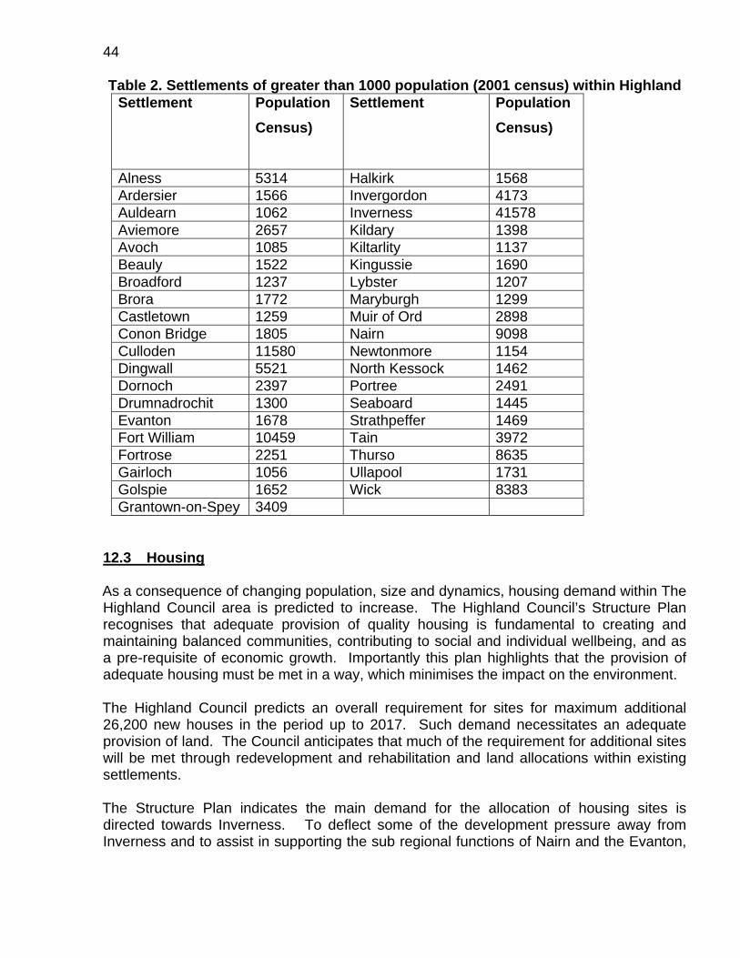
44
Table 2. Settlements of greater than 1000 population (2001 census) within Highland Settlement
Population
Census)
Settlement Population
Census)
Alness 5314 Halkirk 1568 Ardersier 1566 Invergordon 4173 Auldearn 1062 Inverness 41578 Aviemore 2657 Kildary 1398 Avoch 1085 Kiltarlity 1137 Beauly 1522 Kingussie 1690 Broadford 1237 Lybster 1207 Brora 1772 Maryburgh 1299 Castletown 1259 Muir of Ord 2898 Conon Bridge 1805 Nairn 9098 Culloden 11580 Newtonmore 1154 Dingwall 5521 North Kessock 1462 Dornoch 2397 Portree 2491 Drumnadrochit 1300 Seaboard 1445 Evanton 1678 Strathpeffer 1469 Fort William 10459 Tain 3972 Fortrose 2251 Thurso 8635 Gairloch 1056 Ullapool 1731 Golspie 1652 Wick 8383 Grantown-on-Spey 3409
12.3 Housing As a consequence of changing population, size and dynamics, housing demand within The Highland Council area is predicted to increase. The Highland Council’s Structure Plan recognises that adequate provision of quality housing is fundamental to creating and maintaining balanced communities, contributing to social and individual wellbeing, and as a pre-requisite of economic growth. Importantly this plan highlights that the provision of adequate housing must be met in a way, which minimises the impact on the environment. The Highland Council predicts an overall requirement for sites for maximum additional 26,200 new houses in the period up to 2017. Such demand necessitates an adequate provision of land. The Council anticipates that much of the requirement for additional sites will be met through redevelopment and rehabilitation and land allocations within existing settlements. The Structure Plan indicates the main demand for the allocation of housing sites is directed towards Inverness. To deflect some of the development pressure away from Inverness and to assist in supporting the sub regional functions of Nairn and the Evanton,

45 Alness and Invergordon corridor, allowance for housing land allocations have been increased above anticipated needs in both Nairn and Ross & Cromarty. In a desire to promote development to assist in stemming population loss and the regeneration of the sub region, additional allocation is anticipated in Caithness. The Structure Plan also indicates that further new settlements may be particularly appropriate to assist in repopulating fragile rural areas or to accommodate demand in the Inner Moray Firth area. Important infrastructure provisions will be required to meet the needs of additional housing land allocations. Table 3 shows the projected changes in population areas 2006 – 2021. Table 3 Area Population Projections (General Register Office for Scotland 2006)
2006 Actual
2021 Projected
% change 2006 to 2021
Badenoch & Strathspey 12,272 13,567 10.6 Caithness 24,994 24,111 -3.5 Inverness 70,207 79,923 13.8 Lochaber 18,988 19,736 3.9 Nairn 11,998 13,255 10.5 East Ross 20,365 21,965 7.9 Mid Ross 21,728 23,506 8.2 West Ross 8,769 9,738 11.1 Skye & Lochalsh 12,465 13,533 8.6 Sutherland 13,524 13,195 -2.4 Highland 215,310 232,529 8.0 Average Net Inward Migration to Highland
+1,200 per year
The Contaminated Land Team is committed to working closely with the Housing and Property Service in order to ensure that land intended for housing is suitable for use and that, as far as possible, such development meets the Scottish Government’s aspirations for sustainable development as set out in PAN33 and the Scottish Soils Framework. 12.4 Recreation The Highland Council has adopted a proactive approach and the wise use of the natural environment improving accessibility to goods and services and addressing the need for quality living environments (The Highland Council Structure Plan). These are all of relevance to both formal and informal sports and recreation facility provision. The Highland Council recognises issues of land use related to the provision and the importance of safeguarding sports fields and parks from development. Amenity open space also provides for informal recreation and is often under pressure within settlements.

46 The Highland Council confirms its support for recreational land protection and provision in its Structure Plan Policy SR2
"The Council will seek to protect sports facilities and amenity open space within settlements from development, unless provision for replacement facilities of an equivalent standard is made within the locality. Local plans will assess existing open space provision, identify deficiencies and establish standards for the provision of new or the improvement of existing open space".
12.5 Influence on the Strategy The human population of the Highlands is a major potential receptor within the contaminated land regime. Whilst there is a variety of instances and situations where pollutant linkage may arise with regard to elements of the population, groups or individuals the initial broad screening for this receptor will prioritise population according to density. Growth in population, demand for housing and protection of recreational open spaces will increase pressure for redevelopment of sites potentially affected by contamination, particularly in the Inner Moray Firth area. During times of economic growth this is likely to push the consideration of land contamination issues within such areas either in the implementation of the inspection Strategy or through the development control process. In the present more economically straitened times, this will be eased. The influence this will have on the Strategy is potentially significant, but difficult to assess at this stage.

47 CHAPTER 13 ECONOMY
13.1 Business and Industry The creation of an improved business environment is an important strategic theme within The Highland Council's Structure Plan. It recognises that the provision for business and industry is closely related to community, environmental and infrastructure considerations. The availability of land and premises is an important factor in accommodating development and supporting new business growth, the provision of land for business and industry should ensure a distribution of resources focussed on settlements and consistent with the proposed settlement Strategy. The Highland Council recognises the need for provision of a range of suitable sites in terms of size, quality and location to cater for the development of small to medium sized businesses and the needs of larger indigenous and inward investment companies. The Council and the Local Enterprises Companies are the primary providers of both sites and premises, in partnership with the private sector. Sites suitable for such developments are highlighted in the development of The Highland Council Local Plans. Further promotion of business and industry has been taken forward through the planning process through the designation of Simplified Planning Zones. One such zone exists at present around Alness/ Invergordon. The Highland Council's Structure Plan identifies areas for the promotion of business and industrial development. 13.2 Agriculture and Crofting
Agriculture and crofting form the backbone of the Highland identity, both in terms of socio-economic fabric and natural heritage character. The farming sector is particularly vulnerable to external factors and there can be large fluctuations in annual income for farmers specialising in particular crops, as shown by the Scottish Farm Income Estimates, published annually by the Scottish Government.
For example, the statistics show that total income from farming decreased by £11.9 million in 2008 to £629.6 million, a fall of 1.8 per cent over the previous year before inflation is taken into account. In real terms, this represents a fall of 5.6 per cent.
Separate figures on average Net Farm Incomes (NFI) show an increase of £10,000 from £19,800 in 2006-07 to £29,800 in 2007-08.
A major characteristic of agriculture in Highland is its stewardship of the high environmental quality of the area. The Highland Council's Structure Plan seeks to set out policies, which promote and maintain its agricultural and crofting sectors. The Council was also present at the Scottish Government’s Rural Economic Summit, held in Stirling in June 2009.

48 Considerable urban growth is anticipated within the Inner Moray Firth area and is likely to put tremendous development pressure on prime quality Highland agricultural land. In its Structure Plan, The Highland Council also seeks to safeguard agricultural land which although of lesser quality may nevertheless be important locally for the viability of a farm unit, croft or the local agricultural economy; Policy A1 "Development on prime quality or locally important agricultural land will not be permitted except where the development is essential to the interests of the local community and no reasonable alternative location is feasible”. 13.3 Forestry Forestry is a significant land use, covering about 12% of the Highlands and has a wide range of environmental, economic and social impacts across the whole area. Importantly it provides employment in the saw milling and timber processing industry, concentrated around the Moray Firth, Strathspey and Fort William. The Council is keen to encourage the development of a diverse, multi-purpose forest resource which creates lasting local employment opportunities, makes best possible use of native species, compliments the landscape, enhances public access, helps to sustain wildlife and helps safeguard the quality of river and loch systems. The Council has prepared an indicative Forestry Strategy which has divided the Highland area into Preferred, Potential and Sensitive Zones for planting, relative to competing land pressures, and constraining interests. 13.4 Fisheries and Aquaculture Highland has one of the most indented coastlines in Europe. It has largely unpolluted coastal and inland waters, an extensive inshore zone, and a network of freshwater rivers and lochs. These provide a wide spectrum of fishing and aquaculture opportunities whose activities and impacts straddle the divide between water and land. Commercial fishing in the waters around Highland has traditionally been one of the most important elements of its rural economy, and aquaculture has helped sustain populations and services in many of its remotest communities. Game fishing contributes to the wider Highland economy as a significant aspect of the tourism industry. There are environmental considerations both in terms of the impact of development on these industries and in terms of the potential negative impact of fishing and aquaculture developments themselves.

49 13.5 Tourism Tourism is vital to the Highland economy contributing approximately 20% of Highlands Gross Domestic Product, and relies heavily on visitor's perception of quality of both the natural and built environment. Tourism makes major demands on infrastructure and facilities and The Highland Council recognises that there is considerable scope for improvement in both quality and level of provision of many of these. The Council also recognises that quality interpretation is at the heart of enhancing the visitor experience of the Highlands and is a key component of the development of tourism infrastructure. 13.6 Integrated Rural Development The way in which land and coastal waters are managed is crucial to the well being of many Highland communities. The Highland Council recognises the importance of an integrated approach to rural development, which optimises economic, social and environmental interests encapsulating, as it does, sustainable development. The Council views this as the way forward and supports this approach through a series of policies (Structure Plan) on;
area sustainable development strategies, land management, management of the natural and cultural heritage, national parks, and community land ownership and management.
In doing this the Council recognises the importance of land in defining natural and cultural heritage, providing a resource for sustaining communities and meeting local development needs for business, housing and other community facilities, and the key role the local authority can play in steering and integrating development. 13.7 Influence on Strategy The influence of historic land use, by a number of business and commercial sectors within Highland, on Strategy development and implementation is considered elsewhere in this document. Forestry, agriculture, aquaculture, fishing and shooting involve crops and animals specified in the statutory guidance as receptors covered within the description of property. These receptors will be considered within the development and implementation of the Strategy. There may also be potentially contaminative activities associated with aspects of these land uses. Maintenance of high environmental quality, important in most economic sectors within Highland, is likely to have a dual effect in the consideration of sites within the contaminated land regime. Promotion of redevelopment of potentially contaminated land

50 and restriction of greenfield development will encourage the consideration of potential sites within the Development Control process. Potential sites which lie outwith areas designated within the settlement Strategy or local plans or simplified planning zones, but with comparable awarded priority, or contamination profiles, will be given higher priority for consideration within the contaminated land regime because their potential problems are less likely to be dealt with through redevelopment. The Highland Council recognises the importance of balancing the demands on land in its efforts to sustain communities, and in its role in directing and integrating development. This role will have a major effect in addressing development pressures, which are likely to drive redevelopment of sites through the Development Control process and therefore remove them from consideration within the contaminated land regime.
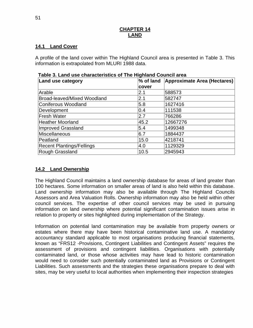
51
CHAPTER 14 LAND
14.1 Land Cover A profile of the land cover within The Highland Council area is presented in Table 3. This information is extrapolated from MLURI 1988 data.
Table 3. Land use characteristics of The Highland Council area Land use category % of land
cover Approximate Area (Hectares)
Arable 2.1 588573 Broad-leaved/Mixed Woodland 2.1 582747 Coniferous Woodland 5.8 1627416 Development 0.4 111538 Fresh Water 2.7 766286 Heather Moorland 45.2 12667276 Improved Grassland 5.4 1499348 Miscellaneous 6.7 1884437 Peatland 15.0 4218741 Recent Plantings/Fellings 4.0 1129329 Rough Grassland 10.5 2945943
14.2 Land Ownership The Highland Council maintains a land ownership database for areas of land greater than 100 hectares. Some information on smaller areas of land is also held within this database. Land ownership information may also be available through The Highland Councils Assessors and Area Valuation Rolls. Ownership information may also be held within other council services. The expertise of other council services may be used in pursuing information on land ownership where potential significant contamination issues arise in relation to property or sites highlighted during implementation of the Strategy. Information on potential land contamination may be available from property owners or estates where there may have been historical contaminative land use. A mandatory accountancy standard applicable to most organisations producing financial statements, known as “FRS12 -Provisions, Contingent Liabilities and Contingent Assets” requires the assessment of provisions and contingent liabilities. Organisations with potentially contaminated land, or those whose activities may have lead to historic contamination would need to consider such potentially contaminated land as Provisions or Contingent Liabilities. Such assessments and the strategies these organisations prepare to deal with sites, may be very useful to local authorities when implementing their inspection strategies

52 14.3 Local Authority Estate The Highland Council is a major landowner within the Highlands, much of its estate is currently used in direct service provision, depots, stores, buildings etc. The Highland Council’s Estate also includes land and buildings used for industrial purposes and for the transfer and disposal of wastes. Issues of ground contamination are most likely to arise on land with historical potentially contaminative industrial use, and land used historically for the transfer and disposal of wastes. There is also a potential for the existence of contaminated materials in parcels of reclaimed land managed by the Council. Information on the extent of The Highland Council’s estate is held by Housing and Property Services in the corporate property database. The corporate property database is linked to a GIS (Geographical Information System), which includes point references for each parcel of land or property. A project is ongoing to identify potentially contaminated land within The Highland Council’s estate and prioritise sites for more detailed inspection and investigation. As a limited data set from The Highland Council’s estate is readily accessible through the GIS, this project may provide priority sites whilst the process of Strategy adoption and implementation is progressing. Where priority sites are identified, the lack of an adopted Strategy will not prohibit further investigation and action. Sites will receive such prioritisation in line with the corporate priorities described in this Strategy. There will be full liaison with any Council Service identified with potential contaminated land liabilities. This will be achieved through the Corporate Contaminated Land Working Group. Any decisions on investigation and remediation of Council owned or managed sites will be taken with due regard to the principles embodied in site-specific risk assessment, sustainable development, and transparency in local government. 14.4 Waste Disposal With the public health revolution of the late 19th and early 20th centuries the disposal of waste became an issue considered at the local authority level. By the beginning of the 20th century local waste disposal sites or “tips” were common on the outskirts of villages towns and cities. Communities in the Highlands, in common with those elsewhere, have historically disposed of waste in local tips; this practice has persisted longer perhaps in the Highlands, as many communities are remote. The nature of household wastes up until relatively recently was such that in general, material going to the tip would have been relatively inert and not considered as a problem. Management of “tips” would have consisted of judicious burning, selective scavenging and burial of remaining materials and residues.

53 The significant change in composition of the waste stream in the last 50 years, the greater potential for disposal to impact within the local environment, and increasing awareness of waste and environmental issues, has sponsored a series of waste management legislation and the tighter regulation of disposal. This and the major structural changes in the provision and delivery of local services have driven both the centralisation of waste management and disposal, and the increase in size and capacity of disposal sites. As a result many of the local tip sites have been closed. The cost and practicalities of waste removal in dispersed and remoter communities has lead to specific disposal circumstances arising. For example: the unauthorised disposal of obsolete cars in disused quarries. It should also be borne in mind that unregulated disposal of commercial and industrial waste may be associated with tip sites. Commercial and industrial waste composition can have an important effect on the likely pollution from, or contamination in such sites. It is possible that historic commercial and industrial waste materials have been used in land reclamation and landscaping, or may have been tipped into convenient quarries or other excavations. Existing licensed landfill sites, subject to current regulatory regimes are outwith the scope of the contaminated land regime. Historic tip sites and landfill will be considered as potential sources of contamination. Information held within the Council, and by Council staff regarding historical disposal will be collated and other sources of such information explored. 14.5 Potentially Contaminative Land Use The most probable sources of soil contamination to be considered within this regime are likely to have arisen around the supply, storage and use of, and wastes arising from materials used in historic commercial and industrial processes. There may also be issues of land contamination associated with the historic disposal of domestic wastes and on land used in military activities. Industry in the Highlands has developed around the exploitation of abundant natural resources, and the growth of population around centres of trade. Such industrial land uses within Highland include:
Quarrying and mining, Manufacture and processing of textiles and rope, Foundries, smelting, fabrication and engineering Land where significant quantities of chemicals or fuels have been stored, used or
processed, Timber processing and treatment, Gasworks, energy production, electricity generation, Dock yards, airports, transportation and railways, Use, storage, or disposal of explosives or military ordinance, Waste recycling, treatment, disposal and sewage works.

54 14.6 Influence on the Strategy Information on land use and ownership, the extent of local authority estate and condition, and the identification of land which, may have had contaminative uses, is vital within the development and implementation of the Strategy. Many Highland communities will have within close proximity of their settlements a disused or closed tip site, there may be numerous unofficial tips particularly in remoter areas, and commercial or industrial wastes may have been used historically in land filling or landscaping. Developmental pressures, expansion of communities and population growth may have resulted in increased potential human contact with such sites and their contents. Materials migrating from these sites may affect environmental receptors, property or the water environment. Known, suspected and potential historic tip or landfill sites will have an important consideration within the Strategy. Liaison with representatives of industry and organisations with potential contaminated land interests will be encouraged to promote consideration of their liabilities and obligations. Similarly liaison within the Council will undertake to promote the consideration of potential liabilities and obligations within the current local authority estate, and previous local authority land use.

55 CHAPTER 15
THE WATER ENVIRONMENT 15.1 The water environment The water environment is defined in Section 3 of the Water Environment and Water
Services (Scotland) Act 2003 as "all surface water, groundwater and wetlands” :
(1) The following provisions have effect for the interpretation of this Part.
(2) "The water environment" means all surface water, groundwater and wetlands.
(3) "Surface water" means inland water (other than groundwater), transitional water and coastal water.
(4) "Groundwater" means water which is below the surface of the ground in the saturation zone and in direct contact with the ground or subsoil.
(5) "Wetland" means an area of ground the ecological, chemical and hydrological characteristics of which are attributable to frequent inundation or saturation by water and which is directly dependent, with regard to its water needs, on a body of groundwater or a body of surface water.
(6) "Inland water" means-
(a) all standing or flowing water on the surface of the land (other than transitional water), and
(b) all groundwater,
within the landward limits of coastal water.
(7) "Transitional water" means water (other than groundwater) in the vicinity of river mouths which is partly saline in character as a result of its proximity to coastal water but which is substantially influenced by freshwater flows.
(8) "Coastal water" means water (other than groundwater) within the area extending landward from the 3 mile limit up to the limit of the highest tide or, where appropriate, the seaward limits of any bodies of transitional water, but does not include any water beyond the seaward limits of the territorial sea of the United Kingdom adjacent to Scotland.
(9) "The 3 mile limit" means the limit consisting of a line every point of which is at a distance of 3 miles on the seaward side from the nearest point of the baseline from which the breadth of the territorial sea of the United Kingdom adjacent to Scotland is measured; and "miles" means international nautical miles of 1,852 metres.

56
(10) Nothing in this Part applies to any water contained in-
(a) artificial swimming pools,
(b) mains or other pipes belonging to Scottish Water or which are used by Scottish Water or any other person for the purpose only of providing a supply of water to any premises,
(c) water treatment works,
(d) sewers and drains which drain into sewers,
(e) sewage treatment works,
(f) artificially created systems for the treatment of pollutants. 15.2 Surface Waters Surface waters in The Highland Council area provide a valuable resource, not only in terms of supporting environmental and biological quality, but also in provision of water supply, their recreational, commercial and industrial uses, and their impressive scenic and landscape value. Maintaining and protecting marine and freshwater surface water resources are important priorities within the council’s strategic response to the contaminated land regime. Some surface water quality is surveyed on a routine basis. In Scotland SEPA undertakes this responsibility and assesses quality on the basis of chemistry, biology, nutrients, dangerous substances and aesthetic conditions. SEPA will be consulted on the quality of such waters as they are incorporated as potential receptors within the contaminated land database. 15.3 Groundwater Ground water is a valuable resource throughout Scotland and within Highland and comprises of bodies of water contained as aquifers within both solid and drift geology. Ground waters can be important in water supply, and in the supply of base flow to rivers and other surface waters. The value and vulnerability of ground water is dependant on the strata (solid geology) the ground water is contained within, the depth of the unsaturated zone which lies above the water table, the presence and nature of the quaternary or drift geology overlying the solid geology and the soil leaching potential. The eastern coastal area of The Highland Council lies within the Caithness and Moray Firth Old Red Sandstone province, areas of which have been highlighted as prime aquifers. Information on regional ground water is currently sparse, although available data suggests recoverable ground water to be negligible within this province (Fletcher et. al., 1996).

57
15.4 The Water Environment – Protected Areas
SEPA has established, and will continue to maintain, a register of water environment protected areas.
The register will help to ensure that water bodies in these designated areas are managed and that they achieve the objectives required by the Water Framework Directive (WFD) and the Water Environment (Register of Protected Areas) (Scotland) Regulations 2004. Areas designated as requiring special protection and/or conservation include:
Areas designated to protect economically significant species These protected areas were established under earlier European directives aimed at protecting shellfish (79/923/EEC) and freshwater fish (78/659/EEC).
Bathing waters Previously designated under the Bathing Water Directive (76/160/EEC), these waters are now covered by the revised Bathing Water Directive (2006/7/EC) which will be enacted in the UK by regulations in 2008.
Nutrient sensitive areas These comprise nitrate vulnerable zones and polluted waters designated under the Nitrates Directive (91/676/EEC) and areas designated as sensitive areas under the Urban Waste Water Treatment Directive (91/271/EEC).
Areas designated for the protection of habitats or species These are areas previously designated for the protection of habitats or species where maintaining or improving the status of water is important for their protection. They comprise the aquatic part of Natura 2000 sites designated under the Birds Directive (79/409/EEC) and the Habitats Directive (92/43/EEC).
Waters used for the abstraction of drinking water These are protected areas designated under the Water Framework Directive (2000/60/EC) that were previously protected by the Surface Water Abstraction Directive (75/440/EEC) (which was repealed on 22/12/2007).
SEPA has produced maps for all the above for the Scotland River Basin District. In November 2008 SEPA issued a consultation document on assigning groundwater assessment criteria for pollutant inputs. The consultation set out SEPA’s proposals for meeting the “prevent and limit” requirements of the EU Water Framework Directive. The Highland Council welcomed the proposals in the consultation and made suggestions

58 regarding clarification of certain points. Publication of the final guidance arising from the consultation is expected by the end of the summer 2009. Large scale hydrogeological and ground water vulnerability maps covering the whole of Scotland are produced by the British Geological Survey. 15.5 Water Supplies Scottish Water undertakes the provision and maintenance of public water supply throughout the Highland area. There are 153 public water supplies serving Highland communities, ranging in size from sources serving as few as 10 people, to regional water schemes serving as many as 50,000 people. The Highland Council Transport, Environmental and Community Services regulate and monitor approximately 2,800 private water supplies across The Highland Council area. These supplies serve a population estimated at 16,927 and range in size from those serving individual domestic properties, to those supplying major food and drinks manufacturers. (reference; Private Water Supplies (Scotland) Regulations 1992, 2000 Return. The Highland Council.) Water supplies arise either in groundwater or surface waters, and as such are receptors in terms of the contaminated land regime. In addition their distribution and use allows them to be considered as possible pathways to human population receptors. 15.6 Influence on Strategy Consideration of Highland water resources will be significant within the development and implementation of the Strategy. Interaction with a number of agencies whose responsibilities include water resource issues is essential within the Strategy. The Highland Council considers that the contaminated land regime should not be utilised as an alternative to existing statutory regimes with water quality remits, and will encourage issues of poor water quality to be considered within existing regimes where this is deemed appropriate. As information on the water environment, vulnerable ground and surface waters, and private and public water supplies is generated or becomes available from a number of sources, it will be incorporated into the Contaminated Land Information Management System.

59 CHAPTER 16
ECOLOGY 16.1 Background The ecology of the Highlands is diverse, reflecting the wide range of habitats present in the region. Key factors influencing this include the degree of altitudinal range (from extensive coastline to Britain's highest mountain), and considerable climate variation (from the oceanic influenced west coast to the relatively dry areas east of the Cairngorms, and the near arctic conditions of their high plateau). Of particular note is the large number of species at the edge of their range, some of which are genetically distinct (for example: Scots pine and many arctic-alpine plants). Other species do not occur in significant numbers elsewhere within the European Union other than in the north of Scotland (examples include: black-throated diver, dotterel and string sedge). There are also populations, which are of genuine global importance, which are uniquely indigenous, or which are internationally threatened, for example: grey seal, arctic and great skua, Scottish primrose and Scottish crossbill. 16.2 International Sites Highland's rich biodiversity is reflected in the range of proposed, candidate and classified international sites. This includes a number of Ramsar sites (an international designation for birds) and a wide raft of sites enjoying protection under European law (82 proposed or candidate Special Areas of Conservation (SAC) and 37 Special Protection Areas for wild birds). These European sites cover in total 15 % of the land area of Highland and include peatlands, wetlands, woodlands, mountainous areas, and rivers including the Spey, certain sealochs and parts of the wider Moray Firth. 16.3 National Sites There are 360 Sites of Special Scientific Interest (SSSI) in Highland, covering 19% of the land area, and which encompass the international sites previously mentioned as well as other areas. This is a reflection of the ecological importance of the region and general sympathetic management of the area. SSSI legislation places responsibilities on those with an interest in the land to consult Scottish Natural Heritage (SNH) when under taking management activities: this includes remediation. There are also 139,5000 ha of National Nature Reserve, all of which will enjoy the SSSI protection. The Cairngorms became Britain’s largest National Park in September 2003. 16.4 Sites Outwith Protection Under Part IIA There is a range of sites which fall outwith the contaminated land regime but which none the less have some form of recognition. These include voluntary reserves, community woodlands and informal areas for wildlife. There are no regional or country parks.
60 However, such is the nature of Highland's wildlife that many of its species rely upon, and many of its habitats occur, in areas of no designation whatsoever. 16.5 Influence on Strategy National and international sites are identified locations of specified receptors within ecological systems. There is a statutory requirement to consult SNH regarding designated sites, falling within the contaminated land regime, which are subject to remedial action. In general over-riding interests of public health would take precedence over nature protection, but only if actions were shown to be unavoidable, therefore early consultation with SNH as the relevant agency is essential. It is also probable that some of the species present may be key receptors, particularly marine species and birds in any contaminated estuarine areas. Runoff into freshwaters might also be a problem. Although certain quarry sites may be important in terms of their vegetation or even fossil outcrops, no particular conflicts have been identified as yet in relation to toxic spoils, which may themselves provide features of scientific interest due to flora, and fauna they may support. There may be some potential nature conservation sites, currently unidentified, which will be affected either by land contaminants or remediation.

61 CHAPTER 17
POLLUTANT LINKAGES The contaminated land statutory regime has at its centre the concept of the pollutant linkage, where a source of contamination comes into contact with a receptor by means of a pathway. In this appendix pollutant linkages are described in more detail. 17.1 SOURCES OF CONTAMINATION The following section outlines the sources of contamination most likely to be considered as important within The Highland Council area. Historical industrial land use Locally important industries with the likeliest contamination profile include:
Gasworks Petrochemical production and storage Chemical production Animal slaughter and processing of animal by-products Metal smelting and refining Scrapyards Engineering and fabrication Energy generation Timber treatment Garages, including depots, sale and storage of fuels and vehicle repair Railway land Textile manufacture and dyeing Dockyards, wharves and airports
Historic landfill sites Sites where a variety of materials, with the potential to act as contaminants, have been disposed of or where they may have been used in landscaping, can act as important sources of contamination. Old unlicensed landfills present a particular challenge.
Quarries Initial examination of historic maps has revealed a very high number of quarry and material extraction sites across the Highlands. What is of concern is the nature and provenance of any material which may have been tipped or dumped into them, or have been used to fill or landscape them. Redevelopment Sources of contamination, which may form an element of pollutant linkages as a result of previous redevelopment, require to be considered within the inspection Strategy.
62 Natural Natural sources of contamination, resulting from naturally occurring, elevated levels of chemicals or compounds will be considered. Such information is available from the BGS or MLURI.
Current industrial land use Current industrial land use, highlighted in contemporary maps, local plans and process authorisations may indicate potential historic industrial land use and potential sources of contamination. Military The Highland Council area has had a long association with various sectors of the military establishment; military bases, fuel and weapons depots, ranges, airfields and training areas may contain historic contaminants. 17.2 PATHWAYS The following section outlines some important pathways by which contaminants may come into contact with receptors. Direct exposure Direct exposure of human populations with proximity to sources, through inhalation dermal contact and ingestion pathways will be considered as the highest priority within the implementation of the contaminated land regime. Water Water resources utilised as public and private water supplies have the ability to transmit contaminants either by contamination at source or through distribution. In consequence water supplies will be considered as important potential pathways to human receptors. Internal liaison within The Highland Council TEC Services with its regulatory role in private water supplies, and externally with Scottish Water will be important in identifying such potential pathways and assessing any impact on the human population. Food - commercial The produce of agriculture, fisheries and aquaculture when incorporated in the human food chain may convey contaminants to the human population and thus may be important pathways within pollutant linkage. Similarly certain commercial uses of water resources, both indirectly and directly, may introduce a pollutant linkage within the human food chain. Food – home grown Similarly the potential use of private gardens and allotments for growing food for human consumption will be an important consideration in identifying potential pathways in areas with suspected contamination. Geological Pathways Both solid and drift geology exposed to particular sources of contamination may allow transmission of contaminants, either as liquids (or in solution), and as gasses. Geology may act as a pathway for a variety of receptors ranging across the water environment,

63 property, and environmental and human receptors. In site specific assessments, the geological expertise of the Contaminated Land Team be employed by the Council to assess the significance of such a pathway. 17.3 RECEPTORS The following section outlines the important receptors within The Highland Council area. People The human population of The Highland Council area is considered within this Strategy as the highest priority receptor. The Water Environment Surface waters have been mapped across the Highlands for inclusion within the contaminated land database. Scottish Water has been consulted on important catchments for public water supply, and requested to provide this as digital information for inclusion within the contaminated land database. A process of mapping the private water supplies across Highland is being developed for inclusion within the database. Information on ground water vulnerability has been incorporated into the site prioritisation tool following work done by the Contaminated Land Team. SEPA, within its general responsibility for protecting the water environment, has been consulted on the water environment it considers as particularly important by virtue of their value, use or vulnerability. Such information will be of particular value when considering the priority of the water environment during investigation and inspection within the regime. Ecological Systems Spatial mapping of specified ecological systems already exists within a The Highland Council GIS database. The information has been provided by SNH and will be imported into the contaminated land database. Ancient Monuments Similarly spatial information regarding scheduled ancient monuments is also available for importation into the contaminated land database. Historic Scotland has provided this information. Other Receptors Consideration is being given to mapping areas containing property receptors other than buildings. These include land associated with forestry and agriculture, important fisheries and locations of sites of fish and shellfish farms. 17.4 EVIDENCE OF HARM Evidence of actual harm to specified receptors arising from pollutant linkages will be examined within collated information and information resulting from site investigations, and

64 compared against the descriptions of significant harm and significant possibility of significant harm (“SPOSH”) contained within the statutory guidance (see Chapter 19). 17.5 EVIDENCE OF POLLUTION OF THE WATER ENVIRONMENT Issues relating to the pollution of the water environment arising from pollutant linkages will be viewed in light of statutory guidance and discussed with SEPA. Where such issues arise they will be viewed by The Highland Council within the Scottish Government’s objectives for sustainable development, and elements of the “suitable for use” approach highlighted in both PAN33 and Part IIA. In addition, at the time of the preparation of this reviewed and updated Strategy, SEPA is collating the responses to its recent consultation on the Second Edition of its guidance booklet “Water Pollution Arising from Land Containing Chemical Contaminants”. The final version of this document has not, at the time of publication of this Strategy, been published, but when this happens The Highland Council will study the Second Edition of the booklet and take from it all appropriate guidance.

65 CHAPTER 18
INTERNAL PROCEDURES 18.1 Complaints and Service Requests Complaints or service requests will be dealt with initially by TEC Services officers within the appropriate area office in liaison with the Principal Contaminated Land Officer (PCLO). The Area Environmental Health Manager or a nominated deputy, in conjunction with the PCLO, will determine whether the contaminated land regime is applicable. When situations arise which require more onerous or specialised involvement or have a greater strategic significance the PCLO may consider a more direct role although every effort to involve local area staff will be made. The Highland Council has a computer database for dealing with a wide range of council business. This database already has a facility for dealing with complaints, which can be adapted to deal with contaminated land issues. Complaints or service requests will be logged and updated within the Protective Services existing electronic recording system by the appropriate area officer, and will be subject to the same standards of Service delivery as are currently adopted. Every effort will be made to resolve complaints quickly and efficiently, and to keep the complainant informed of progress. 18.2 Personal Details All complainants / information providers will be requested to supply their names and contact details. The identities of all complainants and information providers will, as far as practicable, remain confidential. 18.3 Communications The development, publication and implementation of The Highland Council’s Contaminated Land Strategy requires the formation and use of direct lines of communication within and outwith the Council. Internal communication between Council Services will be via the Corporate Contaminated Land Working Group and elected members have been advised through Committee reports. Communication between local authorities regarding interpretation of the legislation and guidance, development of inspection strategies, and implementation of the regime, occurs through the network of pollution liaison groups, co-ordinated by the Scottish Pollution Control Co-ordinating Committee (SPCCC), and through working groups hosted by COSLA. The Highland Council will continue to participate in the Scottish Contaminated Land Forum (SCLF). The Highland Council will work to maximise our influence over contaminated land policy by exploring new ways of working, for example within the context of the Royal Environmental Health Institute of Scotland (REHIS). Direct and effective communication with SEPA is essential in implementing the contaminated land regime in the Highlands. This is so because SEPA is a source of site-specific advice and because of its complementary regulatory role and with its responsibility for compiling the state of contaminated land report. The Highland Council will maintain

66 both formal and informal contact with SEPA regarding issues arising from development and implementation of its strategic role in the contaminated land regime. 18.4 Consultation In addition a number of organisations expressed an interest in the Council’s Strategy. These organisations were included in the draft Strategy consultation process in 2000 – 2001, and will be sent a copy of this reviewed and updated Strategy. This list of organisations is shown in the Table below.
The Highland Council Contaminated Land Inspection Strategy Consultees
Food Standards Agency Neighbouring Local Authorities; Highlands and Islands Enterprise NHS Highland Argyll & Bute Council
Historic Scotland Comhairle Nan Eilean Siar Scottish Water Moray Council Scottish Environment Protection Agency Orkney Islands Council Scottish Government Perth & Kinross Council
This updated and reviewed Strategy will be available on the Council’s Intranet and Internet website. Early and informal discussions with the owners and occupiers of sites considered in the implementation of the inspection Strategy is essential in establishing site contamination profiles, communicating issues with potentially responsible individuals and organisations, and promoting voluntary remediation. Importantly The Highland Council will require to use the expert services of contractors and consultants for site investigation, assessment and interpretation, and potentially remediation. The Council currently has a Framework Agreement in place with a number of consultants, in accordance with the provision of the Public Contracts (Scotland) Regulations 2006. This Agreement is due to expire at the beginning of October 2009 and The Highland Council is working on a new local framework agreement to commence in October / November 2009.

67
CHAPTER 19
SIGNIFICANT HARM, AND THE SIGNIFICANT POSSIBILITY OF SIGNIFICANT HARM
From Environmental Protection Act 1990, Part IIA, Contaminated Land Statutory Guidance, Edition 2, June 2006.
A.24 The local authority should regard as significant only harm which is both:
(a) to a receptor of a type listed in Table A, and
(b) within the description of harm specified for that type of receptor in that Table.
TABLE A - CATEGORIES OF SIGNIFICANT HARM
Type of Receptor Description of Harm to that Type of Receptor
that is to be Regarded as Significant Harm
1 Human beings
Death, disease, serious injury, genetic mutation, birth defects or the impairment of reproductive functions.
For these purposes, disease is to be taken to mean an unhealthy condition of the body or a part of it and can include, for example, cancer, liver dysfunction or extensive skin ailments. Mental dysfunction is included only insofar as it is attributable to the effects of a pollutant on the body of the person concerned.
In this Chapter, this description of significant harm is referred to as a "human health effect".
2
Any ecological system, or living organism forming part of such a system, within a location which is:
an area notified as an area of special scientific interest (commonly called a Site of Special Scientific Interest - SSSI) under section 28 of the Wildlife and Countryside Act 1981;
any land declared a
For any protected location:
harm which results in an irreversible adverse change, or in some other substantial adverse change, in the functioning of the ecological system within any substantial part of that location; or
harm which affects any species of special interest within that location and which endangers the long-term maintenance of the population of that species at that location.
In addition, in the case of a protected location which is a European Site (or a candidate Special

68
national nature reserve under section 35 of that Act;
any area designated as amarine nature reserve under section 36 of that Act;
an Area of Special Protection for Birds, established under section 3 of that Act;
any European Site within the meaning of regulation 10 of the Conservation (Natural Habitats etc) Regulations 1994 (ie Special Areas of Conservation and Special Protection Areas);
any candidate Special Areas of Conservation (see Scottish Office Circular 6/1995) or potential Special Protection Areas given equivalent protection;
any habitat or site afforded policy protection (ie candidate Special Areas of Conservation, potential Special Protection Areas and listed Ramsar sites);
any nature reserve established under section 21 of the National Parks and Access to the Countryside Act 1949; or
Area of Conservation or a potential Special Protection Area), harm which is incompatible with the favourable conservation status of natural habitats at that location or species typically found there.
In determining what constitutes such harm, the local authority should have regard to the advice of Scottish Natural Heritage and to the requirements of the Conservation (Natural Habitats etc) Regulations 1994.
In this Chapter, this description of significant harm is referred to as an "ecological system effect".

69
any National Park designated under the National Parks (Scotland) Act 2000.
3
Property in the form of:
crops, including timber;
produce grown domestically, or on allotments, for consumption;
livestock;
other owned or domesticated animals;
wild animals which are the subject of shooting or fishing rights.
For crops, a substantial diminution in yield or other substantial loss in their value resulting from death, disease or other physical damage. For domestic pets, death, serious disease or serious physical damage. For other property in this category, a substantial loss in its value resulting from death, disease or other serious physical damage.
The local authority should regard a substantial loss in value as occurring only when a substantial proportion of the animals or crops are dead or otherwise no longer fit for their intended purpose. Food should be regarded as being no longer fit for purpose when it fails to comply with the provisions of the Food Safety Act 1990. Where a diminution in yield or loss in value is caused by a pollutant linkage, a 20% diminution or loss should be regarded as a benchmark for what constitutes a substantial diminution or loss.
In this Chapter, this description of significant harm is referred to as an "animal or crop effect".
4
Property in the form of buildings.
For this purpose, "building" means "any structure or erection, and any part of a building including any part below ground level, but does not include plant or machinery comprised in a building".
Structural failure, substantial damage or substantial interference with any right of occupation.
For this purpose, the local authority should regard substantial damage or substantial interference as occurring when any part of the building ceases to be capable of being used for the purpose for which it is or was intended.
Additionally, in the case of a scheduled Ancient Monument, substantial damage should be regarded as occurring when the damage significantly impairs the historic, architectural, traditional, artistic or archaeological interest by reason of which the monument was scheduled.
In this Chapter, this description of significant harm is referred to as a "building effect".

70 A.25 The local authority should not regard harm to receptors of any type other than those mentioned in Table A as being significant harm for the purposes of Part IIA. For example, harm to ecological systems outside the descriptions in the second entry in the table should be disregarded. Similarly, the authority should not regard any other description of harm to receptors of the types mentioned in Table A as being significant harm.
A.26 The authority should disregard any receptors which are not likely to be present, given the "current use" of the land or other land which might be affected.
A.27 For the purposes of this guidance, the "current use" means any use which is currently being made, or is likely to be made, of the land, and which is consistent with any existing planning permission (or is otherwise lawful under town and country planning legislation). This definition is subject to the following qualifications:
(a) the current use should be taken to include any temporary use, permitted under town and country planning legislation, to which the land is, or is likely to be, put from time to time;
(b) the current use includes future uses or developments which do not require a new, or amended, grant of planning permission (but see also paragraph A.37 below);
(c) the current use should, nevertheless, be taken to include any likely informal recreational use of the land, whether authorised by the owners or occupiers or not, (for example, children playing on the land); however, in assessing the likelihood of any such informal use, the local authority should give due attention to measures taken to prevent or restrict access to the land; and
(d) in the case of agricultural land, however, the current agricultural use should not be taken to extend beyond the growing or rearing of the crops or animals which are habitually grown or reared on the land.
Whether the Possibility of Significant Harm Being Caused is Significant
A.28 As stated in paragraph ANNEX 3 -A.9 above, the guidance on determining whether a particular possibility is significant is based on the principles of risk assessment, and in particular on considerations of the magnitude or consequences of the different types of significant harm caused. The term "possibility of significant harm being caused" should be taken as referring to a measure of the probability, or frequency, of the occurrence of circumstances which would lead to significant harm being caused.
A.29 The local authority should take into account the following factors in deciding whether the possibility of significant harm being caused is significant:
(a) the nature and degree of harm;
(b) the susceptibility of the receptors to which the harm might be caused; and
(c) the timescale within which the harm might occur.
A.30 In considering the timescale, the authority should take into account any evidence that the current use of the land (as defined in paragraphs A.26 and A.27 above) will cease in the foreseeable future.

71 A.31 The local authority should regard as a significant possibility any possibility of significant harm which meets the conditions set out in Table B for the description of significant harm under consideration.
TABLE B - SIGNIFICANT POSSIBILITY OF SIGNIFICANT HARM
Descriptions of Significant Harm (as
Defined in Table A)
Conditions for there Being a Significant Possibility of Significant Harm
1
Human health effects arising from
the intake of a contaminant, or
other direct bodily contact with a contaminant (exposure).
If the amount of the pollutant in the pollutant linkage in question:
which a human receptor in that linkage might take in,
or
to which such a human might otherwise be exposed, as a result of the pathway in that linkage, would represent an unacceptable intake or exposure, assessed on the basis of relevant information on the toxicological properties of that pollutant.
Such an assessment should take into account:
the likely total intake of, or exposure to, the substance or substances which form the pollutant, from all sources including that from the pollutant linkage in question;
the relative contribution of the pollutant linkage in question to the likely aggregate intake of, or exposure to, the relevant substance or substances; and
the duration of intake or exposure resulting from the pollutant linkage in question.
The question of whether an intake or exposure is unacceptable is independent of the number of people who might experience or be affected by that intake or exposure.
Toxicological properties should be taken to include carcinogenic, mutagenic, teratogenic, pathogenic, endocrine-disrupting and other similar properties.
2 All other human health effects (particularly by
If the probability, or frequency, of occurrence of significant harm of that description is unacceptable, assessed on the basis of relevant

72
way of explosion or fire).
information concerning:
that type of pollutant linkage, or
that type of significant harm arising from other causes.
Such an assessment should take into account the levels of risk which have been judged unacceptable in other similar contexts.
3 All ecological system effects.
If significant harm of that description is more likely than not to result from the pollutant linkage in question, taking into account relevant information for that type of pollutant linkage, particularly in relation to the ecotoxicological effects of the pollutant.
4 All animal and crop effects.
If significant harm of that description is more likely than not to result from the pollutant linkage in question, taking into account relevant information for that type of pollutant linkage, particularly in relation to the ecotoxicological effects of the pollutant.
5 All building effects
If significant harm of that description is more likely than not to result from the pollutant linkage in question during the expected economic life of the building (or, in the case of a scheduled Ancient Monument, the foreseeable future), taking into account relevant information for that type of pollutant linkage.
A.32 In Table B, references to "relevant information" mean information which is:
(a) scientifically-based;
(b) authoritative;
(c) relevant to the assessment of risks arising from the presence of contaminants in soil; and
(d) appropriate to the determination of whether any land is contaminated land for the purposes of Part IIA, in that the use of the information is consistent with providing a level of protection in line with the qualitative criteria set out in Tables A and B
A.33 In making any assessment of what is an unacceptable probability or frequency, in relation to, the second entry in Table B, the local authority should give particular weight to cases where the pollutant linkage might cause significant harm which:
(a) would be irreversible or incapable of being treated;
(b) would affect a substantial number of people;
(c) would result from a single incident such as a fire or an explosion; or
(d) would be likely to result from a short-term (that is, less than 24-hour) exposure to the pollutant.

73 A.34 In general, when considering significant harm to non-human receptors, the local authority should apply the tests set out in the relevant entries in Table B to determine whether there is a significant possibility of that harm being caused. However, the local authority may also determine that there is a significant possibility of significant harm with respect to a non-human receptor in any case where the conditions in the third, fourth and fifth entries in Table B are not met, but where:
(a) the significant harm would result from a single incident such as a fire of explosion; or
(b) the significant harm would be likely to result from a short-term (that is, less than 24-hour) exposure of the receptor to the pollutant.
A.35 In addition, when considering ecological system effects, the local authority may also determine that there is a significant possibility of significant harm being caused where: (a) there is reasonable possibility of that harm being caused; and (b) if that harm were to occur, it would result in such a degree of damage to features of special interest at the location in question that they would be beyond any practicable possibility of restoration.
A.36 The possibility of significant harm being caused as a result of any change of use of any land to one which is not a current use of that land (as defined in paragraph A.26 above) should not be regarded as a significant possibility for the purposes of this Chapter.
A.37 When considering the possibility of significant harm being caused in relation to any future use or development which falls within the description of a "current use" as a result of paragraph A.27(b) above, the local authority should assume that if the future use is introduced, or the development carried out, this will be done in accordance with any existing planning permission for that use or development. In particular, the local authority should assume:
(a) that any remediation which is the subject of a condition attached to that planning permission, or is the subject of any planning obligation, will be carried out in accordance with that permission or obligation; and
(b) where a planning permission has been given subject to conditions which require steps to be taken to prevent problems which might be caused by contamination, and those steps are to be approved by the planning authority, that the planning authority will ensure that those steps include adequate remediation.

74
GLOSSARY AND ACRONYMS BGS
British Geological Survey
COSLA Convention of Scottish Local Authorities Ecosystem a unit consisting of a community of organisms and their
environment EPA Environmental Protection Act 1990 FSA Food Standards Agency GIS Geographical Information System Glacio-fluvial pertaining to glacial rivers HSE Health and Safety Executive MLURI MacAuley Land Use Research Institute Pathway a route, or means by which a receptor is, or could be
exposed to a contaminant through Pollutant an element, compound or material offensive or harmful to
human, animal, or plant life Pollutant linkage the relationship between a contaminant and receptor by
means of a pathway PCLO Principal Contaminated Land Officer (Highland Council) Ramsar an international wetland site designation for protection of
birds Receptor either:
a living organism, a group of living organisms, an ecological system or a piece of property which (i) is in a category listed in Table A (see Appendix I) as a type of receptor, and
(ii) is being or could be harmed by a contaminant; or
the water environment which is being, or could be, polluted by a contaminant
RIP(S)A Regulation of Investigatory Powers (Scotland) Act 2000 Risk exposure to a hazard, and the degree of probability of loss, inju
danger through such exposure SAC Special Area of Conservation, a European site designation SEERAD Scottish Government Environment and Rural Affairs
Department SEPA Scottish Environment Protection Agency SERAD Scottish Government Rural Affairs Department, now
superseded by SEERAD Source the origin or supply of contamination or contaminants SNH Scottish Natural Heritage SPCCC Scottish Pollution Control Co-ordinating Committee.
SSSI Site of Special Scientific Interest, a National conservation
designation

75 Substance any natural or artificial material, whether in solid, liquid, gas
or vapour form. Water Environment All groundwater, surface water and wetlands, as defined by
Section 3 of the Water Environment and Water Services (Scotland) Act 2003

76 REFERENCES AND SELECTED BIBLIOGRAPHY
Legislation and Other Government Guidance Environment Act 1995 Environmental Protection Act 1990 Contaminated Land (Scotland) Regulations 2000 Contaminated Land (Scotland) Regulations 2005 Building Standards (Scotland) Regulations 1990 and subsequent amendments Planning etc. (Scotland) Act 2006 Planning Advice Note PAN 33 Revised 2000: Development of Contaminated Land. Scottish Planning Policy SPP3 : Planning for Homes, Revised 2008 Scottish Vacant and Derelict Land Survey 2005, January 2006 Scottish Vacant and Derelict Land Survey 2007, January 2008 Scottish Vacant and Derelict Land Survey 2008, January 2009 Scottish Government Rural Affairs Department Circular 1/2000. Environmental Protection Act 1990: PartIIA Contaminated Land Scottish Soils Framework, June 2009 Water Environment and Water Resources (Scotland) Act 2003 and associated Regulations SEPA Sources Scottish Environment Protection Agency. Framework for Local Authority-SEPA liaison under Part IIA of the Environmental Protection Act 1990. 2000, SEPA Stirling Scottish Environment Protection Agency. Policy No 19 Groundwater Protection Policy for Scotland. 1997, SEPA Stirling State of Scotland’s Environment 2006 The Highland Council Sources Strengthening the Highlands. The Programme of The Highland Council 2009 – 2011
77 The Highland Council, Facts and Figures 2001. Available from The Highland Council, Glenurquhart Road Inverness, IV3 5NX. The Highland Council, Highland Trends 1999. Available from The Highland Council, Glenurquhart Road Inverness, IV3 5NX. The Highland Council, Statement of Strategic Goals and Values 1996. Available from The Highland Council, Glenurquhart Road Inverness, IV3 5NX. The Highland Council, Structure Plan 2000. Available from The Highland Council, Glenurquhart Road Inverness, IV3 5NX. Private Water Supplies (Scotland) Regulations 1992.2000 Return. The Highland Council, Transport, Environmental and Community Services.
78 Other Sources Alston, D. Ross and Cromarty: A Historical Guide. Birlinn Ltd. Edinburgh 1999. Close-Brooks, J. The Highlands. HMSO Edinburgh 1995. Fletcher T.P, Auton C.A, Highton A.J, Robertson S. and Rollin K.E. British Geological Survey. Geology of Fortrose and eastern Inverness district. Memoir for 1:50 000 Geological Sheet 84W (Scotland) HMSO London 1996. Johnstone G.S, and Mykura W. British Regional Geology. The North Highlands of Scotland. HMSO London 1989. Roberts J.R. The Highland Geology Trail. Luath Press Ltd Edinburgh 2000. Syms P.M. Desk Reference Guide to potentially Contaminative Land Uses 1999. ISVA, 3 Cadogan Gate, London. Taylor A and Nortcliff S. Soils: Scotland’s Living Landscapes. Scottish Natural Heritage, Publications Section, Perth 1996 Bibliography Department of Environment CLR Report No 5. Information Systems for Land Contamination. DoE 1994. Department of Environment CLR Report No 6. Prioritisation and Categorisation Procedure for Sites which may be Contaminated. DoE 1995. Downing R.A. Groundwater our hidden asset. British Geological Survey Nottingham 1998. Edmonds E. The Geological Map: An Anatomy of the Landscape. HMSO1983. Groundwater Vulnerability Map of Scotland. British Geological Survey, Murchison House, West Mains Road, Edinburgh EH9 2LA. Hydrogeological Map of Scotland. British Geological Survey, Murchison House, West Mains Road, Edinburgh EH9 2LA. Marsland P.A and Carey M.A. Methodology for the Derivation of Remedial Targets for Soil and Groundwater to Protect Water Resources. Environment Agency R & D Publication 20. 1999. Robins N.S. Hydrogeology of Scotland. British Geological Survey HMSO London 1990. Ross, D. Scotland: History of a Nation. Lomond Books Ltd. 2000.

79 Rudland, D.J, Lancefield, R.M and Mayell, P.N. Contaminated land risk assessment. A guide to good practice. Construction Industry Research Information Association C552. CIRIA 2001. Scotland & Northern Ireland Forum For Environmetal Research . Framework for Deriving Numeric Targets to Minimise the Adverse Human Health Effects of Long-term Exposure to Contaminants in Soil. SNIFFER SR99(02) April 2000 Scottish Enterprise. How to Approach Contaminated Land. Scottish Enterprise 1998 Scottish Enterprise. How to Investigate Contaminated Land. Scottish Enterprise 1998. Scottish Government Rural Affairs Department. Contaminated Land Strategies: Advice for Local Authorities. August 2000. Syms P.M. Desk Reference Guide to potentially Contaminative Land Uses 1999. ISVA, 3 Cadogan Gate, London. The Highland Wellbeing Alliance, Community Plan for Highland. Available from The Highland Council (Policy Unit), Glenurquhart Road Inverness, IV3 5NX.