the evolution of the rivers of east devon … · the evolution of the rivers of east devon and...
TRANSCRIPT

THE EVOLUTION OF THE RIVERS OF EAST DEVON AND
SOUTH SOMERSET, UK
R.W. GALLOIS
INTRODUCTION
The middle and lower reaches of the River Exe and theadjacent catchments of the Axe, Otter, Teign and Tone drain anarea with a complex topographical relief that ranges from over300 m above Ordnance Datum (O.D.) in the Blackdown Hillsto a few metres above O.D. on the Devon coast (Figure 1).Geological resurveys of the Exeter, Newton Abbot, Sidmouthand Taunton districts during the past 20 years have confirmedthe 19th century observations of Ussher and others (Ussher,1902; 1906; 1908; 1913; Woodward and Ussher, 1911) thatthe terrace sequences of the Exe and Otter catchments aremarkedly different from those of the Axe, Sid, Teign and Tone.Eight terrace levels, ranging in height from just above, to 60 mabove, the modern floodplain, have been recognised along theExe and its tributaries with patches of ‘undifferentiated’ terraceat higher levels (Edwards and Scrivener, 1999). An even greaterrange is preserved in the lower reaches of the Otter Valleywhere a staircase of ten terrace levels range up to 100 m abovethe modern floodplain and ‘undifferentiated’ terrace depositsrange up to 150 m above (Edwards and Gallois, 2004). Incontrast, Edmonds and Williams (1985) recorded only twoterrace levels in the Tone catchment, one mostly c. 5 m abovethe modern floodplain and the other “just above the alluvialflats”. Selwood et al. (1984) recorded only one terrace level inthe Teign catchment, up to a few metres above the alluvium,and no terrace deposit was recorded in the Sid catchment(Edwards and Gallois, 2004).
Extensive terrace deposits crop out on the lower slopes ofthe Axe Valley at heights up to 20 m above the valley floorbetween Kilmington (SY 270 980) and Chard Junction (ST 342047). In contrast to the terrace deposits of the Exe and Otter,those of the Axe are unusually thick (locally up to 15 m). Theywere worked in Victorian times for road and railway ballast,and continue to be worked at Chard Junction for aggregate.The former workings at Broom (ST 326 024) have yielded agreater number of Palaeolithic implements than any other sitein southern England (Wymer, 1999) and the succession there is,in consequence, the most studied terrace deposit in south-westEngland.
Gallois, R.W. 2006. The evolution of the rivers of east Devon and south Somerset, UK.Geoscience in south-west England, 11, 205-213.
With the exception of the River Tone, which appears to have been separated at an early stage from its neighbours to the south bya major fault, the rivers of south Somerset and east Devon were initiated on a southward dipping Tertiary planation surface.The evolutionary histories of the present-day catchments of the rivers Exe and Otter are complex and inter-related. Those of theadjacent Axe and Teign appear to be less complex and may have evolved relatively independently from the Exe-Otter system.The differences in the histories of the catchments are most clearly demonstrated by their terrace systems. The Exe-Ottercatchment has 10 or more terrace levels at heights of up to 140 m above the modern floodplain. In contrast, the Axe, Teign andTone catchments contain only one or two terrace levels all of which are less than 20 m above the present-day valley floor.The explanation suggested here for the difference involves a sequence of river captures that changed the forerunner of thepresent-day Otter from a major river capable of producing a 3-km wide gravelly braidplain into a minor stream.
92 Stoke Valley Road, Exeter, EX4 5ER, U.K.
(E-mail: [email protected]).
There are too few age data to determine the period of timeduring which the terrace sequences in south-west Englandevolved, but comparison with the denudation chronology ofsouthern England as a whole suggests that all the terracesreferred to in this account formed during the middle and latePleistocene. Throughout this period the region experiencedalternations of cold and temperate climates, but there is noevidence to indicate that the area was ever glaciated. Theclimate experienced by the Exe and Otter catchments was not,therefore, sufficiently different from that of the adjacentcatchments to explain the differences in the terrace successions.These must relate to the underlying geology.
GEOLOGICAL SETTING
The present-day outcrop geology of the region can bedivided into four principal types (Figure 2). In the west andnorth west the complexly folded and faulted Carboniferousdeposits (mostly Crackington and Bude formations) arestrongly lithified rocks. They give rise to a high-relieftopography in which their predominantly E-W Variscanstructural fabric is reflected in the drainage patterns. TheCarboniferous rocks are overlain with marked unconformity bya gently dipping, fining-upward succession of Permian breccias,sandstones and mudstones (Exeter Group to LittlehamMudstone Formation) that was deposited in E-W trendingextensional basins during the denudation phase of the Variscanmountains, most conspicuously in the Crediton and Tivertontroughs. The Permian deposits are disconformably overlain byearly to middle Triassic pebble beds and sandstones (BudleighSalterton Pebble Beds and Otter Sandstone formations). Theseand the Permian rocks give rise to generally low-relief,low-lying land, in which the Budleigh Salterton Pebble Bedsform a prominent ridge that separates the present-daycatchments of the rivers Exe and Otter (Figure 1).
The eastern part of the region is underlain by mid Triassic toearly Jurassic rocks (Mercia Mudstone to Lias groups) that arealmost wholly weakly lithified mudstones that give rise to a
R.W. Gallois
205
The evolution of the rivers of east Devon and south Somerset
206
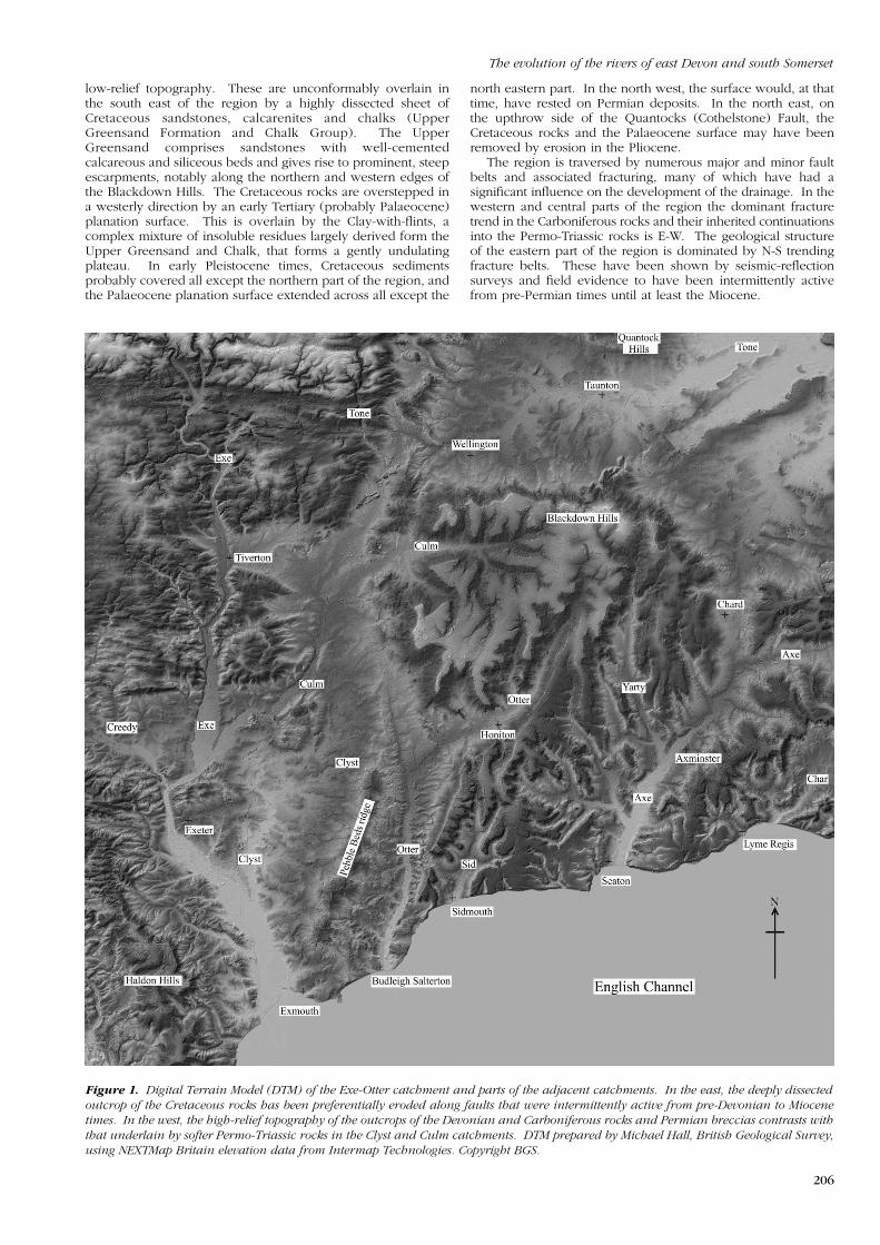
Figure 1. Digital Terrain Model (DTM) of the Exe-Otter catchment and parts of the adjacent catchments. In the east, the deeply dissected
outcrop of the Cretaceous rocks has been preferentially eroded along faults that were intermittently active from pre-Devonian to Miocene
times. In the west, the high-relief topography of the outcrops of the Devonian and Carboniferous rocks and Permian breccias contrasts with
that underlain by softer Permo-Triassic rocks in the Clyst and Culm catchments. DTM prepared by Michael Hall, British Geological Survey,
using NEXTMap Britain elevation data from Intermap Technologies. Copyright BGS.
low-relief topography. These are unconformably overlain inthe south east of the region by a highly dissected sheet ofCretaceous sandstones, calcarenites and chalks (UpperGreensand Formation and Chalk Group). The UpperGreensand comprises sandstones with well-cementedcalcareous and siliceous beds and gives rise to prominent, steepescarpments, notably along the northern and western edges ofthe Blackdown Hills. The Cretaceous rocks are overstepped ina westerly direction by an early Tertiary (probably Palaeocene)planation surface. This is overlain by the Clay-with-flints, acomplex mixture of insoluble residues largely derived form theUpper Greensand and Chalk, that forms a gently undulatingplateau. In early Pleistocene times, Cretaceous sedimentsprobably covered all except the northern part of the region, andthe Palaeocene planation surface extended across all except the
north eastern part. In the north west, the surface would, at thattime, have rested on Permian deposits. In the north east, onthe upthrow side of the Quantocks (Cothelstone) Fault, theCretaceous rocks and the Palaeocene surface may have beenremoved by erosion in the Pliocene.
The region is traversed by numerous major and minor faultbelts and associated fracturing, many of which have had asignificant influence on the development of the drainage. In thewestern and central parts of the region the dominant fracturetrend in the Carboniferous rocks and their inherited continuationsinto the Permo-Triassic rocks is E-W. The geological structureof the eastern part of the region is dominated by N-S trendingfracture belts. These have been shown by seismic-reflectionsurveys and field evidence to have been intermittently activefrom pre-Permian times until at least the Miocene.

R.W. Gallois
AGE CONSTRAINTS AND INTER-CATCHMENT
CORRELATIONS
In the absence of radiometric dates, other than a fewradiocarbon dates for material from the younger deposits,estimates of the ages of the terrace deposits of the region haveuntil recently been based on equivocal palaeontologicalevidence from a few sites. Recent advances in opticallystimulated luminescence (OSL) dating have the potential todetermine ages in excess of 300,000 years with an accuracy ofc. ±5% (Bøtter-Jensen et al., 2003). The OSL dating of samplesrecently collected from the Axe, Exe and Otter terraces(Hosfield et al., in press) should enable reliable correlations tobe made where there are none at present.
Edmonds and Williams (1985) correlated the lower of thetwo Tone terraces with the fossiliferous Burtle Beds of theSomerset Levels. The fossils include plant material, freshwaterand brackish-marine shells, bear, deer, elephant, horse, hyena,
207
Figure 2. Simplified geological sketch map of the region showing the principal rock types that influenced the evolution of the drainage system.
rhinoceros and wolf, all indicative of a temperate climate(Kidson, 1971). The deposits have been attributed to OxygenIsotope Stage (OIS) 5e, the most recent temperate phase in theUK Pleistocene. A temperate-climate fossil assemblage thatincludes plants, elephant, giant ox and hippopotamus was alsorecorded from a site a few metres above the floodplain of theRiver Otter at Honiton (ST 162 006) (Turner, 1975). This toohas been tentatively attributed to OIS 5e (Edwards andScrivener, 1999).
The higher terrace of the Tone was assumed by Edmondsand Williams (1985) on circumstantial evidence to have beendeposited during the draining phase of a conjectural Lake Maw(Mitchell, 1960), a glacial lake that occupied much of theSomerset Levels during the poorly defined ‘WolstonianGlaciation’, 130,000 to 350,000 years ago.

The evolution of the rivers of east Devon and south Somerset
208
very high flow rates. For example, at Budleigh Salterton largepatches of Terrace 6 gravels, preserved at c. 55 m above themodern floodplain, were deposited on a gravelly braidplain thatwas at least 3 km wide.
It is therefore suggested here that the evolutionary historiesof the Exe and Otter catchments are complexly interrelated andincluded several river captures that changed the Otter from amajor to a minor river. In contrast, the catchments of the Axe,Teign and Tone have relatively simple development histories.Selected stages in the evolution of the present-day catchmentsof the region are shown in Figure 3.
The most accurate age obtained to date from the region is anOSL date of 250,000 to 300,000 years from a terrace deposit atBroom about 10 m above the floodplain of the River Axe(Hosfield and Chambers, 2002; Toms et al., 2004). Takentogether, these dates suggest that there has been very littledowncutting by the River Otter during the last 125,000 years(since OIS 5e) and by the Axe and Tone during the past 300,000years (since OIS 8 or earlier), despite major climatic changesduring that time. Similar low rates of downcutting have beenrecorded in the more fluvially mature environments of theThames Estuary area where OIS 5e deposits (in the KemptonPark Gravels) are close to floodplain level and OIS 8 deposits(Lynch Hill Gravel) are only 10 m above the floodplain (Ellison,2004).
EVOLUTION OF THE DRAINAGE SYSTEM
Gibbard and Lewin (2003) postulated that a large eastwardflowing ‘Solent River’ crossed the region from late Palaeocenetimes onward and maintained this course throughout most ofthe Cenozoic Era. There is no depositional or landformevidence within the region to support this hypothesis. Thepresence of Cornubian-derived heavy minerals in thePalaeogene Wittering Formation of the Hampshire Basin(Morton, 1982) indicates the presence of west to east transportpathways in the early Tertiary, but not necessarily via a singlelarge river nor one that survived beyond the Miocenedeformation of the region. Similarly, there is little or nogeological evidence in southern England to support thegeomorphological concept, popular until the 1960s, ofhigh-level Tertiary marine-planation surfaces. Kidson (1962)recognised up to 10 erosional stages on the basis of amorphometric study of the longitudinal profile of thepresent-day Exe. He correlated the more prominent of these,the Westermill (‘690-foot’) and Nethercote (‘330-foot’) stageswith marine-planation surfaces that had been recognised in theHampshire Basin (Wooldridge and Linton, 1955), south-eastDevon (Green, 1941) and Wales (Brown, 1952). Correlationssuch as these, which are based almost entirely on topographicheights, do not take account of the extensive tectonicdeformation of the region in the Miocene, or of neotectonicmovements since that time.
In contrast, there is evidence to suggest that the precursorsof the courses of the Axe, Exe, Otter and Teign, all of which ransouthwards at approximately right angles to the ‘Solent River’,were initiated on a southward-dipping Palaeocene surface thathad been deformed during the Miocene. Where preserved inthe eastern part of the region the surface falls from over 300 mabove Ordnance Datum (O.D.) on the northern edge of theBlackdown Hills to below 100 m O.D. in the Seaton area.It does so unevenly, being locally displaced by faults withvertical throws of up to 60 m.
In the western part of the region the drainage patterns arestrongly influenced by E-W trending fractures in theCarboniferous and Permo-Triassic rocks and by thejuxtaposition of harder and softer rocks in E-W trending foldsin the Culm deposits. These gave rise to secondary drainagefeatures that developed when the Palaeocene surface andCretaceous rocks had been removed by erosion. In the easternpart of the region, the course of the Axe, Otter and Sid and theirtributaries have all developed along fracture zones associatedwith the N-S trending fault belts.
All the present-day rivers in the region are misfits, as notedby the early geologists including De la Beche (1829) who wrote“Could these streams have cut such valleys as they now flowthrough? If there be any true relation between cause and effectthey could not.” Buckland (1822) initially invoked the BiblicalFlood, but was subsequently persuaded by the work of Agassiz(1840) that they had been sculpted by large volumes ofgravel-bearing meltwater during the ‘Glacial Age’. In addition,in the case of the River Otter the present-day catchment wouldbe too small to produce the extensive terrace-gravel spreadspreserved in its lower reaches even if allowance is made for
Axe, Teign and Tone catchments
The proto-Axe developed on the southward-dippingPalaeocene surface, its detailed development being stronglyinfluenced by faulting. The proto-Teign probably has a similarorigin.
The modern catchment of the River Tone is largely confinedto the Permo-Triassic outcrop. It is bounded to the south bythe Cretaceous escarpment of the Blackdown Hills, a sharplydefined topographical feature that may be fault controlled andwhose position may have changed little during the Pleistocene.The Tone catchment seems likely, therefore, to have evolvedindependently from those of its southern neighbours from anearly stage, except possibly in two areas. The Cretaceousescarpment is breached at the Chard Gap (90 m O.D.) andterminates at its western end at the Holcombe Rogus Gap(100 m O.D.), which might have acted as capture points thatprovided links to the Axe and Otter catchments respectively.It has been suggested (Mitchell, 1960) that the Chard Gap actedas the overflow for Lake Maw. However, Green (1974) hasshown that terrace gravels of the Axe do not containany glacially derived erratic material and that the gap did nottherefore act as an overflow channel that influenced theevolution of the Axe catchment. The Holcombe Rogus Gap isdiscussed below.
Exe and Otter catchments
The proto-Otter is also assumed here to have developed onthe Palaeocene surface and to have been modified by thestructures in the Culm in those areas where the Permo-Triassicrocks were removed by erosion. The middle and lowerreaches of the river were bounded on their eastern side by arelatively unbroken Cretaceous escarpment. It was bounded tothe west by a ridge of high ground formed by the BudleighSalterton Pebble Beds. The proposed catchment at this stage(Figure 3a) would have been large enough to produce thebroad spreads of gravel preserved in the lower reaches of themodern valley. Successive captures of the higher tributaries ofthe proto-Otter by the Tone at Holcombe Rogus (1 on Figure4a), by the proto-Creedy-Yeo at Tiverton (2 on Figure 4b) andby the proto-Exe at Talaton (3 on Figure 4c) reduced thecatchment area to its present-day form.
The evolution of the Exe catchment can be interpreted intwo principal ways, neither of which can be discounted on thecurrently available evidence. The simplest interpretation is thatthe proto-Exe and proto-Otter formed on the Palaeocenesurface and ran from Exmoor to the sea on sub-parallelcourses. The present-day narrow valleys where the Execrosses the high ground of the Culm outcrops between theTiverton and Crediton troughs and at Exeter would then beinterpreted as superimposed drainage. However, it is doubtfulthat the much reduced catchment area of the proto-Otter thatthis interpretation implies would be sufficient to explain theextensive spreads of the Otter terraces.
The alternative, more complex evolution favoured heresuggests that a proto-Creedy/Yeo catchment was initiallydeveloped on the Palaeocene surface and soon becamestrongly influenced by the E-W trending structures in thePermo-Triassic rocks. The successive captures outlined aboveand in figures 3 and 4 then gave rise to the present-daycatchment boundaries.

R.W. Gallois
209
Figure 3. Selected stages in the evolution of the catchments of the region from the time of deposition of the River Otter 60-m terrace onwards:
(A) early stage, (B) intermediate stage, (C) present-day drainage and principal catchment boundaries. See text for explanation.

The evolution of the rivers of east Devon and south Somerset
211
Figure 4. Summary, in suggested chronological order, of the principal river captures in the evolution of the present-day Exe and Otter
catchments: (A) 1. Proto-Tone tributary captures a higher tributary of the proto-Otter at Holcombe Rogus. (B) 2. Proto-Creedy tributary
captures higher tributaries of the proto-Otter at Tiverton and at the eastern end of the Tiverton Trough to form an early stage of what will
become the River Exe. (C) 3. Proto-Creedy tributary captures the middle tributary of the proto-Otter near Talaton to form the proto-Clyst.
4. Proto-Creedy tributary captures the upper reaches of the proto-Clyst at Cullompton to form the precursor of the modern River Culm.
(D) 5. A tributary of the River Clyst captures the upper reaches of the River Exe north of Exeter.
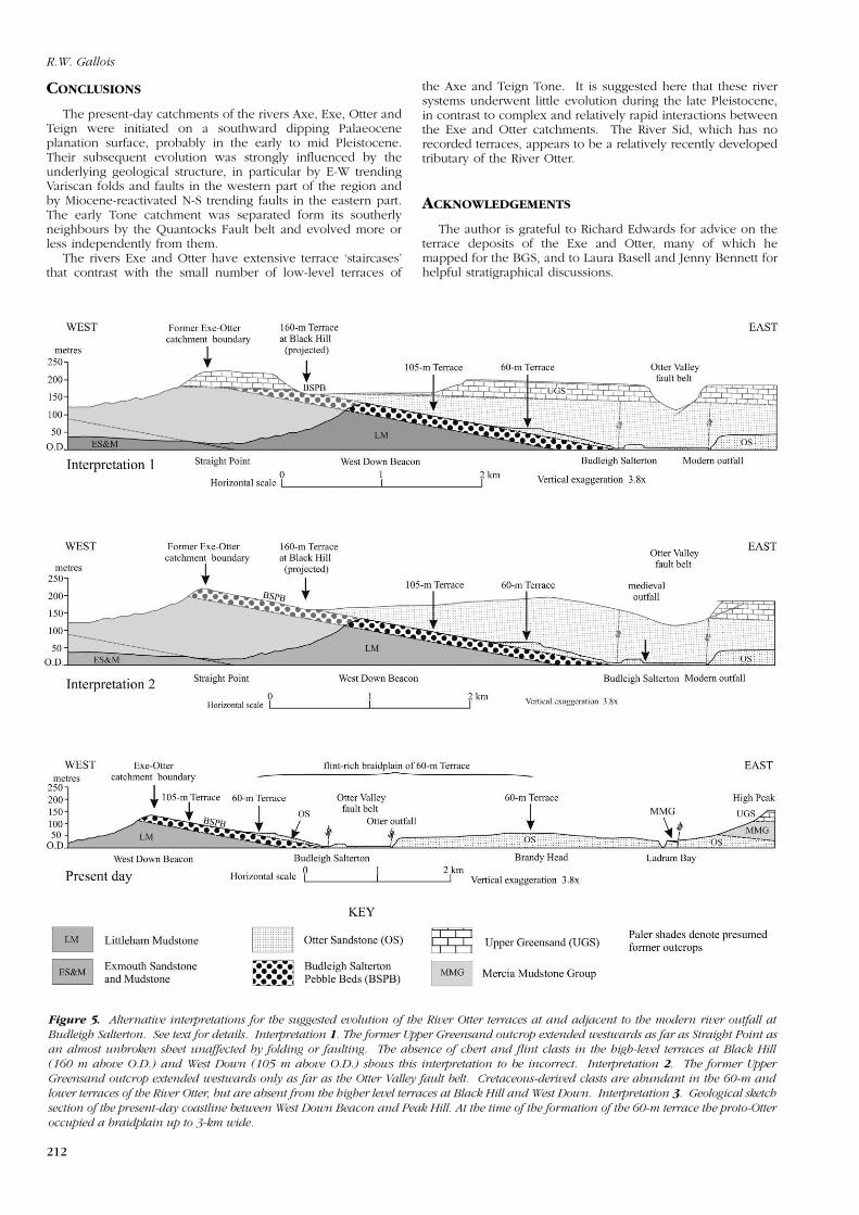
There is tantalising evidence to suggest that the proto-Exeand proto-Otter may originally have been a single riversouthwards from Exeter. At Black Hill (SY 030 852), terracegravels cap the highest point (160 m O.D.) on the present-dayExe-Otter watershed (Nicholas, 2004). The terrace depositsthere are almost wholly composed of clasts derived from theimmediately underlying Budleigh Salterton Pebble Beds. Chertand flint are absent, from which one can conclude that theoutcrop of the Cretaceous rocks did not extend that far west atthat time (Figure 5, Interpretation 1). It is tempting to assumethat because the remnants of the Palaeocene surface preservedon the Cretaceous outliers of the Haldon Hills are at a similarheight (200 to 230 m O.D.) to that on the nearest Cretaceousoutcrop to the east at Sidmouth, that the surface extendedbetween the two as a horizontal sheet until at least the
Pleistocene. This was clearly not the case. As in moreeasterly areas, the surface would have been deformed duringthe Miocene, but all evidence of this has been removed byerosion.
Cretaceous material is also absent from the 105-m terraceexposed in the cliffs below West Down Beacon. This suggeststhat the western edge of the Cretaceous escarpment lay to theeast of the River Otter at that time and that the 105-m terracegravels were separated from it by a ridge of Otter SandstoneFormation (Figure 5, Interpretation 2). It seems likely thereforethat the position of the western margin of the Cretaceousoutcrop, as with the northern margin, was largely faultcontrolled. Neither appears from the present study to haveretreated a significant distance since OIS 8 or earlier.
R.W. Gallois
212
Figure 5. Alternative interpretations for the suggested evolution of the River Otter terraces at and adjacent to the modern river outfall at
Budleigh Salterton. See text for details. Interpretation 1. The former Upper Greensand outcrop extended westwards as far as Straight Point as
an almost unbroken sheet unaffected by folding or faulting. The absence of chert and flint clasts in the high-level terraces at Black Hill
(160 m above O.D.) and West Down (105 m above O.D.) shows this interpretation to be incorrect. Interpretation 2. The former Upper
Greensand outcrop extended westwards only as far as the Otter Valley fault belt. Cretaceous-derived clasts are abundant in the 60-m and
lower terraces of the River Otter, but are absent from the higher level terraces at Black Hill and West Down. Interpretation 3. Geological sketch
section of the present-day coastline between West Down Beacon and Peak Hill. At the time of the formation of the 60-m terrace the proto-Otter
occupied a braidplain up to 3-km wide.
CONCLUSIONS
The present-day catchments of the rivers Axe, Exe, Otter andTeign were initiated on a southward dipping Palaeoceneplanation surface, probably in the early to mid Pleistocene.Their subsequent evolution was strongly influenced by theunderlying geological structure, in particular by E-W trendingVariscan folds and faults in the western part of the region andby Miocene-reactivated N-S trending faults in the eastern part.The early Tone catchment was separated form its southerlyneighbours by the Quantocks Fault belt and evolved more orless independently from them.
The rivers Exe and Otter have extensive terrace ‘staircases’that contrast with the small number of low-level terraces of
the Axe and Teign Tone. It is suggested here that these riversystems underwent little evolution during the late Pleistocene,in contrast to complex and relatively rapid interactions betweenthe Exe and Otter catchments. The River Sid, which has norecorded terraces, appears to be a relatively recently developedtributary of the River Otter.
ACKNOWLEDGEMENTS
The author is grateful to Richard Edwards for advice on theterrace deposits of the Exe and Otter, many of which hemapped for the BGS, and to Laura Basell and Jenny Bennett forhelpful stratigraphical discussions.

The evolution of the rivers of east Devon and south Somerset
213
REFERENCES
AGASSIZ, L. 1840. Etudes sur les glaciers. Jent et Gassmann, Neuchatel.
BØTTER-JENSEN, L., MCKEEVER, L.W.S. and WINTLE, A.G. 2003. Optically
stimulated thermoluminescence dosimetry. Elsevier Science, Amsterdam.
BROWN, E.H. 1952. The River Ystwyth, Cardiganshire. Proceedings of the
Geologists’ Association, 63, 244-269.
BUCKLAND, W. 1822. On the excavation of valleys by diluvian action, asillustrated by a succession of valleys which intersect the south coast of Dorsetand Devon. Transactions of the Geological Society, London, Series 2, Vol. 1, 95.
DE LA BECHE, H.T. 1829. Notice on the excavation of valleys. Philosophical
Magazine, 6, 241-248.
EDMONDS, E.A. and WILLIAMS, B.J. 1985. Geology of the country around
Taunton and the Quantock Hills. Memoir for 1:50 000 geological sheet 295(England and Wales), British Geological Survey. HMSO, London.
EDWARDS, R.A. and GALLOIS, R.W. 2004. Geology of the Sidmouth District.
Sheet Explanation of the British Geological Survey for Sheets 326 & 340(England and Wales). British Geological Survey, Keyworth.
EDWARDS, R.A. and SCRIVENER, R.C. 1999. Geology of the country around
Exeter. Memoir for 1:50 000 geological sheet 325 (England and Wales), BritishGeological Survey. HMSO, London.
ELLISON, R.A. 2004. Geology of London. Special memoir for 1:50,000 geologicalsheets 256 (North London), 257 (South London), 270 (Romford), and 271(Dartford) (England and Wales). British Geological Survey, Keyworth.
GIBBARD, P.L. and LEWIN, J. 2003. The history of the major rivers of southernBritain during the Tertiary. Journal of the Geological Society, London, 160,829-845.
GREEN, C.P. 1974. Pleistocene gravels of the River Axe in south-westernEngland, and their bearing on the southern limit of glaciation in Britain.Geological Magazine, 111, 213-220.
GREEN, J.F.N. 1941. The high platforms of East Devon. Proceedings of the
Geologists’ Association, 52, 36-52.
HOSFIELD, R.T. and CHAMBERS, J.C. 2002. The Lower Palaeolithic site ofBroom: geoarchaeological implications of optical dating. Lithics, 23, 33-42.
HOSFIELD, R.T, BROWN, A.G., BASELL, L.S. and HOUNSELL, S. 2006. Beyondthe caves: the Palaeolithic Rivers of South-West Britain. Geoscience in
south-west England, 11, 183-190.
KIDSON, C. 1962. The denudation chronology of the River Exe. Transactions
of the Institute of British Geographers, 31, 43-66.
KIDSON, C. 1971. The Burtle Beds of Somerset. Proceedings of the Ussher
Society, 2, 189-191.
MITCHELL, G.F. 1960. The Pleistocene history of the Irish Sea. Advancement of
Science, 17, 313-325.
MORTON, A.C. 1982. Heavy minerals of the Hampshire Basin Palaeogene strata.Geological Magazine, 119, 463-476.
NICHOLAS, C. 2004. Geodiversity Audit of Active Aggregate Quarries: Quarries
in Devon. David Roche Geoconsulting, Exeter.
SELWOOD, E.B., EDWARDS, R.A., SIMPSON, S., CHESHER, J.A., HAMBLIN, R.J.O.,HENSON, M.R., RIDDOLLS, B.W. and WATERS, R.A. 1984. Geology of the
country around Newton Abbot. Memoir for 1:50 000 geological sheet 339(England and Wales), British Geological Survey. HMSO, London.
TOMS, P.S., HOSFIELD, R.T., CHAMBERS, J.C., GREEN, C.P. and MARSHALL, P.2004. Optical dating of the Broom Palaeolithic sites, Devon & Dorset. Centre
for Archaeology Report No. 16/2005. English Heritage, London.
TURNER, C. 1975. Der Einfluss grosser Mammalier auf die interglazialeVegetation. Quartar-palaeontologie, 1, 163-168.
USSHER, W.A.E. 1902. The geology of the country around Exeter. Memoirs of theGeological Survey of England and Wales, Sheet 325. HMSO, London.
USSHER, W.A.E. 1906. The geology of the country between Wellington and Chard,Sheet 311. Memoirs of the Geological Survey of England and Wales. HMSO,London.
USSHER, W.A.E. 1908. The geology of the Quantock Hills and of Taunton and
Bridgwater, Sheet 295. Memoirs of the Geological Survey of England andWales. HMSO, London.
USSHER, W.A.E. 1913. The geology of the country around Newton Abbot.Memoirs of the Geological Survey of England and Wales, Sheet 339. HMSO,London.
WOODWARD, H. B. and USSHER, W. A. E. 1911. Geology of the Country near
Sidmouth and Lyme Regis. Memoir of the Geological Survey of Great Britain.HMSO, London.
WOOLDRIDGE, S.W. and LINTON, D.L. 1955. Structure, Surface and Drainage
in South-East England. London Geographical Institute, London.
WYMER, J.J. 1999. The Lower Palaeolithic Occupation of Britain. WessexArchaeology and English Heritage, London.