the electrical effects of tidal streams in cook strait, new zealand
TRANSCRIPT

Deep-Sea Research, 195,5, Vol. 2, pp. 20-$ to 212. Pergamon Press Ltd., London.
The electrical effects of tidal streams in Cook Strait, New Zealand
B. H. OtssoN
(Received 27 January, 1955)
Summary---Electric currents which are generated by tidal streams have been observed in the land near the coast of Cook Strait, New Zealand. In each tidal period, the vector representing the horizon- tal component of the potential gradient was found to.rotate through 360 ° in a counter-clockwise direction. Corresponding rotary streams were observed in the Strait.
The potential gradient associated with those streams which are directed along the channel is explained by the theory worked out by LoNGtn~r-Hic~n~s (1949). No theory is available for dealing with on-shore streams.
Using the potential-gradient measurements, the magnitudes of those streams directed along the channel were computed. These computed values agree with certain direct observations of the streams made by the survey vessel H.M.N.Z.S. Lachlan.
1. INTRODUCTION
IN 1946, on the shores of the English Channel, LONGUET-HIGGINS (1949) measured earth potentials which were caused by tidal streams. He derived a theory connecting the horizontal potential gradient and the streams, showing that earth currents were induced by the movement of the sea water relative to the vertical component of the earth's magnetic field.
In 1949, some measurements were made near Wellington, New Zealand. It was hoped that the principle might later be used to observe the very changeable streams of Cook Strait.
The measurements extended over a little more than a lunar month, from 30 August to 3 October, 1949. Preliminary tests with a number of electrode spacings showed that the gradient was reasonably uniform over the area. Two pairs of electrodes were connected to recording miUivoltmeters to give the components of the potential gradient in approximately north-south and east-west directions. From these records the average tidal and solar-diurnal cycles of the gradient were extracted. In what follows, they are compared with some recordings of tidal streams.
2. RECORDING INSTALLATION
The site of the recording installation is shown in Fig. 1. The district is rugged, with grass-covered hills up to 1,700ft. high dissected by deep valleys. Along the coast, sea-cut cliffs rise steeply for several hundred feet.
Non-polarising, copper : copper-sulphate electrodes, with the electrolyte in porous pots, were buried about one foot deep in positions where the ground was permanently damp. The north-south electrodes were placed about one kilometre apart in the valley of the Karori Stream. The east-west electrodes were placed about one kilometre and a half apart, at Tongue Point and at the recording site near the mouth of the Karori Stream. The distances between the electrodes, which were all about 50 feet above sea level, were measured on aerial photographs of the area.
Field-telephone cables, which were laid on the ground around the cliffs, connected
~0A

The electrical effects of tidal streams in Cook Strait, New Zealand 205
the electrodes to the recording hut. The two recorders were clockwork-driven and had a sensitivity o f about 400 millivolts full-scale, with abou t 6,250 ohms circuit resistance. Every minute, each recorder printed on its char t a dot whose posit ion corresponded to the potential difference between the associated pair o f electrodes. Every four th minute, the electrodes were disconnected f rom the recorders and zero- potential marks were printed.
ORTH ISLANO
• " I
STRAIT
SOUTH ISLAND~7 SOUTH PACIFIC OCEAN IOIMILES
Fig. 1 upper.
+3+2 J +4~O I I K NOT N
_ , _-: I X " "'
Fig. 1 lower. Fi8. 1. Cook Strait, New Zealand, with stream observations. The site of the earth-potential observa- tions is marked by a cross. The tidal streams were observed by H.M.N.Z.S.LacA/an at E on 15 May, 1951, a t F o n 18-19 May, 1951, and at G on 23-24 July, 1951. In the vector diagrams, a line drawn from the origin to any point on the diagram represents the vector stream at the indicated number
of hours before or after hish wate~ at Wellinston.
3. ANALYSIS OF RECORDS
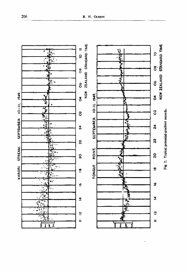
A typical day's records are shown in Fig. 2. New Zealand Standard Time, which is twelve hours ahead of Greenwich Mean Time, is marked on the records.
206 B . H . OLSSON
,e,. g,I ,, . . ]
;A. . ! • " : , , . i .
'..i; .L. ,1 .
~ ..sfl I
I i " , o
I .,~ • de,e : . '~
°-...
W ~ W
o ~ - ~ - - - ° i Z~ "'~
8~,., - - - - - - - - ~ - - - - ' - - ' - 8 ~
a ~ ~1 ~
o 0
]
o &..
, 0
CM

The electrical effects of tidal streams in Cook Strait, New Zealand 207
The points on the records show considerable scatter. It has been found that some of this is caused by magnetic storms, but the large scatter in daylight hours is attributed
I
l iB l i l l l l l l l i i l l l l l l l l l
i i i i i i i i
!gOnLa_.! ~in/~)D M iL,~m I i&lm n i ~ L"m
IQ
+10 0 mV
--I0
4"10
0 ~ ¥
1949 AUG. 31
I Y- ' - ,
SEPT. I 2 3 4 5 6 7
pm [ m [ 51E N,Y i]Lm~ [ ~ ~ lq im~i mlm~ Imlmj ~ ~
miii | i l i i i imimi)
~ r / "
/ -
, ~, o'
+10
O
--IO
-HO
I O
I - Io
k ~
.',_.~v k~.
1949 SEPT. 9 IO II 12 13 14 15
F ! "* "r:" 1,': 1-," I" F , t : "1:-" r" "1- I ~ 1" .'
16 17
l l l l l l l l I l l l i l l i i l l l l l l
l i i i i U i U l i q i i i n - - P
:...,.
1949 SEPT 18 19 20 21 22 23 24 25 26
; ,,,.,
m i mm:,nm
' nc
l l l ' i l ~ ' l m m ' i
]+'o ° J]'i ~ - - i O
m._~.v k.t.
km.
4-10
0 ~._~V km.
-I.IO
i O
- IO
~._!v kv~.
1949 SEPT. 27 :)8 29 3 0 OCT. I 2 3 4 S Fig. 3. Hourly means o f potential gradient. The upper rows of means arc from the Karori Stream observations with the positive gradient to the north. The lower rows o f means arc from the Tongue Point observations with the positive gradient to the west. The vertical lines through the sets o f means
show the times of high water at Wellington.
to electric trams in Wellington city, about five miles from the site of the observations. As the tramway system operates on direct current there is, in addition to the transients produced as the trams start and stop, a continuous leakage current which depends

208 B .H . OLSSON
at any time on the number of trams in use. This leakage current may be expected to cause potential gradients which vary slowly during most of the day. Thus the solar- diurnal variation computed from the records has a doubtful meaning.
3"1 The Solar Diurnal Variation.
The whole series of recordings is summarised in Fig. 3. Each point represents the mean potential gradient during an hour, the means being made visually from the original records. The gaps in the sequence in Fig. 3 are due to cables breaking or to other mishaps.
i
I I I I I 6 0 m
I O - I 0
g ~ ,o
0
- - i O
io.~v]k,~.
0 4 8 12 16 20 24 NOON
N.Z. STANDARD TIMF
Fig. 4. Fig. 5. Fig. 4.--Fig. 5. Mean solar-diurnal variation. In Fig. 5, a line drawn from the origin to any point on the diagram represents the vector potential gradient at the indicated number of hours after local
midnight.
The vertical lines on Fig. 3 mark the times of high water at Wellington as predicted in the New Zealand Nautical Almanac (1949). It is evident on inspection that the recordings have a major oscillation whose period is tidal. To eliminate this, and to obtain the solar-diurnal cycle, averages were taken over 29 days for each hour of the solar day. The average daily cycles are shown in Fig. 4 and they have been combined into a vector plot in Fig. 5.
The solar variation, which has an amplitude greater than would be expected from
The electrical effects of tidal streams in Cook Strait, New Zealand 209
the flow of water in the Strait, appears mainly on the Karori Stream records. As these records also show the greater scatter from the tram transients, it is probable that much of the apparent solar-diurnal variation is due to tramway leakage currents.
Thus it appears that little information relating to the tidal streams can be obtained from these diagrams.
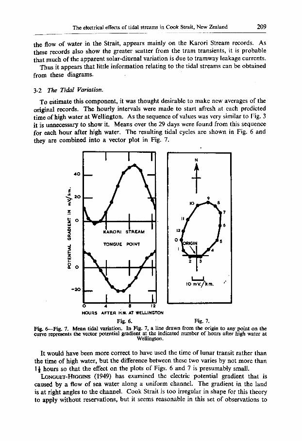
3.2 The Tidal Variation.
To estimate this component, it was thought desirable to make new averages of the original records. The hourly intervals were made to start afresh at each predicted time of high water at Wellington. As the sequence of values was very similar to Fig. 3 it is unnecessary to show it. Means over the 29 days were found from this sequence for each hour after high water. The resulting tidal cycles are shown in Fig. 6 and they are combined into a vector plot in Fig. 7.
:~ 20 9 8
~o .
i
~o
I0 mV./k m. ~',,' ~ 0
0 4 8 12 HOURS AFTER H.w. AT WELLINGTON
Fig. 6. Fig. 7. Fig. 6--Fig. 7. Mean tidal variation. In Fig. 7, a line drawn from the origin to any point on the curve represents the vector potential gradient at the indicated number of hours after high water at
Wellington.
It would have been more correct to have used the time of lunar transit rather than the time of high water, but the difference between these two varies by not more than 1½ hours so that the effect on the plots of Figs. 6 and 7 is presumably small.
LONGUErr-HIGGINS (1949) has examined the electric potential gradient that is caused by a flow of sea water along a uniform channel. The gradient in the land is at fight angles to the channel. Cook Strait is too irregular in shape for this theory to apply without reservations, but it seems reasonable in this set of observations to

210 B.H..OLssON
compare the streams parallel to the coast with the electric potential gradient at fight angles to it. The direction at right angles to the coast is approximately the line joining the points marked 2 and 8 in Fig. 7: The variation of gradient in this direction is almost the same as that shown for the Karori Stream in Fig. 6.
In the next section we attempt to deduce what streams parallel to the shore would account for the gradient and we later compare them with some stream observations.
An overall drift of water through the Strait may explain the predominance of positive values of the gradient at Karori Stream, but this comparison will not be pursued because electrode measurements at this site are probably biassed by leakages of direct current from the tramways.
4. AMPLITUDE OF TIDAL STREAMS, USING POTENTIAL-GRADIENT DATA The notation used in this section is that of LONGUFr-HIc~INS (1949). In discussing
the English Channel he assumes, as a reasonable approximation to actual conditions, that a channel has a semi-elliptical cross-section and is of infinite length. A stream of fluid whose conductivity is K l flows in this channel with a velocity V (supposed uniform over the cross-section). The channel lies in a semi-infinite bed of material of uniform conductivity K 0. If the strength of the vertical component of the earth's magnetic field is Hy, the potential gradient ~/~x across the stream is given by
~ _ V Hy tanh 61 ~x (Ko/,q) + tanh ~
where tanh ~l is the ratio of the minor (vertical) to the major (horizontal) axis of the ellipse.
Sections taken through Cook Strait vary considerably over a few miles. However, as an approximate value, tanh 6~ may be taken as 2 x 10 -2 (channel = 11 nautical miles wide, 110 fathoms deep). The basement under Cook Strait is greywacke (with some tertiary mudstone overlying this in places). For greywacke
K 0 = 5 × 1~ 5 (ohm-cm)-L
By measurement, K~ has been found to be 0-04 (ohm-cm) -1. Therefore
K ° - 1 . 2 5 × 1 0 -3 . t¢ 1
Also, Hy for Wellington = 0-535 gauss. By substituting these values, and changing to practical units, it is found that
~ - - 26 mV/km/knot. ~x
This is the uniform potential gradient in the channel. LONGUET-HIGGINS haS shown that the potential ~ in the plane of the channel bed, at any point outside the channel can be written
oc e-~ cos
where f and , are the elliptic coordinates of the point. On the surface, where cos ,~ ---- 1
o c e - f .
By differentiating this with respect to x (the distance on the surface from the centre

The electrical effects of tidal streams in Cook Strait, New Zealand 211
of the channel, at right angles to the channel), and by changing to rectangular coordinates, it is seen that
~ oc [(k) 2 - i ] - ;exp ( - - cosh -1 k)"
For a channel whose width is much greater than its depth, 2k is approximately equal to the width of the semi-ellipse representing the channel.
The exponential portion of this equation represents the variation in the potential gradient on the surface outside the channel. At the site of the potential gradient observations
x - - - 1 . 3 6 .
k
The above equation shows that the gradient measured will be 0.47 times the gradient in the channel, that is
12.3 mV/km/knot.
These calculations are based on the assumption that the stream flows in a long uniform channel. For Cook Strait, this assumption is not entirely valid.
Except near the turn in the Strait, however, the theory should apply to streams flowing along the channel. The values of the constants in the equations for the potential gradient are such that any likely variation in the ellipses chosen to represent the channel will make little difference to the computed potential gradient.
The theory will not apply to cross-channel streams or to any streams near the turn in the Strait.
From Fig. 7, the potential gradient which is equivalent to a stream along the channel can be found. It has a maximum amplitude of about ± 25 mV/km for the tidal component. The calculations show that the corresponding tidal stream will have a maximum rate of ± 2 knots. This is the average maximum rate for the lunar month.
As the variation of the stream rate with depth is not known for Cook Strait, the stream rate on the surface cannot be found from the mean values calculated from the potential-gradient observations. Probably the surface stream ra t~ will be a little higher than those calculated.
5. COMPARISON OF TIDAL STREAMS AND POTENTIAL-GRADIENT OBSERVATIONS
Unfortunately, very few quantitative data relating to the streams in Cook Strait are available. The water flow is apparently very complex, and much affected by meteorological conditions, while the rough seas that are often encountered make observations difficult.
Some comments on the tidal streams in Cook Strait are given in "The New Zealand Pilot," (1946) but the comments there are of too general a nature for detailed comparison with the potential-gradient observations to be possible.
Nearly two years after the potential gradients were measured, some continuous observations of the streams were made by H.M.N.Z.S. Lacfilan during a hydro- graphic survey. Obse~ations were made on one day at each of four stations, three of which are marked on Fig. 1. Tables of tidal-stream velocities prepared from these observations now appear on the charts of Cook Strait (1951) and Wellington Harbour

212 B . H . OLSSON
(1950), but we shall consider here only the actual observations. These have been made available by the Hydrographic Section of the New Zealand Navy Department, and are shown as vector plots in Fig. 1 .
The point G is nearest to the electrode sites. Its plot in Fig. 1 shows some overall drift of water to the east, but the variable part of the stream has its highest values at 1 or 2 hours after high water at Wellington and at 4 hours before it. The stream is then directed along the coast. These times agree well with the times of maximum electric gradient in Fig. 7. The senses of the stream and gradient agree with the theory ; that is, the gradient is to the left hand of the direction of the water flow. This is the opposite law to that described by LON~UEx-Hm~INS, but the direction of the vertical component of the earth's magnetic field is reversed in New Zealand when compared with its direction in England. The maximum streams observed at point G were about -t- 1½ knots. This is not very different from the :]: 2 knots deduced in the last section.
The streams in Cook Strait vary with the weather, so it is not surprising that the cycle of stream flow on a single day at point G should be less sinusoidal than the cycle of potential gradient averaged from a month's records.
Lastly, we need to consider the potential gradient along the coast. It is greatest about 1½ hours before and 5 hours after high water at Wellington. Presumably it is caused by water flow. At its time of maximum, the tidal components of the streams at points E and F (see Fig. 1) are small and cannot be the cause. There is, however, a stream at point G directed more or less at right angles to the coast, and streams setting on-shore have been noticed near Tongue Point. Such streams may be the cause of the potential gradient parallel to the coast. There are other possible causes, but they will not be discussed here since the observations are too limited at present.
6. CONCLUSION
The tidal streams in Cook Strait are accompanied by electric potential gradients in the land and, so far as it has been possible to check, they agree with the theory described by LONGUET-HIGGINS 0949). It is worth noting that both the observed stream and the gradients rotate in the same counter-clockwise sense.
If the principle is to be used to study the variable streams in the Strait, it seems very desirable to have a theory to connect the streams with potential gradients in an irregular channel where the flow may be complicated.
7. ACKNOWLEDGMENTS
The author wishes to thank the Commanding Officer, H.M.N.Z.S. Lachlan and the New Zealand Naval Board for making available the original stream observa- tions which were made in Cook Strait.
Dominion Physical Laboratory, Lower Hutt, New Zealand.
REFERENCES LONGUET-HIGOINS, M. S. (1949), Royal Astronomical Society of London, Monthly Notices~
Geophysical Supplement, 5, 285. New Zealand Nautical Almanac and Tide Tables (1949), New Zealand Marine 13~partment. The New Zealand Pilot (1946 Edition), Great Britain, Admiralty Hydrographic Department. Royal New Zealand Navy Hydrographic Branch. Chart N.Z. 23, (1951) Cook Strait. Royal New Zealand Navy Hydrographic Branch. Chart N.Z. 50, (1950) Wellington Harbour.