the digging stick - south african archaeological society · most readers of the digging stick will...
TRANSCRIPT

South African Archaeological Society
Most readers of The Digging Stick will be familiarwith the dams (two are already operational, another isabout to begin construction) that form part of theLesotho Highlands Water Project. Dam building is not,however, confined to Lesotho‘s highlands and since
2008 we have been engaged in fieldwork to mitigatethe impact of the Metolong Dam, which will shortlyinundate a 14 km long stretch of the PhuthiatsanaRiver upstream of Thaba Bosiu some 30 km northeastof Maseru (Fig. 2 – see page 2); Arthur & Mitchell2010; Mitchell & Arthur 2010). Systematic archaeo-logical research ahead of such major projects is stillnot the norm in much of Africa. However, in this caserecognition of the area’s archaeological importancecombined with funding from the World Bank and realsupport from the government agency charged withoversight of the project, the Metolong Authority,makes Metolong an exception.
Early explorations of Lesotho’s archaeology locatedMiddle Stone Age (MSA) artefacts downstream of ourresearch area, as well as the rich Bushman rockpaintings at Ha Baroana, but the first serious researchalong the Phuthiatsana River came with Lucas Smits’
(1983) Analysis of Rock Art inLesotho (ARAL) Project, whichrecorded 27 rock art sites withinthe Metolong Dam’s catchmentin 1979. These records are nowavailable via the SARADAdatabase of the Rock Art Re-search Institute, University ofthe Witwatersrand (www.sarada.co.za).
A decade later one of us testedthe two largest rock shelters inthe Metolong Catchment aspart of a broader research pro-ject in western Lesotho (Mit-chell 1994). This showed thatboth Ha Makotoko and NtloanaTsoana contained importantLater Stone Age (LSA) sequen-
THE DIGGING STICK
THE ARCHAEOLOGY OF THE METOLONG DAM, LESOTHO
Peter Mitchell and Charles Arthur
Volume 29, No 1 ISSN 1013-7521 April 2012
Peter Mitchell is Professor of African Archaeology at OxfordUniversity and a Research Associate of GAES, University of theWitwatersrand. [email protected]
Charles Arthur is Senior Archaeologist on the Metolong CulturalResource Management Project. [email protected]
OTHER FEATURES IN THIS ISSUE
6 Dinosaur rock art in Lesotho – Charles
Helm, Kevin Crause and Richard
McCrea
11 The road to understanding – David
Lewis-Williams
13 On limpets, their height and how to getthem on the plate – Jayson Orton,
Antonieta Jerardino and Dave Halkett
15 The Lotsane ruins in eastern Botswana– Rob Burrett and Mark Berry
19 Student exchange project betweenFrance and SA – Aurore Val
21 Rock art stamp exhibition inKwaZulu-Natal – Elwyn Jenkins
Fig. 1: Ntloana Tsoana at the close of excavations in 2010(copyright Jess Meyer)

The Digging Stick 2 Vol 29(1) April 2012
Fig. 2: Site of the Metolong Dam catchment
ces dating to the Pleistocene/Holocene transition(Mitchell 1993), with Ntloana Tsoana also preservingMSA assemblages of Howiesons Poort and post-Howiesons Poort affiliation (Mitchell & Steinberg1992). Optically Stimulated Luminescence (OSL) dat-ing now fixes its initial occupation at around 61 000years ago (Jacobs et al. 2008). Across the CaledonRiver near Ladybrand only Rose Cottage Cave (Wad-ley 1997) provides a comparably detailed set of ob-servations for southern Africa’s central interior, whilethe very closeness of Ntloana Tsoana to Ha Makotoko(they are just 2 km apart) provides a unique opportun-ity for examining cultural responses to environmentalchange across the Pleistocene/Holocene boundary atthe local level. On the basis of previous work in thearea and following our own enquiries about themeasures the Lesotho authorities intended to take tomitigate the dam’s impact on the archaeologicalrecord, we were asked to initiate the MetolongCultural Resource Management (MCRM) Project.
Preliminary investigationsAs no further research had been undertaken in theMetolong area since 1990, establishing the full scaleof the area’s archaeological resources was central toPhase 1 of our work in 2008/09. This involved exten-sive field-walking of both the reservoir catchment andthe area identified for construction of the associatedWater Treatment Works. All rock shelters within theseareas were visited, including the 27 rock art sitespreviously recorded by ARAL, for each of which adetailed digital photographic record was made and anassessment of its current state of preservation under-taken. As a result of this fieldwork two further rock artsites and 23 open-air artefact scatters were located.Test excavations were also undertaken at threesmaller rock shelters thought to be threatened withinundation, and conservation measures put in place atHa Makoanyane, an abandoned late 19th to 20th
century Basotho village. Following these preliminaryefforts, which included drawing up detailed recom-
mendations for the sustainable, long-term develop-ment of archaeological heritage structures in Lesotho,we were asked to carry out much more detailed inves-tigations.
Ntloana Tsoana and Ha Makotoko
Most of that fieldwork took place in 2009/10 andfocused on the two largest rock shelters, NtloanaTsoana (280 m2) and Ha Makotoko (820 m2), both ofwhich lie on the south side of the Phuthiatsana River(Figs 1 and 3). Further excavations, this time fundedindependently of the Metolong Authority, took place atNtloana Tsoana in 2011 and others are scheduledthere and at Ha Makotoko for early 2012. Excavationbegan by removing the archaeologically almost whol-ly sterile complexes of silt, clay and sand depositsoverlying the sites’ early Holocene levels. At NtloanaTsoana excavation has focused within a single areatoward the western edge of the site, while at HaMakotoko several excavation areas have been open-ed up, the largest and most productive of them beingclose to the 1989 trench.
Our excavation policy has had the objective of record-ing the sites’ stratigraphies in as much detail aspossible, while also empowering individual excavat-ors as part of a broader effort to train local people inarchaeological fieldwork techniques (an article byCharles Arthur on this aspect will appear in the August2012 issue). Excavation has been carried out in 0,25m2 quadrats within 1 m2 squares, with all excavatedcontexts recorded, planned and photographed indetail using the single context recording techniquethat is standard procedure in British contract archae-ology. At Ntloana Tsoana the sediments’ high clayfraction and moisture content necessitated wet siev-ing all excavated archaeological deposits through a 2mm mesh, but at Ha Makotoko, where the deposit ismuch finer and drier, dry sieving sufficed. Finds weresorted into basic analytical categories (flaked stone,bone, charcoal, etc.) on-site, or back at the NationalUniversity of Lesotho, and samples were regularlytaken for specialist analyses of macrobotanicalremains, particle size and phytoliths, etc. Sectionshave also been systematically sampled for palaeo-environmental analyses and dating, both radiocarbonand OSL.
All told, over 700 stratigraphically separate contextshave so far been removed at Ntloana Tsoana, alongwith a further 229 at Ha Makotoko. Building on theradiocarbon dates obtained from the 1989 excavat-ions, a further 16 Accelerator Mass Spectrometry(AMS) dates have now been secured, with othersbeing planned. Detailed analyses of the stone, bone,shell and ceramic artefacts, faunal remains, sedimentsamples and botanical specimens retrieved are nowunderway and involve collaboration with colleagues inBritain, Canada and South Africa. Unusually, in thesouthern African cultural resource management(CRM) context, the project has provided two years of

Vol 29(1) April 2012 3 The Digging Stick
funding for these post-excavation analyses.
One of the most exciting discoveries to date is therecognition of previously unanticipated periods ofoccupation at the two sites. At Ntloana Tsoana, forinstance, where the Phuthiatsana River has erodedaway much of the upper sediments, a small post-classic Wilton assemblage dating to the 14th centurywas found at the very rear of the shelter. Much furtherdown, the site’s LSA sequence has been amplified bythe discovery of multiple occupations characterisedby small bladelet cores and numerous bladelets. Thisis the first time that the late Pleistocene RobbergIndustry has been recovered from a datable context inwestern Lesotho. Associated dates suggest that thisoccupation falls around 13000 to 12000 BC.
Turning to Ha Makotoko, immediately below the dustcovering the surface of the site, we encountered theremains of a small stone structure, tentatively interp-reted as a livestock pen because of the presence ofboth animal hair and dung. This structure maydocument an early (18th to early 19th century?) Sothouse of the site, although historical research under-taken by our colleagues Stephen Gill and ThaboNthoana of Morija Museum and Archives suggeststhat the first permanent villages in the Metolong areawere only established in the 1860s. A complete smallpot found near this stone structure may possiblysuggest that early Sotho settlers also used HaMakotoko as a rainmaking site. Finally, and againcontrary to our expectations, Ha Makotoko deliveredin situ MSA deposits for which we have thus far justone date, an AMS determination of 40100 ± 230 BPthat fits our preliminary assessment that the stoneartefacts found are of post-Howiesons Poort char-acter, the formal part of which is dominated by uni-facial points. Lebo Mohapi and Marlize Lombard (Uni-versity of Johannesburg) are currently studying theseartefacts, along with the MSA artefacts from NtloanaTsoana, in ways that will include selective residue andmacrofracture analyses.
The principal contribution Ntloana Tsoana and HaMakotoko make to understanding how hunter-gatherers used the Metolong landscape neverthelessfalls across the Pleistocene/Holocene transition,roughly 13000 to 7500 BC. This was a period ofextensive environmental and climatic change acrosssouthern Africa as the region shared in the globalexperience of moving from much colder conditions atthe tail end of the Last Glaciation to a climate muchmore similar to today’s. The extraordinarily complexand fine-grained nature of our sites’ stratigraphies forthis period, especially at Ntloana Tsoana (Fig. 4),should provide insights into how the local ecologyevolved and how people adapted to changing con-ditions at a level of detail without parallel in southernAfrica. That Ntloana Tsoana was periodically floodedduring the Holocene suggests that its sedimentaryrecord, in particular, may be a sensitive gauge of pastenvironmental conditions.
By excavating on a large scale we can also identifydiscrete, well-preserved spatial patterning of features,flaked stone artefacts and bone, as well as possiblechanges in site use over time. For example, signifi-cant differences in the kinds of fires built (and theactivities undertaken near them?) are evident atNtloana Tsoana, with some hearths being placed insmall pits while other spread over areas of up to 2 macross. At Ha Makotoko, too, our excavations point todifferent uses of different areas of this very large rockshelter: small, discrete hearths in our principalexcavation compared to the much more extensiveashy horizons found only a few metres away in 1989.In the western part of the site, hearths are associatedwith surprisingly few artefacts.
The smaller rock sheltersAlthough Ha Makotoko and Ntloana Tsoana haveconsumed most of our energies, other rock sheltershave also been investigated. Lehaha Fateng TsaPholo, a painted site still used today by male initiationschools, preserves, for example, an early Wiltonindustry dated to about 6000 to 5800 BC thatcombines small convex scrapers and occasionalbacked microliths with the ‘Woodlot’ scrapers (steepend-scrapers with adze-like retouch along one or bothlateral margins) typical of the later phase of the earlyHolocene Oakhurst complex. Nearby, a second rockshelter (2927BD3) also produced a few Woodlotscrapers, but this time from a clearly disturbed andlargely geological deposit. Of greater interest, down-stream of Ha Makotoko, a painted site recorded bySmits (1983) as ARAL172 produced ceramics, mostlikely of Sotho manufacture, in association with apost-classic Wilton lithic assemblage rich in smallscrapers. Dates for this site have still to be obtained,but it may document a very recent survival of hunter-gatherers in the Metolong area.
The broader landscapeOf the many open-air artefacts scatters located inPhase 1 of our project, most are purely MSA in con-tent, although in some cases LSA artefacts wererecorded and, in one instance, an Early Stone Age(ESA) hand-axe. Although most of these sites do notpreserve in situ occupation, in three instances artefactdensity was high enough to warrant collection forfurther study. We have also explored the local land-scape for the sources of the raw materials used tomake the stone artefacts found at Ha Makotoko andNtloana Tsoana, and are integrating these results intoour analysis of the lithic assemblages from the sites.
In addition, Adrian Parker and Mike Morley fromBritain‘s Oxford Brookes University have located andsampled palaeoenvironmentally informative geologi-cal sequences along the Phuthiatsana River and arelinking observations from these sites into their analy-ses of the geoarchaeology, soil micromorphology andphytolith sequences of Ha Makotoko and NtloanaTsoana. Other important palaeoenvironmental/diet-

The Digging Stick 4 Vol 29(1) April 2012
ary collaborations are those of Genevieve Dewar(University of Toronto), who is analysing the faunalremains from both sites, and Patrick Roberts (Univer-sity of Oxford) who, with the help of Julia Lee Thorp,has analysed the stable carbon isotope signatures ofthe sites’ sediments as a proxy record of changes invegetation over time. We plan to extend the lattertechnique to offsite sediment sequences and onsitefaunal remains in due course.
Rock art and living heritage
Before our project began, none of the MetolongCatchment’s paintings had been traced. To produce apermanent record of them before they are flooded wetherefore instituted a comprehensive programme ofdigital photography (by Jess Meyer) and tracing (byLara Mallen, University of Oxford). While most paint-ings belong to the fine-line tradition of San rock art,other traditions – including some linked to contem-porary Basotho initiation rituals – are also present. Aswell as planning to remove some of the best preser-ved panels for safekeeping and eventual display earlyin 2012, we are also facilitating a programme of datingand pigment analysis (by Adelphine Bonneau, Uni-versity of Quebec-Montréal) that we hope will helpdefine a sound chronological context for San rock art.
That some of the painted sites in the Metolong Catch-ment and some of their paintings retain relevance forthe area’s contemporary inhabitants underlines theimportance of the living heritage component of today’slandscape. Most of the work relating to this is beingcarried out by colleagues from the National Universityof Lesotho, but one of our students (Larissa Snow)has made an important contribution by researchingthe beliefs held by local people about water snakesthought to live in pools within the Phuthiatsana andhaving associations with rainmaking practices.
Ha Makoanyane: a recent Basotho village
Previous archaeological research in Lesotho haslargely failed to include sites linked to its presentpopulation and their immediate Iron Age ancestors(though see Dreyer 1996). As well as noting relevantmaterial culture (especially ceramics), stonewalling orrock art in rock shelters within the area, we thereforeseized the opportunity provided by road constructionnear the abandoned village of Ha Makoanyane toexplore the archaeology of this late 19th to early 20th
century rural community (Fig. 5). Attempting to ensurethat no further damage was done to the site byroad-building and deliberately avoiding the associat-ed cemetery and middens where burials were thoughtto be located, we excavated surviving midden depos-its in the oldest part of the village in July 2010. Cont-rary to oral testimonies, this fieldwork documented atleast two phases of building activity and retrieved asignificant quantity of glass beads and pottery, nowbeing examined by Gavin Whitelaw (Natal Museum).
Earlier archaeological projects in Lesotho, including
those associated with the Lesotho Highlands WaterProject and the Maloti-Drakensberg TransfrontierConservation Area, paid little attention to involvinglocal communities and left little legacy by way ofsustainable capacity in archaeology and culturalheritage. In contrast, both themes have been andremain central to our work, which has provided field-work opportunities for students of Lesotho’s NationalUniversity, as well as a significant level of training inexcavation, survey and site recording techniques tosenior Basotho members of our field team, many ofwhom have also presented our fieldwork and wider
heritage issues to visitors, school groups and nationalprint and television media. Over the remainder of theMCRM Project, including a final season of excavationin 2012 before the impoundment of the Metolong Dambegins, we intend to continue these efforts. At thesame time, we are seeking other ways through whichto enhance knowledge of and Basotho participation inrecovering the millennia-long history of southernAfrica‘s mountain kingdom.
Fig. 4: Detailed view of the north-facing section throughthe LSA and MSA deposits at Ntloana Tsoana
(copyright Jess Meyer)
Fig. 3: Ha Makotoko at the close of excavations in 2010(copyright Jess Meyer)

Vol 29(1) April 2012 5 The Digging Stick
Acknowledgements
We thank the Metolong Authority and the World Bank for theirfinancial support, along with that of the University of Oxford and theBritish Academy, for funding the 2011 excavations at NtloanaTsoana. We also wish to acknowledge our gratitude to thefollowing: Lesotho’s Department of Culture, all local chiefs andcommunities, all those colleagues who are collaborating in theanalysis of the finds made during excavation, Jess Meyer forphotographs and everyone who participated in our fieldwork: WillArcher, Kyla Bluff, Wesley Flear, Philip Hine, Rachel King, JoboKokoi, Kate Leonard, Thato Thamae Refiloe Lekhoesa,Maloshoane Letela, Alex Mackay, Lerato Makotoko, MaamaMakotoko, Maletlatsa Makotoko, ‘Mpho Makotoko, TlahehoMaloro, Liepollo Maphika, Sebabatso Maseko, Matikoe Matsoso,Dave McNichol, Jess Meyer, Justice Moahloli, RethabileMokhachane, Nthabiseng Mokoena, Teboho Mokotjo, PuseletsoMoremi, Mokulubete Moshoeshoe, Relebohile Mosola, LineoMothopeng, Chris Naisbitt, Makhotso Nthunya, Pulane Nthunya,Ros O’Maolduin, Mamelo Phomane, Hugo Pinto, Joseph Ralimpe,Mathabo Ralimpe, Mapapali Tau, Thokoane Thokoane and AaraWelz.
References
Arthur, C, & Mitchell, PJ. 2010. The archaeology of the MetolongDam, Lesotho: a preliminary assessment. Antiquity 84. www.antiquity.ac.uk/projgall/ mitchell325/
Dreyer, J 1996. Thaba-Bosiu, mountain fortress in Lesotho. InBrink, JS, Dreyer, J, Henderson, ZL, & Rossouw, L (eds), Guide to
archaeological sites in the Free State and Lesotho, Bloemfontein:Southern African Association of Archaeologists, 37-46.
Jacobs, Z, Roberts, RG, Galbraith, RF, Barré, M, Deacon, HJ,Mackay, A, Mitchell, PJ, Vogelsang, R, & Wadley, L. 2008. Ages forMiddle Stone Age innovations in southern Africa: implications formodern human behaviour and dispersal. Science 322:733-735.
Mitchell, PJ. 1993. Archaeological investigations at two Lesothorock-shelters: the terminal Pleistocene/early Holocene assemb-lages from Ha Makotoko and Ntloana Tsoana. Proceedings of the
Prehistoric Society 59:39-60.
Mitchell, PJ. 1994. The archaeology of the Phuthiatsana-ea-ThabaBosiu Basin, Lesotho southern Africa: changes in Later Stone Ageregional demography. Antiquity 68:83-96.
Mitchell, PJ, & Arthur, C. 2010. Archaeological fieldwork in theMetolong Dam catchment, Lesotho, 2008-10. Nyame Akuma
74:51-62.
Mitchell, PJ, & Steinberg, JM. 1992. Ntloana Tsoana: a MiddleStone Age sequence from western Lesotho. South African Archae-
ological Bulletin 47:26-33.
Smits, LGA. 1983. Rock paintings in Lesotho: their content andcharacteristics. South African Archaeological Bulletin 38:62-76.
Wadley, L. 1997. Rose Cottage Cave: archaeological work 1987 to1997. South African Journal of Science 93:439-444.
Fig. 5: Ha Makoanyane, 12th
December 2009, as seenfrom a helicopter looking south-west across the lowerruins showing the new road and the location of Trench 1

The Digging Stick 6 Vol 28(3) December 2011
‘One day, as the missionaries were going up to the
outcrop, they noticed a massive boulder, which
attracted their attention because of its unusual
markings. This boulder was noticeable because it
appeared to have cracks like those of drying mud,
while on one side were clearly visible footprints of a
large bird of a kind not found today but which would be
more than twice the size of an ostrich. … The feet of
the bird trod just once on this mud, and yet it is seen
today, and will be visible in the years to come.’
These words, written in Sesotho in the local news-paper in 1885, form the first published record of dino-saur footprints in sub-Saharan Africa (Dieterlen 1885,quoted and translated in Ambrose 1991, 4-9). Theyrefer to a site in Lesotho above the town of Morija,famous in the country’s annals of missionary work,printing and education.
The footprints were probably ’discovered’ in 1881 andsketched by another missionary, the artist FrédéricChristol (Christol 1897). Yet Lesotho had been inhab-ited for centuries by the Basotho and their Nguni orSesotho-speaking predecessors, and for millennia bythe San. Lesotho has one of the highest concen-trations of dinosaur footprints in the world and manydinosaur bones. To what extent, before they were re-corded by Europeans, were these phenomena knownto the regional inhabitants? And if they knew of them,did they leave a record?
The San were the finest trackers the world has known,apparently able to interpret the characteristics of atrack-maker from its prints alone (Lockley 1999).Before they disappeared from the region in the early19th century, how could they not have known of suchlarger tracks in stone? And were they aware of thebones that occasionally were visible in the rock? Sanpaintings are common in Lesotho and are prolific inthe Cave Sandstone layer, which is particularly rich indinosaur footprints and skeletons. The people thatreplaced the San in these mountain foothills alsoproduced rock art, in a different style. Could a paintedrecord of such knowledge have been left on cavewalls?
The answers to these questions are affirmative, yetthe chain of events that permits this knowledge istenuous. It involves an intriguing story, involving not
just palaeontology and rock art, but missionary historyand a unique family. A wonderful conclusion emerges,involving images of dinosaurs and a spectaculardinosaur footprint on a canvas of rock.
To understand this we begin with a name, Ellen-berger, which in Lesotho is still mentioned in reverentwhispers, and a three-generation missionary dynasty.Swiss-born D Frédéric Ellenberger (1835-1910) cameto Lesotho in 1861. He spent the next 44 years in thiswork, first in Morija and then in Masitise, where hecreated temporary accommodation by building astone wall in front of a massive rock overhang. Helived with his family in this Cave House for 13 years(Fig. 1). Five of his children were born within it. Heprinted much of the Bible and related works inSesotho. After retiring, he and his wife Emma spent15 years compiling History of the Basuto: ancient and
modern (Ellenberger 1912). Thus he transcribed anoral history stretching back 32 generations to the 10th
century (Gill 2003).
Victor Ellenberger (1879-1972) was born in the CaveHouse while a war raged outside. He excelled as astudent and went to France for his secondary edu-cation, then worked as a minister from 1917 to 1934 inLesotho (mainly at Leribe) and then in Paris. Hebecame an expert on Lesotho’s flowering plants,changing environmental conditions and the tragic endof the San, and published books on these topics. Withthe help of his son Paul he copied over 400 San paint-ings. He extensively translated Sesotho into French.Victor married Évangéline Christol, the daughter ofFrédéric Christol, the artist missionary.
Fig. 1: Cave House at Masitise in which PaulEllenberger’s father Victor was born
MOKHALI CAVE REVISITED
Dinosaur rock art in Lesotho
Charles Helm, Kevin Crause and Richard McCrea
Charles W Helm and Richard T McCrea are with the Peace RegionPalaeontology Research Centre, Tumbler Ridge, British Columbia,Canada. [email protected] & [email protected]
Kevin Crause is with Fingerprints in Time, Cape Town, SouthAfrica. [email protected]

Vol 29(1) April 2012 7 The Digging Stick
Paul Ellenberger (1918 - ) was born in France whilehis parents were on leave. He spent much of hischildhood in Lesotho, attending primary school inLeribe before going to France for his secondaryeducation. As a child he helped his father copy Sanpaintings. He returned to Lesotho with his wifeAnnette in 1953, working as a minister for 17 years,inter alia in Leribe, and Masitise. He and his brotherFrançois made tape recordings of traditional musicand developed a preoccupation with Lesotho’s distantpast. François gravitated to geology and Paul topalaeontology. In 1956 the brothers co-founded theMorija Museum and Archives (Gill 1995).
Lesotho’s abundant dinosaur bones and footprintsprovided a wealth of material and Paul set a newstandard for depicting the prints. Altogether he des-cribed 58 footprint-bearing slabs, 170 different typesof fossil trackways and over 150 ichnospecies. One ofthese was on the ceiling of the Cave House. Herefined the understanding of Lesotho’s stratigraphy.In 1970 he returned to France (University of Mont-pellier), whence most of his publications emanated,yielding diplomas and a doctorate (Ellenberger 1974).Later Paul was criticised for creating too many ichno-species, and for not aligning his findings sufficientlywith North American and European tracks of the sameage. Nonetheless, he stands supreme as a pioneerichnologist in Africa, and for publicising Lesotho’sprodigious dinosaur heritage (Ambrose 1991, 11-14,17-21).
’His worldview reflects his close affinity to nature and
the land in his formative years. He is one of that rare
breed of naturalists who communed with nature so
wholeheartedly that he grew to love it not only with the
intellectual passion of an inquisitive and active mind
but also with a depth of heart and soul feeling that
comes from being immersed in it throughout child-
hood’ (Lockley 1999, 95).
For the Ellenbergers, faith, science, history andculture blended into a glorious whole: ’This one familyof talented individuals has accomplished more thanany other single family to promote, and to make im-portant contributions towards, the study of Lesotho`shistory, palaeontology, rock art, literature and culture’(Gill 2003, 28).
Armed with this knowledge of the Ellenbergers, wecan imagine a 1930 visit to a rock overhang 10 kmnorth-east of Leribe (Hlotse) known as Mokhali Cave.Victor was the minister in Leribe and likely theorchestrator. Present were Victor’s father-in-law, theartist Christol, and 12-year-old Paul, who was giventhe task of tracing the paintings (Fig. 2).
While his grandfather sketched the cave (Christol1930), Paul traced the wonderful images, which wereunlike anything he or his father had seen before.Beside a painting in red ochre of a three-toed dinosaurfootprint, there were three graceful figures of theimagined track-maker. In a rock outside the cave
could be seen the bones of a dinosaur. Mossman(1990) and Mayor & Sarjeant (2001 151) refer brieflyto this art, but 75 years after the initial discovery Paulwas the senior author of a research article interpretingthe paintings published in Ichnos (Ellenberger et al.2005).
How had this come about? The tracings had lan-guished in obscurity in Lesotho and then in Mont-pellier. But in 1989 David Mossman, a Canadianpalaeontologist on sabbatical in France, met Ellen-berger and learned about them. In 2004 he lectured inSouth Africa and visited Mokhali Cave with his sonAlex. They located it after an exhaustive two-daysearch, finally identifying it with the use of a copy ofChristol’s sketch. Unfortunately the paintings hadfaded badly – the footprint (resembling that of an orni-thopod) was just discernible, but the track-makerimages were no longer visible. Ellenberger and theMossmans then collaborated with renownedichnologist Martin Lockley in submitting the article toIchnos.
Describing the images, Ellenberger et al. concluded:
’Most striking is the upright bipedal stance. Thisshows astute perception on the part of thesePaleolithic artists. The reconstruction can be com-pared with the cumbersome and unconvincing modelof a quadrupedal ornithopod assembled for publicdisplay at Crystal Palace in London by Sir RichardOwen in the latter half of the 19
thcentury.
’One can make the case that the artistic portrayalsrepresent a remarkably modern or realistic view ofdinosaurs as elegant, erect, bird-like creatures, whichcontrasts with the rather sluggish, tail-dragginganimals depicted in most western scientific literatureuntil the early 1960s.
’The prehistoric Bushmen sang about the early times,
and about the monsters that made the beast-footed
trackways in the red rock. Petrified bones of dino-
saurs, so numerous in Lesotho, made a big impres-
sion on them. One ought not to be astonished that
these grand connoisseurs of nature were interested
and knowledgeable about dinosaurs. They would
Fig. 2: 1930 tracing by Paul Ellenberger(image courtesy David Mossman)

The Digging Stick 8 Vol 29(1) April 2012
have had vivid impressions of giant footprints left by
wandering dinosaurs, an experience that confers very
strong dynamic images of dinosaurs as living, moving
creatures.’
The San had spoken and sung of a lethal prehistoricmonster called //Khwai-hemm (Bleek & Lloyd 1911).
Ellenberger et al. continued:
’There was, then, an authentic Bushmen paleontology
- //Khwai-hemm had held primacy over all the
creatures which were living on earth during the far old
beginnings. The only things now visible are its tracks,
or bones transformed into stone. By carefully
observing the various Jurassic tracks the artist could
reconstruct pictures of specific trackmakers, in effect
bringing //Khwai-hemm and contemporary creatures
back to life. The resulting delicate pictorial record, and
the surviving songs and stories about dinosaur
footprints and their makers, illustrate the perspicacity
and genius of Bushmen trackers, hunters, and artists.
Their interpretations were at least as convincing as
those of 19th
and early 20th century paleontologists.’
The claim by Ellenberger et al. that the track-makerimages predate European attempts was based on theestimated latest possible occupation of Mokhali Caveby the San (1810-20), before it was occupied by theson of the Basotho king and before the San werekilled or driven from the region. Implicit in such anestimate is the possibility that they may have beenmade even earlier. This claim assumes that the Sanwere the artists.
New technology at Mokhali Cave
Employing technologies developed in astronomy,forensics and medicine, and applying them specifi-cally to rock art, Kevin Crause has developed theCPED Toolset – Capture, Processing, Enhancement,Display. After obtaining high-resolution images, datais colour-balanced and processed to remove lensdistortion. Designed enhancement algorithms resolveimagery details that cannot be resolved under normallight conditions as perceived by the human visualsystem. By using this technology, images often resultof rock art that are no longer visible to the naked eye.We wondered what the CPED Toolset could offerregarding the faded footprint and track-maker images.
Kevin and Charles Helm revisited Mokhali Cave totest this in 2011. The cave, which we found withoutdifficulty thanks to excellent directions from theMossmans, is 75 m wide, 10 m high and 5 m deep(Fig. 3). It provides a magnificent north-facing viewover the Caledon Valley and its level floor is wide anddeep enough to encourage habitation, as in Christol’ssketch, which depicts three Basotho huts. However, itis exposed to the elements. Northerly winds, wintersnow and freeze-thaw events damage the paintingson its walls, which are prone to flaking off. Thechances of rock art surviving seemed remote. How-ever, the footprint, 2 m from the eastern end of the
cave (Fig. 4), was recognisable. Midway along thefloor were the remains of a circular hut.
In addition to analysing the footprint and surroundingarea, all promising surfaces in the cave were photo-graphed. This yielded a few images of so-called LateWhite paintings by Bantu-speaking agriculturalists(Lewis-Williams 2006), likely representing Basothorock art, but also suggesting the possibility of Basothoartists creating the dinosaur images. Rock art shelters200 m further east yielded numerous San paintings. Inthe valley of the Subeng Stream below, 3 km fromMokhali Cave, we visited a dinosaur tracksite that wasrecorded by Ellenberger in the 1950s. From hereMokhali Cave was visible.
The CPED Toolset allowed the faded footprint tomorph into something striking (Fig. 5). It attests to thetracing accuracy of Paul Ellenberger. Where two ofthe track-maker images were recorded, there arevertical lines, but the quality is not sufficient torecognise a specific image. The third track-makerimage is not visible. Here the surface may have flakedoff since 1930. The CPED technology is improvingand perhaps a future visit to Mokhali Cave will reveal
Fig. 3: Mokhali Cave. Kevin Crause can be seen at thebottom left of the shaded area, photographing
the footprint painting
Fig. 4: The Mokhali Cave dinosaur footprint in normal light

Vol 29(1) April 2012 9 The Digging Stick
more of the images. However, erosion continues, andthey may be forever beyond reach.
Placing Mokhali Cave in a global context
Ancient dinosaur-related art, history and legend havebecome part of the new discipline of geomythology(Mayor 2000). Curiously, the track-maker is oftendepicted or imagines as bird-like. Here are someexamples:
� A convincing case has been made that the griffin ofclassical Greek and Roman art and mythologyrepresents the ceratopsian dinosaur Proto-
ceratops (Mayor 2000, 15-53).� In Utah a dinosaur footprint painting dated to
1000-1200 AD adorns a cave wall, close todinosaur trackways (Lockley et al. 2006). On thesame panel are images of bird-like creatures(Mayor & Sarjeant 2001, 151).
� Petroglyphs of dinosaur footprints occur in Arizonaand Wyoming.
� Arabic legends of a colossal bird relate to tracks ofCretaceous dinosaurs in Algeria (Mayor &Sarjeant 2001, 150-151).
� In Australia the similarity of theropod footprints toemu tracks led to the legend of Marella, theemu-man, aided by the belief that seed-fern fossilsin nearby rocks represented its feathers (Mayor &Sarjeant 2001, 159).
� In Poland the proximity of a dinosaur footprint to anancient sacred site with petroglyphs suggests thatthe footprint inspired shamans to choose the sitefor rock art (Gierlinski et al. 2006, 217-220).
Mokhali Cave, with its unique juxtaposition of trackand track-maker is a worthy member of this fas-cinating list. The ’discovery’ of dinosaurs in Europeand North America in the 19th century is thus placed inperspective.
Conclusions
The oldest-known dinosaur images do not occur inEngland, as was once thought, but in earlier cultures.Mokhali Cave represents an outstanding Africanexample. It is the only known such site in Africa.
Computer programs have enhanced the image qualityat this site, confirming the accuracy of Paul Ellen-berger’s 1930 tracing and the relation of the footprintto the track-maker images. However, for details on thetrack-maker images, the efforts over 80 years ago of aremarkable pre-teenager remain the sole source.
Future work is required to resolve the origin of thisrock art and, if possible, its age.
Acknowledgements
Anglo American generously provided financial support. AlbertBroeksma provided logistical assistance. Thanks to Martin Lockleyfor introducing us to the work of Paul Ellenberger and the 2005Ichnos article, and to David and Alex Mossman for willingly sharinginvaluable information.
References
Ambrose, D. 1991. A tentative history of Lesotho palaeontology.NUL Journal of Research (Roma), Occasional Publication No. 1,.
Bleek, WHI, and Lloyd, LC. 1911. Specimens of Bushman folklore.
George Allen: London.
Christol, F. 1897. Au sud de l’Afrique. Nancy: Berger-Levrault.
Christol, F. 1930. Vingt-six ans au sud de l’Afrique. Paris: Sociétédes Missions Évangéliques.
Dieterlen, Hermann. 1885. Nonyana ea Makhuarane, Leselinyana
la Lesotho.
Ellenberger, DF. 1912. History of the Basuto: ancient and modern.
Caxton: London.
Ellenberger, P, Mossman, DJ, Mossman, AD, & Lockley, MG. 2005.Bushmen cave paintings of ornithopod dinosaurs: paleolithictrackers interpret Early Jurassic footprints. Ichnos 12(3):223-226.
Ellenberger, P. 1974. Contribution à la classification des pistes devertébrés du Trias: les types du Stormberg d’ Afrique du Sud,deuxieme partie (le Stormberg Supérieur). Mémoire Extraordinaire,Palaeovertebrata. Société des Missions Évangéliques, Laboratoirede Palaeontologie des Vertébrés, Montpellier.
Gierlinski, GD, and Kowalski, KZ. 2006. Footprint of an [sic] large,early Jurassic ornithiscian from the ancient sacred site ofKontrewers. In Harris, JD, Lucas, SG, Spielmann, JA, Lockley, MG,Milner, ARC & Kirkland, JL, (eds), The Triassic-Jurassic Terrestrial
Transition. New Mexico Museum of Natural History and Science
Bulletin 37.
Gill, SJ. 1995. A Guide to Morija. Morija Museum and Archives.
Gill, SJ. 2003. DF Ellenberger: a short biography and appreciationof his contribution to Lesotho. Masitise Cave House Museum
Publication No. 2,
Lewis-Williams, JD. 2006. The evolution of theory, method andtechnique in southern African rock art research. Journal of
Archaeological Method and Theory 13(4):343-377.
Lockley, M. 1999. The eternal trail. Reading: Perseus Books.
Lockley, MG, Gierlinski, GD, Titus, AT, & Albright, B. 2006. Anintroduction to Thunderbird footprints at the Flag Point Pictographtrack site: preliminary observations on Lower Jurassic theropodtracks from the Vermillion Cliffs area, Southwestern Utah. In Harris,JD, Lucas, SG, Spielmann, JA, Lockley, MG, Milner, ARC &Kirkland, JL (eds), The Triassic-Jurassic Terrestrial Transition. New
Mexico Museum of Natural History and Science Bulletin 37.
Mayor, A. 2000. The First Fossil Hunters: dinosaurs, mammoths
and myth in Greek and Roman times. Princeton: PrincetonUniversity Press.
Mayor, A, and Sarjeant, WAS. 2001. The folklore of footprints instone: from classical antiquity to the present. Ichnos, 8(2):143-163.
Mossman, DJ. 1990. Book review. Ichnos, 1(2):151-157.
Fig. 5: The Mokhali Cave dinosaur footprint employing theCPED Toolset. Width 10 cm, length 7 cm, total divarication
100°. The vertical dark lines at top left are some of theremains of the track-maker images.

The Digging Stick 10 Vol 29(1) April 2012
Neanderthals used ochre pigment 250 000 ya
A new study has indicated that Neanderthals mayhave used iron oxide pigments much earlier thanthought. Ancient humans used it generally in Europeabout 40 000 to 60 000 years ago, in West Asia aslong ago as 100 000 years and in Africa 200 000 to250 000 years ago. Now, a new study suggests thatNeanderthals were also using it in the present dayNetherlands as far back as 200 000 to 250 000 yearsago, if not earlier.
The study, conducted by a team of scientists led by WRoebroeks of Leiden University, examined and an-alysed a sample of red material retrieved fromexcavations originally conducted during the 1980s atthe Maastricht-Belvédère Neanderthal site. The siteexposed scatterings of well-preserved flint and boneartefacts that were produced in a river valley duringthe Middle Pleistocene full interglacial period. Withinsoil collected there were traces of a reddish material.Analysis identified the reddish material as hematite.
Roebroeks has hypothesised that the best explan-ation for its occurrence is that the fine material wasoriginally concentrated in a liquid solution and thatblobs of this ochre-rich substance became embeddedin the sediments during its use and spillage. To testthis interpretation, the team performed an experimentto observe the impact of drops of a hematite-rich liquidon the site sediment. Despite the limitations of thisexperiment, the similarity of the experimentally pro-duced concentrates remarkably similar to the archae-ological concentrates at both macroscopic and micro-scopic levels. The study further found that the nearestsource of hematite for the red ochre pigment was 40km from the site. The liquified red ochre may havebeen used for body decoration, to make glue foradhering stone points to wooden shafts, or to softenanimal hides.
Proceedings of the National Academy of Sciences, 23/01/12
Complete Denisovan genome
From the fragment of a finger bone found in a Siberiancave, researchers have created the most accurategenetic map yet of an extinct human relative thatbefore 2010 was not known to exist. Thanks to inno-vations in gene-sequencing technology, moleculargeneticist Svante Pääbo at the Max Planck Institute ofEvolutionary Anthropology in Leipzig, Germany, hasimproved the genetic picture of the Denisovans, map-ping every position of the genome 30 times over, withan unprecedented level of resolution. ‘Now we canlook at variation,’ says Pääbo. ‘We have a completecatalogue of what makes a fully modern human.’ Theresearchers have released the complete DNAsequence online in the hopes that the scientificcommunity will start to answer some of the many
questions raised by the discovery of this mysterioushominid.
Named after the cave in which the fragment wasfound, the Denisovans inhabited Asia at least 30 000years ago, leaving behind no more than a tiny piece offinger and a wisdom tooth. But from those scantremains researchers have been able to map the entiregenome. In 2010, the Leipzig team presented theirfirst-draft genome, suggesting that the Denisovansare distinct from the Neanderthals and early modernhumans in Eurasia. But where the preliminarysequence raised a host of questions, the newlyreleased data may begin to provide some answersabout who the Denisovans were. The improvedresolution allows researchers to spot the differencesbetween gene copies inherited from the mother andfrom the father. http://blogs.nature.com, 08/02/12
Neanderthal cave paintings in Spain?
Cave paintings in Malaga, Spain, could be the oldestyet found and the first to have been created byNeanderthals. Looking oddly akin to the DNA doublehelix, the images in fact depict the seals that the localswould have eaten, says José Luis Sanchidrián of theUniversity of Cordoba. They have ‘no parallel in Pal-aeolithic art’, he adds. His team say that charcoalremains found beside six of the paintings – preservedin Spain‘s Nerja caves – have been radiocarbon datedto between 43 500 and 42 300 years old.
The next step is to date the paint pigments. If they areconfirmed as being of similar age, this raises the realpossibility that the paintings were the handiwork ofNeanderthals, which would be an ‘academic bomb-shell’ as all other cave paintings are thought to havebeen produced by modern humans. Neanderthals arethought to have remained in the south and west of theIberian peninsula until about 37 000 years ago, 5 000years after they had been replaced or assimilated bymodern humans elsewhere in their European heart-land. Until recently, Neanderthals were thought tohave been incapable of creating artistic works. Thatpicture is changing thanks to the discovery of a num-ber of decorated stone and shell objects, although nopermanent cave art has previously been attributed toour extinct cousins.
The finding ‘is potentially fascinating’, says Paul Pettittof the University of Sheffield, but cautions that thedating of cave art is fraught with potential problems.‘Even some sites we think we understand very well,such as Chauvet in France are very problematic interms of how old they are,’ he says. Even if the age isconfirmed, the paintings could still have been the workof modern humans as there is no absolute certaintythat Homo sapiens were not in the south of Spain atthis time, Pettitt said. New Scientist, 10/02/2012
WORLD ARCHAEOLOGY

Vol 29(1) April 2012 11 The Digging Stick
In the 1950s two new sources of information becameaccessible to rock art researchers. They led event-ually to much of the research being done today, butalso to debates about exactly what constitute ‘Sanbeliefs and rituals’, and to confusion over the littleword ‘pan’.The first new source of information wascolour photography, which became more viable foramateur use in the post-war period. The colourphotographs in Alex Willcox’s Rock paintings of the
Drakensberg (1956) and in a series of books by NeilLee and Bert Woodhouse opened the eyes of manyreaders to the beauty and variety of San rock art.These publications began to fulfil Wilhelm Bleek’sprescient hope expressed as early as 1874: ‘Wherephotography is available, its help would be verydesirable, as the general public is sceptical, and notunfrequently [sic] believes that the drawings are toogood not to have been vastly improved in copying,thereby doing scant justice to Bushman art.’
To explain the intricacy of the painted art that photo-graphy revealed, researchers initially turned to thepublished portions of the 1870s southern San |Xamethnography that Bleek and Lucy Lloyd had compiled,to George William Stow’s overwhelmingly second-hand compendium The native races of South Africa
(1905), and to Isaac Schapera’s more scholarly sur-vey of 19th and early 20th century research, The Khoi-
san peoples of South Africa (1930). Apart from frag-mentary reports by early travellers, there was littleelse.
The second source of information helped to fill thisgap, though not without creating new disputes. Start-ing in the 1950s, the Marshall family undertook aseries of expeditions to the Ju|’hoansi San in thenorthern Kalahari. Numerous anthropologists follow-ed. As a result, the second half of the 20th century sawan explosion of knowledge about the San, and theybecame one of the best known hunter-gathererpeoples in the world.
Because all this new work was systematic and for-mally driven by anthropological method and theory, itwas more comprehensible than the verbatim, oftensomewhat muddled, Bleek and Lloyd phonetic |Xamtexts. Specifically, the more recent work helped re-searchers to spot sections of the Bleek and LloydCollection that potentially pertained to an understan-ding of San rock art – even though the Kalahari San
did not themselves make rock art. The Kalahariethnography also enlarged on areas of belief andritual that were sketchily covered in the 19th centuryrecords. But was it legitimate to link the two sets ofethnography?
At first I was reluctant to use the Kalahari material. Itseemed too remote in time and space from thesouthern rock paintings; moreover, the climate andterrain were different and the groups spoke mutuallyunintelligible languages. But after discussions withthe anthropologist Megan Biesele, who is thoroughlyfamiliar with the northern Kalahari Ju|’hoansi, it wasclear to both of us that some key beliefs and ritualswere common to the Kalahari San and the 19th
century southern |Xam. Careful, point by point com-parisons unequivocally showed that certain huntingrituals, the activities of ‘medicine people’, componentsof girls’ puberty rites and general cosmological beliefswere widespread. Patricia Vinnicombe, too, detectedparallels between the two sets of ethnography. Thiswas a revelation. To be sure, there were differences,but it was the parallels that were unexpected, strikingand undeniable.
Later, another anthropologist, Alan Barnard, con-curred: ‘[R]eligion is far more uniform throughoutBushman and even Khoisan southern Africa than arematerial aspects of culture and society’ (Barnard2007: 96). Thus it was that a set of beliefs and ritualscame to be labelled ‘pan-San’, a phrase coined byDaniel McCall (as ‘pan-Bushman’), who had earlieridentified a widespread equivalence in San thoughtbetween hunting and mating. The (perhaps mislead-ing) phrase ‘pan-San’ does not mean that all Sanlinguistic groups are identical in every respect, assome writers have mistakenly supposed, only thatcertain specific beliefs and rituals are common to all,or virtually all, groups.
The next step on the road to understanding con-cerned the ‘fit’ between pan-San beliefs and rock artimages. Writers who have little first-hand familiaritywith San rock art sometimes imply that almost anyinterpretation can be thrust upon the images. Any-one’s guess, they seem to say, is as good as anyoneelse’s. But, unlike some other rock art around theworld, San images are far too precise, explicit anddistinctive to be susceptible to just any interpretation.
That is why it eventually became apparent that onlysome of the full range of pan-San rituals and beliefsare plainly evident in the art. They include distinctivedance postures (such as bending forward acutely and
Three issues in San rock art research: a series of short contributions
Part 2: THE ROAD TO UNDERSTANDING
David Lewis-Williams
Professor Emeritus David Lewis-Williams is a former director of theRock Art Research Institute at Wits University and is now a mentorin that institute. [email protected]

The Digging Stick 12 Vol 29(1) April 2012
holding the arms in a backward position), nasal bleed-ing, a hand held to the nose, dance rattles and fly-whisks. To these may be added features seen bytrance dancers only, the so-called ‘threads of light’,lines emanating from the top of the head and trans-formations into animals or birds. In addition, imagesare often painted so that they interact with and appearto emerge from the rock face, behind which the Sanbelieved the spirit realm lay. All these features areindicative of the medicine or trance dance, though,especially in the north, there are additional imagesthat point to girls’ puberty rituals.
Importantly, these key features are found from theCederberg in the west to the Drakensberg in the east.Indeed, the beliefs and rituals dovetail so well with thepainted images as to point to the fundamental, but
nevertheless multi-component context of San rockart: interaction between the material and spiritualrealms. Within this context, other ‘meanings’, such aspersonal relationships, were played out.
All this should not have come as a surprise. MathiasGuenther, who works with the Naro San, wrote thatthe trance dance ‘is the central ritual of the Bushmanreligion and its defining institution’ (Guenther 1999:181). And Megan Biesele concluded: ‘Though dreamsmay happen at any time, the central religious experi-ences of Ju|’hoan life are consciously and, as a matterof course, approached through the avenue of trance.
The trancers … mediate to the community not onlyhealing power but also information about how thingsare in the other world and how people in this worldwould do best to relate to them. … Contact with thebeyond is regularly made, and all who come to thedance experience an uplifting energy which they feelto be a necessary part of their lives’ (Biesele 1993: 70,74).
Further reading
Barnard, A. 2007. Anthropology and the Bushman. New York: Berg.
Biesele, M. 1993. Women Like Meat: the folklore and foraging
ideology of the Kalahari Ju/’hoan. Johannesburg: WitwatersrandUniversity Press.
Bleek, WHI. 1875. Remarks on JM Orpen’s ‘A glimpse into themythology of the Maluti Bushmen. Cape Monthly Magazine (n.s.)9(49): 10-13.
Guenther, M. 1999. Tricksters and Trancers: Bushman religion and
society. Bloomington: Indiana University Press.
Lewis-Williams, JD. 1981. Believing and Seeing: symbolic
meanings in southern San rock art. London: Academic Press.
Lewis-Williams, JD, & Challis, S. 2011. Deciphering Ancient Minds:
the mystery of San Bushman rock art. London: Thames & Hudson.
Lewis-Williams, JD, & Pearce, DG. 2004. San Spirituality: roots,
expressions and social consequences. Cape Town: Double Storey.Walnut Creek, CA: AltaMira.
Vinnicombe, P. 1976. People of the Eland: rock paintings of the
Drakensberg Bushmen as a reflection of their life and thought.Pietermaritzburg: University of Natal Press. Reprinted, 2009.
Yates, R, Golson, J, & Hall, M. 1985. Trance performance: the rockart of Boontjieskloof and Sevilla. South African Archaeological
Bulletin 40: 70–80.
60 Church Street Cape Town
Gallery Hours:
Mon - Fri: 09h30 - 17h00
Sat: 10h00 - 14h00
Tel: +27 21 423 5309
Fax: +27 21 424 9063
E-mail: [email protected]
Web: www.capegallery.co.za
American Express, Mastercard, Visa and Diners
cards are accepted. Reliable arrangements can be
made to freight purchases to foreign destinations.
Artist: Anton BoschTitle: The FarmSize: 60 x 60 cmMedia: PorcelainPrice: R8 500(framed)
THE CAPE
GALLERY
The Cape Gallery seeks
to expose you to Fine Art
rooted in an African tradition
that is both eclectic
and diverse. We rotate our
exhibitions monthly,
touching your imagination
with the unique cultural
stamp that is our continent.
The Cape Gallery deals in fine art work by SA artists andstocks a selection of paintings depicting South African
rock art.

Vol 29(1) April 2012 13 The Digging Stick
In the August 2011 issue of The Digging Stick,
Gareth Angelbeck (2011) discussed the manner inwhich shellfish were collected in prehistoric timesalong the Eastern Cape coast. He makes particularreference to harvesting tools and the shell damagethat might be caused as a result. He rightly states thatlittle is known of prehistoric shellfish harvesting andany tools that may have been used, and points outthat the flat iron bars used by the modern amaXhosamake a useful analogy. We thank Mr Angelbeck formaking us reflect on a topic that needs closer atten-tion in current research and we wish to offer alter-native views to his ideas based on our experience onthe west coast of South Africa.
Angelbeck begins by citing Parkington (2006), whonotes the general lack of ‘systematic damage’ onshells excavated from prehistoric shell middens, anobservation with which we agree, although post-depositional breakage makes quantification difficult.However, the statement that limpets were ’removedfrom the rocks by a swift sideways jolt, probably withthe hand or foot or a wooden stick’ (Parkington 2006:33) seems, to us, for the most part, an untestedassumption. Limpets have a muscle in their foot andcling to the rocks with the force of five times theatmospheric pressure by producing glue and stiffen-ing and tightening the foot against the rock surface.Limpets do not suck, which would require only oneatmospheric pressure of force for removal. Success-ful collection relies on breaking the contact betweenfoot and rock extremely rapidly, preferably when theanimal is moving and air penetrates between foot androck. Although some taller profile species, such asScutellastra granularis and S. argenvillei, may bedetachable in certain instances in the manner sug-gested by Parkington, this method would not haveworked with lower profile species (e.g. Cymbula
granatina, C. oculus, C. miniata, S. tabularis) unlessthe shell is crushed before removal.
Angelbeck assumes that the difficulty in harvestingsouth-east coast limpets arises from their lower profilecompared to west coast shellfish. While a smallproportion of west coast limpet species do grow tallerthan usual because of overcrowding, we suggest that
the more likely reason for flatter shells on the eastcoast is the result of natural shape differences. Notethat limpet overcrowding is an ecological phenom-enon observed mostly along the Namaqualand coast.South of the Olifants River mouth Choromytilus merid-
ionalis mussels dominated open rocky shores untilvery recently (now replaced in the intertidal only by thealien mussel Mytilus galloprovincialis (Branch & Stef-fani 2004). Namaqualand shell middens are stronglydominated by three species, namely S. granularis, C.
granatina and S. argenvillei (Dewar 2008), while thefirst two species were collected in variable frequen-cies further south in Lamberts Bay and Elands Bay(e.g. Jerardino et al 2009). S. granularis and S. argen-
villei in the past also occurred on the south coast(Kyriacou 2009) and continue to do so today, with C.
granatina doing so in moderately large quantitiesduring the Middle Pleistocene as represented in theKlasies River Mouth caves (Voigt 1982), although itnow no longer occurs there (Steyn & Lussi 1998).
C. oculus has a similar shell shape to C. granatina andpartially replaces the latter along much of the southcoast and completely on the east coast. According toAngelbeck, C. miniata and C. oculus, both flatter spe-cies, are more frequent on the east coast. That is ob-vious for C. oculus as it does not occur north of TableBay, except for small pockets around the VredenburgPeninsula (Branch et al 2010; Jerardino pers. obs.1995). Moreover, C. miniata and S. cochlear occurand are equally flat on both coasts, countering Angel-beck’s argument that the nutrient-rich west coastwaters support mostly taller species. The ‘apples-and-oranges’ visual comparison between S. granu-
laris and C. oculus (Angelbeck 2011: Fig. 2) is thus in-valid. Moreover, that C. miniata and S. cochlear arefound more often on east coast archaeological sites islikely to be the result of foraging strategies rather thandifferences in extractive technology. Both of thesespecies are low intertidal to high sub-tidal species(Branch et al 2010) and the best way to access themis to schedule their collection during low spring tides.
We note that Angelbeck’s (2011: Fig. 1) shells with‘systematic damage’ are S. tabularis, the largestlimpet species found in South African waters. Thisspecies lives in the very low intertidal but is mostfrequent in the sub-tidal zone (Branch et al 2010).Collection of this species would require diving or walk-ing deep into the sea during low spring tides. Added tothis, they are also difficult to dislodge because of theirlarge feet. The damage shown by Angelbeck is con-
Jayson Orton and Dave Halkett are with the Archaeology ContractsOffice, Department of Archaeology, University of Cape [email protected]
Antonieta Jerardino is with the Departament d’Arqueologia iAntropologia, Institució Mila i Fontanals-CSIC, Barcelona, [email protected]
DISCUSSION
On limpets, their height and how to get them on the plateA response to Gareth Angelbeck
Jayson Orton, Antonieta Jerardino and Dave Halkett
The Digging Stick 14 Vol 29(1) April 2012
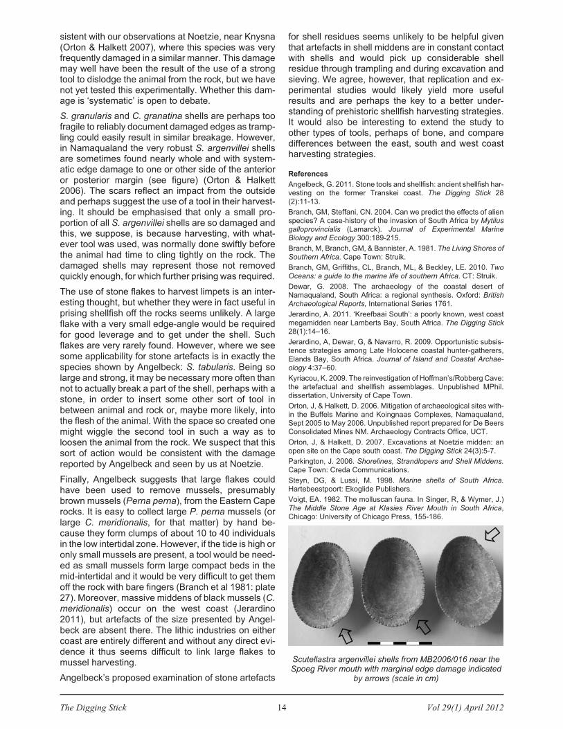
sistent with our observations at Noetzie, near Knysna(Orton & Halkett 2007), where this species was veryfrequently damaged in a similar manner. This damagemay well have been the result of the use of a strongtool to dislodge the animal from the rock, but we havenot yet tested this experimentally. Whether this dam-age is ‘systematic’ is open to debate.
S. granularis and C. granatina shells are perhaps toofragile to reliably document damaged edges as tramp-ling could easily result in similar breakage. However,in Namaqualand the very robust S. argenvillei shellsare sometimes found nearly whole and with system-atic edge damage to one or other side of the anterioror posterior margin (see figure) (Orton & Halkett2006). The scars reflect an impact from the outsideand perhaps suggest the use of a tool in their harvest-ing. It should be emphasised that only a small pro-portion of all S. argenvillei shells are so damaged andthis, we suppose, is because harvesting, with what-ever tool was used, was normally done swiftly beforethe animal had time to cling tightly on the rock. Thedamaged shells may represent those not removedquickly enough, for which further prising was required.
The use of stone flakes to harvest limpets is an inter-esting thought, but whether they were in fact useful inprising shellfish off the rocks seems unlikely. A largeflake with a very small edge-angle would be requiredfor good leverage and to get under the shell. Suchflakes are very rarely found. However, where we seesome applicability for stone artefacts is in exactly thespecies shown by Angelbeck: S. tabularis. Being solarge and strong, it may be necessary more often thannot to actually break a part of the shell, perhaps with astone, in order to insert some other sort of tool inbetween animal and rock or, maybe more likely, intothe flesh of the animal. With the space so created onemight wiggle the second tool in such a way as toloosen the animal from the rock. We suspect that thissort of action would be consistent with the damagereported by Angelbeck and seen by us at Noetzie.
Finally, Angelbeck suggests that large flakes couldhave been used to remove mussels, presumablybrown mussels (Perna perna), from the Eastern Caperocks. It is easy to collect large P. perna mussels (orlarge C. meridionalis, for that matter) by hand be-cause they form clumps of about 10 to 40 individualsin the low intertidal zone. However, if the tide is high oronly small mussels are present, a tool would be need-ed as small mussels form large compact beds in themid-intertidal and it would be very difficult to get themoff the rock with bare fingers (Branch et al 1981: plate27). Moreover, massive middens of black mussels (C.meridionalis) occur on the west coast (Jerardino2011), but artefacts of the size presented by Angel-beck are absent there. The lithic industries on eithercoast are entirely different and without any direct evi-dence it thus seems difficult to link large flakes tomussel harvesting.
Angelbeck’s proposed examination of stone artefacts
for shell residues seems unlikely to be helpful giventhat artefacts in shell middens are in constant contactwith shells and would pick up considerable shellresidue through trampling and during excavation andsieving. We agree, however, that replication and ex-perimental studies would likely yield more usefulresults and are perhaps the key to a better under-standing of prehistoric shellfish harvesting strategies.It would also be interesting to extend the study toother types of tools, perhaps of bone, and comparedifferences between the east, south and west coastharvesting strategies.
References
Angelbeck, G. 2011. Stone tools and shellfish: ancient shellfish har-vesting on the former Transkei coast. The Digging Stick 28(2):11-13.
Branch, GM, Steffani, CN. 2004. Can we predict the effects of alienspecies? A case-history of the invasion of South Africa by Mytilusgalloprovincialis (Lamarck). Journal of Experimental MarineBiology and Ecology 300:189-215.
Branch, M, Branch, GM, & Bannister, A. 1981. The Living Shores ofSouthern Africa. Cape Town: Struik.
Branch, GM, Griffiths, CL, Branch, ML, & Beckley, LE. 2010. TwoOceans: a guide to the marine life of southern Africa. CT: Struik.
Dewar, G. 2008. The archaeology of the coastal desert ofNamaqualand, South Africa: a regional synthesis. Oxford: BritishArchaeological Reports, International Series 1761.
Jerardino, A. 2011. ‘Kreefbaai South’: a poorly known, west coastmegamidden near Lamberts Bay, South Africa. The Digging Stick28(1):14–16.
Jerardino, A, Dewar, G, & Navarro, R. 2009. Opportunistic subsis-tence strategies among Late Holocene coastal hunter-gatherers,Elands Bay, South Africa. Journal of Island and Coastal Archae-ology 4:37–60.
Kyriacou, K. 2009. The reinvestigation of Hoffman’s/Robberg Cave:the artefactual and shellfish assemblages. Unpublished MPhil.dissertation, University of Cape Town.
Orton, J, & Halkett, D. 2006. Mitigation of archaeological sites with-in the Buffels Marine and Koingnaas Complexes, Namaqualand,Sept 2005 to May 2006. Unpublished report prepared for De BeersConsolidated Mines NM. Archaeology Contracts Office, UCT.
Orton, J, & Halkett, D. 2007. Excavations at Noetzie midden: anopen site on the Cape south coast. The Digging Stick 24(3):5-7.
Parkington, J. 2006. Shorelines, Strandlopers and Shell Middens.Cape Town: Creda Communications.
Steyn, DG, & Lussi, M. 1998. Marine shells of South Africa.Hartebeestpoort: Ekoglide Publishers.
Voigt, EA. 1982. The molluscan fauna. In Singer, R, & Wymer, J.)The Middle Stone Age at Klasies River Mouth in South Africa,Chicago: University of Chicago Press, 155-186.
Scutellastra argenvillei shells from MB2006/016 near theSpoeg River mouth with marginal edge damage indicated
by arrows (scale in cm)

Vol 29(1) April 2012 15 The Digging Stick
In north-eastern Botswana there is a pair of small,but in their time perhaps regionally important Zim-babwe-type ruins near the confluence of the Limpopoand Lotsane (formally spelt Lotsani) rivers (Fig. 1).Built in close proximity, the two separate ruins prob-ably represent temporary distinct structures. Eachconsists of an arc of dry-stone walling with roundeddoorways and internal compartments (Fig. 2). Theyare built of blocks of the local gneiss and are typical ofthe stonewalled structures built in the Shona Statesthat once dominated southern central Africa.
The Lotsane sites have not been excavated, so it isdifficult to provide definitive dates. In the literaturethere is disagreement amongst experts as to theiraffiliation and age. Van Waarden (1998: 126-127)places them in the Zimbabwe Period (AD 1300 to1450), while Huffman and Hanisch (1987) advocate alater date, suggesting that they belong to the KhamiPeriod (AD 1450 to 1600). The characteristic free-standing walls at Lotsane would seem to support theformer suggestion, although the presence of somehuts constructed on low stone platforms (most espec-ially at the larger Lotsane Ruin A), as well as a singlesherd decorated with polychrome lines seen by usduring a visit in January 2005, would favour the latter.Unfortunately this small sherd is not truly diagnosticand it could just as easily be assigned to the Letsibogofacies of the Moloko Branch of the Urewe Tradition(Huffman 2007) and be unassociated, indicating laterreuse of the site. Until there is a full investigation wemust leave this matter in abeyance.
The purpose of this article is twofold. Firstly, it bringstogether some of early misplaced historical comment-ary on these ruins; all too often analyses of the so-called ‘Zimbabwe Debate’ focus on Great Zimbabwealone. Secondly, it considers several photographicpairs that permit us to see the extent of structuralfailure in these ruins over a period of 115 years.
Historical commentary
The Lotsane Ruins were, after Great Zimbabwe, oneof the first Zimbabwe-type structures regularly com-mented upon by European travellers in the 19th cen-tury. As with Great Zimbabwe there was contestationas to their origin. Most Europeans advocated anexotic derivation, citing various affiliations accordingto personal preference, knowledge and/or whatothers had said. These erroneous conclusions reflect-ed the general colonial ethos that rejected African
ability and heritage.
The earliest of the Lotsane reports were those ofRhodes’ Pioneer Column. These men encounteredthese strange structures during their march north tooccupy Mashonaland in 1890. The following are diaryentries made at the time, which can be found in theHistorical Manuscripts Collection, National Archivesof Zimbabwe, Harare:
1. ‘We are now temporarily about 200 yards from an
ancient fort which is not even known by the natives as
THE LOTSANE RUINS IN EASTERN BOTSWANA
Rob S Burrett and Mark Berry
Rob Burrett is an archaeologist residing in Bulawayo, [email protected]
Mark Berry is a retired environmentalist living on MmbolelaMmabolela in Swartwater, South Africa. [email protected]
Fig. 1: Location of the Lotsane Ruins
Fig. 2: Recent plans of the Lotsane ruins, modified afterHuffman and Hanisch (1987)

The Digging Stick 16 Vol 29(1) April 2012
to the origin. It is supposed to have been erected by
some old Matabele as his monument’ (NAZ – MISCWA 6/1). The ‘natives’ mentioned by JP Walker werea band of local ‘bushmen’ who were living nearby atthe time. It is likely that they were totally at a loss as towhat to say to this group of domineering Europeansoldiers, and their reference to the Ndebele (Mata-bele) reflects contemporary concerns rather than anyreal knowledge about the origins of the ruins. It isinteresting that Walker suggests an African origin –colonial interpretations were not always hegemonicand dismissive as some post-colonial historians mayimply.
2. ‘There are the ruins of an old fort – said to be
Portuguese but look Moorish to me. There are a good
number of graves about’ (NAZ-BI 3/1/1). The authorwas an educated, widely travelled ex-member of theRoyal Navy (see also Tyndale-Biscoe 2006). With hisbackground he was probably aware of early Portu-guese activities in southern Africa. We are uncertainas to what he meant by graves; possibly he wasreferring to nearby scattered stone piles, accumu-lations of suitable building material or field clearancerather than actual graves.
3. ‘It was here that I examined my first ancient,dry-stone walled ruin, further examples of which wewere to discover at other places along our route. Theflat, grey granite (sic) blocks, squared off to approx-imately the size of an ordinary brick, though wider andflatter, were laid in level courses without the aid ofmortar. They were obviously very old, though no onereally knew how old, or what their origin was. For myown part I originally thought that they were probablyMoorish, although I accepted they may possibly havebeen Phoenician. One school of thought expressedthe belief that they were Portuguese, but having seenmany old Portuguese buildings in Moçambique, whichwere all built with mortar, I could not subscribe to thisview. … Among the ruins we found some pieces ofbroken pottery which we kept. We were very proud ofour finds until the experts told us that they wereprobably only pieces of pots left there by natives whohad been camping on the site’ (Davies 1977:35-36).Like the previous author this diarist, HF Hoste or’Skipper’ Hoste was an educated naval man. It is likelythat he had extensive discussions with Tyndale-Biscoe as they were close friends. That obviousartefactual evidence was dismissed in favour of pre-conceived interpretations that exclude any Africaninvolvement is telling. It would be interesting to knowhow these sherds were recovered. Did they excavateat the sites and, if so, where?
4. ‘At one place we came to three ruined forts, built by
some ancient inhabitants of the country, probably
Arabs’ (Brown 1899:70). A collector for various Ameri-can institutions, ’Curio’ Brown was an officer in thePioneer Column of the British South Africa Company(BSACo). It is interesting that he refers to three ruinedstone forts. There is indeed a third structure in the
area, although some distance apart.1 Like the otherauthors there is an automatic assumption that thesewere defensive positions, drawing from an Euro-centric perspective. His reference to Arab buildersrather than ’moors’ reflects his American background.
A short time later the same structures were investi-gated and mapped by RMW Swan, a British anti-squarian. He first came to the region as part of partyled by Theodore Bent that was invited by CecilRhodes and was sponsored by the BSACo, the RoyalGeographical Society and the British Association forthe Advancement of Science (Bent 1892:4). His mapof the smaller Lotsane (Ruin B in Fig. 2) appears inFig. 3. ‘… about 800 yds from the left bank of the
Lostani river its confluence of the Limpopo river.
These ruins stand on two little Knolls of diorite, which
presents a rough broken surface; and they are about
200 yds apart. Like Zimbabwe they are built of little
blocks of granite which are laid in level courses. I was
unable to make a plan of both of them, as one was
much overgrown by bush, so I devoted the few hours
at my disposal to making a careful plan of No. 1. As
will be seen at a glance at the plan the outer wall
consists of a single curve, and this curve is most
carefully executed on the outer face of the wall. … The
ends of the wall at E and F are rounded and well
finished, and there is no evidence that it ever
extended beyond these points; the extremely rocky
nature of the ground behind G renders it almost
certain that the temple was never a complete
enclosure’ (Swan 1897: 2-3)
Swan, following the conclusions of his former leader,JT Bent (1892:228), suggested that the ruins were
1 A local resident, Mr Roy Young, remembers once seeing a smallsection of walling called ’Tuli Ruins’ on a neighbouring farm (pers.comm. 23/1/2005).
Fig. 3: The smaller Lotsane Ruin after Swan(1897, Plate 1)

Vol 29(1) April 2012 17 The Digging Stick
traces of some lost Near Eastern civilisation, being ofSemitic origin from the Arabian Peninsula although herejected any associations with the biblical Queen ofSheba and King Solomon.
Shortly after Swan’s account, Hall & Neal (1904)published their detailed account of all the knownZimbabwe-type stone ruins in the region. Althoughtheir interpretations are wrong, their facts as tolocation and features are generally sound and inmany cases the best we have before later treasurehunters looking for gold artefacts wrought havoc atthe sites. Their entry, which draws fully on that ofSwan, reads: ‘Near the junction of Lotsani andLimpopo Rivers. These ruins comprise two distinctsets of buildings. Messrs Bent and Swan state thatboth these ruins are orientated towards the settingsun. All the characteristics of the first Zimbabweperiod architecture are present here, including thebattering back on both sides of main walls, which haverounded ends and are built in very regular courses.The holes in side walls of the doorways, similar tothose at Zimbabwe, are now thought to have beenmade during a later period. These ruins arementioned by Mr Bent, and are described by earlypioneers’ (Hall & Neal 1904:329).
We cite these early historical commentaries not be-cause we believe they are correct, but to encourageresearchers and academics to consider ruins otherthan Great Zimbabwe when analysing the so-called’Zimbabwe Debate’. The early European travellersexhibited a diverse range of reactions when facedwith the ruined structures. To them they were myster-ious features, seemingly remote in the heart of theAfrican bush – they had to be exotic despite allobvious signs to the contrary. Most were simplyunable to credit it to local African initiative so they didnot bother to ask. This mirrored the arrogance andracial stereotyping of the period. It also justified theirown activities. The creation of the myth was not some-thing devised by those in ultimate power; conspira-torial efforts of the likes of Cecil Rhodes, as somehave tended to suggest. It is true that Rhodes maywell have perpetuated the stories, but he alone cannotbe fingered as the source.
Also, not all Europeans held to these falsehoods.Some accepted an African origin, but their voiceswere soon drowned out. The monolithic conspiracytheory that has come to dominate the nationalist andrevisionist histories of Zimbabwean archaeologyunder the guise of ’Patriotic History’ (Ranger 2004) issimplistic. There was no single white, Rhodes-inspired plan to subvert history for immediate eco-nomic gain. This fable is easily created and beaten.Rather, we call for a more nuanced approach thatanalyses individual reaction to the ruins. Yes, themajority of these early writers and those that havefollowed were wrong, but we need to analyse thereasons behind what they said. By so doing we mayalso achieve greater understanding of similar dis-
agreements in contemporary interpretations, bothpublic and academic. These equally reflect personal,national, ethnic, gender and class-based bias.
A century of decay
Figs 4 and 5 show the same scene 115 years apart.The older photo was taken by William Ellerton Fry(1891), the official photographer for Rhodes’ PioneerColumn in 1890. This photo shows the smaller Lot-sane B ruin from the west. The more recent photo-graph was taken in 2005. You will excuse our effortsto re-enact the human postures!
The prevailing vegetation, dominated by acaciaspecies, is not much different. Possibly there is a littlemore small scrub and a lot less grass with moreexposed surfaces. This bush encroachment probablyreflects the greater cattle grazing pressure thatprevails today. As regards the structure, the walls area little lower today, the upper courses having fallen orbeen thrown off. At the point marked with an arrowpossibly five courses of stones appear to have gone.This may be attributed to foraging animals, especiallythe much blamed baboon, but is also likely to reflecthuman action. Certainly at the larger Lotsane A ruin
Fig. 5: The smaller Lotsane Ruin in 2005 from about thesame position as the photo taken by Fry
Fig. 4: The smaller Lotsane Ruin 1890 after Fry (1891)

The Digging Stick 18 Vol 29(1) April 2012
the deposit has been dug over and large sections ofwall have been destroyed.
We believe that this reflects the close proximity ofthese ruins to the old Pioneer trail, as well as morerecent visitors still seeking treasure. Inherent struc-tural weak points, especially at the entrances, havealso continued to collapse, reducing the remainingsection of walling further. Whether we should inter-vene and reconstruct the walls using the old photo-graph, or let nature take its toll is a debatable point.Have we the right, what would be the purpose andshould visitors be encouraged? Thankfully we are notthe designated heritage managers so are not respon-sible for such decisions. Our only hope is that the sitewill not be destroyed completely with time as it wouldbe a shame to loose these two ruins that are some ofthe most southerly known in the Zimbabwe Culture.
References
Bent, JT. 1896. The Ruined Cities of Mashonaland: being a record
of excavation and exploration in 1891 (3rd
edit.). London: Long-mans, Green & Co. [Facsimile reprint 1969, Bulawayo: Books ofRhodesia (Rhodesiana Reprint Library 5)].
Brown, WH. 1970. On the South African Frontier: adventure and
observations of an American in Mashonaland and Matabeleland.London: Sampson Low, Marston & Co. [Facsimile reprint 1970,
Bulawayo: Books of Rhodesia (Rhodesiana Reprint Library 12)].
Davies, NS. 1977. Gold Fever. Salisbury: Pioneer Head.
Fry, WE. 1891. Occupation of Mashonaland. [Facsimile reprint1982, Bulawayo: Books of Zimbabwe].
Hall, RN, and Neal, WG. 1904. The Ancient Ruins of Rhodesia(Monomatapae Imperium) (2
ndedit.). London: Methuen & Co.
[Facsimile reprint 1972, Bulawayo: Books of Rhodesia (Rho-desiana Reprint Library 23)].
Huffman, TN, and Hanisch, EOM. 1987. Settlement hierarchies inthe Northern Transvaal: Zimbabwe ruins and Venda history. AfricanStudies 46(1):79-116.
Huffman, TN. 2007. Handbook to the Iron Age: the archaeology ofpre-colonial farming societies in Southern Africa. Scottsville:University of KwaZulu-Natal Press.
Ranger, TO. 2004. Nationalist historiography, patriotic history andthe history of the nation: the struggle over the past in Zimbabwe.Journal of Southern African Studies 30(2):215-234.
Swan, RMW. 1896. On the orientation and measurements ofZimbabwe ruins. In JT Bent, The Ruined Cities of Mashonaland:being a record of the excavation and exploration in 1891(3
rdedit.),
London: Longmans, Green & Co., 141-178. [Facsimile reprint 1969,Bulawayo: Books of Rhodesia (Rhodesiana Reprint Library 5)].
Swan, RMW. 1897. Some Notes on Ruined Temples in Mashona-land. The Journal of the Royal Anthropological Institute of GreatBritain and Ireland 26:2-13.
Tyndale-Biscoe, D. 2006. Sailor Soldier. Simson’s Town: publishedprivately by author.
Van Waarden, C. 1998. The later Iron Age. In Lane, P, Reid, A &Segobye, A. (eds), 1998, Ditswa Mmung: the archaeology ofBotswana, Gaborone: Pula Press, 115-160.
Ash traces at Wonderwork cave one million
years old
There is now evidence at Wonderwork cave in theNorthern Cape that hominins first began controllingfire at least a million years ago. If correct, the Wonder-werk discovery would push the earliest indisputablecontrolled use of fire back by about 300 000 years.The research is reported in the Proceedings of the
National Academy of Sciences.
Fire is difficult to pin down in the archaeological rec-ord. According to Michael Chazan of the University ofToronto, the oldest obvious hearths are just 400 000years old, although the remains of burned wood,stones and food at an Israeli site suggests thathominins were using fire 790 000 years ago. Someresearchers claim that changes to early homininanatomy hint that they began using fire to cook evenearlier than this, though the evidence is hotly con-tested. Molars shrank and skulls grew around 1,9 mil-lion years ago, which according to Richard Wranghamof Harvard University reflects the moment thathominins began cooking their food. As this requiresless chewing and digesting, the theory goes, it freedup energy to sustain a larger brain. But according toChazan, there is a huge discrepancy between thetiming of these changes in hominin anatomy and thearchaeological record of fire.
There are no obvious hearths in Wonderwerk cave,but when Chazan and Boston University’s FrancescoBerna and Paul Goldberg used microscopic analysis
to study the sediments on the cave floor, they foundevidence of ash and burnt bone in layers that formed amillion years ago. The burnt remains are 30 m fromthe present entrance to the cave. According toChazan, it is likely that hominins – probably Homoerectus, because of the stone tools found at the cave– carried fire into the cave. ‘There’s no evidence tosuggest they were creating fire. I think they were mak-ing occasional and opportunistic use of natural wild-fires.’ The burnt bone fragments, including bits of tor-toise bone, suggest but do not prove that H. erectuswas cooking food, he adds.
The new study is not final proof of Wrangham’s cook-ing hypothesis, though. Chazan points out that thetiny traces of fire in the cave stand in contrast to theextensive ash deposits from fire found in much latersites of human occupation. That suggests H. erectus
was not using fire regularly, or routinely cooking food,despite its small teeth and large brains.
New Scientist, 02 April 2012
City older than Troy found in Dardanelles
Scientists from Canakkale (Dardanelles) Universityhave found traces of a lost city buried under thewaters of the Dardanelles Strait. The discovery ofceramics and pottery led to a 7 000-year-old city onthe sea floor at the Aegean entrance of the strait nearthe European shore. It is believed that the civilizationson the shores of the Dardanelles and Bosphorusstraits were buried under water. nationalturk.com, 26/09/11
ARCHAEOLOGY IN AFRICA

Vol 29(1) April 2012 19 The Digging Stick
France and South Africa share a long history ofcollaboration in the field of archaeology, palae-ontology and palaeoanthropology, ranging from as farback as the early 20th century when the Abbé Breuilwas visiting his South African colleagues till today’smajor collaborative works at several palaeontological(Swartkrans, Sterkfontein and Bolt’s Farm in theCradle of Humankind) and archaeological sites(Blombos, Sibudu and Diepkloof, just to mention afew). This collaboration has yielded important papersin both South African and international journals(Backwell & d’Errico 2003; d’Errico et al. 2001;d’Errico & Henshilwood 2007; Gommery et al. 2008a,2008b; Henshilwood et al. 2002a, 2002b, 2009;Mourre et al. 2010; Porraz et al. 2008; Texier et al.2010; Villa et al. 2005).
With this long tradition in mind we decided to instigatea modest student exchange project between SouthAfrica and France in 2010. The main objective wouldbe to allow students from Wits and Cape Town univer-sities to discover aspects of research conducted inFrance, as well as gaining insight into the rich archae-ological and palaeontological heritage of south-westFrance. The project also had the aim of providingFrench students with a glimpse into some of theresearch conducted in South Africa. Ultimately, wehoped that this project would help to weave linksbetween the students of both countries to facilitatefurther scientific discussion, exchange and collabor-ation.
Project sequence
The first part of the project was an exchange betweenFrench and South African delegates in the form of oralpresentations and discussions at the DepartemantPréhistoire, Paléeoenvironnement et Patrimoine(PPP) at the University of Bordeaux. The SouthAfrican group consisted of eight students, three MSCand four PhD students from Wits’ Bernard PriceInstitute of Palaeontological Research and one MSCstudent from the Department of Archaeology at theUniversity of Cape Town, and a researcher from Wits’Institute of Human Evolution (Dr Job Kibii).
Each of of us gave an oral presentation about ourresearch project and six PhD students from Bordeauxdid the same. Researchers from the PPP, including DrAnne Delagnes, Prof. Francesco d’Errico, Dr Jacques
Jaubert, Dr Arnaud Lenoble, Dr Michel Lenoir, DrPierre-Jean Texier and Dr Anne-Marie Tillier, alsopresented their research and talked about how theirresearch in palaeontology, archaeology and palaeo-anthropology is conducted. The talks tackled variousdisciplines, including palaeontology, taphonomy,geology, palaebotany, palaeoecology, stone toolindustries, rock art, funerary practices, functionalanthropology and palaeoanthropology. The SouthAfrican delegates toured the facilities of the PPP,including the laboratories that host state-of-the-artequipment, including a luminescence and isotopicdating laboratories, optical microscopy, etc.
The second half of the project was undertaken in theDordogne Valley in and around the town of Eyzies-de-Tayac. Dr Alain Turc, curator of cultural heritage andassistant head of the National Museum of Prehistoryopened the doors of two of the key-sites for under-standing the Middle and Upper Palaeolithic in south-west France, the rock shelters of Moustier andFerrassie. They gave us an overview of the historicalbackground and archaeological significance of thesites. We visited the National Museum of Prehistoryand the Rouffignac and Fond-de-Gaume rock art cavesites.
Benefits and future perspectives
The symposium permitted people from both countriesworking on similar research questions to interact andstart a constructive scientific relationship, and allowedstudents to expand their horizons and look towardsforming collaborations with foreign researchers. Onepotential post-doc project involving a PhD studentfrom the BPI and a researcher in Bordeaux is currently
A STUDENT EXCHANGE PROJECT BETWEEN
FRANCE AND SOUTH AFRICA
Aurore Val
Aurore Val is a PhD candidate at the Bernard Price Institute forPalaeontological Research, School of Geosciences, University ofthe Witwatersrand, and a Doctoral student at Laboratoire PACEA-UMR 5199 CNRS, University of Bordeaux in France. [email protected]
Michel Lenoir of thePPP Department,
University ofBordeaux, showing
some stone toolknapping on local flint

The Digging Stick 20 Vol 29(1) April 2012
under discussion. Two other PhD students have alsomet researchers from Bordeaux who were interestedin further collaboration. The student from Cape Townwas already in touch with a PhD student in Bordeauxbefore this project took place, and the meeting gavethem an opportunity to discuss their common re-search questions and plan a joint paper .
Given the feedback we received from those we met itseems that the project had very positive outcomes,both in terms of personal experience and professionalinterest. We would like to repeat the experience in2013, but this time with students from University ofBordeaux visiting South Africa. The project would beorganized in the same way.
Acknowledgements
This project was supported financially by the Trans-Vaal Branch ofthe SA Archaeological Society, the French Embassy in SouthAfrica, the University of the Witwatersrand and the FSDIE (Fondsde solidarité et de développement des initiatives étudiantes) at theUniversity of Bordeaux. Thank you to Brigette Cohen for her prec-ious help during the writing up of this paper.
References
Backwell, L, and d’Errico, F. 2003. Additional evidence on the earlyhominid bone tools from Swartkrans with reference to spatialdistribution of lithic and organic artefacts. South African Journal of
Science 99: 259-267.
d’Errico, F, Backwell, LR, and Berger, LR. 2001. Bone tool use intermite foraging by early hominids and its impact on our under-standing of early hominid behaviour. South African Journal of
Science 97: 71-75.
d’Errico, F, and Henshilwood, CS. 2007. Additional evidence forbone technology in the southern African Middle Stone Age. Journal
of Human Evolution 52: 142-163.
d’Errico, F, Backwell, LR, and Wadley, L. 2012. Identifying regionalvariability in Middle Stone Age bone technology: the case of SibuduCave. Journal of Archaeological Science (in press).
Gommery, D, Senegas, F, Thackeray, JF, Potze, S, Kgasi, L,Claude, J, and Lacruz, R. 2008a. Plio-Pleistocene fossils fromFemur Dump, Bolt’s Farm, Cradle of Humankind World HeritageSite. Annals of the Transvaal Museum 45: 67-76.
Gommery, D, Thackeray, JF, Sénégas, F, Potze, S, and Kgasi, L.2008b. The earliest primate (Parapapio sp.) from the Cradle ofHumankind World Heritage site (Waypoint 160, Bolt’s Farm, SouthAfrica). South African Journal of Science 104, 9-10: 405-408.
Henshilwood, CS, d’Errico, F, Marean, CW, Milo, RG, and Yates, R.2002a. An early bone tool industry from the Middle Stone Age atBlombos Cave, South Africa: implications for the origins of modernhuman behaviour, symbolism and language. Journal of Human
Evolution 41: 631-678.
Henshilwood, CS, d’Errico, F, Yates, R, Jacobs, Z, Tribolo, C,Duller, GAT, Mercier, N, Sealy, JC, Valladas, H, Watts, I, andWintle, AG. 2002b. Emergence of modern human behaviour:Middle Stone Age engravings from South Africa. Science 295:1278-1289.
Henshilwood, CS, d’Errico, F, and Watts, I. 2009. Engraved ochresfrom the Middle Stone Age levels at Blombos Cave, South Africa.Journal of Human Evolution 57: 27-47.
Mourre, V, Villa, P, and Henshilwood, CS. 2010. Early use of pres-sure flaking on lithic artifacts at Blombos Cave, South Africa.Science 330: 659-662.
Porraz, G, Texier PJ, Rigaud, JP, Parkington, J, Poggenpoel, C andRoberts, DL. 2008. Preliminary characterisation of a Middle StoneAge assemblage preceding the ‘classic’ Howieson’s Poort complexat Diepkloof rock shelter, Western Cape Province, South Africa.South African Archaeological Society Goodwin Series 10: 105-121.
Texier, PJ, Porraz, G, Parkington, J, Rigaud, JP, Poggenpoel, C,Miller, C, Tribolo, C, Cartwright, C, Coudenneau, A, Klein, R,Steele, T, and Verna, C. 2010. A Howiesons Poort tradition ofengraving ostrich eggshell containers dated to 60 000 years ago atDiepkloof Rock Shelter, South Africa. PNAS 107: 6180-6185.
Villa, P, Delagnes, A, and Wadley, L. 2005. A late Middle Stone Ageartefact assemblage from Sibudu (KwaZulu-Natal): comparisonswith the European Middle Paleolithic. Journal of Archaeological
Science 32: 399-422.
Villa, P, Soressi, M, Henshilwood, CS, and Mourre, V. 2009. TheStill Bay points of Blombos Cave (South Africa). Journal of
Archaeological Science 36(2): 441-460.
The South African participants at the University ofBordeaux: (fltr) Job Kibii, Aurore Val, Mickael Day, Brigette
Cohen, Joseph Chikumbirike, Joy Malaza, CuanHahndiek, Philip Taru, Alexandra Bountalis and
Kimberley Houghton
South African participants in front of the Font-de-Gaumecave
View of the stratigraphyat La Ferrassie,

Vol 29(1) April 2012 21 The Digging Stick
An exhibition of South Africa’s rock art on stampswas on display at the Howick Museum from March toSeptember 2011. Titled ’South African rock art onstamps: showcasing our cultural heritage’, it was aim-ed at school children, tourists and casual visitors asan initiative to feature the region’s local heritage.
The Howick Museum is situated close to the HowickFalls, which are a popular tourist destination and thetown is the hub of the KwaZulu-Natal Midlands, anarea that includes the foothills of the Drakensberg andis therefore a gateway to the rock art of the Drakens-berg, including the public sites at Giant’s Castle andKamberg. The exhibition took account of the needs ofthe large numbers of school groups that visit the smallmuseum. South African stamps featuring rock art andthe archaeological subjects of Mapungubwe and theLydenburg Heads have close connections with var-ious national symbols, which are part of the primaryschool curriculum. Rock art also forms part of the highschool visual arts syllabus and the exhibition providedteachers with material in this regard. The captions tothe exhibition were translated into Zulu and madeavailable as notes for teachers.
The exhibition was mounted by printing large colourreproductions of stamps, other postal materials andillustrations on A1 sheets, which is more effective thandisplaying the small stamps themselves. To context-ualise the stamps, the displays showed pictures of theoriginal art in situ, explained how rock paintings andengravings are copied using various techniques, andpointed out features of the final design of the stamps.The captions stressed the importance of protectingrock art and the legal controls that are in place.
The illustrations included portraits of San people androck art scholars who have contributed to our under-standing of the art, and pointed out how the art repro-duced on some of the stamps had been selected toillustrate aspects of interpretation. One panel showedthe use of rock art in the logos of SA sports teams andon stamps commemorating South Africa’s partici-pation in international events (Fig. 1). Another illus-trated how paintings on the Linton Panel have beenused both on stamps and on the national coat of arms(Fig. 2). Unusual items included two stamps of SouthAfrican rock art issued by Guinea Bissau, a ’flyttkort’(change-of-address postcard) featuring SA art issuedby the Swedish post office, and Telkom telephonecards with copies of paintings made by Harald Pager.Some rock art stamps from neighbouring countrieswere also included for comparative purposes.
The exhibition was opened by archaeologist GavinWhitelaw of the KwaZulu-Natal Museum in Pieter-maritzburg. Shortly after it had opened, the KwaZulu-Natal Provincial Museums Service requested a dup-licate of the entire exhibition for installation at the FortAmiel Museum in Newcastle as part of the MuseumsService’s International Museums Day activities inJune. The original exhibition was moved to anotherhall to become a semi-permanent exhibition in theHowick Museum. In March 2012 it was borrowed bythe KwaZulu-Natal Museum as a temporary exhibitionto accompany a presentation that I gave to theFriends of the Museum.
I curated the exhibition using stamps and other postalmaterials from my collection that is kept in the RockArt Research Institute at the University of theWitwatersrand. The exhibition panels were designedby Greg Moore of the uMngeni Municipality. I amgrateful to the Curator of the Howick Museum, ClaireAdderley, for her support. A paper on the subjectmatter of the exhibition will be published in the journalCritical Arts in September 2012.
Fig. 1 (right): Miniaturesheet issued to mark
South Africa’sparticipation in
the World PhilatelicExhibition in China
in 1999
Fig. 2 (below): Figuresfrom the Linton Panel ona stamp issued in 2006.The one on the left is theone that was incorporatedin the new South African
coat of arms in 2000.
ROCK ART STAMP EXHIBITION IN KWAZULU-NATAL
Elwyn Jenkins
Elwyn Jenkins is Emeritus Professor of English Studies at theUniversity of South Africa. He lives in Howick, [email protected]
2012 subscriptions
Subscriptions for existing members were due on 31March 2012. If you have not yet renewed, please doso now.
Individuals Institutes
Ordinary (Single) R245 South African R480Joint (Family) R255 African R480Junior Member R190 Overseas* R950African Ordinary R270Overseas Ordinary R480*
*Plus R100 for bank charges
Payments should be made to the Cape Town headoffice. See panel on page 24.
ASAPA members please note
Members of ASAPA are reminded that they areeligible for a substantial discount on their ASAPAmembership if they also enrol as a member of the SAArchaeological Society.
WORLD ARCHAEOLOGY
Seafaring in the Aegean: new dates
Seafaring before the Neolithic, circa 7th millenniumBC, is a controversial issue in the Mediterranean.However, evidence from different parts of the Aegeanis gradually changing this. The site of Ouriakos on theisland of Lemnos tentatively dates to the end of thePleistocene and possibly the beginning of theHolocene, circa 10 000 BC. A team from the Labor-atory of Archaeometry, University of the Aegean onRhodes, and the Ephorate of Palaeo-anthropologyand Speleology of Southern Greece suggests thatobsidian sources on the island of Melos in theCyclades could also have been exploited earlier.Studies of material from Franchthi cave in the Argolidindicate Melos as its origin. Obsidian has been apreferred material for stone tools. It absorbs watervapour when exposed to air, such as when a tool isshaped, and absolute or relative dates can bedetermined for that event by measuring the depth ofwater penetration
Two routes for the obsidian found at Franchthi havebeen considered: a direct one of around 120 km withislets in between and another one through Attica,which includes crossings of 15 to 20 km betweenislands. The presence of obsidian in mainland andisland sites indicates that these voyages includedsuccessful return journeys. Sites in Ikaria, Sporades,and on Kythnos demonstrate that during the Meso-lithic a well established system of obsidian exploit-ation and circulation existed, a phenomenon that hasits routes even earlier, as dates from sites in Atticaindicate. Furthermore, obsidian artefacts haverecently been found in two other Mesolithic sites inGreece, one in the island of Naxos and the other one
in the small island of Halki. Exchange systemstherefore brought obsidian to the eastern and thenorth-west Aegean, and even reached coastal inlandsites of mainland Greece such as Attica. Obsidianwas also brought to the Peloponnese.
Journal of Archaeological Science, Volume 38 (9), 2011
Vast find of ancient Buddha statues in China.
Some 2 895 ancient Buddha statues have beenunearthed in China‘s Hebei province, highlighting theBuddhism’s popularity since it spread from India over2 000 years ago. The statues and fragments datingback to the Eastern Wei and Northern Qi period (534-577) were found at historic Yecheng, Linzhang. Theyare made of white marble and blue stone and someare painted or gilded. Their sizes range from 20 cmlong to the actual height of a person. First Post, 05/03/12
The Digging Stick 22 Vol 29(1) April 2012
THE DIGGING STICK
An advertising opportunity for you?
The Digging Stick appears three times a year inApril, August and December. In recent years itssize has increased to 24 pages, its content hasimproved significantly and colour has beenintroduced. Apart from featuring short andreadable articles on new archaeological finds andadvances in southern Africa, it also carries briefnotes on major archaeological developmentsaround the world.
The Digging Stick is the pre-eminent magazine forthose who have an interest in South Africa’s pre-history and historic development. Its readership isinfluential, knowledge-seeking and well-travelled.The magazine is circulated to over 1 000 mem-bers of the Society, around 90 per cent of whomreside in South Africa; the remainder are indivi-duals and institutions located in Africa and over-seas. Generally readers fall in the 40 to 70-yearage group.
The Digging Stick offers an opportunity toadvertise to this very specific readership category.Have you considered The Digging Stick as an
advertising medium for services you may beoffering, or for the company or institution withwhich you are connected? The advertising ratesare reasonable, ranging from R330 for a one-eighth page black and white, R610 for a quarterpage B/W to R1 865 for a full page B/W. Colouradvertisements can also be placed at a low extracost. Loose inserts cost R1 865 for the first A4page.
If you would like to receive a complete schedule ofadvertising rates and production informationplease contact the editor, Reinoud Boers, [email protected]. za or telephone 011 803 2681.

Vol 29(1) April 2012 23 The Digging Stick
Ancient dinosaur nursery found
A 190-million-year-old dinosaur nesting site has beenfound in sedimentary rocks from the Early JurassicPeriod in the Golden Gate Highlands National Park inthe Free State. Canadian palaeontologist at theUniversity of Toronto, Professor of biology RobertReisz led a study entitled Oldest known dinosaurian
nesting site and reproductive biology of the Early
Jurassic sauropodomorph Massospondylus, pub-lished in Proceedings of the National Academy of
Sciences. Dr Adam Yates of the Bernard PriceInstitute (BPI) for Palaeontological Research at Witsco-authored the study with Drs Hans-Dieter Sues(Smithsonian Institute, USA) and Eric Roberts (JamesCook University).
The study reveals clutches of eggs, many withembryos, as well as tiny dinosaur footprints that,provide the oldest-known evidence that the hatchlingsremained at the nesting site long enough to at leastdouble in size. BPI director, Professor Bruce Rubidge,commented that the research project, which had beenongoing since 2005, continued to produce ground-breaking results. ‘First it was the oldest dinosaur eggsand embryos, now it is the oldest evidence of dinosaurnesting behaviour.’
According to the authors, the dinosaur nesting groundis more than 100 million years older than previouslyknown nesting sites. At least ten nests have beendiscovered at several levels at this site, each with upto 34 round eggs in tightly clustered clutches. Thedistribution of the nests in the sediments indicates thatthese early dinosaurs returned repeatedly to this siteand likely assembled in groups to lay their eggs, theoldest known evidence of nesting site fidelity andcolonial nesting behaviour in the fossil record.
The large size of the mother (6 m in length), the smallsize of the eggs (about 6 to 7 cm in diameter) and thehighly organised nature of the nest suggests that themother may have arranged them carefully after shelaid them. ‘The eggs, embryos and nests come fromthe rocks of a nearly vertical road cut only 25 m long,’says Reisz. ‘Even so, we found ten nests, suggestingthat there are a lot more nests in the cliff, still coveredby tons of rock. We predict that many more nests willbe eroded out in time.’
The site has previously yielded the oldest knownembryos belonging to Massospondylus, a relative ofthe giant, long-necked sauropods of the Jurassic andCretaceous periods. ‘Even though the fossil record ofdinosaurs is extensive, we actually have very littlefossil information about their reproductive biology,particularly for early dinosaurs,’ said David Evans,curator of Vertebrate Palaeontology at the RoyalOntario Museum. ‘This amazing series of 190-million-year-old nests gives us the first detailed look at
dinosaur reproduction early in their evolutionaryhistory, and documents the antiquity of nestingstrategies that are only known much later in thedinosaur record.’ Wits Communications, 09/02/2012
Klasies cave engraving may be oldest art
An ochre pebble bearing a sequence of linearincisions dating back to about 100 000 yearsrecovered from Klasies River Cave on the Cape southcoast may be the world’s oldest engraving. The objectis described in the April issue of the Journal of
Archaeology. ‘Associated human remains indicatethat the engraved piece was made by Homo sapiens,’said co-author Riaan Rifkin of Wits’ Institute forHuman Evolution. Rifkin and colleagues Francescod’Errico and Renata Garcia Moreno performedextensive non-invasive analyses of the object andconclude that humans intentionally made the sub-parallel linear incisions on pebble.
‘Upon engraving the piece with a sharp lithicimplement, it is likely to have produced a markedlybright and dark red-maroon powder,’ Rifkin said. ‘Thedesign may therefore have been strikingly visibleshortly after it was produced.’ The pebble measuresabout 75 mm in length and contains a series of sevendeep, broad engraved lines and about 16 narrowerand somewhat shallower linear features. ‘The frag-ment is a remnant of a formerly semi-circular ochrepebble that likely contained a much more extensiveengraved design on its surface,’ Rifkin said. Ofparticular interest now is whether or not the engravermade the design with symbolic intent. Both linear andcrosshatch engraved patterns may have been com-mon thousands of years ago. Similar designs appearon engraved ochres from Blombos Cave and onostrich eggshell fragments found in the Diepkloof rockshelter on the west coast. Discovery News, 23/03/12
Twenty million-year-old ancestor
Ugandan and French scientists have discovered thepartial skull of a tree-climbing ape dated to around 20million years ago in Uganda‘s Karamoja region. It isthe first time a skull of a Ugandapithecus Major, aspecies named in 1950, has been found.
What makes this particular discovery special, DrMartin Pickford, a palaeontologist from the College deFrance in Paris, said ‘(was) its age, completeness,dimensions, excellent preservation of the teeth ...’Preliminary studies of the fossil showed that theherbivore had a head the size of a chimpanzee’s but abrain the size of a baboon’s. The skull was foundwithin volcanic ash that erupted between 19 and 20million years ago. www.pasthorizonspr.com, 24/08/11
ARCHAEOLOGY IN AFRICA

The Digging Stick 24 Vol 29(1) April 2012
ARCHAEOLOGY IN BRIEF
Acropolis of forgotten kingdom uncovered.
Archaeological excavations are underway at a hugesite in southern Cappadocia, Turkey, to uncover theancient but forgotten kingdom of Tuwana known untilnow only from hieroglyphic texts and several sourcesfrom the Assyrian Empire. It was a small buffer statebetween the Phrygian kingdom and the AssyrianEmpire. The site being excavated is known as KinikHoyuk. It dates to the beginning of the first millenniumBC and spans at least 24 ha. Southern Cappadociawas important as it controlled the Cilician Gates on theroute between Europe and Asia, one of the mostimportant junctions in the world during that period.Excavations were begun last year by the University ofPavia in Italy and New York University in collaborationwith Turkish universities. Geomagnetic surveys in2010 revealed particularly significant remains of anacropolis wall and buildings at the centre of theacropolis itself. The monumental walls have beenexcavated to a depth of 6 m and are in an outstandingstate of preservation. Original plaster has been foundon the walls. ANSAmed, 10/02/12
Oldest animal discovered. Microscopic, sponge-likeAfrican fossils could be the earliest known animalsand possibly our earliest evolutionary ancestors. Thecreature, Otavia antiqua, was found in 760-million-year-old rock in Namibia. ‘The fossils are about the sizeof a grain of sand and we have found many hundredsof them,’ said study leader Anthony Prave, a geologistat the University of St Andrews in the UK. ‘In fact,when we look at thin sections of the rocks, certainsamples would likely yield thousands of specimens.Thus, it is possible that the organisms, possibly thefirst muti-cellular animal, were very abundant.’
Prior to the new discovery, the previous earliestknown ‘metazoan’ animals with cells differentiatedinto tissues and organs was another primitive spongedated to about 650 million years ago. Based on wherethe new fossils were found, Prave thinks Otavia livedin calm waters, including lagoons and other shallowenvironments, feeding on algae and bacteria thatwere drawn through pores on its tube-like body. Asreported in the South African Journal of Science thefossil record indicates Otavia survived at least twolong-term, severe cold periods known as ‘snowballEarth’ events. The organism did not evolve much in itsroughly 200 million years of existence.
National Geographic News, 07/02/12
World’s oldest wood. Two 400-million-year-old fos-sil plants, small herbs from France and Canada, arethe oldest known examples of wood found to date.Both fossils date from the early Devonian period, bywhich time simple plants had long colonised the landand begun diversifying. Trees did not evolve until±385 million years ago. Science 333 (August 2011), 837
The South AfricanArchaeological Society
This is the society for members of the public andprofessionals who have an interest in archaeology andrelated fields such as palaeontology, geology andhistory. Four branches serve the interests of members.They arrange regular lectures and field excursionsguided by experts, annual and occasional symposia, andlonger southern African and international archaeologicaltours.
The Society was founded in 1945 to promote archae-ology through research, education and publication. It is anon-profit organization – Registration No. 024-893-NPO.
Cape Town head office: PO Box 15700, Vlaeberg,8018. Tel: +27 (0)21 712 3629. Fax: +27 (0)866 155 [email protected]. www.archaeologysa.co.za.
Trans-Vaal Branch: PO Box 41050, Craighall, 2024Membership Secretary: Mrs Pamela Küstner
012 365 [email protected]
Western Cape Branch: PO Box 426, Muizenberg, 7950Chairperson: Ms Yvonne Viljoen
021 788 [email protected]
KwaZulu-Natal Branch:c/o Natal Museum, P/Bag9070, Pietermaritzburg, 3200
Secretary: Ms Barbara Dunn031 209 [email protected]
Trans-!Gariep Branch: David Morris053 839 [email protected]
The Society produces the following publications:
�South African Archaeological Bulletin, ascientific publication of current research in southernAfrica – twice a year
�The Digging Stick, the Society’s general interestmagazine – three issues a year
�Goodwin Series, an occasional publication on aspecific field of archaeological interest
Subscription rates for 2012 are as follows: Individuals:Single – R245; Joint/Family – R255; Junior membership– R190; Africa ordinary – R270; Overseas ordinary –R480*. Institutions: Local and African – R480; Overseas– R950*. [* Plus R100 bank charges]
The Digging Stick
Editor and advertising: Reinoud BoersPO Box 2196, Rivonia, 2128Tel/fax: 011 803 2681Cell: 082 566 [email protected]
Layout: Marion BoersPrinter: TVaal Johannesburg