the aqueducts of ancient rome by evan james...
TRANSCRIPT
THE AQUEDUCTS OF ANCIENT ROME
by
EVAN JAMES DEMBSKEY
Submitted in fulfilment of the requirements for the degree of
MASTER OF ARTS
in the subject
ANCIENT HISTORY
at the
UNIVERSITY OF SOUTH AFRICA
SUPERVISOR: DR. M.E.A. DE MARRE
CO-SUPERVISOR: DR. R. EVANS
February 2009

2
Student Number 3116 522 2
I declare that
The Aqueducts of Ancient Rome is my own work and that all the
sources I have used or quoted have been indicated and acknowledged by
means of complete references.
..........................
SIGNATURE
(MR E J DEMBSKEY)

ACKNOWLEDGEMENTS
I would like to express my sincere gratitude and appreciation to:
My supervisors, Dr. M. De Marre and Dr. R. Evans for their positive
attitudes and guidance.
My parents and Angeline, for their support.
I’d like to dedicate this study to my mother, Alicia Dembskey.
Contents
LIST OF FIGURES . . . . . . . . . . . . . . . . . . . . . . . . . . v
LIST OF TABLES . . . . . . . . . . . . . . . . . . . . . . . . . . . vii
1 INTRODUCTION 1
1.1 Introduction . . . . . . . . . . . . . . . . . . . . . . . . . . . . 1
1.2 Objectives . . . . . . . . . . . . . . . . . . . . . . . . . . . . . 6
1.3 Conclusion . . . . . . . . . . . . . . . . . . . . . . . . . . . . 7
2 METHODOLOGY 11
2.1 Introduction . . . . . . . . . . . . . . . . . . . . . . . . . . . . 11
2.2 Conclusion . . . . . . . . . . . . . . . . . . . . . . . . . . . . 16
3 SOURCES 19
3.1 Introduction . . . . . . . . . . . . . . . . . . . . . . . . . . . . 19
3.2 Literary evidence . . . . . . . . . . . . . . . . . . . . . . . . . 20
3.3 Archaeological evidence . . . . . . . . . . . . . . . . . . . . . 29
3.4 Numismatic evidence . . . . . . . . . . . . . . . . . . . . . . . 30
3.5 Epigraphic evidence . . . . . . . . . . . . . . . . . . . . . . . 32
3.6 Conclusion . . . . . . . . . . . . . . . . . . . . . . . . . . . . 37
4 TOOLS, SKILLS AND CONSTRUCTION 39
4.1 Introduction . . . . . . . . . . . . . . . . . . . . . . . . . . . . 39
4.2 Levels . . . . . . . . . . . . . . . . . . . . . . . . . . . . . . . 39
4.3 Lifting apparatus . . . . . . . . . . . . . . . . . . . . . . . . . 43
4.4 Construction . . . . . . . . . . . . . . . . . . . . . . . . . . . 46
4.5 Cost . . . . . . . . . . . . . . . . . . . . . . . . . . . . . . . . 51
i

4.6 Labour . . . . . . . . . . . . . . . . . . . . . . . . . . . . . . . 54
4.7 Locating the source . . . . . . . . . . . . . . . . . . . . . . . . 55
4.8 Surveying the course . . . . . . . . . . . . . . . . . . . . . . . 56
4.9 Construction materials . . . . . . . . . . . . . . . . . . . . . . 58
4.10 Tunnels . . . . . . . . . . . . . . . . . . . . . . . . . . . . . . 66
4.11 Measuring capacity . . . . . . . . . . . . . . . . . . . . . . . . 69
4.12 Maths . . . . . . . . . . . . . . . . . . . . . . . . . . . . . . . 70
5 ELEMENTS OF AN AQUEDUCT 71
5.1 Introduction . . . . . . . . . . . . . . . . . . . . . . . . . . . . 71
5.2 Water storage prior to the construction of the aqueducts . . . 71
5.3 Cippi . . . . . . . . . . . . . . . . . . . . . . . . . . . . . . . . 72
5.4 Channels . . . . . . . . . . . . . . . . . . . . . . . . . . . . . 72
5.5 Pipes . . . . . . . . . . . . . . . . . . . . . . . . . . . . . . . . 73
5.6 Bridges . . . . . . . . . . . . . . . . . . . . . . . . . . . . . . 73
5.7 Substructio . . . . . . . . . . . . . . . . . . . . . . . . . . . . 77
5.8 Siphons . . . . . . . . . . . . . . . . . . . . . . . . . . . . . . 78
5.9 Dropshafts . . . . . . . . . . . . . . . . . . . . . . . . . . . . . 81
5.10 Castellum . . . . . . . . . . . . . . . . . . . . . . . . . . . . . 81
5.11 Piscinae . . . . . . . . . . . . . . . . . . . . . . . . . . . . . . 84
5.12 Naumachiae . . . . . . . . . . . . . . . . . . . . . . . . . . . . 85
5.13 Taps . . . . . . . . . . . . . . . . . . . . . . . . . . . . . . . . 85
5.14 Conclusion . . . . . . . . . . . . . . . . . . . . . . . . . . . . 86
6 ROMAN AQUEDUCTS 87
6.1 Introduction . . . . . . . . . . . . . . . . . . . . . . . . . . . . 87
6.2 Rome and its environs . . . . . . . . . . . . . . . . . . . . . . 88
6.3 Early history of the aqueducts . . . . . . . . . . . . . . . . . . 94
6.4 Administration of the aqueducts . . . . . . . . . . . . . . . . 97
6.5 Aqua Appia . . . . . . . . . . . . . . . . . . . . . . . . . . . . 101
6.6 Aqua Anio Vetus . . . . . . . . . . . . . . . . . . . . . . . . . 106
6.7 Aqua Marcia . . . . . . . . . . . . . . . . . . . . . . . . . . . 109
ii

6.8 Aqua Tepula . . . . . . . . . . . . . . . . . . . . . . . . . . . 114
6.9 Aqua Julia . . . . . . . . . . . . . . . . . . . . . . . . . . . . 117
6.10 Aqua Virgo . . . . . . . . . . . . . . . . . . . . . . . . . . . . 118
6.11 Aqua Alsietina . . . . . . . . . . . . . . . . . . . . . . . . . . 120
6.12 Aqua Claudia . . . . . . . . . . . . . . . . . . . . . . . . . . . 121
6.13 Aqua Anio Novus . . . . . . . . . . . . . . . . . . . . . . . . . 128
6.14 Aqua Traiana . . . . . . . . . . . . . . . . . . . . . . . . . . . 131
6.15 Aqua Alexandrina . . . . . . . . . . . . . . . . . . . . . . . . 133
6.16 Water distribution . . . . . . . . . . . . . . . . . . . . . . . . 134
6.17 The later history of the aqueducts . . . . . . . . . . . . . . . 134
6.18 Rome’s minor and missing aqueducts . . . . . . . . . . . . . . 138
6.19 The aqua that never was . . . . . . . . . . . . . . . . . . . . . 143
6.20 Conclusion . . . . . . . . . . . . . . . . . . . . . . . . . . . . 143
7 RESEARCH PROBLEMS 145
7.1 Introduction . . . . . . . . . . . . . . . . . . . . . . . . . . . . 145
7.2 Access to literature . . . . . . . . . . . . . . . . . . . . . . . . 145
7.3 Access to the material remains . . . . . . . . . . . . . . . . . 147
7.4 Complexity of the undertaking . . . . . . . . . . . . . . . . . 148
7.5 Isolation . . . . . . . . . . . . . . . . . . . . . . . . . . . . . . 148
7.6 Conclusion . . . . . . . . . . . . . . . . . . . . . . . . . . . . 150
8 CONCLUSION 151
8.1 Introduction . . . . . . . . . . . . . . . . . . . . . . . . . . . . 151
8.2 Role in the decline of the empire . . . . . . . . . . . . . . . . 152
8.3 Marcus Agrippa: unsung water-man . . . . . . . . . . . . . . 156
APPENDICES 160
A The seven hills of Rome 161
B The fourteen regions 163
C Tables 167
iii

D Maps, figures and illustrations 175
Bibliography 195
iv

List of Figures
D.1 1472 map of Rome . . . . . . . . . . . . . . . . . . . . . . . . 175
D.2 Aqua Claudia . . . . . . . . . . . . . . . . . . . . . . . . . . . 175
D.3 Rome’s Aqueducts . . . . . . . . . . . . . . . . . . . . . . . . 176
D.4 Rome . . . . . . . . . . . . . . . . . . . . . . . . . . . . . . . 177
D.5 Water supply and population . . . . . . . . . . . . . . . . . . 177
D.6 Marcia Denarius - reverse . . . . . . . . . . . . . . . . . . . . 178
D.7 Marcia Denarius - obverse . . . . . . . . . . . . . . . . . . . . 178
D.8 Denarius ”Gens” Marcia . . . . . . . . . . . . . . . . . . . . . 178
D.9 Traiani Sestertius . . . . . . . . . . . . . . . . . . . . . . . . . 178
D.10 The seven hills of Rome . . . . . . . . . . . . . . . . . . . . . 179
D.11 Environs of Rome . . . . . . . . . . . . . . . . . . . . . . . . . 180
D.12 Porta Maggiore . . . . . . . . . . . . . . . . . . . . . . . . . . 181
D.13 Aqueduct model . . . . . . . . . . . . . . . . . . . . . . . . . 182
D.14 Crossection of a typical Roman aqueduct . . . . . . . . . . . 183
D.15 Chorabates . . . . . . . . . . . . . . . . . . . . . . . . . . . . 183
D.16 Dioptra . . . . . . . . . . . . . . . . . . . . . . . . . . . . . . 184
D.17 Groma . . . . . . . . . . . . . . . . . . . . . . . . . . . . . . . 184
D.18 Tomb of Lucius Aebutius Faustus . . . . . . . . . . . . . . . . 185
D.19 Siphon . . . . . . . . . . . . . . . . . . . . . . . . . . . . . . . 186
D.20 Clay pipes in the Claudia . . . . . . . . . . . . . . . . . . . . 186
D.21 Porta Praenestina . . . . . . . . . . . . . . . . . . . . . . . . 187
D.22 Porta Praenestina . . . . . . . . . . . . . . . . . . . . . . . . 188
D.23 Aqua Alsietina . . . . . . . . . . . . . . . . . . . . . . . . . . 188
D.24 Aqua Julia . . . . . . . . . . . . . . . . . . . . . . . . . . . . 189
D.25 Aqua Tepula . . . . . . . . . . . . . . . . . . . . . . . . . . . 189
v

D.26 Aqua Virgo . . . . . . . . . . . . . . . . . . . . . . . . . . . . 190
D.27 Aqua Claudia and Anio Novus Castellum . . . . . . . . . . . 190
D.28 Aqua Claudia and Anio Novus . . . . . . . . . . . . . . . . . 191
D.29 Aqua Claudia . . . . . . . . . . . . . . . . . . . . . . . . . . . 192
D.30 Aqua Claudia . . . . . . . . . . . . . . . . . . . . . . . . . . . 192
D.31 Old Anio . . . . . . . . . . . . . . . . . . . . . . . . . . . . . 193
D.32 Aqua Antonio . . . . . . . . . . . . . . . . . . . . . . . . . . . 193
D.33 Aqua Caracall . . . . . . . . . . . . . . . . . . . . . . . . . . . 194
D.34 Cistern on the Marcia . . . . . . . . . . . . . . . . . . . . . . 194
vi

List of Tables
C.1 Selected modern place names . . . . . . . . . . . . . . . . . . 167
C.8 Timeline of selected events . . . . . . . . . . . . . . . . . . . . 169
C.2 Summary of major roman aqueducts . . . . . . . . . . . . . . 170
C.3 Aqueducts listed in the Curiosum, Notitia and Silvius . . . . 171
C.4 Table of lead pipe sizes . . . . . . . . . . . . . . . . . . . . . . 172
C.5 Number of castella . . . . . . . . . . . . . . . . . . . . . . . . 172
C.6 Most common sizes of calix listed by Frontinus . . . . . . . . 173
C.7 Regional distribution by aqueduct . . . . . . . . . . . . . . . 174
vii

Chapter 1
INTRODUCTION
1.1 Introduction
It is self-evident that all human settlements, whether a village, town or city,
need water for drinking, sanitation and agriculture. As Landels (2000:34)
states: ”Water supply represented one of the most serious problems for Greek
and Roman urban communities”. Three factors influence the amount of
water required, namely 1) the size of the population, 2) the use to which
water is put and 3) the efficiency of the water transport and distribution
system. A city like Rome, which had an estimated population of more than
a million in imperial times (for AD 226 and earlier), used huge amounts
of water for entertainments like the baths and naturally had water leakage
problems in their water distribution systems, therefore needed a copious
supply, more than the Tiber and local springs could provide. Indeed, even
during the early days of Rome, the Tiber was rarely used as a source for
potable water, as it had been polluted relatively early by waste from human
settlements (Heiken, Funiciello & De Rita, 2005:136)1. It is also likely that
the harbour facilities made it impractical to use the Tiber water in the
immediate vicinity 2. Rome solved the problem of supply by diverting water
from the volcanic highlands of the Alban Hills to the southeast, the Sabatini
1This is not accepted without debate. See Chapter 6.52This is a far more likely explanation.
1

volcanoes to the northwest and from the Apennine mountains in the north
and east (see Figure D.11). Rome is probably unique in the ancient world
in regards the quantity of water brought in. Strabo (5.3.8) tells us that
veritable rivers of water flowed through Rome. To quote:
So much, then, for the blessings with which nature supplies the
city... water is brought into the city through the aqueducts in such
quantities that veritable rivers flow through the city and the sew-
ers; and almost every house has cisterns, and service-pipes, and
copious fountains, with which Marcus Agrippa concerned himself
most...
Strabo is of course not referring to natural rivers, but to the artificial
rivers created by the hydraulic engineering skills of the Romans, known as
aqueducts, from the Latin aquae ductus, ”conveyance of water”. Indeed,
there is probably no monument to the hydraulic engineering of the ancient
world that compares with Roman aqueducts in terms of systemic complexity,
engineering and social- and environmental-impact. It can be argued that the
aqueducts were not only functional but also amongst the most pleasing and
satisfying of the ancient monuments. This was not missed by the practical
Roman mind. Pliny the Elder wrote:
... but if anyone will note the abundance of water skilfully
brought into the city, for public uses, for baths, for basins, for
house, runnels, suburban gardens, and villas; if he will note the
high aqueducts required for maintaining the proper elevation; the
mountains which had to be pierced for the same reason; and the
valleys it was necessary to fill up; he will consider that the whole
terrestrial orb offers nothing more marvellous.
Frontinus was even more effusive in his praise (1.16):
With such an array of indispensable structures carrying so many
waters, compare if you will, the idle Pyramids or the useless,
though famous works of the Greeks.
2

It is difficult to establish how many aqueducts the Romans built, the num-
ber usually estimated at between eleven and nineteen, but with most schol-
ars agreeing on the number eleven. In his The Aqueducts of Ancient Rome,
Thomas Ashby fixes the number at eleven, stating that the ”extra” aque-
ducts are branches and not separate aqueducts (Ashby, 1935. See Heiken,
Funiciello & De Rita, 2005:147 for commentary). These eleven aqueducts,
known as the major aqueducts, were built between 312 BC and AD 226. An
unknown number of minor aqueducts, although probably between eight and
twelve in number, may have been built during the same time. The evidence
is scant and inconclusive. The estimated total length of the major aque-
ducts is between 448 and 502 kilometres. The shortest aqueduct, Appia,
was only 16 kilometres long and the longest, the Marcia, was 91 kilometres
long. Hodge (2002:347) gives an estimated total output of 1,127,220 cubic
metres of water per day for the Roman aqueducts. One can deduce then,
that when the population may have been well over a million3 (see Figure
D.5 for a comparison of water supply and population density), the distribu-
tion system would have been able to provide more than one cubic metre4
of water per day for each inhabitant of the city of Rome. By comparison,
New York City consumes 5,550,000 million cubic metres of water per day
for six million inhabitants (not including commuters who work but do not
live in the city) (Elert, 2004). According to the Rand Water Board (2007:5),
they supply 3,550,000 million cubic metres of water to 11 million people in
Gauteng daily. Thus, both New York and Gauteng provide less than 1 cubic
metre of water per person per day. According to the evidence, the Roman
water supply exceeded this.5
3It is difficult to determine the number of Roman inhabitants. We have no idea of the
number of slaves in Rome, beyond the impression that they increased in number in Italy
during the last two centuries of the republic. Estimates are based on chance comments by
authors and the Roman census (Morley, in Rosenstein & Morstein-Marx, 2006:321). The
figures for those receiving the grain dole are particularly useful.4A cubic metre of water is 1000 litres of water.5Patterson, in Rosenstein & Morstein-Marx (2006:352), states that republican Rome’s
poor had poor access to potable water. In the late republic and empire this is not likely
3
A reliable water supply to the hub of the Roman world, both republic
and empire, is one of the many factors in its success and longevity. Without
a steady and reliable supply of water to animate the fountains, slake the
thirst, fill the baths and flush the toilets6 of the citizens of Rome, the wheel
of Empire would not have turned smoothly, and it can be argued that the
Romans would not have risen to the pre-eminent Western civilisation of the
time without it. While this was not a feature of any other empire, the Roman
empire was in many ways more complex than previous empires; it was larger,
more administratively complex, and endured for a longer time than most.
Even after the so-called fall of the empire, the city of Rome continued to
survive, and even thrive. Of course much of the water delivered to Rome
was not intended for use as potable water, but for entertainment7. By the
end of the 4th century A.D. Rome had eleven large public baths (thermae,
965 smaller bathhouses and 1,352 public fountains (Heiken, Funiciello & De
Rita, 2005:129). Each of these would no doubt require a minimum of several
thousand litres of water per day 8. Of the fountains and the quality of the
water, Galen wrote in 164 AD (Morton, 1966:31):
The beauty and number of Rome’s fountains is wonderful. None
emits water that is foul, mineralised, turbid, hard or cold.
While the focus of this study is on the aqueducts that supplied Rome,
by necessity occasional reference will be made to the aqueducts that pre-
date the Romans, and the aqueducts made by the Romans throughout their
empire. This serves to demonstrate the evolution of the aqueducts, and
to be true.6Hodge (2002:270) states that the public toilets may have been the commonest use of
aqueduct water in Rome.7It is interesting to contemplate the fact that many forms of technology that are de-
veloped for one purpose are often used by the entertainment industry.8A modest sized bath, 10 by 5 by 1.5 metres, would take 75 cubic metres of water
to fill. As this water was continuously replaced, daily use could exceed 150 to 225 cubic
metres per day rather easily. Some of the baths must have consumed water at orders of
magnitude greater than this.
4

allows for a comparison between practice at Rome and elsewhere in the
Roman world9. As with many aspects of Roman culture and technology,
the Greeks served as progenitors. Exploring these various aspects will give
a rounded account; the Roman aqueducts are not necessarily representative
of the hundreds of other aqueducts that were built, nor were they created
in a vacuum.
It is within this context that this study has been undertaken. The research
will include the technical aspects of aqueduct construction and maintenance.
The aqueducts in their political and social context is briefly examined. The
major events that made the construction of the aqueducts possible are anal-
ysed. For example, how the Roman conquest of Latium, Samnium, Campa-
nia and Etruria provided the stability and regional control that was needed
for the construction of the aqueducts. The view is put forward that the
development of the aqueducts to their neglect and ruin is a reflection of
the Roman world in miniature, the rise and fall of Roman hegemony. In
addition, a chapter will be devoted to reflection upon the research itself,
including an analysis of the problems and suggesting solutions for historians
when attempting research far removed from the subject of that research.
Construction, whether it be of roads, bridges, buildings or aqueducts re-
quires four elements: the higher authorities to make the initial decisions,
technical experts to put these into practice, material to build with and
labourers to do the actual work (O’Conner, 1993:36). So it must be born in
mind that when it is said that, for example, the censors10 Ap. Claudius and
C. Plautius built an aqueduct,11 it was not they that designed or physically
laboured on it. It means that he decided and directed (or was directed by
a higher authority) the construction of an aqueduct. Of course, this is not
9Rome adopted many innovations and improved on them, and in turn, these were
adopted in the provinces and beyond.10A censor’s duties included he administration of state finances, including the erection
of all new public works.11The Aqua Appia, 312 BC.
5

to imply that the person referred to did not have the technical competence
to build an aqueduct. Appius Claudius was an accomplished man, as were
most in positions of authority. After all, the Roman system did not allow
individuals to reach the highest ranks without prior training and experience.
Indeed, the cursus honorum, or political path, existed as early as the fourth
century BC, and may be one of the stabilising and progressive features of
the Roman political system.
1.2 Objectives
This thesis will examine the eleven main aqueducts that fed the city of
Rome; how they were made, what they were made of, when and how they
were repaired, the tools that were used to make them, the skills needed
to make them and how the prevailing political climate that existed at the
time influenced the construction of each aqueduct. As far as possible, the
distribution of water from each aqueduct will be examined, but this aspect
may be considered an insoluble problem (Evans, 1997:2).
One area that is often neglected in the study of Roman aqueducts is
the minor and ”missing” aqueducts in Rome. Ashby, in particular, makes
mention of many aqueducts that are known only by inscription. His source
seems to be the Notitia and the Curiosum (Ashby, 1935). Some of these refer
to aqueducts known by other names, or branches from major aqueducts, or
even minor waterways that barely warrant the name aqueduct. There are a
number, though, of which nothing is known. It is time to revive the study
of these, even if the goal is simply to begin the synthesis of the work of the
last 70 years into a single document.
To summarise the objectives:
• To discuss the technical aspects of Roman aqueduct construction
• To research the so-called minor Roman aqueducts
6

• To research the problem of the partial, but premature, collapse of the
Aqua Claudia
• To discover the prevailing political climate during the time each aque-
duct was constructed
• To reflect on the aqueducts as indicators of the health of the Roman
republic and empire, the argument being that the health of the aque-
duct system was a reflection of the health of the Roman state
• To reflect on the role of the aqueduct system in the decline of the
Empire
• To reflect on the research process itself
• To produce a list of important Roman aqueduct related inscriptions,
with CIL numbers when available
1.3 Conclusion
The importance of civil infrastructure to the Roman republic and empire is
a worthy subject of study. Where literature fails us, the enduring remains of
Roman engineering serve as a reminder of the grandeur that was Rome, and
simultaneously warns us that technology is not always the answer to social
problems, and that technology can fail and break when society lacks the
resources and will to maintain it. When a society has become accustomed
to a particular way of life, a cultural momentum or resistance to change is
created. When the technology fails, the society can fail too.
The thesis consists of the following chapters.
Chapter 2 deals briefly with the methodology employed in this study.
Chapter 3 deals with primary, secondary and material resources. The
evidence of the ancient authors will be examined, the opinions of modern
7

authors discussed and, when possible, the extant epigraphical, numismatic
and archaeological remains examined 12.
Chapter 4 deals with the tools, construction skills and surveying skills
used in Roman construction. It is worth noting that the majority of tools
are not unique to the construction of aqueducts, but are the common tools
that were employed by the Romans to build roads, bridges and buildings.
Related skills, such as mathematics, are covered in brief.
Chapter 5 examines the various elements used in the construction of aque-
ducts, including bridges, siphons, tunnels, cippi, settling tanks and so forth.
Not all of the elements are typical of Rome’s aqueducts, but some discussion
of each is included to build the argument that the Romans knew more about
hydraulic engineering than sometimes they are given credit for.
Chapter 6 discusses the 11 major Roman aqueducts and the evidence
for smaller and ”missing” aqueducts. This discussion will include water
source and quality, a brief history of each aqueduct, discussion of notable
elements and (as far as possible) the use and distribution of each aqueduct’s
water. The minor aqueducts are barely mentioned by the ancient sources,
and we rely almost exclusively on epigraphical and archaeological evidence,
especially the Curiosum and Notitia.
Chapter 7 reflects on the research process. The difficulties experienced by
researchers when the subject of their research is not at hand is a factor that
must be recognised and controlled for.
12As Evans (2005:37) points out, there is a danger of over-reliance on the written sources
instead of undertaking empirical research. With this in mind, and where possible the
remains of the Roman aqueducts will be considered. A study of the material remains may
illuminate many points that have otherwise been obscured by the ideology of the ancient
writers we so typically rely on.
8

Chapter 8 is the conclusion of the study. Recommendations for further
study will also be made.
The appendices contain maps, tables, the inscription reference, figures and
selected illustrations of sections of Roman aqueducts, tools and technological
artefacts.
9

10
Chapter 2
METHODOLOGY
2.1 Introduction
A strictly analytical approach will be used here. A consequence of this is the
acceptance that the historical process is not moving in any one direction,
towards any goal or end; there is no hidden pattern to be discovered. Ac-
cording to Windschuttle (1997:177) the task of the historian is not to search
for some theory that will reveal all, nor some teleology that will explain the
purpose of past events and things. Rather, the task is to reconstruct the
events of the past in their own terms. As historical events ”grow by force
of circumstances” (Fuller, 2003:122) and not through some coherent set of
laws, this discussion will not look for reason or meaning beyond that which
can be gleaned from the evidence. This does not mean that no analysis will
be performed, but rather that it will be constrained by the facts and will
not be driven by one ideology or another. The post-modern, relativist view
of history as a narrative that is situated for the purpose of making sense
of the world is firmly rejected in favour of the scientific method (Gross &
Levitt (1998), Stove (2006), Ellis (1990), Windschuttle (1997) and Kimball
(2002)). While it is true that history cannot be scientific in the sense that
it is subject to repeatable identical experiments under controlled conditions
(Bispham, in Rosenstein & Morstein-Marx, 2006:47), it can be scientific by
11
principle, by striving for objectivity and the empirical determination of facts.
Repeated literary analysis from different perspectives provide interesting in-
tellectual titbits which may illuminate some aspect of the point in space and
time in which the analysis was performed, it does not reveal anything defini-
tive about what actually happened. With this understanding, the basis for
this research will naturally begin the works of Frontinus and Vitruvius, and
then move to the evidence gleaned from other ancient authors, coins, archae-
ological remains and inscriptions. Due to logistical difficulties, inscriptions
will mainly be drawn from Corpus Inscriptionum Latinarum (CIL). This is
an especially important resource, as ready access to some material, such as
inscriptions and the aqueducts themselves, is not always possible. Similar
difficulties are faced when examining the numismatic evidence.
Middleton (1892a:17) classifies the sources of information available for the
study of Rome as follows.
• Classical writers
• Inscriptions, coins and other existing remains
• The regionary catalogues and other documents of the decadence and
middle ages
• Works from the fifteenth century to the 19th century
• Modern works
The major ancient literary sources for information on the aqueducts are
Vitruvius (1st century BC)1 and Frontinus (c. AD 34 - 104). A number of
other authors mention the aqueducts, but they are usually not of great depth
and are often derived from Vitruvius and Frontinus. One exception might
have been Pliny the Elder (AD 23/4 - 79) who makes interesting and original1As far as possible the Penguin Dictionary of Ancient History is used when dating
individuals. In the case of Roman Emperors, the span of their lives is shown, not of their
rule.
12

comments in his Natural History. Unfortunately, though interesting, Pliny is
not always reliable2, and most of his output is lost. The non-literary sources
consist of a great number of inscriptions, a few coins and the aqueducts
themselves. The aqueducts are actually remarkably revealing, and much
can be learnt by examining their ruins.
Where possible the material remains of the Roman aqueducts will be
considered. A study of the material remains may illuminate many points
that have otherwise been obscured by the ideology3 or ignorance of the
ancient writers (or modern) we so typically rely on. Alas, few modern writers
have the luxury of time and unlimited finances that would free them to
indulge in the years of work it would take for a thorough examination of the
remains. Thus a balanced approach between the remains, records thereof,
the ancient authors and modern authors must be attempted. A number of
visual works, such as those by Piranesi, offer interesting insights into the
ruins, especially after a century of radical urban change in Rome.
A small number of relevant coins were minted. These are useful artefacts
because they help corroborate evidence for dates, and may on occasion be
the only firm evidence for this purpose. They are also useful in helping
us assess ancient attitudes towards the aqueducts. These will be consulted
when practicable. However, this task will be given a low priority, as the coins
are rare and difficult to view, and no single source for this numismatic source
exists. In addition, coins from the Republican period are not as reliable as
coins from the Imperial period. This is due to the fact that there was less
central control of the issue, moneyers had more leeway in the republic.
The CIL is a comprehensive listing of most, if not all, the known classi-
cal Latin inscriptions. Volume six deals with inscriptions found within the2If Pliny the Younger is to be believed, Pliny’s judgement is likewise suspect; he died
while lingering to study the Vesuvian eruption.3See Bispham, in Rosenstein & Morstein-Marx (2006:30), for a discussion of idealogical
bias in ancient literature.
13

city of Rome itself, and so is an important work for reading the primary
source material without having to spend a number of years gathering it.
The L’Annee Epigraphique, published annually, is also a useful source. It
began as a supplement to CIL, serving as a central location for inscriptions
discovered or edited after the publication of the Corpus. The bulk of rele-
vant inscriptions are reproduced in modern works; however, CIL is useful in
that it preserves the look of the inscriptions.
By regionary catalogues, Middleton refers mainly to the Notitia and Cu-
riosum are lists of the chief buildings and monuments in each of the regions
of Augustus. They standard works were compiled in the fourth century.
While useful, they introduce new problems of interpretation.
With the revival of interest in classical civilisation in the fifteenth century
a number of books on the subject of the Eternal city were published. As
Middleton (1892a:24) states, these works are not remarkable for the scholar-
ship or power of accurate and critical research, but they are valuable to the
modern scholar both for the accounts of discoveries and their numerous il-
lustrations of buildings which have now either wholly or in part disappeared.
An example of this is a map from 1472 (see Figure D.1) shows a part of the
Arcus Caelemontani behind the Colosseum, which no longer exists. Sources
such as this are invaluable in reconstructing details.
There has been considerable interest in Roman aqueducts and therefore
there are a large number of modern books and papers on the subject, fore-
most being the work of Ashby, Van Deman, Evans and Hodge. As Evans
(1997:1) states, the work of Ashby and Van Deman will never be superseded,
because much of the physical evidence they documented has now been lost
as a result of Rome’s rapid expansion into the countryside after World War
II (and no doubt the war itself took some toll on the city). This makes it a
necessity to use these works.
14

Ashby has written or contributed to a number of standard works in the
field. The Aqueducts of Ancient Rome, though dated, is an invaluable work
which provides an excellent summary of our knowledge of the aqueducts
in the late 1930s. Until Hodge, this was the standard work on aqueducts,
and remains an extremely valuable work, especially considering Evans’ point
above. Ashby is for all intense purposes, the beginning of any undertaking
to research the Roman aqueducts. The Topographical Dictionary of An-
cient Rome by Samual Ball Platner and Ashby is an indispensable work;
it provides much information and many references that help the researcher
with all aspects of the study of aqueducts and other buildings in Rome.
Likewise, his The Roman Campagna in Classical Times is of great help in
understanding Rome’s water management in the days before aqueducts.
Richardson’s New Topographical Dictionary of Ancient Rome to some ex-
tent succeeds Platner and Ashby’s dictionary. The argument can be made
that both are required references when studying the city of Rome. Although
there is no substitute for actually examining the sites first hand, Nash’s Pic-
torial Dictionary of Ancient Rome goes some way towards understanding
the physical space when such luxury is unavailable.
No research can be conducted without reference to Roman Aqueducts and
Water Supply by Trevor Hodge. Hodge’s work is updates Ashby’s and an-
swers many of the questions left by the latter’s work thanks to the benefit of
almost a century of archaeological and historical research. The only short-
comings are perhaps its sparse attention to geological and historical detail.
Hodge’s bibliography is comprehensive, and serves as a good starting point
for research on aqueducts.
J.G. Landel’s Engineering in the Ancient World is considered canonical
by any researcher interested in the subject matter of Roman and Greek
engineering. Though he devotes only a single chapter to aqueducts, the
entire book provides a solid foundation for any study of Roman engineering.
15

Wasserversorgung im antiken Rom, compiled by the Frontinus-Gesellschaft,
is a modern treatment of the subject that complements the work of Hodge
and Ashby. Of especial interest is W. Eck’s Die Gestalt Frontins in ihrer poli-
tischen und sozialen Umwelt, which makes many illuminating points about
the world in which Frontinus lived, details that are missing in Hodge and
outdated in Ashby.
Raffaello Fabretti’s De aquis et aquaeductibus veteris Romae is an essen-
tial work, and provides some literary evidence found no where else. However,
this work may have to be treated with caution as Fabretti seems to make
sweeping statements without evidence to substantiate them.
Beyond these canonical works, there exists a wealth of books and journal
articles too numerous to mention individually, which will where relevant, be
incorporated in the discussions to follow. Further references to the aqueducts
in the ancient literature will be sought as a matter of course.
As to the issue of place names; within the text the most logical form of the
name will be used, i.e. either the modern or the Roman depending on the
context. A short table of place names, indicating the Roman and modern
names will be included in the appendices. As not all ancient Roman places
have been positively identified, the most likely candidate (if known) will be
indicated, with a note to indicate this fact.
2.2 Conclusion
The method followed in this thesis is to study the primary literature (in
translation), transcribed inscriptions and if possible, coins or coin illustra-
tions and material remains of the aqueducts themselves. Recourse is made to
photographs, etchings and paintings when these prove illuminating. Where
access to the remains is not possible, which it usually isn’t, standard ref-
erences will be used. Due to logistical constraints the luxury of examining
16

the remains will probably have to be forgone. The numismatic evidence is
unfortunately scant, and not without controversy. In addition, secondary
material will be referred to; the arguments of modern scholars are indis-
pensable. This is especially true when it is realised that a multi-disciplinary
approach is required when studying the Roman water system.
17

18

Chapter 3
SOURCES
3.1 Introduction
This chapter examines the surviving evidence for the aqueducts. This in-
cludes literary, numismatic and epigraphic evidence. When dealing with a
complex system such as the aqueducts of Rome in a remote time, it is ex-
pected that there will be gaps or inaccuracies in these sources. Thus, even
though the archaeological evidence has many gaps and mysteries, it will also
be considered.
When studying the topography of an ancient city that has been continu-
ously occupied for more than 2500 years the number and nature of problems
are many and complex. Most of the literary, numismatic and epigraphic ev-
idence is no longer extant. Of the material that is extant, the reliability is
variable and the interpretation often subjective. This is either because of
deficiencies in the original material, conflict between the original purpose
of the material and the purpose to which we wish to put it and through
transcription and translation error. The archaeological evidence is often no
longer extant, or altered in such a manner that poor data is retrieved, or
extant but inaccessible, perhaps due to proximity to modern buildings and
infrastructure or other right of way issues.
19

The best strategy would be to examine the extant ruins as far as possible,
and then fill in the gaps as far as possible from the literary evidence. This will
be better than the reverse, beginning with the literary material, because it
avoids to a large extent the problems caused by biased interpretations of the
literary material and erroneous beliefs caused by deficiencies in the literary
material. However, that approach is not without its own problems, as much
of the material is lost, and much of what remains is inaccessible.
3.2 Literary evidence
The major literary sources for information on the aqueducts are Vitruvius
(1st century BC) and Frontinus (c. AD 34 - 104). Vitruvius speaks in general
about Roman architecture1 and includes a chapter on aqueduct technology,
while Frontinus addresses the aqueducts of Rome specifically. A number of
other authors mention the aqueducts, but such mention is usually not of
great depth or usefulness and are usually derivative of Vitruvius and Fron-
tinus, but at least provide corroborative evidence. One exception, Pliny the
Elder (AD 23/4 - 79), whose wide field of interest and interesting and origi-
nal comments in his books Natural History provide much information from
other sources otherwise lost. As previously mentioned, Pliny is not always
a reliable source, and little of his corpus has survived. Indeed, early Roman
history is built on slender foundations. Roman history involved considerable
willingness to invent and embroider (Bispham, in Rosenstein & Morstein-
Marx, 2006:34). While making for enjoyable reading, this decreases the
usefulness of many texts.
The non-literary sources consist of a great number of inscriptions, a few
coins and the aqueducts themselves. The aqueducts are actually remarkably
revealing considering how little survives, and many facts can be determined
by examining their ruins. Some of these facts show that practice did not
1The definition of Roman architecture is broader than our own, and includes engineer-
ing and even sundials and clocks.
20
always mirror Vitruvius, and teach us not to take his word blindly.
Vitruvius
Vitruvius (fl. 1st century BC) was a Roman architect who worked for
both Caesar and Augustus, but the only building he mentions as his own is
a basilica at Fanum. Vitruvius does not seem to have had any connection to
the major works of his time, and his fame is derived entirely from his treatise
De Architectura in ten books, also known by its English title, On Architec-
ture. The De Architectura was probably written between 30 and 27 BC,
and possibly as late as and 23 BC (Aicher, 1995:7 and Landels, 2000:209).
Vitruvius is unknown to the authors of his day, so virtually everything we
know about him must be drawn from the De Architectura. Even his full
name is not known with certainty. The words Vitruvii de Architectura head
all the most reliable texts, and he is known simply as ”Vitruvius” to Pliny
and Frontinus. There is some evidence to suggest his cognomen may have
been ”Pollio”, from a single reference in a building manual from the early
third century known as De Diversis Fabricis Architectonicae by M. Cetius
Faventius. This is far from certain and not universally accepted (Plommer,
1973:1). The translation could refer to two authors called, the first being
Vitruvius and the second Pollio, and not one by the name of Vitruvius
Pollio. His praenomen is reported variously as Aulus, Lucius and Marcus.
Vitruvius was clearly a freeborn citizen, though probably not of equestrian
class. He claims that he was given a broad ”liberal arts” education (6.3.4)
as well as a professional education. His early adult life was probably spent
in the military. Indeed, Vitruvius was appointed, after Caesar’s death, to
be in charge of the construction and repair of catapults (Landels, 2000:209).
This was a responsible position not given lightly, and shines a positive light
on Vitruvius.
De Architectura is an example of a hybrid type of literature that was
common in the last century or the Republic. It is essentially a technical
21

handbook with literary pretensions (Hodge, 2002:14). Unlike many ancient
authors (especially historians), Vitruvius does not denigrate the work of
other authors but rather lavishes praise on them. The De Architectura is
one of many examples of Latin texts that owe their survival to the palace
scriptorium of Charlemagne in the early ninth century2. The mood of the
preface is one of the strongest reasons for dating the De Architectura to
the decade after Actium (31 BC). Vitruvius states that he is writing at
that particular time because Octavian had previously been occupied with
”Taking possession of the world.” (1.1). A period of peace had brought
about considerable building activity. Vitruvius wrote his text when, as he
put it, ”I perceived that you were solicitous ... for the construction of suit-
able buildings” (1.3). The De Architectura was not the major architectural
handbook of its day, but it’s clear Vitruvius was hoping it would be. The
books themselves are remarkably objective and comprehensive, though pre-
scriptive rather than descriptive. The importance of the De Architectura is
twofold. First, it is a rare survivor from a category that was once numerous
and important, the technical manual. Secondly, as Vitruvius’ definition of
an architect is wider than the modern definition, it gives us a good idea of
a wide variety of Roman engineering practices. Among interesting concepts
contained in the De Architectura, Vitruvius declares that quality depends on
the social relevance of the artist’s work, not on the form or workmanship of
the work itself. Vitruvius studied human proportions (third book) and his
system of human proportions were later encoded in a very famous drawing
by Leonardo da Vinci3. Indeed, the De Architectura was very influential in
the Renaissance. The 16th century architect Palladio considered Vitruvius
his master and guide, and made some drawings based on his. Despite the
praise heaped upon Vitruvius’ shoulders, it must be recalled that most of the
recommendations in the De Architectura were his, and not a true reflection
of actual Roman practice (see Middleton (1892) and Plommer (1973)).
2This activity of finding and recopying classical manuscripts is called the Carolingian
Renaissance.3Homo Vitruvianus
22

Hodge (2002:14) states that Book 8, the book that covered water engi-
neering, is perhaps Vitruvius’ worst book, and may have been an imperfect
summary from other, possibly Greek, sources. It is possible that Vitruvius
did not fully understand the material he copied. A reading of Book 8 par-
tially supports Hodge’s critique, but it is perhaps unfair to hold Vitruvius
to a technical standard so far above that of his contemporaries.
Vitruvius asserted that a structure must exhibit the three qualities of
firmitas, utilitas and venustas - that is, it must be strong or durable, useful
and beautiful or graceful (1.3.2). The aqueducts, being mostly underground,
usually do not exhibit venustas. However, when above ground, it can be
argued that they do. However, they perhaps do not show as much firmitas
as the Romans would have liked.
According to Plommer (1973:28), two later authors, Palladius Rutilius
Taurus Aemilianus and M. Cetus Faventinus, wrote books similar to Vitru-
vius’ books. However, they are mostly derived from Vitruvius; Faventinus
directly from Vitruvius and Palladius from Faventinus. Both of these au-
thors contain sections on aqueducts, but lack the grasp of Hellenistic science
that Vitruvius had. In both cases their works are technically poorer. Faven-
tius seems to show a decline not only from Hellenistic skills, but also from
Roman (Plommer, 1973:29). His addition of wood as a viable material for
aqueduct channel construction may also show a difference in the mindsets
between Vitruvius’ era and Faventinus’ era. Vitruvius, living in a more
optimistic and vigorous time, advocated building for the long term, while
Faventinus seems to have been more pessimistic and focussed on the short-
term.
While Palladius can easily be dismissed as a source, Faventinus may re-
ward a careful reading. He was perhaps a more experienced builder than
Vitruvius. He certainly seemed to have greater empirical knowledge of some
building materials, such as lime (Plommer, 1973:93). However, he seems
23

not to have studied outside his probable area of practical expertise. For ex-
ample, the laying of mosaic floors had advanced since Vitruvius’ time, but
Faventinus follows Vitruvius very closely (Plommer, 1973:99). This suggests
that Faventinus knew little of the actual craft.
Sextus Julius Frontinus
We know little of the Roman politician and engineer Frontinus (c. AD 34
- 104). His full name was Sextus Julius Frontinus, so he belonged to a family
of the Julii. Tacitus speaks of him as praetor urbanus in 70 AD, so we may
infer that he was born in approximately AD 34 or 35. He served under both
Nerva (c. AD 30 - 98) and Trajan (AD 53 - 117). In AD 70 he was city
praetor, and according to Tacitus (Hist. 4.39), Frontinus resigned this post.
He was appointed consul three times, first in 73/4, again in 98 4, and for a
third time in 100. As a governor of Britain (74-8) he subdued the Silures and
founded the legionary camp at Exeter. When appointed curator aquarum5
by Nerva in 96 he began a study of the Roman water supply6 that still
survives as The Aqueducts of Rome. He wrote a number of other books, but
only the Strategemata survives relatively intact. Various other fragments
do survive, usually as additions by other authors into their writings. His
writings on land surveying betray the teachings of the Alexandrian school of
mathematics, and it is possible that he was educated in that city. Vegetius
used Frontinus’ lost book on Greek and Roman warfare, but it is not clear
to what extent. It is not possible to say how long Frontinus held the office
of curator aquarum, but as he died in about AD 103 it is probable that he
held it for the remaining years of his life (see Landels, 2000:211 and Evans,
1997:53). Interestingly, Pliny the Younger (c. AD 61 -112), who succeeded
Frontinus as augur in AD 103, was Pliny the Elder’s nephew and adopted
son.
4As consul suffectus.5Essentially, the ”head of the water board”’6Only nine of the eleven major aqueducts had been built by the time Frontinus took
office
24

Though we know little of Frontinus, his personality emerges through his
work in no ambiguous fashion. He stands out as a proud and honourable
Roman devoted to his emperor and his duty charged with immense respon-
sibility. Martial gives us a picture of Frontinus spending his leisure days in
a pleasing environment (
textitEp. 62. See also 48). Pliny writes of appealing to him to help settle
a legal dispute. Several inscriptions mention Frontinus, one from Germany
dedicated by Julia Frontina, possibly his daughter. An inscription near
the Vetera Castra is dedicated to Jupiter, Juno and Minerva in recognition
and thanks for the recovery of Sextus Julius Frontinus from illness. A lead
pipe found near Via Tiburtina is inscribed SEXTIULIFRONTINI. Little
evidence, but perhaps enough to show that Frontinus was a well-respected
and important. Frontinus himself presents us with two contrasting images.
On one hand we have Frontinus the patrician, owning villas near the sea at
Formiae and Terracina. He followed the conventional career of the Roman
aristocrat, the cursus honorum. Then, having obtained the highest rank in
his early sixties, he took a totally different and, according to Landels, an
apparently less exalted commission. Frontinus points out that the health of
the whole urban community relied on the efficient management of the water
supply and that the office had been held by ”some of the most outstanding
men of the state”. It is possible that he was chosen because of his seniority,
which would have given him the authority to check corruption and raised
him above any need to be involved in it (Landels, 2000:212).
We do not know how long Frontinus held the office of curator aquarum,
but we do know that he became head of a commission of public expenditures
and consul suffectus in 98 AD. It is not likely that he was curator aquarum
for more than two to three years.
Frontinus was unusual in that he did not consider the technical details of
water engineering as beneath his dignity, as perhaps many Roman aristo-
crats would have done. His first action on becoming the curator aquarum
25

was to make a detailed personal inspection of the entire aqueduct system
and to compile his treatise on the essential technical details. The reason he
gives for doing so show him as a conscientious public servant and a shrewd
officer with the experience of commanding men. He wrote:
I have always made it my principle, considering it to be some-
thing of prime importance, to have a complete understanding of
what I have taken on. For I do not think there is any other surer
foundation for any kind of undertaking, or any other way of
knowing what to do or what to avoid; nor is there anything more
degrading for a man of self-respect than to have to rely on the
advice of subordinates in carrying out the commission entrusted
to him.
While Frontinus’ Aqueducts of Rome is a valuable repository of infor-
mation concerning Roman aqueducts, it is far more than that. It gives a
picture of a faithful public servant called to an office that had long been
plagued with abuse and corruption. Nerva and Trajan aimed to correct the
abuses that were rampant under the rule of Domitian (AD 51 - 96), and
they found in Frontinus a loyal champion of their reforms. He studied with
the spirit of a true investigator, displaying scrupulous honesty and fidelity.
It is Frontinus that gives us much of the statistical data usually cited on
the Aqueducts, though some of his figures are very doubtful (Scarre, 1999),
the method Frontinus used was always sound within the parameters of cur-
rent knowledge. It is probable that the only technical knowledge of water
engineering Frontinus had was derived from his own reading, mainly from
Greek authors who dealt with elementary principles, and perhaps from his
predecessor. However, his military experience, which included the command
of men, problems of finance, administration and logistics, would have pre-
pared him well for the task of handling a large organisation. The difficulties
of the office of the curator aquarum must have been considerable. The to-
tal length of the aqueduct system was almost 500 kilometres, and the total
26

labour force involved in the region of 700 slaves, overseers, reservoir-keepers,
stonemasons, plasterers, miners and others. His duties included renovation
of various parts of the system that had fallen into disrepair and maintenance.
In addition, he had to get back a number of the workforce that had been
taken off their proper work (due to bribes) and put onto odd jobs by private
individuals (Landels, 2000). Frontinus tells us that he also made a map of
the entire Roman aqueduct system, so that he could ”constantly have the
whole network before his eyes and take decisions as if I was actually there
on the spot.” Pliny has preserved for us a saying of Frontinus, which well
applies to the man himself, ”Remembrance will endure if the life shall have
merited it” (9.19.1, 6).
There are problems when using Frontinus that must be born in mind.
His statistics on water delivery are partial, dealing only with matters when
he was in office. Sometimes his figures are inconsistent. These are serious
considerations that make the task of researching the aqueducts all the more
difficult. Another issue is that Frontinus is selective. While his stated ob-
jective is the aqueducts of Rome, he does not cover aspects of aqueducts
that are found in other Roman aqueducts (Evans, 1997:53). For example,
siphons.
Other authors
The aqueducts are mentioned by a number of authors, such as Dio Cassius,
Martial and Suetonius, but usually only in passing. No technical details are
ever mentioned, but the information is useful in determining the course, po-
litical or social details and sometimes construction details of the aqueducts.
Dio Cassius
Dio Cassius (c. AD 163 - c. 235) was a Roman historian born in Nicaea
in Bithynia. He moved to Rome as a young man, and rose to the consulate
under Septimius Severus. His work, the Roman History, was written in
27

Greek and consisted of 80 books. According to Dio Cassius, it took 22
years to research and write them. They are still partially extant. He is
perhaps an underrated historian; his methods of research were meticulous
and he typically rejected the fantastic. He was typically pragmatic (Speake,
1994:206). In many ways Dio Cassius calls to mind Thucydides.
Martial
Martial (c. AD 40 - 104) was a Roman poet, born in Bilbilis. He was a
favourite amongst influential Romans. His most important work is the epi-
grams in 12 books. His contribution to the study of science and engineering
in the ancient world is marginal (Speake, 1994:399).
Pliny the Elder
Pliny the Elder has an active public life in Rome, and was a close associate of
Vespasian (Speake, 1994:504). His great curiosity resulted in a work entitled
Natural History. This is a summary of the scientific knowledge of the early
Empire. Though the book is marred by Pliny’s credulity and the low level
of science of the times, it is still a valuable work. Pliny’s great curiosity
killed him; he observed Vesuvius erupting and did not flee in time. He was
clearly an admirer of the Roman aqueducts. To quote (Nat. His., 36.123):
Now if someone shall carefully appraise the abundance of wa-
ter in public buildings, baths, pools, channels, houses, gardens
and suburban villas, the distance the water travels, the arches
which have been built up, the mountains tunnelled, and the level
courses across the valleys, he will acknowledge that nothing more
marvellous has ever existed in the whole world.
Pliny the Younger
Pliny the Younger’s Letters provide a window into Roman life as seen
through the eyes of a cultured gentleman of the Roman ruling class. His
28

work provides minimal evidence, but should not be dismissed, as it provides
useful corroborating evidence, and even at times revealing anecdotes which
are recorded nowhere else. It is probable that his Letters was written for
publication; perhaps he chose this format because his uncle had written so
much on so many diverse topics (Speake, 1994:505).
Suetonius
Suetonius (c. AD 69 - c. 140) was a Roman biographer and a close friend of
Pliny the Younger. Suetonius became Hadrian’s chief secretary. While he
had unparalleled access to people and sources, he seems to have concentrated
on royal scandals (Speake, 1994:608). Unfortunately, the bulk of his output
is lost, so we do not know if that was a characteristic of all of his work, or
just that which we have.
3.3 Archaeological evidence
The archaeological evidence for the Roman aqueducts is, of course, the aque-
ducts themselves. However, unlike Pompeii, Rome has been continuously
occupied since the construction of the aqueducts. Thus not only have the
forces of nature taken their toll on the remains, but human activities too.
The aqueducts have been plundered for building material, incorporated into
other buildings, been covered over, been ploughed over and wantonly de-
stroyed. In Evans’ words, the archaeological evidence is scanty (Evans,
1997:135).
The result of this is that it is impossible to reconstruct the whole of the
water system in Rome. All such efforts are at best educated guesses, with
no sure means of testing for accuracy. However, it is possible to eliminate
the impossible or extremely improbable, and thus narrow the range of pos-
sibilities.
29

As it is not always possible to examine the evidence first-hand, accounts
in the secondary literature must be relied upon instead. This presents its
own difficulties, as such accounts may be incomplete, may vary in quality,
may rely upon supposition instead of observation, may focus on aspects not
of relevance to this discussion and may contain faulty analysis.
However, there is some evidence that is only archaeological in nature. For
example, there are considerable traces of activity on the four aqueducts from
the Anio Valley, dated to the reigns of Hadrian and Septimius Severus. How-
ever, there is no literature or epigraphy that mentions the work of Hadrian,
and only a single fragment of an inscription (CIL 6.1247) that vouches for
the repairs on the Marcia by Septimius Severus (Ashby, 1935:14).
3.4 Numismatic evidence
There is very little numismatic evidence for the Roman aqueducts. Though
aqueducts on coins don’t provide much information, they are useful for dat-
ing purposes. However, there are a few coins of interest.
For example, one coin from 114/3 BC that has caused discussion has on
it’s obverse side the word ROM[A], which represents the head of a female
referring to Roma or Venus behind the neck a star with six rays, the value
sign for a denarius.7 On the reverse side an equestrian statue is shown on
a plateau supported by three arches isolated from its environment together
with the capitals MN[MANIVS]. AEMILI. LEP, the name of the moneyer
(See Figure D.6). In 1945 M. Stuart came to the conclusion that this im-
age was related to the aqueduct Aqua Marcia. This interpretation is not
completely accepted, though, as Crawford (1974:305) states, Stuart’s argu-
ments are stronger than the other arguments that have been put forward.
According to Livius the construction of a new aqueduct was started in 179
BC under supervision of the censors M. Aemilius Lepidus and M. Fulvius
7This coin is number 291 in Crawford (1974).
30
Nobilior. However, M. Licinius Crassus did not allow the aqueduct to cross
his property, which halted the project. In the year 144 BC and with the help
of a different M. Aemilius Lepidus, urban praetor Q. Marcius Rex received
the order of the Senate to restore the Aqua Appia and the Aqua Anio Vetus
and to build the third aqueduct. In 140 BC new objections were raised
for aqueduct water to reach the Capitolinus without success: in the same
year this new aqueduct, the Marcia, was put into use. This interpretation
seemingly solves the problem of the relative short time of construction of
an aqueduct of 92 km in length including 10 km on arcades. However, the
arguments of this author were rejected by M.G. Morgan who concluded that
the aqueduct line of 179 BC was never built (Kek, 1994:269).
Perhaps the most famous coin is the Marcia denarius, from 56 BC. On
the obverse side the word ANCVS, possibly a reference to the fourth king
of Rome, and on the reverse PHILIPPVS / AQUA MR can be seen.8 See
Figure D.8. The moneyer may be Q. Marcius Philippus, but opinion leans
towards it being L. Marcius Philippus (Crawford, 1974:448). The moneyer
honoured Q. Marcius Rex with this coin. The moneyer also belonged to the
Marcia family.
One period where coins are especially useful is that antedating Fronti-
nus. The aqueducts constructed after his time are poorly documented. For
example, one useful sestertius, dating from Trajan’s fifth consulship, dates
the construction of the Aqua Traiani to perhaps 109 A.D. The coin reads
on the obverse IMP CAES NERVAE TRAIANO AVG GER DAC P M TR
P COS V PP. The text on the reverse reads SPQR OPTIMO PRINCIPI
AQVA TRAIANA S C. with an image that can be interpreted in different
ways: the genius of the aqueduct, an image of the castellum aquae (the wa-
ter distribution station) at the end of this Roman aqueduct, or a collection
of general elements of the water supply of Rome (See Figure D.9).
8This coin is number 425 in Crawford (1974).
31

3.5 Epigraphic evidence
Inscriptions are an important source of information regarding the aqueducts
of Rome. In lieu of examining the original inscriptions, The Corpus Inscrip-
tionum Latinarum (CIL) is used, especially Volume 6. The most important
inscriptions in Volume 6 are 1243 - 1268.
There are some limitations in using epigraphic evidence. One such lim-
itation is that none of the inscriptions are earlier than the Augustan age
(Sandys, 1927:129). Another is that inscriptions where not always intended
to record fact; ancient politicians and emperors were well understood the
value of propaganda.
We will now examine some of the important extant inscriptions.
Porta Praenestina
Above the rough stones of the arches of the Porta Praenestina, or Porta
Maggiore, the smooth walls of the channels carries three inscriptions. The
top inscription is bordered above and below by stone slabs that project
from the roof and floor of the Anio Novus channel (Aicher, 1995:54). The
inscription reads (CIL 6.1256 ):
TI. CLAUDIUS DRUSI F. CAISAR AUGUSTUS GERMAN-
ICUS PONTIF. MAXIM., | TRIBUNICIA POTESTATE XII,
COS. V, IMPERATOR XXVII, PATER PATRIAE, | AQUAS
CLAUDIAM EX FONTIBUS, QUI VOCABANTUR CAERULEUS
ET CURTIUS A MILLIARIO XXXXV, | ITEM ANIENEM
NOVAM A MILLIARIO LXII SUA IMPENSA IN URBEM PER-
DUCENDAS CURAVIT.
This is a commemoration of the construction of the Claudia and Anio
Novus, in 52 AD, by the emperor Claudius, ”at his own expense”. It states
the sources for both, the former at the 45th milestone and the latter at the
32

62nd milestone. The second inscription is framed by horizontal mouldings
that extend the floor and roof of the Claudia conduit. It reads (CIL 6.1257 ):
IMP. CAESAR VESPASIANUS AUGUST. PONTIF. MAX.,
TRIB. POT. II, IMP. VI, COS. III DESIG. IIII, P.P., | AQUAS
CURTIAM ET CAERULEAM PERDUCTAS A DIVO CLAU-
DIO ET POSTEA INTERMISSAS DILAPSASQUE | PER AN-
NOS NOVEM SUA IMPENSA URBI RESTITUIT.
This commemorates Vespasian repairing the Claudia in 71 AD. Accord-
ing to the inscription, the Claudia had been in ruins for nine years. Such
a long interruption of the aqueduct after less than twenty years of use is a
mystery. Perhaps the problem was upstream of the Claudia’s junction with
the Anio Novus channel, as the inscription does not mention repair of or
damage to this aqueduct. The third and lowest inscription on the Porta
Maggiore is framed in a space below the two channels, giving the false im-
pression of a third channel below. The channel that can be seen there is in
fact the Acqua Felice, built in the 16th century. The inscription reads (CIL
6.1258 ):
IMP. T. CAESAR DIVI F. VESPASIANUS AUGUSTUS
PONTIFEX MAXIMUS, TRIBUNIC. | POTESTATE X, IM-
PERATOR XVII, PATER PATRIAE, CENSOR, COS. VIII |
AQUAS CURTIUM ET CAERULEAM PERDUCTAS A DIVO
CLAUDIO ET POSTEA | A DIVO VESPASIANO PATRE SUO
URBI RESTITAS, CUM A CAPITE AQUARUM A SOLO VE-
TUSTATE DILAPSAE ESSENT, NOVA FORMA REDUCEN-
DAS SUA IMPENSA CURAVIT
This was erected in honour of Titus restoring the Claudia in 81 AD, after
the aqueduct was ”ruined to its foundations from age”. The fact that such
restoration was required only a decade after the first repair raises questions
about the quality of the initial construction.
33

Porta Tiburtina
The Porta Tiburtina was originally a monumental aqueduct crossing. Later
it was made into a gate in the Aurelian Wall. The partitioning of the three
channels above the arch is very similar in design to Porta Maggiore. The
travertine facing of the middle channel shows the traces that the moulding
of this original archway formed a pediment here. Caracalla chiselled this off
for an inscription recording his restoration of the Marcia in 212 AD. There
are, like the Porta Maggiore, three inscriptions of interest here. The first
(CIL 6.1244 ):
IMP. CAESAR DIVI IULI F. AUGUSTUS | PONTIFEX
MAXIMUS COS. XII | TRIBUNIC. POTESTAT. XIX IMP.
XIIII | RIVOS AQUARUM OMNIUM REFECIT.
This commemorates the restoration of the Marcia, Tepula and Julia by
Augustus between 11 and 5 BC. The middle inscription, Caracalla’s, is (CIL
6.1245 ):
IMP. CAES. M. AURELLIUS ANTONINUS PIUS FELIX
AUG. PARTH. MAX. | BRIT. MAXIMUS PONTIFEX
MAXIMUS | AQUAM MARCIAM VARIIS KASIBUS IMPEDI-
TAM, PURGATO FONTE, EXCISIS ET PERFORATIS |MON-
TIBUS, RESTITUTA FORMA, ADQUISITO ETIAM FONTE
NOVO ANTONINIANO, | IN SACREM URBEM SUAM PER-
DUCENDAM CURAVIT.
This refers to Caracalla’s restoration work of 212 AD, which seems to
have been quite extensive. It involved new arcades and tunnels, and the
addition of a new source for the Marcia (the fons Antoninianus). The lowest
inscription is (CIL 6.1246 ):
IMP. TITUS CAESAR DIVI F. VESPASIANUS AUG. PON-
TIF. MAX. | TRIBUNICIAE POTESTAT. IX IMP. XV CENS.
34

COS. VII DESIG. IIX P.P. | RIVOM AQUAE MARCIAE VE-
TUSTATE DILAPSUM REFECIT | ET AQUAM QUAEIN USU
ESE DESIERAT REDUXIT.
This commemorates Titus earlier restoration of the Marcia, in 79 AD.
Aqua Traiani
Another important inscription is to be found in CIL 6.1260, which dates the
construction of the Aqua Traiani to 109 A.D. This is particularly useful, as
we have little documentary evidence for the Traiani.
AES[A] | [N]ERVAE . F . N[ERVA] | [T]RAIANVS . A[UG]
| GERM . DACIC | [PO]NT . MAX. TR. POT. XI[II] | IMP .
VI . COS . V . P .P | AQVAM . TRAIANAM | PECVNIA .
SVA | IN VRBEM . PERDVXIT | EMPTIS . LOCIS | PER .
LATITVD . P . XXX .
Miscellaneous inscriptions
CIL 1.808 is a valuable inscription that gives insight into the cost of con-
struction in republican Rome.
OPERA . L[OC] | IA . CAECILIA DE . H | D . MIL .
XXXV . PONTEM . IN . FLVIO | A . AD . TRIBVTA . EST .
POPVLO . CONST | Q . PAMPHILO . MANCVPI . ET OPE |
[V]IAR . T . VIBIO . TEMVVDINO . Q . VRB | REA STER-
NENDA . AF . MIL | [P]ENNINVM . MVVNIE[N] | XX PE-
CUNIA . AD . TRIB[VTA] | ONST HS N[] . L[] RVFILIO L
. L .I | [S]TI MANCUPI CVR . VIAR . T . T . VIP | [M]IL .
LXX[]III . AD MIL . CX | LA INTERAMNIVM . V[O] | XX .
PECVNIA . AD. TRI | LO . CONST . HS [] | T . SEPVNIO .
T . F . O | R . T VIBIO / - M | ARCVS DE LA | MANCVPI
| Q VRB
35

Evidence for a number of items exists only in the epigraphic evidence.
For example, CIL 15.7259 provides the only evidence for the existence of
the Aqua Pinciana.
AQUA PINCIANA | D N FL VALENTINIA | NI AVG
CIL 6.33087 provides the only evidence for the existence of the Aqua
Conclusa.
Q . POMPEIVS BITHYNICI . L . SOSVS | SATRIENA .
P . L . SALVIA . VXSOR . FRVG | OPSEQVENTES . ET .
CONCORDES . ESQVILEIS . AB . AQUA | CONCLVSA . FE-
CER . SIREI ET . SVEIS . ET DIGNEIS | DVM . SVPPED-
ITAT . VITA . INTER NOS . ANNOS . LX . VIXIM VS .
CONCORDES | MORTE . OBITA . VT . MONVMENT[]VM
. HABEREMVS . FECIMVS . VIVI | STVDIUM . ET . ACME .
L . VT . VNA . CONDEREMVS . CONDITIVOM | CVBICVLVM
. FECERVNT
There are a number of inscriptions that link particular individuals to
the aqueducts. Unfortunately, these inscriptions provide little information
about the aqueducts themselves. An example of this kind of inscription is
CIL 6.2344. This is a funerary monument set up by a public slave called
Soter, and L. Calpurnius Flavianus, whose status is not made explicit. They
dedicate the monument for their family, themselves and for their descen-
dants.
Soter is specifically referred to as a public slave. As a castellarius, he
would have been in charge of the castella of the Anio Vetus.
D . M | SOTER . SERVOS . PVBLICVS | CASTELLAR .
AQVAE . ANNIONIS | VETERIS . FECIT . CONIVGI . BENE
| MERENTI . ET . L . CALPVRNIVS | FLAVIANVS . MATRI
36

. BENE | MERENTI . SIBI . ET . SVIS | POSTERISQVE .
EORUM
An example of a cippus is provided by CIL 6.1250c.
MAR | IMP . CAESAR | DIVI . F . AVGVSTVS | EX . S .
C | C ∞ . P CCXI
3.6 Conclusion
The sources are scanty; much has been lost and much that still exists is in-
accessible. Many sources are unreliable due to conflicts between the original
purpose and the purpose we put them to. Some sources are unidentified,
some misidentified. Some are enigmatic and open to multiple valid inter-
pretations. However, by systematic examination of the evidence, beginning
with the actual material remains of the aqueducts (or records thereof), and
then placing in the proper order the epigraphic, numismatic, topographi-
cal, geographic and written sources, an acceptably accurate picture of the
Roman aqueducts can be drawn.
37

38
Chapter 4
TOOLS, SKILLS AND
CONSTRUCTION
4.1 Introduction
The nature of Roman tools can be determined both from carved representa-
tions of artisans at work, and from actual artefacts that have been preserved
to this day (O’Conner, 1993:45). While examples of the hammer, anvil, axe,
adze, pick, knife, scythe, spokeshave, plane, chisel, drill, chorabates, dioptra
and file have been found, it is certain that some tools and techniques have
been lost.
4.2 Levels
Roman architects were skilled in this kind of work, for which they used
sophisticated tools. Besides the ordinary level, similar to the one used today
by carpenters, they used devices such as the chorobates and dioptra.
The chorobates was a bench with weighted strings on its sides for mea-
suring the ground’s angle on a system of notches, and a short channel in
the centre, likely for testing the direction of the water flow (O’Conner, 1993:
45). It was mostly used for the levelling of aqueducts. It was probably
39

too unwieldy for general levelling (Dilke 1971:76). It was also probably too
unwieldy to use in the construction of tunnels, being too big to manoeuvre
easily in confined spaces. See Figure D.15 for an illustration of a chorobates.
The dioptra was a different kind of level. It rested on the ground, and was
finely adjusted by tilting and rotating the top part by means of precision
screws, it could assess the angle of a stretch of aqueduct by looking through
pivoting sights (O’Conner 1993:45). See Figure D.16 for an illustration of
a dioptra. Whether or not it was actually used is debatable, as only Hero
of Alexandria1 gives us a description of the device. Vitruvius recommends
the dioptra as an alternative for levelling water-courses and Pliny the Elder
recognised its efficiency for astronomical work. Vitruvius’ reservations and
the lack of further written evidence suggests that it may have been regarded
as too elaborate, expensive and unwieldy for general use (Dilke, 1971:79).
As Hauck (1988:44) points out, the dioptra was essentially a forerunner of
the modern theodolite. Despite its apparent complexity, it would have been
useful in tunnels where the chorobates could not be used.
However, a reading of Vitruvius leaves the impression that the dioptra
may have been the first choice in some cases. While his reliability has been
questioned, it seems a stretch that that he would not have knowledge of
what would be a common tool. In Vitruvius’ own words (8.5.1):
The first stage is to fix levels. This is done by dioptrae, or water
levels, or the chorobates. But the more accurate method is by the
chorobates because the dioptrae and he water levels mislead.
If the chorobates is superior, why would the other devices be used? Vitru-
vius provides the answer; wind can disturb the plummets on the chorobates
(8.5.2), a problem to which the dioptra and water levels would have been
immune.1During Nero’s reign
40

The principal Roman surveying instrument was the groma (See Figure
D.17). It was regarded as the tool most typical of a surveyor; it appeared
in stylised form on the tomb of Lucius Aebutius Faustus.2 The groma was
used in military and civilian surveying, and we are told that a central point
in a military camp was called the gromae locus (Dilke, 1971:66). Since no
groma has survived completely intact, we do not have an accurate picture
of one. The one that appears on Lucius Aebutius Faustus’ tomb serves as
a starting point (see Figure D.18). The staff of the surveying instrument is
upright and the cross is detached and laid diagonally across it. There is not
enough evidence to say for certain that this instrument is a groma, but the
consensus is that it most likely is (Dilke, 1971:66). It certainly matches the
description.
During excavations in Pompeii in 1912, some metal parts were found in
Verus the surveyor’s workshop that might be the remains of a groma. Matteo
Della Corte created a plausible reconstruction from these remains. At the
top is the cross, which has iron sheeting and originally enclosed wooden
arms. To prevent inaccuracy due to the wearing away of the wood, the arms
were reinforced near the centre by bronze angle-brackets. A plumb-line hung
through a hole near the end of each arm. The four plumb-bobs were not
identical, but came in two pairs arranged at opposite corners. The system of
sighting from one plummet to its opposite number worked most effectively
when the cross was off-centre, otherwise there would be an obstruction. The
cross was thus placed on a bracket and not directly on the staff. The bottom
of the bracket fitted into a bronze collar set into the top of wooden staff.
The horizontal distance of the centre of the cross from the staff was 23.5cm.
The staff may have been as long as 2m (Dilke, 1971:70).
The method of operation of the groma was for the surveyor to plant it in
the ground a bracket length away from the required centre of survey. It was
2L. Aebutius Faustus lived in the colony of Eporedia in northern Italy. He was a
freedman (Hauck, 1988:42)
41

then turned until it faced the required direction. Sighting was accomplished
by looking from one plummet to its opposite number. Sights could be set
on to a second groma, positioned perhaps one actus3 away, then a similar
distance from the first and second gromae at right angles. The square would
then be complete and cross-checks made. As can be seen, the groma had
only limited use. It enabled straight lines, squares and rectangles to be
surveyed. These were exactly what the agrimensor required, so more com-
plicated equipment was not needed. If there was not much wind, the groma
would work adequately. In the case of too much wind, a wind-break could
be constructed, or the surveyor could wait for favourable weather (Dilke,
1971:70). If as tall as 2m, its use in tunnels would have been restricted.
However, a shorter groma would have been ideal for this purpose.
A portable sundial was also found in Verus’ workshop in Pompeii. Not
only was this intended to indicate time, but lines on two of the sides were
used for measurements. The exact use of the sundial is uncertain. A sundial
can be used for more than tracking time, it can also be used to orientate
buildings (Dilke, 1971:72).
Another levelling instrument used by the Romans was the simple libella.
It consisted of a frame in the shape of the letter A, with the addition of
a horizontal bar on top. From the apex a plumbline was suspended that
coincided with a mark on the lower crossbar when the instrument was level.
Other marks could have been added to indicate other slopes, but there is no
evidence that this was done (Hauck, 1988:43).
The horizontal accuracy of the aqueducts speaks of the quality of the tools
and skill of the Roman engineers. The tools, however, seemed less accurate
when used for turning angles. For example, when building an aqueduct
at Saldae a tunnel had to be dug through a mountain. The Romans had
teams digging on each side of the mountain, but when each half of the
3Approximately 35.48 m.
42
tunnel exceeded half the thickness of the mountain, they realised they had
a problem. The engineer Nonius Datus4 was summoned, and he discovered
that both teams had veered to the right and missed each other. The error
was lateral and not vertical, probably the more common of the two possible
errors5.
4.3 Lifting apparatus
The five powers of Hero (c. A.D. 62) were the windlass, level, pulley, wedge
and screw. According to O’Conner (1993:47), to this list should be added
the roller, wheel, axle and the gear or toothed wheel. The oldest are the
wedge, roller, wheel and the axle. The wheel and axle is believed to have
been in use by 3000 B.C., and the wedge and roller some time before that.
By 2000 B.C. the Egyptians where using levels, sledges, rockers and rollers
in quarrying. They also used a windlass that applied tension by the twisting
of multiple sets of ropes (O’Conner 1993:47).
A windlass is a lifting device. It consists of a drum on a horizontal axle
which is anchored against displacement. A rope from the drum is tensioned
by rotating the drum using some form of grip like handspike or lever. This
type of windlass, as well as the pulley, was known to Aristotle. The screw
is usually attributed to Archimedes, but may have actually been invented
earlier by Archytas of Tarentum (O’Conner 1993:47). The Romans made
cranes that made use of the windlass to lift heavy objects (Landels, 2000:85).
The most primitive gear is the toothed wheel. This was used, for example,
by the Egyptians for lifting water by transforming rotation about a vertical
axis to rotation about horizontal axis. It has been attributed to Archimedes.
There is some evidence for this, it certainly appeared at about his time.
4Nonius Datus was robbed and wounded by bandits on the way to Saldae. In compen-
sation for his perseverance and skill, he was awarded with a monument at Lambaesis.5Also the easiest to correct.
43
It is unclear if the Romans used toothed gears in the construction of the
aqueducts, but one can speculate that they may have been components of
other machines. A modified toothed wheel, called a ratchet, was probably
used to ensure movement in only one direction (Landels, 2000:11).
More complex gear systems are discussed by Hero and Aristotle. In Prob-
lem 11 of his Mechanical Problems Aristotle describes the roller.
... on the rollers there is no friction at all, but on the carts
there is the axle, where there is friction... The burden upon the
rollers is moved on two points, the ground supporting from below
and the burden lying above, for the circle turns at both these
points and is pushed forward the way it travels.
In Roman aqueduct construction one of the most pressing problems was
to move heavy weights, especially in the construction of temples, bridges
and tall buildings. A stone block, for example, would have to be moved
on the quarry floor, lifted, carried to the building site and then placed in
position (O’Conner 1993:48). There is no doubt a variety of tools would
have been used for this purpose, from the lever to sophisticated cranes. We
have many references to cranes in the literature, but actual physical remains
are almost completely lacking. However, the evidence of their existence is
in the form of tall structures that could not have been constructed without
them (Landels, 2000:84). It is almost certain that wood would have been
used in their construction, and wood only survives a period of 1800 years or
more under extraordinary circumstances.
The principle of the lever was well understood, and written about by
Hero and Aristotle in Mechanica and Mechanical Problems respectively. It
is clear the Romans understood that that longer the lever between mover
and fulcrum, the greater the force exerted on the load. They also seemed to
understand that the weight of the load and the force needed to lift it are in-
versely proportional to their distances from the fulcrum (Landels, 2000:195).
44

From the evidence, one can deduce that the Romans had a knowledge of the
three orders of lever, even if they did not call them that.
The Romans used a device called a tympanum to lift water (see Vitruvius
10.4). It consisted of a large wheel, perhaps 1.5m in diameter, with several
internal sectional chambers. The chamber at any any one time and takes
in water through an opening in the rim. As the wheel turns the water is
drained through the hollow axle of the wheel. Thus water is raised by about
half the diameter of the tympanum (Landels, 2000:63). Vitruvius (10:15)
tells us the following of its capacity:
Now this [the tympanum] does not lift water to a great height,
but draws a large amount in a short time.
Vitruvius then tells us of a similar device, with buckets fixed around
the circumference of a wheel, which could lift water the full diameter of
the wheel. A more efficient device than the tympanum was the cochlea, or
Archimedean screw. Using this, water is raised by a spiral turning inside
a tube. There was a pump, described by Vitruvius (10:17), invented by
Ctesiphon and called a Ctesibica machina (Hauck, 1988:50). The pump
could, according to Vitruvius, raise water to a great height. This device is
cleverly conceived and requires a high degree of skill to construct. It is best
described by Vitruvius himself (10.7.1):
It is to be made of bronze. The lower part consists of two simi-
lar cylinders at a small distance apart, with outlet pipes. These
pipes converge like the prongs of a fork, and meet in a vessel
placed in the middle. In this vessel valves are to be accurately
fitted above the top openings of the pipes. And the valves by clos-
ing the mouths of the pipes retain what has been forced by air
into the vessel. Above the vessel, a cover like an inverted fun-
nel is fitted and attached, by a pin well wedged, so that the force
of the incoming water may not cause the cover to rise. On the
45
cover of the pip, which is called a trumpet, is jointed to it, and
made vertical. The cylinders have, below the lower mouths of the
pipes, valves inserted above the openings in their bases. Pistons
are now inserted from above rounded on the lathe, and well oiled.
Being thus enclosed in the cylinders, they are worked with piston
rods and levers. The air and water in the cylinders, since the
valves close the lower openings, the pistons drive onwards. By
such inflation and the consequent pressure they force the water
through the orifices of the pipes into the vessel. The funnel re-
ceives water and forces it out by pneumatic pressure through a
pipe. A reservoir is provided, and in this way water is supplied
from below for fountains.
The existence of such a device provides more evidence for the high level
of Roman skill. Moreover, it provides solutions to the problems of water
distribution within Rome and to diverting modest amounts of water during
maintenance. One can also speculate that water lifted in such a fashion
could be used to test raised sections of the aqueduct before the whole was
completed; to discover a leak after the entire aqueduct was complete and
water from the source was running through it would have complicated mat-
ters. It is unlikely these were used as part of the aqueduct system on a daily
basis, but rather for special purposes as outlined above.
4.4 Construction
Construction of roads, bridges and aqueducts required four elements: higher
authorities to make the initial decisions, technical experts to put the deci-
sions into practice, the correct materials and labourers to do the actual work.
Decision making, planning, construction, obtaining and fashioning the ma-
terials each required different and sometimes specialised skills. It is easy to
dismiss technical skill for the first of the elements as unlikely in this day of
managerial theory, however the Roman system did not permit an individual
46

to reach the highest ranks without training and experience6. As early as
the 4th century BC the positions of public office had been arranged into an
orderly progression known as the cursus honorum. The normal course began
with a period of military service, then a quaestorship or more probably a
series of appointments such as aedile, praetor and possibly even consul, fol-
lowed by censor and in some cases dictator. By 180 BC minimum ages had,
rather sensibly, been set for higher positions. We also have evidence that at
least two higher officials had technical skill, Marcus Vipsanius Agrippa7 and
Sextus Julius Frontinus (O’Conner, 1993:36). Both had marked influence
in the construction and administration of aqueducts in their time, and ap-
peared to be men of high competence and energy. In the opinion of Hauck
(1988:46) the Roman engineers had no formal understanding of force vectors
and their resolution, shear and bending moment, the nature of stress, ten-
sion or compression, and other basic engineering principles. Probably then,
their knowledge was developed empirically. Strong intuition and experience
must have played a role.
Most ancient aqueducts were gravity systems. That is to say that they did
not employ any means of pumping or moving water besides that of gravity in
the aqueduct system, except perhaps for testing and water diversion during
maintenance. By ensuring the source was higher than the termination, and
by plotting a course for the aqueduct which maintained a uniform downward
gradient, the water would flow purely by gravity. This required a detailed
knowledge of the terrain. Engineers had to maintain a uniform slope while
bridging valleys and tunnelling through hills. This required skilled survey-
ing and the construction of detailed maps (Heiken, Funiciello & De Rita,
2005:143). This provides evidence for the high level of Roman planning.
Possessing the skill is a necessary skill, but without a method of planning
and control, the aqueducts could not be built.
6Something that many in the modern world lack.7to whom Augustus granted many well-deserved honours for his remarkably varied
accomplishments
47

For most of their length the aqueducts were simply channels (rivus or
specus) or tunnels, or less commonly pipes. The depth of the channel below
ground varied so as to maintain a constant, shallow gradient throughout the
length of the aqueduct. Vertical shafts were bored at intervals to provide
ventilation and access. Only in the final stretches were aqueducts raised on
arches, to give sufficient head for distributing water in the city. In order to
maintain the shallow gradient the aqueducts did not take the most direct
route to Rome, but followed the contours of the land and heading along
spurs that led towards Rome. Tunnels were only resorted to when the fall
from source to termination was too slight for a longer circuit around an
obstruction, like a hill or mountain. In time, Roman engineers became more
daring in the construction of high arches to support the conduits across
valleys and plains. Some of the later aqueducts were as much as 27 metres
off ground level. Closed pipes were occasionally used to span valleys using
the inverted siphon method. Pressure forced the water down and up again
on the other side of the valley, but to a slightly lower level than before. This
system was costly as it required lead pipes and it was difficult to make joints
strong enough to withstand the considerable pressure exerted by the water.
Herodotus gives us a clear Greek precedent for the Roman techniques in
the astonishing aqueduct built at Samos by the Megarian named Eupalinus,
at the order of Polycrates. Herodotus describes it thus (3.60):
... a tunnel nearly a mile long, eight feet wide and eight feet
high, driven clean through the base of a hill nine hundred feet
in height. The whole length of it carries a second cutting thirty
feet deep and three broad, along which water from an abundant
source is led through pipes into the town.
The Samos aqueduct is 1036 metres long, approximately 2.4 metres
square. It was dug from two openings, with the two working groups meeting
in the centre of the channel. The construction started in 530 BC and took
about ten years. The error was only 60 cm. The workers faced problems
48
with the unstable soil and had to deviate from the original course; they still
managed to determine the correct path to the opposite working team. The
deviation was 200 metres away from a straight line connecting the ends of
the tunnel. Around 7000 cubic meter rock were removed from the mountain.
Using the text of Herodotus, Guerin (1856) uncovered the entrance of the
aqueduct. Between 1971 and 1973 the German Archaeological Institute of
Athens uncovered the entire tunnel (Kienast, 1977 & Tsimpourakis, 1997).
The typical Roman aqueduct was a surface channel in that it followed the
surface of the land, instead of being raised on arches or sunk beneath it in a
tunnel (Hodge, 2002:93). The channel was usually fifty centimetres to one
metre below the ground, deep enough to afford some protection but shallow
enough to provide access when repairs were required. Vitruvius specifies
three types of conduit, namely masonry channels, lead pipes and terracotta
pipes. By far the most common channel was masonry. The channel was
built using the ”cut and cover” principle rather than directly tunnelling it.
Essentially, a hole was dug, the channel constructed, and then covered. This
is quicker, easier and cheaper than tunnelling. In cross-section, the conduit
normally formed an oblong, taller than it was wide. The size of the conduit
varied, but the Marcia (90 cm wide by 2.4 m high) and the Brevenne (79 cm
wide by 1.69 m high) give an idea of the averages. A vault usually formed
the roof. Less commonly a pair of tilted flat slabs where used to form a
pointed roof. The reason for these proportions is practical. The channel
had to be accessible to a man for maintenance and cleaning, and it was
this factor and not the volume of water to be carried that governed its size
(Hodge, 2002:94). The channel was normally only one half to two-thirds full
of water anyway, and was never intended to carry more. The floors and walls
were lined with waterproof cement. The cement was usually not all the way
to the roof, but only as high as the water would actually rise. The function
of the cement was threefold, to make the channels impervious to leaks or
seepage, to provide a smooth, friction-free contact surface and to make the
49

contact surface continuous and uniform with no joints from one end of the
aqueduct to the other. As well as performing these functions, the cement
had to be strong and resistant to cracking, whether from heat expansion,
freezing or other causes. The cement also had to be able to cure while wet.
The cement was typically installed in layers, and the last layer was polished.
There were three reasons for polishing the cement. Firstly, to inhibit the
formation of lime deposits and to make the removal of such deposits easier.
Secondly, to harden the top layer and thus protect the other layers. Thirdly,
to process the particles of lime and marble to form a horizontal orientation
which prevents cracking due to shrinkage. Both the composition and the
installation were therefore very complex tasks, the ingenuity of which must
not be underestimated (Hodge, 2002:98).
The gradient of the aqueduct was an important factor. Too shallow a
gradient and the water would not move, and to steep a gradient means the
water would move too quickly. Typically, the slower the current the less need
there would be for repairs, but the more time there would be for sediment in
suspension to settle and clog the channel. A faster current would keep the
channel cleaner, but would necessitate more repairs. The gradient was not
uniform for an entire aqueduct, for a number of reasons. A tunnel might
have a steeper gradient than average for the entire aqueduct, to keep it
cleaner in view of the difficulties of cleaning it. A tunnel is also less likely to
require repairs than a channel. A rapid increase in gradient might also serve
to slow water down. The rate of flow increases, but the forward momentum
does not increase. Like a waterfall, the turbulence at the end of the slope
serves to slow the water down (Hodge, 2002). The ancient sources give
two quite different figures for a minimal acceptable slope, and these are not
uncommonly at odds with the gradient of a number of aqueducts. Vitruvius
suggests 0.5% and Pliny specifies 0.02%. The aqueducts themselves range
between 0.3% and 0.15%, with extremes of 0.07% and 3.0% at Nmes and
Rome respectively (see Hodge, 2002:178).
50

The length of the aqueducts was expressed in passus (”steps”), a common
Roman measurement. A passus corresponded to 1.482 m or 4 ft 10 14 in. The
next order of magnitude was the milia passus, or Roman mile. This actually
meant ”thousands of steps”. A milia passus equals 1.482 km, or 0.92 mi.
The Romans also used the pes, or foot, a measurement they inherited. The
pes varied through time from 295.7mm to 297.3mm. The 1/12 part of a
pes was called uncia, 1/16 was called digitus and the 1/4 part palma. Five
pedes made a passus, the standard double step of a soldier. To measure land
surveyors used the actus, equal to 120 pedes or 24 passus. Two square actus
made an iugerum (Hauck, 1988:36).
4.5 Cost
Originally, the money for the aqueducts came primarily from war-booty
and from the patronage of wealthy individuals. Many of these would have
made their fortune in war, or inherited it from an ancestor who did. The
state also had income from the taxes imposed on conquered people, but this
would become a more important source of funds during the empire. The
sudden income from pillage was ideal to meet the outlay of money needed
for aqueduct construction. Rome itself benefited most from this income.
The aqueducts, and many other services, were never expected to pay for
themselves, but were supplied to the people as a benefit (Aicher, 1995:26).
The construction of the aqueducts caused a number of changes in the way
the Republic’s finances functioned. Erdkamp, in Rosenstein & Morstein-
Marx (2006:284), states that the first issues of silver coins by Rome were
minted in Campania around 310 BC. They were probably issued to pay
for the construction of the Via Appia, but might also have been minted to
pay for the Aqua Appia. Also, the Anio Vetus was paid for by the spoils
of the Pyrrhic War, and was one of the earliest examples of a system of
public finance which deliberately embellished the Roman state by means of
war-booty (Ashby, 1935:41). This method of finance remained more-or-less
51

intact for the duration of the Republic. Under the Empire, the Emperor
took over responsibility for public works. At that time, private donations
and taxation were also used to finance the construction. However, such
a large drain on state and private purses without return on capital surely
drained the wealth of the state and people of Rome.
Vitruvius’ model for an aqueduct had private customers paying their wa-
ter. This was actually the case in most towns. Rome was different. In Re-
publican times the private use of aqueduct water was not prevalent. Only
the overflow water was sold to private users. With the construction of new
aqueducts in Imperial times, more water become available for private users.
Much of this water was free, available in grants bestowed by the emperor.
He would determine the amount8, and send a letter of authorisation to the
curator. The curator would give the job of installation to the procurator
and his men. The grant was given to an individual, not to property, and
it was not hereditary. If the individual died or the property was sold the
water reverted to imperial discretion. Sometimes the aquarii sold the water
in the interim for their own profit (Aicher, 1995:26). Some users continued
to pay in Imperial times as they has in Republican. Frontinus records a
yearly income of 250,000 sesterces from the sale of aqueduct water. He does
not identify who these users are.
Pipe inscriptions reveal that about half of the private users who were
granted water belonged to the numerically fewer senatorial class. That these
were precisely the people who could afford most to buy it is a standard
feature of Roman patronage (Aicher, 1995:27).
According to Frontinus the money allocated for public works, including
the Aqua Marcia, was 180 million sesterces9. According to Frontinus,the
term of his praetorship was not sufficient for the completion of the enter-
8One of the standard calix sizes9This may have been equal to four and a half years revenue (Evans, 2000:84)
52

prise.. As the Marcia is 91km, the cost was approximately two million
sesterces per kilometre. Leveau (1991) estimates that it cost between one
and three million sesterces per kilometre on average to build an aqueduct.
Hauck (1988:153) estimated that the aqueduct of Nemausus (including the
Pont du Gard) cost two million sesterces per kilometre. At approximately
50km, that would have cost in the region of 100 million sesterces. Thus,
modern estimates seem to accord well with Frontinus’ reported budget for
the Marcia. However, Frontinus states that the Aqua Claudia and Anio
Novus to have cost only 55.5 million sesterces. As the Claudia was out of
operation within less than two decades of its construction, this may indicate
that poor materials and workmen were used.
The cost, and duration, of the work was a function of the difficulties,
i.e. tunnels, bridges, arcades, raised foundations, siphons, cascades, ground
composition and so on. If Frontinus’ figures can be relied upon, then the
Marcia cost 1.966 million sesterces per kilometre, and the Claudia and Anio
Novus 2.248 million sesterces per kilometre.
CIL 1.808 (see Chapter 3.5) provides an idea as to the cost of building in
Rome early in the last century of the Republic. Paving twenty miles of the
Appenine road, starting with the 78th milestone, with gravel cost 150,000
sesterces. Another unknown length, but at least thirteen miles, cost 600,000
sesterces. Pliny (33.17), in his Natural History, tells us that at the beginning
of the social war there was 1,620,831 sesterces in the public treasury. Caesar
withdrew from the treasury 15,000 pounds of gold, 30,000 pounds of silver
and 30,000,000 sesterces. We can see that the size of the public treasury
could vary enormously, and one is lead to suspect that no exact figures have
come down to us10. We can conclude that the cost of construction and
maintenance was high, considering the relatively high costs of maintaining
short sections of roads.
10If they ever existed
53

4.6 Labour
Historians are not sure how major public projects were completed in Rome
(Flower, 2004:174). Chanson (1999) and Hodge (2002:191) states that the
majority of the labour was undertaken by the army; however. Private and
public slaves and forced labour also played its part in the construction of
roads, harbours and other public buildings (Flower, 2004:174).
There is also some direct evidence of public contracting with citizens.11
The lex parieti faciundo is a detailed document from 105 BC drafted by
local duumviri that describes the job of building a wall. Potential contrac-
tors, known as redemptores, were required to provide sureties in the form
of people, known as praedes, and landed property, or praedia. The redemp-
tores had to respect set dimensions and quality standards in terms of the
construction materials they employed. The work was to be completed to
the satisfaction of the duumviri and a council attended by at least twenty
former duumviri. Payment was made in two instalments, half at the time of
contracting and half at the time of approval (Flower, 2004:174).
A great deal of Roman building construction was based on the principle of
mass production by semi-skilled labour. This would have lent itself to mod-
ular design, the repeated construction of identical elements, such as arches
and columns (Hodge, 2000:164). This simplified the Roman building pro-
cess, and allowed the system to perpetuate itself without extensive education
of the labourers and administrators. It also had the beneficial consequence
of providing work for a large number of people, who may otherwise have
turned their attentions to antisocial behaviour.
As Roman labour was probably relatively unproductive on the average
(Hodge, 2002:128), the cost of building aqueducts may have been more ex-
pensive than they should have been. However, this may not have been a
11From the Roman colony of Puteoli.
54
serious issue. The construction of the aqueducts would have increased the
food supply in the areas surrounding them by providing more water for
irrigation.12 The majority of the labourers would have been in the field
with a ready supply of water. Keeping so many occupied in construction
for so long and then having so many enjoy the fruits of the labour in the
form of increased production of food, potable water and entertainment, will
have outweighed the inefficiencies in the system. There is some evidence
that Vespasian, at least, recognised the political necessity of keeping people
occupied. In his Life of Vespasian, Suetonius writes (18):
To an engineer who promised to transport some heavy columns
to the Capitoline Hill at a low cost, he gave a significant reward
for his scheme, but refused to put it into operation, saying ”You
must let me feed the poor folk”.
4.7 Locating the source
The source of clean, constant and copious water was not always obvious.
The search for it turned into an empirical science. When the source was
obvious, like springs, streams or lakes, the engineer had only to determine
the quality of the water. Vitruvius tells the engineer to not only test the
clarity, taste and flow of the water, but the physique and complexion of the
locals who drink it. Soil and rock types are also good indicators. Clay is
generally a poor source, but water found around red tufa will be copious
and pure. In Vitruvius’ (8.1.2) words:
In clay the supply is thin and scanty and near the surface; this
will not be of the best flavour. In loose gravel the supply is scanty
but it is found lower down; this water will be muddy and unpleas-
ant. In black earth, moisture and small drops are found; when12It is not certain if aqueduct water was used for farm irrigation in Rome, though it
is likely that it was, even if not officially. Increased drinking water would have increased
productivity anyway.
55
these gather after the winter rains and settle in hard solid recep-
tacles, they have an excellent flavour. But in gravel small and
uncertain currents are found; these also are of unusual sweetness.
In coarse gravel, common sand and red sand, the supply is more
certain, and this is of good flavour. The waters from red rock are
copious and good, if they do not disperse through the interstices
and melt away. At the foot of the mountains and in flinty rocks
water flows more copiously; and this is more cool and wholesome.
Springs on level ground are salt, coarse, lukewarm and unpleas-
ant, unless they flow from the mountains underground, and break
out in the middle of the fields, and there under the shadows of
the trees they furnish the sweetness of mountain springs.
Many springs were underground and had to be found. That this could
present problems is clear from the stories of the discovery and naming of the
Aqua Virgo. According to the story, a local girl pointed out the underground
springs to Agrippa’s military engineers. This story is preserved in the Trevi
Fountain. Vitruvius advises engineers in search of underground water to ex-
amine soil type, surface vegetation and landscape formations. The presence
of water-loving plants like willows, alders and rushes on higher-lying ground
is a good sign that water lies below them. Morning mist on the landscape
can indicate a source, as can bright green grass in a dry season.
Once found, the water had to be channelled. Some areas were too swampy
for construction and some water too foul for consumption. A good source
of water is a natural limitation on the number of aqueducts that supply a
city.
4.8 Surveying the course
The Romans attributed great antiquity to land surveying. Indeed, there
is some evidence of Etruscan roots in the Roman methods and religious
56
rites. The Romans insisted in setting the groma with correct auspices. The
whole notion of boundaries and boundary marks had religious significance
to the Romans. Rome was also indebted to Greece and Carthage, though
it is unlikely they would admit to the latter (Dilke, 1971:31). The Roman
system of education was not very technical. Nonetheless, surveyors had an
adequate grounding in geometry, orientation, sighting and levelling, distance
calculations, astronomy and cosmology and perhaps a little law. The latter
was probably limited to the law governing the classification of land and
those concerning boundaries and boundary disputes (Dilke, 1971:47). These
traditional surveying skills would have been directly applicable to planning
and surveying the aqueducts’ courses.
Since the aqueducts were operated by gravity (see chapter 4.4), the course
of the channel had to be carefully planned so that it would maintain a steady
slope. A steep gradient was avoided, since faster flowing water would erode
the channel walls and threaten the stability of the structure, especially at
bends. These constraints would have affected possible courses the aqueducts
took. Vitruvius gives a figure of 0.5% as an ideal angle of descent, but in
practice this varied considerably, the average gradient usually lying between
0.15% and 0.3%, due to the constraints of geography. The Aqueducts of
Rome were typically closer to the higher number; the terrain is quite hilly.
The skills needed to level must have been in regular use too; it is unlikely
that the Romans rediscovered them every time they built an aqueduct.
Vitruvius recommends the chorobates as the most accurate surveying in-
strument. In tunnels where it would be impractical, a simple water level
could be used. Since the tunnels were connected to the surface with vertical
shafts at frequent intervals, it was generally not difficult to keep the tunnel
straight (Aicher, 1995:8). A plumb line could measure both the depth of the
tunnel below the surface and ensure that the shaft descended vertically.
57
4.9 Construction materials
An engineer or artisan must work within the constraints imposed by his
materials and skills; these limit his ability to shape, transport and handle
materials and finished goods. The growth and stability of Rome was in
large part due to the richness of its site and the neighbourhood in a variety
of excellent building materials that were available to Roman engineers and
artisans. The material varied in quality and over time.
4.9.1 Stone, brick and tile
Building stone was quarried as early as 2800 BC The Egyptians quarried soft
rocks like limestone, but they also managed harder materials like sandstone,
serpentine, basalt and granite (O’Conner, 1993:51). This was accomplished
with wood, stone and bronze tools. O’Conner (1993:51) mentions the Egyp-
tians were able to saw limestone using copper blades fed with sand or set
with emery teeth. This technology was passed on to the Romans via the
Greeks 13.
Tufa, or tuff, is a compressed volcanic ash. It is common in Italy and
available in three forms - stony (tufa litoide), employed as a building stone;
granular (tufa granulare), too soft for building stone but forms the chambers
of catacombs; and sandy (pozzolana), used in hydraulic cement 14. O’Conner
(1993:51), quoting M.E. Blake, subdivides the building tufas; capellaccio, a
widespread, very soft rock that was taken from the first layers of ash that
fell near Rome; Fidenae tufa from the second layer; and Grotta Obscura,
Monte Verde and Anio tufa from third. The fourth discharge of ash resulted
in a layer of stone consisting of hard, dark gray tufa containing fragments
of dark lava, white limestone and other materials. This was called peperino,
due to its speckled appearance. A similar, but coarser, stone is Gabine
13M.E. Blake has done extensive research in this area. Other authors worth consulting
are D.T. Bishop, M.W. Porter and D. Hill14A hydraulic cement is a cement that is capable of hardening underwater
58
stone. The better of these materials for building appear to have been Monte
Verde, Anio tufa and peperino.
Tufa was the only stone used during the early prehistoric period of Rome,
because it was both near at hand and could be worked with the available
bronze tools. Simply removing the covering earth and removing the required
material using hammer and chisel was all that was needed. A simple coat of
stucco is sufficient to protect it from the weather, and was probably never
used externally without this protection (Middleton, 1892a:5).
Lapis Albanus, modern peperino, is a conglomerate of ashes, gravel and
other fragments of stone, all cemented together into a dense mass. It is
moderately good for outdoor use, and is fireproof. It was used in parts of
the Servian wall and at the exit of the Cloaca Maxima (Middleton, 1892a:6).
Lapis Gabinus, also called peperino is similar to Lapis Albanus, but con-
tains less mica, is harder and more weather resistant. It contains broken
fragments of lava, the product of some earlier eruption. The Tabularium is
faced with Lapis Gabinus, the inner walls are of tufa. In the circuit wall
around the Forum of Augustus both the Alban and Gabine stones are used,
and the difference in their abilities to withstand weathering can be easily
compared. The lower part of the wall is Gabine stone, and is fresh and
sharp; while the upper story is of Alban stone and show considerable signs
of weathering. Tacitus (Annals, 15.43) tells us that Nero enacted a law
that required Gabine stone to be used for fronts of houses in the streets of
Rome, because of its fire-resistant properties. This occured after the great
fire (Middleton, 1892a:7).
Vitruvius (2.7) mentions some of these stones. He also refers to travertine
(lapis travertinus), quarried near Tivoli or Tibur, on the banks of the River
Aniene. Travertine is calcium carbonate, or hard limestone rock, deposited
by hot springs, formed in a highly stratified state with frequent cavities and
59
fissures. In it are frequently embedded bits of petrified leaves and sticks.
It is strong and durable, and also has a pleasing appearance and texture,
starting out with a creamy colour and weathering into a rich golden tint.
In was normal building practice to face tufas with other materials, but
travertine was used as both structure and facing. Vituvius mentions that
it is a strong material, but also states that it is readily susceptible to fire
damage.15 One of the earliest known uses of travertine is on the bridge Pons
Mulvius in 109 B.C. One of the most conspicuous uses is the exterior of the
Colosseum (Middleton, 1892a:8).
Silex,16 which is simply lava, was used to pave roads and broken into
pieces and mixed with lime and pozzolana to form concrete. Silex is hard
and dark gray in colour (Middleton, 1892a:8).
Pulvis Puteolanus, modern pozzolana existed in great quantities around
Rome and Puteoli, near Naples, from which it took its name. Colour ranges
from brown to brownish red and resembles a clean sandy earth mixed with
larger lumps about the size of coarse gravel. The brown stone was of inferior
quality and was used mostly after the 3rd century AD. This fact is a useful
guide to date existing buildings. When Pulvis Puteolanus is mixed with
lime it forms a strong hydraulic cement. Vitruvius devotes chapter six of
his second book to this important material, without which the Pantheon and
great vaulted Thermae would not have been possible (Middleton, 1892a:8).
High quality sand (arena) and gravel (glarea) can be found in great quan-
tity near Rome and contributed to the strength of Roman mortar and ce-
ment. Vitruvius mentions three kinds of sand, with arena fossitia, or pit-
sand, being of the highest quality, and arena fluminibus, or river-sand, next
best. No sand could be better for building purposes than the golden pit-sand
15When burnt, it produces high quality lime. It contributed to the durability of Roman
concrete, cements and mortar.16No relation to modern silex, which is flint.
60
of the Janiculan Hill. That which the Tiber deposits is not free from muddy
impurities. Arena marina, or sea-sand, is of the lowest quality and is to
be avoided for building purposes because of the salt it contains efflorescing
out from the mortar or stucco (Middleton, 1892a:10). Vitruvius states that
the highest quality sand can be judged by its crackling when rubbed in the
hand, and by its not staining a white dress. This shows that it is both sharp
and clean.
Bricks were of two types, lateres, or sun-dried, and testae or tegulae, or
kiln-baked. Vitruvius writes only about lateres (2.3), and curiously never
mentions the common triangular bricks that were used in all the existing
Roman walls which have brick facings. His chapter on sun-dried bricks is of
great interest, as it records the methods used by the Greeks as well as the
Romans used to prepare this important building material. The clay was to
be carefully selected and exposed to the weather for two years before being
made into bricks. It was then thoroughly beaten, mixed with chopped straw
and moulded into shape. They were then put in the sun to dry, but only
used after a long time had been allowed to elapse. Vitruvius (2.3.2) states
that, at Utica, bricks had to be kept for five years and then approved by a
magistrate before they could be used. As long as they were protected by a
coat of stucco these bricks were perfectly durable (Middleton, 1892a:11). In
some bricks, mainly those of high quality, a quantity of red pozzolana was
included with the clay, probably to prevent warping.
The existing examples of bricks in Rome are used as facing to concrete
walls. No wall seems to have been made of bricks only. These facing bricks
are not rectangular, but are equilateral triangles, varying in length from 10
to 35 centimetres, with 25 centimetres being the commonest size. Though
the bricks for any particular wall are usually of regular size, their apparent
length when seen in the face of the wall could seem to vary a great deal. This
is because one or more of the sharp points of the triangle might have been
accidently broken off before being set into the wall (Middleton, 1892a:11).
61

The bricks were laid with their ends being placed as near as possible over
the centres of the triangles in the course below. The bricks (and tiles) in
Roman buildings are of many colours, usually red or yellow, less commonly
brown.
The sigilla, or stamps, which occur on the bricks of buildings of Imperial
date in Rome are of great value in determining the dates of various struc-
tures. In other places in Italy brick stamps occur as early as the middle
of the 1st century BC. In Rome the complete series does not begin until
after the 1st century AD, and continues until circa 500 AD, in the reign of
Theodoric, though not without interruptions. The inscriptions of the 2nd
and 3rd centuries are usually circular, with the inscription in two concentric
rings. The later stamps are usually rectangular (Middleton, 1892a:12).
Various names and facts are recorded on these stamps, such as the names
of consuls or (more frequently) the owner of the brickfield from which the
clay came, and that of the figulus, or potter, who made the brick. The words
ex praediis denote the estate where the clay was dug, after it comes the name
of the owner, very often the Emperor. Severus appears to have owned many
praedia, which supplied the bricks used in his palace on the Palatine. The
potter’s name comes after the words opus doliare or opus figlinum, meaning
”clay-work”, or else ex figlinis or ex officina, meaning ”from the pottery”
or ”manufactory”. After the potter’s name the phrase Valeat qui fecit fre-
quently occurred, wishing the maker prosperity (Middleton, 1892a:13).
The use of brick stamps appears to have been enforced by law. This
was probably in connection with a tax that was levied on bricks and tiles
(Middleton, 1892a:13). The following is a example of a tile-stamp inscription
in concentric rings.
EX . PRAE[DIIS] . DOMITIAE . LVCILLAE . EX . FIG[VLINUS]
DOMIT[IANIS] . MINORIB[VS] . OP[VS] . DOL[IARE] . AELI
. ALEXANDRI
62
The facings of arches are nearly always made with large square tiles, about
two Roman feet square. Vitruvius named these tegulae bipedales. They are
usually cut into three or four pieces so as only to tail a few inches into
the concrete arch which they hide. At intervals in each arch a few of the
complete squares are introduced to improve the bond. Tiles of 30, 36 and 46
centimetres square also occur, but less commonly. There are also the small
squares of about 21 centimetres which were used for the pilae of hypocausts,
and also for laying over the wooden centering into which the fluid concrete
to form vaults was poured (Middleton, 1892a:12).
4.9.2 Concrete
Concrete was one of two discoveries near the end of the Republican pe-
riod that would immeasurably enrich the the store of construction materials
available to the Romans (the other being kiln-baked bricks, or testae. In the
vicinity of Mount Vesuvius, near Puteoli, a reddish volcanic soil was found
that had useful properties. When mixed with lime, pottery fragments, sand
and water in the correct proportions, a plastic mass would form that would
harden, even under water, into a durable material. This material was called
pulvis Puteolanus, and was used in construction until the invention of port-
land cement.
Lime was manufactured by the Romans by burning limestone in kilns
and then slaking in water. The first process reduced calcium carbonate to
calcium oxide, or quicklime. The addition of water converts this to calcium
hydroxide, or slaked lime. Vitruvius describes this process in 2.5.1-3 and
7.2. He advised the selection of white stone, and knew of the importance of
thorough slaking before use. Lime has the capacity of hardening on exposure
to air; calcium hydroxide combines with carbon dioxide to form calcium
carbonate, the substance from which it was originally formed (O’Conner,
1993:57).
63

The use of lime with sand and water to a hardening mortar was known
to the Greeks, who passed on the knowledge to the Romans (O’Conner,
1993:57). The Romans in turn were able to devise or discover a means of
converting this to a hydraulic cement.
It was only towards the end of the first century BC that concrete became
a commonly used building material. Thus most of the aqueduct bridges
used concrete. However, as many of the bridges had to be repaired and even
strengthened over a period of hundreds of years, the bridges are mixtures
of different materials, styles and dates (Hodge, 2002:130). Thus we find
older bridges that are partially constructed with concrete; this is misleading,
however, as the concrete was added later, probably to provide additional
strength, as bridges were expected to carry loads exceeding that of their
original design, as new aqueducts were placed above or alongside existing
ones (O’Conner, 1993).
4.9.3 Pipes
Terracotta pipes called tubuli were the second most common material used
for the construction of aqueducts, but were only suitable for low-pressure
applications. They are found in some of the smaller main-line aqueducts,
local urban distribution systems and even in drains. The individual sections
are usually around 40-70 cm long with an internal diameter of up to fifteen
cm. The length might have been dictated by the fact that they were made
on a potter’s wheel. They were not symmetrical, the one end was narrower
than the other end so they could be joined, the narrower of one section
fitting neatly into the wider end of another section, with a flange or groove
to help seal the joint. A plaster, similar to the cement used in the masonry
channels, was used to complete the seal. One unique method, used only
in Bibracte in Burgundy, boasts a pipeline made entirely of re-used wine
amphorae, their tops and bottoms knocked off so they fitted snugly into
each other. The short length of terracotta pipes meant there were a large
64
number of joints in a pipeline (Hodge, 2002:113).
A number of the pipes had openings in their tops, with removable lids,
presumably to allow for cleaning. These lids would probably have leaked.
One of the extant lids, now on the left wall of the vestibule of the S. Maria
in Cosmedin in the Forum Boarium, is the Bocca della verita, or ”Mouth
of Truth”. According to legend, if a liar was to put his or her hand in the
mouth, it would be bitten off (Hintzen-Bohlen, 2000:364).
A metal pipe, called fistula, was also used. Sometimes bronze was used,
but more often the less expensive lead was used (Evans, 1997:6, Landels,
2000:42 and Hodge, 2002:110).
Vitruvius prefers the use of earthen ware for several reasons (8.10). Firstly,
he believed that there is a danger of lead poisoning from the formation of
white lead oxide in lead pipes. Vitruvius calls this substance cerussa. As ev-
idence of the ill effects of lead he points out the unhealthy symptoms shown
by workers in lead smelting and casting; however, he does not know that
working with lead is far more dangerous than drinking water that has passed
through lead pipes. Secondly, it requires workmen with specialist skills to
carry out construction, while an ordinary bricklayer can deal with earthen-
ware pipes. Vitruvius is probably mistaken in this, as the bricklayer would
have required training and experience in order to work with pipes. Thirdly,
Vitruvius states that lead is more expensive than earthenware pipes. This
is no doubt true. The cost of transporting lead must have been prohibitive.
The Roman method of making lead pipes can be seen in the remains at
Bath in Somerset, England. A rectangular sheet of lead was folded, proba-
bly around a wooden former, into either a circle or a triangle with rounded
corners. The two edges either had a simple overlap and were soldered closed,
or were overlapped and folded then soldered. There were ten standard size,
each named from the width of the sheet of lead used. The sized were mea-
65

sured in digits, one digit being 1.85 cm. Lead pipes were made in sections
longer than earthenware pipes, but with thinner walls (Landels, 2000:44).
There are two problems associated with closed-pipe systems. These are
pressure and sediment. If the pipe falls a long way below either the source
of the delivery point, the water develops a pressure which works out at
approximately 1kg/cm2 for every 10 metre head. If this pressure rises above
the order of 3.5kg/cm2 it begins to have several potentially serious effects.
Lead pipes tend to split open at their joins, and earthenware pipes crack
along any flaws or weaknesses. The joints in sections in both tend to blow
apart. This is not a serious problem when they are all in a straight line, or
curved gradually up or down, since the weight of the joints is held together
by the weight of the system as a whole. However, as Vitruvius points out,
if there is a sharp bend between a vertical and a near-vertical section and a
horizontal one, there is a great danger of bursting because the thrust of the
water has to be taken by the joint itself (8.6). To remedy this problem when
using earthenware pipes, Vitruvius suggests enclosing the entire elbow (or
knee, as he calls it) in red sandstone (see Hodge, 2002:106).
The problem of sediment was defeated in several ways. The most effective
was the settling tank. The water was fed in at one end, and if the rate of
traverse was slow enough, most of the sediment would sink to the bottom
before the water exited at the opposite end.
4.10 Tunnels
Approximately 80% of the total length of Rome’s aqueducts ran under-
ground. The preference for underground structures persisted long after they
were called for by the threat of invasion. This was due to several advan-
tages they had over surface structures. Firstly, they were more economical,
as they required less material to build than archways. Secondly, they were
not subject to wind stress or erosion that weakened the surface structures.
66

Thirdly, the periodic earthquakes on the Campagna damaged the under-
ground structures less than the surface structures, and were also cheaper to
repair when they were damaged. Finally, underground structures were less
disruptive of surface activities (Aicher, 1995:11).
The sizes of the tunnels varied, sometimes within the same aqueduct.
Typically they were about one metre wide and two metres tall, allowing
room for the tunnellers and maintenance men to work. At frequent intervals
the tunnels were connected to the surface with a vertical shaft named a
puteus or lumen. The distance between these shafts varied between 30 and
60 metres. These shafts were equipped with handholds and footholds. They
performed several functions. During the initial construction of the tunnel
they allowed work to proceed at several points and not just at the two
faces at opposite ends of the tunnel. They were also useful in determining
the depth of the tunnel below the surface, by dropping a plumb line down
the shaft. This would also serve to determine and manage the slope of the
tunnel. When the aqueduct was in use, the shafts provided for air circulation
and for maintenance access. Tunnels under deeper mountains, such as the
Barberini tunnel under Mt. Arcese, dispensed with these shafts. Originally
the the tops of the shafts were covered with lids of stone or wood (Aicher,
1995:12).
The usual method of tunnel construction, as recommended by Vitruvius,
was to make the tunnel more or less straight with vertical shafts at intervals
of about 35.5 metres. It is easy to ensure that a shaft is exactly vertical
by hanging a plumb-bob line from a rod across the top, and ensuring that
the bob hands in the centre of the shaft all the way down. A line of posts
was laid over a hill, using optical sighting, and shafts sunk from them. This
makes the horizontal alignment of the tunnel easier. One the tunnel reaches
the first shaft it can be aligned by sighting rods under the centre of each
shaft, and will more or less reliably meet up with the next along a straight
line. There is some evidence to suggest that the Romans did not trouble to
67

get the gradient exactly right at the initial stage, but corrected it later by
making a channel in the floor of the tunnel, which could be adjusted a little
up or down as required (Landels, 2000:39).
When digging a tunnel from both sides of a hill or mountain, there is
always the possibility of the two ends not meeting. The error can be plani-
metric or altmetric. The altimetric is the more serious of the two possible
errors, and could mean that one half of the tunnel was simply not usable.
The best case altimetric error results in a small waterfall in the tunnel. If
the water were to flow the other way, the result may be the formation of
a dam. Planimetric errors are more acceptable. These can usually be cor-
rected by connecting the two halves of the tunnels by digging at an angle
from one end until the two are joined (Taylor, 2007:75).
The longest tunnel used by the Romans was probably used in the Anio
Novus. It was about 2.25 kilometres long. No trace of it survives, but its
existence is attested by the presence of otherwise impenetrable hills that
cross the line of the aqueduct. Shorter tunnels between 50 and 400 metres
were not uncommon. If possible, tunnels were made by sinking a number
of vertical shafts and tunnelling in both directions from the bottom of each.
Once the channel or tunnel is made, the shafts provided ventilation and easy
access for inspection and maintenance. An experienced miner could spot
the points at which subsidence or collapse might be expected and promptly
stop the leak (Landels, 2000:39). The shafts might also serve to release air
pressure that might form when the inflow of water increased sharply. The
openings were usually round, sometimes square. It is not known whether
the Romans were influenced by the one great advantage of a round manhole
cover over a square one, it is impossible to drop the lid through the hole
(Hodge, 2002). Occasionally the ridge or hill that needed tunnelling was too
high, making vertical shafts impractical. The tunnel was there driven in one
continuous bore, either starting at one side and continuing until the tunnel
was complete, or starting at both ends and meeting in the middle. The latter
68

was probably the normal method, as it cut the working time by as much
as half. This method faces the problem of orientation, and indeed there are
examples of ”misses”, such as in Saldae in North Africa. An inscription by
Nonius Datus, an army engineer, complains how the two halves of the tunnel
missed each other by so much and the workers continued digging for so long
that they almost had two tunnels (Hodge, 2002:128 and Landels, 2000:53).
4.11 Measuring capacity
Measuring the discharge of the aqueducts is no easy task. The most accepted
modern figures per aqueduct are found in Table C. Frontinus gives us figures
for the aqueducts extant at the time of his office, but his figures are probably
not all that accurate. The discharge cannot be measured as a cross section
of the channels, as they were never filled to capacity, nor is it easy to judge
the actual amount of water in the channel. Frontinus does specify that
measuring equipment for recording discharge is often installed in a piscina.
He does not actually specify what the equipment is, and it seems that there
would have been difficulties in using it in the piscina, such as darkness and
the awkwardness of working in a covered tank full of water. The approximate
daily output has been determined to be between 520,000 m3 (520,000,000
litres) and 1, 125, 880 m3 (1, 125, 880, 473 litres) per day.
The rate of flow of each aqueduct was calculated in quinariae. It is perhaps
an impossible task to determine exactly what a quinaria was, but scholars
have calculated that one quinaria was equals to 0.48 litres/second. The most
powerful of the eleven aqueducts, the Anio Novus, drew 4,738 quinariae,
which meant a supply of almost17 200 million litres per day (see Hodge,
2002:347, Landels, 2000:52 and Middleton, 1892b:349).
17There are 86,400 seconds in a day. A rate of 4,738 quinariae equals 2274.24 litres per
second. The product of 2274.24 and 86,400 is 196,494,336.
69

4.12 Maths
Trigonometry, the basis for modern surveying, was unknown in Rome. Ge-
ometry, which had been developed into a sophisticated art, was applied to
the task of surveying instead. Surveyors knew how to calculate the areas
of triangles, rectangles, some polygons and even to a certain extent, circles.
The Romans were aware of the insights of Thales, Pythagoras and Euclid.
Diophantus, who lived somewhere between the first and perhaps as late
as the third century AD in Roman Egypt, is taken by many historians as
being the father of algebra (Derbyshire, 2006:31).18 Algebra is a valuable
mathematical tool in the design and planning of all aspects of project man-
agement and civil enginering. However, Diophantus took the stage a little
late for his work to be of use in the construction of the Roman aqueducts.
In some cases, cleverness can compensate for a lack of knowledge. For
example, it is easy to find the distance to a point on the opposite side of a
river using triangulation, a technique of trigonometry. The Romans used a
geometric method instead, one based on equal triangles. A groma, a tape
and a few poles were all the equipment that was needed (Hauck, 1988:45).
What probably gave surveyors and engineers the hardest time was not
geometry, but arithmetic. The Romans used a number system that was
decimal based, but units that were not. They also lacked decimal fractions
and had to use true fractions in calculations (Hodge, 2002:296). This made
it difficult to evaluate the square root of integers, and to evaluate the number
π.
18Others prefer al-Khwarizmi. Both made valuable contributions to the advancement
of mathematics.
70

Chapter 5
ELEMENTS OF AN
AQUEDUCT
5.1 Introduction
The aqueducts of Rome are a system of many parts, each contributing to the
overall functionality. Each part required different materials and sets of skills
to build. Each part had its own set of problems and different maintenance
requirements. This chapter will briefly examine these parts, though the case
can be made that each of them deserves its own chapter.
5.2 Water storage prior to the construction of the
aqueducts
Some of the early rock-cut cisterns for storing spring water and the well
shafts which connect to them, still exist on the Palatine (Middleton, 1892:315).
Other springs of water, such as the Fons Jaturnae in the Forum were pre-
served for ornamental and religious reasons. A large proportion of the
streams which once formed open brooks, draining the main valleys of Rome,
were after the growth of the city and the construction of the aqueducts, no
longer allowed to run along the surface if the ground but were redirected
71
into the cloacae (Middleton, 1892:315).
5.3 Cippi
One interesting feature that seems unique to the aqueducts of Rome is the
cippi1. A cippus was a small stone marker set in the ground. It performed
two functions; where the channel ran underground the cippi marked its
location and since they were numbered like milestones, they gave the main-
tenance staff a convenient point of reference to any point on the line. No
cippi have been found anywhere but on the aqueducts of Rome, and then not
on all of them. Frontinus tells us that instituted by Augustus, who installed
them on existing aqueducts and on new construction and renovation.
Hodge (2002:103) states that cippi were usually placed 240 Roman feet
apart, about 71.3m. However, in practice, the placement varied. Not enough
have been found in situ to make a definitive judgement on the matter. Hodge
also notes that they may not have been used much, and were probably unique
to Rome. See Chapter 3.5 for an example of a cippus.
5.4 Channels
Channels could be open or closed. Most ran within one metre of the sur-
face of the ground, and were probably built using the cut and cover method
(Hodge, 2002:93). In this method, a hole was dug, the channel was con-
structed and then covered with earth. However, occasionally aqueduct chan-
nels were open to the air, especially when they traversed rock. This was
more common in provincial aqueducts than in those that supplied Rome. A
channel was typically lined with concrete and the roof vaulted.
Another benefit of using channels was that they could be smaller than
the conduits that ran on arches. Those conduits were large enough to allow
1Literally, ”a gravestone”
72

men in them for maintenance purposes. An open channel could be a little
smaller, as there would be enough space for a man to manoeuver if the roof
was removed - a relatively easy process in the case of stone slabs and vaulted
ceilings.
5.5 Pipes
According to Vitruvius, water could be conducted in three ways (8.6.1):
Water can be conducted in three ways: by flow in masonry chan-
nels, lead pipes and terracotta pipes.
Pipes were not only made of terracotta, lead and stone, but also of wood.
The use of all four has been found in Roman aqueducts (Hodge, 2002:106).
Terracotta was the most common, followed by lead and then stone. Wood
was rare in southern Europe, but more common than stone and lead in
northern Europe and Britain. Pipes are more difficult to maintain than
open channels, so it is likely that, and the evidence suggests, that pipes
were used less than channels. Nonetheless, both Vitruvius (8.6.1) and Pliny
(Nat.His. 31.57) provide detailed specifications for the use of pipes.
Figure D.20 shows three clay pipes tapped into the Aqua Claudia.
5.6 Bridges
According to O’Conner (1993:151), the total length of the aqueducts at
Rome was 507 kilometres. 434 underground, 15 on the surface and 59 on
bridges. This makes only 11.6% on bridges, unless you take into account
that some briges counted for more than one channel, so the total is closer to
5%. See Figure D.14 for a crossection of a typical aqueduct above ground.
According to O’Conner (1993:203) only six of the eleven Roman aqueducts
have significant remains of bridges. These are the Marcia, Tepula, Julia,
73

Claudia, Anio Novus and Alexandrina. The most impressive remains of
aqueduct bridges span the valleys and ravines between Tivoli and the Alban
Hills, in the area between the modern town of Gallicano nel Lazio and the
village of S. Vittorio (Aicher, 1995:113).
One of the most important, and impressive, remaining bridges is the Ponte
Lupo, just south of the road to Poli. It is a massive and confused mass of
original stone and concrete repair, 115 metres long and 30 metres tall. The
evidence show that this bridge carried the Aqua Marcia. Van Deman (1934)
provides a succinct summary of the bridges history.
This colossal structure, an epitome in stone and concrete of
the history of Roman construction for almost nine centuries, is
composed of two lofty arches of early cut-stone over the stream
with heavy abutments of Augustan concrete on both banks, en-
closed, but a few years later, in walls of concrete of the same
general type, which, in their turn, were reinforced by massive
walls at least three times in as many centuries, with extensive
later repairs.
The Ponte Lupo was originally built in 144 BC out of cut-stone quarried
from the tufa slopes on the valley’s left bank near the bridge. The only
remains of the structure are the two tall arches that are clearly visible at
the stream. A century later the bridge had deteriorated badly enough to ne-
cessitate almost complete replacement. Agrippa, rather than shoring up the
original structure, replaced all but the two central stone archways. Agrippa’s
engineers were the first in Rome to use concrete in the construction of aque-
duct arches and they built a bridge that was too airy for this material.
Nero’s engineers were to repeat the mistake in the next century. Within a
few decades Agrippa’s work was again shored up by adding encasing walls.
Titus found it necessary to repeat this in 79 AD. Hadrian found it neces-
sary to add a few encasing walls and buttresses, but nothing as dramatic
as the former repairs. Caracalla’s repairs of 212 AD were more substantial,
74

and the bridge required only minor repairs less than a century later. The
resulting work is a conglomeration of construction techniques and materials
that, while not following Vitruvius’ admonition that structures should be
beautiful, was certainly strong and useful.
There was a limit to the height to which the Romans built the arches
over which aqueducts were carried. It is possible for a tall pillar to fold
sideways in the middle during a high wind or if subsidence had taken place
a the base. If one pillar gave way, it could cause a progressive collapse of
the whole series of arches. The Roman solution was to limit the height of
the arches to about 21 metres. When they worked near this limit they made
the pillars very massive, and the arches between them narrow. If a greater
elevation was required, the Romans built the arches in two tiers, the pillars
of the upper resting directly on those of the lower. The arches of the lower
tier could me made simple and not very heavy, their sole purpose being to
brace the pillars from each side. They consisted of the solid wedge-shaped
stones which formed the arches themselves and shaped stone forming a level
top course above the arch. The structure above the upper tier was exactly
like that on a single-tier aqueduct (Landels, 2000:47).
When the aqueduct had to cross a deep valley, and for some reason the
engineers had decided not to use a siphon, the same principle was used, but
carried a stage further by the addition of a third tier of arches. The most
famous example of this is the Pont du Gard. This technique does not appear
to have been used near Rome, probably because it was not necessary to do
so.
According to Taylor (2002), only one of the bridges that crossed the Tiber
carried an aqueduct exclusively, the Pons Traiani. Until 109 AD, when the
Aqua Traiana was built, most of the water in the Transtiberim (the west side
of the Tiber) had to be supplied from the east bank by means of inverted
siphons carrying pressurised water in pipes across existing bridges. The most
75
notable of these was Agrippa’s Aqua Virgo and Nero’s Claudia-Anio Novus
system from the western Caelian hill. When Frontinus was writing in the
late first century AD three other systems also fed the Transtiberim, namely
the Aqua Appia, the Anio Vetus and the Aqua Marcia. These crossings may
initially have been the work of Agrippa, who as aedile in 33 BC had restored
and expanded the water system throughout Rome. In the following decades
a number of new water sources became available, including new branches of
the Aqua Appia and the Aqua Marcia, new aqueducts in the form of the
Aqua Julia, Aqua Virgo and the specialised Aqua Alsietina. When possible,
the river crossings were probably added to existing bridges. The distribution
point of the Aqua Appia was at the Porta Trigemina in the Salinae, making
the likely crossing to have been on the Pons Aemilius. The crossing sites
of the Anio Vetus and the Aqua Marcia are less certain, but there are few
options. The Pons Cestius might have been built by order of Agrippa to help
carry his planned load of aqueduct siphon pipes. The funerary inscription of
C. Cestius indicates that he was a partisan of Augustus. Doubtless Agrippa
built the Pons Agrippae with a similar purpose in mind. There is evidence
that the Aqua Virgo crossed the Tiber on this bridge (Taylor, 2002:16). It
can only be a matter of conjecture which bridges the other aqueducts used,
but it is likely that the largest (for example, the Claudia-Anio Novus) had
multiple crossings on whatever bridges were available.
The reference to the Pons Traiani appears only once, in a late source
(Taylor, 2002:17). It is usually taken as a mistaken reference to the Pons
Aelius, the bridge Trajan’s successor Hadrian built. Taylor has argues that
the Pons Traiani is a separate bridge and can be identified on maps of the
early modern period. Taylor’s view is that it was exclusively an aqueduct
crossing and offered no transit for traffic. It is for this reason that it is not
included in the various extant lists of traffic bridges. As the Pons Traiani
would have served as the support for a free-flow channel of water it would
have been more prominent than its neighbours, rising (in Taylor’s view)
76

perhaps as high as 35 metres above the surface of the water. The ruins of
bridge piers that plausibly may have been the Pons Traiani appear in a map
by G.-B. Nolli in 1748, and are reproduced in a map by Lanciani.
According to Taylor (2002:17) the Pons Traiani bore the Aqua Traiani
across the Tiber. This was the sixth and last aqueduct to cross the Tiber,
and the only one to cross from west to east, as unlike most of the aqueducts,
it arrived in the city from the west. There is epigraphic evidence that the
Aqua Traiani served the entire city. As most of Rome’s population was on
the east bank, it is sensible that Trajan’s engineers would build a free-flow
channel across a river instead of using a siphon pipe; the volume of water
would make using siphons problematic.
It is worth mentioning that what is called a bridge is sometimes actually
a viaduct. Technically, a bridge carries a route across an obstacle such as
a river or gorge where intermediate support is difficult or impossible. A
viaduct carries a route across a dip in the land where almost continuous
support can be provided, and the purpose of the structure is to maintain
the level of the route. With a bridge, the emphasis is on a wide, clear
span, while with a viaduct it is on height (Hodge, 2002:130). Thus, as many
Roman aqueduct’s had to cross a valley while maintaining a level route, they
are technically viaducts.
5.7 Substructio
If a hill intervened on the course of an aqueduct and there were sufficient
masons available and a ready supply of local stone, a channel was built
around the hillside. This would follow the contour line except for the slight
fall required to maintain the flow of water. The channel was supported
on what was in effect a low, broad wall. This was faced with stone on
the outside and filled with rubble. Thin slabs of stone formed the bed
and channel, covered with a lining of cement to make it waterproof. This
77

was named substructio by the Romans. There were a number of serious
drawbacks to this kind of construction. It was labour-intensive to build and
expensive. It was exposed to pollution. And it was vulnerable to damage in
the event of a siege. The alternative of building a tunnel was thus generally
preferred (Landels, 2000:38).
5.8 Siphons
One way by which natural features such as valleys and depressions could be
crossed was the inverted siphon, a technique based on the simple physical
principle that ”water finds its own level”. The Romans were well aware of
this principle, as Pliny puts it - subit altitudinem exortus sui (Hist. Nat.,
21.57). They took advantage of this fact by constructing pipes reaching to
the tops of high fountains and to supply the upper rooms of houses (Middle-
ton, 1892:316). On occasion the Romans would cross the lowest portion of
a valley on a bridge, whether to reduce water pressure that increased with
the vertical drop of the pipe, or to form a level and sturdy bed (Aicher,
1995:17).
Just before a downward slope, water was collected into a cistern, from
which a pipe carried it to the bottom of the hollow by gravity, and then up
again into a second cistern, thanks to the pressure generated along the first
slope. A small viaduct was sometimes built on the bottom of the hollow to
reduce its maximum height, thus to minimize the water pressure needed to
climb the opposite side. Figure D.19 shows an illustration of such a siphon.
Figure D.34 shows a cistern on the Aqua Marcia, near the villa Vignacce with
the Marcia, Tepula and Julia in the background, near the Via Lemonia.2
2This section conducts water from the Acqua Felice. This was completed by Pope
Sixtus V in 1586, and was the first new aqueduct of early Modern Rome. It is 24 km
long, running underground for almost 13 km from its source, first in the channel of Aqua
Alexandrina, then alternating on the arches of the Aqua Claudia and Aqua Marcia for 11
km to its terminus at the Fountain of Moses on the Quirinal Hill.
78
Many modern sources state that the siphon was not often used for Roman
aqueducts, and give a number of reasons for this. For example, pipes avail-
able in Roman times, made of lead or earthenware, could not be soldered
steadily enough to hold the rather strong pressure generated by the slope,
causing a substantial loss of water and requiring frequent repairs. Another
example often mentioned is that they did not know of its existence. Some
modern sources even state that the Romans had failed to realise that ”water
finds its own level”. However, it is clear from the writing of Archimedes,
Hero and Vitruvius that the Greeks and Romans had a thorough grasp of
the pressure-equilibrium principle (Landels, 2000:43), if not from their en-
gineering accomplishments.
As Hodge (2002:147) points out, the Romans did in fact use inverted
siphons. They were both numerous and successful. Hodge gives two possible
reasons why modern scholars often write as if the Romans did not use them.
Firstly, there might be ignorance of evidence, arising from the circumstance
that siphons are very rare on the Rome metropolitan network, and this is
where study has been concentrated. The second is a misapprehension of the
hydraulics involved, in particular what Vitruvius has to say about them.
Vitruvius said that siphons create pressure and steps have to be taken to
deal with it. This is then garbled into statements that Romans tried to
avoid pressure systems, and sometimes that they did avoid them and that
such systems did not exist. Middleton (1892:316) states that the reason
the Roman engineers did not use the siphon often was economical: lead
and bronze were very expensive and had to be brought from some distance
away. The amount of lead needed to manufacture an inverted siphon is
considerable. Hauck (1988) states that one of the reasons for building the
Pont du Gard may have been because of the prohibitive cost of purchasing
and transporting enough lead to build enough inverted siphons to carry
that amount of water. Middleton also points out that it is convenient to
79

employ channels which were readily accessible for maintenance purposes.3
Landels (2000:43) states that siphons are more difficult to construct and
require specialised skills. He also states that the lead pipes were more prone
to bursts and leakage, and the conduit itself was not accessible in case of
blockage. Sections or entire pipes would have to be replaced.
The architects, instead, in most cases preferred to lengthen the course
of the aqueduct, sometimes quite considerably (as in the case of the Aqua
Virgo), so to follow the ground’s natural features and constantly meet a
regular slope. This, according to Frontinus, is the reason why most aque-
ducts were much longer than the direct distance between their source and
their urban output. Middleton (1892:317) finds this description unsatisfac-
tory. He states that step-like falls of water could have been arranged at
required points along the course of the aqueduct, and would have shortened
the length considerably.
There is additional evidence against the commonly believed that the Ro-
mans did not make use of siphons. The Beaunant siphon of the Gier aque-
duct serving Lyon had a drop of 123 metres and was 2.6 kilometres long
(Aicher, 1995:17). What is true is that there is little evidence for their use
in Rome itself, though Ashby (1935) does point out that the Capitoline and
Palatine Hills were supplied by siphon. Evans and Bruun are in agreement
with this. Evans (2000:90) states that the Marcia’s higher level made deliv-
ery of water to the Palatine possible, and that it is probable a siphon was
used.
3The Croton Aqueduct in New York, constructed between 1837 and 1842, was similar
to the Roman aqueducts in many ways. It also did not employ siphons for the reason of
cost.
80

5.9 Dropshafts
Chanson (1999) believes that the use of dropshafts to trap sediment would
not have worked unless with very heavy particles that would damage the
conduit mortar. Chanson states that Roman dropshafts might have been
used for one of three purposes: a vertical drop in invert elevation, kinetic
energy dissipation and flow aeration. In the first application, a dropshaft
allows the connection between two conduits located at different elevations
within a short distance. The second application is common and is still used
today. Ervine & Ahmed (1982) have investigated the use of dropshafts for
aeration thoroughly; the interested reader is directed to them.
5.10 Castellum
Water from the aqueducts was usually channelled to a tank or terminus
known as a castellum4 to store and filter it. All that was needed to filter the
water was essentially a large tank where the speed of the current would be
sufficiently retarded for the impurities in suspension to settle to the bottom.
More elaborate filtration methods where also used. For example, a castellum
might have two chambers set at different levels. The water would arrive in
the lower chamber and leave from the upper chamber. At Cirta in Alge-
ria a filter made of sandbags was used, though nothing like this has been
found in Rome. A Castellum5 was also built where the water was chan-
nelled to public collecting tanks. As the number of aqueducts increased,
favoured individuals were granted ”private” supplies; water was diverted to
their private residences. Once collected in the distribution tank, the water
was carried out to various places through lead or tile pipes (fistulae), which
were connected to the castellum by a tap called a calix. Fistulae transported
water to many facets of the city; private, public and imperial. An interesting4Although most castella belonged to the state, when enough private users existed to
justify it, and they could afford it, they could build a private castellum at a location
approved by a waterworks inspector (Hodge, 2002:294).5There are 247 known Castella in Rome (Hodge, 2002:291). See Table C.5.
81

phenomenon, regarding the distribution tank, is the law governing the hier-
archy of delivery. Vitruvius’ treatise on architecture explains this hierarchy
(8.6.1-2):
When it [the water] has reaches the walls of the city, build a
reservoir (castellum aquae) and adjoining the reservoir a three-
part reservoir compartments connected with the reservoir to re-
ceive the water. Within the reservoir lay three systems of pipes,
one for each of the connecting tanks, so that when the water runs
over from the tanks at the ends, it may run into the central tank.
The piping system for all the public pools and running fountains
should be put in the middle tank; pipes for the baths in one of the
outside tanks, to provide tax revenue every year for the people of
Rome; and in the third tank the piping system should be directed
to private homes, so that there will never be a shortage of pub-
lic water for private citizens will not be inclined to divert public
supplies if they have their own supply from the same source.
The philosophy of water distribution thus seems to favour public good
over private gain. A castellum as described by Vitruvius would have three
pipes for distributing water, one slightly lower than the other two, supplying
public fountains. If the water level dropped, then the lower pipe would still
receive a full supply, but the upper two pipes would receive progressively
less water. The aqueduct’s primary purpose, in theory, was to provide the
masses with a good supply of water. There was a water tax, and this was
determined by the size of the calix that was connected to the distribution
tank. A premium was charged for all private deliveries.
Frontinus supplies a great deal of information on the methods by which
supplies were measured and assessed for tax. Here we meet the contrast
between the understanding of the static, and the lack of understanding of
the dynamic. No attempt seems to have been made to measure the speed at
82
which water flowed through a pipe or conduit. The entire technique seems
to have been based on the size of the calix. Why this is is not known. The
Romans certainly had some knowledge of water pressure. For example, t
was known that if the gradient of the channel was steeper, the speed of the
flowing water would increase. Vitruvius also discusses pressure in reference
to inverted siphons. Frontinus makes no attempt to explain this. Under
normal circumstances a calix of a specific size delivers a certain amount of
water to a customer, but in the case of a steeper channel or extra rain in
the catchment area more water than normal would be delivered (Landels,
2000:49). This seems to be simply regarded as a bonus for the recipient of
the water. Frontinus does write of making some adjustment if the rate of
flow differs from the normal (1.35):
Let us remember that every stream of water, whenever it comes
from a higher point and flows into a reservoir after a short run,
not only comes up to its measure, but actually yields a surplus;
but when ever it comes from a lower point, that is, under less
pressure, and is conducted a longer distance, it shrinks in vol-
ume, owing to the resistance of its conduit; and that, therefore,
on this principle it needs either a check or a help in its discharge.
Frontinus also recognises that the position of the calix is important, not
just the size. He states (1.36):
But the position of the calix is also a factor. Places at right
angles and level, it maintains the normal quantity. Set against
the current of the water, and sloping downward, it will take in
more. If it slopes to one side, so that the water flows by, and
if it is inclined with the current, that is, less favourably placed
for taking in water, it will receive the water slowly and in scant
quantity.
Frontinus takes a number of pages to describe all the calixes in detail
(see C.6 for a list of the most common sizes). He (1.37) states that of the
83

25 available, only 15 are in use.
5.11 Piscinae
In order to remove impurities and particulate matter from the water, set-
tling tanks (piscinae)6 were installed at various points between the source
and castellum. Subsidiary lines (ramus) were also employed along the course,
in order to augment the capacity of the line or cool the temperature of the
water. The ramus did not always terminate in the same castellum as the
main line. Sometimes small settling pits set in the floor of the ordinary
channel supplemented the piscinae (Hodge). Another problem was incrus-
tation, which occurred at varying rates according to the hardness of the
water. Polishing the cement in the channel served to alleviate this prob-
lem somewhat, but deposits of calcium carbonate and lime carbonate (also
known as sinter) could choke the channel by as much as 50%. Pipes were
an even bigger problem, as a pipe is likely to be full any layer of deposit
reduces the cross-section by the square of the reduced diameter. Thus sinter
had to be removed more often from pipes than cfrom channels. If the pipe
consited of lead, this was easy. According to Fahlbusch, lead pipes could be
cut open, the sinter broken out, and the pipes soldered closed again (Hodge,
1991:8). Fahlbusch also speculates that boiling vinegar might have been
used to remove sinter(Hodge, 1991:9).
Interestingly, the incrustation of sinter could become so thick that it was
sometimes cut and used in construction. In appearance it is very much like
travertine and was often used in churches as a decorative veneer. Noteworthy
examples of this are the altar in the church of Kreuzweingarten near Cologne
and a headstone in the cemetery of the same. The headstone dates to 1964
A.D. (Hodge, 2002:233).
6Only three of Rome’s aqueducts lacked piscinae, the Appia, the Virgo and the Alsietina
(Hodge, 2002:274).
84

The incrustation of sinter provides another benefit for the historian and
archaeologist; sinter can be used for comparative dating, much like tree-
rings can be used (Hodge, 2002:99). The information that can be extracted
is, of course, limited to the last removal of the sinter. This at least places
boundaries on dating, and while not providing an accurate date, certainly
improves any estimates.
5.12 Naumachiae
Though not strictly part of the aqueduct, the naumachiae is still part of
the overall water-system of Rome. It was constructed by Domitian for naval
spectacles. According to Cassius Dio (67.8) it was a new place, so most
topographers conjecture that that it was on the right bank of the river.
However, all of his other buildings for shows were in the Campius Martius.
According to Suetonius (Dom. 5), Trajan used stone from the Naumachiae
to repair the Circus Maximus after a fire. There is some evidence that
Trajan built his own Naumachiae. This would probably have had a non-
trivial impact on the management of the water supply. Either they needed
a supply of water to constantly refresh them in order to avoid turning them
into mosquito breeding grounds, or they were only filled when needed and
then emptied. Either way, a considerable anount of water would have been
required for them.
5.13 Taps
Landels (2000:52) asks the question: if a Roman householder had a piped
supply of water, did he (or she) have a tap to turn it off? Neither Vitruvius
not Frontinus makes any mention of a tap. This fact may mean nothing
more than that they saw no reason to mention such a common device. If
there were no taps, then presumably the water ran from a spout into a basin,
from which it flowed away. It may have been used to flush a lavatory, in
much the same way as at public buildings.
85
5.14 Conclusion
The aqueducts of Rome consisted of a system of many interrelated and inter-
acting parts. Following the Roman tradition of ensuring that construction
of impressive and durable buildings, most of the aqueduct system require
no more than standard artisans skills. However, it is likely that aqueduct
construction advanced the use of cement and, to some extent, metallurgy.
The construction, planning and maintenance of the aqueduct system also
have contributed to the Romans ability to think on a systemic level, with-
out which the administration of such a large city as Rome would not have
been possible. Some of the elements of the aqueduct systems, such as the
Naumachiae, would have increased the demand for water.
86

Chapter 6
ROMAN AQUEDUCTS
6.1 Introduction
It is generally agreed that the city of ancient Rome had eleven major aque-
ducts1 built between 312 BC and AD 226 and possibly a few minor aque-
ducts, probably between eight and twelve in number. The evidence for the
majority of the minor aqueducts is not substantial, and they must perhaps
remain little mysteries. The first major aqueduct was built in 312 BC and
the last around 200 AD. Some of the aqueducts outlasted the Empire and
remained in use well into the middle ages; parts are still in use. The quan-
tity of water carried by the aqueducts is one of Rome’s most impressive
achievements.
Though we have a number of estimates of the total volume of water the
aqueducts delivered 2, Frontinus faced a number of problems when trying to
make this measure. He found that the aqueducts delivered more than the
records indicated (2.64):
Now there were, in the aggregate, 12,755 quinariae set down in
the records, but 14,018 quinariae actually delivered; that is, 1,263
1See Table C for a list of the 11 traditional aqueducts.2Hodge’s figure of 1,127,220 cubic metres of water per day is perhaps the most accurate
87
more quinariae were reported as delivered than were reckoned as
received.
Such a large discrepancy demanded an investigation. The investigation
initially deepened the mystery:
Accordingly, I first undertook measurements of the intakes of
the conduits and discovered a total supply far greater - that is,
by about 10,000 quinariae - than I found in the records.
There are another two complications. Firstly, about one third of the
water was actually distributed outside Rome (Evans, 1997:140). There are
also problems with Frontinus’ techniques of measurement. However, more
importantly, water theft was rampant. Often small-gauge offtakes would
be inserted into main pipes and conduits to steal water. Often these were
not well-installed, and severe damage to the main pipe or conduit resulted.
For example, placing the offtake in loosely might result in a leak, or the
expulsion of the offtake pipe due to pressure. Too many offtakes in close
proximity might result in the main pipe or conduit collapsing. Frontinus
states that they may be ”ripped apart”.
These two complications make an already complex task more difficult. We
must satisfy ourselves with the estimates we have, and try to improve them
if new information or insight arises.
6.2 Rome and its environs
Rome is situated on the Tiber River, which follows a structural depression
created late in the geologic history of the region, when the land was being
pulled apart by movements of the Earth’s crust. The river’s basin is one
of the largest on the narrow Italian peninsula. Most of it’s 403-kilometre
length runs parallel to the Apennines across Tuscany, Umbria and Lazio
before it enters the sea at Ostia. The Tiber drains a huge area, more than
88
17,000 square kilometres (Heiken, Funiciello & De Rita, 2005:65). The river
rises in the Apennines, near Arretium (Speake, 1995:635). This is in modern
Emilia-Romagnaan administrative region comprising the two historic regions
of Emilia and Romagna.
The key structural feature of the peninsular of Italy is the presence of
the Appennines. They run from continental Italy through a length of 1000
km, cover a breadth of between 50 and 100 km, down to Sicily. Less than
20% of the peninsula is lowland (Stoddart, in Rosenstein & Morstein-Marx,
2006:103). The Apennines are structurally complex, made mostly of sedi-
mentary rocks that were deposited in ancient seas, subjected to high temper-
atures and pressures while deeply buried, consolidated and then thrust up to
their present elevation. These rocks are mostly limestone 3 and dolomite 4.
Over time, slightly acidic rainfall cuts into these rocks and dissolves them,
creating networks of caves and fissures, known as karst terrain5. The central
Italian Apennines contains karst terrains over an area of about 8,000 square
kilometres, and it is calculated that this supports a cumulative groundwater
outflow of 220,000 litres of water per second (Heiken, Funiciello & De Rita,
2005:37).
The Tiber enters Rome from the north, then turns southwest towards the
Tyrrhenian sea. The hills west of the Tiber are composed of million-year-old
marine mudstones and sandstones, giving evidence that once the region was
beneath the sea (Heiken, Funiciello & De Rita, 2005:11).
Eruptions in volcanic fields located southeast and northwest of Rome cre-
ated two plateaus that descend towards the Tiber. Flows of ash and gas from
3Mostly calcium carbonate (CaCO3), with traces of other elements (Blyth & de Freitas,
1986:124)4A magnesium-calcium carbonate (CaMg(CO3)2), a non-silicate mineral (Blyth & de
Freitas, 1986:83)5Named after the Karst area of Istria in the former Yugoslavia Serbia and Montenegro)
which has this characteristic terrain (Blyth & de Freitas, 1986:32)
89
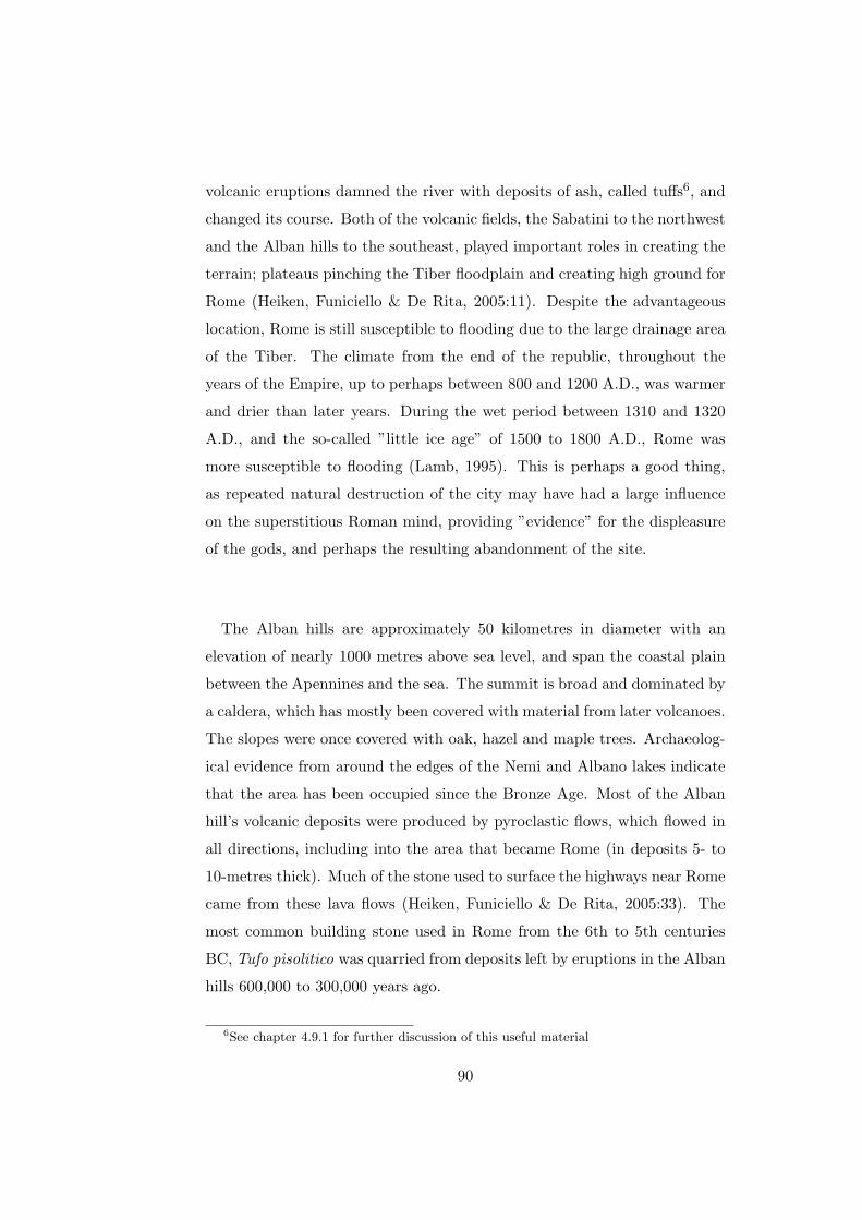
volcanic eruptions damned the river with deposits of ash, called tuffs6, and
changed its course. Both of the volcanic fields, the Sabatini to the northwest
and the Alban hills to the southeast, played important roles in creating the
terrain; plateaus pinching the Tiber floodplain and creating high ground for
Rome (Heiken, Funiciello & De Rita, 2005:11). Despite the advantageous
location, Rome is still susceptible to flooding due to the large drainage area
of the Tiber. The climate from the end of the republic, throughout the
years of the Empire, up to perhaps between 800 and 1200 A.D., was warmer
and drier than later years. During the wet period between 1310 and 1320
A.D., and the so-called ”little ice age” of 1500 to 1800 A.D., Rome was
more susceptible to flooding (Lamb, 1995). This is perhaps a good thing,
as repeated natural destruction of the city may have had a large influence
on the superstitious Roman mind, providing ”evidence” for the displeasure
of the gods, and perhaps the resulting abandonment of the site.
The Alban hills are approximately 50 kilometres in diameter with an
elevation of nearly 1000 metres above sea level, and span the coastal plain
between the Apennines and the sea. The summit is broad and dominated by
a caldera, which has mostly been covered with material from later volcanoes.
The slopes were once covered with oak, hazel and maple trees. Archaeolog-
ical evidence from around the edges of the Nemi and Albano lakes indicate
that the area has been occupied since the Bronze Age. Most of the Alban
hill’s volcanic deposits were produced by pyroclastic flows, which flowed in
all directions, including into the area that became Rome (in deposits 5- to
10-metres thick). Much of the stone used to surface the highways near Rome
came from these lava flows (Heiken, Funiciello & De Rita, 2005:33). The
most common building stone used in Rome from the 6th to 5th centuries
BC, Tufo pisolitico was quarried from deposits left by eruptions in the Alban
hills 600,000 to 300,000 years ago.
6See chapter 4.9.1 for further discussion of this useful material
90

After the conquest of Veii in 396 BC the Romans acquired new territories
to the north. There, in the Sabatini volcanic fields, they began to quarry tufo
Giallo, which replaced the weaker Tufo pisolitico as the favoured building
stone. The volcanic events that created these tuffs were at least seven in
number and occurred about 500,000 years ago. The flows covered an area of
about 400 square kilometres (Heiken, Funiciello & De Rita, 2005:44). The
history of Rome can be read in the stone used to build her.
The highlands of the Alban hills and the Sabatini volcanoes have a rain
catchment area of 5,100 square kilometres, which recharges a number of
lakes and the aquifers7 below the hills and fields. Today, the area provides a
cumulative flow of surface and groundwater amounting to 45,000 litres per
second. (Heiken, Funiciello & De Rita, 2005:137). The water derived from
all these various sources makes Rome the only city of its size in the world
that is chiefly supported by groundwater in a sustainable manner.
Figure D.11 shows a collage of satellite images of western Italy from a
height of eighty kilometres. Rome can be seen slightly left and down of
centre. To the top left (northeast) is Lake Sabatinus, known today as Lake
Bracciano. The bottom right (southeast) shows the Alban hills with Lake
Albanus, known today as Lake Albano. The Tiber can be followed for most
of its course.
As a result of the structure of the land and its location, much of Rome
was once under water. The Forum Romanum, the velabrum, the Campus
Martius and other valleys were once almost impassable marshes and pools
of water. As Ovid put it (Fast. 6.401): ”Hic, ubi nunc Fora sunt, udae
tenuere paludes”. Dionysius (2.50) speaks of the site of the forum having
formerly been a marshy thicket owing to the depressed nature of the ground:
”di� tä koØlon eÚnai tä qwrÐon”. The draining of these valleys was effected by
means of the Cloacae, which were amongst the first important architectural
7Water-bearing, permeable deposits.
91
works of Rome.8 As Varro says (Lin. Lat. 5.149): ”lacum Curtium in locum
palustrem, qui tum fuit in Foro, antequam cloacae factae sunt”. Moreover,
the hills and ridges of Rome were once more numerous and abrupt than
they are. At an early period, when each hill was crowned by a separate
village and surrounded by hostile tribes, the inhabitants naturally wanted
to increase the steepness of the cliffs to make their villages more difficult for
enemies to access. In later years, when these various villages were united
into a single city and surrounded by a wall, this became inconvenient. The
tendency became, especially in Imperial times, to get rid of all the features
that tended to break the city into separate parts. Tops of hills were levelled,
whole ridges cut away and gentle slopes formed where there once were abrupt
cliffs. The levelling of the Velia and the excavation of the site for Trajan’s
Forum are instances of this (Middleton, 1892a:4).
As the Tiber leaves Rome the slope of the riverbed decreases and the flow
is placid as the river approaches the sea. This is an important factor in
the economic and military success of Rome, making it possible to establish
ports near the city and thus ship men, materials and goods upriver to the
city (Heiken, Funiciello & De Rita, 2005:11).
It is perhaps of importance to consider the Porta Praenestina, or Porta
Maggiore as it is called today, because of its importance to the aqueduct
system in ancient Rome and as one of the best surviving parts of that system.
See Figure D.12 for a satellite image of the modern Porta Maggiore; remains
of the aqueduct system can be clearly seen. Frontinus called this entire area
the ad spem veterem because of its proximity to an old temple of Hope.
The Porta Praenestina was the highest point on the eastern side of Rome,
and was thus selected by the engineers of the aqueducts from the upper
valley of the Anio and from the Alban Hills as the point at which the water
8While originally designed to drain the marshes, it is estimated that by the the imperial
period 5000 kg of city waste was being drained through it every day into the Tiber (Gowers,
1995:25)
92
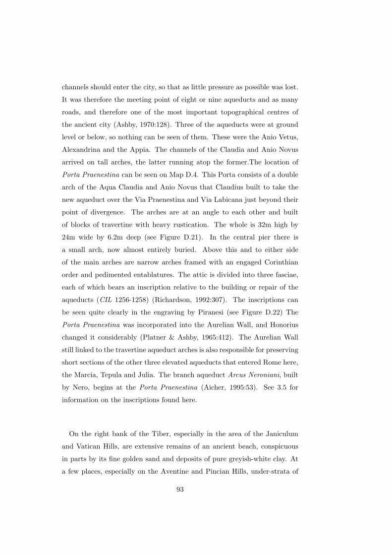
channels should enter the city, so that as little pressure as possible was lost.
It was therefore the meeting point of eight or nine aqueducts and as many
roads, and therefore one of the most important topographical centres of
the ancient city (Ashby, 1970:128). Three of the aqueducts were at ground
level or below, so nothing can be seen of them. These were the Anio Vetus,
Alexandrina and the Appia. The channels of the Claudia and Anio Novus
arrived on tall arches, the latter running atop the former.The location of
Porta Praenestina can be seen on Map D.4. This Porta consists of a double
arch of the Aqua Claudia and Anio Novus that Claudius built to take the
new aqueduct over the Via Praenestina and Via Labicana just beyond their
point of divergence. The arches are at an angle to each other and built
of blocks of travertine with heavy rustication. The whole is 32m high by
24m wide by 6.2m deep (see Figure D.21). In the central pier there is
a small arch, now almost entirely buried. Above this and to either side
of the main arches are narrow arches framed with an engaged Corinthian
order and pedimented entablatures. The attic is divided into three fasciae,
each of which bears an inscription relative to the building or repair of the
aqueducts (CIL 1256-1258) (Richardson, 1992:307). The inscriptions can
be seen quite clearly in the engraving by Piranesi (see Figure D.22) The
Porta Praenestina was incorporated into the Aurelian Wall, and Honorius
changed it considerably (Platner & Ashby, 1965:412). The Aurelian Wall
still linked to the travertine aqueduct arches is also responsible for preserving
short sections of the other three elevated aqueducts that entered Rome here,
the Marcia, Tepula and Julia. The branch aqueduct Arcus Neroniani, built
by Nero, begins at the Porta Praenestina (Aicher, 1995:53). See 3.5 for
information on the inscriptions found here.
On the right bank of the Tiber, especially in the area of the Janiculum
and Vatican Hills, are extensive remains of an ancient beach, conspicuous
in parts by its fine golden sand and deposits of pure greyish-white clay. At
a few places, especially on the Aventine and Pincian Hills, under-strata of
93

Travertine crop out. The conditions under which the tufa hills were formed
have been various, as can be seen by the examination of rock at various
places. The volcanic ashes and sand, of which tufa is composed, appear in
parts to lie just as they were showered down from the crater. In this case,
the tufa shows little or no sign of stratification and consists wholly of igneous
products. In parts time and pressure have bound together these scoriae into
soft and friable rock. In other places they still lie in loose and sandy beds,
which can be dug out with a spade. Other masses of tufa show signs of
having been deposited in water or else washed away from their first resting
place and redeposited elsewhere with visible marks of stratification. This
is shown by water-worn pebbles and chips of limestone rock which form a
conglomerate, bound together by volcanic ash into a sort of natural cement.
On the Palatine Hill there is evidence of extremely hot ash falling on a thick
forest. The burning wood of this forest, partly smothered in ashes, has been
converted into charcoal, large lumps of which are embedded in the tufa rock.
In some places charred branches of trees can be easily distinguished. The
so-called Walls of Romulus and some of the other prehistoric buildings on
the Palatine were built of this conglomerate of tufa and charcoal. A perfect
section of a branch of a tree is visible in the face of one of the massive tufa
blocks on the north side of the Scalae Caci (Middleton, 1892a:8).
6.3 Early history of the aqueducts
The Romans were not the first people channel water long distances. The
Assyrians developed the technique of tunnelling that is still used today in
the Iranian plateau to supply modern Tehran with water. These tunnels,
named qanats, tap underground aquifers and drain the water out to the side
of a hill. They are usually about 1.5 metres wide and 3 metres tall. The
Assyrian ruler Sargon II spread the technique of building qanats in the 8th
century BC. His engineers may have learned the techniques when they visited
northern Iran and western Turkey during military campaigns. The qanat
supplied the cities of the Medes and Persians with water, and then spread
94

throughout space and time to be used in north Africa, Spain and even the
Americas to this day. Two of the Roman aqueducts, the Appia and Virgo,
bear a resemblance to to qanat construction: they tap underground water
sources and lead the water to to a hillside exit by means of a tunnel. These
Roman aqueducts had their model in the Etruscan techniques of drainage,
such as can be found in the valleys near Veii.
A different system supplied Assyrian Nineveh. Three construction projects
re-routed water from a tributary of the Tigris, using dams and broad open-
air canals. The last and most elaborate of these projects channelled water
into a reservoir made by damming a gorge of the Atrush river, approxi-
mately 55 kilometres from Nineveh. From this dam an older canal carried
the water to the Khosr river, where the water was again dammed and routed
by another canal to the city. A notable achievement of this early 7th cen-
tury project is the Jerwan aqueduct bridge, which crossed a valley between
the Atrush river dam and the Khosr. Made from stone, it still exists and
measures 300 metres long and 12 metres wide.
The Greeks supplied many of their towns with aqueducts before Roman
occupation. The typical Greek technique was to channel water through pipes
laid in a secondary channel. Herodotus describes an engineering feat on the
island of Samos (3.60):
... a tunnel nearly a mile long, eight feet wide and eight feet
high, driven clean through the base of a hill nine hundred feet in
height. The whole length of it carries a second cutting thirty feet
deep and three feet broad, along which water from an abundant
source is led through pipes into the town.
Classical Athens had several aqueducts. One drew water from Mt. Pen-
telicus and had to pass through a hill outside of Athens by means of a tunnel.
In the early 2nd century BC, Pergamum acquired an aqueduct 42 kilome-
tres long. This consisted of two, and in places three, parallel subterranean
95

terracotta pipes. This was one of the high points of Hellenistic engineering,
and included a section under pressure that enabled the pipes to cross two
valleys at elevations below that of the water’s terminus in the town (Aicher,
1995:2).
The modern consensus is that the Etruscans had developed techniques
of land-drainage and water-supply which involved tunnelling through the
soft volcanic rock of the region.9 The Etruscan kings are also credited with
Rome’s first notable hydraulic work. During the reign of Tarquinius Priscus
in the 6th century BC, the low-lying areas of Rome were drained by means
of a system of canals. The main canal, running from the Subura through
the area that was to become the forum, was named the Cloaca Maxima
(Torelli, in Rosenstein & Morstein-Marx, 2006:81). It collected water from
a large number of feeder drains, and was vaulted over in the 2nd century
BC. It still carries run-off water into the Tiber today. The mouth of the
tunnel is visible in the left bank of the river downstream of the Tiber Island
and Ponte Palatino. Rome’s sewer system was the hidden half of Rome’s
water system. Strabo (Geography, 5.3) and Cassiodorus (7.6) state they
were equally as impressive as the roads and aqueducts.
It was only through Tarquinius Priscus’ construction efforts that the val-
ley between the Capitoline and Palatine Hills was rendered dry enough to
construct the forum. This area, though insignificant at first, grew into the
financial and political centre of Rome, and subsequently of the Roman Em-
pire.
The earliest aqueducts of Rome were constructed in a manner similar to
the drainage channels built by the Etruscans. The aqueducts evolved over
time, becoming more complex and specialised, with the Romans benefiting
from the experience of those that came before them. Roman economy and
9Patterson, in Rosenstein & Morstein-Marx (2006:347), provide a short discussion of
the archaeological evidence for an early development of Rome.
96

society, the system of patronage and love of baths, encouraged the under-
taking of large civic projects. Distant and secure borders made this possible.
It is unlikely that the censor Appius Claudius Caecus would have been
able to build either the Appian Way or the Aqua Appia had it not been for
Rome’s military successes in the preceding two centuries. Building roads
and aqueducts requires some measure of stability, or at least the ability to
enforce and maintain law and order over some area. The outcome of the
Latin, Samnite and Etruscan wars in a sense paved the way for Rome’s civil
expansion into Italy, the local control and stability allowing the Romans
to improve their city, and this in turn feeding back and allowing them to
extend their reach, which in turn lead to the development of stabilising
infrastructure.
During the period preceding and during the construction of the first aque-
duct, the Appia, Rome fought a remarkable series of battles. The fact that
the Romans were capable of this series of battles while transforming their
civil practices speaks of their vigour at this time. A list of the most impor-
tant battles follows (Flower, 2004:24).
• 327-326: Neapolis
• 326-304: The Samnites
• 312-298: The Marsi and other tribes of cental Abruzzo
• 311-308: The Etruscans
• 310-308: The Umbrians
6.4 Administration of the aqueducts
Until the last century of the Republic the censors had charge of all the aque-
ducts (Livy, 39.44), and built three of the four republican aqueducts. The
censors had to contract out and inspect the work. The task of inspection
97

might be delegated to an aedile, who oversaw the distribution of water in
the town. Then the aqueducts were for a short time under the administra-
tion of the aediles and quaestors. The quaestors acted in their capacity as
treasurers. The aediles would deputise two locals on each street to police
their neighbourhood fountain. During the periodic vacancy of the censor-
ship, questions of jurisdiction sometimes fell to a praetor to decide (Aicher,
1995:23). This lasted until the reign of Augustus, who instituted a new a
complete system of management directed by a Curator Aquarum who was
appointed for life.10 It was an office of great dignity, resembling in function
that of a Curator Viarum or Frumenti. The first Curator Aquarum was, in
effect, Marcus Agrippa, who held the office from 36 BC until his death in 12
BC (Middleton, 1892:317). He had at first acquired the office of the aedile-
ship in part to give his intervention in the water-supply some constitutional
precedence. Once out of office, he retained his position as chief supervisor
of the aqueducts. The senate acknowledged the office of Curator Aquarum
the year after Agrippa’s death, in 11 BC (Aicher, 1995:23).
The Curator Aquarum managed the public water supply, and also adjudi-
cated over right-of-way disputes and cases of water-law violations. He man-
aged a number of minor officials and personal attendants (apparitores) to
assist with these tasks, such as secretaries (scribae libarii), ushers (accensi),
criers (praecones), three public slaves (servi publici), engineers (architecti)
and two lictors when outside the gates of Rome. The public office of the Cu-
rator was called the Statio Aquarum. A number of clerks were attached to
it, known as the Tabularii Stationis. Other subordinate officials of relevance
were the two assistants, Adiutores, men of senatorial rank, one Procurator
Aquarum, usually an Imperial Freedman, and a Tribunus Aquarum. The
artisans who worked under the Curator were classed as belonging to the Fa-
10However, it was not necessarily a full-time appointment. Appointees could carry
on their private work simultaneously. This did not extend to important offices like the
consulship (Ashby, 1935:20). When Frontinus was appointed consul in 98, he must have
resigned from the office of Curator Aquarum.
98
milia aquaria publica and Familia aquaria Caesaris. These included Aquarii
or Villici, presided over by a Praepositus, who made and laid the lead supply
pipes; Libratores, who measured levels of the water; Castellarii, who kept
the Castella or reservoirs in order; Circitores, inspectors of the works; Sili-
carii, who took up and relaid the silex (lava) street pavement, when mains
were laid or repaired; Tectores, tilers, and other workmen, such as bricklay-
ers, masons, Pestatores, pottery crushers (testae tunsae), to make the opus
signinum of lining the channels and reservoirs.11
Agrippa bequeathed to his emperor a vast fortune, including a private
crew of 240 slaves that had been employed in the maintenance of the city’s
aqueducts. Augustus gave these to the state, and the Senate’s legislation
organised them into a familia publica, in essence a slave gang supported by
public funds and under the direction of the curator (Aicher, 1995:23). These
were known as the aquarii.
Claudius (d. AD 54) introduced reforms in line with his policy of concen-
trating authority in the civil service directly under his authority. He created
the Procurator Aquarum post and appointed men to it. Trajan and his
successors were to appoint the occasional equestrian to the post. Claudius
added another 460 slaves to the aquarii. They were now called the familia
Caesaris and were controlled by the procurator.
The curatorship of the aqueducts might have been the most prestigious
non-political office in ancient Rome. Its holders were generally senators who
held distinguished positions both before and after their terms as curator. A
curator received many honours extended to other high offices of the Roman
state. These included certain immunities of office, and the right to wear the
toga praetexta. The curator was appointed by the emperor and served for an
11Immense quantities must have been used. The great heap of broken pottery (mostly
from amphorae from the ships) called Monte Testaccio, south of the Aventine Hill, was
very likely used for this purpose.
99

indeterminate amount of time, ranging from a few months to many years.
The post may have been left unfilled for some period of time, and there is
some evidence that two men may have held it from time to time. It was not
meant to be a full-time occupation. A resolution of the senate, as quoted
by Frontinus (101), prescribes that the curators devote one quarter of the
year to the public office (Aicher, 1995:24).
The physical location of the statio aquarum is not known, if there was
one. At the end of the second century AD the title curator aquarum et Min-
uciae appears, indicating that the same official oversaw the water-supply
and distribution of free grain. The latter occurred from the Porticus Min-
ucia, which was probably located in the Campus Martius east of the four
Republican temples in Largo Argentina (Aicher, 1995:25). Inscriptions from
Constantine’s reign found on a statue in some rooms near the spring and
temple of Juturna in the Forum have led to speculation that the office was
relocated to the forum in the 4th century. Bruun argues against the exis-
tence of and special physical office at all (Bruun, 1991). Richardson states
that the speculation is probably accurate (Richardson, 1992).
Considering how copious the water supply was in Rome, the silicarii must
have been constantly at work, pulling up and relaying the pavements of the
streets when the mains or their branches needed repair. In some cases, espe-
cially for more important streets, the Romans formed tunnels in which the
pipes were laid, and could thus be repaired without breaking up the street.
This wise policy has not been widely adopted in modern cities (Middleton,
1892:318). It is possible that the Roman pipes, made from thick lead, was
more robust than modern pipes and thus required less frequent repairs.
There is evidence that the construction of new aqueducts was carried out
in part by public contractors (Redemptores operum publicorum).
100

The reforms of 11 BC simplified the administration of the aqueducts.
A law was passed requiring a clear space of 15 Roman feet (4.5 m) to be
maintained on each side of arcades and substructions, and 5 feet (1.5 m)
on each side of a subterranean channel. This was to ensure ready access to
the channel, and to avoid damage caused by tree roots. Tombs and other
edifices were also prohibited from encroaching on the space above channels.
A second law required that owners of adjacent land supply construction
material at a fair price, and allow construction and repair crews right-of-
way to the channel (Aicher, 1995:25).
A Republican law stipulated a fine of 10,000 sesterces for anyone who
polluted a a public fountain. The aediles appointed two men on each street
as caretakers and watchmen of the fountains. Augustus imposed a 10,000
sesterces fine on anyone who planted trees or shrubs in the clear zone around
aqueducts. This fine would be divided, half going to the state, and half going
to the person whose information led to the conviction. A fine of 100,000 ses-
terces was imposed on anyone who wilfully destroyed any aqueduct structure
(Aicher, 1995:26).
6.5 Aqua Appia
Frontinus tells us that ”For four hundred and forty-one years from the foun-
dation of the City, the Romans were satisfied with the use of such waters as
they drew from the Tiber, from wells, from springs”. By the late fourth cen-
tury, about thirty years after the beginning of the Samnite War (343 BC),
this supply was to prove inadequate to meet the city’s growing commercial
and private sectors.12 Another reason may have been reduction in the qual-12Compare this to the Croton Aqueduct, which was a large and complex water distribu-
tion system constructed for New York City between 1837 and 1842. It was named after its
source, the Croton River. The island of Manhattan, surrounded by brackish rivers, had
a limited supply of fresh water which dwindled as the city grew rapidly after the Amer-
ican Revolutionary War. Before the aqueduct was constructed, residents of New York
obtained water from cisterns, wells, natural springs, and other bodies of water n a manner
101

ity of well water. As Hodge points out (2002:71), most of the Roman well
water would have been water from the Tiber that had percolated through.
With the increased use of the Tiber, and probably consequent increase in
pollution, the quality of well water may have decreased. However, this is
not likely, as the ground would have provided an adequate filter.
In response to the probable growing need for water, the censor Appius
Claudius Caecus built the Aqua Appia in 312 BC. It was the procedure in
Rome to entrust to the two censors during their eighteen months of office
the building of public works. The censor Gaius Plautius was entrusted with
the task of finding a new water supply, which he did. To Appius Claudius
was given the responsibility of building the aqueduct, as he was already
busy with the Appian Way. The aqueduct had not been completed by the
time the censors were to leave office. Plautius stepped down, but Appius
Claudius argued that the Lex Aemilia did not apply to him, and remained
in office until the aqueduct was built and, as per custom, named after him.
The Appia’s source was approximately 24 meters above sea level (20 me-
tres below ground level), at a series of springs discovered by Gaius Plautius
Venox. The cognomen Venox was acquired due to this feat. There is no con-
sensus as to the exact location of the source, as the springs were located 16
m. below ground level and have probably been covered over again (Aicher,
similar to that of the Romans. But rapid population growth in the Nineteenth Century
and encroachment on these areas as Manhattan moved further North of Wall Street led
to the pollution of many local fresh water sources. The Old Croton is considered one of
the engineering achievements of the 19th century. The tunnel is an elliptical tube 8.5 feet
high by 7.5 feet wide. It is brick-lined and uses hydraulic cement for most of its length.
The outer walls are of hammered stone. The tunnel is gravity fed for its entire length,
dropping gently 13 inches per mile. To maintain this steady gradient through a varied
terrain, its builders had to cut the conduit into hillsides, set it level on the ground, tunnel
through rock, and carry it over valleys and streams on massive stone and earth embank-
ments and across arched bridges. Typically, it is partly buried, with a tell-tale mound
encasing it. The Old Croton was used until 1955, even though it had been replaced by
the New Croton, build between 1885 and 1890. See Koeppel (2001).
102

1995:34). The intake is described by Frontinus as being 780 paces to the
left of the Via Praenestina between the seventh and eighth miles, at a place
called Ager Lucullanus. Middleton (1892:336) believes this to be a mistake,
and that the probable intake is the reservoirs formed in the ancient quarries,
now called latomie della Rustica. The location of the sources is unknown
today. See Map D.3 for a guide to the paths that the aqueducts probably
took to reach Rome, and Map D.4 for a guide to the paths that they took
within Rome.
It entered Rome underground13 in the area of Spes Vetus, crossed both
the Caelian and Aventine Hills and terminated at the Clivus Publicius in the
southern Forum Boarium14, in the Porta Trigemina15, near the Salinae. 16.
In level it was the lowest of all the aqueducts (Ashby, 1965:21). Compared to
later lines the design of the Appia was very basic; for it had no piscina and
travelled almost completely underground for its sixteen kilometre length,
excepting for its terminus and at an arcade 17 bridging the valley between
the Caelian and Aventine Hills near the eastern end of the Circus Maximus.
13See Figure D.13 for a photograph of a model showing the Appia, Anio Vetus, Julia,
Tepula and Marcia entering Rome.14While the northern Forum Boarium was well supplied with water, the southern Forum
Boarium had only one spring that we know of, the Fons Scaurianus.15The Porta Trigemina was an important gate, mentioned often in the ancient sources,
but its location is a matter of dispute. It was on the Servian wall between the Aventine
and the Tiber, in Region XI (Platner & Ashby, 1965:41816Aicher (1995:35) speculates that this was probably the site of an ancient salt flat.
Evans (1997:68) believes it was the site where salt was either stored or refined. Platner
& Ashby (1965:462) are in agreement with Evans, stating that the Salinae contained
warehouses to store salt brought up the Tiber. Richardson (1992:341) states that the
location would not have been convenient for warehouses, and that the name suggests a
place where salt is refined. Evans goes further to speculate that if salt refining took place
as late as 312, then a large supply of water would be needed. He states this is unlikely
and is in agreement with Aicher, Platner & Ashby and Richardson that by 312 nothing
but the name remained.17If this arcade dated from the original construction of the Appia, then it one of the
very earliest, if not the earliest, use of an arcade in Roman architecture (Evans, 1997:67).
103
This arcade stood just inside the Servian Wall and no longer exists. From
this point the channel continued underground again, probably following the
ridge taken by later lines and paralleled by the Arcus Caelimontani of the
Aqua Claudia, traversing the Aventine to end near the Tiber. Frontinus
notes that the Appia did emerge from its subterranean course at the Porta
Capena, however, he continues to point out that there was no castellum
installed at this point. Because of its low level, the aqueduct can be traced
mainly from the evidence of Frontinus (Evans, 1997:65). The water system
pursues this subterranean course probably for reasons of security. Rome
was burdened by frequent battles with the Samnites who could have, in an
attempt to siege the city, cut the water supply in an attempt to paralyse
Rome. Indeed, this is just what happened during the Goth invasions of the
early 6th century.
According to Aicher (1995:35) the Appia had more in common with early
drainage systems than with later aqueducts. Drainage tunnels had long been
dug by the Etruscans in the fields north of Rome. Etruscan kings had begun
the drainage system of Rome with the Cloaca Maxima. The Appia lacked
any piscina, in contrast to the later aqueducts.18 Nonetheless, the Appia
was probably considered a marvel at the time of its construction (Evans,
1997:65).
Despite their reputation as marvels of engineering, the aqueducts leaked
quite badly and required frequent maintenance. Besides information attest-
ing to this in Frontinus, Juvenal and Martial mention the leaks in the Aqua
Marcia as it passed over the Porta Capena. The Appia was repaired by Q.
Marcius Rex between 144 and 140 BC (Pliny, 36.121) and again by Agrippa
(Frontinus, 1.9) and lastly by Augustus in 22-4 BC. Augustus also added
a new feeder branch, the Appia Augusta, of 6,380 passus. This drew wa-
ter from springs located between the Via Prenestina and the Via Collatina.
18(Torelli, in Rosenstein & Morstein-Marx (2006:93), states that it did have a piscina
publica.
104

This would be closer to Rome than the original branch and joined the Ap-
pian channel near a location Frontinus calls ad Gemellos, which is probably
at the Porta Praenestina. This introduces an inconsistency; an entire new
aqueduct is considered only a feeder, while aqueducts like the mixed Tepula
and Julia maintain their identities.
Platner & Ashby (1965) curiously do not mention Agrippa’s repairs. Fron-
tinus states that in ”year 719” Agrippa
... repaired the conduits of Appia, Old Anio and Marcia, which
had almost worn out, and with unique forethought provided the
City with a large number of fountains.
The traditional founding of Rome is 753, so presumably Frontinus refers
to about 34 BC, which accords well with Richardson and other scholars’
dates. There can be little doubt that repairs were carried out by Agrippa,
and Platner & Ashby’s omission must be in error.
It is problematic to argue that the Appia’s main purpose was to supply
surrounding inhabitants with water as, over a course of 11,190 passus (16.2
km), the Appia’s elevation fell to about 15 meters. This decline, 8 meters
or 5%, reflects the minimum ”drop off” prescribed by Vitruvius. Therefore
the line posed several problems for its contemporary engineers, and their
task to provide water to higher elevations, especially residential areas. In
fact, as Evans (1997:66) states, that from a technical standpoint the Appia’s
low level prevented distribution to higher areas. It seems probable, however,
that the key reason for the Appia’s introduction was the increasing commer-
cial importance of the Forum Boarium. While the northern Forum Boarium
had the spring of Lupercal, the southern end had no such supply. The po-
sitioning of the aqueduct’s terminus and the growing number of cults lend
support to this theory. Cults such as, Portunus, Fortuna, Hercules, Diana,
105

Mater Matuta Ceres and Liber played a quintessential role in the market-
place of the Boarium, and therefore, it seems likely that the aqueduct was
instituted to meet the increasing need for water that could not be supplied
by existing cisterns. Frontinus agrees with this theory. By his time the
Appia had been reworked three times. He states that the Appia served
seven of the fourteen Augustan regions: the Caelian, Roman Forum, Cir-
cus Flaminius, Circus Maximus, Piscina Publica, Aventine, and Transtiber.
Frontinus believes that roughly one fourth of the Appia’s water was dis-
tributed to private inhabitants. This seems very plausible given the date
of the aqueduct’s introduction, its low level and small rate of declination.
Frontinus’ figures illustrate that the Appia delivered 70% of its volume to
imperial and public buildings. This adds more evidence to the contention
that the Appia was instituted for civic as opposed to private needs and per-
haps aided the commercial growth of the Boarium and its cults. Over time,
as Rome’s requirements grew, more uses were found for the Appia’s waters.
6.6 Aqua Anio Vetus
The construction of the Anio Vetus, occurring merely forty years after that
of the Appia, was an ambitious undertaking. Its course was approximately
four times the length of the Appia and the source was much higher than the
Appia. In time it became known as the ”Old Anio”. Funded by the spoils
of the Pyrrhic war, it was constructed between 272 and 269 BC. The source
is the river Anio, a tributary of the Tiber, in the upper Anio valley, and was
the first of four to take water from that place. Frontinus states that ”the
intake of the Old Anio is above Tibur at the twentieth milestone...”, which
is too low a figure, whereas it is too high a figure if Tivoli is meant. Most
archaeologists believe its source to be between Vicovaro and Mandela, 850
metres upstream of the gorge at S. Cosimato. The intake, off a basin filled
by river water, was 260 metres above sea-level (Aicher, 1995:35). Ashby
(1935:57) concludes that Frontinus was mistaken in the length of the Anio
Vetus.
106

Like the Aqua Appia, the Vetus’ course was primarily underground. Later,
however, as technology advanced, the addition of bridges and substructures
shortened its course to between 64 and 81 kilometres. Frontinus records
the lower number, Blackman (1979) states this is too low and gives the
higher figure. The Vetus’ general path to Rome became the template for
future aqueducts, except for its supplementary channel that took short cuts
to avoid the paths along the sides of valleys. From its source it descended
along the river to Tivoli where it left the Anio valley and sloped south
towards the Alban Hills to near Gallicano, below Palestrina. From here
turned west again towards Rome. It crossed under the Via Latina near the
7th mile marker, southeast of the city.19 At the 4th milestone the aqueduct
turned northwest to enter Rome.
After entering the city underground via the Porta Praenestina it termi-
nated inside the Porta Esquilina. Frontinus states that the aqueduct served
the following areas: the Porta Capena; Isis and Serapis; Templum Pacis; Es-
quiliae; Alta Semita; Via Lata; Forum Romanum; Circus Flaminius; Piscina
Publica; and Transtiber. Both the Vetus and the Appia served the Forum
Romanum and Circus Flaminius, thus alluding to the increased needs of the
city’s centre, particularly the subura, an area which could not be supplied by
the Appia alone; on account of its low level and terminal position near the
Tiber. Frontinus documents that only 5.8% of the Vetus’ total distribution
supplied imperial buildings. This illustrates an important difference with
the Appia, which gave almost 22% to such buildings. Approximately 44% of
the Vetus’ volume was delivered to the privati located on the eastern hills.
A remaining 49.8% supplied the usibus publicis. Included in this category
are fountains and industrial and irrigation areas. Water was reserved for
the latter two areas so that the Marcia was free to supply public taps and
water troughs for animals. It is important to note that the water, due to its
poor quality, was used primarily for public baths, gardens and industry. The
19Near the terminal subway station at Anagnina
107

water was muddy after storms, and cloudy even in good weather. Frontinus
estimated that the Anio Vetus delivered 180,000 m3 per day (Aicher, 1995
and Frontinus, 1925).
The Vetus approached the city in the same fashion as the Appia; under-
ground near the Spes Vetus and distributed its water inside a gate of the
Servian Wall. The Vetus and the Appia complement each other in a fashion
that suggests the careful planning of the Vetus. The aqueducts serviced two
of the same regions due to the increased demands, however, they also fuel
separate areas with regards to the low and high lands of the city. How-
ever, the two aqueducts differed considerably in construction. The Vetus
was much more complex in design, for it incorporated a piscina, drew some
of its water from the Marcia, and supplied a branch line of its own called
the specus Octavianus. Frontinus indicates that the Vetus had 35 castella,
indicating its widespread distribution. The Vetus, however, probably did
not supply the drinking water to the Roman aristocracy. Confirmation of
this hypothesis is found in Frontinus’ discussions regarding the quality of
the water in the Vetus line. Frontinus indicates that the Vetus had ”muddy
water” and goes on to state that the aqueduct did not pollute the lines of
later aqueducts that ran similar courses.20 This alludes to the fact that
the Vetus ran beneath these future lines and thus did not have the ability
to service the higher locations within the city (Aicher, 1995 and Frontinus,
1925).
There are two known branches of the Vetus. The branch known as the
specus Octavianus diverted from the Vetus less than four km from Rome.
Augustus erected the only cippi recorded for the Anio Vetus, and it was no
doubt he that constructed this branch (Ashby, 1935:55). There are now no
remains left of the specus Octavianus. The other branch is only mentioned
20Perhaps the muddy water was the reason for the piscina less than 8 km from Rome,
as mentioned by Frontinus (1.15). It is also probably the Castellum Viae Latinae contra
dracones mentioned in the inscription CIL 6.2345.
108
by Livy once, on the work knows as the Oxyrhynchus Epitome, in book 54.
6.7 Aqua Marcia
Waters flowing into the city via the Aqua Appia and the Anio Vetus satis-
fied the needs of Rome’s population for about ninety years. Or perhaps it
should be said that the Romans had to be satisfied with the supply21. The
near cataclysm and associated expenses of the Second Punic War caused an
understandable hiatus in building projects in Rome. When supplies became
inadequate to support Rome’s public fountains private users were removed
from the system by cutting off their pipes. Marcus Aemilius Lepidus and
Marcus Fulvius Nobilior, censors from 179 BC to 174 BC, let contracts to
construct a new water supply, but Livy tells us that the project was blocked
by Marcus Licinius Crassus, who would not allow the aqueduct to cross his
property (See 6.19. Consequently, no new water was brought into Rome for
another thirty years, until the praetor Quintus Marcius Rex was charged
with restoring the existing aqueducts and building a new one (Heiken, Fu-
niciello & De Rira 2005: 145).
The only aqueduct built by a praetor, the Aqua Marcia22 was constructed
between 144 and 140 BC, one hundred and thirty years after the construction
of the Vetus and became perhaps the most famous of the Roman aqueducts.
It was financed with booty taken from Carthage and Corinth after 146 BC
(Evans, 2000:84). Frontinus states that Q. Marcus Rex was also charged
with the responsibility of repairing the Appia and Anio Vetus, which by this
time where leaking badly, and many citizens where stealing water for their
own use without paying taxes. The Marcia provided clean water to the city
that had more than doubled in size since the previous aqueduct was built,21Accounts of the censorship of Cato the Elder (184 A.D.) include notices that the
censors reclaimed public water flowing onto private property. Evans (2000:83) sees this as
an indication of an attempt to make the best use of a limited resource.22According to Pliny (Nat. Hist. 31.41), the Marcia was originally named the Aufeia.
There is no other evidence for this.
109
and was continuing to expand as a result of military success against Carthage
and Macedonia. In the years following the Second Punic War water was in
such demand that private lines were reclaimed for public usage. Both Livy
(39.44.4-5)23 and Plutarch (Cat. Mai. 19)24 indirectly support the notion of
this water shortage, and indicate that it was a limited resource. Frontinus
hints that the old aqueducts were in such bad repair that their supply was
wholly inadequate.
The Marcia’s source25 was a series of springs located on the right bank
of the Upper Anio, just below Agosta on the road to Subiaco. This is
in the same area where numerous spring houses gather water today for
the Marcia’s modern counterpart, the Acqua Marcia Pia (Aicher, 1995:36).
The ancient channels are now approximately eight metres below ground,
the floor of the Anio Valley having been raised by calcareous deposits and
the springs themselves (Ashby, 1935:95). Apparently, the pools of water
that seeped from the ground until the 1920s was from leaks in the ancient
channel. Several underground catchment channels and the run-off from the
slopes of the Simbruini ridge may also have contributed. Frontinus describes
the reservoir at the source, Its waters stand like a tranquil pool with a deep
green colour. Tacitus (Ann. 14.22) states that Nero swam in the sacred
pool, and shortly afterwards fell sick. From its source, the Marcia descended
mostly underground along the river’s right bank, until it crossed to the left
bank near Vicovaro and took almost the same route to Rome that the Anio
Vetus took. The Marcia emerged from the ground to finish the last ten
kilometres to Rome aboveground, near the farmhouse named Romavecchia.
Incorporating both sub-channels and arches, the aqueduct entered the city
through the Porta Maggiore and terminated in a large tank on the Viminal
23To quote Livy: The censors cut off all public water that had been piped into a private
building or into private land, after giving thirty days notice.24To quote Plutarch: He cut off the pipes by which people were in the habit of diverting
some of the public water supply into their houses and gardens...25Pliny calls the spring Pitonia (Nat. Hist., 31.41).
110

hill, located north of Diocletian’s Baths. This would be under the present
Ministry of Finance. Near the Porta Tiburtina, however, a branch of the
Marcia, called the Rivus Herculaneus, diverged from its original path only
to transverse the Caelian Hill and terminate at the Aventine Hill. The Aqua
Marcia was the longest aqueduct spanning 91 km and yielded and estimated
190,000 m3 per day. Eighty kilometres of the channel lay underground, 1.5
kilometres on substructures and 9.5 kilometres on arches.
Martial (Epi. 9.18) gives us some evidence that the Marcia was also
delivered to the Quirinal Hill.
I possess, and pray that I may long continue to possess, under
your guardianship, Caesar, a small country seat; I have also a
modest dwelling in the city. But a winding machine has to draw,
with laborious effort, water for my thirsting garden from a small
valley; while my dry house complains that it is not refreshed even
by the slightest shower, although the Marcian fount1 babbles close
by. The water, which you will grant, Augustus, to my premises,
will be for me as the water of Castalis or as showers from Jupiter.
The Marcia supplied supplemented the Tepula and Anio26(2.67). On the
surface this fact complicates the task of assessing the number of aqueducts
in Rome. However, the supplementary volumes are so low that in this case
the aqueducts can maintain their separate identities.
The Rivus Herculaneus crossed the valley between the Caelian and Aven-
tine Hills on an arcade, like the Appia. Lanciani’s (1990) hypothetical recon-
struction of the channel has the arches of the Marcia parallel and abutting
the Servian Wall, on the basis of references to an old arcade and a wet
gateway at Porta Capena by Juvenal (3.2) and Martial (3.47.1). Juvenal
refers to the arch veteres arcus madidamque Capenam. Martial refers to it
26Presumably Anio Vetus
111

as arcus stillans. Aicher (1995:37) thinks these descriptions may refer to an
even older arcade of the Appia, on the basis of evidence in Frontinus (1.5)
which supports his version. By Frontinus’s time a higher branch on arches
delivered water to the heights of the Caelian and Aventine Hills.
The Marcia was appreciated by the Romans for the quality of its clear,
cold water, which derived from rainwater on the slopes of the Simbruini
ridge west of the valley. Here, Mt. Autore reaches a height of 1,850 metres.
The rain takes several months to percolate through the porous limestone
before it wells up in the valley springs. This makes the water hard, and the
Marcia’s channels were quickly coated with a calcareous deposit that had to
be removed periodically (Aicher, 1995:37).
The Marcia underwent several restorations and additions during its life-
time. Augustus significantly increased its capacity by adding a supplemental
source called the Aqua Augusta. This source, after the introduction of the
Claudia, was reserved as a supplemental supply for the Marcia and occa-
sionally for the Claudia. Evidence regarding Augustus’ overhauling of the
line appears as an inscription on the Porta Tiburtina, or in literary sources
such as the Res Gestae. Finally in AD 212, Caracalla added another sec-
ondary channel, the Aqua Antoniniana, near Torfiscale, in order to supply
water to his baths. Diocletian also made renovations for the same reasons
as Caracalla. The result of these extensive restorations and additions was
a complex distribution system that delivered water to a diverse area. The
Marcia was the first aqueduct that supplied the high elevation districts of
Rome. Archaeological evidence suggests that widespread distribution oc-
curred in the area of the Porta Viminalis. The only evidence visible until
quite recently, of this distribution was marked by a small circular structure
outside the line of the Servian Wall (Evans, 1997:85). Its other location
outside the Porta Viminalis, coupled with its small size, indicate that this
was part of a secondary branch. The Marcia supplied the Palatine and by
means of a siphon, the Caelian, the Aventine, the Forum Romanum, the
112
southern Campus Martius, and the locations too high for the Vetus on the
eastern hills of the city.
The Aqua Antoniniana ended in the large cisterns of Caracalla’s Baths.27
These remain on the south side of the baths (below Via Baccelli), buttressed
against the hill on which the aqueduct arrived. The water was stored here
for distribution from 32 chambers of approximately two stories each. Such
a high capacity would have served the baths well should the water supply
have been interrupted.
A branch of the Marcia was also taken to the Capitoline Hill. This against
the opposition of a number of politicians, who were rivals of the builders.
They cited an oracle of the Sybilline books that prohibited water of Anio
Valley from touching the Capitoline (Frontinus, 7). According to Livy, the
Anio Vetus was also brought here.
Frontinus observes that only a small portion of the Marcia’s flow was
allotted to public buildings, public works and ornamental fountains. The
greatest volume of water was delivered to privati (49.3%) and to public la-
cus (23.2%). Approximately three-fourths of the Aqua Marcia was reserved
for drinking, either for private citizens or for public basins. This explains
Frontinus’ efforts to keep the integrity of the line, saving it for human con-
sumption whenever possible. The only regions not supplied were the Circus
Maximus and Piscina Publica.
The Marcia has a number of well-preserved cippi. Ashby (1935:93) lists
ten. Their inscriptions are mostly preserved in CIL 6.3156 and 6.3157. He
mentions another fourteen that are joint cippi for the Marcia, Tepula and
Julia. These mostly in CIL 6.31561 and 6.1249.27The Baths of Caracalla would have required a copious supply of water. Grant
(1968:101) estimates that it could accommodate 1600 bathers at one time. The baths
which Diocletian and maximian built after the fire of 283 are estimated to have been
twice that size; perhaps they could accommodate 3000 bathers.
113

The Aqua Marcia was an ingenious, well-built and handsome engineering
system. Its length set a record that would stand for centuries, and would
never be broken in Rome. It supplied two and a half times as much clean
water than the Appia, and more water even than the Anio (Hauck, 1988:35).
It was in use until the 10th century.
6.8 Aqua Tepula
We know little of the original Tepula, as it was completely reworked and the
original path abandoned by Agrippa. According to Frontinus, it was built
in 126 BC by the censors G. Servilius Caepio and L. Cassius Longinus and
took its water from the estate of Lucullus (2.8). Though modern scholars
believe that the Tepula drew its waters from the foot of the northern slope of
the Alban Hills, its source was a number of streams in the Marciana valley,
about two kilometres west of Grottaferrata. Ashby (1935:159) believes it to
be the Sorgente Preziosa. The water temperature here is indeed still quite
warm. Frontinus has this to say (2.68):
Tepula is credited in the records with 400 quinariae. This aque-
duct has no springs; it consists only of some veins of water taken
from Julia.
This is rather an odd statement by Frontinus, as the Tepula is older than
the Julia. It is true that they used the same channel, and as Frontinus says
(1.9):
The Name Julia was given to the new aqueduct by its builder,
but since the waters were again divided for distribution, the name
Tepula remained.
It can be argued that mixed water cannot be divided into its original
components, so perhaps the birth of the Julia meant the transformation of
the Tepula into a branch of the Julia.
114

Nothing remains of the Tepula’s collection system, but the same warm
water (16 C) that gave the Tepula its name feeds the fountain named Sor-
gente Preziosa today. It was introduced in order to service the Capitoline
Hill, and would have been a high-level line, similar to that of the Marcia. In
fact it entered Rome atop the Marcia and was the highest of the ”contempo-
rary” aqueducts, thus allowing it to have the potential to service regions of
higher elevation. As indicated by its name the aqueduct delivered ”tepid”
water and therefore was not as valued as other aqueducts, especially the
Aqua Marcia. Its temperature made the Tepula unpalatable and therefore
its flow was used for industrial purposes. This is no bad thing, because s
a result of the addition of the Tepula the waters of the Marcia were freed
for drinking purposes. The Tepula, passing through 14 castella, delivered
water to four regions, Templum Pacis, Esquiliae, Alta Semita, and Via Lata.
Three-fourths of its waters furnished private citizens and 15% was assigned
to usibus publicis. These statistics coupled with the regions that the Tepula
served adds weight to the statement that the role of the aqueduct was to
complement the other lines, such as the Marcia, that provided water to the
eastern districts of the city. According to Evans (2000:96), the Tepula’s lim-
ited length and capacity were perhaps dictated by economic considerations
during the politically unstable decade of the 120s BC
It is interesting to note that the Tepula served the same region as the
Marcia, and this less than twenty years after the former’s construction. This
may point to rapid growth in the city, especially after the wars of the 130s,28
or the land problems that spurred the Gracchi to action. There was probably
a serious requirement for the extra water, considering that lower quality
water was accepted and that no opposition to the Tepula’s construction on
the Capitoline is recorded, in contrast to the Marcia. The Tepula’s small
size may have been an economic necessity; the 140s saw full coffers and
28This included wars against the Numantines in Spain, against the Scordisci in Macedo-
nia and against a slave revolt in Sicily. None of these conflicts could have produced much
booty and probably represented a net loss.
115

extravagant spending, but the minor wars, land problems and grain problems
(caused by the Sicilian Slave wars, the revolt led by the slave Eunus) meant
that spending in the 130s and early 120s was restricted (Boren, 1958:900).
The Tepula originally ran its own course from source to terminus. In
33 BC, in an attempt to improve both the water quality and its volume,
Agrippa combined water from his new aqueduct, the Aqua Julia, to the
existing Tepula. The two waters of the Tepula and Julia ran together to
their piscina and then divided back into two channels at a clearing basin
somewhere near today’s Capannelle, subsequently travelling to their respec-
tive terminus. Due to the cost of its forerunner, the Marcia, and the poor
nature of the water, however, the Tepula did not fulfil this expectation. In
fact it was Rome’s smallest line, spanning a mere eighteen kilometres, and
delivered only 17, 800 m3 per day29.
The Aqua Tepula proved to be the most problematic of all the Republican
aqueducts. The constructs of the original Tepula are unknown; because
all of Frontinus’ discussions refer to the line after Marcus Agrippa made
extensive restorations30. Because there is no trace of the original channel,
it is inferred (reasonably) that the initial channel was abandoned and a new
one instituted. Frontinus indicates that the aqueduct possessed no source
of its own, but drew its waters from springs that later supplied the Aqua
Julia. This confirms the belief that the line had a restricted capacity.
29Alone of all the aqueducts listed by Frontinus, the Tepula lost none of its waters
between its source and terminus.30According to Evans (2000:97), the Tepula ceased to have it’s own identity after
Agrippa. This argument has much to recommend it.
116

6.9 Aqua Julia
The political and social chaos during the last century of the Republic pre-
vented the establishment of any new major water system until the Julia. As
early as 33 BC it had become apparent to Octavian that he would have to
reorganise the public works administration (Anderson, 1997:89). The exist-
ing four aqueducts were in dire need of restoration, as they had become an
administrative and maintenance disaster. Agrippa (c. 63 - 12 BC), holding
the office of aedile, played a crucial role in the restoration and repair of the
system, perhaps the most important role. He established an administration
policy for the aqueducts. Acting as the curator aquarum, he instituted a
permanent staff for the operation and maintenance of the water systems of
Rome. His energy, creativity and competence formed a model for successive
generations.
It is generally accepted that Agrippa built the Aqua Julia in 33 BC31. Its
source was a few kilometres upstream to that of the Tepula, southeast of
Grottaferrata 32 and below the roads to Marino and Rocca di Papa. This
source is a number of springs that gather in a catch basin approximately
three kilometres before its subterranean course in the Marciana Valley33;
Frontinus states that it was not possible to judge the volume of water at
the intake because of the number of tributaries involved. According to
Frontinus (1.9), the Julia was also supplemented by water from a brook
called Crabra, the main supply of Tusculum34. As the Julia ran its course,
it was mixed with waters from the Tepula some three of four kilometres
31The date is disputed. Dio Cassius (49.32.3) states that the line was introduced in 40
BC This suggests that the Julia was Julius Caesar’s project, and finished by Agrippa after
his death. This would also explain the name, which according to Evans (2000:99) would
be a typical act of Agrippan self-effacement. Wright (1937) has another theory for the
origin of the same; he postulates a family relationship between Caesar and Agrippa32Middleton (1892:341) states a mile north of Grottaferata, and Ashby (1935:162) places
it in the region of Ponte degli Squarciarelli.33This water now feeds the Marrana Mariana.34This practice was stopped and the supply returned to Tusculum.
117
from the beginning of its subterranean course in the Marciana valley, passed
through a piscina near Capannelle after another six kilometres, and finally
rode atop the Marcia on its way into the city (See Figure D.13). Frontinus
indicates that a subsidiary branch of the Julia, diverging from the main
conduit near Spes Vetus, supplied castella on the Caelian. This was made
possible due to the Julia’s elevation that was slightly higher than that of the
Marcia. The Julia also furnished the Palatine via a siphon. Frontinus lists its
widespread distribution, indicating that the Julia supplied the Caelian, Isis
and Serapis, Esquiliae, Alta Semita, Forum Romanum, Palatine, and Piscina
Publica. The Julia’s main terminus was a reservoir near the Porta Viminalis
and a secondary branch delivered water to the Caelian and Aventine Hills.
The aqueduct was between 22 and 23 kilometres long, and yielded 48,000
m3 per day.
According to Frontinus, the Julia may have been introduced to meet the
water needs of the Augustan building program. Sixty five percent of its
capacity was allocated for usibus publici, of which 30% was allotted for
public works. Only 3% of its total distribution supplied imperial buildings
and property.
6.10 Aqua Virgo
There is a great deal of literature about the Aqua Virgo, because it is the one
ancient aqueduct that remains functional within modern Rome. Fourteen
years after he built the Aqua Julia, Agrippa constructed the Aqua Virgo
(19 BC) in order to supply water to the Campus Martius, which Augustus
was in the process of developing. There are two theories with regards to the
aqueduct’s name. Frontinus suggests that it was named after the young girl
who discovered its source. Others, however, believe that it was named after
a statue of a water goddess housed in a temple near the source.
118

The Virgo’s source was positioned near Rome in a marshy area north of
the Via Collatina, just before the 8th milestone. Several feeder channels
throughout its course augmented the Virgo’s water volume. One conse-
quence of these channels was an influx of precipitate impurities that could
impede or even obstructed its flow, and therefore the Virgo required peri-
odic maintenance. The plan of the Virgo complemented that of the Julia
and met the specific requirements of the districts that were poorly served
by earlier aqueducts. The Virgo distributed water to the Via Lata, Circus
Flaminius, Campus Martius and Transtiber. The service to the Transtiber
illustrates one of the main reasons for the construction of the Pons Agrip-
pae. The Virgo required a bridge to carry the water to the Transtiber.
Frontinus notes that the Transtiber already received water from the Appia,
Anio Vetus and Marcia, but this supply was limited by the constraints of
the delivery pipes running across the Pons Aemilius. The aqueduct was also
to service Agrippa’s baths near the Pantheon and the artificial stream near
the baths, called the Euripus. The Virgo entered Rome via a circular route
to the north, subsequently eliminating the difficulties of tunnelling through
densely inhabited areas. It terminated at the Villa Julia and transported
100,000 m3 of water per day into Rome. All but about one kilometre of the
Virgo ran underground.
Frontinus suggests that little of the Virgo’s volume was allocated for pri-
vate use, only about 15%. This seems plausible because of its distribution to
the Campus Martius that is primarily a non-residential area. Certainly some
of the water was intended for Agrippa’s public bath near the Pantheon. It
also supplied an artificial stream near the baths namd the Euripus (Aicher,
1995:39). About 22% of the Virgo’s capacity was used for buildings in the
Martius and Transtiber, including warehouses and industrial zones along
the Tiber. Its limited service to the Transtiber probably indicates that the
water was used for public means and not as a luxury for private dwellings.
The remaining 63% of the water was distributed for usibus publici.
119

The Virgo’s water was apparently quite cold and pure, according to Seneca
and Martial. Seneca refers to it as pleasant water to bathe in, while Martial
twice mentions its coldness. Cassiodorus (Var. 7.6) says
The Aqua Virgo runs with delightful purity, for while other wa-
ters during excessive rains are invaded by earthy matter, the
Vitgo’s current runs pure as a never-clouded sky.
The Virgo is one of the aqueducts that was in use the longest. It is still
used today, though the water is unsuitable for drinking. The Trevi Fountain,
on the Collis Quirinalis, and other display fountains on the Campus Martius
are supplied with water by the Virgo.
6.11 Aqua Alsietina
Augustus constructed the Aqua Alsietina in 2 BC. The Alsietina and Traiani
are the only two aqueducts to draw their water from an area other that the
Anio watershed to the east and southeast of Rome. The Alsietina took its
water directly from the southern side of Lake Alsietinus, at a height above
sea level of 207 m, a small crate lake east of Lake Sabatinus. The opening
of the tunnel, which was the lake’s only emissary, has been found in the
hillside 12 metres above the current water level (Aicher, 1995:41).
Of the Alseitina’s 33 kilometre length, only about 500 metres was above
ground. Much of the course is unknown. From the lake it headed due south
towards Osteria Nuova. South of here it passed near to the abandoned S.
Maria di Galeria, where a branch from Lake Sabatinus joined it. It entered
the city to the north side of the (later) Porta Aurelia and after a short stretch
of arches dropped underground again to the Trastevere. A short section of
its tunnel has been discovered near S. Cosimato (Aicher, 1995:41). Frontinus
mistakenly states that the Alsietina is the lowest of the aqueducts.
120

Frontinus states that he is unclear as to why the Alsietina was built be-
cause its waters were unfavourable for drinking. He assumes that its purpose
was to furnish Augustus’ Naumachia at Trastevere with water, and while
that was not in use, all the water was delivered extra urbem. There was
no evidence regarding the existence of any piscina, which adds weight to
the theory that the Alsietina did not service public needs, but was used for
private purposes. There is some evidence from Frontinus, however, that in-
dicates that its waters were also used to irrigate gardens and country villas
located along the Alsietina’s course, thanks to the generosity of Augustus.
Despite its poor quality, the water was used for drinking when the conduits
of the Marcia and Virgo, crossing the river to Trastevere, were closed for
repairs. This aqueduct supplied only 6,000 m3 of water per day.35 All of
this water was consumed outside of the city.
One problem with using the Alsietina’s water for the Naumachia was
its height. The Alsietina entered the city at a much higher level than the
Naumachia; dropping the height of the water over such a short course is
problematic.
6.12 Aqua Claudia
Started by Caligula (AD 12 - 41) and officially finished by Claudius (10 BC
- AD 54), the Aqua Claudia was constructed between 38 and 52 AD. The
date of completion is given in an inscription at Porta Maggiore, but Tacitus
(2.13) suggest that the aqueduct was in use by 47 AD. It was fairly common
practice to begin using an Aqueduct before construction was completed.
Caligula ordered its construction because the seven existing aqueducts were
by now inadequate due to the demand for water from consumption and
utilities such as the baths. It is on account of its massive arches that the
Claudia is one of Rome’s most visually impressive aqueducts.
35Aicher (1995) differs in his estimate, giving a figure of 16,000 m3 per day.
121

Its source is a number of springs in the Anio Valley, near Agosta and
close to the sources of the Marcia. Originally there were two springs, the
Caeruleus and Curtius. Later these were to be supplemented by the Albud-
inus spring. From its source the Claudia descended along the right bank of
the Anio, mostly underground and slightly uphill from the Marcia. Origi-
nally the Claudia crossed to the left bank of the Anio over a bridge below
Vicovaro. Remains of this bridge have been incorporated in a modern road
bridge. Hadrian built an alternate loop that crossed the Anio upstream at
the gorge of S. Cosimato near the base of the hydroelectric dam. On the
left bank of the Anio the Claudia followed approximately the same route as
that of the Marcia and Anio Vetus, even crossing their paths occasionally on
its way around Tivoli towards the Alban Hills. Like the Marcia, he Claudia
emerged above ground near Capannelle and crossed the land near Romavec-
chia on a long series of high arches. After about ten kilometres on arches,
the Claudia entered Rome at Spes Vetus and crossed the Via Prenestina
and Labicana on Porta Maggiore. Its castellum was on the Esquiline Hill,
near the temple to Minerva Medici.36 Nothing remains of this once imposing
castellum, which was destroyed by fire in 1880 when it was being used as
a hay barn (Aicher, 1995:55). Piranesi’s etching (see D.27) is useful when
imagining what the 21.5 by 14.2 metres and several stories high castellum
looked like. Porta Maggiore can be seen in the background of this etching.
Inscriptions on the Porta Praenestina indicate that Vespasian (AD 9 - 79)
and Titus (AD 39 - 81)37 repaired the aqueduct shortly after its completion,
in 71 AD, after a nine year period of inoperation. Furthermore, Hadrian
(AD 76 - 138) and the Severans carried out later restorations. Brick stamps
from 123 AD provide the evidence for Hadrian’s restoration, which had
an elegance about them which was unusual in this type of undertaking.
Restorations during the latter, less prosperous period were more utilitarian
in nature. After Nero (AD 37 - 68) built the Arcus Neroniani, one of the
36See Figure D.2 for a photograph of a model of a section of the Aqua Claudia.37See Chap. 3.5
122

Claudia’s branch lines, and because of its height, the aqueduct could supply
water to all fourteen districts. Domitian (AD 51 - 96) also added a branch
to supply water to the imperial palaces on the Palatine Hill. It was one of
the more difficult aqueducts to maintain, possibly because of its innovations.
The Claudia was 69 km long and delivered 185,000 m3 per day.
While the measurements for the water volume at their intakes are close
for the Claudia and Marcia, Frontinus describes the Claudia as abundantior
aliis. He also states that the channel could not receive all the water available
at the intake.
The nine year hiatus in operation is a puzzling aspect, especially when
it is realised that the Claudia accounted for nearly 20% of Rome’s water
supply at that time. It is exceedingly strange that the aqueduct should
break only 15 years after entering operation, and only 8 years after its official
opening, unless it was poorly constructed or suffered a series of unfortunate
disasters, or both. The relatively low cost of the Claudia points to lower
quality building materials or hurried construction.
However, while low quality material and construction might explain why
the Claudia collapsed, it does not explain why it took so long to repair it.
Some major events of the 60s serve to provide clues for this. Firstly, a there
was major earthquake in southern Italy 5 February 62 AD, which caused
extensive damage to a number of towns, including Pompeii. Though there
is little to no evidence suggesting that the earthquake effected Rome, the
date coincides with the breakdown of the Claudia. In the same year a storm
wrecks 200 ships in the newly constructed but still incomplete Claudian
harbour at Ostia, and a 100 more by accidental fire further upstream (Tac.,
Ann. 15.18). ). The storm may have been a Tsunami caused by the same
earthquake that damaged Pompeii. If this is the case, it points to a powerful
earthquake that might have caused some damage to Rome. One result of the
storm was the loss of huge quantities of corn at the harbour, in warehouses
123

and on the ships. The destruction of so much corn, when Nero has just
thrown away vast quantities of old spoilt corn, must have led to shortages.
These particular events may not have damaged the aqueduct itself, but
may have further drained the imperial coffers (Nero was well-known for his
financial irresponsibility (Cary & Scullard, 1975:361).
The fire that swept through Rome for more than a week in 64 devastated
Rome. Tacitus (15.37) gives a dramatic account, stating that the fire left
only four districts intact, destroying three totally and reducing the other
seven to smoking ruins. In his own words (15.38):
It began in the circus, where it adjoins the Palatine and Caelian
Hills... the conflagration instantly grew and swept the whole
length of the circus... the fire swept over the level spaces and
then climbed the hills, but returned to ravage the lower ground
again.... When [the residents of Rome] escaped to neighbour-
ing quarters, the fire followed even into districts believed too re-
mote to be involved... the flames overwhelmed the whole of the
Palatine... [the fire] was finally stamped out at the foot of the
Esquiline Hill.
However, flames broke out again and many temples and ”pleasure ar-
cades” were destroyed. 38. It is possible that the Claudia was damaged
by the fire, as it would have passed through some of the worse effected re-
gions. However, as the Claudia and Anio Novus met in Rome and there is
no mention of the Anio Novus being damaged, the damage that caused the
shutdown of the Claudia is unlikely to be the fire. Instead, the fire may have
reduced the combined Claudia/Anio Novus line to the extent that it would
be unwarranted to repair the Claudia until the damage within Rome had38While Nero deserves credit for his not-inconsiderable relief measures and reconstruc-
tion efforts, he did spend a small fortune on building his new 120 acre palace, the Domus
Aurea. It was perhaps for this reason that his relief efforts were not met with approval
124
been repaired. This is indeed quite plausible. Also, this expenditure and
diversion of resources may have further delayed the repairs of the Claudia.
The fire may have had another effect. Subsequent to the fire massive
rebuilding took place in the area where the Colosseum would later be built.
Nero began to build his Domus Aurea, or Golden Palace, which consisted
of a 120 foot statue of Nero, parks, colonnades and, most significantly, a
large lake. The most convenient aqueduct to use to fill and maintain the
lakes would have been the Claudia. It is possible that Nero drained the
Claudia for this purpose. Sometime between 70 and 72 AD Vespasian began
construction of the Flavian Amphitheatre, later known as the Colloseum. It
would have been necessary to drain Nero’s lakes to build the amphitheatre,
at which time the water from the Claudia would no longer be needed. The
timing of these two events is suggestive of a link.
A somewhat prosaic explanation may be that, during the construction of
the Arcus Neroniani, the Claudia was shut off. This is unlikely, as it would
have not been necessary to cut of the supply for more than a week, if it was
cut off at not just diverted, which was the common practice.
Finally, there was the political unrest which culminated in 69. Nero
toured Greece from 67-68. His imperious showmanship not only caused him
to neglect urgent public business, but involved him in riotous expenditure
which threw the state finances into grave embarrassment (Cary & Scullard,
1975:359).
Taken in isolation these events suggest little, but in concert may have
resulted in delayed repairs for the Claudia.
The remains of the Claudia show repeated efforts at repair from its con-
struction and throughout the second and third centuries (Richardson, 1992:16).
It is entirely possible that the Claudia was badly built and suffered from poor
125

workmanship. Despite Vitruvius, many Roman buildings did not exhibit fir-
mitatis. Disasters due to poor workmanship were not unknown. Suetonius
tells us of the panic in the Theatre of Marcellus shortly after its completion
under Augustus, brought on by the crowd’s fear of the structural integrity
of the building. At the collapse of the amphitheatre at Fidenae, which
killed perhaps as many as twenty thousand people, which was considered a
grievous calamity, Tiberius returned from his island retreat of Capri (Taylor,
2007:5), an unusual act.
The interruption has also been doubted by a number of authors (Richard-
son, 1992:16 and Evans, 1983:393). One of the reasons given is that Ves-
pasian claimed to have repaired the Claudia for propaganda reasons.
Later, Pliny the Younger (13.17.3) writes of the Anio flooding, causing
extensive damage. Though it is a stretch, earlier floods may have had a
detrimental effect on the Claudia (and other aqueducts). In Pliny’s words:
The Anio... has broken off and carried away most of the glades
with which it is shaded. It has undermined the hillside, and in
several places it is blocked by massive landslides. In it’s search for
its lost course, it has battered buildings and forced its way, extri-
cating itself over the fallen masonry... [e]ven areas not reached by
the rising river have not escaped the calamity. Instead of river-
floods they have had incessant rain, tornadoes hurtling down from
the clouds...
In all probability, low quality construction, fire and alternate uses for the
water explain why the Claudia was out of operation for such a long period
of time.
The Arcus Neroiani39 is one of the most prominent ruins of the aqueducts
within Rome and seems to have been in use until the 11th century. It ran for39Referred to as the Arcus Caelimontani in later inscriptions
126
two kilometres, starting from where the Claudian arcade makes its first turn
at Porta Maggiore and ending on the Palatine Hill, at a major distribution
reservoir above the Colosseum. From here its waters were distributed to the
Aventine and Trastevere (across the Tiber) as well as to the Palatine itself,
after an extension by Domitian. In addition, it supplied the Domus Aurea,
Nero’s estate built on urban land cleared by the fire. The Arcus Neroiani was
probably built after the fire of 64 AD, which had given Nero the opportunity
to rebuild much of Rome. A branch of the Marcia supplied the same areas
with good water, but was in such bad repair that Nero seems to have taken
the decision simply to replace it. The Arcus Neroiani was built mainly with
concrete, as opposed to the heavy stone-block construction of earlier arcades
for arches. They can be seen in the etching by Piranesi (see D.29). This
proved a poor choice, and both Domitian and Septimius Severus had to
renovate it extensively, using brick-faced concrete. Nero and his architects
may have been trying to minimise the size of the arcades. This may have
been a common practice; when Hadrian restored the Claudia, smaller brick
and concrete arches were placed within the older ones. The Severan repairs
dimin
The Arcus Caelimontani furnishes new insights into Nero’s sometimes
overlooked accomplishments as an urban planner, while they also prompt us
to reassess the true achievement of the Claudian aqueducts. Nero’s branch
played a significant role in supplying water to residential neighbourhoods.
Because of their position and capacity, the Arcus Caelimontani may have
eliminated the need for introduction of additional aqueducts into the centre
of Rome. Despite the steady growth of the city in the late first century
and the demands of the Flavian building program, no new aqueducts were
added for over sixty years, until the Aqua Traiana was introduced to the
Transtiber (Evans, 1983:399). Whether or not this was intentional, or merely
good fortune, cannot be established for certain.
127
Frontinus shows his concern to make most efficient use of water. He
states that water should be reserved for human consumption and that wa-
ter of poorer quality for irrigation or industrial purposes (1.91). Special-
ized distribution through branches like the Arcus Caelimontani indicates a
high degree of sophistication in the Roman water-system (Evans, 1983:399),
which was not to be matched until the 19th century.
About twenty years after the original Neronian construction, Dominitian
had an extension built from the original terminus at the Temple of Claudius
to his new palace on the Palatine. Before this time, the Palatine relied on
the Julia for its water. Septimius Severus extended the dimensions of the
palace and restored the Palatine aqueduct, perhaps in conjunction with the
restoration of the Arcus Neroiani (Aicher, 1995:68).
6.13 Aqua Anio Novus
The Aqua Anio Novus proved to be the zenith of all ancient Roman aque-
ducts. Both the physical remains and purpose of these two lines can be
argued to be the most ambitious and innovative of the Roman aqueducts.
Certainly they are the most visually impressive. Like the Aqua Claudia,
the Anio Novus was started by Caligula and completed by Claudius. The
steady growth of imperial Rome in the early first century increased the de-
mand for water that was not only used for drinking and washing, but also
for luxurious and decorative purposes. Frontinus (2.14) indicates that its
muddy source was situated near that of the Marcia and Claudia
The Anio Novus has its intake at the forty-second milestone on
the Via Sublacensis in Simbruibe territory, from the Anio River,
which flows muddy and turbid even without the bad effect of rain,
since it has cultivated and such lands around it, and as a result,
quite loose banks. For this reason a settling tank was installed
away from the intake of the conduit, where the water might settle
128

and be filtered between the river and aqueduct channel. But even
so, it comes to the city turbid whenever there are heavy rains.
Trajan responded to the shortcomings of the source mentioned by Fron-
tinus by moving it upstream to the lake formed when Nero dammed the
Anio for his villa.40 According to Frontinus (1.15), it is supplemented by
the Herculanean Brook, which has its source... opposite the springs of Clau-
dia. From its source, the channel descended along the river, always on the
left bank and generally underground. The aqueduct divided into two chan-
nels above Tivoli, one of which followed the traditional hillside course, while
the other took a shortcut by turning south and tunnelling deep into the
mountain before rejoining the original channel near Gericomo on the slopes
above the Campagna. When the Anio Novus surfaced, just after its clearing
tank near Capannelle, it travelled on the Claudia’s channel into Rome.41 Its
terminus was a large castellum on the Esquiline Hill near the temple to Min-
erva Medici that the Novus shared with the Claudia (see D.27). Frontinus
indicates that the castella in which the two systems flowed made service pos-
sible to the Caelian, Palatine, Aventine and Transtiber. Supplies were first
brought to the Palatine through siphons, however, restorations soon allowed
for the waters to be carried over an aqueduct bridge. Frontinus alludes to
an impressive bridge that permitted distribution to the Aventine. There is,
however, no remaining archaeological evidence to confirm the descriptions
this. The same is true with the delivery to the Transtiber. Frontinus does
not note any arcade in connection with this district, and therefore one must
conclude that water travelled here through pipes along the Pons Aemilius.
The Anio Novus delivered 190,000 m3 per day. According to an inscription
on the Porta Maggiore, the Novus spanned 87 km before Trajan lengthened
it to 92 km. It was the highest of the Roman aqueducts.40Very little is known of what must have been a remarkable dam. It is estimated that it
was 40 metres high. Little of the remains have been found, perhaps due to the ruggedness
of the location. The dam was destroyed in 1305 A.D. by floods (Hodge, 1991:124).41This can be clearly seen in Figure D.28. The construction of the Novus channel has
a different look to the older Claudian structure.
129

The relationship between these the Anio Novus and Claudia parallels that
of the Tepula and Julia. The waters of the two aqueducts were mixed and
then separated as each channel entered the city. Archaeological evidence
supports this connection with the findings of various castella and the actual
positioning of their respective specus. The two systems did enter Rome
separately, and it is worth noting that the Arcus Caelimontani was a crucial
branch of the Claudia. This branch line might have been built to supply the
Domus Aurea, particularly its extensive waterworks including the stagnum
located in the valley of the Colosseum, and the nymphaeum on the Caelian.
It might have been used to augment the water supply on the Palatine and
in the centre of Rome after the fire of AD 64. Because of this maintenance
required by these two aqueducts, water administrators and maintenance
crew doubled in numbers. Men were employed to patrol the courses of the
lines to dismantle the numerous illegal taps.
One interesting, but puzzling, feature of the Anio Novus is the castellum,
now known as the Grotte Sconce. It is located along the Viottola Pomata
on the same side of the road as the Arcinelli bridge, closer to Tivoli by sev-
eral hundred metres (Aicher, 1995:136). Through the castellum would have
served as a settling tank, it had another purpose. This was to divert water
to the three aqueducts on the slope below it. A diversion channel descends
rapidly from the Novus, and about 75 metres from the castellum a vertical
shaft drops water directly into the Claudian channel. A similar technique
was used on the Marcia 15 metres further on, and again for the Vetus at
the end of the side channel. For what purpose water was diverted from the
Novus can only be guessed. One possible reason is that the diversion would
allow the channel after the castellum to be worked on without depriving
Rome of its water. It would also allow work on the Marcia and Vetus up-
stream of this point without completely depriving their distribution points
of water (The Novus and Claudia used the same castellum in Rome, so this
would not apply to the Claudia). Another possibility is that after a storm,
130

when the Vetus ran muddy, the Vetus supply was suspended and water from
the Novus was diverted instead.
The Novus has another side channel at Fossa della Noce, which may have
also served to divert water to the Marcia below. This may have been a sim-
pler but functionally equivalent system to that at Grotte Sconce, suggesting
that this system of water diversion was perhaps fairly common. The reason
was probably to divert water while repairs and maintenance was undertaken.
Frontinus’ data on the Anio Novus and Claudia point to the differences
between them and previous aqueducts. Instead of having a specialised pur-
pose, these systems provided water for a wide variety of uses. Approxi-
mately one-fourth of its capacity furnished imperial buildings and property
(the palace complex on the Palatine took most of this), roughly 45% of its
total volume supplied privati. Less than one-third served usibus publici.
The Claudia and the Anio Novus almost doubled the existing total water
supply in Rome. The introduction of the two systems took a great deal
of time, money and administrative re-engineering, but the result was the
increase in water supply for every aspect of its usage.
6.14 Aqua Traiana
As suggested by its name, Trajan built the Traiana. Before its construc-
tion, the Trastevere region depended on aqueducts across the river (Aicher,
1995:44). The literature and study of the Aqua Traiana is somewhat lim-
ited because it was established after Frontinus. Inscription CIL 6.1260 (See
Chapter 3.5), however, does indicate that it was established in AD 109. Fur-
ther evidence commemorating its establishment is found on a sestertius coin
dating from the Trajan’s fifth consulship and by a lead fistulae found on
the Esquiline near the baths of Trajan bearing the markings ”THERM(ae)
TRAIAN(i)” and ”AQ(ua) TR(aiani)” (Evans, 1997:131). It is also men-
tioned in the Liber Pontificalis in the life of Felix II (AD 355-8) and in an
131

inscription which records repairs to it by Belisarius (Ashby, 1935:299). This
inscription seems to have been lost since the seventeenth century.
Its source was taken from the high-quality springs located near Trevig-
nano, northeast of Lake Bracciano. Its course generally ran south following
the high lands of its region. One section of its conduit was discovered in 1912
underneath the American Academy and is still accessible today. Another
discovery was made in 1990 and 1991 in the Via Giacomo Medici. Remains
of a mill powered by the aqueduct were found at this location. Other evi-
dence suggests that a terminal castellum of the Traiana resided under the
present day casino of the Villa Spada. The Traiana’s estimated length was
35 to 60 km. A more accurate figure is difficult due to the lack of written
sources and material remains.
The height of the aqueduct and its point of entry made it possible for the
Traiana to distribute water to all fourteen districts in Rome. The point of
entry, above the Transtiber, indicates that its primary role was to service the
needs of that district. This area had grown rapidly during the first century
and required more water to satisfy the district’s needs. The Appia and the
Alsietina would have been too low to have fulfilled this requirement.
The necessity of supplying his Baths with water seems to have been met by
Trajan with the introduction of the Aqua Traiana. Epigraphical evidence
suggests that a certain amount was distributed throughout the city and
either supplied the new Baths directly or freed water from other aqueduct
lines for that purpose (Anderson, 1985:508).
Recent excavations on the Janiculum have lead to speculations about the
use of water mills on the Aqua Traiani. An excavated complex in the region
shows that location of water mills, using undershot wheels at the point where
the Traiana’s gradient starts to increase but before it becomes steep enough
to use overshot wheels, looks like an attempt to squeeze in the maximum
132

number of mills possible in this area. The course of the Traiani and Alsi-
etina follow the peculiar configuration of the Janiculum salient traced by the
Aurelian Walls at this location (Wilson, 2002:13). Interestingly, Procopius
tells us that the line of the Aurelian Walls on the Janiculum was intended
to protect the water-mills there.
The Traiani was the last great aqueduct built in Rome. Frontinus’ (87.2,
88.1 and 89) praise of Trajan seems well justified when considering Trajan’s
foresight in building the first aqueduct on the western side of the Tiber, and
using it to supply the Eastern side. This was opposite of the usual practice
(Evans, 1997:132).
6.15 Aqua Alexandrina
Like the Traiani, the Alexandrina was built after Frontinus, so there is little
but the material remains as evidence. The Alexandrina was built, circa 226
AD, primarily to serve the baths built by Alexander Severus (AD 208 - 235)
in that same year. Severus’ baths, located between the Pantheon and the
Piazza Navona, replaced the earlier baths of Nero, located between the Pan-
theon and today’s Piazza Navona. Alexandrina ran a course approximately
22 kilometres long and entered Rome at ground level near the Spes Vetus.
The Alexandrina’s source was the marshy basin of the Pantano springs,
one mile south of Via Prenestina’s 14th mile, at the foot of the hill of Sasso-
bello. Instead of making for the ridge to the south that the other aqueducts
followed to Rome, the Alexandrina headed due west, almost paralleling the
Via Prenestina. Brick arcades carried the aqueduct across a series of valleys,
cut by the tributaries of the Anio. At some undiscovered point it turned
north towards Porta Maggiore, where it entered Rome at ground level. No
remains have been found between Porta Maggiore and its terminus in the
Campus Martius at the Severan baths. Despite the impressive arches, the
Alexandrina was one of the lower aqueducts, approximately level with the
133

Anio Vetus at Porta Maggiore. No remains have been found in Rome be-
tween Porta Maggiore and the terminus in the Campus Martius.
This constitutes the extent of knowledge regarding its course and dis-
tribution. This aqueduct was established for the sole purpose of Severus’
remodelling of the Thermae Neronianae in the Campus Martius. If it did
have further applications its elevation would have been greater so that it
could service a wider range of areas
6.16 Water distribution
We can easily see that the combined Claudia/Anio Novus aqueduct dis-
tributed water through all fourteen regions. However, by referring to Table
C.5 we can see that the earlier lines were also important. The Appia’s low
volume and elevation prevented its widespread distribution. The Marcia
was distributed more widely than the Anio Vetus. The Virgo brought enor-
mous volumes, but only to three regions. The Tepula and Julia, reworked
by Agrippa, was quite widely distributed, having 31 castella between them
(Evans, 1997:139).
Looking at Table C.7, we can see that the aqueducts catered for all four-
teen regions in Rome. It does not appear as if any master plan was fol-
lowed to achieve this, but rather a policy of building a new aqueduct when
necessary, and distributing water where needed. While this is a flexible ap-
proach, it requires strong central authority and considerable financial outlay
to achieve.
6.17 The later history of the aqueducts
At the time of the sack of Rome in 410 AD the eleven aqueducts were
feeding 1212 public fountains, 11 imperial thermae and 926 public baths
(Morton, 1966:31). All trace of this achievement vanished during the bar-
134

barian invasions. Under Vitiges, the Goths cut the aqueducts in 537 AD.
They probably were well acquainted with the utilities of the Romans by
this time, as they had ruled much of Italy for the previous half century. By
then, the Romans were a shadow of their former selves, and Vitiges actions
diminished them further, forcing them to again take their water from wells
and the Tiber. When Constantine moved the capital to Constantinople he
took with him a host of patricians, artisans and professional men, to the
detriment of Rome. The next two centuries became a cycle of neglect and
decline, and depredations by Goths, Vandals and waves of Roman refugees.
Morton (1966:56) estimates that perhaps 100 fountains were still working
when Vitiges cut the water supply. Belisarius had taken Naples by send-
ing men through an empty aqueduct. To prevent this happening again, he
blocked many of Rome’s channels with masonry. Nonetheless, an attempt
was made. Procopius tells that a sentry saw the gleam of eyes and flicker
of a torch in an aqueduct channel near the Pincian Gate. The Goths were
prevented from further progress by one of the masonry walls. Belisarius
sent a patrol into the aqueduct and discovered evidence that the Goths were
scouting for an entrance into Rome. He kept the channel under close guard
after this incident (Procopius, 6.9.1). The fact that the aqueduct could so
easily be navigated suggests that little to no water flowed through it, per-
haps as a result of Vitiges actions or neglect. Belisarius had taken Naples
by sending men through an empty aqueduct.
One of the most notable of the Goths camps during their siege of Rome
was located in the area south of Tor Fiscale in the area still known as Campo
Barbarico. In his history of the Gothic wars, Procopius (7.3.3-7) describes
the camp and the reason for its location among the aqueducts:
Now there are two aqueducts between the Latin and Appian Ways,
exceedingly high and carried on arches for a great distance. These
two aqueducts meet at a place 50 stades distant from Rome and
cross each other, so that for a little space they reverse their rela-
135

tive position. For the one which previously lay to the right from
then on continues on the left side. And again coming together
they resume their former places, and thereafter remain apart.
Consequently the space between them, enclosed, as it is, by the
aqueducts, comes to be a fortress. And the Barbarians walled up
the lower arches here, with stones and mud and in this way gave
it the form of a fort, and encamping there to the number of no
fewer than seven thousand men, they kept guard that no provi-
sions should thereafter be brought into the city by the enemy.
The two aqueducts Procopius refers to are the Claudia and Marcia ar-
cades that are found in that area. He is mistaken in his measurement of 50
stades, the truth is closer to 30, which is about 6 kilometres from Rome.
The Goths remained in the camp for a little over a year, between February
537 and March 538, until pestilence forced them to abandon the siege.
One consequence of Vitages cutting the aqueducts was to put the corn
mills out of action. In response Belisarius mounted mills on rafts and moored
them in the Tiber, and used the current to turn them. Vitages left without
doing much more damage, but nine years later the Goth Totila captured
Rome and evacuated the city. Rome may have been totally abandoned for
forty days (Morton, 1966:57). After imperial victory, Belisarius repaired
the aqueducts. Many of them continued to function until at least the 10th
century. Only the Virgo continued to supply water into the middle ages. By
the 14th century Rome and been reduced to 25000 inhabitants. It would
not be until the 16th century when a prosperous Rome would build a new
aqueduct (Aicher, 1995:6).
At the end of the 6th century Pope Gregory the Great refers to a comes
formarum, indicating that the office of the curator, though now called a
comes, still existed, as did the aqueducts, as often called in the middle
ages formae. By this time the city was poor, and little arrived in the way
136

of patronage from Constantinople. The church took up the case of the
aqueducts, unlike most of the other building and monuments, and the Popes
continued to renovate them until the middle ages (Aicher, 1995:29).
Pope Hadrian I carried out several restorations in the late 8th century.
His restoration of the Traiana supplied the Trastevere region again, with
its watermills on the Janiculum Hill.42 St. Peter’s Basilica also received
this water, which played an important role in the religious life of the region.
Hadrian also restored the Claudia. Nero’s branch of the Claudia ran adjacent
to the other major centre of the Church in Rome, St. John of the Lateran.
Besides ensuring supply to these religious centres, Hadrian also renovated
the Virgo and Marcia (Aicher, 1995:29).
References to working aqueducts dwindle in the following centuries. While
we have no dates to indicate when any of them ceased to function, we can be
reasonably sure that by the end of the 10th century the people of Rome were
again getting their water from wells and streams. The Traiana was repaired
as late as the 9th century, but nothing more is heard of it until Pope Paul
V incorporated parts of it into a new aqueduct in the 17th century. Both
the Claudia and Anio Novus were out of commission by the 12th century,
when an open-air ditch named the Marrana Mariana was built to supply
the Lateran region (Aicher, 1995:29).
Like most of Rome’s physical ruin, the process of losing water and san-
itation was gradual. The agencies of destruction were invasion, erosion,
earthquake and sedimentation, and the people lacked the will and resources
for maintenance. Only the Virgo continued to function into the Middle Ages,
however at a much reduced capacity (Aicher 1995:29).
42The Janiculum is not one of the so-called seven hills. It lay to the west of the Tiber,
outside the traditional city walls.
137
It is a tragedy to see how so great a system, created and extended in days
of law, order and prosperity collapsed under the pressures of anarchy and
invasion. In such a spectacle, there are many lessons to be learned.
6.18 Rome’s minor and missing aqueducts
The Curiosum, Notitia and Silvius all list a number of aqueducts that are
either unknown or not known for certain. See Table C.3 for a complete list
of aqueducts listed in these sources.
The aqueducts in doubt are: Annia, Atica, Attica, Anena, Herculea, Her-
acliana, Caerulea, Augustea, Ciminia, Aurelia, Damnata, Severiana, An-
toniniani and Dorraciana. These may be aqueducts that are unknown to us
today, but it is far more likely that they are misnamed or renamed known
aqueducts or branches of known aqueducts. The following section will dis-
cuss each of the above, as well as some other possibilities from other sources.
To this list can be added the Annesis
6.18.1 Annia
As both the Anio Vetus and Novus are not mentioned in the list, it is likely
that this is corruption for one or both of them. The fact that there is no
other listing of an Annia adds weight to this hypothesis (Platner & Ashby,
1965:21). Richardson (1992:15) agrees with this interpretation. The Annia
may very well be Polemius Silvius’ (545) Anena. The similarity of Annia to
Anio adds weight to this belief.
6.18.2 Atica and Attica
According to Platner & Ashby (1965:21), this is also likely to be a corruption
of Anio Vetus or Novus. This requires a greater stretch of the imagination.
Richardson (1992:16) states that Atica or Attica is probably a corruption of
the word ”Antiqua”. This might then refer to an older aqueduct.
138
6.18.3 Antoniniani
This may refer to the fons Antoninianus, which was added to the Marcia’s
supply by Caracalla, according to Platner & Ashby (1965:25). According to
Richardson (1992:18), this probably occurred outside the city , perhaps at
the third milestone of the Via Latina. This new branch, the Antoniniani,
would have supplied the Baths of Caracalla43.
6.18.4 Augustea or Augusta
Platner & Ashby (1965:22) state that this may refer to the Aqua Alsietina,
or possibly (at a stretch) the fons Augustae of the Aqua Marcia. Richardson
(1992:16) states that it is an alternative name for the Alsietina, and also the
name of a supplement of the Appia that joined it at Gemellos. This is in
agreement with Frontinus (1.1), who states clearly: Alsietina, which is also
called Augusta. However, Frontinus also states of the Appia (1.5): Near
Spes Vetus... there joins it a branch of Augusta, added by Augustus, as a
supplementary supply. Ashby (1935:50) concurs with this.
Frontinus mentions two other possibilities for Augustea or Augusta. The
first (1.11), is the Alsietina, which is no doubt where Richardson drew his
conclusion from. In I.12 Frontinus states that Augustus added a feeder to
the Marcia, which was called Augusta after its donor. Occasionally, when
the Marcia could not carry the volume of water from the Augusta, it would
be diverted to the Claudia.
It is not clear which of these is the one referred to by the Curiosum, Notitia
and Silvius. The Augusta mentioned in 1.12 seems to be a minor branch;
but one is tempted to to come to the conclusion that it is the aqueduct
in question, especially considering it fed two aqueducts. However, a larger
aqueduct is more probable.
43So great was the water supply to the Baths of Caracalla that a water-mill was installed
in the basement (Hodge, 2002:270).
139

6.18.5 Aurelia
Platner & Ashby (1965:22) offer no explanation for this aqueduct, but, like
the Ciminia, believe that it might actually refer to a road. Richardson
(1992:16) is of the opinion that it might refer to a spring near the summit
of the Janiculum north of the Via Aurelia. However, he goes on to make an
excellent point. He states that as all the identifiable items in the Curiosum,
Notitia and Silvius Polemius, it is more likely that the Aurelia is an alternate
name for one of the more familiar aqueducts. This logic applies equally to
the other unidentified items in the lists.
6.18.6 Caerulea
Platner & Ashby (1965:22) identify this with the Aqua Claudia. This pos-
sibly after the fact that one of the springs that fed the Claudia was the
Caeruleus. It is also possible that Caerulea is an alternate name for the
Claudia, or perhaps a part of it, after the Neronian Arcus Caelimontani,
but this is admittedly a stretch.
6.18.7 Cernens
The Cernens is only mentioned in the Notitia. Platner & Ashby (1965:22)
offer no explanation. Richardson (1992:16) speculates that it might refer to
a fountain on Vicus Tuscus or the lower slopes of the Palatine, and not an
actual aqueduct. Translating the name Cernens provides a tempting clue,
a suggestion that it might be a branch and not a separate aqueduct.
6.18.8 Ciminia
Platner & Ashby (1965:22) offer no explanation for this aqueduct, but be-
lieve that it might actually refer to a road. Richardson (1992:16) believes
identification to be unlikely.
140

6.18.9 Conclusa
The Conlcusa is mentioned only in one inscription, recorded in CIL as
6.33087 (see Chapter 3.5). It places the aqueduct on the Esquiline, but
is probably the name of one of another aqueduct’s tanks (Platner & Ashby,
1965:23). Richardson (1992:17) speculates that it might refer to a covered
piscina or the castellum of the Claudia and Anio Novus. The word Conclusa
certainly seems to indicate this.
6.18.10 Damnata
Platner & Ashby (1965:23) offer only speculation about this aqueduct. They
speculate it may be the same as Polemius Silvius’ (545) Aqua Dotraciana or
Dorraciana. Jordan (1907) suggests it might be a corruption of Diocletiana.
While this may be true, it does little to clear the matter up. Richardson
(1992:17) believes it may be a nickname for the Alsietina. Fabretti (Evans,
2002:186) states that the Damnata is the name that was given to the Crabra
after its waters become too foul for drinking purposes. Originally, Agrippa
had not used this water to supply the Julia, but later corrupt water-men had.
Frontinus restored the Crabra ”at the emperor’s command” and restored its
waters to the Tusculan proprietors. Frontinus (1.9) is quite clear that the
Crabra is a brook; Frabretti’s reasoning is unclear on this matter and we
defer to Frontinus.
6.18.11 Dorraciana
It has been speculated that this is the Damnata by Platner & Ashby (1965:23).
However, there is little solid evidence for this speculation. There is even less
evidence to lead to any substantial speculation as to the actual nature of
the Dorraciana.
141
6.18.12 Drusia
The Drusia is mentioned only by Polemius Silvius(546). Richardson (1992:17)
speculates that it may be the Anio Vetus, which may have passed over the
Arcus Drusi.
6.18.13 Herculea or Heracliana
According to Platner & Ashby (1965:23), this is not an aqueduct, but rather
the rivus Herculaneus of the Aqua Marcia. The Anio Novus also has a
branch with the same name (Frontinus, 1.15),44 and Pliny (31.31) connects
the rivus with the Aqua Virgo. For both these latter cases Platner & Ashby
are difficult to reconcile with the evidence.
6.18.14 Mercurii
Ovid (Fasti, 5.673) is the only one to mention this aqueduct and he only
mentions it once. He places it near the Porta Capena. The only mention is:
est aqua Mercurii portae vicina Capenae;
si iuvat expertis credere, numen habet.
huc venit incinctus tunica mercator et urna
purus suffita, quam ferat, haurit aquam.
Richardson (1992:18) states that it is unlikely that there was ever a sepa-
rate spring dedicated to Mercury, so it is unlikely to have been an aqueduct.
The Mercurii is probably an invention of Ovid for fictional purposes.
6.18.15 Pinciana
The Pinciana is known only from a single inscription on a waterpipe (CIL
15.7259) near the porta Salaria (See chapter 3.5). Platner & Ashby (1965:27)
speculate that it might have carried water to the Domus Pinciana. Thus it
was perhaps not an aqueduct but merely a pipe. Richardson (1992:18) is
44Frontinus calls it a brook.
142

puzzled, because it is logical to expect that the Domus Pinciani would be
supplied by the Virgo, but the location of this pipe would make it unlikely.
Perhaps then the Pinciani was a supplement, built for reasons now unknown.
6.18.16 Severiana
The Severiana is mentioned only in the Not. app. and Polemius Silvius.
Platner & Ashby (1965:27) offer no further ideas as to the nature of this
aqueduct. Nor does Richardson (1992:18).
6.19 The aqua that never was
According to Livy (40.51.1), in 179 BC censors M. Fulvius Nobilior and M.
Aemilius Lepidus enjoyed the allocation of an entire years vectigal45. This
money was to be used for public building contracts. This included aqueduct
repair and the creation of a new aqueduct. The construction of the new
aqueduct was blocked by M. Licinius Crassus, who would not give right of
way for the construction over his land (Anderson, 1997:83). See chapter 3.4
for a discussion of the numismatic evidence, which sheds some light on the
matter.
However, some believe that the aqueduct may actually have been built,
at least partially, and that the Marcia was built from this pre-existing but
incomplete aqueduct. As the Marcia was the longest of the aqueducts by a
fair margin, there may be some truth to this belief. However, the evidence
is lacking, and most scholars, notably M.G. Morgan reject the notion that
construction began on this earlier aqueduct.
6.20 Conclusion
We cannot conclude that 11 is a reliable number for the number of Ro-
man aqueducts. The Tepula and Julia were really a single aqueduct, having45Tax revenue.
143
joined outside the city before using the same structure as the Anio Novus,
Claudia, Marcia and Anio Vetus to enter the city, while the Marcia sup-
plemented them but maintained its identity as a separate aqueduct. The
Anio Novus and Claudia also joined, but only within the city, thus we can
reasonably conclude that they are in fact separate aqueducts. There is little
evidence that the Crabra, or Damnata, was anything more than a brook
that was used by the water-men to cover their theft of water from the Julia
by supplementing it. The Augusta seems to merit the distinction of being
labelled a separate aqueduct, excepting for the fact that it itself does not
terminate in Rome, but in the Marcia or occasionally the Claudia.
Thus, if the Augusta is included as an aqueduct, there are 11 major aque-
ducts, if not, then 10 is the likely number. However, in a sense there is only
an aqueduct system, with the parts having names, and these names are the
names of the aqueducts.
144

Chapter 7
RESEARCH PROBLEMS
7.1 Introduction
The problems of researching the Roman aqueducts in general, and particu-
larly from South Africa, can be summarised as follows:
• Access to literature
• Access to the material remains
• The complexity of the undertaking
Naturally, these problems are not unique to the study of the aqueducts,
but can be found in any similar undertaking when the researcher is working
in isolation and far away from the subject of the research. Rather than not
undertaking such a study, strategies must be developed to cope with the
difficulties.
7.2 Access to literature
While much has been written on the subject of the aqueducts, much of it
is not readily accessible due to being out of print, high cost or general un-
availability of the material. Specialist literature is by its nature expensive,
has limited print-runs and usually only available in European and American
145

libraries. In South Africa, the problem of high cost is compounded by the
relative weakness of the currency as compared to American or European
currencies.
As in any niche area with a small publication run, books on the subject
of the aqueducts are expensive. This places them out of the reach of the ma-
jority of students. The high cost also prevents libraries from buying copies,
as the topic is not considered essential by most universities and industries,
especially in South Africa. The result is that most local libraries have very
small ancient history collections, and that mainly of populist books.
Some of the books and maps have been out of print for many years,
and are thus also difficult to get hold of. Some may be available through a
library, but are more likely to be found in American or European libraries
than South African libraries. Often these books and maps are not avail-
able for inter library loan, due to their rarity. Often, they are available for
viewing only; while it is not impossible to view these books, it is an added
expense and there is little time to spend with the book or map.
Much of the literature on aqueducts is written in English, but a signifi-
cant percentage is written in Italian, French and especially German. These
texts are typically not available in South Africa. When they can be ob-
tained, skill in one or more of these languages are required, or translation.
In the case of the aqueducts, the country with the most vigorous research
is currently Germany.
Lastly, much that was written in ancient Rome is no longer extant, hav-
ing been lost due to the ravages of time. Much of what was written mentions
the subject of study only in passing. Of course, this is not only a problem
for lone researchers, but is a general problem in historical research.
146
Some material is available on the World Wide Web (WWW). However,
much of this is derived from the books, and much that is original is of du-
bious quality, repetitive or basic and incomplete. Often, historical criticism
and analysis requires many thousands of words to build a coherent argu-
ment; such lengthy material is ill-suited to the WWW. The higher quality
books are generally not available online. A problem that arises especially
for novice researchers is that on the Internet it is not always a simple matter
to judge the value and accuracy of material. Entirely plausible but incor-
rect arguments are placed on an equal footing with valid arguments; only a
knowledge of the subject domain can help differentiate the two.
7.3 Access to the material remains
It a study of the aqueducts, or indeed any of the buildings of any ancient
city, nothing can replace actually viewing and examining the remains first-
hand. However, there are three factors that make this difficult to impossible.
Firstly, the expense is prohibitive. It would involve travel to Rome, lo-
cal transportation in Rome, provisions and accommodation for what may be
many months to perhaps years of work. Additionally, specialised equipment
is needed, such as cameras and surveying equipment.
Secondly, it would take many months to study the remains, perhaps
years. Unless the researcher is in possession of a large grant and not of a
family, this is a rare luxury few can afford.
A third factor is that not all of the remains are accessible. This may
be for several reasons, including the destruction of major sections, the mys-
tery of the location of much of the remains and access problems due to
the remains being buried underground or built on top of. Another major
problem is that much of the remains will be on private property. Not all
property owners are willing to allow access to their property for the purposes
147

of historical research.
These factors restrict research to literature reviews and the examination
of epigraphic and numismatic in the literature. For viewing the aqueducts,
photographs and models are used.
7.4 Complexity of the undertaking
Studying the aqueducts requires an interdisciplinary approach. The skills
of historian, archaeologist, statistician/mathematician, geologist, hydraulic
engineer, civil engineer, town planner, architect and surveyor are all required
to some degree. This range of skills is not usually found in a single individual;
nor is it a trivial matter to build a team with these skills.
When undertaking research of this nature, a broad range of literature is
consulted. The danger here is that the knowledge gained, while broad, lacks
depth. Thus, when commenting on some technical detail or historical fact,
only a very superficial commentary can be made. Many of the subtleties that
come with a deeper knowledge of a subject are missed, and this can lead
to error, misunderstandings or too narrow a focus. This is especially true
when the student of history, and not yet an expert in that area, attempts
to write about engineering. The deficiencies in historical scholarship are
compounded by the deficiencies in engineering understanding, and the final
work is poorer for it.
7.5 Isolation
Studying in isolation, without the sustaining conversation of like-minded
people, is a problem that leads to doubt, demoralization and questions on
the worth of the undertaking.
When researching a question that is, by the standards of the general pub-
lic, quite obscure, the researcher misses the benefit of discussion and debate.
148

The benefits of immediate criticism and the sharing of ideas and new dis-
coveries is often overlooked, but cannot be underestimated. A few minutes
discussion with a like-minded colleague can not only solve a problem, but
open entirely new areas for thought and research. While isolation is miti-
gated by the Internet to some degree, email and discussion1 boards are not
substitutes for discussion. Regular discussion on a particular subject reveals
more to and inspires the researcher, especially about the current status of
the discipline, than a roomful of books and journals.
The result of this is that the isolated researcher has no checks and balances
in place to ensure that their work is on the right path and valid academic
work. This can be demoralising; the demoralised researcher tends to pro-
crastinate and produce lower quality work; a vicious spiral. Low quality and
productivity result.
Technology solves the problems of isolation to some degree. For example,
email discussion lists can be used as a substitute for group discussion. How-
ever, the signal to noise ratio on these lists tends to be low. Furthermore, it
takes more effort to read messages than to listen, with the result that some
messages are inevitable skipped; perhaps the wheat is lost in the consider-
able chaff. Online discussion forums, email and multimedia resources are
all necessary and extremely useful, but are restricted by Internet connec-
tion capacities, search tool accuracy and understanding of the technology.
Of course this is not written in stone, but the argument can be made that
the majority of academics produce their best work when not working in
isolation. Discussion, positive criticism and daily guidance are essential for
sustained academic success.
1Email and discussion boards are important additions to academic discussion.
149

7.6 Conclusion
Historical research in isolation and at a distance is subject to many obstacles.
These obstacles can be overcome, but at a cost. The most obvious cost is
the increased time needed to complete the research. The lack of access to
archaeological and primary sources is a barrier to fresh interpretation of
evidence. The researcher must base his or her conclusions on the evidence
and conclusions of previous researchers in the field. The lack of access to
secondary sources in the study of aqueducts potentially leads to re-inventing
the wheel, and reaching incorrect conclusions based on partial evidence.
However, these obstacles should not prevent the researcher from under-
taking the research. Indeed, if they did, the majority of research would
not be undertaken, for these problems are common ones. The intelligent
use of modern communication technology plays a mitigating role and helps
connect the lone scholar with his or her peers. More importantly, diligence,
discipline and perseverance are traits to be cultivated, which will lead to
success.
150

Chapter 8
CONCLUSION
8.1 Introduction
In chapter one the objectives of this study was outlined as follows:
• To discuss the technical aspects of Roman aqueduct construction. This
has been covered in chapters 4, 5 and 6.
• To research the so-called minor Roman aqueducts (see Chapter 6)
• To research the problem of the partial, but premature, collapse of the
Aqua Claudia (see Chapter 6.12)
• To discover the prevailing political climate during the time each aque-
duct was constructed. This is an aspect that requires more research.
• To reflect on the aqueducts as indicators of the health of the Roman
republic and empire, the argument being that the health of the aque-
duct system was a reflection of the health of the Roman state
• To reflect on the role of the aqueduct system in the decline of the
Empire. This is answered in Section 8.2.
• To reflect on the research process itself (see Chapter 7)
151

• To produce a list of important Roman aqueduct related inscriptions,
with CIL numbers when available (see Chapter 3)
These objectives have been, on the whole, accomplished. The research
has shown that it is difficult to count many of the aqueducts as separate
entities, but rather they must be seen as part of a system. The traditional
names then become the names, not of whole aqueducts, but of parts of
the system.1 Roman construction technique and project management (as
it is called today) was of extremely high standard, and recognised the need
for high-quality construction using minimally skilled workmen; thus skills
that were easy to teach and tasks that were easy to accomplish were the
order of the day. The timing of the construction was as much driven by the
construction of the baths, and politics, as by any demand for potable water.
While the Romans did not seem to see political stability as a prerequisite
for undertaking such large building projects, many of the aqueducts were
built after successful wars, when the coffers were full of war-booty. Insofar
as can be judged, the aqueducts make a coarse instrument for judging the
health of the Empire, having declined in step with it, and thus can be seen
rather as a symptom of the overall problems than a cause. However, this
gives rise to the question of how the aqueducts might have contributed to
the decline of the Empire.
8.2 Role in the decline of the empire
As marvellous as the aqueducts were, there were serious problems in their
construction, and serious deficiencies in the design of the overall system.
This should not come as a surprise; the aqueducts were built and modified
as necessity called for and resources allowed, and not according to some
overall plan. Also, the Romans lacked the tools for improving their water-
system; these would only arise in the 19th century, when the western world
rediscovered much that was lost. These problems with the aqueducts may
1This is certainly true by the time the Julia was constructed.
152

have almost paradoxically turned one of the great engineering marvels into
one of Rome’s major problems.
There is a theory that maintains that the Roman Empire fell due to lead
poisoning from the pipes. Hodge quickly dismisses this, stating that the
insides of the lead pipes rapidly acquired an encrusted calcium carbonate
coating that separated the lead from the water.2 The water was in any case
in constant flow, and was never in contact for long enough periods to take
any harm from it (Hodge, 2002:3). Besides, the city of Rome still used wells
and springs for some percentage of its water, and many important Romans
and military men spent long periods of time outside of the city. If lead
poisoning was a factor in the downfall of Rome, it did not come from the
lead aqueduct pipes, and some other source must be found.
Of the nine aqueducts in Frontinus’s time, the Alsietina was not fit for
human consumption and the Anio Vetus was used mainly for other purposes.
That left seven aqueducts to cater for Roman thirst for drinking water and
bathing.3 Of the eleven total aqueducts in Rome, five were dependent on
just two sets of arches, those of the Aqua Marcia and Aqua Claudia. Both
of these had been designed to carry only one channel, but now the Marcia
carried three and the Claudia two. This additional stress resulted in more
frequent repairs, and hence cost, than would have been needed if they had
not been so burdened.
These two substructures carried approximately 64% of the water supply
into Rome 4. Thus, in a sense, Rome had only three major aqueducts; the
Virgo, Claudia and Marcia, with the Virgo contributing almost 10% of the
2The water delivered to Rome was quite hard, that is to say, had high levels of dissolved
minerals. Hodge is no doubt correct in his analysis.3Or perhaps only 6, as the Tepula cannot be counted as a separate aqueduct by this
time. Of course, it is the volume of water that matters, and not the number of water
channels.4Using Hodge’s figures as a guide.
153

supply. Almost 75% of Rome’s water depended on only three aqueducts.
Trajan’s decision to build the Traiana, which contributed 10% of the total
water supply and reduced the total of the Virgo, Claudia and Marcia to
only 64% of the total supply, was a good one. The improvement was quite
significant. The addition of the Alexandrina, which contributed less than
2%, would not have contributed significantly.
As Rome increased it water’s supply, the people would have become accli-
matised to the abundance of water, especially during the summer drought,
when cooling drinks and refreshing baths would have been in high demand.
Indeed, the proliferation of baths would have demanded an abundance. It
would have been necessary for the Roman government to maintain the aque-
ducts, which would have been a huge expense. With the change of method
of financing the construction and maintenance of the aqueducts, the money
would come mostly from taxing the relatively inefficient output of the cit-
izens and industry. Thus, in the later Empire, the aqueducts may have
contributed an unsustainable drain on the imperial coffers.
Irrigation must have consumed vast quantities of water, but we have no
records with which to make any reasonable estimate as to how much water
was used for that purpose. Indeed, the dearth of references to irrigation is
a problem. It is possible that the Romans did not actually irrigate their
lands effectively, but relied on nature to water their crops. Pliny (Nat. Hist.
19.60):
There is no doubt that the gardens should adjoin the farmhouse,
and above all they should be kept irrigated by a passing stream,
if there happens to be one. But if not, they should be irrigated
from a well by means of a pulley or force pumps or the bailing
action of a shaduf.
In the following extract, Pliny seems surprised by the actions of the
people of Sulmo (Nat. Hist. 17.250):
154
In the Italian territory of Sulmo, in the Fabian district, they
irrigate even the ploughed land.
However, Frontinus does say that aqueduct water is used to irrigate
gardens (2.92):
It was decided then to keep all the aqueducts separate, and be-
sides that each of them be regulated in such a way that first of all
the Marcia might serve only for drinking, and that the rest, each
according to its own particular quality, should be allotted suitable
applications, so that the Anio Vetus, for many reasons, might be
applied to the irrigation of gardens and for the more base tasks
of the city proper.
A field of one hectare5 would require approximately 20, 000m3 of water
(Hodge, 2002:247)6. Thus 10 hectares of land could consume the entire
supply of even the Anio Vetus. Allowing for wells, rain, water from rivers, the
supply was probably barely adequate for Roman agricultural needs and may
have throttled agricultural expansion. The Roman method of tillage was not
efficient, and did not produce the best crops, but did leave the surface soil
in a rough condition which retarded evaporation in the summer sun (Cary
& Haarhoff, 1968:108). A better water supply might have improved crop
yield.
It would indeed be puzzling if the Romans used water to irrigate gardens
but not farmland. More research in this area is needed.
Tardieu (1986) argues that, as the Roman aqueducts aged, they would
have cost more money to maintain. While some emperors may have been
tempted to neglect them, especially in the later empire, to do so would
5That is, 10, 000m2, 0r 2.47 acres.6Hodge does not specify over what period of time this quantity of water would be
required.
155

have been a bad idea. The aqueducts had become so much a part of the
fabric of Roman life, that to diminish the supply of water (and thus the
availability of potable water, water for ablutions, but most importantly,
water for the baths) might have caused civil unrest and cost even more
money (and possibly political careers). Thus, once created, the Roman water
system had to be maintained, no matter what the cost, as the alternative
was even worse.
Wilson (2002:30) argues that the Roman Empire saw considerable growth
due to technological innovation. He states that agriculture remained fun-
damental to the Roman economy, but the Roman Empire saw both ag-
gregate and per capita economic growth, due to significant technological
progress, both in agricultural technology to sustain a greater number of
non-agricultural workers and in non-agricultural technologies, such as min-
ing. He argues that the economic boom of the first and second centuries
AD is partly attributable to the boost to state finances given by the use of
advanced mining technologies, on top of a very healthy agrarian base which
grew in the provinces under the stimulus of the opening up of new markets
as vast swathes of territory came under Roman control. If Wilson is correct,
then a partial re-examination of the aqueducts place in Roman political and
fiscal life must be made. This will require further research.
8.3 Marcus Agrippa: unsung water-man
The Roman water system in the early empire can be said to be the prod-
uct of one man: Marcus Agrippa. Though he constructed only three of
the six aqueducts existing at that time, he so improved and extended the
others that his contributions may have outweighed the original construc-
tion. A careful reading of Frontinus suggests that he believed that Rome
had Agrippa to thank for the good state of the aqueducts. We find ample
mention of Agrippa’s building activities in the ancient sources, for example
in Strabo (5.3.8 and 13.1.19), Pliny (Nat. His., 36.102, 104-108 and 121)and
Dio (49.43, 53.27, 54.29, 55.8 and 56.24).
156

Agrippa’s life until his friendship with Octavius is obscure (Reinhold,
1965:1). We know nothing of his parents and his early days. Agrippa was
likely slightly older than Octavius. It is surprising that Agrippa, belonging
to one of the most humble gens, the Vipsania, was educated with Octavius
and became his closest friend by the age of 17. Wright (1937:9) hazards a
controversial guess, that Agrippa’s father was in reality Julius Caesar. As
evidence, he points out that Caesar led a loose life, and that if Caesar was
indeed the father, this would explain why Agrippa received an education
usually reserved for rich men’s sons. It would also explain why Caesar had
Agrippa as well as Octavius accompany him on his Spanish expedition, and
why both men were send to study at Apollonia together. It is also interesting
to note that Agrippa usually dropped his middle name, and Herod named his
grandson after him, calling his grandson Marcus Julius Agrippa. Certainly
Marcus Agrippa had Caesars drive and energy.
Agrippa’s extraordinary range of accomplishments and his evident com-
petence indicates that perhaps Octavius would not himself been so accom-
plished were it not for Agrippa7. It was perhaps Agrippa, and not Augustus,
who ”found Rome brick and left it marble” - Agrippa seemed to have been a
self-effacing man, and besides, it was normal practice for an emperor to take
credit.. Among his many accomplishments are the reconditioning of the sew-
ers, building public bathes in the Campus Martius, building the Pantheon
and setting up the naval base Portus Julius at Cumae. It is perhaps sug-
gestive of the respect in which he was held, that Hadrian had the Pantheon
inscription bearing Agrippa’s name installed when he rebuilt it. He also
established a permanent Roman navy and put an end to the Mediterranean
pirate bands, commanded the fleet at Actium and fought in nearly every
major battle of his time. Agrippa was also responsible for the construction
of two aqueducts, an accomplishment matched by no other individual, and
apparently at his own expense.8 Though his involvement with the aqueducts
7Reinhold (1965) agrees on this point.8See Dio Cassius (49.43.1).
157
is well documented, further research is still needed to assess quantitatively
as well as qualitatively exactly what his contribution was, not only in Rome,
but wherever he contributed to the water supply. Certainly there is evidence
that he was an innovator as well as an administrator. Frontinus (1.25) notes
that it was a common belief that it was Agrippa who introduced the quinaria.
In a sense, the Empire’s aqueduct system was an extension of Agrippa’s
ideas. The later aqueducts offered some innovation in construction, but the
system within the city remained very much the same as it was in Agrippa’s
day. This is not to say that branches were not added, or water was not de-
livered to dry areas and baths; on the contrary, the system expanded beyond
control. However, the methods of storage, delivery and measurement were
those known before Agrippa or introduced by him. We find much evidence
of Agrippa’s building activities.9 However, his water planning deserves more
recognition. He built the foundation for imperial administration of Rome’s
aqueduct system, which was never entirely superseded. The city’s needs
for water increased with steady growth and new tastes in monumental ar-
chitecture that used water more, and more for decorative purposes such as
fountains. Later lines introduced by Claudius and Trajan were of much
higher elevation and greater capacity but while they distributed water all
over Rome, our evidence concerning their delivery indicates that they func-
tioned as general and not specialized lines serving a wide variety of uses.
While the Claudian aqueducts dwarfed all earlier lines in their height and
volume (Pliny HN 36.122), quickly becoming the master part of the entire
system, they and the Aqua Traiana appear to have been built to provide an
overall supplement to existing aqueducts rather than to replace the distri-
bution plan Agrippa had devised (Evans, 1982:411).
A final accomplishment of Agrippa’s worth mentioning: Frontinus credits
him with the invention of a new system of measuring water, the quinaria,
9Strabo 5.3.8 and 13.1.19; Pliny Nat. His. 36.102, 104-108 and 121; Dio 49.43, 53.27,
54.29, 55.8 and 56.24
158

which has been extensively discusses in a previous chapter. This is the
system that continued to be used for at least several hundred years. Though
it is inadequate by today’s standards, it is probable that it was better than
the previous system.
Not only did Agrippa lay the foundation for the imperial administration
of Rome’s aqueduct system, but it can be argued that his plan for water
distribution was never entirely superseded. The city’s needs for water in-
creased with growth and new tastes in monumental architecture that used
water for decorative purposes. Later aqueducts introduced by Claudius and
Trajan were of higher elevation and greater capacity. While they distributed
water all over Rome, our evidence concerning their delivery indicates that
they functioned as general and not as specialised lines. While the Claudian
aqueducts dwarfed all earlier lines in their height and volume, quickly be-
coming the master part of the entire system, the evidence shows that they
and the Aqua Traiana were built to provide an overall supplement to ex-
isting aqueducts rather than to replace the distribution plan Agrippa had
devised (Evans, 1982:411).
159

160

Appendix A
The seven hills of Rome
Traditionally, it is held that Rome was built upon seven hills (though in fact
it is difficult to ascertain precisely). Figure D.10 is a satellite photograph of
modern Rome, showing the location of the seven hills. A brief account of
each of them is illuminating.
1. Palatium: The chief of the seven hills, and apparently the first of
the hills to be inhabited (OCD, 770-771). The etymology is obscure,
but might have something to do with a pasture or place of shepherds.
”Palatium” later comes to mean palace, from which the English word
derives. The palaces of the emperors finally came to occupy the entire
hill. At 44-acres, the Palatine was high enough for defence and cooling
summer breezes. Excavations on the western corner of the Palatine
have unearthed the foundations of a village at the lowest archaeological
strata. Remains of pottery found there have been dated to the 8th
century B.C., which corresponds closely with the traditional date of
the founding of Rome, 753 B.C. (Stambaugh, 1992:11).
2. Capitolium: Originally a description limited to the temple of Jupiter in
Rome on the summit of Mt Saturnius or Tarpeius and only later came
to describe the entire hill. The Romans seemed to believe the name
originated from the discovery of a man’s head when the foundations
of the temple were laid. The word has lived on; today we have capital
161
cities, and the Capital Hill in the USA.
3. Collis Quirinalis: The Quirinal is the most northerly of the hills and
was ocuupied early on, possibly by Sabines. The name means ”of or
belonging to Quirius”. This refers to Romulus, the founder of the city.
4. Viminalis Collis: The name Viminal is derived from a willow-copse
found there. Vimin means a plinat twig, or woven work such as a
basket.
5. Esquilinae: A plateau formed from the montes Oppius and Cispius.
It is the largest of the hills, 70 acres, with several summits, hence
its plural form. Traditionally added to the city by the king Servius
Tullius, it was in early times used as a burial place and also a place of
execution.
6. Caelius Mons: Named after the Etruscan Caeles Vibenna, but origi-
nally called Querquetulanus (OCD, 188). Vibenna, perhaps from Veii,
is said to have settled here after helping one of the kings, Tarquinius
Priscus (OCD, 1119). It is the most south-easterly of the hills, and
one of the most densely populated in earlier times. It measures 69
acres.
7. Aventinus Mons: The name possibly dervived from Aventinus, a king
of Alba Longa. Traditionally outside the city until the reign of An-
cus Marcius and, until AD 49, also outside the pomerium, or religous
boundary (OCD, 155). The hill was well populated , and a thriving
commercial sector of the city from early times, with several temple
sites associated with the Latin League. The Aventine is the southern-
most of the hills and closest to the tiber. Though 96 acres, it is similar
to the Palatine in form, from which it is seperated only by the small
calley that is the Circus Maximus.
162

Appendix B
The fourteen regions
In 7 BC, for political, social and religious reasons Augustus planned and
carried out a complicated division of the whole intra-mural and extra-mural
city into Regiones and Vici, each with its set of officials, both municipal
and religious. The main divisions were into fourteen Regiones. Each Regio
was subdivided into Vici, varying in number from seven in the smallest (the
Regio Caelimontana) to seventy-eight in the largest (Regio Transtiberina).
The fourteen Regiones contained 265 Vici. Each Vicus formed a religious
body with its aedicula Larium or Compitalis. They were presided over by the
Magistri vicorum, the lowest ranking of the Roman magistrates (Middleton,
1892a:379). This organisation lasted more-or-less intact until the seventh
century (Richardson, 1992:331).
The following list of the Regiones was taken from the regionary catalogues,
which were mainly compiled during the reign of Constantine. However, some
of the boundaries, espcially around the outer edge of the city, are uncertain.
1. Porta Capena: It was named for the gate in the Servian Wall from
which the Via Appia issued. Extended beyond the fork of the Via
Appia and Latina, probably as far as the later circuit wall of the Au-
relianus. It was divided into ten Vici.
2. Caelimontana: Included the Caelian Hill. It was divided into seven
163

Vici.
3. Isis et Serapis: It included the valley of the Colosseum and the adja-
cent part of the Esquiline Hill. It was divided into eight Vici.
4. Templum Pacis: It was divided into eight Vici.
5. Esquilina: It included the Viminal Hill and the northern part of the
Esquiline. It was divided into fifteen Vici.
6. Alta Semita: It included the Quirinal Hill as far as the Praetorian
Camp. It was divided into seventeen Vici.
7. Via Lata: It was bounded on the west by Via Lata and extended to
the east as far as the Quirinal Hill. It was divided into fifteen Vici.
8. Forum Romanum: It included not only the forum from which it took
its name, but also the Fora of Julius Caesar, Augustus and Trajan,
and the whole of the Capitoline Hill. It was divided into thirty-four
Vici.
9. Circus Flaminius: It was bounded by the Capitoline Hill, the Via Lata
and Flaminia and the Tiber. It was divided into thirty-five Vici.
10. Palatina: It included the whole of the Palatine Hill. It was divided
into twenty Vici.
11. Circus Maximus: Named for the square near its southern extremity.
It included the whole valley between the Aventine and Palatine Hills.
It was divided into eighteen Vici.
12. Piscina Publica: Named for an old tank that was probably originally
a public resevoir, and later a public swimming pool. It included the
space between the Caelian and the Aventine. It was divided into
fourteen Vici.
13. Aventina: It included the whole of the Aventine Hill, and its slopes
down to the river. It contained seventeen Vici.
164

14. Transtiberina: It included the entire transpontine city, with the Janic-
ulan and Vatican Hills, and also the island in the Tiber. It was divided
into seventy-eight Vici.
165

166

Appendix C
Tables
ROMAN NAME MODERN NAME
Allia Fosso della Bettina
Aqua Traiana Acqua Paola
Aqua Virgo Acqua Vergine
Arretium Arezzo
Campus Martius Corso
Lake Alsietinus Lake Martignano
Lake Sabatinus Lake Bracciano
Porta Praenestina Porta Maggiore
Tibur Tivoli
Varia Vicovaro
Via Lata Via del Corso
Table C.1: Selected modern place names
DATE EVENT
753 BC Foundation of the city
396 BC Fall of Veii
377 - 353 BC Servian Walls constructed
Continued...
167

356 BC Etruscan war begins
351 BC Etruscan war ends
343 BC First Samnite war begins
341 BC First Samnite war ends
327 BC Second Samnite war begins
312 BC Aqua Appia completed
304 BC Second Samnite war ends
278 BC Alliance with Carthage
273 BC Treaty with Egypt
273 BC Anio Vetus completed
264 - 241 BC First Punic War
218 - 202 BC Second Punic War
212 BC Servian Walls repaired
140 BC Aqua Appia and Aqua Vetus repaired
144 BC Aqua Marcia completed
125 BC Aqua Tepula completed
87 BC Servian Walls repaired and strengthened
44 BC Assassination of Caesar
33 BC Aqua Appia, Aqua Marcia repaired. Aqua Julia com-
pleted and mixed with Aqua Tepula. Aqua Virgo be-
gun
19 BC Aqua Virgo completed
2 BC Aqua Alsietina completed
14 AD Aqua Julia repaired
38 AD Aqua Novus and Aqua Claudia begun
52 AD Aqua Claudia completed
52 AD Anio Novus completed
Continued...
168
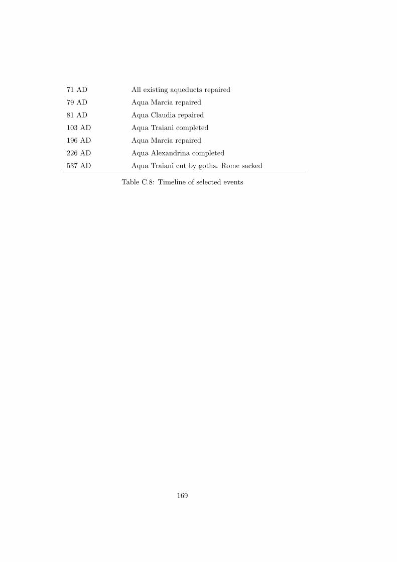
71 AD All existing aqueducts repaired
79 AD Aqua Marcia repaired
81 AD Aqua Claudia repaired
103 AD Aqua Traiani completed
196 AD Aqua Marcia repaired
226 AD Aqua Alexandrina completed
537 AD Aqua Traiani cut by goths. Rome sacked
Table C.8: Timeline of selected events
169
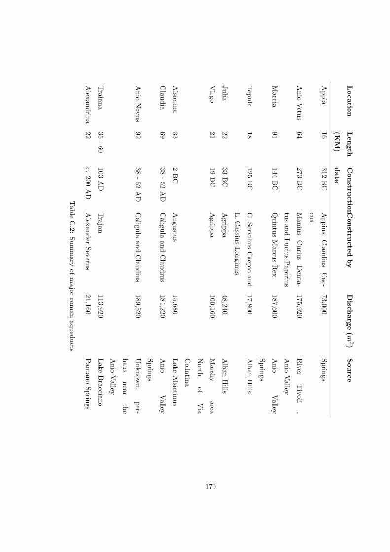
Location
Len
gth
(KM
)
Con
struction
date
Con
structed
by
Disch
arge(m
3)S
ource
Appia
16312
BC
Appius
Claudius
Cae-
cus
73,000Springs
Anio
Vetus
64273
BC
Manius
Curius
Denta-
tusand
Lucius
Papirius
175,920R
iverT
ivoli,
Anio
Valley
Marcia
91144
BC
Quintus
Marcus
Rex
187,600A
nioV
alley
Springs
Tepula
18125
BC
G.
ServiliusC
aepioand
L.
Cassius
Longinus
17,800A
lbanH
ills
Julia22
33B
CA
grippa48,240
Alban
Hills
Virgo
2119
BC
Agrippa
100,160M
arshyarea
North
ofV
ia
Collatina
Alsietina
332
BC
Augustus
15,680L
akeA
lsietinus
Claudia
6938
-52
AD
Caligula
andC
laudius184,220
Anio
Valley
Springs
Anio
Novus
9238
-52
AD
Caligula
andC
laudius189,520
Unknow
n,per-
hapsnear
the
Anio
Valley
Traiana
35-
60103
AD
Trajan
113,920L
akeB
racciano
Alexandrina
22c.
200A
DA
lexanderSeverus
21,160P
antanoSprings
Table
C.2:
Summ
aryof
major
roman
aqueducts
170

Curiosum and Notitia Polemius Silvius
1 Traiani 1 Traiani et
2 Annia ? 3 Atica ?
3 Attica ? 2 Anena
4 Claudia * 4 Claudia *
5 Marcia * 5 Marcia *
6 Herculea (*) 6 Heracliana (*)
7 Caerulea (*) 15 Virgo *
8 Iulia * 8 Julia *
9 Augustea (*) 12 Ciminia
10 Appia * 13 Aurelia
11 Alseatina * 9 Augustea (*)
12 Ciminia 11 Alsitina *
13 Aurelia 10 Appia *
14 Damnata ? 17 Severiana
15 Virgo * 18 Antoniniani
16 Tepula * 19 Alexandreana
17 Severiana 7 Caerulea (*) et
18 Antoniana 14 Dorraciana ?
19 Alexandrina Drusia
20 Cernens
Table C.3: Aqueducts listed in the Curiosum, Notitia and Silvius (Jordan,
1871:223)
171

Roman Size Lead/10 feet (kg) Diameter allowing
for overlap (cm)
100-digit 392.25 57.4
80-digit 313.7 45.5
50-digit 196.1 27.8
40-digit 157 22
30-digit 117.6 16
20-digit 78.5 10.2
15-digit 59 7.2
10-digit 39 4.3
8-digit 32.7 3
5-digit 19.5 1.32
Table C.4: Table of lead pipe sizes (Hodge, 2000:44)
Appia 20
Anio Vetus 35
Marcia 51
Tepula 14
Julia 17
Virgo 18
Claudia/Anio Novus 92
TOTAL 247
Table C.5: Number of castella (Evans, 1997:139)
172

Num
ber
Lat
inN
ame
Dia
met
er(d
igit
s)D
iam
eter
(cm
)C
ircu
mfe
renc
e(c
m)
Are
a(cm
2)
Cap
acit
y(q
uina
riae
)
5qu
inar
ia1
1 42.
317.
264.
191
1
8oc
tona
ria
23.
696
11.6
1110
.728
2+161
288
12A
duod
enar
ia3
5.54
417
.417
24.1
45+
219
288
12B
duod
enar
ia3+
18
288
5.65
917
.779
25.1
516
20A
vice
nari
a5+
13
288
9.32
329
.29
68.2
6516
+7 24
20B
vice
nari
a41 2
8.31
626
.125
54.3
1513
40qu
adra
gena
ria
7+39
288
13.1
8641
.425
136.
5632
+7 12
60se
xage
nari
a8+
212
288
16.1
4450
.71
204.
6948
+251
288
80oc
toge
nari
a10
+26
288
18.6
4658
.58
273.
0665
+1 6
100A
cent
enar
ia11
+81
288
20.8
4765
.495
341.
3381
+130
288
100B
cent
enar
ia12
2.17
669
.668
386.
2492
120A
cent
enum
-vic
enum
12+
102
288
22.8
371
.724
409.
3597
3 4
120B
cent
enum
-vic
enum
1629
.568
92.8
968
6.64
163+
11
12
Tab
leC
.6:
Mos
tco
mm
onsi
zes
ofca
lixlis
ted
byFr
onti
nus
(Hod
ge,
2000
:55)
173
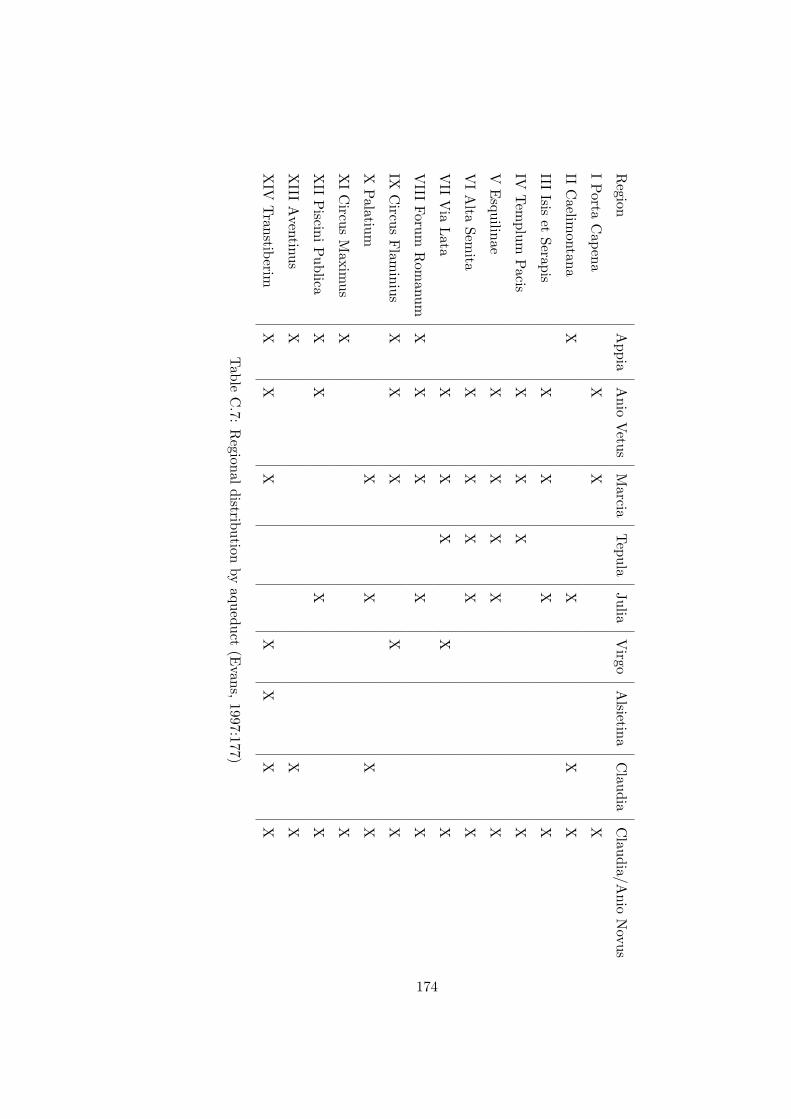
Region
Appia
Anio
Vetus
Marcia
Tepula
JuliaV
irgoA
lsietinaC
laudiaC
laudia/Anio
Novus
IP
ortaC
apenaX
XX
IIC
aelimontana
XX
XX
IIIIsis
etSerapis
XX
XX
IVT
emplum
Pacis
XX
XX
VE
squilinaeX
XX
XX
VI
Alta
Semita
XX
XX
X
VII
Via
Lata
XX
XX
X
VIII
ForumR
omanum
XX
XX
X
IXC
ircusF
laminius
XX
XX
X
XP
alatiumX
XX
X
XI
Circus
Maxim
usX
X
XII
Piscini
Publica
XX
XX
XIII
Aventinus
XX
X
XIV
Transtiberim
XX
XX
XX
X
Table
C.7:
Regional
distributionby
aqueduct(E
vans,1997:177)
174
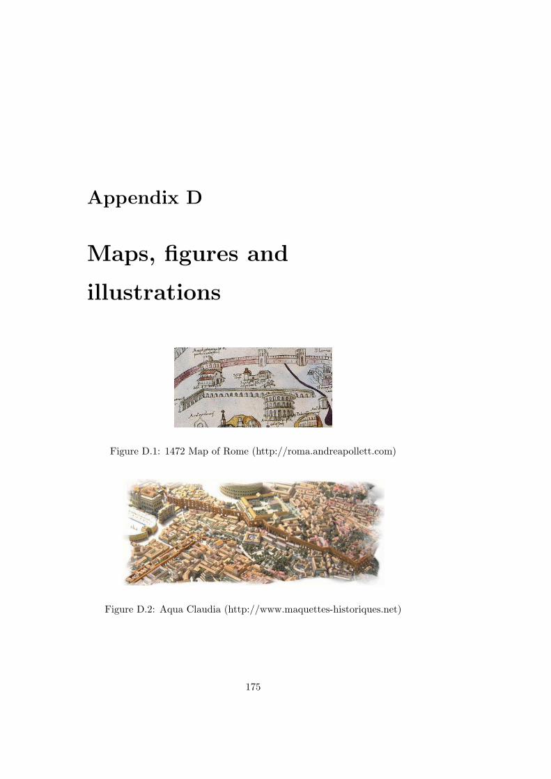
Appendix D
Maps, figures and
illustrations
Figure D.1: 1472 Map of Rome (http://roma.andreapollett.com)
Figure D.2: Aqua Claudia (http://www.maquettes-historiques.net)
175

Figure D.3: Rome’s aqueducts (http://www.speakeasy.org/-
bwduncan/aquae.html)
176

Figure D.4: Rome (http://www.the-colosseum.net/)
Figure D.5: Water Supply and Population (Hodge, 2002)
177

Figure D.6: Marcia Denarius - reverse (http://www.romanaqueducts.info)
Figure D.7: Marcia Denarius - obverse (http://www.romanaqueducts.info)
Figure D.8: Denarius ”Gens” Marcia (http://www.coinarchives.com/)
Figure D.9: Traiani Sestertius (http://www.coinarchives.com/)
178
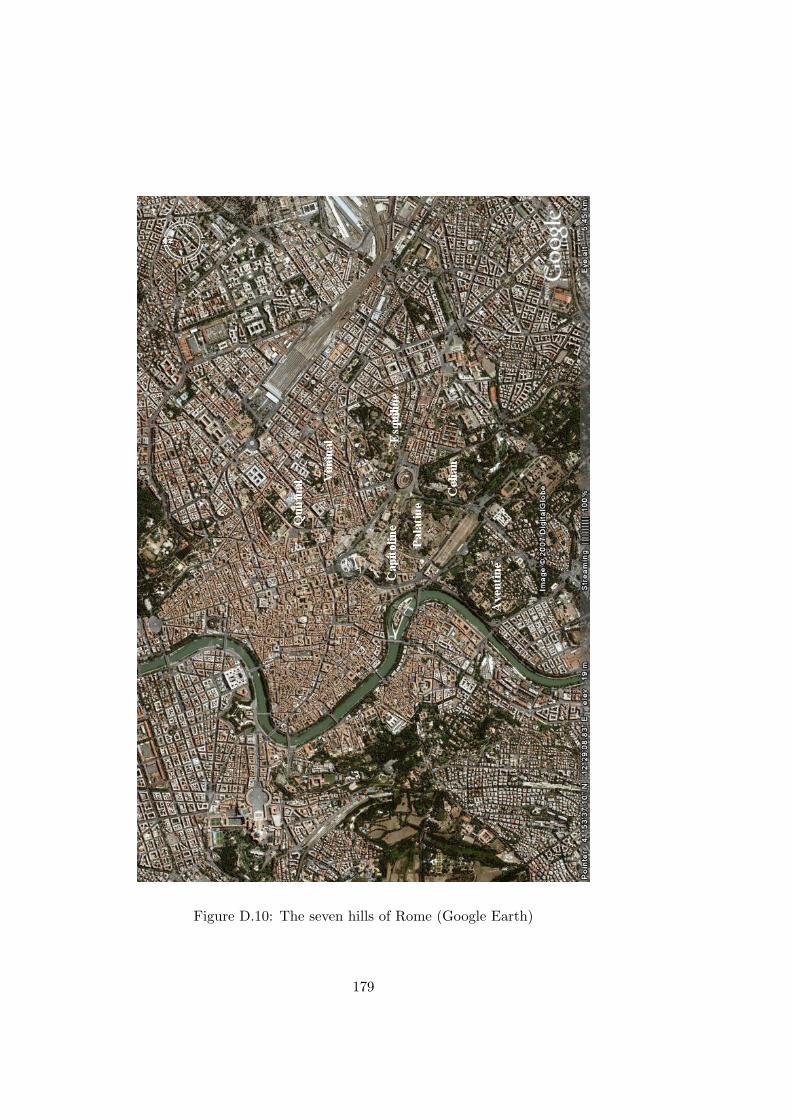
Figure D.10: The seven hills of Rome (Google Earth)
179

Figure D.11: Environs of Rome (Google Earth)
180

Figure D.12: Porta Maggiore (Google Earth)
181
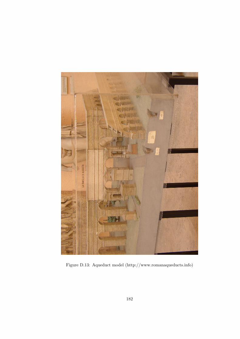
Figure D.13: Aqueduct model (http://www.romanaqueducts.info)
182
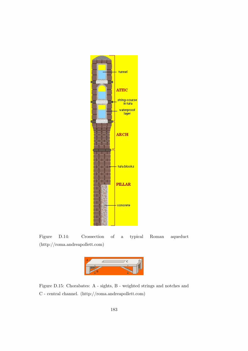
Figure D.14: Crossection of a typical Roman aqueduct
(http://roma.andreapollett.com)
Figure D.15: Chorabates: A - sights, B - weighted strings and notches and
C - central channel. (http://roma.andreapollett.com)
183
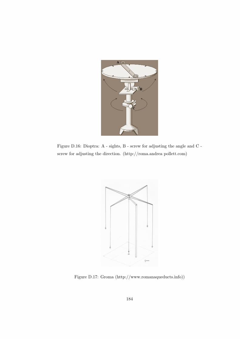
Figure D.16: Dioptra: A - sights, B - screw for adjusting the angle and C -
screw for adjusting the direction. (http://roma.andrea pollett.com)
Figure D.17: Groma (http://www.romanaqueducts.info))
184
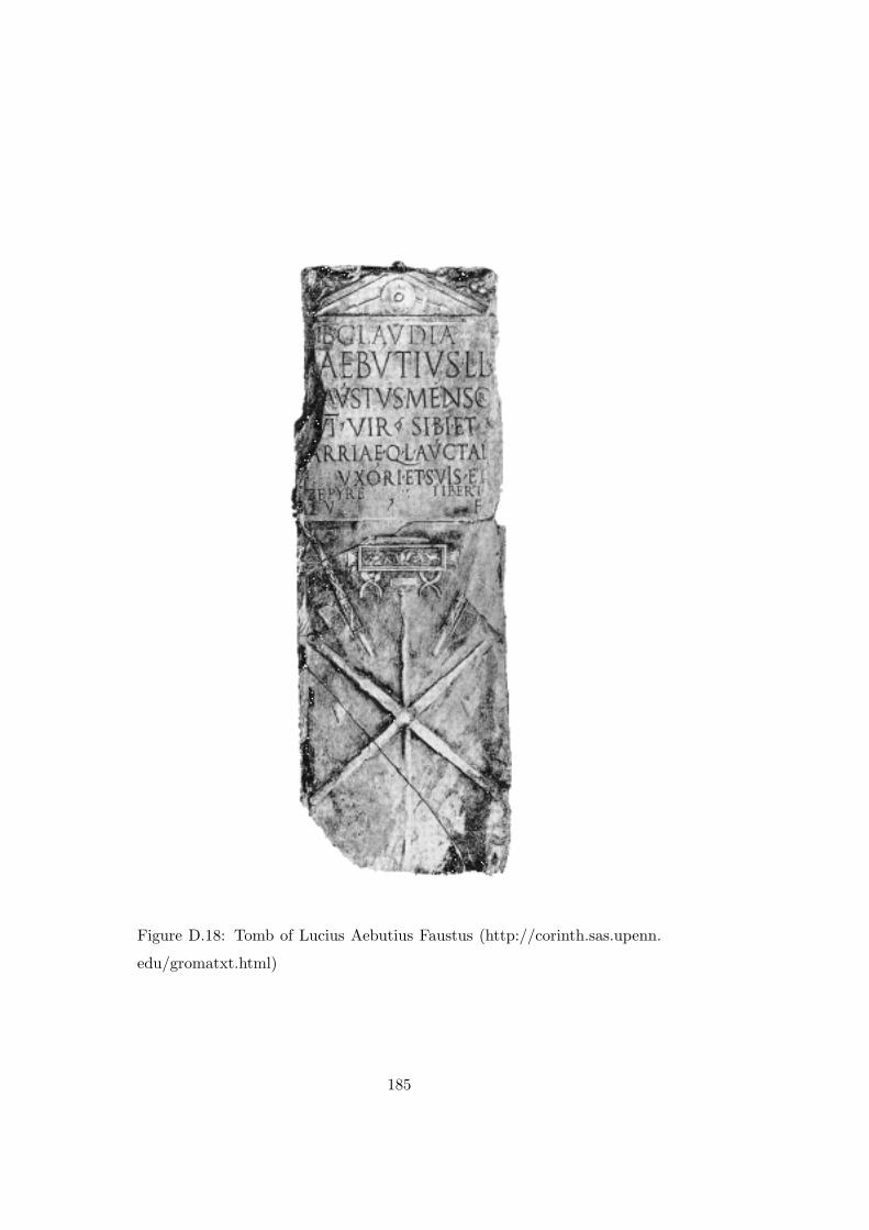
Figure D.18: Tomb of Lucius Aebutius Faustus (http://corinth.sas.upenn.
edu/gromatxt.html)
185
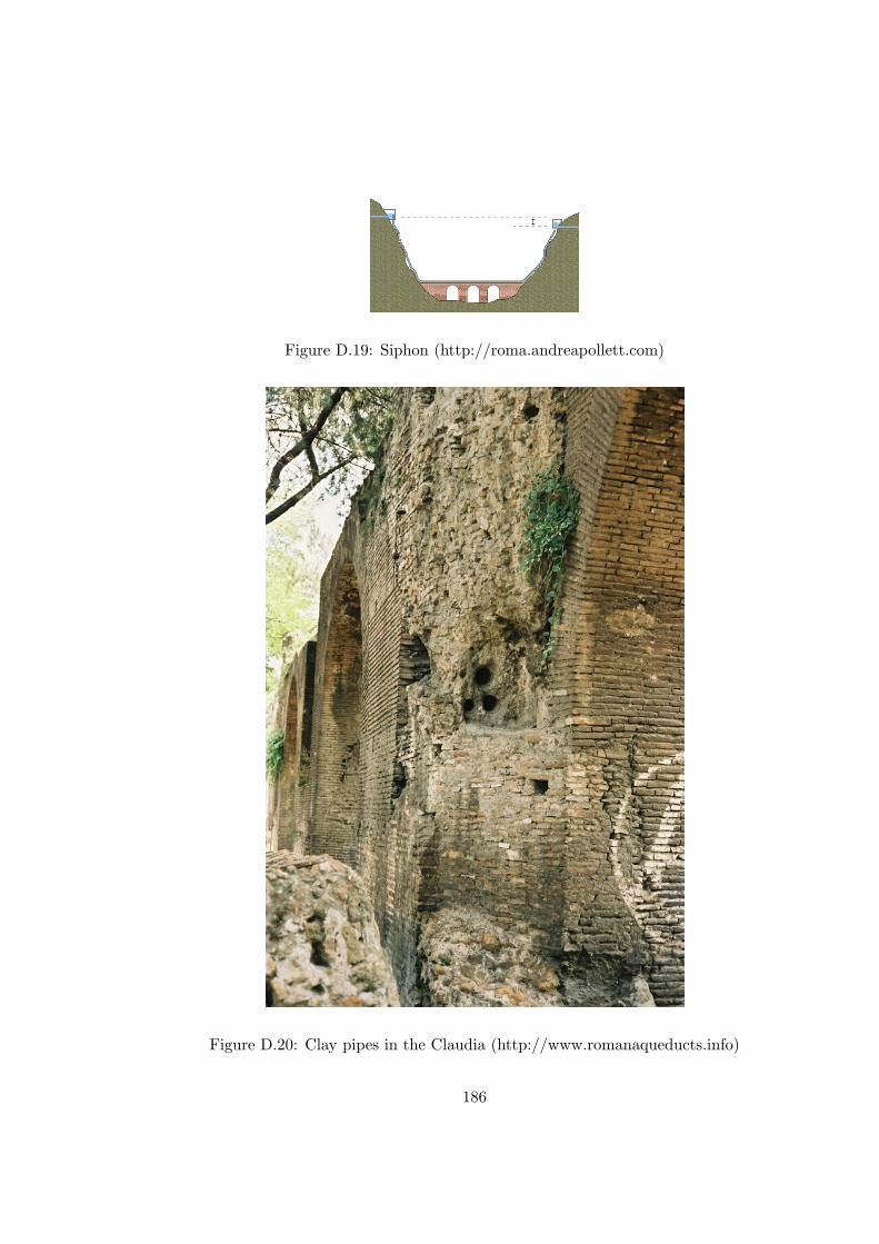
Figure D.19: Siphon (http://roma.andreapollett.com)
Figure D.20: Clay pipes in the Claudia (http://www.romanaqueducts.info)
186
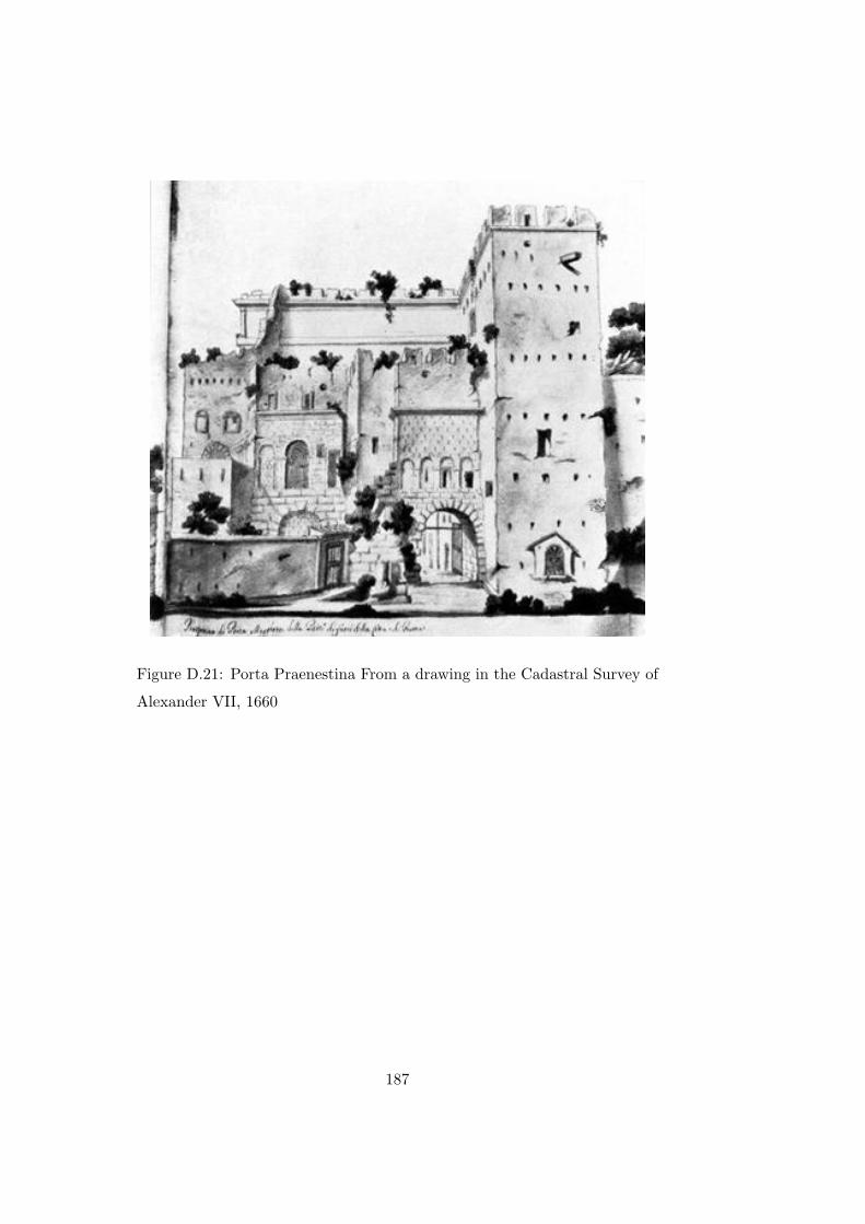
Figure D.21: Porta Praenestina From a drawing in the Cadastral Survey of
Alexander VII, 1660
187
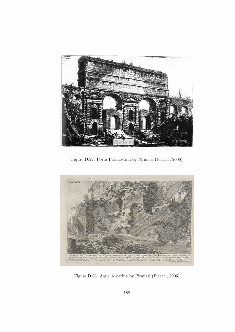
Figure D.22: Porta Praenestina by Piranesi (Ficacci, 2006)
Figure D.23: Aqua Alsietina by Piranesi (Ficacci, 2006)
188
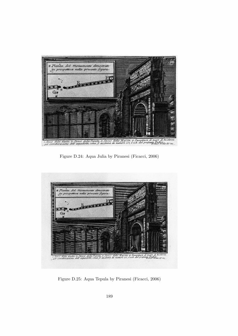
Figure D.24: Aqua Julia by Piranesi (Ficacci, 2006)
Figure D.25: Aqua Tepula by Piranesi (Ficacci, 2006)
189

Figure D.26: Aqua Virgo by Piranesi (Ficacci, 2006)
Figure D.27: Aqua Claudia and Anio Novus Castellum by Piranesi (Ficacci,
2006)
190

Figure D.28: Aqua Claudia and Anio Novus (http://www.romanaqueducts.
info)
191

Figure D.29: Aqua Claudia 1 by Piranesi (Ficacci, 2006)
Figure D.30: Aqua Claudia 2 by Piranesi (Ficacci, 2006)
192

Figure D.31: Old Anio by Piranesi (Ficacci, 2006)
Figure D.32: Aqua Antonio by Piranesi (Ficacci, 2006)
193

Figure D.33: Aqua Caracall by Piranesi (Ficacci, 2006)
Figure D.34: Cistern on the Marcia (http://www.romanaqueducts.info)
194

Bibliography
Texts and Sources
CASSIODORUS. (1992) Variae. Liverpool: Liverpool University Press.
CORPUS INSCRIPTIONUM LATINARUM (1847-). Berlin: Berlin-Brandenburgische
Akademie der Wissenschaften.
DIO CASSIUS. (2005) Roman History. New York: Penguin Books Ltd.
FRONTINUS. (1925) The Aqueducts of Rome. Cambridge: Harvard Uni-
versity Press.
GALEN. (1916) On the Natural Faculties. Cambridge: Harvard University
Press.
HERODOTUS. (1920) The Persian Wars. Cambridge: Harvard University
Press.
LIVY. (1919) History of Rome. Cambridge: Harvard University Press.
MARTIAL. (1993) Epigrams. Cambridge: Harvard University Press.
195

OVID. (1931) Fasti. Cambridge: Harvard University Press.
PLINY THE ELDER. (1938) Natural History. Translated by Eichholz, D.E.
Cambridge: Harvard University Press.
PLINY THE YOUNGER. (2006) Complete Letters. Oxford: Oxford Uni-
versity Press.
PROCOPIUS. (1914) History of the Wars. Oxford: Oxford University
Press.
STRABO. (1917) Geography. Cambridge: Harvard University Press.
SUETONIUS. (1978) The Twelve Caesars. Harmondsworth: Penguin Books
Ltd.
TACITUS. (1956) The Annals of Imperial Rome. Rome: Penguin Books
Ltd.
VARRO. (1938) On the Latin Language. Translated by Kent, R.G. Cam-
bridge: Harvard University Press.
VITRUVIUS (1934) On Architecture. Cambridge: Harvard University Press.
Secondary Literature
AICHER, P. (1995) Guide to the Aqueducts of Ancient Rome. Wauconda:
Bolchazy-Carducci Publishers, Inc.
196

ANDERSON, J. (1985) The Date of the Thermae Traiani and the Topog-
raphy of the Oppius Mons. American Journal of Archaeology, Vol. 89, No.
3. (Jul., 1985), pp. 499-509.
ANDERSON, J. (1997) Roman Architecture and Society. Baltimore: John
Hopkins University Press.
ASHBY, T. (1935) Aqueducts of Ancient Rome. Oxford.
ASHBY, T. (1970) The Roman Campagna in Classical Times. London:
Ernest Benn Limited.
BLACKMAN, D. (1979) The Length of the Four Great Aqueducts of Rome.
Papers of the British School at Rome, 47, pp. 12-18.
BLYTH, F. & DE FREITAS, M. (1986) A Geology for Engineers. London:
Arnold.
BOREN, H. (1958) The Urban Side of the Gracchan Economic Crisis. The
American Historical Review, 63, 890-902.
BRUUN, C. (1991) The Water Supply of Ancient Rome. Commentationes
Humanarum Litterarum, 93.
CARY, M. & SCULLARD, H. (1975) A History of Rome. London: Macmil-
lan Press.
CARY, M. & HAARHOFF, T. (1968) Life and Thought in the Greek and
Roman World. London: Methuen & Co. Ltd.
197
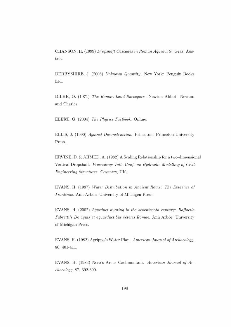
CHANSON, H. (1999) Dropshaft Cascades in Roman Aqueducts. Graz, Aus-
tria.
DERBYSHIRE, J. (2006) Unknown Quantity. New York: Penguin Books
Ltd.
DILKE, O. (1971) The Roman Land Surveyors. Newton Abbot: Newton
and Charles.
ELERT, G. (2004) The Physics Factbook. Online.
ELLIS, J. (1990) Against Deconstruction. Princeton: Princeton University
Press.
ERVINE, D. & AHMED, A. (1982) A Scaling Relationship for a two-dimensional
Vertical Dropshaft. Proceedings Intl. Conf. on Hydraulic Modelling of Civil
Engineering Structures. Coventry, UK.
EVANS, H. (1997) Water Distribution in Ancient Rome: The Evidence of
Frontinus. Ann Arbor: University of Michigen Press.
EVANS, H. (2002) Aqueduct hunting in the seventeenth century: Raffaello
Fabretti’s De aquis et aquaeductibus veteris Romae. Ann Arbor: University
of Michigan Press.
EVANS, H. (1982) Agrippa’s Water Plan. American Journal of Archaeology,
86, 401-411.
EVANS, H. (1983) Nero’s Arcus Caelimontani. American Journal of Ar-
chaeology, 87, 392-399.
198
EVANS, R. (2005) Rome’s Cimbric Wars and their impact on the Iberian
Peninsula. Acta Classica, XLVIII, 37-56.
FICACCI, L. (2006) Piranesi: The Etchings. Koln: Taschen.
FLOWER, H. (2004) The Cambridge Companion to the Roman Republic.
Cambridge: Cambridge University Press.
GOWERS, E. (1995) The Anatomy of Rome from Capitol to Cloaca. The
Journal of Roman Studies, Vol. 85. (1995), pp. 23-32.
GRANT, M. (1993) The Climax of Rome. London: Weidenfeld & Nicholson.
GROSS, R. & LEVITT, N. (1998) Higher Superstition. Baltimore: The
Johns Hopkins University Press.
HAUCK, G. (1988) The Aqueduct of Nemausus. Jefferson: McFarland &
Company, Inc.
HEIKEN, G., FUNICIELLO, R. & DE RITA, D. (2005) The Seven Hills of
Rome. Princeton: Princeton University Press.
HINTZEN-BOHLEN, B. (2000) Rome and the Vatican City. Cologne: Kne-
mann Verlagsgesellschaft mbH.
HODGE, A. (2002) Roman Aqueducts and Water Supply. London: Gerald
Duckworth & Co. Ltd.
HODGE, A. (1991) Future Currents in Aqueduct Studies. Leeds: Francis
Cairns (Publications) Ltd.
199

JORDAN, H. (1871) Topographie der stadt Rom im alterthum. Berlin:
Weidmannsche Buchhandlung.
JORDAN, H. (1907) Topographie der stadt Rom im alterthum. Berlin:
Weidmannsche Buchhandlung.
KEK, D. (1994) Der romische Aquadukt als Bautypus und
Reprasentationsachitektur. Munster: Lit Verlag.
KIENAST, H. (1977) Der Tunnel des Eupalinas auf Samos. Architectura,
1977, 97-116.
KIMBALL, R. (2002) Experiments Against Reality. New York: Ivan R. Dee.
KOEPPEL, G.T. (2001) Water for Gotham: A History. Princeton: Prince-
ton University Press.
LAMB, H. (1995) Climate, History and the Modern World. London: Rout-
ledge.
LANCIANI, R. (1990) Forma Urbis Romae. Rome: Edizione Quasar.
LANDELS, J. (2000) Engineering in the Ancient World. London: Constable
& Robinson Ltd.
LEVEAU, P. (1991) Research on Roman Aqueducts in the past ten years.
In: Future Currents in Aqueduct Studies (ed. T. Hodge), pp. 149-162.
MIDDLETON, J. (1892a) The Remains of Ancient Rome Vol. 1. London:
Elibron Classics.
200

MIDDLETON, J. (1892b) The Remains of Ancient Rome Vol. 2. London:
Elibron Classics.
MORTON, H. (1966) The Waters of Rome. London: The Connoisseur and
Michael Joseph.
O’CONNOR, C. (1993) Roman Bridges. Cambridge: Cambridge University
Press.
PLATNER, S. & ASHBY, T. (1965) Topographical Dictionary of Ancient
Rome. Rome.
PLOMMER, H. (1973) Vitruvius and Later Roman Building Manuals. Lon-
don: Cambridge University Press.
RAND WATER BOARD. (2007) Annual Report 2007. Johannesburg: Rand
Water Board.
REINHOLD, M. (1965) Marcus Agrippa. Rome: ”L’Erma” di Bretschneider.
RICHARDSON, L. (1992) A New Topographical Dictionary of Ancient Rome.
Baltimore: The Johns Hopkins University Press.
ROSENSTEIN, N. & MORSTEIN-MARX, R. (2006) A Companion to the
Roman Republic. Malden: Blackwell Publishing Ltd.
SANDYS, J. (1927) Latin Epigraphy. London: Cambridge University Press.
SCARRE, C. & SCARRE, C. (1999) Seventy Wonders of the Ancient World.
London: Thames and Hudson.
201
SMITH, W. (1875) Dictionary of Greek and Roman Antiquities. London:
John Murray.
SPEAKE, G. (1994) The Penguin Dictionary of Ancient History. London:
Penguin Books.
STAMBAUGH, J. (1992) The Ancient Roman City. Baltimore: The Johns
Hopkins University Press.
STOVE, D. (2006) Scientific Irrationalism. New York: Transaction Pub-
lishers.
TARDIEU, G. (1986) The Roman Water System. San Jose: The San Jose
State University.
TAYLOR, R. (2002) Tiber River Bridges and the Development of the An-
cient City of Rome. THE WATERS OF ROME, Occasional Papers, no. 2,
June 2002, pp. 1-20.
TSIMPURAKIS, D. (1997) The Diggings of Eupalinos in Ancient Samos.
Athens: Editions Arithmos.
VAN DEMAN, E. (1934) The Building of the Roman Aqueducts. Washing-
ton D.C: Carnegie Institution of Washington.
WILSON, A. (2002) Machines, Power and the Ancient Economy. The Jour-
nal of Roman Studies, Vol. 92, pp. 1-32.
WINDSCHUTTLE, K. (1997) The Killing of History. New York: The Free
Press.
202

WRIGHT, F. (1937) Marcus Agrippa: Organizer of Victory. London: George
Routledge and Sons, Ltd.
203