the anthroposolic soil order - in1touch order_4apr2018_konstantin dlusskiy...outline •why do we...
TRANSCRIPT

ANTHROPOSOLIC SOIL ORDERProposed Soil Order for the 4th Edition of the Canadian System of Soil Classification
Konstantin Dlusskiy, Ph.D., P.Ag. Paragon Soil and Environmental Consulting Ltd.
14th Annual AIA Banff Conference: Governments and People April 2018

Outline
• Why do we need the Anthroposolic soil order
• What is an Anthroposol
• How to classify Anthroposols and describe Anthroposolic soil horizons
• Overview of Anthroposolic Great Groups with examples
• Typical examples of Anthroposols from Alberta
• What are the challenges with Anthroposol classification
• Primarily based on the research paper published by Dr. Naeth• Naeth, M.A., Archibald, H.A., Nemirsky, C.L., Leskiw, L.A., Brierley, A. J.,
Bock, M.D., VandenBygaart, A.J. and Chanasyk, D.S., 2012. Proposed classification for human modified soils in Canada: Anthroposolic order. Canadian Journal of Soil Science 92, 7-18

1. INTRODUCTION TO DISTURBED SOILSApproach to the Anthroposols

Canadian System of Soil Classification
The 3rd Edition of the CSSC, published in 1998, includes 10 Soil Orders:
• Brunisolic
• Chernozemic
• Cryosolic Order
• Gleysolic Order
• Luvisolic Order
• Organic Order
• Podzolic Order
• Regosolic Order
• Solonetzic Order
• Vertisolic Order
Why do we need the 11th one?

Why do we need the 11th one?
• In 1941 Hans Jenny published Factors of Soil Formation, a system of quantitative pedology where he summarized and illustrated many of the basic principles of modern soil science to that date
• He said that the following five factors completely describe the soil system:
• Recently a new factor has been introduced beyond the five listed by Jenny

Human activity – the new soil forming factor
• Placement and removal of natural geological materials
• Introduction of new materials to the landscape• Waste
• Chemicals
• Terraforming• Landscaping
• Modifying soil drainage
• Constructing soil horizons and therefore
• Changing trajectories of soil formation

Recognizing human activity
• Regulatory frameworks must incorporate reclamation criteria for disturbed soils, requiring consistent descriptions andinterpretations.
• Many human altered soils cannot be described and classified using the Canadian System of Soil Classification (CSSC)
• Consistent description requires introduction of new horizon types and classification of parent materials
• Consistent interpretation requires creation of subgroups and great groups forming a new soil order based on severe human disruption of soil-forming factors and introduction of potentially new pedogenic trajectories

International approach
• WRB - the World Reference Base for Soil Resources (International Union of Soil Sciences 2007) is widely accepted as an international soil classification
• Anthrosol and Technosol reference soil groups
• Anthrosols have been subjected to intensive agricultural use for some time
• Technosols contain artefacts or technic hard rock (a consolidated product of an industrial process)• Technosols include soils from wastes such as landfills or mine spoils,
pavements and underlying materials, soils with geomembranes and constructed soils in human-made materials

Canadian Approach
• 2006 – Land Capability Classification System• Tailored to forest ecosystems in the Oil Sands region – Alberta only
• Did not cover classification, just suggested horizon designations
• Horizon names were not in a system: OB, Ptmix, TSS, MIN, KM (LOS)
• Approved by the Alberta Government
• 2012 –new Soil Order proposed• Group led by Dr. Anne Naeth (U of A)
• Comprehensive classification of Anthroposols open for discussion
• Yet, just a research paper in Canadian Journal of Soil Science
• 2015 – Field Handbook for the Soils of Western Canada • Group associated with Canadian Society of Soil Science
• Purpose – to allow field testing of the classification proposed in 2012
• No changes made to the 2012 classification

Step 1 – Proposed classification
• 2012 – A research paper by a group of researchers lead by Dr. Anne Naeth (U of A, consulting, Government)
• Thorough review of existing options
• Proposed new soil order – Anthroposols
• Comprehensive classification to Great Groups, Subgroups and Phases
• Approach was generally accepted by the community
• Regulatory frameworks don’t recognize a research paper as a trustful source

Step 2 – Field testing stage
• The Pedology Subcommittee of the Canadian Society of Soil Science (CSSS) was established in 2005• Mandate included “improvement of the taxonomic classification system
for Canadian soils through revision of the system because of new information”
• In 2015-2016 the Subcommittee published the Field Handbook for the Soils of Western Canada• Pedology Subcommittee team (led by Dr. Pennock) in collaboration with
the team that originally proposed the classification (led by Dr. Naeth)
• Intent for the Field Handbook was two-fold1. to simplify the use of the Canadian System of Soil Classification in the
field and
2. to allow field testing of a new soil order for Anthroposolic soils, which has been proposed for inclusion in the Canadian System of Soil Classification

Two sources of information
Naeth, M.A., Archibald, H.A., Nemirsky, C.L., Leskiw, L.A., Brierley, A. J., Bock, M.D., VandenBygaart, A.J. and Chanasyk, D.S. 2012. Proposed classification for human modified soils in Canada: Anthroposolic order. Canadian Journal of Soil Science. 92, 7-18
Pennock, D.J., Watson, K., and Sanborn, P. 2015. Section 4. Horizon Identification. From: D. Pennock, K. Watson, and P. Sanborn. Field Handbook for the Soils of Western Canada. Canadian Society of Soil Science. 27 pp.
Approach to the Anthroposol definition
• To be classified as an Anthroposol, the soil disturbance or modification needs to be evident
• If the soil was minimally disturbed and could not be distinguished from a natural soil, it could be classified into its appropriate natural soil order
• If over time an anthropogenically modified soil reaches an equilibrium that is diagnostic of a natural soil, then the soil could be classified as such at that time• Not every soil order requires equilibrium and we will discuss this later

Definition lies in parent material deposition
• The most critical moment in classification of Anthroposols is to define limits of the Soil Order
• Naeth et al (2012) defined the Order based on parent material deposition or removal
• >10 cm stripped orreplaced ormodified in situ making soil disturbance or modification evident (disturbed D layer)• Tillage is not qualified
• In future, some agricultural soils could be included in Anthroposols

2. DISTURBED LAYERSand the control sectionas defined in the current classification

Anthroposolic Profile
• It is an Anthroposol if one or more of a soil’s natural horizons was• removed,
• removed-and-replaced,
• added to, or
• significantly modified by human activity.
• Soil should have a diagnostic disturbed horizon (D)
• Depth of the anthropogenic disturbance, modification or addition must be >10 cm.
Note:Ap horizon ( tillage ) - may have been disturbed >10 cm however does not constitute changes sufficient for a soil to be called an Anthroposol.

Definition of Disturbed layer (D)
• The diagnostic Disturbed layers (D layers) are anthropic in origin (anthropogenic) and contain materials that have been significantly modified physically and/or chemically by human activities
• Dr. Naeth with colleagues (2012) uses the term “layer” and avoids using the word “horizon” as the separation is based on placement of materials rather than formation of properties
• Dr. Pennock with colleagues (2015) applies the term “horizon” widely
• Multiple different D layers can be described in one soil profile

Suffixes• Traditional Canadian System of Soil Classification (CSSC) suffixes
and prefixes should be applied to D horizons (h, m, k, g, II, III etc.)
• ADDITION OF NEW SUFFIXES
SUFFIX Description
w artefacts (w for waste)
q hydrocarbons (contained in the quintessential reclamation profile)
o organic materials with >17% organic carbon in Carbic Great Group

Examples of D layers
• Peat-Mineral Mix (Dh, Do),
• Stripped and replaced mineral topsoil (Dh, D1),
• Human waste layer with human artefacts (Dw),
• Placed fair-good subsoil (Dm, D2, Dk),
• Placed calcareous buffer (Dk),
• Waste rock layer (IIDq), or
• Tailings (IID)

Examples of D layers
Example 1: Alberta Oil Sands (Dh) peat mineral mixes on top of (Dk) suitable overburden over (IIDq) unsuitable overburden materials
Example 2: Pipeline or Coal MineLayers were excavated, stored, then replaced in the relative sequence of the undisturbed soils: (Dh) topsoil/former Ah over (Dm) upper subsoil/former Bm, and (Dk) lower subsoil/former Cca, Ck, Csk Example 3: Landfill Capping

Control Section• Control Section – Depth of 120 cm
• compare 100 cm for mineral soil and 160 cm for organic soil (CSSC)
• Diagnostic disturbed D layer – the one encompassing the greatest cumulative proportion of the disturbed profile• if equal proportions – uppermost layer used for classification

3. CLASSIFICATIONGreat Groups, Subgroups and Phases of Anthroposols

Anthroposolic Great GroupsThe great group level in the CSSC, by definition, is ‘‘based on properties that reflect differences in the strengths of dominant processes, or a major contribution of a process in addition to the dominant one’’
Composition of disturbed layers defines Great Group in Anthroposolic classification
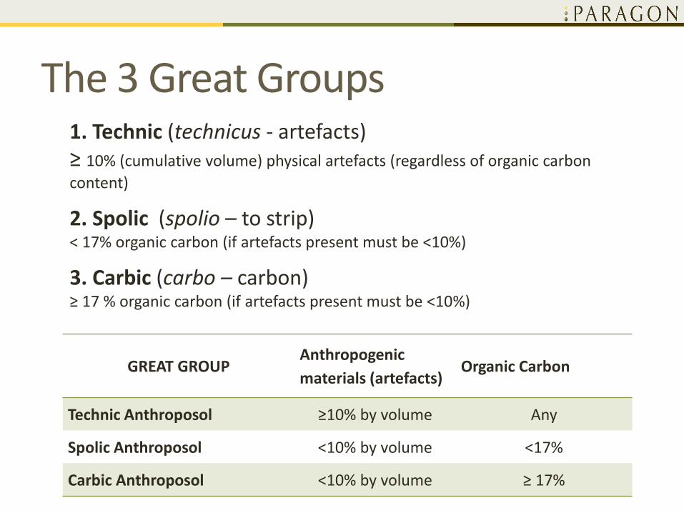
The 3 Great Groups
GREAT GROUPAnthropogenic
materials (artefacts)Organic Carbon
Technic Anthroposol ≥10% by volume Any
Spolic Anthroposol <10% by volume <17%
Carbic Anthroposol <10% by volume ≥ 17%
1. Technic (technicus - artefacts)≥ 10% (cumulative volume) physical artefacts (regardless of organic carbon
content)
2. Spolic (spolio – to strip)< 17% organic carbon (if artefacts present must be <10%)
3. Carbic (carbo – carbon) ≥ 17 % organic carbon (if artefacts present must be <10%)

The 3 Great Groups

Anthroposolic Subgroups• Subgroups are differentiated
on ‘‘the kind and arrangement of horizons that indicate conformity to the central concept of the great group, intergrading towards soils of another order, or additional special features within the control section’’ (Soil Classification Working Group 1998)
Anthroposolic Subgroups
Subgroups in the Anthroposolic order are based on:
• Characteristics of a 10-cm topsoil or cover soil layer
• Presence of layers characteristic for other subgroups
• Depth of disturbance
• Drainage characteristics

The 9 Subgroups
SUBGROUP Defining Features
1. EgeoLatin egeo - lack or to be
without
Soils with a distinguishable surface layer that is <10 cm thick, regardless of
its organic carbon content, over another layer(s) of disturbed material
2. AlboLatin albus -white
Soils with a surface layer that is ≥10 cm thick and has <2% organic carbon
(light colour)
3. Fuscofusc - to make dark
Surface layer that is ≥10 cm thick and has 2 to 17% organic carbon (dark
colour)
4. Carbocarbo - carbon
Surface layer that is ≥10 cm thick and has ≥17% organic carbon, but is not
sufficiently deep to be classified in the Carbic Great Group
Combination subgroups are used more widely than in other Orders

The 9 SubgroupsSUBGROUP Defining Features
5. Technotechnicus - artificial
Soils with a technic layer present (≥10 cm), but not in a sufficient
cumulative thickness for the soil to be classified in the Technic great
group
6. Spolospolio – to strip
Spolic layer present (≥10 cm), but not in a sufficient cumulative
thickness for the soil to be classified in the Spolic Great Group
7. Terroterro in Latin
connotes earth, a
sense of naturalness
Soils with shallow disturbances. Depth of disturbance is less than the
depth of original parent material within the control section. At least 10
cm of original parent material present
8. AquoAqua - water
Soils with imperfect, poor or very poor drainage. Mottles and gleying
not necessarily diagnostic in the anthropogenically disturbed
environment (could be relict). Must be evidence of prolonged wetness in
the soil profile, such as a water table or saturated soil in a layer and
hydrophilic vegetation
9. Cryo Soils with the presence of permafrost

Anthroposolic Subgroups
• No standard abbreviations proposed yet
• No Orthic subgroup
• Unlimited combinations are allowed
• Gleyed Eluviated Dystric Brunisol (GLE.DYB)
• Fusco Spolic Anthroposol (FU.SA)
• Fusco Terro Spolic Anthroposol (FUTE.SA)
• Fusco Aquo Techno Terro Spolic Anthroposol (FUAQTCTE.SA ??)
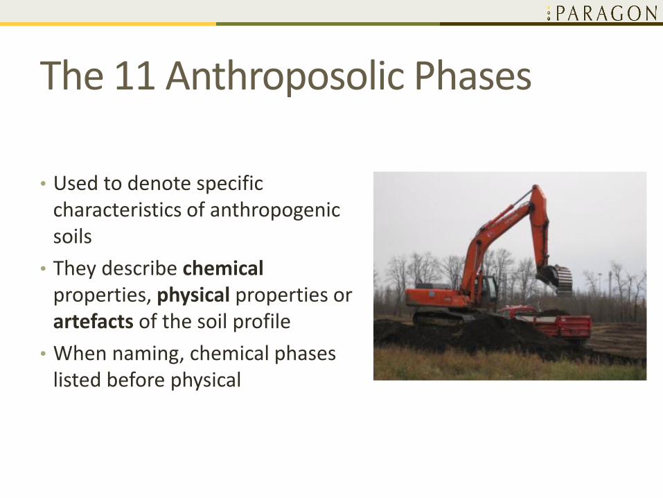
The 11 Anthroposolic Phases
• Used to denote specific characteristics of anthropogenic soils
• They describe chemicalproperties, physical properties or artefacts of the soil profile
• When naming, chemical phases listed before physical
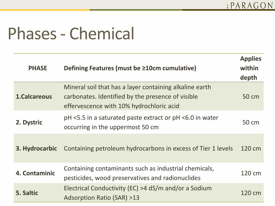
Phases - Chemical
PHASE Defining Features (must be ≥10cm cumulative)
Applies
within
depth
1.Calcareous
Mineral soil that has a layer containing alkaline earth
carbonates. Identified by the presence of visible
effervescence with 10% hydrochloric acid
50 cm
2. DystricpH <5.5 in a saturated paste extract or pH <6.0 in water
occurring in the uppermost 50 cm50 cm
3. Hydrocarbic Containing petroleum hydrocarbons in excess of Tier 1 levels 120 cm
4. ContaminicContaining contaminants such as industrial chemicals,
pesticides, wood preservatives and radionuclides120 cm
5. SalticElectrical Conductivity (EC) >4 dS/m and/or a Sodium
Adsorption Ratio (SAR) >13120 cm

PHASE Defining Features (must be ≥10cm cumulative)
Applies
within
depth
6. Clayic Fine textured (>40% clay) layer 50 cm
7. Compactic
Mineral soil showing evidence of root restriction in a layer as
indicated by compacted structure and very firm to extremely
firm consistence
50 cm
8. Sablic
Textures ranging from sand to loamy sand. It is loose or very
friable, structureless or weakly structured, rapidly permeable,
uncompacted material
120 cm
9. Thick Soil with a surface layer >40 cm deep 120 cm
Phases - Physical

PHASE Defining Features (must be ≥10cm cumulative)
Applies
within
depth
10. Garbic
Contains refuse from human activity either high in organic matter
or primarily of manufactured origin such as glass, plastic or
concrete. Middens may be included in this category.
120 cm
11. Slurric
Materials that are deposited as a slurry layer. This phase is only
applied in situations where the use of a slurry process is still
discernible (e.g., fresh drilling mud). Slurric materials must exhibit
a high degree of human modification. Dredged materials that
have been moved from an aquatic environment to dry land
without physical or chemical modification may be included as this
movement constitutes a high degree of human modification.
50 cm
Phases – Origin of Artefacts

Review
1. Calcareous
2. Dystric
3. Hydrocarbic
4. Contaminic
5. Saltic
6. Clayic
7. Compactic
8. Sablic
9. Thick
10. Garbic
11. Slurric
Anthroposolic
Phases
1. Egeo
2. Albo
3. Fusco
4. Carbo
5. Techno
6. Spolo
7. Terro
8. Aquo
9. Cryo
Anthroposolic
Subgroups
1. Technic
2. Spolic
3. Carbic
Anthroposolic
Great GroupsAnthroposolic
Cryosolic
Organic
Luvisolic
Vertisolic
Podzolic
Gleysolic
Solonetzic
Chernozemic
Brunisolic
Regosolic
Order

4. EXAMPLES6 examples from Naeth et al (2012) = handouts
4 examples from the CEMA’s Long-Term Plot Network

Example 1Landfill site capped with Spolic material
Image source: www.ediweekly.com/worlds-first-municipal-waste-biofuels-plant-opens-edmonton
Image source: http://mmmgrouplimited.com/projects/clover-bar-landfill-re-vegetation

Example 1
Great Group: Technic because technic material (>10% human artefacts) is the
dominant layer in the control section (120 cm of the surface).Subgroup: Spolo because spolic material (<10% artefacts and <17% organic
carbon) is >10 cm thick in the control section. Fusco because the surface layer is >10 cm thick and organic carbon
content is between 2 and 17%.Phases Calcareous because carbonates are present in a >10 cm layer within
50 cm of the soil surface. Garbic because human refuse is present in a 10 cm layer within 120
cm of the soil surface
Landfill site capped with Spolic material
Fusco Spolo Technic Anthroposol – calcareous, garbic phase
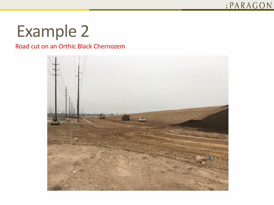
Example 2Road cut on an Orthic Black Chernozem

Example 2
Great Group:Spolic because the dominant layer has <10% artifacts and contains
<17% organic carbonSubgroup: Albo because the surface layer is ≥ 10 cm and has <2% organic carbon.Terro because depth of disturbance (10 cm) is less than depth of the
control section.PhasesCalcareous because carbonates are present in >10 cm layer within 50
cm of the soil surface.Compactic because there is evidence of compaction in a 10 cm layer
within 50 cm of the soil surface.
Terro Albo Spolic Anthroposol - calcareous, compactic phase
Road cut on an Orthic Black Chernozem

Example 3Drilling mud spread on the surface of an Orthic Black Chernozem

Example 3Drilling mud spread on the surface of an Orthic Black Chernozem
Great Group:• Spolic because dominant material has <10% artefacts and contains
<17% organic carbon.Subgroup:• Albo because the surface layer (10 cm D horizon) contains <2% organic
carbon.• Terro because the original soil is present in the control section.Phase:• Slurric because a 10 cm slurry layer occurs within 50 cm of the soil
surface.
Terro Albo Spolic Anthroposol - slurric phase

Example 4Well site pad located on a fen, west central Alberta
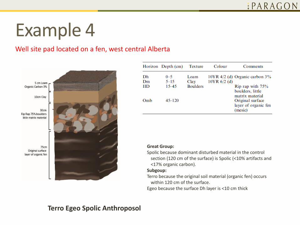
Example 4Well site pad located on a fen, west central Alberta
Terro Egeo Spolic Anthroposol
Great Group:Spolic because dominant disturbed material in the control
section (120 cm of the surface) is Spolic (<10% artifacts and <17% organic carbon).
Subgoup:Terro because the original soil material (organic fen) occurs
within 120 cm of the surface.Egeo because the surface Dh layer is <10 cm thick

Example 5Reclaimed Pipeline (3 lift) in southern Alberta

Example 5Reclaimed Pipeline (3 lift) in southern Alberta
Fusco Spolic Anthroposol - calcareous, saltic phase
Great Group:Spolic because the dominant disturbed material in the control section
(120 cm of the surface) is Spolic (<10% artifacts and <17% organic carbon).
Subgroup:Fusco because the surface layer is >10 cm thick and contains >2 and<17%
organic carbon.Phase:Calcareous because carbonates are present in >10 cm layer within 50 cm
of the surface.Saltic because free salts (electrical conductivity >4 dS/m) are present in a
>10 cm layer within 120 cm of the surface
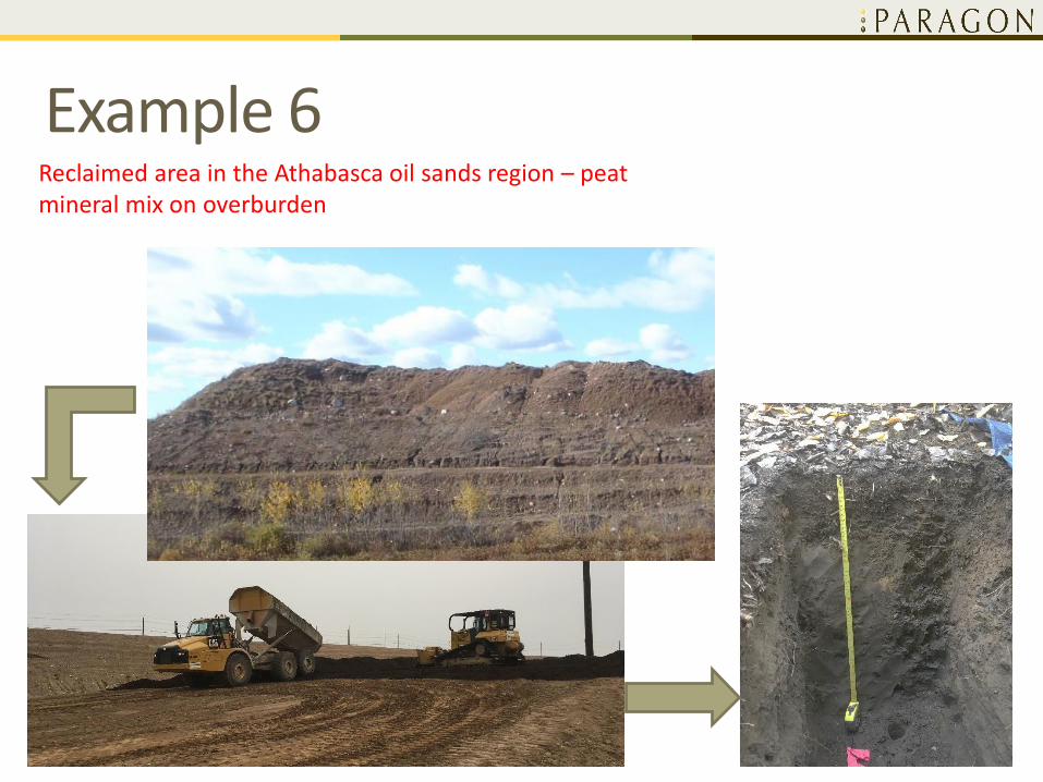
Example 6Reclaimed area in the Athabasca oil sands region – peat mineral mix on overburden
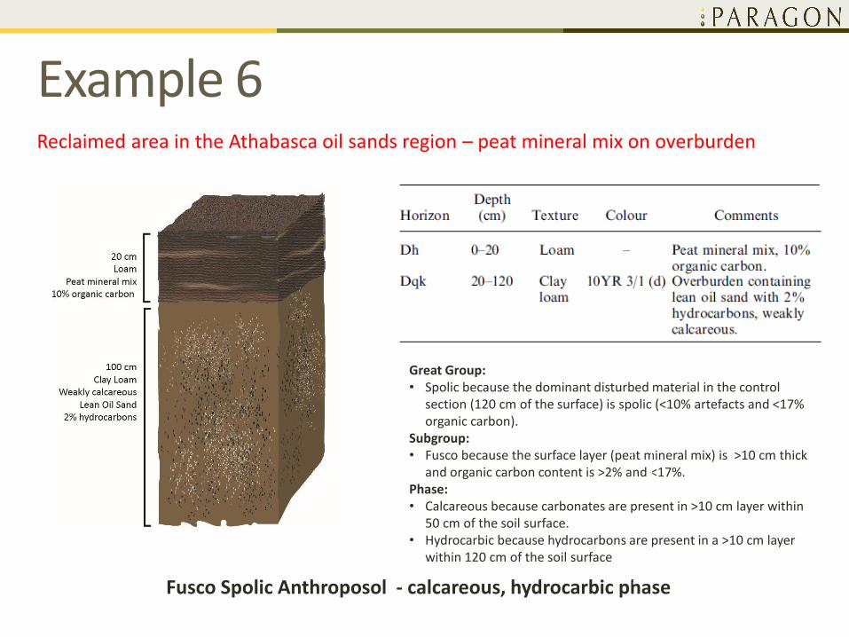
Example 6Reclaimed area in the Athabasca oil sands region – peat mineral mix on overburden
Fusco Spolic Anthroposol - calcareous, hydrocarbic phase
Great Group:• Spolic because the dominant disturbed material in the control
section (120 cm of the surface) is spolic (<10% artefacts and <17% organic carbon).
Subgroup:• Fusco because the surface layer (peat mineral mix) is >10 cm thick
and organic carbon content is >2% and <17%.Phase:• Calcareous because carbonates are present in >10 cm layer within
50 cm of the soil surface.• Hydrocarbic because hydrocarbons are present in a >10 cm layer
within 120 cm of the soil surface
• Cumulative Environmental Management Association (CEMA)
• CEMA's role in the oil sands region is to produce recommendations and management frameworks pertaining to the cumulative impact of oil sands development in North-Eastern Alberta
• Long-Term Plot Network (LTPN) – a set of research and monitoring plots through the existing reclaimed areas

Tailings Pond Dyke
Horizon Depth Colour Texture Structure
LF 3-0
Dh 0-18 10YR 3/4 fSL M-M-SBK
IID 18-100 10YR 4/3 fS SG
Reclaimed area in the Athabasca oil sands region – peat mineral mix on tailings sand
Development of LF indicates beginning of boreal soil formation
LF
Dh
IID
Fusco Spolic Anthroposol – dystric phase
Dm development in subsoil
Horizon Depth Colour Texture Structure
LF 2-0
Dh 0-31 10YR 2/2 fSL W-M-GR
IIDm 31-50 10YR 4/2 fS W-M-SBK
IIDgj 50-100 10YR 5/2 fS SG
Reclaimed area in the Athabasca oil sands region – peat mineral mix on tailings sand
Development of LF and slight alteration in Dm indicate progress of boreal soil formation
Fusco Spolic Anthroposol – dystric phaseor
Orthic Sombric Brunisol
LF
Dh
IIDm
IIDgj

Dm development in topsoil
Horizon Depth Colour Texture Structure
LF 1-0
Dh 0-13 10YR 3/2 SL M-F-GR
Dm 13-43 10YR 3/4 CL M-M-ABK
IID 43-100 10YR 5/3 fS SG
Reclaimed area in the Athabasca oil sands region – peat mineral mix on tailings sand
Development of LF and slight alteration in Dm indicate progress of boreal soil formation
Fusco Spolic Anthroposol – dystric phaseor
Orthic Sombric Brunisol
LF
Dh
IID
Dm

Three layer placement on waste rock pile
Horizon Depth Colour Texture Structure
LFH 4-0
Dh 0-16 10YR 2/2 L W-M-GR
Dmk 16-64 10YR 3/4 CL W-M-ABK
IIDq 64-100 10YR 2/2 SL MA
Reclaimed area in the Athabasca oil sands region – peat mineral mix on fair quality subsoil over unsuitable overburden material
Development of LFH and slight alteration in Dm indicate progress of boreal soil formation
Fusco Spolic Anthroposol – calcareous hydrocarbic phase
LF
Dh
IIDq
Dmk
5. CHALLENGES WITH ANTHROPOSOLCLASSIFICATION
• Equilibrium
• Dm/Bm development
• Cultivation and fertilizers
• Deep plowing
• Gley features
• Subgroup abbreviations

Challenges: Equilibrium
• Naeth et al 2012: • “Anthroposolic soils have not yet reached equilibrium through their
physical expression in the current environment.
• If over time an anthropogenically modified soil reaches an equilibrium that is diagnostic of a natural soil order, then the soil could be classified as such at that time”.
• Not all natural soils have reached equilibrium• Regosols typically are young soils and have not yet reached equilibrium
• Brunisols typically are immature soils that have not reached equilibrium
• Solonetzic soils conceptually evolve from Solonetz to Solodized Solonetz and eventually to Solod. Therefore Solonetz and Solodized Solonetz are not at their equilibrium yet
• When should we call an Anthropogenic soil a Brunisol?

Challenges: Dm/Bm development
Question:
At what stage of development Dm should be called a Bm?
Definition (CSSC, 1998):
Bm – a horizon slightly altered by hydrolysis, oxidation, or solution, or all three to give a change in color or structure, or both.
Characteristically Brunisols have Bm >10 cm
LF
Dh
IIDm
IIDgj
Horizon Depth Colour Texture Structure
LF 2-0
Dh 0-31 10YR 2/2 fSL W-M-GR
IIDm 31-50 10YR 4/2 fS W-M-SBK
IIDgj 50-100 10YR 5/2 fS SG

Challenges: Cultivation and fertilizers1. Fertilizers change pH and base
saturation leading to evolution of the soil from Dark Gray Chernozem to Dark Gray Luvisol
2. Cultivation mixes LFH, Ahe, Ae and Bt1 horizons forming Ap horizon
• Cultivation does not qualify soil as an Anthroposol
Challenges: Deep plowing
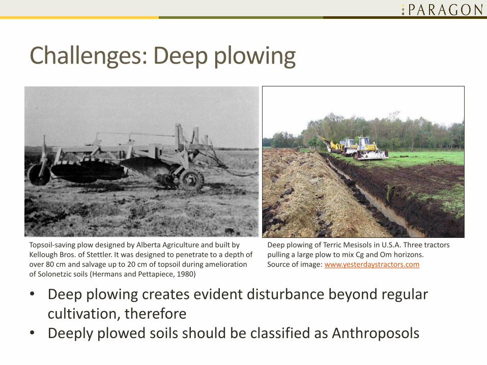
Topsoil-saving plow designed by Alberta Agriculture and built by Kellough Bros. of Stettler. It was designed to penetrate to a depth of over 80 cm and salvage up to 20 cm of topsoil during amelioration of Solonetzic soils (Hermans and Pettapiece, 1980)
Deep plowing of Terric Mesisols in U.S.A. Three tractors pulling a large plow to mix Cg and Om horizons.Source of image: www.yesterdaystractors.com
• Deep plowing creates evident disturbance beyond regular cultivation, therefore
• Deeply plowed soils should be classified as Anthroposols

Challenges: Gley features
Ponded area on reclaimed pipeline RoW,East-Central Alberta
Distinct mottling in IIDgj horizon,Athabasca Oil Sands Region
• Mottling is not a qualifying parameter for Aquo subgroup• Ponding and hydrophilic vegetation trigger Aquo subgroup

Challenges: Subgroup abbreviations
• Abbreviations are not discussed by Naeth et al 2012 or by Pennock et al 2015
• Intuitive Approach• Fusco Spolic Anthroposol = FU.SA
• Aquo Terro Spolo Carbic Anthroposol = AQTESP.CA
• Fusco Spolo Technic Anthroposol, calcareous, garbic phase = FUSP.TA-cagb
• Setting up standardized abbreviations would be required• During the field testing stage
• Prior adding the Anthroposolic Order to the Canadian System of Soil Classification

6. CONCLUSION

Conclusion
• Classification is a language to communicate a problem• Classification by itself does not solve any problems
• Anthroposolic soil classification was proposed in 2012 • Field testing started in 2015
• Anthroposols will be included in the 4th edition of the CSSC
• Evident disturbance layer >10 cm thick defines Anthroposol• Tillage is not qualified
• Three Great Groups based on TOC and artefacts• Technic Anthroposols
• Spolic Anthroposols
• Carbic Anthroposols
• 9 subgroups and 11 phases subdivide the Great Groups

Acknowledgements
• Paragon Soil and Environmental Consulting Inc.
• Cumulative Environmental Management Association (CEMA) Long-Term Plot Network (LTPN)
• Dr. Anne Naeth (University of Alberta)
• Leonard Leskiw (Paragon Soil and Environmental Consulting)
• Diana Dabrowa (Paragon Soil and Environmental Consulting)
THANK YOU
Questions?