the african telatelisttelately.co.za/wp-content/uploads/2015/07/n-l-199... · the civilization of...
TRANSCRIPT
The African Telatelist
Newsletter 199 of the African Telately Association – January 2015.
___________________________________________________________________________
UNESCO – World Heritage Sites-Part 2(W.Stobrawe)
In the previous
Newsletter (N/L
198) the focus was
described in the
broader contex of
Worldwide,
UNESCO
(The United
Nations
Educational, Scientific and Cultural
Organization).
In this Edition of ATA’s Newsletter we bring the focus closer to home, AFRICA.
Depicted below are phonecard images and reference images of some of the Heritage sites within the African continent.
EGYPT:
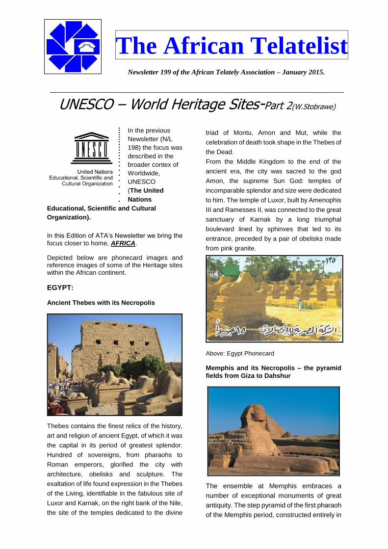
Ancient Thebes with its Necropolis
Thebes contains the finest relics of the history,
art and religion of ancient Egypt, of which it was
the capital in its period of greatest splendor.
Hundred of sovereigns, from pharaohs to
Roman emperors, glorified the city with
architecture, obelisks and sculpture. The
exaltation of life found expression in the Thebes
of the Living, identifiable in the fabulous site of
Luxor and Karnak, on the right bank of the Nile,
the site of the temples dedicated to the divine
triad of Montu, Amon and Mut, while the
celebration of death took shape in the Thebes of
the Dead.
From the Middle Kingdom to the end of the
ancient era, the city was sacred to the god
Amon, the supreme Sun God: temples of
incomparable splendor and size were dedicated
to him. The temple of Luxor, built by Amenophis
III and Ramesses II, was connected to the great
sanctuary of Karnak by a long triumphal
boulevard lined by sphinxes that led to its
entrance, preceded by a pair of obelisks made
from pink granite.
Above: Egypt Phonecard
Memphis and its Necropolis – the pyramid
fields from Giza to Dahshur
The ensemble at Memphis embraces a
number of exceptional monuments of great
antiquity. The step pyramid of the first pharaoh
of the Memphis period, constructed entirely in

-2-
limestone, is the oldest known architectural
structure of this type, from regularly cut stone.
At Giza, one of the oldest boats preserved
today, the solar barge, was discovered intact in
the complex around the Pyramid of Cheops.
The archaic necropolis of Saqqara dates back
to the period of the formation of the pharaonic
civilization. The exceptional historic, artistic
and sociological interest of these monuments
bears witness to one of the most brilliant
civilizations of this planet.
The capital of the Old Kingdom of Egypt has
some extraordinary funerary monuments,
including rock tombs, ornate mastabas,
temples and pyramids. In ancient times, the
pyramids were considered one of the Seven
Wonders of the World.
Above: Egypt Phonecard.
Nubian Monuments from Abu Simbel to Philae
The open-air Museum of Nubia and Aswan
brings together cultural properties closely
associated with the unfolding of a long sequence
of Egyptian Pharaonic history. In addition to the
complexes of Abu Simbel and Philae the site
includes the temples of Amada, of Derr, those of
Ouadi Es Sebouah, Dakka and Maharraqah, the
temple of Talmis, and the kiosk of ak-Kartassi,
the temple of Beit el Ouali which are both rare
and ancient. To these must be added the
astonishing granite quarries of Aswan, exploited
by pharaohs from early antiquity, where colossal
unfinished obelisk-like monuments have been
discovered.
An archaeological zone of primary importance
extends from Aswan to the Sudanese border.
Aswan, situated north of the First Cataract, was
an essential strategic point where, since
prehistoric times, victorious expeditions had
been mounted leading to a lasting domination of
Nubia, the country to the south, rich in gold and
other minerals, in ivory and in precious wood. To
each of the great periods of Egyptian history
there corresponds, if only partially, a seizure of
Nubia, which enjoyed the role of a natural annex
to the kingdom. The sovereignty of the pharaohs
was solidly established during the New Empire.
After the military conquest, towards 1550 BC,
Nubia virtually became a colony, administered by
a governor, whose fiscal and commercial income
was transferred to Aswan. With the fall of the
New Empire (c. 1070 BC) Nubia again entered a
period of prosperity during the Graeco-Roman
period and during the first years of the Christian
era, until the triumph of Islam.
Above: Egypt Phonecard
LIBYA:
Archaeological Site of Sabratha
A Phoenician trading-post of the Tripolitanian
coast, Sabratha funnelled the products of Africa

-3-
to the Gulf of the Lesser Syrtis, thanks to the
route linking it to the continent via Cydamus
(now Ghadamès).
It was part of the short-lived Numidian Kingdom
of Massinissa, together with Leptis and Oea,
before being Romanized and absorbed into the
Roman province of Africa, and subsequently
rebuilt in the 2nd and 3rd centuries AD.
Sabratha enjoyed its greatest prosperity during
the 2nd and 3rd centuries. This period saw the
construction of grandiose monuments, of which
the most renowned is that of the theatre,
probably built during the reign of the Emperor
Commodus (AD 161-92), with its three orders of
columns of thefrons scenae.
The best conserved part is the scena,
recomposed with original fragments and
subdivided on three levels with overlapping
marble columns. The theatre had a capacity of
5,000 seats.
The pulpitum has a series of decorations in bas-
relief representing divinity, historical and
theatrical scenes, and a series of rectangular
and semicircular niches. In the central niche
stands the goddess Rome with helm and shield,
dressed like an Amazon. On her flank there is
another divinity that represents Sabratha.
Near the theatre stands the amphitheatre with
the arena where once the gladiators faced the
ferocious wild animals, fighting until death. The
underground corridors that were used in order to
make enter can still be seen.
Above: A lybian phonecard
MALI:
Djenné, chief town of the Djenné Circle, located 130 km south-west of Mopti (the regional capital) and roughly 570 km north-east of Bamako (the national capital), is one of the oldest towns of sub-Saharan Africa.
The cultural property “Old Towns of Djenné” is a serial property comprising four archaeological sites, namely Djenné-Djeno, Hambarkétolo, Kaniana and Tonomba, along with the old fabric of the present town of Djenné covering an area of 48.5 ha and divided into ten districts. The property is an ensemble that over many years has symbolised the typical African city. It is also particularly representative of Islamic architecture in sub-Saharan Africa.
The property is characterised by the intensive and remarkable use of earth specifically in its architecture. The outstanding mosque of great monumental and religious value is an outstanding example of this. The town is renowned for its civic constructions, with the distinctive style of verticality and buttresses as well as the elegant monumental houses with intricate facades.
Excavations carried out in 1977, 1981, 1996 and 1997, revealed an extraordinary page of human history dating back to the 3rd century B.C. They have brought to light an archaeological ensemble which bears witness to a pre-Islamic urban structure with a wealth of circular or rectangular constructions in djenné ferey and numerous archaeological remains (funerary jars, pottery, millstones, grinders, metal scoria etc.).
Above: A Mali phonecard

-4-
NAMIBIA:
Twyfelfontein or /Ui-//aes has one of the largest concentrations of [...] petroglyphs, i.e. rock engravings in Africa. Most of these well-preserved engravings represent rhinoceros,. The site also includes six painteelephant, ostrich and giraffe, as well as drawings of human and animal footprintsd rock shelters with motifs of human figures in red ochre.
The objects excavated from two sections, date from the Late Stone Age. The site forms a coherent, extensive and high-quality record of ritual practices relating to hunter-gatherer communities in this part of southern Africa over at least 2,000 years, and eloquently illustrates the links between the ritual and economic practices of hunter-gatherers.
Above: A Namibia phonecard
Namib Sand Sea is the only coastal desert in the world that includes extensive dune fields
influenced by fog. Covering an area of over three million hectares and a buffer zone of 899,500 hectares, the site is composed of two dune systems, an ancient semi-consolidated one overlain by a younger active one. The desert dunes are formed by the transportation of materials thousands of kilometres from the hinterland, which are carried by river, ocean current and wind. It features gravel plains, coastal flats, rocky hills, inselbergs within the sand sea, a coastal lagoon and ephemeral rivers, resulting in a landscape of exceptional beauty. Fog is the primary source of water in the site, accounting for a unique environment in which endemic invertebrates, reptiles and mammals adapt to an ever-changing variety of microhabitats and ecological niches.
Above: A Namibia phonecard
NIGER:
Historic Centre of Agadez
Known as the gateway to the desert, Agadez, on the southern edge of the Sahara desert, developed in the 15th and 16th centuries when the Sultanate of Aïr was established and Touareg tribes were sedentarized in the city, respecting the boundaries of old encampments, which gave rise to a street pattern still in place today.
The historic centre of the city, an important crossroads of the caravan trade, is divided into 11 quarters with irregular shapes.
They contain numerous earthen dwellings and a well-preserved group of palatial and religious buildings including a 27m high minaret made entirely of mud brick, the highest such structure in the world.

-5-
The site is marked by ancestral cultural, commercial and handicraft traditions still practiced today and presents exceptional and sophisticated examples of earthen architecture.
Above: A Mali phonecard
SOUTH AFRICA:
Robben Island was used at various times between the 17th and 20th centuries as a prison, a hospital for socially unacceptable groups and a military base. Its buildings, particularly those of the late 20th century such as the maximum security prison for political prisoners, witness the triumph of democracy and freedom over oppression and racism.
What survives from its episodic history are 17th century quarries, the tomb of Hadije Kramat who died in 1755, 19th century ‘village’ administrative buildings including a chapel and parsonage, small lighthouse, the lepers’ church, the only remains of a leper colony, derelict World War II military structures around the harbour and the stark and functional maximum security prison of the Apartheid period began in the 1960s.
The symbolic value of Robben Island lies in its somber history, as a prison and a hospital for unfortunates who were sequestered as being socially undesirable.
This came to an end in the 1990s when the inhuman Apartheid regime was rejected by the South African people and the political prisoners who had been incarcerated on the Island received their freedom after many years.
Above: Thewell known South African phonecard image of Robben Island.
ETHIOPIA:
Situated in the highlands of northern Ethiopia, Aksum symbolizes the wealth and importance of the civilization of the ancient Aksumite kingdom, which lasted from the 1st to the 8th centuries AD. The kingdom was at the crossroads of the three continents: Africa, Arabia and the Greco-Roman World, and was the most powerful state between the Eastern Roman Empire and Persia. In command of the ivory trade with Sudan, its fleets controlled the Red Sea trade through the port of Adulis and the inland routes of north eastern Africa.
The ruins of the ancient Aksumite Civilization covered a wide area in the Tigray Plateau. The most impressive monuments are the monolithic obelisks, royal tombs and the palace ruins dating to the 6th and 7th centuries AD.
Several stelae survive in the town of Aksum dating between the 3rd and 4th centuries AD. The largest standing obelisk rises to a height of over 23 meters and is exquisitely carved to represent a nine-storey building of the Aksumites. It stands at the entrance of the main stelae area. The largest obelisk of some 33 meters long lies where it fell, perhaps during the process of erection. It is possibly the largest monolithic stele that ancient human beings ever attempted to erect.

-6-
A series of inscription on stone tablets have proved to be of immense importance to historians of the ancient world. Some of them include trilingual text in Greek, Sabaean and Ge'ez (Classical Ethiopian), inscribed by King Ezana in the 4th century AD.
The introduction of Christianity in the 4th century AD resulted in the building of churches, such as Saint Mary of Zion, rebuilt in the Gondarian period, in the 17th century AD, which is believed to hold the Ark of the Covenant.
Above: An Ethiopian phonecard
MOZAMBIQUE:
The Island of Mozambique bears important witness to the establishment and development of the Portuguese maritime routes between western Europe and the Indian subcontinent and thence all of Asia. The town and the fortifications on the island, and on the smaller island of St Laurent, are an outstanding example of an architecture in which local traditions, Portuguese influences, and to a somewhat lesser extent Indian and Arab influences, are all interwoven.
Inhabited by a Bantu tribe, the territory of Mozambique was occupied around AD 900 by Arabs who set up trading posts. In their search for a maritime route to India to avoid Muslim forces, the Portuguese decided to go around the continent of Africa. King John II (1481-95) sent Bartolomeu Dias to explore the African coast. Sailing beyond the coast of the Congolese kingdom, the great navigator rounded the extreme southern tip of Africa, unaware of the feat he had accomplished. It was not until his return that he discovered the 'Cape of Storms', which John II renamed Cape of Good Hope.
Manuel I (1495-1521) ordered Vasco da Gama to continue the search for a maritime route. Leaving Lisbon in July 1497, he reached the Island of Mozambique on 2 March 1498, where he was well received by the sultan and the people, who thought the Portuguese were Muslims. During his second voyage, he occupied the territories of present-day Mozambique and returned to Lisbon in 1503 laden with gold.
Some years later, Mozambique had become one of Portugal's principal ports and trading posts on the sea route to India. The first fortress, St Gabriel, was built in 1507. At the end of the 17th century, after enjoying strong economic expansion, the town with its fortifications, along with the smaller island of St Laurent, went into a period of decline. In the second half of the 18th century, the economy was revived by the slave trade.
In 1898 the capital of Mozambique (the Portuguese colony) was transferred to Laurenço Marques (Maputo), considerably slowing down the economy of the town on the island of Mozambique. The town had developed unequally over some 400 years. Less than half of it was built from stone, a little more than a quarter in macuti (straw), with the remainder being the various fortifications.
The incredible architectural unity of the island derives from the uninterrupted use of the same building techniques with the same materials and the same decorative principles. The island's patrimony also includes its oldest extant fortress (St Sebastian, 1558-1620), other defensive buildings and numerous religious buildings (including many from the 16th century).
The island has been classed on the national level and for about 10 years has benefited from restoration work and studies by international specialists. However, while the present state of conservation is not fully satisfactory, a restoration and management programme is in progress.
Above: A Mozambique phonecard

-7-
LESOTHO:
The Maloti-Drakensberg Park is a trans-boundary site composed of the uKhahlamba Drakensberg National Park in South Africa and the Sehlathebe National Park in Lesotho.
The site has exceptional natural beauty in its soaring basaltic buttresses, incisive dramatic cutbacks, and golden sandstone ramparts as well as visually spectacular sculptured arches, caves, cliffs, pillars and rock pools. The site's diversity of habitats protects a high level of endemic and globally important plants. The site harbors endangered species such as the Cape vulture (Gyps coprotheres) and the bearded vulture (Gypaetus barbatus).
Lesotho’s Sehlabathebe National Park also harbors the Maloti minnow (Pseudobarbus quathlambae), a critically endangered fish species only found in this park. This spectacular natural site contains many caves and rock-shelters with the largest and most concentrated group of paintings in Africa south of the Sahara. They represent the spiritual life of the San people, who lived in this area over a period of 4,000 years.
Above: A Lesotho phonecard
MALAWI:
Lake Malawi National Park
Located at the southern end of the great expanse of Lake Malawi, the property is of global importance for biodiversity conservation due particularly to its fish diversity. Lying within the Western Rift Valley, Lake Malawi is one of the deepest lakes in the world.
The property is an area of exceptional natural beauty with the rugged landscapes around it contrasting with the remarkably clear waters of the lake. The property is home to many hundreds of cichlid fish, nearly all of which are endemic to Lake Malawi, and are known locally as "mbuna". The mbuna fishes display a significant example of biological evolution. Due to the isolation of Lake Malawi from other water bodies, its fish have developed impressive adaptive radiation and speciation, and are an outstanding example of the ecological processes.
Above: A Malawian phonecard