th hi t i lthe historical remote sensing atlas of al ain, uae · his highness sheikh zayed bin...
TRANSCRIPT

Th Hi t i lTh Hi t i lThe HistoricalRemote Sensing Atlasof Al Ain, UAE(1976-2000)
The HistoricalRemote Sensing Atlasof Al Ain, UAE(1976-2000)
Mohamed Yagoub MohamedLecturer of GIS
Department of GeographyFaculty of Humanities and Social SciencesFaculty of Humanities and Social SciencesUnited Arab Emirates University
In Celebrating the 25th Anniversary ofThe UNITED ARAB EMIRATES University
1
First EditionApril 2002

Source: Al Ain Magazine, 2001, volume 69, page:43.
His Highness Sheikh Zayed bin Sultan Al Nahyan and His Highness Sheikh Tahnoun bin Mohammed Al Nahyan discussing Al Ain development (with map of Al Ain in front of them) at Almaqam Palace in 1977.
The whole development in Al Ain may be attributed to:- Oil revenue- Determination of the leadership of the UAE- The special flavor to the UAE leader (Al Ain is the motherland of H. H.
h ikh d bi l l h )
2
Sheikh Zayed bin Sultan Al Nahyan)

AcknowledgementsAcknowledgements
The author would like to acknowledge the support of the UAE university research council through the provision of research grant number 04-1-11/2 and the special encouragement by Dr. Maitha Salem Al Shamsi, Deputy Vice Chancellor for Scientific Research at the UAE University.
Thanks are extended also to Al Ain Town Planning Department for providing aerial photographs, the Remote Sensing Laboratory at the Faculty of Science for providing satellite imagery, and Mr. Hamdi Kandil for cartographic editing.
Please send your comments to :Dr. M.M.Yagoub,Department of GeographyUnited Arab Emirates UniversityP.O. Box: 17771, Al AinUnited Arab EmiratesFax: 03-7671706 Tel: 03-7612316
3
Fax: 03 7671706 Tel: 03 7612316E-mail: [email protected]: http://www.angelfire.com/mo/yagoub

ContentsContents
G l M f U i d A b E i 5
Page
• General Map of United Arab Emirates 5• General Map of Al Ain 6• Historical Development of Al Ain by Figures 7• Al Ain, 1990 from Landsat-5 8• Al Ain, 2000 from Landsat ETM-7 9• Al Ain Oasis, 1976 10• Al Ain Oasis, 1984 11• Al Ain Oasis, 1998 12• Al Ain, Central Area, 1976 13• Al Ain, Central Area, 1984 14• Al Ain, Central Area, 1998 15• Al Jimi Hospital, 1976 16p ,• Al Jimi Hospital, 1984 17• United Arab Emirates University, 1976 18• United Arab Emirates University, 1984 19• Public Garden and Private Department Area, 1976 20• Public Garden and Private Department Area, 1984 21• Public Garden and Private Department Area 1998 22Public Garden and Private Department Area, 1998 22• Al Hosn and Murabba’a Fort Area, 1976 23• Al Hosn and Murabba’a Fort Area, 1984 24• Al Hosn and Murabba’a Fort Area, 1998 25
4

General Map of United Arab EmiratesGeneral Map of United Arab Emirates
25o
Diba
Fujairah
Gul
f of O
man
DubaiSharjah
Ajman
Ras Al Khaimah
Umm Al Qaiwin
52o 53o 54o 55o 56o
Arabian Gulf
N
25o
Iran
SaudiArabia
Iraq
Kuwait
Qatar
UAE
Al Ain
ABU DHABI
ArabianSea
AFRICA
24o24o
O M A NUNITED ARAB EMIRATES
23o
S A U D IA R A B I A
23o
52o 53o 54o 55o 56o
50 km
5

General Map of Al AinGeneral Map of Al Ain
Source: Al Ain Tourist and Street Address Guide, 2001. Al Ain Town Planning Department .
6
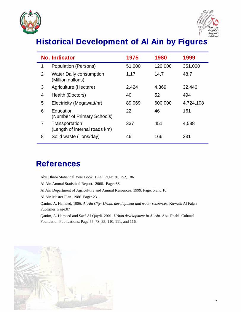
Historical Development of Al Ain by FiguresHistorical Development of Al Ain by FiguresHistorical Development of Al Ain by FiguresHistorical Development of Al Ain by Figures
No. Indicator 1975 1980 19991 Population (Persons) 51,000 120,000 351,000
2 Water Daily consumption 1,17 14,7 48,7(Million gallons)(Million gallons)
3 Agriculture (Hectare) 2,424 4,369 32,440
4 Health (Doctors) 40 52 494
5 Electricity (Megawatt/hr) 89,069 600,000 4,724,108
6 Education 22 46 161(Number of Primary Schools)(Number of Primary Schools)
7 Transportation 337 451 4,588(Length of internal roads km)
8 Solid waste (Tons/day) 46 166 331
Abu Dhabi Statistical Year Book. 1999. Page: 30, 152, 186.
Al Ain Annual Statistical Report. 2000. Page: 88.
Al Ain Department of Agriculture and Animal Resources. 1999. Page: 5 and 10.
ReferencesReferences
Al Ain Master Plan. 1986. Page: 23.
Qanim, A. Hameed. 1986. Al Ain City: Urban development and water resources. Kuwait: Al Falah Publisher. Page:87
Qanim, A. Hameed and Saef Al-Qaydi. 2001. Urban development in Al Ain. Abu Dhabi: Cultural Foundation Publications. Page:55, 73, 85, 110, 111, and 116.
7

Al Ain, 1990 from Landsat-5Al Ain, 1990 from Landsat-5
N Hili
Oasis
• The appearance of Al Ain as an international destination (The construction of Al Ain Airport).
8

Al Ain, 2000 from Landsat ETM-7Al Ain, 2000 from Landsat ETM-7
N
HiliHili
Oasis
• Al Ain witnessed an expansion in agricultural areas in the south-west, increase in built-up areas in the north-west (Al Towayya), and road network (Al Towayya-Al Slamat).)
• The city is largely extended in the south-west direction.• This may be due to:
• availability of water and electricity along the line from Abu Dhabi.• transportation network (Al Ain-Abu Dhabi road).• attraction nodes (Almaqam Palace, Tawam Hospital, UAE University).• less topographic constraints (low sand dunes).
9
less topographic constraints (low sand dunes).• legal ownership of the land (no political boundaries).• planning rules and regulations (Master plan implementation).

Al Ain Oasis, 1976Al Ain Oasis, 1976
NN
OasisOasis
ClockRoundabout
10
• The legacy: the oasis dominated the center of Al Ain with few roads and buildings scattered around it.

Al Ain Oasis, 1984Al Ain Oasis, 1984
NN
OasisOasis
ClockRoundabout
11
• More roads and buildings started to dominate the center of Al Ain with the oasis being conserved.

Al Ain Oasis, 1998Al Ain Oasis, 1998
NN
OasisOasis
Clock
• Although of the continuous expansion of buildings and roads the oasis is
ClockRoundabout
12
Although of the continuous expansion of buildings and roads, the oasis is almost remains the same between 1976 and 1998. This is a unique example of environmental conservation.
• Worldwide there is intrusion of urban areas into agricultural ones, however, in Al Ain the case is not the same.

Al Ain, Central Area, 1976Al Ain, Central Area, 1976
N
ClockRoundabout
ClockRoundabout
• Few commercial buildings: along Zayed bin Sultan Street and there was almost no buildings along Khalifa bin Zayed Street.
13

Al Ain, Central Area, 1984Al Ain, Central Area, 1984
NN
G
ClockRoundabout
ClockRoundabout
• New buildings, roads and farming techniques started to appear.• Buildings: more commercial buildings along Zayed bin Sultan Street, Khalifa
bin Zayed Street and the Souk.
14
• Roads: Roads linking Zayed bin Sultan and Khalifa bin Zayed Street started to appear.
• Farming techniques:Green houses (G) was practiced at the farm in the center of the photo.

Al Ain, Central Area, 1998Al Ain, Central Area, 1998
NN
G
ClockRoundabout
ClockRoundabout
• Although of the continuous increase in the number of buildings and roads in the central district, the three farms between Zayed bin Sultan Street and Khalifa bin Zayed Street had resisted the urban expansion
15
Street and Khalifa bin Zayed Street had resisted the urban expansion between (1976-1998) (Conservation of green areas at the center of the city).

Al Jimi Hospital, 1976Al Jimi Hospital, 1976
NN
AL JIMI HOSPITALAL JIMI HOSPITAL
• The existence of Al Muwaijii Fort and Al Jimi Hospital before 1976 surrounded by desert.
16

Al Jimi Hospital, 1984Al Jimi Hospital, 1984
NN
PMD
N b ildi d t ti iti d t ti t t d t d Al Ji i• New buildings, roads, sport activities, and vegetation cover started to appear around Al Jimi Hospital.
• Buildings: Villas were built to the north of the hospital (Hai Al Wadi). However, until 1984, there was no Preventive Medicine Department (PMD).
• Roads: Shakhboot bin Sultan Street (north of the hospital) was extended from east to west and Saeed bin Tahnoun Al Awwal Street to the west of the hospital.
• Sport activities: Camel Race Track appeared at the north-west corner of the photo
17
• Sport activities: Camel Race Track appeared at the north-west corner of the photo (Heritage conservation).
• Vegetation cover: More landscaping trees appeared inside Al Jimi Hospital and along Al Baladiyya Street. Farms to the south of the hospital and Al Muwaijii Fort have witnessed an increase in the density of trees.

United Arab Emirates University, 1976United Arab Emirates University, 1976
NN
UAE UNIVERSITYUAE UNIVERSITY
• The existence of the UAE University before 1976 (The Islamic Institute)• The existence of the UAE University before 1976 (The Islamic Institute)• There was no celebration ground to the south and no landscaping on the Shakhboot
bin Sultan Street (north).• Teaching Staff of UAE University: 56• Students: 519
18

United Arab Emirates University, 1984United Arab Emirates University, 1984
NN
UAE UNIVERSITY
• The restructuring of the UAE University (parking area to the east and sport complex at the west of the University).
• The green revolution of H.H. Sheikh Zayed bin Sultan started to appear at Shakhboot bin Sultan Street (the formation of the Al Baladiyya Park).
• Teaching Staff of UAE University: 469
19
g y• Students: 6326

United Arab Emirates University, 1998United Arab Emirates University, 1998
NN
UAE UNIVERSITY
• There was no major change in the UAE University (Islamic Institute) between 1984 and 1998. This is because the majority of students were distributed among other campuses. However, in late 2001 an additional facility (Almultaga-Social Club) was established in the southern part of the University.
20

Public Garden and Private Department Area, 1976
NN
ClockRoundabout
Public Garden
• The Public Garden was existed since 1976 as an entertainment node for the public. However, there was no Private Department during that period.
• There was a big farm extended across Al Ain Street and no buildings along the street.
21

Public Garden and Private Department Area, 1984
NN
ClockRoundabout
Public Garden
• The Public Garden witnessed more plantation. However, until 1984 there was no Private Department.
• The big farm extended across Al Ain Street was disappeared and new buildings along the street replaced it.buildings along the street replaced it.
22

Public Garden and Private Department Area, 1998
NNNN
ClockRoundabout
• The Private Department appeared as a land mark at the center of the photo.
• The number of buildings along Al Ain Street has increased and more internal streets appeared.
23

N
Al Hosn and Murabba’a Fort Area, 1976
N
• The area contained important historical landmarks: Al Hosn and Murabba’a Fort, Fish and vegetable Market, Police Station, and the old settlements surrounding Al Hosn Fort. These settlements may indicate association of people in the past to Al Hosn Fort and the Oasis.
24

Al Hosn and Murabba’a Fort Area, 1984
NN
• Until 1984, no action has been taken on Al Hosn and Murabba’a Fort and Police Station However the old settlements surrounding Al Hosnand Police Station. However, the old settlements surrounding Al Hosn Fort had been displaced and new commercial buildings appeared along Zayed bin Sultan Street in the northeastern direction of the area.
• Fish and vegetable Market had been renovated.
25

Al Hosn and Murabba’a Fort Area, 1998
NN
• Al Hosn and Murabba’a Fort had seen some renovations. The Al Hosn Fort was becoming part of Al Ain Museum The old settlementsFort was becoming part of Al Ain Museum. The old settlements surrounding Al Hosn Fort had been displaced and new commercial buildings appeared along Zayed bin Sultan Street in the northeastern.
• Fish and vegetable Market had been renovated.• The Cattle Market appeared with roads and shelters.
By: M. M. Yagoub (http://faculty.uaeu.ac.ae/~myagoub)S UAE U i it
26
Sponsor: UAE UniversitySource of Photos: Al Ain Town Planning Department . June 2002

NN
Private Department and Jahili Fort 1998
27