terrestrial ecology assessment report final/media/files/network/network...terrestrial ecology...
TRANSCRIPT

Botany Bay 132kV Cable Project –
Terrestrial Ecology Assessment
Report


38 Cowper St Parramatta NSW 2150 Tel (02) 9891 5399 Fax (02) 9893 9806
Email: [email protected] Web: www.molinostewart.com.au
Botany Bay 132kV Cable Project – Terrestrial Ecology Assessment
REPORT
for
Energy Australia
by
Molino Stewart Pty Ltd
ACN 067 774 332
JUNE 2007

Botany Bay 132kV Cable Project – Terrestrial Ecology Assessment Report i
CONTENTS
1 INTRODUCTION 1 1.1 Background 1 1.2 Approach 2
2 METHODS 3 2.1 Desktop Analysis 3 2.2 Field Inspection 3
2.2.1 Kurnell STS 4 2.2.2 Bunnerong STS 4 2.2.3 Cable Route 5
3 RESULTS 7 3.1 Desktop Analysis Results 7
3.1.1 Bunnerong 7 3.1.2 Kurnell STS 7 3.1.3 Road Reserve Cable Route 7 3.1.4 Database Search Results 7 3.1.5 Threatened Species Legislation 8 3.1.6 Subject Threatened Species 10 3.1.7 Other Ecological Issues 11
3.2 Field Inspection Results 12 3.2.1 Bunnerong STS 12 3.2.2 Kurnell STS 14 3.2.3 Cable Route 16
4 DISCUSSION 17 4.1 Bunnerong STS 17 4.2 Kurnell STS 18 4.3 Northern Cable Route 19 4.4 Southern Cable Route 20 4.5 Recommendations 20 4.6 Conclusions 21
5 REFERENCES 22

Contents
ii Energy Australia
APPENDICES
Appendix A Flora Lists
Appendix B Subject Threatened Fauna Species
Appendix C Cable Route Sections
Appendix D EPBC Act Protected Matters Report
LIST OF TABLES
Table 1: An indicative list of potential threatened species based on Wildlife Data Base Searches 8
LIST OF FIGURES
Figure 1 Location of Proposed Works 1 Figure 2: Kurnell STS depicting possible cable route approaches. Orange outlines
depict proposed building locations, solid orange are existing buildings. Mauve area to the south is RAMSAR wetland. 4
Figure 3: Bunnerong STS depicting feeder cable routes (red) connecting to Bunnerong south and the optional connection to Bunnerong north (yellow dashed). 5
Figure 4: Cable routes a) Northern La Perouse to Bunnerong STS. b) Southern Silver Beach to Kurnell STS (Yellow dots indicate where assessment was carried out and photographic records taken.) 6
Figure 5: Bunnerong South STS area proposed for vegetation clearance. 16 Figure 6: Proposed gazettal area of Eastern Suburbs Banksia Scrub Endangered
Ecological Community on the Bunnerong STS site. 18

Botany Bay 132kV Cable Project – Terrestrial Ecology Assessment Report 1
1 INTRODUCTION
1.1 Background
During the next decade EnergyAustralia must replace ageing infrastructure in the Sydney CBD and the inner metropolitan area. It has been identified that replacement of two existing high voltage feeders which currently connect EnergyAustralia’s Bunnerong subtransmission substation (“STS”) at Matraville with its Canterbury STS at Earlwood, must be achieved by late 2008.
The preferred replacement for the feeders, known as Feeders 908 and 909, however, is a new connection between Bunnerong and Kurnell across Botany Bay.
It is proposed that the new feeders would take the following route:
from Bunnerong STS, following the road alignments to La Perouse (3.2km);
under the National Park at La Perouse by way of horizontal directional drilling (0.5km);
across Botany Bay by way of submarine cable to a section of Silver Beach situated outside (but next to) the National Park at Kurnell (2.2km); and
from Silver Beach to Kurnell STS, following the road alignments (1.5km).
At Bunnerong STS, little work is proposed other than the laying of the cables within the site and connecting them to new terminations and existing equipment/apparatus.
The new connections would provide an opportunity to upgrade Kurnell STS so that supplies to the Kurnell Peninsula are more secure, as well as facilitating the additional power into the CBD and inner metropolitan area. The proposed works at the Kurnell STS comprise:
Replacement of the ageing outdoor high voltage switch gear with a building to house the Gas Insulated Switchgear and Control and Protection equipment to which the new cables would be connected.
Three new transformers in new transformer bays.
An underground retention system which would capture any oil spilled in the unlikely event of rupture of a transformer.
The Project will be known as the ‘Botany Bay Cable Project’ and the location of the proposed works is shown in the following figure.

Terrestrial Ecology Assessment Report3.doc/7/06/2007 8:12:00 AM
Botany Bay 132kV Cable Project – Terrestrial Ecology Assessment Report 1
Figure 1 Location of Proposed Works
This development will involve modifications to facilities at both sub-transmission stations, the installation of terrestrial underground feeder cables and a submarine section under the sea bed of Botany Bay linking the two sides of the Bay.
The overall proposal will necessitate some vegetation clearance within or adjacent to the grounds of the two STS to accommodate enlarged compounds, new switching gear and associated buildings. The installation of underground cables will mainly follow existing formed road reserves with the exception of its crossing of the ‘La Perouse’ historic heritage section of Botany Bay National Park, its crossing of the sea bed of

Terrestrial Ecology Assessment Report3.doc/7/06/2007 8:12:00 AM
2 Energy Australia
Botany Bay itself and its crossing of the Silver Beach front at Kurnell adjacent to the ‘Cooks Landing Place’ historic heritage section of Botany Bay National Park.
1.2 Approach
This report documents an assessment of the likely ecological impacts resulting from the terrestrial components of the Energy Australia proposal as briefly outlined above.
The aims and objectives of this study are to:
Review existing information on the terrestrial ecology of the two sub-transmission stations and the land based section of the cable route itself;
Determine the known or likely presence of any threatened species or their habitat (including endangered populations and ecological communities) as listed under both the Commonwealth Environment Protection and Biodiversity Conservation Act 1999 (EPBC Act) and NSW Threatened Species Conservation Act 1995 (TSC Act) through site and cable route inspections and;
Identify any other matters of National environmental significance; and
Identify measures and strategies to avoid, minimise, mitigate/ameliorate and offset any likely impacts on threatened species or other ecological matters of national environmental significance.

Terrestrial Ecology Assessment Report3.doc/7/06/2007 8:12:00 AM
Botany Bay 132kV Cable Project – Terrestrial Ecology Assessment Report 3
2 METHODS
2.1 Desktop Analysis
A desktop analysis was undertaken using Geographic Information System Software – ArcView GIS.
This involved acquiring, overlaying and analysis of various digital data sets including:
Tenure
Landuse/Zoning
Cadastre
Vegetation coverage
Environmental values – (RAMSAR, SEPP etc)
Orthorectified aerial photographs
Topographic and
Flora and Fauna including threatened species, JAMBA and CAMBA species records.
An EPBC Act Protected Matters Report was generated courtesy of the Department of Environment and Heritage (DEH) documenting the various matters of National Environmental significance that may be affected by the proposal.
These initial investigations were undertaken to determine indications of constraints or possible issues for further consideration and that would require addressing within a thorough ecological assessment of the possible impacts of the proposal as outlined.
This analysis generated indicative maps, species lists and an issues list that required further consideration and discussion.
2.2 Field Inspection
Two field investigations were undertaken along the proposed cable route and at the Bunnerong and Kurnell sub transmission substations (STS) and their immediate environs.
An initial investigation was carried out on 4th August 2006 and again on 20th September 2006.
A floristic survey and a general fauna survey were undertaken to validate previous studies and determine the extent or likelihood for direct or indirect impacts on threatened species and/or their habitat likely to result from the understood scope of works required by the current proposal.
Futhermore the assessment process took into account relevant considerations as outlined in the NSW Department of Environment and Climate Change Draft “Threatened Biodiversity Survey and Assessment Guidelines for Developments and Activities” when undertaking the STS sites and cable route inspections.
Terrestrial Ecology Assessment Report3.doc/7/06/2007 8:12:00 AM
4 Energy Australia
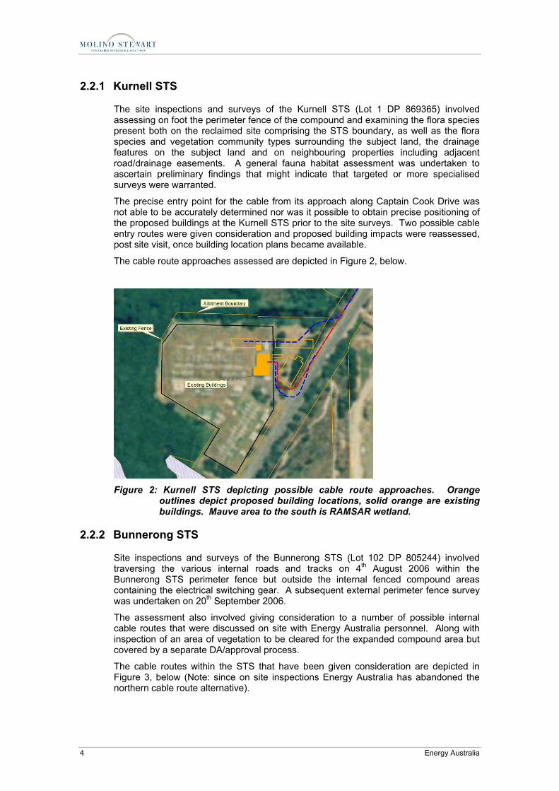
2.2.1 Kurnell STS
The site inspections and surveys of the Kurnell STS (Lot 1 DP 869365) involved assessing on foot the perimeter fence of the compound and examining the flora species present both on the reclaimed site comprising the STS boundary, as well as the flora species and vegetation community types surrounding the subject land, the drainage features on the subject land and on neighbouring properties including adjacent road/drainage easements. A general fauna habitat assessment was undertaken to ascertain preliminary findings that might indicate that targeted or more specialised surveys were warranted.
The precise entry point for the cable from its approach along Captain Cook Drive was not able to be accurately determined nor was it possible to obtain precise positioning of the proposed buildings at the Kurnell STS prior to the site surveys. Two possible cable entry routes were given consideration and proposed building impacts were reassessed, post site visit, once building location plans became available.
The cable route approaches assessed are depicted in Figure 2, below.
Figure 2: Kurnell STS depicting possible cable route approaches. Orange
outlines depict proposed building locations, solid orange are existing buildings. Mauve area to the south is RAMSAR wetland.
2.2.2 Bunnerong STS
Site inspections and surveys of the Bunnerong STS (Lot 102 DP 805244) involved traversing the various internal roads and tracks on 4th August 2006 within the Bunnerong STS perimeter fence but outside the internal fenced compound areas containing the electrical switching gear. A subsequent external perimeter fence survey was undertaken on 20th September 2006.
The assessment also involved giving consideration to a number of possible internal cable routes that were discussed on site with Energy Australia personnel. Along with inspection of an area of vegetation to be cleared for the expanded compound area but covered by a separate DA/approval process.
The cable routes within the STS that have been given consideration are depicted in Figure 3, below (Note: since on site inspections Energy Australia has abandoned the northern cable route alternative).

Terrestrial Ecology Assessment Report3.doc/7/06/2007 8:12:00 AM
Botany Bay 132kV Cable Project – Terrestrial Ecology Assessment Report 5
Figure 3: Bunnerong STS depicting feeder cable routes (red) connecting to
Bunnerong south and the optional connection to Bunnerong north (yellow dashed).
2.2.3 Cable Route
The cable route inspections involved undertaking assessment in discrete sections of the terrestrial cable route, as illustrated in Figure 4. A photographic record of each section of the cable route was taken and the photo location was identified by GPS position and odometer reading. Any ecological values that might require consideration as part of the assessment at each location was noted.
The northern route assessed commences at the unformed/informal parking area (Lots 1 & 2 DP776343) adjacent to the corner of Goorawahl Avenue then along Anzac Parade, thence Bunnerong Road and Military Road before entering the access roadway of the Energy Australia site opposite the Eastern Suburbs Crematorium.
The southern route inspected commences from where it emerges from beneath Silver Beach in the car park near the entrance to Botany Bay NP at the intersection of Charles Parade and Botany Bay Drive. The cable route extends west along Charles Parade, then Silver Beach Road and south west along Captain Cook Drive before entering the Energy Australia Property at Lot 1 DP 869365.

Terrestrial Ecology Assessment Report3.doc/7/06/2007 8:12:00 AM
6 Energy Australia
Figure 4: Cable routes a) Northern La Perouse to Bunnerong STS. b) Southern
Silver Beach to Kurnell STS (Yellow dots indicate where assessment was carried out and photographic records taken.)
A B

Terrestrial Ecology Assessment Report3.doc/7/06/2007 8:12:00 AM
Botany Bay 132kV Cable Project – Terrestrial Ecology Assessment Report 7
3 RESULTS
3.1 Desktop Analysis Results
3.1.1 Bunnerong
Bunnerong Sub Transmission Station is located within Lot 102 DP 805244 where its northern boundary fronts Botany Road, Matraville and its southern access roadway enters off Military Road.
The land is zoned 4(a) Industrial under the Randwick 1998 Local Environment Plan (LEP).
A Flora and Fauna assessment report has been produced (Total Earth Care, 2006) that documents flora and fauna species detected at the Bunnerong Sub-transmission Substation and the likely impacts of clearing a section of vegetation to allow for an expanded Bunnerong South STS (see Figure 5).
3.1.2 Kurnell STS
Kurnell Sub transmission Station is located within Lot 1 DP 869365 where its southern boundary fronts Captain Cook Drive Kurnell. The land is zoned 5 (a) ‘Special Uses’ under the Sydney Regional Environment Plan (SREP) 31 - Kurnell Peninsula 1989.
A search of the NSW Wildlife Atlas, Australian Museum specimen database and other records for the area, within a 5 kilometre radius of each of the subject land parcels comprising Bunnerong and Kurnell STS respectively, provided a preliminary list of threatened flora and fauna species (see Table 1 below).
3.1.3 Road Reserve Cable Route
The Bunnerong to Kurnell cable route is proposed to exclusively follow road reserves with a few minor exceptions and these are intended to be dealt with via establishment of easements, underground boring or through land acquisition.
The proposed cable route is described in Section 2.2.3, above and illustrated in Figure 4, below.
3.1.4 Database Search Results
Searches of the relevant flora and fauna databases provided a shortlist of indicative threatened species that occur or have been previously recorded within a 5km radius of the subject land comprising the two Sub transmission stations. This indicative list is presented below as Table 1.

Terrestrial Ecology Assessment Report3.doc/7/06/2007 8:12:00 AM
8 Energy Australia
3.1.5 Threatened Species Legislation
Under the NSW Threatened Species Act 1995 (TSC Act) and the Environmental Planning and Assessment Act, 1979 (EP&A Act) proponents are required to consider the potential for a development to impact on Threatened Species. Section 5A of the EP&A Act sets out a “7 Part Test” for consideration of species that may be impacted by a development. It is intended, so as to avoid duplication, that a bilateral agreement between NSW and the Commonwealth will ultimately enable a single assessment process to consider both state and Commonwealth listed threatened entities and other matters of National Significance identified under the Commonwealth Environment Protection and Biodiversity Conservation Act 1999 (EPBC Act).
To date no bilateral has been agreed to and thus both State and Commonwealth potentially have an approval role.
The assessment below has considered both TSC Act listed species and EPBC Act listed species along with other matters of National Significance where relevant.
Table 1: An indicative list of potential threatened species based on Wildlife Data Base Searches
Group Family Species Common Name Status
Frogs Myobatrachidae Crinia tinnula Wallum Froglet V
Hylidae Litoria aurea Green and Golden Bell Frog E1, (V)
Reptiles Cheloniidae Chelonia mydas* Green Turtle V, (V)
Birds Anatidae Oxyura australis Blue-billed Duck V
Procellariidae Macronectes giganteus* Southern Giant-Petrel E1, (E)
Procellariidae Pterodroma leucoptera leucoptera* Gould's Petrel E1, (E)
Procellariidae Pterodroma neglecta neglecta*
Kermadec Petrel (West Pacific subsp.) V, (V)
Procellariidae Pterodroma nigripennis* Black-winged Petrel V
Procellariidae Pterodroma solandri* Providence Petrel V
Procellariidae Puffinus assimilis*# Little Shearwater V
Procellariidae Puffinus carneipes* Flesh-footed Shearwater V
Diomedeidae Diomedea exulans* Wandering Albatross E1, (V)
Diomedeidae Thalassarche cauta* Shy Albatross V, (V)
Diomedeidae Thalassarche melanophris* Black-browed Albatross V, (V)
Ardeidae Botaurus poiciloptilus Australasian Bittern V
Accipitridae Pandion haliaetus Osprey V
Scolopacidae Calidris alba# Ω Sanderling V
Scolopacidae Calidris tenuirostris# Ω Great Knot V
Scolopacidae Limicola falcinellus# Ω Broad-billed Sandpiper V
Scolopacidae Limosa limosa# Ω Black-tailed Godwit V

Terrestrial Ecology Assessment Report3.doc/7/06/2007 8:12:00 AM
Botany Bay 132kV Cable Project – Terrestrial Ecology Assessment Report 9
Group Family Species Common Name Status
Scolopacidae Xenus cinereus# Ω Terek Sandpiper V
Haematopodidae Haematopus fuliginosus Sooty Oystercatcher V
Haematopodidae Haematopus longirostris Pied Oystercatcher V
Charadriidae Charadrius leschenaultii # Ω Greater Sand Plover V
Charadriidae Charadrius mongolus# Ω Lesser Sand Plover V
Laridae Gygis alba White Tern V
Laridae Procelsterna cerulea Grey Ternlet V
Laridae Sterna albifrons# Ω Little Tern E1
Laridae Sterna fuscata Sooty Tern V
Psittacidae Lathamus discolor Swift Parrot E1, (E)
Strigidae Ninox strenua Powerful Owl V
Meliphagidae Xanthomyza phrygia Regent Honeyeater E1, (E)
Mammals Pteropodidae Pteropus poliocephalus Grey-headed Flying-fox V (V)
Emballonuridae Saccolaimus flaviventris Yellow-bellied Sheathtail-bat V
Vespertilionidae Miniopterus schreibersii Common Bentwing-bat V
Vespertilionidae Myotis adversus Large-footed Myotis V
Otariidae Arctocephalus forsteri* New Zealand Fur-seal V
Otariidae Arctocephalus pusillus* Australo-African Fur-seal V
Dugongidae Dugong dugon* Dugong E1
Balaenopteridae Megaptera novaeangliae* Humpback Whale V, (V)
Balaenidae Eubalaena australis* Southern Right Whale V, (E)
Plants Fabacaea Acacia terminalis subsp terminalis Sunshine Wattle E1, (E)
Myrtaceae Syzygium paniculatum Magenta Lilly Pilly V, (V)
Endangered Ecological Communities
Eastern Suburbs Banksia Scrub Endangered Ecological Community
E3, (E)
The Shorebird Community occurring on the relict tidal delta sands at Taren Point – Endangered Ecological Community.
E3
Coastal Saltmarsh in the NSW North Coast, Sydney Basin and South East corner bioregions – Endangered Ecological Community
E3
Sydney Freshwater Wetlands in the Sydney Basin Bioregion - Endangered Ecological Community
E3

Terrestrial Ecology Assessment Report3.doc/7/06/2007 8:12:00 AM
10 Energy Australia
Group Family Species Common Name Status
Swamp Sclerophyll forest on coastal floodplains of the NSW North Coast, Sydney basin and South East Corner bioregions – Endangered Ecological Communities
E3
Swamp Oak Floodplain Forest of the NSW North Coast, Sydney Basin and South East Corner bioregions – Endangered Ecological Communities
E3
Species annotated with a * are considered marine/oceanic species and are considered elsewhere within a separate assessment report that considers the marine/submarine component of the proposal. The threatened species so noted receive no further consideration in this report. Under status E and V designate Endangered and Vulnerable respectively under the NSW TSC Act. The numeric value represents schedule 1, 2 or 3 under that Act. (E) or (V) in brackets indicates Commonwealth status under EPBC Act. Those annotated with # or Ω
indicate CAMBA and/or JAMBA species respectively.
3.1.6 Subject Threatened Species
This indicative threatened species list can be readily reduced to a shortlist of ‘subject species’ for further consideration and assessment based on knowledge of current distribution patterns, the presence and extent of suitable habitat, the sensitivity of the relevant species to disturbance and/or the timing or likely veracity of specimen records that have been recorded from the vicinity of that locality.
Bunnerong Subject Species Consequently the subject threatened species list for further consideration at Bunnerong STS is:
Powerful Owl Ninox strenua
Regent Honeyeater Xanthomyza phrygia
Swift Parrot Lathamus discolor
Grey-headed Flying Fox Pteropus poliocephalus
Yellow-bellied Sheathtail-bat Saccolaimus flaviventris
Common Bent-wing Bat Miniopterus schreibersii
Large Footed or Southern Myotis Myotis macropus
Sunshine Wattle Acacia terminalis sub sp terminalis
Eastern Suburbs Banksia Scrub Endangered Ecological Community
Kurnell Subject Species Subject threatened species for the Kurnell STS include:
Green and Golden Bell Frog Litoria aurea
Regent Honeyeater Xanthomyza phrygia
Grey-headed Flying Fox Pteropus poliocephalus
Yellow-bellied Sheathtail-bat Saccolaimus flaviventris

Terrestrial Ecology Assessment Report3.doc/7/06/2007 8:12:00 AM
Botany Bay 132kV Cable Project – Terrestrial Ecology Assessment Report 11
Common Bent-wing Bat Miniopterus schreibersii
Large Footed or Southern Myotis Myotis macropus
Sunshine Wattle Acacia terminalis sub sp terminalis
Magenta Lilly Pilly Syzygium paniculatum
The Shorebird Community occurring on the relict tidal delta sands at Taren Point – Endangered Ecological Community.
Coastal Saltmarsh in the NSW North Coast, Sydney Basin and South East corner bioregions – Endangered Ecological Community
Sydney Freshwater Wetlands in the Sydney Basin Bioregion - Endangered Ecological Community
Swamp Sclerophyll Forest on coastal floodplains of the NSW North Coast, Sydney basin and South East Corner bioregions – Endangered Ecological Communities
Swamp Oak Floodplain Forest of the NSW North Coast, Sydney Basin and South East Corner bioregions – Endangered Ecological Communities
3.1.7 Other Ecological Issues
An assessment of other matters of an ecological nature revealed that the Kurnell STS is located immediately adjacent to a RAMSAR designated wetland that is also a NSW DECC Nature Reserve. Fauna records exist for species that, whilst not threatened, are subject to international agreements including JAMBA and CAMBA. Potential for the Kurnell STS to impact on the wetland were given careful consideration as part of the ecological assessment.
Similarly wetlands (including RAMSAR wetlands) and aeolian sand deposits with aquifers that underlie much of the Kurnell peninsula are considered generally to support Groundwater Dependent Ecosystems (GDE). Elements of the proposal that have the potential to impact on GDEs were also given consideration.
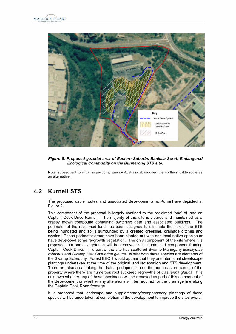
Also an examination of the NSW DEC Recovery Plan for Eastern Suburbs Banksia Scrub revealed that components of the Bunnerong STS lands are identified as possessing significant stands of the EEC. It further revealed that Energy Australia had entered into an agreement with NSW DEC to appropriately manage the remnants of the EEC within the STS and that a site specific Management Plan had been prepared by Energy Australia for the site. To-date this plan has not been sighted and its phase of implementation undetermined.
NSW DEC in early 2006 advertised the designation of mapped areas of Eastern Suburbs Banksia Scrub (including the Bunnerong STS units) as ‘Critical Habitat’. The advertised period for public comment on this intended listing is now closed and the final gazettal is pending (M. Bremner pers. comm.). Energy Australia is understood to have raised objection to the critical habitat designation.
Under the Commonwealth EPBC Act these are matters with the potential, if affected, to require referral to the Commonwealth as matters of National Environmental Significance.

Terrestrial Ecology Assessment Report3.doc/7/06/2007 8:12:00 AM
12 Energy Australia
3.2 Field Inspection Results
3.2.1 Bunnerong STS
Field inspection of the Bunnerong STS site and consideration of the proposal impact footprint revealed the following.
The Bunnerong STS is a parcel of land just over 7.2 Ha in area. It is characterised by a series of existing developments including a network of internal roadways, parking areas and walkways along with two separate (north and south) STS fenced compounds containing switching gear and associated buildings.
Outside these developments there exists significant areas of vegetation that have been, in some cases, fragmented and all are disturbed to varying extent as a result of previous existing developments and changed landuses.
The identified options for the internal STS cable routes are depicted in Figure 3, above.
It is further understood that an eastern section of the southern STS compound will be expanded to accommodate associated switching gear. This compound expansion will require the removal of an area of mainly Bitou Bush infested vegetation and is apparently the subject of a separate development application/approval process (see Figure 5 below and Total Earth Care 2006).
Flora A general flora survey detected 40 plant species during the two site inspections at the Bunnerong STS lands. Almost half of the plants detected were introduced species and three species in particular occur as heavy weed infestations throughout most of the vegetation remaining on the site.
Specifically Bitou Bush Chrysanthemoides monilifera and to a lesser extent Lantana Lantana camara and Pampas Grass Cordateria selloana are present across the site. All three are declared Noxious Weeds under the Noxious Weeds Act 1993 (NW Act) and are ‘Class 4 - Locally Controlled’ weeds that require control in accordance with a Plan of Management published by the Randwick Weed Control area. Lantana is additionally a ‘Class 5 – Restricted’ and notifiable weed under the NW Act and Invasion of Native Plant Communities by Bitou Bush is also a listed Key Threatening Process under the NSW TSC Act. A draft Threat Abatement Plan (TAP) has been prepared by the NSW DEC (NSW DEC, 2006).
A preliminary flora list is provided in Appendix 2.
Sunshine Wattle Acacia terminalis ssp terminalis was identified as a potential subject Threatened Species for the Bunnerong STS site however no specimens were detected from within the site during the site inspections.
Eastern Suburbs Banksia Scrub Endangered Ecological Community (ESBS EEC) was also identified as a subject ‘threatened species’ on the basis of the previous report by Total Earth Care (2006) and analysis of digital data provided by NSW DEC depicting the distribution of ESBS EEC as identified in the National and State Recovery Plan for the EEC (NSW DEC, 2004a) and in the Critical Habitat Recommendation (NSW DEC, 2006a).
The site inspection confirmed the presence of vegetation that conforms to the EEC determination issued by the NSW Scientific Committee and was found to be distributed as depicted in the DEC reports (NSW DEC 2004a; 2006a) and digital mapping data provided. Other patches of vegetation on the site have been previously identified as regrowth (Total Earthcare, 2006) although elements of ESBS EEC may be present in some of these patches despite the heavy infestation of Bitou and other weeds.

Terrestrial Ecology Assessment Report3.doc/7/06/2007 8:12:00 AM
Botany Bay 132kV Cable Project – Terrestrial Ecology Assessment Report 13
It is evident from the site inspection and the information provide by Energy Australia that the proposed internal cable route of this proposal at Bunnerong will be confined to existing roadways and will therefore have no direct impact on the mapped Eastern Suburbs Banksia Scrub.
The patch of regrowth vegetation to be removed as a component of an associated but separate development application (see Figure 5) has been assessed by Total Earth Care (2006) who concluded that there would be no significant impact on the ESBS EEC as a result of the clearing required by that development. There is however potential for elements of ESBS to persist within the soil seed bank across other vegetation patches on the site and therefore any future proposed vegetation removal or modification should be considered on this basis even if outside the mapped ESBS EEC areas. This community is capable of regenerating from soil seed bank on cleared sand where the soil profile remains intact (NSW DEC 2004a).
Fauna A general fauna survey was undertaken to determine the presence of habitat for the seven (7) identified subject fauna species or the habitat of perhaps other species not indicated by the existence of proximal records within the NSW DEC Wildlife Atlas. The inspection enabled the likelihood of threatened species or their habitat that might be impacted by the current proposal to be assessed and to determine whether any more detailed or specific targeted surveys were warranted.
Three of the subject threatened species are Microbat species Miniopterus shreibersii, Saccolaimus flaviventris and Myotis adversus. All three species have been detected within a 5km radius of the subject site. The latter species is often referred to as the ‘fishing bat’ due its habit of flying over expanses of water and capturing prey with its extended feet dragged along the water surface. They are known to colonise built structures particular near humid locations such as bridges and drainage culverts as well as tree hollows. The other two species are tree canopy foragers with Miniopterus shreibersii utilising caves and occasionally built structures. Saccolaimus flaviventris utilises tree hollow as shelter and also built structures such as buildings. In all likelihood these three species are occasional visitors or ‘flyovers’ of the site and may periodically forage among canopy tree species. No trees with hollows were detected on the site and no obvious likely roosting or nesting sites were observed. The current proposal at Bunnerong does not propose to remove any of the trees on the site and so any possible impact is likely to be minimal and insignificant. Potential impacts might include changed lighting conditions to the STS site and this could influence feeding behaviours and utilisation of the site.
The Grey-headed Flying Fox Pteropus poliocephalus, Regent Honeyeater Xanthomyza phrygia and Swift Parrot Lathamus discolor are wide ranging and/or migratory species that may utilise flowering Eucalypt species such as Swamp Mahogany Eucalyptus robustus known from the site. Occasional foraging use of these components of the subject site is only likely to supplement the more extensive foraging habitat required by these species in the local area and during their wider migratory behaviours. Consequently the subject land is unlikely to form habitat of any major significance to any of these species and given that the current proposal will not alter the extent of this foraging vegetation on site the likely impact of the proposal on these species would also likely be insignificant.
The remaining subject species, the Powerful Owl Ninox strenua, is a species that is distributed over a large area of eastern Australia where it generally occupies heavily timbered country of varying vegetation types. Local populations exist as pairs or family groups occupying huge territories. In developed areas the species has shown, on occasion, an ability to occupy patches of fragmented but vegetated land as component elements of its range. The species main diet is predominantly arboreal mammals such as Gliders and Possums and they nest and roost in very large hollow bearing trees. There are no large hollow bearing trees on the site and, whilst no indications that Brush-

Terrestrial Ecology Assessment Report3.doc/7/06/2007 8:12:00 AM
14 Energy Australia
tailed Possums Trichosurus vulpecula still persist on the site, even if the do their numbers would be low given the size of the property and resources available. Consequently the current proposal will likely have little or no impact on this species.
During the site survey three incidental herpetofauna species were observed and are new records for the site.
Previous investigations by Total Earthcare (2006) did not detect/record any herpetofauna from the site.
The three herpetofauna species detected during the general fauna survey and that are additional to the fauna lists provided by Total Earthcare (2006) are:
Jacky Lizard Amphibolurus muricatus
She-Oak Skink Cyclodomorphus michaeli
Litter Skink Lampropholis delicata
None of these are listed as threatened however on of these, the She-Oak Skink Cyclodomorphus michaeli, is significant as it is the closest population of this species remaining near Sydney City. Once much more widespread and patchily distributed around Sydney many of these patches have now been extirpated. Remnant patches of the species still occur in Royal NP south of Sydney, in the Blue Mountains west of Sydney, at Dapto and Shellharbour on the Illawarra coast and around Tuggerah on the Central Coast. Consequently the persistence of this remnant of a possible fragmented Sydney Eastern Suburbs population has considerable conservation significance.
3.2.2 Kurnell STS
Field inspection of the Kurnell STS and consideration of the proposal footprint revealed the following.
The Kurnell STS is a parcel of land of approximately 2.1 Ha in area that has at some previous time been reclaimed with infill from its previous state as a component of Coastal Saltmarsh and Swamp Sclerophyll Forest wetland (both now listed as EECs). This infill process was presumably undertaken to actually accommodate the original Kurnell STS construction and facilitate operations at the adjacent Caltex Refinery establishment.
Other than the section at the front of the subject land all of the proposed development is to be confined to the existing cleared compound comprising the Kurnell STS proper.
Those components of the proposal to be contained within the existing compound will have no direct impact on any of the subject species listed for the Kurnell STS at Section 3.1.4 above.
However the proposed buildings at the front of the subject land allotment and the northern (blue) cable route approach options have the potential to impact, to some degree, on several of the subject species listed in section 3.1.4 above and discussed below.
Flora A general flora survey of the subject land at Kurnell revealed a very low species diversity comprising only approximately 10 species along with a variety of weeds and introduced grasses. Predominant weeds are Bitou Bush Chrysanthemoides monilifera and Lantana Lantana camara. Most of the native plants occurring on the elevated ‘pad’ of land comprising the sub transmission substation (STS) appear to be planted although some specimens may be regrowth from the neighbouring natural vegetation communities. The site consists of a predominantly mown grass area comprising the

Terrestrial Ecology Assessment Report3.doc/7/06/2007 8:12:00 AM
Botany Bay 132kV Cable Project – Terrestrial Ecology Assessment Report 15
STS fenced compound and building enclosure and the fence perimeter area. This maintained area is virtually devoid of any natural vegetation.
An area to the front of the STS compound fronting Captain Cook Drive to the south consists of:
A row of Swamp Mahogany Eucalyptus robusta and a row of Swamp Oak Casuarina glauca where the dish drain along Captain Cook Drive holds water or remains wet.
Where the two access driveways enter the property and form an enlarged vehicular ‘turnaround bay’ there is a majority of these tree species along with raised garden beds containing two wattle species Acacia pycnantha and A. saligna. Both these species appear to have been planted along the frontage to the property and along the artificial creekline on the eastern boundary. Both species are native species but not to the Kurnell area. The latter species A. saligna in particular is widespread in areas where it has been used in preference to Bitou to stabilise dunes after sand mining operations. It is now an environmental weed in many areas outside its natural range and other species should be used in the future in any replanting.
Drainage ditches, swale depressions, creeklines and concrete revetment bunds form the perimeter to the Kurnell STS property. The damper areas, swales and creekline borders contained areas of ground cover that were predominantly Hydrocotyle bonariensis. Along the southwest boundary in particular a large stand of Phragmites australis exists and it also forms a component of the creekline vegetation on the eastern boundary.
Where the drainage line extends beneath Captain Cook Drive, from the oil refinery opposite, a stand of juvenile and/or root sucker regrowth of Casuarina glauca exists and is more or less continuous with the mature street front stand of the same species.
The northern and south western concrete bund revetment boundaries front onto vegetation that conforms to Coastal Saltmarsh EEC and is continuous with and includes the mangrove wetland vegetation forming part of the adjacent Towra Point NR and RAMSAR designated wetland. This vegetation merges with Swamp Sclerophyll Forest vegetation on the eastern boundary where it is influenced by the creekline on the eastern side of the property.
Swamp Sclerophyll Forest and Coastal Saltmarsh vegetation communities are both listed as Endangered Ecological Communities under the NSW TSC Act. Both these vegetation communities were identified as subject ‘species’ for this component of the development proposal at Kurnell. However the proposed development is confined to the existing cleared grassy compound area of the STS and the modified street scape vegetation fronting Captain Cook Drive. Most of this vegetation would appear to have been established at the time of the original STS construction and consequently there will be no direct impact on either of the EECs at the site resulting from the proposal.
Whilst some of the canopy elements that were originally planted as street trees and for landscaping are also elements of the Swamp Sclerophyll Forest EEC, the loss of some specimens of E. robusta for the building construction component of the development, can be readily offset with re-plantings and appropriate positioning of such plantings so that future activities and maintenance will not be required to further disturb or remove any new specimen plantings. Replanting of a suitably extended number of specimens would more than compensate for tree losses and will also offset the habitat losses these same species may provide for occasional foraging viditors.
The Magenta Lilly Pilly Syzigium paniculatum, whilst occurring at Kurnell, is not present on the site and will not be impacted by the development. Suitable provenance specimens of this species for planting in any site landscaping could also be a beneficial consideration.

Terrestrial Ecology Assessment Report3.doc/7/06/2007 8:12:00 AM
16 Energy Australia
Fauna A general fauna survey was undertaken at the Kurnell STS site to ascertain whether more detailed or targeted surveys may be warranted.
The species identified as potential subject species for this component/site of the development were Green and Golden Bell Frog Litoria aurea, Swift Parrot Lathamus discolor, Regent Honeyeater Xanthomyza phrygia, Grey-headed Flying Fox Pteropus poliocephalus, and a number of threatened microbat species.
None of these species were detected during the timing of the site surveys however this is not surprising given the extent of habitat present and the habit of these species.
Green and Golden Bell Frogs have been detected at a number of sites across the Kurnell Peninsula and the Kurnell Key Population is identified in the draft National Recovery Plan and Priorities Action Statement (PAS) for this species as having high conservation significance. The species has been identified within the Kurnell refinery lands and at other nearby properties along Captain Cook Drive and within the adjacent Towra Point Nature Reserve.
It is considered that with care in approach and minor degrees of flexibility and adoption of compensatory or offsetting measures that all potential impacts on these threatened species can be either eliminated or kept to such a minor nature that no threshold of significance would be triggered and possible minor impact easily compensated or offset by associated measures within the proposal.
3.2.3 Cable Route
The northern and southern cable routes are depicted in Figure 4, above. A series of photographs taken at identified sections along the routes illustrate the road reserve site for installation. Any ecological constraints or issues observed along the road reserve routes were documented. A sequential table of photographs is provided in Appendix 2.
Figure 5: Bunnerong South STS area proposed for vegetation clearance.
The yellow boxed area is proposed for clearing to accommodate expansion of the STS compound to receive the new 132kV feeder cables.

Terrestrial Ecology Assessment Report3.doc/7/06/2007 8:12:00 AM
Botany Bay 132kV Cable Project – Terrestrial Ecology Assessment Report 17
4 DISCUSSION
4.1 Bunnerong STS
The current proposal at Bunnerong incorporates feeder cable routes (Figure 3) that follow existing internal roads and avoid any further disturbance to vegetation on site. Subject to a separate development application/approval process is the clearing of a small vegetation patch to expand the Bunnerong South STS compound. This vegetation clearing action has been the subject of a separate assessment by Total Earth Care (2006) that concluded there would be no significant impact on Eastern Suburbs Banksia Scrub EEC, the only threatened species known or likely to occur on the site with the potential to be significantly impacted by either proposal. Eastern Suburbs Banksia Scrub is an Endangered Ecological Community listed as such under both State (TSC Act) and Commonwealth (EPBC Act) legislation. The vegetation patch in question is a virtual monoculture of Bitou Bush Chrysanthemoides monilifera and only three native species are evident. The possibility of ESBS EEC elements being present in the soil seed bank is unknown but possible and this was not adequately discussed in the previous study.
Energy Australia (EA) were consulted during the preparation of the National and State Recovery Plan for ESBS EEC. Surveys were undertaken by NSW DEC at the Bunnerong site and the extent of the highest quality ESBS EEC patches were mapped and analysed (see Figure 6 below). Subsequently the NSW DEC undertook to have these mapped patches of the ESBS EEC declared as critical habitat and the public exhibition phase for this process was completed in March 2006. Energy Australia is understood to have objected to the listing of the ESBS EEC patches on the Bunnerong site as critical habitat and the NSW Environment Ministers gazettal and listing of the critical habitat is pending.
Notwithstanding this, the loss of the Bitou Bush infested and unmapped patch of vegetation is not significant. Other vegetation on the site is to be retained and the previously prepared management plan for the ESBS EEC on site will be implemented in accordance with the National Recovery Plan for the EEC and the NSW Threat Abatement Plan for Bitou Bush. The EEC does not warrant further concern under TSC Act requirements nor referral to the Commonwealth Minister for Environment and Water Resources on the basis of the Bunnerong component of the proposal, if affected as described.
Management strategies for the onsite vegetation are intended to take consideration of the possibility that some of the Swamp Mahogany specimens could be occasionally utilised as foraging habitat by migratory and wide ranging threatened species such as the Regent Honeyeater Xanthomyza phrygia, Swift Parrot Lathamus discolor and Grey-headed Flying Fox Pteropus poliocephalus. Any required slashing or burn strategies required as part of management of the site and the ESBS EEC will also give consideration to the remnant and highly significant local population of the She-Oak Skink Cyclodomorphus michaeli.
Terrestrial Ecology Assessment Report3.doc/7/06/2007 8:12:00 AM
18 Energy Australia
Figure 6: Proposed gazettal area of Eastern Suburbs Banksia Scrub Endangered Ecological Community on the Bunnerong STS site.
Note: subsequent to initial inspections, Energy Australia abandoned the northern cable route as an alternative.
4.2 Kurnell STS
The proposed cable routes and associated developments at Kurnell are depicted in Figure 2.
This component of the proposal is largely confined to the reclaimed ‘pad’ of land on Captain Cook Drive Kurnell. The majority of this site is cleared and maintained as a grassy mown compound containing switching gear and associated buildings. The perimeter of the reclaimed land has been designed to eliminate the risk of the STS being inundated and so is surrounded by a created creekline, drainage ditches and swales. These perimeter areas have been planted out with non local native species or have developed some re-growth vegetation. The only component of the site where it is proposed that some vegetation will be removed is the unfenced component fronting Captain Cook Drive. This part of the site has scattered Swamp Mahogany Eucalyptus robustus and Swamp Oak Casuarina glauca. Whilst both these species are elements of the Swamp Sclerophyll Forest EEC it would appear that they are intentional streetscape plantings undertaken at the time of the original land reclamation and STS development. There are also areas along the drainage depression on the north eastern corner of the property where there are numerous root suckered regrowths of Casuarina glauca. It is unknown whether any of these specimens will be removed as part of this component of the development or whether any alterations will be required for the drainage line along the Captain Cook Road frontage.
It is proposed that landscape and supplementary/compensatory plantings of these species will be undertaken at completion of the development to improve the sites overall

Terrestrial Ecology Assessment Report3.doc/7/06/2007 8:12:00 AM
Botany Bay 132kV Cable Project – Terrestrial Ecology Assessment Report 19
streetscape appearance from Captain Cook Drive. These plantings will also more than offset any possible negative impacts on the possible occasional utilisation of the site by wide ranging threatened species such as the Regent Honeyeater Xanthomyza phrygia, Swift Parrot Lathamus discolor and Grey-headed Flying Fox Pteropus poliocephalus.
Whilst no Green and Golden Bell Frogs Litoria aurea have been observed on the site, given the proximity of other recent records, there is potential for the species to utilise the creek and drainage lines from time to time. Consequently it is proposed that as a component of the site landscaping there will be installation of microhabitat features for the species as a contingency measure against any possible negative impacts for this species.
All four of the above threatened species are listed under both State and Commonwealth legislation but the proposal, as described, will likely have minimal if any impact on any of them. No EECs will be significantly affected by the Kurnell STS component of the proposal and EEC elements will be incorporated into street plantings as a proactive measure.
The nature of the proposal as described will have no direct impact on the adjacent Towra Point NR and RAMSAR declared wetland. This adjacent wetland area is the only GDE of any significance that could be impacted by the project. The only potential for impacts to the wetland arise from possible indirect effects on the groundwater or due to runoff. Based on the details of the proposal, and the safeguards intended to be put in place during the construction phase of the development, these impacts are considered likely to be miniscule. Building heights and compound security lighting also have the potential to impact not only on aesthetic considerations but also possibly movements and foraging behaviour of microbats and migratory shorebirds utilising the wetland and adjacent airspace. These details need to be considered in the building design phase along with operation of lighting on completion.
The above subject threatened species do not warrant further specific concern under either TSC Act requirements nor referral to the Commonwealth Minister for Environment and Water Resources on the basis of the Kurnell STS component of the proposal, if effected as described.
4.3 Northern Cable Route
The northern cable route is proposed to be confined to the road reserve along Anzac Parade, Bunnerong Road and Military Road. No vegetation will be removed by this process and no ecological impacts are envisaged by any of the road reserve installation.
The only section of the northern cable route installation where there is potential for indirect impacts is at the creek/drainage line crossing just south of Little Bay Road. This creek flows to Yarra Bay and the catchment of this creek has records of the Green and Golden Bell Frog Litoria aurea (GGBF). These records are not old but no specimens were detected at the creek crossing during the site inspection. Consequently disturbance to the creek line could potentially impact on the local GGBF population if its still persists. An appropriate ameliorative action would be to take due care in the installation process at this crossing and undertake installation of microhabitat features for the species in the vicinity as part of the process and any rehabilitation of areas where protective measures are installed during construction.
The section crossing the La Perouse Historic Heritage section of Botany Bay NP will be under bored from the unformed carpark adjacent to Goorawahl Avenue. No ecological impacts are envisaged from this subterranean section of the cable installation.
No significant impact on threatened species will arise out of the northern cable route component of the proposal effected as described.

Terrestrial Ecology Assessment Report3.doc/7/06/2007 8:12:00 AM
20 Energy Australia
4.4 Southern Cable Route
The southern cable route is proposed to be largely confined to the road reserve along Captain Cook Drive and the formed suburban streets of Kurnell. No vegetation will be required to be removed as part of this process and no ecological impacts are expected or likely. The depth of trenching for cable installation is proposed to be a metre or less and this is considered unlikely to have any impact on groundwater or aquifers occurring on the Kurnell peninsula.
From the car park area adjacent to Silver Beach it is understood that trenching across Silver Beach itself will be undertaken to connect with the submarine component of the cable route. A report by Douglas Partners (2006) indicates that potential for acid sulfate soil issues does not exist in this area.
Consequently it is envisaged that the only potential terrestrial ecological impacts are temporary disturbance to foraging shore birds along this portion of Silver Beach in the vicinity of the mechanical works that will be in operation. Silver Beach has high human visitation from residents and visitors to the Captain Cook Historic Heritage section of Botany Bay NP.
Following installation and burial of the cable no permanent impacts are likely and the temporary impacts considered negligible. Threatened species noted from the vicinity include Sooty Oyster Catchers and Pied Oyster Catchers but both are generally foragers further to the east along the rocky sections of the foreshore. Consequently no significant impact on threatened species is likely to arise out of the southern cable route component of the proposal effected as described.
4.5 Recommendations
Construction phase management plans be prepared to ensure the threatened species habitat values in the vicinity are not inadvertently impacted during the development/construction/installation.
A landscape plan be developed as part of the proposal at both STS sites and possibly at Yarra Bay Creek as required.
Suitable plantings using local provenance species, (and perhaps the locally occurring threatened plant Syzygium paniculatum Magenta Lilly Pilly as a biodiversity investment), be planted in a 5 for 1 offset ratio for any specimens removed the details of which should be incorporated into the site Landscape Plans.
The positioning and details of required microhabitat features required as a component of GGBF landscaping/habitat creation should be incorporated into the Kurnell landscape plan.
Similar features should be incorporated at the Little Bay/Yarra Bay creek crossing of Bunnerong Road during trenching and cable installation as a component of any reparation that may become necessary.
Any trenching that may be required across the Yarra Bay Creek should be undertaken with appropriate safeguards to downstream water quality and habitat that may be present (appropriate and suitably maintained erosion and sediment control).
The potential for indirect impact from run off due to possible drainage line modifications be considered in contingency at Kurnell STS and dealt with in a ‘best practice’ approach to Soil Erosion Mitigation Guidelines (SEMGLs).

Terrestrial Ecology Assessment Report3.doc/7/06/2007 8:12:00 AM
Botany Bay 132kV Cable Project – Terrestrial Ecology Assessment Report 21
Potential for installed lighting to have impacts on microbats at both STS sites and perhaps migratory bird species at Kurnell STS be given consideration in the details of the proposal.
The potential for indirect impact from run off due to possible drainage line modifications be considered in contingency at the Kurnell STS.
Indirect impacts that could arise due to careless, untrained/awareness raised workers during construction processes need to be given adequate consideration and safe guards put in place. This should include the decommissioning or replacement/upgrade of any electrical equipment that have potential to contaminate from oil/PCB spillage as well as the use of machinery in the vicinity of the ESBS and Declared Critical Habitat at Bunnerong.
A Management Plan for Eastern Suburbs Banksia Scrub at the Bunnerong STS should be reviewed and updated as necessary as a result of this proposal and findings herein reported. That a time frame for the MPs implementation be enunciated and the details should also be provided to NSW DEC and the Commonwealth DEWR as lead agencies in coordinating the implementation of the National Recovery Plan for the ESBS EEC.
Management of the Bunnerong STS sites vegetation should give consideration to the local remnant of a highly significant She-Oak Skink Cyclodomorphus michaeli population on site.
Precise positioning of the cable route at Silver Beach should endeavour to avoid the drainage line outlet onto Silver Beach in that vicinity.
4.6 Conclusions
Provided the recommendations above and the detailed accounts provided in the various sections of this report are appropriately considered there will be no significant impact on any terrestrial ecological element.
None of the threatened species considered or discussed as subject species will be impacted by the various sections of the proposal provided the recommendations are heeded. In fact with full implementation of the above recommendations there will be likely a biodiversity and threatened species benefit from the terrestrial components of the proposal.
Consequently no NSW TSC Act listed species will be significantly impacted by the proposal, no Commonwealth EPBC Act listed threatened species will be significantly impacted by the proposal and no other matters of National Environmental Significance including: JAMBA/CAMBA migratory bird species; the RAMSAR listed wetland; and any associated GDEs, are likely to be significantly impacted by the proposal. A referral to the Commonwealth Minister for the Environment and Water Resources is herein considered unwarranted.

Terrestrial Ecology Assessment Report3.doc/7/06/2007 8:12:00 AM
22 Energy Australia
5 REFERENCES
1. Department of Environment and Conservation (2004) Threatened Biodiversity Survey and Assessment: Guidelines for Developments and Activities (Draft). November 2004. DEC Sydney South
2. Douglas Partners (2006) Botany Bay Cable Project Bunnerong to Kurnell Sub-Transmission Stations. Report on Topography, Soils, Geology and Groundwater. Report Prepared for Molino Stewart on behalf of Energy Australia
3. NSW Department of Environment and Conservation (2003) Eastern Suburbs Banksia Scrub in the Sydney Basin Bioregion. Environmental Impact Assessment Guidelines.
4. NSW Department of Environment and Conservation (2004a) Eastern Suburbs Banksia Scrub in the Sydney Basin Bioregion. Threatened Species Information Profile.
5. NSW Department of Environment and Conservation (2004b) Eastern Suburbs Banksia Scrub Endangered Ecological Community Recovery Plan. NSW Department of Environment and Conservation, Hurstville
6. NSW Department of Environment and Conservation (2006a) Recommendation for the Identification of Critical Habitat for the Eastern Suburbs Banksia Scrub Endangered Ecological Community – Recommendation Report prepared for public exhibition pursuant to Part 3 of the Threatened Species Conservation Act 1995. NSW Department of Environment and Conservation, Hurstville
7. NSW Department of Environment and Conservation (2006b). NSW Threat Abatement Plan –Invasion of native plant communities by Chrysanthemoides monilifera (Bitou Bush and Boneseed). Department of Environment and Conservation (NSW), Hurstville.
8. Total Earth Care (2006) Flora and Fauna Assessment Bunnerong Subtransmission Substation proposed stage 1 expansion Military Road, Matraville. Report prepared for Energy Australia


Appendix A
Flora Lists


Terrestrial Ecology Assessment Report3.doc/7/06/2007 8:12:00 AM 1
Flora List Bunnerong
Native Plant Species
Dennstaedtiaceae Pteridium esculentum
Campanulaceae Wahlenbergia gracilis
Cassythaceae Cassytha sp.
Casuarinaceae Allocasuarina distyla
Allocasuarina littoralis
Cunoniaceae Ceratopetalum gummiferum
Cheilanthaceae Cheilanthus sieberi
Dilleniaceae Hibbertia obtusifolia
Hibbertia scandens
Ericaceae Leucopogon ericoides
Epacridaceae Astroloma pinifolium
Leucopogon ericoides
Monotoca elliptica
Euphorbiaceae Breynia oblongifolia
Ricinocarpus pinifolius
Fabaceae Acacia sophorae
Acacia suaveolens
Acacia terminalis subsp. angustifolia
Acacia ulicifolia
Aotus ericoides
Bossiaea heterophylla
Dillwynia retorta
Hardenbergia violacea
Halagoraceae Gonocarpus teucroides
Myrtaceae Angophora costata
Eucalyptus robusta
Eucalyptus botryoides
Leptospermum laevigatum
Phormiaceae Dianella revoluta
Pittosporaceae Billardieria scandens
Pittosporum undulatum
Proteaceae Banksia aemula
Banksia integrifolia
Persoonia lanceolata

2 Terrestrial Ecology Assessment Report3.doc/7/06/2007 8:12:00 AM
Rubiaceae Pomax umbellata
Thymelaeaceae Pimelea linifolia
Violaceae Hybanthus monopetalus
Cyperaceae Isolepis nodosa
Lepidosperma laterale
Lomandraceae Lomandra longifolia
Moraceae Ficus rubiginosa
Phormiaceae Dianella revoluta
Poaceae Cynodondactylon
Dichelachne crinita
Eragrostis brownii
Imperata cylindrica
Microlaena stipoides
Themeda australis
Xanthorrhoeaceae Xanthorrhoea resinifera
Weed Species
Chrysanthemoides monilifera subsp rotundata (Bitou Bush)
Eragrostis curvula (African Love Grass)
Lantana camara (Lantana)
Rhynchelytrum repens (Red Natal Grass
Chloris gayana (Rhodes Grass)
Cordateria selloana (Pampas Grass)
Conyza floribunda (Fleabane)
Conyza bonariensis (Fleabane)
Bidens pilosa (Cobblers Peg)
Ageratina adenophera (Crofton Weed)
Ochna serrulata (Ochna)
Olea europaea (European Olive)
Protasparagus aethiopicus (Asparagus Fern)
Pennisetum clandestinum (Kikuyu)
Sonchus oleraceus (Sowthistle)

Terrestrial Ecology Assessment Report3.doc/7/06/2007 8:12:00 AM 3
Flora List Kurnell
Myrtaceae Eucalyptus robustus Swamp Mahogany
Callistemon citrinus Bottlebrush
Melaleuca sp Paper Bark
Mimosaceae Acacia pycnantha Golden Wattle
Acacia saligna Golden Wreath Wattle
Casuarinaceae Casuarina glauca Swamp Oak
Apiaceae Hydrocotyle bonariensis Kurnell Curse
Poaceae Phragmites australis Native Reed
Euphorbiaceae Glochidion ferdinandi Cheese Tree
Avicenniaceae Avicennia marina Grey Mangrove
Verbenaceae Lantana camara Lantana
Astaraceae Chrysanthemoides monilifera Bitou Bush


Appendix B
Subject Threatened Fauna Species


Terrestrial Ecology Assessment Report3.doc/7/06/2007 8:12:00 AM 1
SUBJECT THREATENED FAUNA SPECIES
Scientific Name
Common Name Status Species Account Threats Measures to avoid
impact
Saccolaimus flaviventris
Yellow-bellied Sheathtail-bat
V
The Yellow-bellied Sheathtail-bat is a very distinctive, large, insectivorous bat up to 87 mm long. The Yellow-bellied Sheathtail-bat is a wide-ranging species found across northern and eastern Australia.
Disturbance to roosting and summer breeding sites. Foraging habitats are being cleared for residential and agricultural developments, including clearing by residents within rural subdivisions. Loss of hollow-bearing trees; clearing and fragmentation of forest and woodland habitat. Pesticides and herbicides may reduce the availability of insects, or result in the accumulation of toxic residues in individuals' fat stores.
Sensitive lighting at both Kurnell and Bunnerong STS. No removal of hollow bearing trees
Miniopterus schreibersii oceanensis
Eastern Bentwing-bat
V
The Eastern Bentwing-bat is a small insectivorous microbat with chocolate to reddish-brown fur on its back and slightly lighter coloured fur on its belly. It weighs up to 20 grams, has a head and body length of about 6 cm and a wingspan of 30 - 35 cm. Eastern Bent-wing Bats occur along the east and north-west coasts of Australia.
Damage to or disturbance of roosting caves, particularly during winter or breeding. Loss of foraging habitat. Application of pesticides in or adjacent to foraging areas. Predation by feral cats and foxes.
Sensitive lighting at both Kurnell and Bunnerong STS.
Myotis adversus
Large-footed Myotis
V
This species is now most often referred to as Myotis macropus or the Southern Myotis or Fishing Bat. It has disproportionately large feet; more than 8 mm long, with widely-spaced toes which are distinctly hairy and with long, curved claws. The Large-footed Myotis is found in the coastal band from the north-west of Australia, across the top-end and south to western Victoria. Generally roost in groups of 10 - 15 close to water in caves, mine shafts, hollow-bearing trees, storm water channels, buildings, under bridges and in dense foliage. Forage over streams and pools catching insects and small fish by raking their feet across the water surface.
Reduction in stream water quality affecting food resources Loss or disturbance of roosting sites. Clearing adjacent to foraging areas. Application of pesticides in or adjacent to foraging areas.
Sensitive lighting at both Kurnell and Bunnerong STS. No removal of hollow bearing trees
2 Terrestrial Ecology Assessment Report3.doc/7/06/2007 8:12:00 AM
Scientific Name
Common Name Status Species Account Threats Measures to avoid
impact
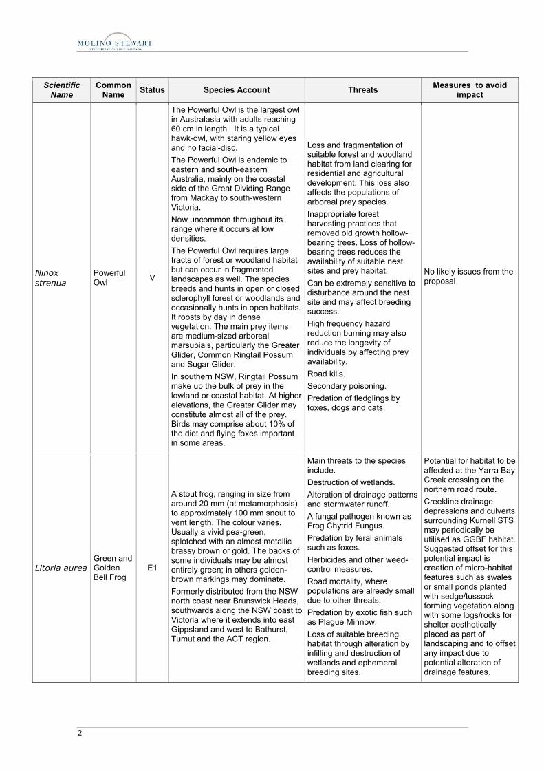
Ninox strenua
Powerful Owl V
The Powerful Owl is the largest owl in Australasia with adults reaching 60 cm in length. It is a typical hawk-owl, with staring yellow eyes and no facial-disc. The Powerful Owl is endemic to eastern and south-eastern Australia, mainly on the coastal side of the Great Dividing Range from Mackay to south-western Victoria. Now uncommon throughout its range where it occurs at low densities. The Powerful Owl requires large tracts of forest or woodland habitat but can occur in fragmented landscapes as well. The species breeds and hunts in open or closed sclerophyll forest or woodlands and occasionally hunts in open habitats. It roosts by day in dense vegetation. The main prey items are medium-sized arboreal marsupials, particularly the Greater Glider, Common Ringtail Possum and Sugar Glider. In southern NSW, Ringtail Possum make up the bulk of prey in the lowland or coastal habitat. At higher elevations, the Greater Glider may constitute almost all of the prey. Birds may comprise about 10% of the diet and flying foxes important in some areas.
Loss and fragmentation of suitable forest and woodland habitat from land clearing for residential and agricultural development. This loss also affects the populations of arboreal prey species. Inappropriate forest harvesting practices that removed old growth hollow-bearing trees. Loss of hollow-bearing trees reduces the availability of suitable nest sites and prey habitat. Can be extremely sensitive to disturbance around the nest site and may affect breeding success. High frequency hazard reduction burning may also reduce the longevity of individuals by affecting prey availability. Road kills. Secondary poisoning. Predation of fledglings by foxes, dogs and cats.
No likely issues from the proposal
Litoria aurea Green and Golden Bell Frog
E1
A stout frog, ranging in size from around 20 mm (at metamorphosis) to approximately 100 mm snout to vent length. The colour varies. Usually a vivid pea-green, splotched with an almost metallic brassy brown or gold. The backs of some individuals may be almost entirely green; in others golden-brown markings may dominate. Formerly distributed from the NSW north coast near Brunswick Heads, southwards along the NSW coast to Victoria where it extends into east Gippsland and west to Bathurst, Tumut and the ACT region.
Main threats to the species include. Destruction of wetlands. Alteration of drainage patterns and stormwater runoff. A fungal pathogen known as Frog Chytrid Fungus. Predation by feral animals such as foxes. Herbicides and other weed-control measures. Road mortality, where populations are already small due to other threats. Predation by exotic fish such as Plague Minnow. Loss of suitable breeding habitat through alteration by infilling and destruction of wetlands and ephemeral breeding sites.
Potential for habitat to be affected at the Yarra Bay Creek crossing on the northern road route. Creekline drainage depressions and culverts surrounding Kurnell STS may periodically be utilised as GGBF habitat. Suggested offset for this potential impact is creation of micro-habitat features such as swales or small ponds planted with sedge/tussock forming vegetation along with some logs/rocks for shelter aesthetically placed as part of landscaping and to offset any impact due to potential alteration of drainage features.

Terrestrial Ecology Assessment Report3.doc/7/06/2007 8:12:00 AM 3
Scientific Name
Common Name Status Species Account Threats Measures to avoid
impact
Pteropus poliocepha-lus
Grey-headed Flying Fox
V
Xanthomyza phrygia
Regent Honey-eater
E1
The Regent Honeyeater is a striking and distinctive, medium-sized, black and yellow honeyeater with a sturdy, curved bill. The Regent Honeyeater mainly inhabits temperate woodlands and open forests of the inland slopes of south-east Australia. The Regent Honeyeater mainly inhabits temperate woodlands and open forests of the inland slopes of south-east Australia. Birds are also found in drier coastal woodlands and forests in some years. Once recorded between Adelaide and the central coast of Queensland, its range has contracted dramatically in the last 30 years. The Regent Honeyeater is a flagship threatened woodland bird whose conservation will benefit a large suite of other threatened and declining woodland fauna. Every few years non-breeding flocks are seen foraging in flowering coastal Swamp Mahogany and Spotted Gum forests, particularly on the central coast and occasionally on the upper north coast. Birds are occasionally seen on the south coast.
Historical loss, fragmentation and degradation of habitat from clearing for agricultural and residential development, particularly fertile Yellow Box-White Box-Blakely's Red Gum woodlands. Continuing loss of key habitat tree species and remnant woodlands from strategic agricultural developments, timber gathering and residential developments. Suppression of natural regeneration of overstorey tree species and shrub species from overgrazing. Riparian gallery forests have been particularly impacted by overgrazing. Inappropriate forestry management practices that remove large mature resource-abundant trees. Firewood harvesting in Box-Ironbark woodlands can also remove important habitat components. Competition from larger aggressive honeyeaters, particularly Noisy Miners, Noisy Friarbirds and Red Wattlebirds. Egg and nest predation by native birds.
Avoid removal of flowering Eucalypts potentially used by the species during coastal migrations. Offset the removal of any specimens of winter flowering Eucalyptus robusta with re-plantings of the same species with local provenance and at a replacement ration of 5 for 1 or greater.
Lathamus discolor
Swift Parrot
The Swift Parrot is small parrot about 25 cm long. It is bright green with red around the bill, throat and forehead. The species breeds in Tasmania during spring and summer, migrating in the autumn and winter months to south-eastern Australia. Favoured feed trees include winter flowering species such as Swamp Mahogany Eucalyptus robusta, Spotted Gum Corymbia maculata, Red Bloodwood C. gummifera, Mugga Ironbark E. sideroxylon, and White Box E. albens. Return to home foraging sites on a cyclic basis depending on food
On the mainland the main threat is loss of habitat through clearing for agriculture, and urban and industrial development. Collisions with wire netting fences, windows and cars, during the breeding season and winter migration (especially where such obstacles are in close proximity to suitable habitat).
Avoid removal of flowering Eucalypts potentially used by the species during coastal migrations. Offset the removal of any specimens of winter flowering Eucalyptus robusta with re-plantings of the same species with local provenance and a replacement ratio of 5 for 1 or greater.

4 Terrestrial Ecology Assessment Report3.doc/7/06/2007 8:12:00 AM
Scientific Name
Common Name Status Species Account Threats Measures to avoid
impact
availability.
Acacia terminalis sub sp terminalis
Sunshine Wattle
E1
An erect or spreading shrub, 1 - 5 m tall. Pale yellow flower heads and seed pods 3 - 11 cm long. Differs from more widespread forms by being hairier, possessing thicker flower stalk and wider seed pods. Very limited distribution between Botany Bay to the northern foreshore of Port Jackson. Recent collections have only been made from the Quarantine Station, Clifton Gardens, Dover Heights, Parsely Bay, Nielson Park, Cooper Park, Chifley and Watsons Bays. Coastal scrub and dry sclerophyll woodland on sandy soils. Habitat is generally sparse and scattered. Most areas of habitat or potential habitat are small and isolated. Most sites are highly modified or disturbed due to surrounding urban development. Flowers in autumn.
Clearing, land development and habitat degradation by rubbish dumping, weed invasion and access by people. Greatest threat is habitat loss due to urban development. Inappropriate fire regimes may also threaten persistence at some locations. As some plants occur on the edge of walking tracks and roads, there is potential for impacts from park management activities or recreational usage. Acacia terminalis is available from nurseries in the Sydney area and the source stock is questionable. There is potential for the sub-species to hybridise with horticultural cultivars.
No specimens of the species were detected at either STS and so no impact on the species is likely.
Syzygium paniculatum
Magenta Lilly Pilly V
The Magenta Lilly Pilly is a small to medium sized rainforest tree that grows to 8 m tall. The Magenta Lilly Pilly is found only in NSW, in a narrow, linear coastal strip from Bulahdelah to Conjola State Forest. On the central coast, including Sydney, Magenta Lilly Pilly occurs on gravels, sands, silts and clays in riverside gallery rainforests and remnant littoral rainforest communities.
As a rainforest plant, it is likely the Magenta Lilly Pilly has not evolved to cope with frequent fire. Loss of habitat through clearing for residential development. Grazing and trampling of habitat by grazing stock. Weeds, particularly Lantana, are invading the species’ habitat
No impacts from the proposal. This plant species could be considered as an appropriate landscape planting in consultation with NSW DEC and Council. Local provenance material should be used and planted as a biodiversity investment.
Endangered Ecological Community
Eastern Suburbs Banksia Scrub
E3
Predominantly a sclerophyllous heath or scrub community although, depending on site topography and hydrology, some remnants contain small patches of woodland, low forest or limited wetter areas. Common species include Banksia aemula, B. ericifolia, B. serrata, Eriostemon australasius, Lepidosperma laterale, Leptospermum laevigatum, Monotoca elliptica and Xanthorrhoea resinifera. Once occupied around 5,300 hectares of land between North Head and Botany Bay in Sydney’s eastern suburbs. Surviving stands totalling approximately 146
Loss and fragmentation of habitat as a consequence of clearing and development. Altered nutrient status, hydrological regimes, and fire regimes. Invasion by weed species (particularly Bitou Bush, Lantana and African Love Grass). Mowing, slashing and the inappropriate use of herbicide. Dumping of rubbish including fill material and green waste. Grazing and trampling by horses and rabbits. Unrestricted access by
Direct impacts from the proposal at Bunnerong are either unlikely or negligible provided workers involved in the installation process and using machinery are briefed and safeguards put in place.

Terrestrial Ecology Assessment Report3.doc/7/06/2007 8:12:00 AM 5
Scientific Name
Common Name Status Species Account Threats Measures to avoid
impact
hectares have been recorded from the local government areas of Botany, Randwick, Waverley, and Manly. Occurs on disjunct patches of nutrient poor aeolian (wind blown) dune sand. The community possesses soil seed bank and has been observed to regenerate naturally on cleared sand where the soil profile remains intact. Floristic composition and structural diversity is influenced by the size and disturbance history of the remnant.
pedestrians and vehicles. Inappropriate plantings in and around remnants. Seed and wildflower collection.
Endangered Ecological Communities
Swamp Sclero-phyll Forest on coastal floodplains of the NSW North Coast, Sydney basin and South East Corner bioregions
E3
This swamp community has an open to dense tree layer of eucalypts and paperbarks although some remnants now only have scattered trees as a result of partial clearing. The trees may exceed 25 m in height, but can be considerably shorter in regrowth stands or under conditions of lower site quality where the tree stratum is low and dense. The most widespread and abundant dominant trees include Eucalyptus robusta (Swamp Mahogany), Melaleuca quinquenervia (paperbark) and, south from Sydney, Eucalyptus botryoides (Bangalay) and Eucalyptus longifolia (Woollybut). Other trees may be scattered throughout at low abundance or may be locally common at few sites, including Callistemon salignus (Sweet willow Bottlebrush), Casuarina glauca (swamp oak) and Eucalyptus resinifera subsp. hemilampra (red mahogany), Livistona australis (Cabbage Palm) and Lophostemon suaveolens (Swamp Turpentine).
Landfilling and earthworks associated with urban and industrial development Grazing and trampling by stock and feral animals (particulary pigs) Changes in water quality, particularly increased nutrients and sedimentation Weed invasion Climate change Activation of acid sulfate soils Removal of dead wood Rubbish dumping Frequent burning which reduces the diversity of woody plant species Management of water and tidal flows Further clearing for urban and rural development, and the subsequent impacts from fragmentation Flood mitigation and drainage works
Direct impacts from proposal to this EEC at Kurnell are unlikely. Construction phase management plan should provide measures to avoid indirect impacts from machinery, from run off or alteration to drainage lines. Plantings as offset should be of local provenance.
Endangered Ecological Community
The Shorebird Comm-unity occurring on the relict tidal delta sands at Taren Point.
E3
A group of shorebirds (also called waders) which occupy a particular area of Botany Bay and includes the characteristic assemblage of the following 20 species: Bar-tailed Godwit (Limosa lapponica), Red Knot (Calidris canutus), Great Knot (Calidris tenuirostris), Sharp-tailed Sandpiper (Calidris acuminata), Curlew Sandpiper (Calidris ferruginea), Red-necked Stint (Calidris ruficolli), Common Sandpiper (Actitis hypoleucos), Terek Sandpiper (Xenus cinereus),
Loss of feeding and roosting habitat. Fragmentation or isolation of sites within feeding areas resulting in decreasing abundance. Human disturbance at roost and feeding sites. Disturbance by dogs at roost and feeding sites. Pollution.
Direct impacts from the proposal on this EEC will not occur. Potential for indirect impacts on individual elements whilst foraging outside Taren Point are minimal to negligible. Threatened shore bird species such the Sooty Oyster Catcher and Pied Oyster Catcher are unlikely to utilise the
6 Terrestrial Ecology Assessment Report3.doc/7/06/2007 8:12:00 AM
Scientific Name
Common Name Status Species Account Threats Measures to avoid
impact
Latham’s Snipe (Gallinago hardwickii), Grey-tailed Tattler (Heteroscelus brevipes), Grey Plover (Pluvialis squatarola), Pacific Golden Plover (Pluvialis fulva), Common Greenshank (Tringa nebularia), Masked Lapwing (Vanellus miles), Marsh Sandpiper (Tringa stagnatili), Ruddy Turnstone (Arenaria interpres), Pied Oystercatcher (Haematopus longirostris), Sooty Oystercatcher (Haematopus fulinginosus), Whimbrel (Numenius phaeopus), and Eastern Curlew (Numenius madagascariensis). Occurs on the relict marginal shoal of the Georges River between Taren Point and Shell Point in Botany Bay. Some species identified within this community can also be found foraging and roosting at other locations within Botany Bay. In Botany Bay the shorebird community utilises roosting and foraging habitat (intertidal mud flats and sand flats) not only at the relic marginal shoal at Taren Point but at other sites including Penrhyn Inlet, Sandringham and the shoreline adjacent to the north-east side of the Captain Cook Bridge. For some species (Terek Sandpiper, Grey-tailed Tattler), the proximity of mangroves (Avicennia marina) is important as roosting habitat. The substrates found in the Taren Point area are rich in invertebrates upon which shorebirds feed. Only two other locations within Botany Bay exhibit this high invertebrate species diversity, Quibray Bay (Towra Point Nature Reserve) and Penrhyn Inlet.
sandy beach area proposed for the cable crossing.
Endangered Ecological Community
Coastal Saltmarsh in the NSW North Coast, Sydney Basin and South East corner bioregions
E3
Coastal Saltmarsh occurs in the intertidal zone on the shores of estuaries and lagoons that are permanently or intermittently open to the sea. It is frequently found as a zone on the landward side of mangrove stands. Characteristic plants include Baumea juncea, Juncus krausii, Sarcocornia quinqueflora, Sporobolus virginicus, Triglochin striata, Isolepis nodosa, Samolus repens, Selliera radicans, Suaeda australis and Zoysia
In-filling for development, including roads, residential, industrial, recreational, waste disposal and agricultural purposes. Modification of tidal flows as a consequence of artificial structures being erected. Alteration of salinity and increasing nutrient levels resulting from the discharge of stormwater into saltmarshes.
Direct impacts from proposal to this EEC at Kurnell are unlikely. Construction phase management plan should provide measures to avoid indirect impacts from machinery, from run off or alteration to drainage lines.
Terrestrial Ecology Assessment Report3.doc/7/06/2007 8:12:00 AM 7
Scientific Name
Common Name Status Species Account Threats Measures to avoid
impact
macrantha. Occasionally mangroves are scattered through the saltmarsh. Tall reeds may also occur, as well as salt pans. This community occurs in the intertidal zone along the NSW coast.
Weed invasion, particularly by Juncus acutus. Physical damage from human disturbance, domestic and feral animals. Dumping of rubbish and pollution from oil or chemical spills from shipping or road accidents; catchment runoff of nutrients and agricultural chemicals. Invasion by mangroves. Inappropriate fire regimes.
Endangered Ecological Community
Sydney Fresh-water Wetlands in the Sydney Basin Bioregion
E3
A complex of vegetation types largely restricted to freshwater swamps in coastal areas. These also vary considerably due to fluctuating water levels and seasonal conditions. Characteristic species include sedges and aquatic plants such as Baumea species, Eleocharis sphacelata, Gahnia species, Ludwigia peploides ssp. montevidensis and Persicaria species. Areas of open water may occur where drainage conditions have been altered and there may also be patches of emergent trees and shrubs. Occurs on sand dunes and low-nutrient sandplains along coastal areas in the Sydney Basin bioregion.
Habitat loss and fragmentation due to clearing and filling associated with urban development. Habitat degradation resulting from altered hydrology/nutrient levels, weed invasion, off-road vehicles, illegal waste dumping and sand extraction.
Direct impacts from proposal to this EEC at Kurnell are unlikely. Construction phase management plan should provide measures to avoid indirect impacts from machinery, from run off or alteration to drainage lines. Occurrence of vegetation that may conform to this community is mainly upstream and on opposite side of Captain Cook Drive.

Appendix C
Cable Route Sections


Terrestrial Ecology Assessment Report3.doc/7/06/2007 8:12:00 AM 1
CABLE ROUTE SECTIONS
Northern Road Route
Photographic Record Photo Details Issues
Subterranean section view north Subterranean section view south
This section of the northern terrestrial cable route extends beneath the La Perouse historic heritage section of Botany Bay NP. The under bore process proposed for this section will have no likely ecological impacts.
Unformed carpark adjacent to Goorawahl Avenue. Starting point for the underboring of La Perouse historic heritage section of Botany Bay NP and starting point for road reserve installation to Bunnerong.
No ecological impacts likely
Anzac Parade adjacent to commencement of road route north
No ecological impacts likely
Anzac Parade ca 140 metres north of starting point No ecological impacts likely

2 Terrestrial Ecology Assessment Report3.doc/7/06/2007 8:12:00 AM
Photographic Record Photo Details Issues
Anzac Parade ca 440 metres north of starting point No ecological impacts likely
Anzac Parade ca 600 metres north of starting point. No ecological impacts likely
Bunnerong Road in the vicinity of Mirrabooka Parade on right. No ecological impacts likely
Bunnerong Road in vicinity of La Perouse PS and opposite Woomera Reserve.
No ecological impacts likely
Bunnerong Road in vicinity of approach to Little Bay Road No ecological impacts likely
Bunnerong Road adjacent to Botany Cemetery No ecological impacts likely
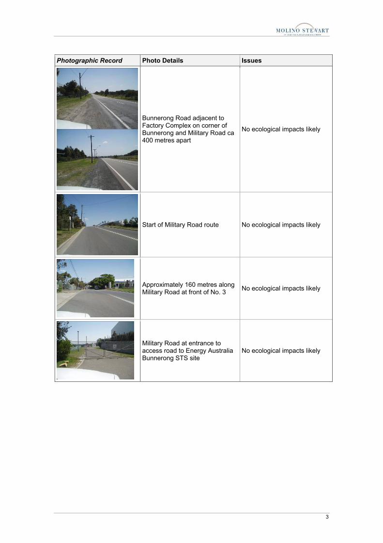
Terrestrial Ecology Assessment Report3.doc/7/06/2007 8:12:00 AM 3
Photographic Record Photo Details Issues
Bunnerong Road adjacent to Factory Complex on corner of Bunnerong and Military Road ca 400 metres apart
No ecological impacts likely
Start of Military Road route No ecological impacts likely
Approximately 160 metres along Military Road at front of No. 3 No ecological impacts likely
Military Road at entrance to access road to Energy Australia Bunnerong STS site
No ecological impacts likely

4 Terrestrial Ecology Assessment Report3.doc/7/06/2007 8:12:00 AM
Southern Cable Route
Photographic Record Photo Details Issues
Captain Cook Drive at the front of Kurnell STS No ecological impacts likely
Captain Cook Drive ca 150 metres North east of the STS No ecological impacts likely
Round about at intersection of Captain Cook Drive and Torres Street, Kurnell
No ecological impacts likely
Torres Street near vicinity of Silver Beach Road No ecological impacts likely

Terrestrial Ecology Assessment Report3.doc/7/06/2007 8:12:00 AM 5
Photographic Record Photo Details Issues
Silver Beach Road No ecological impacts likely
Intersection Silver Beach Road and Charles Parade No ecological impacts likely
Charles Parade No ecological impacts likely
Charles Parade Car Park No ecological impacts likely

6 Terrestrial Ecology Assessment Report3.doc/7/06/2007 8:12:00 AM
Photographic Record Photo Details Issues
Charles Parade Car Park No ecological impacts likely
Silver Beach in the vicinity of the proposed beach crossing to the Charles Parade car park
Ecological impacts are unlikely on any wading bird species. Beach is heavily frequented by local residents and visitors to the area
Drainage outlet to Silver Beach in the vicinity.
No significant ecological impacts are likely although it would be preferable to avoid disturbance to the drainage line if possible. Any disturbance should be mitigated using best practice methods and offset with appropriate local endemic plantings.
Appendix D
EPBC Act Protected Matters Report


Terrestrial Ecology Assessment Report3.doc/7/06/2007 8:12:00 AM 1
DEPARTMENT OF ENVIRONMENT AND HERITAGE - EPBC ACT PROTECTED MATTERS REPORT
EPBC Act Protected Matters Report 23 June 2006 11:20
This report provides general guidance on matters of national environmental significance and other matters protected by the EPBC Act in the area you have selected. Information on the coverage of this report and qualifications on data supporting this report are contained in the caveat at the end of the report. You may wish to print this report for reference before moving to other pages or websites. The Australian Natural Resources Atlas at http://www.environment.gov.au/atlas may provide further environmental information relevant to your selected area. Information about the EPBC Act including significance guidelines, forms and application process details can be found at http://www.deh.gov.au/epbc/assessmentsapprovals/index.html
Search Type:
Area
Buffer: 0 km
Coordinates: -33.98630,151.12953, -34.05854,151.12953, -34.05854,151.26002, -33.9863,151.26002

2 Terrestrial Ecology Assessment Report3.doc/7/06/2007 8:12:00 AM
EPBC Act Protected Matters Report 23 June 2006 11:20
Report Contents:
Summary Details • Matters of NES • Other matters protected by the EPBC Act • Extra Information Caveat Acknowledgments
Matters of National Environmental Significance This part of the report summarises the matters of national environmental significance that may occur in, or may relate to, the area you nominated. Further information is available in the detail part of the report, which can be accessed by scrolling or following the links below. If you are proposing to undertake an activity that may have a significant impact on one or more matters of national environmental significance then you should consider the Administrative Guidelines on Significance - see http://www.deh.gov.au/epbc/assessmentsapprovals/guidelines/index.html. World Heritage Properties: None
National Heritage Places: 1
Wetlands of International Significance: (Ramsar Sites)
1
Commonwealth Marine Areas: Relevant
Threatened Ecological Communities:
1
Threatened Species: 43
Migratory Species: 39
Other Matters Protected by the EPBC Act This part of the report summarises other matters protected under the Act that may relate to the area you nominated. Approval may be required for a proposed activity that significantly affects the environment on Commonwealth land, when the action is outside the Commonwealth land, or the environment anywhere when the action is taken on Commonwealth land. Approval may also be required for the Commonwealth or Commonwealth agencies proposing to take an action that is likely to have a significant impact on the environment anywhere. The EPBC Act protects the environment on Commonwealth land, the environment from the actions taken on Commonwealth land, and the environment from actions taken by Commonwealth agencies. As heritage values of a place are part of the 'environment', these aspects of the EPBC Act

Terrestrial Ecology Assessment Report3.doc/7/06/2007 8:12:00 AM 3
protect the Commonwealth Heritage values of a Commonwealth Heritage place and the heritage values of a place on the Register of the National Estate. Information on the new heritage laws can be found at http://www.deh.gov.au/heritage/index.html. Please note that the current dataset on Commonwealth land is not complete. Further information on Commonwealth land would need to be obtained from relevant sources including Commonwealth agencies, local agencies, and land tenure maps. A permit may be required for activities in or on a Commonwealth area that may affect a member of a listed threatened species or ecological community, a member of a listed migratory species, whales and other cetaceans, or a member of a listed marine species. Information on EPBC Act permit requirements and application forms can be found at http://www.deh.gov.au/epbc/permits/index.html.
Commonwealth Lands: 3
Commonwealth Heritage Places: 1
Places on the RNE: 11
Listed Marine Species: 60
Whales and Other Cetaceans: 13
Critical Habitats: None
Commonwealth Reserves: None
Extra Information This part of the report provides information that may also be relevant to the area you have nominated.
State and Territory Reserves: 7
Other Commonwealth Reserves: None
Regional Forest Agreements: None

4 Terrestrial Ecology Assessment Report3.doc/7/06/2007 8:12:00 AM
Details
Matters of National Environmental Significance National Heritage Places [ Dataset Information ]
Kurnell Peninsula Headland NSW
Wetlands of International Significance [ Dataset Information ] (Ramsar Sites)
TOWRA POINT NATURE RESERVE
Commonwealth Marine Areas [ Dataset Information ]
Approval may be required for a proposed activity that is likely to have a significant impact on the environment in a Commonwealth Marine Area, when the action is outside the Commonwealth Marine Area, or the environment anywhere when the action is taken within the Commonwealth Marine Area. Generally the Commonwealth Marine Area stretches from three nautical miles to two hundred nautical miles from the coast.
Within 3 Nautical Mile Limit
Threatened Ecological Communities [ Dataset Information ]
Status Type of Presence
Eastern Suburbs Banksia Scrub of the Sydney Region
Endangered Community known to occur within area
Threatened Species [ Dataset Information ] Status Type of Presence
Birds
Diomedea amsterdamensis * Amsterdam Albatross
Endangered Species or species habitat may occur within area
Diomedea antipodensis * Antipodean Albatross
Vulnerable Species or species habitat may occur within area
Diomedea dabbenena * Tristan Albatross
Endangered Foraging may occur within area
Diomedea exulans * Wandering Albatross
Vulnerable Species or species habitat may occur within area
Diomedea gibsoni * Gibson's Albatross
Vulnerable Species or species habitat may occur within area
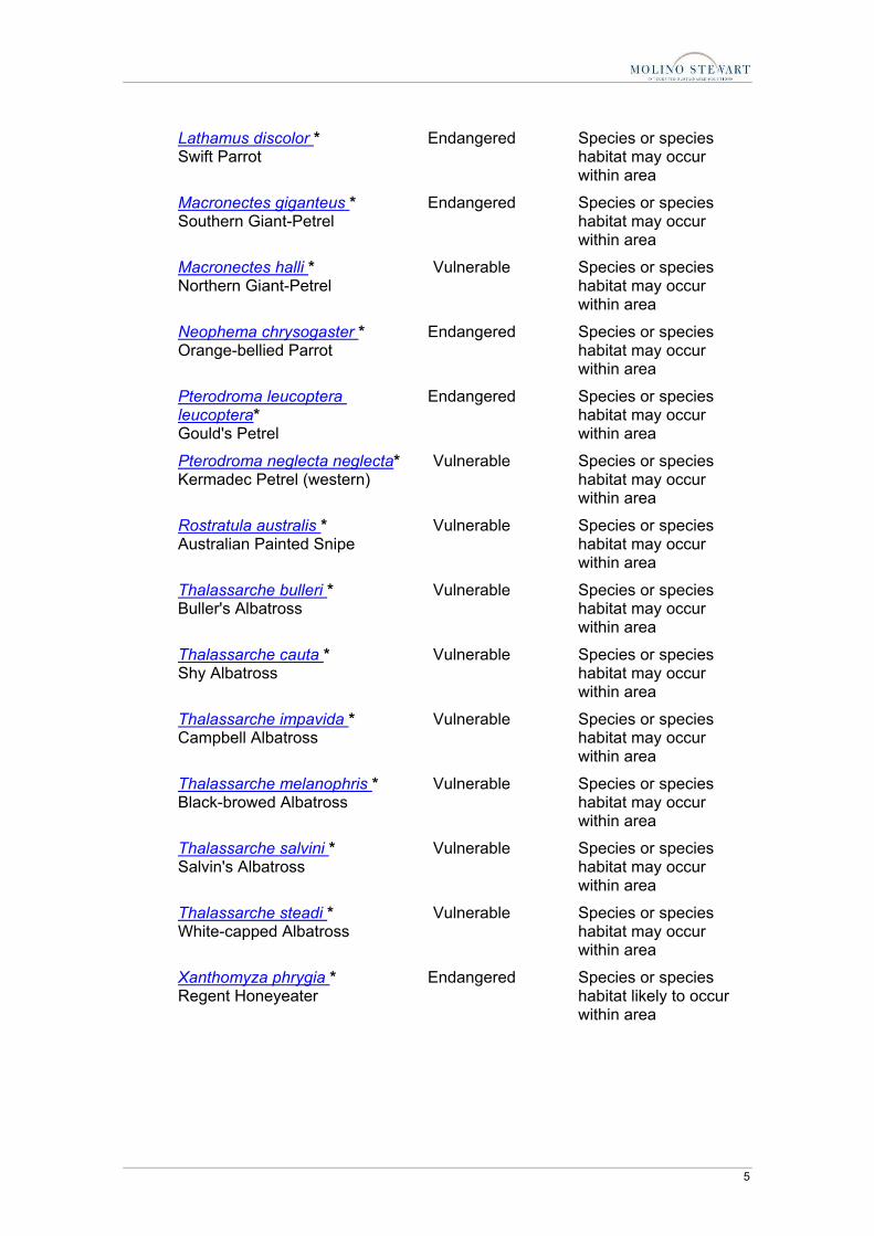
Terrestrial Ecology Assessment Report3.doc/7/06/2007 8:12:00 AM 5
Lathamus discolor * Swift Parrot
Endangered Species or species habitat may occur within area
Macronectes giganteus * Southern Giant-Petrel
Endangered Species or species habitat may occur within area
Macronectes halli * Northern Giant-Petrel
Vulnerable Species or species habitat may occur within area
Neophema chrysogaster * Orange-bellied Parrot
Endangered Species or species habitat may occur within area
Pterodroma leucoptera leucoptera* Gould's Petrel
Endangered Species or species habitat may occur within area
Pterodroma neglecta neglecta* Kermadec Petrel (western)
Vulnerable Species or species habitat may occur within area
Rostratula australis * Australian Painted Snipe
Vulnerable Species or species habitat may occur within area
Thalassarche bulleri * Buller's Albatross
Vulnerable Species or species habitat may occur within area
Thalassarche cauta * Shy Albatross
Vulnerable Species or species habitat may occur within area
Thalassarche impavida * Campbell Albatross
Vulnerable Species or species habitat may occur within area
Thalassarche melanophris * Black-browed Albatross
Vulnerable Species or species habitat may occur within area
Thalassarche salvini * Salvin's Albatross
Vulnerable Species or species habitat may occur within area
Thalassarche steadi * White-capped Albatross
Vulnerable Species or species habitat may occur within area
Xanthomyza phrygia * Regent Honeyeater
Endangered Species or species habitat likely to occur within area

6 Terrestrial Ecology Assessment Report3.doc/7/06/2007 8:12:00 AM
Frogs
Heleioporus australiacus * Giant Burrowing Frog
Vulnerable Species or species habitat likely to occur within area
Litoria aurea * Green and Golden Bell Frog
Vulnerable Species or species habitat likely to occur within area
Litoria littlejohni * Littlejohn's Tree Frog, Heath Frog
Vulnerable Species or species habitat may occur within area
Mammals
Balaenoptera musculus * Blue Whale
Endangered Species or species habitat may occur within area
Chalinolobus dwyeri * Large-eared Pied Bat, Large Pied Bat
Vulnerable Species or species habitat may occur within area
Dasyurus maculatus maculatus (SE mainland population)* Spot-tailed Quoll, Spotted-tail Quoll, Tiger Quoll (southeastern mainland population)
Endangered Species or species habitat likely to occur within area
Eubalaena australis * Southern Right Whale
Endangered Species or species habitat known to occur within area
Megaptera novaeangliae * Humpback Whale
Vulnerable Species or species habitat known to occur within area
Petrogale penicillata * Brush-tailed Rock-wallaby
Vulnerable Species or species habitat may occur within area
Potorous tridactylus tridactylus* Long-nosed Potoroo (SE mainland)
Vulnerable Species or species habitat may occur within area
Pteropus poliocephalus * Grey-headed Flying-fox
Vulnerable Species or species habitat likely to occur within area
Ray-finned fishes
Prototroctes maraena * Australian Grayling
Vulnerable Species or species habitat likely to occur within area
Reptiles
Chelonia mydas * Green Turtle
Vulnerable Species or species habitat may occur within area
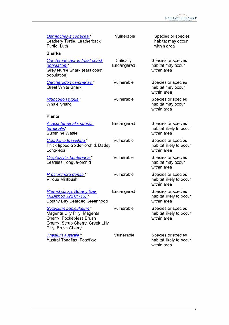
Terrestrial Ecology Assessment Report3.doc/7/06/2007 8:12:00 AM 7
Dermochelys coriacea * Leathery Turtle, Leatherback Turtle, Luth
Vulnerable Species or species habitat may occur within area
Sharks
Carcharias taurus (east coast population)* Grey Nurse Shark (east coast population)
Critically Endangered
Species or species habitat may occur within area
Carcharodon carcharias * Great White Shark
Vulnerable Species or species habitat may occur within area
Rhincodon typus * Whale Shark
Vulnerable Species or species habitat may occur within area
Plants
Acacia terminalis subsp. terminalis* Sunshine Wattle
Endangered Species or species habitat likely to occur within area
Caladenia tessellata * Thick-lipped Spider-orchid, Daddy Long-legs
Vulnerable Species or species habitat likely to occur within area
Cryptostylis hunteriana * Leafless Tongue-orchid
Vulnerable Species or species habitat may occur within area
Prostanthera densa * Villous Mintbush
Vulnerable Species or species habitat likely to occur within area
Pterostylis sp. Botany Bay (A.Bishop J221/1-13) * Botany Bay Bearded Greenhood
Endangered Species or species habitat likely to occur within area
Syzygium paniculatum * Magenta Lilly Pilly, Magenta Cherry, Pocket-less Brush Cherry, Scrub Cherry, Creek Lilly Pilly, Brush Cherry
Vulnerable Species or species habitat likely to occur within area
Thesium australe * Austral Toadflax, Toadflax
Vulnerable Species or species habitat likely to occur within area

8 Terrestrial Ecology Assessment Report3.doc/7/06/2007 8:12:00 AM
Migratory Species [ Dataset Information] Status Type of Presence
Migratory Terrestrial Specie
Birds
Haliaeetus leucogaster White-bellied Sea-Eagle
Migratory Species or species habitat likely to occur within area
Hirundapus caudacutus White-throated Needletail
Migratory Species or species habitat may occur within area
Monarcha melanopsis Black-faced Monarch
Migratory Breeding may occur within area
Myiagra cyanoleuca Satin Flycatcher
Migratory Breeding likely to occur within area
Neophema chrysogaster Orange-bellied Parrot
Migratory Species or species habitat may occur within area
Rhipidura rufifrons Rufous Fantail
Migratory Breeding may occur within area
Xanthomyza phrygia Regent Honeyeater
Migratory Species or species habitat likely to occur within area
Migratory Wetland Species
Birds
Arenaria interpres Ruddy Turnstone
Migratory Species or species habitat likely to occur within area
Charadrius mongolus Lesser Sand Plover, Mongolian Plover
Migratory Species or species habitat likely to occur within area
Gallinago hardwickii Latham's Snipe, Japanese Snipe
Migratory Species or species habitat may occur within area
Numenius madagascariensis Eastern Curlew
Migratory Species or species habitat likely to occur within area
Pluvialis fulva Pacific Golden Plover
Migratory Species or species habitat likely to occur within area
Rostratula benghalensis s. lat. Painted Snipe
Migratory Species or species habitat may occur within area

Terrestrial Ecology Assessment Report3.doc/7/06/2007 8:12:00 AM 9
Migratory Marine Birds
Diomedea amsterdamensis Amsterdam Albatross
Migratory Species or species habitat may occur within area
Diomedea antipodensis Antipodean Albatross
Migratory Species or species habitat may occur within area
Diomedea dabbenena Tristan Albatross
Migratory Foraging may occur within area
Diomedea exulans Wandering Albatross
Migratory Species or species habitat may occur within area
Diomedea gibsoni Gibson's Albatross
Migratory Species or species habitat may occur within area
Macronectes giganteus Southern Giant-Petrel
Migratory Species or species habitat may occur within area
Macronectes halli Northern Giant-Petrel
Migratory Species or species habitat may occur within area
Pterodroma leucoptera leucoptera Gould's Petrel
Migratory Species or species habitat may occur within area
Puffinus leucomelas Streaked Shearwater
Migratory Species or species habitat may occur within area
Thalassarche bulleri Buller's Albatross
Migratory Species or species habitat may occur within area
Thalassarche cauta Shy Albatross
Migratory Species or species habitat may occur within area
Thalassarche impavida Campbell Albatross
Migratory Species or species habitat may occur within area
Thalassarche melanophris Black-browed Albatross
Migratory Species or species habitat may occur within area
Thalassarche salvini Salvin's Albatross
Migratory Species or species habitat may occur within area
Thalassarche steadi White-capped Albatross
Migratory Species or species habitat may occur within area

10 Terrestrial Ecology Assessment Report3.doc/7/06/2007 8:12:00 AM
Migratory Marine Species
Mammals
Balaenoptera edeni Bryde's Whale
Migratory Species or species habitat may occur within area
Balaenoptera musculus * Blue Whale
Migratory Species or species habitat may occur within area
Caperea marginata Pygmy Right Whale
Migratory Species or species habitat may occur within area
Eubalaena australis * Southern Right Whale
Migratory Species or species habitat known to occur within area
Lagenorhynchus obscurus Dusky Dolphin
Migratory Species or species habitat may occur within area
Megaptera novaeangliae * Humpback Whale
Migratory Species or species habitat known to occur within area
Orcinus orca Killer Whale, Orca
Migratory Species or species habitat may occur within area
Reptiles
Chelonia mydas * Green Turtle
Migratory Species or species habitat may occur within area
Dermochelys coriacea * Leathery Turtle, Leatherback Turtle, Luth
Migratory Species or species habitat may occur within area
Sharks
Carcharodon carcharias Great White Shark
Migratory Species or species habitat may occur within area
Rhincodon typus Whale Shark
Migratory Species or species habitat may occur within area
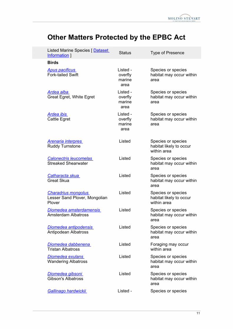
Terrestrial Ecology Assessment Report3.doc/7/06/2007 8:12:00 AM 11
Other Matters Protected by the EPBC Act Listed Marine Species [ Dataset Information ] Status Type of Presence
Birds
Apus pacificus Fork-tailed Swift
Listed - overfly marine area
Species or species habitat may occur within area
Ardea alba Great Egret, White Egret
Listed - overfly marine area
Species or species habitat may occur within area
Ardea ibis Cattle Egret
Listed - overfly marine area
Species or species habitat may occur within area
Arenaria interpres Ruddy Turnstone
Listed Species or species habitat likely to occur within area
Calonectris leucomelas Streaked Shearwater
Listed Species or species habitat may occur within area
Catharacta skua Great Skua
Listed Species or species habitat may occur within area
Charadrius mongolus Lesser Sand Plover, Mongolian Plover
Listed Species or species habitat likely to occur within area
Diomedea amsterdamensis Amsterdam Albatross
Listed Species or species habitat may occur within area
Diomedea antipodensis Antipodean Albatross
Listed Species or species habitat may occur within area
Diomedea dabbenena Tristan Albatross
Listed Foraging may occur within area
Diomedea exulans Wandering Albatross
Listed Species or species habitat may occur within area
Diomedea gibsoni Gibson's Albatross
Listed Species or species habitat may occur within area
Gallinago hardwickii Listed - Species or species

12 Terrestrial Ecology Assessment Report3.doc/7/06/2007 8:12:00 AM
Latham's Snipe, Japanese Snipe overfly marine area
habitat may occur within area
Haliaeetus leucogaster White-bellied Sea-Eagle
Listed Species or species habitat likely to occur within area
Hirundapus caudacutus White-throated Needletail
Listed - overfly marine area
Species or species habitat may occur within area
Lathamus discolor Swift Parrot
Listed - overfly marine area
Species or species habitat may occur within area
Macronectes giganteus Southern Giant-Petrel
Listed Species or species habitat may occur within area
Macronectes halli Northern Giant-Petrel
Listed Species or species habitat may occur within area
Merops ornatus Rainbow Bee-eater
Listed - overfly marine area
Species or species habitat may occur within area
Monarcha melanopsis Black-faced Monarch
Listed - overfly marine area
Breeding may occur within area
Myiagra cyanoleuca Satin Flycatcher
Listed - overfly marine area
Breeding likely to occur within area
Neophema chrysogaster Orange-bellied Parrot
Listed - overfly marine area
Species or species habitat may occur within area
Numenius madagascariensis Eastern Curlew
Listed Species or species habitat likely to occur within area
Pluvialis fulva Pacific Golden Plover
Listed Species or species habitat likely to occur within area
Rhipidura rufifrons Rufous Fantail
Listed - overfly
Breeding may occur within area

Terrestrial Ecology Assessment Report3.doc/7/06/2007 8:12:00 AM 13
marine area
Rostratula benghalensis s. lat. Painted Snipe
Listed - overfly marine area
Species or species habitat may occur within area
Sterna albifrons Little Tern
Listed Breeding likely to occur within area
Thalassarche bulleri Buller's Albatross
Listed Species or species habitat may occur within area
Thalassarche cauta Shy Albatross
Listed Species or species habitat may occur within area
Thalassarche chlororhynchos Yellow-nosed Albatross, Atlantic Yellow-nosed Albatross
Listed Species or species habitat may occur within area
Thalassarche impavida Campbell Albatross
Listed Species or species habitat may occur within area
Thalassarche melanophris Black-browed Albatross
Listed Species or species habitat may occur within area
Thalassarche salvini Salvin's Albatross
Listed Species or species habitat may occur within area
Thalassarche steadi White-capped Albatross
Listed Species or species habitat may occur within area
Mammals
Arctocephalus forsteri New Zealand Fur-seal
Listed Species or species habitat may occur within area
Arctocephalus pusillus Australian Fur-seal, Australo-African Fur-seal
Listed Species or species habitat may occur within area
Ray-finned fishes
Acentronura tentaculata Hairy Pygmy Pipehorse
Listed Species or species habitat may occur within area
Festucalex cinctus Girdled Pipefish
Listed Species or species habitat may occur within area
Filicampus tigris Tiger Pipefish
Listed Species or species habitat may occur within
14 Terrestrial Ecology Assessment Report3.doc/7/06/2007 8:12:00 AM
area
Heraldia nocturna Upside-down Pipefish
Listed Species or species habitat may occur within area
Hippichthys penicillus Beady Pipefish, Steep-nosed Pipefish
Listed Species or species habitat may occur within area
Hippocampus abdominalis Eastern Potbelly Seahorse, New Zealand Potbelly, Seahorse, Bigbelly Seahorse
Listed Species or species habitat may occur within area
Hippocampus whitei White's Seahorse, Crowned Seahorse, Sydney Seahorse
Listed Species or species habitat may occur within area
Histiogamphelus briggsii Briggs' Crested Pipefish, Briggs' Pipefish
Listed Species or species habitat may occur within area
Lissocampus runa Javelin Pipefish
Listed Species or species habitat may occur within area
Maroubra perserrata Sawtooth Pipefish
Listed Species or species habitat may occur within area
Notiocampus ruber Red Pipefish
Listed Species or species habitat may occur within area
Phyllopteryx taeniolatus Weedy Seadragon, Common Seadragon
Listed Species or species habitat may occur within area
Solegnathus spinosissimus Spiny Pipehorse, Australian Spiny Pipehorse
Listed Species or species habitat may occur within area
Solenostomus cyanopterus Blue-finned Ghost Pipefish, Robust Ghost Pipefish
Listed Species or species habitat may occur within area
Solenostomus paradoxus Harlequin Ghost Pipefish, Ornate Ghost Pipefish
Listed Species or species habitat may occur within area
Stigmatopora argus Spotted Pipefish
Listed Species or species habitat may occur within area
Stigmatopora nigra Wide-bodied Pipefish, Black Pipefish
Listed Species or species habitat may occur within area

Terrestrial Ecology Assessment Report3.doc/7/06/2007 8:12:00 AM 15
Syngnathoides biaculeatus Double-ended Pipehorse, Alligator Pipefish
Listed Species or species habitat may occur within area
Trachyrhamphus bicoarctatus Bend Stick Pipefish, Short-tailed Pipefish
Listed Species or species habitat may occur within area
Urocampus carinirostris Hairy Pipefish
Listed Species or species habitat may occur within area
Vanacampus margaritifer Mother-of-pearl Pipefish
Listed Species or species habitat may occur within area
Reptiles
Chelonia mydas * Green Turtle
Listed Species or species habitat may occur within area
Dermochelys coriacea * Leathery Turtle, Leatherback Turtle, Luth
Listed Species or species habitat may occur within area
Pelamis platurus Yellow-bellied Seasnake
Listed Species or species habitat may occur within area
Whales and Other Cetaceans Status Type of Presence
Balaenoptera acutorostrata Minke Whale
Cetacean Species or species habitat may occur within area
Balaenoptera edeni Bryde's Whale
Cetacean Species or species habitat may occur within area
Balaenoptera musculus * Blue Whale
Cetacean Species or species habitat may occur within area
Caperea marginata Pygmy Right Whale
Cetacean Species or species habitat may occur within area
Delphinus delphis Common Dolphin
Cetacean Species or species habitat may occur within area
Eubalaena australis * Southern Right Whale
Cetacean Species or species habitat known to occur within area
Grampus griseus Risso's Dolphin, Grampus
Cetacean Species or species habitat may occur within area
Lagenorhynchus obscurus Cetacean Species or species

16 Terrestrial Ecology Assessment Report3.doc/7/06/2007 8:12:00 AM
Dusky Dolphin habitat may occur within area
Megaptera novaeangliae * Humpback Whale
Cetacean Species or species habitat known to occur within area
Orcinus orca Killer Whale, Orca
Cetacean Species or species habitat may occur within area
Stenella attenuata Spotted Dolphin, Pantropical Spotted Dolphin
Cetacean Species or species habitat may occur within area
Tursiops aduncus Spotted Bottlenose Dolphin
Cetacean Species or species habitat likely to occur within area
Tursiops truncatus s. str. Bottlenose Dolphin
Cetacean Species or species habitat may occur within area
Commonwealth Lands [ Dataset Information ]
Communications, Information Technology and the Arts - Telstra Corporation Limited
Defence - Defence Housing Authority
Transport and Regional Services - Airservices Australia
Commonwealth Heritage Places [ Dataset Information ]
Cape Baily Lighthouse NSW
Places on the RNE [ Dataset Information ] Note that not all Indigenous sites may be listed.
Historic
Bare Island Fort NSW
Cape Baily Lighthouse NSW
Captain Cooks Landing Place Historic Site NSW
La Perouse Memorial Group NSW
La Perouse Monuments Historic Site NSW
Prince Henry Hospital Conservation Area NSW
The Watch Tower NSW
Natural Cape Banks NSW
Jennifer Street Bushland NSW

Terrestrial Ecology Assessment Report3.doc/7/06/2007 8:12:00 AM 17
Kurnell Peninsula Towra Point Area NSW
Towra Point Aquatic Reserve NSW
Extra Information Boat Harbour Aquatic Reserve, NSW
Botany Bay National Park, NSW
Cape Banks Aquatic Reserve, NSW
Towra Point Aquatic Reserve, NSW
Towra Point Nature Reserve, NSW
Towra Point SZ Stink Pot Bay Aquatic Reserve, NSW
Towra Point SZ Weeny/Quibray Bays Aquatic Reserve, NSW
Caveat The information presented in this report has been provided by a range of data sources as acknowledged at the end of the report.
This report is designed to assist in identifying the locations of places which may be relevant in determining obligations under the Environment Protection and Biodiversity Conservation Act 1999. It holds mapped locations of World Heritage and Register of National Estate properties, Wetlands of International Importance, Commonwealth and State/Territory reserves, listed threatened, migratory and marine species and listed threatened ecological communities. Mapping of Commonwealth land is not complete at this stage. Maps have been collated from a range of sources at various resolutions.
Not all species listed under the EPBC Act have been mapped (see below) and therefore a report is a general guide only. Where available data supports mapping, the type of presence that can be determined from the data is indicated in general terms. People using this information in making a referral may need to consider the qualifications below and may need to seek and consider other information sources.
For threatened ecological communities where the distribution is well known, maps are derived from recovery plans, State vegetation maps, remote sensing imagery and other sources. Where threatened ecological community distributions are less well known, existing vegetation maps and point location data are used to produce indicative distribution maps.

18 Terrestrial Ecology Assessment Report3.doc/7/06/2007 8:12:00 AM
For species where the distributions are well known, maps are digitised from sources such as recovery plans and detailed habitat studies. Where appropriate, core breeding, foraging and roosting areas are indicated under "type of presence". For species whose distributions are less well known, point locations are collated from government wildlife authorities, museums, and non-government organisations; bioclimatic distribution models are generated and these validated by experts. In some cases, the distribution maps are based solely on expert knowledge.
Only selected species covered by the migratory and marine provisions of the Act have been mapped.
The following species and ecological communities have not been mapped and do not appear in reports produced from this database:
• threatened species listed as extinct or considered as vagrants • some species and ecological communities that have only recently been listed • some terrestrial species that overfly the Commonwealth marine area • migratory species that are very widespread, vagrant, or only occur in small
numbers.
The following groups have been mapped, but may not cover the complete distribution of the species:
• non-threatened seabirds which have only been mapped for recorded breeding sites;
• seals which have only been mapped for breeding sites near the Australian continent.
Such breeding sites may be important for the protection of the Commonwealth Marine environment.
Acknowledgments This database has been compiled from a range of data sources. Environment Australia acknowledges the following custodians who have contributed valuable data and advice:
• New South Wales National Parks and Wildlife Service • Department of Sustainability and Environment, Victoria • Department of Primary Industries, Water and Environment, Tasmania • Department of Environment and Heritage, South Australia Planning SA • Parks and Wildlife Commission of the Northern Territory • Environmental Protection Agency, Queensland • Birds Australia • Australian Bird and Bat Banding Scheme • Australian National Wildlife Collection • Natural history museums of Australia • Queensland Herbarium • National Herbarium of NSW • Royal Botanic Gardens and National Herbarium of Victoria

Terrestrial Ecology Assessment Report3.doc/7/06/2007 8:12:00 AM 19
• Tasmanian Herbarium • State Herbarium of South Australia • Northern Territory Herbarium • Western Australian Herbarium • Australian National Herbarium, Atherton and Canberra • University of New England • Other groups and individuals
ANUCLIM Version 1.8, Centre for Resource and Environmental Studies, Australian National University was used extensively for the production of draft maps of species distribution. Environment Australia is extremely grateful to the many organisations and individuals who provided expert advice and information on numerous draft distributions.