appendix s ecology (terrestrial) · pekapeka to otaki sara terrestrial ecology assessment...
TRANSCRIPT
Appendix S
Ecology (Terrestrial)


Pekapeka to Otaki SARA
Terrestrial Ecology Assessment

Pekapeka To Otaki SARA Terrestrial Ecology Assessment
Doc Ref: 3-55537.36
Date: 13th December 2011 i
Contents
1 Executive summary ............................................................................................................. 1
2 Introduction .......................................................................................................................... 2
2.1 Purpose and scope ....................................................................................................... 2
2.2 Methodology ................................................................................................................. 2
3 Project Description .............................................................................................................. 2
4 Description of Terrestrial Ecology along the route alignment .......................................... 3
4.1 Overview....................................................................................................................... 3
4.2 Habitat features of recognised ecological significance .................................................. 3
4.3 Unregistered sites of ecological significance ................................................................. 4
4.4 Riparian vegetation ....................................................................................................... 5
4.5 Fauna ........................................................................................................................... 5
4.6 Significant indigenous vegetation and significant habitat of indigenous fauna
assessment criteria ................................................................................................................ 6
4.7 Threatened species criteria ........................................................................................... 6
4.8 Significant indigenous vegetation and significant habitat of indigenous fauna ............... 6
4.9 Species of ecological significance ................................................................................. 7
4.10 Maori perspective ......................................................................................................... 8
5 Effects................................................................................................................................... 9
5.1 Positive effects.............................................................................................................. 9
5.2 Summary of adverse effects ......................................................................................... 9
5.3 Habitat loss ................................................................................................................. 10
5.4 Hydrological effects on Marycrest bush and wetland................................................... 11
5.5 Habitat fragmentation.................................................................................................. 11
5.6 Edge effects resulting from vegetation clearance ........................................................ 11
5.7 Effects on long-tailed bats ........................................................................................... 11
6 Degree of effects ................................................................................................................ 12
7 Requirements ..................................................................................................................... 12
8 Addressing effects and meeting requirements................................................................ 12
8.1 Avoidance of effects ................................................................................................... 12
8.2 Mitigation .................................................................................................................... 12
8.3 AEE survey requirements ........................................................................................... 13
9 Costs................................................................................................................................... 13
References .................................................................................................................................. 14

Pekapeka To Otaki SARA Terrestrial Ecology Assessment
Doc Ref: 3-55537.36
Date: 13th December 2011 ii
Maps 15

Pekapeka To Otaki SARA Terrestrial Ecology Assessment
3-55537.36
13th December 2011 1
1 Executive summary
This report provides an assessment of the effects proposed upgrade of SH1 between
Pekapeka to Otaki on terrestrial, wetland and riparian ecosystems. The report will form part
of the Scheme Assessment Report Addendum (SARA). The effects on aquatic ecosystems
(rivers and streams) are described and assessed in a separate report.
The alignment passes through a landscape that has been highly modified by agriculture,
and to a lesser extent viticulture and urbanisation. However, there are a number of areas of
indigenous bush and wetland along the alignment of local and district ecological
significance that will be impacted by the road. A regionally significant area of indigenous
bush and wetland near Marycrest was directly affected by the original alignment proposed
through this area. However, the road has been realigned and this site has now been
avoided.
The main impact on the areas of indigenous bush is the loss of habitat. In all cases habitat
is lost from the edge of the bush. The scale of the effect is such that for a number of sites,
taking into account the significance ranking of the site, the effect is considered minor in
terms of Section 6 c) of the RMA. However, in the case of the loss of vegetation from the
stand of indigenous bush on the Steven’s Property the effect is considered greater than
minor. In this case there is a 15-20% loss of habitat from a site considered to be of district
significance. This effect is considered to be one of moderate rather major significance.
Similarly, the effect on Hautere Bush F is considered greater than minor but of moderate
rather than major significance, taking into account the scale of impact and the value of the
site. There are a number of options that could be undertaken to mitigate these effects
including increasing protection of existing areas of bush by fencing and weed removal
and/or planting additional areas of bush to compensate for the areas lost.
One wetland listed in the KCDC Heritage Register, and assessed as being of local
significance, will be impacted by the Project footprint. The wetland located adjacent to the
railway in Otaki will be completely lost to the Project footprint. This wetland, along with the
bush/wetland at Marycrest, is of particular interest to local Iwi. Options to mitigate the loss
of this wetland include establishment of a new wetland on nearby Iwi land and/or
development of stormwater wetland ponds for treatment of road runoff in such a way that
they provide wetland habitat for native flora and fauna.
There are no significant indigenous riparian habitats impacted by the Project.
Overall the degree of effect on terrestrial, wetland and riparian ecosystems as per NZTA
PSF/13 is considered to be moderate.
Pekapeka To Otaki SARA Terrestrial Ecology Assessment
3-55537.36
13th December 2011 2
2 Introduction
2.1 Purpose and scope
This report provides an assessment of effects of the alignment of the proposed upgrade of
SH1 between Pekapeka to Otaki on terrestrial, wetland and riparian ecosystems. The report
will form part of the Scheme Assessment Report Addendum (SARA). The effects on aquatic
ecosystems (rivers and streams) are described and assessed in a separate report.
This ecological assessment covers the following with respect to terrestrial, wetland and
riparian ecosystems:
• a description of the terrestrial, wetland and riparian habitats, and their associated
flora and fauna;
• an assessment of the ecological values of the habitats and species potentially
affected by the Project;
• details of the nature and scale of the Project’s actual or potential adverse effects,
and the likely significance of those effects;
• and details of such measures that are necessary to avoid, remedy, mitigate or offset
any effects greater than minor.
2.2 Methodology
This assessment was based on the following:
• a review of existing background information relating to the Project and Project
Corridor including: Project Plans, existing ecological reports, aerial photographs and
the Kapiti Coast District Plan;
• and walkthrough surveys undertaken in January and July 2011.
The field surveys focussed on recording main vegetation types, key plant and bird species
during a walkthrough of ecological sites along the alignment. An assessment of habitat
potential for other fauna groups (mammals, reptiles and invertebrates) was also
undertaken. The level of detail of the surveys was sufficient to confirm ecological values,
level of effects and broad measures to mitigate effects. A more detailed level of survey will
be required for the assessment of effects needed to support the Notice of Requirements.
3 Project Description
The planned upgrading of State Highway 1 between Peka Peka and Otaki North is “part of
the Wellington Northern Corridor Road of National Significance (RoNS) – a planned four-
lane expressway from Wellington Airport to Levin.” SH1 is the major route in and out of
Wellington, linking the centres of Palmerston North, Wanganui and Levin with Wellington.
By improving transport networks through the Kapiti Coast, this project will contribute to
economic growth and productivity.

Pekapeka To Otaki SARA Terrestrial Ecology Assessment
3-55537.36
13th December 2011 3
Currently the Peka Peka to North Otaki section of SH1 has a relatively poor and worsening
safety record. It also experiences high levels of congestion during peak periods, weekends
and holiday periods. This congestion is compounded by a high proportion of local traffic,
and an increasing level of shopping-generated parking and pedestrian movements in the
Otaki urban area. A bypass of Otaki, and the provision of a high-standard highway through
the area will increase the efficiency of movements between Wellington and the North, will
ease local congestion, improve safety, and will facilitate local, regional and national
economic development.
The scope of this project is therefore to construct a high quality four-lane expressway
bypassing the township of Otaki and the settlement of Te Horo. Together with the MacKays
to Peka Peka section to the south, it forms the Kapiti Expressway and when both sections
are completed will provide a superior transport corridor providing much improved, reliable
and safer journeys through the Kapiti Coast. The project seeks to safeguard for double
tracking of the main trunk rail line and also involves the relocation of the track through Otaki
in order to accommodate the proposed expressway.
4 Description of Terrestrial Ecology along the route alignment
4.1 Overview
The alignment passes through a landscape that has been highly modified by agriculture,
and to a lesser extent viticulture and urbanisation. Most of the alignment impacts areas that
support no indigenous vegetation and are likely to be of limited value as habitat for
indigenous fauna. There are however a number of localised features of ecological
significance impacted by the alignment. Maps 1 to 4 show the locations of the ecological
features referred to below.
4.2 Habitat features of recognised ecological significance
Part I of the Kapiti Coast District Plan contains the District Heritage Register. Table E of the
Heritage register lists ecological sites (areas of significant indigenous vegetation and
significant habitat of indigenous fauna). Inclusion of ecological sites in the Heritage Register
was confirmed by surveys and ranking assessments undertaken by Wildland Consultants
Ltd. (Wildland Consultants Ltd., 2003).
Table 1 below details the sites listed in the KCDC Heritage Register along the alignment
and their ranking.
Pekapeka To Otaki SARA Terrestrial Ecology Assessment
3-55537.36
13th December 2011 4
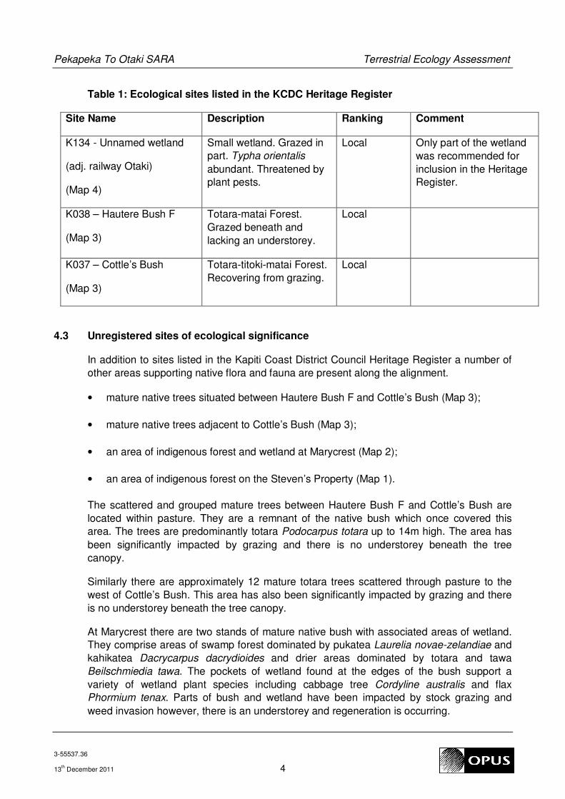
Table 1: Ecological sites listed in the KCDC Heritage Register
Site Name Description Ranking Comment
K134 - Unnamed wetland
(adj. railway Otaki)
(Map 4)
Small wetland. Grazed in
part. Typha orientalis
abundant. Threatened by
plant pests.
Local Only part of the wetland
was recommended for
inclusion in the Heritage
Register.
K038 – Hautere Bush F
(Map 3)
Totara-matai Forest.
Grazed beneath and
lacking an understorey.
Local
K037 – Cottle’s Bush
(Map 3)
Totara-titoki-matai Forest.
Recovering from grazing.
Local
4.3 Unregistered sites of ecological significance
In addition to sites listed in the Kapiti Coast District Council Heritage Register a number of
other areas supporting native flora and fauna are present along the alignment.
• mature native trees situated between Hautere Bush F and Cottle’s Bush (Map 3);
• mature native trees adjacent to Cottle’s Bush (Map 3);
• an area of indigenous forest and wetland at Marycrest (Map 2);
• an area of indigenous forest on the Steven’s Property (Map 1).
The scattered and grouped mature trees between Hautere Bush F and Cottle’s Bush are
located within pasture. They are a remnant of the native bush which once covered this
area. The trees are predominantly totara Podocarpus totara up to 14m high. The area has
been significantly impacted by grazing and there is no understorey beneath the tree
canopy.
Similarly there are approximately 12 mature totara trees scattered through pasture to the
west of Cottle’s Bush. This area has also been significantly impacted by grazing and there
is no understorey beneath the tree canopy.
At Marycrest there are two stands of mature native bush with associated areas of wetland.
They comprise areas of swamp forest dominated by pukatea Laurelia novae-zelandiae and
kahikatea Dacrycarpus dacrydioides and drier areas dominated by totara and tawa
Beilschmiedia tawa. The pockets of wetland found at the edges of the bush support a
variety of wetland plant species including cabbage tree Cordyline australis and flax
Phormium tenax. Parts of bush and wetland have been impacted by stock grazing and
weed invasion however, there is an understorey and regeneration is occurring.

Pekapeka To Otaki SARA Terrestrial Ecology Assessment
3-55537.36
13th December 2011 5
The small area of forest on the Steven’s property supports tawa, karaka Corynocarpus
laevigatus and kohekohe Dysoxylum spectabile and a range of other native tree and shrub
species. It is fenced and has an understorey.
4.4 Riparian vegetation
Most of the streams crossed by the route are grazed along their margins and are typified by
closed cropped pasture grasses. Willows occur along the riparian margins of the Otaki
River and Waitohu Stream however there is no native vegetation of any note along any of
the waterways crossed by the alignment.
4.5 Fauna
Birds
The birdlife found along the alignment is typical of farmland with fragments of native bush
and wetland. Common native and introduced species are present including; fantail
Rhipidura fuliginosa, silvereye Zosterops lateralis, tui Prosthemadera novaeseelandiae,
New Zealand Pigeon Hemiphaga novaeseelandiae, harrier Circus approximans, kingfisher
Halcyon sancta, goldfinch Carduelis carduelis, chaffinch Fringilla coelebs, blackbird Turdus
merula, song thrush Turus philomelos, pukeko Porphyrio porphyrio and magpie
Gyminorhina tibicens. Peacock Pavo cristatus were abundant in the vicinity of Marycrest.
No threatened bird species were encountered during the walkover survey, and given the
nature and quality of habitats present along the route no threatened bird species are
expected to be significantly impacted by the Project.
Long-tailed bats
The long-tailed bat Chalinolobus tuberculatus is known to inhabit Kapiti Island and the
Tararua Forest Park. Very recent studies in and around Hamilton have found long-tailed
bats in areas where previously they were not expected to occur, including highly modified
relatively open landscapes on the periphery of the City, with roosting occurring in exotic as
well as native trees. In view of the experience of finding this species in modified habitat
close to Hamilton, and the presence of known long-tailed bat populations on Kapiti Island
and in the Tararua Forest Park, the presence of this species along the Project corridor
cannot be ruled out.
Other terrestrial fauna
Threatened native invertebrates, reptiles or amphibians typically have very restricted
distributions and niche habitat requirements. The habitats found within the Project corridor
are not suitable for native frogs. While non-threatened reptiles, such as copper skink, may
occur along the alignment it is unlikely that the habitats present will provide habitat for
threatened reptile species.
Common native invertebrates are expected to be present along the alignment. However,
the occurrence of threatened species is unlikely, given the degree of habitat modification
that has occurred and the high degree of isolation of the remnants of indigenous habitat.

Pekapeka To Otaki SARA Terrestrial Ecology Assessment
3-55537.36
13th December 2011 6
4.6 Significant indigenous vegetation and significant habitat of indigenous fauna
assessment criteria
Determination of the ecological value of a habitat and its associated species is a critical part
of assessing the significance of the ecological impact associated the Project. Section 6(c) of
the Resource Management Act 1991 requires the protection of significant indigenous
vegetation, and significant habitats of indigenous fauna. This is to be recognised and
provided for by local authorities as a matter of national importance. Consequently the
identification of sites that are representative of significant indigenous vegetation and
significant habitat of indigenous fauna is an important part of assessing ecological values
and determining the significance of ecological effects.
There are various tools and approaches that can be used to assess the ecological
significance of sites. The system used to assess and rank sites in the Kapiti District is
detailed in the report listing sites to be included in the Heritage Register prepared by
Wildland Consultants Ltd (2003). These criteria are adapted from guidelines used to
determine significant indigenous vegetation and significant habitat of indigenous fauna in
the Waikato Region (Wildland Consultants, Environment Waikato, 2002). A number of sites
(section 4.2 above) have already been assessed and recognised in the District Heritage
Register using these criteria. This assessment will therefore assess the values of the other
ecological sites identified by this assessment using these criteria.
4.7 Threatened species criteria
New Zealand’s native flora and fauna were classified in terms of their risk of extinction by
Hitchmough et. al. (2007). The document was comprehensive and covered all groups of
flora and fauna. The classification system was reviewed in 2007, resulting in several new
threat categories, and redefinition of some existing categories (Townsend et al. 2008).
Based on this new system, several taxonomic groups have been reassessed and results
published in a number of papers which now supersede the relevant sections of Hitchmough
et. al. (2007): bats (O’Donnell et. al., 2011), birds (Miskelly et. al., 2008), freshwater fish
(Allibone et. al., 2010).
Where appropriate, in assessing the significance of individual species reference will be
made to Hitchmough et. al. (2007) and papers covering the different taxonomic groups that
have been subsequently reassessed following Townsend et al. (2008).
4.8 Significant indigenous vegetation and significant habitat of indigenous fauna
The site identified in Table 1 have already been assessed against criteria set out in
Wildland Consultants Ltd (2003) as being examples of significant indigenous vegetation
and/or significant habitat of indigenous fauna. This assessment concurs with the previous
assessment with respect to these sites and their ranking as being sites of local significance.
Table 2 below summarises an assessment of the other unregistered sites impacted by the
alignment also using the criteria set down in Wildland Consultants Ltd (2003).

Pekapeka To Otaki SARA Terrestrial Ecology Assessment
3-55537.36
13th December 2011 7
Table 2: Assessment of unregistered ecological sites
Site Ranking Reasons
Mature native trees
within pasture situated
between Hautere
Bush F and Cottle’s
Bush
Not ranked Significantly degraded ecosystem that will continue
to decline without protection. Not an example of
significant indigenous vegetation, hence not
ranked. However, mature native trees take
generations to replace and therefore they still have
modest ecological value in the context of the local
landscape.
Mature native trees
dispersed through
pasture adjacent to
Cottle’s Bush
Not ranked Ditto.
Indigenous dry forest,
swamp forest and
wetland at Marycrest
Regional Under-represented habitat. Species rich. Large
mature specimen trees. Range of vegetation types
including swamp forest.
Indigenous forest on
the Steven’s Property
District Under-represented habitat. Covers a small area.
However, it is fenced and supports an understorey.
4.9 Species of ecological significance
Plants
No threatened plant species were recorded or are known to be directly affected by the
alignment.
Birds
No threatened bird species were recorded during the walkover survey, or are likely to be
significantly impacted by the Project given its alignment and the habitats present.
Long-tailed bats
Long-tailed bats are classified as nationally threatened (sub classification: nationally
vulnerable) (O’Donnell, et. al. 2010). This species is endemic to New Zealand i.e. found
nowhere else in the World. Long-tailed bats are one of only two native terrestrial mammal
species found in New Zealand, and the only species of native terrestrial mammal potentially
found in highly modified environments and close proximity to human habitation. However,
while the species is classified as threatened, it is also much more widespread in the
Waikato landscape than previously thought. If present within the highly modified landscapes
along the Waikato Expressway alignment, it may also prove to be similarly widespread
along the Kapiti Coast.

Pekapeka To Otaki SARA Terrestrial Ecology Assessment
3-55537.36
13th December 2011 8
Other terrestrial fauna
The occurrence of threatened amphibians, reptiles or terrestrial invertebrates is unlikely
given the modified and isolated nature of habitat fragments along the alignment. Most of
the stands of trees impacted are heavily grazed beneath which limits their habitat values for
ground dwelling animals. Furthermore, in most cases where native trees are to be removed
only a relatively small percentage of the available habitat is being lost. The risk of significant
impact on threatened reptile or invertebrate species is considered low. While, further
surveys would provide a higher level of confidence around this assessment, they are not
considered essential given the level of risk as determined by the habitat based assessment.
However, if in the course of the AEE or consultation process further information becomes
available that indicates the risk of significant impact may be higher than presently thought,
the need for further surveys will be reassessed.
4.10 Maori perspective
At a meeting and site visit held on Friday 29th July ecological issues of importance to the Iwi
were discussed. The wetland adjacent to the railway alignment was of significant interest
being of importance from an archaeological and cultural perspective, as well as ecological.
The possibility of recreating the wetland as mitigation was discussed, as was the possibility
of ‘capturing’ the source of the spring located in the northern part of the wetland.
Capturing the source of the spring requires further investigation and consideration however
this may prove extremely difficult. One solution might be to try to preserve the source and
create a flow channel alongside the new road following a “natural” flow path. Indigenous
riparian planting could be incorporated to the extent that available space allows.
To offset the loss of wetland there are two possible options: 1) create a new wetland on Iwi
owned land to the west, 2) develop stormwater wetlands ponds into ecological habitats.
This matter requires further discussion with Iwi. However, creation of wetland habitat within
stormwater wetland ponds is a habitat enhancement opportunity for the Project regardless
of where the mitigation for the lost wetland occurs.
Bush to the west of the affected wetland (beyond Project corridor) was considered very
significant and Iwi are working with Tim Park at GWRC to look at enhancement/fencing
opportunities. This area is not impacted by the Project.
Avoiding the bush and wetland at Marycrest was viewed as a very positive step for the
Project to have taken. There was also recognition that the Project has brought the area to
the attention of Iwi and other stakeholders. Iwi are keen to pursue protection and
enhancement of the area with the land owner and other stakeholders.
The treatment and water quality enhancement opportunities provided by stormwater
wetland ponds are of significant interest to Iwi and seen as a positive potential
enhancement that the Project can provide.
Iwi also generally support efforts to minimise loss of bush from other sites along the
alignment. Where native trees are unavoidably lost, recovery of timber for carving or other
traditional uses is advocated.

Pekapeka To Otaki SARA Terrestrial Ecology Assessment
3-55537.36
13th December 2011 9
5 Effects
5.1 Positive effects
Positive effects on terrestrial ecosystems resulting from new roads are rare. Trees can be
planted to replace those lost however there is a significant time delay in trees reaching
maturity (several human generations). While mitigation is possible, a positive result is
difficult to argue where mature forest is being lost, particularly in the case of planting new
replacement trees, although in the very long-term it may be possible to replace the area of
bush lost and achieve no net loss of habitat.
There are however potential alternatives to planting new habitat that could provide
significant offset to habitat loss. Most of the indigenous forest areas impacted by the
alignment, and also the Marycrest bush fragments, are currently impacted by grazing and
weed invasion. They are in a process of decline that in the long-term (potentially many
years) will see them disappear from the landscape unless there is intervention. By simply
fencing these areas and undertaking weed control, the long-term future of the areas of bush
will be substantially improved. Furthermore, in the case of those stands of bush that have
no understorey or ground cover because of grazing, exclusion of stock can be
transformational in terms of the development of sub-canopy structure and natural
regeneration. While, the implementation of such options is dependent upon securing land
owner agreement and covenant protection, if this is achieved, then the resulting bush
protection will be a significant offset to compensate for the bush lost. By preventing ongoing
bush degradation with the potential for eventually losing areas completely in the long-term,
a significant positive benefit is possible.
Wetlands by contrast, particularly those that have relatively low ecological values, can be
created and mitigation achieved in a relatively short period of time (within 5 years). If more
wetland is created than is lost then a net gain is achieved. If stormwater wetland ponds,
needed to treat runoff from the new road, are designed to include wetland habitat and use
native plant species, a net gain could be achieved over habitat lost. Furthermore, the higher
level of treatment of road runoff from the new road compared to the existing road, provided
by the wetland ponds, is likely to provide an enhancement in water quality over the existing
situation.
5.2 Summary of adverse effects
The following is a summary of the key adverse effects on terrestrial, wetland and riparian
ecosystems that need to be considered by this assessment:
• habitat loss to the Project footprint;
• potential effects of the hydrology of the Marycrest bush and wetland;
• habitat fragmentation;
• edge effects resulting from removing trees along the edge of stands of bush;
Pekapeka To Otaki SARA Terrestrial Ecology Assessment
3-55537.36
13th December 2011 10
• effects on long-tailed bats.
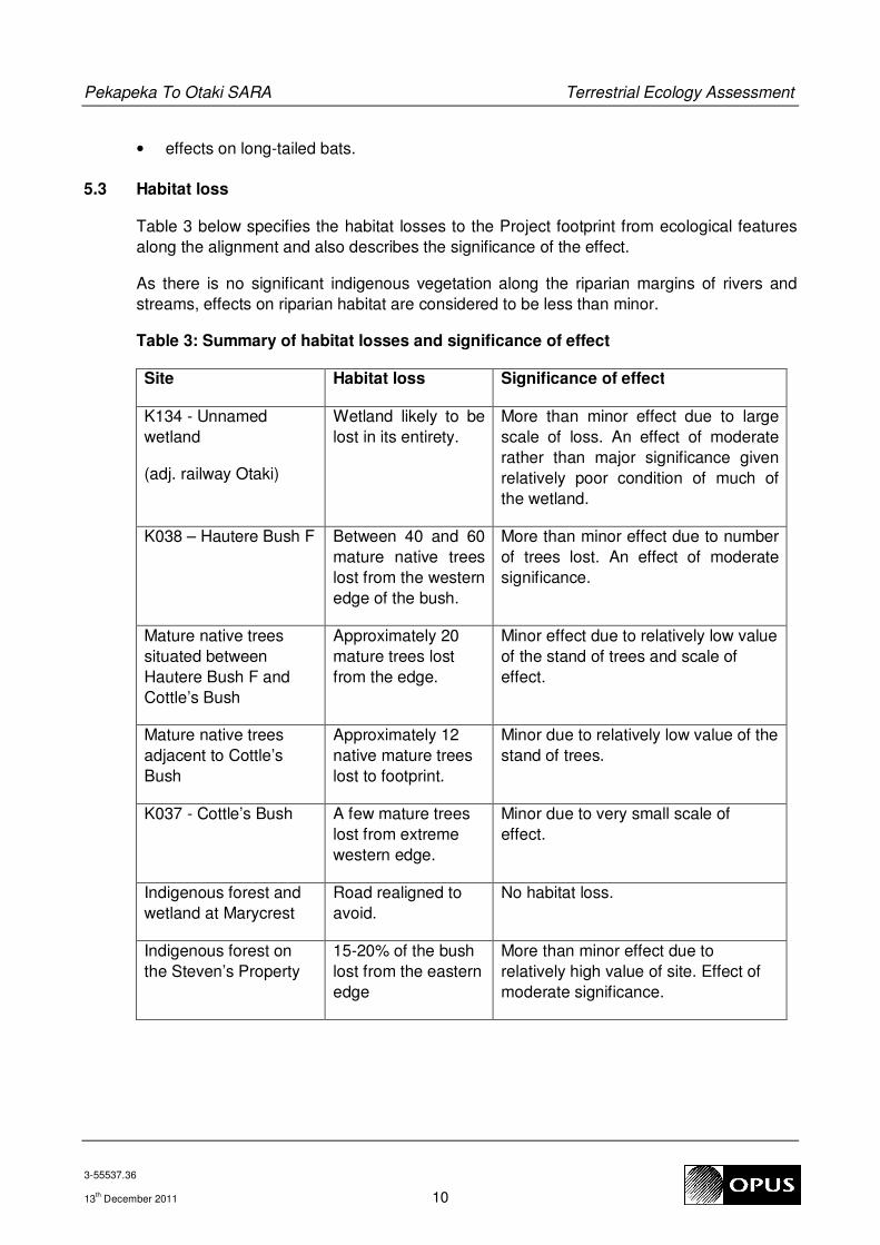
5.3 Habitat loss
Table 3 below specifies the habitat losses to the Project footprint from ecological features
along the alignment and also describes the significance of the effect.
As there is no significant indigenous vegetation along the riparian margins of rivers and
streams, effects on riparian habitat are considered to be less than minor.
Table 3: Summary of habitat losses and significance of effect
Site Habitat loss Significance of effect
K134 - Unnamed
wetland
(adj. railway Otaki)
Wetland likely to be
lost in its entirety.
More than minor effect due to large
scale of loss. An effect of moderate
rather than major significance given
relatively poor condition of much of
the wetland.
K038 – Hautere Bush F Between 40 and 60
mature native trees
lost from the western
edge of the bush.
More than minor effect due to number
of trees lost. An effect of moderate
significance.
Mature native trees
situated between
Hautere Bush F and
Cottle’s Bush
Approximately 20
mature trees lost
from the edge.
Minor effect due to relatively low value
of the stand of trees and scale of
effect.
Mature native trees
adjacent to Cottle’s
Bush
Approximately 12
native mature trees
lost to footprint.
Minor due to relatively low value of the
stand of trees.
K037 - Cottle’s Bush A few mature trees
lost from extreme
western edge.
Minor due to very small scale of
effect.
Indigenous forest and
wetland at Marycrest
Road realigned to
avoid.
No habitat loss.
Indigenous forest on
the Steven’s Property
15-20% of the bush
lost from the eastern
edge
More than minor effect due to
relatively high value of site. Effect of
moderate significance.

Pekapeka To Otaki SARA Terrestrial Ecology Assessment
3-55537.36
13th December 2011 11
5.4 Hydrological effects on Marycrest bush and wetland
Wet pasture occurs to the south of the Marycrest bush and wetland. There is also a drain
that flows from east to west along the southern edge of the bush/wetland. This drain then
converges with a stream that flows west through the wet pasture. A preliminary assessment
of the surface drainage within the wet pasture suggests that there is no surface connection
between the pasture and the bush/wetland. However, the hydrological connectivity or lack
of connectivity between the two areas will need to be confirmed during the next phase of
the Project to ensure that the road design does not impact on the hydrology of the
bush/wetland.
5.5 Habitat fragmentation
Very little habitat fragmentation will result from the proposed alignment. Since the
bush/wetland at Marycrest has now been avoided by re-alignment there will be no habitat
fragmentation in this location. Of the remaining areas of native bush affected by the Project
footprint, habitat is only lost from the edge and therefore there is no habitat fragmentation
effect. The wetland adjacent to the railway in Otaki will be totally removed by the alignment
therefore there is no residual fragmentation effect here.
5.6 Edge effects resulting from vegetation clearance
Where trees and shrubs are cleared from the edge of areas of bush, the exposed trees can
be more prone to windthrow and the understorey to dessication. This is particularly the case
in exposed coastal areas. A number of locations along the alignment will require removal of
mature vegetation from the edge of existing stands thus exposing trees that may be more
susceptible to wind damage. Measures to minimise such effects will need to be considered
during the design process.
5.7 Effects on long-tailed bats
The main risk to the long-tailed bats is loss of potential roost trees. Roosts can occur in
mature native and exotic trees that contain dry crevices or cavities. If long-tailed bats are
confirmed as present along the alignment further assessment will be required to identify
potential roost trees and determine the most appropriate mitigation to address likely effects.
Effects on roosting bats can be reduced by timing tree removal to coincide with periods of
the year when bats are least vulnerable to disturbance. Loss of roost trees can be
compensated by provision of artificial roost sites and, in the long-term, replacement of trees
lost.
Significant adverse effects on foraging or barrier effects from the new road are highly
unlikely given that the new alignment closely follows the existing alignment i.e. the effects of
the new alignment are likely to be similar to the existing situation. However, the effect of
artificial street lighting on long-tailed bats is as yet poorly understood, and therefore the
introduction of lighting along the new road into environments that are currently unlit, will
require further assessment and consideration if bats are confirmed to be present.
Further work needs to be undertaken to assess the risk of long-tailed bats being present.

Pekapeka To Otaki SARA Terrestrial Ecology Assessment
3-55537.36
13th December 2011 12
6 Degree of effects
Habitat losses have been reduced by careful design of the Project footprint in the vicinity of
features of ecological significance. In particularly, re-alignment to avoid the bush/wetland at
Marycrest has substantially reduced the net effect of the Project on ecosystems. There will
be loss of habitat of local significance and partial loss of habitat of district significance. This
can be mitigated through habitat creation and enhancement. Overall therefore the degree of
effect on terrestrial, wetland and riparian ecosystems is considered to be moderate.
7 Requirements
The key requirements that the Project must meet with respect to terrestrial and wetland
ecology are:
• Section 6(c) of the Resource Management Act 1991 which requires the protection of
significant indigenous vegetation, and significant habitats of indigenous fauna;
• NZTA’s Environmental Policy (November 2004);
• NZTA’s Environmental Plan (June 2008);
• Rules in the Regional Plan relating to the disturbance of wetlands.
8 Addressing effects and meeting requirements
8.1 Avoidance of effects
The footprint design has taken account of the need to minimise effects on features of
ecological value along the alignment. In the case of Marycrest the route has been realigned
to avoid the bush thereby avoiding both habitat loss and habitat fragmentation effects. This
measure has significantly reduced the overall effect of the alignment on terrestrial
ecosystems.
8.2 Mitigation
Some loss of mature native trees from the edge of a number of stands of bush will be
unavoidable (see Table 3). There are a number of options that could be undertaken to
mitigate these effects including increasing protection of existing areas of bush by fencing
and weed removal and/or planting additional areas of bush to compensate for the areas
lost. Ideally the latter would be undertaken such that the new planting was contiguous with
an existing area of bush.
The unnamed wetland adjacent to the railway in Otaki will be completely lost to the Project
footprint. Wetlands can, if designed well and properly maintained during the establishment
phase, rapidly achieve significant ecological values (within 5 years). Options to mitigate the
loss of this wetland include establishment of a new wetland on nearby Iwi land and/or

Pekapeka To Otaki SARA Terrestrial Ecology Assessment
3-55537.36
13th December 2011 13
development of stormwater wetland ponds for treatment of road runoff in such a way that
they provide wetland habitat for native flora and fauna.
Options for mitigating bush and wetland habitat loss need further exploration and
development during the preparation of the AEE. Firm recommendations on the options to
be adopted are not possible until the location and design of stormwater ponds have been
determined and issues relating to the potential for protecting habitats on land outside of
NZTA ownership have been explored.
8.3 AEE survey requirements
Further work needs to be undertaken to assess the risk of long-tailed bats being present.
This should include consultation with DoC and other stakeholders to determine if bats have
been observed in the area. However, based on experience gained from working in the
Hamilton area, unless specific surveys have been undertaken, anecdotal evidence that
indicates they have not been observed in a particular area is a very poor predictor as to
whether bats are present or not. Surveys using automated bat detectors are the only
reliable method of confirming presence/absence and such surveys would be required to
provide a high level of confidence around the status of long-tailed bats along the alignment,
regardless of what any anecdotal evidence may suggest as to likely presence or absence.
9 Costs
Costs to mitigate ecological effects are difficult to predict at this stage of the development
process. Some costs for ecological mitigation may overlap with costs aimed at mitigating
other environmental effects. For example mitigation for loss of Wetland K134 (adjacent to
the railway in Otaki) may involve construction of a wetland at an alternative location away
from the Project corridor in order to fully reflect the loss of the wetland on cultural and
archaeological values as well as ecological. This will involve wetland construction costs as
well as planting. A very rough order of cost for such a constructed wetland is $250k/ha. The
area of wetland lost is approximately 1ha. One hectare is therefore the minimum size that
would be needed to be created to achieve no net loss of wetland.
If it were a case of only mitigating the loss of ecological values then it may be possible to
achieve this by incorporating ecological features into the design of the proposed stormwater
wetland ponds. In this case the construction and planting costs to provide for ecological
mitigation would be subsidized by the costs already attributable to the construction of the
wetland for stormwater treatment purposes. It is difficult to estimate what the additional cost
might be, however an allowance of an additional $50-100k/per pond would be advisable for
estimating rough order of costs.
In addition to mitigation for wetland loss there will also be a requirement to mitigate loss of
mature native trees and native bush. This may include new planting and/or fencing of
existing bush stands. This is again difficult to estimate but an allowance of $200k would be
advisable.

Pekapeka To Otaki SARA Terrestrial Ecology Assessment
3-55537.36
13th December 2011 14
If long-tailed bat roosts are found along the alignment and impacts need to be mitigated this
could add $100k-$200k in additional detailed surveys and mitigation such as provision of
artificial roost sites and removal of trees in ways that minimise risk of injury or bat mortality.
Overall, a very approximate order of costs for ecological mitigation work is estimated at
between $500k and $750k.
References
Allibone, R.; Bruno, D.; Hitchmough, R.; Jellyman, D.; Ling, N.; Ravenscroft, P.; Water, J.
2010. Conservation status of New Zealand freshwater fish, 2009. New Zealand Journal of
Marine and Freshwater Research 1- 17.
Environment Waikato; Wildland Consultants Ltd. 2002: Areas of Significant Indigenous
Vegetation and Habitats of Indigenous Fauna in the Waikato Region: Guidelines to applying
Regional Criteria and Determine Level of Significance. Environment Waikato Technical
Report TR 2002/15.
Hitchmough, R.; Bull, L.; Cromarty, P. (comps) 2007. New Zealand Threat Classification
System lists – 2005. Department of Conservation, Wellington 194p.
Johnson, P.; Gerbeaux, P. 2004. Wetland Types in New Zealand. Department of
Conservation.
Miskelly, C.M.; Dowdling, J. E.; Elliott, G.P.; Hitchmough, R.A.; Powlesland, R.G.;
Robertson, H.A.; Sagar, P.M.; Scofield, R.P.; Taylor, G.A. 2008. Conservation Status of
New Zealand birds, 2008. Notornis, 2008, Vol. 55: 117-135.
O’Donnell, C.F.J.; Christie, J.E.; Hitchmough, R.A.; Lloyd, B.; Parsons, S. 2011. The
Conservation Status of New Zealand bats 2009. NZ Journal of Zoology.
Townsend, A.J.; de Lange, P.J.; Duffy, C.A.J.; Miskelly, C.M.; Molloy, J.; Norton, D. 2008.
New Zealand Threat Classification System manual. Wellington, Department of
Conservation. 35 p.
Wildland Consultants Ltd., 2003. Kapiti Coast District Council: 2002-2003 Ecological Site
Surveys. Contract Report No. 662.

Pekapeka To Otaki SARA Terrestrial Ecology Assessment
3-55537.36
13th December 2011 15
Maps

Map 3 PP20 Pekapeka to North Otaki – SARA: Key Ecological Constraints
K037 Cottle’s Bush – Totara-Matai Forest (Local importance)
K038 Hautere Bush F – Totara-Titoki-Matai Forest (Local importance) Mature native trees
(Not ranked)

Map 2 PP20 Pekapeka to North Otaki – SARA: Key Ecological Constraints
Indigenous bush and wetland – Marycrest (Regionally Significant)

Map 1 PP20 Pekapeka to North Otaki – SARA: Key Ecological Constraints
Indigenous Bush on the Steven’s Property (District Significance)

Map 4 PP20 Pekapeka to North Otaki – SARA: Key Ecological Constraints
K134 Otaki Railway Wetland (Part of local importance)
