teresa gordon’s adventures in montana: a trip diary ... 2010 photos/trip...teresa gordon’s...
TRANSCRIPT

1
Please note: this is the “raw” mostly unedited musing as I travelled – don’t expect polished writing and do expect typos!
Teresa Gordon’s Adventures in Montana: A Trip Diary – Summer 2010
5/25/10 I left home about 10 AM on Tuesday, May 25, 2010 and headed east toward Troy, Idaho. Then I took road to Kendrick/Julietta – always a great view of the distant mountains over the rolling wheat fields when one climbs out of the “gully” in which Troy is located. The grade getting back down is steep and windy and then the road back up out of Kendrick is equally windy and slow. This time it was really slow because I was following some sort of dump truck with red-colored contents – possibly treated seeds to plant. He could only go 10 miles per hour up the grade and just wouldn’t pull over! Finally, I got around him and then tried to be courteous to those behind me, whenever possible. But there aren’t many pull offs on that park road! The drive down the canyon to Freeman Creek campground is always interesting and with the motorhome, the many 10 mph curves really are “one-lane” – fortunately, I met no one on either the trip down or the trip back up the next day. The campground was very quiet with just 3 or 4 other rigs – so I had my pick of pull through sites. It was a lovely day with scattered fluffy clouds and about 65 degrees. We did the usual nature trail hike (Placid Lake). Even though I wore boots, I turned my ankle on the unevenness. I spent much of the afternoon sitting out under a tree reading and then got out my sketch book and did some pretty poor drawings of a really long-needled pine I could see. We took another walk, of course, but stayed mostly on the pavement for the evening stroll. The next morning, we walked down toward the boat ramp and out through picnic area to the point. There was still a lot of “bath tub ring” as the reservoir was far from full. Since the water hadn’t been tested for safety yet, I didn’t fill the tanks and decided I didn’t need to use dump station.

2
5/26/10 – along the Clearwater & Lochsa Rivers (Highway 95)
Wednesday morning, I headed out mid-morning for the adventurous trek up the grade and then down to Orofino to connect with Highway 12. I haven’t gone past Kamiah in years so I really enjoyed the road along the Clearwater River. I stopped at numerous pull-offs to read the signs about the Nez Perce or about Lewis & Clark – and sometimes to watch the river rafters – there were a few. It was a lot cloudier than Tuesday but plenty of sunshine too. The historic Lochsa ranger station was not yet open so didn’t stop there. I intended to stay at Wilderness Gateway FS CG but it was pretty full – maybe bicyclists? There was one CG circle closed off and another not available to me because I don’t have horses. The one I drove around was about half full but most of the sites looked very short and hard to get into. A couple of longer ones were really in the deep woods. So I decided to go on a ways. Several other CGs for which reservations are not available caught my eye and I eventually stopped at Wendover – just short of Powell ranger station. Too bad I didn’t go on because Powell had electricity and pull-throughs (not many but they were still available the next morning when I drove the piddly few additional miles! However, I didn’t know that so I stopped and eventually maneuvered myself into a paved campsite – but not without misadventure. Somehow, I caught the edge of the “house” part of my rig on the numbered post on the OTHER SIDE of road (I guess it was too short to see in the mirrors). Nothing serious but it was distressing none the less. We took a nice walk through the rest

3
of the campground and down to the Lochsa River. A little after we got back to the rig, it started raining and rained off and on for the evening. Another camper pointed out that there was a weather forecast posted on the outhouse. Unfortunately, the forecast is rain, rain, rain – through the furthest date shown (sigh). I got the laptop out and created the spreadsheet to keep track of miles and costs of this trip.
Thursday, May 27, 2010. I checked out Powell CG and found a great pull-through site that was available for that day only – so I drove probably less than 10 miles! When I went up to pay, the campground hosts motored up in their little golf-cart machine and offered to take me up to the ranger station to get my “old folks pass” so I’d only have to pay half price to camp ($7.50 is a bargain since there was electricity!). That was very nice of them and I eventually got my access card (the ranger had to look all over the place to get organized). Site #22 is not reservable but a similar pull through (#30 I think) was almost as nice (for future reference). The driveway was really, really long – like room enough for three or four rigs my size. There were two tables (shaded) with the Lochsa river in view through the woods – and the pleasant sound of the rushing white water! It was early so again the water hadn’t been tested so this is third day without dump station or adding water to rig but the outhouses were very nice. I put up the canopy since it was threatening rain and sat outside to read a bit. Then we took another stroll around the CG and discovered access to a potion of the Lewis and Clark trail. I did it by “time” since I’d already done quite a bit of walking and both ankles and low back were complaining. But the part of the trail we did was fairly level and through fairly-open forest – couldn’t see the river but I could hear the occasional highway noise. After the hike, I did a close-up sketch of a branch of a very different tree – probably a sub-alpine fir (definitely not a grand fir). I used colored pencils and it came out much better than the one the previous day. Maybe my talent will return with practice! Then watched an episode of Xena on DVD.

4
Friday, May 28, 2010. I awoke to rain and, as I write this about 8:30 PM it is still raining. There has never been a “sun break” all day. However, there have been periods of drizzle rather than soaking rain. So it is the kind of day that makes one wonder if the RV lifestyle is all that one would desire! I only took a short walk with dogs this morning while it was drizzling – after digging out the “buried down deep” back of doggy raincoats. The new one I got for Franny didn’t fit just right so I then spent some painful and long minutes making adjustments. It was painful because the fabric was almost impossible to get a needle through. I bent one, broke another one, and managed to poke my finger through my only thimble (one from Alaska made out of moose hide). The moose hide just wasn’t tough enough either! After alterations, the jacket worked pretty well, except for no head coverage. The one I made originally for Percy fits Armand just fine but he won’t leave the hood on (neither would Percy) so maybe it is just as well that Franny’s store-bought jacket doesn’t have a hood! After we left the campground, we stopped at the Devoto Memorial Cedar Grove (I love red cedar forests!) and did the short trail (in our raincoats). The next stop was the visitor center at the top of Lolo Pass. What a difference from the original one I stopped at in 1986. Apparently, it was expanded with lots of extra parking, new building, etc. for the Lewis and Clark centennial. The museum was very interesting and I spent a good bit of time reading the exhibits. The ranger said the trails were not open yet (snow) so I didn’t take the dogs for another walk. That was probably a mistake because that was the least rainy spot all day (more mist than drizzle). From the pass, I headed into Montana and reached Lolo Hot Springs were I had made reservations. The guide book said there are “good gravel” roads but not in this much rain. All I can find is MUD and PUDDLES and more MUD. The hot springs pool is on the other side of the highway and the advertised WIFI hotspot must be at the hotel or restaurant over there too because there is no connection on this side of Lolo Creek. I had a bit of trouble even using this pull through because I think every hookup in this park is “side by side” and I was too far from the plug where I initially stopped. However, I have the extension cord I originally got for the PU camper but haven’t needed yet for Winnie. I think that the replacement “land line” I got this spring up at R&R is shorter than the one that came with the rig

5
originally. But worse, it won’t plug into the supposedly identical receptacle on the extension cord Finally, I pulled the slideout back in and moved the rig forward until I was close enough for the land-line to reach. Guess I need a new extension cord or some sort of adapter (very aggravating!). The process to get parked and ready to cook lunch must have taken at least an hour total with driving around, finding the using the dump station, etc. And THEN, I’m standing out in the rain fiddling with electric extension cord for what must have been 20 minutes. As you can probably tell, I’m not having a good time at this campground – in fact, I’m missing that nice asphalt pavement at Powell, Wendover, Wilderness Gateway or Freeman Creek! Once I eventually got situated and fixed lunch, we took a very soggy, muddy dog walk. Given all the mud and the continuous rain, I couldn’t see the benefit of hiking through the rain, crossing the highway, and then paying to go into the swimming pool just to be rained on some more. I decided to settle for the bathhouse and a shower. Back in the rig, I’ve read brochures, caught my spreadsheet up, and started this diary. Now it is probably time to take the rain gear out of my shower where things are hanging to dry so I can take the dogs for the last soggy dog walk before we settle down for the night. I can tell Armand at least is getting anxious. So that’s all for now!
Saturday, May 29, 2010 to Sunday May 30. Saturday morning we left the ever-soggy Lolo Hot Springs CG and drove a few miles for our first stop at Travelers’ Rest State Park just outside of Lolo, MT. This is the only scientifically verified stopping point for the Lewis & Clark expedition – they stayed here on Lolo Creek on both the westward and return treks. It was interesting learning about the archaeology involved in identifying the camping site. While a bit misty, it wasn’t raining so I decided to do the outdoor part of the exhibits first (about a ¾ mile very nice trail with brochure). Then I put the dogs up and walked over to the museum building but there was a sign that the docent was on the trail – guess we missed him or her. I wanted to go to the Daly Mansion in Hamilton (tours start on the hour) so I left without going inside. Unfortunately, there were too many clouds blocking most of the views of the Bitter Root Mountains – normally this valley is a wonderful drive. But there were scattered periods of sunshine and mid-day was lovely (some of the peaks peaking out of the

6
clouds). I arrived at the mansion about 12:30 so fixed a bite to eat, walked the dogs, and made it in good time for the tour – there was just one other person in my group, a gentleman from Spokane. It was an interesting story as to how the “Copper King” mansion was remodeled by his widow and then sat boarded up for years after her death in 1941. Most of the original furnishing were eventually auctioned off (the gentleman and the docent shared stories since they had both been there for the auction – around 1973 as I recall) but some preservation folks acquired certain pieces and there were photos so that the rooms we saw are furnished similar to what Mrs. Daly had (with some original pieces).
After another dog walk, I headed for Indian Trees Campground – toward the south end of the Bitteroot Valley. It was a nice campground with asphalt paving (although a 2 mile gravel road to get to the asphalt!) Of course, that 2 miles got us away from any traffic noise! While I had reserved a pull-through, it was

7
“backwards” with the door away from the picnic table which was down a fairly steep hill. Site #7 was also pretty sloped but I made do with the plastic leveling blocks. I think the elevation was pretty high – we were close to the snowy peaks. So it was rather chilly and I ran the heater the first afternoon and night. Maybe that’s why I had no power by late Sunday! My rig has a generator although I have never needed it before. Of course, I couldn’t get it to run at all! (Sounds like I need a stop at a good RV place for the extension cord and the generator.) So I ran the motor for awhile to put some charge back into the house batteries and turned off everything I could (including the heater). I set the alarm clock for an early start on Monday but it didn’t go off. Guess what – yes! The battery was dead in the clock! Fortunately, Sunday night was warmer than Saturday night! The campground was very interesting because of the mature Ponderosa pine trees that had been “skinned” of bark by Indians who travelled through the area. They would remove the bark from one side of the tree to get at the Cambrian(?) layer which they rolled up for a food source. So all of the trees with these “patched” are protected because they help scientists/historians determine where the native peoples migrated between seasons. Sunday morning was still on the rainy side but it got better and I took the dogs for a long walk on a forest service road (the rest of the time, we walked around the CG on the nice pavement). Once I was well away from the CG, I let the dogs off lead and they ran around excitedly poking their noses into squirrel (presumably) holes. Franny was so interested, she didn’t come along with me (even though I whistled and called). After a ways, Armand and I headed back and he joined her in the fruitless but fun squirrel hunt. I’d just gotten back to this interesting meadow spot when I see a car coming up the road with a dog running along side – the “easy way” to take one’s dog for a run, I guess. I tried to get my dogs to return to me but of course they charged after the “car dog.” Fortunately, the other family was going slowly and I was able to leash my pair. It was probably a good thing because I would otherwise have been out in the meadow trying to catch my squirrely dogs!
Memorial Day, Monday, May 31, 2010. As mentioned above, I intended to get an early start but slept until after 7 AM so didn’t leave until about 8:40 AM. This was a long day (relatively) of driving since

8
my next reservations were at Henrys Lake State Park in Idaho, near W. Yellowstone – over 200 miles. The first stop was at the Big Hole National Battlefield. This is where you come out of the mountain passes and really know why they call Montana the Big Sky Country. It is a huge grassy valley surrounded by snowy peaks. The story is, of course, said. The battle was one of the engagements between the US Calvary and the Nez Perce people who did want to be forced onto a reservation and were trying to escape to Canada. This is one of those trail of tears stories so common for the native Americans. The band (originally less than 300) did not make it and the ones who survived slaughter were sent on trains to Oklahoma – about as different from their home lands as one can imagine. After a number of years, they were allowed to return to Idaho. My trail of tears story was different – I knew I had one of those “national parks passports” and it took me 15 or 20 minutes of digging around to find it. But I found it and went into the museum for a brief visit and stamped my passport and put it into the pocket of my jacket. Then I took the dogs for a nice walk. When we got back to the rig, I realized the passport was not in my pocket. I went back to see if I had dropped it in the restroom (no) and then drove slowly (with binoculars out) looking for it assuming it was lost while walking the dogs. No luck –although I suppose it could still turn up inside the RV. Oh, well. I can always buy another one but it is the second one I’ve had so maybe I’ve outgrown the need. It is interesting to flip through the old one, though, and see the dates when I visited various places. The new one had Cascade National Park and Olympic National Park from last summer. But enough of that. I drove on stopping once for fuel and at a rest area in Twin Bridges, MT where I made a quick grilled cheese sandwich to eat while driving. Unfortunately the PAN was still very hot so it wasn’t the smartest “quick” lunch after all.

9
The highway took me through Virginia City and other mining ghost towns. I knew there was an RV park there and was hoping it was in walking distance (there is one like that in Tombstone AZ which I really enjoyed because it was so convenient). Well, this one is way too far to walk to the shops and other exhibits. I did not stop since I had miles yet to go (parking an RV is always a drawback too). Climbing out of Virginia City brings one to a great overlook of the Madison Valley (the Missouri River’s three “headwaters” were named by Lewis and Clark for Jefferson, Madison and Gallatin – all politicians of the time). The mountains to the east were spectacular (see photo above). The drive turned out to be fairly easy since the Madison River valley is quite wide (probably of glacier origin). As it headed south into more mountains, there was a strange rest area that said dogs were not allowed in the ‘rest area’ or on the lawns but there was a place that said “pet area” so maybe it meant not to take dogs into the rest rooms! Soon after, I branched off the main road for the cutoff that goes to Island Park ID and Henry’s Lake. It was sprinkling on and off on this latter part of the drive and there were lots of clouds by the time I got to the park. I haven’t been here before and the campsite I reserved (#27) is long enough but not level – I need to make note of the better choices for future reference! The ladies at the entrance gave me lots of brochures, warned about grizzly bears in the area, etc. The lake is in a valley surrounded by three mountain passes out of which stormy weather can abruptly appear. Near the lake it is sage brush country so there aren’t many trees so nothing to block the view of the lake and the mountains (except CLOUDS of course). It was pretty windy and chilly as I used the dump station and got the rig situated. There were still a lot of people here fishing in the late afternoon (noted as I took the dogs for a nice walk). With the threatening rain, I put up the canopy

10
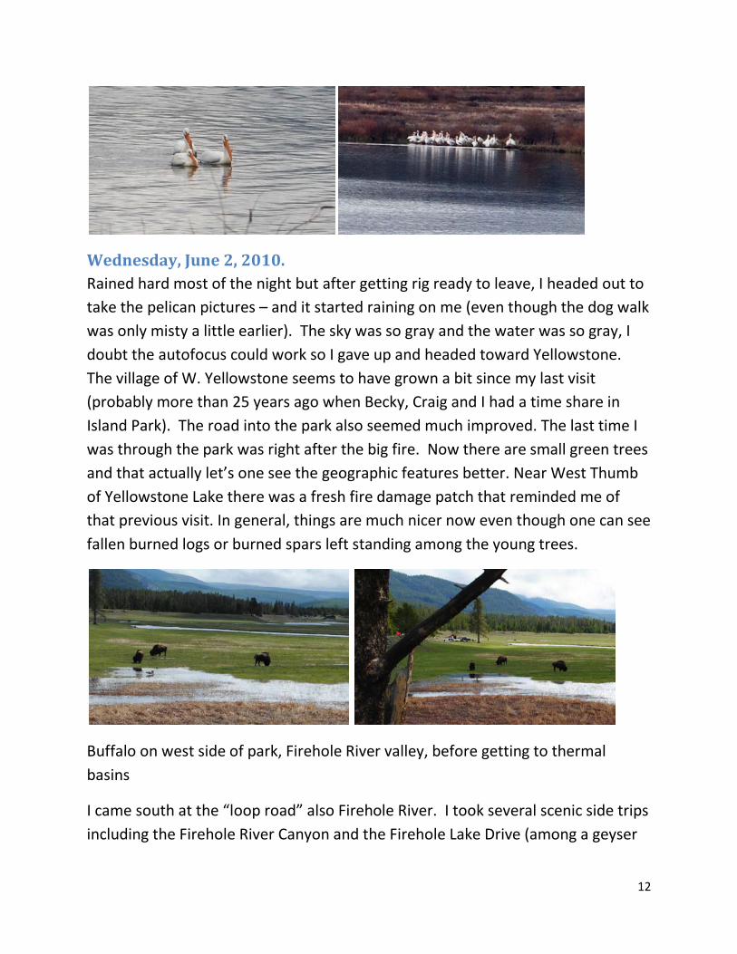
and sat reading some of those brochures. After coming in to fix dinner (after a nice hot shower), I realized that the wind was whipping the canopy so I went out and took it down – I could imagine one of the storms (about which the boaters are warned) coming up and turning my rig over! That would probably be worse that the grizzly bear threat! I need to take the dogs for another bed time walk but when I checked, it was raining so I started catching this diary up-to-date. I hope we get some sunshine tomorrow because it looks like a great place to try some out-of-door watercolor sketching! Here are some pelican and other photos from Henry’s Lake State Park.
Tuesday, June 1, 2010. I got on-line this morning and checked email, checked road conditions and weather, etc. The good news is that Beartooth Highway (northeast entrance to

11
Yellowstone) is now open. The bad news is that the forecast is still rain, rain, rain for another week or so. There may be sun breaks as there were today – but we also had a couple of thunderstorms roll over us causing Franny her usual panic and need for reassurance! During on of the sunnier periods, I got organized with the bear spray and jingle bells on the leashes and took the dogs out on a paved nature walk overlooking the lake. Very nice except that we met a young lady who was also walking two medium-to-large dogs. So I got off the trail a bit hoping for less trouble. But my dogs pulled me off my feet in their effort to “attack” the other dogs. Whether any fighting actually happened is not for me to say since I was sprawled onto the asphalt. She apologized and I apologized because I think it was really the fault of my dogs. I have a bit of a skinned elbow (left) and my right knee will probably hurt tomorrow as well as other parts that got twisted. Of course, the left ankle I turned at Freeman Creek seems worse this evening, must have twisted it a bit in the fall. Well, we continued to the end of the trail and came back. I had gotten my art supplies out but I was out of the mood after the rumpus. So watched a DVD for awhile, took a nap, and fixed a nice comfort-food lunch (mac and cheese). Then I got back on-line (gotta get my $3 worth of internet surfing!) for awhile. The first thunderstorm came through about lunch. Then there was a nice sun break and we sat outside. I’m particularly interested in the large white birds I first notices as I did the early morning dog walk by the lake shore. Since I don’t see too good, I was wondering if they were swans because the necks were rather long. But they were more the shape of white domestic geese. When I got closer, I could see that they were pelicans and the fisherfolk were trying to shoo them away. A sign said they were American White Pelicans. They have some black trim on the wings and it has been fun watching them fly low over the water. They seem to congregate on the shore to the east (beyond the campground area) but they also like the boat ramp – probably trying to steal bait! I’d like to get some photos but, when I think about it, it seems to be raining. We had another thunderstorm about 5 PM and then there was a lull and I just took the dogs on a short walk. Now it is raining again (6:30 PM). So I’ll sign off the diary for the day and fix some dinner.
12
Wednesday, June 2, 2010. Rained hard most of the night but after getting rig ready to leave, I headed out to take the pelican pictures – and it started raining on me (even though the dog walk was only misty a little earlier). The sky was so gray and the water was so gray, I doubt the autofocus could work so I gave up and headed toward Yellowstone. The village of W. Yellowstone seems to have grown a bit since my last visit (probably more than 25 years ago when Becky, Craig and I had a time share in Island Park). The road into the park also seemed much improved. The last time I was through the park was right after the big fire. Now there are small green trees and that actually let’s one see the geographic features better. Near West Thumb of Yellowstone Lake there was a fresh fire damage patch that reminded me of that previous visit. In general, things are much nicer now even though one can see fallen burned logs or burned spars left standing among the young trees.
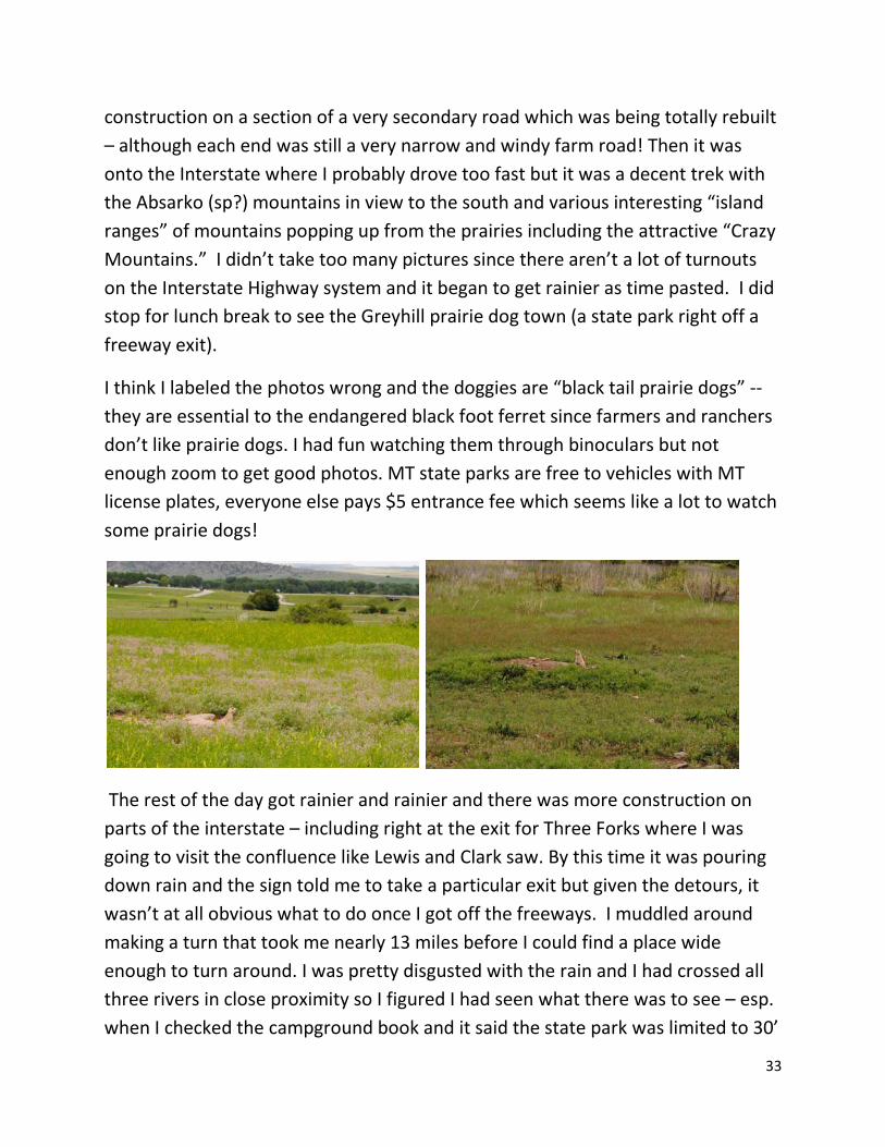
Buffalo on west side of park, Firehole River valley, before getting to thermal basins
I came south at the “loop road” also Firehole River. I took several scenic side trips including the Firehole River Canyon and the Firehole Lake Drive (among a geyser

13
basin). There were a lot of bison to be seen in the valley (I guess it is warmed up by all the hot springs warming the rivers! The valleys were spring like and green except for the geyser areas – but I took one photo of a bison right from a board walk! I did see one collared cow elk along the canyon drive. I did several of the board walk trails through the thermal features including Fountain Paint Pot, Midway Geyser Basin and West Thumb Geyser Basin. Since it was rainy off and on, I took my little camera on the board walks although I used my new SLR Nikon to take photos from the highway. While the new camera has a general purpose lens that zooms to about 3X, I was really wishing I had a more powerful zoom for wildlife photos. The weather improved some during the morning and there were some sun breaks although it was cold and windy (you can see the clouds from the photos). The wind was so strong at Midway that there were places were visibility was almost nil because of the steam blowing sideways! It sure made it hard to take decent photos of the hot springs – or even to see into the ones at Midway! I skipped Old Faithful area because of the probable crowds. The trip over to Lake Yellowstone crosses the continental divide at least twice and everything was very snow covered along that stretch of the highway. I was surprised to find a lot of ice left on Yellowstone Lake, particularly in the West Thumb bay (which is a separate younger caldera in the bigger 640 million year old caldera and is apparently deeper than the rest of the lake).

14
The dogs can’t go on any trails so they didn’t get very much exercise. Of course, I get an extra share since I have to go on their walks too. Accordingly, I was pretty pooped by the time I pulled into the very soggy Bridge Bay Campground. I’m sure the CG would be fine in better weather – it was easy to tell the bison liked it because it was covered with bison-patties even though the critters themselves probably found a less soggy place to bed down! Note: there were pull throughs but no showers or hookups at all.
By the by, yesterday’s fall seems to have mostly affected my abdominal muscles (although scraped left elbow is a bit sore and so is right knee). While I did my usual exercises, I doubt that was enough to make my stomach muscles sore – and these are really sore! Strange. To add to the aches and pains, I somehow gouged my right calf on the truck door when I got out to get fuel in W. Yellowstone – about a 3 inch bloody rip. I hope I get passed this accident prone period! What with all the walking and the consequences of the fall, I had a hard time sleeping because of aches, esp. in my ankles.
Thursday, June 3. Yesterday was geysers, today was rugged peaks. I headed south to the Grand Tetons at the maximum speed limit of 45 mph. This was the worst burned part of the park (to my recollection) and one can certainly see the Snake River canyon much better than before the fire when it was largely hidden by forests. Then one comes out into the sagebrush “hole” which has interesting geological story. I had

15
heard that the Tetons are some of the youngest mountains in the country – 80 million years ago, an earthquake fault line pushed up the west side of the fault while the east side dropped even more than the west side rose. The east is now the Jackson Hole and the west is the jagged Teton peaks. I was reading National Geographic article about the super-volcano eruption 640 million years ago that created Yellowstone so I guess this quake was unrelated – even to the West Thumb eruption which was just 170 million years ago. A number of the thermal features behave differently over recorded history and the changes are often attributed to earthquakes like the Hegben quake in 1959 – so I’m betting the quake that created the Tetons must have had an impact on Yellowstone area too!
On the drive south, I did the ‘slower’ road closer to the peaks but not all the available side trips and fewer “hikes” than yesterday. Tonight I’m camped nearly 150 miles south of last night’s site but the weather seems to be stuck on rain and evening thundershowers. I didn’t stop in Jackson Wyo either (more of the avoidance of crowded roads and few places to park a big rig). Most of the drive followed the Snake River which I found fascinating since I live just 35 miles north of the Snake and here it is heading south just at the beginning of its long journey across southern Idaho and then north to meet up with the Clearwater River (where I was camping at the first night of this trip). This campground is located in a beautiful green valley, apparently called “Star Valley” since that’s the name of the RV park. It is a very nice one and huge with purchased campsites (I’m in the transient section as a member of a related park). However, it is still rainy (off and on) but the dogs got to play in a nice little dog park. Fortunately, they had it to

16
themselves since I’m not sure they would play well with others! I sat in a chair and got bored long before they did – so much to sniff! The bathrooms are very nice, there is a very nice laundry, pool, golf course, etc. It would have been nice to sit around outside but the weather didn’t cooperate. I decided to do a load of laundry (I’m running out of WARM clothes although I have plenty of shorts left to wear!). I’m also using a lot of towels to dry muddy dog feet! Since WIFI was free, I’ve checked email, downloaded photos from the little camera, sent some messages, etc. This is really different than my trips to Alaska – the world is a more connected place! Well, enough is enough. Tomorrow I head north to see the “CANYON” side of Yellowstone.
Friday, June 4, 2010. Wow, I really made the right choice in taking the scenic route by the Tetons yesterday since I awoke to rain and more rain. The clouds were so low that one could imagine that there might be mountains there, but you couldn’t really tell for sure! So there was no real need to make a lot of stops heading north, although I took photo of the Lewis Falls (the canyon on the south entrance is the Lewis river canyon but it joins the Snake River so my comments earlier are basically true but may require editing. Of course, I had to walk the dogs in the rain a few times – I was able to pick some “less hard” breaks but it really never stopped until late afternoon once I was back in Yellowstone. It must be something about the geysers – all the geyser walks were misty and cloudy but not actually raining. This one was the Mud Volcano board walk and it was the most strenuous of any that I’ve done with a steep up-hill climb and then (of course), one has to get back down the hill.

17
At Mud Volcano Area
The most interesting feature was “dragon mouth” which I attempted to photograph but you really have to be there to hear the growls.
I saw more bison in the Hayden Valley as I approached the Grand Canyon of the Yellowstone. Since it was only drizzle by then, I thought I should “do the canyon” so I went to Artist’s Point on the south rim and several overviews on the north rim. I didn’t get into the Canyon campground until about 6 PM but it was much better than the one at Bridge two nights earlier even though there were 2-foot banks of snow on two sides of the rig. At least the pavement was wide and the forest (rather than meadow) left it damp but not soggy. I put the canopy up for a bit and tried to sit outside even in the light rain – but it was really too cold to be comfortable.

18
Saturday, June 5, 2010. Given the continuing rain, I decided to go to Cody the “shorter way” partly because there was a small amount of blue sky showing to the south and heavy dark clouds to the north. There were oodles of bison so I took some more photos of them and I enjoyed some of the Canyon Overlooks as I headed south and made some stops along Yellowstone Lake including one with fumaroles and geysers between road and water.
The mountain pass was like middle of winter with deep snow. Either the recovery from the “big fire” wasn’t as good at higher elevations or there had been a more recent fire because it was quite a lot of burned trees in the snow. Maybe the baby trees were buried. Once out of the high mountains, the scenic highway was well worth the trip – I don’t think I’d come to Yellowstone that way before. The canyon walls were very strange formations, some pinnacles but often rather “mushy” looking like melted marshmallows of dark stone. One could imagine all sorts of images in the weird shapes. There were lots of pull offs and lots of Forest Service campgrounds along the Shoshone River. I pulled off at one and had lunch,

19
a nap, and a nice dog walk under partly sunny sky. I didn’t take photos until later but put one of the hoodoos here with the campground.
Buffalo Bill State Park was pretty much a typical Washington/Idaho style of green grass lawn and trees in the middle of sage brush. It had very nice and roomy pull-through sites and was almost empty. The attendant sent me to an area that I had not reserved as it was supposed to be less windy – less did -not equal “no wind.” He also gave me a lot of tourist literature about the area. As I sat outside in the sun(!), the wind almost tore the pages out of my hands and threatened to blow my beverage cup over. The Wyoming state parks are cheaper for residents but $19 for no hookups is pretty high to me! There was an outhouse, water, and a dump station – no other services. But I was thrilled to be able to sit in the sunshine (wind or no wind). There was also a nice nature trail along the very turbulent and muddy river (from all that rain, I imagine). This was the last of my reservations but I was planning to go next to the Big Horn national recreation area for Sunday night. I had fun planning next stops since there seems to be a whole lot to do around Cody and the Big Horn Basin area.
Sunday, June 6, 2010. The sunshine didn’t last. I awoke to full could over and rain sprinkles and no wind either. I was hoping the wind would start up and blow the clouds away but no such luck. It rained until about 11:30 AM when I left the very interesting visitor center that the Buffalo Bill Dam (the attendant at the campground had highly recommended it). I tried to get a photo of the dam since th canyon was quite lovely. Unfortunately, the highway went through so many tunnels that you couldn’t see the dam at all once you came out of the last tunnel and had a place
20
to pull over. The dam was built for the irrigation water that brought agriculture to the arid basin. Crops seem to include various beans (pinto, navy) as well as sugar beets. After I got fuel in Cody, I headed toward Lovell (through a patch of very bad construction where it said you could go 45 mph – but 25 mph was rough enough!). At Lovell, there was another lovely visitor center for the Big Horn National Recreation Area that surrounds the canyon/lake on the Big Horn river. The geology is very interesting because the river appears to be flowing into HIGHER mountains even though we all know that water only flows downhill. The explanation is that the ground was higher in the past where it looks lower now but unimaginable amounts of terrain have been eroded away. I was thinking I would do a hike to the “medicine” site in the Big Horn mountains on Monday. It is about 80 feet in diameter with something like 28 spokes in a wheel around a central cairn – and was already in existence when the Shoshone tribe came into the area. So it has probably been around for more than 1,000 years. I had read that it was a 1.5 mile hike to the site ( so 3+ miles round trip) and had the good luck to ask how strenuous the hike was. The nice gentleman said I was welcome to hike it but I wouldn’t see anything since the wheel is presently still under a couple of feet of snow! So that was good to know – but even better, they had a video that took one up the hill and around the site. Very interesting and I got to ‘see’ it without blisters or achy muscles!

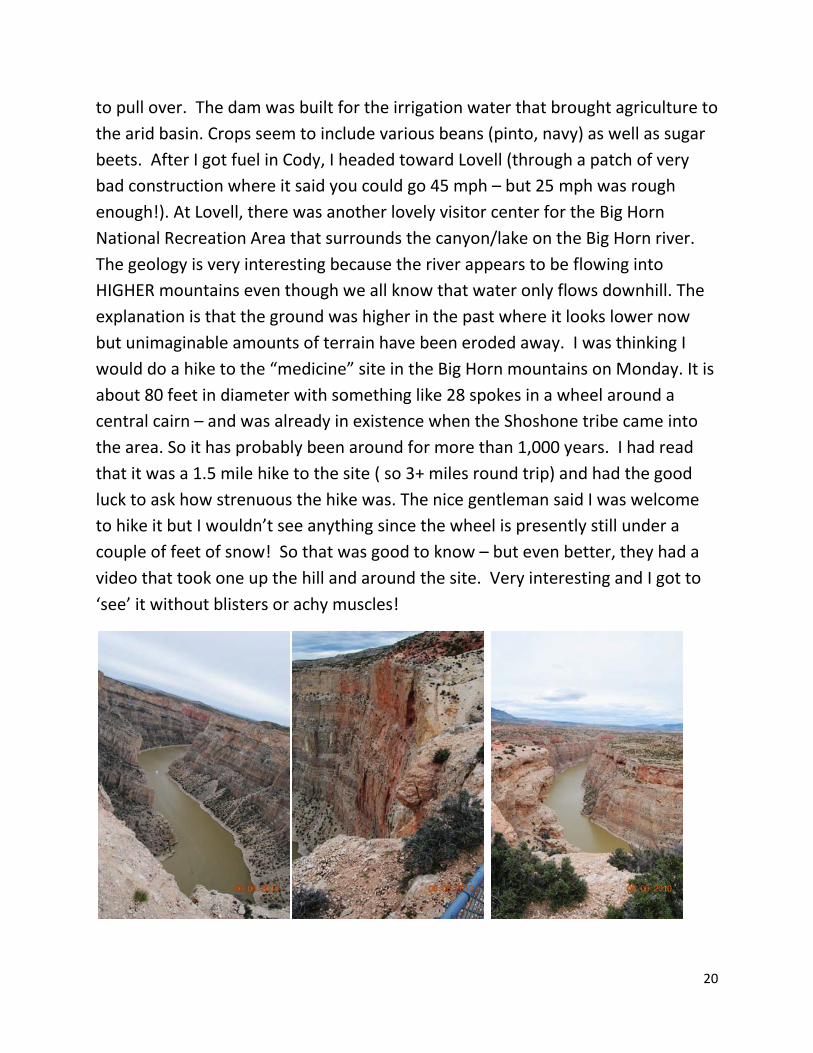
21
From the visitor center, I headed north into the NRA. I was also looking for the wild horses in the Pryor Wild Horse Preserve that partially overlaps the NRA. There were three “lookout” roads – the first was a marina with red rock walls. The second was the best and overlooked the really deep part of the canyon – so deep it was almost impossible to photograph the canyon walls and the water too! I might have seen some horses through the binoculars but they were so far away they might have just been a herd of juniper bushes! No sign of any big horn sheep either. The campground was on the third road which led to another boat ramp at the other end of the deepest part of the canyon (I didn’t see it until the next morning since the campsites were along the road before one got to where you could see the lake.) By this time of the afternoon, it was partly sunny (mostly cloudy) and not raining so I was able to sit outside and enjoy the colorful cliffs. In all, the country reminded me of the Escalante-Grand Staircase area in southern Utah. Lots of beige rocks but mixed with reds and even the occasional lavender. It was a very scenic drive and I am glad I did it. The campground was ultra-primitive: outhouse, picnic table and bear lockers. Something about the place made the dogs nervous. Armand was standing looking toward the creek with his tail tucked between his legs. Eventually, we all three decided to go inside the RV for the evening. However, there were two groups tent-camping up a little ways from where I was the only rig in the “RV camping” section. I had picked up more tourist info at the two visitor centers so I had plenty of reading materials.
Monday, June 7, 2010. The good weather of yesterday afternoon didn’t hold although it wasn’t raining this morning either. The visible blue sky was to the south with heavy clouds over the higher mountains. There was a 100+ mile scenic drive through the Big Horn Mountains that I had been planning but with the snow on the medicine wheel, I figured I’d have a long drive through snow and probably no good campground. So I headed toward Thermopolis through Greybull and Worland. The drive out of the NRA was, of course, beautiful although still no wild horses. However, the country-side for the rest of the day was barren or sagebrush hills or irrigated agricultural areas. Not totally uninteresting but not all that scenic either. Several patches of construction made it dreary too but the blue sky kept drawing me south. When I

22
arrived at Hot Springs State Park (about 1 PM maybe), I took the dogs for a nice walk to the “headwaters” of the springs (but I didn’t want them on the board walks on the ‘rainbow terrace’ area. Then I made use of the “free” state facility. It is free because of a treaty with the tribes that ceded the hot springs area to the US in return for the promise that access would be free to all (one of the few promises to native Americans we seem to have kept!). There were several fancier commercial facilities with slides, etc. but the basic bathhouse with indoor and outdoor pools was free. After my permitted 20 minutes, I came out smelling like sulfur and very relaxed. I decided to visit the other main attraction here which is the Wyoming Dinosaur Museum. It was excellent but I was feeling so enervated y the hot water that I omitted the tour of the dig sites which was at some distance and a higher price. The exhibit were extraordinary and well worth the entrance fee.
By this time is was about 3 PM and I sought out my first “Good Sam” RV park which is quite nice but also expensive ($33). I even have cable TV on which I watched the weather channel to find out that the rest of the week will be more of the same (clouds, rain, thundershowers). I think I’ll see the Wind River Canyon tomorrow – about 20 mile drive south of Thermopolis. There is a state park at the far end which might be nice. Otherwise, I’m thinking I’ll head back to Cody for a couple of days. There are nice museums there which one can visit in the rain. Maybe I’ll take in a rodeo too. Eventually, I want to do the Chief Joseph scenic highway up to the Beartooth scenic highway. But I’d like to do those mountain passes in the sunshine, esp. since they are probably still very snowy!

23
Tuesday, June 8, 2010. This was probably the best day of trip so far because it was sunny! After leaving very nice RV park, I headed south toward Wind River Canyon. There were many pull-over spots and I pulled over a lot of them and took lots of photos. I kept looking for the big horns since they are supposed to hang out around the canyon, but no luck. There were two state park campgrounds at the end of the canyon just below the dam at the beginning of the canyon (a very ugly desolate reservoir so I can see why they put the campgrounds in the canyon where there were trees and vegetation). However, none of the sites were level and it was still early and the sun was still shining.

24
So I drove the 20 some miles back to Thermopolis and went to the state park for a nice dog walk and lunch. I had missed the hanging bridge across the river and got some (hopefully) good pictures of the “rainbow terraces” created by the minerals in the hot water. I thought about doing the hot springs again but it made me so tired the day before that I decided not to.
The drive back to Cody through Meetesee was much more attractive than the trip down the east side of the basin through Greybull – but that could have been a matter of attitude caused by sunshine rather than rain! I stopped in at one of the

25
RV parks that mentioned a shuttle to take you downtown, but the guy said “they” weren’t doing the shuttle anymore. So I figured I’d better check out the one near the museum but it was such a nice sunny day, I hated to be squeezed in with all those other people – so I made reservations for the following night and drove back the 20 miles to Buffalo Bill State Park. It was lovely sitting out in the sunshine that afternoon! So another lovely afternoon at Buffalo Bill State Park:
Wednesday, June 9 Got up to partly cloudy but still nice so dilly-dallied a bit and took long hike with dogs before heading back to Cody. Stopped at a Super Wal-Mart to stock up on fresh stuff like milk and bread but ended up spending more for things like fresh strawberries! It was about noon when I got to the Ponderosa RV park and I walked back to the office to tell them which site I was in just to remember that they didn’t take credit cards. So walked back to get checkbook – not a terribly long walk but I was already tired from the hike and shopping. The walk to the museum seemed like a quarter mile but it is a great museum. I did the natural history part first, then the Plains Indian part, and finally the art museum. It was nearly 5 PM when I drug my aching feet back to the RV – and I of course had to walk the dogs first thing. I was so pooped, I didn’t even turn the computer on – but instead watched the weather channel for awhile and went to bed early. For $37 per night, you get cable TV, of course, as well as other hookups and WIFI.

26
Thursday, June 10
The weather, as predicted, was pretty cloudy but it wasn’t raining. A little before 8 AM, I called the wild horse tour company expecting to make reservation for this afternoon or tomorrow morning. They said they had room if I could be ready in half an hour. So I was and I did the Red Canyon Wild Horse Tour with a van of about 5 or 6 other people. This herd is on the McCullough Mountain Wild Horse Preserve and these horses probably interbred with Buffalo Bill Cody’s herds which wintered in the area so they are not as “pure” Spanish-derived mustangs as those I didn’t see in the Pryor preserve. Our guide said those horses are smaller, rarely over 13 hands as compared to this group. We drove about 20 miles out of town (back toward Meetesee) and then on dirt roads. The guide spotted the horses before I saw anything. They usually hang out in family groups (stallion and his mares with the bachelor horses in a different group). Today, there were about 5 families grazing in the same area. We parked and walked closer – best view was in binoculars and I doubt my photos are going to show much (not enough zoom). It was fascinating watching them, including some rough and tumble tussles between a couple of bachelor stallions. There were probably 6 foals, all less than

27
two weeks old. They were frolicking around and fun to watch too. The herd started grazing in our direction so they did get a lot closer – and we had to back up because you are supposed to stay 500 feet away. I also saw a bunch of pronghorn antelope on the way to and from the wild horse preserve (some of the antelope were in the preserve). So it was a nice morning trip. Maybe I’ll get some interesting photos if I can crop them so that the horses appear to be closer!
I got back to my rig a little after 11 AM to walk the dogs, get on the internet to check mail and see if I can find a cheaper campground for a couple of days until we are supposed to have a sunny day so I can do the Beartooth Scenic highway! Then I went back to the museum to do the history part. It wasn’t raining when I left the campground so I just had a denim jacket on (I don’t seem to have an umbrella in this rig and I didn’t want to be bothered with carrying a heavier coat). The Buffalo Bill section was very interesting, as it turns out. He was one of the pony express boys as well as a scout for the army before he started his wild west show. There is also a firearm museum but I really should have skipped it because after I came out of that part, it was pouring down rain with thunder. After a bit, the rain slowed down so I decided to head back (it might get worse again later). I was completely soaked after the long walk – my jeans, jacket and blouse are hanging in the shower (no sign of being close to dry yet!). Franny was in a panic because of the thunder and there was water getting into the rig through the vent I had left open. So it was a busy time getting dried out – made some soup to warm up! Of course, an hour later it had quit raining and I took the dogs out for a short walk - all I was up to since my ankles are hurting a lot. So now I’m catching up the diary. I think I’ve identified a forest service CG for the next couple of nights until that ONE partly cloudy day (of the next five) shows up for the trip to Red

28
Lodge MT. I’m looking forward to a couple of less busy days to rest up, esp. if I can have electricity!
Friday June 11 thru Sunday June 13
The weather during my “resting up” weekend had been unexpectedly nice (all that weather channel watching said it was going to rain all weekend but it hasn’t rained at all yet, although there have been a lot of clouds and it is colder than earlier. Friday, when I arrived, I sat outside in the sunshine long enough to burn my ankles (short people don’t understand why I like my pants long – it was the area between the top of my socks and the bottom of my too-short jeans! I tried to sit out some on Saturday but it was just too cold so watched some DVDs as well as figured out how to get photos from Nikon to laptop, etc. Sunday (today) has been warmer and sunny all morning although the clouds are rolling in so we may yet have rain. I plan to head up through 2 scenic drives tomorrow, ending in Red Lodge Montana (unless it is pouring down rain!)
I could tell I had done too much walking – my left ankle hurt so bad during the night that it kept me awake Saturday night. The rest seems to be helping since I didn’t have trouble sleeping on Saturday night. I did more walking Sunday morning – went across the river on a pedestrian only bridge and p.hike up the road aways – could see a clear water stream heading toward the muddier Shoshone R. I couldn’t find any rock specimens that were suitable to “explain” the weird hoodoos (very uninteresting in small chunks!) but there was an unusual flower I wish I could take a photo of but of course, had no camera with me.

29
During the sunny part of the day, sat outside and read magazines and then worked some more on the “I was there” patches on my hat I’ve been working on off and on during the trip. I really needed a thimble and got a ceramic souvenir one at the museum but decided to get a real one at Wal-Mart. The cheapest way was to buy a “starter sewing kit” since I needed to tighten up waist of one the mid-thigh denim things I’ve been wearing.
From trail, early morning walk to get photo of flower I had never seen before (6/14/10) – when I first saw it, thought there were 8 petals and it looked pinker in the sun.
Monday, June 14, 2010 I’m catching this up ten days after it happened – Not sure why I didn’t work on it when I had hookups at Conestoga RPI park in White Sulphur Springs – it was rainy but maybe I was too busy doing laundry! Or it all went to word heaven! Monday was the sunny day long awaited for the trek up Chief Joseph Scenic Highway and across Beartooth Pass. The Chief Joseph highway was beautiful as shown in next few pictures. I was disappointed in Beartooth partly because of construction but also I think I missed some favorite parts between Yellowstone and the intersection.

30
It was also very snowy for much of the high mountain portion of Beartooth pass. However, there was a really neat rest area with a walk out to a scenic point that I don’t think I visited on my previous trek over the pass. So I enjoyed taking a bunch of photos of the Montana side, past the snowiest part!

31
Also, with the construction and the traffic, it was hard to find a turnout from which to take photos. Maybe that is what the construction will fix since a “scenic highway” should have plenty of turnouts and rest areas!

32
This is part of the long walkway out to the view point – very nicely done. Beartooth Highway needs more of these type facilities on the Wyoming side!
Once down the pass, I looked at some forest service campgrounds and they were pretty narrow and not very level, although we had a lovely dog walk at one place. So I drove on into Red Lodge and got a spot at a KOA campground which was decent although price was about $40. I couldn’t get the WIFI to work very well, however and didn’t take time to download photos since the next morning started out sunny and I wanted to “make memories” while the sun shown!
Tuesday, June 15, 2020 I got a fairly early start and planned to camp near the headwaters of the Missouri River where Lewis and Clark finally came to the three forks they named Jefferson, Gallatin and Madison. The day started out with a stretch of really serious
33
construction on a section of a very secondary road which was being totally rebuilt – although each end was still a very narrow and windy farm road! Then it was onto the Interstate where I probably drove too fast but it was a decent trek with the Absarko (sp?) mountains in view to the south and various interesting “island ranges” of mountains popping up from the prairies including the attractive “Crazy Mountains.” I didn’t take too many pictures since there aren’t a lot of turnouts on the Interstate Highway system and it began to get rainier as time pasted. I did stop for lunch break to see the Greyhill prairie dog town (a state park right off a freeway exit).
I think I labeled the photos wrong and the doggies are “black tail prairie dogs” -- they are essential to the endangered black foot ferret since farmers and ranchers don’t like prairie dogs. I had fun watching them through binoculars but not enough zoom to get good photos. MT state parks are free to vehicles with MT license plates, everyone else pays $5 entrance fee which seems like a lot to watch some prairie dogs!
The rest of the day got rainier and rainier and there was more construction on parts of the interstate – including right at the exit for Three Forks where I was going to visit the confluence like Lewis and Clark saw. By this time it was pouring down rain and the sign told me to take a particular exit but given the detours, it wasn’t at all obvious what to do once I got off the freeways. I muddled around making a turn that took me nearly 13 miles before I could find a place wide enough to turn around. I was pretty disgusted with the rain and I had crossed all three rivers in close proximity so I figured I had seen what there was to see – esp. when I checked the campground book and it said the state park was limited to 30’
34
length and my RV is 31 feet long. So I had some supper in a pull off, studied maps and started to head toward my membership campground (only one in MT) in White Sulphur Springs (thinking to stop earlier if I found a spot). As it turns out, I didn’t so I pulled into Conestoga CG around 6 PM very very tired! There was a scenic stretch through the Big Belt Mountains to get to White Sulphur Springs b but it would have been a whole lot faster and a lot fewer miles to go straight up to WSS instead of taking the long way through Three Forks!
June 16-17, 2010 Conestoga park was very nice with thick gravel that kept one out of the mud (mostly). It was on edge of town with cow pastures on three sides so plenty of places to walk dogs. They had a nice laundry so I decided to stay 3 nights altogether with one day spent doing laundry, primarily. However, the morning of the 16th I headed into town to visit “the Castle” and with a guide to the historic buildings in hand. Unfortunately, the vehicle was making some very strange and disturbing whines so I pulled into a “real service station” that has been advertised on the town map (WSS is a very small town) and the attendant suggested power steering fluid – and it took almost a whole bottle but the noise stopped. So I then drove around town looking at some of the old home and doing the tour of “the Castle” built around the turn of the century – the Victorian style furnishings were not original since the builder didn’t live there very long but it was a nice museum and just as interesting as the Daly Mansion in Hamilton but a lot smaller. I also “ate out” for the second time this trip (the first hardly counts since I got a McDonalds Filet of Fish and ate it in RV with the dogs!). It was a nice little deli recommended by the gal at the campground and they had sweet potato French fries! By this time, the off-and-on showers had become pretty steady and it pretty much rained the rest of the day and all of Thursday as well. I did the laundry Thursday and otherwise walked dogs in “no rain breaks” as the nice gravel campground got soggier and soggier!

35
Three very rainy days but after the storm there is sometimes a chance to get good photos – the sunset pictures and the rainbows are from Conestoga Campground (RPI) in White Sulphur Springs MT
Friday, June 18, 2010 With weather looking up, I headed toward Great Falls over the “scenic highway” section (need to get name off brochure) through what they called the “Little Belt” Mountains. From the castle in WSS, one was supposed to be able to see all three mountain ranges (Stone Mountains to east, Big Belt mountains to west and south and Little Belt mountains to the north) but of course there were too many low clouds to get more than a hint of mountains during my stay! These next two photos were taken on the way from White Sulphur Springs to Great Falls. This is the Sluice Box Canyon, a state park that contains an early railroad bed but they

36
took out all of the bridges so you can only hike it late in year when the river is low enough to ford!
I got to Great Falls and found the KOA easily (the only other CG was supposed to be hard to find) so I stopped in to make reservations for the weekend. The parking lot was a muddy mess from all the rain and they wanted over $60 per night which is more than I have ever paid. So I said no thanks and made my way to the Lewis and Clark museum with little trouble. It is on the Missouri River between the 4th and 5th of the five great falls that confronted Lewis and Clark and just a short walk from the “Great Spring” that L&C described as turning a portion of the Missouri blue for quite a distance downstream. The museum was excellent (and free for me since it was federal) and then I walked the dogs on the nice paths down the river to the Big Springs (a state park). Afterwards, I drove a ways downstream to see Rainbow Falls (now a dam of course) and then upstream to Black Eagle Falls (also a dam).

37
The first three photos are the Great Springs and the fourth is the cliff along the river where there were lots of swallows’ nests if you look closely. The springs were beautiful with pretty green plants growing in the clear water.
The first two photos below are Rainbow Falls and Dam and the 3rd photo is Crooked Falls (not dammed) and one of the 5 great falls is underwater from one of the dams. I did not drive out to the one actually called the great falls (and dam), figuring I had the idea of what L&C faced – pretty big barriers to the boats!
At this point, I spent a lot of time “seeing” Great Falls as I tried to find the Petco (needed some supplies for dogs). I eventually got there but was pretty sick of the traffic and (what else) construction! I asked location of Walmart, thinking to camp in parking lot, but young man gave me such complicated instructions (none of the named streets were on my map) that I decided to head for Helena on the Interstate (which was marked scenic). I noticed an RV park sign near Tower Rock

38
state park and pulled in to discover a very beautiful setting although the park itself was a work-in-progress! So I spent the night with full hookups but decided to use my own bathroom given the state of the one restroom on the place. The last photo is looking upstream toward Black Eagle Falls and Dam from the walkways along the river near the Lewis and Clark museum. You can barely see the white water from the falls.
The next photos are Black Eagle Falls and Dam, the last of the 5 Lewis and Clark had to portage around from a pull off next to the dam on a very busy road.

39
Saturday, June 19
CG views near Tower Rock State Park – Missouri River between me and the rocks
After reading newly acquired travel brochures, I was more eager than ever to do the “Gates of the Mountains” boat tour to see something described by the L&C expedition. I took some photos of the towering rock around the Missouri River where I had camped and had wished I realized that the “Recreation Road” the campground was on was apparently the “old road” and I could have seen more scenery at a slower pace had I stayed on it! But I made the 12 noon tour for Gates of the Mountain and the two hour boat ride was beautiful and well worth the modest ticket price. I took lots and lots of photos of the various limestone rocks of which the canyon was made. We saw some eagles but otherwise the wildlife often seen on the tours did not make an appearance.
The first two photos are from the south end (upstream since river flows north).

40
This is a sequence showing how mountains appear to open as one goes upstream (closed to left, open to right) but who knows if this is the spot that L&C actually meant as “the gates to the mountains appeared to open.” Things probably looked different to them (darker and threatening) since it was late in the day and they were probably exhausted!
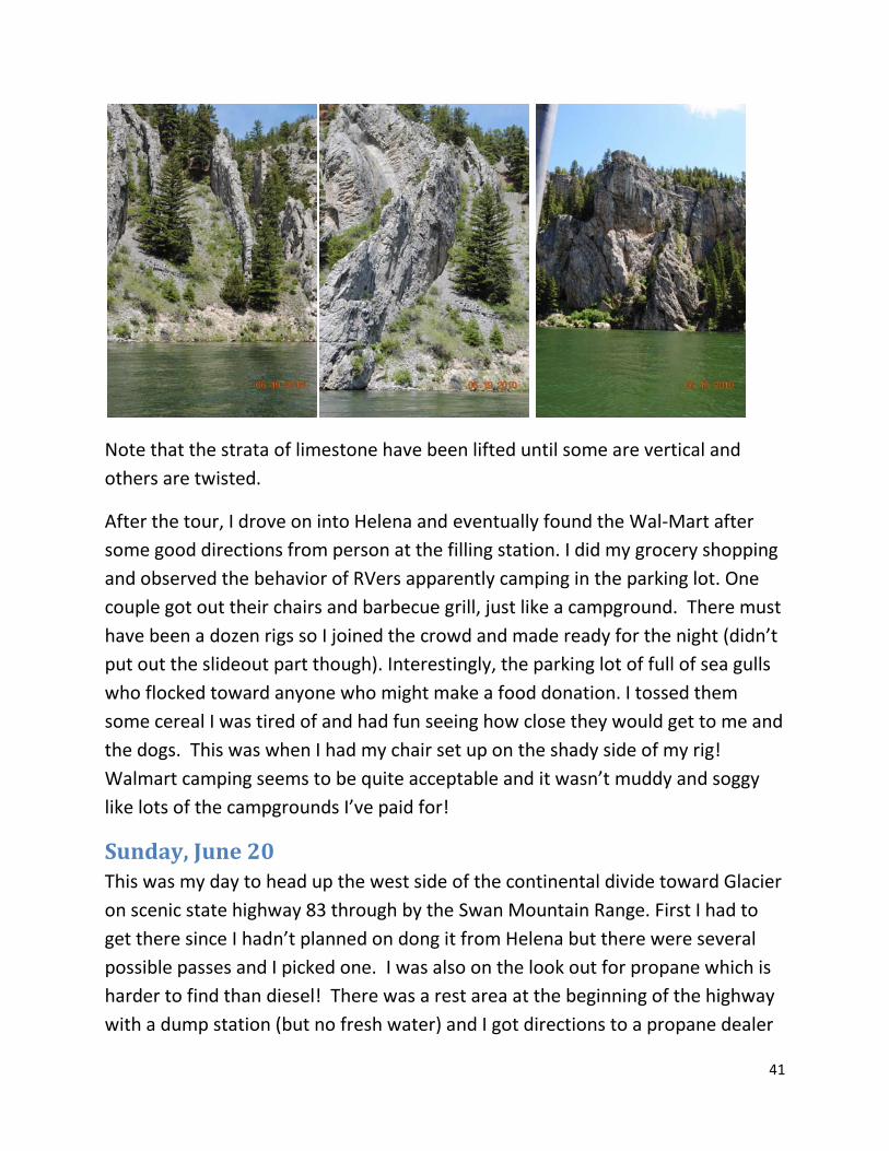
41
Note that the strata of limestone have been lifted until some are vertical and others are twisted.
After the tour, I drove on into Helena and eventually found the Wal-Mart after some good directions from person at the filling station. I did my grocery shopping and observed the behavior of RVers apparently camping in the parking lot. One couple got out their chairs and barbecue grill, just like a campground. There must have been a dozen rigs so I joined the crowd and made ready for the night (didn’t put out the slideout part though). Interestingly, the parking lot of full of sea gulls who flocked toward anyone who might make a food donation. I tossed them some cereal I was tired of and had fun seeing how close they would get to me and the dogs. This was when I had my chair set up on the shady side of my rig! Walmart camping seems to be quite acceptable and it wasn’t muddy and soggy like lots of the campgrounds I’ve paid for!
Sunday, June 20 This was my day to head up the west side of the continental divide toward Glacier on scenic state highway 83 through by the Swan Mountain Range. First I had to get there since I hadn’t planned on dong it from Helena but there were several possible passes and I picked one. I was also on the look out for propane which is harder to find than diesel! There was a rest area at the beginning of the highway with a dump station (but no fresh water) and I got directions to a propane dealer

42
in Seely Lake. Proceeding north, it got rainier and I was pretty sure there were beautiful mountains still around me but all I could see was lots of clouds! I took a couple of decent photos early in day but gave up later. I pulled into a lot of forest service campground on the way which were not suitable for one reason or another. Finally came to Swan Lake which was just opening from re-do of all the asphalt and I pulled in and found a nice wide PAVED campsite (#11) for the night. As I pulled in, I realized that the horrible whine was back. Fortunately, I had purchased another bottle of power steering fluid and I put it in and the whine went away. But I KNEW I had a leak or something seriously wrong. Got a yellow pages from camp host to find repair places so that was my known task for Monday! I then sat outside for awhile but then it started raining harder so went to bed.
Monday, June 21 – a “fixit day” In early morning, walked dogs across highway to the boat ramp and picnic area – beautiful with lots of freshly paved walkways for wheel chairs (but very nice for regular folks too). I didn’t take camera but I did on another morning later in the week. After breakfast, headed toward Kalispell for “help” which I found at “Loren’s” after a bit of a hunt and another stretch of several miles before I could find a place to turnaround. I sat and read novel for about an hour until they could get to me. We left the dogs in the RV which might have been a mistake since it took so long and I didn’t realize they’d be up really high on the lift! But they did okay, I guess, at least they seemed fine when it was finished about 3 hours later! I was pretty hungry since that ran well past lunch. And I spent a bunch of money to get oil change, filters, etc. but most of it was HOURS to find a loose connection

43
in the power steering line. It seems to be fixed okay and everything is still working fine as of June 26 and a good number of miles. It was still a very rainy day so I decided to go back to Swan Lake CG (cheap with “senior” discount and all that nice pavement and no mud puddles!).
Tuesday June 22 – another “fixit day” When I got up Tuesday morning and was listening to the news on the radio, the radio cut off and I checked the power level and it was “red” which meant the batteries had only lasted one night. I may have mentioned the batteries only lasting two nights at Indian Springs. Clearly, the batteries were at end of useful life. I had seen several RV places in Kalispell on Monday so I headed back to town. On the way, I saw Les Schwab sign so I figured that might be better since Les Schwab is also in Moscow in case there were warranty problems. It took a bit but I found one Les Schwab but they didn’t have the batteries in stock but one in Columbia Falls did so I visited Columbia Falls (maybe another 20 miles) to get my two new $100 each batteries! It was still fairly early as I headed back toward Swan Lake. However, there are very few dump stations along the lakes and one was a state park in Big Fork which I had to drive through anyways. So I pulled into Wayfarer State Park to use dump station and found the park to be very nice with multiple pull-through sites (no hookup though). So I parked myself for the day. The park is on Flathead Lake, the largest natural freshwater lake west of the Mississippi River. It is also the last remant of prehistoric Lake Missoula which periodically flooded central Washington state to create the coulees and bad lands. In walking the dogs, I discovered a scenic walk area up on the cliffs – not a good “walk the dog” area since I figured I’d sprain an ankle or worse if they jerked me at the wrong moment! But later I went back alone with the camera to take a number of photos. There were large flatish areas of “glacier polished” rocks and a couple of nice park benches.

44
Wednesday June 23 – around the lake day Wednesday dawned with decent partly cloudy weather so I decided this was the day to drive around Flathead Lake. I went south on the east side and north on the west side hoping for better light for photos that way. I was surprised by the large number of apple and cherry orchards perched above the east side of the lake – reminded me of Lake Chelan. However, there weren’t a lot of pullouts for photos. I stopped at a state park that had electricity but didn’t care for the spots (and it was an adventure getting to it!). We were in Polson MT about lunch time and I found a city park for a lunch and walk-the-dogs spot. When I got back to Big Fork, I had empty waste tanks and full load of water and new batteries so I went back to Swan Lake campground – a better place for walking dogs! This time I picked a different site that was sunny with mowed grass “meadow” section and paid for 2 nights.

45
Here are some photos from the south end of Flathead Lake. I admit that I expected the “reservation” sides of the lake to be less developed but there were houses and cabins pretty much all the way around the lake and not much difference between Flathead Reservation sections and the others. I’m guessing the Flatheads got a bad deal like the Nez Perce and other tribes.
Thursday, June 24, 2010 I brought art supplies with me but have barely used them – to paint outdoors, one needs it to be dry, not too cold or hot, and not too windy. Thursday was perfect and I set up thing on the picnic table. I started with a watercolor of what I remembered I’d seen of Swan Lake on the morning dog walk (turned out pretty bad). Then I wanted to work with my watercolor pencils – I’d ordered several books on the topic. I tried to follow a project and didn’t care for how it turned out. So then I decided to work from a photo on one of the many travel brochures I have and that was going better when I realized that the “light gray” watercolor pencil I thought I had been using was really just a graphite drawing pencil included with the set. No wonder it didn’t blend with the blue and carmine colors

46
in the project. When I continued to read, the project book called for about 3 dozen colors and only provided less than 10 basic color pencils to use. No wonder things weren’t turning out! Obviously, I need to buy the right kind of pencils. But I was still working on the third painting when Franny started her panic mode to let me know of thunder I can’t hear yet. I did see some rain clouds on the horizon so figured I’d better back up some stuff just in case (along about 2 PM). By 4 PM it still hadn’t rained but there had been more thunder audible to the dogs! Eventually, they turned out to be “right” and it did rain some but otherwise it was a really lovely day! Here are some early morning photos of Swan Lake and a couple of the Swan Mountains which finally became visible!
Above are from the Swan Lake CG picnic and boat launch area

47
The Swan Mountain Range, finally visible!
Friday & Sat. June 25-26 I have reservations this weekend at a “related” park in Kalispell, then two nights next week in a “related” park in Hungry Horse, near entrance to Glacier. The next 3 nights (4th of July weekend) I’ll be camped in the park on the east side (St Mary’s) and then a night in Wateron followed by a night in Mt Fernie provincial park. So I decided that Friday would be the day to “do” the town of Whitefish MT. It is really close to Columbia Falls but I technically hadn’t been there and thought the gondola ride up “Big Mountain” ski resort would be nice. Well, I eventually got on the right road to the ski area bud didn’t make a crucial turn and ended up on a deadend road (very narrow and windy) around the east side of Whitefish Lake. Very scenic but there were no turnouts and believe you me I was looking for one big enough to turn my rig around! Finally, the road dropped down to lake-level again, and I was able to get turned around in a fancy paved driveway. So I headed back and darn if I didn’t miss the turn off to the ski area again – a problem of very bad signage! Instead of turning around (it was pretty cloudy and threatening rain by this time), I headed to a city park on the map which sounded nice – and it was but there was absolutely no place for an RV to park! So next try was for a rest area on the map just northwest of town. I found the SIGN but couldn’t spot the rest area until I knew I had gone more than ½ mile. Again, I’m going down a rural highway looking for a place to turn around. I finally found a turnoff but it was to a gated community (couldn’t see gates from highway) so it was to WORST yet place I’ve found to turn around! So back toward Whitefish. There was another “rest area ½ mile” sign but still couldn’t see it so turned into the Whitefish State Park – at least they’d let me turn around! When I

48
finally found the stupid rest area (it was just a small parking lot off a city park with tennis courts), it was pouring down rain. So we sat there until the rain eased and I headed for post office to mail postcard and then to a Mexican restaurant adverstised to be best in Flathead valley. Well, I found the Dos Amigos but they weren’t open for dinner until 4 PM (just the casino was open). By the by, what is it about Montana – there is a raggedly little casino attached to most filling stations and convenience stores! Well, there went my third attempt to “EAT OUT” this trip. Fortunately, there was a Safeway next door and I got a nice Starbucks mocha, pastries, deluxe frozen PF Chang Chinese shrimp dinner, etc. After snacking in the Safeway parking lot, I headed for my campground back in Kalispell. The Glacier Pines campground is quite nice with roomy pull through sites with mature trees providing shade. Unfortunately, it is right on a very busy highway and the noise is intolerable (but one doesn’t know this until one has paid for 2 nights). So Saturday has been spent on the laptop fiddling with photos, paying bills, checking email and catching this diary up-to-date! Even though it is a perfectly beautiful partly cloud, warm day! At least I’ve been working outside at the picnic table for part of the day between short walks with the dogs (not much room for dog walks here). Tomorrow, I plan to leave early and head for the Hungry Horse reservoir area where there are a couple of forest service campground to check out. Here is a photo of my “RV Office” – you can tell it is a bit crowded. By the way, the PF Chang Garlic Shrimp last night was quite good – I even made brown rice to go with it!

49
Sunday, Jun 27.
I really had fun on Sunday riding the ski lift to the top of “Big Mountain” just outside of Whitefish. From the top, one could see into the high peaks of Glacier Natl Park plus the Flathead valley. I ate lunch at the summit restaurant – you couldn’t beat the view! But the blackened yellow fin tuna sandwich was very good and the curly fries were exceptionally good! The valley was hazy and I was told it is often better in the afternoon. So I road down, took the dogs for a fairly long walk, took a 20 min. nap, etc. Then I splurged for another $10 round trip ticket to the top. Surprisingly, it was colder (windier) than the earlier trip but the haze was no less. So I didn’t stay up there too long the second time. By the time I got down again, it was 4:30 or so and I needed a few groceries so I decided to give the very new Wal-Mart in Kalispell my business and spent the night there in the parking lot. The highway noise was actually somewhat less than I’d experienced at the RV park where I last up-dated this diary.
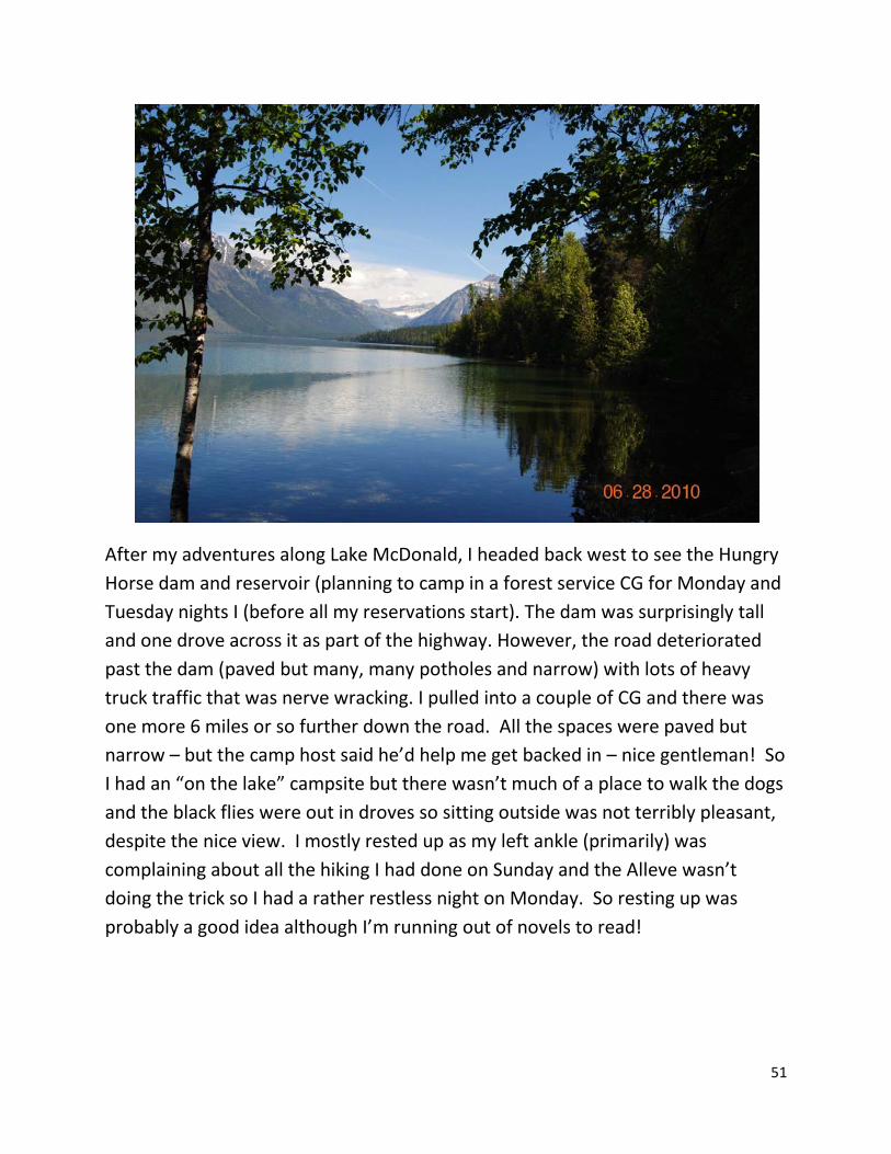
Monday & Tuesday June 28 & 29. On Monday I drove to the national park to get information on where I could drive and what I could do. I drove up the going to the sun highway along side Lake McDonald and tried to do the nature trail that is the point beyond which I can’t drive my big rig. The parking lot was absolutely jam packed -the 3 or 4 RV spots were filled with two cars each. So I’ll do that walk once the shuttle is up and running – probably July 1 while I’m camped in the RV park in Hungry Horse.

50
51
After my adventures along Lake McDonald, I headed back west to see the Hungry Horse dam and reservoir (planning to camp in a forest service CG for Monday and Tuesday nights I (before all my reservations start). The dam was surprisingly tall and one drove across it as part of the highway. However, the road deteriorated past the dam (paved but many, many potholes and narrow) with lots of heavy truck traffic that was nerve wracking. I pulled into a couple of CG and there was one more 6 miles or so further down the road. All the spaces were paved but narrow – but the camp host said he’d help me get backed in – nice gentleman! So I had an “on the lake” campsite but there wasn’t much of a place to walk the dogs and the black flies were out in droves so sitting outside was not terribly pleasant, despite the nice view. I mostly rested up as my left ankle (primarily) was complaining about all the hiking I had done on Sunday and the Alleve wasn’t doing the trick so I had a rather restless night on Monday. So resting up was probably a good idea although I’m running out of novels to read!

52
Wednesday, June 30. Left the campground mid-morning and I can’t check into the new one until 3 PM so decided to shop for a new fanny pack since my current one is worn out with all the elastic portions just stretched out. I used it anyway for the camera when I did the ski lift ride but I’ll be doing several days of shuttle tours and need a way to carry new camera and water and snack. So drove to Columbia Falls (nothing) and then on to Whitefish (where I was told there was a “mall”) and in the mall I found a super good sporting goods store. So after much agonizing, I bought one. Then did a bit of other shopping and pulled into a roomy Pizza Hut parking lot to order a pizza for lunch (shared with dogs). I think that makes my 4th meal “out” for the trip and to tell the truth, I’ve had Digorna rising crust pizza at home that I liked better. Then drove back to Glacier to try to do the “other” nature walk to which I can drive in my rig – it was supposed to be about fire and there was a lot of burned out sketches on the road. However, when I got to the trailhead, there were no brochures so the numbered posts were meaningless – decided not to do the whole thing – the trees were all just tall enough to hide a grizzly bear and I was alone! So then checked into my RV spot planning to wash my hair – got to the bathroom and it required quarters so to heck with it, came back and washed my hair in my own shower and then sat down to check email and catch this up-to-date. Tomorrow, the shuttle service starts and I’m going to go back to Avalanche Creek on the shuttle and do the nice nature walk for which I could find no parking place on Monday! After checking in, went back to park and did the drive out to Polebridge - lots of burnt areas. Didn’t see any animals and the hike had no brochures to go with the numbered posts so I did not go far.

53
Thurs. July 1 Drove into Apgar Transit Center and got on shuttle about 11 AM and rode up to Trail of the Cedars. Did the hike and then caught a shuttle toward Logan pass almost immediately. Weather was deteriorating and the construction and traffic was very bad! It took a long time to get to the pass where it was cold, windy and cloudy (too cold for clothes I had on). So went to restroom and caught shuttle back down to Avalanche Creek – again the construction delay was well over 30 minutes (one driver on radio said she’d been delayed an hour!). Had to wait 15 or 20 minutes for the bigger bus back to Apgar and arrived about 4 PM – so dogs were really ready for a walk! I decided to drive back to the sporting goods store for the disposable ponchos and a windbreaker/rain coat that fit better than the old one I had. Also ended up buying bear spray since mine had to be 15 years old since I’m pretty sure I bought it on my first trip to Alaska in 1995! Everyone assured me that it was likely to be defective.

54
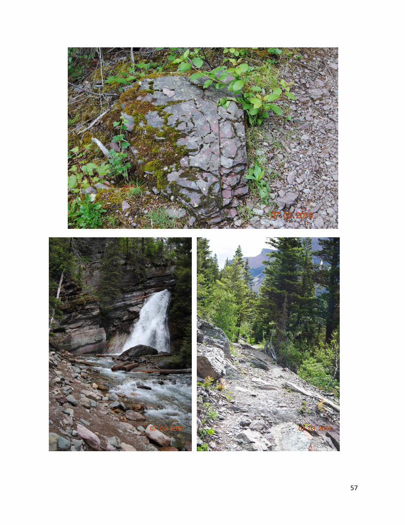
Friday, July 2 Rainy, rainy morning so didn’t get off very early for the drive around Glacier to get to St Mary’s CG. Stopped and took photos of a nice waterfall and the memorial at top of pass but really not good photo weather (still).
Saw sign that said I couldn’t drive the ‘shortcut’ road to St Marys if vehicle > 21 feet so there went my plan to visit Two Medicine area which was supposed to

55
have good nature walk. So I got to St Mary’s CG fairly early—at least it was on the sunny side of the mountains! I went to visitor center and then sat outside and did some painting during the afternoon. The CG had a trail to the visitor center where the shuttles left = about ¼ mile between CG and Visitor Center but that depends on where your campsite is located – I figured it was about ½ mile for me – level and mostly paved. So I decided not to move RV the next day for my shuttle adventure on the east side. If the weather was nice, I planned to “re-do” the Logan Pass to Avalanche Creek portion of the trip from Thursday.
Saturday, July 3 Weather seemed pretty nice in St Marys but I could see the storm clouds over the higher mountains. So I got things ready and took shuttle up to Sunpoint where I started my hike toward St Mary’s Falls. It was a lovely hike – unfortunately, bad exposure on most of the photos I took. I went first to Baring Falls which seemed at least a mile of careful walking (including side trips). Then I thought about things, starting up one trail and changing mind. It also started to rain so I got to try out the new rain coat (worked well). With the rain, I opted for the nearest shuttle stop which was Sun Gorge. It turned out to be delightful and right off the highway. I had to wait about 10 min for shuttle and road it all the way up to Logan Pass. The weather at the top was even worse than it had been on July 1 (add rain to the wind, cold and fog) so there was no point in going with original plan! So I didn’t even get off the bus! Road back down to the Visitor Center – I think it was about the same 5 hours as the west-side shuttle but the hike was longer and, while there was some construction, there were no 30+ minute delays. Weather

56
remained uncertain so no sitting out enjoying the sun – in fact, it was incredibly windy (which is apparently very common there).
57

58

59
Sunday July 4 I stopped by visitor center to check weather forecast (rain likely) and asked the shuttle driver how it was on top (fogged in). So I decided to visit the Many Glaciers area which I had intended to do on the way to Waterton. I also learned that the 21 foot length prohibition only applied to about 2 miles of the shortcut highway so I could go to Two Medicine area through East Glacier (it adds a lot of miles but the weather was certainly sunnier on the prairie as compared to the peaks). So that’s what I did – drove north first to Many Glaciers (it was pretty cloudy so not too many decent photos) and the nature hike turned out to be a multiple mile hike around the lake there. So I skipped the hike and took a state highway (464?) back to Browning. This was a much better road than the Highway 89 to St Marys and it also gave a wonderful panoramic view of the horizon to horizon front range (much different than the view from the other highway). I liked Two Medicine a lot although clouds interfered with the exposures on some of my photos. There were some teepee like peaks around the lake and then the Running Eagle Falls hike was really special – one of my favorites so far. We got back to the St Mary’s CG (where it was raining too) rather late, maybe 6 pm but it was probably a better day than I would have had on the shuttle. I figured I could still do the shuttle to Logan Pass on Monday if the weather was more promising. I was tired and went to bed about 10PM (which is before dark up here at this time of year). Some loud noises woke me (thought someone was pounding on my door) and Franny was in a panic. It was of course the fireworks and I had a nice view from the back window above the bed – although rather at a distance. The only problem was Franny trying to crawl under me or whatever and distracting me from oohing and aahing over the fireworks.
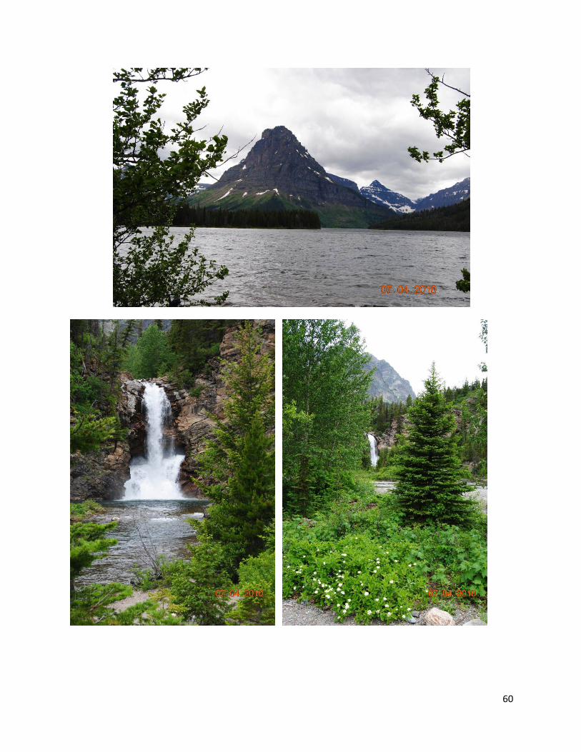
60

61
Monday, July 5 Well, the weather was not better – about the same forecast as Sunday and I could see the clouds over the higher peaks. I did drive up as far as permitted along Lake St Marys and got a few nice photos before departing for Waterton. The drive up Chief Mountain highway was one of the best of the trip (although not many photos turned out well).
See next page
When I got to Waterton, the storm clouds were very dark to the south. They were having a free shuttle to take folks to Red Rock Canyon which I’d never done before. So after resting up awhile in the sunny campsite, I got ready and caught the 3 pm shuttle. By this time, Waterton was looking sunny and the north where we headed was extremely stormy with rain most of the way. However, the trail head was sunny so we all got off the shuttle and commenced the hike. I reminded me of Malad Canyon in Jasper but with just 3 bridges rather than 7. And the canyon was much prettier with a red mudstone rock interleaved with occasional lighter strata. The paved trail was on both sides of the canyon and I was on my way back down between bridge 3 and 2 when the clouds were getting bad again with thunder making it a bit scary. I stood under the bridge to put camera in fanny pack and get out the rain coat. It was raining hard by the time I got to the shelter near the shuttle stop. There must have been 25 or 30 of us in the cabin (one of those like in Jasper with a wood stove and two picnic tables. When the shuttle arrived it was only a 12 or 15 passenger van (smaller than the one I had ridden out to the canyon). So I was lucky to get a seat and got back to Wateron townsite CG about 5 pm. Since it was getting ready to rain, the dogs got a short walk and I downloaded photos from Nikon camera and set its battery to charge (since I hope to do the lake cruise tomorrow). Eventually, I tore myself away from the laptop and took the dogs for a misty walk along the lake short – they were very excited about the plethora of ground squirrel holes! Back in the rig, I decided to catch diary up-to-date and time flies so it is 9 PM as I finish and I haven’t had supper!

62
Between St Mary’s and Canadian Border toward Waterton

63
Tuesday, July 6

64
It is now a week later (since I wrote the previous section) and I’m getting tired of spending ALL my time on the computer when I have occasion to have electricity! I spent about 4 hours straight on going through emails today and downloading transactions and paying bills, etc. while at Fairmont Hot Springs in Montana (not near as nice as the BC version).
Okay, on July 6 I was thinking about doing the Waterton Boat tour but the price was pretty stiff (something like $40 for the 2 hours) and the clouds were building up. I hadn’t slept well (too much walking = ankle/foot pain that keeps me from sleeping so slept pretty late). I walked the dogs over to Cameron Falls, in the Waterton townsite, washed my hair, etc. By then, we had missed the 10 AM boat tour and the 1 PM tour would not have gotten back until 3 pm. [“Funny” aside, the supposed dumpstation in Wateron was a hole in the middle of a street without rinse water or fresh water, etc. I To use it, I’d be blocking the entire street! So I was glad I hadn’t showered inside the rig!) Given weather, I decided to do the Head Smashed in Buffalo Jump museum instead – since I was probably as close as I’d ever be to this attraction highly recommended by Marcia Niles. On the way north, I drove through the bison paddock and was just about done with the drive thinking that I couldn’t even spot wild animals when they put them in a pasture for me! But I finally found a small group of about 5 adult and 3 calves.

65
Then on north and east -- It was a longish drive, getting further and further from the mountains. I probably arrived about 1 PM and discovered that it was an incredible 5-level museum, not counting the cliff top viewing of where the stampedes occurred. The site has been used for about 10,000 years although in one time slot it went unused for about a thousand years for no none reason. The museum included a video reconstructing the tedious process by which the drives were set up (days before horses arrived). I think I was in the museum about 3 hours! Then it was back west on the Crowsnest Highway. There is some interesting sites along the way including world’s biggest truck, Frank slide – a horrible rock slide area that wiped out a small town and killed lots of people. We took a break at a historic colliery (coal processing plant) – spent lots more time than I would have otherwise trying to follow signs to washrooms (as they call them in Canada) but finally concluded, the washrooms were for guided tours only and didn’t exist for self-tours. It was getting pretty late as we approached Fernie – I had stayed at Mt Fernie provincial park before and thought it was east of town so I was a bit worried but did find in on the west side of town – very nice, in the woods, very level, big campsite. Probably got there about 6:30 pm.
Wed. July 7 I was directed to a dump station east of Fernie and used it. I had been thinking about whether to take side trip to Fairmont hot springs. Decided to try the Montana version instead as part of trip homeward. So I headed west over the pass and past the amazing rock slide that wiped out a whole town. I also stopped to tour an old smelting plant along the highway then dropped south toward Montana again. All day I worried about getting fuel but I made it all the way across the border -- but I must have had less than 3 gallons left (out of my 50 gallon tank) when I filled up in Eureka MT. In other words, I did not buy any fuel in Canada – it would have been over $4 per gallon and I’ve been paying less than $3. After getting fueled up and using dump station at Rexford Bench park, I headed south along Highway 37 toward Libby Montana. The route along Lake Koocanusa is very scenic and a good road without much traffic. I stopped by several campgrounds to check them out and then the visitor center at the Libby Dam.

66
The visitor center at the dam was very nice and I ended up camping about 10 m north of the dam on the west side of the lake (main road goes down the east side and yes it is quite scenic). I think the name was McGillvray and there was a boat ramp but the campground was a long way from the marina and had no lake view. It did have flush toilets. The weather was definitely on the warm side – into the upper 80s. So far the long walk in the evening, I decided to walk to the boat ramp to get a lake view. And we walked and walked and walked – finally came to a couple of group picnic area and could sort of see an “out of the water” sandy beach (this reservoir is the first I’ve seen the whole trip that wasn’t full to the brim – this one was down 25 feet so it was about like Dworshak with a whitish bathtub ring all around the lake and, of course, all the beach features useless!). At one of the picnic areas, there was a trail marker and it seemed likely it went to the campground. Since I had no bear spray with me, it was a bit nerve racking but my guess was right and we did end up back in the campground probably 9 PM which is still light but close to sundown. The next morning we DROVE to the boat ramp and it was maybe a quarter mile further than we’d walked. I’m pretty sure the name of the recreation area and lake is a “made up” word that includes a bit of Kootenay (the dammed river) plus Canada and USA since it was a joint project and the reservoir extends way up into Canada.

67
July 8, Thursday
The next morning, I made use of some of the tourist material I had picked up at the dam visitor center and headed to Libby (a few miles south of the dam). To the east of Libby is the Kootenai river falls with a swinging bridge and trails to explore. Dogs were allowed but mine were making a stink about every dog we met so I put them back in the RV to wait for me. I assumed the swinging bridge would give a nice view of the falls but it was an either/or “t” trail. First, one walked through a nice forest on paved trail to a lookout point where one could see a tiny bit of the falls. (That’s as far as I got with the dogs). Then the trail went down steeply to a sturdy foot bridge over the railroad tracks – with probably 3 or 4 stories to descend on the other side. A short distance north was the sign with swinging bridge to left and falls to the right. I did the falls first, glad I had gotten my walking stick when I took the dogs back to the RV. The falls were spectacular, a large river tumbling down maybe 40 feet or so in several cataracts.

68
Then I went back and did the swinging bridge trail (lots of other hikers around, some who encouraged me to do it but warned it was a round trail). So I made my way carefully up and down a loooong way to finally see the bridge. And you had to climb another flight of steps to get to the bridge – sign said 5 people at a time so it took a while to get across. The bridge is pretty narrow, not much passing room. Then another flight of stairs to get down for a short walk to cliff edge for a view of the falls at a distance. This was another hot day and what I mostly wished was that I had brought WATER with me. There were so many people on the trail (and what with the narrowness of the bridge and the 5 person limit) there was a bottleneck getting a turn to get back across the river. I think I waited 30 minutes (at least it seemed that long) for a turn because the newcomers ignored those of us waiting on the other side! But eventually a hot tired thirsty woman made it to the RV and drank a bunch of water and had some lunch.

69
So I continued west, almost to Idaho, to do the “Yaak Loop” which had been recommended. I’m not sure I did what they intended, though. The first stop was Yaak Falls, not as impressive as Kootenai Falls but it is a smaller river and not so green in color. Yaak was hardly a town but I checked out several campgrounds in the area and liked none any better than those in the Koocanusa recreation area – none had dump stations, for one thing. So I headed toward Rexford for 2 reasons: I wanted to do the bridge to nowhere and the bridge was only a short ways from Rexford Bench which had a dump station. This is the part of the loop I probably wasn’t intended to do at all – but unlike Going to the Sun highway in Glacier, there was no one to tell me I couldn’t. I’ll admit to some nervousness at signs saying end of county maintenance then some miles later, not maintained for travel (something like that). Eventually the narrow but paved road reached the top of a range of mountains from which I got occasion views of the other side of the “shearling mountains.” Yes, this was a heavily harvested area with trees of different heights in various patches. Not snowy, craggy peaks but just ‘trees to the top’ mountains like adjoining parts of north Idaho. The road coming down toward Koocanusa was quite windy, Fortunately there was not much traffic but enough to know that the road was open! I made it down to the bridge and, after using the dump station, checked out the campground and found it quite nice. The sites were spread out in the trees and were very wide (so people could park boat

70
and trailer or dingy vehicle along with RV). I was very tired, it was hot, and I paid for one night.
July 9 & 10, Friday and Saturday I was pretty pooped and campgrounds do fill up on weekends so I decided to stay 2 more nights at Rexford Bench. Weather remained hot so RV didn’t cool down enough to sleep until 11 PM or so. Therefore, it was 2 days of sleeping late, reading novels as I moved around to stay in shade. There were plenty of nice trails for dog walking and a very nice flush toilet restroom that seemed to be air conditioned. Why they hadn’t included showers beats me. Signs said that next week, upgrade to spread new asphalt would begin so I bet it would be even nicer if I’m ever in that neck of the woods again.
Sunday, July 11 I thought about taking a different road south but all were out of the way so my first step was to use dump station and then drive back to Eureka for fuel. Then I drove south to Libby and then cut south on another scenic route. Halfway down HWY 56, I stopped for a red cedar walk which was another tourist recommendation for the area. It was an exciting road to get to the Morris grove and I was lucky to be able to park. The cedars were a nice walk (took the dogs and of course they were obnoxious about other dogs) and it was probably 10 degrees cooler in the damp dark forest. The dogs had to wade in the creek and that cooled them off.

71
I then checked out the nearby “Bad Medicine” campground which had very narrow roads with lots of trees right next to pavement. I was part way around one circle of not too promising sites when I heard a strange noise and I was sure I had rubbed against a tree or something. Still not sure what the noise was, but there was no damage. So I continued slowly and carefully around the circle to meet a truck pulling trailer just starting up the narrow road – no way at all to pass. His wife got out and they backed up and were sure to tell me they would had toward the other circle. I figured that was two close calls and that I shouldn’t risk a 3rd piece of bad medicine! Besides it was hot and the air conditioning while driving is better than stopping early. So we drove on down to HWY 200 (another marked scenic) and headed east. I eventually stopped at a forest service campground on Noxon Reservoir (full to brim) which is part of the Clark Fork of the Columbia (which HWY 200 follows past Missoula). I was about to go further when the last site turned out to be an empty pull through! So I pulled through and spent the night. The problem with this campground is that it is surrounded by private property so other than the small campground circle, there was only a small picnic area at the boat launch for dog walking.
Monday July 12

72
Continued east on Hwy 200 and following the Clark Fork River was indeed scenic but it was a terribly windy day so very stressful just keeping rig in my lane! Also remained hot day although the wind kept one a bit cooler – but hold on to your hat! Took a side trip to the National Bison preserve – museum was not much after the head smashed in buffalo jump museum and I was not allowed to drive on most of the sightseeing roads. I did what I could and managed to see two buffalo and two antelope. The grasslands were lovely though with lots of wild flowers. I took the dogs on a nature walk in the picnic area and then headed on.
When Hwy 200 ran into Hwy 93, I went south to the interstate and continued east. I turned off on the Pintlar Scenic route and drove through Philipsburg, a well preserved mining town. But I wasn’t in the mood to shop so continued south. The pleasant country took a turn for the very scenic and the road climbed to some 6000’ which helped the heat problem! I had seen a few snowy peaks from the bison range and there were again snowy peaks in view (probably the Anaconda

73
Range) from Georgetown reservoir – a small lake created by daming a river. The campground was very wooded but I could seen the lake from my site. Given the cooler temperatures, sitting outside and reading was quite pleasant – and of course I had stocked up on “cool foods” at my last grocery shopping trip! In fact, it got too cold to sit out in short and I actually made soup for supper. I haven’t had a dump station since Rexford but Fairmont Hot Springs is very close now and I’ll get the works including electricity and WIFI tomorrow.
Tuesday, July 13
The wind continued but the temperatures dropped a bunch (and not just at higher elevations!). I took some photos of the Georgetown reservoir as we left area this morning there was a picnic area with a peninsula created to assure a quiet water boat ramp. The walk way was not more than 3 feet wide and the wind was blowing so hard that small waves were crashing up over the walkway. With the cold wind, even the dogs were not enthusiastic about getting wet – it was like being on the Oregon coast on a cold day! The road continued south with a loss in
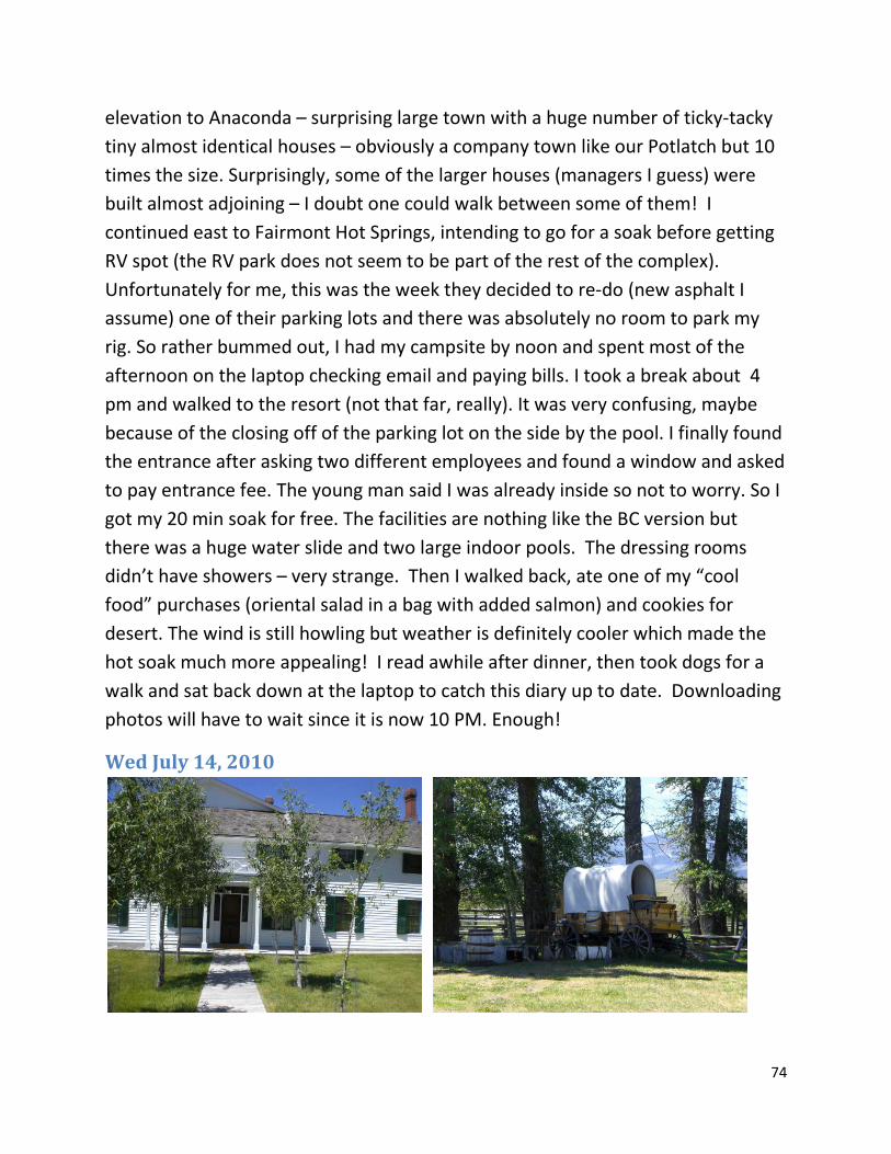
74
elevation to Anaconda – surprising large town with a huge number of ticky-tacky tiny almost identical houses – obviously a company town like our Potlatch but 10 times the size. Surprisingly, some of the larger houses (managers I guess) were built almost adjoining – I doubt one could walk between some of them! I continued east to Fairmont Hot Springs, intending to go for a soak before getting RV spot (the RV park does not seem to be part of the rest of the complex). Unfortunately for me, this was the week they decided to re-do (new asphalt I assume) one of their parking lots and there was absolutely no room to park my rig. So rather bummed out, I had my campsite by noon and spent most of the afternoon on the laptop checking email and paying bills. I took a break about 4 pm and walked to the resort (not that far, really). It was very confusing, maybe because of the closing off of the parking lot on the side by the pool. I finally found the entrance after asking two different employees and found a window and asked to pay entrance fee. The young man said I was already inside so not to worry. So I got my 20 min soak for free. The facilities are nothing like the BC version but there was a huge water slide and two large indoor pools. The dressing rooms didn’t have showers – very strange. Then I walked back, ate one of my “cool food” purchases (oriental salad in a bag with added salmon) and cookies for desert. The wind is still howling but weather is definitely cooler which made the hot soak much more appealing! I read awhile after dinner, then took dogs for a walk and sat back down at the laptop to catch this diary up to date. Downloading photos will have to wait since it is now 10 PM. Enough!
Wed July 14, 2010

75
This was the day I went through Deer Lodge – I’ve heard a lot about it and went to the historic Grant-Kohler ranch. It was an interesting walk and I was able to join a tour of the house. I really enjoyed the barn with lots of different buggies and wagons. I also saw some huge draft horses – they still do some old fashion ranching on this land. The prison is supposed to be another must see (it looks like a castle from the outside) but I figured the ranch was more my speed! I spent the night in the Bozeman MT Wal-Mart parking lot.
July 15, 2010 The next morning headed toward Livingston (backtracking some of the interstate I had seen before – but this time it was not pouring down rain!). There were some beautiful rocky areas between Butte and Livingston but no place to pull over to take photos.
Thurs. July 15 The plan was to do the Mammoth Hot Springs entrance to Yellowstone since I’m not sure I’ve ever been to the park from that direction. I was hoping to see more wild life but that just did not happen except for MANY elk in the township of Mammoth. I stayed the first night in the Mammoth campground which was interestingly built into the side of the hill. The road into the park was along a river and quite pretty. Apparently it is a major migration route for various critters.
Friday, July 16, 2010. The next day I made the top loop and went by Tower Falls which I hadn’t seen the first time – but there sure was a lot of traffic and not much wildlife to see except for a “buffalo jam” along the Yellowstone River. There was water on one side and

76
steep hill on the other and that buffalo figured the highway was the way to go. So we followed this bull at about 5 miles an hour for at least a mile!
I did enjoy seeing an unfrozen Yellowstone Lake but I don’t think the traffic was really worth it. May was definitely a better time to visit! I also did the Norris Geyser Basin which I hadn’t done in May. But it was a lot of driving for not a lot of additional value – I guess I was just getting tired of travelling and ready to get home! There was one really long traffic wait – people obviously getting out to see something. If it had been a BEAR, I would have thought it reasonable. But when I asked a couple of people what they’d been seeing, the answer was “two elk.”

77
I enjoyed a walk across meadows to a small high mountain lake. It was hard to find placed to pull off since the park was so busy – not room for a big rig in many spots! So I enjoyed the walk even though the dogs had to be content with sniffing things within 50 feet of parking area! I always enjoy looking at the wild flowers too.
I spent another night in a Walmart parking lot – this one in Butte. Not a bad place to stay esp. when one needs to BUY some clean clothes (cheap) to avoid having to do laundry before getting home! The drive north from W. Yellowstone was very lovely but there was a lot of traffic as I approached the “city” with folks coming out for the weekend plus the inevitable road construction.
July 17, 2010 – Lucky Me at Bannock Days Now it was time to head home. Fellow tourists had told me that Bannock State Park area was fun place to visit and it was rather on the way home. So I

78
I spent several hours enjoying the festivities at Bannock Days. This town was the original capital of Montana and it is now a state park. Really just a ghost town except for one weekend each summer which I just happened to hit! There was a reenactment of a shoot out involving a famously corrupt sheriff and then a stage coach robbery. All sorts of crafts were on display – I esp. enjoyed the candle making. After leaving the park, I headed north on one of those scenic routes (after asking if it was paved). The route through the Pioneer mountains was really beautiful with several turnoffs and signs describing flora, fauna and history. There was a place to dig for crystals but it took a lot more equipment than I had with me (and the bugs were bad too). I stayed in a very nice campground (Price Creek) – beautiful except for the multitude of bugs which made sitting out not at all pleasant. The lookout pictures were just before the campground. The highway isn’t really numbered but it goes through Polaris and there is pretty much NO towns or development until Wise River (also small).

79
July 20, 2010

80
July 19, 2010. The next day, I continued north toward Wisdom MT. There was a particularly nice nature trail down to a stream side as well as other attractions. However, the road got less pretty further north although I eventually got back to the Big Hole area and then proceeded to touch Idaho before heading north through the Bitterroot Valley. Actually, the valley was not as pretty as in May – snow was melted and I mostly drove and drove. I was planning to stay at the very nice campground near Lolo Pass but even though it was Sunday, everything was full, full, full. It was getting very dark and I was getting very grumpy and tired before I finally found a spot in Wendover CG – where I had to run-in with the “number sign” my second day out back in May! Fortunately, no problems this time around.
July 20, 2010 Home Again, Home Again As I came down the river, I stopped and did the salt-lick trail – I remember doing this trail once before with Becky, Justin and Lindsay on their only visit ever to see me. It is sort of marshy up on top where the warm salty springs are (above the river canyon). They had some nice stepping stones to get across but OF COURSE the dogs wouldn’t walk on the stepping stones. No, they had to wade in the mud (sigh). But I got them cleaned up and we pretty much just drove straight on home, stopping for fuel at the Casino just before Lewiston. The one interesting thing was a land slide that closed traffic for awhile. Rocks were still tumbling down – and I realized the there were guys up on the hill side trying to get the loose stuff to fall so the machines could remove it – not a job for the faint of heart!

81
The End