tendringdistrict historicenvironment ... · iv 3.1.16 heca 16 river stour valley floor ..... 79...
TRANSCRIPT

Tendring DistrictHistoric EnvironmentCharacterisation Project
2008

ii
Front Cover: Iron Age enclosure and field system, St Osyth
iii
Contents
FIGURES ...................................................................................................................................... IX
ABBREVIATIONS................................................................................................................................XIII
ACKNOWLEDGEMENTS....................................................................................................................XIV
TENDRING DISTRICT HISTORIC ENVIRONMENT CHARACTERISATION PROJECT ................... 15
1 INTRODUCTION......................................................................................................... 15
1.1 PURPOSE OF THE PROJECT ............................................................................................ 16
2 THE HISTORIC ENVIRONMENT OF TENDRING DISTRICT.................................... 18
2.1 PALAEOLITHIC AND PLEISTOCENE ................................................................................... 18
2.2 MESOLITHIC .................................................................................................................. 19
2.3 NEOLITHIC..................................................................................................................... 19
2.4 BRONZE AGE................................................................................................................. 21
2.5 IRON AGE ...................................................................................................................... 23
2.6 ROMANO-BRITISH .......................................................................................................... 23
2.7 SAXON .......................................................................................................................... 25
2.8 MEDIEVAL ..................................................................................................................... 26
2.9 POST MEDIEVAL ............................................................................................................ 28
2.10 MODERN ....................................................................................................................... 31
3 CHARACTERISATION OF THE RESOURCE ........................................................... 35
3.1 HISTORIC ENVIRONMENT CHARACTER AREA DESCRIPTIONS............................................. 36
3.1.1 HECA 1 Historic Harwich ........................................................................................... 37
3.1.2 HECA 2 Dovercourt, Harwich and Parkeston ............................................................. 40
3.1.3 HECA 3 Great Oakley area ........................................................................................ 43
3.1.4 HECA 4 Hamford Water .............................................................................................. 46
3.1.5 HECA 5 Frinton and Walton ....................................................................................... 49
3.1.6 HECA 6: South East Tendring Plateau and the Sokens ............................................. 52
3.1.7 HECA 7 Clacton-on-Sea ............................................................................................ 55
3.1.8 HECA 8 Colne Estuary................................................................................................ 58
3.1.9 HECA 9 Brightlingsea Peninsula................................................................................. 61
3.1.10 HECA 10 Brightlingsea Town..................................................................................... 63
3.1.11 HECA 11 St. Osyth and Great Bentley........................................................................ 66
3.1.12 HECA 12 Ardleigh ....................................................................................................... 69
3.1.13 HECA 13 Little Bentley area........................................................................................ 72
3.1.14 HECA 14 Manningtree and Mistley ............................................................................ 74
3.1.15 HECA 15 Stour Estuary Intertidal.............................................................................. 78

iv
3.1.16 HECA 16 River Stour Valley Floor .............................................................................. 79
3.1.17 HECA 17 Elmstead Market, Arlesford and Thorrington ............................................. 82
4 CREATION OF HISTORIC ENVIRONMENT CHARACTER ZONES ........................ 85
4.1 GENERAL BACKGROUND ................................................................................................ 85
4.2 METHODOLOGY ............................................................................................................. 85
4.3 THE SCORING OF THE HISTORIC ENVIRONMENT CHARACTER ZONES ................................ 85
4.3.1 Diversity of historic environment assets ...................................................................... 86
4.3.2 Survival........................................................................................................................ 86
4.3.3 Documentation ............................................................................................................ 87
4.3.4 Group Value Association............................................................................................. 87
4.3.5 Potential....................................................................................................................... 88
4.3.6 Sensitivity to Change................................................................................................... 88
4.3.7 Amenity Value ............................................................................................................. 89
5 HISTORIC ENVIRONMENT CHARACTER ZONE DESCRIPTIONS ........................ 90
HECZ 1.1: HISTORIC CORE OF HARWICH ......................................................................................... 90
HECZ 1.2: POST-MEDIEVAL HARWICH EXPANSION AND THE NAVY YARD ............................................ 92
HECZ 2.1: BATHSIDE AND PARKESTON............................................................................................ 94
HECZ 2.2: TOWER HILL AND BEACON HILL ...................................................................................... 96
HECZ 2.3: DOVERCOURT................................................................................................................ 98
HECZ 2.4: UPPER DOVERCOURT .................................................................................................. 100
HECZ 2.5: DOVERCOURT CARAVAN PARK AND SPORTS GROUND................................................... 101
HECZ 2.6: HARWICH AND DOVERCOURT FORESHORE .................................................................... 102
HECZ 3.1 GREAT OAKLEY, LITTLE OAKLEY AND RAMSEY .............................................................. 104
HECZ 3.2 WIX AREA .................................................................................................................... 106
HECZ 3.3 RAMSEY CREEK FLOODPLAIN ....................................................................................... 108
HECZ 4.1 HAMFORD WATER........................................................................................................ 110
HECZ 4.2 HORSEY ISLAND .......................................................................................................... 112
HECZ 4.3 HAMFORD WATER FORMER MARSHES .......................................................................... 114
HECZ 4.4 BRAMBLE ISLAND ......................................................................................................... 116
HECZ 4.5 THE NAZE ................................................................................................................... 118
HECZ 5.1: WALTON NORTH .......................................................................................................... 121
HECZ 5.2: NAZE MARINE HOLIDAY PARK....................................................................................... 122
HECZ 5.3: HISTORIC WALTON ...................................................................................................... 123
HECZ 5.4: FRINTON CORE............................................................................................................ 124
HECZ 5.5: FRINTON NORTH.......................................................................................................... 126
HECZ 5.6: KIRBY CROSS .............................................................................................................. 127
HECZ 5.7: FRINTON AND WALTON SHORELINE ............................................................................... 128
HECZ 6.1: TENDRING ................................................................................................................... 130
HECZ 6.2: WEELEY AREA ............................................................................................................. 131

v
HECZ 6.3: THE SOKENS ............................................................................................................... 133
HECZ 6.4: GREAT HOLLAND AREA ................................................................................................ 135
HECZ 6.5: LITTLE CLACTON AREA ................................................................................................. 137
HECZ 6.6: HOLLAND BROOK FLOODPLAIN ..................................................................................... 138
HECZ 6.7: HOLLAND HAVEN ......................................................................................................... 140
HECZ 7.1 JAYWICK SOUTH .......................................................................................................... 141
HECZ 7.2: JAYWICK NORTH .......................................................................................................... 143
HECZ 7.3 CLACTON ON SEA ........................................................................................................ 145
HECZ 7.4 GREAT CLACTON ......................................................................................................... 147
HECZ 7.5 HOLLAND ON SEA ........................................................................................................ 148
HECZ 7.6 CLACTON .................................................................................................................... 151
HECZ 7.7 CLACTON NORTH......................................................................................................... 153
HECZ 7.8 CLACTON AIRFIELD ...................................................................................................... 155
HECZ 8.1 ST OSYTH MARSHES ................................................................................................... 157
HECZ 8.2 SEAWICK HOLIDAY VILLAGE ......................................................................................... 159
HECZ 8.3 FORMER MARSHES AT POINT CLEAR BAY ...................................................................... 160
HECZ 8.4 HOWLANDS MARSH...................................................................................................... 162
HECZ 8.5 BRIGHTLINGSEA MARSHES ........................................................................................... 165
HECZ 8.6 COLNE ESTUARY INTER TIDAL ZONE .............................................................................. 166
HECZ 9.1: EASTERN BRIGHTLINGSEA............................................................................................ 169
HECZ 9.2: LAND WEST OF BRIGHTLINGSEA AND MOVERONS PIT..................................................... 171
HECZ 10.1 BRIGHTLINGSEA HIGH STREET..................................................................................... 173
HECZ 10.2 BRIGHTLINGSEA WATERFRONT ................................................................................... 175
HECZ 10.3 SOUTH AND NORTH OF BRIGHTLINGSEA HIGH STREET .................................................. 176
HECZ 10.4 NORTH BRIGHTLINGSEA .............................................................................................. 178
HECZ 11.1: AREA TO THE NORTH OF LITTLE BENTLEY...................................................................... 179
HECZ 11.2: GREAT BENTLEY AREA ................................................................................................. 180
HECZ 11.3: GREAT BENTLEY VILLAGE ............................................................................................. 182
HECZ 11.4: LANDSCAPE SURROUNDING ST OSYTH.......................................................................... 184
HECZ 11.5: ST OSYTH PRIORY AND PARK....................................................................................... 187
HECZ 11.6: HISTORIC CORE OF ST OSYTH ...................................................................................... 189
HECZ 11.7: MODERN ST OSYTH ..................................................................................................... 191
HECZ 11.8: POINT CLEAR .............................................................................................................. 192
HECZ 12.1: ARDLEIGH CROPMARK COMPLEX .................................................................................. 193
HECZ 12.2: ARDLEIGH ................................................................................................................... 195
HECZ 12.3: GREAT BROMLEY......................................................................................................... 197
HECZ 12.4: FOXASH ESTATE .......................................................................................................... 199
HECZ 13.1: LAWFORD HALL ........................................................................................................... 200
HECZ 13.2: BRADFIELD HEATH ....................................................................................................... 202
HECZ 13.3: WRABNESS ................................................................................................................. 204

vi
HECZ 13.4: STOUR WOOD AND COPPERAS WOOD .......................................................................... 205
HECZ 14.1: NEW MISTLEY.............................................................................................................. 207
HECZ 14.2: MISTLEY...................................................................................................................... 208
HECZ 14.3: MISTLEY PARK............................................................................................................. 210
HECZ 14.4: HISTORIC MANNINGTREE.............................................................................................. 211
HECZ 14.5: MANNINGTREE, LAWFORD AND MISTLEY ....................................................................... 213
HECZ 15.1: MANNINGTREE AND MISTLEY STOUR ESTUARY.............................................................. 214
HECZ 15.2: MISTLEY TO PARKESTON INTERTIDAL ............................................................................ 216
HECZ 15.3: BATHSIDE BAY............................................................................................................. 217
HECZ 16.1 STOUR VALLEY PASTURE ............................................................................................. 219
HECZ 16.2 CATTAWADE MARSHES ............................................................................................... 221
HECZ 17.1: ELMSTEAD MARKET AND ALRESFORD ........................................................................... 223
HECZ 17.2: THORRINGTON............................................................................................................. 225
HECZ 17.3: ALRESFORD GRANGE................................................................................................... 227
BIBLIOGRAPHY ................................................................................................................................. 229
APPENDICES ................................................................................................................................... 230
1 HISTORIC ENVIRONMENT CHARACTER AREA METHODOLOGY..................... 230
1.1 CREATION OF HISTORIC LANDSCAPE CHARACTER AREAS .............................................. 230
1.1.1 General Background ................................................................................................. 230
1.1.2 Methodology .............................................................................................................. 231
1.1.3 Outline of Results ...................................................................................................... 232
HLCA 3. EASTERN COLNE MARSHES................................................................................ 232
1.2 CREATION OF URBAN CHARACTER AREAS FOR TENDRING.............................................. 233
1.2.1 General Background ................................................................................................. 233
1.2.2 Method and Approach ............................................................................................... 233
1.2.3 Characterisation and Description .............................................................................. 234
1.2.4 Outline of results........................................................................................................ 234
1.3 CREATION OF ARCHAEOLOGICAL CHARACTER AREAS IN TENDRING................................ 235
1.3.1 General Background ................................................................................................. 235
1.3.2 Approach to the Analysis........................................................................................... 235
1.3.3 Outline of Approach and Methodology...................................................................... 236
1.3.4 Description and Review............................................................................................. 237
1.3.5 Outline of Results ...................................................................................................... 237
ACA 4 RIVER STOUR INTERTIDAL.................................................................................................. 238
1.4 CREATION OF HISTORIC ENVIRONMENT CHARACTER AREAS .......................................... 238
1.4.1 Description................................................................................................................. 239
1.4.2 Results....................................................................................................................... 239

vii
2 HISTORIC LANDSCAPE CHARACTER AREA DESCRIPTIONS .......................... 240
HLCA 1. MANNINGTREE, MISTLEY AND LAWFORD URBAN AREA ............................... 240
HLCA 2. DEDHAM HEATH AREA .......................................................................................... 240
HLCA 3. EASTERN COLNE MARSHES................................................................................ 241
HLCA 4. BRIGHTLINGSEA PENINSULA............................................................................... 242
HLCA 5. ALRESFORD AREA................................................................................................ 242
HLCA 6. ARDLEIGH HEATHS AREA..................................................................................... 243
HLCA 7. TENDRING PLATEAU.............................................................................................. 244
HLCA 8. MARSHES ALONG THE STOUR ESTUARY ......................................................... 245
HLCA 9. HARWICH URBAN AREA........................................................................................ 245
HLCA 10. HAMFORD WATER.................................................................................................. 246
HLCA 11. FRINTON AND WALTON URBAN AREAS ............................................................ 246
HLCA 12. HOLLAND BROOK VALLEY ................................................................................... 247
HLCA 13. ST OSYTH AREA ..................................................................................................... 247
HLCA 14. CLACTON URBAN AREA....................................................................................... 248
HLCA 15. COLNE POINT.......................................................................................................... 248
3 HISTORIC URBAN CHARACTERISATION............................................................. 250
HUCA 1: THE HISTORIC CORE OF HARWICH................................................................................ 250
HUCA 2: HARWICH: WEST OF BEACON HILL................................................................................ 251
HUCA 3: HARWICH QUAYSIDE .................................................................................................... 251
HUCA 4: EASTERN HARWICH (TOWER HILL) ............................................................................... 252
HUCA 5: BATHSIDE.................................................................................................................... 252
HUCA 6: HISTORIC CORE OF UPPER DOVERCOURT..................................................................... 253
HUCA 7: LOWER DOVERCOURT.................................................................................................. 253
HUCA 8: SOUTH AND WEST UPPER DOVERCOURT ...................................................................... 254
HUCA 9: NORTH UPPER DOVERCOURT....................................................................................... 254
HUCA 10: DOVERCOURT CARAVAN PARK ..................................................................................... 254
HUCA 11: CORE OF PARKESTON ................................................................................................. 255
HUCA 12: PARKESTON HINTERLAND............................................................................................. 255
HUCA 13: HISTORIC CORE OF ST. OSYTH .................................................................................... 256
HUCA 14: ST OSYTH EAST .......................................................................................................... 257
HUCA 15: HISTORIC CORE OF MANNINGTREE ............................................................................... 258
HUCA 16: MANNINGTREE SOUTH ................................................................................................. 259
HUCA 17: SOUTH OF STATION ROAD............................................................................................ 260
HUCA 18: TRINITY ROAD ............................................................................................................. 260

viii
HUCA 19: NORTH OF STATION ROAD............................................................................................ 260
HUCA 20: HISTORIC CORE OF LAWFORD ...................................................................................... 261
HUCA 21: LAWFORD EAST ........................................................................................................... 261
HUCA 22: LAWFORD NORTH ........................................................................................................ 262
HUCA 23: HISTORIC CORE OF MISTLEY ........................................................................................ 262
HUCA 24: NEW MISTLEY.............................................................................................................. 263
HUCA 25: MISTLEY INDUSTRIAL................................................................................................... 263
HUCA 26: MISTLEY EAST ............................................................................................................. 264
HUCA 27: HISTORIC CORE OF WALTON ........................................................................................ 265
HUCA 28: WALTON NORTH .......................................................................................................... 266
HUCA 29: WALTON WEST............................................................................................................ 266
HUCA 30: CORE OF FRINTON ....................................................................................................... 267
HUCA 31: HISTORIC CORE OF KIRBY CROSS ................................................................................ 267
HUCA 32: FRINTON NORTH.......................................................................................................... 268
HUCA 33: HISTORIC CORE OF CLACTON ON SEA .......................................................................... 269
HUCA 34: CLACTON .................................................................................................................... 270
HUCA 35: HOLLAND ON SEA ........................................................................................................ 270
HUCA 36: GREAT CLACTON ......................................................................................................... 271
HUCA 37: CLACTON NORTH......................................................................................................... 271
HUCA 38: GORSE LANE ESTATE .................................................................................................. 272
HUCA 39: HIGHFIELDS ................................................................................................................. 272
HUCA 40: HISTORIC CORE OF BRIGHTLINGSEA ............................................................................. 273
HUCA 41: AREA TO THE SOUTH OF THE HIGH STREET ................................................................... 274
HUCA 42: QUAYSIDE ................................................................................................................... 274
HUCA 43: AREA TO THE NORTH OF THE HIGH STREET ................................................................... 274
HUCA 44: BRIGHTLINGSEA NORTH AND WEST .............................................................................. 275
HUCA 45: WESTERN PROMENADE................................................................................................ 276
HUCA 46: JAYWICK SOUTH (BROOKLANDS, GRASSLANDS AND JAYWICK VILLAGE).......................... 276
HUCA 47: JAYWICK NORTH (TUDOR ESTATE) ............................................................................... 277
HUCA 48: SACKETT GROVE CARAVAN PARK................................................................................. 277
HUCA 49: TOWER CARAVAN PARK ............................................................................................... 278
4 ARCHAEOLOGICAL CHARACTER AREAS .......................................................... 279
ACA 1 – ARDLEIGH........................................................................................................................... 279
ACA 2 SOUTH OF LAWFORD........................................................................................................... 280
ACA 4 RIVER STOUR INTERTIDAL.................................................................................................. 282
ACA 5 GREAT OAKLEY .................................................................................................................... 283
ACA 6 HAMFORD WATER ................................................................................................................ 284
ACA 7 THORPE-LE-SOKEN.............................................................................................................. 285

ix
ACA 8 WIX ................................................................................................................................... 286
ACA 9 LITTLE CLACTON.................................................................................................................. 286
ACA 10 BRIGHTLINGSEA AND GREAT BENTLEY ........................................................................ 287
ACA 11 ALRESFORD ........................................................................................................................ 288
ACA 12 CLACTON-ON-SEA.............................................................................................................. 288
ACA 13 HARWICH AND DOVERCOURT.......................................................................................... 289
Glossary of Terms used………………………………………………………………………………………290

x
Figures
Fig.1 Palaeolithic wooden spear tip from Clacton
Fig.2 Cropmark of a Neolithic Henge-like ring ditch, Lawford
Fig. 3 Bronze Age Ardleigh style Bucket Urn from Lodge Farm, St Osyth
Fig.4 Computer reconstruction of Roman salt working and the creation of Red
Hills.
Fig. 5 Cropmark of a medieval windmill, Little Bentley
Fig.6 St Osyth Priory. The Abbot’s Tower on the right was built by Lord
D’Arcy c.1553
Fig. 7 Reconstruction painting of the Harwich Redoubt
Fig.8 Walton Pier, Walton-on-the-Naze
Fig.9 Tendring Historic Environment Character Areas
Fig. 11 The historic town of Harwich showing the grid like street layout with the
church of St Nicolas in the foreground and the harbour in the distance.
Fig. 12 HECA 2 Dovercourt, Harwich, Parkeston
Fig.13 HECA 3 Great Oakley area
Fig. 14 The Post mill at Ramsey, originally built in Woodbridge, Suffolk, was
one of the last two windmills to operate in Essex
Fig.15 HECA 4 Hamford Water
Fig. 16 The 19th century Lime Kiln at Beaumont Quay
Fig. 17 HECA 5 Frinton and Walton
Fig. 18 HECA 6 South East Tendring Plateau and the Sokens
Fig. 19 Cropmarks of Bronze Age ring ditches, Little Clacton
Fig. 20 HECA 7 Clacton-on-Sea
Fig. 21 Restored Martello Tower, Clacton
Fig.22 HECA 8 Colne Estuary
Fig. 23 HECA 9 Brightlingsea Peninsula
Fig.24 HECA 10 Brightlingsea
Fig. 25 Historic Waterfront, Brightlingsea
Fig.26 HECA 11 St.Osyth and Great Bentley
Fig.27 HECA 12 Ardleigh
Fig.28 HECA 13 Little Bentley area
Fig.29 HECA 14 Manningtree and Mistley

xi
Fig. 30 Mistley Maltings
Fig. 31 HECA 15 Stour Estuary Intertidal
Fig. 32 HECA 16 River Stour Valley Floor
Fig. 33 Historic Grazing Marsh in the valley of the River Stour, Lawford
Fig. 34 HECA 17 Elmstead Market, Arlesford and Thorrington
Fig. 35 Historic Environment Character Zones
Fig.36 The 17th century Harwich Treadwheel Crane, relocated from the Naval
dockyard
Fig. 37 The Harwich Redoubt
Fig. 38 The 19th century Lower Lighthouse at Dovercourt
Fig. 39 18th century timber-framed weather-boarded 3 bay barn, Great Oakley
Fig. 40 Hulk of a spritsail barge, Landermere Creek
Fig. 41 View from The Naze tower of former marshland (middle distance) of
Walton Hall, with Hamford Water byond.
Fig. 42 Aerial view of the 20th century explosives Factory on Bramble Island
Fig. 43 The Naze Tower was built in the 18th century as an aid to navigation
Fig. 44 Modern movement house on the Frinton Park Estate, Frinton
Fig. 45 Sea front, Walton-on-the-Naze
Fig. 46 The High Street, Thorpe-le-Soken
Fig. 47 Grazing pasture in the floodplain of the Holland Brook
Fig. 48 Buick Avenue, Grasslands Estate, Jaywick
Fig. 49 Clacton Pier
Fig. 50 Earthwork remains of the medieval church, Holland-on-Sea
Fig. 51 Martello Tower, Clacton
Fig. 52 Chalets in Seawick Holiday Village
Fig. 53 Raised causeway, Howlands Marsh
Fig. 54 Parallel lines of timber posts from a former jetty at Colne Point
Fig. 55 Bronze Age Ring Ditch Cemetery, Brightlingsea
Fig. 56 15th century Jacobes Hall, Brightlingsea High Street
Fig. 57 Field boundary of pollarded oaks
Fig. 58 St Cleres Hall, St Osyth
Fig. 59 East wall of the Dorter Range, St Osyth Priory. Remodelled in the 16th
century by Lord D’Arcy
Fig. 60 Reconstruction painting of the Bronze Age landscape at Ardleigh

xii
Fig. 61 14/15th century Church of St George, Great Bromley
Fig. 62 Bronze Age Round Barrow, Lawford
Fig. 63 Wrabness Church Bell-Cage
Fig. 64 The Mistley towers are all that remain of the church designed by the
architect Robert Adam.
Fig. 65 Manningtree High Street
Fig. 66 Beach houses within the inter-tidal zone at Wrabness Point
Fig. 67 Scheduled mulit-period cropmark complex at Lawford
Fig. 68 Historic grazing marsh, Cattawade Marshes
Fig. 69 The 19th century timber-framed tide mill at Thorrington
Fig. 70 Historic Landscape Character Areas
Fig. 71 Harwich, Dovercourt, Parkeston Historic Urban Character Areas
Fig. 72 St Osyth Historic Urban Character Areas
Fig. 73 Lawford, Manningtree and Mistley Historic Urban Character Areas
Fig. 74 Frinton and Walton Historic Urban Character Areas
Fig. 75 Clacton Historic Urban Character Areas
Fig. 76 Brightlingsea Historic Urban Character Areas
Fig. 77 Jaywich Historic Urban Character Areas
Fig. 78 Archaeological Character Areas
All maps in this document have been reproduced by permission of Ordnance
Survey® on behalf of the Controller of Her Majesty's Stationery Office
© Crown Copyright. Licence number LA100019602

xiii
Abbreviations
ACA Archaeological Character Area
CBA Chris Blandford Associates
ECC Essex County Council
GHQ General Headquarters
GIS Geographical Information system
HECA Historic Environment Character Area
HECZ Historic Environment Character Zone
HER Historic Environment Record
HLC Historic Landscape Characterisation
HLCA Historic Landscape Character Area
HUCA Historic Urban Character Area
NMP National Mapping Programme
OS Ordnance Survey
PPG 16 Planning Policy Guidance Note 16 Archaeology and Planning
VDS Village Design Statement

xiv
Acknowledgements
Thanks are due to Malcolm Inxster of Tendring District Council for commissioning,
encouragement, discussion and comment during the course of the project and also to
to Phil Hornby for comment on the first draft. The Tendring District Historic
Environment Characterisation Project report was prepared by Essex County Council
Historic Environment Branch. The project team comprised Nigel Brown, Pat Connell,
Adam Garwood, Adrian Gascoyne, Richard Havis, Maria Medlycott and Teresa
O’Connor.

15
Tendring District Historic Environment Characterisation Project
1 Introduction
The historic environment is a central resource for modern life. It has a powerful
influence on peoples’ sense of identity and civic pride. Its enduring physical presence
contributes significantly to the character and ‘sense of place’ of rural and urban
environments. In Tendring District this resource is rich, complex and irreplaceable. It
has developed through a history of human activity that spans many thousands of years.
Some of the resource lies hidden and often unrecognised beneath the ground in the
form of archaeological deposits. Other elements, such as the area’s historic landscape,
are a highly visible record of millennia of agriculture, industry and commerce and now
form an integral aspect of peoples’ daily lives. The ‘built’ part of the historic environment
is equally rich, with towns, villages and hamlets.
As a fundamental aspect of the District’s environmental infrastructure the historic
environment has a major role to play in Tendring’s future. At the same time it is
sensitive to change and it needs to be properly understood before change is planned in
order to ensure proper management and conservation so that the historic environment
can make its full contribution to shaping sustainable communities.
It is important that the many opportunities for the enhancement of the historic
environment are realised and that adverse impacts associated with development are
minimised so as to avoid unnecessary degradation. The historic environment lends
character to places and provides a positive template for new development. It can play a
key role in creating a ‘sense of place’ and identities as new communities are created
and existing ones enhanced.
The Tendring Historic Environment Characterisation project is designed along similar
lines to that of the Thames Gateway Characterisation report produced by Chris
Blandford Associates (2004) on behalf of English Heritage, Essex County Council, and
Kent County Council, although on a more detailed level. A number of Councils across
Essex have now had Historic Environment Characterisation projects completed
including Rochford, Chelmsford, Basildon, Castle Point and Thurrock, with further
16
reports underway for Colchester and Uttlesford. The characterisation work for Tendring
has been undertaken using the methodology refined during the previous projects. The
Characterisation work is intended to inform the creation of the Local Development
Framework, but should also be useful for a range of other purposes.
The Historic Environment has been assessed using character assessments of the
urban, landscape and archaeological resource of Tendring. The results of these studies
were then combined to create large Historic Environment Character Areas.
The Historic Environment Character Areas are broken down into more specific and
more detailed Historic Environment Character Zones which are more suitable for
informing strategic planning, and master planning activity within the District.
There are 20 Conservation Areas within the district and Conservation Area Appraisals
have been written. These cover all or much of the historic cores of the larger
settlements such as Harwich and Frinton and also a number of the historic villages.
1.1 Purpose of the project
This project has been developed to primarily serve as a tool for Tendring District to use
in the creation of the Local Development Framework. The report reveals the sensitivity,
diversity and value of the historic environment resource within the District. The report
should facilitate the development of positive approaches to the integration of historic
environment objectives into spatial planning for the District.
In addition to this primary purpose there are a range of other potential benefits:
Provide the opportunity to safeguard and enhance the historic environment as
an integrated part of development within Tendring District.
The report provides the starting point for identifying opportunities for the integration of
historic environment objectives within action plans for major development proposals but
also offers a means by which conservation and management of the historic environment
can be pursued by means outside the traditional planning system.

17
The report will allow planners, with support from specialist advisors, to integrate the
protection, promotion and management of the historic environment assets both within
Local Development Documents and Master Plans for developments.
Provide Guidance to Planners at the early stages of development proposals
The report will provide planners with information on the historic environment covering
the whole District. This can be used at an early stage for identifying the Historic
Environment elements which will be affected and lead to highlighting the need for
informed conservation or enhancement, and effective communication and co-ordination
between appropriate services.
Provide a means for local communities to engage with their historic
environment.
The report may provide a means of engaging the wider public with the historic
environment, for example during the creation of Village Design Statements (VDS).

18
2 The Historic Environment of Tendring District
2.1 Palaeolithic and Pleistocene
Tendring District, and in particular the southern coastal area from Clacton to Jaywick is
known to contain Palaeolithic deposits of international importance.
For a long period of time prior to around 450,000 years BP, the River Thames flowed
not in its present position but across north Essex and into Suffolk. At the same time, the
River Medway flowed north to join the Thames in the region of modern Clacton. These
rivers bore little resemblance to those we see now. Being larger and more powerful and
heavily braided they deposited the large areas of sands and gravels (the Kesgrave) that
cover much of this part of Essex. About 450,000 years BP, the Anglian ice sheet moving
south diverted the course of these two rivers to approximately their current position.
Over 200 Palaeolithic flint tools known as ‘handaxes’ were recovered during mineral
extraction at the Gants Pit quarry in Dovercourt, the largest assemblage ever recovered
in Essex. The deposits in the Clacton area are particularly significant, they have
produced a range of flint artefacts and the tip of a wooden spear, the oldest wooden
artefact ever recovered from Britain. This site has given the name ‘Clactonian’ to an
industry of European flint tool manufacture that dates to 300,000–200,000 years ago;
these were made by Homo Erectus rather than modern humans. In addition these
deposits have proved to be rich in palaeo-environmental remains, including pollen, plant
macrofossils, molluscs, small mammals and much larger animals including horse, red
deer, bison, rhinoceros, giant beaver, lion and straight tusked elephant.
Fig. 1 Palaeolithic wooden spear tip from Clacton
19
2.2 Mesolithic
The Mesolithic period is characterised by a trend of rising sea levels associated with
glacial ice melt and the appearance of new tool technologies and is generally accepted
to begin around 11,000 years BC and end around 5000 years BC. Sporadic finds of
Mesolithic material are spread across the district and attest to the presence of groups of
people whose lifestyle was transient and based on an economy of hunting a variety of
wild game. Marine and freshwater fishing is also likely to have been important
dependant on location and time of year. Lower sea levels resulted in large areas of the
North Sea being dry land throughout much of the Mesolithic period. This is clearly
demonstrated by frequent finds of bone and teeth from large animals such as
mammoths and occasional artefacts dredged up from the sea floor or caught in fishing
nets off the Tendring coast.
Significant collections of Mesolithic flintwork are known from the coastline around
Walton on the Naze indicating at least seasonal occupation. These consist mainly of
microliths (small pieces of worked flint used in composite tools) which have eroded from
exposed ancient land surfaces. This microlith technology is typical of the Mesolithic
period. Recognisable within these collections are examples of microliths which can be
attributed to both the early and late Mesolithic, indicating the attractiveness of the area
throughout the period.
2.3 Neolithic
After around 4000BC, the gradual introduction of the cultivation of crops, the
domestication of animals, the introduction of pottery and new flint technologies, marks
the beginning of more settled societies and the start of the Neolithic period. Evidence for
Neolithic activity is abundant across Tendring District with a wide variety of sites and
monuments known.
Cropmark evidence is suggestive of a range of monuments within the Tendring area
including some major Neolithic monuments, such as the St. Osyth causewayed
enclosure and possible cursus, and several long enclosures and mortuary enclosures.
The causewayed enclosure at St Osyth, a roughly circular monument defined by a
number of elongated pits and the cursus, a form of processional way, may form part of

20
an important Neolithic ceremonial landscape. The St Osyth site has been extensively
excavated, and produced a large assemblage of flintwork and decorated Early Neolithic
Pottery. A range of radiocarbon dates from the site indicate that the initial phase of
activity lasted for perhaps just a single generation in the 4th millennium BC. The
cropmark long and mortuary enclosures are related to Neolithic funerary practices. A
ring-ditch excavated at Brightlingsea contained a centrally placed cremation burial
covered by a highly decorated bowl. The surrounding ditch, which had been recut a
number of times, perhaps indicating a protracted period of use yielded a large quantity
of early Neolithic pottery. The pottery from Brightlingsea together with that from St
Osyth mean that Tendring has produced one of the largest collections of early Neolithic
ceramics of anywhere in the East of England.
Fig.2 Cropmark of a Neolithic Henge-like ring ditch, Lawford

21
During the Neolithic the sea level was still considerably lower than it is today; as a result
large areas now within the intertidal zone were then dryland. In a number of places
around the Tendring coast Neolithic settlements sites are preserved within the intertidal
zone. Pioneering investigations of a number of sites off Clacton and Stone Point,
Walton, in the 1930s, resulted in one of the first multidisciplinary investigations of
archaeological sites in England, and placed Tendring at the heart of our understanding
of coastal archaeology. Similar Neolithic sites have been investigated more recently off
Dovercourt.
Many of these intertidal sites produced Late Neolithic occupation often with a type of
highly decorated pottery known as Grooved Ware, one of the substyles of which is
named after Clacton. One of the largest assemblages of Grooved Ware in The East of
England was recovered during the excavation of a Late Neolithic midden surrounded by
a ring-ditch at Lawford in the 1970s.
2.4 Bronze Age
Evidence of the Bronze Age, spanning c.2000 – 750BC is particularly apparent within
Tendring. The early Bronze Age is represented by numerous finds of Beaker pottery not
only from the coastline but from further inland with the discovery of a beaker burial at
Ardleigh containing a near complete vessel. Extensive excavations near St. Osyth
identified a pond barrow and a number of distinctive collared urns typical of the period.
Radiocarbon dating of the cremated bone contained within these urns places them in
the Early Bronze Age.
Well known and important are the Middle Bronze Age cremation cemeteries at Ardleigh,
Brightlingsea and Little Bromley. Dating for the most part from the middle Bronze Age,
these consist of clusters of ring ditches (the ploughed out remains of a once upstanding
barrow) with frequent cremations placed between the barrows. The cremations are
often contained within large straight sided Bucket Urns displaying elaborate decoration.
Both the form of the pottery and the funerary tradition displayed at these sites is
distinctive of the area and largely confined to north east Essex. These cemeteries with
their many barrows would have been important landmarks in the middle Bronze Age
landscape. Excavation at these cemeteries has yielded important assemblages of this
locally distinctive and often almost complete Bronze Age pottery. A large number of

22
other smaller clusters of ring ditches are also known from cropmarks from across the
District and more have recently been excavated at Lodge Farm, St Osyth. Bronze Age
burials have also recently been identified eroding out of the cliffs north of Walton which
at the time of deposition would have been some distance inland.
Fig. 3 Bronze Age Bucket Urn from Ardleigh
Apart from the cemeteries no other major Bronze Age monuments have as yet been
identified. By the later Bronze Age (c1000BC) it is probable that an agricultural economy
was fully developed within a landscape of small farms and settlements.
Given the probable importance and value of bronze itself in the Bronze Age, the relative
paucity of metalwork finds from the District is unsurprising. No doubt the metal would
have been both scarce and well curated. Nonetheless, occasional finds of middle
Bronze Age palstaves (a type of axe) have been found in the north of the district and a
small dispersed hoard of four palstaves have been found at Great Bromley.
Interestingly, one of the four pieces belongs to an earlier phase and perhaps reinforces

23
the idea of a well looked after resource. Further, later Bronze Age axe hoards are
known from south of Harwich and chance finds of socketed axes of similar date have
been made in the area around Elmstead Market.
2.5 Iron Age
Early Iron Age pottery has been recovered from a number of sites in the District.
Several Middle Iron Age settlements are known including those at Ardleigh and Lodge
Farm, St Osyth. Excavations at Ardleigh identified one substantial Middle Iron Age
roundhouse and other evidence for domestic occupation set amongst an extensive field
system. Late Iron Age cremation burials indicate long lived occupation on the site. The
St. Osyth site revealed an extensive settlement of 19 Middle Iron Age roundhouses and
a number of post built structures in an area which had also clearly been important in the
Neolithic and Bronze ages.
The evidence from St Osyth suggests a mixed economy of arable and pastoral farming.
Probable granaries are suggestive of efficient crop production and this pattern was likely
throughout the Tendring District. The salt marsh and wetter areas were probably
extensively used for grazing stock including both sheep and cattle. Many pieces of
loomweight imply that wool production was a significant industry. During the later Iron
Age, it is probable that Camulodunum (near modern Colchester), one of the largest and
most important Iron Age settlements in the country and tribal capital of the Trinovantes,
would have exerted a considerable influence on the economy of the area.
In common with much of the Essex coastline, Tendring displays a number of red hills.
These are the remains of salt production sites that almost certainly started in the Iron
Age and grew in importance in the Roman period.
2.6 Romano-British
Tendring District lies to the east of Colchester, the earliest and one of the most
important towns of Roman Britain. It is likely that Roman Colchester would have had a
significant influence on the economy of the area creating a ready market for many local
products such as grain, meat, fish, shellfish and salt. The estuary of the River Colne
was a major artery serving not only Colchester itself but its hinterland within Tendring. It

24
is probable that the Stour estuary was also important in trade but little is currently known
of Roman settlement in the area.
Although no major urban settlements are known within Tendring, the evidence for life in
the period suggests well established rural and agricultural communities spread across
the district and served by a number of roads radiating out from Colchester. Evidence for
continuity of activity and occupation from the Iron Age into the Roman period is
frequently found at excavated sites such as Ardleigh and St Osyth. At Ardleigh, the
evidence suggests the continuation of a farming community throughout most of the
Roman period. The provision of defensive works for the community probably sometime
around the Boudiccan revolt of AD60 suggests at least a measure of local importance.
Kilns and the discovery of large quantities of ‘wasters’ demonstrate a small scale
industry, producing pottery for local use and probably for sale in the ready market of
Colchester. A small cemetery containing both cremations and later inhumation burials
served the needs of the community. At the St Osyth excavations, elements of a Roman
date field system and contemporary trackway were identified presumably related to an
as yet unidentified settlement.
There is some evidence, including probable villa sites, to suggest Roman occupation at
Brightlingsea which may have had a function as a port on the Colne estuary. Villas,
most likely representing locally important centres of farming and agriculture are found in
a small cluster in the south-west of the district around St. Osyth and the River Colne,
with further known examples at Little Oakley and Dovercourt. At Little Oakley,
excavations have shown that a large timber building was constructed in the early
Roman period but replaced with a ‘corridor villa’ on masonry foundations in the second
century AD. This building was altered at least once more in the 3rd century and a bath
block inserted. In close proximity to the villa were a number of timber buildings and a
fishpond. Although the economy was largely based on farming, the area was also
important for a number of other industries largely based around the coast. Septaria, a
fairly low grade building stone, was mined extensively in the Harwich area, where it
naturally outcrops, and used widely throughout Essex. The production of salt which
probably started in the Late Iron Age continued on an increasing scale and is
demonstrated by the large number of red hills in the coastal zone.

25
Fig.4 Computer reconstruction of Roman salt working and the creation of Red Hills.
2.7 Saxon
Evidence for the early Saxon period in Tendring is sparse. Finds of pottery and
distinctive Saxon buildings at Little Oakley and Dovercourt Roman villas suggest either
reoccupation of previously abandoned sites or possibly Saxon settlers playing an active
role in the work of late Roman villa estates. Recent excavations outside Clacton have
produced a large assemblage of middle Saxon ceramics and a possible post built
structure indicative of domestic occupation. Other finds of early Saxon material occur
throughout the District but are generally rare and occur in small quantities. Part of an
irregular field system has been excavated at Ardleigh.
A seventh century minister church was located at St Osyth, and monastic establishment
is known to have existed there by the 8th century AD. The town is named after Osyth, a
nun and the daughter of a Saxon King, who was reputedly martyred by the Vikings. The
recovery of Ipswich Ware pottery from St. Osyth and Merovingian coins (derived from
France) to the south are indicative of involvement in sea based trading networks. From
around 640AD onwards large land grants were made to St Paul’s cathedral centred on
the royal holdings at St Osyth but also across the Tendring peninsula. Brightlingsea and
Lawford were both locations of important royal vills or manorial land holdings.

26
Further evidence for the period comes from a limited number of finds of Anglo-Saxon
metalwork from the district. Included are a notable late 6th/early 7th century gold sword
pommel cap from Ardleigh parish and a later 10th/11th century lobed sword pommel from
Little Bromley. Other metal finds of the period are mainly coins and strap ends of a wide
range of dates and from across the district.
Evidence for later, Viking settlement is rare in Essex. However, both Thorpe-le-Soken
and Kirby-le-Soken are names of wholly Danish origin which imply at least limited
settlement in the area towards the end of the Saxon period.
2.8 Medieval
The medieval landscape of the Tendring peninsula is one of dispersed settlements,
hamlets and individual farms, with focal points provided by church/hall complexes,
greens and commons; linking the dispersed settlements was an extensive network of
lanes. The settlements were set within a variety of field types: including common-fields
which were mostly sub-divided long before parliamentary enclosure, former deer parks
and demesne fields which were divided and hedged in the late medieval and Tudor
period.
Moated sites, one of which has been excavated at Gutteridge Hall, are a characteristic
medieval site type for Essex, but less common on the Tendring peninsula, with only 19
known examples (including Gutteridge Hall) recorded on the Essex Historic
Environment Record. The majority appear to have been built between 1275 and 1350,
with a revival in the late medieval and early Tudor period.
At Lofts Farm, St. Osyth, medieval features included evidence for a post built structure,
possibly a barn or large shed, a pond and a large number of pits. It is thought that these
belonged to a 13/14th century croft which must have existed in the near vicinity.
27
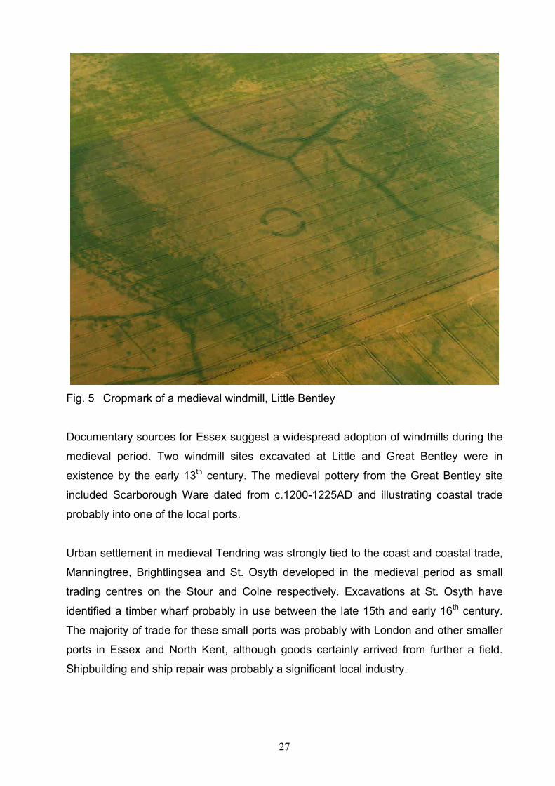
Fig. 5 Cropmark of a medieval windmill, Little Bentley
Documentary sources for Essex suggest a widespread adoption of windmills during the
medieval period. Two windmill sites excavated at Little and Great Bentley were in
existence by the early 13th century. The medieval pottery from the Great Bentley site
included Scarborough Ware dated from c.1200-1225AD and illustrating coastal trade
probably into one of the local ports.
Urban settlement in medieval Tendring was strongly tied to the coast and coastal trade,
Manningtree, Brightlingsea and St. Osyth developed in the medieval period as small
trading centres on the Stour and Colne respectively. Excavations at St. Osyth have
identified a timber wharf probably in use between the late 15th and early 16th century.
The majority of trade for these small ports was probably with London and other smaller
ports in Essex and North Kent, although goods certainly arrived from further a field.
Shipbuilding and ship repair was probably a significant local industry.

28
The main urban centre in Tendring District was undoubtedly Harwich. Founded in the
early 13th century by the Earls of Norfolk as a commercial venture, the town quickly
became one of the major east coast ports with both local and continental trading links. A
market, a Borough Charter and a licence to build town walls were quickly granted.
Trade, fishing and shipbuilding were important in the local economy. Archaeological
deposits are well preserved within the town and large assemblages of Dutch and
French pottery emphasise the importance of the town in medieval continental trade.
St Paul’s Cathedral continued to hold large estates around St Osyth and throughout
Tendring. The Augustinian Priory at St Osyth was established for the Augustinian
Canons shortly after 1120. Elements of the original building survive along with more
remains of 13th century construction. The most imposing feature however and one
which dominates the town to this day is the late 15th century gatehouse presenting a
magnificent façade to the outside world both then and now. After the Dissolution many
of the buildings were pulled down and the priory was granted to Lord D’Arcy who began
a programme of secular rebuilding in the 16th century. In sharp contrast to the rich
establishment at St. Osyth, was the small and poor Benedictine Priory at Wix, founded
in 1123 for Benedictine nuns and dissolved quite early in 1525.
Areas of saltmarsh along the coast continued to constitute an important element of
pastoral farming being extensively utilised for the grazing and rearing of both sheep and
cattle. The medieval period saw the beginning of the reclamation of areas of saltmarsh
with the construction of embankments and ditches with the land being used for grazing,
arable farming or the production of hay.
The coastline, in the north of the area appears to have suffered considerable erosion in
the period with the medieval village of Walton being lost to the sea. St. Paul’s records
include references to ‘lands lost to the sea’ in the vicinity of Walton.
2.9 Post Medieval
Harwich continued to grow in importance throughout the post –medieval period as an
international trading port, although remaining largely within its medieval limits.
Stimulated by a series of wars against the Dutch in the 17th century the town took on an
increasingly important role as a naval base and centre of shipbuilding. An important

29
survival is the timber built Harwich Crane dating from the late 17th century. The town
defences went through typical cycles, of decay during peace, and refortification during
times of conflict or threat of war.
The port at Manningtree thrived throughout the period largely due to its role in the
shipping and transport of the area’s agricultural produce and its growing role in the
malting industry. Previously, the brewing of ale and beer had been predominantly on a
small, domestic scale. The post-medieval and modern periods saw the gradual
introduction of brewing on an increasing scale generating a thriving malting industry in
this part of the county. Brightlingsea continued in existence as a trading port and
smaller wharves existed at Beaumont cum Moze, St Osyth and elsewhere along the
coast.
The Chapman and Andre map of 1777 shows the settlement landscape dominated
largely by dispersed farmsteads and halls closely associated with a network of roads
established since at least the medieval period. Larger settlements included St Osyth,
Thorpe le Soken, Walton, Great Clacton, Great Oakley and Great Bentley. Areas of
heathland, originally common land providing pasture and fuel, are shown surviving from
the medieval period.
The 1530s saw the dissolution of the monasteries nationwide and selling of their
properties and lands into private hands. Wix Priory quickly succumbed followed
eventually by St. Osyth. Although nothing survives above ground at Wix, Lord D’Arcy’s
conversion and re-use of buildings at St. Osyth has ensured that at least some medieval
fabric survives along with a range of later buildings associated with the post medieval
mansion. The priory precinct was eventually landscaped by the 4th Earl of Rochford in
the middle of the 18th century.

30
Fig.6 St Osyth Priory. The Abbot’s Tower on the right was built by Lord D’Arcy
c.1553
Chapman and Andre’s map of 1777 illustrates significant areas of saltmarsh around
Dovercourt, Walton and Jaywick no doubt continued to provide grazing throughout the
period. The saltmarsh was particularly valued for its sheep grazing and for the quality of
the meat and cheese that ensued. Duck decoys, newly introduced within these areas,
provided large numbers of wildfowl for consumption and sale.
The process of reclamation of the natural saltmarsh continued during the post medieval
period, the resulting land providing both important grazing and arable. A good example
is the loss of a large area at St Osyth Marsh south of Wigborough Wick and Jaywick
which was reclaimed in the post-medieval period and is associated with a string of
marsh edge ‘wick’ (dairy) farms.
A further important industry around Walton and Brightlingsea was that of copperas
production. Iron pyrites in the form of ‘copperas stones’ eroded onto the beach were
turned by a complicated process into copperas (Ferrous Sulphate) itself, a valuable
chemical used in the dyeing and tanning industries and also in the production of ink,
sulphuric acid and medicines. Copperas Bay on the Stour Estuary provides a further
indication of the significance of the industry.

31
The 18th century saw the development of spa towns throughout Britain. Richard Rigby
brought in the famous architect Robert Adam to help fulfil his grand vision of turning
Mistley into a spa town. Unfortunately the plans were never fully brought to fruition but
the area acquired much of its Georgian character from this episode and important
architectural survivals include both Mistley Towers and the Swan Fountain.
2.10 Modern
The repeated threat of invasion since the beginning of the 19th century has left indelible
marks on the Tendring coastline. The Martello towers that sit along the coast marked a
shift in strategy in the early 1800s towards defeating a French invasion force before it
could land. Linked with the Martello towers, the Harwich Redoubt, Bathside Bay battery
and Beacon Hill battery are significant Napoleonic era defences emphasising the
strategic importance of the naval facilities at Harwich. Although the Martello towers and
the Bathside Bay battery quickly fell into disuse, the Redoubt and Beacon Hill battery
were modernised and re-armed several times during the later 19th century. The Redoubt
survives in excellent condition today.
Fig. 7 Reconstruction painting of the Harwich Redoubt
Defences dating from WWII, mainly pillboxes, occur frequently along the coast.
Although appearing innocuous today these would have formed a strong defence line in
conjunction with other features such as barbed wire entanglements, minefields and anti
tank defences (a large number of which survive). A searchlight emplacement and 12

32
pounder casemate survive at Harwich. Beacon Hill Battery, now a Scheduled
Monument, was also rearmed with powerful coastal artillery and continued in use for
some time after the war had finished.
At Mistley, an interesting Cold War survivor remains. Built for the Royal Artillery in 1951,
this concrete bunker was bought by the County Council in 1961 as a command centre
and refuge for local government officials in the event of nuclear war.
As its military importance declined, the commercial port of Harwich has expanded
during the modern period with the growth of major international facilities at Parkeston
quay. The expansion of Dovercourt starting in the late 19th century with its development
as a resort and continuing through the 20th century, has effectively linked this area with
the medieval town at Harwich.
Clacton-on-Sea as a town and resort was effectively begun by the efforts of the
Victorian engineer and entrepreneur Peter Bruff. Purchasing a significant amount of
land in 1864 he proceeded to put in place the infrastructure necessary for the
development of a successful seaside resort including the pier in 1871 and the Royal
Hotel in 1872. His efforts proved a success and the town expanded rapidly after the
coming of the railway in 1882 opened the market for ever more people.
The history of modern Walton-on-the-Naze begins with the opening of the Marine Hotel
in 1829 and pier in 1830. Again it was Bruff who was instrumental in the further
development of the town as a resort, both bringing the railway in 1867and building a
pier, an important part of any Victorian seaside resort.
The introduction of the railway and lines to Harwich, Walton and Clacton during the 19th
century promoted not only traditional industrial growth but a whole new industry based
on leisure and recreation. Between the 1st and 2nd edition OS maps, a period of around
15 years, Clacton shows significant growth from Bruff’s small resort to a burgeoning
town. The town at Clacton continued to develop and became the area’s premier
seaside resort throughout the 20th century, overshadowing Walton in terms of size and
popularity.

33
Both Clacton and Walton in particular exhibit specific associated architectural types with
hotels, piers, marine gardens and guest houses prevalent and there are fine examples
of modernist seaside buildings at Clacton. In sharp contrast is Frinton-on-Sea, a later,
largely Edwardian development, very much quieter in nature and displaying a notable
development of Modern Movement style houses at Frinton Park and Cliff Way.
Fig.8 Walton Pier, Walton-on-the-Naze
The 20th century saw further development along the coast with new growth in areas
such as Jaywick and Point Clear and the establishment of a number of holiday caravan
parks.
Situated next to the medieval port at Manningtree, the village of Mistley developed a
thriving malting industry in the 19th century supplying malt to large scale brewing
companies with much going to the London market. By the end of the century and aided
by effective rail and sea transport, Mistley had become a major centre of the industry.
Eight brick built malthouses incorporating a number of technological innovations
pioneered by Robert Free were erected which dominated the town. The surviving
maltings at Mistley, along with associated features such as the railway station, dock
facilities, office block, workers housing and school form a group of national importance
and have been the subject of extensive study. Another important and earlier malting
(1874-1882) built by Robert Free can be found at Thorpe-le-Soken with a smaller rural
malting surviving as part of a farm complex at Little Bentley.
34
In the farming industry several of the existing pre-industrial farmsteads were
remodelled as ‘model farms’ in the later 19th century in line with new thinking on efficient
agricultural practice.
The ever increasing needs of the aggregates industry has resulted in significant areas
of mineral extraction across the Tendring peninsula since the Second World War. The
main occurrences of extraction are at Ardleigh, Alresford, Brightlingsea and St. Osyth.
Archaeological investigations prior to work beginning on these sites has revealed much
about the influence and activities of man on the Tendring landscape.

35
3 Characterisation of the Resource
The characterisation analysis formed the initial stage of this project, with the
methodology based on the work carried out by CBA for the Thames Gateway Historic
Characterisation Project and the more refined work undertaken for Rochford, the
Thames Gateway and Chelmsford Historic Environment Characterisation Projects by
Essex County Council which involved a number of distinct processes. These focussed
on preparing three separate strands of characterisation, one for each strand of the
historic environment, namely: Historic Landscape Character, Archaeological
Character and Historic Urban Character and then weaving these together into
combined Historic Environment Character Areas. The detailed methodology and the
results of the three separate strands of the characterisation are presented later in this
report and within the GIS data, and the Historic Environment Character Areas presented
within section 3 of this report.
Although the characterisation of all the three strands drew on existing approaches, e.g.
Historic Landscape Characterisation and Landscape Character Assessment, in terms of
its scope, subjects and style, the characterisation work undertaken for this and the
previous projects is novel and challenging.
The Tendring Characterisation Project, following the methodology used for the Rochford
and Chelmsford Historic Environment Characterisation Reports, has divided the Historic
Environment Character Areas, which are divisions at a high strategic level, down into
Historic Environment Character Zones. These form the core of this report and are
smaller zones which can be used at all stages of the planning process, from the
production of Local Development Frameworks and Master Plans, through to the initial
considerations of planning applications (see section 1.1).
The detailed methodology is outlined in Appendix 1. Historic Landscape Character
Areas (HLCA) are detailed in Appendix 2, Historic Urban Character Areas (HUCA) are
detailed in Appendix 3 and Archaeological Character Areas (ACA) are described in
Appendix 4. The Historic Environment Character Area (HECA) methodology is given in
Appendix 1 and the area descriptions are in section 3.1 of this report. The sub division
36
of these areas into Historic Environment Character Zones (HECZ), which form the core
of this study, is presented in section 5.
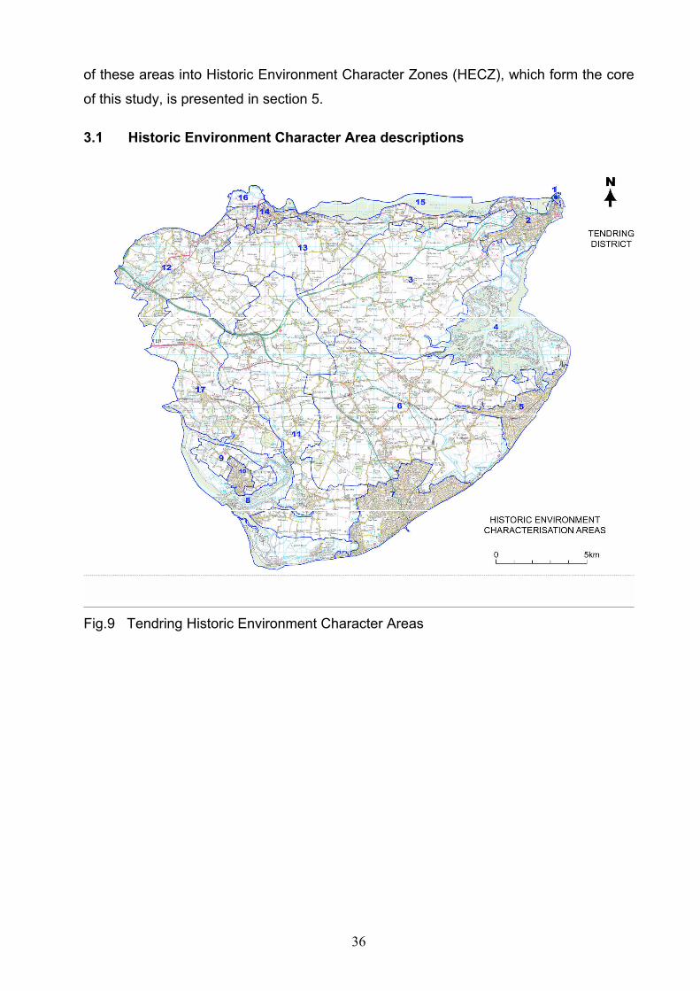
3.1 Historic Environment Character Area descriptions
Fig.9 Tendring Historic Environment Character Areas
37
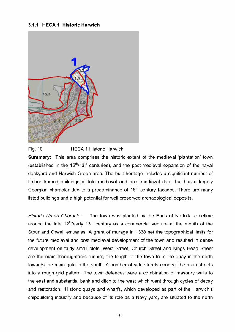
3.1.1 HECA 1 Historic Harwich
Fig. 10 HECA 1 Historic Harwich
Summary: This area comprises the historic extent of the medieval ‘plantation’ town
(established in the 12th/13th centuries), and the post-medieval expansion of the naval
dockyard and Harwich Green area. The built heritage includes a significant number of
timber framed buildings of late medieval and post medieval date, but has a largely
Georgian character due to a predominance of 18th century facades. There are many
listed buildings and a high potential for well preserved archaeological deposits.
Historic Urban Character: The town was planted by the Earls of Norfolk sometime
around the late 12th/early 13th century as a commercial venture at the mouth of the
Stour and Orwell estuaries. A grant of murage in 1338 set the topographical limits for
the future medieval and post medieval development of the town and resulted in dense
development on fairly small plots. West Street, Church Street and Kings Head Street
are the main thoroughfares running the length of the town from the quay in the north
towards the main gate in the south. A number of side streets connect the main streets
into a rough grid pattern. The town defences were a combination of masonry walls to
the east and substantial bank and ditch to the west which went through cycles of decay
and restoration. Historic quays and wharfs, which developed as part of the Harwich’s
shipbuilding industry and because of its role as a Navy yard, are situated to the north

38
and north east of the planned town. The Harwich Green area was used intermittently as
a temporary garrison site over several centuries.
Fig. 11 The historic town of Harwich showing the grid like street layout with the
church of St Nicolas in the foreground and the harbour in the distance.
19th century structures relating to the development of steam packets and ferry’s to the
continent, built along the northern shoreline, include the half penny pier and train ferry
berth.
There is a high proportion of Listed Buildings and the entire medieval town is a
conservation area. Many of the buildings are timber framed and date from the late
medieval and early post-medieval periods but the face presented is largely Georgian
due to the number of re-frontings in the 18th century.
Archaeological Character: A number of archaeological excavations have taken place
within historic Harwich which clearly demonstrate the high potential of the area.
Archaeological investigations within the quay area have uncovered masonry and timber

39
quay structures dating to the 14th and 15th century. The sea front and intertidal zone are
characterised by navigation structures. Deeply stratified deposits have been excavated
at the Kings Head Garage, Kings Head Street, Church Street and St. Austins Lane
revealing 13th and 14th century occupation and episodes of dumping of thick layers of
beach sand followed by new building in an action to raise levels and combat flooding.
The post-medieval expansion to the north and east in the area of the naval dockyard
and Angelgate was constructed on a layer of dumped material deriving from waste from
the town; several phases of expansion and rebuilding are known to have taken place in
this area.
Ceramic evidence shows that the medieval port was engaged in a wide ranging east
coast trade from London to Scarborough. Continental pottery indicates direct trade with
Europe, also known from documentary sources. There is a high potential for the survival
of waterlogged deposits which would be likely to contain well preserved organic
artefacts. These may include waterfront and quayside deposits and features.

40
3.1.2 HECA 2 Dovercourt, Harwich and Parkeston
Fig. 12 HECA 2 Dovercourt, Harwich, Parkeston
Summary: This area contains the 19th century and modern expansion of upper and
lower Dovercourt, Parkeston Quay, and Harwich Harbour, which resulted from
industrial, military and port related development and the areas role as a popular seaside
resort. The area is bisected by the main road leading into the historic core of Harwich
and the Manningtree to Harwich railway line runs through the northern part of the area.
The ports strategic importance resulted in the construction of significant defensive
works during the Napoleonic era and WWII.
Historic Urban Character: Prior to the late 19th century the area was largely agricultural
with a highly dispersed settlement pattern situated alongside the roads, focal points
around All Saints Church and a linear green, with a larger centre at Lower Dovercourt.
Parkeston Quay was developed in the 19th century on reclaimed land located at the
mouth of the River Stour.
The expansion of Lower Dovercourt began in the later 19th century with its success as a
seaside resort. Although Dovercourt had been a resort from earlier in the 19th century,

41
its popularity and expansion really began with the arrival of the railway and the resort
had it’s hey day during the pre- and post-war periods. Steady growth is indicated
between the 1st to 3rd Ordnance Survey maps with more rapid growth shown by the
extent of the built up area shown on the 4th edition map immediately preceding WWII.
Modern development associated with Dovercourt's role as a seaside resort is
particularly evident at the southern end of the developed area, with holiday caravan
parks, beach huts and leisure facilities.
A further focus of late 19th century growth in the area was around the terminus of the
railway south of Harwich historic core, providing housing for a growing industrially based
population. Similar, localised growth occurred at Parkeston in the late 19th century with
workers at the new Parkeston Quay and associated railway station being
accommodated in a new housing development. A brick and tile works was located close
to Main Road and a cement works was in existence to the north of main road in Lower
Dovercourt.
From WWII onwards the area has shown steady growth; the modern area is largely
residential with a commercial centre around the High Street in Dovercourt. Industrial
activity (a refinery) is concentrated in the Parkeston area with further light industry along
Ramsey/Main Road.
The seaward side of the Dovercourt area has long been important to the defence of
Harwich; the Harwich Redoubt is a well preserved Napoleonic fort, and significant
surviving multi-period military remains are to be found at both Tower and Beacon Hills.
Archaeological Character: Gants Pit, now occupied by Spring Meadows Primary School
is a Palaeolithic site of national importance. A significant number of hand axes and
fossilised bones of extinct fauna were discovered here during local gravel extraction at
the end of the 19th century. Recent work at the school has identified surviving river
terrace gravels which are likely to retain a high archaeological interest. Further gravel
deposits of similar significance are likely to survive within the area.
Little formal archaeological work has taken place within the area. However, mostly
chance finds of Late Bronze Age metalwork Iron Age and earlier pottery along with

42
Roman pottery, coins and a possible road indicate settlement from later prehistory and
in those areas that have not been significantly disturbed archaeological deposits may
survive. Archaeological deposits of medieval and early post-medieval may also survive
in places reflecting the pre-urban dispersed settlement pattern.
The sea front and intertidal zone are characterised by navigation structures, including
four scheduled lighthouses and the re-located treadwheel crane which is a 17th century
structure from the Naval yard. The area is also characterised by defensive structures
including the 19th century Harwich Redoubt, which is a scheduled monument.
Significant defences survive from WWII when the area was heavily defended due to its
importance as a naval base. These include some of the massive concrete anti tank
obstacles belonging to The Stanier line, constructed to the east of The Green. There are
also coastal batteries and associated structures at the Beacon Hill scheduled
monument.
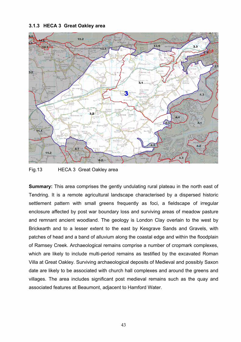
43
3.1.3 HECA 3 Great Oakley area
Fig.13 HECA 3 Great Oakley area
Summary: This area comprises the gently undulating rural plateau in the north east of
Tendring. It is a remote agricultural landscape characterised by a dispersed historic
settlement pattern with small greens frequently as foci, a fieldscape of irregular
enclosure affected by post war boundary loss and surviving areas of meadow pasture
and remnant ancient woodland. The geology is London Clay overlain to the west by
Brickearth and to a lesser extent to the east by Kesgrave Sands and Gravels, with
patches of head and a band of alluvium along the coastal edge and within the floodplain
of Ramsey Creek. Archaeological remains comprise a number of cropmark complexes,
which are likely to include multi-period remains as testified by the excavated Roman
Villa at Great Oakley. Surviving archaeological deposits of Medieval and possibly Saxon
date are likely to be associated with church hall complexes and around the greens and
villages. The area includes significant post medieval remains such as the quay and
associated features at Beaumont, adjacent to Hamford Water.
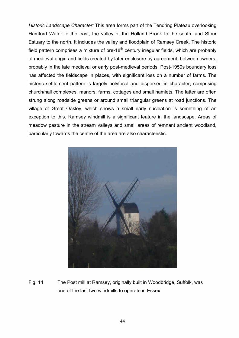
44
Historic Landscape Character: This area forms part of the Tendring Plateau overlooking
Hamford Water to the east, the valley of the Holland Brook to the south, and Stour
Estuary to the north. It includes the valley and floodplain of Ramsey Creek. The historic
field pattern comprises a mixture of pre-18th century irregular fields, which are probably
of medieval origin and fields created by later enclosure by agreement, between owners,
probably in the late medieval or early post-medieval periods. Post-1950s boundary loss
has affected the fieldscape in places, with significant loss on a number of farms. The
historic settlement pattern is largely polyfocal and dispersed in character, comprising
church/hall complexes, manors, farms, cottages and small hamlets. The latter are often
strung along roadside greens or around small triangular greens at road junctions. The
village of Great Oakley, which shows a small early nucleation is something of an
exception to this. Ramsey windmill is a significant feature in the landscape. Areas of
meadow pasture in the stream valleys and small areas of remnant ancient woodland,
particularly towards the centre of the area are also characteristic.
Fig. 14 The Post mill at Ramsey, originally built in Woodbridge, Suffolk, was
one of the last two windmills to operate in Essex

45
Archaeological Character: The area contains a number of cropmark complexes with a
main concentration to the south west of Great Oakley. The Great Oakley complex
indicates a range of features including enclosures, ring-ditches, trackways and field
systems. Many more cropmarks are noted in the area representing a wide range of
features and multi-period settlement.
Although little fieldwork has so far been done, the area is likely to contain deposits
related to widespread prehistoric activity and occupation. Iron Age and particularly
Roman activity is well attested with a villa site excavated at Little Oakley displaying
several phases of building and improvement. Prior to the Roman period the excavations
indicated occupation in the Late Bronze/Early Iron Age, Middle Iron Age and possibly
late Iron Age settlement. In the post Roman period the site yielded evidence for early
Saxon activity, although the nature of this is not fully understood. There are also
indications of agricultural activity and possibly settlement at the site during the later
Saxon and early Medieval periods.
The medieval settlement pattern was generally dispersed with farmsteads and
church/hall complexes and linear greens forming focal points, archaeological deposits
associated with this dispersed settlement pattern are likely to be widespread. The only
nucleated settlement is at Great Oakley where a market is known to have exited by the
mid 13th century. The location of the market place is suggested by the layout of the
village and there is the possibility of surviving archaeological deposits of medieval date.

46
3.1.4 HECA 4 Hamford Water
Fig. 15 HECA 4 Hamford Water
Summary: This area comprises current and former reclaimed coastal grazing marsh,
un-reclaimed salt marsh, marshland islands, the significant intertidal zone of Hamford
Water and Walton Channel, and the Naze peninsula. The Historic landscape is
dominated by post medieval features; principally the sea walls, but also structures
associated with access to and from the sea. A wide range of archaeological finds and
remains are represented from all periods and preservation of deposits is likely to be
good.
Historic Landscape Character: Hamford Water is an extensive area of current and
former marshland, saltmarsh, creeks, mudflats and marshland islands, some of which
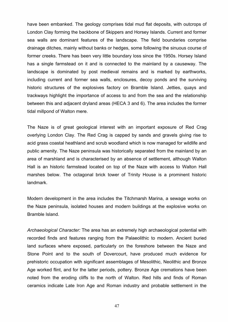
47
have been embanked. The geology comprises tidal mud flat deposits, with outcrops of
London Clay forming the backbone of Skippers and Horsey Islands. Current and former
sea walls are dominant features of the landscape. The field boundaries comprise
drainage ditches, mainly without banks or hedges, some following the sinuous course of
former creeks. There has been very little boundary loss since the 1950s. Horsey Island
has a single farmstead on it and is connected to the mainland by a causeway. The
landscape is dominated by post medieval remains and is marked by earthworks,
including current and former sea walls, enclosures, decoy ponds and the surviving
historic structures of the explosives factory on Bramble Island. Jetties, quays and
trackways highlight the importance of access to and from the sea and the relationship
between this and adjacent dryland areas (HECA 3 and 6). The area includes the former
tidal millpond of Walton mere.
The Naze is of great geological interest with an important exposure of Red Crag
overlying London Clay. The Red Crag is capped by sands and gravels giving rise to
acid grass coastal heathland and scrub woodland which is now managed for wildlife and
public amenity. The Naze peninsula was historically separated from the mainland by an
area of marshland and is characterised by an absence of settlement, although Walton
Hall is an historic farmstead located on top of the Naze with access to Walton Hall
marshes below. The octagonal brick tower of Trinity House is a prominent historic
landmark.
Modern development in the area includes the Titchmarsh Marina, a sewage works on
the Naze peninsula, isolated houses and modern buildings at the explosive works on
Bramble Island.
Archaeological Character: The area has an extremely high archaeological potential with
recorded finds and features ranging from the Palaeolithic to modern. Ancient buried
land surfaces where exposed, particularly on the foreshore between the Naze and
Stone Point and to the south of Dovercourt, have produced much evidence for
prehistoric occupation with significant assemblages of Mesolithic, Neolithic and Bronze
Age worked flint, and for the latter periods, pottery. Bronze Age cremations have been
noted from the eroding cliffs to the north of Walton. Red hills and finds of Roman
ceramics indicate Late Iron Age and Roman industry and probable settlement in the

48
area. The Medieval and post medieval periods are represented by a variety of finds and
features including ceramics, earthwork enclosures, decoys, hulks, wharves and,
industrial works including the scheduled lime kiln and quay at the end of Beaumont Cut.
WWII defences including anti-aircraft sites, bombing decoys and pill boxes are also a
characteristic feature of the area due to its proximity to the naval port at Harwich.
Fig. 16 The 19th century Lime Kiln at Beaumont Quay
Archaeological deposits are likely to be in many cases very well preserved, with good
survival of organic artefacts and environmental deposits.

49
3.1.5 HECA 5 Frinton and Walton
Fig. 17 HECA 5 Frinton and Walton
Summary: This area comprises the popular seaside towns of Frinton-on-Sea and
Walton-on-the-Naze. The area is largely characterised by 19th and 20th century
residential development and structures associated with these coastal resorts. WWII
defences are also a feature due to the coastal location.
Historic Urban Character: The core of the seaside resort of Frinton was developed from
a small dispersed settlement during the late C19 following the construction of Frinton
railway station. The main residential development occurred in the early 20th century
with the construction of larger detached, arcadian housing sited toward the seafront,
and including a number of Arts and Crafts buildings constructed before the First World
War. Blocks of late C19 and early C20 terraced housing appear further inland (north)
and along the main road arteries. The area incorporates the International Modern
50
Movement buildings of the failed Frinton Park Estate, to the north-east. Most of the core
area is in residential use. The northern part of Frinton includes a large area of
predominantly post war residential housing which incorporates some C20 ribbon
development along the Kirby and Walton roads but which is primarily development
between Kirby Cross and the C19/C20 settlements of Frinton and Walton.
The historic core of the seaside resort of Walton developed in the area of the High
Street from the early C19 onwards and still retains remnants of the early C19 street
pattern of terraces and crescents. Later C19 domestic terrace housing developed
within the core area following the arrival of the railway in 1867 and construction of the
new pier in 1869-71. There are no buildings predating the C18 in Walton. Most of the
core area is in either business/retail or residential use including an Interwar residential
development of non terraced houses to the south of the pier bounded by the railway line
and the South Cliffs. This area also incorporates beach huts fronting the promenade
and overlooking Walton beach. To the north is a further large area of mainly interwar
terraced housing which incorporates later C19 ribbon development of terrace housing
following Hall and Naze Park Roads. From the early C20 larger non terrace houses
were built toward the northern extent of the town along Naze Park and Old Hall Lane.
Despite being largely residential in character, the area includes the site of Warners (now
Harmers) iron foundry built c.1874 and associated workers housing built by T.A. Cressy
along Hall Lane and First Avenue. Post war residential ribbon development
characterises the route along Old Hall Lane towards the Tower and Walton Hall. Along
the west side of the town is a large area of partly reclaimed marshland which mainly
comprises a holiday park and associated recreational facilities but which includes the
Scheduled Napoleonic Martello tower.
Archaeological Character: Defensive structures are a feature of the area including a
scheduled Martello Tower, the site of a destroyed Martello Tower. There is also a
concentration of WWII defences due to the fact that the Walton/Frinton section of the
Essex coastline was highlighted as a potential enemy landing zone and as a
consequence very heavily defended. The sites of pillboxes, anti-tank defences and gun
emplacements are frequent, especially on the coast itself and although many have been
lost a number of these features still survive.

51
The area is now heavily developed and although the earlier archaeological potential has
been correspondingly reduced, undeveloped areas may contain undisturbed deposits,
and in particular medieval and early post-medieval deposits may survive in parts of
Kirby, Walton and in the vicinity of the medieval church at Frinton.

52
3.1.6 HECA 6: South East Tendring Plateau and the Sokens
Fig. 18 HECA 6 South East Tendring Plateau and the Sokens
Summary: This area comprises the gently undulating rural plateau in the south east of
Tendring and includes the section of coastline between Clacton and Frinton. The
landscape is characterised by a dispersed historic settlement pattern, although several
small villages and greens provide foci, a fieldscape of pre-19th century and later
enclosure and a cluster of small ancient woodlands in the north of the area. The valley
of the Holland Brook with its enclosed meadows and reclaimed tidal marshes is a
significant feature running through the middle of and draining the area, which is likely to
contain well preserved palaeoenvironmental deposits. The archaeological record is
largely dominated by concentrations of multi-period cropmarks although WWII defensive
structures are also a feature due to the short length of coastline.
Historic Landscape Character: This area comprises the gently undulating agricultural
plateau in the south east of Tendring, drained by the shallow valley of the Holland Brook
with tidal marshes at its mouth. The geology is London Clay overlain by patches of
Brickearth and Kesgrave Sands and Gravels. The valley floor is covered by alluvium
53
and is characterised by enclosed meadows alongside the brook, with drained linear
reclamation of the tidal marshes and fields of ancient origin on the valley sides and in
the southern portion of the area. To the north of the valley, the fieldscape comprises a
mixture of fields of ancient origin and later enclosure which has suffered from moderate
boundary loss. Small oak and sweet chestnut coppice ancient woodlands survive in the
northern western portion of the area on high ground to the north of St Osyth and around
Weeley. Settlement in the area was historically polyfocal and dispersed, comprising
isolated manors and farms but with foci at Little Clacton, Great Holland, Kirby-le-Soken,
Thorpe-le-Soken, Weeley and a number of linear and other greens. Modern ribbon
development has occurred along the road leading to Clacton and the roads into Great
Holland.
Archaeological Character: Although there are no specific records of Palaeolithic finds
from the short section of coast between Holland and Frinton this area along with much
of the remaining Tendring coastline has potential for survival of Pleistocene deposits
which may contain Palaeolithic material, although here they are likely to be deeply
buried by alluvium.
The area contains a range of cropmark evidence and there are two prominent areas of
cropmarks, one surrounding the village of Tendring and another south of Thorpe-le-
Soken. Although a number of these represent modern field boundary loss others are
clearly indicative of surviving earlier deposits. Close to Tendring a group of ring-ditches
of probable Bronze Age origin equate closely to others found across the Tendring
peninsula. There are also a variety of linear and rectilinear features and excavation on
similar sites in adjacent areas has demonstrated that a number of these cropmarks
relate to later Iron Age and Romano-British field systems. Deposits relating to Roman
settlement have been identified at Thorpe Hall and further may be expected within the
area. A saltern has been recorded adjacent to the coast which dates from the Late Iron
Age/Roman period, and others may be present in the coastal zone.
Although the place names Thorpe-le-Soken and Kirby-le-Soken are Scandinavian in
origin and notable within Essex, so far no archaeological evidence of Danish settlement
has been found. Other medieval settlements are Tendring and Great Holland and all
three may retain archaeological deposits relating to their early development. Thorpe-le-

54
Soken in particular has a wealth of historic buildings. Windmills shown on the Chapman
and Andre map of 1777 at Tendring and Thorpe and a watermill on the Holland Brook
may have medieval origins.
Fig.19 Cropmarks of Bronze Age ring ditches along the Clacton-Weeley by-pass
Archaeological work on the line of the Clacton-Weeley bypass which examined a
significant swathe of landscape probably indicates the kind of archaeological remains
likely to be present in many parts of the area. Investigation along the line of the bypass
revealed a range of well preserved prehistoric, Roman and later deposits including a
medieval moated site at Gutteridge Hall. The alluvium of the marshes and Holland
Brook valley is likely to contain well preserved environmental deposits.
As with much of the rest of the Tendring coast, this short section was heavily defended
during the early stages of WWII. Some pillboxes survive although a number have now
been demolished.
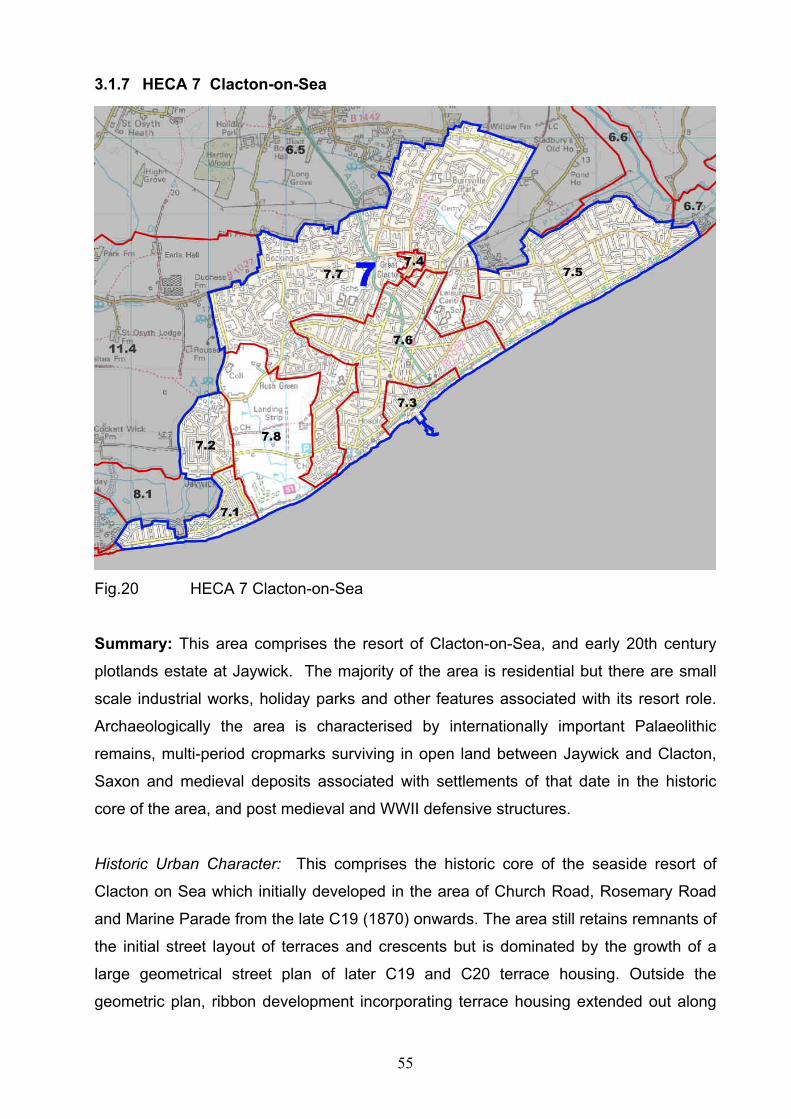
55
3.1.7 HECA 7 Clacton-on-Sea
Fig.20 HECA 7 Clacton-on-Sea
Summary: This area comprises the resort of Clacton-on-Sea, and early 20th century
plotlands estate at Jaywick. The majority of the area is residential but there are small
scale industrial works, holiday parks and other features associated with its resort role.
Archaeologically the area is characterised by internationally important Palaeolithic
remains, multi-period cropmarks surviving in open land between Jaywick and Clacton,
Saxon and medieval deposits associated with settlements of that date in the historic
core of the area, and post medieval and WWII defensive structures.
Historic Urban Character: This comprises the historic core of the seaside resort of
Clacton on Sea which initially developed in the area of Church Road, Rosemary Road
and Marine Parade from the late C19 (1870) onwards. The area still retains remnants of
the initial street layout of terraces and crescents but is dominated by the growth of a
large geometrical street plan of later C19 and C20 terrace housing. Outside the
geometric plan, ribbon development incorporating terrace housing extended out along

56
the Old Road and St Osyths Road during the later C19 and early C20. There are no
buildings predating the C18 in this part of the HECA but the C19 built area includes
three Martello Towers (1809-12) and listed buildings of C19 and C20 date. There are
small scale C20 industrial works along Old Road and in the area of the railway station.
Most of the core area is in residential use. To the north of the historic core is an area of
largely post War and later C20 residential development. This incorporates the historic
core of Great Clacton and lesser settlements such as Rush Green and Bocking’s Elm.
The settlement at Great Clacton is focused around the C12 church and as ribbon
development along St Johns and Old Road. It includes a cluster of listed buildings.
The area includes a pre-war residential development to the north of the cemetery and is
bounded by the railway line to the east. There is a large modern satellite Industrial and
retail estate at Gorse Road and recreational/Holiday camp at Highfields. To the north
east of Clacton is Holland on Sea which comprises an area of predominantly interwar
terraced housing partly laid out to a distinctive co-axial street plan. To the south is the
20th century plotlands estate at Jaywick which also has a distinctive co-axial street
pattern and originated as a seaside development comprising bungalows and chalets
and a Butlins holiday camp.
Archaeological Character: Largely built over and extensively developed through the
latter half of the 20th century, much of the archaeological potential has been lost.
However, the area retains significant potential for Palaeolithic remains of
national/international importance. Now largely contained by sea defences, eroding
deposits of the Clacton Channel of the Thames have in the past produced large
numbers of artefacts including the famous Clacton wooden spear and varied faunal
remains. Gravel deposits containing further important data on this early period of human
activity in Britain are known to survive within the area.
The area of remaining open agricultural land between West Clacton and Jaywick
displays a number of cropmarks, many of which appear to be related to probable
prehistoric funerary activity along with later agricultural land divisions. The whole area
was clearly of long standing importance and alongside the cropmarks are many records
of worked flint. A Bronze Age barrow has been excavated at Rush Green. Later
prehistoric finds of Iron Age pottery, an Iron Age burial and coin hoards are also known.

57
Roman settlement has been identified close to the Golf course and there are a number
of chance finds of Roman material.
Evidence for early Saxon settlement has been excavated at Rush Green including a
large assemblage of 6th/7th century pottery unusual for the district. A church/hall
complex at Great Clacton formed the focus of medieval settlement within the area
surrounded by a number of dispersed farms. This has been consumed by modern
Clacton and the potential for medieval archaeology is correspondingly low, although
isolated elements such as the 1520’s Cann Hall survive.
A Napoleonic period Martello tower remains on the coastline and, relating to later
invasion scares, around 10 of a known total of 125 WWII defensive sites, mainly
pillboxes, survive.
Fig. 21 Restored Martello Tower, Clacton

58
3.1.8 HECA 8 Colne Estuary
Fig. 22 HECA 8 Colne Estuary
Summary: This area comprises historic reclaimed coastal grazing marsh and un-
reclaimed salt marsh and the intertidal zone along the north shore of the Colne Estuary,
around Colne Point, Arlesford Creek and Brightlingsea. Archaeologically the area is
characterised by Late Iron Age or Roman red hills, medieval and post medieval
structures relating to the exploitation of the marshland and other coastal resources, and
post medieval and WWII defences. The area is internationally important for wildlife.
Historic Landscape Character: This area comprises the Colne estuary and associated
creeks with their intertidal mudflats, fringe of saltmarsh and flat areas of present and
former grazing marsh along the north shore. The geology is largely estuarine alluvium
deposits. St Osyth Marsh comprises an extensive area of current and former coastal
marshland, located at the mouth of the Colne estuary. The area was exploited by farms

59
located on the marshlands northern edge (HECA 11). Similarly, former marshland areas
on Brightlingsea would have been exploited by farms on the adjacent upland (HECA 9)
and the estuary north of Brightlingsea, including Arlesford Creek would have been
exploited for resources and transportation by settlement and later industrial activity in
HECA 12.
Field boundaries are mainly dykes and drainage ditches, many following the sinuous
course of former creeks, together with modern post and wire fences. There has been
little or no boundary loss in the area, post 1950. The sea walls are a dominant
landscape feature protecting former marshland from flooding. Other historic landscape
features include: former oyster beds at Colne Point and within Brightlingsea Creek,
notably on Cindery Island; industrial and transport structures such as the former swing
bridge in Arlesford Creek; timber jetties, a duck decoy and hulks. Modern development
includes caravan and mobile home parks and a short ribbon of buildings at Lee-over-
Sands and a leisure area to the west of Brightlingsea harbour which includes a boating
lake, open-air swimming pool and beach huts.
Archaeological Character: The area to the immediate east of this HECA is noted for its
geoarchaeological / Palaeolithic deposits relating to river terrace gravels deposited by
ancient courses of the Rivers Thames and Medway which continue beneath HECA 8.
These deposits are believed to extend into the area to the south of Jaywick, where they
are likely to be deeply buried by alluvium.
A Neolithic polished axe retrieved from the foreshore suggests the possibility that areas
of well preserved land surface, as found elsewhere along the coast, may be present in
places. At least two salterns of probable Iron Age/Roman date exist along with records
of Roman ceramics, and there are likely to be more. Finds of timber work and
associated pottery in the intertidal zone at Arlesford Creek indicate the location of
medieval activity. Areas of un-reclaimed saltmarsh survived into the late 18th century.
Post medieval oyster pits, industrial features, a scheduled duck decoy at Lion Point,
hulks and relict sea defences reflect the strong coastal/marine nature of the
archaeological remains in this area. Military defences include a Martello tower west of
Seawick and concentration of WWII defensive structures such as pillboxes, anti tank
obstacles, an anti aircraft site and a bomb decoy site. Cropmarks indicating the position

60
of extensive WWII anti-airborne landing ditches exist in the former grazing marshes at
Brightlingsea.
The potential for palaeoenvironmental remains and deposits in this area is high and
there are significant possibilities of archaeological remains directly related to these
deposits including timber structures.
This HECA has a close and important relationship with HECA 9 and 10, 11 and 12
which share an economic inter-relationship of exploitation of the estuary.

61
3.1.9 HECA 9 Brightlingsea Peninsula
Fig. 23 HECA 9 Brightlingsea Peninsula
Summary: This area comprises the dryland peninsula of Brightlingsea, excluding the
present extent of the town of Brightlingsea (HECA 10). The fieldscape consists of pre-
18th century enclosure and the historic settlement comprises a string of farms located on
the marshland edge. The archaeological character of the dryland is dominated by
cropmarks of prehistoric or later date including Bronze Age ring ditch cemeteries. Within
the former marshes, archaeological preservation is likely to be good.
Historic Landscape Character: This area comprises the dryland peninsula of
Brightlingsea. The geology is mainly Kesgrave sands and gravels, with the underlying
London Clay forming a fringe around the edges. The fieldscape is largely irregular and
of ancient origin. The levels of post 1950s boundary loss in the area are low. The
settlement pattern was highly dispersed with All Saints on a prominent site adjacent to
Brightlingsea Hall forming a church hall complex at the northern end of the peninsula
and a number of farms along the roads, the north, west and eastern edges of the island,
adjacent to the former marshland (HECA 8). The Chapman and Andre map of 1777
62
shows a number of small nucleations and ribbon development along the roads in the
area of the modern town (HECA10).
Archaeological Character: The character of the area is dominated by a series of
impressive cropmark complexes a number of which have now been lost to mineral
extraction. To the west of Brightlingsea at Moverons Pit, a number of cropmarks have
been shown to relate to deposits of Late Neolithic, later Bronze Age, Middle and Late
Iron Age and early Roman date. Excavation prior to working the site concentrated on a
large Early Neolithic ring-ditch and a middle Bronze Age cemetery which contained a
tight cluster of 22 ring ditches with a number of cremations placed in the spaces
between them. Further cropmarks, a number of which survive may relate to
contemporary or later settlement and another smaller cropmark cemetery exists
immediately west of Brightlingsea. The site of a Roman Villa is located at the north west
end of the area.
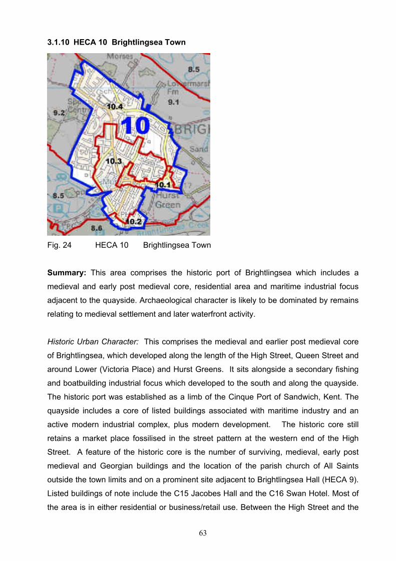
63
3.1.10 HECA 10 Brightlingsea Town
Fig. 24 HECA 10 Brightlingsea Town
Summary: This area comprises the historic port of Brightlingsea which includes a
medieval and early post medieval core, residential area and maritime industrial focus
adjacent to the quayside. Archaeological character is likely to be dominated by remains
relating to medieval settlement and later waterfront activity.
Historic Urban Character: This comprises the medieval and earlier post medieval core
of Brightlingsea, which developed along the length of the High Street, Queen Street and
around Lower (Victoria Place) and Hurst Greens. It sits alongside a secondary fishing
and boatbuilding industrial focus which developed to the south and along the quayside.
The historic port was established as a limb of the Cinque Port of Sandwich, Kent. The
quayside includes a core of listed buildings associated with maritime industry and an
active modern industrial complex, plus modern development. The historic core still
retains a market place fossilised in the street pattern at the western end of the High
Street. A feature of the historic core is the number of surviving, medieval, early post
medieval and Georgian buildings and the location of the parish church of All Saints
outside the town limits and on a prominent site adjacent to Brightlingsea Hall (HECA 9).
Listed buildings of note include the C15 Jacobes Hall and the C16 Swan Hotel. Most of
the area is in either residential or business/retail use. Between the High Street and the

64
quayside is a later C19 residential development of terrace housing within a regimented
co-axial street plan, which expanded during the 20th century, fronting street plans that
surround the historic core. Ribbon development extended out along the main road
arteries of Church Road, Chapel Road and Regent Road into the early C20. There has
been small scale post-war residential infill. Along the northern and western extent of the
post medieval town there is post war and later C20 residential expansion including a
series of housing estates. C20 residential development is defined by the extent of Red
Barn Lane and to the west is built over the Manor House and part of its former parkland.
Some ribbon development and two listed buildings are built along Red Barn Road.
There is a modern ‘edge of town’ satellite Industrial estate along Morses Lane and an
area of C20 recreational/holiday camps sited adjacent to Promenade Way and
overlooking the Brightlingsea Creek.
Fig. 25 Waterfront, Brightlingsea
Archaeological Character: The area comprises the urban area of Brightlingsea which
has seen a large expansion since the late 19th century with particular growth during the
later 20th century. This is likely to have had significant impact on the archaeological

65
potential of the area. Romano-British pottery is known from Hurst Green which is
indicative of settlement, the nature of which cannot however be accurately assessed.
The areas of medieval and post-medieval settlement subsequently engulfed by the town
may also preserve archaeological deposits (see above and HECA 9)
Medieval settlement appears likely to have been concentrated around Hurst Green and
as a ‘corporate limb’ of the Cinque ports, Brightlingsea had some significance as a port
at the mouth of the Colne during the medieval and post medieval period. Little
structured archaeological work has been undertaken within the town but deposits may
survive especially in the historic core around Hurst Green and the waterfront.
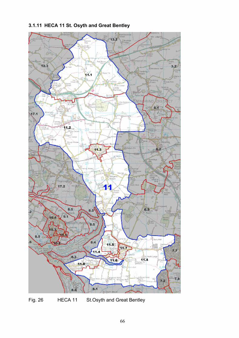
66
3.1.11 HECA 11 St. Osyth and Great Bentley
Fig. 26 HECA 11 St.Osyth and Great Bentley

67
Summary: This area includes part of the open, rural plateau, much of it former
heathland in the south west of Tendring and the historic town of St. Osyth with
associated Priory and Parkland. Elsewhere settlement is generally dispersed but with
several foci around greens and former isolated heaths to the north of the town. The
fieldscape is of ancient origin and there are several areas of ancient woodland in the
north. Archaeologically, the character of the area is dominated by multi-period cropmark
complexes.
Historic Urban Character
The area includes the historic town of St. Osyth which has a medieval core and
incorporates the C12 priory built for the order of St Augustine by the Bishops of London.
The core comprises four key centres, including the C12 priory, the medieval and early
post medieval ribbon development concentrated around the crossroads to the east of
the priory, a smaller focus along Mill Street toward the St. Osyth’s quay and a later
expansion north along the Colchester Road. A major feature of the historic core is the
Augustinian Priory precinct and the survival of significant elements of a medieval market
town with a market place and fair green still recognisable. Co-axial ribbon development
has spread out from the centre during the later post medieval period. Most of the urban
area is in residential use but there is small scale industry focused toward the quayside.
On the east side of the town is an area of post war urban development built either side
of the Clacton Road, which incorporates an earlier C20 development of terraces along
St Clair and D’Arcy Roads and includes a large area of housing of mixed terraced, semi
and detached housing and modern school facilities.
Historic Landscape Character: The geology of this area comprises the London Clay
slope around St Osyth with areas of Kesgrave Sands and Gravels and Brickearth to the
north. The fieldscape is of ancient origin comprising irregular enclosure, with an area of
rectilinear regular fields in the southern portion of the area, and also some later
enclosure in the north on the Tendring Plateau. There has been moderate post-1950
boundary loss throughout the area. The historic settlement pattern is polyfocal and
generally dispersed in character although the medieval town of St Osyth is a significant
foci, and to the north of St Osyth, settlement is clustered around greens and former
heaths, most obviously Gt. Bentley but also including Balls Green, Frating Green, Hare

68
Green, Havens Green, Aingers Green, St Osyth Heath, Row Heath and South Heath.
Otherwise settlement comprises isolated halls, farms and cottages. The string of ‘wick’
farms on the dryland boundary with the former marshland area of Colne Point to the
south (HECA 8) is a noticeable feature of the historic settlement pattern. Modern
settlement includes infilling of the greens by inter-war small holdings or more recent
housing, ribbon development along the roads e.g. at Thorrington Cross and plotland
style development and caravans at Point Clear. The Priory grounds at St Osyth are
former medieval deer park re-landscaped in the post-medieval period. There are
surviving fragments of Ancient Woodland to the south of Little Bentley.
Archaeological Character: Dominated by multi-period cropmark complexes from Great
Bentley and Frating in the north, to those at St. Osyth in the south, the area retains
great archaeological potential despite significant localised mineral extraction.
Excavation at Lodge Farm, St. Osyth has demonstrated the long occupation and activity
within the area from the Neolithic to the medieval period and beyond. The main
discoveries at Lodge Farm included an Early Neolithic causewayed enclosure, an Early
Bronze Age pond barrow, a Middle Bronze Age barrow group, a Middle Iron Age
settlement, Late Iron Age and Roman ditches, Early Saxon pits and a 13th century croft.
The most significant settlement is at St. Osyth which although in its present form dates
largely from the establishment of the Priory in the early 12th century, is known to have
earlier origins and contain well preserved deposits both within the town and at the
waterfront. The Priory will contain nationally important archaeological deposits.
The other significant medieval settlement was probably around the church and the
green at Great Bentley. Archaeological deposits are likely to survive here, reflecting the
arrangement of the settlement around the (reputedly) largest village green in England.
Further medieval remains are likely to survive in relation to settlement clustered around
greens and former heaths, and dispersed halls, farms and cottages. Two excavated
medieval sites are known from Great Bentley and Little Bentley and there is a surviving
post medieval tidal mill at Thorrington.
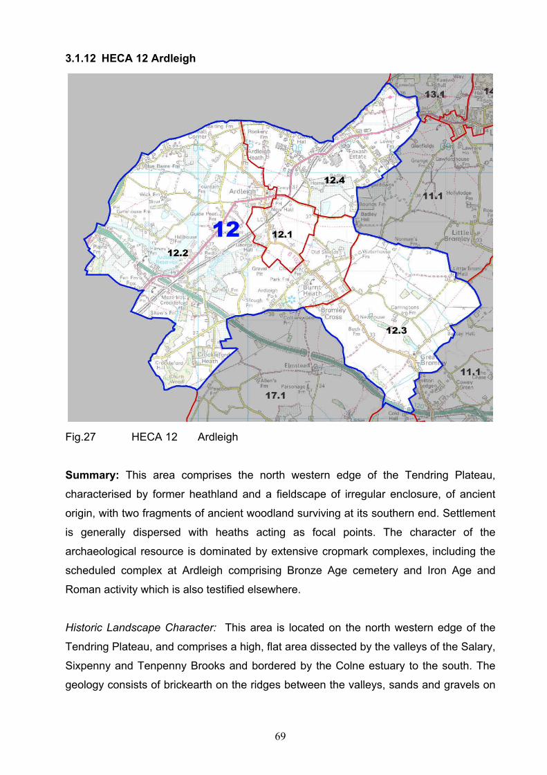
69
3.1.12 HECA 12 Ardleigh
Fig.27 HECA 12 Ardleigh
Summary: This area comprises the north western edge of the Tendring Plateau,
characterised by former heathland and a fieldscape of irregular enclosure, of ancient
origin, with two fragments of ancient woodland surviving at its southern end. Settlement
is generally dispersed with heaths acting as focal points. The character of the
archaeological resource is dominated by extensive cropmark complexes, including the
scheduled complex at Ardleigh comprising Bronze Age cemetery and Iron Age and
Roman activity which is also testified elsewhere.
Historic Landscape Character: This area is located on the north western edge of the
Tendring Plateau, and comprises a high, flat area dissected by the valleys of the Salary,
Sixpenny and Tenpenny Brooks and bordered by the Colne estuary to the south. The
geology consists of brickearth on the ridges between the valleys, sands and gravels on

70
the valley sides and London Clay in the valley floor. The area is characterised by large
areas of former heathland; these included Ardleigh Heath and Burnt Heath forming part
of a rough semi-circle round the eastern flank of Colchester. These were enclosed by
agreement in the early 19th century. Elsewhere the fieldscape is largely of ancient origin
and irregular but there has been moderate loss of field boundaries since the 1950s. Two
small areas of ancient woodland survive at the southern end of the area. There were
orchards in the north east of the area established in the early 20th century and an
extensive area of glass houses / nurseries exists today, the greatest concentration
being the area around Foxash. Ardleigh Park is medieval in origin. Historic settlement
foci include the nucleated village of Ardleigh, but more typically heaths formed the focal
points for settlements as at Ardleigh/Burnt Heath. There are also church hall complexes
and a scatter of halls, farms and cottages. The Foxash estate was developed for
horticultural purposes in the 20th century, originating as a Land Settlement Association
smallholding scheme. Modern housing is largely restricted to ribbon development along
the roads. Ardleigh Reservoir forms a major modern landscape feature in the north west
of the area and there has been significant mineral extraction south of Ardleigh. The area
is bisected by the Colchester to Ipswich railway lines and modern A120.
Archaeological Character: The archaeology of this area is dominated by cropmarks
including the Scheduled cropmark complex south of Ardleigh. This nationally important
Bronze Age cemetery has also significant remains of Iron Age and Roman material
known from excavations carried out between 1950 and 1980. The remains include an
extensive complex of Iron Age and Roman trackways and ditched enclosures, an
enclosed Middle Iron Age roundhouse, ‘Belgic’ burials, a ritual pit and various Roman
features including pottery kilns. Deposits of Iron Age and Roman date have also been
identified within the wider landscape with excavation at Wick Farm west of Ardleigh.
Other significant cropmark complexes are found at Great Bromley and further sites
occur throughout the area. Both Ardleigh Reservoir and major mineral extraction works
south of Ardleigh have resulted in extensive loss and truncation of the archaeological
resource, but in most of the area survival has been shown to be good with high potential
for deposits of both prehistoric and historic periods.

71
The main settlement lies at Ardleigh which retains significant potential for archaeological
survival. Elsewhere, the historic settlement pattern was generally dispersed and
associated archaeological deposits are likely to be widespread.

72
3.1.13 HECA 13 Little Bentley area
Fig.28 HECA 13 Little Bentley area
Summary: This area comprises part of the northern side of the Tendring Plateau and
adjacent southern slopes of the Stour Valley. The historic landscape is characterised by
a fieldscape irregular in pattern and of ancient origin but with elements of later
enclosure. There is some former parkland and significant Ancient Woodland situated
overlooking the Stour estuary. Settlement is generally dispersed. Archaeological
character is dominated by multi-period cropmark complexes.
Historic Landscape Character: This area comprises the northwest corner of the
Tendring Plateau and the slopes of the Stour Valley. The geology consists of brickearth
with sands and gravels and London Clay on the valley sides and river terrace gravels
and alluvium in the valley floor. The area has some long, linear roadside heaths and
small triangular heaths at road junctions together with a larger area of former heath at
Bradfield Heath. There is an important cluster of ancient woodlands along the edge of
the Stour estuary in the north east corner of the area. Areas of former and surviving
parkland can be found along the northern edge of the area e.g. Mistley Park, Furze Hill
and Lawford Hall Park overlooking the Stour. The fieldscape comprises a mixture of
later enclosure by agreement and irregular fields of ancient origin. Post 1950s boundary
loss has been moderate. Settlement is polyfocal and includes settlement around former
heathland such as Bradfield Heath. Elsewhere it is generally dispersed and comprises
scattered halls, farms and cottages and the occasional hamlet. The Manningtree to
Harwich railway runs along the northern edge of the area.

73
Archaeological Character: In common with much of the rest of the Tendring peninsula,
multi-period cropmark sites are the dominant and most striking archaeological features
of the area. An extensive site northwest of Little Bromley is bisected by a Roman road
leading towards Colchester. Northwest of Horsleycross Street and at Bradfield Hall are
further examples. Although under arable cultivation these sites are likely to survive in
relatively good condition.
East of Bradfield Heath the area extends along the valley side of the south bank of the
Stour Estuary. Cropmarks, although present are much reduced in this coastal strip. The
area contains a large number of medieval halls and dispersed farms with more
significant medieval settlement at Wrabness and Bradfield which are likely to retain an
archaeological potential. There are many Listed Buildings, such as the 12th century
church and 17th century bell-house at Wrabness.
WWII defensive structures, mostly pillboxes, survive in the area particularly along the
line of the Stour.

74
3.1.14 HECA 14 Manningtree and Mistley
Fig.29 HECA 14 Manningtree and Mistley
Summary: This area includes the historic ports of Manningtree and Mistley Thorn,
abortive 18th century spa and 19th and 20th century industrial settlement at Mistley.
Manningtree retains its medieval and post medieval street plan and a good range of
surviving buildings from these periods; survival of associated archaeological deposits is
likely to be good. Mistley includes a historic core of predominantly Georgian character
and significant industrial buildings.
Historic Urban Character: This area includes structures related to the abortive 18th spa
and 19th and 20th century industrial settlement at Mistley, medieval and post medieval
historic town of Manningtree and adjacent settlement of Lawford. The geology consists
of boulder clay with sands and gravels and London Clay on the valley sides and river
terrace gravels and alluvium in the valley floor. The historic core of Manningtree is laid
to a compact street plan dating from the medieval and early post medieval periods
centered on the High Street and the quay. The street plan and quayside lie parallel with
the river course. A major feature of the historic core is the number of surviving,
medieval early post medieval and Georgian buildings. Most of the historic core is in
either business/retail or residential use. On the southern side of the historic core there is
initial C18 urban expansion which continued as ribbon development along South Street
and infilling of the market place. Urban development during the C19 continued to the
south along South and Brook Streets and infilled the area between the core and the
railway line established by the Eastern Union Railway by 1854. Stimulated by the arrival
of the railway and the presence of a navigable quay, satellite industrial complexes
developed around the edge of the C19 settlement. There is Post War urban infill along

75
the east and western flanks of the C19 settlement and late C20 residential
redevelopment of the C19 industrial site of the Walls Maltings to the east of the core.
Between Station Road and the Harwich main railway line there is an area of post war
urban infill development and interwar development of terraced housing along
Lushington Road. To the North of Station Road and west of the historic core and
quayside is a series of 20th century industrial and retail trading estates built on
reclaimed / low lying land, together with a sewerage works.
To the south of the established 19th century urban area and along Trinity and Long
Roads, there is 20th century ribbon development, mainly comprising single detached
dwellings.
East of Manningtree is the historic port of Mistley Thorn and historic core of the model
spa town established by Richard Rigby during the 18th century together with later C19
and early C20 planned industrial settlement of new Mistley which developed to the
south of the railway and to the east and outside of Mistley Thorn. The historic core still
retains terraces of C18 houses along the High Street, hotels and industrial workers
cottages and C18 and C19/20 industrial buildings along the quayside. Structures of
particular note are the Mistley Towers and Swan Fountain designed by Robert Adam
and the former spa hotel, Fountain House, all built as part of the abortive attempt to
develop a spa. A major feature of the historic core is the number of surviving Georgian
buildings. Most of the area is in either business/retail or residential use.
New Mistley predominantly comprises blocks of C19 and early C20 terraced workers
cottages situated along the northern and eastern side of the planned town, some earlier
housing fronting Harwich Road and some commercial development along School Lane.
There is also some post war and later 20 century housing. To the east of New Mistley is
a large, later C20 residential estate, including the River View Estate built in 1976. There
is also some early C20 and later ribbon development along Harwich Road. The
quayside area includes 19th and 20th century industrial buildings associated with the port
and malt industry. This remains an active port facility with docking at Mistley Quay and
Baltic Wharf. A major feature of the area is the unity and survival of C19/C20 industrial
maltings and associated buildings and the preservation of this significant industrial

76
landscape. However, some later C20 residential redevelopment of redundant
industrial buildings has occurred.
Fig. 30 Mistley Maltings
To the west of Manningtree is the historic settlement of Lawford, comprising small later
post medieval roadside development concentrated along Wignall Street and around the
crossroads of Hungerdown Lane and Dedham Roads. The two settlements are joined
by 20th century ribbon development of terrace housing extending along Wignall Street.
To the north is a large, late 20th century single phase housing development.
Archaeological Character: The town of Manningtree, situated at the head of the Stour
Estuary was planned and planted as a local port probably during the early 13th century.
Developed around its quayside facilities the town was first mentioned in 1248 and was
clearly fairly successful. Only limited archaeological work has taken place within the
core of the medieval town but that which has occurred has identified well preserved
deposits of the late 15th/early16th century. There is clearly good potential for further
surviving medieval deposits including possible waterfront and quayside features.
The area around modern Mistley was largely occupied by Mistley Hall and its
associated parkland up until the 19th century. The Roman road noted as passing
through HECA 13 can be projected to terminate on the Stour estuary at Mistley and may
suggest the presence of a small port and trading centre on the river during the Roman
period. Mistley itself is of great industrial archaeological significance with the growth of

77
the malting industry during the 19th century leaving a legacy of important industrial
buildings. Separate quays were developed at Mistley in order to service this trade. In
addition to its clear medieval, post-medieval and industrial potential, a number of finds
of prehistoric and Roman material including cremations have been made indicating
further potential in those areas that remain undeveloped.

78
3.1.15 HECA 15 Stour Estuary Intertidal
Fig. 31 HECA 15 Stour Estuary Intertidal
Summary: This area comprises the Stour Estuary intertidal zone and thin strip of
adjacent marshland. There is only seasonal settlement in the area at Wrabness Point.
Archaeological character is in some ways typical of the Essex coast, with indications of
deeply buried and well preserved buried prehistoric land surfaces, medieval timber
structures and hulks. This area has been proposed for an extension of the Suffolk
Coasts and Heaths AONB.
Historic Landscape Character: This is a flat area which comprises long, narrow strips of
tidal salt marsh, intertidal mud flats between the high and low water mark, and the
southern side of the channel of the Stour Estuary. The geology comprises alluvial
deposits overlaying London Clay. The area includes Copperas Bay, Jaques Bay, and
Bathside Bay. The only built development are the distinctive holiday huts at Wrabness
Point, raised above the water level on stilts, and the road and railway bridges which
cross the Stour at Cattawade.
Archaeological Character: Noted within the intertidal area of the Stour Estuary are a
range of finds from Mammoth bone and worked flint to hulks. A number of finds of flint
including some of Mesolithic date indicate early prehistoric activity. There is a possibility
of prehistoric land surfaces, but where they occur they are likely to be deeply buried.
Later timber structures are known to be present; a major Saxon fishtrap has been
identified on the Suffolk side of the estuary. Structures relating to quays and landing
facilities may survive in the Mistley and Manningtree areas with smaller jetties and
pontoons along the estuary. Hulks are known at Baltic Wharf Mistley and other wrecks
are probable, particularly close to Mistley and Manningtree. Place name evidence as at
Copperas Bay is indicative of previous industrial activity, physical elements of which
may remain.

79
3.1.16 HECA 16 River Stour Valley Floor
Fig. 32 HECA 16 River Stour Valley Floor
Summary: This area encompasses a flat landscape of former and current estuarine
grazing marshes and valley floor pasture at the head of the Stour Estuary. There is no
significant settlement in the area. Archaeological character is dominated by a nationally
important multi-period cropmark complex at Lawford. Most of the area falls within the
Dedham Vale AONB.
Historic Landscape Character: This area comprises a relatively homogenous flat
landscape of current and former estuarine grazing marshes and valley bottom pastures.
The geology comprises alluvial deposits overlaying, river gravels and London Clay. The
River Stour forms the northern boundary of the area, with the Harwich to Manningtree
railway line demarcating the southern edge. Both the River Stour and the relict arm of
the tidal estuary flow through the landscape but are of very different character. The reed
lined River Stour meanders naturally but also shows signs of engineering, as at the
locks of Brantham Mill, whilst the southern channel has muddy shores reflecting its
former tidal regime, after being cut off by the construction of the Cattawade Barrage
during the late 20th century. The coastal grazing marshes are collectively known as
Cattawade Marshes and are managed as a nature reserve by RSPB. At their western
and eastern limits, these are characterised by relict salt marsh preserved in rough
pasture. Field boundaries follow the sinuous former creeks, although there are also
some straighter field ditches. Within the centre of the marshes, agricultural improvement
has had a greater impact with sub rectangular fields of improved pasture bordered by
straight field ditches. The former sea walls alongside the remnant arm of the tidal
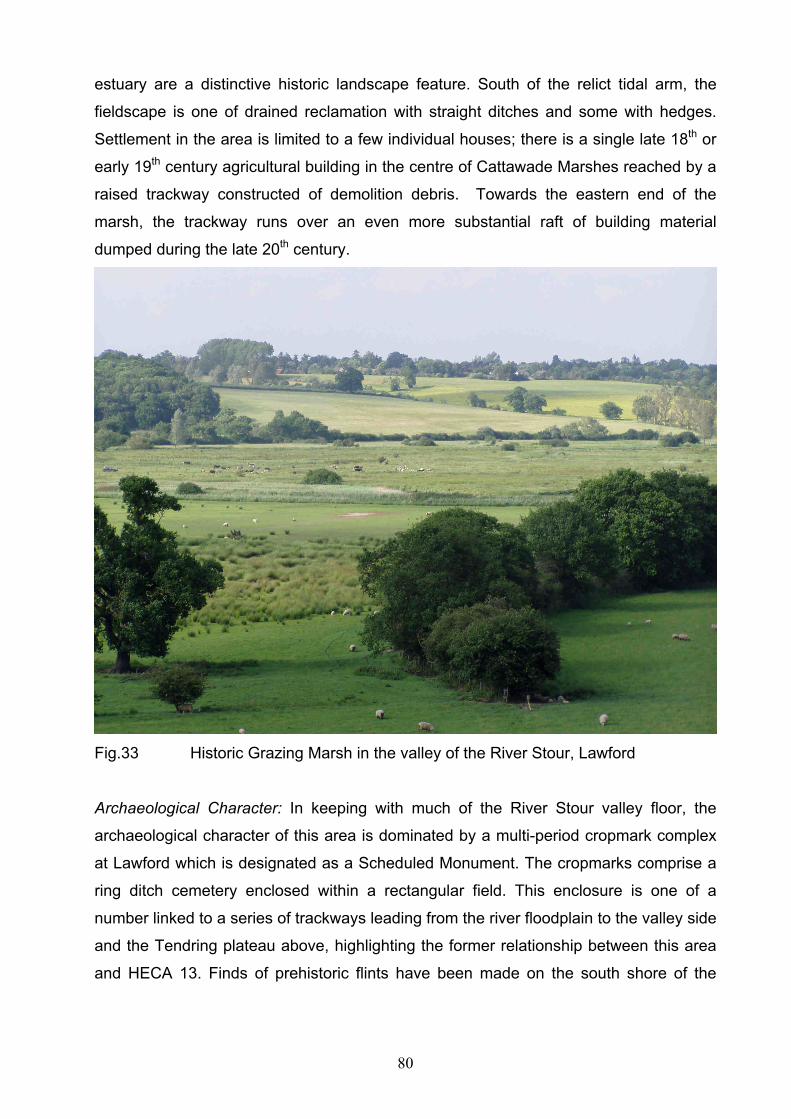
80
estuary are a distinctive historic landscape feature. South of the relict tidal arm, the
fieldscape is one of drained reclamation with straight ditches and some with hedges.
Settlement in the area is limited to a few individual houses; there is a single late 18th or
early 19th century agricultural building in the centre of Cattawade Marshes reached by a
raised trackway constructed of demolition debris. Towards the eastern end of the
marsh, the trackway runs over an even more substantial raft of building material
dumped during the late 20th century.
Fig.33 Historic Grazing Marsh in the valley of the River Stour, Lawford
Archaeological Character: In keeping with much of the River Stour valley floor, the
archaeological character of this area is dominated by a multi-period cropmark complex
at Lawford which is designated as a Scheduled Monument. The cropmarks comprise a
ring ditch cemetery enclosed within a rectangular field. This enclosure is one of a
number linked to a series of trackways leading from the river floodplain to the valley side
and the Tendring plateau above, highlighting the former relationship between this area
and HECA 13. Finds of prehistoric flints have been made on the south shore of the

81
former tidal arm. The area includes relict channels of the River Stour visible as
cropmarks, and will retain well preserved palaeoenvironmental deposits.

82
3.1.17 HECA 17 Elmstead Market, Arlesford and Thorrington
Fig. 34 HECA 17 Elmstead Market, Arlesford and Thorrington
Summary: This area comprises the south western edge of the Tendring Plateau,
characterised by former heathland and a fieldscape of irregular enclosure, of ancient
origin, with small areas of ancient woodland survival along its east side. Settlement is

83
generally dispersed with heaths acting as focal points. The character of the
archaeological resource is dominated by prehistoric and later cropmark sites.
Historic Landscape Character:
This area is located on the south western edge of the Tendring Plateau, and comprises
a high, flat area dissected by the valleys of the Sixpenny and Tenpenny Brooks and
bordered by the Colne estuary to the south. The geology consists of brickearth on the
ridges between the valleys, sands and gravels on the valley sides and London Clay in
the valley floor. The area is characterised by large areas of former heathland; these
included Elmstead Heath, Crockleford Heath, Whitmore Heath, Burnt Heath, Wivenhoe
Heath and Thorrington Heath, which together with Ardleigh Heath in HECA 12, formed a
rough semi-circle round the eastern flank of Colchester. These were enclosed by
agreement in the early 19th century. Elsewhere the fieldscape is largely of ancient origin
and irregular but there has been moderate loss of field boundaries since the 1950s.
Small areas of ancient woodland survive with a concentration in the south around
Thorrington. Historic settlement foci include the nucleated village of Elmstead Market to
the north, but more typically heaths formed the focal points for settlements at
Crockleford, Elmstead Heath, and Alresford Heath. There are also church hall
complexes and a scatter of halls, farms and cottages. Modern housing is largely
restricted to ribbon development along the roads. The area is bisected by the
Colchester to Clacton railway lines and modern A120.
Archaeological Character: The archaeology of this area is dominated by cropmarks with
particular concentrations to the south of Elmstead Market and further sites throughout
the area. Only limited archaeological work has been done within the area but deposits
of prehistoric date have been identified at Elmstead Market and a Roman villa is known
from the south of Arlesford adjacent to the creek, which is one of a string of villas along
the north shore of the Colne and its estuary. Evidence of medieval activity has been
excavated around Alresford. Major mineral extraction works south of Arlesford have
resulted in extensive loss and truncation of the archaeological resource, but in most of
the area survival has been shown to be good with high potential for deposits of both
prehistoric and historic periods. Mineral extraction has left a legacy of 20th century
industrial structures such as the aerial runway leading to Arlesford Creek.

84
The main settlements lie at Arlesford and Elmstead Market. The latter is centred on the
previous small settlement situated at a significant road junction. Elsewhere, the historic
settlement pattern was generally dispersed, including a church/hall complex at
Elmstead, and associated archaeological deposits are likely to be widespread.

85
4 Creation of Historic Environment Character Zones
4.1 General Background
This section of the report is designed to look at the Historic Environment in more detail
than that appropriate for the larger HECAs. This is achieved by dividing the Historic
Environment Character Areas into smaller Historic Environment Character Zones of a
size more suitable for strategic planning within Tendring District.
4.2 Methodology
Through a combination of analysing the main datasets such as historic mapping,
ancient woodland, Historic Environment Record data, and secondary sources, it was
possible to develop a series of character zones within the Historic Environment
Character Areas. These zones were digitised and descriptions for each have been
prepared.
The descriptions draw on a range of sources and attempt to reflect, simply, clearly and
briefly the reasoning behind the definition of each zone and, where possible, relate that
zone to its wider historic context. The descriptions seek to highlight the key
characteristics in an area and identify any particularly significant aspects of the zones
historic environment. Preparation of the descriptions of the zones clarified their nature
and their boundaries, so that an iterative process between descriptions and boundary
definition resulted in the creation of robust Historic Environment Character Zones.
For each character zone the description comprises an overall summary, a summary of
the archaeological character, and either a summary of the historic landscape character
or historic urban character as appropriate. A number of particular issues are highlighted
relating to the conservation management and understanding of the historic environment
in the zones.
4.3 The scoring of the Historic Environment Character Zones
Each character zone has been scored on a range of criteria for which separate scores
are retained within the GIS metadata. The following system is based on scoring
developed for the English Heritage Monuments Protection Programme (MPP); modified
to consider broad zones rather than particular monuments. This method of scoring is

86
intended as a simple means of engaging with issues of sensitivity, value and
importance. It is not designed to be definitive and is likely to be subject to change as
new information becomes available and understanding develops.
Seven criteria have been used:
Diversity of historic environment assets
Survival
Documentation
Group Value Association
Potential
Sensitivity to change
Amenity Value
Each of the criteria have been scored for each of the zones with a rating of 1, 2, or 3
with 1 as the lowest and 3 as the highest. Where in a few instances a score of 1/2 or
2/3 is given in the text the lower score is shown on the metadata.
4.3.1 Diversity of historic environment assets
This indicates the range of Historic Environment Assets within the zone which may be
chronologically diverse. For example a zone with multi-period settlement sites or a
zone with a range of assets, such as church, village, farmstead, field systems of the
same date would both score highly, whilst a zone containing a limited range of historic
environment assets would score low.
1 = Very few known assets or many assets of a limited range of categories.
2 = Contains a range of assets of different date and character
3 = Contains a wide range of assets both in date and character
4.3.2 Survival
This relates to the state of completeness of the range of historic environment assets
within the character zone. The zone may be relatively well preserved or it may have
been disturbed by hostile land-use/development and/or erosion. Even where such

87
factors have adversely affected assets within a zone there may be potential for well
preserved but deeply buried deposits.
1 = Zone extensively disturbed by for instance quarrying or development. Likelihood is
that whilst many of the assets have been disturbed or destroyed there is the potential
for survival in some areas or of some types of assets.
2 = Zone has little disturbance but there are few known assets, or there are many
known assets but there has been some adverse effects from, for instance, development
or quarrying.
3 = Zone contains known assets which are well preserved.
4.3.3 Documentation
The level of documentation for a zone reflects the extent of investigations that have
taken place. Such work includes; excavation, field survey/recording, historical
documentation, research project work (this includes for example the National Mapping
Programme, coastal zone survey etc).
1 = Little or no documentation.
2 = A range of documentation containing elements of the above
3 = A wide range of documentation.
4.3.4 Group Value Association
Two forms of association are considered, either historic environment assets of a similar
nature or historic environment assets of a similar date. For example a zone with red
hills all of the same date or a zone with multi period historic environment assets
associated with coastal exploitation would both score highly, whilst a zone with a wide
range of diverse assets, which are not associated, would score low.
1 = Contains few historic environment assets of a similar date or nature.
2 = Contains a limited range of historic environment assets which are related or of a
similar date.
3 = Contains a range of historic environment assets which are related such as moats
with well preserved field systems of medieval origin or salt working sites of different
dates.
88
4.3.5 Potential
The potential is assessed with reference to the expected average circumstances within
the zone. The score considers the nature of the historic environment assets based on
current evidence and indicates the likelihood of further assets being present.
1 = The potential for surviving historic environment assets within the zone has been
significantly reduced by for instance quarrying or development.
2 = There are limited known historic environment assets however the landscape has
not been significantly disturbed and current lack of knowledge is probably the result of
lack of investigation rather than poor preservation.
3 = Current evidence and little disturbance indicates that a range of high quality assets
probably survive within the zone.
4.3.6 Sensitivity to Change
Each Historic Environment Zone is assessed with regard to the sensitivity of the area to
medium to large scale development, specifically housing expansion. The score is an
indication of the vulnerability of the historic environment assets within the zone to this
type of change. A lack of sensitivity to change should not be taken as an indication that
no historic environment mitigation would be required to accommodate development. It
would be possible to consider sensitivity to other types of change e.g. flood risk
management.
1 = The historic environment of the zone could accommodate medium to large scale
development, however specific historic environment assets may suffer adverse effects.
2 = Medium to large scale development is likely to have a considerable impact on the
historic environment character of the zone.
3 = The zones historic environment is highly sensitive to medium to large scale
development.

89
4.3.7 Amenity Value
Relates to the actual and/or potential amenity value of the historic environment zone
and this is indicated in the description box. If there are specific elements which would
warrant enhancement these are also indicated in the description box. The score may
relate to uniqueness, historical associations, key landmarks, good access, and interest
for visitors and educational value etc.
1 = Historic environment does not lend itself to display or visitor attraction. Current
knowledge gives limited potential for the historic environment to play a significant role in
creating a definable and promotable identity to the zone.
2 = Historic environment does, or could help define a sense of place of the zone. There
may be specific elements which are or could be promoted such as woodlands, castles
etc.
3 = The historic environment plays, or could play a key role in the zones sense of place
for the local people and visitors. The zone contains assets which, are or could be,
promoted for the benefit of local people or visitors.

90
5 Historic Environment Character Zone Descriptions
Fig. 35 Historic Environment Character Zones
HECZ 1.1: Historic core of Harwich
Summary: This zone represents the historic core of Harwich. The geology comprises
alluvial deposits, overlying London Clay and Thanet Sands. The present urban
character comprises closely packed buildings with very little open space, the layout has
its origins in the medieval period. Important stratified archaeological deposits exist
throughout this zone with particularly significant medieval and post-medieval deposits.
This zone lies within the Harwich Conservation Area. Details of the development of this
zone are provided by the Historic Town Assessment (Medlycott 1999).
91
Urban character: It is possible that there was a small settlement on the Harwich
peninsula by 1177, when there was a chapel on the site. However, the origins of the
planned town date to the early thirteenth century, when it was founded as an economic
venture by the Earls of Norfolk, in direct competition with Ipswich. The present street
plan is still largely that of the medieval town. There were three main north-south
streets, King’s Head Street (formerly High Street or East Street), Church Street
(formerly Middle Street) and West Street. These were sub-divided into rectangular
blocks by a series of east-west lanes. The largest properties were sited at the northern
end of the town, with the most prominent building being the Earl of Norfolk’s townhouse.
The area on the western side of West Street was largely open space until the early
post-medieval period. The quay forms the northern, seaward limit of this zone and was
widened and extended. The entirety of this zone lies within the Harwich Conservation
Area. Many of the buildings are Listed, with the oldest examples largely located along
King’s Head Street, Church Street and Saint Austin’s Lane. The built environment of
Harwich is densely packed, with very little public or private open space, due to the
constrictions imposed on urban expansion by its peninsula site and town defences.
Archaeological character: The historic town of Harwich is still very visible in the
surviving built fabric of the town. The dense nature of the settlement at Harwich,
confined by the sea on three sides, has led to the development of very tight house plans
and small yards. Because of the high saline water-table many houses had
underground cisterns in their back-yards for the collection of rain-water, some of which
survive. There are fragments of rubble stone walls scattered throughout the town,
probably medieval in origin.
There have been a number of excavations and watching-briefs in Harwich. The most
significant sites are the Quay Pavilion site, 14 St Austin’s Lane, Ebenezer Chapel, Kings
Head Garage, Methodist Chapel Site and the George Street excavations. The
excavations have established the presence of deep, stratified archaeological deposits
relating to the town’s development. In particular they have demonstrated that the quay
area was expanded northwards, so that earlier lines of revetments, hythes and water-
stairs are buried behind it.

92
Diversity of historic environment assets
Listed buildings and medieval and post
medieval below ground deposits
3
Survival Buildings survive well above ground.
Below ground archaeological deposits
survive well and in places there is a
considerable depth of deposits
3
Documentation Archaeological reports, HER data, Historic
town assessment. Cartographic evidence
3
Group Value Association Range of surviving assets related to the
medieval and post medieval town
3
Potential High potential of surviving archaeological
deposits and for better understanding of
the existing built heritage
3
Sensitivity to change Below ground deposits buildings and street
layout, and built heritage all very sensitive
3
Amenity Value Historic identity of this zone has a high
promotional value. Good potential for
interpretation and promotion of the below
ground and built heritage
3
HECZ 1.2: Post-medieval Harwich expansion and the Navy yard
Summary: This zone comprises the post-medieval expansion of historic Harwich,
including the area of the naval dockyard (HUCA 3 and 4). The geology comprises
alluvial deposits overlying London Clay. Important stratified archaeological deposits
exist throughout this zone with particularly significant post-medieval deposits. This zone
lies within the Harwich Conservation Area. Details of the development of this zone are
provided within the Historic Town Assessment (Medlycott 1999).
Historic urban character: This zone includes the historic site of the quays and
wharfs associated with the 17th century naval dockyard. This zone underwent various
phases of re-development throughout the following centuries, much of the zone is
currently used for storage and there is a strong possibility that below ground

93
archaeological remains survive. To the north-west 19th century developments, for
steam-packets and ferries to the continent, built along the northern shoreline include the
half penny pier and train ferry berth. To the south of the dockyard are the Angelgate
Cottages, built originally as coastguard cottages, and the site of the Angelgate Battery.
The southern part of the zone includes the Scheduled Monuments of the Harwich
Treadwheel Crane and High and Low Lighthouses. The area around Harwich Green
was used as a barracks (parts of which survive) and a military camp throughout the
post-medieval period.
Fig.36 The 17th century Harwich Treadwheel Crane, relocated from the Naval
dockyard
Archaeological character: The historic elements of maritime Harwich are still very
visible in the surviving built fabric of this zone, despite modern development.
Excavation has established the presence of deep, stratified archaeological deposits
relating to the towns development. In particular it is known that the quay and dockyard
area was expanded northwards and eastwards, so that earlier lines of revetments,
docks, hythes and water-stairs are buried behind it. In addition much of this expansion
is built on deposits deriving from rubbish-disposal from within the medieval and post-
medieval town, the possibility of significant finds assemblages and palaeoenvironmental
evidence being buried within these deposits is high. Below-ground features relating to
the use of Harwich Green as a military camp can also be anticipated.
94
Diversity of historic environment assets
listed buildings medieval and post
medieval archaeological deposits, maritime
structures
3
Survival Buildings survive well above ground.
Below ground archaeological deposits
survive well
3
Documentation HER data, Historic town assessment.
Cartographic and excavation evidence
2
Group Value Association Range of surviving assets related to the
medieval and post medieval town
3
Potential Potential of surviving archaeological
deposits and for better understanding of
the existing built heritage
2
Sensitivity to change Below ground deposits buildings and street
layout very sensitive
3
Amenity Value Historic identity of this zone has a high
promotional value. Good potential for
interpretation and promotion of the below
ground, maritime and built heritage
3
HECZ 2.1: Bathside and Parkeston
Summary: This zone comprises the late 19th century and modern development along
Bathside Bay, on what was formerly salt-marsh and grazing marsh. It includes
Parkeston, a unique planned industrial settlement built by GER adjacent to Parkeston
Quay, and Parkeston Quay itself. The present urban character is largely industrial, with
the exception of the residential area of Parkeston.
Historic urban character: This zone was reclaimed in the late 19th century, from
former marshland. Parkeston Quay freight and passenger terminal was constructed by
the Great Eastern Railway (GER), in place of the old facilities in Harwich. Elements of

95
this original build, including the passenger terminal for ships to the continent and some
railway station/port buildings remain. Linked to this commercial development was the
construction of Parkeston, a unique later 19th century planned industrial settlement built
by GER. This retains its original terraced street plan and many of the original workers
cottages. Parkeston was expanded in the early 20th century, but has not been
adversely affected by modern housing/infill. Modern disturbance to the remainder of the
zone includes the modern road and rail infrastructure, as well as some small scale
commercial and retail outlets and the construction of a large oil refinery in the west of
the zone.
Archaeological character: There is the possibility of the survival of some elements of
the original grazing marsh, and associated below-ground deposits. Otherwise the
archaeological character comprises the post-medieval industrial development of the
site, including two former brickworks, the phases of reclamation and the GER
developments.
Diversity of historic environment assets
Known historic environment confined to the
post medieval period much of which is related
to industrial and residential heritage
2
Survival Industrial heritage survives well 2
Documentation HER data, Cartographic evidence 2
Group Value Association Range of surviving assets related to the
industrial development
2
Potential Low for surviving below ground deposits 1
Sensitivity to change Industrial buildings and residential layout
sensitive
1
Amenity Value Historic identity of this zone has a
promotional value with the remainder of
Harwich.
2
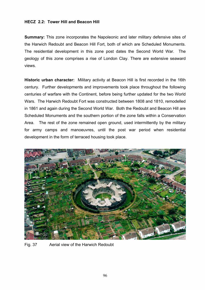
96
HECZ 2.2: Tower Hill and Beacon Hill
Summary: This zone incorporates the Napoleonic and later military defensive sites of
the Harwich Redoubt and Beacon Hill Fort, both of which are Scheduled Monuments.
The residential development in this zone post dates the Second World War. The
geology of this zone comprises a rise of London Clay. There are extensive seaward
views.
Historic urban character: Military activity at Beacon Hill is first recorded in the 16th
century. Further developments and improvements took place throughout the following
centuries of warfare with the Continent, before being further updated for the two World
Wars. The Harwich Redoubt Fort was constructed between 1808 and 1810, remodelled
in 1861 and again during the Second World War. Both the Redoubt and Beacon Hill are
Scheduled Monuments and the southern portion of the zone falls within a Conservation
Area. The rest of the zone remained open ground, used intermittently by the military
for army camps and manoeuvres, until the post war period when residential
development in the form of terraced housing took place.
Fig. 37 Aerial view of the Harwich Redoubt

97
Archaeological character: There are antiquarian records of an earthwork and Roman
remains in the vicinity of Beacon Hill. Although much of the original promontory here
has been lost to the sea, the possibility remains that elements relating to this earlier
settlement may survive within the current open areas within this zone. On the Beacon
Hill site many of the 20th century buildings survive and retain important military
information on the architecture of gun installations, ammunition storage,
communications, observation and radar posts. Buried foundations/footings of the 19th
century barrack blocks may remain beneath the modern playing fields, and there are
extensive underground tunnels and workshops. The RCHME produced a survey report
of the site in 1997. The Harwich Redoubt also retains important military information on
the architecture of gun installations, ammunition storage, communications, observation
and radar posts.
Diversity of historic environment assets
Range of multi-period military assets, below
ground deposits
2
Survival Military structures survive well above ground.
Below ground archaeological deposits survive
well
3
Documentation Archaeological reports, HER data, Historic
town assessment. Cartographic evidence,
RCHME survey
3
Group Value Association Military assets through history 3
Potential High potential of surviving archaeological
deposits and for better understanding of the
existing built heritage
3
Sensitivity to change Military assets and, where present, below
ground deposits highly sensitive
3
Amenity Value Historic identity of this zone has a high
promotional value. Good potential for
interpretation and promotion of the military
history
3

98
HECZ 2.3: Dovercourt
Summary: This zone comprises the post-medieval and modern built-up area of
Dovercourt. The geology of this zone comprises a natural ridge of London Clay,
overlying this are areas of Red Crag sand and Kesgrave Sands and Gravels. The
earliest evidence for activity in this zone dates to the Palaeolithic period and there is
evidence for settlement from the prehistoric period onwards.
Historic urban character: This zone’s urban origins were as a seaside resort in the
1850s. The zone includes the station and the 19th century terraced housing at Lower
Dovercourt, including a number of hotels. In the late 19th and early 20th century further
streets of terraced housing were laid out parallel or perpendicular to the Main Road.
There was sustained post war residential development along and between the roads
that linked Upper and Lower Dovercourt. Later 20th century housing is densely packed
to the south of the historic core of Upper Dovercourt (HECZ 2.4) and the main road.
Industry in the form of brick and cement works were established on the north side of the
main road and between it and the railway line, an area which remains predominantly
non-residential and retains some commercial and municipal buildings. Open areas are
restricted to allotment gardens, school grounds and recreational facilities. Notable
structures include the Arts and Crafts designed Fryatt Memorial Hospital, the Tower
Hotel and Orwell Terrace. There are a number of Listed Buildings, mostly 19th century,
and part of the Beacon Hill Conservation Area extends into this zone.
Archaeological character: The evidence for prehistoric activity in the Harwich area is
concentrated around this zone. In 1908 a large collection of Palaeolithic flint tools was
found at Gant’s Pit, Upper Dovercourt as were the faunal remains of elephant,
rhinoceros, deer, ox and mammoth. Mesolithic tools and the remnants of a Neolithic
settlement have been recovered from Dovercourt beach, and it is possible that this
activity extended into this zone. A hoard of fifteen Late Bronze Age axeheads was
found in 1911 in Upper Dovercourt. Dovercourt is one of the few places in Essex where
a usable building stone, septaria, can be quarried. The stone was quarried from the
cliffs or dredged from the sea-bed and was used extensively throughout the county both
as a building-stone and as a constituent of cement. Roman finds have been found
throughout the Dovercourt area, suggesting a sizeable community. There is evidence
99
for an early Saxon cemetery at Dovercourt, as an iron spearhead was found to the
south of the church in 1963 and a complete pot and brooch from the Dovercourt area
were found in the last century. The Domesday Book records the presence of Dovercourt
but not Harwich, suggesting that the area of Harwich was subsumed within the manor of
Dovercourt, prior to the founding of the town in the early 13th century. The later periods
are represented in the form of a number of former brickworks and the site of a World
War II military camp.
Diversity of historic environment assets
Wide range of multi-period below ground
archaeological deposits. Buildings related to
the seaside resort
3
Survival Below ground archaeological deposits likely to
survive in undeveloped areas, Palaeolithic
deposits will survive across the zone. Seaside
buildings survive
2
Documentation HER data, Cartographic evidence 2
Group Value Association Range of surviving assets related to seaside
heritage
1
Potential some potential of surviving archaeological
deposits and for better understanding of the
existing built heritage
2
Sensitivity to change Below ground deposits and seaside buildings
sensitive
2
Amenity Value Historic identity of this zone has a promotional
value mainly related to the development of the
seaside resort and to some extent the multi-
period history of the zone
2

100
HECZ 2.4: Upper Dovercourt
Summary: This zone comprises the medieval, post-medieval and modern built-up area
of Upper Dovercourt. The geology of this zone comprises Kesgrave Sands and
Gravels. The earliest evidence for activity in this zone dates to the Palaeolithic period
and there is evidence for settlement from the prehistoric period onwards.
Historic urban character: This zone is the historic core of Upper Dovercourt centred
around the parish church of All Saints. The medieval settlement comprised the church
and a scattering of cottages around a linear green, formed by a widening of the road.
This settlement gradually expanded and infilled with post-medieval and 19th century
ribbon development, particularly along the main Harwich Road. The 19th century
development included schools, non-conformist chapels and a cemetery, constructed in
response to the wider expansion of the Dovercourt urban area (see HECZ 2.3). A
number of structures are Listed, including some of the tombs in the cemetery.
Archaeological character: The evidence for prehistoric activity in the Harwich area is
concentrated around this zone. Palaeolithic flint tools were found at Gant’s Pit, just to
the east of the zone, as were the faunal remains of elephant, rhinoceros, deer, ox and
mammoth, and the gravels underneath this zone are of equally high potential for this
period. There is evidence for Iron Age or Roman occupation and for an early Saxon
cemetery in the vicinity of the church. The Domesday Book records the presence of
Dovercourt, but not Harwich, suggesting that the area of Harwich was subsumed within
the manor of Dovercourt, prior to the founding of the town in the early 13th century, and
below-ground deposits relating to this and subsequent periods can be anticipated.
Diversity of historic environment assets
Range of multi-period below ground
archaeological deposits. Historic settlement
buildings
2
Survival Buildings survive well above ground. Below
ground archaeological deposits will survive in
the historic core
2
Documentation HER data, Cartographic evidence 2
Group Value Association Range of surviving assets related to the 2
101
historic settlement of Dovercourt
Potential Potential for below ground deposits especially
in the historic core as well as earlier
occupation back to the Palaeolithic
2
Sensitivity to change Layout of historic settlement sensitive 2
Amenity Value Historic identity of the settlement could be
promoted
1
HECZ 2.5: Dovercourt Caravan Park and Sports Ground
Summary: A zone of 20th century leisure activity, including a sport’s ground and
caravan park. The geology comprises London Clay, overlain on the seaward side by
alluvium. The earliest evidence for activity in this zone dates to the Palaeolithic period
and there is evidence for settlement from the prehistoric period onwards.
Historic urban character: This zone comprises an open, non-residential area
overlooking the promenade to Dovercourt Bay, formerly farmland and grazing marsh.
This area is largely used for leisure activities including a caravan park and sports
grounds. In addition there are a number of edge-of-town activities such as a public
refuse tip and sewage works.
Archaeological character: A zone of former farmland and grazing marsh, the latter
was enclosed in the early post-medieval period. There is evidence for prehistoric
activity along the foreshore (HECZ 4.1), in the form of Mesolithic flints and a Neolithic
occupation site, and it is possible that remains of a similar date may survive in or
beneath the alluvium. There is also the possibility of important deposits relating to
periods of marine transgression, or other environmental evidence within the alluvium.
Most of the archaeological evidence however relates to the Second World War and the
defence of Britain, with recorded sites including a Heavy Anti-Aircraft and Rocket site, a
spigot mortar gun emplacement, a pill-box and bomb craters.

102
Diversity of historic environment assets
World War two monuments, potential for
prehistoric activity extending from adjacent
zones.
1
Survival Below ground deposits likely to survive. Only
one pillbox remains
2
Documentation HER data, Cartographic evidence, 2
Group Value Association World War II features 1
Potential Potential for surviving below ground
archaeological deposits
2
Sensitivity to change Known deposits of limited sensitivity 1
Amenity Value Zone has a low amenity value 1
HECZ 2.6: Harwich and Dovercourt foreshore
Summary: A long narrow zone, comprising the eastern shore of Harwich and
Dovercourt, this includes the sea-defences, a number of marine-related structures such
as the Dovercourt Causeway and Lighthouses, the Guard breakwater and the
promenade, as well as extensive areas of inter-tidal sand and mud. The geology
comprises London Clay, overlain at the northern and southern ends of the zone by
marine alluvium.
Historic urban character: This zone comprises the sea-front for urban Harwich and
Dovercourt. The structures and buildings associated with this zone are all related to its
marine edge location. They include the sea-defences, which had their origins in the
post-medieval period and the 19th century Promenade, which runs the length of
Dovercourt Bay. A double row of wooden beach huts is sited on the promenade, adding
considerably to the ‘seaside resort’ nature of the zone. The Dovercourt Upper and
Lower Lighthouses, erected in 1863 to replace earlier brick structures, are Scheduled
Ancient Monuments. The Lower Lighthouse, which is sited some 200m out to sea, is
accessed via a causeway. Other structures include The Guard, a breakwater which juts
out from Beacon Cliff, and a series of groynes along the beach.

103
Fig. 38 The 19th century Lower Lighthouse at Dovercourt
Archaeological character: There is evidence for prehistoric activity along the
foreshore to the south of this zone in HECZ 4.1, in the form of Mesolithic flints and a
Neolithic occupation site, and it is possible that remains of a similar date may survive
within this zone also. There is also the possibility of remains relating to later periods
surviving, including the foundations for the predecessors to the Dovercourt lighthouses.
The sea-defences may also contain evidence relating to the date of their construction.
Diversity of historic environment assets
Known historic assets relate to the sea front
location and include lighthouses, beach huts
and sea defences
2
Survival Buildings survive well. 2
Documentation HER data, Cartographic evidence 1
Group Value Association Range of surviving assets related to the sea
front location
2
Potential Potential of surviving archaeological deposits 2
Sensitivity to change Sea front heritage is sensitive to change 2
Amenity Value Potential promotion of the sea front historic
assets, particularly in relation to neighbouring
zones.
2

104
HECZ 3.1 Great Oakley, Little Oakley and Ramsey
Summary: This zone comprises the countryside around Great Oakley and Little
Oakley. The geology of this zone largely comprises London Clay, with ridges of
Kesgrave sands and gravels. The zone is dissected by the valley of Ramsey Creek, the
floodplain of which forms a separate zone (HECZ 3.3). The zone is a gently undulating
rural agricultural plateau with a dispersed and polyfocal settlement pattern.
Archaeological remains comprise a number of cropmarks complexes, which are likely to
include multi-period sites as testified by the excavated Roman Villa at Great Oakley.
Surviving archaeological deposits of Medieval and possibly Saxon date are likely to be
associated with historic settlements.
Historic Landscape Character: This zone largely comprises a gently undulating
agricultural landscape although the ridge that runs north east – south west along the
east side of the zone is a dominant topographic feature. Drainage is into the Ramsey
Creek. The fieldscape is largely ancient in origin, but significant areas have been
affected by post medieval enclosure and post war boundary loss, particularly around the
eastern ridge and the fields leading down towards Hamford Water. The valley sides
above Ramsey Creek have, to a greater extent, escaped the pressures of agricultural
intensification. Inland, field boundaries comprise low gappy hedgerows, with occasional
mature hedgerow oaks, but towards Hamford Water hedgerows become intermittent
with few trees. Settlement in the zone was historically dispersed and polyfocal with
isolated manorial halls such as Great and Little Oakley, farms and cottages. The biggest
settlement is the nucleated village at Great Oakley which developed around a medieval
market square. Ramsey Village (formerly Ramsay Street) is a small linear settlement
located at an historic crossing point of Ramsey Creek. A network of narrow lanes
connects the historic settlements and tends to follow the higher ground and ridges. The
B1414 runs along the top of the ridge connecting Great and Little Oakley with
Dovercourt and Harwich. The windmill above Ramsey Village is an important historic
feature in the landscape.

105
Fig. 39 18th century timber-framed weather-boarded 3 bay barn, Great Oakley
Archaeological Character: The area is likely to contain deposits related to prehistoric
activity and occupation as indicated by cropmarks of ring ditches and finds of Bronze
Age metal work. There is a notable cropmark complex around Little Oakley which is
likely to represent multi-period remains including a WWII anti-aircraft site. Late Iron Age
and particularly Roman activity is well attested with a villa site excavated at Little Oakley
displaying several phases of building and improvement. Prior to the Roman period the
excavations indicated occupation in the Late Bronze/Early Iron Age, Middle Iron Age
and possibly late Iron Age settlement. In the post Roman period the site yielded
evidence for early Saxon activity, although the nature of this is not fully understood.
There are also indications of agricultural activity and possibly settlement at the site
during the later Saxon and early Medieval periods. Elsewhere in the zone, Anglo-Saxon
activity is attested by finds of metal work. There is the possibility of surviving
archaeological deposits of medieval date associated with the historic dispersed
settlement pattern and Great Oakley contains listed vernacular buildings including
timber framed and weather-boarded and brick built cottages with clay tiled roofs, and
some thatch. Little Oakley also contains several listed buildings and there are a number

106
of 16th to 19th century listed buildings elsewhere in the zone. A post medieval duck
decoy pond is depicted on the 1777 Chapman and Andre map near Ramsay.
Diversity of historic
environment assets
Range of cropmarks, archaeological finds
historic buildings and settlement pattern, villa
site, historic field boundaries
3
Survival Cropmarks indicate surviving below ground
deposits
2
Documentation HER data, cartographic evidence, NMP,
excavation evidence
2
Group Value Association Settlement pattern and field system 2
Potential Good potential for below ground
archaeological deposits
2
Sensitivity to change Sensitive to change due to the historic
settlement pattern and below ground
deposits
2
Amenity Value Potential for interpretation of historic
settlements
1
HECZ 3.2 Wix area
Summary: This zone comprises the countryside to the north, south and west of Wix.
The geology of this zone largely comprises London Clay, with a promontory of
Brickearth on the west side and a further area to the south. Patches of Kesgrave sands
and gravels also overlay the London Clay in places and there is a small area of Head on
the slopes above the Hamford Water. The zone is a gently undulating rural agricultural
plateau with a dispersed and polyfocal settlement pattern. Archaeological remains
comprise a number of cropmark complexes, which are likely to include multi-period
remains, and excavated sites. Surviving archaeological deposits of Medieval and
possibly Saxon date are likely to be associated with historic settlements. The area

107
includes significant post medieval remains such as the quay and associated features at
Beaumont-cum-Moze, adjacent to Hamford Water.
Historic Landscape Character: This zone comprises a gently undulating agricultural
landscape. Drainage is into the Holland Brook to the south, Ramsey Creek to the east
and a minor stream to the north. The fieldscape is largely ancient in origin, but
significant areas have been affected by post medieval enclosure and post war boundary
loss. Field boundaries comprise low gappy hedgerows, with occasional mature
hedgerow oaks, due to the decline of Elm during the late 20th century. There are
surviving remnants of ancient woodland, particularly in the southern half of the zone.
These include Stonehall, Gravel and Killgrove Woods, typically with a structure of
neglected coppice of sweet chestnut, hornbeam, hazel and small-leaved lime and oak
standards. Settlement in the zone was historically polyfocal and dispersed, comprising
settlement around linear and triangular greens like Goose Green, Bockings Green,
Stones Green and Tendring Green, church/hall complexes such as Beaumont and
isolated halls, farms and cottages. Many of the greens have been subsequently infilled
by housing, or removed by road widening or enclosure. Wix is the largest village in the
zone, having developed from a crossing of two roads at ‘Wick’s Cross’ close to the
monastic settlement of Wix Abbey. A network of narrow lanes connects the historic
settlements and tends to follow the higher ground and ridges. The modern A120 cuts
across the zone on an embankment.
Archaeological Character: The area is likely to contain deposits related to widespread
prehistoric activity and occupation. There are a range of cropmarks across the zone
with a notable complex to the north of Beaumont representing multi-period settlement.
Prehistoric ring ditches and ring ditch cemeteries are particularly characteristic of the
zone and are most likely to represent the buried archaeological remains of individual
Bronze Age round barrows and barrow cemeteries. Other cropmarks include: prehistoric
and later ditched enclosures, field boundaries, and double-ditched trackways, a number
of medieval moated sites and a World War II anti-aircraft site adjacent to Hamford
Water, illustrating the archaeological potential of the zone. Excavations and geophysics
survey at Wix Abbey have revealed the below ground remains of the Benedictine priory
founded in 1123 which will retain archaeological deposits pertaining to socio-economic

108
as well as religious aspects of the foundation. There is the possibility of surviving
archaeological deposits of medieval date associated with the historic settlement pattern.
Diversity of historic
environment assets
Range of cropmarks, historic settlement
pattern, religious foundation, ancient
woodland, historic field boundaries
3
Survival Cropmarks indicate surviving below ground
deposits. The settlement pattern and field
system are quite well preserved
2
Documentation HER data, cartographic evidence, NMP,
excavation evidence
2
Group Value Association Settlement pattern and field system 2
Potential Good potential for below ground
archaeological deposits
2
Sensitivity to change Sensitive to change due to the historic
settlement pattern and below ground
deposits
2
Amenity Value Potential for interpretation of historic
settlements/landscape patterns and
cropmarks particularly in relation to
neighbouring zones
2
HECZ 3.3 Ramsey Creek Floodplain
Summary: This zone comprises the lower reaches of the meandering Ramsey Creek
and its flat alluvial floodplain. The geology comprises London Clay, overlain with
alluvium which gives rise to waterlogged soils. Historically the landscape comprised
small scale, enclosed meadow pasture in the upper section of the flood plain and wider
flat landscape of drained reclamation in the lower section. There is limited settlement in
the zone. The main A120 follows the edge of the floodplain whilst the B1352 is the
historic crossing point of the river at Ramsey. A dismantled railway line crosses the
lower section of the floodplain. Potential for palaeoenvironmental deposits is high.

109
Historic Landscape Character: The zone includes the Ramsey Creek and its
floodplain. The fieldscape in the upper section of the floodplain comprises a mix of
enclosed meadow pasture, laid out either side of Ramsey Creek with fields bordered by
straight drainage ditches and low hedgerows interspersed by floodplain trees. The
lower section of the floodplain opens out into a wide flat open landscape of former
coastal and freshwater marshes that was drained during the 19th century, and affected
by boundary loss in the 20th century, to create a landscape of large arable fields. Field
boundaries comprise straight drainage ditches. At its eastern end, the floodplain
accommodates a golf course. The golf course incorporates the Delf pond, relict counter
walls and the embankment of a dismantled railway line (Manningtree-Dovercourt). This
area is important for nature conservation and is designated as a County Wildlife Site.
There are few buildings except for the farmstead at Pond Hall Farm.
Archaeological Character:
The site of a mill pond is known from the 1777 Chapman and Andre map and it is likely
that below ground remains associated with this, and possibly earlier water mill
structures survive. The 1st edition OS map (c1876) depicts Ray Island Farmstead on
what is now the golf course and post medieval or earlier below ground deposits
associated with this site may survive, despite later landscaping. Geophysics survey and
trenching at Ramsey located the late 18th to mid 19th century phase of Michaelstow
Hall, a former manor with probable Late Saxon or medieval origins. The zone contains a
number of WWII pillboxes, highlighting its proximity to Harwich and the coast and its
function as a transport route.
The waterlogged alluvial silts in this floodplain have the potential to hold important
palaeoenvironmental evidence relating to the interaction of human and natural process
and the vegetational, climatic and coastal changes in the history of Tendring peninsula,
although landscaping associated with the golf course will have had a negative impact.
Diversity of historic
environment assets
Potential palaeoenvironmental deposits,
meadow pasture, mill pond.
2
Survival Historic field pattern survives well 2
Documentation Cartographic, HER, Archaeological survey 1
Group Value Association Historic landscape features including relict 2

110
counter walls, field system, Delf pond,
Potential High potential for palaeo-environmental
deposits
3
Sensitivity to change Elements of the field pattern and palaeo-
environmental deposits highly sensitive
3
Amenity Value Potential for promotion, in conjunction with
other zones, of the history of flood plain and
coastal marsh exploitation in Tendring
District.
2
HECZ 4.1 Hamford Water
Summary: This zone comprises the large shallow estuarine basin of Hamford Water
including an extensive area of tidal creeks, intertidal mud, sand flats, open salt marshes,
reed beds, islands, beaches and marsh grasses, outside the current sea walls. The
geology is estuarine alluvium deposits with an outcrop of London Clay forming the
backbone of Skippers Island. The zone has a range of archaeological remains and
historic landscape features throughout, including prehistoric land surfaces, red hills,
hulks, and relict sea walls. There is no settlement within the zone although with the
exception of holiday accommodation on Skippers Island. The zone is highly important in
terms of the natural environment. With the exception of the Walton Mere, the entire
zone is designated as a Site of Special Scientific Interest (SSSI), Special Area of
Conservation (SPC), and falls within the Essex Coast Special Protection Area (SPA)
and Hamford Water Ramsar site. Skippers Island is managed as a nature reserve.
Hamford Water is important for both commercial and leisure activities. Historically the
zone had a close relationship with adjacent dryland zones via numerous small jetties,
wharfs and docks.
Historic Landscape Character: The broad expanse of Hamford Water and its
associated creeks has been a major artery for trade and transport, together with a
source of fish, shell fish and wildfowl, for millennia. Now mainly used by leisure craft the
estuary still has limited commercial traffic and oyster beds. The zone is characterised by
its open, flat aspect and remoteness. The zone includes areas of former saltings that
were enclosed within seawalls during the 19th century. Where field boundaries exist on

111
these areas of short lived reclamation, such as Pewitt Island, they comprise drainage
ditches, some following the lines of creeks. Former sea walls, visible both as earthworks
and as lines of exposed timbers are dominant features of the landscape. At the north
east tip of Horsey Island, a series of lighters have been sunk to form a sea defence.
Hulks, such as the spritsail barge in Landermere Creek, and timber jetties also highlight
the importance of access to and from the sea and the relationship between this zone
and adjacent dryland areas (HECZ 4.3 and HECZ 4.4). The zone includes the former
tidal millpond of Walton mere which is a significant feature adjacent to the historic town
of Walton (HECZ 5.3). Modern development in the zone includes the Titchmarsh
Marina.
Fig. 40 Hulk of a spritsail barge, Landermere Creek
Archaeological Character: To the south of Dovercourt, extensive areas of prehistoric
land surface have been exposed and produced quantities of flint artefacts and pottery,
and a number of in situ archaeological deposits including those relating to important
Neolithic occupation sites. Red Hills indicate the importance of Late Iron Age and
Roman salt manufacturing in the zone. The post medieval period is represented by a
variety of archaeological remains including current and relict seawalls, which will retain
evidence for date and construction, earthwork enclosures, hulks, jetties, docking areas
cut into the salt marsh, causeways to the islands and pits, most probably from oyster
cultivation. WWII bomb craters have been identified from aerial photographs, and there
are destroyed pill boxes along the beach to the south of Dovercourt, highlighting the
proximity of the zone to the naval base at Harwich. Archaeological deposits are likely to
be in many cases very well preserved, with good survival of organic artefacts and

112
environmental deposits although some features, such as buried land surface and hulks
exposed at low tide, may be vulnerable to accelerated decay.
Diversity of historic environment assets
Range of historic landscape and
archaeological features; finds, prehistoric
land surfaces, earthworks and timbers
3
Survival Good survival 3
Documentation HER data, Hullbridge Survey, NMP data 2
Group Value Association Features relating to coastal exploitation
sea walls, timbers, oyster pits, hulks
3
Potential Excellent potential for surviving deposits. 3
Sensitivity to change Landscape and archaeological deposits
highly sensitive to change.
3
Amenity Value Potential for promoting the importance of
the historic environment within the
Hamford Water, particularly post medieval
coastal transport but this is restricted by
access.
2
HECZ 4.2 Horsey Island
Summary: This zone comprises Horsey Island located within Hamford Water. The
geology is an outcrop of London Clay fringed by estuarine alluvial deposits. The zone
has a range of archaeological remains and historic landscape features including red
hills, decoy ponds, stetch cultivation earthworks and sea walls. The zone is highly
important in terms of the natural environment. The entire zone is designated as a Site of
Special Scientific Interest (SSSI), Special Area of Conservation (SPC), and falls within
the Essex Coast Special Protection Area (SPA) and Hamford Water Ramsar site. There
is a single farmhouse. The zone is grazed, and managed for wildlife. Historically the
zone has a close relationship with Hamford Water (HECZ 4.1) and the adjacent dryland
zone to the south to which it is connected by a causeway (HECZ 6.3).
Historic Landscape Character: Horsey Island is characterised by its open and flat
aspect. The natural saltings that formerly existed in the zone may have begun to be

113
enclosed within seawalls during the late medieval period. Enclosure had certainly begun
by the mid 17th century and was undertaken in more than one stage. The fleets and
other natural depressions that survive in some areas of grassland, particularly on the
east side of the island, are evidence of former creeks and saltmarsh before the seawall
was built. Historically the marsh would have provided grazing for cattle and sheep,
although parts of the marsh have also been used in the past for crop production as
evidenced in places by surviving ridges and furrows of ‘stetch’ cultivation earthworks.
The sea walls are the dominant historic landscape feature on the island, but the well
preserved earthworks of a decoy on the east side of the island are also a significant
feature. A second decoy pond on the island retains water but has been subjected to re-
excavation in recent decades. Field boundaries in the zone are mainly straight drainage
ditches and dykes, but some follow the sinuous course of former creeks. There are
some hedgerows bordering the fields closest to the farmstead. There has been little
boundary loss, although wetland scrapes and reservoirs have been created for nature
conservation.
Archaeological Character: Evidence for at least one red hill has been noted in the
southern end of the zone indicating its significance for the production of sea salt during
the late Iron Age and Roman periods. The sea walls are likely to be late medieval in
origin and will retain evidence for date and construction. The well preserved earthworks
of a duck decoy on the east side of the island will also contain archaeological remains
relating to date and use. A second duck decoy to the south east of the farmhouse has
been affected by 20th century modifications and is unlikely to include archaeological
deposits of note. The single farmstead on the island dates from at least the late 18th
century and may retain archaeological remains from earlier phases of occupation. In
limited locations modern excavations for wetland improvements are likely to have had a
negative impact on archaeological deposits, although elsewhere, archaeological
deposits will probably be well preserved, with good survival of organic artefacts and
environmental deposits

114
Diversity of historic environment assets
Range of historic landscape and
archaeological features
2
Survival Good survival of earthworks and
potential below ground deposits
3
Documentation HER data, NMP data, RCHME survey 2
Group Value Association Coastal zone/marshland exploitation Sea
walls, Duck decoys, Red hills and other
earthwork features
3
Potential Good potential for surviving below
ground deposits.
2
Sensitivity to change Landscape and archaeological deposits
sensitive to change.
3
Amenity Value Privately owned island limited potential
for promoting the importance of the
historic environment as part of a wider
understanding of human activity around
Hamford Water
2
HECZ 4.3 Hamford Water Former Marshes
Summary: This zone comprises former marsh around the fringes of Hamford Water
including Walton Hall Marsh on the eastern side. The geology is estuarine alluvial
deposits. The zone has a wide range of archaeological remains and historic landscape
features including: flint artefacts, red hills, cropmark enclosures, decoy ponds, sea
walls, and WWII defences. The zone lies adjacent to the tidal waters of Hamford Water
(HECZ 4.1) which is highly important in terms of the natural environment. Small areas of
the zone are designated as a Site of Special Scientific Interest (SSSI), Special Area of
Conservation (SPC), and fall within the Essex Coast Special Protection Area (SPA) and
Hamford Water Ramsar site. Historically the zone had a close relationship with Hamford
Water (HECZ 4.1) and the adjacent surrounding dryland zones (HECZ 4.5, HECZ 6.3,
HECZ 3.2, HECZ 3.1).

115
Fig. 41 View from The Naze tower of former marshland (middle distance) of
Walton Hall, with Hamford Water byond.
Historic Landscape Character: The former marsh land surrounding Hamford Water is
characterised by its open and flat aspect. The natural saltings that formerly existed in
the zone began to be enclosed within seawalls during the post medieval period as
grazing marsh. Significant reclamation took place in the mid 19th century and the
process was certainly complete by the time the 1st edition OS map of Essex was
published c.1876. The sea walls are the dominant historic landscape feature around the
fringes of Hamford Water. Field boundaries in the zone are mainly straight drainage
ditches and dykes, some following the sinuous course of former creeks. There has been
little boundary loss, although wetland scrapes and reservoirs have been created for
nature conservation. The majority of fields within the zone are under arable cultivation.
Archaeological Character: Early prehistoric activity in the zone is indicated by finds of
flint artefacts. Evidence for around a dozen red hills has been noted in the zone
indicating its significance for the production of sea salt during the late Iron Age and
Roman periods. Several cropmark enclosure sites, a single ring ditch, drainage
channels and a 19th century duck decoy are known from aerial photographs. Medieval
features and deposits have been recorded on the west side of the zone which probably
relate to marsh edge farming activity. The sea walls are likely to be post medieval in
origin and will retain evidence for date and construction. The zone was the location for

116
extensive defences during WWII including heavy anti-aircraft gun batteries, bombing
decoy, and anti-landing ditches, due to its proximity to the naval port at Harwich.
Modern excavations for wetland improvements are likely to have had a negative impact
on archaeological deposits, although in places, such as buried former creeks,
archaeological deposits will probably be well preserved, with good survival of organic
artefacts and environmental deposits
Diversity of historic environment assets
Wide range of archaeological features 3
Survival Original field boundaries and buried
archaeological remains
2
Documentation HER data, NMP data, 1
Group Value Association Marsh land exploitation, Red Hills, Sea
walls, Duck decoys
2
Potential Good potential for surviving deposits. 2
Sensitivity to change Archaeological deposits and wider
landscape sensitive to change.
2
Amenity Value Limited except in relation to promoting
the wider story of human activity around
Hamford Water
1
HECZ 4.4 Bramble Island
Summary: This zone comprises a spit of former salt marsh on the north west side of
Hamford Water. The geology is mainly estuarine alluvial deposits with an area of
London Clay on the west side of the zone. The zone has a limited range of historic
landscape features and archaeological remains. The zone lies adjacent to the tidal
waters of Hamford Water (HECZ 4.1) which is highly important in terms of the natural
environment and the zone is designated as a Site of Special Scientific Interest (SSSI),
and falls within the Essex Coast Special Protection Area (SPA) and Hamford Water
Ramsar site. Historically the zone had a close relationship with Hamford Water (HECZ
4.1) and the adjacent surrounding dryland zone (HECZ 3.2).

117
Historic Landscape Character: The zone is characterised by its open and flat aspect
although there is considerable scrub/tree cover around the modern buildings of the
explosive factory on the north west side of the island. The natural saltings that formerly
existed in the zone were enclosed within seawalls during the late 19th century. The sea
walls are a dominant historic landscape feature but the blast mounds and other
earthworks of the early 20th century explosive factory are also a significant visual
feature. These are linked by a network of former and current paths and trackways. Field
boundaries in the zone are mainly drainage ditches which follow the sinuous course of
former creeks.
Fig. 42 Aerial view of the 20th century explosives Factory on Bramble Island
Archaeological Character: The earliest activity recorded in the zone dates from the
Roman period and a find of abraded Roman pottery. During the post medieval period, a
duck decoy was operated within the zone but this now only survives as a cropmark and
there are not likely to be significant archaeological remains associated within it. The 20th
century explosive factory includes a complex of earthworks, structures and buildings

118
which are an important resource of industrial archaeology, although the site is still in
use.
Diversity of historic environment assets
Limited range of archaeological and
landscape features
1
Survival Good survival of 20th century industrial
archaeology
1
Documentation HER data, NMP data 1
Group Value Association Association of early 20th century
industrial remains which will retain
layout, form and function
2
Potential Low potential for surviving deposits. 1
Sensitivity to change Medium scale development could be
accommodated in and around the
modern industrial buildings
2
Amenity Value Limited except in relation to promoting
the wider story of human activity around
Hamford Water
1
HECZ 4.5 The Naze
Summary: This zone comprises a peninsula of land on the north east side of Hamford
Water. The geology is sands and gravels on top of an important exposure of Red Crag
overlying the London Clay. There is significant erosion of the cliffs above the beach on
the east side of the Naze. With the exception of Walton Hall, the zone has an absence
of settlement, but a range of archaeological remains from prehistoric pottery to WII
defences. The Naze Tower is the dominant feature in the landscape. The zone lies
adjacent to the tidal waters of Hamford Water (HECZ 4.1) which is highly important in
terms of the natural environment and significant areas of the zone are designated as a
Site of Special Scientific Interest (SSSI), and fall within the Essex Coast Special
Protection Area (SPA) and Hamford Water Ramsar site. A large part of the zone is
public open space, including an area managed as the John Weston nature reserve.
Modern development includes a sewage treatment works. Historically the zone had a

119
close relationship with Hamford Water (HECZ 4.1) and Walton Hall Marshes (HECZ
4.3).
Historic Landscape Character: The Naze peninsula was historically separated from
the mainland to the south (HECZ5.1) by an area of marshland and is characterised, by
a general absence of settlement. One of the few buildings, Walton Hall, is located on
top of the Naze with access to Walton Hall marshes below. The Hall is a listed building
which originated as a late medieval or post medieval sea-mark that later operated in
conjunction with the Naze Tower. The Walton Hall farmstead comprises a collection of
agricultural buildings including two listed timber framed barns. To the north of the
farmstead is a group of cottages that originated as an early 20th coastguard station. The
listed 18th century octagonal brick tower of Trinity House was built as a navigation aid
and is the dominant historic landmark within the zone. The western side of the zone
overlooking Hamford Water and sloping down to the former Walton Hall Marshes is
arable farmland. Field boundaries are all hedged and straight and represent late
enclosure. There has been a moderate degree of boundary loss. Historically the east
side of the zone was also arable farmland but it is now occupied by acid grass and
scrub woodland that is managed for wildlife and public amenity.
Fig.43 The Naze Tower was built in the 18th century as an aid to navigation

120
Archaeological Character: The earliest activity recorded in the zone is represented by
stray finds of prehistoric flint artefacts and Neolithic pottery and a Middle Bronze Age
burial has been recorded eroding from the cliffs. Evidence for several red hills has been
noted in the zone, indicating its significance for the production of sea salt during the late
Iron Age and Roman periods. Walton Hall may have late medieval and post medieval
deposits associated with the standing buildings. The zone was heavily defended during
the Second World War due to its coastal location and proximity to Harwich. It was the
site of a military camp and contains remains of defensive structures including anti-
aircraft batteries, a bombing decoy and pill boxes, some of which have been identified
from aerial photographs. Low intensity land use over much of the zone means that the
potential for buried archaeological remains is likely to be good. Ongoing erosion of the
cliffs on the east side of the zone results in regular exposure of archaeological finds and
deposits.
Diversity of historic environment assets
Archaeological finds, cropmarks,
defensive structures and buildings
2
Survival Survival of robust WWII defensive
structures and potential for below ground
deposits
2
Documentation HER data, NMP data, cartographic
evidence
1
Group Value Association WWII defensive structures 1
Potential Low intensity land use means there is
good potential
2
Sensitivity to change The zone is highly sensitive to change 3
Amenity Value Good public access and a range of
visible assets means considerable
potential for the promotion of the historic
environment particularly in relation to
neighbouring zones
2

121
HECZ 5.1: Walton North
Summary: Zone of modern development to the north of Walton with a potential for
archaeological deposits of probable prehistoric date in undeveloped areas.
Historic Urban Character: A zone of mainly interwar terraced housing which
incorporates a small group of later 19th century terrace housing on Hall and Naze Park
Roads. From the early 20th century larger non terrace houses were built toward the
northern extent of the town with a convalescent home constructed in the early part of
the 20th century. The zone includes the site of Warners (now Harmers) iron foundry
built c.1874 and associated workers housing built by T.A. Cressy along Hall Lane and
First Avenue. Also located within the zone is the Port Walton Brick and Tile works.
Post war residential development covers most of the zone with both the convalescent
home and industrial sites now redeveloped. A small area of industry remains on part of
the Foundry site.
Archaeological Character: Archaeological records relate to Bronze Age, Iron Age and
Roman pottery found during development of the zone. Although almost entirely built up,
any areas such as the public open space adjacent to the cliffs are likely to contain
prehistoric deposits if previously undisturbed. The area was used for the industrial
production of iron, brick and tiles in the late post medieval and early modern period.
There are numerous records of structures relating to coastal defence during World War
II including pill boxes and anti-tank pimples but none survive except a single pillbox to
the rear of a house at Old Hall Lane.
Diversity of historic
environment assets
Extensive prehistoric flint artefacts, post
medieval industrial sites, industrial housing,
Second World War military structures
2
Survival Post medieval industrial housing survives,
industrial and 2nd World War largely
destroyed. Prehistoric deposits likely to
survive in undeveloped areas
2
Documentation Industrial and Second World War surveys 2
Group Value Association Industrial sites and housing 2

122
Potential Possibility for below ground prehistoric
deposits to survive
2
Sensitivity to change Limited sensitivity due to modern
development
1
Amenity Value Prehistoric flint work worth promoting in
association with other zones. Industrial
heritage of the zone could be promoted.
1
HECZ 5.2: Naze Marine Holiday Park
Summary: Reclaimed marshland, now a holiday park which has moderate
archaeological potential with remnants of the port associated with the Warners Foundry.
Historic Urban Character: Large area of partly reclaimed marshland lying between
the historic core of Walton and the later Walton North residential development. The
zone mainly comprises a holiday park and associated recreational facilities.
Archaeological Character: In the north of the zone was a 19th century iron foundry
and a man made channel cut from Walton Channel providing small scale dock facilities
for the foundry. This cut has since been filled in. Although the zone is now occupied by
the holiday park, previous ground disturbance may have been minimal and deposits
relating to the former saltmarsh may survive.
Diversity of historic
environment assets
Industrial remains, potential for palaeo-
environmental deposits
1
Survival Landscape extensively disturbed by modern
leisure and sewage development. Possible
survival of marshland and creek assets
2
Documentation Very limited documentation 1
Group Value Association Earthworks associated with the reclaimed
marshland
1
Potential Potential for palaeo-environmental deposits 2

123
Sensitivity to change Little sensitivity to change 1
Amenity Value Little amenity value 1
HECZ 5.3: Historic Walton
Summary: Mainly 19/20th century development related to the development of the sea
side resort of Walton. The historic core still retains remnants of the early 19th century
street pattern of terraces and crescents.
Historic Urban Character: The zone comprises the historic core of the seaside resort
of Walton which developed in the area of the High Street from the early 19th century
onwards. The historic core still retains remnants of the early 19th century street pattern
of terraces and crescents which can be recognised to the east of Station Road and
along the sea front/parade. Later 19th century domestic terrace housing developed
within the core area following the arrival of the railway in 1867 and construction of the
new pier. There are no buildings predating the 18th century in Walton. Listed buildings
of local note include the resort buildings of the Marine Hotel by John Penrice and East
Terrace by John Warner, the latter built as part of the Eastcliff development. Most of
the core area is in either business/retail or residential use.
There is an Interwar residential development of non terraced houses to the south of the
pier bounded by the railway line and the South Cliffs. This also incorporates beach huts
fronting the promenade and overlooking Walton beach.
Archaeological Character: There are no archaeological finds or deposits noted from
this zone. A Napoleonic Martello Tower was situated on The Parade close to the Pier,
however, this no longer survives, but below ground remains may remain. The zone was
well defended during World War II and there are numerous records of pillboxes, road
obstacles and anti tank structures, none of which survive.

124
Diversity of historic
environment assets
Historic core of seaside resort, WW II
military sites, Martello tower
2
Survival Historic core survives, military remains
including Martello tower may remain below
ground
2
Documentation HER data, cartographic data 2
Group Value Association Built heritage in core of resort 2
Potential Some potential for below ground deposits 1
Sensitivity to change Historic core sensitive to change 2
Amenity Value Potential to promote the historic core along
with its military history
2
HECZ 5.4: Frinton Core
Summary: The geology comprises of remnants of Kesgrave gravel survives on top of
London Clay. The zone comprises mainly 20th century residential development. with
the potential for surviving archaeological deposits in open, undisturbed areas.
Historic Urban Character: The core of the seaside town of Frinton developed from a
small scattered settlement during the late 19th century following the construction of
Frinton railway station. The main residential development occurred in the early 20th
century with the construction of larger non-terraced housing sited toward the seafront.
Blocks of late 19th century and early 20th century terraced housing appear further inland
(north) and along the main road arteries. Frinton core incorporates the International
Modern Movement buildings of the failed Frinton Park Estate, to the north-east. Listed
buildings of note include the Arts and Crafts Homstead by Voysey and three modern
movement houses, The Roundhouse and 55 Quendon Way by Oliver Hill and Seaspan,
4 Audley Way. Most of the core area is in residential use.

125
Fig. 44 Modern movement house on the Frinton Park Estate, Frinton
Archaeological Character: A large number of prehistoric flint artefacts are recorded
from this zone; however none of these have a definite location. There are however, a
number of open spaces which if undisturbed have the potential for archaeological
deposits, particularly of prehistoric date. A possible brick working site is located in the
northern area of the zone. There were a number of World War II defences especially
located around the railway station within the zone including anti-tank obstacles and
pillboxes, some of which survive.
Diversity of historic
environment assets
Flint artefacts, World War II defences,
Brickworks
2
Survival Some of the WW II defences survive 1
Documentation HER, 1
Group Value Association WW II defences 2

126
Potential Open areas have potential for below ground
deposits
1
Sensitivity to change Little sensitivity due to extent of modern
housing
1
Amenity Value Military deposits could be associated with
other zones.
1
HECZ 5.5: Frinton North
Summary: The geology comprises Kesgrave Sands and Gravels surviving on top of
London Clay. The zone largely comprises post war residential development. Chance
finds from the Palaeolithic through to the medieval period have been recovered. A
single medieval church/hall complex was present until the 20th century. The sea front
was heavily defended in World War II.
Historic Urban Character: This is a large area of predominantly post war residential
housing incorporating some earlier 20th century ribbon development along Kirby and
Walton Roads but is primarily infill development between Kirby Cross and the 19/20th
century settlements of Frinton and Walton. Early occupation comprises a single Church
Hall complex at Frinton Hall.
Archaeological Character: A number of finds of Palaeolithic flint tools and flint
working waste have been made within the zone indicating the potential for further
important finds of this date. A single church/hall complex is located in the zone the
church of which survives. A scheduled Martello tower survives as a standing structure
within the northern end of the zone; it was originally placed to overlook the town hard of
Walton on the Naze. The tower was also used to mount a 24 pound gun in the Second
World War. The zone was heavily defended during World War II with a variety of
pillboxes, a number of which survive, a range of anti-tank obstacles and a six inch
coastal battery.
127
Diversity of historic
environment assets
Palaeolithic artifacts, Roman finds, Church
Hall complex, WWII sites
2
Survival Majority of WWII sites have been destroyed,
majority of zone covered by housing thus
destroying much of the below ground
deposits, Martello tower survives.
1
Documentation HER 1
Group Value Association Defensive structures; Martello Tower and
World War II defences
2
Potential Potential for archaeological deposits
surviving in undeveloped areas.
1
Sensitivity to change Little sensitivity to change due to extent of
housing
1
Amenity Value Military remains could be promoted along
with other zones
2
HECZ 5.6: Kirby Cross
Summary: The geology comprises a central area of brickearth in the area of the post
medieval settlement of Kirby with the remainder comprising London Clay. Settlement
originated as dispersed medieval occupation with later infilling until today. The zone
largely comprises residential properties.
Historic Urban Character: The zone comprises the medieval and post medieval
dispersed settlement of Kirby Cross, ribbon development is concentrated along the
main Thorpe Road and the crossroads of Halstead and Holland Roads. Included are a
number of 16th to 18th century listed buildings. A single windmill is recorded within the
settlement.
Archaeological Character: The Chapman and Andre map of 1777 shows a small
settlement located at the road junction within Kirby Cross which is likely to have
medieval origins. A number of Roman coins have been found immediately outside the

128
zone. There is the potential of buried remains of medieval and post medieval date. The
windmill only remains as below ground evidence.
Diversity of historic
environment assets
Listed buildings, medieval occupation 2
Survival Historic buildings, possible below ground
deposits
2
Documentation HER, Cartographic data 1
Group Value Association Historic buildings 1
Potential Potential for medieval deposits surviving in
core
2
Sensitivity to change Limited sensitivity 1
Amenity Value Historic village could be promoted especially
via VDS
2
HECZ 5.7: Frinton and Walton shoreline
Summary: A long narrow zone, comprising the eastern shore of Walton on the Naze
and Frinton, which includes the sea-defences and a number of marine-related
structures. The geology comprises London Clay, overlain by small areas of head
deposits and Kesgrave sands. Multi-period deposits are recorded as eroding out of the
cliffs. Extensive defences associated with World War II are recorded within the zone.
Historic Landscape Character: This zone comprises the intertidal area of Frinton and
Walton and the promenade of Frinton. The intertidal area contains large numbers of
sea defences but erosion is still occurring especially in the area of the cliffs at Walton.

129
Fig. 45 Sea front, Walton-on-the-Naze
Archaeological Character: The intertidal zone between the Naze at Walton and the
southern end at Frinton is known to contain a rich archaeological resource. Significant
finds of Palaeolithic and Mesolithic flint have been made at various points along the
coast. Red hills or salterns of Late Iron Age/Roman date have been identified along with
surviving associated wooden structures and small finds such as coins. Further Roman
finds including tiles and other finds found in the intertidal area including prehistoric
pottery from cremation burials, derive from the eroding cliffs. Large numbers of military
sites were originally located on the promenade and Greensward of which a single
scheduled Napoleonic Martello tower survives; this was used to mount a 24 pound gun
in the Second World War.
Diversity of historic
environment assets
Multi period prehistoric deposits, Roman
finds, Military structures
3
Survival Extensive survival in the cliffs especially of
prehistoric deposits, military deposits in inter
tidal area
3
Documentation HER, Survey reports, excavation reports,
chance finds records
3
Group Value Association Flint artifacts, WW II defences 3
Potential High potential for multi-period archaeological
deposits
3
Sensitivity to change Highly sensitive to change 3
Amenity Value High amenity value promoting the value of 2

130
the eroding deposits and the military
defences.
HECZ 6.1: Tendring
Summary: This zone comprises the village of Tendring and the multi-period cropmark
complexes that surround it. The geology of this zone consists of brickearths/head
deposits in the northern half and Kesgrave sands and gravels in the southern half,
overlying London Clay. The latter is exposed in the valley sides of the Holland and
Tendring Brooks, which form the boundary of this zone.
Historic Landscape Character: This zone comprises a gently undulating agricultural
landscape, forming a slightly higher peninsula of land, bounded by the shallow valleys
of the Holland and Tendring Brooks. The fieldscape comprises a mixture of rectilinear
fields of ancient origin and later enclosure, which has suffered from moderate boundary
loss. There was some enclosed meadow pasture bordering the Holland Brook, but little
of this survives. Settlement in the area was historically polyfocal and dispersed,
comprising the medieval church/hall complex at the junction of The Street and School
Road, a straggle of buildings (mostly late post-medieval) bordering The Street and a
number of isolated farms and cottages.
Archaeological Character: There are extensive complexes of multi-period cropmarks
within this zone. A number of these represent medieval or post-medieval field
boundaries, others are clearly indicative of surviving earlier archaeological features.
They include a group of ring-ditches of probable Bronze Age origin, as well as a variety
of linear and rectilinear features. Some of these may be later prehistoric or Roman in
date, whilst others appear to relate to the medieval and post-medieval Tendring village,
perhaps representing differing stages in its development. Medieval remains relating to
the dispersed settlement pattern may also survive. More recent elements include the
line of the abandoned railway. The alluvium of the Holland and Tendring Brook valley
may contain palaeoenvironmental deposits.

131
Diversity of historic
environment assets
Range of multi-period cropmarks, historic
settlement pattern, palaeo-environmental
deposits
3
Survival Good survival of settlement pattern and
below ground deposits.
3
Documentation HER data, cartographic evidence, NMP 2
Group Value Association Cropmarks, dispersed settlement pattern and
major element of the historic landscape
3
Potential Good potential for below ground
archaeological deposits
2
Sensitivity to change Sensitive to change due to the historic
settlement pattern and below ground
deposits
2
Amenity Value Potential for promotion of the historic
development of Tendring District particularly
in relation to neighbouring zones.
2
HECZ 6.2: Weeley area
Summary: This zone comprises the village of Weeley and the flattish open landscape
around it. The geology of this zone largely comprises London Clay, with patches of
Kesgrave sands and gravels overlying it and an area of brickearth in the southern half.
There is some alluvium in the valley floors of the Weeley and Holland Brooks. The
cropmark and excavation evidence from the zone attests to a long history of occupation,
including Bronze Age sites and medieval dispersed settlement.
Historic Landscape Character: This zone comprises an agricultural landscape, open
in aspect, drained by the shallow valleys of the Holland and Weeley Brooks. The
fieldscape comprises a mixture of rectilinear fields of ancient origin and later enclosure,
this has suffered from moderate boundary loss. In the eastern part of the zone there
were extensive greens at Thorpe Green and Far Thorpe Green, portions of which
survive. There is enclosed meadow pasture of medieval origin bordering the Holland
Brook and some surviving ancient woodland. Settlement in the zone was historically

132
polyfocal and dispersed, comprising the church/hall complex at Hall Farm (to the south
of the modern village), a small cluster of buildings at the cross-roads which forms the
core of modern Weeley and a number of isolated halls, moated sites, farms and
cottages.
Archaeological Character: There are areas of cropmarks within this zone, largely
corresponding to the extent of the Kesgrave sands and gravels. A number of these
represent medieval or post-medieval field boundaries, others are clearly indicative of
surviving earlier archaeological features. Excavations in advance of the construction of
the A133 revealed a series of sites, dating from the Bronze Age onwards. These include
the medieval moated site of Gutteridge Hall, illustrating the archaeological potential of
this zone. It is probable that further medieval sites relating to the historically dispersed
and polyfocal nature of the settlement pattern are also present. The alluvium of the
Holland and Weeley Brook valleys may contain palaeoenvironmental deposits.
Surviving remains from the medieval and post-medieval periods comprise listed
buildings, including the industrial complex at Thorpe Maltings, and the historic
landscape of fields and trackways.
Diversity of historic
environment assets
Range of cropmarks, historic settlement
pattern
3
Survival Cropmarks and other evidence indicate
surviving below ground deposits, historic
settlement pattern and major landscape
features
3
Documentation HER data, cartographic evidence, NMP,
excavation evidence
2
Group Value Association Cropmarks, settlement pattern 3
Potential Good potential for below ground
archaeological deposits
2
Sensitivity to change Sensitive to change due to the historic
settlement pattern and below ground
deposits
3
Amenity Value Potential for promotion of the historic
settlement pattern and cropmarks in relation
2

133
to other zones to elucidate the history of
Tendring District.
HECZ 6.3: The Sokens
Summary: This zone comprises the parishes of Thorpe-le-Soken and Kirby-le-Soken.
The geology of this zone largely comprises London Clay which slopes gently down to
the marsh edge at Hamford Water. The place-name Soken is an indication that it was
once the holding of a Viking or Danish Sokeman. The isolated halls, farms and
cottages on the northern side of the zone have tracks down to Hamford Water giving
them access to the intertidal zone. The cropmarks demonstrate the presence of
features relating to the medieval and earlier periods. The settlement pattern includes
the medieval settlements of Kirby and Thorpe-le-Soken, dispersed farms and cottages
and several phases of interwar development.
Historic Landscape Character: This zone comprises an agricultural landscape, open
in aspect, which slopes down to the marsh-edge of Hamford Water. The fieldscape
comprises a mixture of rectilinear fields of ancient origin and some later enclosure, this
has suffered from moderate boundary loss. There were a number of linear greens in the
southern part of the zone, which do not survive. The historic settlement in the area
comprised the village of Thorpe-le-Soken, the rather smaller settlement around the
church/hall complex at Kirby-le-Soken and a number of isolated halls, farms and
cottages. Those on the northern side of the zone have access to Hamford Water down
long farm tracks. The modern landscape retains much of this historic pattern, although
both Thorpe and Kirby-le-Soken have expanded considerably in size. Their expansion
had its origin in the inter-war period, with the initial construction of streets for a planned
‘New Town’ at Thorpe (subsequently abandoned), as well as more piecemeal
introduction of ‘plotland style’ development. These roads are still present within the
modern street-plan, but have been infilled with modern housing. The historic cores of
Thorpe and Kirby-le-Soken are protected as Conservation Areas and the early 20th
century garden at Thorpe Hall is a Registered Park and Garden.

134
Fig. 46 The High Street, Thorpe-le-Soken
Archaeological Character: There has been little archaeological fieldwork within this
zone. However a number of groups of cropmarks have been identified, some of these
represent medieval or post-medieval field boundaries, others are clearly indicative of
surviving earlier archaeological features, including a possible settlement site. The
place-name Soken is an indication that it was once the holding of a Viking or Danish
Sokeman, and it is possible that archaeology relating to this enigmatic period may
survive, as well as to the later medieval period, in relation to the historically dispersed
settlement pattern perhaps particularly in the vicinity of the church/hall complexes.
There are notable groups of Listed Buildings in the historic core of both villages, and
many of the isolated farms are also Listed. The zone includes the site of a Second
World War anti-aircraft battery.

135
Diversity of historic
environment assets
Range of cropmarks, historic villages, and
dispersed settlement, plotlands
3
Survival Good survival of below ground deposits,
plotland layout survives, historic settlement
pattern
3
Documentation HER data, cartographic evidence, NMP 2
Group Value Association Dispersed settlement associated to the
coastal parts of the zone, cropmarks
3
Potential Good potential for below ground
archaeological deposits
2
Sensitivity to change Sensitive to change because of the historic
settlement pattern and below ground
deposits
2
Amenity Value Potential for promotion of the, cropmarks and
settlement pattern and its relationship with
the inter-tidal area, particularly in relation to
neighbouring zones.
2
HECZ 6.4: Great Holland area
Summary: This zone comprises the village of Great Holland and its immediate
environs. It occupies a promontory of higher ground falling gently south east to the
undeveloped coastline north of Holland-on-Sea and to the Holland Brook to the south
west. The geology largely consists of London Clay, overlain with discrete patches of
Kesgrave sands and gravels and brickearth. There are several cropmark complexes
indicating multi-period activity within the zone.
Historic Landscape Character: This zone comprises an agricultural landscape, open
in aspect, with extensive views eastwards to the sea. The fieldscape comprises a
mixture of rectilinear fields of ancient origin and some later enclosure, most notably the
19th century enclosure of Kirby Heath. There has been boundary loss, some post-
1950s and some much earlier, possibly associated with the creation of Thorpe Park.
The settlement pattern of the zone is historically highly dispersed, comprising a

136
church/hall complex at Great Holland, a scattering of cottages around the greens and at
road junctions and a number of isolated halls and farms. Gradual infilling of the
settlement in the older village and around the heath had occurred by the end of the 19th
century, this area now forms the Conservation Area and further infill and expansion has
taken place throughout the 20th century.
Archaeological Character:
There has been little archaeological fieldwork within this zone. However a number of
groups of cropmarks have been identified, some of these represent historic field
boundaries of medieval or post-medieval date, whilst other relate to earlier phases of
settlement, possibly later prehistoric or Roman, and ring-ditch cemeteries of possible
Bronze Age date, the latter are particularly characteristic of the archaeology of the
Tendring peninsula. Numerous stray finds, ranging in date from the Palaeolithic to the
post-medieval period, are also recorded. There are a number of Listed Buildings in the
historic core of Great Holland, and some of the isolated farms are also Listed. Medieval
remains relating to the dispersed historic settlement of the zone may also be present.
The zone was heavily defended during the Second World War, due to its coastal
location, and remains of this are still visible in the form of the cropmarks of a Heavy Anti
Aircraft gun battery.
Diversity of historic
environment assets
Range of multi-period cropmarks, settlement
pattern, WWII defences
3
Survival Cropmarks indicate good survival of multi-
period below ground deposits, settlement
pattern survives well
3
Documentation HER data, cartographic evidence, NMP 2
Group Value Association Cropmarks settlement pattern, WWII
defences
3
Potential Good potential for below ground
archaeological deposits
2
Sensitivity to change Sensitive to change due to historic
settlement pattern and below ground
deposits
2
Amenity Value Cropmarks and settlement pattern could be 2

137
used in relation to neighbouring zones to
elucidate the history of Tendring District.
HECZ 6.5: Little Clacton area
Summary: This zone comprises the village of Little Clacton and its immediate
environs. The geology largely consists of London Clay, overlain with discrete patches
of Kesgrave sands and gravels and brickearth. There are also some river terrace
deposits in the south-eastern corner of the zone. The zone is drained by Picker’s
Ditch and the Holland Brook, the latter forms the eastern boundary of the zone. This
zone has the potential for Palaeolithic deposits and there are also significant groups of
cropmarks dating from the Bronze Age onwards. The historic settlement pattern is
highly dispersed.
Historic Landscape Character: This zone comprises a gently undulating agricultural
landscape, open in aspect. The fieldscape comprises a mixture of rectilinear fields of
ancient origin and former heathlands, most notably Weeley Heath and Chisbon Heath,
these were enclosed in the 19th century. There has been some post-1950s boundary
loss. The settlement pattern of the zone was historically highly dispersed, comprising a
church/hall complex at Little Clacton, a scattering of cottages around the greens and at
road junctions and a number of isolated halls and farms. Weeley Hall Wood is one of
the finest woods in the district, a sweet chestnut coppice with oak standards, it is an
SSSI. There are also a few other smaller areas of ancient woodland. Modern roadside
development has taken place all along the road between Little Clacton and Great
Clacton and the heaths have also been largely infilled with housing. There are also a
number of caravan and holiday parks. The new A133 cuts this area in half from north-
south.
Archaeological Character:
The river terrace gravels in the south-eastern corner of this zone derive from a former
line of the River Medway, and have the potential to contain Palaeolithic deposits. There
are significant groups of cropmarks in this zone, many of these seem to relate to earlier
phases of settlement, possibly later prehistoric or Roman, others include ring-ditch
cemeteries of possible Bronze Age date, a monument form characteristic of the

138
Tendring peninsula in general. Historic field boundaries of medieval or post-medieval
date and a number of moated sites are also visible as cropmarks. There is a likelihood
of medieval deposits related to the historically dispersed settlement pattern surviving in
this zone. Excavations in advance of the construction of the A133 have confirmed the
presence of below-ground archaeological remains dating from the prehistoric period
onwards. There are a number of Listed Buildings in the historic core of Little Clacton
and many of the farms are also listed.
Diversity of historic
environment assets
Range of multi-period cropmarks, historic
settlement pattern, ancient woodland
2
Survival Good survival of below ground remains,
historic settlement pattern
2
Documentation HER data, cartographic, NMP, excavation
reports
2
Group Value Association Cropmarks, settlement patterns and historic
landscape features
2
Potential Good potential for below ground
archaeological deposits
3
Sensitivity to change Sensitive to change due to the significance
and nature of the historic settlement pattern
3
Amenity Value Cropmarks and settlement pattern could be
used in relation to neighbouring zones to
elucidate the history of Tendring District.
2
HECZ 6.6: Holland Brook Floodplain
Summary: This zone comprises the lower reaches of the Holland Brook and its
floodplain. The geology comprises London Clay, overlain with alluvium. Historically
the landscape comprised grazing marsh at the seaward end and enclosed meadow
pasture further upstream. It is possible that archaeological deposits relating to the
exploitation of the river and the floodplain survive belowground.
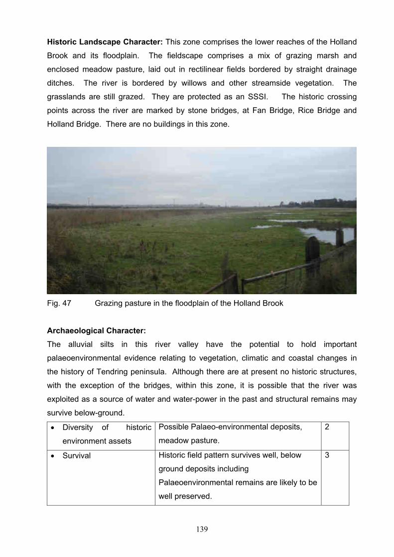
139
Historic Landscape Character: This zone comprises the lower reaches of the Holland
Brook and its floodplain. The fieldscape comprises a mix of grazing marsh and
enclosed meadow pasture, laid out in rectilinear fields bordered by straight drainage
ditches. The river is bordered by willows and other streamside vegetation. The
grasslands are still grazed. They are protected as an SSSI. The historic crossing
points across the river are marked by stone bridges, at Fan Bridge, Rice Bridge and
Holland Bridge. There are no buildings in this zone.
Fig. 47 Grazing pasture in the floodplain of the Holland Brook
Archaeological Character:
The alluvial silts in this river valley have the potential to hold important
palaeoenvironmental evidence relating to vegetation, climatic and coastal changes in
the history of Tendring peninsula. Although there are at present no historic structures,
with the exception of the bridges, within this zone, it is possible that the river was
exploited as a source of water and water-power in the past and structural remains may
survive below-ground.
Diversity of historic
environment assets
Possible Palaeo-environmental deposits,
meadow pasture.
2
Survival Historic field pattern survives well, below
ground deposits including
Palaeoenvironmental remains are likely to be
well preserved.
3

140
Documentation cartographic 1
Group Value Association Meadow pasture features 2
Potential High potential for palaeo-environmental
deposits
3
Sensitivity to change Field pattern and palaeo-environmental
deposits highly sensitive
3
Amenity Value Historic nature of meadow pasture could be
used in relation to neighbouring zones to
elucidate the history of Tendring District.
2
HECZ 6.7: Holland Haven
Summary: A small zone comprising coastal grazing marsh that was enclosed and
drained in the 17th century. The known archaeological remains consist of a Red Hill and
defensive structures, reflecting the zones coastal location,
Historic Landscape Character: This zone comprises an area of drained coastal
marshland located between Clacton and Frinton. Originating as salt-marsh it was
enclosed and drained in the 17th century to form coastal grazing marsh. Elements of
the original creeks still survive within the landscape, coupled with straight drainage
ditches. Part of the zone is still being grazed, whilst the remainder has been converted
to a golf course. The marshes are protected as a SSSI. There are no buildings in this
zone with the exception of the golf course buildings.
Archaeological Character:
The alluvial silts in this zone have the potential to hold important palaeoenvironmental
evidence for vegetation, climatic and coastal changes relating to the history of the
Tendring peninsula. The known archaeology relates to its coastal position. One Red
Hill (Late Iron Age or Roman salt-making site) is recorded and more may be present.
Later periods are represented by defensive structures, including an early 20th century
gun emplacement at Chevaux de Frise Point and a World War II Heavy Anti Aircraft site
at Little Holland. Two lines of sea-wall are visible, with the innermost probably
representing the 17th century reclamation line.
141
Diversity of historic
environment assets
Red hills, original grazing marsh, military
sites
2
Survival Good survival of both landscape and
archaeological deposits
3
Documentation HER data, cartographic 2
Group Value Association Features relating to coastal/wetland
exploitation, Second World War defences
3
Potential Good potential for below ground
archaeological and palaeo-environmental
deposits
3
Sensitivity to change Below ground deposits, surviving historic
landscape features and remaining military
sites highly sensitive to change
3
Amenity Value Potential for promotion of historic
coastal/wetland exploitation and military
defences in association with other coastal
zones
2
HECZ 7.1 Jaywick South
Summary: This zone comprises a group of housing estates which were developed
during the interwar period, comprising bungalows and chalets of lightweight construction
planned as a holiday village for residents of London. The underlying geology is alluvium
overlying London Clay which is exposed on the west side of the zone. The zones
archaeological resource is characterised by a buried land surface with important
prehistoric features and deposits. Most of the zone is in residential use with some
commercial properties.
Historic Urban Character: This zone comprises the interwar residential development
of the Brooklands and Grasslands estates and Jaywick Village. The buildings in the
zone largely comprise bungalows and chalets of lightweight construction. The zone also
includes a small development of ‘Beach Cottages’ built in the late 1990s. The pattern of
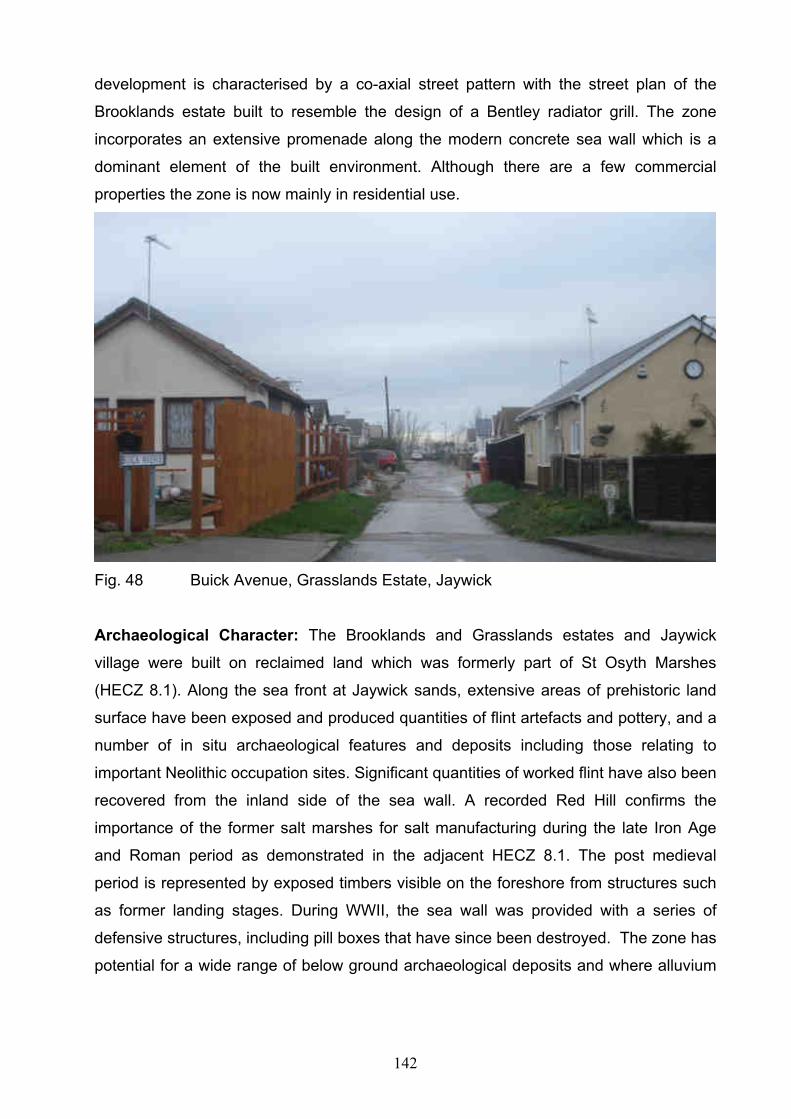
142
development is characterised by a co-axial street pattern with the street plan of the
Brooklands estate built to resemble the design of a Bentley radiator grill. The zone
incorporates an extensive promenade along the modern concrete sea wall which is a
dominant element of the built environment. Although there are a few commercial
properties the zone is now mainly in residential use.
Fig. 48 Buick Avenue, Grasslands Estate, Jaywick
Archaeological Character: The Brooklands and Grasslands estates and Jaywick
village were built on reclaimed land which was formerly part of St Osyth Marshes
(HECZ 8.1). Along the sea front at Jaywick sands, extensive areas of prehistoric land
surface have been exposed and produced quantities of flint artefacts and pottery, and a
number of in situ archaeological features and deposits including those relating to
important Neolithic occupation sites. Significant quantities of worked flint have also been
recovered from the inland side of the sea wall. A recorded Red Hill confirms the
importance of the former salt marshes for salt manufacturing during the late Iron Age
and Roman period as demonstrated in the adjacent HECZ 8.1. The post medieval
period is represented by exposed timbers visible on the foreshore from structures such
as former landing stages. During WWII, the sea wall was provided with a series of
defensive structures, including pill boxes that have since been destroyed. The zone has
potential for a wide range of below ground archaeological deposits and where alluvium

143
and marsh deposits are present these will be conducive to good palaeoenvironmental
survival.
Diversity of historic
environment assets
Built environment, street pattern, red hill,
prehistoric features, finds and deposits, post
medieval timbers
2
Survival Good survival of early 20th century built
environment and prehistoric
features/deposits
2
Documentation HER data 1
Group Value Association Buildings and related co-axial street pattern 2
Potential Potential for deeply buried archaeological
deposits
2
Sensitivity to change Sensitive historic built environment 2
Amenity Value Historic built environment provide
opportunities to explain the early 20th century
development of the sea side resort in
relation/contrast to others nearby
2
HECZ 7.2: Jaywick North
Summary: This zone comprises a 20th century housing estate and static caravan park.
The underlying geology is alluvium and river terrace gravels overlying London Clay. The
zones archaeological resource includes prehistoric features visible as cropmarks and
may contain surviving below ground remains associated with its former marsh edge
location, such as Jay Wick farm. Most of the zone is in residential and leisure use.
Historic Urban Character: This zone includes the Tudor estate which comprises
interwar period and later residential, non-terraced housing. It incorporates the site of Jay
Wick, a modern school and church and the Sackett Grove Caravan Park, located on the
northern edge of the estate, and some modern ribbon development along Jaywick Lane.
The Tudor estate is largely residential with the caravan park providing some leisure use.

144
Archaeological Character: The northern half of the zone is underlain by deeply buried
geoarchaeological deposits associated with ancient courses of the Rivers Thames and
Medway which are likely to contain important evidence for the Clactonian Palaeolithic
industry. These deposits continue into HECZ 7.8 to the east and HECZ 11.4 to the
west. Buried archaeological remains in the north of the zone at Sacketts Grove Caravan
Park have been identified as cropmarks on aerial photographs. They include a large
ring ditch and double ditched trackway which are likely to be prehistoric in origin and to
form part of a complex of ring ditches, field boundaries and enclosures visible in the
adjacent areas to the north, east and west (HECZ 11.4 and 7.8). In the south of the
zone, the Tudor estate overlies the site of Jay Wick farm, which is likely to have been
medieval in origin and which formed the easternmost of a string of ‘wick’ farms located
along the boundary between dry land and St Osyth marsh (HECZ 11.4). In the north
east corner of the zone, is the extant Cross House which is shown on the 1777
Chapman and Andre map and the 1st edition Ordnance Survey map. A heavy anti-
aircraft battery built to the north of Jaywick as part of the WWII defences of the area has
been entirely built over. The zones former marsh edge location and known
archaeological remains suggests that it would have been a focus for activity linked to
the exploitation of the marshes. Whilst the development of the Tudor estate will have
destroyed much of the archaeology in the zone, fragmentary remains may survive.
Preservation is likely to be much greater in the area of the Sackett Grove Caravan Park.
The river terrace gravels that lie within the zone have high potential for important,
minimally disturbed, but deeply buried Palaeolithic deposits.
Diversity of historic
environment assets
Cropmarks, ‘wick’ farm, post medieval
building. WWII defences
2
Survival Extensive disturbance by 20th century
housing development, deeply buried
Palaeolithic deposits may survive well
2
Documentation HER, NMP data, historic mapping 2
Group Value Association Cropmarks 1
Potential Some potential, particularly, within Sackett
Grove Caravan Park and within deeply
buried river terrace deposits
1
145
Sensitivity to change Cropmark sites would suffer from medium to
large scale development
1
Amenity Value Some limited potential to promote the historic
environment due to the zones current leisure
use
1
HECZ 7.3 Clacton on Sea
Summary: This zone comprises the historic core of the 19th century seaside resort of
Clacton on Sea. The archaeological resource includes important Palaeolithic deposits
associated with channel deposits within the river terrace gravels which underlie the
zone. The underlying geology is river terrace gravels and alluvium overlying London
Clay. Most of the zone is in residential use with some commercial/leisure activity, a
significant portion falls within the Clacton Seafront Conservation Area and it contains a
number of listed buildings and structures.
Historic Urban Character: This zone comprises the historic core of the seaside resort
of Clacton on Sea which initially developed as a planned resort in the area of Church
Road, Rosemary Road and Marine Parade from the late 19th century (1870) onwards.
The zone still retains remnants of the initial street layout of terraces and crescents but is
dominated by the growth of a geometrical street plan of later 19th century terraces. The
zone incorporates the promenades of Marine Parade East and West, both centred on
Clacton Pier which was built in 1871. There are no buildings predating the 18th century
but the initial development includes listed street furniture along West Parade. The zone
is largely in residential use with commercial and leisure activity relating to shops and the
pier.

146
Fig. 49 Clacton Pier
Archaeological Character: The western side of the zone is noted for internationally
important geoarchaeological deposits associated with ancient courses of the Rivers
Thames and Medway which contain artefact evidence for the Clactonian Palaeolithic
industry. Neolithic material has also been found on the foreshore indicating a
continuation of the buried land surface identified to the west in HECZ 7.1. Elements of
the late 18th century pattern of roads are preserved within the streets of the later resort
and the zone contains an early 19th century Martello Tower which is designated as a
scheduled monument. Archaeological remains of properties depicted on the 1777
Chapman and Andre map may survive although these are likely to have suffered
significant disturbance. During WW1, West Beach was the site of a sea plane landing
station, of which nothing survives, and the area was heavily defended during WWII with
pill boxes, anti tank obstacles, anti-invasion scaffolding but no remains are known.
Diversity of historic
environment assets
Palaeolithic deposits, historic defences,
historic built environment including resort
structures e.g. piers
2
Survival Good survival of deeply buried Palaeolithic
deposits, and the built heritage of the
seaside resort.
2
Documentation HER data, research projects, historic
mapping
2
Group Value Association Palaeolithic artefacts and associated
deposits, built heritage reflecting the
development of the seaside resort.
3

147
Potential Potential for deeply buried Palaeolithic
deposits, and deposits within the intertidal
zone.
2
Sensitivity to change Built environment of historic seaside resort
(architecture and formal planned street
pattern) sensitive to medium to large scale
change
2
Amenity Value Good potential to interpret the historic
environment of the zone particularly its
seaside heritage in relation to other seaside
resorts. Also Palaeolithic remains.
2
HECZ 7.4 Great Clacton
Summary: This zone comprises the medieval and post medieval historic core of Great
Clacton, the archaeological resource includes medieval and post medieval features and
deposits related to the origins and development of the village. The geology is mainly
London Clay with some river terrace gravels. The majority of the zone falls within the
Great Clacton Conservation Area and it contains a number of listed buildings. Most of
the zone is in residential use with some commercial activity.
Historic Urban Character: This zone comprises the medieval and post medieval
historic core of the village of Great Clacton focused around a church / hall complex,
Great Clacton Hall and the 12th century church of St John, and as ribbon development
along St Johns and Old Road. The zone is now surrounded by housing due to the
expansion of Clacton but retains its character from the impressive parish church and its
surrounding churchyard, and a range of 16th century and later buildings. Great Clacton
Hall is 18th century in date, having replaced an earlier hall located immediately north of
the church within HECZ 7.7. The zone is largely in residential use but is also an
important commercial centre including three historic inns.
Archaeological Character: The church contains Roman brick within its quoins which
suggests Roman activity in the vicinity, although not necessarily within the zone. There
is also some indication of Anglo-Saxon activity within or near to the zone, but again, the
148
precise location is unknown. Important archaeological remains related to the 12th
century church and its churchyard will survive and medieval and post medieval below
ground deposits from associated settlement, including properties depicted on the 1777
Chapman and Andre map, are likely to characterise the archaeology of the zone,
although these have probably suffered disturbance. The zone still retains the historic
road pattern depicted on the 1777 Chapman and Andre map and the surviving built
heritage forms an important part of the archaeological character of the zone. During
WWII the roads leading in and out of the village centre were defended by various
obstacles, none of which survive.
Diversity of historic
environment assets
Historic built environment, below ground
remains
2
Survival Good survival of built heritage, potential for
below ground deposits
2
Documentation HER data, historic mapping, Listed building
descriptions, Conservation Area appraisal
2
Group Value Association Historic buildings reflecting medieval and
post medieval settlement
2
Potential Potential for medieval and post medieval
below ground deposits
2
Sensitivity to change Built environment of historic village
(architecture and historic street pattern)
sensitive to medium to large scale change
2
Amenity Value Potential to interpret the historic environment
of the zone including the medieval origins of
Clacton , prior to its development as a
seaside resort
2
HECZ 7.5 Holland on Sea
Summary: This zone comprises the medieval church/hall complex of Little Holland and
interwar expansion to the east of Clacton. The geology of the zone is River Terrace
gravels over London Clay. The zones archaeological resource includes the scheduled

149
remains of the medieval parish church and cemetery. Listed buildings include Little
Holland Hall . Most of the zone is in residential use.
Historic Urban Character: This zone comprises mainly interwar, and some post war,
expansion to the east of Clacton on Sea. The interwar expansion includes a significant
area of semi-detached housing partly laid out in a distinctive co-axial street plan. Post
war residential development is located to the north of the B1032. The zone contains two
listed buildings consisting of the 17th century, or earlier, Oakwood Inn and Little Holland
Hall which is a 16th century or earlier timber framed house (now a residential home).
Other buildings of note include the Ogilvie School of Recovery comprising two late
19th/early 20th century convalescent homes (now Shorefields Special School). The zone
is largely residential. The sea front is characterised by blocks of beach huts and modern
sea defences.
Archaeological Character: Finds of prehistoric flints on the foreshore indicate a
continuation of the buried land surface identified elsewhere along this part of the coast.
A single find of Roman pottery suggests Roman activity within the zone. The medieval
parish church is designated as a scheduled monument and survives as a raised
earthwork and upstanding east wall preserved within an area of open space.
Excavations have indicated that the origins of the associated cemetery may predate the
medieval church. Located to the north of the church are two ponds and a large basin,
former mill ponds that are significant historic landscape features and which have
potential for waterlogged deposits. Important archaeological remains related to the
church and cemetery will survive and medieval and post medieval below ground
deposits from associated settlement, including properties depicted on the 1777
Chapman and Andre map, are likely to characterise the archaeology of the zone,
although these have probably suffered disturbance. The zone still retains the historic
road pattern depicted on the 1777 Chapman and Andre map. During WWII the roads
leading in and out of the zone and the sea front were heavily defended by dummy
minefields, gun emplacements and pill boxes, none of which survive.

150
Fig. 50 Earthworks of the medieval church, Holland-on-Sea
Diversity of historic
environment assets
built environment, medieval church,
dispersed medieval and post medieval
settlement, WW II sites, prehistoric land
surface
2
Survival Good survival both of built and buried
deposits around Holland Hall, remaining area
badly affected by post war development
1
Documentation HER data, historic mapping, designation
documentation
2
Group Value Association Medieval complex at Little Holland, WW II
monuments
2
Potential Potential for medieval and post medieval
below ground deposits
2
Sensitivity to change Built environment of medieval church / hall
complex, and inter war street pattern
sensitive to medium to large scale change
2
Amenity Value Some potential to interpret the historic
environment of the zone including medieval
origins of Little Holland
1
151
HECZ 7.6 Clacton
Summary: This zone comprises the 19th and 20th century expansion of the seaside
resort of Clacton on Sea. The zones archaeological resource includes important
Palaeolithic deposits associated with channel deposits within the river terrace gravels
which underlie the zone. The geology of the zone is River Terrace gravels, alluvium and
Head overlying London Clay. Most of the zone is in residential use. There are a number
of listed buildings of 19th and 20th century date and a scheduled Martello Tower.
Historic Urban Character: This zone comprises later 19th and 20th century expansion
of Clacton on Sea including residential housing built outside the initial geometric plan of
the seaside resort (HECZ 7.3) and incorporates ribbon development of terraces along
Old Road and St Osyths Road. Geometric street planning continues to the south of the
railway station, opened in 1882, and to the east of the historic core of the seaside
resort. There is some small scale 20th century industrial development along Old Road
and in the area of the railway station but otherwise the zone is in residential use. The
zone contains no buildings which predate the 18th century but the 19th century built area
includes listed buildings of 19th and 20th century date. The zone is largely residential
with some commercial/retail use.
Archaeological Character: The zone is noted for internationally important
geoarchaeological deposits associated with ancient courses of the Rivers Thames and
Medway that have been identified through various excavations and which contain
artefact evidence for the Clactonian Palaeolithic industry. These Clacton Channel
deposits were once exposed along cliffs when numerous artefacts, famously including a
wooden spear, were found on the foreshore. The cliffs are now concealed by sea
defences and deposits are deeply buried. They continue into HECZ 7.7 to the west.
Neolithic material has also been found on the foreshore indicating a continuation of the
buried land identified to the west (HECZ 7.1). The Chapman and Andre map of 1777
depicts a linear green (Magdalen Green) within the zone, which would have been a
focus for settlement during the medieval period, as it was when the map was published.
Archaeological remains of green side settlement and other properties depicted on the
1777 Chapman and Andre map may survive although these are likely to have suffered
significant disturbance. The zone includes a Napoleonic Martello tower, which was

152
originally fronted by a gun battery that has since been lost to the sea. The tower is
designated as a Scheduled Monument. Industrial sites including a late 19th century gas
works and three brick works are known in the zone. During WW1, West Beach was the
site of a sea plane landing station, of which nothing survives, and the area was heavily
defended during WWII with pill boxes, anti tank obstacles and ammunition dump, but no
remains are known.
Fig.51 Martello Tower, Clacton
Diversity of historic
environment assets
Palaeolithic deposits, historic defences 2
Survival Good survival of deeply buried Palaeolithic
deposits
1
Documentation HER data, research projects, historic
mapping
2
153
Group Value Association Palaeolithic artefacts and associated
deposits, built environment relating to the
development of the seaside resort
2
Potential Potential for deeply buried Palaeolithic
deposits
2
Sensitivity to change Formal planned street pattern sensitive to
medium to large scale change
2
Amenity Value Some potential to interpret the historic
environment of the zone including its seaside
heritage in relation to other zones
1
HECZ 7.7 Clacton North
Summary: This zone largely comprises post War and later 20th century residential and
industrial development built to the north and west of the planned settlement at Clacton
on Sea. The underlying geology is river terrace gravels and Head over London Clay.
The zones archaeological resource includes important Palaeolithic deposits, a
submerged Neolithic land surface, prehistoric and later cropmark sites and possible
medieval and post medieval settlement remains. Most of the zone is in residential use.
There are a number of listed buildings of 16th to19th century date.
Historic Urban Character: This zone comprises post War and later 20th century
residential developments built to the north and west of the initial planned 19th century
settlement at Clacton on Sea. It incorporates lesser settlements such as Rush Green
and Bocking’s Elm and includes a pre-war residential development bounded by the
railway line to the east and a number of schools and playing fields. There is a large
modern satellite industrial and retail estate along the northern fringe of the built up area
at Gorse Lane. Otherwise, the zone is largely residential use.
Archaeological Character: The zone is noted for internationally important
geoarchaeological deposits associated with ancient courses of the Rivers Thames and
Medway that have been identified through various excavations and which contain
artefact evidence for the Clactonian Palaeolithic industry. These Clacton Channel
deposits were once exposed along cliffs when numerous artefacts, famously including a

154
wooden spear, were found on the foreshore. The cliffs are now concealed by sea
defences and deposits are deeply buried. The deposits continue into HECZ 7.6 to the
east. Neolithic material has also been found on the foreshore indicating a continuation
of the submerged land surface identified to the west at Lion Point (HECZ 7.1). Aerial
photographs have revealed cropmarks of ring ditches, pits, linear features and ditched
enclosures scattered across the zone. Many of these are within school playing fields but
some have been built over. On the western side of the zone, the cropmarks continue
into HECZ 7.8. Small scale excavations have indicated a prehistoric origin for at least
one of these features. The Chapman and Andre map of 1777 depicts a dispersed
settlement pattern within the zone including greens (Rush Green and Coppens Green),
isolated farms and halls, and the site of Great Clacton Hall which was part of a medieval
church/hall complex that may have had its origins in the Anglo-Saxon period (see also
HECZ 7.4) Archaeological remains of green side settlement and other properties
depicted on the 1777 Chapman and Andre map, including Great Clacton Hall, may
survive although these are likely to have suffered significant disturbance. On the east
side of the zone is the extant and listed Cann Hall, which is shown on the 1777
Chapman and Andre map and the 1st edition Ordnance Survey map. At least one post
medieval industrial site was located in the zone comprising a brick-works, which
continued into HECZ 7.5. During WWII the zone was heavily defended with pill boxes
and anti tank obstacles, and there was an ammunition dump next to the station but no
remains are known. Martello Bay is the site of a former Butlins Holiday Camp which
was closed in 1983 and redeveloped as a housing estate.
Diversity of historic
environment assets
Palaeolithic deposits, Neolithic land surface,
cropmark sites, industrial remains, historic
buildings
2
Survival Good survival of deeply buried Palaeolithic
deposits
1
Documentation HER data, research projects, historic maps,
NMP data
2
Group Value Association Palaeolithic artefacts and associated
deposits
1
Potential Potential for deeply buried Palaeolithic
deposits
1
155
Sensitivity to change The historic environment of the zone is able
to accommodate medium to large scale
change
1
Amenity Value Limited potential except in relation to other
zones
1
HECZ 7.8 Clacton Airfield
Summary: This zone comprises a flat and open landscape situated between Clacton
and Jaywick. The geology consists of estuarine alluvium deposits in the south, and
river gravel terraces overlying London Clay. Current land use includes two golf courses
separated by Clacton airfield and arable fields. The southern golf course overlies the
eastern end of what was formerly St Osyth Marsh. Historic settlement in the zone was
sparse. The fieldscape is of ancient origin. Archaeologically, the character of the zone is
dominated by multi-period cropmark complexes and the internationally important
Palaeolithic remains of the Clacton Channel deposits. The zone also includes a
scheduled Martello Tower.
Historic Landscape Character: The southern half of the zone was once part of St
Osyth Marsh (HECZ 8.1). The natural saltings that formerly existed in this part of the
zone began to be enclosed within seawalls during the medieval period. The process of
reclamation was largely complete by the time the Chapman and Andre map of Essex
was published in 1777. Historically the marsh would have provided grazing for cattle
and sheep, although parts of it may also have been used at times for crop production.
Fragments of former grazing marsh may survive within the golf course but appears to
have been largely removed through landscaping. A modern road (West Road) runs
between this golf course and the airfield and golf course to the north. Straight, hedged
field boundaries survive in this area, surrounding rectangular arable fields. A large,
water-filled gravel quarry, depicted on the 1st edition OS map (c 1876) is located on the
airfield site. The northern half of the zone includes a civic amenity site, and playing
fields, including those of a modern college.
Archaeological Character: The southern half of the zone is noted for internationally
important geoarchaeological deposits associated with ancient courses of the Rivers

156
Thames and Medway that have been identified through various excavations and which
contain artefact evidence for the Clactonian Palaeolithic industry. These Clacton
Channel deposits were once exposed along cliffs when numerous artefacts, famously
including a wooden spear, were found on the foreshore. The cliffs are now concealed by
sea defences and deposits are deeply buried. They continue into HECZ 7.7 and HECZ
7.6 to the east. Along the sea front, extensive areas of prehistoric land surface have
been exposed and produced quantities of flint artefacts and pottery, and a number of in
situ archaeological features and deposits including those relating to important Neolithic
occupation sites. In the northern half of the zone, extensive, cropmark complexes have
been identified including ditched field boundaries and enclosures and ring ditch
cemeteries. Excavations at Bishops Park College, revealed the multi-period origin of
these features with finds ranging from a Late Bronze Age trackway and elements of a
Roman field system and probable building to Saxon material and a medieval ditched
trackway. The Martello Tower is designated as a Scheduled Monument and Listed
Building. There were numerous WWII defensive structures including pill boxes and a
diver site, across the zone due to its open, coastal position.
The zone still retains significant potential for below ground archaeological deposits
despite extensive disturbance from landscaping associated with the golf courses which
will have had a negative impact. Within the southern half of the zone, the soil-type,
comprising extensive alluvium and marsh deposits are conducive to good
palaeoenvironmental survival. The river terrace gravels that lie beneath the southern
end of the zone have high potential for internationally important, but deeply buried
Palaeolithic deposits.
Diversity of historic environment assets
Good range of archaeological features
from different periods
3
Survival Significant remains surviving but some
adverse affects from golf course
construction
2
Documentation HER data, NMP data, historic mapping,
research project, designation
documentation
2
Group Value Association Cropmark sites 2

157
Potential Potential for surviving remains including
deeply buried Palaeolithic deposits within
river gravels, and cropmark sites in
farmland
3
Sensitivity to change Cropmark complexes and specific assets
sensitive to change.
2
Amenity Value Potential for promotion of the zone in
relation to others particularly with regard to
Palaeolithic deposits and of specific
assets such as the Martello Tower.
2
HECZ 8.1 St Osyth Marshes
Summary: This zone comprises the surviving and former coastal grazing marsh of St
Osyth Marsh. The geology is estuarine alluvium deposits. The sea walls and borrow
dykes on the western side of the zone fall within areas of importance for nature
conservation and are designated as an Essex Coast Special Protection Area (SPA),
Site of Special Scientific Interest (SSSI) and the Colne Estuary Ramsar. Modern
developments include holiday chalets at Lee-over-sands and a sewage treatment
works. The zone is characterised by Red Hills and late medieval and post medieval
historic landscape features.
Historic Landscape Character: The natural saltings that formerly existed in the zone
began to be enclosed within seawalls during the medieval period. The process of
reclamation was largely complete by the time the Chapman and Andre map of Essex
was published in 1777, although there may have been some additional reclamation in
the early 19th century on the western side of the zone. Fragments of grazing marsh
survive on the eastern side of the zone, containing fossilised fleets and other natural
depressions which are evidence of former creeks and saltmarsh before the seawall was
built. The zone is characterised by its open and flat aspect and arable cultivation. Field
boundaries are mainly dykes and drainage ditches, some following the sinuous course
of former creeks. There has been significant boundary loss since the 1st edition OS map
(c1876), most probably as a result of post 1950 rationalisation. The sea walls and an
occasional counter wall survive as earthworks and are the dominant historic landscape

158
feature in the zone although a scheduled post medieval duck decoy with surrounding
vegetation is prominent on the zones eastern side. The zone has a close relationship
with HECZ 11.4 to the north via the line of ‘Wick’ farms which were located along the
former marsh edge.
Archaeological Character: The river terrace gravels that lie beneath the eastern half of
the zone have high potential for internationally important, but deeply buried Palaeolithic
deposits. Evidence for at least four red hills has been noted within the zone, indicating
its significance for the production of sea salt during the late Iron Age and Roman
periods. Aerial photographs have recorded the location of a series of former sea walls
on the west side of the zone, some of which are depicted as earthworks on the 1st
edition OS map (c.1876), and which represent different stages of marshland
reclamation. The surviving sea walls and counter walls are likely to be medieval or post
medieval in origin and will retain evidence for date and construction. The Lion Point
duck decoy pond survives as a significant earthwork and may retain evidence for its
construction and operation within waterlogged deposits. The zone has potential for a
further wide range of below ground archaeological deposits, and possibly earthworks
within the relict grazing marsh, although agricultural intensification will have denuded
below ground archaeological remains in areas which have been converted to arable
production. The soil-type, comprising extensive alluvium and marsh deposits are
conducive to good palaeoenvironmental survival.
Diversity of historic environment assets
Red Hills, Sea and Counter walls 1
Survival Moderate to good survival particularly
below ground deposits
2
Documentation HER data, NMP data 1
Group Value Association Features relating to marshland and
coastal zone exploitation including Red
Hills, counter and sea walls
2
Potential Good potential for surviving deposits
including important palaeoenvironmental
remains
2
Sensitivity to change Relict grazing marsh and archaeological 2

159
deposits sensitive to change.
Amenity Value Potential for promotion, in conjunction with
other zones, of the history of marshland
and coastal zone exploitation in Tendring
District.
2
HECZ 8.2 Seawick Holiday Village
Summary: This zone comprises the holiday complex at Seawick, including chalets,
caravan parks and leisure facilities located on an area formerly part of St Osyth Marsh.
The geology is estuarine alluvium deposits. The zone is characterised by sea walls and
coastal fortifications, including a nationally important Napoleonic Martello tower.
Fig. 52 Chalets in Seawick Holiday Village
Historic Landscape Character: The natural saltings that formerly existed in the zone
began to be enclosed within seawalls during the medieval period. The process of
reclamation was largely complete by the time the Chapman and Andre map of Essex
was published in 1777. A former sea wall, surviving as a significant earthwork, runs
through the eastern side of the zone, dividing two caravan parks. This and the current
sea wall which demarcates the southern edge of the zone are the dominant historic
landscape features.
Archaeological Character: The river terrace gravels that lie beneath the eastern half
of the zone have high potential for internationally important, but deeply buried
Palaeolithic deposits. The surviving sea walls within the zone will retain evidence for
date and construction. The most significant known archaeological remains in the zone
160
comprise a Napoleonic Martello tower, which is designated as a Scheduled Monument.
The tower stands to its original height but originally accompanied a ‘V’-shaped gun
battery, of which little survives, although it is reflected in the angle of the modern sea
wall. Later defensive structures include WWII pill boxes, many of which have been
destroyed. There is potential for palaeo-environmental remains buried within or beneath
the alluvium.
Diversity of historic environment assets
Known range of historic environment
assets is limited.
1
Survival Limited survival, except with regard to the
Martello tower and possibly deeply buried
deposits.
2
Documentation EHER data, NMP data and designation
documentation
1
Group Value Association Sea defences and fortifications 1
Potential Low potential for surviving assets, with the
exception of deeply buried deposits.
2
Sensitivity to change Specific assets sensitive to change 1
Amenity Value Potential for promoting defence and
coastal heritage of Tendring in conjunction
with other zones.
2
HECZ 8.3 Former marshes at Point Clear Bay
Summary: This zone is comprised of an area of former reclaimed saltmarsh, along the
south bank of Brightlingsea Creek. The geology is estuarine alluvium deposits with an
outcrop of river gravel terraces on the eastern side of the zone. Two thirds of the zone is
now occupied by houses, caravan parks and a leisure complex at Point Clear Bay. The
remaining eastern part of the zone is utilised as a golf course. The zone contains a
nationally important Napoleonic Martello Tower and gun battery. Areas adjacent to the
zone are highly important for nature conservation and the northern and western fringes
of the zone falls within a Special Area of Conservation (SPC) and the Essex Coast
Special Protection Area (SPA). Historically the zone will have had a close relationship

161
with HECZ 8.6 (the inter tidal zone of the Colne Estuary) and the adjacent inland zone,
HECZ 11.4, to the south of St Osyth.
Historic Landscape Character: The natural saltings that formerly existed in the zone
probably began to be enclosed within seawalls during the medieval period. The process
of reclamation was certainly complete by the time the Chapman and Andre map of
Essex was published in 1777. The fleets and creeks which show up as cropmarks on
the golf course are evidence of former saltmarsh before the seawall was built.
Historically the marsh would have provided grazing for cattle and sheep, although parts
of it may also have been used at times for crop production. There are very few surviving
field boundaries in the zone, mainly dykes and drainage ditches. The sea wall and
visible sections of adjacent borrow dyke are the dominant historic landscape feature.
20th century development on the marsh took place after c.1950.
Archaeological Character: The depiction of sea walls on the 1st to 3rd edition OS maps
and as cropmarks on aerial photographs from the 1950’s suggest at least three stages
of reclamation of the saltmarsh, and the surviving sea walls will retain evidence for date
and construction. A compound of buildings, presumably livestock sheds situated on
the zones southern boundary, is also depicted on the 1st to 3rd edition OS maps and
there are likely to be archaeological, possibly earthwork remains relating to these
structures, although the site is now partially covered by buildings associated with a
caravan park. A sheepfold, formed from the ends of four creeks, is also shown but is
now covered by a modern road and building. The most significant known
archaeological remains in the zone comprise a Napoleonic Martello tower and
associated gun battery situated at the northwest tip of the zone, overlooking
Brightlingsea Reach and the mouth of the River Colne. The tower stands to its original
height, but has later additions dating to the Second World War. The upstanding remains
of the Stone Point battery comprised sections of the ‘V’-shaped brick wall and its
massive foundations. The Martello Tower and gun battery are designated as a
Scheduled Monument; the tower is also a Listed Building. Later defensive structures
comprised a destroyed WWII pill box.
The zone retains some potential for below ground archaeological deposits, although
modern development across its western end will have severely reduced the level of

162
survival and at its eastern end, landscaping associated with the golf course will also
have had a negative impact. The soil-type, comprising extensive alluvium and marsh
deposits are conducive to good palaeoenvironmental survival. The river terrace gravels
that lie within the eastern side of the zone have high potential for important, minimally
disturbed, but deeply buried Palaeolithic deposits.
Diversity of historic environment assets
Defensive structures, sea walls/borrow
dyke and buried archaeological features
2
Survival Limited survival, except with regard to
buried deposits
1
Documentation HER data, NMP data, historic mapping,
designation documentation
2
Group Value Association Napoleonic and defensive structures 1
Potential Restricted potential for surviving remains
apart from buried remains including deeply
buried Palaeolithic deposits within river
gravels
2
Sensitivity to change Landscape fragments, specific assets
sensitive to change, and buried deposits.
1
Amenity Value Potential for promoting defence and
coastal heritage of Tendring in conjunction
with other zones.
2
HECZ 8.4 Howlands Marsh
Summary: This zone comprises an area of reclaimed saltmarsh along the south bank
of Flag Creek and north bank of St Osyth Creek to the west of St Osyth Priory and park.
Howlands Marsh includes around 73 hectares of improved and unimproved grazing
marsh, spilt up by former dykes and creeks. The northern end of the zone is occupied
by the ballast quay at Wellwick Wharf and associated slurry pools, industrial buildings
and machinery. There is no settlement within the zone which is highly important in
terms of the natural environment. Significant parts of the zone are designated as a Site
of Special Scientific Interest (SSSI), Special Area of Conservation (SPC), and fall within
the Essex Coast Special Protection Area (SPA) and Colne Estuary Ramsar site. The

163
majority of the zone is owned and managed as a nature reserve by Essex Wildlife Trust.
Historically the zone had a close relationship with HECZ 8.6 (the tidal waters of the
Colne Estuary) and adjacent inland HECZ 11.4 and 11.5. This relationship continues to
be expressed in the ongoing activities at Wellwick Wharf.
Historic Landscape Character: The natural saltings that formerly existed in the zone
probably began to be enclosed within seawalls during the medieval period. The process
of reclamation was certainly complete by the time the Chapman and Andre map of
Essex was published in 1777. The fleets and other natural depressions in the grassland
are evidence of former creeks and saltmarsh before the seawall was built. Historically
the marsh would have provided grazing for cattle and sheep, although parts of the
marsh have also been used in the past for crop production as evidenced in places by
surviving ridges and furrows of ‘stetch’ cultivation earthworks. The 1st edition OS map
(c1876) also depicts a series of straight hedged field boundaries at the north end of the
zone which are likely to have bordered fields used for arable farming. Elsewhere, field
boundaries in the zone are mainly dykes and drainage ditches, many following the
sinuous course of former creeks, together with modern post and wire fences. The
geology of the zone is estuarine alluvium deposits. The zone is characterised by its
open and flat aspect. The dominant historic landscape feature within the zone is the sea
wall but other significant features include low linear earthworks which are likely to be
either counter walls or raised sheep walks/trackways. There has been little boundary
loss other than in the area of the ballast quay at Wellwick Wharf. The wharf developed
during the mid to late 20th century and has had a significant impact on the visual
character of the northern part of the zone, with modern industrial machinery, including
high level conveyors, buildings, mounds of aggregate and slurry pools/lagoons
dominating the area.

164
Fig. 53 Raised causeway, Howlands Marsh
Archaeological Character: Evidence for at least two red hills has been noted in the
southern end of the zone indicating its significance for the production of sea salt during
the late Iron Age and Roman periods. The sea walls and counter walls/raised
causeways are likely to be medieval in origin and will retain evidence for date and
construction. A rectangular enclosure bordered by marsh drains has been recorded in
the zone on aerial photographs but this has largely been destroyed by the construction
of a lagoon at Wellwick Wharf. A compound of buildings, presumably livestock sheds, is
depicted in the centre of the zone from the 1st to 3rd edition OS maps and there are
likely to be archaeological, possibly earthwork remains relating to these structures. The
zone has potential for a further wide range of below ground archaeological deposits,
although modern industrial activity towards its northern end will have severely reduced
the level of survival in a limited area. The soil-type, comprising extensive alluvium and
marsh deposits is conducive to good palaeoenvironmental survival.
Diversity of historic environment assets
Range of historic landscape and
archaeological features
2
Survival Good survival. 2
Documentation Limited HER data, NMP data, and historic
mapping
1
Group Value Association Features relating to coastal and
marshland exploitation including sea walls,
raised walkways, stetch, red hills,
3
Potential High potential for surviving deposits. 3

165
Sensitivity to change Landscape and archaeological deposits
highly sensitive to change.
3
Amenity Value Potential for promoting the importance of
the historic environment within the Colne
Estuary, especially the medieval economy.
Proximity to tourist attraction of medieval
St Osyth Priory.
2
HECZ 8.5 Brightlingsea Marshes
Summary: This zone comprises reclaimed coastal grazing marsh and former grazing
marsh around the Brightlingsea peninsula, adjacent to Brightlingsea Creek, Arlesford
Creek and the River Colne. The geology is estuarine alluvium deposits. Parts of the
zone are important for nature conservation and are designated as a Special Protection
Area (SPA) and Site of Special Scientific Interest (SSSI). The zone includes significant
Roman remains and fragments of historic grazing marsh landscape.
Historic Landscape Character: The natural saltings that formerly existed in the zone
may have begun to be enclosed within seawalls during the medieval period but there is
no evidence for reclamation prior to 1700. The creek to the north of the peninsula
appears to have been reclaimed relatively early and several lengths of counter wall
survive. Together with the sea wall, these are the dominant historic landscape features
within the zone. The process of reclamation was largely complete by the time the
Chapman and Andre map of Essex was published in 1777. Quite substantial fragments
of grazing marsh survive on the north and south sides of the peninsula and contain
fleets and other natural depressions which are evidence of former creeks and saltmarsh
before the seawall was built. The zone is characterised by its open and flat aspect. Field
boundaries are mainly dykes and drainage ditches, some following the sinuous course
of former creeks. There has been little boundary loss other than in the area to the west
of Brightlingsea Harbour which has been developed from the pre-war years as a
seaside resort with boating lake, caravan parks and 1930’s open-air swimming-pool.
This area of the zone also includes Batemans Tower, built in the late 19th century as a
folly.
166
Archaeological Character: Evidence for at least three red hills has been noted on the
eastern side of the zone, at the junction between the marsh edge and high ground,
indicating its significance for the production of sea salt during the late Iron Age and
Roman periods. The site of a possible Roman Villa is located at the north east end of
the peninsula on the edge of the zone and may be associated with the industry. A
rectangular enclosure located to the south of the villa has been recorded on aerial
photographs. The sea walls and counter walls are likely to be late medieval or post
medieval in origin and will retain evidence for date and construction. Oyster pits are
recorded on the 1st edition OS map in the area to the west of Brightlingsea Port. The
archaeology of the zone is also characterised by WWII defensive structures including
anti-glider ditches recorded on aerial photographs, and anti tank obstacles, now
destroyed. The zone has potential for a further wide range of below ground
archaeological deposits, and possibly earthworks within the relict grazing marsh,
although modern leisure development west of Brightlingsea Harbour will have severely
reduced the level of survival in a limited area. The soil-type, comprising extensive
alluvium and marsh deposits are conducive to good palaeoenvironmental survival.
Diversity of historic environment assets
Red Hills, Roman Villa, Sea and Counter
walls, WW II defences
2
Survival Moderate to good survival 2
Documentation HER data, NMP data 1
Group Value Association Features reflecting coastal and marshland
exploitation at a number of periods
including Red Hills, Roman Villa, counter
and sea walls
3
Potential Good potential for surviving deposits. 2
Sensitivity to change Relict grazing marsh and archaeological
deposits sensitive to change.
3
Amenity Value Potential for promoting coastal heritage of
Tendring in conjunction with other zones.
2
HECZ 8.6 Colne Estuary inter tidal zone
Summary: This zone comprises the Colne Estuary outside the sea walls and includes
the main river channel, tidal creeks at Brightlingsea, St Osyth and Arlesford, natural

167
saltings and large expanses of mudflat covered over at high water. The geology is
estuarine alluvium deposits. An extensive shingle spit encloses a considerable area of
salt marsh at Colne Point. The zone has a range of archaeological remains throughout
but with a particular focus on the saltings and between the low and high water mark.
There is no settlement within the zone. The zone is highly important in terms of the
natural environment; with the exception of the mill pond at St Osyth, the entire zone is
designated as a Site of Special Scientific Interest (SSSI), Special Area of Conservation
(SPC), and falls within the Essex Coast Special Protection Area (SPA) and Colne
Estuary Ramsar site. Colne Point is managed as a nature reserve. The river is
important for both commercial and leisure activities. Historically the zone had a close
relationship with adjacent dryland zones, in particular through the port at Brightlingsea
(HECZ 10.2) and quay at St Osyth (HECZ 11.6), but also via numerous small jetties,
wharfs and docks.
Historic Landscape Character: The broad expanse of the Colne estuary and its
associated creeks has been a major artery for trade and transport, together with a
source of fish, shell fish and wildfowl, for millennia. In the recent past particularly during
the 19th century the estuary was a focus of the oyster industry as shown by the number
of oyster pits in Brightlingsea Creek, notably on Cindery Island and at Colne
Point. Now mainly used by leisure craft the estuary still has limited commercial and
fishing traffic together with some oyster beds. The tidal mill pond at the end of St Osyth
Creek and mill pond at Thorrington Mill on Arlesford Creek and their associated dams
are significant features in the landscape.
Archaeological Character: The tidal waters of the Colne Estuary have been shown to
contain some well preserved archaeological deposits and remains associated with the
use of the estuary for transport and the exploitation of its resources. The area to the
immediate east of this zone is noted for its nationally important geoarchaeological /
Palaeolithic deposits relating to river terrace gravels deposited by ancient courses of the
Rivers Thames and Medway which are believed to extend into the foreshore to the
south of Seaview Holiday Park. A Neolithic polished axe has been reported from the
foreshore at Arlesford and a stone macehead was recovered from Cindery Island but no
prehistoric in situ features or land surfaces have been identified. Roman pottery has
been recovered from the saltings at Colne Point. The Colne estuary has had a

168
chartered fishery since the 12th century and archaeological remains from this industry
can be seen off Colne Point, where two parallel lines of timber posts indicate the
location of a fish-trap. Further finds of timberwork, together with associated pottery in
Arlesford Creek are thought to represent the location of a wharf and associated
trackway. Principal archaeological remains from the post medieval period mainly
relating to industry and transport are; numerous wrecks of hulks, such as ‘The Folly’ in
Brightlingsea Creek, timber jetties, relict sea walls, oyster pits and a disused swing
bridge at Arlesford Creek. The zone is also characterised by WWII defensive structures
including rows of anti tank obstacles and WWII pill boxes, many of which are destroyed,
with particular concentrations along the beach between Jaywick and Lee-over-Sands.
Fig. 54 Parallel lines of timber posts from a former jetty at Colne Point
The potential for palaeoenvironmental remains and deposits in this area is high and
there are significant possibilities of archaeological remains directly related to these
deposits including further timber structures.

169
Diversity of historic environment assets
Range of historic landscape and
archaeological features
2
Survival Moderate to good survival 2
Documentation HER data, Hullbridge Survey (research
project), NMP data
2
Group Value Association Features related to coastal/marine
exploitation including sea walls, timbers,
oyster pits, hulks
3
Potential Good potential for surviving deposits. 2
Sensitivity to change Landscape and archaeological deposits
sensitive to change.
2
Amenity Value Potential for promoting and coastal
heritage of Tendring in conjunction with
other zones, particularly in relation to
access to ports within and beyond the
district. .
2
HECZ 9.1: Eastern Brightlingsea
Summary: This zone comprises the eastern half of the former island of Brightlingsea.
The geology comprises Kesgrave sands and gravels which overlie London Clay, the
latter is exposed around the edges of the peninsula at the interface with the marshes.
The fieldscape consists of pre-18th century enclosure and settlement comprises a string
of farms located on the interface between the gravel and the London Clay. The
archaeological character is dominated by cropmarks of prehistoric or later date. There
has been a considerable degree of quarrying in this zone.
Historic Landscape Character: The fieldscape is largely irregular and of ancient
origin, there is a band of more rectangular fields on the London Clay in the north-east of
the zone. The settlement pattern was highly dispersed, comprising the church/hall at
Brightlingsea Hall and a number of farms strung out along the interface between the
London Clay and the sands and gravel, close to the former marshland of the Colne
Estuary (HECA 8). There are a number of small areas of historic woodland and one
170
small triangular green at Eastend Green. There has been post 1950s boundary loss in
the zone, largely due to earlier mineral extraction operations.
Archaeological Character: The character of the zone is dominated by a series of
cropmark complexes a number of which have now been lost to mineral extraction. The
cropmarks include ring-ditches of possible Neolithic or Bronze Age date. A number of
cropmarks of enclosures, some of which survive, may represent prehistoric or Roman
settlement. A series of cropmarks of large pits at Morses Wood may represent Saxon
sunken-featured buildings. Brightlingsea was a Royal Vill in the later Saxon period.
Brightlingsea Hall comprised a church/hall complex; the church is Listed Grade I. The
farms are all medieval in origin; a number of their buildings are also Listed. There has
been extensive quarrying in this zone, largely without archaeological record.
Diversity of historic
environment assets
Multi-period cropmarks, medieval
settlement pattern
2
Survival Good survival of below ground
archaeological deposits in unquarried
areas
2
Documentation HER data, NMP 1
Group Value Association Cropmarks 2
Potential High potential for below ground
archaeological deposits in unquarried
areas
2
Sensitivity to change Surviving landscape sensitive to visible
change with below ground deposits
sensitive to both quarrying and housing
development.
2
Amenity Value Limited potential, however cropmark
information could be used in conjunction
with other zones to explore the history of
the Tendring peninsula.
1

171
HECZ 9.2: Land west of Brightlingsea and Moverons Pit
Summary: This zone consists of the north-western part of the former island of
Brightlingsea, containing the quarry of Moverons Pit. The geology comprises Kesgrave
sands and gravels which overlie London Clay; the latter is exposed around the edges of
the peninsula at the interface with the marshes. The fieldscape consists of pre-18th
century enclosure and a few scattered farms. The archaeological character is
dominated by cropmarks of prehistoric or later date. There has been a considerable
degree of quarrying in this zone.
Fig. 55 Bronze Age Ring Ditch Cemetery, Brightlingsea
Historic Landscape Character: The fieldscape on the sands and gravels is largely
irregular and of ancient origin, with a band of more rectangular fields on the London
Clay. The settlement pattern was highly dispersed, comprising a few scattered farms.

172
There are a number of small areas of historic woodland, some of which acted as
windbreaks. There has been post 1950s boundary loss in the area, largely due to
quarrying.
Archaeological Character: The character of the area is dominated by a series of
impressive cropmark complexes; however large areas have been lost to mineral
extraction. At Moverons Pit, excavation prior to quarrying concentrated on a large Early
Neolithic ring-ditch and a middle Bronze Age cemetery which contained a tight cluster of
22 ring ditches with a number of cremations placed in the spaces between them. It is
evident from the cropmarks that these formed one small element of a much larger multi-
period landscape. Extensive fieldwalking has taken place over much of the rest of the
zone, confirming widespread prehistoric, mainly Neolithic and Bronze Age, settlement
and exploitation. To the south and east of Moverons Pit more cropmarks survive; these
include a ring-ditch cemetery, enclosures, trackways and fields. The site of a Roman
villa is located at Noah’s Ark, at the north west end of the zone. The farms are first
recorded in the 13th century and a number of them are Listed Buildings. Later periods
are represented by a series of WWI and WWII slit-trenches in the northern part of the
zone, some of which still survive as crop-marks.
Diversity of historic
environment assets
Extensive range of archaeological
deposits of multi-period date, landscape
features, built heritage, World War
features
3
Survival Extensive survival outside quarried areas 2
Documentation HER data, NMP, excavation reports 3
Group Value Association Important group value associated with
prehistoric settlement and burial
3
Potential High potential for below ground deposits
in unquarried areas
3
Sensitivity to change Surviving below ground deposits highly
sensitive to further quarrying
3
Amenity Value Potential for promotion of below ground
deposits relating to the history of the
2

173
Brightlingsea peninsula and Tendring
more generally.
HECZ 10.1 Brightlingsea High Street
Summary: This zone comprises the medieval and early post medieval core of the
historic town of Brightlingsea focused on the High Street and Queen Street with historic
open spaces at each end. The zone has the potential for well preserved archaeological
deposits relating to the origin and development of the medieval and early post-medieval
town. The geology includes exposures of Kesgrave Sands and Gravels, River Terrace
gravels and London Clay. The entire zone falls within the Brightlingsea Conservation
Area and contains a number of listed buildings. Most of the zone is either in residential
or business/retail use. Historically the zone had a close relationship with the waterfront
fishing and boat building area (HECZ 10.2) located to the south, and the River Colne
(HECZ 8.6).
Fig. 56 15th century Jacobes Hall, Brightlingsea High Street
Historic Urban Character: This zone comprises the medieval and earlier post
medieval core of Brightlingsea, which developed along the length of the High Street,
Queen Street and around Victoria Place and Hurst Greens. A feature of the historic core
is the number of surviving medieval, early post medieval and Georgian buildings. The
High Street is framed by triangular open spaces at each end. To the east is Hurst

174
Green, informally surrounded by domestic properties including at least two 17th century
or earlier timber-framed buildings. To the west is Victoria Place, which originated as a
market place. It now comprises a range of domestic properties, including 17th, 18th and
19th century timber framed houses, commercial buildings, and formal space including a
war memorial and parking areas. The High Street itself is quite narrow and contains a
number of listed and fine period buildings including the 15th century Jacobes Hall and
16th century Swan Hotel. Queen Street was chiefly built up during the 19th century but
includes a small group of 16th, 17th and 18th century timber-framed cottages.
Archaeological Character: To date there has been no archaeological investigations
undertaken within the zone. A record of Roman pottery from Hurst Green indicates the
possibility of evidence for activity from that, and earlier, periods surviving within the
zone, particularly within undeveloped areas of open space. There has been limited
modern development, and it is likely to retain well preserved deposits associated with
the origin and later development of the High Street, its associated greens and market
place and the towns maritime connections. Place name evidence indicates the former
presence of one or more mills at Hurst Green.
Diversity of historic
environment assets
Range of timber-framed period buildings,
historic urban form including green and
fossilised market place
2
Survival Good survival of late medieval and early post
medieval built environment
2
Documentation Listed building descriptions, Conservation
Area Appraisal
1
Group Value Association Late medieval and post medieval vernacular
buildings and probable below ground
archaeological remains.
3
Potential Potential for medieval, post medieval and
earlier archaeological deposits
2
Sensitivity to change Highly sensitive historic environment 3
Amenity Value Historic built environment and urban form
provide opportunities to explain the medieval
and early post medieval origin of the town
2

175
HECZ 10.2 Brightlingsea Waterfront
Summary: This zone comprises the post medieval quay and waterfront area of the
historic port of Brightlingsea. The zone has the potential for well preserved
archaeological deposits relating to the origin and development of the port and
associated maritime industries. The geology comprises estuarine alluvium. The western
half of the zone falls within the Brightlingsea Conservation Area and contains a number
of listed buildings. Most of the zone is in industrial/commercial use, but there has been
significant modern residential development. Historically the zone had a close
relationship with the town’s historic urban core (HECZ 10.1) to the north, and the
adjacent River Colne (HECZ 8.6).
Historic Urban Character: This zone comprises the post medieval quay and waterfront
of the historic port of Brightlingsea which was a Limb of the Cinque Port of Sandwich.
The zone is focused on the street of Waterside and the modern, industrial Shipyard
Estate. A feature of the waterfront area is the core of 19th and 20th century listed
maritime civil and industrial buildings, associated with the oyster, sail-making and ship
building industries including sail lofts, the timber framed Customs House and the Cinque
Port Wreckhouse within the former James and Stone Shipyard. Another significant
element on the waterfront is the early 20th century Anchor Hotel on the site of a 17th inn
of the same name. There has been significant modern development in the zone.
Archaeological Character: To date there has been no archaeological investigations
undertaken within the zone and no known archaeological evidence has been recovered
from it. Despite modern development, much open ground remains and the zone is likely
to retain well preserved, including waterlogged, deposits associated with the origin and
development of the waterfront and port, and the town’s maritime connections. There are
records of anti-tank obstacles relating to coastal defence during WWII but none of these
features survive.

176
Diversity of historic
environment assets
Range of timber-framed period buildings
and later structures related to the port
1
Survival Survival of post medieval buildings and
probable below ground deposits
2
Documentation Listed building descriptions, Conservation
Area Appraisal
1
Group Value Association Post medieval vernacular buildings
associated with maritime activity
2
Potential Potential for medieval, post medieval and
earlier archaeological deposits
2
Sensitivity to change Period buildings and buried deposits
sensitive to change
2
Amenity Value Historic built environment provide
opportunities to interpret the ports maritime
connections in conjunction with neighbouring
zones.
2
HECZ 10.3 South and North of Brightlingsea High Street
Summary: This zone comprises late 19th and early 20th development around the
historic medieval and post medieval core of Brightlingsea. Archaeological finds indicate
prehistoric and Roman activity within the zone. The geology includes exposures of
Kesgrave Sands and Gravels, River Terrace gravels, London Clay and estuarine
alluvium. The zone is mostly in residential use, and parts of it fall within the
Brightlingsea Conservation Area.
Historic Urban Character: This zone comprises an initial late 19th century development
of terrace housing within a regimented co-axial street plan between the High Street
(HECZ 10.1) and waterfront/quayside area (HECZ 10.2) to the south. Expansion
continued into the late 19th century as part of a so called ‘Revival’ of the town, including
an area to the north of the High Street which is characterised by late 19th century and
early 20th century terraced housing fronting street plans that surround the historic core
of the town. The zone is also characterised by ribbon development which extended out

177
along the main road arteries of Church Road, Chapel Road and Regent Road in the
early 20th century. There are also small areas of post war residential infill. Historically
the zone was mainly residential use although it includes the derelict site of a mid 19th
century gas works in Sydney Street.
Archaeological Character: The recorded find of a prehistoric loom weight suggests
prehistoric occupation within the zone and archaeological investigations have revealed
the site of a Roman Villa complex, indicated by considerable quantities of building
material located around the junction of Church Road, Walnut Street, Park Chase and
Spring Road. Elsewhere within the zone, a post medieval field boundary has been
uncovered. Whilst much of the zone will have been disturbed by 19th and 20th century
development, preservation of archaeological deposits is likely to be good within the rear
gardens of properties and any remaining open space such as the school playing field.
Diversity of historic
environment assets
Terraced housing, prehistoric and Roman
archaeology
1
Survival Good survival of Victorian and early 20th
century residential housing and street
pattern, plus survival of buried remains.
2
Documentation Conservation Area Appraisal, historic
mapping, HER data, antiquarian reports and
modern evaluation reports
2
Group Value Association 19th and 20th century terrace housing
marking planned ‘revival’ of the town
2
Potential Potential for Roman and earlier
archaeological deposits
2
Sensitivity to change Moderately sensitive historic environment 2
Amenity Value Historic built environment and urban form
provide opportunities to explain the 19th and
20th century development of Brightlingsea
1
178
HECZ 10.4 North Brightlingsea
Summary: This zone comprises post war and later 20th century expansion of
Brightlingsea characterised in the main by modern housing estates. The zone has the
potential for buried archaeological deposits. The geology includes exposures of
Kesgrave Sands and Gravels, River Terrace gravels, London Clay and estuarine
alluvium. The zone is mostly in residential use, although it includes industrial units and
some recreational and educational provision.
Historic Urban Character: This zone is characterised by late 20th century residential
development with a series of housing estates built along the northern and western
extent of the post medieval town. Expansion from this period is defined to the north by
the extent of Red Barn Road which has some post medieval ribbon development
including two listed buildings. The zone includes an intact late 19th century pumping
station and mid 20th century water tower and there is a modern ‘edge of town’ satellite
industrial estate along Morses Lane. The zone also contains recreational areas and a
secondary school.
Archaeological Character: To date there have been no archaeological investigations
within the zone. However, cropmarks which extend into the northern part of the zone,
beneath Camperne Close, indicate the presence of buried archaeological deposits of
prehistoric and later date. There are also several poorly located records for Roman and
earlier deposits within the zone which hint at different periods of activity. Post medieval
brickworks are recorded to the north of the railway station and WWII defensive
structures are known to have been in place along roads into the town, although these
no longer survive. There is potential for well preserved archaeological deposits within
any remaining open space such as the school and other playing fields and there is the
potential for survival within the rear gardens of properties.
Diversity of historic
environment assets
Listed buildings, 19th century pump house,
cropmarks
2
Survival Dense housing development means that
there will be limited survival of below ground
archaeology
1

179
Documentation Listed building descriptions, historic
mapping, HER data
1
Group Value Association Historic roads and associated period
buildings
1
Potential Potential for Roman and earlier
archaeological deposits in remaining open
spaces including gardens
1
Sensitivity to change Historic environment of low sensitivity 1
Amenity Value The zone has limited amenity value 1
HECZ 11.1: Area to the north of Little Bentley
Summary: This zone comprises an open, rural landscape, incorporating areas of
former heathland and greens. The geology is largely brickearth deposits, overlying
London Clay, the latter is exposed in the valley of the Holland Brook. The settlement is
largely dispersed, with small scale foci at little Bentley and Hare Green. The fieldscape
is of ancient origin and there are several areas of ancient woodland in the north.
Archaeologically, the character of the zone is dominated by multi-period cropmark
complexes. The zone is bisected across its southern half by the A120.
Historic Landscape Character: The fieldscape is of ancient origin comprising irregular
enclosure, with some later enclosure of the former heathlands and greens. There has
been moderate post-1950 boundary loss throughout the zone. The settlement was
historically dispersed, comprising cottages and farms spread out along the greens and
former heaths. Settlement foci comprise Hare Green, where the green has been infilled
by housing, and Little Bentley which developed at the crossroads to the north of the
historic church/hall complex located in zone 11.2.
Archaeological Character: A number of cropmark complexes attest to the
archaeological potential of the zone. These include ring-ditches of probable Bronze
Age date, settlement enclosures and trackways of later prehistoric or Roman date and
probable medieval field boundaries. Medieval remains are likely to survive in relation to
settlement clustered around greens and former heaths, and associated with the

180
dispersed halls, farms and cottages. There is the cropmark of a possible post-mill to the
north of Little Bentley. There are a number of Listed Buildings, scattered across the
zone.
Diversity of historic
environment assets
Multi-period cropmark complexes, range
of medieval and post medieval buildings,
historic landscape features
2
Survival Good survival due to limited development
in the zone.
3
Documentation HER data, cartographic evidence, NMP 2
Group Value Association Cropmark complexes, historic landscape
features and settlement pattern.
3
Potential Good potential for below ground
archaeological deposits
3
Sensitivity to change Below ground deposits and dispersed
settlement pattern sensitive to change.
3
Amenity Value Potential for promotion of development
of little Bentley and in conjunction with
other zones the historic development of
Tendring District
2
HECZ 11.2: Great Bentley area
Summary: This zone comprises an open, rural landscape, incorporating areas of
former heathland and greens. The geology is largely Brickearth deposits, with patches
of Kesgrave sands and gravels, overlying London Clay. The latter is exposed in the
valley-sides of the Holland Brook, the Tenpenny Brook and the Bentley Brook.
Historically the settlement was dispersed (the exception, Great Bentley is described in
HECZ 11.3). The fieldscape is of ancient origin and there are several areas of ancient
woodland. Archaeologically, the character of the zone is dominated by multi-period
cropmark complexes.

181
Historic Landscape Character: The fieldscape is of ancient origin comprising irregular
enclosure, with some later enclosure of the former heathlands and greens. There has
been post-1950 boundary loss throughout the zone, rising to high in some areas. The
settlement was historically very dispersed, comprising church/hall complex, cottages
and farms spread out along the greens and former heaths. Modern settlement foci at
Frating Green and Aingers Green were formed in the early to mid 20th century by the
piecemeal infilling of the greens with housing. There are several surviving areas of
ancient woodland, typically composed of sweet chestnut, hazel or hornbeam coppice
with oak or ash standards. There are some stretches of surviving enclosed meadow
along the Bentley Brook
Fig. 57 Field boundary of pollarded oaks
Archaeological Character: Archaeologically the zone is dominated by extensive multi-
period cropmark complexes. These include ring-ditch cemeteries of probable Bronze
Age date and numerous enclosures of probable late prehistoric or Roman date. There
are a number of Roman farmsteads, comprising tracks, enclosures, paddocks and fields

182
identified from the cropmarks. Later periods are represented by trackways, field
boundaries, house plots and mill mounds. Historically the settlement was highly
dispersed, with settlement strung out around greens and former heaths, comprising
church/halls, halls, farms and cottages. There is the potential for palaeoenvironmental
deposits in the valley floors of the Tenpenny and Bentley Brooks.
Diversity of historic
environment assets
Extensive multi-period cropmark
complexes, dispersed settlement pattern
3
Survival Cropmarks show extensive survival of
below ground deposits. Historic field
pattern has suffered considerable
boundary loss.
3
Documentation HER data, NMP 2
Group Value Association Cropmarks have an important group
value
3
Potential High potential for below ground
archaeological deposits
3
Sensitivity to change Cropmark complexes highly sensitive.
Historic settlement pattern sensitive
3
Amenity Value Potential in conjunction with other zones
the historic development of Tendring
District
2
HECZ 11.3: Great Bentley village
Summary: This zone comprises the village of Great Bentley. The village had its
origins in the Late Saxon period. It consists of the largest village green in Britain, the
church and Bentley Hall, and housing, originally concentrated along the western side of
the green. The geology is largely Brickearth deposits, with an area of Kesgrave sands
and gravels in the south-west corner.
183
Historic Landscape Character: The historic fieldscape largely comprised the
triangular green, at 43 acres reputedly the largest village green in Britain and now
protected as a conservation area. On the western and southern side there was a
scatter of cottages, the hall and the church, and a few other buildings, including public
houses and mills. A few structures were sited on the green itself. The remainder of the
zone comprised large irregular fields of pre-18th century origin, these are now under
modern housing estates.
Archaeological Character: The known archaeology in this zone all relates to the
medieval settlement of Great Bentley. The settlement is first referenced in an Anglo-
Saxon will of 1045 and is recorded in the Domesday Book. The early settlement
comprised St Mary’s Church and Great Bentley Hall, located at the south-western
corner of the large triangular green, and there is the potential for further evidence for
medieval settlement around the edges of the green. The post-medieval period is
marked by an expansion in the settlement area at Great Bentley, as demonstrated by
the number of Listed Buildings fringing the southern, western and northern sides of the
green. A number of structures, including a mill, were constructed on the green itself.
Modern development is limited to small-scale housing estates to the south and north-
west of the green and some road-side development along the Plough Road. There has
only been limited archaeological fieldwork in Great Bentley, comprising an excavation
next to the church, revealing below-ground burial vaults. There is the potential for
further surviving below-ground remains relating to the origin and development of Great
Bentley.
Diversity of historic
environment assets
Range of medieval and post medieval
buildings, important green
2
Survival Important Green and associated buildings 3
Documentation HER data, cartographic and documentary
evidence
2
Group Value Association Green and associated buildings 3
Potential Good potential for below ground
archaeological deposits
2
Sensitivity to change Sensitive to change due to the historic
settlement and Green
3

184
Amenity Value Potential for promotion of the development of
the village and the green as part of the
dispersed polyfocal settlement pattern typical
of Tendring.
2
HECZ 11.4: Landscape surrounding St Osyth
Summary: This zone comprises the flat and open rural landscape encircling St Osyth.
The geology comprises Kesgrave sands and gravels in the northern half and river
terrace gravels in the southern half, over London Clay which comes to the surface in the
southern part of the zone. The historic settlement was both sparse and widely
dispersed, largely comprising farms set along the interface with the coastal marshes.
The fieldscape is of ancient origin. Archaeologically, the character of the zone is
dominated by extensive multi-period cropmark complexes.
Historic Landscape Character: The fieldscape is of ancient origin, largely consisting
of rectilinear regular fields. There has been moderate post-1950 boundary loss
throughout the area. The historic settlement comprises isolated halls, farms and
cottages; in particular the string of ‘wick’ farms on the dryland boundary with the former
marshland area of Colne Point to the south (HECA 8) is a major feature of the historic
settlement pattern. Many of the farms are Listed, of particular note is the 14th century
timber-framed aisled hall of St. Cleres Hall. Modern settlement is largely confined to
ribbon development along the roads e.g. St Johns Road. There has been some small-
scale mineral extraction in the north of this zone.

185
Fig. 58 14th century St Cleres Hall, St Osyth
Archaeological Character: The archaeology of this zone is characterised by extensive
areas of multi-period cropmark complexes, demonstrating the huge archaeological
potential of this zone. The excavations at Lodge Farm have established that the
cropmarks represent many phases of occupation and activity. The excavations found an
Early Neolithic causewayed enclosure, an Early Bronze Age pond barrow, a Middle
Bronze Age barrow group, a Middle Iron Age settlement, Late Iron Age and Roman
ditches, Early Saxon pits and a 13th century croft.
Other cropmarks complexes appear to represent a possible Neolithic cursus, a number
of ring-barrow cemeteries of probable Bronze Age date and extensive Iron Age and
Roman fieldscapes aligned along a Roman road. The Saxon, medieval and post-
medieval periods are represented by cropmarks of field and property boundaries. The
excavations at Lodge Farm have established that the cropmark evidence mainly
represents the larger linear features, and it can be presumed that many other
archaeological features, such as pits and postholes are also present. The river terrace
gravels in the south of the zone, which were laid down in the Hoxnian/Saalian period
and the pre-Anglian period, have the potential for important artefactual and faunal
Palaeolithic remains. There are also known to be palaeo-channels within the zone,
these have the potential for important palaeoenvironmental deposits. The modern
186
fieldscape and built environment has the potential to contain much useful information on
the medieval and post-medieval development of the zone, and further below-ground
remains relating to those periods can be anticipated.
Diversity of historic
environment assets
Range of multi-period cropmarks, listed
buildings, wick farms, early prehistoric
artefactual evidence
3
Survival Significant survival of below ground deposits
as well as historic settlement pattern
3
Documentation HER data, cartographic evidence, NMP,
excavation reports
3
Group Value Association Important group value associated with
medieval and post medieval settlement
3
Potential Significant potential for below ground
archaeological deposits
3
Sensitivity to change Sensitive to change due to the significance
and nature of the historic settlement pattern
3
Amenity Value Potential for promotion of the settlement
pattern and long history of cropmark
complexes in association with the village of
St Osyth (HECZ 11.5) and in conjunction
with other zones the wider history of
Tendring district.
3
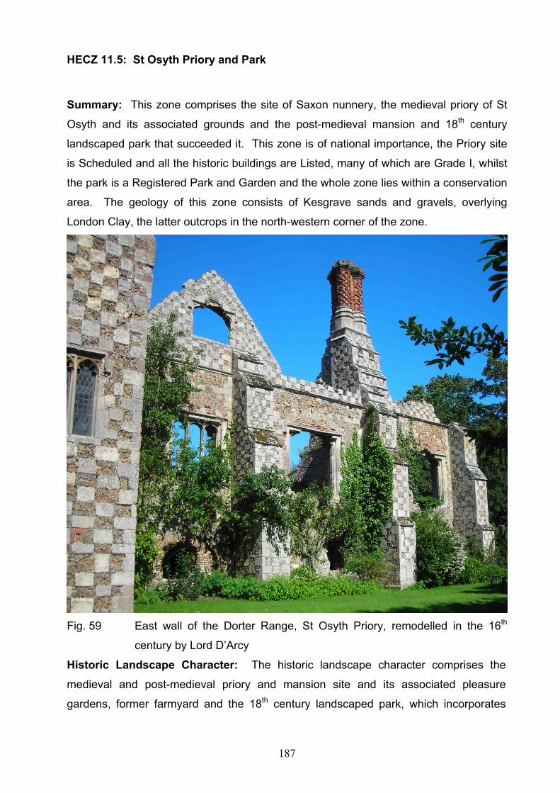
187
HECZ 11.5: St Osyth Priory and Park
Summary: This zone comprises the site of Saxon nunnery, the medieval priory of St
Osyth and its associated grounds and the post-medieval mansion and 18th century
landscaped park that succeeded it. This zone is of national importance, the Priory site
is Scheduled and all the historic buildings are Listed, many of which are Grade I, whilst
the park is a Registered Park and Garden and the whole zone lies within a conservation
area. The geology of this zone consists of Kesgrave sands and gravels, overlying
London Clay, the latter outcrops in the north-western corner of the zone.
Fig. 59 East wall of the Dorter Range, St Osyth Priory, remodelled in the 16th
century by Lord D’Arcy
Historic Landscape Character: The historic landscape character comprises the
medieval and post-medieval priory and mansion site and its associated pleasure
gardens, former farmyard and the 18th century landscaped park, which incorporates
188
earlier features dating to its origins as medieval parkland. Post-medieval and modern
mineral extraction within the park, accounts for about half the total area, and has had a
considerable impact on the historic landscape, with the creation of a series of water-
filled extraction pits.
Archaeological Character: The archaeology of this zone is characterised by the
Priory. The site had its origins in the 7th century with the foundation of a nunnery at
Cicc by the Saxon princess, St Osyth. The nunnery was reputedly sited within Nuns
Wood within the later park. The Priory of St Osyth was founded before 1127 (possibly
in 1121) by the Austin Canons. The earliest remaining buildings date to the early
twelfth century. The priory became an Augustinian Abbey in about 1200 AD. The
buildings are characterised by magnificent chequer-board patterning of ashlar, septaria
and flint, the Gatehouse being a particularly fine example of flint flushwork. There are
parchmarks to the immediate north of the surviving priory buildings, demonstrating the
presence of associated below-ground archaeology. The priory was suppressed in
1539, and in 1553 it came into the possession of Lord Darcy who converted some of
the buildings into a house and levelled others, including the abbey church (now under
the rose garden). Further building work and modifications took place in a piecemeal
fashion throughout the post-medieval period.
The park, formerly part of the priory grounds, was landscaped in the eighteenth century.
Features include avenues of mature trees, pools and the remnants of an eighteenth
century shell grotto, as well as earlier elements, including the Nuns Wood and a moated
site.
It is probable, given the extent and density of the multi-period cropmark complexes
encircling this zone that earlier occupation evidence will be preserved as buried
remains.
This zone is included in the historic town assessment for St Osyth (Medlycott 1999)

189
Diversity of historic
environment assets
Historic parkland, Abbey buildings, post
medieval listed buildings, below ground
deposits
3
Survival Good survival although some areas of park
have been quarried
2
Documentation HER data, cartographic and documentary
evidence, Scheduling
3
Group Value Association Important group value associated the priory
and associated park
3
Potential High potential for below ground
archaeological deposits
3
Sensitivity to change Highly sensitive to change 3
Amenity Value High potential for promotion of the Priory and
parkland especially in association with 11.6
3
HECZ 11.6: Historic core of St Osyth
Summary: This zone comprises the historic core of the town of St Osyth. This can be
sub-divided into three distinct areas, consisting of the medieval and early post medieval
development concentrated around the crossroads to the east of the priory, a ribbon
development along Mill Street toward the Quay and a later expansion northwards along
the Colchester Road. The entire zone lies within a conservation area. The geology of
this zone consists of Kesgrave sands and gravels, overlying London Clay, this outcrops
in the south-western corner of the zone. There are alluvial deposits immediately
adjoining the quay area.
Historic Urban Character: The historic core sub-divides into three distinct areas, each
with their own individual character. Firstly there is the medieval and early post medieval
settlement concentrated around the crossroads, the church and the gates to the Priory.
Secondly there is the medieval settlement at the Quay and the ribbon development
along Mill Street which links the Priory and the Quay. The third area comprises the later
expansion northwards along the Colchester Road. Much of the former open-spaces
(gardens, orchards and paddocks), with the exception of the Bury in front of the Priory,

190
have been infilled with small-scale, piece-meal modern development. A major influence
on the character of the historic core is the external façade of the Augustinian Priory and
the survival of elements of the medieval market town with a market place and fair green
still recognisable, as well as the maritime aspects of the Quay area. The historic core is
largely residential in nature, what small-scale industry there is, is concentrated in the
Quay area.
Archaeological Character: The archaeological character of this zone is heavily
influenced by the 12th century Priory (HECZ 11.5). Archaeological investigation within
the historic core has uncovered Saxon material suggestive of a thriving community
dating to the first half of the 11th century, as well as evidence for the survival of
medieval and post-medieval below-ground deposits, both in the vicinity of the church
and the former market-place and in the area around the Quay.
It is probable, given the extent and density of the multi-period cropmark complexes
encircling this zone that earlier occupation evidence, dating to the prehistoric, Roman or
Saxon periods, can also be anticipated. The surviving built heritage forms an important
part of the archaeological character of the area and is a tangible reminder of the
archaeological and historical significance of this zone.
A historic town assessment has been produced for St Osyth (Medlycott 1999)
Diversity of historic
environment assets
Range of historic buildings, medieval
settlement, medieval and post med port
3
Survival Good survival of listed building and original
historic layout. Below ground deposits
survive well
3
Documentation HER data, cartographic and documentary
evidence,
3
Group Value Association Important group value associated with
medieval and post medieval settlement
3
Potential Good potential for below ground
archaeological deposits
3
Sensitivity to change Highly sensitive to change due to the 3

191
significance and nature of the historic
settlement pattern
Amenity Value Potential for promotion of the settlement in
association with the priory (Zone 11.5)
3
HECZ 11.7: Modern St Osyth
Summary: This zone comprises the 20th century elements of St Osyth. This includes
an early 20th century development along St Clair and D’Arcy Road, and post-war
development along the Clacton Road, as well as more recent development. The
geology of this zone consists of Kesgrave sands and gravels, overlying London Clay,
this outcrops in the southern part of the zone.
Historic Urban Character: The urban character comprises a post war urban
development built either side of the Clacton Road. This incorporates an earlier 20th
century development of terraces along St Clair and D’Arcy Roads. There are areas of
mixed terraced, semi and detached housing between By-pass Road and Clacton Road
and Clacton Road and Spring Road. This zone is entirely residential, with the
exception of the schools and their associated sports fields.
Archaeological Character: There has only been very limited archaeological fieldwork
in this zone. However excavations on the site of the school revealed a deposit of
oyster-shell. Given the extent and density of the multi-period cropmark complexes
encircling this zone it is likely that earlier occupation evidence extended into this zone.
However, given the density of the modern development, surviving evidence may be
limited.
Diversity of historic
environment assets
Limited to 20th century development 1
Survival Poor survival due to modern development 1
Documentation HER data 1
Group Value Association No group value 1
Potential Limited due to the density of housing 1

192
Sensitivity to change Little sensitivity due to modern housing 1
Amenity Value Could add to the history of the settlement of
St Osyth
1
HECZ 11.8: Point Clear
Summary: This zone comprises the settlement of Point Clear, which had its origins as
sea-side plotland development in the 1930s constructed on the gravel and London Clay
ridge which forms the southern bank of St Osyth Creek. There are extensive views
across the Colne estuary to Mersea Island and the Dengie peninsula.
Historic Landscape Character: The fieldscape of this area consisted of large
rectangular fields of pre-18th century origin. There was one farm, Blockhouse Wick, and
the site of a Napoleonic Martello tower at Beacon Hill on the coast. The area was sub-
divided into plotlands in the inter-war period. The building types largely comprise
bungalows and chalets of lightweight construction.
Archaeological Character: There has been no archaeological fieldwork in this zone.
There is the possibility that below-ground elements of the Martello tower survive. It is
probable, given the extent and density of the multi-period cropmark complexes to the
south and east of this zone, that earlier occupation evidence could be present on the
undeveloped areas. The modern settlement incorporates elements of the original
plotlands.
Diversity of historic
environment assets
Martello tower, plotlands possible below
ground deposits
2
Survival Martello tower and open areas may contain
below ground deposits
2
Documentation HER data, cartographic data 1
Group Value Association Little group value 1
Potential Some potential for below ground
archaeological deposits in open areas
2
193
Sensitivity to change Sensitivity limited to layout of plotlands 1
Amenity Value Potential for promotion of the Martello tower
and plotland layout, to explore, in
conjunction with other zones the more recent
history of Tendring.
2
HECZ 12.1: Ardleigh Cropmark Complex
Summary: The geology comprises a mix of Kesgrave gravels in the western part of the
zone with the remainder being of brickearth. A zone of high archaeological importance
in terms of both, its known archaeology, and its future potential. The zone comprises
the nationally important scheduled cropmark complex covering approximately 50% of
the zone. Excavation has shown multi period deposits from the Bronze Age through to
the Saxon period.
Historic Landscape Character: Lying at around 37 metres OD, the landscape is level
and displays a historic rectilinear field pattern of possible ancient origin. Bovill’s Hall and
Martell’s Hall are shown on the Chapman and Andre map lying at the head of a shallow
valley, both with small areas of associated woodland and may have medieval origins.
The field pattern has suffered considerable field boundary loss across the zone. The
zone is crossed in the north by the railway line running from Colchester to Manningtree
and contains the Ardleigh Railway Station.
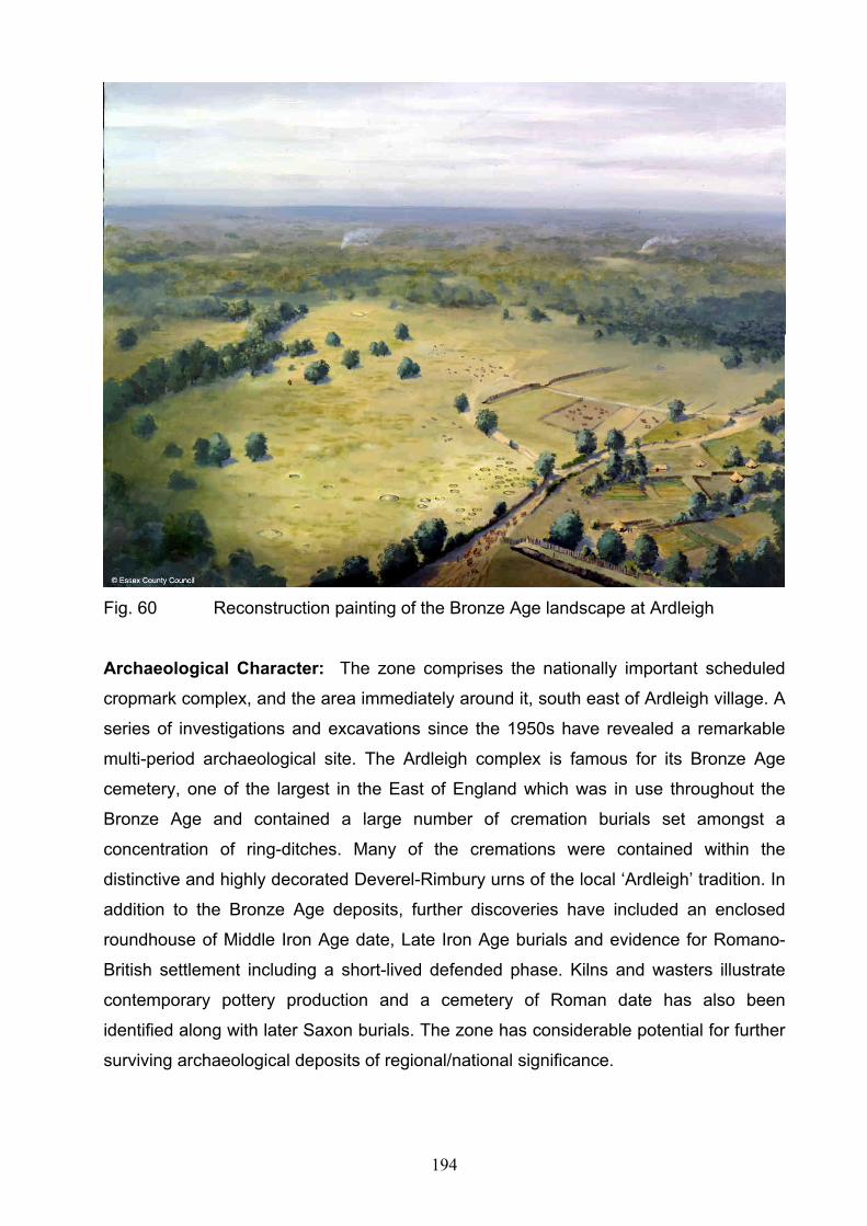
194
Fig. 60 Reconstruction painting of the Bronze Age landscape at Ardleigh
Archaeological Character: The zone comprises the nationally important scheduled
cropmark complex, and the area immediately around it, south east of Ardleigh village. A
series of investigations and excavations since the 1950s have revealed a remarkable
multi-period archaeological site. The Ardleigh complex is famous for its Bronze Age
cemetery, one of the largest in the East of England which was in use throughout the
Bronze Age and contained a large number of cremation burials set amongst a
concentration of ring-ditches. Many of the cremations were contained within the
distinctive and highly decorated Deverel-Rimbury urns of the local ‘Ardleigh’ tradition. In
addition to the Bronze Age deposits, further discoveries have included an enclosed
roundhouse of Middle Iron Age date, Late Iron Age burials and evidence for Romano-
British settlement including a short-lived defended phase. Kilns and wasters illustrate
contemporary pottery production and a cemetery of Roman date has also been
identified along with later Saxon burials. The zone has considerable potential for further
surviving archaeological deposits of regional/national significance.

195
Diversity of historic
environment assets
Bronze Age cemetery, Middle Iron Age
settlement, Roman and Saxon occupation,
medieval halls and medieval or post
medieval mill, ancient woodland, field system
3
Survival Below ground archaeological deposits
survive well, field pattern largely removed
2
Documentation HER data, Cartographic, published reports,
scheduling
3
Group Value Association Multi-period archaeological deposits, burials
through Bronze Age to Roman period,
medieval halls
3
Potential High potential for below ground deposits 3
Sensitivity to change Below ground deposits and settlement
pattern highly sensitive to change
3
Amenity Value Archaeological deposits have a potentially
high amenity value in explaining the history
of the immediate area and Tendring District
both to the local population and wide
archaeological audience.
3
HECZ 12.2: Ardleigh
Summary: The geology is largely Brickearth, with sands and gravels and London Clay
revealed in the valley sides, with some alluvium bordering the Colne estuary. The zone
has a dispersed medieval settlement pattern of individual farmsteads and halls. The
field pattern has suffered considerable boundary loss with gravel extraction and the
construction of a reservoir changing the landscape. Extensive archaeological deposits
are represented by cropmarks cross the zone.
Historic Landscape Character: Areas of woodland of probable ancient origin survive
within a landscape of largely rectilinear fields and dispersed halls and farmsteads with a
nucleated settlement at Ardleigh. Contained within the valleys tributaries of the River
Colne there are a number of mills along their length identified on the Chapman and

196
Andre map although these may have earlier medieval origins. The zone is bisected by
the main line of the original Great Eastern Railway. Ardleigh reservoir formed by the
damming of two of the former stream valleys, is a significant modern feature in this
zone. Gravel quarrying has occurred in the south east of the zone.
Archaeological Character: Largely surrounding the Scheduled Ardleigh Cropmark
complex, this zone contains a further range of cropmarks especially in the area around
Ardleigh reservoir with several large enclosures being apparent. Limited excavation
during evaluation at Wick Farm has suggested a late Iron Age date for these features
although Roman activity is also apparent. Further but less concentrated cropmarks are
spread throughout the rest of the zone and are likely to represent a range of periods.
The Roman road from Colchester to a possible port at Mistley passes through the south
of the zone and is clearly visible as a cropmark at certain points. The main settlement in
the zone is Ardleigh village which by the late 18th century was a small settlement
situated around a crossroads and the late 15th century church. However, records of a
parish priest stretch back to the early 12th century and the village is likely to have earlier
origins and retain below ground archaeological deposits. Three shallow valleys
containing a tributary of the River Colne lie within the zone, two of which are now
flooded forming Ardleigh reservoir. Three fulling mills situated on this tributary are
illustrated on the Chapman and Andre map of 1777.
Diversity of historic
environment assets
Iron Age and Roman deposits, medieval
halls and farms, cropmarks, historic
landscape features
3
Survival Below ground archaeological deposits
survive well, considerable boundary loss
2
Documentation HER data, Cartographic, site reports 2
Group Value Association Cropmarks, medieval settlement pattern 2
Potential High potential for below ground deposits 3
Sensitivity to change Below ground deposits and settlement
pattern highly sensitive to change
3
Amenity Value Excavated evidence, and Ardleigh’s
settlement history could be promoted
especially linked to associated zones.
2

197
HECZ 12.3: Great Bromley
Summary: The geology largely comprises brickearth with Kesgrave Sands and
Gravels and London clays on the east of the zone. The dominant historic environment
element within this zone is the extent of surviving cropmarks, with a date range from the
Bronze Age through to the medieval period. The medieval settlement pattern is largely
intact with surviving farms and church/hall complexes.
Historic Landscape Character: The fieldscape is of rectilinear fields incorporating a
number of isolated farms and limited ancient woodland. The zone contains an area of
former heathland, Ardleigh Heath, historically used for rough pasture but enclosed in the
early 19th century. The present landscape comprises a mixture of pre-18th century
irregular fields (these are probably of medieval origin and some maybe even older) and
later enclosure by agreement, the latter largely but not entirely corresponding to the
former heathlands. Although the historic field pattern has suffered considerable
boundary loss this has concentrated on the removal of the later post medieval sub
divisions inadvertently restoring the landscape to its earlier form. The largely modern
settlement of Great Bromley has developed around a medieval Church/hall complex.
The 14/15th century Church of St George is Grade I listed and is a particularly fine
example of the East Anglian style. Historically the settlement pattern comprises
dispersed farmsteads and church/hall complexes. A number of streams drain the zone
into the Tenpenny Brook.

198
Fig. 61 14/15th century Church of St George, Great Bromley
Archaeological Character: Multi-period archaeological deposits are present
throughout the zone. Cropmark evidence is dominant with only a small area in the north
west where few are apparent. These cropmarks comprise clear concentrations of ring-
ditches, linear features, enclosures, trackways and pits demonstrating the survival of a
significant multi-period archaeological resource. Interpretation of the cropmarks show
the presence of ring ditch cemeteries, probably of Bronze Age date, in several locations,
other prehistoric monuments including a possible henge, settlement enclosures of both
prehistoric and Roman date. This evidence also shows that virtually the whole zone
has been extensively exploited throughout history. Some of the trackways identified on
the cropmarks may indicate medieval occupation beyond that identified in the dispersed
settlement pattern identified on cartographic records. Archaeological work has shown
extensive survival of archaeological deposits with the zone having a clear and
significant archaeological potential.

199
Diversity of historic
environment assets
Multi-period cropmarks, prehistoric
enclosures, and burials
3
Survival Cropmarks indicate extensive below grounds
survival, field pattern suffered considerable
boundary loss
3
Documentation HER, cartographic, NMP 2
Group Value Association Cropmark complexes 3
Potential High potential for below ground deposits 3
Sensitivity to change Below ground deposits highly sensitive in
certain areas
3
Amenity Value Cropmarks and settlement pattern could be
could in conjunction with neighbouring zones
be promoted to explore the history of
Tendring.
2
HECZ 12.4: Foxash Estate
Summary: Much of the zone was developed for horticultural purposes in the 20th
century, originating as a Land Settlement Association smallholding scheme. Historically
the medieval and post-medieval settlement was highly dispersed and there is crop-mark
evidence for earlier periods. The geology comprises brickearths and head deposits,
with smaller areas of Kesgrave sands and gravels.
Historic Landscape Character: The historic fieldscape comprised a mixture of regular
and irregular fields. Historically the settlement pattern was of halls and dispersed farms.
Elements of this survive but there has been significant modification of this pattern with
the introduction of intensive horticulture and fruit production in the area around the
Foxash Estate. Foxash Estate is a 20th century development originating as a Land
Settlement Association smallholding scheme. A small area of ancient woodland
survives in the north east of the zone along the Shir Burn.

200
Archaeological Character: Cropmarks are noted sporadically throughout the zone
and consist mainly of linear features, enclosures and ring-ditches. The main
concentration lies in the east of the zone and archaeology is likely to survive within
areas of arable and pasture. There is the potential for the survival of deposits
associated with the medieval and post-medieval dispersed settlement pattern.
Diversity of historic
environment assets
Multi-period cropmarks, medieval field
pattern
2
Survival Cropmarks indicate good belowground
survival. Field pattern survives well although
fields have changed function considerably
2
Documentation HER, cartographic, NMP, 1
Group Value Association Cropmark complexes 1
Potential Potential for below ground deposits 2
Sensitivity to change Below ground deposits sensitive 2
Amenity Value Limited promotional aspects to this zone,
although the role of horticulture in the
development of the Tendring landscape has
some potential and the Foxash Estate is of
interest from both a social and historical
perspective.
2
HECZ 13.1: Lawford Hall
Summary: Largely parkland, pasture and woodland associated with Lawford Hall. The
geology comprises Kesgrave sands and gravels, overlying London Clay, the latter
surfaces in the northern part of the zone.
Historic Landscape Character: Sitting on a low spur of land, this zone is dominated
by Lawford Hall and the associated medieval church of St. Mary (both Grade I listed),
gardens, parkland and pasture. Pockets of mature woodland, some ancient along with
more recent plantation are present. Much of the zone would previously have been under
arable but is now mainly pasture. A small settlement exists around the church and is

201
probably medieval in origin. There is also a small later post medieval roadside
development concentrated along Wignall Street and around the crossroads of
Hungerdown Lane and Dedham Roads to the south. The zone is entirely within the
Dedham Vale AONB.
Fig. 62 Bronze Age Round Barrow, Lawford
Archaeological Character: Cropmarks of trackways and a group of ring-ditches in the
west of the zone are visible indicating below ground archaeological deposits. The
historic landscape of parkland and pasture over much of the zone is however not
conducive to cropmark formation and further deposits are likely to be widespread. An
extant round barrow, designated as a scheduled monument survives to the west of the
zone in close association with further cropmarks of ring-ditches. Archaeological deposits
are likely to be well preserved within the zone. The site of Lawford Hall has medieval
origins and related archaeological deposits may survive. The road side settlement to the
south may be medieval in origin and associated archaeological evidence is likely to
survive particularly in undeveloped plots and garden areas.

202
Diversity of historic
environment assets
cropmarks, prehistoric burial mound,
medieval church/hall complex, parkland, post
medieval model farm
3
Survival Cropmarks indicate good below grounds
survival, field pattern and park land survive
well. Scheduled tumulus
3
Documentation HER, cartographic, NMP, scheduling 2
Group Value Association Parkland and church hall complex,
prehistoric burials
3
Potential High potential for below ground deposits.
Parkland could be enhanced
3
Sensitivity to change Below ground deposits, settlement pattern
and landscape features highly sensitive,
3
Amenity Value Parkland, Hall and church and associated
below ground deposits could be promoted as
part of the wider history of Tendring.
2
HECZ 13.2: Bradfield Heath
Summary: A zone of considerable archaeological potential with numerous multi-period
cropmarks. The area was heathland in the medieval and early post-medieval period. It
is now largely under arable and some pastoral agriculture, the settlement retains its
historically dispersed character. The geology comprises brickearths and head deposits
and Kesgrave sands and gravels overlying London Clay.
Historic Landscape Character: Significant areas of heathland at Bradfield Heath,
Hull-Bush and Shuckmore Heath are evident on the Chapman and André map of 1777,
these are probably medieval in origin. The heaths were however largely enclosed by
the mid 19th century as part of wider agriculture developments, the current fieldscape
comprises a mixture of later enclosure by agreement and irregular fields of ancient
origin. Post 1950s boundary loss has been moderate. The historic settlement in the
zone was dispersed and polyfocal, with settlement around former heathland such as

203
Bradfield Heath scattered halls, farms and cottages and a small nucleation around the
church at Bradfield. This settlement pattern survives well in the modern landscape.
Archaeological Character: The high density of cropmarks throughout the zone point
to an area that has long been the subject of human occupation and activity. In addition
to the usual wide array of cropmarks evident throughout the Tendring peninsula, two
parallel cropmarks representing roadside ditches clearly illustrate the line of a Roman
road from Colchester to a purported Roman settlement at Mistley. Largely under arable
the zone clearly has significant below ground potential for multi-period archaeological
deposits. As a historic settlement Bradfield is likely to retain some archaeological
potential, and there is also potential for the survival of deposits relating to the dispersed
settlement pattern.
Diversity of historic
environment assets
Extensive multi-period cropmarks, including
prehistoric cemeteries and settlements,
Roman settlements and roads, settlement
pattern, redundant church
3
Survival Significant survival of Cropmarks across
whole zone, medieval settlement pattern.
Some field boundary loss
3
Documentation HER, Cartographic, NMP, scheduling 2
Group Value Association Cropmarks 3
Potential Extensive below ground deposits 3
Sensitivity to change Below ground deposits highly sensitive to
change
3
Amenity Value Importance of cropmarks settlement pattern
and historic landscape features could be
promoted, in conjunction with other zones as
part of the wider history of Tendring.
2

204
HECZ 13.3: Wrabness
Summary: There is cropmark evidence for settlement in this area from the prehistoric
period onwards. The historic settlement pattern was highly dispersed comprising halls
and farms. The lack of modern development may promote good archaeological survival.
The drift geology is of Kesgrave gravels, undifferentiated river gravels and head and
alluvium over London Clay.
Historic Landscape Character: The zone comprises the north facing slope of the
Tendring plateau above the Stour Estuary, falling from around 20metres OD to sea
level. The 1st edition OS map depicts large open fields in the west of the zone around
Jacques Hall giving way to smaller, rectangular fields orientated towards the estuary.
Post 1950s boundary loss has obscured most of this pattern however. Small pockets of
woodland survive particularly in the east. The historic settlement pattern was very
sparse, comprising a few halls, including the church/hall complex at Wrabness, together
with a small number of dispersed farms. The majority of the zone remains under arable,
although smaller areas of pasture and scrub exist. Included within the zone are
restricted strips of saltmarsh along the Stour estuary. The Great Eastern railway line to
Harwich was built in the mid 19th century and remains an important landscape feature
and a small area of modern settlement has grown up south of Wrabness Station.
Fig. 63 Wrabness Church Bell-Cage

205
Archaeological Character: Cropmarks are largely restricted to the area east of
Wrabness church/hall complex and comprise linear features, trackways and a ring-ditch.
Little or no archaeological work has been done within the zone but there is significant
potential for surviving archaeological deposits including the medieval church /hall site at
Wrabness.
Diversity of historic
environment assets
Multi-period cropmarks, medieval settlement
pattern of church/hall complex and halls
2
Survival Cropmarks indicate good below grounds
survival. Field pattern survives well.
Medieval settlement pattern survives
2
Documentation HER, cartographic, NMP, 1
Group Value Association Medieval settlement pattern 2
Potential potential for below ground deposits 2
Sensitivity to change Below ground deposits and settlement
pattern sensitive
2
Amenity Value Settlement pattern and landscape features
could be promoted in conjunction with other
zones and the Stour estuary, to promote the
wider history of Tendring.
2
HECZ 13.4: Stour Wood and Copperas Wood
Summary: Characterised by two substantial areas of ancient woodland and arable
production, the zone retains a below ground archaeological potential. The geology
comprises London Clay, overlain with small patches of Kesgrave sands and gravels.
Historic Landscape Character: The zone is dominated by two major stands of ancient
woodland (sweet chestnut coppice) at Stour Wood and Copperas Wood separated by a
small area of pasture, both are SSSI. Copperas Wood extends along the shoreline of
the Stour for around 1km to the eastern end of the zone. There is the potential for

206
earthworks such as woodland banks surviving within the woods. Settlement is sparse
with Stour Hall of probable 19th century origin close to Stour Wood, the modern farm at
Copperas Wood and a roadside strip of modern housing in the south of the zone. Arable
dominates to the east of the zone in large rectangular fields and a modern sewage
works is present.
Archaeological Character: Two linear cropmarks have been noted within the zone but
these have now been compromised by the construction of the sewage works. No
archaeological work has taken place within this zone and there are no further records of
specific archaeological finds or features. It is likely however given the visibility of
cropmarks in contiguous zones that archaeological deposits survive.
Diversity of historic
environment assets
Ancient woodland, flint artifacts, cropmarks 1
Survival Woodland survives well 3
Documentation Cartographic, NMP 1
Group Value Association Woods, historic landscape 2
Potential Potential for below ground deposits and for
earthworks within woodland
2
Sensitivity to change Woods and below ground deposits 3
Amenity Value Historic environment could be promoted in
conjunction with other zones and the Stour
estuary, to promote the wider history of
Tendring. In particular woodland
management may be promoted within the
nature reserve
2
207
HECZ 14.1: New Mistley
Summary: The geology largely comprises Kesgrave sand and gravels overlying
London Clay. The western part of the zone comprises the late 19th century planned
industrial settlement associated with the railway, whilst the eastern part of the zone
comprises post 1970 housing development. Rescue excavation has recovered multi-
period finds indicating occupation from the prehistoric period.
Historic Urban Character: The western part of the zone comprises later 19th and
early 20th century planned industrial settlement which developed to the south of the
railway and is within a conservation area. Blocks of 19th and early 20th century terraced
workers cottages are situated along the northern and eastern side of the planned town,
but also includes some earlier housing fronting Harwich Road. Incorporated into the
zone is some commercial development along School Lane. A large 20th century
residential estate to the east of the above, was built in the 1970’s. Most of the area is in
residential use.
Archaeological Character: Finds made during development for housing in the 1970s
and during small scale gravel extraction indicate multi period settlement in the area. No
organised fieldwork took place but finds included a small amount of struck flint, Iron Age
pottery and a large amount of Roman-British ceramics including wasters suggestive of a
kiln or kilns locally. A Romano-British cremation burial is also noted which is probably
linked to settlement within the zone. The Roman deposits are likely to relate to
occupation at the terminus of the Roman road from Colchester, visible as a cropmark.
Medieval pottery has also been identified. The zone is now largely built over but may
retain archaeological potential in any currently undeveloped areas.
Diversity of historic
environment assets
Multi-period artifacts, Roman features,
industrial settlement
2
Survival Some below ground deposits survive in
undisturbed areas, industrial housing
survives.
1
Documentation HER, Conservation Area description 1

208
Group Value Association Industrial development associated with 14.2 2
Potential Potential for below ground deposits in
undeveloped areas
1
Sensitivity to change Limited sensitivity due to modern
development
1
Amenity Value Industrial heritage can be linked to zone 14.2 2
HECZ 14.2: Mistley
Summary: The geology of this zone is very mixed with Kesgrave sands and gravels in
the east, river terrace deposits in the west and London Clay in the centre. The zone is
important for its industrial archaeology and 18th and 19th century architecture.
Fig. 64 The Mistley towers are all that remain of the church designed by the
architect Robert Adam.
209
Historic Urban Character: This zone comprises the historic core of the model spa
town and historic port of Mistley Thorn established by Richard Rigby during the 18th
century. The historic core still retains terraces of 18th century houses along the High
Street, hotels and industrial workers cottages and incorporates 18th and 19/20th century
industrial buildings along the quayside. Buildings of particular note are the Mistley
Towers and Swan Fountain designed by Robert Adam and the former spa hotel,
Fountain House. A major feature of the historic core is the number of surviving Georgian
buildings. Also within the zone are 19th and earlier 20th century industrial buildings
associated with the port and the Mistley malt industry. A major feature of the area is the
unity and survival of 19th and 20th century industrial maltings and associated buildings
and the preservation of this significant industrial landscape.
An active port facility exists with docking at Mistley Quay and Baltic Wharf and current
industrial sites include EDME and a large modern (Carlsberg/Tetley) malting to the
south of the railway. There is also later 20th century residential redevelopment of
redundant industrial buildings.
Archaeological Character: There are no noted archaeological finds from this zone but
given the projection of the Roman road and the findspots of Roman material in
contiguous zones the zone retains a potential for archaeology of this date. At the
northern end of the zone lies the scheduled monument of the New Church of St Mary’s
dating to 1735 of which only the two towers remain, both listed, and the graveyard. The
industrial history of the town and its historic core indicates the high potential for the
survival of post medieval and early modern archaeological deposits.
Diversity of historic
environment assets
Demolished Church, model spa town,
industrial monuments, historic port
2
Survival Post medieval and early modern settlement
survives well. Below ground deposits may
survive relating to the development of the
port
2
Documentation HER, Industrial surveys, conservation area
description
Group Value Association Industrial monuments relating to the port, 3

210
and spa town
Potential Potential for the protection of historic
buildings and industrial sites. Potential for
below ground deposits
2
Sensitivity to change Buildings and layout highly sensitive to
change
3
Amenity Value Has a high potential for promotion of the
town and its industrial history
2
HECZ 14.3: Mistley Park
Summary: The geology of this zone largely comprises river terrace gravels with the
southern part comprising London Clay. The zone largely contains the historic 18th
century parkland associated with Mistley Place retaining a moderate archaeological
potential
Historic Landscape Character: Separating Manningtree from Mistley this zone now
comprises woodland, parkland, lakes and playing fields. The church of St. Mary was
constructed in the late 19th century replacing the 18th century church in zone 14.2. The
grounds of Mistley Place, owned by Richard Rigby, were fashionably landscaped in the
18th century including woodland and lakes and resulting in much of what can be seen
today. The main railway line runs across the southern part of the zone. The whole zone
lies within a conservation area.
Archaeological Character: There are no noted archaeological finds from this zone but
multi-period buried remains may survive and there is parkland features surviving within
the present park. The original road running through this zone was moved when the
parkland was created.

211
Diversity of historic
environment assets
Park land features, Mistley Place 1
Survival Parkland features, possibility of below
ground deposits
2
Documentation HER, conservation area assessment 2
Group Value Association Park features 2
Potential Potential for below ground deposits surviving 2
Sensitivity to change Parkland sensitive to change 2
Amenity Value Historic parkland could be promoted 2
HECZ 14.4: Historic Manningtree
Summary: The geology of the zone comprises London Clay. The zone contains the
historic settlement of Manningtree. Manningtree is of considerable archaeological and
historical importance, as an example of a small market town which contains elements of
both a sea-port and an industrial town. Its importance archaeologically is as an
example of a deliberately planted medieval town that retains its medieval street-pattern
and parts of the medieval and early post-medieval built environment. There is also the
distinct possibility that the medieval wharfage survives behind the current quay frontage,
protected and buried by 18th-19th century build-up.
Historic Urban Character: Medieval Manningtree appears to have been deliberately
planted in the first half of the 13th century, presumably by the lord of the manor; there is
a reference of the grant of a market to the manor of Sciddinghou in 1238 and the town
itself is first recorded in 1248. The town was intended as a new port, and achieved
some success in local trade, transhipping provisions to the fleet in Harwich and as a
fishing port supplying Colchester. The town layout suggests some form of deliberate
planning based on the market in the High Street and the Quay. The dog-leg plan of
South Street immediately to the south of the town raises the possibility that there had
been a town enclosure.

212
Fig. 65 Manningtree High Street
The quality of the 16th century built environment suggests that the town underwent a
financial boom in that century. In the early nineteenth century Manningtree was a major
centre of the Essex malt industry with five separate sites in operation. The Lawford
Works was also a major employer with three complexes producing leather and iron
goods on the west side of the town. This industrial activity necessitated the construction
of small terraces of workers’ housing and more substantial managers’ dwellings. In the
late nineteenth century the erection of the huge Mistley Maltings in the neighbouring
parish effectively eclipsed the production of malt in Manningtree and parts of the
Lawford Works appear to have gone into decline about the same time. The group of
19th century maltings known as The Walls are of significant importance.
Archaeological Character: Archaeological investigations within the historic core have
been very limited, however, those that have occurred have uncovered archaeology of
medieval and post-medieval date. Recent work has identified significant surviving
deposits of late medieval and early post medieval date to the rear of Stour Street and
the potential for further archaeological deposits is high. There is the possibility that the
213
medieval wharfage survives behind the current quay frontage, protected and buried by
18th-19th century build-up.
Diversity of historic
environment assets
Listed buildings, historic core and street
layout, below ground medieval and post
medieval deposits.
3
Survival Historic core, buildings and below ground
deposits
3
Documentation HER, Historic Town survey, excavation
reports, Conservation area appraisal
3
Group Value Association historic town and port assets 3
Potential High potential for below ground deposits 3
Sensitivity to change Historic town layout, buildings and below
ground deposits highly sensitive
3
Amenity Value High potential for promotion of the history of
the town
3
HECZ 14.5: Manningtree, Lawford and Mistley
Summary: The geology comprises a mix of river terrace gravels in the north, London
clay to the south of this, a large area of Kesgrave Sands and Gravels and in the south,
Brickearth. The zone comprises largely modern residential expansion but does contain
listed buildings and industrial sites to the south of the historic core of Manningtree.
Historic Urban Character: Urban expansion within the zone began in the 18th century
and was further fuelled by the arrival of the Eastern Union Railway in 1854. Manningtree
Station falls within the zone. This expansion is protected by the Manningtree and
Mistley conservation area. This expansion has continued throughout the 19th and 20th
centuries. The zone is predominantly residential but also contains a number of industrial
sites including maltings, timber yards, the Lawford Iron Works and later 20th century
industrial and retail trading estates

214
Archaeological Character: A round barrow of probable Bronze Age date is recorded
from the west of the zone along with finds of worked flint of Neolithic and Bronze Age
date. Modern development will have had a severe impact on the potential
archaeological resource. However, school playing fields and a small remaining area of
arable, containing linear cropmarks to the west of the zone are likely to preserve
archaeological deposits.
Diversity of historic
environment assets
Prehistoric burials, possible settlement sites,
industrial sites
2
Survival Surviving below ground deposits in
undeveloped areas, industrial sites
2
Documentation HER, Historic town survey 2
Group Value Association Industrial sites 2
Potential Potential in undisturbed areas for surviving
below ground deposits
2
Sensitivity to change Limited sensitivity to change 1
Amenity Value Industrial buildings could be promoted with
adjacent zones
2
HECZ 15.1: Manningtree and Mistley Stour Estuary
Summary: This zone comprises the estuary of the Stour including intertidal mud, deep
water channels, sand flats, narrow strips of open salt marshes, beaches outside the
current sea walls and adjacent to the historic ports of Mistley and Manningtree. The
intertidal zone has the potential for well preserved archaeological, palaeoenvironmental
and organic deposits. The geology comprises alluvial deposits overlying London Clay.
The zone is highly important in terms of the natural environment. The entire zone is
designated as a Site of Special Scientific Interest (SSSI), and falls within the Stour and
Orwell SPA/Ramsar site.
Historic Landscape Character: The broad expanse of the Stour Estuary and its
associated creeks has been a major artery for trade and transport, together with a

215
source of fish, shell fish and wildfowl, for millennia. Although mainly used by leisure craft
the estuary still has commercial traffic with activity concentrated at Mistley. The zone is
characterised by its open, flat aspect and remoteness comprising the intertidal zone,
mudflats and channels at Manningtree and Mistley. The mud flats extend over much of
the estuary at low water in the Manningtree area. At Mistley and Manningtree, the deep
water river channel approaches close to the shore. Hulks highlight the importance of
access to and from the sea and the relationship between this zone and the adjacent
ports.
Archaeological Character: The zone includes the historic site of the quays and wharfs
associated with the medieval port of Manningtree and post medieval port of Mistley
Thorn. There are no known archaeological sites or finds from the intertidal zone.
However, it is probable that a range of features including timber/wooden structures such
as former quays survive within the estuary deposits and that these may be in a good
state of preservation. There are numerous hulks at Baltic Wharf and earlier wrecks may
be present elsewhere in the zone. It is also possible that prehistoric land surfaces
survive beneath the silts which elsewhere in the county, have been shown to contain a
great range of archaeological and palaeoenvironmental data.
Diversity of historic
environment assets
No known deposits 1
Survival Intertidal area likely to contain high quality
surviving deposits
2
Documentation None available 1
Group Value Association No group value 1
Potential Potential for intertidal preserved land
surfaces and features associated with
exploitation of the estuary
3
Sensitivity to change Below ground deposits highly sensitive 2
Amenity Value Can only be promoted in association with
other zones.
1
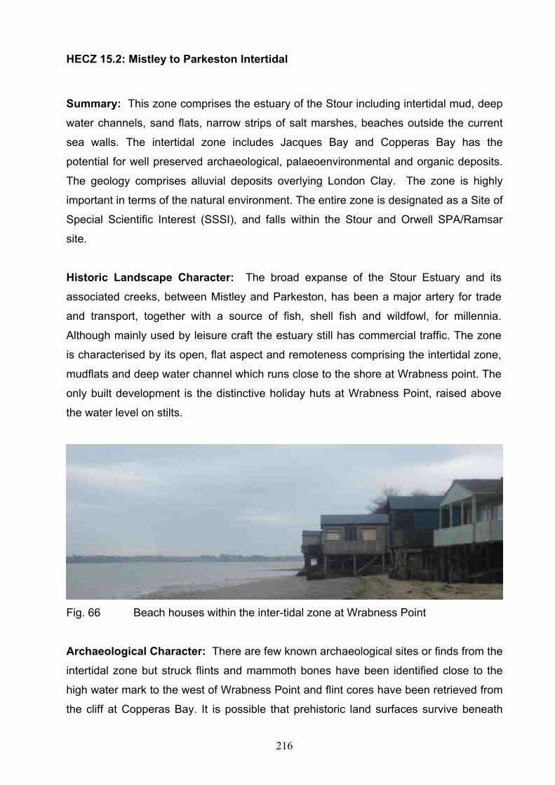
216
HECZ 15.2: Mistley to Parkeston Intertidal
Summary: This zone comprises the estuary of the Stour including intertidal mud, deep
water channels, sand flats, narrow strips of salt marshes, beaches outside the current
sea walls. The intertidal zone includes Jacques Bay and Copperas Bay has the
potential for well preserved archaeological, palaeoenvironmental and organic deposits.
The geology comprises alluvial deposits overlying London Clay. The zone is highly
important in terms of the natural environment. The entire zone is designated as a Site of
Special Scientific Interest (SSSI), and falls within the Stour and Orwell SPA/Ramsar
site.
Historic Landscape Character: The broad expanse of the Stour Estuary and its
associated creeks, between Mistley and Parkeston, has been a major artery for trade
and transport, together with a source of fish, shell fish and wildfowl, for millennia.
Although mainly used by leisure craft the estuary still has commercial traffic. The zone
is characterised by its open, flat aspect and remoteness comprising the intertidal zone,
mudflats and deep water channel which runs close to the shore at Wrabness point. The
only built development is the distinctive holiday huts at Wrabness Point, raised above
the water level on stilts.
Fig. 66 Beach houses within the inter-tidal zone at Wrabness Point
Archaeological Character: There are few known archaeological sites or finds from the
intertidal zone but struck flints and mammoth bones have been identified close to the
high water mark to the west of Wrabness Point and flint cores have been retrieved from
the cliff at Copperas Bay. It is possible that prehistoric land surfaces survive beneath

217
the silts which may contain a great range of archaeological and palaeoenvironmental
data. It is also probable that a range of finds including hulks and wrecks and
timber/wooden structures survive within the estuary deposits and that these may be in a
good state of preservation. Finds of medieval midden material eroding out of the river
cliff in Jacques Bay may relate to erosion repair work indicated by a timber revetment.
Similar medieval material has come from the cliff at Copperas Bay. Ballast Hill near
Manningtree is a site where ships dumped ballast as they entered into shallower water
of the upper reaches or across the marshes to dock or unload goods along the Stour.
The name Copperas Bay suggests remains of the once important Copperas industry
may survive within the zone.
Diversity of historic
environment assets
Prehistoric flints, mammoth bones, medieval
timbers, medieval midden deposits, ships
ballast
2
Survival Intertidal area likely to contain high quality
surviving deposits
2
Documentation HER 1
Group Value Association Likely to be remains associated with
coastal/marine exploitation.
1
Potential Potential for preserved land surfaces and
features associated with exploitation of the
estuary. Ballast Hill has great potential for
items dumped with ships ballast.
3
Sensitivity to change Below ground deposits highly sensitive 2
Amenity Value Potential for promotion in association with
other zones.
1
HECZ 15.3: Bathside Bay
Summary: Intertidal zone which has limited very deeply buried (c -12m OD) peat
deposits and a number of other features with potential for well preserved prehistoric,
palaeoenvironmental and organic deposits in addition to finds and features of more
recent origin.
218
Historic Landscape Character: Intertidal zone which at low water consists of mudflats
and some areas of sand to the east. In the south west of the zone a small area has
been reclaimed. The zone extends from Parkeston Quay in the west to Harwich town in
the east.
Archaeological Character: Aerial photographic and walkover survey together with
borehole analysis undertaken in connection of the Bathside Bay port development
proposal, have revealed very few archaeological sites or deposits. This is in part the
reflection of the geomorphology of the area with deep alluvial deposits with some
indication of very deeply buried peat (c-12m OD) of limited extent. This is in marked
contrast with other intertidal locations in Tendring such as to the south east of
Dovercourt (HECZ 2.6) where extensive peat deposits and prehistoric land surfaces
survive close to the surface. A few wrecks and hulks of relatively recent date have also
been identified by recent survey work. Sub-tidal survey has also indicated a number of
similar sites in the estuary to the north outside this zone.
Diversity of historic
environment assets
Few known sites or deposits 1
Survival Limited survival of deeply buried deposits 1
Documentation Range of recent survey and other
investigations
3
Group Value Association Limited group value of wrecks and hulks 1
Potential Survey work has revealed limited potential 2
Sensitivity to change Limited sensitivity of deeply buried deposits. 1
Amenity Value Some potential to promote this zone with
other adjacent zones as part of the wider
history of the Parkeston Dovercourt area.
Supported by the results of recent survey.
2

219
HECZ 16.1 Stour Valley pasture
Summary: This zone encompasses a flat landscape of valley floor pasture at the head
of the Stour Estuary. The geology is dominated by river terrace sand and gravel
deposits with a small area overlain by estuarine alluvium at the western end of the zone.
The zone falls within the Dedham Vale Area of Outstanding Natural Beauty and its
eastern end is designated as a Special Site of Scientific Interest (SSSI). There is no
significant settlement in the area. Archaeological character is dominated by a nationally
important multi-period cropmark complex at Lawford. Historically the zone had a close
relationship with the adjacent coastal marshes (HECZ 16.2) and adjacent upland zone
(HECZ 13.1).
Historic Landscape Character: This area comprises an open, flat landscape of valley
bottom pasture within the floodplain of the River Stour. At its eastern end, the zone is
crossed by the road to Brantham and the southern end of the Cattawade Bridge. The
Harwich to Manningtree railway line embankment demarcates the southern edge of the
zone and a former tidal arm of the River Stour forms the northern boundary. This
channel has muddy shores reflecting its former tidal regime, after being cut off by the
construction of the Cattawade Barrage during the late 20th century. The former sea wall
alongside the relict arm of the tidal estuary is a distinctive historic landscape feature.
The fieldscape is largely one of drained and improved grassland with straight ditched
field boundaries, some with low hedges, indicative of late enclosure. A trackway,
leading from Lawford Hall Farm to the south, crosses the zone to a former bridging point
of the river channel. Towards the eastern end several boundaries follow the sinuous
lines of former creeks denoting reclamation of salt marsh. Settlement in the area is
limited to a single farmstead close to Cattawade Bridge.
Archaeological Character: The archaeological character of this zone is dominated by
a multi-period cropmark complex at Lawford which is designated as a Scheduled
Monument. The cropmarks comprise a ring ditch cemetery enclosed within a
rectangular field. This enclosure is one of a number linked to a series of trackways
leading from the river floodplain to the valley side and the Tendring plateau above,
highlighting the former relationship between this area and HECZ 13.1. The sea wall will
retain evidence for date and construction. The zone includes remnant channels of the
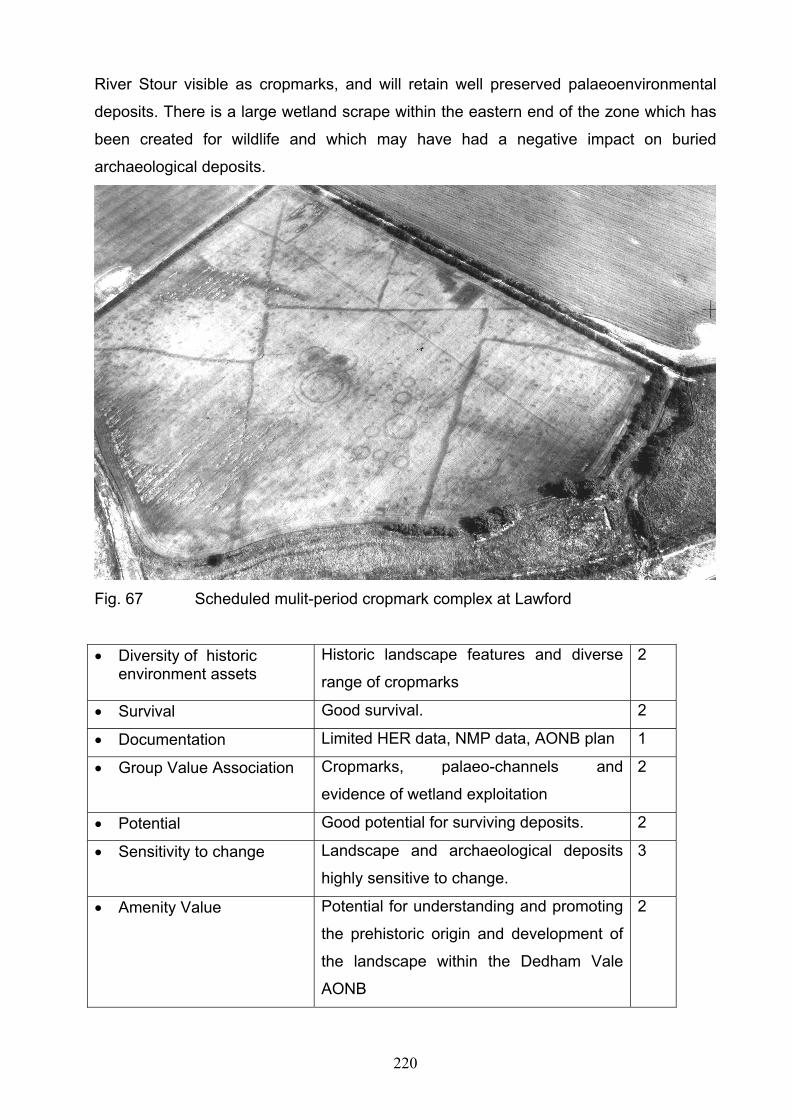
220
River Stour visible as cropmarks, and will retain well preserved palaeoenvironmental
deposits. There is a large wetland scrape within the eastern end of the zone which has
been created for wildlife and which may have had a negative impact on buried
archaeological deposits.
Fig. 67 Scheduled mulit-period cropmark complex at Lawford
Diversity of historic environment assets
Historic landscape features and diverse
range of cropmarks
2
Survival Good survival. 2
Documentation Limited HER data, NMP data, AONB plan 1
Group Value Association Cropmarks, palaeo-channels and
evidence of wetland exploitation
2
Potential Good potential for surviving deposits. 2
Sensitivity to change Landscape and archaeological deposits
highly sensitive to change.
3
Amenity Value Potential for understanding and promoting
the prehistoric origin and development of
the landscape within the Dedham Vale
AONB
2

221
HECZ 16.2 Cattawade Marshes
Summary: This zone encompasses a flat landscape of former and current estuarine
grazing marshes at the head of the Stour Estuary. The geology is dominated by
estuarine alluvium. The zone falls within the Dedham Vale Area of Outstanding Natural
Beauty and is designated as a Special Site of Scientific Interest (SSSI). The marshes
are managed as a nature reserve by the RSPB. There is no settlement in the area.
Historically the zone had a close relationship with the adjacent estuary (HECZ 15.1) and
adjacent valley bottom pasture to the south (HECZ 16.1).
Historic Landscape Character: This area comprises an open, flat landscape of former
and current estuarine grazing marsh within the floodplain of the River Stour. At its
eastern end, the zone is demarcated by the Cattawade Bridge. The River Stour forms
the northern boundary of the area and a former tidal arm of the River Stour forms the
southern boundary. Both the River Stour and the relict arm of the tidal estuary flow
through the landscape but are of very different character. The reed lined River Stour
meanders naturally but also shows signs of engineering, as at the locks of Brantham
Mill, whilst the southern channel has muddy shores reflecting its former tidal regime,
after being cut off by the construction of the Cattawade Barrage during the late 20th
century. The coastal grazing marshes are collectively known as Cattawade Marshes
and are managed as a nature reserve by RSPB. At their western and eastern limits,
these are characterised by relict salt marsh preserved in rough pasture. Field
boundaries follow the sinuous former creeks, although there are also some straighter
field ditches including a double ditched trackway, leading from a historic bridging point
of the southern channel, which appears to have been used in conjunction with field
ditches for corralling livestock. Within the centre of the marshes, agricultural
improvement has had a greater impact with sub rectangular fields of improved pasture
bordered by straight field ditches. The sea walls and river banks alongside the remnant
arm of the tidal estuary and northern bank of the River Stour are a distinctive historic
landscape feature. There is a single late 18th or early 19th century agricultural building
in the centre of Cattawade Marshes reached by a raised trackway constructed of
demolition debris. Towards the eastern end of the marsh, the trackway runs over an
even more substantial raft of building material dumped during the late 20th century and
at the western end a modern weir has been constructed at Judas Gap.

222
Fig. 68 Historic grazing marsh, Cattawade Marshes
Archaeological Character: The archaeological character of this zone is largely
undefined due to a lack of field work. However, the proximity of prehistoric cropmarks
identified in the adjacent zone to the south (HECZ 16.1), lack of intensive land use and
preservative qualities of the underlying geology means that the zone has high
archaeological and palaeoenvironmental potential, including the potential for well
preserved organic material. The sea walls and river banks will retain evidence for date
and construction and the former tidal channel contains structural timbers from a bridge,
shown on the 1st edition OS map (c1876), at the western end of the zone.

223
Diversity of historic environment assets
Limited range of historic landscape and
archaeological features
1
Survival Little disturbance and likelihood of
waterlogged conditions means that buried
remains may be well preserved.
2
Documentation Limited HER data, NMP data 1
Group Value Association Sea walls, historic field boundaries and
other features relating to wetland
exploitation.
2
Potential Little disturbance and good potential for
surviving deposits.
2
Sensitivity to change Landscape and archaeological deposits
highly sensitive to change.
3
Amenity Value Potential for understanding and promoting
the prehistoric origin and development of
the landscape within the Dedham Vale
AONB
2
HECZ 17.1: Elmstead Market and Alresford
Summary: The drift geology consists of brickearth and Kesgrave Sands and Gravels.
The zone comprises a dispersed medieval settlement pattern with relatively good
survival of fieldscape. There are extensive cropmark complexes covering a large part of
the zone, of a multi-period date, including Bronze Age cemeteries.
Historic Landscape Character: Historically the landscape consisted partly of large
areas of heathland including Elmstead Heath. These were enclosed by agreement in
the early 19th century. Elsewhere the fieldscape is largely of ancient origin irregular and
regular fields but there has been moderate loss of field boundaries since the 1950s
especially in the north of the zone. Small areas of ancient woodland survive along the
western side of the zone. The eastern boundary of the zone is formed by the Tenpenny
Brook. The historic settlement pattern consisted of dispersed church/hall complex, halls
and farms with a small nucleated settlement at Elmstead Market. With the coming of

224
the railway in the 19th century a further nucleated settlement developed at Arlesford.
Considerable quarrying activity has occurred in the southern part of the zone.
Archaeological Character: Cropmarks are the dominant archaeological feature with
particular concentrations of multi-period features lying between Elmstead Market and
Alresford. There are two complexes which can be accurately assessed as Bronze Age
cemeteries with a number of ring ditches (ploughed out burial mounds) in groups, which
can be paralleled on a number of sites across Tendring. The other cropmarks comprise
settlement enclosures, trackways, roads and field systems. Excavations have shown
occupation within the zone from the Bronze Age through to the medieval period.
Further evidence of medieval occupation can be seen in the surviving landscape and
settlement pattern.
Diversity of historic
environment assets
Multi-period cropmarks, prehistoric
enclosures, and burials, medieval settlement
pattern
3
Survival Cropmarks indicate good below grounds
survival, field pattern suffered considerable
boundary loss in northern part. Quarrying
activity especially in the south
2
Documentation HER, cartographic, NMP, excavation reports 3
Group Value Association Cropmark complexes 2
Potential High potential for below ground deposits 3
Sensitivity to change Below ground deposits highly sensitive,
especially in the northern half of the zone.
3
Amenity Value Below ground deposits, Cropmarks and
settlement pattern could be promoted
especially within the settlements of Elmstead
and Arlesford as part of the wider history of
Tendring
2

225
HECZ 17.2: Thorrington
Summary: The zone retains a high archaeological potential as demonstrated by the
cropmark and cartographic evidence. The historic landscape contains a number of
significant areas of ancient woodland and enclosed meadow pasture. The historic
settlement pattern was highly dispersed. The drift geology for the zone is composed of
brickearth and Kesgrave sands and gravels.
Historic Landscape Character: The historic landscape comprises a pre-eighteenth
century irregular field system interspersed with significant areas of ancient woodland,
much of the latter still survive. Thorrington Heath formed an extensive open area in the
centre of the zone, this was enclosed in the nineteenth century. There are areas of
enclosed meadow pasture along the streams, particularly in the area of the Tenpenny
Brook. The historic settlement was both highly dispersed and rather sparse. The
modern village of Thorrington developed around and on the former heath. The
medieval church/hall complex of Thorrington Hall is located immediately to the south-
east of modern Thorrington. An important post-medieval tide mill survives at the head of
Alresford Creek.
Fig. 69 The 19th century timber-framed tide mill at Thorrington

226
Archaeological Character: Sparse in the north of the zone, cropmarks become more
prolific in the area to the south and east of Thorrington. Trackways, enclosures, ring-
ditches and ancient field systems are represented and point to good survival of below
ground archaeological features. The paucity of cropmark evidence in the north of the
zone is likely to result from differing crop regimes or geological factors rather than a lack
of previous human use of the land. It is probable that there are surviving deposits and
features relating to the medieval and early post-medieval settlement pattern. A 19th
century brick works existed at Thorrington Plantation.
Diversity of historic
environment assets
Multi-period cropmarks, bronze Age
cemetery, medieval settlement pattern,
ancient woodland, field pattern
2
Survival Cropmarks indicate good below grounds
survival, field pattern suffered limited loss.
Ancient woodland likely to contain important
earthworks
3
Documentation HER, cartographic, NMP 2
Group Value Association Cropmark complexes 2
Potential High potential for below ground deposits and
earthworks within woodland
3
Sensitivity to change Woodland and surviving historic landscape
features, below ground deposits sensitive, all
sensitive to change.
2
Amenity Value Potential to promote cropmark complexes
and ancient woodland/settlement pattern, in
relation to adjacent zones.
2

227
HECZ 17.3: Alresford Grange
Summary: This zone comprises the tongue of land sited between the Colne Estuary
and the Sixpenny Brook. The surface geology is largely mixed Kesgrave Sands and
Gravels and Brickearth with alluvial deposits associated with the Colne estuary. There
is considerable crop-mark, cartographic and excavation evidence for extensive historic
settlement in the area from at least the later prehistoric periods onwards. Despite the
extensive mineral extraction that has taken place, discrete areas of archaeology still
may survive.
Historic Landscape Character: The topography slopes down to the River Colne to the
west and south of the zone, with the valley of the Sixpenny Brook forming the eastern
edge of this zone. The historic landscape pattern was of pre-18th century irregular fields
and discrete areas of enclosed meadow pasture along the Sixpenny Brook, woodland,
plantation and in the south, part of Alresford Hall Park. The historic settlement pattern
comprised isolated farms. There are considerable areas of mineral extraction.
Archaeological Character: Cropmarks are apparent where the land rises away from
the Colne Estuary in the north of the zone with trackways, linear features and
enclosures visible. A further concentration occurred north and west of Plumptons Farm
in the south of the zone. Many of these have been destroyed by mineral extraction, but
a few discrete areas still survive. A Roman villa was close to the junction of the River
Colne and Alresford Creek, and the cropmarks at Plumptons Farm suggest that a
second possible villa was located there. There is the potential for surviving medieval
and post-medieval deposits relating to the historic settlement pattern. The valley
bottoms and sides have potential for palaeoenvironmental deposits.
Diversity of historic
environment assets
Multi-period cropmarks, prehistoric
enclosures, and burials, Roman villa
3
Survival Unquarried areas likely to contain buried
archaeological deposits,
2
Documentation HER, cartographic, NMP, excavation reports 2
228
Group Value Association Cropmark complexes, surviving historic
landscape features related to six penny
brook valley and Colne estuary
2
Potential Potential for below ground deposits in
unquarried areas and palaeoenvironmental
deposits in valley bottom/slope locations.
2
Sensitivity to change Unquarried areas sensitive to change 2
Amenity Value Cropmarks, historic landscape, and in terms
of industrial development the quarries
themselves could be promoted in
conjunction with neighbouring zones to
elucidate the history of Tendring
2

229
Bibliography
Chris Blandford
Associates
2004 Thames Gateway Historic Environment Characterisation
Project
Countryside
Agency, English
Heritage, English
Nature, Environment
Agency
2005 Environmental Quality in Spatial Planning: Incorporating
the natural, built and historic environment, and rural issues
in plans and strategies
DCMS and DTLR 2001 The Historic Environment: A Force for our Future
Essex County
Council
2005 Rochford District Historic Environment Characterisation
Project
Medlycott, M. 1999 Harwich: Historic Town Assessment report
Medlycott, M. 1999 Manningtree: Historic Town Assessment report
Medlycott, M. 1999 St Osyth: Historic Town Assessment report
Essex County
Council
2007 Chelmsford Borough Historic Environment
Characterisation Project

230
Appendices
1 Historic Environment Character Area Methodology
The development of the Historic Environment Character Areas (HECAs) involved an
initial 3 stage process:
Analysis and creation of Historic Landscape areas,
Analysis and creation of Urban Character areas
Analysis and creation of Archaeological Character areas;
1.1 Creation of Historic Landscape Character areas
1.1.1 General Background
The rural landscape of Essex is a much treasured resource whose form and character
reflects millennia of human activity and underlying topographical and geological
influences. It has been well-researched but still has surprises and new findings to offer.
It is a living, dynamic and changing entity that alters in response to natural factors, e.g.
climate change, as well as human intervention e.g. 20th century farming practices. The
landscape of an area has many qualities and values including its visual character,
biodiversity, recreational uses and economic value to those who farm and own it. It is
also an important historical resource that catalogues the activities and lifestyles of past
communities and its structure, character and form have long been studied as a pathway
into the past.
Tendring encompasses large areas of rural and some urban landscapes from a range of
periods. This assessment has confined itself to examining the historic rural landscape of
the region, the urban areas are addressed in the built heritage section. However, these
two elements are closely related and where necessary themes and findings are
transferred between the two sections. This section and the results of the
characterisation presented should be read in conjunction with the broad overview of the
area's historical development.

231
Tendring has a highly varied historic landscape reflecting a range of influences and
patterns. Some of the key human and cultural drivers behind the development of the
landscape include:
• The emergence, seemingly in the late prehistoric period, of an agricultural economy;
• The development in the late prehistoric period of large-scale landscape organisation
and field systems which along with the patterns of transhumance have had a strong
influence on the grain of the landscape;
• The prehistoric / Roman development of the major road corridors, and route ways and
settlement;
• The development of a distinctive pattern of dispersed settlement across Tendring
District;
• The use of the marshes and estuary throughout history as a key resource for
agriculture, fishing and industry;
• 20th century urban expansion.
1.1.2 Methodology
Through a combination of analysing and simplifying the regional Historic Landscape
Characterisation data, drawing in other key datasets such as Ancient Woodland, historic
mapping, historic parks and gardens and secondary sources, it was possible to develop
a series of character areas that reflected distinct combinations of Historic Landscape
Character types and landscape character attributes.
Once the initial area had been digitised the descriptions for each area were prepared.
The descriptions drew on a range of sources and attempted to reflect the reasoning
behind the definition of an area and, where possible, relate that area to its wider historic
context. The descriptions sought to highlight the key characteristics and Historic
Landscape Character types in an area and identify any particular significant features or
assets. The process of preparing the descriptions was also a part of the process of
defining the areas.

232
1.1.3 Outline of Results
Figure 34 shows the location and extent of the Historic Landscape Character Areas.
Each of these areas is accompanied by a short description (see Appendix 2). This data
is also available in the accompanying GIS and an example of the descriptions is
provided below:
HLCA 3. Eastern Colne marshes
An area of current and former marshland, sited on the eastern shore of the Colne
estuary, and including the Brightlingsea Creek and St Osyth Creek marshes.
The geology comprises estuarine alluvium deposits.
The field boundaries comprise drainage channels, many following the sinuous course of
the former creeks. The marshes nearly enclose the Brightlingsea peninsula. The levels
of post 1950s boundary loss in the area are low.
A number of areas of former oyster beds are located within this area, most notably those
of Cindery Island to the south of Brightlingsea. Other historic landscape features include
the sea walls, jetties and hulks. The tidal mill pond at the head of St Osyth Creek is also
included in the area, this is of medieval, or possibly late Saxon origin.
Settlement was historically confined to the dryer ground to the east But Brightlingsea
Town Hard occupies an area of reclaimed marsh where a cluster of buildings including
the Harbour Commissioner’s building, workshops, Customs building and warehouses
are located.
There is a leisure area to the west of the harbour which includes modern sea defences,
a boating lake, lido and beach huts and the 19th century folly, Bateman’s Tower.
The nature of the study has led to the development of descriptions and mapping that is
broad and general in nature. The characterisation has highlighted the time depth of the
structure of the landscape and the role that this structure has played in shaping the
development of communities in the region; perhaps indicating that there is a future role
for these structures in the implementation of the sustainable communities plan.

233
1.2 Creation of Urban Character areas for Tendring
1.2.1 General Background
There is a wide range of urban types in Tendring District. St Osyth is arguably the
oldest of the towns, with its origins in the Late Saxon period. The medieval period is
represented by the planned port town of Harwich and the smaller port towns of
Manningtree and Brightlingsea. Mistley had its origins as a spa town, and Clacton and
Walton were both seaside resorts, and Frinton a seaside town. The impact of the
railways and of industry in the 19th and 20th centuries are evident in the development of
Parkeston and at Mistley.
Key themes in the development of the urban landscape of the region include:
Development during the Saxon period
The growth of the medieval town;
Industrial development;
The influence of the coastal location on urban development
Late 19th and 20th century suburban development;
1.2.2 Method and Approach
The Tendring historic environment characterisation project has expanded on the
identification of the structure, evolution and form of the urban areas. This has been
undertaken using desk-based sources and has not involved comprehensive field
analysis and survey, although some areas were briefly examined on the ground during
the course of the project. This involved intensive examination of historic mapping
sources, HER data, Extensive Urban Survey, listed building data and conservation area
data. The characterisation defined the dominant architectural / structural character of an
area. This has involved developing an understanding of current and past land use,
evolution of the street layout and form, the identification of major episodes of change
and the nature of that change.
The key datasets used in the process were:
• OS Modern Mapping;
• OS Historic Mapping (1st to 4th Editions);

234
• Conservation area boundary data;
• Listed building data;
• Historic Town Survey
1.2.3 Characterisation and Description
Through a detailed analysis of the historic OS mapping, coupled with other data held in
the Historic Environment Record, it has been possible to identify, in broad terms, the
surviving historic cores of the urban settlements in Tendring District. From these cores
the analysis worked its way out through the settlements developing an understanding of
how the later urban form was developed, demolished and redeveloped. This has led to
the definition of the character areas.
The character areas predominantly reflect survival of different periods of urban
landscape, in terms of both the survival of the layout and form of an area as well as its
built fabric. In some instances, the character areas mark the theoretical extent of a
historic core, but only when the surrounding urban form has become so confused as to
make more accurate definition less achievable.
The characterisation was accompanied by structured descriptions, which catalogued the
dominant periods, uses and the nature of development. The listed building descriptions
and conservation area descriptions were used during the description process to aid
understanding.
1.2.4 Outline of results
Figures 35 show the location and extent of the identified Urban Character Areas. Each
of these areas is accompanied by a short description (see Appendix 3). This data is also
available in the accompanying GIS. An example of the descriptions is provided below:

235
HUCA 11: Core of Parkeston
Predominant Periods: Post medieval
Secondary Periods: Modern
Predominant Type: Residential
Secondary Type: Retail/commercial
Parkeston is a unique later C19 planned industrial settlement built by GER adjacent to
Parkeston Quay
It retains its original terraced street plan and many of the original workers cottages
The residential provision was increased in the early C20 to the west but the settlement at
Parkeston has not been adversely affected by modern housing/infill
Some small scale commercial facilities
1.3 Creation of Archaeological Character Areas in Tendring
1.3.1 General Background
As described in the overview of the historic environment the archaeological resource of
Tendring is complex and varied. It represents evidence of human / hominid activity from
the Palaeolithic period and encompasses every aspect of life from settlement and
farming; to religion and ritual; and industry and commerce.
Our knowledge of this resource is also highly varied and while many places have a long
history of archaeological investigation other areas have been subject to little or no
research. In recent years our understanding of the archaeological resource has been
enhanced by extensive archaeological research, e.g. the Historic Town survey and the
National Mapping Programme. It has also been improved by the considerable range of
archaeological investigations undertaken in advance of development under the aegis of
PPG16.
1.3.2 Approach to the Analysis
The Archaeological Character Analysis has sought to respond to this situation not by
characterising the archaeological resource itself (because so much of it – perhaps the
majority - remains unknown), but by characterising our current understanding and
236
knowledge of the archaeological resource. This has been done through the definition of
discrete geographical areas that are likely, based on current knowledge, to be distinctly
different in terms of the nature, type and survival of archaeological resources contained
within them.
The Archaeological Character Analysis does not seek to present a comprehensive and
new understanding of the archaeological resource, nor does it attempt to predict the
location of individual archaeological sites. It has sought to present our understanding of
the archaeological resource in a manner that is compatible with the approaches used
for the historic landscape characterisation and urban characterisation as well as being
understandable to specialists and non-specialists alike.
1.3.3 Outline of Approach and Methodology
Key to these approaches is the definition of generalised areas that share definable and
distinctive characteristics. This generally relies on the analysis of consistent datasets,
something that it’s not always possible with pure archaeological data as this has
historically tended to be collected on a site-by-site basis rather than as the result of
systematic and comprehensive survey.
A number of factors were examined in an attempt to determine the boundaries of
character areas. These included historic settlement pattern; extent of modern
development; topography; geology; known archaeological sites and find spots; and
secondary source analysis. Because the analysis was seeking to address complex
patterns of survival, visibility of archaeology (in the broadest sense), past exploration
and current knowledge, it was decided that patterns of modern and historic
development were key to developing the extents of areas, as these have influenced
both the deposition and survival of archaeological deposits.
Other consistent datasets relating to past human activity, including topography and
geology, also formed part of the basis of the analysis. The methodology reflects the
concept that the geology and topography of an area influences the visibility and survival
of archaeological deposits and the broad types of activity that may have occurred in an
area at different times.

237
The archaeological character of each of these identified areas was then explored
through an analysis of available data including Historic Environment Record data,
Scheduled Monument data, various secondary sources, historic mapping and other
available digital datasets. The work also involved a considerable body of professional
judgement. Through this process some character area boundaries were revised and
edited, some amalgamated and new areas created.
1.3.4 Description and Review
This was perhaps the key stage of the process where the results of the broad-brush
characterisation were subject to more detailed scrutiny and examination. This involved
examining a broad range of data sources including:
• Historic Environment Record Data;
• National Mapping Programme (NMP) cropmark plots;
• Historic Town and Settlement Assessment reports;
• Roman roads;
• Selected Secondary sources:
Each of the preliminary areas was then analysed and described using a combination of
this data and the background geology / topographical and historic development
information. This led to the creation of a number of new areas and the identification of
key sites and deposits, particularly within the historic core of the urban areas. The
boundaries of many areas were also revised and edited.
1.3.5 Outline of Results
Figure 37 shows the location and extent of the identified Archaeological Context Areas.
Each of these areas is accompanied by a short description of the archaeological context
(see Appendix 4). This data is also available in the accompanying GIS. An example of
one area is provided below:
238
ACA 4 River Stour Intertidal
Lying between the high and low water marks, the surface geology of this area is
composed of estuarine silts and alluvium crossed by numerous named fleets and creeks
with narrow strips of saltings, which were traditionally used for sheep grazing.
Copperas Bay indicates the importance of the copperas industry here in the post
medieval period. Copperas was an important and valuable product used in a number of
manufacturing processes..
The area has some potential for prehistoric archaeology and buried ancient land
surfaces but the potential for more recent evidence is probably greater including
evidence for maritime activities, notably hulks and other timber structures such as
wharves. Baltic Wharf has a number of sunken vessels associated with it and Ballast Hill
within the estuary was used as a dumping ground for ships ballast.
The descriptions aim to give a broad indication of the nature of the known archaeology
of the area as well as identifying factors that may have influenced the survival and
preservation of that archaeological resource. The data is presented in a standard bullet-
point format and is designed to give a summary of the character area.
1.4 Creation of Historic Environment Character Areas
The three independent sets of boundaries were overlain on a single drawing. This
produced a series of boundaries, some of which corresponded, some of which
remained isolated. Areas where Historic Landscape Character Areas and
Archaeological Context Areas, and Urban Character Areas and Archaeology Context
Areas, coincided were quickly highlighted and these formed the basic structure for the
combined areas.
Where area boundaries did not correspond, decisions were made as to the relative
primacy of different themes. For the most part the historic landscape boundaries
dominated in the rural areas and urban boundaries dominated in urban areas as these
reflect visible and recognisable boundaries; their edges also often tend to be more
absolute than the archaeological boundaries. However there were some instances
239
where the difference in the archaeological context between parts of the emerging
HECAs was strong enough to warrant sub-division or the refinement of a boundary.
1.4.1 Description
These descriptions for these draft areas were then rapidly compiled by drawing on the
relevant elements of each of the themes in a single description.
Each of the character areas was then described using a standard format:
• Summary: Outlines key messages and general character.
• Historic Landscape Character: Presents the historic landscape characterisation of the
area. This includes broad information on settlement pattern in rural areas. In urban
areas this section is omitted.
• Urban Character: This presents the urban character of the area drawing on the urban
characterisation. In rural areas this section is omitted.
• Archaeological Character: Presents a summary of the area's archaeological context
based on the archaeological context analysis.
1.4.2 Results
Figure 12 shows the location and extent of the Historic Environment Character Areas
(HECAs). Each of these areas is accompanied by a short description and this data is
available in section 3 of the main report and in the accompanying GIS.

240
2 Historic Landscape Character Area Descriptions
Fig. 70 Historic Landscape Character Areas
HLCA 1. Manningtree, Mistley and Lawford Urban Area
The modern urban area of Manningtree, Mistley and Lawford villages, this
incorporates the medieval and post-medieval historic core of the port of
Manningtree, and the 18th century development of Mistley.
HLCA 2. Dedham Heath area
This area comprises a ridge of higher ground to the south of the Stour valley
which lies within both Colchester Borough and Tendring District.

241
The soil-type consists of Head on the higher ground with sands and gravels and
London Clay revealed in the valley sides.
The present landscape comprises a mixture of 18th century and later enclosure,
pre-18th century irregular fields (these are probably of medieval origin and some
maybe even older) and later enclosure by agreement. The first category largely
but not entirely corresponds to the former heathlands around Dedham e.g.
Ardleigh Heath, and is concentrated in the southern half of the area. Whilst the
more piecemeal later enclosure and the irregular fields are concentrated in the
north, on the slopes overlooking the Stour valley. Post 1950’s boundary loss can
be described as moderate.
There are tracts of enclosed meadow pasture in the valleys of the tributary
streams feeding into the Stour.
There were extensive orchards, and an extensive area of glass houses /
nurseries exist today, the greatest concentration of these are at the eastern end
of the area around Foxash.
Along the eastern edge of the area is Lawford Park.
The settlement is also largely concentrated along the northern ridge, and
historically comprised dispersed settlement of church/hall complexes, manors,
farms, cottages and hamlet.
Modern ribbon development has now linked many of these sites.
HLCA 3. Eastern Colne marshes
An area of current and former marshland, sited on the eastern shore of the Colne
estuary, and including the Brightlingsea Creek and St Osyth Creek marshes.
The geology comprises estuarine alluvium deposits.
The field boundaries comprise drainage channels, many following the sinuous
course of the former creeks. The marshes nearly enclose the Brightlingsea
peninsula. The levels of post 1950s boundary loss in the area are low.
A number of areas of former oyster beds are located within this area, most
notably those of Cindery Island to the south of Brightlingsea. Other historic
landscape features include the sea walls, jetties and hulks. The tidal mill pond at
the head of St Osyth Creek is also included in the area, this is of medieval, or
possibly late Saxon origin.

242
Settlement was historically confined to the dryer ground to the east But
Brightlingsea Town Hard occupies an area of reclaimed marsh where a cluster of
buildings including the Harbour Commissioner’s building, workshops, Customs
building and warehouses are located.
There is a leisure area to the west of the harbour which includes modern sea
defences, a boating lake, lido and beach huts and the 19th century folly,
Bateman’s Tower.
HLCA 4. Brightlingsea peninsula
A small area comprising the dryland peninsula of Brightlingsea, which is virtually
an island set in the coastal marshes of the eastern Colne.
The geology is mainly Kesgrave sands and gravels, with the underling London
Clay forming a fringe around the edges, it in turn is bordered by a band of
alluvium that extends beyond the area into the coastal marshes.
The fieldscape has largely been identified as being pre-18th century irregular
enclosure, these appear to have been sub-divided internally into rectangular strip
fields, possibly in the medieval period. Brightlingsea was the centre of a Royal
vill in the Saxon period and it is possible that some of the irregular field
boundaries may date to that period.
Settlement is largely concentrated in the village of Brightlingsea, a historic
cinque-port, as well as a number of isolated farms, mostly strung out along the
marsh edge.
There are a number of small areas of ancient woodland on the higher ground.
There is an extensive mineral extraction pit to the southeast of the village,
otherwise the post 1950s boundary loss can be described as low to moderate
HLCA 5. Alresford area
This area comprises the valleys of three brooks, of which the largest is the
Frating Brook which bisects the area. All three drain into the marshes to the rear
of Brightlingsea.
The geology consists of head on the ridges between the valleys, sands and
gravels on the valley sides and London Clay in the valley floor.
This area is distinguished by the enclosed meadows which line the valley floors
and areas of orchards, many of which still survive around Elmstead and Frating.

243
The remainder of the fieldscape comprises a mixture of pre-18th century irregular
fields (these are probably of medieval origin and some maybe even older) and
later enclosure of common fields. Field boundaries largely comprise low gappy
hedgerows with hedgerow oaks. Post 1950s boundary loss can be described as
moderate, rising to high on a number of farms. Shelter belts of poplar and fast
growing Leylandii have been created in the 20th century to protect the orchards
There are some areas of ancient woodland, particularly in the southern half of
the area and including Thorrington Hall woods, one of the largest in the district.
They are typically composed of sweet chestnut, hazel, or hornbeam coppice with
oak or ash standards.
Historically the settlement was sparse and very dispersed, comprising isolated
church/hall complexes, manors, farms and small hamlets, the latter often located
at road junctions or around greens such as Frating Green, Balls Green and Hare
Green. Many of these have been infilled by inter-war smallholdings or more
recent housing; the large village green at Great Bentley is a notable exception.
Scattered settlement around former heaths such as Elmstead Heath is also a
feature. Historically these were used for rough pasture but were enclosed in the
early 19th century.
A network of narrow lanes connects the scattered farms and hamlets and cross
the brooks at historic crossing points.
Modern development has largely confined itself to ribbon development along the
roads, e.g. at Thorrington Cross, with the only sizable settlement being Elmstead
Market.
There are extensive areas of mineral extraction in the southern half of the area.
HLCA 6. Ardleigh Heaths area
This area is located on the western edge of the Tendring Plateau, and comprises
a higher flat area, bisected by the valley of the Salary Brook and bordered by the
Colne estuary to the south.
The geology is largely Head, with sands and gravels and London Clay revealed
in the valley sides, and with some alluvium bordering the Colne estuary.
The area is characterised by large areas of former heathland, these included
Ardleigh Heath, Crockleford Heath, Whitmore Heath and Wivenhoe Heath.
These were all sited on the Boulder Clay, forming a rough semi-circle around the

244
eastern flank of Colchester. Historically they were used for rough pasture but
were enclosed in the early 19th century. The present landscape comprises a
mixture of pre-18th century irregular fields (these are probably of medieval origin
and some maybe even older) and later enclosure by agreement, the latter largely
but not entirely corresponding to the former heathlands. Field boundaries largely
comprise low gappy hedges with hedgerow oaks, although 20th century shelter
belts of poplar or Leylandii are also a feature. Post 1950s boundary loss can be
described as moderate, rising to high in a number of areas.
There are areas of ancient woodland, chiefly in the western half of the area.
There were also extensive orchards, some of which still survive for example
around Ardleigh.
Ardleigh Park is medieval in origin.
Ardleigh Reservoir forms a major modern landscape feature in the north-west of
the area.
Historically settlement comprised the nucleated village of Ardleigh in the north
and a dispersed scatter of manors, farms, cottages and small hamlets. This
settlement pattern is still evident today.
The area is dissected by the Colchester to Ipswich railway line and modern
A120.
HLCA 7. Tendring plateau
A large plateau-like area, drained by the Holland Brook to the south and by
smaller streams to the north and west.
The geology is largely London Clay in the central and eastern parts, overlain by
Head in the western part. There are bands of Kesgrave sands and gravels,
marking the former line of the River Thames running diagonally across the area,
and small patches of alluvium close to the coast and in the valley of Ramsey
Creek.
The fieldscape comprises a mixture of later enclosure by agreement and pre-
18th century irregular fields (these are probably of medieval origin and some
maybe even older), with the later enclosure in the majority. It appears that at
least some of the enclosure comprised the sub-division into strip fields of early
irregular shaped fields. Post-1950s boundary loss can be assessed as
moderate, rising to high on a number of farms and severe on one or two farms.

245
The area is characterised by long, thin, roadside greens and small triangular
greens at road junctions, with one larger area of former heathland at Bradfield
Heath. There are areas of enclosed meadow pasture in the stream valleys. The
areas of ancient woodland are largely in the southern half of the area, although
there is an important grouping overlooking the Stour estuary at Wrabness. There
are also areas of orchards, mainly in the northern half of the area.
The settlement is dispersed in character, comprising church/hall complexes,
manors, farms, cottages and small hamlets, the latter often strung out along the
roadside greens. Modern development has largely taken the form of infilling of
this pattern, resulting in ribbon development along the roads.
A network of narrow lanes connects the scattered farmsteads and villages. The
Manningtree to Harwich railway line runs along the northern edge of the area and
the area is dissected by the modern A120 and A123.
Small areas of ancient woodland survive with a largely neglected coppice with
standards structure.
Areas of former and surviving parkland can be found along the northern edge of
the area e.g. Mistley Park and Furze Hill.
HLCA 8. Marshes along the Stour estuary
This area comprises a long narrow strip of tidal marshland along the southern
bank of the Stour estuary. It also includes an area of reclaimed marsh at the
head of the estuary. At Mistley Walls the saltings are common grazing land.
There has been little boundary loss in this area, the boundaries are all of the
drainage ditch type. Sea walls are a dominant landscape feature.
There are few settlements in this area and the only other built development in the
marshes are the distinctive holiday huts at Wrabness Point, raised above the
water level on stilts and the road and railway bridges which cross the Stour at
Cattawade.
Cattawade Marshes is now an RSPB nature reserve.
HLCA 9. Harwich urban area
The modern urban area of Harwich, this incorporates the medieval and post-
medieval historic core of the town, the military redoubt to the south of the town
and the modern Parkeston Quay to the west.

246
HLCA 10. Hamford Water
Hamford Water is an extensive area of current and former marshland, creeks
and marshland islands, some of which have been embanked. Much of the
embankment took place in the 19th century, the field boundaries comprise
drainage channels, mainly without banks or hedges, some following the sinuous
course of the former creeks. Post 1950s boundary loss in the area is very low.
The sea walls are a dominant landscape feature.
Topographically this is a very complex landscape of interlocking dryland,
marshland, mud and tidal waters. The area incorporates the reclaimed marshes
to the south of Harwich and the mud cliffs that form the Naze at Walton-on-the–
Naze.
The geology comprises tidal mud flat deposits, with outcrops of London Clay
forming the backbone of Skippers and Horsey Islands.
The area is very important for nature conservation, Skipper Island is a nature
reserve and the improved grass fields of Horsey Island provide feeding and
roosting sites. Horsey Island has a single farmstead on it and is connected to the
mainland by a causeway.
Bramble Island was used as an explosive factory and remains dating to that
phase survive; it is now used as a chemical factory. The landscape is marked by
old jetties, quays and track-ways, many of which terminate at a quay, dock or
landing stage including Beaumont Quay with its associated brick built lime kiln,
Old Moze Dock, Great Oakley Dock and Kirby Quay. The Naze is dominated by
the octagonal, early 18th century tower built by Trinity House as a navigational
mark. The area includes the former tidal millpond of Walton mere on the North
West edge of Walton which was developed as a boating lake in 1921.
20th century built development includes a static caravan park and marina on the
edge of the Walton backwaters and sewage works to the north of the Naze.
HLCA 11. Frinton and Walton urban areas
The modern urban areas of Frinton and Walton. The towns developed as two
distinct 19th century seaside resorts. Much of the current urban area however
dates to the post 1960s.
247
HLCA 12. Holland Brook valley
This area includes the small shallow valley of the Holland Brook and the
marshes at its mouth.
The geology comprises London Clay, overlain with patches of Kesgrave sands
and gravels on the valley sides and alluvium in the valley floor.
The area is characterised by enclosed meadows along the brook, with drained
linear reclamation of the tidal marshes where the sea wall is a dominant
landscape feature. These were enclosed in the early 19th century. The field
boundaries on the reclaimed marshes comprise drainage channels with no banks
or hedges. The fields along the valley sides largely consist of pre-18th century
enclosure, much of this echoes the contours of the valley with the rectangular
fields running down the slope. Post 1950s boundary loss can be described as
high.
Ancient woodlands, typically dominated by oak, ash and sweet chestnut, are
located in the wetter areas and on the steeper slopes.
The area includes Far Thorpe Green and Great Holland Common,
There is little settlement in this area, and the few examples are highly dispersed
in nature, comprising isolated farms and cottages, former mills and Thorpe
Maltings. These are situated along minor lanes which drop down the valley sides
and cross the streams at historic crossing points, on stone or brick bridges.
The 19th century railway line to Frinton on Sea and Clacton on Sea runs down
into the valley from the north and crosses the Holland Brook close to Thorpe
station.
20th century agricultural development has resulted in the construction of
numerous reservoirs. A former quarry at Great Holland has been converted into
the Great Holland Pit Nature Reserve.
HLCA 13. St Osyth area
This geology of this area comprises the London Clay slope around St Osyth with
areas of Kesgrave sand and gravel.
The fieldscape is largely one of pre-18th century irregular fields (these are
probably of medieval origin and some maybe even older), with an area of pre-
18th century regular fields in the southern portion of the area. The size of the
248
fields in this area is noticeably smaller than those to the north of the area. Field
boundaries largely comprise low gappy hedgerows with occasional hedgerow
oaks. Post 1950’s boundary loss can be described as moderate, rising to high in
a number of areas, particularly on the edges of Clacton.
The priory grounds at St Osyth are former medieval deer park, re-landscaped in
the post-medieval period.
There are a number of areas of ancient woodland such as Riddles Wood, which
congregate on the higher ground in the northern half of the area, and which
typically comprise oak standards and sweet chestnut coppice.
Historically settlement was very dispersed, with only two small foci, at St Osyth
and Little Clacton. Otherwise the settlement comprised isolated manors, farms
and cottages, although the string of ‘wick’ farms on the dryland boundary with the
former marshland area of Colne Point to the south is a noticeable feature of the
historic settlement pattern.
The present settlement pattern reflects the 20th century trend for seaside
holidays, with a mixture of plotland style development and caravan parks at Point
Clear, and ribbon development along the road to Clacton
HLCA 14. Clacton urban area
The modern urban area of Clacton-on-Sea. The town developed as an early
19th century seaside resort. Much of the current urban area however dates to
the post 1960s.
HLCA 15. Colne Point
The geology comprises alluvial deposits overlaying London Clay.
An extensive area of current and former marshland, sited at the mouth of the
Colne estuary. There is no post 1950s boundary loss.
The field boundaries comprise drainage channels, mainly without banks or
hedges, many following the sinuous course of the former creeks together with
modern post and wire fences.
Surviving historic landscape features include the sea wall bordering the southern
and western edges of the area and a decoy pond situated at the eastern end.
The south eastern corner contains a number of caravan and mobile-home parks,
facing on to the beach including the holiday village of Seawick.. Settlement also

249
includes a cluster and short ribbon of buildings at Lee-over-Sands and
associated development including a sewage treatment works.
The western end of the tidal marsh is a nature reserve.
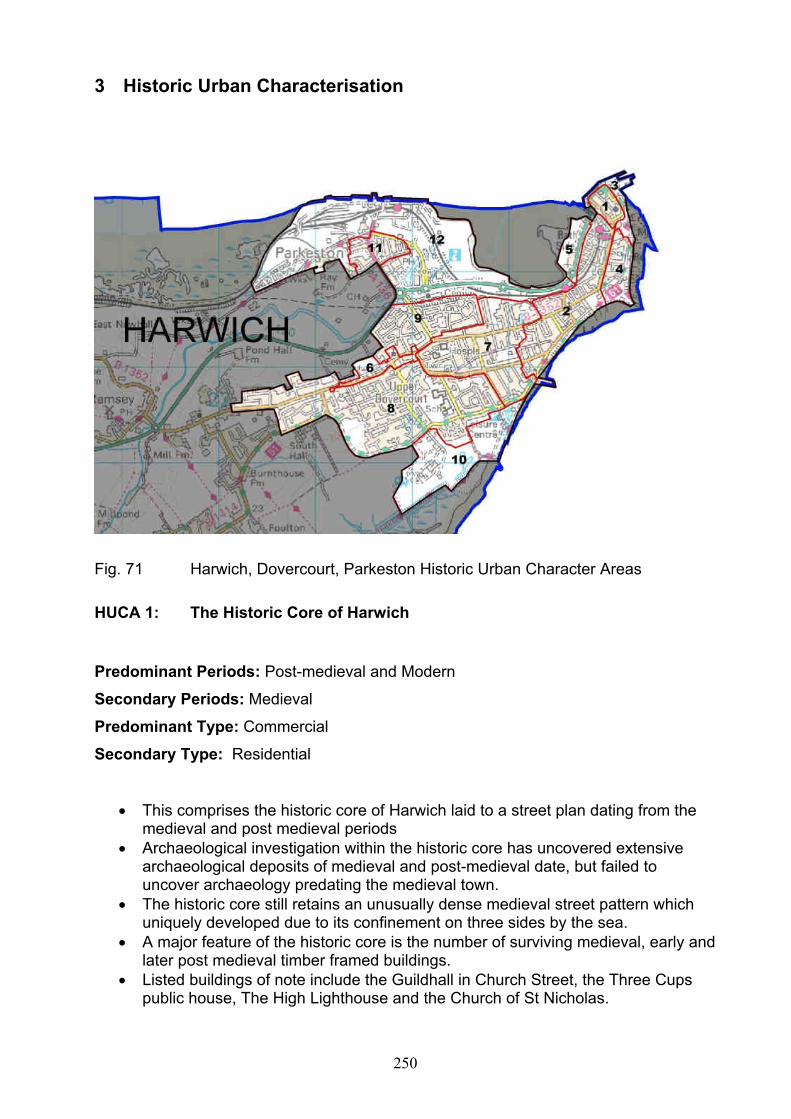
250
3 Historic Urban Characterisation
Fig. 71 Harwich, Dovercourt, Parkeston Historic Urban Character Areas
HUCA 1: The Historic Core of Harwich
Predominant Periods: Post-medieval and Modern
Secondary Periods: Medieval
Predominant Type: Commercial
Secondary Type: Residential
This comprises the historic core of Harwich laid to a street plan dating from the medieval and post medieval periods
Archaeological investigation within the historic core has uncovered extensive archaeological deposits of medieval and post-medieval date, but failed to uncover archaeology predating the medieval town.
The historic core still retains an unusually dense medieval street pattern which uniquely developed due to its confinement on three sides by the sea.
A major feature of the historic core is the number of surviving medieval, early and later post medieval timber framed buildings.
Listed buildings of note include the Guildhall in Church Street, the Three Cups public house, The High Lighthouse and the Church of St Nicholas.

251
Most of the area is in either business/retail or residential use
HUCA 2: Harwich: West of Beacon Hill
Predominant Periods: Post medieval
Secondary Periods: Modern
Predominant Type: Residential
Secondary Type: Commercial
Initial C19 residential development of terrace housing along to the west of the
Main Road and the railway line
Construction of the railway infra-structure along Bathside serving the New Pier
and quayside to the south and west of the historic core. Includes the scheduled
Dovercourt lighthouse and Causeway.
Terrace housing fronting street plans laid out parallel or perpendicular to the
main road continues to extend south toward Dovercourt during the early C20
Some post War infill
HUCA 3: Harwich Quayside
Predominant Periods: Modern
Secondary Periods: Later post medieval
Predominant Type: Commercial
Secondary Type: Residential
Historic site of quays and wharfs developed as part of the towns shipbuilding
industry are situated to the north and north east of the planned town. Includes
scheduled monuments, the Harwich Tread wheel Crane and High and Low
Lighthouses.
Archaeological investigations within the quay area have uncovered masonry and
timber quay structures dating to the C14 and C15
Later post medieval and modern industrial development has impacted upon the
quays post medieval character

252
C19 development for steam packets and ferry’s to the continent built along the
northern shoreline include the half penny pier and train ferry berth
Most of the area is in commercial use
HUCA 4: Eastern Harwich (Tower Hill)
Predominant Periods: Modern
Secondary Periods: Post medieval
Predominant Type: Residential
Secondary Type: Commercial
Predominantly post War residential development to the east of Main road
comprising terraced properties
Prior to the war the entire area including Tower Hill, Barrack Field and Beacon
Hill remained unbuilt
Incorporates historic Napoleonic and later military defence sites including the
Scheduled Harwich Redoubt and Beacon Hill Fort
Some small scale industrial development
Schools and recreational open space to the south of Barrack Road
HUCA 5: Bathside
Predominant Periods: Modern
Secondary Periods:
Predominant Type: Commercial
Secondary Type:
Later C19 reclaimed low lying land along the western side of the Harwich
peninsula and overlooking Bathside Bay
Outside residential zone
Modern commercial development associated with transport/port facilities

253
HUCA 6: Historic Core of Upper Dovercourt
Predominant Periods: Modern
Secondary Periods: Post medieval
Predominant Type: Residential
Secondary Type:
This forms the historic core of Upper Dovercourt centred around the parish
church of All Saints
Post medieval and C19 ribbon development along the main Harwich Road
Some listed buildings survive
Archaeological excavations record traces of occupation from the Roman periods
Extensive C19 development including schools, non-conformist chapels and a
cemetery
The village green survives alongside the main road
HUCA 7: Lower Dovercourt
Predominant Periods: Modern
Secondary Periods: Post medieval
Predominant Type: Residential
Secondary Type: Commercial
Residential development of terrace housing along the two main arterial roads
between Harwich and Dovercourt
Sustained post war residential development along and between the roads
merges Dovercourt with the established C19 expansion on the south side of
Harwich
Industry in the form of brick and cement works were established on the north side
of the main road and between it and the railway line. This area remains
predominantly non residential and retains some commercial and municipal
buildings
Areas set aside for allotment gardens, recreational facilities

254
Arts and Crafts designed Fryatt Memorial Hospital
HUCA 8: South and West Upper Dovercourt
Predominant Periods: Modern
Secondary Periods:
Predominant Type: Residential
Secondary Type:
A predominantly later C20 densely housed development south of the historic
core of upper Dovercourt and the main road.
Retains some later post med housing fronting the main roadside
Includes modern schools and recreation grounds and holiday facilities
Industrial provision to the north of Main Road
HUCA 9: North Upper Dovercourt
Predominant Periods: Modern
Secondary Periods:
Predominant Type: Residential
Secondary Type:
A predominantly later C20 densely housed development infilling between the
main road (old A120) and the modern by-pass to the north.
Lies directly north of the historic core of upper Dovercourt
Includes modern school and recreational provision
HUCA 10: Dovercourt Caravan Park
Predominant Periods: Modern
Secondary Periods:

255
Predominant Type: Recreational
Secondary Type:
Non residential area overlooking the promenade to Dovercourt Bay and saltings
Mainly comprises leisure facilities including a caravan park and sports grounds
Also includes utility sites, a public refuse tip and sewage works
HUCA 11: Core of Parkeston
Predominant Periods: Post medieval
Secondary Periods: Modern
Predominant Type: Residential
Secondary Type: Retail/commercial
Parkeston is a unique later C19 planned industrial settlement built by GER
adjacent to Parkeston Quay
It retains its original terraced street plan and many of the original workers
cottages
The residential provision was increased in the early C20 to the west but the
settlement at Parkeston has not been adversely affected by modern housing/infill
Some small scale commercial facilities
HUCA 12: Parkeston Hinterland
Predominant Periods: Modern
Secondary Periods: Post medieval
Predominant Type: Industrial
Secondary Type: Commercial
Parkeston Quay, freight and Passenger Terminal built during the later C19 by the
GER in preference to Harwich. Passenger terminal for ships to the continent and
some railway station/port buildings remain.

256
Extensive modern road and rail infrastructure serving the terminal lie to the north
and east of the planned town.
Small scale modern commercial and retail outlets to the south of Parkeston.
Large Oil Refinery to the west
Fig. 72 St Osyth Historic Urban Character Areas
HUCA 13: Historic Core of St. Osyth
Predominant Periods: Post medieval
Secondary Periods: Saxon/medieval/modern
Predominant Type: Residential
Secondary Type:
This forms the historic core of St. Osyth incorporating the C12 priory built for the
order of St Augustine by the Bishops of London.
The core comprises four key centres, including the C12 priory, the medieval and
early post medieval ribbon development concentrated around the crossroads to
the east of the priory, a smaller focus along Mill Street toward the St. Osyth quay
and a later expansion north along the Colchester Road.
Archaeological investigation within the historic core has uncovered Saxon
material suggestive of a thriving community dating to the first half of the C11.

257
A major feature of the historic core is the Augustinian Priory precinct and the
survival of elements of a medieval market town with a market place and fair
green still recognisable.
Co-axial ribbon development has spread out from the centre during the later post
medieval period.
Most of the urban area is in residential use
Small scale industry focused toward the quayside
HUCA 14: St Osyth East
Predominant Periods: Modern
Secondary Periods: Post modern
Predominant Type: Residential
Secondary Type:
A post war urban development built either side of the Clacton Road. Incorporates
an earlier C20 development of terraces along St Clair and D’Arcy Roads.
Large area of housing of mixed terraced, semi and detached housing
Includes modern school facilities but no industrial or retail estates

258
Fig. 73 Lawford, Manningtree and Mistley Historic Urban Character Areas
HUCA 15: Historic Core of Manningtree
Predominant Periods: Post medieval
Secondary Periods: Medieval/modern
Predominant Type: Residential
Secondary Type: Commercial-retail
This comprises the historic core of Manningtree laid to a compact street plan
dating from the medieval and post medieval periods
Archaeological investigations within the historic core have uncovered
archaeology of medieval and post-medieval date, but failed to uncover settlement
predating the medieval town.
The historic core still retains a compact medieval street pattern centred around
the High street and the quay which was probably initially confined by a town
enclosure.

259
The street plan and quayside lie parallel with the river course. Archaeological
investigations in the area of the quayside suggest the potential for a medieval
wharfage surviving below C18 and C19 build up.
A major feature of the historic core is the number of surviving, medieval early
post medieval and Georgian buildings.
The list descriptions for Manningtree are thought to be of a poor reliability.
However listed buildings of note include the C15 Old Coffee Shop (3-5 High
Street, the White Hart Inn and 38-40 High Street.
Most of the area is in either business/retail or residential use
HUCA 16: Manningtree South
Predominant Periods: Post medieval
Secondary Periods: modern
Predominant Type: Residential
Secondary Type: Commercial
Initial C18 urban expansion on the southern side of historic core continues as
ribbon development along South Street and infilling the market place
Urban development during in the C19 continues to the south along South and
Brook Streets and infills the area between the core and the railway line
established by the Eastern Union Railway by 1854
Satellite Industrial complexes, stimulated by the arrival of the railway and the
presence of a navigable quay develop around the edge of the C19 settlement,
with the Walls Maltings, the quayside maltings and timber yards and the Lawford
Iron works.
Post War urban infill along the east and western flanks of the C19 settlement
Late C20 residential redevelopment of the C19 industrial site of the Walls
Maltings to the east of the core.

260
HUCA 17: South of Station Road
Predominant Periods: Modern
Secondary Periods:
Predominant Type: Residential
Secondary Type:
A post war urban infill development built between Station Road and the wide
east-west arc of the Harwich main railway line.
Incorporates an interwar development of terraced house along Flushington Road.
HUCA 18: Trinity Road
Predominant Periods: Modern
Secondary Periods:
Predominant Type: Residential
Secondary Type:
C20 ribbon development along Trinity and Long Roads and to the south of the
established C19 urban area.
Mainly comprised of single detached dwellings
HUCA 19: North of Station Road
Predominant Periods: Modern
Secondary Periods:
Predominant Type: Commercial
Secondary Type: Utility
A series of C20 industrial and retail trading estates built on reclaimed/low lying
land to the north of Station Road and west of the historic core and quayside
Includes Manningtree railway station
261
Incorporates sewage works at the junction of the Colchester to Ipswich mainline
and Harwich branch line
This area previously comprised low levels of industry and housing in the C19 and
early C20
HUCA 20: Historic Core of Lawford
Predominant Periods: Post medieval
Secondary Periods: modern
Predominant Type: Residential
Secondary Type: Retail
Small later Post medieval roadside development concentrated along Wignall Street
and around the crossroads of Hungerdown Lane and Dedham Roads
This core of buildings lie at a distance to the south of the manor house, Lawford Hall,
built for Sir Edward Waldegrave in the late C16 and the C14 church of St Mary
Buildings of note include the C17 Kings Arms public house, mid C19 school (1848)
and almshouses (1867) and post war cottages by Raymond Erith
Archaeological investigations in Tey Field immediately SE of the historic core, have
revealed extensive evidence of prehistoric occupation.
HUCA 21: Lawford East
Predominant Periods: modern
Secondary Periods: post medieval
Predominant Type: Residential
Secondary Type: Commercial
C20 Ribbon development of terrace housing extending along Wignall Street
between old Lawford and Manningtree
Includes Later C20 housing developments to the north of Wignall Street and C20
educational and commercial enterprises.

262
The area contains no listed buildings but does incorporate the early C20 Ogilvie
Hall by R. Wrinch and skirts around the late C18 Lawford Place.
HUCA 22: Lawford North
Predominant Periods: modern
Secondary Periods:
Predominant Type: Residential
Secondary Type:
Large late C20 single phase housing development skirted by railway branch line
to the east and road arteries to the north and west.
Modern street plan arranged around a central orbital road circuit.
HUCA 23: Historic Core of Mistley
Predominant Periods: Post medieval
Secondary Periods: modern
Predominant Type: Residential
Secondary Type: Commercial
This comprises the historic core of the model spa town and historic port of
Mistley Thorn established by Richard Rigby during the C18.
The historic core still retains terraces of C18 houses along the High Street, hotels
and industrial workers cottages.
Incorporates C18 and C19/20 industrial buildings along the quayside
Buildings of particular note are the Mistley Towers and Swan Fountain designed
by Robert Adam and the former spa hotel, Fountain House.
A major feature of the historic core is the number of surviving Georgian buildings.
Most of the area is in either business/retail or residential use
263
HUCA 24: New Mistley
Predominant Periods: Post medieval
Secondary Periods: modern
Predominant Type: Residential
Secondary Type:
Later C19 and early C20 planned industrial settlement which developed to the
south of the railway and to the east and outside of Mistley Thorn
Predominantly comprises blocks of C19 and early C20 terraced workers cottages
situated along the northern and eastern side of the planned town, but also
includes some earlier housing fronting Harwich Road
Incorporates some commercial development along School Lane
Some post war and later C20 housing.
Most of the area is now in residential use
HUCA 25: Mistley Industrial
Predominant Periods: Post medieval
Secondary Periods: modern
Predominant Type: Commercial
Secondary Type: residential
Mainly comprises C19 and earlier C20 industrial buildings associated with the
port and the Mistley malt industry
Remains an active port facility with docking at Mistley Quay and Baltic Wharf
Industry remains with active sites at EDME and a large modern
(Carlsberg/Tetley) malting to the south of the railway.
A major feature of the area is the unity and survival of C19/C20 industrial
maltings and associated buildings and the preservation of this significant
industrial landscape.
Later C20 residential redevelopment of redundant industrial buildings
At present most of the area remains in commercial use
264
HUCA 26: Mistley East
Predominant Periods: Modern
Secondary Periods: Post medieval
Predominant Type: Residential
Secondary Type:
Large later C20 residential estate to the east of New Mistley, including the River
View Estate built in 1976
Incorporates some early C20 and later ribbon development along Harwich Road
Most of the area is in residential use

265
Fig.74 Frinton and Walton Historic Urban Character Areas
HUCA 27: Historic Core of Walton
Predominant Periods: Post medieval
Secondary Periods: modern
Predominant Type: Residential
Secondary Type: Commercial/retail
This comprises the historic core of the seaside resort of Walton which developed
in the area of the High Street from the early C19 onwards.
The historic core still retains remnants of the early C19 street pattern of terraces
and crescents which can still be recognised to the east of Station Road and
along the sea front/parade.
Later C19 domestic terrace housing develops within the core area following the
arrival of the railway in 1867 and construction of the new pier.

266
There are no buildings predating the C18 in Walton although listed buildings of
local note include the resort buildings of the Marine Hotel by John Penrice and
East Terrace by John Warner, the latter built as part of the Eastcliff development
Most of the core area is in either business/retail or residential use
Includes an Interwar residential development of non terraced houses to the south
of the pier bounded by the railway line and the South Cliffs. This are also
incorporates beach huts fronting the promenade and overlooking Walton beach
HUCA 28: Walton North
Predominant Periods: Post medieval
Secondary Periods: modern
Predominant Type: Residential
Secondary Type: Commercial
A large area of mainly interwar terraced housing which incorporates later C19
ribbon development of terrace housing following Hall and Naze Park Roads
From the early C20 larger non terrace houses were built toward the northern
extent of the town along Naze Park and Old Hall Lane
Includes the site of Warners (now Harmers) iron foundry built c.1874 and
associated workers housing built by T.A. Cressy along Hall Lane and First
Avenue.
Post war residential ribbon development along Old Hall Lane towards the Tower
and Walton Hall
HUCA 29: Walton West
Predominant Periods: Modern
Secondary Periods:
Predominant Type: Commercial/recreational
Secondary Type:

267
Large area of partly reclaimed marshland lying between the historic core
(HUCA1) and the later Walton North residential development
Mainly comprises a holiday park and associated recreational facilities.
HUCA 30: Core of Frinton
Predominant Periods: Post medieval
Secondary Periods: modern
Predominant Type: Residential
Secondary Type: Commercial/retail
The core of the seaside resort of Frinton developed from a small scattered
settlement during the late C19 following the construction of Frinton railway
station.
The main residential development occurred in the early C20 with the construction
of larger non-terraced housing sited toward the seafront
Blocks of late C19 and early C20 terraced housing appear further inland (north)
and along the main road arteries.
Incorporates the International Modern Movement buildings of the failed Frinton
Park Estate, to the north-east
Listed buildings of note include the Arts and Crafts Homstead by Voysey and
three modern movement houses, The Roundhouse, 55 Quendon Way by Oliver
Hill and Seaspan at 4 Audley Way.
Most of the core area is in residential use
HUCA 31: Historic Core of Kirby Cross
Predominant Periods: Post-medieval
Secondary Periods: Modern
Predominant Type: Residential
Secondary Type: Commercial
Comprises the post medieval core of Kirby Cross,

268
Ribbon development concentrated along the main Thorpe Road and the
crossroads of Halstead and Holland Roads.
Includes C16 to C18 listed buildings
The majority of the area remains in residential use
HUCA 32: Frinton North
Predominant Periods: Modern
Secondary Periods: Post-medieval
Predominant Type: Residential
Secondary Type:
Large area of predominantly post war residential housing
Incorporates some earlier C20 ribbon development along Kirby and Walton
Roads but is primarily infill development between Kirby Cross and the C19/20
settlements of Frinton and Walton
Residential and schools facilities
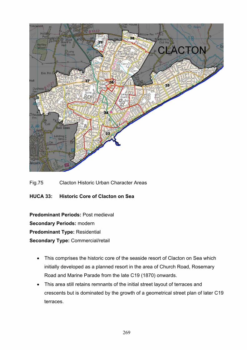
269
Fig.75 Clacton Historic Urban Character Areas
HUCA 33: Historic Core of Clacton on Sea
Predominant Periods: Post medieval
Secondary Periods: modern
Predominant Type: Residential
Secondary Type: Commercial/retail
This comprises the historic core of the seaside resort of Clacton on Sea which
initially developed as a planned resort in the area of Church Road, Rosemary
Road and Marine Parade from the late C19 (1870) onwards.
This area still retains remnants of the initial street layout of terraces and
crescents but is dominated by the growth of a geometrical street plan of later C19
terraces.

270
Incorporates the promenades of Marine Parade East and West, both centred on
Clacton Pier, built 1871.
There are no buildings predating the C18 but the initial development includes a
Martello Tower (1809-12) and listed street furniture along west parade.
HUCA 34: Clacton
Predominant Periods: Post medieval
Secondary Periods: modern
Predominant Type: Residential
Secondary Type: Commercial/retail
Later C19 and earlier C20 residential terrace housing built outside the initial
geometric plan and incorporating ribbon development of terraces along Old Road
and St Osyths Road.
Geometric street planning continues to the south the railway station opened 1882
and east of the core
There are no buildings predating the C18 but the C19 built area includes a
Martello Tower (1809-12) and listed buildings of C19 and C20 date.
Small C20 industrial development along Old Road and in the area of the railway
station.
Most of the area otherwise is in residential use
HUCA 35: Holland on Sea
Predominant Periods: Modern
Secondary Periods: Medieval/post medieval
Predominant Type: Residential
Secondary Type:
Large area of predominantly interwar terraced housing partly laid out to a
distinctive co-axial street plan.

271
Incorporates the scheduled remains of the medieval parish church and cemetery,
which lies within the grounds of Little Holland Hall.
Archaeological excavations on the church site suggest the location of a pre-
conquest church, cemetery and manor.
Some post-war C20 residential development to the north of the B1032
Most of the area is in residential use
HUCA 36: Great Clacton
Predominant Periods: Medieval/Post medieval
Secondary Periods: Modern
Predominant Type: Residential
Secondary Type: Commercial
Medieval and post-medieval historic core of Great Clacton
The settlement at Great Clacton is focused around the C12 church and as ribbon
development along St Johns and Old Road
Great Clacton includes listed buildings from the C16 onwards and a number of
locally important unlisted buildings
HUCA 37: Clacton North
Predominant Periods: Modern
Secondary Periods: Medieval/Post medieval
Predominant Type: Residential
Secondary Type: Commercial
Largely comprises post War and later C20 residential developments built to the
north and west of the initial planned C19 settlement
Incorporates lesser settlements such as Rush Green, Bocking’s Elm and the
medieval/post-medieval hamlet of Great Clacton.
Includes a pre-war residential development bounded by the railway line to the
east and a number of schools and playing fields

272
HUCA 38: Gorse Lane Estate
Predominant Periods: Modern
Secondary Periods:
Predominant Type: Commercial
Secondary Type:
Large modern satellite Industrial and retail estate along the northern fringe of the
built up area at Gorse Lane
Non residential
HUCA 39: Highfields
Predominant Periods: Modern
Secondary Periods:
Predominant Type: recreational/leisure
Secondary Type: commercial
Modern holiday camp and retail facilities at Highfields situated along the north-
western extent of modern Clacton
Mainly non-residential

273
Fig.76 Brightlingsea Historic Urban Character Areas
HUCA 40: Historic Core of Brightlingsea
Predominant Periods: Post-medieval
Secondary Periods: medieval/modern
Predominant Type: Residential
Secondary Type: Commercial/retail
This comprises the medieval and earlier post medieval core of Brightlingsea,
which developed along the length of the High Street, Queen Street and around
Lower (Victoria Place) and Hurst Greens.
It sits alongside a secondary fishing and boatbuilding industrial focus which
developed to the south and along the quayside (see 42)
The historic core still retains a market place fossilised at the western end of the
High Street.
A feature of the historic core is the number of surviving, medieval, early post
medieval and Georgian buildings and the location of the parish church of All
Saints outside the town limits and on a prominent site adjacent to Brightlingsea
Hall.

274
Listed buildings of note include the C15 Jacobes Hall and the C16 Swan Hotel
Most of the area is in either residential or business/retail use
HUCA 41: Area to the south of the High Street
Predominant Periods: Post-medieval
Secondary Periods: Modern
Predominant Type: Residential
Secondary Type: Commercial
Initial late C19 residential development of terrace housing within a regimented
co-axial street plan develops between the High Street and quayside.
Continued expansion in the late C19 established as part of a so called ‘Revival’
of the town.
Majority of the area remains in residential use
HUCA 42: Quayside
Predominant Periods: Modern
Secondary Periods: Post-medieval
Predominant Type: Commercial
Secondary Type:
Comprises an historic port and quay established as a Limb of the Cinque Port of
Sandwich
Quayside includes a core of C19 and C20 listed maritime civil and industrial
buildings, associated with the oyster, sail-making and ship building industries
The quayside incorporates an active modern industrial estate (Shipyard Estate)
Non residential industrial area
HUCA 43: Area to the north of the High Street
Predominant Periods: Post-medieval

275
Secondary Periods: Roman/Modern
Predominant Type: Residential
Secondary Type: Commercial
Continued expansion of late C19 and early C20 terrace housing fronting street
plans that surround the historic core. Established as part of a so called ‘Revival’
of the town
Ribbon development extends out along the main road arteries of Church Road,
Chapel Road and Regent Road into the early C20
Archaeological investigations uncovered the remains of a Roman house or
houses in Well Street during the C19
Small scale post-war residential infill
Most of the area remains in residential use
HUCA 44: Brightlingsea North and West
Predominant Periods: Modern
Secondary Periods: Post-medieval/Modern
Predominant Type: Residential
Secondary Type: Commercial
Post war and later C20 residential expansion with a series of housing estates
built along the northern and western extent of the post-medieval town
Some ribbon development and two listed buildings are built along Red Barn
Road
C20 residential development is defined by the extent of Red Barn Lane and to
the west is built over the Manor House and part of its former parkland.
Modern ‘edge of town’ satellite Industrial estate along Morses Lane
The area is mainly in residential use but with some industrial and recreational
provision

276
HUCA 45: Western Promenade
Predominant Periods: Modern
Secondary Periods:
Predominant Type: Recreational
Secondary Type:
Area of partly reclaimed saltings and former oyster beds to the south west of the
main settlement
Partly comprises a caravan park plus a promenade and various recreational
facilities overlooking Brightlingsea Creek.
Fig.77 Jaywich Historic Urban Character Areas
HUCA 46: Jaywick South (Brooklands, Grasslands and Jaywick Village)
Predominant Periods: Modern
Secondary Periods:
Predominant Type: Residential
Secondary Type: Commercial

277
Interwar seaside development initiated in 1929 by developer Jack Stedman and
comprising bungalows and chalets of lightweight construction. The Brooklands
Estate was once part of a Butlins holiday camp.
The development mainly adopts a co-axial street pattern with the street plan of
the Brooklands estate built to resemble the design of a Bentley radiator grill.
Includes a small development of ‘Beach Cottages’ built in the late 1990s by the
Guinness Trust
Incorporates an extensive promenade along the shoreline and sea wall
It is built on reclaimed marshland and on the seaward side of the old sea wall.
Now mainly in residential use
HUCA 47: Jaywick North (Tudor Estate)
Predominant Periods: Modern
Secondary Periods:
Predominant Type: Residential
Secondary Type:
Interwar and later residential estate of non-terraced housing
Incorporates the site of Jay Wick, a modern school and church
Most of the area is in residential use
HUCA 48: Sackett Grove Caravan Park
Predominant Periods: Modern
Secondary Periods:
Predominant Type: Recreational/leisure
Secondary Type: Residential
Caravan park sited on the northern edge of the Tudor Estate
Incorporates some ribbon development along Jaywick Lane

278
HUCA 49: Tower Caravan Park
Predominant Periods: Modern
Secondary Periods: Post-medieval
Predominant Type: Recreational/leisure
Secondary Type:
Caravan park sited toward the western extreme of Jaywick
Forms part of a group of caravan parks situated between Jaywick, Seawick and
the Bel Air Estate.
Incorporates a scheduled early C19 Martello Tower (C).

279
4 Archaeological Character Areas
Fig. 78 Archaeological character Areas
ACA 1 – Ardleigh
The area comprises an undulating plateau at around 35m OD with a maximum
elevation of around 43m OD north of Ardleigh reservoir. The drift geology consists
of Lowestoft formation clay and silts overlying mixed deposits of Kesgrave
sands/gravels and Lowestoft clays/silts. A number of small streams drain the
plateau southwards.
The Ardleigh ACA contains a dense, varied and valuable archaeological resource
within a significant cropmark landscape. Particular concentrations are evident to
the south east of Ardleigh, and in a wide band along the eastern side of the ACA.
The cropmark sites include: numerous ring ditches; concentrations of pits; a
diverse range of circular, sub rectangular, sub square and irregular ditched
enclosures, including a possible Neolithic henge or medieval windmill site to the

280
south of Little Bromley; and frequent linear ditched features representing either
field boundaries of track ways. Many of the cropmarks relate to prehistoric activity
but other later periods are also represented and the ACA has clear potential for
other periods with finds of Iron Age and Roman material known from recent
excavations and medieval/post medieval archaeology likely to survive both within
the settlements and wider landscape.
The most significant feature of the area is the nationally important, Bronze age
cemetery south of Ardleigh which has been shown to comprise hundreds of
cremation burials, many with associated ring ditches.
The main settlements lie at the nucleated village of Ardleigh and Great Bromley,
both of medieval origin but with significant recent expansion. Historically,
settlement was also sited around former heathland to the south of Ardleigh, but
was largely dispersed across the area with scattered farmsteads and cottages and
the occasional isolated moated site.
Ardleigh reservoir is a major modern landscape feature in the west of the area and
together with major mineral extraction works south of Ardleigh has resulted in
extensive loss and truncation of the archaeological resource. .Outside these areas
survival has been shown to be good, despite intensification of agricultural
cultivation since the 1950s.
ACA 2 South of Lawford
The area comprises an undulating plateau at around 30-35m OD. The plateau is
drained by three streams, two running north into the River Stour and the Holland
Brook flowing south-east from the plateau. The drift geology consists of Lowestoft
formation clay and silts overlying mixed deposits of Kesgrave sands/gravels and
Lowestoft clays/silts.
The area is notable for a widespread multi period cropmark landscape with a
particular band running south east from Lawford and a further concentration
apparent south of Bradfield. The cropmark sites include: numerous ring ditches;
concentrations of pits; a range of ditched enclosures, and frequent linear ditched

281
features representing either field boundaries of track ways. Many of the cropmarks
relate to prehistoric activity and excavation of a Late Neolithic midden surrounded
by a ring ditch at Lawford has revealed a significant assemblage of Neolithic
pottery. In Lawford Park, a linear barrow cemetery is evidenced by a series of ring
ditch cropmarks and a Bronze Age round barrow which survives as an upstanding
earthwork. These features are related to cropmark sites on the floor of the Stour
Valley to the north (ACA 3). Later periods are also represented by the cropmark
sites and the ACA has potential for remains from other periods within the
settlements and wider landscape.
The area contains the settlements at Lawford which is relatively modern (20th
century) and Bradfield, which originated in the medieval period. Historically the
area contained isolated heathland and a significant stand of woodland west of
Bradfield Lodge in a landscape of scattered farms and halls of medieval origin.
These include the medieval moated site at Bradfield Hall and Lawford Hall with its
associated parkland and possible settlement earthworks.
Numerous agricultural reservoirs dot the landscape which will have had a negative
impact on the archaeological resource, but otherwise archaeological deposits may
be expected to survive in good condition.
ACA 3 Manningtree and Mistley
Occupying the south bank of the Stour Estuary the area drops sharply from around
30 metres OD to sea level. The drift geology is a mixture of river terrace gravels,
Kesgrave formation gravels/Lowestoft clay/silts and occasional alluvium.
Cropmarks are largely absent from the area but a few notable concentrations are
known. The most significant of these lies on the floor of the Stour Valley in Lawford
and includes a ring ditch cemetery, associated trackways and linear field system
and relict river channels. Elsewhere, concentrations of multi-period cropmarks
occur in the vicinity of Wrabness and to the south and east of Mistley.
Manningtree and Mistley form the main settlements within the area. Manningtree
was established as a port during the medieval period with Mistley, especially with
regard to the malting industry, coming to later prominence. The wider landscape

282
contains a scatter of farms and halls, including the site of Mistley Hall and its
former parkland, and a medieval church/hall complex at Wrabness. The site of the
original St Mary’s parish church is located near Mistley Heath.
Manningtree is known to have good potential for surviving medieval archaeology
including potential waterlogged deposits and Mistley is notable for its extant
industrial remains and structures. Cropmark sites within the Stour Valley have high
archaeological and palaeoenvironmental potential. Further archaeological features
relating to use of the estuary are likely to survive well in the inter tidal zone
between Baltic Wharf and Cattawade Bridge.
An area of reclaimed salt marsh lies at the head of the estuary and two significant
examples of Ancient Woodland, Stour Wood and Copperas Wood, survive in the
east of the area probably containing earthworks. Post medieval features include
the cropmark of a duck decoy to the west of Nether Hall, the Manningtree to
Harwich railway line and short lived and aborted Mistley-Thorpe-Walton branch
line. At Furze Hill, Mistley there is a post war nuclear underground bunker.
Outside the built up settlements, the area is dominated by arable farming.. The
A120 passes through the east end of the area which also contains a golf course
and sewage treatment works. Agricultural reservoirs are scattered throughout, all
of which will have had a negative impact on the archaeological resource.
ACA 4 River Stour Intertidal
Lying between the high and low water marks, the surface geology of this area is
composed of estuarine silts and alluvium crossed by numerous named fleets and
creeks with narrow strips of saltings, which were traditionally used for sheep
grazing.
Copperas Bay indicates the importance of the copperas industry here in the post
medieval period. Copperas was an important and valuable product used in a
number of manufacturing processes..
The area has some potential for prehistoric archaeology and buried ancient land
surfaces but the potential for more recent evidence is probably greater including
evidence for maritime activities, notably hulks and other timber structures such as

283
wharves. Baltic Wharf has a number of sunken vessels associated with it and
Ballast Hill within the estuary was used as a dumping ground for ships ballast.
ACA 5 Great Oakley
Overlying London Clay the drift geology is comprised of Lowestoft formation
clay/silts, and mixed Kesgrave sands and gravels/Lowestoft formation clay/silts.
There are also patches of head and alluvium on the line of a former creek. The
area contains a valley dropping from c.20metres OD down to c.5metres OD
running down from Great Oakley to the formerly much more prominent Ramsey
Creek.
The area demonstrates a variety of cropmarks but the main concentration lies in
the area around Beaumont, up to Great Oakley to the north. Cropmark sites
include a range of different ditched enclosures, ring ditches and linear features
likely to represent trackways or field boundaries. A number of the latter are of
clearly recent origin but others are likely to represent earlier, probably prehistoric
or Roman sites. A medieval moated site is know to the north of Beaumont. A
smaller group of cropmarks around Little Oakley include those of a WWII heavy
anti-aircraft battery.
An Iron Age site and Roman Villa with associated field system is known from
excavations at Little Oakley. Interestingly, the villa shows evidence of continued
occupation into the Saxon period
The main settlements are Great Oakley and Ramsey, both of which originate at
least as early as the medieval period, and Little Oakley which is essentially
modern. Great Oakley and Ramsey are likely to contain archaeological deposits
relating to their medieval or earlier origins.
The wider historic settlement pattern comprised a number of halls and scattered
farmsteads closely associated with the early road network. Medieval church/hall
complexes occur throughout the area with examples at Ramsey, Little Oakley and
Beaumont. The site of the former parish church of Moze is located adjacent to
Moze Hall.
There has been no significant industrial activity and modern land use is largely
arable farming, although areas of ancient woodland survive particularly in the
south west of the area. The majority of the archaeological resource is likely to be
284
well preserved but agricultural reservoirs, such as those concentrated to the north
of Great Oakley, will have destroyed any archaeological remains.
ACA 6 Hamford Water
Overlying a bedrock of London Clay the surface geology is largely alluvium with
some patches of head. The area consists of the tidal Hamford Water and creeks,
numerous islands and a narrow coastal strip. Maximum height is 5metres OD on
Horsey Island.
Traditional farming would have been largely limited to sheep/cattle grazing but
former grazing marshes on the mainland have been converted for arable
production.. The area contains a single farmstead on Horsey Island.
A wide range of cropmarks sites survive including Iron Age and Roman red hills,
former sea walls, duck decoys and World War II defences. The latter include a
number of anti-aircraft gun batteries, anti-land ditches, a bombing decoy and bomb
craters.
The area has an extremely high archaeological potential with finds and features
ranging from the Palaeolithic to modern. Ancient buried land surfaces, where
exposed, have produced much evidence for all prehistoric periods. Numerous red
hills and finds of Roman ceramics indicate Iron Age and Roman salt
manufacturing..
The post medieval period is particularly well represented by extant wharves such
as Beaumont Quay, sea walls, duck decoys including the well preserved
earthworks on Horsey Island, hulks and industrial works such as the Lime Kiln at
Beaumont Quay and former pond of the tidal mill at Walton Mere. Bramble Island
is the site of a 20th century explosive factory.
Archaeological deposits are likely to be very well preserved with good survival of
organic artefacts and environmental deposits within the salt marsh and intertidal
mud flats.
In addition to arable farming, modern land use includes nature conservation such
as the reserve on Skippers Island, and land owned by the Tendring Wildfowlers
Club, Walton Marina, sewage works south of Dovercourt and holiday parks at
Walton on the Naze and Dovercourt.
285
ACA 7 Thorpe-le-Soken
Overlying exposed London Clay are superficial deposits of Lowestoft formation
clay and silt and undifferentiated Kesgrave sand/gravels and Lowestoft formation.
Alluvial deposits follow the line of the Holland Brook.
As with most of Tendring, arable is the dominant form of agriculture. Medieval
settlement was largely dispersed farmsteads and halls with areas of isolated
woodland.
The historic villages of Tendring and Thorpe-le-Soken occupy a ridge of higher
ground at around 25metres OD running south east. The land drops away to the
south west into the valley of the Holland Brook and to the north towards Hamford
Water.
The coastal zone of this area from the Naze in the north to Clacton in the south
has produced significant numbers of finds of prehistoric date including nationally
important Palaeolithic material and the potential for all prehistoric periods is high.
There are two prominent areas of cropmarks, one in the vicinity of Tendring and
another south of Thorpe-le-Soken. Although a number of these represent modern
field boundary loss others are clearly indicative of surviving earlier deposits. Other,
more discrete cropmarks are apparent.
Tendring, Thorpe-le-Soken and Great Holland are medieval settlements and are
likely to retain related archaeological deposits. The village names Kirby-le-Soken
and Thorpe-le-Soken indicate Danish settlement of the 10-11th century in the area.
Some modern mineral working has taken place with prior investigation revealing
Bronze Age funerary monuments and prehistoric/Roman landscape elements.
The area contains the major settlements of Frinton-on-Sea and Walton-on-the-
Naze both of which are essentially modern in character. The earlier village of
Walton was lost to the sea in the medieval period.
The coastal zone was well defended during WWII and there are numerous
pillboxes and strongpoints
The alluvium of the Holland Brook is likely to contain well preserved environmental
deposits

286
ACA 8 Wix
The drift geology consists of Brickearth over London Clay bedrock with infrequent
Kesgrave sand/gravels.
The undulating landscape is one of arable farming with a high point of around
40metres OD dropping away to around 15 metres OD in the north of the area near
the Stour Estuary.
A medieval landscape of scattered farms, woodland, greens and heath with no
settlements of any size. A significant local medieval pottery industry is known at
Mill Green and a small community of Benedictine nuns was founded at Wix Priory
in the early 12th century which survived until the Dissolution.
Cropmarks occur regularly throughout the area with a significant site near Priory
Farm, Wrabness but there are no great concentrations as noted in other parts of
the district.
Industrial activity in the area is light and archaeological deposits where occurring
may be expected to survive in good condition.
ACA 9 Little Clacton
The drift geology consists of Brickearth over London Clay bedrock with infrequent
Kesgrave sand/gravels.
Undulating Tendring arable landscape with a high point of around 26 metres OD
dropping away north and east to the Holland Brook and south to the coast. The
area contains the villages of Little Clacton, Weeley and Weeley Heath and the
northernmost modern expansion of Clacton.
As with much of Tendring, cropmark evidence is indicative of a range of surviving
multi-period deposits but in lesser concentrations in this area.
Settlement in the medieval period was located mainly to the south of the Holland
Brook valley and represented by scattered farms and halls amidst heath and
woodland.
Excavations prior to the construction of the Clacton-Weeley bypass enabled the
examination of a significant section through this area. In addition to a fine example

287
of a medieval moated site at Gutteridge Hall, the investigation identified a range of
well preserved prehistoric, Roman and later deposits indicating the potential of the
remaining area.
Environmental deposits may be expected in the vicinity of Pickers Ditch and the
Holland Brook.
ACA 10 Brightlingsea and Great Bentley
Overlying London Clay bedrock are found extensive drift deposits of Brickearth
over Kesgrave sands and gravels/Lowestoft formation. Alluvial deposits are
widespread over the areas adjacent to the River Colne and Brightlingsea Creek.
From a maximum height of around 28metres OD the landscape drops away to the
south and the Colne Estuary and Brightlingsea Creek. The area is drained
southwards by the Bentley Brook.
The area is notable for its widespread and important cropmark landscape
encompassing the entire area. Although no doubt representing a wide variety of
periods, of particular significance are those that have been shown by excavation to
relate prehistoric activity, especially during the Bronze Age. Further evidence of
prehistoric activity may be expected in the coastal and intertidal zones.
Neolithic features and a possible enclosure have been identified near Great
Bentley.
Finds of Roman material at Brightlingsea and the identification of a Roman villa
suggest the importance of the area in contemporary agricultural production and its
position at the mouth of the Colne Estuary may have been of importance.
Medieval settlement existed at Great Bentley and Brightlingsea with the latter
serving as a port. A medieval monastic establishment existed at Frating. St Osyth
was home to an important monastic establishment and a significant local port and
town in the medieval period.
The coast has long been home to industry including salt production, fishing, and
oyster production and evidence of these activities is widespread.
Where undisturbed (by mineral extraction for instance) archaeological survival is
likely to be good and the coast and intertidal zone have the further potential for a
wide range of well preserved archaeological and environmental evidence.

288
ACA 11 Alresford
Overlying London Clay bedrock are found extensive drift deposits of Brickearth
over Kesgrave sands and gravels/Lowestoft formation. Drained southwards by the
Sixpenny and Tenpenny Brooks the land falls away to the south and the Colne
Estuary from a maximum elevation of around 35 metres OD.
The area contains an extensive and valuable multi-period cropmark landscape.
Mineral extraction is a significant local industry and will have had an adverse
impact on the archaeological resource.
The medieval landscape was likely to have been one scattered farms and halls
amidst open agricultural land with areas of both heath and woodland.
The area has a section of coastline and associated alluvial deposits which are
likely to contain a range of well preserved multi-period archaeological deposit
ACA 12 Clacton-on-Sea
Lying over London Clay the key drift deposits are composed of river terrace sands
and gravels partially overlain by head. Alluvial deposits are prevalent in the
western part of the area. The area is low lying falling away southwards from
around 10 metres OD to sea level.
Much of the land in the western part of the area was saltmarsh until the late 18th or
early 19th century. Areas of saltmarsh survive at the mouth of the Colne Estuary.
The area is noted for its geoarchaeological/Palaeolithic deposits relating to river
terrace gravels deposited by ancient courses of the Rivers Thames and Medway.
Finds of international importance have been made from these deposits in the
vicinity of Clacton and Jaywick and the potential for further research/discoveries is
high.
The area is known to contain further later archaeological deposits of both
prehistoric and later date. A large assemblage of early Saxon pottery has recently
been excavated to the west of Clacton.
289
A church/hall complex and medieval settlement existed at Great Clacton. Further
medieval and post medieval settlement was composed of scattered farms and
occasional halls.
Clacton-on-Sea and Jaywick are relatively modern settlements with Clacton (and
Holland-on-Sea) expanding rapidly in the early 20th century as a seaside resort
after the introduction of the railway.
The area has been at the forefront of anti-invasion plans since the 19th century. A
series of Martello towers were designed to counter the French threat during the
Napoleonic wars and the coast was heavily defended during the early part of
WWII. Elements of both these defensive systems survive.
ACA 13 Harwich and Dovercourt
The earliest evidence for activity in this zone dates to the Palaeolithic period from
the Gants Pit excavations
There is the possibility of the survival of some elements of the original grazing
marsh, and associated below-ground deposits although much of the area is urban
in nature.
Contains the historic town of Harwich with extensive medieval and post medieval
deposits, frequently deeply stratified surviving.
There are significant deposits both below ground and upstanding relating to the
maritime history of the area. This includes medieval, post medieval and modern
remains including the international port at Parkeston
The area includes the Napoleonic and later military defensive sites at Harwich
Redoubt and Beacon Hill Fort.
The area contains Parkeston, a unique planned industrial settlement built by GER
adjacent to Parkeston Quay, and Parkeston Quay itself.

290
Glossary of Terms Used
Bronze Age: The period from about 2,000 BC, when bronze-working first began in
Britain, until about 700BC when the use of iron begins.
Cropmarks: Variations in the sub-soil caused by buried archaeological features results
in different crop growth visible from the air.
Iron Age: The period from about 700 BC when iron-working arrived in Britain until the
Roman invasion of 43 AD.
Medieval: This is the period between the Norman Conquest of England in 1066 and the
dissolution of the monasteries in 1538.
Mesolithic: The period following the end of the last ice age and prior to the introduction
of farming in the Neolithic.
Neolithic: The period from about 4000BC when farming and pottery manufacture began
in Britain, until about 2000BC when metalworking began.
Palaeolithic: The Palaeolithic period covers the time span from the initial colonisation of
Britain, c. 700,000 years ago to the end of the last ice age c 10,000 years ago.
Post-medieval: The period from 1538-1900
Red Hill: A Late Iron Age or Roman salt making site.
Roman: The period of Roman occupation from 43AD through to 410AD.
Saxon: The period of Saxon occupation from 410 to 1066.
Scheduled Monument: (Formerly Scheduled Ancient Monument): A site of nationally
archaeological importance protected under the 1979 Ancient Monuments and
Archaeological Areas Act.
This report is issued by
Essex County Council Historic Environment Branch
You can contact us in the following ways:
By Post:
Essex County Council
Historic Environment Branch
County Hall
Chelmsford, Essex CM1 1QH
By telephone:
0845 7430 430
By email:
Visit our website:
www.essex.gov.uk
The information contained in this leaflet can be
translated, and/or made available in alternative
formats, on request.
Published December 2008