technical resource document: extraction and beneficiation ... · epa 530-r-94-035 ntis pb94-201811...
TRANSCRIPT
EPA 530-R-94-035
NTIS PB94-201811
TECHNICAL RESOURCE DOCUMENT
EXTRACTION AND BENEFICIATION OFORES AND MINERALS
VOLUME 6
GOLD PLACERS
October 1994
U.S. Environmental Protection AgencyOffice of Solid WasteSpecial Waste Branch
401 M Street, SWWashington, DC 20460
Technical Resource Document: Gold Placers
DISCLAIMER AND ACKNOWLEDGEMENTS
This document was prepared by the U.S. Environmental ProtectionAgency (EPA). The mention of company or product names is not to beconsidered an endorsement by the U.S. Government or by EPA.
This Technical Resource Document consists of three sections. The firstis EPA's Profile of the gold placer mining industry; the following sectionsare reports on site visits conducted by EPA to gold placer mines inAlaska. The Profile section was distributed for review to the U.S.Department of the Interior's Bureau of Mines, the State of AlaskaDepartment of Natural Resources and Department of EnvironmentalConservation, the Interstate Mining Compact Commission, the AmericanMining Congress, the Mineral Policy Center, and public interest groups. Summaries of the comments received on the draft profile and of EPA'sresponses are presented as an appendix to this section. The site visitsections were provided to representatives of the companies and of stateagencies who participated in the site visit. Their comments and EPA'sresponses are presented as appendices to the specific site visit section. EPA is grateful to all individuals who took the time to review sections ofthis Technical Resource Document.
The use of the terms "extraction," "beneficiation," and "mineralprocessing" in this document is not intended to classify any waste streamfor the purposes of regulatory interpretation or application. Rather, theseterms are used in the context of common industry terminology.
Technical Resource Document: Gold Placers
ii
TABLE OF CONTENTS
Page
1.0 MINING INDUSTRY PROFILE: GOLD PLACERS . . . . . . . . . . . . . . . . . . . . . . . . . . . . . . . . . . . . . . 1-1
1.1 INTRODUCTION . . . . . . . . . . . . . . . . . . . . . . . . . . . . . . . . . . . . . . . . . . . . . . . . . . . . . 1-11.2 ECONOMIC CHARACTERIZATION OF THE GOLD PLACER INDUSTRY . . . . . . . . . . . . 1-3
1.2.1 Background . . . . . . . . . . . . . . . . . . . . . . . . . . . . . . . . . . . . . . . . . . . . . . . . . . 1-31.2.2 Current Operations . . . . . . . . . . . . . . . . . . . . . . . . . . . . . . . . . . . . . . . . . . . . . 1-4
1.3 PHYSICAL CHARACTERIZATION OF PLACER DEPOSITS . . . . . . . . . . . . . . . . . . . . . . 1-71.4 GOLD PLACER MINING PRACTICES . . . . . . . . . . . . . . . . . . . . . . . . . . . . . . . . . . . . . 1-12
1.4.1 Background . . . . . . . . . . . . . . . . . . . . . . . . . . . . . . . . . . . . . . . . . . . . . . . . . 1-121.4.2 Extraction Methods . . . . . . . . . . . . . . . . . . . . . . . . . . . . . . . . . . . . . . . . . . . . 1-13
1.4.2.1 Open Cut Methods . . . . . . . . . . . . . . . . . . . . . . . . . . . . . . . . . . . . . 1-151.4.2.2 Other Methods . . . . . . . . . . . . . . . . . . . . . . . . . . . . . . . . . . . . . . . 1-17
1.4.3 Beneficiation Methods . . . . . . . . . . . . . . . . . . . . . . . . . . . . . . . . . . . . . . . . . . 1-211.4.3.1 Sizing . . . . . . . . . . . . . . . . . . . . . . . . . . . . . . . . . . . . . . . . . . . . . . 1-221.4.3.2 Coarse Concentration . . . . . . . . . . . . . . . . . . . . . . . . . . . . . . . . . . . 1-231.4.3.3 Fine Concentration . . . . . . . . . . . . . . . . . . . . . . . . . . . . . . . . . . . . . 1-251.4.3.4 Mercury Amalgamation . . . . . . . . . . . . . . . . . . . . . . . . . . . . . . . . . 1-27
1.5 WASTE MANAGEMENT PRACTICES . . . . . . . . . . . . . . . . . . . . . . . . . . . . . . . . . . . . . 1-291.5.1 Extraction and Beneficiation Wastes and Materials . . . . . . . . . . . . . . . . . . . . . . 1-29
1.5.1.1 Waste Rock or Overburden . . . . . . . . . . . . . . . . . . . . . . . . . . . . . . . 1-291.5.1.2 Tailings . . . . . . . . . . . . . . . . . . . . . . . . . . . . . . . . . . . . . . . . . . . . . 1-30
1.5.2 Waste and Materials Management . . . . . . . . . . . . . . . . . . . . . . . . . . . . . . . . . . 1-311.5.2.1 Tailings Impoundments/Settling Pond Systems . . . . . . . . . . . . . . . . . 1-32
1.6 ENVIRONMENTAL EFFECTS . . . . . . . . . . . . . . . . . . . . . . . . . . . . . . . . . . . . . . . . . . . 1-401.6.1 Surface Water . . . . . . . . . . . . . . . . . . . . . . . . . . . . . . . . . . . . . . . . . . . . . . . 1-401.6.2 Ground Water . . . . . . . . . . . . . . . . . . . . . . . . . . . . . . . . . . . . . . . . . . . . . . . 1-421.6.3 Soil . . . . . . . . . . . . . . . . . . . . . . . . . . . . . . . . . . . . . . . . . . . . . . . . . . . . . . . 1-431.6.4 Wetlands . . . . . . . . . . . . . . . . . . . . . . . . . . . . . . . . . . . . . . . . . . . . . . . . . . . 1-431.6.5 Wildlife . . . . . . . . . . . . . . . . . . . . . . . . . . . . . . . . . . . . . . . . . . . . . . . . . . . . 1-43
1.7 MITIGATING MEASURES AND REMEDIATION . . . . . . . . . . . . . . . . . . . . . . . . . . . . . 1-451.7.1 Tailings . . . . . . . . . . . . . . . . . . . . . . . . . . . . . . . . . . . . . . . . . . . . . . . . . . . . 1-451.7.2 Stream Channel . . . . . . . . . . . . . . . . . . . . . . . . . . . . . . . . . . . . . . . . . . . . . . 1-451.7.3 Floodplain . . . . . . . . . . . . . . . . . . . . . . . . . . . . . . . . . . . . . . . . . . . . . . . . . . 1-461.7.4 Soils . . . . . . . . . . . . . . . . . . . . . . . . . . . . . . . . . . . . . . . . . . . . . . . . . . . . . . 1-481.7.5 Mined Land Remediation . . . . . . . . . . . . . . . . . . . . . . . . . . . . . . . . . . . . . . . . 1-48
1.8 CURRENT REGULATORY AND STATUTORY FRAMEWORK . . . . . . . . . . . . . . . . . . . 1-501.8.1 Environmental Protection Agency Regulations . . . . . . . . . . . . . . . . . . . . . . . . . 1-50
1.8.1.1 Resource Conservation and Recovery Act . . . . . . . . . . . . . . . . . . . . 1-501.8.1.2 Clean Water Act . . . . . . . . . . . . . . . . . . . . . . . . . . . . . . . . . . . . . . 1-511.8.1.3 Dredged and Fill Material . . . . . . . . . . . . . . . . . . . . . . . . . . . . . . . . 1-52
1.8.2 Department of the Interior . . . . . . . . . . . . . . . . . . . . . . . . . . . . . . . . . . . . . . . 1-541.8.2.1 Bureau of Land Management . . . . . . . . . . . . . . . . . . . . . . . . . . . . . . 1-541.8.2.2 National Park Service and Fish and Wildlife Service . . . . . . . . . . . . . . 1-55
1.8.3 Department of Agriculture (Forest Service) . . . . . . . . . . . . . . . . . . . . . . . . . . . 1-551.8.4 State Programs . . . . . . . . . . . . . . . . . . . . . . . . . . . . . . . . . . . . . . . . . . . . . . . 1-56
1.8.4.1 Alaska . . . . . . . . . . . . . . . . . . . . . . . . . . . . . . . . . . . . . . . . . . . . . 1-561.8.4.2 Colorado . . . . . . . . . . . . . . . . . . . . . . . . . . . . . . . . . . . . . . . . . . . . 1-60
1.9 REFERENCES . . . . . . . . . . . . . . . . . . . . . . . . . . . . . . . . . . . . . . . . . . . . . . . . . . . . . . 1-63
2.0 SITE VISIT REPORTS: ALASKA PLACER MINES . . . . . . . . . . . . . . . . . . . . . . . . . . . . . . . . . . . . . 2-1
2.1 INTRODUCTION . . . . . . . . . . . . . . . . . . . . . . . . . . . . . . . . . . . . . . . . . . . . . . . . . . . . . 2-12.2 POLAR MINING, INC. . . . . . . . . . . . . . . . . . . . . . . . . . . . . . . . . . . . . . . . . . . . . . . . . . 2-1
2.2.1 General Facility Description . . . . . . . . . . . . . . . . . . . . . . . . . . . . . . . . . . . . . . . 2-12.2.2 Regulatory Requirements and Compliance . . . . . . . . . . . . . . . . . . . . . . . . . . . . . 2-9
2.3 ALF HOPEN . . . . . . . . . . . . . . . . . . . . . . . . . . . . . . . . . . . . . . . . . . . . . . . . . . . . . . . . 2-112.3.1 General Facility Description . . . . . . . . . . . . . . . . . . . . . . . . . . . . . . . . . . . . . . 2-11

Technical Resource Document: Gold Placers
iii
2.3.2 Regulatory Requirements and Compliance . . . . . . . . . . . . . . . . . . . . . . . . . . . . 2-132.4 COOK'S MINING . . . . . . . . . . . . . . . . . . . . . . . . . . . . . . . . . . . . . . . . . . . . . . . . . . . . 2-15
2.4.1 General Facility Description . . . . . . . . . . . . . . . . . . . . . . . . . . . . . . . . . . . . . . 2-152.4.2 Regulatory Requirements and Compliance . . . . . . . . . . . . . . . . . . . . . . . . . . . . 2-17
2.5 REFERENCES . . . . . . . . . . . . . . . . . . . . . . . . . . . . . . . . . . . . . . . . . . . . . . . . . . . . . . 2-19
3.0 SITE VISIT REPORT: VALDEZ CREEK MINE CAMBIOR ALASKA INCORPORATED . . . . . . . . . . . . . 3-1
3.1 INTRODUCTION . . . . . . . . . . . . . . . . . . . . . . . . . . . . . . . . . . . . . . . . . . . . . . . . . . . . . 3-13.1.1 Background . . . . . . . . . . . . . . . . . . . . . . . . . . . . . . . . . . . . . . . . . . . . . . . . . . 3-1
3.1.1.1 General Description . . . . . . . . . . . . . . . . . . . . . . . . . . . . . . . . . . . . . 3-23.1.2 Environmental Setting . . . . . . . . . . . . . . . . . . . . . . . . . . . . . . . . . . . . . . . . . . . 3-6
3.1.2.1 Geology . . . . . . . . . . . . . . . . . . . . . . . . . . . . . . . . . . . . . . . . . . . . . 3-63.1.2.2 Surface Water . . . . . . . . . . . . . . . . . . . . . . . . . . . . . . . . . . . . . . . . . 3-83.1.2.3 Ground Water . . . . . . . . . . . . . . . . . . . . . . . . . . . . . . . . . . . . . . . . . 3-8
3.2 FACILITY OPERATION . . . . . . . . . . . . . . . . . . . . . . . . . . . . . . . . . . . . . . . . . . . . . . . 3-103.2.1 General Overview . . . . . . . . . . . . . . . . . . . . . . . . . . . . . . . . . . . . . . . . . . . . . 3-103.2.2 Extraction . . . . . . . . . . . . . . . . . . . . . . . . . . . . . . . . . . . . . . . . . . . . . . . . . . 3-10
3.2.2.1 Excavation . . . . . . . . . . . . . . . . . . . . . . . . . . . . . . . . . . . . . . . . . . 3-103.2.2.2 Water Management . . . . . . . . . . . . . . . . . . . . . . . . . . . . . . . . . . . . 3-12
3.2.3 Beneficiation . . . . . . . . . . . . . . . . . . . . . . . . . . . . . . . . . . . . . . . . . . . . . . . . 3-133.2.3.1 Ancillary Facilities . . . . . . . . . . . . . . . . . . . . . . . . . . . . . . . . . . . . . 3-16
3.3 MATERIALS AND WASTE MANAGEMENT . . . . . . . . . . . . . . . . . . . . . . . . . . . . . . . . 3-173.3.1 Waste Rock . . . . . . . . . . . . . . . . . . . . . . . . . . . . . . . . . . . . . . . . . . . . . . . . . 3-173.3.2 Tailings . . . . . . . . . . . . . . . . . . . . . . . . . . . . . . . . . . . . . . . . . . . . . . . . . . . . 3-173.3.3 Other Materials . . . . . . . . . . . . . . . . . . . . . . . . . . . . . . . . . . . . . . . . . . . . . . . 3-21
3.4 REGULATORY REQUIREMENTS AND COMPLIANCE . . . . . . . . . . . . . . . . . . . . . . . . . 3-243.4.1 Federal Permits . . . . . . . . . . . . . . . . . . . . . . . . . . . . . . . . . . . . . . . . . . . . . . 3-24
3.4.1.1 Bureau of Land Management . . . . . . . . . . . . . . . . . . . . . . . . . . . . . . 3-243.4.1.2 Army Corp of Engineers . . . . . . . . . . . . . . . . . . . . . . . . . . . . . . . . . 3-243.4.1.3 Environmental Protection Agency . . . . . . . . . . . . . . . . . . . . . . . . . . 3-24
3.4.2 State Permits . . . . . . . . . . . . . . . . . . . . . . . . . . . . . . . . . . . . . . . . . . . . . . . . 3-253.4.2.1 Dam Safety . . . . . . . . . . . . . . . . . . . . . . . . . . . . . . . . . . . . . . . . . . 3-253.4.2.2 Diversion Channel . . . . . . . . . . . . . . . . . . . . . . . . . . . . . . . . . . . . . 3-263.4.2.3 Alaska Fish and Game . . . . . . . . . . . . . . . . . . . . . . . . . . . . . . . . . . 3-263.4.2.4 Solid Waste Permit . . . . . . . . . . . . . . . . . . . . . . . . . . . . . . . . . . . . . 3-26
3.4.3 Inspections and Compliance Incidents . . . . . . . . . . . . . . . . . . . . . . . . . . . . . . . 3-273.4.3.1 Inspections . . . . . . . . . . . . . . . . . . . . . . . . . . . . . . . . . . . . . . . . . . 3-273.4.3.2 Compliance Incidents . . . . . . . . . . . . . . . . . . . . . . . . . . . . . . . . . . . 3-28
3.5 REFERENCES . . . . . . . . . . . . . . . . . . . . . . . . . . . . . . . . . . . . . . . . . . . . . . . . . . . . . . 3-30
Technical Resource Document: Gold Placers
iv
APPENDICES
APPENDIX 1-A ACRONYMS . . . . . . . . . . . . . . . . . . . . . . . . . . . . . . . . . . . . . . . . . . . . . . . . . 1-69
APPENDIX 1-B COMMENTS SUBMITTED BY U.S. BUREAU OF MINESON DRAFT GOLD PLACER PROFILE . . . . . . . . . . . . . . . . . . . . . . . . . . . . . . 1-72
APPENDIX 1-C RESPONSE TO COMMENTS SUBMITTED BY U.S.BUREAU OF MINES ON DRAFT GOLD PLACERPROFILE REPORT . . . . . . . . . . . . . . . . . . . . . . . . . . . . . . . . . . . . . . . . . . . . 1-74
APPENDIX 3-A COMMENTS SUBMITTED BY CAMBIOR ALASKA INC.,ON DRAFT SITE VISIT REPORT . . . . . . . . . . . . . . . . . . . . . . . . . . . . . . . . . 3-31
APPENDIX 3-B EPA RESPONSE TO COMMENTS SUBMITTED BYCAMBIOR ALASKA INCORPORATED ON DRAFT SITEVISIT REPORT . . . . . . . . . . . . . . . . . . . . . . . . . . . . . . . . . . . . . . . . . . . . . . . 3-32
APPENDIX 3-C COMMENTS SUBMITTED BY THE STATE OF ALASKAON DRAFT SITE VISIT REPORT . . . . . . . . . . . . . . . . . . . . . . . . . . . . . . . . . 3-34
APPENDIX 3-D EPA RESPONSE TO COMMENTS SUBMITTED BY THESTATE OF ALASKA ON DRAFT SITE VISIT REPORT . . . . . . . . . . . . . . . . . . 3-35
LIST OF TABLES
Page
Table 1-1. EPA and Bureau of Mines Estimates of Operational Placer Mines . . . . . . . . . . . . . . . . . . . 1-6Table 1-2. Turbidity and Arsenic Levels in Two Alaskan Creeks . . . . . . . . . . . . . . . . . . . . . . . . . . 1-42
Table 3-1. Estimated Volumes of Overburden and Pay-Gravel . . . . . . . . . . . . . . . . . . . . . . . . . . . 3-11Table 3-2. Theoretical Efficiency of Settling Ponds . . . . . . . . . . . . . . . . . . . . . . . . . . . . . . . . . . . 3-19Table 3-3. NPDES Discharge Rates . . . . . . . . . . . . . . . . . . . . . . . . . . . . . . . . . . . . . . . . . . . . . . 3-20Table 3-4. Storage Tank Summary . . . . . . . . . . . . . . . . . . . . . . . . . . . . . . . . . . . . . . . . . . . . . . 3-23
Technical Resource Document: Gold Placers
v
LIST OF FIGURES
PageFigure 1-1. Overview of a Placer Mining Operation . . . . . . . . . . . . . . . . . . . . . . . . . . . . . . . . . . . 1-16Figure 1-2. Long Tom . . . . . . . . . . . . . . . . . . . . . . . . . . . . . . . . . . . . . . . . . . . . . . . . . . . . . . . 1-19Figure 1-3. Basic Design for a Prospector's Rocker . . . . . . . . . . . . . . . . . . . . . . . . . . . . . . . . . . 1-20Figure 1-4. Diagram of a Trommel . . . . . . . . . . . . . . . . . . . . . . . . . . . . . . . . . . . . . . . . . . . . . . 1-23Figure 1-5. Diagram of a Sluice Box Including Hungarian Riffles . . . . . . . . . . . . . . . . . . . . . . . . . 1-24Figure 1-6. Diagram of a Jig . . . . . . . . . . . . . . . . . . . . . . . . . . . . . . . . . . . . . . . . . . . . . . . . . . . 1-26Figure 1-7. Diagram of a Centrifugal Bowl . . . . . . . . . . . . . . . . . . . . . . . . . . . . . . . . . . . . . . . . . 1-27Figure 1-8. Diagram of a Pinched Sluice . . . . . . . . . . . . . . . . . . . . . . . . . . . . . . . . . . . . . . . . . . 1-28Figure 1-9. Pre-Settling Ponds . . . . . . . . . . . . . . . . . . . . . . . . . . . . . . . . . . . . . . . . . . . . . . . . . 1-34Figure 1-10. Sediment Removal Before Ponds by Filtration . . . . . . . . . . . . . . . . . . . . . . . . . . . . . . 1-35Figure 1-11. Settling Ponds with Tailings Filters . . . . . . . . . . . . . . . . . . . . . . . . . . . . . . . . . . . . . . 1-36Figure 1-12. Settling/Recycle Pond . . . . . . . . . . . . . . . . . . . . . . . . . . . . . . . . . . . . . . . . . . . . . . . 1-38
Figure 2-1. Polar Mining, Inc., Vicinity Map . . . . . . . . . . . . . . . . . . . . . . . . . . . . . . . . . . . . . . . . . 2-2Figure 2-2. Sketch of Lower Goldstream Creek Mining Operation . . . . . . . . . . . . . . . . . . . . . . . . . 2-4Figure 2-3. Plan View of Lower Goldstream Creek Operation, Amended 1992 . . . . . . . . . . . . . . . . . 2-6Figure 2-4. Second Plan View of Lower Goldstream Creek Operation, Amended 1992 . . . . . . . . . . . 2-7
Figure 3-1. Facility Location Map . . . . . . . . . . . . . . . . . . . . . . . . . . . . . . . . . . . . . . . . . . . . . . . . 3-3Figure 3-2. Denali Mine Work Areas . . . . . . . . . . . . . . . . . . . . . . . . . . . . . . . . . . . . . . . . . . . . . . 3-4Figure 3-3. Typical Cross Section of Pits A-6 Through A-10 . . . . . . . . . . . . . . . . . . . . . . . . . . . . . 3-7Figure 3-4. Water Balance for 1990 Through 1991 . . . . . . . . . . . . . . . . . . . . . . . . . . . . . . . . . . . 3-15
Mining Industry Profile: Gold Placers
1-1
1.0 MINING INDUSTRY PROFILE: GOLD PLACERS
1.1 INTRODUCTION
This Industry Profile presents the results of U.S. Environmental Protection Agency (EPA) research intothe domestic gold placer mining industry and is one of a series of profiles of major mining sectors. Additional profiles describe lode gold mining, lead/zinc mining, copper mining, iron mining, and severalindustrial mineral sectors, as presented in the current literature. EPA prepared these profiles to enhanceand update its understanding of the mining industry and to support mining program development by states. EPA believes the profiles represent current environmental management practices as described in theliterature.
Each profile addresses extraction and beneficiation of ores. The scope of the Resource Conservation andRecovery Act (RCRA) as it applies to mining waste was amended in 1980 when Congress passed theBevill Amendment, Section 3001(b)(3)(A). The Bevill amendment states that "solid waste from theextraction, beneficiation, and processing of ores and minerals" is excluded from the definition of hazardouswaste under Subtitle C of RCRA (40 CFR 261.4(b)(7)). The exemption was conditional upon EPA'scompletion of studies required by RCRA Section 8002(f) and (p) on the environmental and healthconsequences of the disposal and use of these wastes. EPA segregated extraction and beneficiationwastes from processing wastes. EPA submitted the initial results of these studies in the 1985 Report toCongress: Wastes from the Extraction and Beneficiation of Metallic Ores, Phosphate Rock,Asbestos, Overburden From Uranium Mining, and Oil Shale (U.S. EPA 1985a). In July 1986, EPAmade a regulatory determination that regulation of extraction and beneficiation wastes under Subtitle Cwas not warranted (51 FR 24496; July 3, 1986). EPA concluded that Subtitle C controls wereunnecessary and found that a wide variety of existing Federal and State programs already addressedmany of the risks posed by extraction and beneficiation wastes. Instead of regulating extraction andbeneficiation wastes as hazardous wastes under Subtitle C, EPA indicated that these wastes should becontrolled under Subtitle D of RCRA.
EPA reported their initial findings on wastes from mineral processing from the studies required by theBevill Amendment in the 1990 Report to Congress: Special Wastes From Mineral Processing (U.S.EPA 1990). This report covered 20 specific mineral processing wastes; none involved gold processingwastes. In June 1991, EPA issued a regulatory determination (56 FR 27300) stating that regulation ofthese 20 mineral processing wastes as hazardous wastes under RCRA Subtitle C is inappropriate orinfeasible. These 20 wastes are subject to applicable state requirements. Any mineral processing wastesnot specifically included in this list of 20 wastes no longer qualifies for the exclusion (54 FR 36592). Dueto the timing of this decision and the limited number of industry wastes at issue, gold placer processingwastes are not addressed in this profile.
In addition to preparing profiles, EPA has undertaken a variety of activities to support state mine wasteprograms. These activities include visits to a number of mine sites; compilation of data from Stateregulatory agencies on waste characteristics, releases, and environmental effects; preparing summaries ofmining-related sites on the National Priorities List (NPL); and an examination of specific wastemanagement practices and technologies. EPA has also conducted studies of State mining-relatedregulatory programs and their implementation.

Mining Industry Profile: Gold Placers
1-2
The purpose of this profile is to provide additional information on the domestic gold placer mining industry. The report describes gold placer extraction and beneficiation operations with specific reference to thewastes associated with these operations. The report is based on literature reviews. This reportcomplements, but was developed independently of, other Agency activities, including those describedabove.
This report briefly characterizes the geology of gold placer deposits and the economics of the industry. Following this discussion is a review of gold placer extraction and beneficiation methods; this sectionprovides the context for descriptions of wastes and materials managed by the industry, as well as adiscussion of the potential environmental effects that may result from gold placer mining. The profileconcludes with a description of the current regulatory programs that apply to the gold placer miningindustry as implemented by EPA, Federal land management agencies, and selected States. The profilesection is followed by reports on site visits conducted by EPA to gold placer mines in Alaska.
Mining Industry Profile: Gold Placers
1-3
1.2 ECONOMIC CHARACTERIZATION OF THE GOLD PLACER INDUSTRY
1.2.1 Background
Placer gold is typically sold in one of two forms. Nuggets may be sold to jewelry makers, the generalpublic, or other users directly. An unknown amount of gold production enters the market directly by salesto the jewelry industry, and thus, may never be reported as typical production from some small operations. Individual pieces are typically assessed an additional charge or "nugget bonus" in addition to the goldmarket price. Placer gold may also be smelted, and pass into the market through the same route as lode-mined gold (U.S. EPA 1988b).
Gold mining began in the United States in the early 1800s in North Carolina and soon followed in Georgiaand Alabama in 1829 and 1830, respectively. Although not a state until 1850, gold mining was alsoconducted in California as early as the late 1700s. California was not a major gold producer until the goldrush began with the discovery of gold at Sutter's Mill in 1848. As gold prospectors moved west, miningalso commenced in other states. Production in California between 1850 and 1864 averaged nearly 2.45million troy ounces annually. After the rich, readily accessible placer deposits were mined out, gold wasextracted using drift mining techniques and later, hydraulic methods. Hydraulic methods were limitedafter 1884. In the late 1890s, dredges were employed to mine alluvial placers, a practice that continuedsteadily through the 1960s, and intermittently through the 1980s (Clark 1970; Silva 1986).
Placer gold deposits were known to exist in Alaska prior to its purchase by the United States in 1867, butthese deposits were not exploited until California gold rush prospectors eventually commenced operationsin Alaska as they moved up the coast. By 1940 Alaska led the states in gold production, supplying750,000 troy ounces of gold, mostly from placer mines. During World War II, domestic placer miningactivity subsided substantially and remained at a low level after the war because of rising operating costsand a government-fixed gold price of $35 per troy ounce. When the federal restrictions on prices andprivate ownership of gold were relaxed and the market price of gold increased in the late 1970s, therewas a resurgence in gold mining activity including placers (U.S. EPA 1988a).
During the 1800s, and early into this century, gold mining of alluvial deposits primarily involved placermethods. Miners worked stream deposits using a variety of techniques and recovered gold by gravityseparation and mercury amalgamation. In Alaska, mining quickly exhausted the high-grade gold deposits,but the introduction of new extraction techniques made it possible for miners to successfully accesslower-grade deposits, as well as to increase the overall productivity of placer mining. Large-scalepermafrost thawing, hydraulic stripping, and mechanized excavation methods were some of theinnovative extraction techniques that modernized the industry. In 1905, mechanical dredges reachedNome, Alaska, and in the 1920s, mining operations in the same region began to work with large electric-powered dredges (U.S. EPA 1988a).
Gold recovery methods and efficiency have continued to evolve over the years with the refinement oftechniques, equipment and technology. Before the 1940s, miners were able to recover up to 60% of thegold values within a deposit. By 1945, recovery rates were between 70 and 75 percent. Currently,miners interviewed during EPA's recent site visits claimed that, depending on the type of operation, over90 percent of gold may be recovered from a deposit. As efficiency has gone up, so has the difficultylevel in extracting the remaining deposits (Silva 1986).
Mining Industry Profile: Gold Placers
1-4
1.2.2 Current Operations
According to U.S. Bureau of Mines statistics, placer mines have historically produced approximately 35percent of the total U.S. gold production. However, while net gold production has increased annually inrecent years, placer production has decreased as the readily accessible deposits have been mined out andwith the increase and improvement in heap leaching technology. Placer mines produced only two to threepercent of the total U.S. gold production during the period from 1984 through 1989; in 1990 and 1991,placer production accounted for approximately one percent of the U.S. total. According to Bureau ofMines statistics, placer mines produced 2,888 kg of gold in 1991 while total U.S. gold production wasapproximately 289,885 kg (U.S. DOI, Bureau of Mines 1988a; U.S. DOI, Bureau of Mines 1992a; Lucas1992).
The economics involved in mining a deposit is dependant on factors including the cost of fuel, interestrates, and the market price of gold. These factors are variable in terms of location and time. Under 1991conditions, gold placer mines could economically beneficiate gravels containing as little as 0.49 grams percubic meter (0.01 oz/cubic yard). However, average recoverable gold content of precious metals fromplacer gravels was 0.82 gm/m3 (0.02 oz/yd3) of material washed. (U.S. DOI, Bureau of Mines 1992a).
The size and nature of placer mines range from open cut operations disturbing tens of acres annually tosmall sluices operated solely as a recreational activity. In 1987, the average number of employees atplacer mines in the contiguous 48 states was between three and four, and few mines employed more than10 people (U.S. EPA 1988b). The size of a placer mining operation determines whether or not it issubject to compliance with the Clean Water Act administered by the Environmental Protection Agency(EPA) under 40 CFR 440 Subpart M. Mines handling less than 1,500 cubic yards of ore per year anddredges handling less than 50,000 cubic yards annually are exempted from the effluent guidelines (40CFR, Part 440, Subpart M 1989). A more complete discussion of regulatory issues is presented in thecurrent regulatory framework section of this report.
Regardless of size, most placer mines throughout the country operate on a seasonal basis (ADEC 1986;U.S. EPA 1988a). The small size of most placer operations and the relative ease in establishing anoperation make placer mines particularly sensitive to fluctuations in market prices; more mines are activewhen prices are up and fewer are active as prices drop. These facts contribute to the difficulty inestablishing the number of mines operating at any one point in time (U.S. EPA 1988a). Additionally, thelimited information collected by state and federal agencies, and the sources that these agencies use todetermine the number of operational mines, make specific characterization of the placer mining industryexceedingly difficult.
Alaska has the highest concentration of operational placer mines and is the only state where goldproduction from placer operations exceeds that from lode operations. In 1991, according to the AlaskaDepartment of Natural Resources, Alaskan mines (202 placer and 2 hard rock mines) produced 7,585 kgof gold. Production from placer and hard rock mines was not differentiated. The number of placer minesoperating in 1991 dropped to 202 from the 218 reported in 1990. Low gold prices, exhaustion ofresources and increasing regulatory requirements were cited as reasons for the decrease. The 202 placermines operating in Alaska in 1991 employed 1,240 people, although this number is adjusted for a 260 daywork-year (Alaska Department of Natural Resources 1992b). Half of the placer gold produced in Alaskain recent years comes from just two mines; Valdez Creek mine and Green's Creek mine. The remaining200 mines produce an average of 500 ounces per year. The average grade is .0158 ounces per yard, so
Mining Industry Profile: Gold Placers
1-5
that the average in-place value of Alaskan pay gravels is just over $5.00 a yard or about $3.00 per ton. Stripping overburden costs between $1 and $2 a yard at most mines, depending on site specific conditions. The low grade of placer ores is the reason the placer industry is a small business or family orientedindustry. Major mining companies with high capitalization costs can not operate placer ground at a profit(Peterson 1993).
The Bureau of Mines also collects and publishes data based on results collected from a voluntary survey. Data collected during the 1988 survey showed that placer mines operated in a number of states includingAlaska, Idaho, Montana and Nevada (U.S. DOI, Bureau of Mines 1989a; U.S. DOI, U.S. DOI, Bureauof Mines 1989b; U.S. DOI, Bureau of Mines 1989c; U.S. DOI, Bureau of Mines 1989d). Placer mineshave also operated in Oregon on at least a limited basis (U.S. DOI, Bureau of Mines 1992a).
Data from a previous survey (U.S. EPA 1985b) indicated that there were four operating placer mines inColorado; 29 in Idaho (mostly seasonal); one in California (processing 4.5 x 10 6 ton/year) and 46 inMontana (most probably seasonal or intermittent). These were based upon state agency records andpermit files.
Bureau of Mines publications typically withhold figures for placer production by state to protectproprietary information and do not provide specific lists of gold placer mines. Of the 19 placer operationsthat responded in 1991, 14 were considered in the underground, small-scale mechanical and hand methodsor suction dredge category. The other four were bucketline dredging operations (U.S. DOI, Bureau ofMines 1992a). A 1986 survey conducted by the EPA, based on data collected from state agencies,showed a total of 454 placer mines in operation (U.S. EPA 1988b). The same year, the Bureau of Minesreported 207+ operational placer mines (U.S. DOI, Bureau of Mines 1986). The number of placer minesoperating in each state in 1986, as tabulated by EPA and the Bureau of Mines, is presented in Table 1-1.

Mining Industry Profile: Gold Placers
1-6
State EPA Estimate 1 Bureau of Mines Estimate 2
Alaska 190 195
Idaho 69 2
Montana 57 6
California 26 2
Colorado 13 0
Oregon 49 Several
South Dakota 18 0
Wyoming 8 0
Washington 16 1
Utah 5 0
Nevada 3 1
TOTAL 454 207+
1 (U.S. EPA 1988b).2 (U.S. DOI, Bureau of Mines 1986).
Table 1-1. EPA and Bureau of Mines Estimates of Operational Placer Mines
Mining Industry Profile: Gold Placers
1-7
1.3 PHYSICAL CHARACTERIZATION OF PLACER DEPOSITS
Placer deposits are mineral bearing deposits found in weathered residuum and alluvium. The word placeris of Spanish derivation, used by early miners in North and South America to describe the gold found ingravels and sands associated with streams. For the most part, placers are unconsolidated sedimentarydeposits, although, depending on the nature of the associated materials, placers may be cemented tovarying degrees. Placers occurring within permafrost are usually frozen solid (Boyle 1979). Currentplacer mining activity generally takes place in young placers originating as waterworked sediments orstream deposits.
There are several natural requirements necessary before a placer deposit can form: there must be avaluable mineral which is relatively heavy and resistant to weathering and abrasion; the valuable mineralmust be released from its parent rock; and the valuable mineral must be concentrated into a workabledeposit (usually by water transport). Although the location, size, and shape of a placer will reflect theregional forces of erosion, transportation, and deposition which created it, its final form will be controlledor modified by purely local conditions. As a result, each placer deposit can be expected to be unique inone or more ways. The end richness and size of a placer deposit will depend more on there being anabundant supply of source materials, and on conditions favorable for their concentration, than on theactual richness of the primary source. (Wells 1973)
Gold particles in placer deposits range in size from `flour' gold (-400 mesh) found in Idaho's Snake River,to the massive, 2516 troy ounce `Welcome Stranger' nugget found in Victoria, Australia. Although thevalue of a placer deposit is generally based on smaller particles (called colors), nuggets are the perceivedrewards for a miner's toils and are associated with placers. Nugget formation is not fully understood:some are larger remnants of lode deposits that have become part of a placer deposit, while othersapparently form in place within streams where dissolved gold precipitates on either a gold particle or othernucleus. Although nugget formation may occur within streams, placer gold often has a platy (i.e., tabular)form (Boyle 1979; MacDonald 1983).
The density of gold, and its resistance to chemical weathering, are two principal factors for thedevelopment of gold placer deposits. Gold is considerably more dense than the minerals typicallyassociated with it (19.13 grams per cubic centimeter [g/cc] versus 2.65 g/cc for quartz). Heavy mineralstypically settle to the bottom of a stream or beach displacing lighter material. Gold continues a downwardmigration in response to additional agitation within the streambed. Settling action also occurs on land incolluvium although the downward migration is not as pronounced as the absence of a fluid matrix. Placerdeposits are formed as particles accumulate in this manner (Park and MacDiarmid 1975).
The distance gold particles move within a stream (or by gravity) is dependant on the size and shape of theparticle, and the energy of the stream. Large particles will settle close to their source while the smallestmay travel great distances. Particles are often deposited in riffles and other irregularities within thestreambed where the energy and velocity of the stream are reduced (Park and MacDiarmid 1975).
Particles that are carried great distances in streams are typically more pure than the lode deposits fromwhich they came. The increase in purity is a result, in part, of the dissolution of impurities within the goldparticle (Boyle 1979). It has also been observed that the oxidized portion of lode deposits, (that which isalso most likely to become placer gold), is often of greater purity than the primary deposit. Fineness is a

Mining Industry Profile: Gold Placers
1-8
measure of purity in gold with 1.000 being absolutely pure. Gold in placers ranges from 0.500 to 0.999fine; most is greater than 0.850 fine (Boyle 1979).
Placer gold is different in appearance than gold deposited in veins. Crystallization on the surface ofplacer particles dull the luster normally associated with vein deposits. Placer deposits may be coloredbrown or black if coated with manganese and iron oxides or manganese and iron humates; or white togray when coated with calcium carbonate or colloidal clay (Boyle 1979).
The terms pay streak, pay dirt and pay gravel refer to the zone where the economic concentration of goldis located. The pay zone is often found in the layer adjacent to the bedrock, but under certain conditionsthe pay zone may be located on the surface or in one or more intermediate layers (Wells 1973). Finergold particles are carried farther from their source and have a greater tendency to be distributedthroughout the sediments in which they are found. The value of the pay streak is usually assessed as troyounces per cubic yard, and varies throughout the deposit (Boyle 1979).
Placers exist in different forms although they all originate from lode deposits. Placer deposits may beyoung (modern) or ancient (fossil). Young deposits are usually found along present day water coursesand were formed during the Quaternary (Recent and Pleistocene Epochs) and late Tertiary Periods. Young deposits range from a few feet to more than 10 feet in thickness (U.S. EPA 1988a). Ancientdeposits occur in paleochannels and are usually buried by layers of sediment or volcanics. In the SierraMadre of California, lava that filled ancient stream channels now forms residual ridges as materialadjacent to the lava has been eroded away (Park and MacDiarmid 1975). Some of these rich fossilplacers have been identified in tertiary gravels buried beneath up to 1,500 feet of sediment (Hatkoff1983). Ancient deposits in Alaska may be 10 to 40 feet thick, buried under 10 to 30 feet of humus, sand,silt and clay (U.S. EPA 1988a). Other ancient placers have been located in northwestern Wyoming andthe Deadwood formation of South Dakota. Ancient placers in the contiguous 48 states are not typicallymined since expensive underground mining techniques are often required (Boyle 1979).
Alluvial placers form when material is concentrated in stream channels. For this reason they are alsoreferred to as stream or fluvial placers. Alluvial placers were likely to have been man's first source ofgold. It is speculated that sheepskins may have been placed in streams to trap gold bearing sediments,adding new insight to the myth of Jason's golden fleece (Boyle 1979). Alluvial placers are formed insedimentary deposits as gold is picked up where currents are fast and deposited where the streamvelocity slows. Alluvial deposits are not restricted to channels and may be deposited at the mouths ofstreams and rivers. Most significant placer deposits in the U.S. are of alluvial origin including those in theSierra Nevada region of California (Boyle 1979).
Alluvial gold placers are associated with a wide range of minerals depending on the geology of the lodedeposits from where they came. The gold, or electrum, may be naturally alloyed with other metals suchas copper, iron, lead, silver and zinc. In addition, minerals containing varying concentrations of copper,iron, lead, silver and zinc have been found with gold placer deposits as have monazite, pyrite, arsenopyriteand wolframite. 'Black sands', associated with placer deposits in many areas, consist of heavy mineralsincluding magnetite, ilmenite and members of the garnet group (ADEC 1986; Ferguson and Gavis 1972;Thompson 1992).
The characteristics of different alluvial or stream placers varies considerably, but generally they can bedivided into several categories based on the size of the stream (Wells 1973). Gulch placers are
Mining Industry Profile: Gold Placers
1-9
characteristically small in area, have steep gradients and are confined to minor drainages in which apermanent stream may or may not exist. This type of placer is made up of poorly sorted gravel. Boulders are usually found in quantities that preclude all but simple hand mining methods. Creek placersare found in permanent streams and are composed of a mix of gravels, cobbles and boulders. Generallythe size and number of boulders in creek placers is less than in gulch placers. Creek placers areimportant sources of gold. River placers are similar to creek placers but the gold is usually finer, thegravel well-rounded and large boulders few or absent. Over-all river placers are generally low-grade, butlocal pay streaks and bedrock concentrations may be able to support large-scale mining operations.
Alluvial placer deposits are currently the most economically significant in the U.S. and will be the focus ofthis profile. Other forms of placers, including flood gold, bench, beach, eluvial, desert, eolian, and glacialplacers will also be discussed briefly below.
As a rule, finely-divided gold travels long distances under flood conditions. This gold, which can best bereferred to by the miners' term of "flood gold," consists of extremely minute particles and is found farfrom its original source. Flood gold will be deposited near the surface of a sand bar between the high andlow water mark on the inside bend of the stream. Good surface showings of fine-size gold are notuncommon, but often the gravel a few inches beneath these surface concentrations is nearly worthless. With few exceptions flood gold has proven economically unimportant in spite of its deceptively richsurface concentrations. However, such deposits may not be permanently exhausted by mining sincefloods deposit a new supply of gold and the renewal will continue indefinitely. In some cases small-scalemining operations are able to skim the new accumulations of flood gold from the same location year afteryear, however more ambitious plans to mine the deeper gravels have generally proved unprofitable.(Wells 1973)
Bench placers are usually remnants of deposits formed during an earlier stage of stream development andleft behind as the stream cuts downward. The abandoned segments, particularly those on the hillsides, arecommonly referred to as "bench" gravels. Frequently there are two or more sets of benches in whichcase the miners refer to them as "high" benches and "low" benches. Bench placers have been mined inthe past using underground mining methods and following the development of hydraulic mining in the1850s, many of the larger benches were worked by hydraulicking and the smaller ones by ground sluicing.(Wells 1973)
Beach placers are also formed by water action, but in this case gold is eroded by wave action fromdeposits along a shoreline or reworked from sediments carried to the sea by nearby rivers and depositedwithin the beach materials. Some beach placers are being, or have recently been, mined around Nome,Alaska, usually by dredging (Boyle 1979). Typical beach placers are found as erratically distributed,somewhat lenticular concentrations or streaks of black sand minerals with varying amounts of finely-divided gold. Those found along active beaches are the result of storm and tidal action, and they comeand go with the changing conditions of the beach (Wells 1973). Beach placers may be either submergedor elevated due to sea level fluctuations of the past.
Eluvial placers have been referred to as residual deposits. The distinction between eluvial and otherforms of placer deposits is that these deposits have been concentrated in place, as the lighter, valuelesssurrounding material has been leached or eroded away. Deposits formed on a slope as a result of gravity-driven downhill creep are included in the definition of eluvial deposits although these deposits may also bereferred to as colluvial (Hatkoff 1983; Macdonald 1983). Eluvial deposits were worked in the
Mining Industry Profile: Gold Placers
1-10
Appalachians of Georgia as well as in California, Oregon, Nevada and Montana (Boyle 1979; Hatkoff1983; Macdonald 1983). Considering the relative ease in mining these deposits, most of the economicallysignificant deposits have been mined out.
Desert placers are so different from normal stream placers as to deserve a special classification. Desertplacers are found in arid regions where erosion and transportation of debris depends largely on fast-risingstreams that rush down gullies and dry washes following summer cloudbursts. During intervening periods,varying amounts of sand, gravel or hill-side detritus is carried in from the sides by lighter, intermittent rainwash which is sufficient to move material into the washes but not carry it further. When the next heavyrain comes, a torrential flow may sweep up all of the accumulated detrital fill, or only part of it, dependingon intensity and duration of the storm and depth of fill. The intermittent flows provide scant opportunityfor effective sorting of the gravels or concentration of the gold. Under such conditions the movement andconcentration of placer gold will be extremely erratic. Moreover, where the entire bedload is not moved,any gold concentration resulting from a sudden water flow will be found at the bottom of the temporarychannel existing at that time. This may be well above bedrock. As a result, gold concentrations, ifpresent at all, may be found in one or more discrete lenses or layers scattered throughout the gullysediments and the best chance of finding pay gravel is to a great extent fortuitous and largely dependenton careful prospecting. (Wells 1973)
Eolian placers are also found in arid or desert regions, but where the wind acts as the agent ofconcentration. By blowing sand and the lighter rock particles away from a body of low-value material thewind may leave an enriched surface veneer containing gold in a somewhat concentrated state (Wells1973). Eolian placers differ from most other placers in that the gold has been concentrated in place bythe removal of other less valuable material rather than by being transported to a new location where it isconcentrated and deposited. There is no reference to eolian placers being mined in the U.S. World-wide,the limited extent of these deposits generally does not warrant specific exploration or development(Macdonald 1983).
Glacial placers are deposited as a result of glacial activity. The nature of glacial movement, however,tends to mix materials to such an extent that without subsequent fluvial activity, mining is not aneconomically viable option. On the other hand, it is not unusual for a miner to assert that a particulardeposit, particularly if its origin is obscure, is a "glacier" placer. Occasionally bits of rich but widelyscattered float have been found in glacial moraines but because the gold is mixed with large masses ofbarren earth attempts to mine the moraines are rarely successful. One reference was made to the miningof a glacial placer near Fairplay, Colorado. Here the actual moraines were mined locally but the mostextensive and productive placers were found in outwash aprons extending away from the true moraines. Where outwash aprons were mined, the glacial materials were reworked by running water and were not atrue glacial placer, however since glacial rivers choke themselves and build up their channelsprogressively, their deposits are likely to be thicker and not so well concentrated as those of the morenormal graded rivers which are not associated with glaciers. (Wells 1973)
Mining Industry Profile: Gold Placers
1-11
1.4 GOLD PLACER MINING PRACTICES
1.4.1 Background
Typically a placer mine moves up-valley so that settling ponds and water runoff will be down gradientfrom the wash plant. Often the original stream is relocated to a temporary channel during the period ofmining. In addition, the previously mined ground cannot be immediately reclaimed since it is necessary tomaintain a drain below the operation. Miners have also found that it is almost impossible to control all ofthe water that comes into the mine from the side hills and the cut above the wash plant creating thepotential for prolonged erosion and down-stream environmental impacts. Once the mine has ceasedoperations, the miner is then faced with the need to reclaim large tracts of stream valley with no moreprospect of additional income from the property.
Recently two popular mining methods have been developed that make reclamation easier. One is the"Koppenberg" method in which the wash plant is highly portable. In this method, the wash plant iscontinuously moved to the pay dirt instead of the pay dirt being moved to the plant. In this method, thesize of each mining cut is the length of the back-hoe arm that feeds the plant. No great mounds of tailingsare generated because the tailings are backfilled into the previous hole as the plant moves along. Thismethod works extremely well in narrow valleys but does not work well in frozen ground (Peterson 1993).
A second new method, effective in mining large open cut mines is to mine down-valley instead of thestandard up-valley method. This means that the recycle pond and settling basin is up hill from the cut. The result is they can much more easily control the amount of water coming into and escaping from theoperation, and they can reclaim the old cuts as they mine down-valley away from them. Since they arenot needed to maintain an open drain, there is no reason for the open cuts to be left unreclaimed. Acritical part of the reclamation plan is to plan for the position of the stream at the end of mining (Peterson1993).
Gold placer mining consists of three major operational steps: extraction, beneficiation and processing. Extraction is defined as removing ore material from a deposit and encompasses all activities prior tobeneficiation. Beneficiation is the operation by which gold particles are separated from the associatedundesirable material. Beneficiation in placer mining usually involves gravity separation techniques. Processing operations, including smelting, produce a final, marketable product bullion from the goldconcentrate produced in beneficiation. Most gold placer mining has been conducted using surfacetechniques, although some underground drift mining of placers occurred historically.
At a typical placer mine, overburden is removed to expose the pay zone. In some permafrost areas, orwhere other conditions require it, the pay zone is blasted to fluff-up the material and make it easier toexcavate. The gold bearing gravel is then hauled by trucks to a wash plant, which consists of acombination of equipment used to size and concentrate the pay dirt. A typical wash plant consists of agrizzly where initial sizing takes place and extreme oversize material is rejected. A trammel then sizes theremainder of the plant feed. The pay dirt is then washed into a sluice or sluices, where the gold and otherheavy minerals are concentrated and settle below the riffles and onto matting. The gold remains in thesluice, while the tailings and wash water flow out of the sluice and into a tailings or settling pond. Thenumber and configuration of settling ponds varies depending on site specific conditions. The purpose ofthe settling ponds is to allow the solids to settle out prior to recycling the water back to the wash plant. The ponds may also serve to reduce the sediment load in any remaining water prior to discharge.
Mining Industry Profile: Gold Placers
1-12
Periodically, (on the order of 1 - 2 days) the wash plant is shut-down and the gold is removed. Theconcentrate may then be subjected to further, more refined concentration, with gravity separationtechniques such as jigs, shaking tables and pinched sluices, and possibly magnetic separation if magnetiteis present, to produce a high grade concentrate suitable for processing.
Mercury amalgamation was used to collect fine gold in the lowest (final) portion of a sluice. Regulationsand environmental concerns have all but eliminated this procedure, except for the recent mention of a fewvery specialized operations, which employ mercury amalgamation. These operations function such thatmercury is not allowed to escape into the environment (Thompson 1992). Otherwise, more efficientoperations utilizing gravity separation have generally replaced mercury amalgamation.
1.4.2 Extraction Methods
Extraction methods employed at gold placer operations differ substantially from hard rock extractionmethods. Although many placer gold operations are fairly small, relatively large amounts of overburden,waste rock, and gold bearing gravel must be excavated and concentrated to remove the trace constituentgold. The stripping ratio, which is defined as the amount of overburden and waste rock moved relative tothe amount of pay dirt mined, at gold placer mines is high. At the largest placer gold mine in NorthAmerica, Cambior, Inc.'s Valdez Creek Mine near Cantwell, Alaska, approximately 34,000 cubic yards ofmaterial were extracted daily. Of this, 3,000 cubic yards pass through the wash plant when it is operating,leaving approximately 90 percent of the material moved as waste. The figures for this mine site suggest astripping ratio that approaches 10:1 (waste:ore). Other Alaskan gold placer mines had stripping ratios of4:1 and 3:1. In the coldest regions where gold placer mining occurs, frozen overburden (consisting ofvegetation, muck, and waste rock) and gold bearing deposits must be loosened by blasting and/ormechanical means prior to extracting the pay dirt. They may also be thawed by a system or grid of waterpipes circulating over the deposit. Many gold placer operations are located in extremely cold climates andremote areas. These conditions increase the difficulty of mining and associated cost of equipmentmaintenance. (U.S. EPA 1988a)
Gold extraction at placer operations may be conducted using either surface or underground techniques,but surface methods are most commonly used because they generally are the least expensive (Whiteway1990). The principal surface extraction method associated with large-scale gold placer operations is opencut mining, which is synonymous with open pit mining; for the purposes of this study, the term "open cut"will be used. Other extraction methods employed at gold placer mines include dredging, hydraulicking,and other recreational and small-scale extraction techniques, such as panning and small suction dredging. Currently, use of dredging and hydraulicking methods is limited. Underground mining methods includebore-hole and drift mining, which in the past have been employed to reach deep deposits. (AlaskaMiner's Assn. 1986; Argall 1987)
An article on drift mining in the Engineering and Mining Journal (Argall 1987) states that theprohibitive cost of mining deep shafts and long adits has prevented a major revival of drift mining. However, in Alaska there may be a resurgence in this type of mining. A few years ago nearly 100percent of the placer mining operations used surface mining methods. However, in Alaska the industrytrend toward underground placer mining suggests that use of, and dependence on, underground placermining techniques may increase in the future. (Alaska Miner's Assn. 1986; U.S. EPA 1988a; Argall1987; ADEC 1992)
Mining Industry Profile: Gold Placers
1-13
Historically, large-scale gold placer mining operations used hydraulic methods to excavate the pay zone. Underground drift mining methods developed in the early 1900s were also used to reach rich placerdeposits located far below the surface. With the advent of mechanical methods of extracting and haulingmaterials, hand, hydraulic, and drift mining extraction methods were displaced by mobile earth-movingequipment that was capable of handling greater volumes of material. The increase in the volume ofmaterial mined compensated for the decline in the grade of deposits (Alaska Miner's Assn. 1986). Priorto 1930, excavation equipment at open cut gold placer mines was steam-powered, but the development ofthe diesel engine revolutionized the industry both in Alaska and in other placer mining states. Newequipment in the mid-1930s reduced costs and increased the volume of material handled. This allowedpreviously uneconomical deposits to be mined. Concurrent improvements were made in gravel washingand recovery systems. Technological advancements in placer mining methods generally offeredoperators increased flexibility and efficiency.
The selection of mining methods that maximize gold recovery and allow the safe, efficient, and economicremoval of the pay dirt is influenced by several factors. The choice of mining methods is based on thephysical characteristics of the placer deposits (dip, size, shape, depth, degree of consolidation), the watersupply, and, ultimately, the available funds. A gold placer mining operation will usually employ acombination of extraction methods because of the variety of conditions that must be addressed. (Whiteway 1990; U.S. EPA 1988a; Alaska Miner's Assn. 1986)
1.4.2.1 Open Cut Methods
The surface mining method most commonly used in placer mining is open cut. Modern earth-movingequipment is used to mine deposits of varying size and depth. Characteristics of the deposit such astopography and condition of the underlying bedrock are important. While open cut mining is the mostcommon method used to extract placer gold, specifics on the frequency of use of this type of surfacemining relative to other mining methods are not known. (Alaska Miner's Assn. 1986)
Open cut mining involves stripping away vegetation, soil, overburden, and waste rock to reach the oreburied below. In the placer industry, the pay zone or pay streak is the equivalent of ore and may bereferred to as either pay dirt or pay gravel, depending on the nature of the deposit. The pay steak can beexcavated by bulldozers, loaders, scrapers, and draglines; conveyors or trucks transport the pay dirt to awash plant for beneficiation. Usually the excavation site is located upstream or upslope of the wash plant,and the direction of the mining activity is away from the plant. Once a cut has been mined, it is generally

Mining Industry Profile: Gold Placers
1-14
Figure 1-1. Overview of a Placer Mining Operation
(Source: ADEC 1987)
either backfilled with excavated overburden and waste rock or converted to a water recycle or sedimentpond (see Figure 1-1). (ADEC 1987)
Mining Industry Profile: Gold Placers
1-15
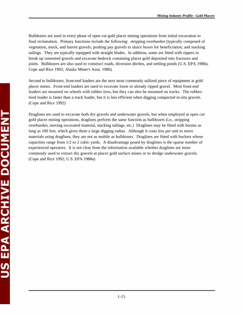
Bulldozers are used in every phase of open cut gold placer mining operations from initial excavation tofinal reclamation. Primary functions include the following: stripping overburden (typically composed ofvegetation, muck, and barren gravels; pushing pay gravels to sluice boxes for beneficiation; and stackingtailings. They are typically equipped with straight blades. In addition, some are fitted with rippers tobreak up cemented gravels and excavate bedrock containing placer gold deposited into fractures andjoints. Bulldozers are also used to construct roads, diversion ditches, and settling ponds (U.S. EPA 1988a;Cope and Rice 1992; Alaska Miner's Assn. 1986).
Second to bulldozers, front-end loaders are the next most commonly utilized piece of equipment at goldplacer mines. Front-end loaders are used to excavate loose or already ripped gravel. Most front-endloaders are mounted on wheels with rubber tires, but they can also be mounted on tracks. The rubber-tired loader is faster than a track loader, but it is less efficient when digging compacted in-situ gravels. (Cope and Rice 1992)
Draglines are used to excavate both dry gravels and underwater gravels, but when employed at open cutgold placer mining operations, draglines perform the same function as bulldozers (i.e., strippingoverburden, moving excavated material, stacking tailings, etc.) Draglines may be fitted with booms aslong as 100 feet, which gives them a large digging radius. Although it costs less per unit to movematerials using draglines, they are not as mobile as bulldozers. Draglines are fitted with buckets whosecapacities range from 1/2 to 2 cubic yards. A disadvantage posed by draglines is the sparse number ofexperienced operators. It is not clear from the information available whether draglines are morecommonly used to extract dry gravels at placer gold surface mines or to dredge underwater gravels. (Cope and Rice 1992; U.S. EPA 1988a)
Mining Industry Profile: Gold Placers
1-16
1.4.2.2 Other Methods
Dredging
Although dredges are used in both surface mining and underwater mining of placer deposits, they aregenerally associated with the mining and beneficiation of metal-bearing minerals (values) below waterlevel. Dredges are limited by the availability of a saturated placer gold deposit or the existence of a watertable near the surface to create the appropriate excavating environment (i.e., a pond). Some dredges,however, operate in the water while anchored on land. Four commonly used dredging systems includebucketline (also referred to as bucket-ladder), backhoe, dragline, and suction dredging. Dredges aredesigned to execute multiple functions. For example, many floating dredges are equipped to performextraction, beneficiation, processing, and waste disposal. (U.S. EPA 1988a; Alaska Miner's Assn. 1986) Hydraulic dredging systems have been used to produce sand and gravel, marine shell deposits foraggregate, and mine deposits containing diamonds, platinum and tin. Heavy mineral mining, includingtitanium sand dredging is also practiced to obtain ilmenite, monazite, rutile and zircon (Harty and Terlecky1986).
Dredging systems are categorized as either hydraulic or mechanical, depending on the method of digging. Hydraulic systems include suction dredges, while mechanical systems comprise bucketline, backhoe, anddragline dredges. Some dredging systems integrate hydraulic and mechanical power for the purposes ofextracting placer gold. Special circumstances might make a combination dredge (sometimes called a"combiminer") more desirable than simply a plain suction dredge. Some suction dredges are equippedwith a cutter head to make excavation easier. Dredges are known to be capable of excavating to depthsof 225 feet, but excavation for mineral recovery has been much less, perhaps one quarter of that depth.
Hydraulic Methods
In hydraulic mining, or hydraulicking, water under pressure is forced through an adjustable nozzle called amonitor or giant and directed at a bank to excavate gold placer pay streak and to transport it to therecovery unit, which is generally a sluice box. The pressurized water jet can also be used to thaw frozenmuck and to break up and wash away overburden. Water pressure is supplied either by a pump or bygravity. The operator controls the vertical and horizontal movements of the monitor (giant, or watercannon), as well as the water pressure and the volume of the flow by remote control (U.S. EPA 1988a).
One advantage of hydraulicking is the ability to move large volumes of material at a low cost. Theamount of water required to accomplish this movement and the resultant tailings, however, present aserious obstacle to the widespread use of this water-dependent extraction technique. Originally employedin geographic areas rich with water bodies, hydraulicking tapered off as mechanized earth-movingextraction equipment gained favor and as restrictions were placed on the availability and pollution ofwater. Given the efficiency and economic savings of the equipment used in open cut gold placer miningoperations and concerns related to hydraulic mining's environmental impacts, it seems unlikely thathydraulic mining will be widely used in the future. (U.S. EPA 1988a)
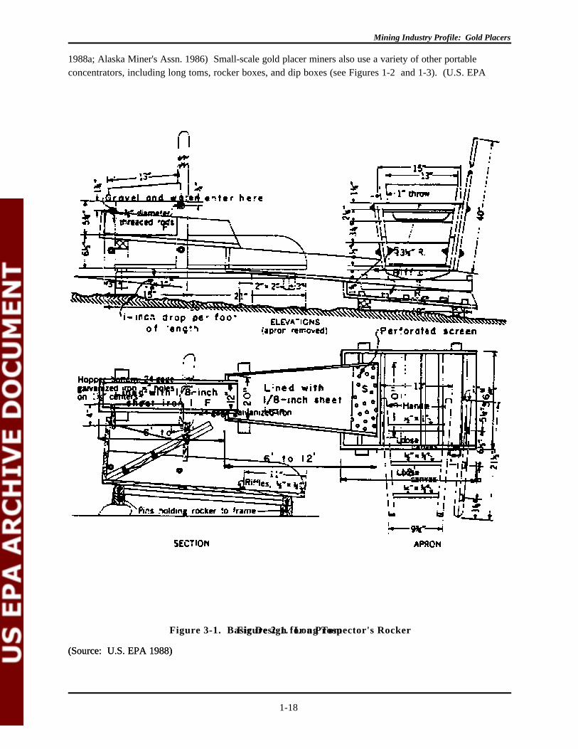
Small-Scale Methods
Small-scale extraction methods include panning, and suction dredging. Small-scale extraction methods areprimarily used by recreational gold placer miners working on a non-commercial scale. Small-scalemethods combine extraction and beneficiation steps because the extraction phase of the placer operation
Mining Industry Profile: Gold Placers
1-17
is integrated with beneficiation. Essentially, shallow alluvial sediments are "sifted" using equipment that ismodeled after the basic mining equipment used in some open cut and dredging operations; small-scaleextraction methods employ the basic principles of gravity separation. (U.S. EPA 1988a)
Panning recovers gold concentrate. It is a low budget, labor intensive method involving fairly rudimentarygravity separation equipment. Panning is also a sampling method used by prospectors to evaluate a placergold deposit to determine whether it can be mined profitably. Such assessment operations differ fromsmall-scale mining operations that recover gold for an immediate return on their investment. (U.S. EPA
Mining Industry Profile: Gold Placers
1-18
Figure 2-1. Long Tom
(Source: U.S. EPA 1988)
Figure 3-1. Basic Design for a Prospector's Rocker
(Source: U.S. EPA 1988)
1988a; Alaska Miner's Assn. 1986) Small-scale gold placer miners also use a variety of other portableconcentrators, including long toms, rocker boxes, and dip boxes (see Figures 1-2 and 1-3). (U.S. EPA
Mining Industry Profile: Gold Placers
1-19
1988a)
Small suction dredges are being used successfully by recreational or small (part-time) gold placerventures. A pump varying from one to four inches usually floats immediately above the mined area. Themechanism that recovers the gold sits in a box next to the suction pipe and is carried under water. Alternatively, the nozzle has two hoses, one that transports water to the head and the other that transportsmaterial to the surface of a beneficiation device (i.e., usually a small sluice box that deposits tails backinto the stream).
Underground Mining Methods
Drift mining and bore-hole mining are terms applied to working alluvial placer deposits by undergroundmethods of mining. Drift mining is more expensive than open cut sluicing and hydraulicking, so it is usedonly in rich ground. In drift mining, the pay streak is reached through a shaft or an adit. Pay dirt that hasbeen separated from the gold bearing zone either by blasting or with hand tools is carried in wheelbarrowsor trammed to small cars that transport the gravel to the surface for beneficiation. If a deposit is large,then regular cuts or slices are taken across the pay streak, and work is generally performed on the depositin a retreating fashion from the inner limit of the gravel. (U.S. DOI 1968; Argall 1987)

Mining Industry Profile: Gold Placers
1-20

Mining Industry Profile: Gold Placers
1-21
1.4.3 Beneficiation Methods
Beneficiation of placer materials involves the separation of fine gold particles from large quantities ofalluvial sediments. Gravity separation is the most commonly used beneficiation method. Magneticseparation is used in some operations to supplement the gravity separation methods. Water is used inmost, if not all steps; initially, to wash gold particles from oversized material and later, to move goldconcentrate through the wash plant. The wash plant refers to the collection of equipment wherebeneficiation is conducted. For land-based operations, the plant may be stationary but is often mounted onskids so that it can be moved along with the mining operation as it progresses. Dredge operationsfrequently employ floating wash plants, where the beneficiation equipment is carried within the dredge.
Beneficiation typically involves three general steps: the first is to remove grossly oversized material fromthe smaller fraction that contains the gold, the second to concentrate the gold, and the third to separate thefine gold from other fine, heavy minerals. The same type of equipment is often used in more than onestep, for example an array of jigs may be employed to handle successively finer material (Flatt 1990).
Classification (sizing) is the initial step in the beneficiation operation when the large, oversize material(usually over 3/4 inch) is removed during beneficiation. A rough (large diameter) screen is usually used. This step may be fed by a bulldozer, front-end loader, backhoe, dragline or conveyor belt. Within theindustry, this step is also referred to as roughing (U.S. EPA 1988a). Previous studies have indicated thatthe practice improves the efficiency of gold recovery and reduces the water consumption (Bainbridge1979).
After the initial removal of the larger material during sizing, pay dirt is subject to a coarse concentrationstage. This step, also referred to as cleaning, may employ trommels or screens. Other equipment used inthe coarse concentration stage includes sluices, jigs, shaking tables, spiral concentrators and cones. Depending on the size of the gold particles, cleaning may be the final step in beneficiation (Flatt 1990;Silva 1986).
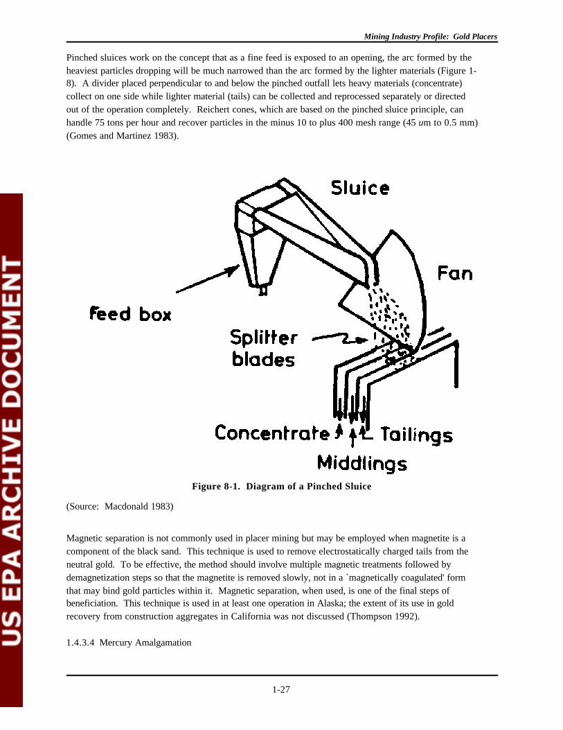
Fine concentration is the final operation used to remove very small gold values from the concentrategenerated in the previous stages. Many of the previously identified pieces of equipment can be calibratedfor finer separation sensitivity. Final separation uses jigs, shaking tables, centrifugal concentrators, spiralconcentrators or pinched sluices.
The following is a summary of the equipment commonly used in beneficiation. One of the keydeterminants in selecting equipment is the volume of material that will pass through each step within agiven time period. Rates for material handling for the equipment discussed below are included where theinformation was available.
1.4.3.1 Sizing
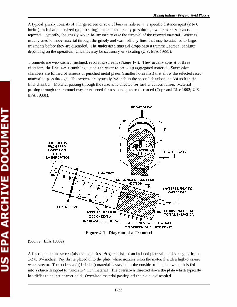
Sizing is a physical separation of material based strictly on size. The sizing step removes large rocks priorto additional beneficiation. The waste generated is usually solid and is much lower in volume compared tothe pay dirt that passes through. Discharge material may be used for other applications including roadaggregates. This step typically involves the pay dirt being loaded into a grizzly, trammel or screen or acombination thereof.
Mining Industry Profile: Gold Placers
1-22
Figure 4-1. Diagram of a Trommel
(Source: EPA 1988a)
A typical grizzly consists of a large screen or row of bars or rails set at a specific distance apart (2 to 6inches) such that undersized (gold-bearing) material can readily pass through while oversize material isrejected. Typically, the grizzly would be inclined to ease the removal of the rejected material. Water isusually used to move material through the grizzly and wash off any fines that may be attached to largerfragments before they are discarded. The undersized material drops onto a trammel, screen, or sluicedepending on the operation. Grizzlies may be stationary or vibrating (U.S. EPA 1988a).
Trommels are wet-washed, inclined, revolving screens (Figure 1-4). They usually consist of three chambers, the first uses a tumbling action and water to break up aggregated material. Successivechambers are formed of screens or punched metal plates (smaller holes first) that allow the selected sizedmaterial to pass through. The screens are typically 3/8 inch in the second chamber and 3/4 inch in thefinal chamber. Material passing through the screens is directed for further concentration. Materialpassing through the trammel may be returned for a second pass or discarded (Cope and Rice 1992; U.S.EPA 1988a).
A fixed punchplate screen (also called a Ross Box) consists of an inclined plate with holes ranging from1/2 to 3/4 inches. Pay dirt is placed onto the plate where nozzles wash the material with a high-pressurewater stream. The undersized (desirable) material is washed to the outside of the plate where it is fedinto a sluice designed to handle 3/4 inch material. The oversize is directed down the plate which typicallyhas riffles to collect coarser gold. Oversized material passing off the plate is discarded.

Mining Industry Profile: Gold Placers
1-23
Figure 5-1. Diagram of a Sluice Box Including Hungarian Riffles
(Source: EPA 1988a)
Screens function to separate oversized, undesirable material from the gold concentrate. Screen size(usually 1/2 to 3/4 inch) is selected based on pay dirt characteristics. Screens may be fixed or vibrating. The action of both is similar although vibrating screens speed the rate of particle separation. Theconcentrate continues for further concentration while the oversize is removed via a chute or stackerconveyor belt. Different sized screens may be used to sort material into different sizes for use as roadconstruction aggregate or other purposes.
1.4.3.2 Coarse Concentration
Separation in the coarse concentration step involves particle density rather than size. Sluices are thepieces of equipment most commonly used in the coarse concentration step although jigs and screens mayalso be employed. The wastes are discharged to a tailings pond also called a recycle pond or settlingpond. Most of the material that enters the sluice exits as waste. The gold and other heavy minerals settlewithin the lining material while the lighter material is washed through. Coarse concentration generates thelargest volume of waste during beneficiation.
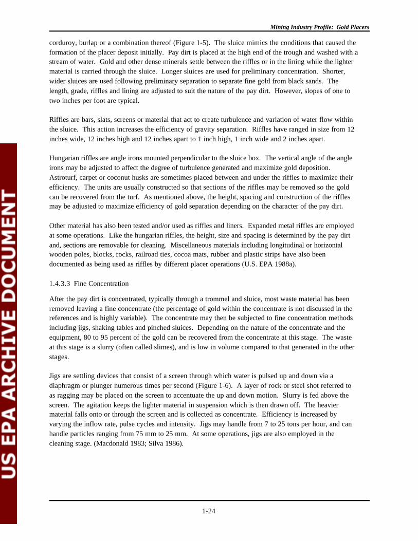
A sluice consists of a long, narrow, inclined trough lined with riffles, perforated screens, astroturf,
Mining Industry Profile: Gold Placers
1-24
corduroy, burlap or a combination thereof (Figure 1-5). The sluice mimics the conditions that caused theformation of the placer deposit initially. Pay dirt is placed at the high end of the trough and washed with astream of water. Gold and other dense minerals settle between the riffles or in the lining while the lightermaterial is carried through the sluice. Longer sluices are used for preliminary concentration. Shorter,wider sluices are used following preliminary separation to separate fine gold from black sands. Thelength, grade, riffles and lining are adjusted to suit the nature of the pay dirt. However, slopes of one totwo inches per foot are typical.
Riffles are bars, slats, screens or material that act to create turbulence and variation of water flow withinthe sluice. This action increases the efficiency of gravity separation. Riffles have ranged in size from 12inches wide, 12 inches high and 12 inches apart to 1 inch high, 1 inch wide and 2 inches apart.
Hungarian riffles are angle irons mounted perpendicular to the sluice box. The vertical angle of the angleirons may be adjusted to affect the degree of turbulence generated and maximize gold deposition. Astroturf, carpet or coconut husks are sometimes placed between and under the riffles to maximize theirefficiency. The units are usually constructed so that sections of the riffles may be removed so the goldcan be recovered from the turf. As mentioned above, the height, spacing and construction of the rifflesmay be adjusted to maximize efficiency of gold separation depending on the character of the pay dirt.
Other material has also been tested and/or used as riffles and liners. Expanded metal riffles are employedat some operations. Like the hungarian riffles, the height, size and spacing is determined by the pay dirtand, sections are removable for cleaning. Miscellaneous materials including longitudinal or horizontalwooden poles, blocks, rocks, railroad ties, cocoa mats, rubber and plastic strips have also beendocumented as being used as riffles by different placer operations (U.S. EPA 1988a).
1.4.3.3 Fine Concentration
After the pay dirt is concentrated, typically through a trommel and sluice, most waste material has beenremoved leaving a fine concentrate (the percentage of gold within the concentrate is not discussed in thereferences and is highly variable). The concentrate may then be subjected to fine concentration methodsincluding jigs, shaking tables and pinched sluices. Depending on the nature of the concentrate and theequipment, 80 to 95 percent of the gold can be recovered from the concentrate at this stage. The wasteat this stage is a slurry (often called slimes), and is low in volume compared to that generated in the otherstages.
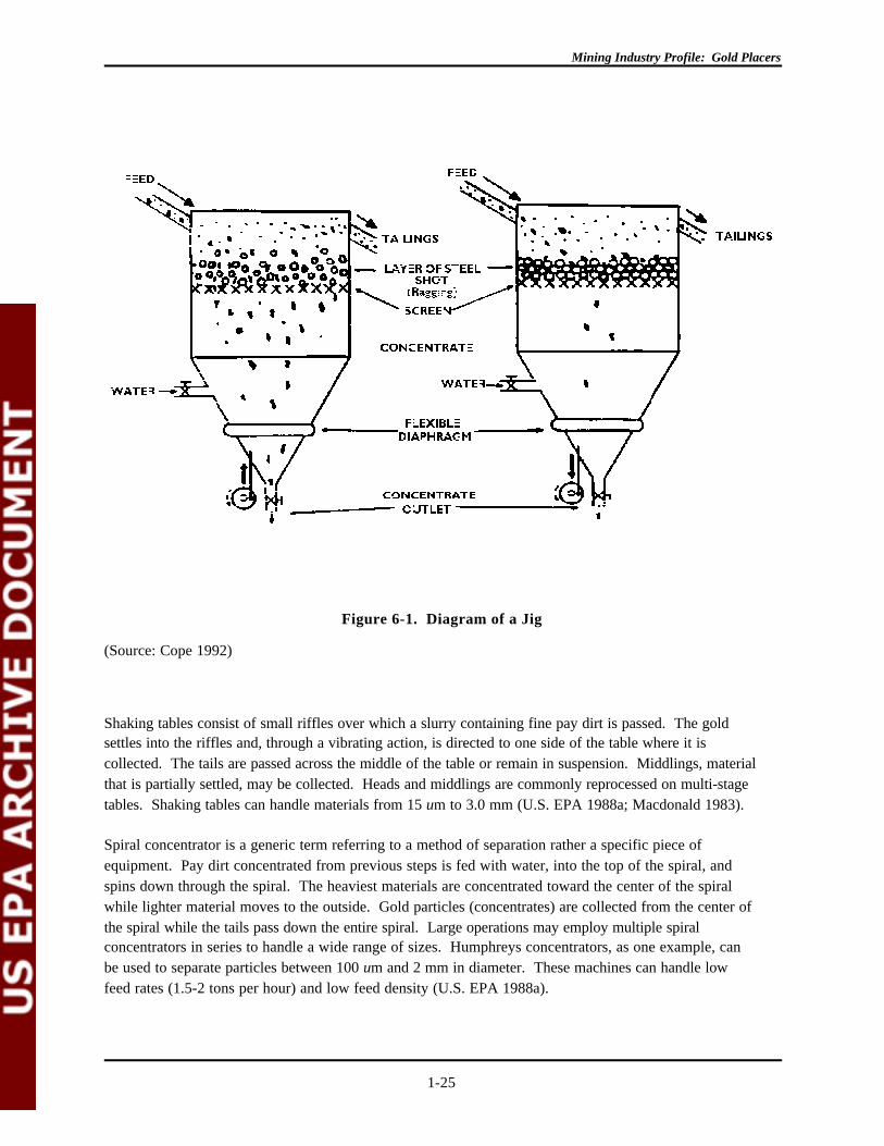
Jigs are settling devices that consist of a screen through which water is pulsed up and down via adiaphragm or plunger numerous times per second (Figure 1-6). A layer of rock or steel shot referred toas ragging may be placed on the screen to accentuate the up and down motion. Slurry is fed above thescreen. The agitation keeps the lighter material in suspension which is then drawn off. The heaviermaterial falls onto or through the screen and is collected as concentrate. Efficiency is increased byvarying the inflow rate, pulse cycles and intensity. Jigs may handle from 7 to 25 tons per hour, and canhandle particles ranging from 75 mm to 25 mm. At some operations, jigs are also employed in thecleaning stage. (Macdonald 1983; Silva 1986).
Mining Industry Profile: Gold Placers
1-25
Figure 6-1. Diagram of a Jig
(Source: Cope 1992)
Shaking tables consist of small riffles over which a slurry containing fine pay dirt is passed. The goldsettles into the riffles and, through a vibrating action, is directed to one side of the table where it iscollected. The tails are passed across the middle of the table or remain in suspension. Middlings, materialthat is partially settled, may be collected. Heads and middlings are commonly reprocessed on multi-stagetables. Shaking tables can handle materials from 15 um to 3.0 mm (U.S. EPA 1988a; Macdonald 1983).
Spiral concentrator is a generic term referring to a method of separation rather a specific piece ofequipment. Pay dirt concentrated from previous steps is fed with water, into the top of the spiral, andspins down through the spiral. The heaviest materials are concentrated toward the center of the spiralwhile lighter material moves to the outside. Gold particles (concentrates) are collected from the center ofthe spiral while the tails pass down the entire spiral. Large operations may employ multiple spiralconcentrators in series to handle a wide range of sizes. Humphreys concentrators, as one example, canbe used to separate particles between 100 um and 2 mm in diameter. These machines can handle lowfeed rates (1.5-2 tons per hour) and low feed density (U.S. EPA 1988a).
Mining Industry Profile: Gold Placers
1-26
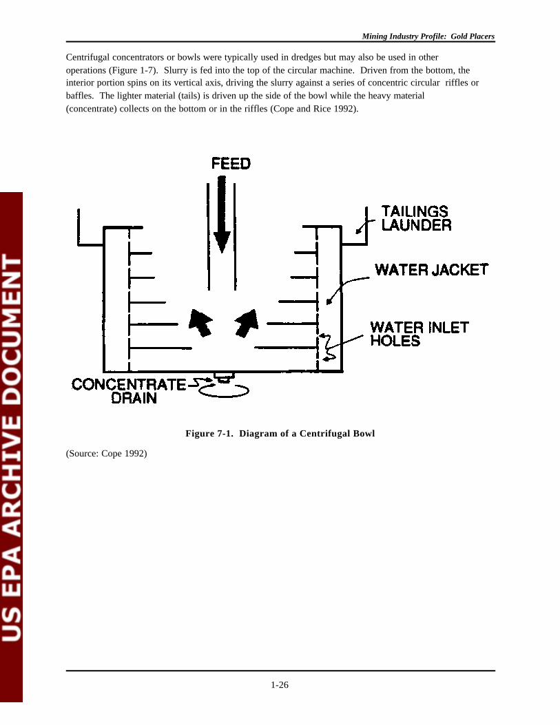
Figure 7-1. Diagram of a Centrifugal Bowl
(Source: Cope 1992)
Centrifugal concentrators or bowls were typically used in dredges but may also be used in otheroperations (Figure 1-7). Slurry is fed into the top of the circular machine. Driven from the bottom, theinterior portion spins on its vertical axis, driving the slurry against a series of concentric circular riffles orbaffles. The lighter material (tails) is driven up the side of the bowl while the heavy material(concentrate) collects on the bottom or in the riffles (Cope and Rice 1992).
Mining Industry Profile: Gold Placers
1-27
Figure 8-1. Diagram of a Pinched Sluice
(Source: Macdonald 1983)
Pinched sluices work on the concept that as a fine feed is exposed to an opening, the arc formed by theheaviest particles dropping will be much narrowed than the arc formed by the lighter materials (Figure 1-8). A divider placed perpendicular to and below the pinched outfall lets heavy materials (concentrate)collect on one side while lighter material (tails) can be collected and reprocessed separately or directedout of the operation completely. Reichert cones, which are based on the pinched sluice principle, canhandle 75 tons per hour and recover particles in the minus 10 to plus 400 mesh range (45 um to 0.5 mm)(Gomes and Martinez 1983).
Magnetic separation is not commonly used in placer mining but may be employed when magnetite is acomponent of the black sand. This technique is used to remove electrostatically charged tails from theneutral gold. To be effective, the method should involve multiple magnetic treatments followed bydemagnetization steps so that the magnetite is removed slowly, not in a `magnetically coagulated' formthat may bind gold particles within it. Magnetic separation, when used, is one of the final steps ofbeneficiation. This technique is used in at least one operation in Alaska; the extent of its use in goldrecovery from construction aggregates in California was not discussed (Thompson 1992).
1.4.3.4 Mercury Amalgamation
Mining Industry Profile: Gold Placers
1-28
Before Federal environmental regulations were promulgated in the mid-1970s, mercury amalgamationwas commonly used to recover gold fines. An amalgam of mercury and gold is formed by addingmercury to the lowest portions of a sluice. There had been little or no reference to its recent use until anarticle in the Engineering and Mining Journal entitled "Byproduct Gold From Construction Aggregates"mentioned its use in recovering gold from bowl concentrates. In this case, gold concentrates weregenerated as a byproduct from the production of construction aggregates. The amalgam was to producea final bullion. The mining and beneficiation operations were not described in the article. The onlydiscussion regarding control of environmental releases simply stated that the operation was conductedaway from the mining activities (Thompson 1992).
Mining Industry Profile: Gold Placers
1-29
1.5 WASTE MANAGEMENT PRACTICES
This section describes several of the wastes and materials that are generated and/or managed at goldplacer extraction and beneficiation operations and the means by which they are managed. As is noted inthe previous section, a variety of wastes and other materials are generated and managed by gold placeroperations.
Some, such as waste rock and tailings, are generally considered to be wastes and are managed as such,typically in on-site management units. Even these materials, however, may be used for various purposes(either on- or off-site) in lieu of disposal. Some quantities of waste rock and tailings, for example, may beused as construction or foundation materials at times during a mine's life. Many other materials that aregenerated and/or used at mine sites may only occasionally or periodically be managed as wastes. Theseinclude mine water removed from underground workings or open pits, which usually is recirculated for on-site use but at times can be discharged to surface waters. Some materials are not considered wastes atall until a particular time in their life cycles.
The issue of whether a particular material is a waste clearly depends on the specific circumstancessurrounding its generation and management at the time. In addition, some materials that are wastes withinthe plain meaning of the word are not "solid wastes" as defined under RCRA and thus are not subject toregulation under RCRA. These include, for example, mine water or process wastewater that isdischarged pursuant to an NPDES permit. It is emphasized that any questions as to whether a particularmaterial is a waste at a given time should be directed to the appropriate EPA Regional office.
The first subsection below describes several of the more important wastes (as defined under RCRA orotherwise) and nonwastes alike, since either can have important implications for environmentalperformance of a facility. The next subsection describes the major types of waste units and minestructures that are of most environmental concern during and after the active life of an operation.
1.5.1 Extraction and Beneficiation Wastes and Materials
1.5.1.1 Waste Rock or Overburden
Waste rock consists of material that contains no gold and must be removed to access the pay zone. Industry usually refers to overburden and, in the case of underground mines, mine development rock aswaste rock. It is generally disposed of in waste rock dumps near the point of excavation. Eventually, thestockpiled waste rock may be used to backfill the mine cut during reclamation. Because the desiredmaterial (gold) is such a small fraction of the material mined (< 0.1 oz/ton) there is a tremendous amountof waste rock generated. Surface mining operations generate more waste per unit of crude ore extractedthan underground operations, although stripping ratios vary from one site to the next. For example, in1992 at Polar Mining, Inc.'s Lower Goldstream placer operation near Fairbanks, Alaska, approximately2,200,000 cubic yards of overburden were excavated to beneficiate 500,000 cubic yards of pay dirt. PolarMining, therefore, has a stripping ratio that exceeds 4:1 (waste:ore). On the other hand, estimates fromthe 1992 Reclamation Plan and Annual Placer Mining Application of another Alaska placer mine (AlfHopen's Little Eldorado Creek operation in the Fairbanks mining district near Cleary, Alaska) for totalmaterial mined and total material concentrated (70,000 cubic yards and 60,000 cubic yards, respectively)suggest a very low ratio of overburden to pay dirt (Polar Mining, Inc. 1991b).
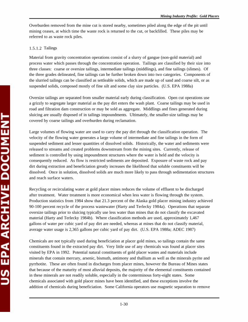
Mining Industry Profile: Gold Placers
1-30
Overburden removed from the mine cut is stored nearby, sometimes piled along the edge of the pit untilmining ceases, at which time the waste rock is returned to the cut, or backfilled. These piles may bereferred to as waste rock piles.
1.5.1.2 Tailings
Material from gravity concentration operations consist of a slurry of gangue (non-gold material) andprocess water which passes through the concentration operation. Tailings are classified by their size intothree classes: coarse or oversize tailings, intermediate tailings (middlings), and fine tailings (slimes). Ofthe three grades delineated, fine tailings can be further broken down into two categories. Components ofthe slurried tailings can be classified as settleable solids, which are made up of sand and coarse silt, or assuspended solids, composed mostly of fine silt and some clay size particles. (U.S. EPA 1988a)
Oversize tailings are separated from smaller material early during classification. Open cut operations usea grizzly to segregate larger material as the pay dirt enters the wash plant. Coarse tailings may be used inroad and filtration dam construction or may be sold as aggregate. Middlings and fines generated duringsluicing are usually disposed of in tailings impoundments. Ultimately, the smaller-size tailings may becovered by coarse tailings and overburden during reclamation.
Large volumes of flowing water are used to carry the pay dirt through the classification operation. Thevelocity of the flowing water generates a large volume of intermediate and fine tailings in the form ofsuspended sediment and lesser quantities of dissolved solids. Historically, the water and sediments werereleased to streams and created problems downstream from the mining sites. Currently, release ofsediment is controlled by using impoundment structures where the water is held and the velocity isconsequently reduced. As flow is restricted sediments are deposited. Exposure of waste rock and paydirt during extraction and beneficiation greatly increases the likelihood that soluble constituents will bedissolved. Once in solution, dissolved solids are much more likely to pass through sedimentation structuresand reach surface waters.
Recycling or recirculating water at gold placer mines reduces the volume of effluent to be dischargedafter treatment. Water treatment is more economical when less water is flowing through the system. Production statistics from 1984 show that 21.3 percent of the Alaska gold placer mining industry achieved90-100 percent recycle of the process wastewater (Harty and Terlecky 1984a). Operations that separateoversize tailings prior to sluicing typically use less water than mines that do not classify the excavatedmaterial (Harty and Terlecky 1984b). Where classification methods are used, approximately 1,467gallons of water per cubic yard of pay dirt are needed, whereas at mines that do not classify material,average water usage is 2,365 gallons per cubic yard of pay dirt. (U.S. EPA 1988a; ADEC 1987)
Chemicals are not typically used during beneficiation at placer gold mines, so tailings contain the sameconstituents found in the extracted pay dirt. Very little use of any chemicals was found at placer sitesvisited by EPA in 1992. Potential natural constituents of gold placer wastes and materials includeminerals that contain mercury, arsenic, bismuth, antimony and thallium as well as the minerals pyrite andpyrrhotite. These are often found in discharges from placer mines, however the Bureau of Mines statesthat because of the maturity of most alluvial deposits, the majority of the elemental constituents containedin these minerals are not readily soluble, especially in the conterminous forty-eight states. Somechemicals associated with gold placer mines have been identified, and these exceptions involve theaddition of chemicals during beneficiation. Some California operators use magnetic separation to remove
Mining Industry Profile: Gold Placers
1-31
high concentrations of magnetite. At early placer mines, mercury was frequently added to sluice boxes toaugment the recovery of fine gold. Mercury amalgamation produced a slurry waste composed of amercury-tainted solution and gangue. Modern placer operations in California have recovered mercuryfrom the sediments as a byproduct of historic amalgamation operations. The use of mercury at moderngold placer mines is considered minimal. (U.S. EPA 1991; Cope and Rice 1992)
1.5.2 Waste and Materials Management
Waste and non-waste materials generated as a result of extraction and beneficiation of gold placerdeposits are managed (treated, stored, or disposed) in discrete units. For the purposes of this report, theseunits are divided into two groups: (1) waste rock piles and (2) tailings impoundments, also referred to assettling and recycle ponds.
In general, the goal of treating or managing these materials is to separate the silt and fine-grained solidsfrom the water, reusing the water or ensuring it meets NPDES discharge requirements prior todischarging to a stream. Most management occurs after sluicing; the stacking of overburden and wasterock in areas proximate to the mining operation, however, constitutes an interim method of managing solidextraction wastes prior to their ultimate return to the mine cut. (Alaska Miner's Assn. 1986)
There are two ways to maximize the quality of the effluent discharged from a gold placer operation. Theeffluent can be treated using a variety of impoundments (tailraces, pre-settling ponds, and settling/recycleponds), filtration, and, in rare instances, flocculants. A study sponsored by the EPA in 1984 showed thatpolymer-aided settling removed over 96 - 99+ percent of suspended solids using cationic polymers (Hartyand Terlecky 1984c). Alternatively, the mining operation can be modified to reduce water use duringbeneficiation, thereby reducing the volume of effluent discharged. Management methods used to achievethis reduction include classification, recycling, use of a bypass, and control of water gain (i.e., surface andsubsurface seepage). (Alaska Miner's Assn. 1986)
1.5.2.1 Tailings Impoundments/Settling Pond Systems
Tailings (oversize, intermediate, and fines) are typically managed in tailings impoundments or used forconstruction. The method of managing tailings is largely determined by the water content of the tailings. Tailings impoundments associated with gold placer mines are generally unlined containment areas for wettailings in the form of slurries.
At most gold placer operations, the disposal of tailings requires a permanent site with adequate capacityfor the life of the mine. The size of tailings impoundments varies between operations; that is, if theimpoundment is going to function effectively, the dimensions and characteristics are tailored to meet thespecifications for a particular operation.
The removal of sediment from water is the goal of effluent treatment. A properly designed settling pondcan remove 99 percent of the settleable solids (SS) from the effluent. There are numerous factors thatinfluence how efficiently a settling pond removes sediment from effluent, including the following:
• Surface area of the pond• Flow rate through the pond• Settling characteristics of the sediment

Mining Industry Profile: Gold Placers
1-32
• Short circuiting• Entrance and exit effects• Wind and rain turbulence.
To promote settling, the surface area of the pond should be as large as possible. The flow rate throughthe pond can be minimized by means of a bypass that diverts excess water around the operation. Settlingponds are designed to meet the needs of a specific placer mining operation. Short circuiting occurs whenthe slurry in the pond flows directly from the inlet to the outlet without using the available settling area. Berms or baffles can be constructed in the pond to eliminate short circuiting, or the inlet and outletstructures can be positioned far apart from each other. Entrance and exit effects occur when the velocityof the incoming effluent creates a turbulent plume in the pond. If the slope of the tailrace is decreased orif a berm is situated at the entrance perpendicular to the flow, entrance effects can be eliminated. (ADEC 1987; Alaska Miner's Assn. 1986)
Tailraces and Pre-Settling Ponds
The tailrace is the open channel that carries the effluent from the beneficiation plant to the settling pond. A pre-settling pond is an area of the tailrace that has been widened and deepened two to three feet toform a small pond in which heavy sediment settles and is temporarily stored. Pre-settling ponds aresmaller than settling ponds, and they are less expensive to build. Pre-settling ponds require regularcleaning to remain effective, but the frequency of cleaning depends on pond size. To prevent bulldozersand other heavy equipment from getting stuck during cleaning, the pre-settling pond should be located onflat, competent bedrock, with a gentle slope on one side of the pond. When the beneficiation plant shutsdown between shifts effluent in the pre-settling pond drains off completely, allowing for easy cleaning. Asmall berm of course tailings placed at the downstream end of the tailrace slows the flow velocity duringplant operation, thereby maximizing sediment removal, while still allowing for the complete drainage of thepre-settling pond after the shift. (Alaska Miner's Assn. 1986; ADEC 1987)
Tailraces and pre-settling ponds are characteristic of open cut surface mining operations. Even at opencut mines, however, there are variations of the typical tailrace and pre-settling pond. Two pre-settlingponds are sometimes used simultaneously and in series to provide extra storage in case the first pond fillsprematurely or in the event that a scheduled cleaning is missed. Alternatively, two parallel pre-settlingponds might be used at alternating times (see Figure 1-9). (Alaska Miner's Assn. 1986; ADEC 1987)
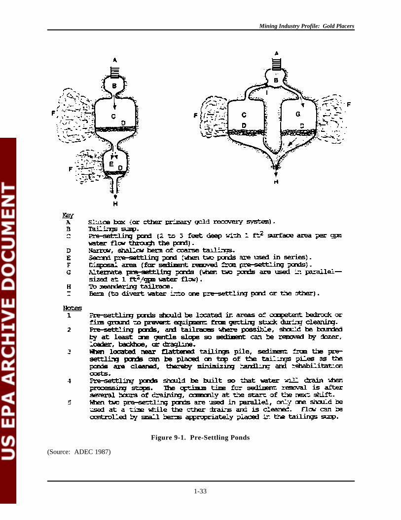
Mining Industry Profile: Gold Placers
1-33
Figure 9-1. Pre-Settling Ponds
(Source: ADEC 1987)

Mining Industry Profile: Gold Placers
1-34
Filtration
Filtration of sediments can occur at two stages during management. Prior to reaching the settling pond,the tailings slurry is routed through coarse tailings, which enhance the percolation rates. Tailings filters

Mining Industry Profile: Gold Placers
1-35
Figure 10-1. Sediment Removal Before Ponds by Filtration
(Source: ADEC 1987)
are constructed at sites that use fixed or mobile wash plants; the latter have coarse tailings stackers thatdeposit the tailings in the mine cut downstream from the direction of mining (see Figure 1-10). (ADEC

Mining Industry Profile: Gold Placers
1-36
1987)
Mining Industry Profile: Gold Placers
1-37
Filtration also occurs just prior to discharge of the effluent into a receiving stream. Settling ponds in series
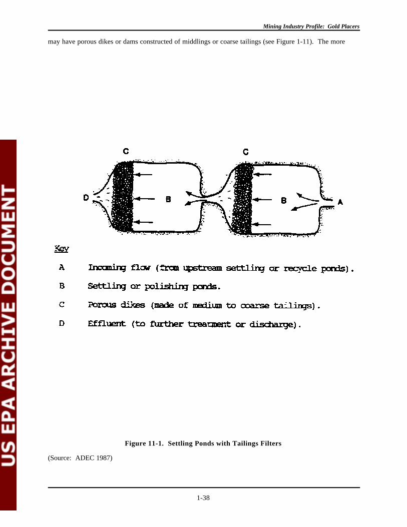
Mining Industry Profile: Gold Placers
1-38
Figure 11-1. Settling Ponds with Tailings Filters
(Source: ADEC 1987)
may have porous dikes or dams constructed of middlings or coarse tailings (see Figure 1-11). The more

Mining Industry Profile: Gold Placers
1-39
coarse the tailings, the higher the percolation rates will be. Water levels in ponds fluctuate, rising whenthe wash plant is actively beneficiating and falling when the plant is shut down. Tailings filters dampenflow surges through the pond, filter out solids, and mix effluent with ground water, which decreases theconcentration of solids and turbidity. Finally, vegetative filtration can "polish" the effluent after othertreatment methods have removed all settleable solids. (ADEC 1987)
Settling Ponds
Settling ponds are containment areas designed to remove solids from effluent through simple settling(ADEC 1987). These structures are similar in form and function to tailings impoundments and are usedprimarily by large-scale placer operations. Settling ponds are usually created by constructing a

Mining Industry Profile: Gold Placers
1-40

Mining Industry Profile: Gold Placers
1-41
Mining Industry Profile: Gold Placers
1-42
dam composed of tailings across the downstream end of the mined cut. When the next cut is mined, mostof the extracted sediment is captured in this new pond. Thus, as mining progresses, a series of pondsemerge. Often the main recycle pond remains intact. Settling ponds should be accurately sized andshould provide for the sum of the following:
• Sediment storage volume• Retention time volume• Storm surge volume. (ADEC 1987)
According to the Alaska Department of Environmental Conservation, settling ponds have a length to widthratio of 2:1. Narrow ponds are less effective at removing sediment because water flows more rapidlythrough the pond, scouring and resuspending the sediment. Ponds should be distant from the bypass andshould have adequate emergency spillways to minimize potential damage from floods. Multiple ponds(i.e., ponds in series) generally provide better treatment than one large pond.

Mining Industry Profile: Gold Placers
1-43
Figure 12-1. Settling/Recycle Pond
(Source: ADEC 1987)

Mining Industry Profile: Gold Placers
1-44
Settling/recycle ponds in combination remove sediment from process water before it is returned to thewash plant for reuse (Figure 1-12).

Mining Industry Profile: Gold Placers
1-45
Mining Industry Profile: Gold Placers
1-46
Recreational and small-scale gold placer miners do not usually use settling ponds. Applying thismanagement technology to small operations results in disproportionately large in-stream or riparian areadisturbances. The use of settling ponds by small-scale gold placer miners also presents the risk ofincreased erosion at the site. In sum, the reduction in sediment discharge must justify the additionalsediment likely to be produced by pond construction and stream diversion.
Flocculants
Flocculants could potentially be used as a final polishing step to reduce turbidity in a small volume ofeffluent from a recycle system (ADEC 1987). Chemically assisted settling may involve the addition ofpolymers to aid in the removal of suspended solids. For small gold placer mining operations, the additionof chemicals to the settling pond increases beneficiation costs. The danger of chemical spills and thepotential for improper use of chemicals by recreational miners probably outweighs potential improvementsin settling.
Mining Industry Profile: Gold Placers
1-47
1.6 ENVIRONMENTAL EFFECTS
Most environmental effects associated with placer mining activities concern water quality. Historically,the most severe impacts have been physical disturbances to stream channels and the addition of largequantities of sediment downstream. As regulations governing placer mining evolved to address theseproblems, environmental impacts became less severe, although, through the mid-1980s, water qualityimpacts from placer mining continued to be documented. In 1988, effluent limitations were placed onplacer mines through the NPDES program (40 CFR 440 Subpart M).
Available data on environmental impacts of placers is often dated with the majority of informationcollected prior to 1988. Annual reports from the ADEC, and one study conducted since the effluentlimitations were enacted, are discussed to provide a limited evaluation of the current status ofenvironmental impacts.
Prior to the initiation of any regulatory controls, placer mining operations, as previously mentioned, createdsignificant disturbances within stream channels. Little or no effort was made to recontour waste rockpiles to resemble the premining topography. Natural revegetation of mined areas from Alaska toCalifornia ranges from none to complete. Depending on the remaining substrate, natural stream patternsin some areas may take a century to return. These operations were also responsible for generating largequantities of sediment and increasing concentrations of heavy metals, including arsenic, copper, lead andmercury, downstream from mining activities (ADEC 1986; Clark 1970; Holmes 1981).
This section does not purport to be a comprehensive examination of environmental effects that can occuror that actually occur at mining operations. Rather, it is a brief overview of some of the potentialproblems that can occur under certain conditions. The extent and magnitude of contamination depend onhighly variable site-specific factors that require a flexible approach to mitigation. EPA is aware thatmany of the potential problems can be, and generally are, substantially mitigated or avoided by properengineering practices, environmental controls, and regulatory requirements.
1.6.1 Surface Water
Surface water quality impacts are typically due to the addition or disturbance of sediments during mining. Increases in turbidity levels, total suspended solids (TSS), some dissolved solids (primarily heavy metals),and settleable solids (SS) are all concerns. Physical disturbances of stream channels also effect wetlandsand wildlife.
A study of mined and unmined streams conducted in Alaska during the 1985 field season showed thattotal suspended solids were elevated in a number of actively mined streams. During this time period,sediment ponds were employed at some operations and provided a wide range of effectiveness. Downstream uses; water supply, aquatic life, and recreation were precluded as a result of the increasedsediment loads in two of the three streams studied. Fine sediments were readily carried downstream inresponse to increased stream flows (spring runoff); therefore the severity of localized impacts couldchange with time as sediments were picked up and redeposited in different locations downstream (ADEC1986).
The same study found that total dissolved solids were not categorically increased as a result of miningactivities, although levels of iron, manganese, cadmium, mercury, copper and arsenic were elevated below
Mining Industry Profile: Gold Placers
1-48
mining operations in some streams. (It is not clear from the study whether these concentrations areexpressed as total or dissolved). A study of water quality within the Circle District, Alaska, conducted in1983, showed elevated levels of total arsenic, copper, lead, and zinc, and elevated levels of dissolvedarsenic and zinc downstream from placer mining activity. Mercury and cadmium levels were notelevated downstream from mining. Concentrations of dissolved constituents are typically of more concernin terms of water quality as the dissolved fraction is available for uptake by living organisms (ADEC 1986;LaPierriere et al. 1985).
The presence of metals in mined streams is dependant on the constituents of the pay streak and the pH ofthe water. Arsenic behaves somewhat differently than other metals and, in actively mined streams, isassociated with settleable solids, those particles smaller than 75 microns (silt and clay). Studies indicatethat 84 to 88 percent of the arsenic attached to the suspended solids can be removed in settling pondsgiven sufficient retention time. Dissolved forms and those attached to particles smaller than 25 micronswill not settle out and will be carried downstream in the mining effluent. There were no discussions thatpresented possible controls for other heavy metals (ADEC 1986).
Turbidity is a measure of light transmission, measured in nephelometric turbidity units (NTU). Datacollected in 1985 showed turbidity ranging from 0.02 to 24 NTU upstream from mining activities;downstream from mining, turbidity ranged from 19 to 6,600 NTU. The effects of the increase in turbidityis addressed below as part of the discussion of wildlife impacts (ADEC 1986).
The effectiveness of the 1988 regulations in reducing the severity of environmental impacts has yet to befully determined; however, the situation appears to be improving. The ADEC 1990 Annual Mining Reportstates that the percentage of miners whose sampled wastewater contained 0.2 ml/l or less of settleablesolids had drastically improved from 1984 through 1990 (ADEC 1991). During 1989 and 1990 however,most mines requested modifications of their turbidity requirements. The regulatory requirement forturbidity was 5 NTU above the baseline level; modifications were granted based on the dilution factorprovided by the receiving stream, and averaged 587 NTU (ADEC 1991).
The 1991 ADEC Annual Mining Report states that 99 percent of the mines that had a discharge and weresampled did not exceed the 0.2 ml/l limit. The report also states that the trend in settleable solids andturbidity data continue to improve (ADEC 1992). In 1991, a study of water quality associated with twomines in Alaska was conducted to evaluate the effect of reduced sediment discharges. The studyevaluated the concentrations of five metals upstream from mining and in mining effluent at two locationsin Alaska, one along the Fairbanks Creek and the other along Porcupine Creek. Table 1-2 presents asummary of the turbidity and arsenic data.
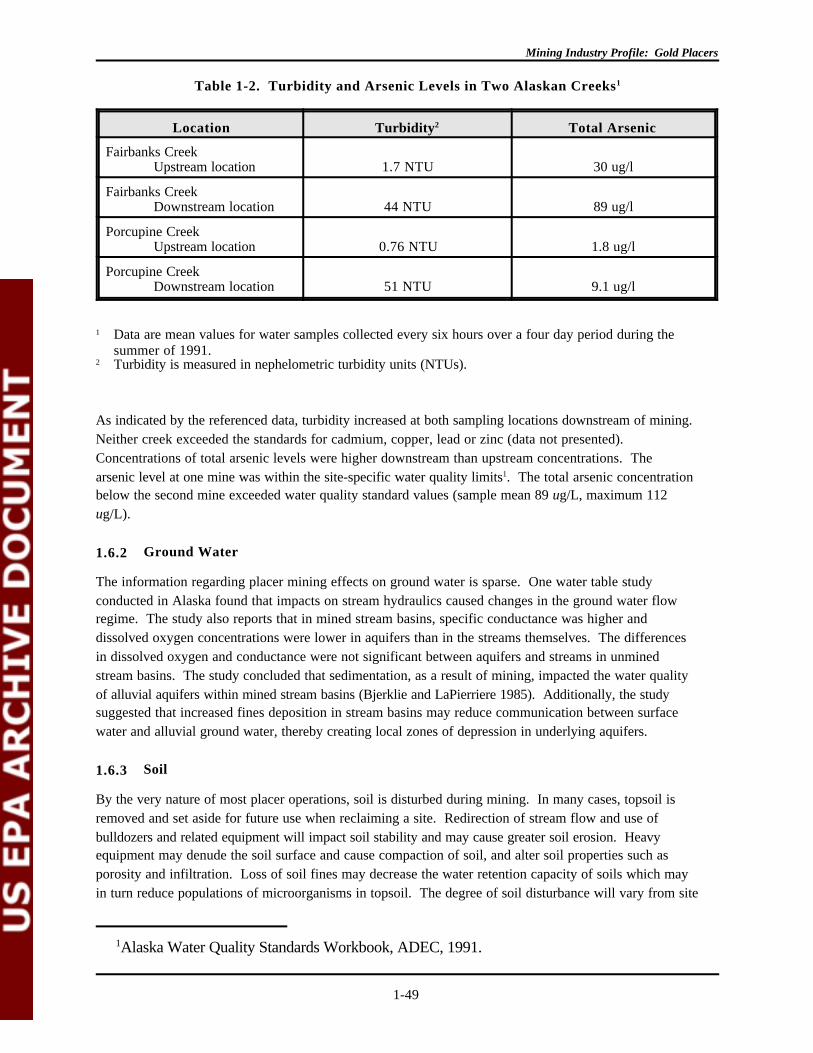
Mining Industry Profile: Gold Placers
1Alaska Water Quality Standards Workbook, ADEC, 1991.
1-49
Location Turbidity2 Total Arsenic
Fairbanks CreekUpstream location 1.7 NTU 30 ug/l
Fairbanks CreekDownstream location 44 NTU 89 ug/l
Porcupine CreekUpstream location 0.76 NTU 1.8 ug/l
Porcupine CreekDownstream location 51 NTU 9.1 ug/l
1 Data are mean values for water samples collected every six hours over a four day period during thesummer of 1991.
2 Turbidity is measured in nephelometric turbidity units (NTUs).
Table 1-2. Turbidity and Arsenic Levels in Two Alaskan Creeks1
As indicated by the referenced data, turbidity increased at both sampling locations downstream of mining. Neither creek exceeded the standards for cadmium, copper, lead or zinc (data not presented). Concentrations of total arsenic levels were higher downstream than upstream concentrations. Thearsenic level at one mine was within the site-specific water quality limits1. The total arsenic concentrationbelow the second mine exceeded water quality standard values (sample mean 89 ug/L, maximum 112ug/L).
1.6.2 Ground Water
The information regarding placer mining effects on ground water is sparse. One water table studyconducted in Alaska found that impacts on stream hydraulics caused changes in the ground water flowregime. The study also reports that in mined stream basins, specific conductance was higher anddissolved oxygen concentrations were lower in aquifers than in the streams themselves. The differencesin dissolved oxygen and conductance were not significant between aquifers and streams in unminedstream basins. The study concluded that sedimentation, as a result of mining, impacted the water qualityof alluvial aquifers within mined stream basins (Bjerklie and LaPierriere 1985). Additionally, the studysuggested that increased fines deposition in stream basins may reduce communication between surfacewater and alluvial ground water, thereby creating local zones of depression in underlying aquifers.
1.6.3 Soil
By the very nature of most placer operations, soil is disturbed during mining. In many cases, topsoil isremoved and set aside for future use when reclaiming a site. Redirection of stream flow and use ofbulldozers and related equipment will impact soil stability and may cause greater soil erosion. Heavyequipment may denude the soil surface and cause compaction of soil, and alter soil properties such asporosity and infiltration. Loss of soil fines may decrease the water retention capacity of soils which mayin turn reduce populations of microorganisms in topsoil. The degree of soil disturbance will vary from site
Mining Industry Profile: Gold Placers
1-50
to site and there are measures being used to minimize erosion and other impacts to soil. In Alaska, frozenground or permafrost may suffer greater long-term damage due to the sensitivity of the environment. Specific data on soil disturbances were not available.
1.6.4 Wetlands
Mining activities, particularly those mining recent alluvial deposits are likely to impact wetlands during theremoval of vegetation and soils as well as the removal of the gravels that support wetland hydrology. Reclamation of the hydrologic, soil and vegetation parameters that support wetlands is currently aninexact science and the level of success in these efforts is yet to be determined on a large-scale basis.
No discussions of placer mining impacts on wetlands were located, nor has information regarding theacreage impacted by placer operations with U.S. Army Corps of Engineers Section 404 permits beenobtained. However, a discussion of Section 404 dredge permits is included in the regulatory section of thisreport.
1.6.5 Wildlife
Wildlife is impacted by placer mining through the physical disturbance of stream channels, the addition ofsediments to the streams, and the presence of human activities and heavy equipment in what are typicallyremote areas.
Aquatic and terrestrial wildlife may be impacted by the disturbance of stream beds and adjacent alluviumby mining activities. Mining may present a physical barrier to fish migration through disruption ordiversion of the active channels. Analysis of data collected during the 1985 field season found that thegreater the length of disturbance within a mined stream channel, the lower the fish density upstream. Theriparian areas disturbed by mining activities are typically used by birds and mammals for food, shelter andwatering. Studies indicate that even on properly reclaimed areas, wildlife values are low for the first 10 to15 years or until a relatively diverse riparian community can develop (ADEC 1986).
High sediment concentrations and turbidity adversely impact fish and aquatic invertebrates. The directimpacts from sediment on arctic grayling, the principal game fish within many Alaskan streams, includegill damage, reduced fertility, and changes in blood chemistry. Reproduction is inhibited when spawninggrounds are lost to siltation and eggs are suffocated when covered by excess sediment. Additionally, fryshow decreased survival rates in waters with high levels of sediment (ADEC 1986; Reynolds 1989).
Increases in turbidity levels do not cause direct effects on fish populations but can interfere with visualactivities such as feeding and spawning. Additionally, a study of primary productivity (measured bydissolved oxygen and chlorophyll concentrations) showed a loss of productivity within streams impactedby mining. In the most severely impacted streams, primary productivity dropped to zero. The decreasesin productivity, and the corresponding reduction in the food available at the lowest level of the food chain,were directly related to increases in turbidity (Reynolds 1989; Van Nieuwenhuyse and LaPierriere 1986).
Streams provide a general habitat for native fish populations. In addition, specialized stream habitats maybe needed by certain species for spawning and rearing. Mining tends to eliminate many of theirregularities in a stream channel that provide variations in habitat such as bank and channel vegetation,shade, pools, riffles and bed texture. Some impacts from mining that might not threaten the life of
Mining Industry Profile: Gold Placers
1-51
individual fish may greatly affect the habitat needed by the species for successful spawning and rearing ofa new generation of fry. Furthermore, mining can disrupt the food chain by adversely affecting theconditions necessary for the production of aquatic plants and invertebrates.
Although the impact to stream populations was not evaluated, Ray et al. in their 1992 study of twoAlaskan creeks noted changes in water temperature, pH, dissolved oxygen, and specific conductivity. (Ray et al. 1992) Altering parameters such as these can impact aquatic ecosystems. Increases indissolved metals in soil or water may also adversely effect wildlife.
Mining Industry Profile: Gold Placers
1-52
1.7 MITIGATING MEASURES AND REMEDIATION
1.7.1 Tailings
The bare surfaces of tailings piles are often far above the summer water table and may have dry soilsduring the summer. Dry soils limit plant colonization and can cause tailings piles to stagnate in the earlieststages of plant succession. Smoothed tailings piles created by current reclamation practices are generallystill too high above the summer water table for the establishment and growth of the desired plant species. Thus, the rate of plant succession is not increased by smoothing operations. Peat and topsoil respreadonto tailings piles may actually retard plant succession by absorbing rainwater and keeping the underlyingsediments even drier than they would be without peat. This hinders root penetration into the soil. Evengrasses seeded onto reclamation areas can reduce soil moisture and inhibit or delay the establishment andgrowth of native plants in northern Alaska (Cooper and Beschta 1993).
One study found that for natural revegetation to be successful, the surface soil texture must contain atleast 10% fine sand, silt and/or clay. Also, the soil moisture level must be between slightly dry and moistfor natural revegetation to occur, in other words, the surface six inches must be moist, but not saturatedduring at least part or all of the growing season. Finally, colonizing type plants must be adjacent or veryclose on the up-wind side of the disturbed area to provide the seeds necessary for natural revegetation(Davidson 1993).
1.7.2 Stream Channel
Placer mining of streams can severely alter the existing natural channel. Impacts include: removal oflarge, instream substrate, including boulders and woody debris; clearing of riparian vegetation from thefloodplain; relocation (diversion) and straightening (reducing sinuosity and increasing gradient) of thestream channel; and isolating side channels from the main channel (Blanchet and Wenger 1993).
Scannell (1993) states that a stream system can be considered to have three conditions: what it used tobe, which we may not even know; what it is now, which we can determine through sampling; and what itcan become. We can often predict what it can become and what uses it can support by the type ofstream channel, the flooding pattern of the stream, and even by how much money is available forreclamation. In his study, Scannell stressed that we should not equate the attainable habitat with what weperceive to be the undisturbed habitat. Instead, this study suggested that we define new habitat goals forthe stream channel and work to attain them. Although it may not be practical to reclaim the hundreds ofmiles of disturbed stream habitat or to restore these streams to natural, or pre-mined, conditions, we canconsider these streams in terms of what beneficial uses they now support and what attainable uses theymight have (Scannell 1993).
Streams channels provide native species of fish with habitats necessary for migration, spawning andrearing. In addition, stream quality influences the aquatic productivity of benthic invertebrates which inturn provide food for larger fish. As a result, wildlife, and especially aquatic wildlife, can be impacted bydisruptions to any of the various habitats necessary for any of the stages in the life-cycle of a species. However, in restoring a disturbed stream channel, care must be taken not to try and force-fit a specifichabitat to the existing topography of a site. Another study pointed out that stream channel gradients mustbe allowed to vary in relation to the topography. In the long-term, variation in channel planform, shapeand gradient will provide a variety of fish habitat throughout the stream such as pools, runs, riffles, andrapids (Latoski and Chilibeck 1993).
Mining Industry Profile: Gold Placers
1-53
In remediating a mined portion of stream channel, Blanchet and Wenger (1993) identified severalrestoration measures that can be employed to improve fish habitat such as:
• Replacing large stream substrate, including rocks and/or wood, to increase pool habitat andcover in disturbed channel reaches
• Revegetating disturbed streambanks to increase nearshore cover and wood debris supply
• Developing side channel or slough access for fish fry in disturbed areas
• Accessing adjacent abandoned settling ponds and old channels to provide additional offchannelrearing habitat.
This study went on to describe several methods for constructing instream structures to provide anincrease in habitat diversity. These structures include boulders and boulder clusters keyed into thechannel bottom; vortex rock weirs which are cross channel boulder structures V'ed slightly upstream andwith a spacing between individual boulders; log barbs consisting of wooden logs keyed into thestreambank between the high and low water levels and with the instream portion pointing upstream; rootwads installed and anchored into instream pools to provide additional cover within the pool; and sprucetree revetments utilizing beetle-killed trees felled and attached along the stream bank using earth anchorsto provide diverse shelter and cover for fish fry even in relatively swift water (Blanchet and Wenger1993).
1.7.3 Floodplain
Floodplains provide a means by which streams can maintain a level of equilibrium with the stream channelduring times of flood. A natural floodplain provides room for a flooded stream to spread out and slowdown, thereby reducing the erosive force of the water. Vegetation on the floodplain further helps todissipate the energy of a flood-swollen stream and also helps to anchor the sediments to prevent erosion. In fact, floodplains are often the site of sediment deposition. This deposition helps to enrich the soils andmake them more fertile.
Placer mining can destroy a stream's natural floodplain, replacing a broad sinuous channel and floodplainwith a deep narrow channelized stream that concentrates all of its erosive power in a small area ofdisturbed sediments. The inevitable result is increased erosion of the stream channel and banks andincreased turbidity of the down stream water.
Floodplains can be rebuilt following placer mining and stabilizing vegetation can be reestablished eitherthrough reseeding or mature plantings. Individual site conditions may dictate the means for rebuilding thefloodplain. To protect against erosion, stream channels should be armored with the coarsest materialavailable. Gravels from piles left by mining can be used to fill in settling ponds, old stream channels andother unnatural depressions. Excess gravels can be blended into the valley slope along the floodplain'smargin. Depending on the geometry of the valley and stream channel, floodplains can be located on oneor both sides of a stream. Typically floodplains are located on the inside of bends or meanders and alongboth sides in straight reaches. Double terraces can be constructed with the lower terrace designed tocarry a 20 to 50 year flood, and the capacity of the upper terrace designed to carry a 100 year flood(Karle 1993).
Mining Industry Profile: Gold Placers
1-54
One of the problems to be considered when rebuilding a floodplain after mining has disturbed the valley isthe occurrence of a large flood before revegetation can occur. The choice between reseeding andmature plantings may be based on the probability of a damaging flood occurring before seedlings canbecome well enough established to withstand a flood. The probability of a flood occurring within a givenperiod of time can be calculated using the following equation from Karle (1993). The probability J that aflood P will be equalled or exceeded in N years is:
J=1-(1-P)N
For example, in an estimated five year time period for revegetation to occur, there is a 67% probabilitythat a 5-year flood will occur or be exceeded, or a 41% probability that a 10-year flood will occur or beexceeded, and a 23% probability that a 20-year flood will occur or be exceeded (Karle 1993).
To prevent erosion of the floodplain and to encourage sediment deposition from floodwaters, brush can beplanted in clumps or in linear plantings perpendicular to the stream channel. In addition, small circularridges made by the tracks of a bulldozer driving in a pattern of tight turns can be effective in trappingprecipitation runoff and small particles of sediment and airborne seeds as they tumble across theroughened surface. These small ridges have also been shown to be effective in trapping sediment wheninundated by a flood (Karle 1993).
1.7.4 Soils
Soils are more than a veneer of inorganic dirt or fine-grained mineral particles over bedrock. A true soilis a combination of both mineral and organic (living and dead) material. Top soils are especially rich inorganic matter. Plants require many nutrients provided by soils for proper health and growth. In somecases, revegetation after placer mining may be as simple as stabilizing the site and allowing naturalrevegetation to occur. In other cases, it may require replacing top soil and reseeding or replanting.
According to Helm (1993), one aspect of plant establishment is the formation of mycorrhizae on the plantroots. Mycorrhizae are symbioses between plants and fungi which are essential for growth of most plantspecies under field conditions. The fungi help the plant absorb nutrients from the soil while the plantprovides energy for the fungi. However, microbial communities in the rooting zone may be disrupted bynatural or man-made disturbances such as glaciers, floods or placer mines.
In reestablishing vegetation on a mined site, mycorrhizal fungi propagules may enter the rooting zone ofplants by natural dispersal or by their presence in topsoil or soil transfer treatments. Many placer minesare long and narrow and have a good source of propagules next to the site. Topsoil that is fresh or hasnot been stockpiled for too long may have viable fungi propagules present. If not, the rooting zone ofseedlings or cuttings can be treated (or inoculated) with viable soil from the rooting zone of nearby plants. Different plant species can survive for varying lengths of time without mycorrhizae and studies are stillunderway to fully understand the requirements of mycorrhizal formation (Helm 1993).
1.7.5 Mined Land Remediation
To be truly successful, remediation of a mined area needs to be undertaken with a unified ecosystemapproach. Piecemeal attempts at solutions will generally not fully or successfully restore a section ofplacer mined stream channel. The goal of a remediation program should include the restoration of the
Mining Industry Profile: Gold Placers
1-55
stream channel, floodplain, and vegetation to recreate a valley bottom ecosystem similar to that occurringin undisturbed streams (but not necessarily identical to the conditions existing in a given stream prior tomining). This interaction will restore the ecological functions of these ecosystems. Goals should also beto initiate natural plant succession processes on the streambanks, floodplain and any non-floodplainportions of the mined area which will allow succession to operate at a rate similar to that on naturalfloodplains.
Latoski and Chilibeck (1993) state that miners must be made aware that cost effective restoration beginsat the planning stage. Restoration requirements can then be integrated into the mining operation withminimal cost to the miner (e.g., stockpiling organic material and boulders, separating overburden andwashed materials, etc.).
In order to implement a successful remediation project, miners should start with a clear statement ofrealistic goals or objectives. This should be more than just a simple recitation of the procedures to be usedin restoring the stream after mining has ceased; otherwise, the restoration project may become an effortto apply a specific technique regardless of results rather than achieve a specific condition in the stream. With clear objectives identified beforehand, proper site-specific measures can be employed so thateffective stream remediation is much more easily achieved.
Mining Industry Profile: Gold Placers
1-56
1.8 CURRENT REGULATORY AND STATUTORY FRAMEWORK
Gold placer mining activities must meet the requirements of both Federal and state regulations. Environmental statutes administered by EPA or the states, such as the Clean Water Act (CWA), apply tomining sites regardless of the status of the land on which they are located. The extent to which otherFederal regulations apply depends on whether a mining operation is located on federally owned land. Federal regulations exist for operations on lands managed by the U.S. Bureau of Land Management(BLM), the U.S. Forest Service (FS), the U.S. Fish and Wildlife Service (FWS), the National ParkService (NPS), and other management agencies. In addition, the U.S. Army Corps of Engineers haspromulgated rules for construction and mining activities that have the potential to impact wetlands andnavigable waters. Finally, operations must comply with a variety of state requirements, some of whichmay be more stringent that Federal requirements.
This section summarizes the existing Federal regulations that may apply to gold placer operations. It alsoprovides an overview of the operational permitting and water quality and on quality regulations in two goldplacer states, Alaska and Colorado.
1.8.1 Environmental Protection Agency Regulations
1.8.1.1 Resource Conservation and Recovery Act
The EPA implements the Resource Conservation and Recovery Act (RCRA) to protect human health and the environment from problems associated with solid and hazardous wastes. Mining wastes areincluded in the Act's definition of solid waste and in 1978, when EPA proposed regulations for the SubtitleC hazardous waste program, special management standards were proposed for mining wastes. However,in 1980, RCRA was amended to include what is known as the Bevill Amendment (§3001(b)(3)(A)). TheBevill Amendment provided a conditional exclusion from RCRA Subtitle C hazardous waste requirementsfor wastes from the extraction, beneficiation, and processing of ores and minerals.
The exemption was conditioned upon EPA's preparation of a report to Congress on the wastes and asubsequent regulatory determination as to whether regulation under Subtitle C was warranted. EPA metits statutory obligation with regard to extraction and beneficiation wastes with the 1985 Report toCongress: Wastes from the Extraction and Beneficiation of Metallic Ores, Phosphate Rock,Asbestos, Overburden from Uranium Mining, and Oil Shale. In the subsequent regulatorydetermination (51 FR 24496; July 3, 1986), EPA indicated that extraction and beneficiation wastes(including gold mining and milling wastes) should not be regulated as hazardous but should be regulatedunder a Subtitle D program specific to mining waste.
EPA subsequently studied processing (i.e., smelting and refining) wastes and in 1990 submitted its Reportto Congress on Special Wastes From Mineral Processing. This report covered 20 specific mineralprocessing wastes; none involved gold processing wastes. In June 1991, EPA issued a regulatorydetermination (56 FR 27300) stating that regulation of these 20 mineral processing wastes as hazardouswastes under RCRA Subtitle C is inappropriate or infeasible. Any mineral processing wastes notspecifically included in this list of 20 wastes no longer qualifies for the exclusion (54 FR 36592).
As discussed above, wastes from the extraction and beneficiation of minerals (including gold placeroperations) are generally excluded from RCRA Subtitle C requirements by the Bevill Amendment andEPA's subsequent regulatory determination. EPA interprets this exclusion to encompass only those

Mining Industry Profile: Gold Placers
1-57
wastes uniquely associated with extraction and beneficiation activities: the exclusion does not apply towastes that may be generated at a facility but are not uniquely related to extraction or beneficiation. Forexample, waste solvents that meet the listing requirements as a hazardous waste under 40 CFR Section261.31 and are generated at an extraction or beneficiation facility by cleaning metal parts (e.g., activitiesnot uniquely related to extraction or beneficiation) are considered listed hazardous wastes and regulatedas such. These wastes must be managed as any other hazardous waste, subject to the Federalrequirements in 40 CFR Parts 260 through 271 (or State requirements if the State is authorized toimplement the RCRA Subtitle C program), including those for manifesting and disposal in a permittedfacility.
1.8.1.2 Clean Water Act
Under Section 402 of CWA (33 USC §1301, et seq.), all point source discharges to waters of the UnitedStates from industrial and municipal sources must be permitted under the National Pollutant DischargeElimination System (NPDES). A point source is defined as any discreet conveyance, natural ormanmade, which includes pipes, ditches, and channels. NPDES permits are issued by EPA or delegatedstates.
Under Sections 301 and 302, NPDES permittees must meet specified effluent limitations establishedunder the CWA. Effluent limitations may be either technology-based or water-quality-based. Withrespect to technology-based limitations, there are separate limitations applicable to existing sources ofdischarges. They include, but are not limited to, best practicable technology (BPT) and best availabletechnology economically achievable (BAT). Also, under the New Source Performance Standards(NSPS), new sources must use the best available demonstrated technology (BADT).
Technology-based limitations specifically applicable to the gold placer mine subcategory of the OreMining and Dressing Point-Source Category are codified in 40 CFR 440 Subpart M. These standards areonly applicable to large placer mining operations (defined as mines which beneficiate more than 1,500cubic yards of ore per year or dredges handling more than 50,000 cubic yard of ore per year). There areno regulations under the CWA specific to small placer mine operations.
The effluent limitation guidelines contain a storm exemption for a treatment systems designed,constructed, and maintained to contain the maximum volume of flow which would result from four hoursof beneficiation plus a five-year, six-hour rainfall. Such facilities must meet best management practice(BMP) standards, as well. BMP standards require that NPDES permits include, to the greatest extentpossible, provisions addressing such things as surface water diversions, berm construction, and pollutantmaterials storage (U.S. EPA 1988).
In addition to such technology-based limitations, an NPDES permit may contain water-quality-basedlimitations. The CWA requires EPA to ensure that discharges of pollutants from a point source intowaters of the United States will not interfere with the water quality. States are required to develop waterquality standards to protect the designated uses of the receiving water. Where technology-basedstandards are inadequate to provide such water quality protection, water quality-based effluent limitationsmust be developed. Permit writers must determine that the technology-based standards are sufficient toensure that such standards are being met.
Mining Industry Profile: Gold Placers
1-58
Some discharges from mine sites do not meet the definition of point source discharge because they arenot controlled through a discrete conveyance. These types of discharges are frequently considerednonpoint source discharges. Under Section 319 of the CWA, states are required to prepare nonpoint-source assessment reports and to develop programs to address such discharges.
Under Section 402, EPA promulgated regulations in 1990 requiring NPDES permit applications for pointsource storm water discharges from industrial facilities, including active and inactive/abandoned mine sitescontaminated by contact with overburden, raw material, etc.. These facilities were required to submitpermit applications by October 1, 1992 (U.S. EPA 1990b). Under EPA's strategy to implement permittingfor industrial sources of storm water, EPA and some delegated States have issued general permits whichcover mining sites. Some mining sites will be addressed with individual permits. However, these generalpermits do not address inactive mines on Federal lands; for these, EPA is developing a separate set ofgeneral permits.
In recent years in Alaska, the State Water Quality Standards for turbidity (normally 5 NTU abovebackground) and total arsenic (0.05 mg/L) have been incorporated into NPDES permits. The turbiditylimit may be modified depending upon the amount of dilution provided by the receiving stream. In 1989and 1990, for example, there were 363 and 64 applications, respectively, for NPDES placer miningpermits. From the 1989 applications, 338 (93%) received modified turbidity limitations allowing greaterthan 5 NTU; in 1990, 60 (94%) received similar modifications. (ADEC 1990.)
1.8.1.3 Dredged and Fill Material
Under Section 404 of the CWA, the U.S. Army Corps of Engineers (COE) is authorized to issue permitsfor the discharge of dredged or fill materials, including that from gold placer mining operations, intonavigable waters at specified disposal sites (Permit form 4345). Such permits may only be issued afternotice and the opportunity for public hearings has been provided. A State may administer its own permitprogram governing the discharge of dredged and fill materials into navigable waters by submitting to EPAa detailed description of the proposed program (and generally obtaining approval of such program) inaccordance with the CWA.
Also under Section 404, EPA is authorized to prohibit the specification (i.e., use) of a defined area (orrestrict the use of such an area) as a disposal site whenever EPA determines that, after notice and theopportunity for a hearing, discharge of such materials will have an unacceptable adverse effect onmunicipal water supplies, shellfish beds, fishery areas, wildlife, or recreational areas (in making thisdetermination EPA must consult with the COE). The CWA requires that in specifying a particulardisposal site in a 404 permit, the COE must apply guidelines developed by the EPA, in conjunction withCOE. These guidelines are found at 40 CFR 230. The guidelines are intended to restore and maintain thechemical, physical, and biological integrity of waters of the United States.
Section 404 authority has been construed to extend to all waters of the United States, not just navigablewaters (33 CFR 328.1). Waters of the United States have been construed to include "wetlands." Therefore, the COE issues permits for discharges to wetlands, as well as other waters of the UnitedStates. Gold mining operations (including placer operations) have a significant potential to physicallyrestructure wetlands (U.S. EPA 1992a).
Mining Industry Profile: Gold Placers
1-59
EPA and the COE use the same definition of wetlands (the U.S. Fish and Wildlife Service uses anotherdefinition). The definition is:
The term "wetlands" means those areas that are inundated or saturated by surface orground water at a frequency and duration sufficient to support, and that under normalcircumstances do support, a prevalence of vegetation typically adapted for life insaturated soil conditions. Wetlands generally include swamps, marshes, bogs, and similarareas (33 CFR 323.2(c)).
The issuance of a permit by COE may be subject to the requirements of the National EnvironmentalPolicy Act (NEPA), as such issuance is deemed a major Federal action significantly affecting the qualityof the human environment (Section 511[c]).
The COE (or a State to which permit program authority has been delegated) may issue individual orgeneral (i.e., Statewide, nationwide, regional) permits. The COE (or an authorized State) may issue ageneral permit, after notice and an opportunity for public hearing, for any category of activities involvingdischarges of dredged or fill materials where the COE (or the State) finds that the activities in suchcategory are similar in nature and will cause only minimal adverse environmental effects when consideredindividually and cumulatively. General permits are widely used to speed up the Section 404 permitting-process, because they do not require detailed, case-specific review. Such permits are issued to the publicat large and authorize specified activities in wetlands and other waters (U.S. EPA 1992b).
Until 1986, all discharges into waters of the United States from mining operations, including placer mining,were regulated by the COE under Section 404 as discharges of dredged materials. However, in this sameyear, EPA and the COE entered into an agreement (updated in 1990) which clarified the jurisdiction ofthe two agencies with respect to placer mining-related discharges. The agreement established that pointsource discharges from placer mining operations would be subject to NPDES permitting by EPA underSection 402, but that some discharges of materials incidental to such operations may still be considereddredged or fill materials, subject to Section 404 permitting by COE (U.S. EPA 1991). Such materialssubject to COE permitting include material used in sediment pond construction and the filling of dredgepits. Materials from gold placer mining operations are subject to NPDES permitting as a waste discharge(U.S. EPA 1992a).
In Alaska (see following discussion of State permits), the State issues a Certificate of ReasonableAssurance that proposed discharges to waters in the State will be in compliance with the Alaska WaterQuality Standards and the Alaska Coastal Management Plan (Department of EnvironmentalConservation, 1990).
Alaska recommends that if it is likely that a mining activity will affect a "wetland" (which includes allsaturated soils and permafrost) a Section 404 permit application should be filed. The COE will decidewhether or not the operation is likely to have an effect on a wetland. Such a decision (a "jurisdictionaldetermination") may be based upon a field inspection of the site or on maps of Alaska (Alaska, DNR,Division of Mining, undated).
Mining Industry Profile: Gold Placers
1-60
1.8.2 Department of the Interior
1.8.2.1 Bureau of Land Management
Gold placer operations on Federal land are subject to Bureau of Land Management (BLM) regulations. All mining claims located on lands managed by the BLM are subject to BLM regulation to prevent"unnecessary and undue degradation" of the Federal lands and resources involved. The BLM's authorityto regulate mining claim operations under this "unnecessary and undue degradation" standard derives fromthe Federal Land Policy and Management Act of 1976 (FLPMA), the statute which sets out the BLM'sgeneral land management and planning authority. Exploration sites are subject to the less-than-5-acreexemption or must submit a plan of operation if greater than 5 acres.
BLM does not have a program geared specifically towards placer mining; placer operations are handledin the same manner as other mining operations with the same permitting, reclamation and bondingrequirements. (BLM 1993a, 1993b.)
The BLM's general surface management regulations governing mining claim operations, which includegold mining operations, are found at 43 CFR Part 3809. These regulations cover general design,operating and reclamation standards, monitoring requirements, bonding requirements, environmentalreview requirements, and remedies for noncompliance. They establish three general use categories formining operations, each eliciting different levels of oversight by the BLM. These categories are (1)casual use operations (i.e., those that normally result in only negligible disturbances of Federal lands andresources and that require no prior notice to or approval from the BLM), (2) notice-level operations (i.e.,those that involve disturbances of 5 acres or less for which the operator must notify the BLM prior tocommencing surface disturbing activities), and (3) plan-level operations (i.e., disturbances of greater than5 acres, and operations in some specified areas, for which the operator must obtain BLM approval of aplan of operations prior to commencing activity).
All operations, including casual use and operations under either a notice or a plan of operations, must beconducted to prevent unnecessary or undue degradation of the Federal lands. All operations must also bereclaimed and must comply with all applicable State and Federal laws, including air and water qualitystandards such as those established under the CAA and the CWA.
All plan-level operations, regardless of operation type (e.g., strip, open-pit, dredge, and placer) will berequired to post a bond. Bond amounts are to be set at the discretion of the BLM (up to $2,000 per acre),depending on the nature of the operation, the record of compliance, and whether it is covered by asatisfactory State bond.
Mining claims located in BLM wilderness study areas are generally subject to stricter regulation thanother mining claims. The regulations covering mining in wilderness study areas are found at 43 CFR Part3802.
The BLM has the authority to issue leases for gold on certain acquired (as opposed to public domain)lands. Although this is rarely done, such leases would be covered by the general regulations applicable tohardrock leasing found at 43 CFR Part 3500.

Mining Industry Profile: Gold Placers
1-61
The National Environmental Policy Act (NEPA) of 1969 requires Federal agencies to consider theenvironmental impact of proposed activities. BLM uses the NEPA process to review proposed miningoperations. A site may require an Environmental Assessment (EA) or an Environmental ImpactStatement (EIS).
1.8.2.2 National Park Service and Fish and Wildlife Service
Location of new mining claims is generally prohibited in most areas managed by the National ParkService (NPS) and the Fish and Wildlife Service (FWS). Neither the NPS nor the FWS have a specificprogram for gold placer operations. Regulations at 36 CFR Part 9 govern activities on land managed bythe NPS under patented and unpatented mining claims in existence prior to inclusion of the land under theNPS. The NPS regulations restrict water use, limit access, and require permits and completereclamation.
The regulations of 50 CFR Part 29 govern mining activities under mineral rights on lands managed by theFWS. The FWS regulations are fairly general and require that operations prevent, to the greatest extentpossible, the damage, erosion, pollution, or contamination of the area. Leasing on FWS land is allowedonly when operations are not incompatible with the aims of the refuge or other FWS center.
1.8.3 Department of Agriculture (Forest Service)
Forest Service regulations are similar to BLM regulations and provide for consultation with appropriateagencies of the U.S. DOI to review technical aspects of proposed plans of operation. Unlike BLM, theForest Service regulations do not specify acreage limitations. Although the BLM has generalmanagement authority for the mineral resources on Forest Service lands, the BLM regulations governingactivities under mining claims do not apply to units of the Forest Service. Instead, surface uses associatedwith operations under mining claims on Forest Service lands are governed by regulations in 36 CFR Part228, Subpart A. The general regulations apply to placer operations, however; there are no specialprovisions for these operations.
The Forest Service requires a notice of intent to operate; this notice is filed with the district ranger. If thedistrict ranger determines that the operations will be likely to cause significant disturbance of surfaceresources, the operator must submit a proposed plan of operations. Neither a notice of intent nor aproposed plan of operation are required for the locating or marking of mining claims, mineral prospectingthat will not cause significant surface disturbance, operations that do not involve mechanized equipment orthe cutting of trees, or uses that will be confined to existing roads.
Like the BLM, the Forest Service may require an environmental assessment or environmental impactstatement according to the National Environmental Policy Act (NEPA) program. Bonds are required tocover the cost of reclamation. Regulations specific to mining operations in Wilderness Areas areaddressed in 36 CFR Part 293.
1.8.4 State Programs
1.8.4.1 Alaska
Exploration, claim staking, permitting, mining, and reclamation in Alaska is regulated by several Stateagencies. (Federal agencies also issue permits for activities in Alaska; see above). Among the State
Mining Industry Profile: Gold Placers
1-62
regulatory agencies with regulatory authority applicable to gold placer mining operations are: theDepartment of Natural Resources' Division of Mining; the Alaska Department of EnvironmentalConservation; and the Alaska Department of Fish and Game. State permitting authorities are discussedbelow. Also included is an overview of Alaska's reclamation and bonding regulations, as they apply togold placer mining operations.
The Annual Placer Mining Application
The Annual Placer Mining Application (APMA) form must be completed and submitted to the Division ofMining (DoM) for all mining activities except for lode or hardrock mining. The APMA form is not itself apermit, but rather an application which may serve as the basis for the issuance of a number of requiredpermits in Alaska. If this form is submitted along with a $100 application fee, the completed form is sentby DoM to numerous Alaska (and Federal) agencies, such as the Alaska Department of Fish and Game(see discussion of "Title 16 permits" below) and may, at the discretion of receiving agencies, serve as thebasis for issuance of their respective permits. Federal agencies which receive copies of the APMAinclude the Federal land managers (Forest Service or Bureau of Land Management) (if the site is onFederal lands) and the National Park Service (if the site is on land under its control).
The APMA saves time for miners in that they may not have to complete individual permit applications foreach permit required in the State. However, the APMA will not suffice as the application for a NPDESor Section 404 permit, as specific permit application forms are required for such permits. Also, sinceacceptance of the form for the issuance of a particular permit (e.g., National Park Service permit) isdiscretionary, the particular agency receiving the permit application form may request that additional orsupplemental information accompany the APMA form.
The APMA form includes a reclamation plan form and a Statewide bond pool form (see followingdiscussion on reclamation and bonding regulations). The bonding pool was established in Alaska foroperations over five acres and which are on State land and for all unreclaimed areas on Bureau of LandManagement operations. The total cost to join the pool is $150 per acre.
The application requests information concerning the intended placer mining method (e.g., suction dredge,bucket line dredge), make-up water supply, recycling/settling pond system (e.g., length and depth),overburden, access, and exploration trenching and drilling. Also, the form contains a Coastal ZoneManagement (CZM) Certification Statement (Certification Statement) that must be completed byapplicant's whose proposed operation is located in the Coastal Zone. The Certification Statement isintended to satisfy the requirements of the Federal Coastal Zone Management Act, which requires,among other things, that applicants for permits to conduct activities affecting land or water use in Alaska'scoastal area provide certification that the activities will comply with the standards of the Alaska CoastalManagement Program (State of Alaska, Department of Natural Resources, Division of Mining 1992).
Title 16 Permit
This permit is issued by the Alaska Department of Fish and Game under Alaska law. Its purpose is toprotect Alaska's anadromous fish, especially salmon. The mining activity must not interfere with thesafety of the fish. Also, the Department's permitting authority extends to the establishment of a"fishway," which means basically that mine sites must provide adequate passage for the fish. Title 16
Mining Industry Profile: Gold Placers
1-63
permits require the best management practices be applied to ensure that normal flow of creek issegregated from active mining area.
Dam Safety
The Alaska Department of Natural Resources, Division of Water issues permits to ensure dam safety. Plans for dam construction must be reviewed and approved by the Division prior to construction, andmonitoring is conducted during construction to ensure compliance with the approved plans. The State hasthree categories of dams based on hazard risks: high, significant and low risk. The categories areessentially similar to that used by the Army COE. Dams that are categorized as high or significant riskrequire inspections at a minimum of once every three years. Low risk dams require inspections at leastonce every five years. Inspections are the responsibility of the dam operator, although the State reviewsand approves qualifications of the individuals or firms selected to perform the inspections. (Alaska DNR1993.)
According to the laws and regulations of the State, a permit is required to close or abandon a dam. Theapplicable State statute is the Alaska Dam Safety Act (1987); Dam Safety Regulations (1989) arecontained in 11.A8293 Article 3. (Alaska DNR 1993.)
Other State Permits
Other permits are required by the State for activities related to gold placer mine operations, but areoutside the scope of this examination. One such permit concerns water access rights of miners. Generally, a permit to allow miners' access to waters for mining operations is required from the DNR'sDivision of Land and Water.
Reclamation and Bonding
Under Alaska Statute 27.19, Alaska requires reclamation plans and bonding for all material miningoperations on State, Federal, municipal, and private lands, where such operations involve a mined area offive acres or more. (The APMA, discussed previously, includes forms to address these requirements). Also, BLM requires reclamation bonding of all operations on Federal lands regardless of size.
The regulations promulgated pursuant to Statute 27.19 contain reclamation performance standards whichrequire that miners reclaim areas disturbed by mining operations so that any surface that will not have astream flowing over it is left in stable condition. "Stable condition" is one which allows for "...thereestablishment of renewable resources on the site within a reasonable period of time by naturalprocesses" and which can be expected to return waterborne soil erosion to pre-mining levels within oneyear after the reclamation is completed and can achieve revegetation.
Reclamation regulations also address bonding requirements and reclamation plan submittal and approval. At least 45 days before commencement of mining activities, a miner must submit a proposed reclamationplan to the State for approval. Within 30 days of determining that the plan is complete, the State mustapprove, disapprove, or conditionally approve the plan. The plan does not take effect until the minersatisfies the bonding requirements.
Mining Industry Profile: Gold Placers
1-64
Plans submitted on forms other than the one provided by the State (i.e., APMA) must include informationsuch as:
• list of all properties, mining locations, and leases on which the mining operations are to beconducted;
• a map showing the vicinity of the operation;
• general description and diagram of the operation and mined area, including acreage to bemined in each year covered by the plan;
• estimated number of yards or tons of overburden or waste and ore/materials to be mined eachyear; and
• a description of the reclamation measures to be taken, including a time schedule.
In addition to plan submittal (and approval), all miners except for exempt miners (discussed below), mustcomply with bonding provisions. Bonding requirements allow for any number of options to satisfy thefinancial assurance provisions. Some of the options include:
• participating in a statewide bonding pool (which basically allows a miner to pay into a pooleach year 15% of the miner's total bond amount for the year, plus an annual fee of fivepercent the total bond amount [this usually results in a bonding pool deposit of $112.50 peracre and a fee of $37.50 per acre]);
• posting a performance bond [either a corporate surety bond or a personal bond accompaniedby a letter of credit, certificate of deposit, or cash or gold deposit]; or
• posting a general performance bond assuring that reclamation standards are met and which isfor no less than $750 per acre of mined area (11 AAC 97 1992).
Operations smaller than five acres are exempt from bonding requirements, as well as the requirement tosubmit a reclamation plan. However, such exempt miners must file, annually, a "letter of intent" prior tocommencement of mining activities. The letter must include most of the information required for non-exempt mining operation required in reclamation plans, but non-exempt miners do not have to obtainapproval of the data in the letter. The data required in the letter of intent includes the following: a list ofproperties and mining location or leases on which operations will be conducted; a map of the generalvicinity of the mining operation; and total acreage to be reclaimed in the year covered by the letter ofintent.
1.8.4.2 Colorado
The primary State mining law is the 1976 Colorado Mined Land Reclamation Act (MLRA) (34-32-101 etseq. C.R.S.), which succeeded the Colorado Open Land Mining Act of 1973. (ELI 1992)
Colorado has a number of placer mines, although the number in actual operation at any one time varies. Almost all of the placer mines in Colorado operate on an intermittent basis, fluctuating seasonally or withmarket prices. Colorado does not have specific regulations for placer mining; placer mines in the statemust adhere to the same regulations as other mines. Colorado regulations are fairly generic for all miningoperations; specific requirements are written into each individual permit (Colorado DNR 1993).
Mining Industry Profile: Gold Placers
1-65
The Colorado Department of Natural Resources, Division of Minerals and Geology administers theMLRA, while the Mined Land Reclamation Board issues rules and regulations, reviews permits, andoversees enforcement. Nonpoint source and ground water discharges at mining operations also are underthe jurisdiction of the Division of Minerals and Geology.
Although Colorado does not have specific guidance or policy for placer operations, some of the applicablemining program elements are highlighted below.
Mining and Reclamation
All placer operations must have a permit if they mine and sell gold. Regular operating permits arerequired for mining operations affecting ten acres or more, or extracting 70,000 tons/annually (mineraland/or overburden). The State issues limited impact operation permits to facilities less than ten acres insize. A further distinction is made for those operations that are less than ten acres and are located in oradjacent to stream channels, or on certain Federal or State recreational or wilderness lands. Approximately 50 percent of the State's placer operations are less than ten acres in size. Specialapplications for two acre limited impact facilities are processed on an expedited basis and require financialassurance bonds of only $1500 (ELI 1992; Colorado DNR 1993). New mines require reclamation permitsunder the MLRA prior to beginning operations.
A notification of temporary cessation is required if a facility will cease operations for more than 180 days. The facility must ensure that the facility is stabilized prior to cessation, and the Division of Minerals andGeology may conduct inspections to verify facility compliance with this. The Mined Land ReclamationBoard typically reviews the temporary cessation notice (Colorado DNR 1993). Because most placeroperations in the State are intermittent, the temporary cessation policy is particularly important to placermining operations. A five year period is allowed for temporary cessation; after an inactive period of fiveyears, a facility must begin reclamation. A facility may apply for a second five year period of inactivity,although the Mined Land Reclamation Board will conduct a thorough review of the facility plans prior toauthorization.
All permits issued by the Mined Land Reclamation Board require financial assurances, including placeroperations. The dollar amount of financial assurances varies depending on the type and extent ofoperation, and the estimated reclamation costs. Financial assurances are required throughout the life ofthe permit until reclamation has concluded. Concurrent reclamation of placer operations is encouraged bythe State through bond mechanisms. Bonds are typically lower for facilities conducting concurrentreclamation. Usually a disturbed acreage limitation is listed in a facility's reclamation permit, no more thantwo acres can be disturbed at any one time for example, and prior to excavating a new area the old areamust be reclaimed (Colorado DNR 1993).
Counties with zoning requirements may issue, through the zoning committees, a certificate of designation,which is akin to a land-use permit. The level of involvement of Counties in issuing mining permits is quitevariable throughout the State. Sites on public lands may be jointly reviewed by the State and BLM orForest Service.
Mining Industry Profile: Gold Placers
1-66
Surface Water Discharges
Water quality and releases related to mining are regulated by the Colorado Department of Health, WaterQuality Control Division and the Water Quality Control Commission under the State's Water QualityControl Act. Water quality standards are set by the Division, and permits are issued for discharges tosurface water through NPDES/Colorado Discharge Permit System (CDPS) permits. Colorado has afederally-approved NPDES program. The Permits and Enforcement Section, Industrial Unit, of theWater Quality Division issues CDPS permits, which are required for all active mines that have a pointsource discharge to surface water.
There is a CDPS general permit for placer mining. The general permit covers water used to transportalluvial material through a separator, runoff crossing the disturbed area, surface and ground waterassociated with placer mining activities, and other process water as determined by the Water QualityControl Division (ELI 1992). There is a CDPS general permit for Stormwater Discharges Associatedwith Metal Mining Operations, Permit No. COR-040000, issued September 14, 1992, and valid throughSeptember 30, 1996 (Colorado DOH 1992). Site specific dredge permits (per Section 404 of CWA) mayalso be required at some placer sites.
Colorado has a Passive Treatment of Mine Drainage (PTMD) program for controlling drainage that is notsubject to NPDES/CDPS requirements. The PTMD program approves construction, operation, and setsstandards for systems used to control mine drainage. The program covers biological, geochemical andphysical drainage control or treatment measures such as cascades, settling ponds, and man-madewetlands (standard reclamation measures are not included under PTMD). (ELI 1992.)
Mining Industry Profile: Gold Placers
1-67
1.9 REFERENCES
Alaska Department of Environmental Conservation. 1986. A Water Use Assessment of SelectedAlaska Stream Basins Affected by Gold Placer Mining. Prepared by Dames & Moore, ArcticHydrologic Consultants, Stephen R. Braund and Associates, L.A. Peterson and Associates, andHellenthal and Associates.
Alaska Department of Environmental Conservation. 1987 (March). Placer Mining DemonstrationGrant Project Design Handbook (prepared by L.A. Peterson & Associates, Inc.). Fairbanks,AK.
Alaska Department of Environmental Conservation. 1988 (June 3). Placer Mine Inspection Form, withan EPA NPDES Compliance Inspection Report cover sheet dated August 2, 1988 and signed byConrad Christianson.
Alaska Department of Environmental Conservation. 1989 (December 19). Decision Record, withattachments.
Alaska Department of Environmental Conservation. 1990. 1990 Annual Mining Report. AlaskaDepartment of Environmental Conservation, Division of Environmental Quality. Fairbanks, Alaska.
Alaska Division of Mining. 1992 (May 6). Alaska Division of Mining Approved Reclamation Plan.Approved by John E. Wood.
Alaska Department of Natural Resources. 1992a (February 21). Alaska Department of NaturalResources Case File Abstract.
Alaska Department of Natural Resources, Division of Geological and Physical Surveys. 1992b(February). Alaska's Mineral Industry 1991 Survey (by T.K. Bundtzen, R.C. Swainbank, J.E.Wood, and Albert Clough). Information Circular 35. Fairbanks, AK.
Alaska Department of Natural Resources. 1992c (April 27). Alaska Department of Natural Resources,State Wide Bond Pool Form.
Alaska Department of Natural Resources, Division of Mining. 1992d. Annual Placer Mining Application,with attachments.
Alaska Department of Natural Resources, Division of Water. 1993. Kyle Cherry, personalcommunication with Michelle Stowers, Science Applications International Corporation, Falls Church,Virginia, on June 15, 1993.
Alaska Department of Natural Resources, Division of Mining. Undated. Letter to potentialminers/prospectors on permits required for mining, reclamation, or mineral exploration in Alaska.
Alaska Miners Association. 1986. Placer Mining -- A Systems Approach. Short Course, AlaskaMiners Association Eleventh Annual Convention, October 29-30, 1986. Anchorage, Alaska.
Argall, G.O., Jr. 1987 (December). "The New California Gold Rush." Engineering & Mining Journal: 30-37.
Bainbridge, K.L. 1979. Evaluation of Wastewater Treatment Practices Employed at Alaskan GoldPlacer Mining Operations, Calspan Corporation Report No. 6332-M-2.
Bjerklie, D.M. and J.D. LaPierriere. 1985 (April). Gold-Mining Effects on Stream Hydrology and WaterQuality, Circle Quadrangle, Alaska. Water Resources Bulletin: 235-242.

Mining Industry Profile: Gold Placers
1-68
Blanchet, D. and Wenger, M. 1993. Fisheries Habitat Restoration in Placer Mined Reaches ofResurrection Creek. In Papers of the Second EPA Placer Mine Reclamation Workshop. U.S.EPA publication # EPA 910-R-93-015.
Boyle, R.W. 1979. The Geochemistry of Gold and Its Deposits. Canada Geological Survey Bulletin280. Canadian Publishing Centre. Hull, Quebec, Canada. 584 pp.
Clark, W.B. 1970. Gold Districts of California. California Division of Mines and Geology, Bulletin193. San Francisco, CA.
Code of Federal Regulations. Section 40, Part 440, Subpart M -- Gold Placer Subcategory. 1989. Office of the Federal Register, National Archives and Records Administration. Washington, DC.
Colorado Department of Health, Water Quality Control Division. 1992 (September). CDPS GeneralPermit, Stormwater Discharges Associated with Metal Mining Operations, Authorization toDischarge Under the Colorado Discharge Permit System, Permit No. COR-040000, IssuedSeptember 14, 1992.
Colorado Department of Natural Resources, Division of Geology and Minerals, 1993. Bill York-Fern,personal communication with Michelle Stowers, Science Application International Corporation, FallsChurch, Virginia, June 9, 1993.
Cooper, D.J. and Beschta, R.L. 1993. Restoration of a Placer Mined Valley Bottom in Interior Alaska:Birch Creek at Steese Highway Mile 99. In Papers of the Second EPA Placer MineReclamation Workshop. U.S. EPA publication # EPA 910-R-93-015.
Cope, L.W., and Rice, L.R. (editors). 1992. Practical Placer Mining. Society for Mining, Metallurgy,and Exploration, Inc. Littleton, CO.
Davidson, D.F. 1993. A Preliminary Inventory of Abandoned Mine Sites on the Chugach Nation Forestand the Present State of the Natural Vegetation. In Papers of the Second EPA Placer MineReclamation Workshop. U.S. EPA publication # EPA 910-R-93-015.
Environmental Law Institute. 1992 (November). State Regulation of Mining Waste: Current State of theArt, prepared under Grant Agreement No. X-818255-01-0, funded by the U.S. EnvironmentalProtection Agency.
Ferguson, J.F. and Gavis, J. 1972. "A Review of the Arsenic Cycle in Natural Waters." WaterResearch: 6:1259-1274.
Flatt, P. 1990 (March). "Fine Placer Gold Recovery Methods." California Mining Journal: 5-8.
Gomes, J.M. and Martinez, G.M. 1983. Recovery of Gold and Other Heavy Minerals From AlluvialDeposits: Equipment and Practices. In The Encyclopedia of Placer Mining (R.A. Hatkoff, ed.) Inter Resources Publications, Lakewood, Colorado.
Harty, D.M. and Terlecky, P.M. 1980. Titanium Sand Dredging Wastewater Treatment Practices,Frontier Technical Associates, Inc. Report No. 1804-1 for the U.S. Environmental ProtectionAgency, Effluent Guidelines Division.
Harty, D.M. and Terlecky, P.M. 1984a (February). "Existing Wastewater Recycle Practices at AlaskanPlacer Gold Mines", Frontier Technical Associates, Memorandum to B.M. Jarrett, U.S. EPA,Effluent Guidelines Division.
Harty, D.M. and Terlecky, P.M. 1984b (February). "Water Use Rates at Alaskan Placer Gold MinesUsing Classification Methods", Frontier Technical Associates, Memorandum to B.M. Jarrett, U.S.EPA, Effluent Guidelines Division.
Mining Industry Profile: Gold Placers
1-69
Harty, D.M. and Terlecky, P.M. 1984c. "Reconnaissance Sampling and Settling Column Test Results atAlaskan Placer Gold Mines", Frontier Technical Associates Report No. FTA-84-1402/1, preparedfor U.S. EPA, Effluent Guidelines Division.
Hatkoff, R.A. 1983. The Encyclopedia of Placer Mining. Inter Resources Ltd. Denver, CO.
Helm, D. 1993. Reclamation, Succession, and Mycorrhizae in Alaska. In Papers of the Second EPAPlacer Mine Reclamation Workshop. U.S. EPA publication # EPA 910-R-93-015.
Herkenkoff, E.C. 1987 (December). Snake River Placers Host Elusive Flour Gold. Engineering &Mining Journal: 42-45.
Holmes, K.W. 1981 (January). Natural Revegetation of Dredge Tailings at Fox, Alaska. InAgroborealis: 26-29.
Karle, K.F. 1993. Stream and Floodplain Reclamation on Glen Creek in Denali National Park andPreserve. In Papers of the Second EPA Placer Mine Reclamation Workshop. U.S. EPApublication # EPA 910-R-93-015.
LaPierriere, J.D., Wagener, S.M. and Bjerklie D.M. 1985 (April). Gold-Mining Effects on Heavy Metalsin Streams, Circle Quadrangle, Alaska. Water Resources Bulletin: 245-252.
Latoski, D. and Chilibeck, B. 1993. Placer Mining and Fish Habitat Restoration in the Yukon. In Papersof the Second EPA Placer Mine Reclamation Workshop. U.S. EPA publication # EPA 910-R-93-015.
Lucas, J.M. 1992 (November). Personal communication between J. Lucas, U.S. Bureau of Mines,Washington, DC. and G. Weglinski, Science Applications International Corporation, Denver,Colorado.
MacDonald, E.H. 1983. Alluvial Mining, the Geology, Technology and Economics of Placers. Chapman and Hall. New York, NY. 508 pp.
Memorandum. 1988 (August 9). From Paul Bateman to Pete McGee regarding Public HearingSummary.
Park, C.F. and MacDiarmid, R.A. 1975. Ore Deposits, published by W.H. Freeman and Company, SanFrancisco.
Peterson, J. 1993. Mining Methods that Maximize Reclamation Efficiency and Minimize Costs. InPapers of the Second EPA Placer Mine Reclamation Workshop. U.S. EPA publication # EPA910-R-93-015.
Polar Mining, Inc. 1991a (October 14). Letter from Daniel May to the Reclamation Commissioner,Division of Mining, with enclosed sketches.
Polar Mining, Inc. 1991b (December 23). 1992 Annual Placer Mining Application (Number F927278),with attached maps. Signed by Dan May, Operator, Polar Mining, Inc.
Ray, S.R., Vohden, J. and Morgan, W. 1992. Investigation of Trace Metals Related to Placer Miningon Fairbanks and Porcupine Creeks. Alaska Division of Geological and Geophysical SurveysPublic-data File 93-13. Fairbanks, Alaska.
Reynolds, J.B., Simmons, R.C. and Burkholder, A.R. 1989 (June). Effects of Placer Mining Dischargeon Health and Food of Arctic Grayling. Water Resources Bulletin: 625-635.
Mining Industry Profile: Gold Placers
1-70
Scannell, P.W. 1993. Natural Recovery of Placer Mined Streams in the Fairbanks and Circle MiningDistricts: Water Quality and Fisheries Perspectives. In Papers of the Second EPA Placer MineReclamation Workshop. U.S. EPA publication # EPA 910-R-93-015.
Silva, M. 1986. Placer Gold Recovery Methods. California Division of Mines and Geology. SpecialPublication 87. Sacramento, CA.
Thompson, J.V. 1992 (June). Byproduct Gold From Construction Aggregates. Engineering & MiningJournal: 49-52.
U.S. Department of the Army, U.S. Army Engineer District, Alaska. 1991 (December 17). Letter fromTimothy R. Jennings to William D. McGee, with enclosed sketches.
U.S. Department of the Interior, Bureau of Land Management. 1993a. Bill Lee, personal communicationwith Michelle Stowers, Science Applications International Corporation, June 11, 1993.
U.S. Department of the Interior, Bureau of Land Management, Fairbanks. 1993b. Personalcommunication with Michelle Stowers, Science Applications International Corporation, June 14,1993.
U.S. Department of the Interior, Bureau of Mines. 1986. "Gold" (by J.M. Lucas). In MineralsYearbook, Volume I: Metals and Minerals, 1986. Washington, DC.
U.S. Department of the Interior, Bureau of Mines. 1988a. "Gold" (by J.M. Lucas). In MineralsYearbook, Volume I: Metals and Minerals, 1988. Washington, DC.
U.S. Department of the Interior, Bureau of Mines. 1989a. Minerals Yearbook -- Alaska (by T.L.Pittman). Washington, DC.
U.S. Department of the Interior, Bureau of Mines. 1989b. Minerals Yearbook -- Idaho (by R.J.Minarik and V.S. Gillerman). Washington, DC.
U.S. Department of the Interior, Bureau of Mines. 1989c. Minerals Yearbook -- Mining Trends in theMetals and Industrial Minerals Industries (by A.O. Tanner). Washington, DC.
U.S. Department of the Interior, Bureau of Mines. 1989d. Minerals Yearbook -- Montana (by R.J.Minarik and R.B. McCulloch). Washington, DC.
U.S. Department of the Interior, Bureau of Mines. 1989e. Minerals Yearbook -- Nevada (by F.V.Carrillo and J.G. Price). Washington, DC.
U.S. Department of the Interior, Bureau of Mines. 1992a. 1991 Annual Report -- Gold (by J.M.Lucas). Washington, DC.
U.S. Department of the Interior, Bureau of Mines. 1992b. Annual Report -- Survey Methods andStatistical Summary of Nonfuel Minerals (by J.A. McClaskey and S.D. Smith). Washington, DC.
U.S. Environmental Protection Agency. 1985a (December). Report to Congress: Wastes FromExtraction and Beneficiation of Metallic Ores, Phosphate Rock, Asbestos, Overburden fromUranium Mining, and Oil Shale. EPA/530/SW-85-033.
U.S. Environmental Protection Agency, Office of Water. 1985b. Development Document forProposed Effluent Limitations Guidelines and New Source Performance Standards for theOre Mining and Dressing Point Source Category, Gold Placer Mine Subcategory (Draft).
U.S. Environmental Protection Agency, Office of Water. 1988a (May). Development Document forEffluent Limitations Guidelines and New Source Performance Standards for the Ore Mining

Mining Industry Profile: Gold Placers
1-71
and Dressing Point Source Category: Gold Placer Mine Subcategory (Final Draft). Washington, DC.
U.S. Environmental Protection Agency. 1988b. Economic Impact Analysis of Final EffluentGuidelines and Standards for the Gold Placer Mining Industry. Office of Water Regulationsand Standards. Washington, DC.
U.S. Environmental Protection Agency. 1990a (July). Report to Congress: Special Wastes fromMineral Processing. EPA/530/SW-90-070C.
U.S. Environmental Protection Agency. 1990b (November 16). 55 Federal Register 222.
U.S. Environmental Protection Agency. 1991 (April). Background Document: Phase I: RegulatoryStrategy For Controlling Small Commercial and Recreational Placer Mining (draft)
U.S. Environmental Protection Agency. 1992a (August). Draft Industry Profile: Gold.
U.S. Environmental Protection Agency. 1992b (August). Agriculture and Wetlands: A Compilation ofFactsheets. EPA 503/9-92-003.
Van Nieuwenhuyse, E. and LaPierriere, J.D. 1986 (February). Effects of Placer Gold Mining Effects onPrimary Production in Subarctic Streams of Alaska. Water Resources Bulletin: 91-99.
Wells, J.H. 1973. Placer Examination, Principles and Practice. Technical Bulletin 4, U. S.Department of the Interior, Bureau of Land Management
Whiteway, P. (editor). 1990. Mining Explained: A Guide to Prospecting and Mining. The NorthernMiner, Inc. Toronto, Ontario, Canada.

Mining Industry Profile: Gold Placers
1-72
APPENDIX 1-A
ACRONYMS

Mining Industry Profile: Gold Placers
1-73
ACRONYM LIST
ADEC Alaska Department of Environmental ConservationAMD acid mine drainageAWQC Ambient Water Quality CriteriaBAT/BPJ best available technology/best professional judgmentBLM
Bureau of Land ManagementBMP
best management practiceBPJ
best professional judgmentCAA
Clean Air ActCCD
continuous countercurrent decantationCERCLA Comprehensive Environmental Response, Compensation, and Liability ActCFR
Code of Federal RegulationsCWA
Clean Water ActDHEC
Department of Health and Environmental Controldscm dry standard cubic meterFLPMA Federal Land Policy and Management ActFS
Forest ServiceFWS
Fish and Wildlife ServiceHDPE high-density polyethyleneHRS Hazard Ranking SystemICS
individual control strategyIM Instruction Memorandumkg kilogramlb poundLOEL Lowest-Observed Effect LevelMCL
Maximum Contaminant Levelmg/L milligrams per literMSHA Mine Safety and Health AdministrationNAAQS National Ambient Air Quality StandardsNEPA
National Environmental Policy ActNESHAP National Emission Standards for Hazardous Air PollutantsNIOSH National Institute for Occupational Safety and HealthNMEID New Mexico Environmental Improvement DivisionNPDES National Pollutant Discharge Elimination SystemNPL National Priorities ListNPS
National Park ServiceNSPSs
New Source Performance StandardsNTIS National Technical Information Serviceoz/t
troy ounces per tonPME Precision Metals Extraction. Ltd.

Mining Industry Profile: Gold Placers
1-74
ppmparts per million
PSD prevention of significant deteriorationRCRA
Resource Conservation and Recovery ActRI/FS Remedial Investigation and Feasibility StudyROD Record of DecisionSHDG sediment-hosted disseminated goldSIP State Implementation PlanTSCA Toxic Substance Control Act
Mining Industry Profile: Gold Placers
1-75
ACRONYMS (Continued)
TSS total suspended solidsug/L microgram per literUSC U.S. CodeU.S. DOI U.S. Department of the InteriorU.S. EPA U.S. Environmental Protection AgencyUSGS United States Geological SurveyVLDPE very low-density polyethylene
Mining Industry Profile: Gold Placers
1-76
APPENDIX 1-B
COMMENTS SUBMITTED BY U.S. BUREAU OF MINESON DRAFT GOLD PLACER PROFILE

Mining Industry Profile: Gold Placers
1-77
[Comments were not copied for this electronic version ofthe Industry Profile. Copies of the comment documentmay be received from U.S. EPA, Office of Solid Waste,Special Waste Branch.]

Mining Industry Profile: Gold Placers
1-78
APPENDIX 1-C
RESPONSE TO COMMENTS SUBMITTED BYU.S. BUREAU OF MINES
ON DRAFT GOLD PLACER PROFILE REPORT
Mining Industry Profile: Gold Placers
1-79
Response to Comments Submitted byU.S. Bureau of Mines
on Draft Gold Placer Profile Report
Written comments on the placer gold mining report were received from the U.S. Bureau of Mines. Mostcomments were of a technical nature and were incorporated into the report. However, one commentmade by the Bureau of Mines suggested that the report convert all units of measurement to the metricsystem (i.e., weight, length, distance, etc.). The Bureau also suggested the possibly of including both troyounces and metric weights. Although much of the industry is moving towards metric measurements, EPAdid not adopt this comment because it was felt that the units used in this report are well understood withinthe placer mining industry; the use of these measurements was only incidental to the purpose of thisreport; and the effort needed to convert them to the metric system was not warranted.

Mining Industry Profile: Gold Placers
1-80

Mining Industry Profile: Gold Placers
1-81
