tactical flood response plan 2013 part one - norfolk · pdf file12 message timings ... raynet...
TRANSCRIPT

NOT PROTECTIVELY MARKED
Tactical Flood Response Plan 2013
Part One Version No. 3.0 April 2013
NOT PROTECTIVELY MARKED
NOT PROTECTIVELY MARKED Norfolk Resilience Forum Tactical Flood Response Plan 2013 Part One
Page 1 NOT PROTECTIVELY MARKED
Foreword
This document has been produced after consultation with Category 1 and 2 Responders (as defined within the Civil Contingencies Act 2004), through the Norfolk Resilience Forum. It provides a framework by which Norfolk can be suitably prepared to respond to an actual or potential major flooding emergency, whereby the combined resources of numerous agencies is required. It will be used by these agencies when information is received or events occur that require a coordinated response at the tactical level.
John Ellis Resilience Manager, Norfolk County Council Chair of the Norfolk Resilience Forum Programme Board April 2013

NOT PROTECTIVELY MARKED Norfolk Resilience Forum Tactical Flood Response Plan 2013 Part One
Page 2 NOT PROTECTIVELY MARKED
Table of Contents
Foreword ...................................................................................................... 1
Table of Contents ......................................................................................... 2
Purpose of Document ................................................................................... 4
Protocols ...................................................................................................... 5
Policy Statement .......................................................................................... 5
Training & Exercising ................................................................................... 5
Master Copy Distribution .............................................................................. 6
Protective Marking ........................................................................................ 7
Record of Amendments ................................................................................ 8
Abbreviations................................................................................................ 9
1 Introduction ......................................................................................... 11
2 Borough / City / District Plans .............................................................. 12
3 Environment Agency Local Flood Warning Plan For Norfolk............... 12
4 Types of Flooding ................................................................................ 12
5 Public Awareness ................................................................................ 14
6 Flood Risk Management ..................................................................... 15
7 Flood Defences ................................................................................... 15
8 Flood Warning Services ...................................................................... 16
9 Flood Response Activation.................................................................. 19
10 Flood Warning Codes ......................................................................... 20
11 Distribution of Flood Messages ........................................................... 21
12 Message Timings ................................................................................ 22
13 Coordination of Response ................................................................... 22
14 Command and Control ........................................................................ 23
15 Community Impact .............................................................................. 24
16 Infrastructure Impact ........................................................................... 25
17 Evacuation .......................................................................................... 26
18 Holding Areas ...................................................................................... 26
19 Recovery ............................................................................................. 26
20 Other Agency Assets .......................................................................... 27
21 Flood Rescue ...................................................................................... 29
22 Risk Assessment ................................................................................. 29

NOT PROTECTIVELY MARKED Norfolk Resilience Forum Tactical Flood Response Plan 2013 Part One
Page 3 NOT PROTECTIVELY MARKED
Appendix A - Flood Warning Areas ............................................................ 30
Appendix B - Flood Warning Map for the Norfolk Area ............................... 37
Appendix C - Flood Warning Triggers and Responses .............................. 38
Appendix D - Resource Availability ............................................................ 42
Appendix E - Agency Flood Related Roles and Responsibilities ................ 44
Appendix F - Flood Forecasting Centre Rainfall and Flood Products ......... 47
Appendix G - Flooding: General Public Advice .......................................... 49
NOT PROTECTIVELY MARKED Norfolk Resilience Forum Tactical Flood Response Plan 2013 Part One
Page 4 NOT PROTECTIVELY MARKED
Purpose of Document
Civil Contingencies Act 2004
The purposes of the arrangements outlined within this document are to ensure the:-
Saving and protecting of human life
Relief of suffering
Containment of the emergency – limiting its escalation or spread
and mitigating its impacts
Provision to the public and businesses of warnings, advice and
information
Protection of the health and safety of responding personnel
Safeguarding of the environment
Protection of property (as far as is reasonably practicable)
Maintenance and restoration of critical activities
Maintenance of normal services at an appropriate level
Promotion and facilitation of self-help in affected communities
Facilitation of investigations and inquiries (e.g. by preserving the
scene and effective records management)
Facilitation of the recovery of the community (including mitigating
the humanitarian, economic, infrastructure and environmental
impacts)
Evaluation of the response and recovery effort
Identification of, and taking action to implement lessons identified
(Extract from Emergency Response and Recovery guidance document) Local Considerations:
Outline operational procedures for responding agencies
Provide specific details for warning and informing
Identify infrastructure assets
Identify vulnerable groups of people
Reducing the risk of an evacuation turning into a rescue

NOT PROTECTIVELY MARKED Norfolk Resilience Forum Tactical Flood Response Plan 2013 Part One
Page 5 NOT PROTECTIVELY MARKED
Protocols
This document will be effective from the 1st April 2013 and will be reviewed annually thereafter. This process will be advanced should legislation or best practice guidance necessitate such action. The master copy of this document and a record of the review and decision-making process will be held by the NRF Programme Board Chair. It will be made available for inspection and audit as necessary. This document is circulated as a controlled master copy. Should agencies wish to distribute it further within their own organisation, they may do so, remembering that any amendments to those plans is their responsibility. Contributing organisations are asked to notify the Programme Board Chair of any changes that may impact on the content or procedures contained within the master version. All amendments to this Plan will be considered by relevant members of the Norfolk Resilience Forum Programme Board prior to publication. There is an expectation that all agencies will participate in a training/exercise regime in order to familiarise relevant staff with the contents of this plan, in addition to identifying any shortfalls/improvements that can be made to this document.
Policy Statement
This document supports the European Convention of Human Rights (ECHR), in adhering to its principles, namely legality, legitimacy, proportionality, necessity and accountability.
Training & Exercising
The NRF has a robust multi-agency exercise programme to ensure that areas for improvement are identified and appropriate staff are able to manage a flood incident, should one occur. The NRF is committed to exercise both the Norfolk Strategic and the Norfolk Tactical Flood Response Plans within this programme regime, at least annually.

NOT PROTECTIVELY MARKED Norfolk Resilience Forum Tactical Flood Response Plan 2013 Part One
Page 6 NOT PROTECTIVELY MARKED
Master Copy Distribution
Emergency Services
Norfolk Constabulary Norfolk Fire and Rescue Service East of England Ambulance Service NHS Trust Maritime and Coastguard Agency Health
NHS England Public Health England NCC Public Health NHS Norfolk & Waveney Clinical Commissioning Groups Norfolk County Council
Resilience Team Internet/Intranet Sites—
Norfolk County Council Intranet Site Part One only National Resilience Extranet (NRE) Norfolk Resilience Forum Private Website Part One only Borough / City / District Councils
Broadland District Council Breckland Council Great Yarmouth Borough Council Borough Council of King’s Lynn & West Norfolk North Norfolk District Council Norwich City Council South Norfolk District Council External Organisations
Environment Agency Eastern Area (Ipswich) Environment Agency Central Area (Brampton) Broads Authority Please Note Part One of this plan can be placed entirely within the public domain with no restrictions on access for people or organisations. Part Two of this plan contains operational and other sensitive information that if misused could potentially inhibit the response of the emergency services and other agencies therefore it should be handled in accordance with the "Restricted" protective marking procedures. These are listed on the next page.
NOT PROTECTIVELY MARKED Norfolk Resilience Forum Tactical Flood Response Plan 2013 Part One
Page 7 NOT PROTECTIVELY MARKED
Protective Marking
Part Two of this document has been classified as “Restricted” under the Government Protective Marking Scheme. It should therefore be handled with the appropriate level of protection to prevent compromise of the information it contains: Storage: Protected by one barrier, e.g. a locked container (cabinet or
drawer) within a secure building. Internal Mail: In a sealed envelope with protective marking shown and
addressed to an individual by name or job title and mark it 'Addressee only'.
External Mail: By post or courier, in a sealed envelope. Do not show any
protective marking on the envelope, which should addressed to an individual by name or job title and marked 'Addressee only'.
Transmission: Must not be available via a web site or sent over non-secure
email. Can use internal phone. Can use external and mobile phone if operationally necessary and using brief, guarded speech.
Copying: Copying should be kept to the minimum necessary and all
copies handled with the same level of security as the original. Destruction: By means that makes reconstitution unlikely, ideally
shredded. The Cabinet Office document “Security Vetting and Protective Markings: A Guide for Emergency Responders” contains further information.

NOT PROTECTIVELY MARKED Norfolk Resilience Forum Tactical Flood Response Plan 2013 Part One
Page 8 NOT PROTECTIVELY MARKED
Record of Amendments
Amendment No Date Amended by Signed
Version 2
December 2011
NRF Partners
Version 3
March 2013 NRF Partners
If amendments are required to this plan, please notify: Resilience Manager, Resilience Team, County Hall, Martineau Lane, Norwich, NR1 2DH. Tel 01603 222016 Email [email protected]

NOT PROTECTIVELY MARKED Norfolk Resilience Forum Tactical Flood Response Plan 2013 Part One
Page 9 NOT PROTECTIVELY MARKED
Abbreviations
Please Note The abbreviations listed are those used within this plan. Where appropriate the Norfolk Emergency Response and Recovery Strategy (NERRS) provides an overview of the function of important command and control functions. A full list of abbreviation is contained within the Civil Protection Lexicon available on the UK Gov web site CRR Community Risk Register CRIP Common Recognised Information Picture DEFRA Department for the Environment, Food and Rural Affairs DEPM District Emergency Planning Manager EA Environment Agency EPDO Emergency Planning Duty Officer EDW Extended Direct Warnings ERA Extreme Rainfall Alert ETD Environment, Transport and Development FAS Flood Advisory Service FFC Flood Forecasting Centre FWD Floodline Warnings Direct FAQ Frequently Asked Questions FAS Flood Advisory Service FGS Flood Guidance Statements FWFI Flood Warnings for Infrastructure GLO Government Liaison Officer IDB Independent Drainage Board JRLO Joint Regional Liaison Officer (military) LA Local Authority LALO Local Authority Liaison Officer LRF Local Resilience Forum LLFA Lead Local Flood Authority LO Liaison Officer MACA Military Aid to the Civil Authority MASG Multi Agency Support Group MCA Maritime and Coastguard Agency MLO Military Liaison Officer MRCC Maritime Rescue Coordination Centre NCC Norfolk County Council NCCEC Norfolk County Council Emergency Centre NHS National Health Service NERRS Norfolk Emergency Response and Recovery Strategy NFRS Norfolk Fire and Rescue Service PEN Precautionary Evacuation Notice PWS Public Weather Service RAYNET Radio Amateurs Emergency Network RM Resilience Manager
Contd….

NOT PROTECTIVELY MARKED Norfolk Resilience Forum Tactical Flood Response Plan 2013 Part One
Page 10 NOT PROTECTIVELY MARKED
RNLI Royal National Lifeboat Institution RCG Recovery Coordinating Group RWG Recovery Working Group SAR Search and Rescue SCC Strategic Coordination Centre SCG Strategic Coordinating Group SMA Subject Matter Advisors (NFRS) SMS Short Messaging Service SWMPS Surface Water Management Plans TCG Tactical Coordinating Group TTX Table Top Exercise UKCMF UK Coastal Monitoring and Forecasting WIM Water Incident Manager (NFRS)

NOT PROTECTIVELY MARKED Norfolk Resilience Forum Tactical Flood Response Plan 2013 Part One
Page 11 NOT PROTECTIVELY MARKED
LRF Strategic Response Documents
LRF Plans & Guidance
Multi Agency Flood Plans
Organisational Plans
NERRS NRF Strategic Flood Plan
NRF Emergency Media Plan
EA Local Flood Plan for Norfolk
NRF Recovery Guidance
NRF Humanitarian Assistance Plan
Community Risk RegisterNRF Resilient
Telecommunications Plan
NRF Tactical Flood PlanNRF Tactical Flood Plan
Part Two Borough / City / Districts
Emergency Services Operational Plans
Local Authority PlansEA Local Plans &
Procedures
Rest Centre PlansCommunity Emergency
Plans
1 Introduction
The Norfolk Community Risk Register identifies the threat of flooding as a “High or Very High Risk”. It therefore requires that procedures should be developed in order to reduce or eliminate the risk, and that mitigation in the form of multi-agency planning, exercising and training should be put in place.
The threat to Norfolk comes from coastal (tidal), fluvial (river), surface water (pluvial) and groundwater flooding.
In order to provide a consistent but community based response, the Norfolk Resilience Forum has produced a Strategic Flood Plan in addition to this document.
Part One of this Tactical Flood Plan provides general advice and guidance. Detailed information and actions that relate to specific areas is contained in Part Two of the plan (also covered in section 2 below).
It is not intended to replicate information which is covered in other plans, however when necessary, elements are included in order to assist with clarity. Other plans most likely to support the tactical decision making process are:

NOT PROTECTIVELY MARKED Norfolk Resilience Forum Tactical Flood Response Plan 2013 Part One
Page 12 NOT PROTECTIVELY MARKED
2 Borough / City / District Plans
Within Norfolk, Borough / City / District Councils have produced a specific tactical response plan. These plans typically detail:-
the exact areas at risk including numbers of properties
historical flooding information,
flood defences
critical infrastructure at risk
location of properties vulnerable persons
rest centres
major roads at risk
local response arrangements and contacts, including volunteers
and flood wardens
The information in these plans can be used to inform the local response and will be available at the location from which that response is being coordinated.
These plans are contained in Part Two of this document.
3 Environment Agency Local Flood Warning Plan For Norfolk
This is a comprehensive document and contains technical information on the risks from flooding much of which is used during the preparation of the Borough / City / District plans. There are also very detailed maps of the areas at risk.
The information in the plan can also be used to inform decision making at all levels of coordination. Where possible this will be augmented by incident specific information from the Environment Agency during any event.
4 Types of Flooding
In total, some 42,200 properties in Norfolk are in floodplains and are considered to be at risk of flooding. In addition, many more people work in, visit or travel through potentially vulnerable areas and may be unfamiliar with the risk.
Flooding in Norfolk can occur from a number of sources:
a Coastal (Tidal) Flooding
The primary factors for coastal flooding in Norfolk are the low lying nature of the land, length of the coastline and the proximity of the population to that coastline.

NOT PROTECTIVELY MARKED Norfolk Resilience Forum Tactical Flood Response Plan 2013 Part One
Page 13 NOT PROTECTIVELY MARKED
Note
It is important to recognise that it is not only the coastline that is at risk of tidal flooding. In particular the tidal reaches of rivers in the Broads are particularly susceptible to tidal surges especially when high water affects the ability of fresh water to drain to the sea, or salt water is forced deeper into fluvial systems.
Should this type of flooding occur or be forecast, the need to provide a comprehensive strategic response using significant levels of personnel and equipment will be vital.
b Tidal Surge Event
The most significant threat is from a North Sea Surge event. This occurs when a combination of strong winds, low atmospheric pressure and normal tidal levels cause excessively high tides of up to 2 metres in the Southern North Sea. These have the potential to breach defences and cause significant flooding along the East Coast. The effects will be exacerbated by later tides making repairs difficult to effect and flood water being unable to drain back to the sea.
Monitoring equipment and tidal prediction are such that there should be advance warning of such an event.
c River (Fluvial) Flooding
River flooding occurs as a result of water overflowing from river channels. This is influenced by two key factors: - the volume of rainfall and the capacity of the ground and rivers to absorb and transport the water.
The rivers in Norfolk that could be affected are:-
River Waveney which forms much of the southern border with
Suffolk.
River Ouse and its tributaries which are found in the west of the
county and drain a large part of Cambridgeshire and
Bedfordshire, flowing into the Wash at Kings Lynn.
The short rivers Burn, Stiffkey, Glaven and Mun on the North
Norfolk coast
Broadland rivers
The rest of the rivers in Norfolk flow east through the city of
Norwich, into the complex tidal Norfolk Broads system and exit
into the sea at Great Yarmouth.
Specific details of areas at risk are detailed in the Borough / City / District Tactical Flood Plans in Part Two, and the EA Local Flood Warning Plan.

NOT PROTECTIVELY MARKED Norfolk Resilience Forum Tactical Flood Response Plan 2013 Part One
Page 14 NOT PROTECTIVELY MARKED
d Surface Water (Pluvial) Flooding
Surface water flooding usually occurs quickly, without warning and is hard to predict. It occurs when natural and man-made drainage systems have insufficient capacity to deal with the volume of rainfall. The critical factors for surface water flooding are the volume of rainfall, where it falls and its intensity. In urban areas sudden and intense rainfall cannot drain away as quickly as it can in rural areas where the soil is exposed.
Surface Water Management Plans (SWMPS) have been produced for Norwich and King’s Lynn and work on others is ongoing. These plans can be used to inform the response to this type of flooding.
e Groundwater Flooding
Groundwater flooding occurs when the level of water underground (the ‘water table’) rises and water emerges above the natural surface. It generally happens in low-lying areas, particularly those which sit above layers of permeable rock such as chalk.
In some parts of Norfolk due to underlying geology, very high ground water levels can see ephemeral springs develop or ground water levels to be such that basement cellars can occasionally be inundated.
As work under the Flood and Water Management Act 2010 (see section 6) matures identified areas of risk can be added to Borough/City/District plans in Part Two.
f The Broads
The Broads form a complex system of waterways in east Norfolk comprising the tidal rivers Waveney, Yare, Bure, Ant and Thurne which can only drain out into the North Sea at Great Yarmouth. These areas are vulnerable to flooding from all or any of the above events and therefore should be subject to particular attention during any response.
5 Public Awareness
Many residents of flood risk areas are aware of the threat and the precautions that are required.
Public information in respect of the threat of flooding is made available to residents through the use of leaflets, websites and other media such as flood awareness roadshows. The relevant information to be provided and method of distribution will be determined by the Environment Agency (EA) and Borough / City / District Councils.

NOT PROTECTIVELY MARKED Norfolk Resilience Forum Tactical Flood Response Plan 2013 Part One
Page 15 NOT PROTECTIVELY MARKED
It is important to consider the diversity needs of the community affected; measures taken should include initiatives such as information leaflets in a variety of languages and liaison with local community groups.
Section 15a also provides guidance on the setting up of a Community cell during the response to a flooding event.
Appendix G contains information prepared by the EA that can be issued as a basis for public information.
People living in areas at risk or organisations who have critical infrastructure assets in those areas are able to sign up to a number of flood warning systems including:
Floodline Warning Direct
Flood Warnings for Infrastructure
Section 11 provides further information on the distribution of messages.
6 Flood Risk Management
Under the Flood and Water Management Act 2010, Norfolk County Council has the responsibility for leading the coordination of flood risk management in the County. In summary this new role of "Lead Local Flood Authority" (LLFA) requires the council to:-
Develop, maintain apply and monitor a strategy for local
flood risk management
Investigate all significant flooding incidents
Maintain an asset register of structures and features that
affect flood risk
Issue consent on works that affect the flows of
watercourses.
Within the context of this tactical flood plan the LLFA role will predominantly be post incident. However the records of previous areas that have flooded may prove useful when making decisions regarding the response to potential flooding
7 Flood Defences
There are a range of flood defence systems across the county . The EA has the strategic overview of flooding and coastal protection but day-to-day responsibility for these defences falls under the EA, LA (NCC or districts), Independent Drainage Boards, The Broads Authority and private owners. Part Two of this plan provides details of the flood defences that are in place.
NOT PROTECTIVELY MARKED Norfolk Resilience Forum Tactical Flood Response Plan 2013 Part One
Page 16 NOT PROTECTIVELY MARKED
8 Flood Warning Services
a Flood Advisory Service
The Flood Advisory Service (FAS) is provided by the Flood Forecasting Centre (FFC) which is a joint centre run by the EA and the Meteorological Office. It provides early and coordinated information on a potential flood event.
b Flood Guidance Statement
The Flood Guidance Service provides information for
Category 1 and 2 Responders to help with planning
decisions, it is issued daily at 1030.
It presents an overview of flood risk across England and
Wales for 5 days.
It gives an assessment of the probability and impact of
flooding based on meteorological information and an
understanding of the situation across river catchments and
the coast.
If the Flood guidance Statement is coloured Amber or Red,
Environment Agency would initiate a teleconference with
partners known as the Flood Advisory Service.
The teleconference will involve contacts from our Category
1 and 2 partners and will be run by Local Resilience Forum
boundaries, not EA Areas.
If available, the Met Office Public Weather Service Advisor
will attend the partner teleconference, if unavailable an
update will be provided via the Environment Agency.
Notification of Flood advisory service teleconference,
agenda and minutes will be sent to LRF contacts via pre-
arranged email addresses.
c Met Office National Weather Warning Service
The National Severe Weather Warning Service warns the community by providing warnings of severe or hazardous weather which could cause problems, ranging from widespread disruption of communications to conditions resulting in transport difficulties or threatening lives.
There are two categories:
Alerts which indicate the risk of severe weather over the
next 2 to 5 days.
Warnings which indicate the risk of severe weather during
the next 24 hours.

NOT PROTECTIVELY MARKED Norfolk Resilience Forum Tactical Flood Response Plan 2013 Part One
Page 17 NOT PROTECTIVELY MARKED
Both Alerts and Warnings aim to give an indication of both the impact the expected weather might have and the likelihood of its occurrence.
Before issuing a warning, the Met Office will make an assessment of the likelihood of severe weather, classifying it as Very Low, Low, Medium or High. An assessment of the expected impact will also be made and the potential impact will also be classified as Very Low, Low, Medium or High.
Both assessments will then be plotted on to a Risk Matrix – see Fig 1 below – and so assigned a colour state, GREEN, YELLOW, AMBER or RED.
FIG 1: Risk Matrix & Colour Code messages
LIK
EL
IHO
OD
HIGH
Basic Colour Code Messages
MED
NO SEVERE WEATHER EXPECTED N.B. This does not preclude some minor impacts.
LOW
BE AWARE Remain alert and ensure you access the latest weather forecast.
VERY LOW
BE PREPARED Remain vigilant and ensure you access the latest weather forecast. Take precautions where possible.
VERY LOW
LOW MED HIGH
TAKE ACTION Remain extra vigilant and ensure you access the latest weather forecast. Follow orders and any advice given by authorities under all circumstances and be prepared for extraordinary measures.
IMPACT
Alerts and Warnings will be issued as necessary for rain, wind, snow, ice and fog.
With each Alert and Warning issued a chief forecaster’s assessment will also be published explaining why the alert/warning has been assigned the particular colour and giving more details of any uncertainties in the forecast (e.g.timing, areas affected etc.)

NOT PROTECTIVELY MARKED Norfolk Resilience Forum Tactical Flood Response Plan 2013 Part One
Page 18 NOT PROTECTIVELY MARKED
Wherever possible alerts and warnings will be issued during normal working hours to help responders make preparations where necessary.
Copies of Alerts and Warnings which are classified as AMBER or RED will be sent to registered responders. All Alerts and Warnings are available on the Met Office public website (http://www.metoffice.gov.uk ) and via the passworded Hazard Manager responders’ website.
Information on the range of Flood Forecasting Centre Rainfall and Flood Products is detailed in Appendix F
d Tide Tables
The Environment Agency also publishes tide tables showing times and predicted heights of tides. This is important information that will also be used to assist decision making at all levels of coordination.
e EA teleconference
It is possible that in considering all the available data the EA may decide to provide advance warning of potential flooding in the county. In this case they will invite Local Resilience Forum partners to take part in a teleconference to assess the risk and ensure that the response is coordinated.
A specimen agenda and dialling-in information is contained in Part Two of this plan.

NOT PROTECTIVELY MARKED Norfolk Resilience Forum Tactical Flood Response Plan 2013 Part One
Page 19 NOT PROTECTIVELY MARKED
At any stage in the lead up to a flooding event the EA may elect to initiate a teleconference with NRF partners
Triggers in areas covered by the Flood Warning Service
Triggers in areas not covered by the Flood Warning Service
Flood Guidance statement issued by the Flood Forecasting Centre (FFC)
Flood Warnings from the EA activate the flood plan
EA opens Area Incident Room monitors/operates flood defences on main river/
tidal
Low / Medium Flood RiskEA considers teleconference with NRF
partnersTCG considered
High Flood RiskLiaison within NRF SCG/TCG's
considered
Very High Flood RiskNorfolk SCG/TCG structure formed and
functional
“No longer in force”
Lead taken by Recovery Coordinating Group
Flood Guidance statement issued by the Flood Forecasting Centre (FFC)
Severe weather warning and/or reports of minor
flooding
Reports of property flooding
Reports of significant and/or catastrophic
flooding
Water recedes and handover criteria met
Category 1 & 2 Responders receive reports of flooding
9 Flood Response Activation
The following diagram indicates the method by which the coordinated response to a flooding event will be activated.

NOT PROTECTIVELY MARKED Norfolk Resilience Forum Tactical Flood Response Plan 2013 Part One
Page 20 NOT PROTECTIVELY MARKED
10 Flood Warning Codes
The Environment Agency uses a three stage system to provide warnings of impending flooding. These are also sent to the media for “dissemination" and to other organisations such as the emergency services and local authorities for information or action.
The following are the Flood Warning Service Codes used by the EA:
The Flood Alert stage is to warn people of the possibility of flooding and encourage them to be alert, stay vigilant and make early preparations for flooding.
The Flood Warning stage is to warn people of expected flooding and encourage them to take action to protect themselves and their property. Customers should only receive one Flood Warning telling them to take action
The Severe Flood Warning stage is to warn people of a significant risk to life, or significant disruption to
communities, and encourage them to take action to protect themselves and follow the advice of the emergency
services.
Significant risk to life means that death or serious injury is a likely risk for people in the area, rather than just a
possible risk, as is always present with flooding.
Significant disruption to communities means that people maybe without essential services which could result in harm to their health, or people are put at risk by the
extent of flooding and the inability of emergency services and the authorities to cope with it. Significant disruption to communities will often be a result of flooding
being widespread.
The codes and the actions that people should take feature throughout all information and publicity generated by the Environment Agency. Actions for responders in respect of each level are contained in section 13.
A synopsis of the public advice guidance is in Appendix G.

NOT PROTECTIVELY MARKED Norfolk Resilience Forum Tactical Flood Response Plan 2013 Part One
Page 21 NOT PROTECTIVELY MARKED
Notes
The Flood Alert and Flood Warning areas are based on likelihood and timing of different levels of flooding within a community or catchment.
Flood Alert messages are made available to all properties within the floodplain for rivers and the sea. Flood warnings and Severe Flood Warnings are more closely targeted at the residents of specific areas. Full flood warning service is not available to all properties at flood risk. The public is advised to check the Environment Agency website at:
http://www.environment-agency.gov.uk/homeandleisure/floods
It must also be recognised that not everyone is signed up to receive these messages and responders must not assume that people have received them.
11 Distribution of Flood Messages
a Coastal / Tidal / Fluvial
Once the EA has made the decision to issue a flood message it will be sent to professional partners, the media and those members of the public that have signed up to receive them via an automated system known as Floodline Warnings Direct (FWD). The messages are sent via a number of means i.e. fax, pager, e-mail, telephone and Short Messaging Service (SMS) Text.
Each agency that receives the message will cascade it to appropriate staff in accordance with established plans and procedures.
The EA also now make use of social media and desk top widgets.
b Pluvial and groundwater flooding
The information provided by the Flood Forecasting Centre (see section 8) will provide responders with advanced warning of severe weather that could lead to this type of flooding. The information in Appendix F provides a comprehensive overview of the level of advice likely to be received.
c Flood Warnings for Infrastructure
The Flood Warnings for Infrastructure (FWFI) will provide infrastructure operators, such as utility companies and transport, with individually tailored warnings allowing organisations to take actions earlier to protect crucial assets.
Borough / City / District plans provide specific information of the threat to infrastructure in their flood warning areas. Part Two of this plan refers.

NOT PROTECTIVELY MARKED Norfolk Resilience Forum Tactical Flood Response Plan 2013 Part One
Page 22 NOT PROTECTIVELY MARKED
12 Message Timings
a Timings – Tidal Flooding
In respect of coastal messages, the EA will issue the appropriate level of warnings 12 hours before the time of the high tide, although it is possible that this period of time can be increased. By continually running the prediction models, more accurate predictions can be made prior to the event and where necessary the warning can be amended. However, no changes will normally be made within 6 hours of a high tide time.
b Timings – Fluvial Flooding
In respect of fluvial flooding messages, the EA will issue the appropriate level of warnings when the EA triggers have been reached. The Environment Agency aim to give at least a two hour warning to those in flood warning reas.
13 Coordination of Response
a Flood advisory service
At any stage leading up to a potential flooding event the EA may decide to convene a teleconference with partner agencies. Section 8 provides additional information.
b Flood Alert
Category 1 Responders will monitor the situation with an option to communicate, in order to ascertain whether a Tactical Coordinating Group (TCG) should be convened and take action as appropriate in accordance with local plans.
c Flood Warning
Category 1 Responders discuss the situation and threat. A decision whether or not to set up TCG will be made. It is possible that a Strategic Coordinating Group (SCG) will also be convened.
d Severe Flood Warning
A full command hierarchy will be established, this will include SCG and a framework, where appropriate of TCG’s.

NOT PROTECTIVELY MARKED Norfolk Resilience Forum Tactical Flood Response Plan 2013 Part One
Page 23 NOT PROTECTIVELY MARKED
e Warning No Longer in Force
This is used when the threat of flooding has passed and no more flooding is expected. It removes the Flood Alert / Flood Warning / Severe Flood Warning that is in force. If it is necessary to activate recovery procedures these will be coordinated by the Local Authority. Guidance is contained in the Norfolk Emergency Response & Recovery Strategy.
Notes
Appendix C has an overview of the triggers for each level and the multi agency response.
Appendix E expands on this with a comprehensive overview of the roles and responsibilities of individual agencies / organisations in a flooding event.
The Borough / City / District flood plans describe the local arrangements that will be followed when flood messages are issued.
14 Command and Control
The NERRS provides a comprehensive overview of the command, control and coordination arrangements that are used in Norfolk. In the context of the response to severe flooding the following arrangements will be used.
a Strategic Coordinating Group (SCG)
A Strategic Coordinating Group (SCG) comprising commanders and executive officers from relevant organisations will be formed.
The location for the SCG is likely to be the Police Operations and Communications Centre (OCC) at Wymondham.
b Tactical Coordinating Groups (TCG)
These will be formed as required depending on the scale of the threat.
The decision to establish a TCG will be made by the Police following consultation with partner agencies.
Where a threat/response to flooding crosses Police district boundaries, the SCG will agree the most appropriate method to coordinate the response.
Norfolk Constabulary currently has TCG facilities at King’s Lynn, North Walsham, Great Yarmouth and Norwich Police Stations, from where these TCGs could coordinate the tactical management and response to an emergency.

NOT PROTECTIVELY MARKED Norfolk Resilience Forum Tactical Flood Response Plan 2013 Part One
Page 24 NOT PROTECTIVELY MARKED
In addition, other sites could be considered, their location being dependant upon the needs of the incident and the facilities required. The suitability of any location used for a TCG should be subject to a dynamic risk assessment process, for example if a proposed location is situated within an area at risk of flooding.
The police will advise responding organisations of the exact locations of the TCG(s).
Representation at TCG will be by the agencies identified as appropriate to the response. Consideration for teleconferencing facilities may need to be considered as the EA may not always be in a position to deploy staff to the TCG.
It is recognised that individual agencies will set up their own control arrangements to deal with issues specific to their organisation. However they must ensure representation of their organisation, when appropriate at TCG meetings.
c Operational Level
This will be undertaken by personnel at the scene of operations. It is likely that representation at this level will be from agencies such as the Emergency Services, Local Authority and others, such as the Voluntary and Faith Sector and Community Resilience Volunteers including local Flood Wardens.
d Multi Agency Support Group (MASG) East
Where there is a threat of widespread flooding across several counties, for example in a potential east coast inundation, the Multi Agency Support Group (East) may be set up. This will allow the establishment of a framework to maintain situational awareness and coordinate the response across the affected counties. The NERRS contains further information regarding the establishment of MASG.
15 Community Impact
a Community Cell
A major flooding event could have a significant impact on many thousands of people in the County. Many will be more vulnerable than others and it must also be recognised that in some of the flood risk areas the population is multi-cultural, and English is not their first language.
Seasonal variations in population also needs to be considered, holiday makers are less likely to be aware of flood risks and will not be signed up to receive warnings.

NOT PROTECTIVELY MARKED Norfolk Resilience Forum Tactical Flood Response Plan 2013 Part One
Page 25 NOT PROTECTIVELY MARKED
The Broads are a particular area of concern with many thousands of visitors unfamiliar with the threat and actions to take. Where appropriate, Borough/City/District Plans should reflect these additional issues.
It is important therefore that the needs of all elements of the community are considered when dealing with these events. If necessary the TCG should establish a separate cell, staffed by personnel from community safety departments, and tasked with the provision of advice and guidance. A key output from this group would be a Community Impact Assessment. This assessment would be fed back into the SCG to form part of the CRIP.
This cell will also be necessary to consider any reoccupation that is necessary after a flooding event.
b Vulnerable People
At the operational and tactical levels a key element of the response is the early identification of vulnerable people or premises. This information is contained in Part Two and within other plans (such as Community Emergency Plans), and supported by local knowledge.
The NERRS document provides generic advice regarding meeting the needs of those affected.
16 Infrastructure Impact
Norfolk’s critical infrastructure comprises a range of sectors, including water, energy, transport, communications, health, food and financial services.
Maintaining this critical infrastructure is an important consideration when responding to a flooding event. The Borough / City / District plans contain information that relates to infrastructure assets that are in flood warning areas.
The interdependences of the utilities must also be recognised, for example to safeguard the electrical infrastructure power may be cut prior to an overtopping of flood defences.
It may therefore be appropriate to consider the formation of an Infrastructure Cell to ensure this element of the response receives the appropriate level of response. It will also then be able to coordinate the post event recovery in respect of impacts on infrastructure.
The response can be informed by the Flood Warnings for Infrastructure messages described in Section 11c.

NOT PROTECTIVELY MARKED Norfolk Resilience Forum Tactical Flood Response Plan 2013 Part One
Page 26 NOT PROTECTIVELY MARKED
17 Evacuation
The evacuation of people from areas at risk is a primary concern and will be considered by the TCG. Any evacuation must take place in a timely manner in order to significantly reduce the number of people who may require rescue. The underlying strategy being to evacuate all those at risk, in order to avoid the need for rescue, and consequent additional risk to responders.
Experience has shown that the TCG should set up an ‘Evacuation Cell’; this group would consider only that issue.
The Norfolk Emergency Response and Recovery Strategy provides a comprehensive overview of the processes that are required when carrying out an evacuation. The Evacuation Cell should make reference to that document when formulating their actions.
The media will have a key role to play during any evacuation, close liaison with the media cell – if established – will be vital.
The Norfolk Emergency Media Plan provides further guidance.
18 Holding Areas
Dependant on the scale of the emergency, it may be necessary for the SCG and / or TCG(s) to immediately establish Holding Areas to which resources can be marshalled ready for deployment. The use of these locations will be dictated by the extent of the flood risk and the prevailing weather conditions.
There are a range of pre-identified Holding Areas within the County, several of which are depots managed by NCC Environment, Transport & Development (ETD) Highways.
A full list of pre-identified Holding Areas, together with information on their management is in Part Two of this plan.
19 Recovery
In line with the response to any major crisis, SCG will address the issue of recovery, and where appropriate convene a Recovery Working Group (RWG). The intention being to consider, at an early stage, management of recovery related issues, such as resourcing and rebuilding affected communities in the aftermath of a major flooding event.
It is recommended and considered best practice that the work of this group will commence at the same time as the response phase.
The procedure will follow local and national guidelines, details of which can be found in the NERRS and the NCC Emergency Management Strategy and Operational Procedures document.
NOT PROTECTIVELY MARKED Norfolk Resilience Forum Tactical Flood Response Plan 2013 Part One
Page 27 NOT PROTECTIVELY MARKED
The environmental impact of a flooding event could be significant, it may be necessary to form a separate cell tasked with these issues. The NERRS provides guidance regarding the management of post incident waste. In addition the Norfolk Coastal Pollution Emergency Response Plan contains relevant guidance and advice.
Norfolk County Council in it's role as LLFA (described in section 6) will also be responsible for investigating the cause of any flooding.
20 Other Agency Assets
a Maritime and Coastguard Agency (MCA)
The MCA has the potential to offer considerable assistance in the case of severe flooding. This will be dependent on the resources available; their primary task is the saving of life at sea.
All requests for MCA assistance must be made through the Maritime Rescue Coordination Centre (MRCC).
The NERRS details specific protocol arrangements with the MCA.
The MCA will also be the first point of contact in respect of support from the RNLI and Broads Authority as detailed in the following sections.
b Royal National Lifeboat Institution (RNLI)
The RNLI may also be able to provide assistance in an inland flooding event. Private or RNLI Lifeboat assistance should be requested via the MCA.
c The Broads Authority
The Broads Authority is a Special Statutory body set up by the Norfolk and Suffolk Broads Act 1988 with a general duty to manage the Norfolk and Suffolk Broads, for the purposes of:
Conserving and enhancing their natural beauty, wildlife and
cultural heritage
Promoting opportunities for the understanding and
enjoyment of the special qualities of the Norfolk Broads by
the public
Protecting the interests of navigation

NOT PROTECTIVELY MARKED Norfolk Resilience Forum Tactical Flood Response Plan 2013 Part One
Page 28 NOT PROTECTIVELY MARKED
Within a response to flooding the Broads Authority can provide a range of assistance for example to assist the emergency services, boating visitors and local residents as tasked by the MCA. The Authority can also check the river system for danger, fallen trees obstructions and pollution. This will be particularly useful during the recovery phase.
Further information detailing the resources that the Broads Authority can provide is contained in Appendix D. Contact details for the Authority are in Part Two.
d Armed Forces
The Armed Forces, if requested, in accordance with accepted protocols under Military Aid to the Civil Authority (MACA). Responders must be aware that assistance is provided on an availability basis and the Armed Forces cannot make a commitment that guarantees assistance to meet specific emergencies.
Advice should be sought and requests for assistance should be made through49 (East) Brigade's Joint Regional Liaison Officer (JRLO). Advice on military air/aviation assistance should be sought from the RAF Regional Liaison Officer.
The NERRS and also the MOD’s Joint Doctrine Publication 02 (2nd Edition) – Defence Contribution to Resilience provides comprehensive guidance on MACA. Link: http://www.cabinetoffice.gov.uk/resource-library/operations-uk-defence-contribution-resilience.
e Norfolk Fire & Rescue Service
In the event of significant flooding Norfolk Fire & Rescue Service would deploy both locally based and national resources.
Typically assets mobilised would include:
High volume pumps
Swift water rescue boats and crews
Communication units
A consolidated list of resource availability is in Appendix D.
f East of England Ambulance Service NHS Trust
East of England Hazardous Area Response Teams are trained to work safely alongside Fire and Rescue and RNLI teams to provide casualty care in a flood environment.
The team carry the same level of PPE as other responders to support flood rescue operations.

NOT PROTECTIVELY MARKED Norfolk Resilience Forum Tactical Flood Response Plan 2013 Part One
Page 29 NOT PROTECTIVELY MARKED
21 Flood Rescue
A key purpose of flood preparedness is that people have sufficient time to evacuate before they are at risk thereby avoiding the need for rescue from flood situations.
If rescue becomes necessary all of that activity will be coordinated by Norfolk Fire & Rescue Service.
22 Risk Assessment
Each organisation involved in the response to a flooding emergency must be mindful of the risks and put adequate control measures in place.
The Environment Agency publishes the following advice to responders when dealing with flood water.
Don’t walk through flowing water – Currents can be deceptive, and
shallow, fast moving water can knock you off your feet!
Don’t swim through fast flowing water – You may get swept away
or struck by an object in the water!
If you have to walk in standing water, use a pole or stick to ensure
that you do not step into deep water, open manholes or ditches!
Don’t drive through a flooded area – You may not be able to see
abrupt drop-offs and only half a metre of flood water can carry a car
away!
Avoid contact with flood water – It may be contaminated with
sewage, oil, chemicals or other substances!
The following points should also be considered.
Health issues associated with contact with contaminated floodwater
(FAQ’s regarding flooding and health can be found on the HPA
website)
Risk associated with electrocution
Hidden objects/ trip hazards beneath the water
The power of water - how easy it is to become unbalanced
Drowning or hypothermia
Submerged drains with significant suction.
It is likely that a continual process of dynamic risk assessment will be undertaken throughout the event
A record of significant findings from the risk assessment process, together with circumstances/reasoning behind subsequent decisions must be kept.

NOT PROTECTIVELY MARKED Norfolk Resilience Forum Tactical Flood Response Plan 2013 Part One
Page 30 NOT PROTECTIVELY MARKED
Appendix A - Flood Warning Areas
Note. In order to provide a community focused warning service, those areas at risk of coastal (tidal) and fluvial flooding are identified as Flood Alert or Flood Warning Areas. However, not all areas prone to flooding are covered by the Flood Warning Service; exclusions include the very top end of most rivers and areas prone to pluvial flooding (surface water) Norfolk is served by three Environment Agency Areas:
Central Area based at Brampton
Eastern Area based at Ipswich
Northern Area based at Lincoln
There are minor differences in the format of the codes; however each message will clearly identify a specific area. Northern Area Office
Flood Alert Areas (Tidal)
Code District Specific Area
055FWTNENE1 King’s Lynn & West Norfolk
Cross Border: Lincolnshire
Cambridgeshire
Tidal Nene including Sutton Bridge & Wisbech
055FWTNENE2C King’s Lynn & West Norfolk
Cross Border: Lincolnshire
Wash frontage and the right bank of the Tidal Nene from Walton Dam to Admiralty Point

NOT PROTECTIVELY MARKED Norfolk Resilience Forum Tactical Flood Response Plan 2013 Part One
Page 31 NOT PROTECTIVELY MARKED
Central Area Office
Flood Alert Areas (Tidal)
Code District Specific Area
052WATCST King’s Lynn & West Norfolk
Tidal River Great Ouse from Denver to King’s Lynn and the coast from King’s
Lynn to Hunstanton
Flood Warning Areas (Tidal)
Code District Specific Area
052 FWTNC1HU King’s Lynn & West Norfolk
The West Norfolk coast at Hunstanton
052 FWTNC2HES The West Norfolk coast along Heacham sea front.
052 FWTNC3HE The West Norfolk coast at Heacham
052 FWTNC4SNS The West Norfolk coast along Snettisham sea front
052 FWTNC5SN The West Norfolk coast at Snettisham
052 FWTTR4KL The tidal river Gt Ouse along Kings Lynn river frontage
052 FWTTR5KLS The urban area of Kings Lynn
052 FWTTR6WL The tidal river Gt Ouse at West Lynn
052 FWTTR2WH The tidal river Gt Ouse at the Wiggenhalls
052FWTTR1ST The tidal river Gt Ouse from Stowbridge to Nordelph including
Barroway Drove
052OPTPEN Precautionary Evacuation Notice For caravans/bungalows on the Norfolk
Coast between Snettisham and Hunstanton
052FWTWASH_GO1A Wash Frontage and the west bank of the Tidal River Great Ouse from Admiralty Point to Eau Brink
052FWTWASH_GO2B
West bank of the Tidal River Great Ouse from Eau Brink to Wiggenhall St Mary Magdalen
052FWTWASH_GO3C
East of Wisbech along the A47 and surrounding area

NOT PROTECTIVELY MARKED Norfolk Resilience Forum Tactical Flood Response Plan 2013 Part One
Page 32 NOT PROTECTIVELY MARKED
Flood Alert Areas (Fluvial)
Code District Specific Area
052WAFLTH Breckland
River Thet including Thetford and Brandon and the Little Ouse and its
tributaries in Norfolk and Suffolk
052WAFWNR Breckland King’s Lynn & West Norfolk
North West Norfolk Rivers
Flood Warning Areas (Fluvial)
Code District Specific Area
052FWFTL1TL Breckland King’s Lynn & West Norfolk
River Thet & Little Ouse from Thetford to Brandon
052FWFGO7HL King’s Lynn & West Norfolk
Hundred Foot River Flood Defences
052FWFGO7BL King’s Lynn & West Norfolk
Old Bedford Counter Drain Flood Defence
052FWFGO7DL King’s Lynn & West Norfolk
River Delph Flood Defences
052FWFMLC01 King’s Lynn & West Norfolk
Middle Level Drain, Old Popham’s Eau, Well Creek
052FWFMLC03 King’s Lynn & West Norfolk
Twenty Foot River, River Nene Old Course
Operational Alarms
Code District Specific Area
052OPFWELNEY King’s Lynn & West Norfolk
Causeway at Welney Alarm

NOT PROTECTIVELY MARKED Norfolk Resilience Forum Tactical Flood Response Plan 2013 Part One
Page 33 NOT PROTECTIVELY MARKED
Eastern Area Office
Flood Alert Areas (Tidal)
Code District Specific Area
054WACDV2A King’s Lynn & West Norfolk North Norfolk
The North Norfolk Coast from Old Hunstanton to Weybourne
054WACDV2B North Norfolk Great Yarmouth
The Norfolk Coast from Sheringham to, and including Winterton on Sea
054WACDV3A Great Yarmouth The Norfolk Coast at Gt Yarmouth
Flood Warning Areas (Tidal)
Code District Specific Area
054 FWC DV2A1 King’s Lynn & West Norfolk
The North Norfolk Coast at Old Hunstanton
054 FWC DV2A2 King’s Lynn & West Norfolk
The North Norfolk Coast at Thornham
054 FWC DV2A3 King’s Lynn & West Norfolk
The North Norfolk Coast at Brancaster
054 FWC DV2A4 King’s Lynn & West Norfolk
The North Norfolk Coast at Brancaster Staithe
054 FWC DV2A5 King’s Lynn & West Norfolk
The North Norfolk Coast at Burnham
054 FWC DV2A6 King’s Lynn & West Norfolk North Norfolk
The North Norfolk Coast at Burnham Overy Staithe and Holkham
054 FWC DV2A7 North Norfolk The North Norfolk Coast Wells-next-the-sea
054 FWC DV2A8 North Norfolk The North Norfolk Coast at Stiffkey
054 FWC DV2A9 North Norfolk The North Norfolk Coast at Morston
054 FWC DV2A10 North Norfolk The North Norfolk Coast at Blakeney
054 FWC DV2A11 North Norfolk The North Norfolk Coast At Cley-next-the-sea
054 FWC DV2A12 North Norfolk The North Norfolk Coast at Salthouse
054 FWCDV2B North Norfolk The Norfolk Coast from Sheringham to, and including Winterton on Sea
054 FWC DV2B1 North Norfolk The Norfolk Coast at Walcott

NOT PROTECTIVELY MARKED Norfolk Resilience Forum Tactical Flood Response Plan 2013 Part One
Page 34 NOT PROTECTIVELY MARKED
Code District Specific Area
054 FWC DV3A1 Great Yarmouth Norfolk Coast at Great Yarmouth from Gorleston to Breydon Water including Southtown and Cobholm
Island
054 FWC DV3A2
Great Yarmouth The River Yare & Bure at Gt Yarmouth from South Quay to Bure Park, including Runham, Newtown
and North Denes.
054 FWC DV3A3 Great Yarmouth THE River Yare at Gt Yarmouth at South Denes from Wimpey Quay to
the river mouth
054 FWC DV3A4 Great Yarmouth The River Yare at Gt Yarmouth from the pilot station to Lower Ferry and from South Quay to Phillips Quay
054 FWC DV3A5 Great Yarmouth The River Bure from Scare Gap to the Euro Centre Industrial Estate
054 FWC DV3A6 Great Yarmouth The seafront at Gt Yarmouth from Salisbury Road to the Pleasure
Beach
Flood Alert Areas The Broads
054WATBT1 Gt Yarmouth Broadland North Norfolk
Tidal Rivers Bure, Ant and Thurne
054WATBT2 Gt Yarmouth Broadland
Tidal River Yare
054WATBT3 Gt Yarmouth Broadland South Norfolk
Tidal River Waveney

NOT PROTECTIVELY MARKED Norfolk Resilience Forum Tactical Flood Response Plan 2013 Part One
Page 35 NOT PROTECTIVELY MARKED
Flood Warning Areas The Broads
Code District Specific Area
054FWTTBT1A Great Yarmouth Broadland
Tidal River Bure from Scare Gap to Acle Bridge
054FWTTBT1B Broadland Great Yarmouth
North Norfolk
Tidal River Bure from Acle Bridge to Hoveton including Horning,
Wroxham and Hoveton
054FWTTBT1C Broadland Great Yarmouth
North Norfolk
Riverside properties on the River Thurne, including Repps, Thurne bungalows, Martham Ferry and
Hickling Broad
054FWTTBT1D Broadland North Norfolk
River Ant between the A1062 and Wayford Bridge
054FWTTBT1E Broadland North Norfolk
Outlying villages including Acle, Damgate, Billockby, Bastwick,
Martham, Ludham, Hickling, Dilham, and Honing on the Rivers Bure, Ant
and Thurne
054FWTTBT1F Great Yarmouth
Trinity Broads from Billockby to Hemsby
054FWTBT2 Great Yarmouth Broadland
South Norfolk
The Tidal River Yare from Thorpe St Andrew to Breydon Water
054FWTBT3 South Norfolk The Tidal River Waveney from Ellingham to Breydon Water
Fluvial Flood Alert Areas
Code District Specific Area
054WAFNF1A North Norfolk Mundesley Beck (River Mun)
054WAFNF1B North Norfolk River Glaven
054WAFNF1C North Norfolk River Stiffkey
054WAFNF1D Kings Lynn & West Norfolk
River Burn
054WAFNF2 North Norfolk, Broadland
River Bure and Spixworth Beck
054WAFNF3 Norwich City, South Norfolk
Upper Yare, Tiffey and Tas
054WAFNF3D Norwich City, South Norfolk
River Yare at Norwich
054WAFNF4A North Norfolk, Breckland, South Norfolk
Upper Wensum and Tat
054WAFNF4B Breckland, South Norfolk
Middle Wensum, Wendling Beck, and Tud
054WAFNF5 Norwich City, South Norfolk
Lower Wensum including Norwich

NOT PROTECTIVELY MARKED Norfolk Resilience Forum Tactical Flood Response Plan 2013 Part One
Page 36 NOT PROTECTIVELY MARKED
Fluvial Flood Warning Areas
Code District Specific Area
054FWFNF1A North Norfolk The River Mun at Mundesley (Mundesley Beck)
054FWFNF1B North Norfolk The River Glaven from Thornage to Cley-next-the-Sea
054FWFNF1C North Norfolk The River Stiffkey from Great Walsingham to Stiffkey
054FWFNF1D Kings Lynn & West Norfolk
The River Burn from South Creake to Burnham Thorpe
054FWFNF2B Broadland North Norfolk
The River Bure from Corpusty to Brampton, including Aylsham
054FWF NF2C Broadland The River Bure from Brampton to Wroxham
054FWF NF2D Broadland Spixworth Beck from Horsford to Crostwick
054FWF NF3A South Norfolk The River Tas from Stoke Holy Cross to Trowse Newtown
054FWF NF3B South Norfolk The River Tiffey from Wymondham to (and including) Barford
054FWF NF3C Norwich City South Norfolk
The River Yare from Barnham Broom to Cringleford
054WAFNF3D Norwich City South Norfolk
The River Yare at Norwich from Marlingford to Trowse
054WAFNF4A Breckland
The River Wensum upstream of Great Ryburgh, including the River
Tat
054WAFNF4B
Breckland
Middle Wensum, Wendling Beck and Tud from Great Ryburgh to Lenwade
including Wendling Beck
054FWF NF4C Breckland Broadland
The River Wensum from Swanton Morley to Costessey
054FWF NF4D Breckland Broadland
South Norfolk
The River Tud from East Dereham to New Costessey
054FWFSF1A South Norfolk The River Waveney from Diss to Bungay
054FWFSF1B South Norfolk The River Waveney from (and including) Bungay to (and including)
Ellingham
054FWFNF5A Norwich City Riverside properties in Norwich including Bishopgate and the football
ground
054FWFNF5B Norwich City River Wensum through Norwich
NOT PROTECTIVELY MARKED Norfolk Resilience Forum Tactical Flood Response Plan 2013 Part One
Page 37 NOT PROTECTIVELY MARKED
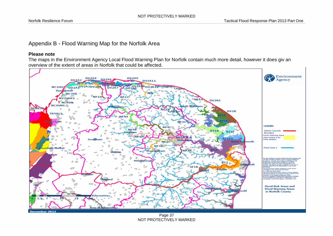
Appendix B - Flood Warning Map for the Norfolk Area
Please note The maps in the Environment Agency Local Flood Warning Plan for Norfolk contain much more detail, however it does giv an overview of the extent of areas in Norfolk that could be affected.

NOT PROTECTIVELY MARKED Norfolk Resilience Forum Tactical Flood Response Plan 2013 Part One
Page 38 NOT PROTECTIVELY MARKED
Appendix C - Flood Warning Triggers and Responses
Flood Alert
Flood Warning code, icon and strapline
Purpose Triggers Impact on ground (when threshold exceeded)
Multi-agency Response
To warn people of the possibility of flooding and encourage them to start making simple / low impact preparations for flooding.
Notes The aim is for customers to receive a Flood Alert between 2 and 12 hours prior to levels exceeding Flood Alert thresholds and during waking hours.
Flood Alerts can be issued for individual tides or a specified series of tides.
Updates are issued to the Internet and Floodline only, to inform customers of new developments or continuing situation.
Will not be sent to unregistered customers. (EDW customers)
Forecasts received, based on; threshold exceedance, telemetry data (raingauge, river level, groundwater levels, etc), forecasts of Result Threshold exceedances, etc that indicate that flooding will occur.
Forecast rainfall which sufficiently correlates to expected rapidly responding flooding.
High astronomical tides, surge & wind forecasts and alerts from UKCMF that threshold levels are likely to be exceeded.
Output from our tidal forecasting models, tide detection gauges and site observations.
EA flood plan will include the levels at which these alerts are triggered.
For low lying land and floodplain warnings, issued in advance of:
Flooding of fields, recreation land and car parks;
Flooding of minor road infrastructure (A (non-trunk) B, C & Unclassified)
Farmland flooding (arable & pasture)
Spray/wave overtopping on coast
Overland flow from rivers and streams
Localised flooding due to heavy storms (could be linked to river flooding re: surcharge from drains)
For Alerts in advance of flooding to property, likely to be issued when the conditions above have already been met.
Monitor situation - Maintain watch on National Server Weather Warning Service, EA Flood Warnings.
Alert EA & Cat 1 & 2 partners to any flood incidents.

NOT PROTECTIVELY MARKED Norfolk Resilience Forum Tactical Flood Response Plan 2013 Part One
Page 39 NOT PROTECTIVELY MARKED
Flood Warning
Flood Warning code, icon and strapline
Purpose Triggers Impact on ground (when threshold exceeded)
Multi-agency Response
To warn people of expected flooding and prompt them to take action to protect themselves and their property
Notes
The aim is for customers to receive a Flood Warning at least 2 hours prior to the onset of flooding.
A Flood Warning can be issued directly (i.e. without the prior issue of a Flood Alert) if warranted by a forecast or observations.
Sent to all customers in Flood Warning areas who are registered, including EDW customers
Information received based on threshold exceedance, telemetry data, tidal forecasting models, weather radar data, raingauge alarms, rainfall forecasts, flow forecast model output, forecasts of Result thresholds exceedances that indicate flooding will occur;
Actual flooding;
Site observations;
High astronomical tides, surge & wind forecasts and alerts from UKCMF that threshold levels are likely to be exceeded
A breach in defences or failure of a tidal surge barrier or dam.
EA flood plan will include the levels at which these alerts are triggered.
Flooding of homes.
Flooding of businesses.
Flooding of cellars and basements.
Flooding to roads with Major impacts.
Flooding to rail infrastructure.
Wave/spray overtopping;
Extensive flood plain inundation (including caravan parks or campsites).
Flooding of major tourist/recreational attractions.
Inform partners of identified risk area(s).
Consider establishing SCG
Consider implementing Operational and Tactical Flood Plan actions.
Review supporting Emergency Plans.
Consider mobilisations of resources – personnel, plant, flood protection, voluntary organisations
Consider / Implement activation of evacuation plans and arrange for rest centres to be set up.

NOT PROTECTIVELY MARKED Norfolk Resilience Forum Tactical Flood Response Plan 2013 Part One
Page 40 NOT PROTECTIVELY MARKED
Severe Flood Warning
Flood Warning code, icon and strapline
Purpose Triggers Impact on ground (when threshold exceeded)
Multi-agency Response
To warn people of significant risk to life or significant disruption to the community
Notes
Could be issued before or during flooding and in exceptional cases, after flooding.
A Severe Flood Warning can be issued directly (i.e. without the prior issue of a Flood Warning) if warranted by a forecast of rapid onset severe flooding.
Sent to all customers in Flood Warning areas who are registered, including EDW customers
Information received based on telemetry data, weather radar data, threshold exceedance or forecast threshold exceedance (in some cases), raingauge alarms, rainfall forecasts, flow forecast model output, that indicate significant flooding will occur.
Actual flooding where the conditions are deteriorating.
Site observations.
A breach in defences or failure of a tidal surge barrier or dam that is likely to cause significant risk to life.
Discussions with partners.
EA flood plan will include the levels at which these alerts are triggered.
Deep and fast flowing flood water.
Debris in the water that could cause death or injury.
Potential/observed collapse of buildings/structures.
Large town/city isolated by flood waters with no obvious means of escape.
Critical resources / infrastructure for communities disabled (no access to food, water, electricity)
Large volumes of evacuees.
Military assistance
Convene SCG meeting (in consultation with Cat 1 & 2 partners).
Identify risk / effected areas.
Activate Operational and Tactical Flood Plan actions.
Consider / Implement activation of evacuation plans and arrange for rest centres to be set up.
NOT PROTECTIVELY MARKED Norfolk Resilience Forum Tactical Flood Response Plan 2013 Part One
Page 41 NOT PROTECTIVELY MARKED
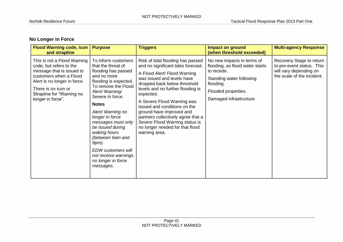
No Longer in Force
Flood Warning code, icon and strapline
Purpose Triggers Impact on ground (when threshold exceeded)
Multi-agency Response
This is not a Flood Warning code, but refers to the message that is issued to customers when a Flood Alert is no longer in force.
There is no icon or Strapline for “Warning no longer in force”.
To inform customers that the threat of flooding has passed and no more flooding is expected. To remove the Flood Alert/ Warning/ Severe in force.
Notes
Alert/ Warning no longer in force messages must only be issued during waking hours (between 6am and 9pm).
EDW customers will not receive warnings no longer in force messages.
Risk of tidal flooding has passed and no significant tides forecast;
A Flood Alert/ Flood Warning was issued and levels have dropped back below threshold levels and no further flooding is expected.
A Severe Flood Warning was issued and conditions on the ground have improved and partners collectively agree that a Severe Flood Warning status is no longer needed for that flood warning area.
No new impacts in terms of flooding, as flood water starts to recede.
Standing water following flooding.
Flooded properties.
Damaged infrastructure
Recovery Stage to return to pre-event status. This will vary depending on the scale of the incident.

NOT PROTECTIVELY MARKED Norfolk Resilience Forum Tactical Flood Response Plan 2013 Part One
Page 42 NOT PROTECTIVELY MARKED
Appendix D - Resource Availability
These lists of resources are available from the following organisations / agencies: The NERRS provides comprehensive details of resources that can be made available during an emergency. Within the context of a flooding event the following equipment and personnel are relevant. Generally
Resources Organisation Contact
Sandbags Borough / City / District Councils have access to sandbags. These may be accessed during an emergency, details of availability and contact details are in part two or refer to the relevant Borough/City/District websites.
In Part two
Boats Norfolk Fire & Rescue Service Norfolk Constabulary Maritime Coast Guard Agency Broads Authority RNLI
Via appropriate control room
Pumps Norfolk Fire & Rescue Service Environment Agency
Via appropriate control room
Transport Norfolk County Council Via Resilience team Duty Officer
Broads Authority
A ‘Broads Control’ is staffed 0900-1800hrs in summer (Easter to the 31st October) and 0900-1700hrs in winter – Contact details are in Part two. Communications
Video and telephone conferencing facilities.
Private VHF Channel
Permission to use HMCG Emergency channel '0' in an emergency
Emergency standby roster
Assets
8 River launches,
a rigid inflatable boat (RIB)
a number of smaller dinghy type vessels,
large wherries,
small tugs,
three steel workboats,
2 water based cranes,

NOT PROTECTIVELY MARKED Norfolk Resilience Forum Tactical Flood Response Plan 2013 Part One
Page 43 NOT PROTECTIVELY MARKED
Rangers Trained in boat handling, VHF and first aid and are experienced in dealing with emergencies on land and water and working with all the emergency services especially the MCA. The rangers are organised into area teams:-
10 full-time Rangers, 6 summer seasonal.
50 volunteer Rangers who are trained (RYA2 VHF and First Aid) and
able to assist with emergencies and pollution incidents
Other land based staff (25) have access to 10 4x4 vehicles plus diggers
and numerous chainsaw equipment (under review).
Norfolk Fire and Rescue Service
In addition to the recognised Fire & Rescue response capability NFRS can provide the following resources
5 Type B Water Rescue Boat teams
10 High axle 4x4 rescue vehicles with associated Type D water rescue
first responder team (wading rescue)
High Volume Pump x1 with 4x4 capabilities and up to 3km hose
Underwater Search and Recovery Team
Water Incident Manager (WIM) x 15- Specialist Bronze Commanders for
flood rescue
Subject Matter Advisors (SMA) x 4- Specialist Silver/Gold Commanders
for flood rescue
Marine VHF communications with channel 0 authority
Portable SAT PHONE comms equipment
The Fire and Rescue Service will be responsible for coordinating rescue of people from flood situations. Norfolk Voluntary & Faith Sector Capabilities Directory
The voluntary and faith sector will be able to provide a wide range of support to responders during a flooding event. Reference to the above document provides a comprehensive overview.
NOT PROTECTIVELY MARKED Norfolk Resilience Forum Tactical Flood Response Plan 2013 Part One
Page 44 NOT PROTECTIVELY MARKED
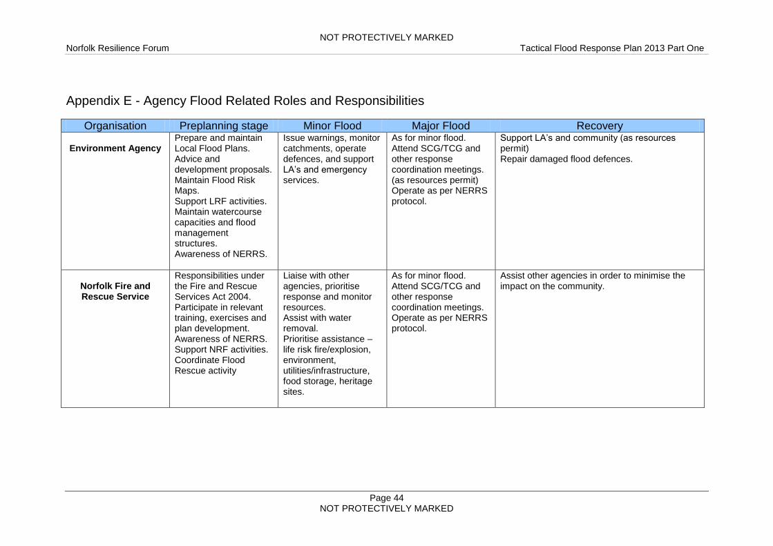
Appendix E - Agency Flood Related Roles and Responsibilities
Organisation Preplanning stage Minor Flood Major Flood Recovery
Environment Agency Prepare and maintain Local Flood Plans. Advice and development proposals. Maintain Flood Risk Maps. Support LRF activities. Maintain watercourse capacities and flood management structures. Awareness of NERRS.
Issue warnings, monitor catchments, operate defences, and support LA’s and emergency services.
As for minor flood. Attend SCG/TCG and other response coordination meetings. (as resources permit) Operate as per NERRS protocol.
Support LA’s and community (as resources permit) Repair damaged flood defences.
Norfolk Fire and Rescue Service
Responsibilities under the Fire and Rescue Services Act 2004. Participate in relevant training, exercises and plan development. Awareness of NERRS. Support NRF activities. Coordinate Flood Rescue activity
Liaise with other agencies, prioritise response and monitor resources. Assist with water removal. Prioritise assistance – life risk fire/explosion, environment, utilities/infrastructure, food storage, heritage sites.
As for minor flood. Attend SCG/TCG and other response coordination meetings. Operate as per NERRS protocol.
Assist other agencies in order to minimise the impact on the community.
NOT PROTECTIVELY MARKED Norfolk Resilience Forum Tactical Flood Response Plan 2013 Part One
Page 45 NOT PROTECTIVELY MARKED
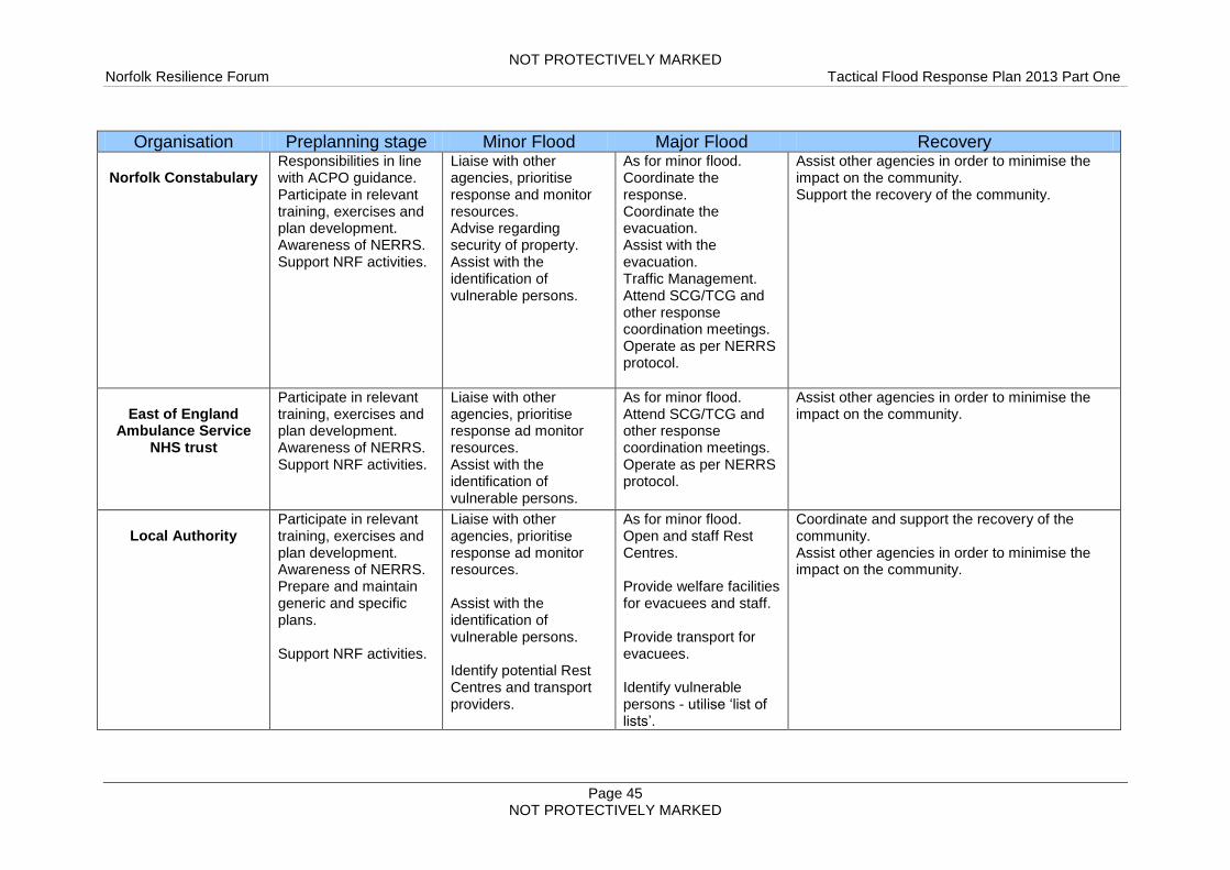
Organisation Preplanning stage Minor Flood Major Flood Recovery
Norfolk Constabulary Responsibilities in line with ACPO guidance. Participate in relevant training, exercises and plan development. Awareness of NERRS. Support NRF activities.
Liaise with other agencies, prioritise response and monitor resources. Advise regarding security of property. Assist with the identification of vulnerable persons.
As for minor flood. Coordinate the response. Coordinate the evacuation. Assist with the evacuation. Traffic Management. Attend SCG/TCG and other response coordination meetings. Operate as per NERRS protocol.
Assist other agencies in order to minimise the impact on the community. Support the recovery of the community.
East of England
Ambulance Service NHS trust
Participate in relevant training, exercises and plan development. Awareness of NERRS. Support NRF activities.
Liaise with other agencies, prioritise response ad monitor resources. Assist with the identification of vulnerable persons.
As for minor flood. Attend SCG/TCG and other response coordination meetings. Operate as per NERRS protocol.
Assist other agencies in order to minimise the impact on the community.
Local Authority
Participate in relevant training, exercises and plan development. Awareness of NERRS. Prepare and maintain generic and specific plans. Support NRF activities.
Liaise with other agencies, prioritise response ad monitor resources. Assist with the identification of vulnerable persons. Identify potential Rest Centres and transport providers.
As for minor flood. Open and staff Rest Centres. Provide welfare facilities for evacuees and staff. Provide transport for evacuees. Identify vulnerable persons - utilise ‘list of lists’.
Coordinate and support the recovery of the community. Assist other agencies in order to minimise the impact on the community.

NOT PROTECTIVELY MARKED Norfolk Resilience Forum Tactical Flood Response Plan 2013 Part One
Page 46 NOT PROTECTIVELY MARKED
Organisation Preplanning stage Minor Flood Major Flood Recovery Local Authority contd… Lead Local Flood Authority under Water Management Act 2010. Develop, maintain apply and monitor a strategy for local flood risk management Investigate all significant flooding incidents Maintain an asset register of structures and features that affect flood risk Issue consent on works that affect the flows of watercourses.
Attend SCG/TCG and other response coordination meetings. Operate as per NERRS.
Category 2
Responders
Participate in relevant training, exercises and plan development. Support NRF activities. (as Category 2 Responder)
Respond to reports of foul sewage flooding, threats to infrastructure and relevant utilities.
As for minor flood. Attend relevant response coordination meetings.
Attend relevant recovery coordination meetings.

NOT PROTECTIVELY MARKED Norfolk Resilience Forum Tactical Flood Response Plan 2013 Part One
Page 47 NOT PROTECTIVELY MARKED
Appendix F - Flood Forecasting Centre Rainfall and Flood Products
Product Purpose Audience Source of flooding Target lead-time Delivery method Boundaries
Information
Rainfall radar
Met Office
Input into flood forecasts Met Office, Environment Agency, Category 1 and 2 responders
Rainfall only Available 24 hours a day, updated every 5 and 15 minutes
Met Office Hazard Manager
United Kingdom
River and sea levels Environment Agency
Provide access to river and sea level information
Public, Emergency responders, Media
Coast, Rivers Twice daily. Can be more frequent when levels are high.
Environment Agency website www.environment-agency.gov.uk
England and Wales
Advice
Flood Guidance Statement Flood Forecasting Centre
Provide partners with a
5 day overview of flood
risk
Environment
Agency, Category 1
and 2 responders
Coast, rivers and
surface water,
ground water
Up to 5 days Email , Hazard
Manager, Text,
Voicemail
County level in England
and Wales
National Severe Weather Warning Service Met Office
Advise customers of
severe weather
Public, emergency
responders, media
organisations
All weather types Up to 5 days Met Office website
www.metoffice.gov.uk
Public Weather
Service Advisors
United Kingdom
Three-day Flood Risk Forecast Environment Agency
Raise early awareness of potential flooding
Public, media organisations
Coast, rivers and surface water
Up to 3 days Environment Agency website www.environment-agency.gov.uk
County level in England and Wales
Flood Advisory
Service
Environment
Agency
Met Office
Flood Forecasting
Centre
Provide local and
national partners with
early flood information
and advice
Category 1 and 2
responders
All sources Up to 5 days Telephone conference
with Environment
Agency Flood Duty
staff
Met Office Public
Weather Service and
Flood Forecasting
Centre
England and Wales Local Resilience Forum network

NOT PROTECTIVELY MARKED Norfolk Resilience Forum Tactical Flood Response Plan 2013 Part One
Page 48 NOT PROTECTIVELY MARKED
Product Purpose Audience Source of flooding Target lead-time Delivery method Boundaries
Warning
National Severe
Weather Warning
Service – Alerts
and Warnings
Met Office
Warn customers of
severe weather short
and long lead times
Public, emergency
responders, media
organisations
All weather types Alerts 2 to 5 days. Warnings up to 24 hours.
Email, fax, SMS
Met Office website
www.metoffice.gov.uk
County level in the United Kingdom
Flood Warnings
Environment
Agency
Warn the public and
partners of flooding
Public, emergency
responder, media
organisations
Coast, rivers Flood alerts:
2 hours to 2 days
Flood warnings:
Half an hour to 1
day
Severe flood
warnings:
when flooding
poses
a threat to life
Telephone, email,
SMS, fax, pager,
sirens, loudhailers,
media broadcasts and
Environment Agency
website
www.environment-
agency.gov.uk
Flood alerts:
River catchments and
stretches of the coast
Flood warnings:
Communities
Severe flood
warnings:
Communities
PLEASE NOTE This table is based on the document provided by the Flood Forecasting Centre. The original document can be obtained from the following web site:- http://www.ffc-environment-agency.metoffice.gov.uk/services/FFC_Diagram.pdf

NOT PROTECTIVELY MARKED
Norfolk Resilience Forum Tactical Flood Response Plan 2013 Part One
Page 49 NOT PROTECTIVELY MARKED
Appendix G - Flooding: General Public Advice
Before a flood
Prepare a flood kit and include the following:
Pack a small bag with essential belongings and include warm clothes,
torch (check batteries), radio (wind up or battery powered), food, water,
other drink, mobile phone (pre input useful numbers), any medicines that
you might need to take, any important documents that you have and a
first aid kit. Keep this bag easily accessible
Collect personal belongings, including insurance and bank details, and
essential telephone numbers together, and keep them in a waterproof
bag
Move people, pets, valuables and sentimental items upstairs or in a high
place downstairs
Keep a separate list of useful telephone numbers to hand (this should
include your local Council, your insurance company and the 24 hour
Floodline – 0845 988 188)
Find out where and how to turn off your gas and electricity. Ensure that
you switch it off if flooding is imminent before evacuating;
If possible, move electrical equipment and furniture upstairs
Try to raise well off the floor any furniture that you cannot move upstairs;
Alert neighbours and assist the elderly, infirm and those with small
children
Seal doorways and air bricks against the ingress of water
Avoid walking and driving through floodwater, there could be hidden
hazards
Keep up to date with information by listening to local radio and Floodline.
During a flood
Continue to listen to situation updates on your local radio and via
Floodline (0845 988 1188)
Keep dry and out of floodwater if possible
Stay in your property, if safe to do so, until advised otherwise by the
emergency services or the floodwater has receded
Do not walk or drive through flowing floodwater
If it is necessary to walk through shallow floodwater, take care for hidden
holes, obstacles or other hazards
Do not walk on riverbanks, sea defences or cross bridges over torrential
rivers
Avoid contact with floodwater and wash any exposed parts before
handling food or attending to wounds
If possible, move electrical equipment and furniture upstairs

NOT PROTECTIVELY MARKED
Norfolk Resilience Forum Tactical Flood Response Plan 2013 Part One
Page 50 NOT PROTECTIVELY MARKED
If evacuation becomes necessary
Stay calm and do not panic
Police officers and / or other officials will try to visit all properties at risk
to advise on the requirement to evacuate
If road conditions permit, move vehicles to unaffected areas for example
higher ground and ask friends/family away from affected areas if you can
share their parking facilities
You will hear about your evacuation point for transport and the location
of the reception centre either verbally or by a leaflet
Remember to take medicines and special foods
Try to check that any elderly/vulnerable family members or neighbours
know about the evacuation
Try to inform family members/friends as to where you are evacuating
Listen to the advice of the authorities and follow any instructions to leave
the property
After a flood / returning home
Check the safety of electricity and gas before use. A qualified electrician
needs to check any electrical equipment and circuits that have been
exposed to floodwater
Avoid contact with any remaining floodwater or items having had contact
with floodwater unless wearing protective gloves/clothing
Boil all tap water until it is declared safe by the water supply company
Wash yours and your children’s hands frequently with bottled water if
your supply has not been declared fit for use. Disinfect any children’s
toys
Dispose of any contaminated food, including tinned food, defrosted food,
and packaged food that have been exposed to floodwater
Contact your insurers as soon as possible and follow their advice. Most
insurers have a 24hr helpline. Do not throw away damaged goods until
your insurer has authorised you to do so. It is a good idea to take
photographs of the damage
Seek medical assistance if any health issues appear, especially flu like
symptoms
Ventilate your property whilst taking care for security
Do not throw rubbish and furniture outdoors; wait for an organised
collection
During these hard times, bogus/rogue builders and traders are frequently
offering their services. Make sure that you get a written quotation that is
on letter headed paper with a landline contact number and address.