table of contents i. introduction, - ontario · - 2 - ii. property, description and location the...
TRANSCRIPT
52G15NWei79 52G15NWM79 SIXMILE LAKE 01052QISNWt179 S2G1SNWM7S S IXMILE LAKE 010C
II.
III.
IV.
V.
VI.
VII.
VIII.
IX.
x.XI.
No,
TABLE OF CONTENTS
I. INTRODUCTION,
PROPERTY, DESCRIPTION andLOCATION. ...........2*3
ACCESSIBILITY, CLIMATE,LOCAL RESOURCES . . . . . . . . 3 - 5
HISTORY ............5-7
REGIONAL GEOLOGY. . . . . . . . 7 - 9
LOCAL GEOLOGY . . . . . . . . . 9 - 11
EXPLORATION PROGRAM . . . . . .11-24
GEOLOGY . . . . . . . . . . . .24 - 29
COSTS . . . . . . . . . . . . . 29
SUMMARY and CONCLUSIONS . . . .30-33
RECOMMENDATION: 33 - 34
REFERENCE MATERIAL. . . . . . . 35
EXHIBITS
No. No. NO. NO. No. 6 No. 7
2345
General Location of Sturgeon Lake AreaClaim Group.Sturgeon Lake Area Claim Group SL-3.Supplementary Geophysical Information.Preliminary Regional Geological Base Map,Assay Certificates.Geological and Surficial Information.Staking Activity and Group Holdings.
* * * *
52G15NW8179 S2G15NWM79 SIXMILE LAKE 01052G15NW4179 52G15NWM79 SIXMILE LAKE
010C
No.
No. No. No. No. No.
TABLE OF CONTENTS
I. INTRODUCTION. . . . . . . . . . l
II. PROPERTY, DESCRIPTION andLOCATION. ...........2*3
III. ACCESSIBILITY, CLIMATE,LOCAL RESOURCES . . . . . . . . 3 - 5
IV. HISTORY ............5-7
V. REGIONAL GEOLOGY. . . . . . . . 7 - 9
VI. LOCAL GEOLOGY . . . . . . . . . 9 - 11
VII. EXPLORATION PROGRAM . . . . . .11-24
VIII. GEOLOGY . . . . . . . . . . . .24 - 29
IX. COSTS . . . . . . . . . . . . . 29
X. SUMMARY and CONCLUSIONS . . . .30-33
XI. RECOMMENDATIONS . . . . . . . .33 - 34
REFERENCE MATERIAL. . . . . . . 35
EXHIBITS
23456
No. 7
General Location of Sturgeon Lake AreaClaim Group.Sturgeon Lake Area Claim Group SL-3.Supplementary Geophysical Information.Preliminary Regional Geological Base Map,Assay Certificates.Geological and Surficial Information.Staking Activity and Group Holdings.
* * * *
"— —— ————"—————~~~——— JbnnMHim Jfouf&ti fc
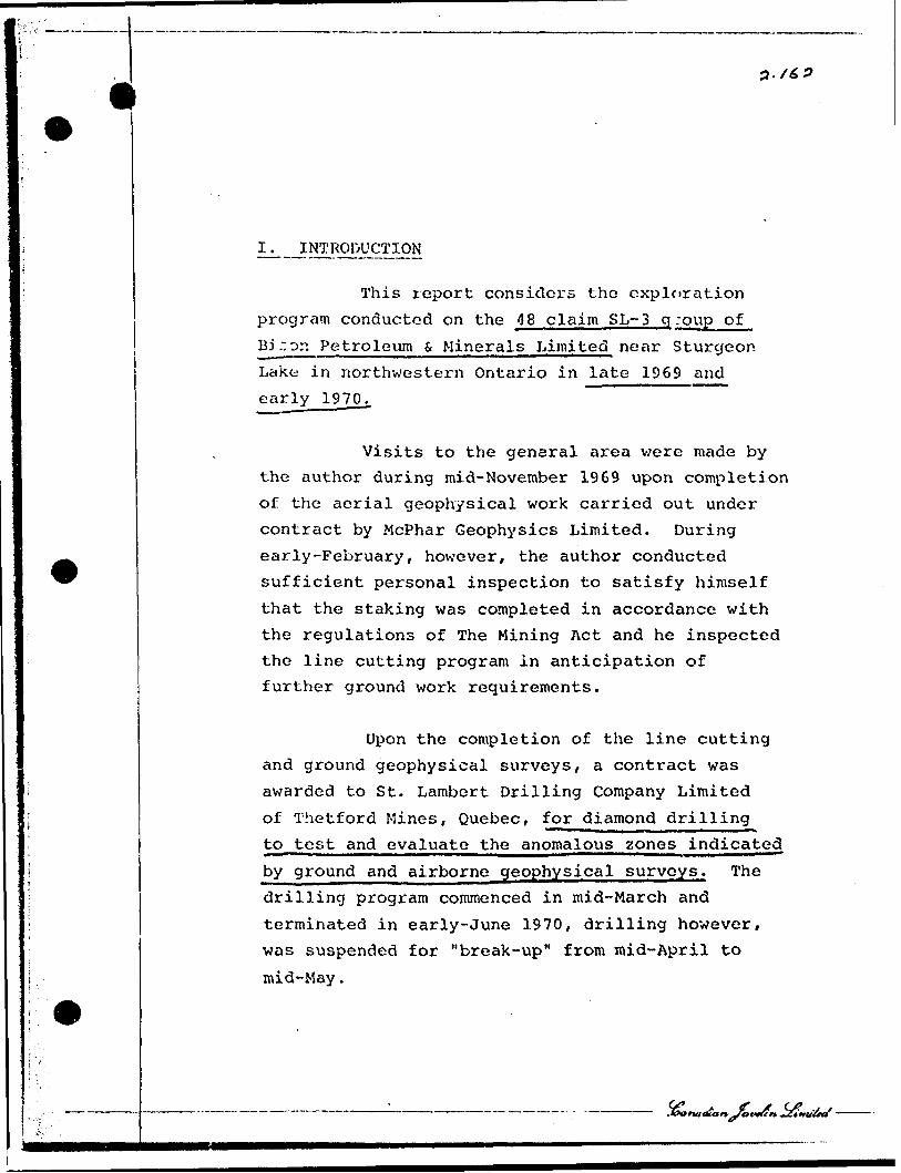
1^__INTRODUCTION
This report considers the exploration
program conducted on the 48 claim SL-3 g :pup of
BJ ~on Petroleum S Minerals Limited near Sturgeon Lake in northwestern Ontario in late 1969 and early 1970..
Visits to the general area were made by the author during mid-November 1969 upon completion
of the aerial geophysical work carried out under contract by McPhar Geophysics Limited. During early-February, however, the author conducted sufficient personal inspection to satisfy himself
that the staking was completed in accordance with the regulations of The Mining Act and he inspected the line cutting program in anticipation of further ground work requirements.
Upon the completion of the line cutting and ground geophysical surveys/ a contract was
awarded to St. Lambert Drilling Company Limited
of Thetford Mines, Quebec, for diamond drilling to test and evaluate the anomalous zones indicated
by ground and airborne geophysical surveys. The drilling program commenced in mid-March and
terminated in early-June 1970, drilling however, was suspended for "break-up" from mid-April to
mid-May.
- rf
r-* SECTION r.jnj.-To
F ^ B- l ^ 5
NOV 3 01970r M7i8iO)l(Wil2,l,?,3,4,5,0
EXPLORATION REPORT - BISON PETROLEUM l MINERALS LIMITED
SL-3 CLAIM GROUP,
STURGEON LAKE, ONTARIO.
November 2 5th, 1 970.
W. B. Bleikeman, M. Se. ,Geologist,
CANADIAN JAVELIN LIMITED
- 2 -
II. PROPERTY, DESCRIPTION and LOCATION
The JSL-3 group consists of a contiguous
block of 48 unpatented mining claims located
in the jixmile Lake.- Area, District of Kenora-
Thundar Bay, Patricia Mining Division. A general
location map of the region, (Exhibit 1) and a
specific detailed claims location :.iap, (Exhibit 2)
are appended hereto.
The 48 claircs were purchased by Bison^
Petroleum 6 Minerals Limited from Messrs. L. K.
Smith and I. O. Dearden on October 24th, 1969.
All of the claims were properly recorded with
the Ontario Department of Mines Recorder at
Sioux Lookout, Ontario, on October 16th, 1969.
The original transcripts of the transfers to
Mr. G. N. Milner, "In Trust", a lawyer with the
firm of Day, Wilson, Campbell, Solicitors for
Bison Petroleum s Minerals Limited, are held in
the Engineering Offices of Bison Petroleum fc
Minerals Limited at 100 Bronson Avenue, Ottawa
4, Ontario. The claims are registered as Numbers
PA 211,830 to PA 211,832 inclusive, PA 211,834 to
PA 211,861 inclusive, PA 213.,870 to PA 211,875
inclusive, PA 211,878 to PA 211,888 inclusive;
all appearing on the Ontario Department of Mines,
Claim Map Number M 2877, the Sixmile Lake Sheet
and the Claim Map entitled "Area South of Sturgeon
Lake, District of Thunder Bay." Personal examina
tion of major portions of the property by the
- 3 -
writer indicates that to the best of his knowledge, the claims and the group boundaries are properly
staked, tagged and marked in accordance with The
Mining Act, but thrt the physical location of the south boundary is about one claim width to the
north of its position as indicated on Claim Map Number M 2877.
Canadian Javelin Limited holds a interest in all of the above mining claims, and
under a management agreement with Bison Petroleum S. Minerals Limited, all exploration, engineering
and management services are provided by Canadian Javelin Limited.
III. ACCESSIBILITY, CLIMATE, LOCAL RESOURCES
During the winter months it is possible
to drive within ten miles of the property by the
Ontario Highway #599 and a series of winter roads from the end of the Mattagami Lake Mines road
in Block 7. The last ten miles must be covered
by ski-doo type vehicles. During the summer it
is most easily reached by charter aircraft from Ignace, Savant Lake or Sioux Lookout. The C.N.R. Northern Transcontinental mainline route passes about 15 miles north of the property; and a C.N.R. branchline from Sioux Lookout to the
Lakehead passes about 15 miles southwest of the property.

- 4 -
The SL-3 claim group is situated between Post, Willet and Hump Lakes, below the
western end of the Sturgeon Lake Narrows. The
center of the group is approximately eight miles in an east-northeasterly direction from the
Mattagami Lake Mines Limited property on the "Block
7" timber lea^e held by Abitibi Paper Company Limited.
The climate in the area is described as Cool Temperate East Coast {with short summers). Mean annual precipitation is in the order of 20 inches, and mean annual snowfall is about 80 inches.
The mean January temperature is -5OF with over night lows approaching -60OF, and mean July tem perature is 620F with daily highs approaching 95OF. The winter period extends from mid-October to late
April; the average frost-free period is about 75 days.
The group is roughly longitudinally bisected by an east-xvest trending ridge 200 to 300
feet above Post Lake and is covered with second- growth species of woods, particularly spruce, jackpine, birch, poplar and cedar. An extensive muskeg area is situated in the eastern part of
the group near Willet Lake. The general area is prime logging country that is extensively traversed
by winter logging trails and roads.
- 5 -
The area is in the Brown-Podzoli c, soil
zone which is typical in the northern forests of
mixed hardwoods and conifers. It is in glaciated
country that is underlain with glacial detritus
and scoured bedrock. Accordingly, the agricultural
potential of the soil is low.
The population in the region is sparse
and located in small centre? along the railway
lines at Ignace, Sioux Lookout and Dryden. A
transient logging and forestry population moves
throughout the area during the winter season.
Several Indian Reserves containing small scattered
bands- are also located nearby.
IV. HISTORY
The general region has been investigated
over the past century by the Geological Survey of
Canada, the Ontario Department of Mines, and to
varying degress by several mining companies.
Numerous reports have been written about the
region during this period. The most recent
reports are: the Ontario Department of Mines,
Geological Report Number 24, Metionga Lake Area by
David P. Rogers, 1964; and, the Geological Survey
of Canada, Paper 68-45, Geology of the Sioux
Lookout Map-Area, Ontario, a Part of the Superior
Province of the Precambrian Shield, by R. Skinner,
1968. In addition, the area is extensively covered
on the Ontario Department of Mines Preliminary
•trjove&r*-Ztn
'it;:: i
~ 6 -
Geological Map P-353, the Minnitaki-Sturgeon
Lakes Sheet, Districts of Kenora and Thunder Bay, compiled by J. C. Davies and A. P. Pryslak, issued in 1966, which has been superceded by Map Number 2169, the Sioux Lookout-Armstrong
Sheet. During the summer of 1970, an Ontario Department of Mines field party was mapping the Glitter Lake Area.
Previous mining activity in theSturgeon Lake Area centered around the Darkwater
and St. Anthony gold mines, prior to the Second
World War. Since that time many mining claims have been staked on gold, copper and magnetite iron formation showings, but most of these claims have been allowed to lapse. There is no evidence
of previous staking or mineral exploration in the claims currently described as the Bison SL-3 Group.
The recent claim staking activity in the Sturgeon Lake Area was stimulated by an
announcement of a mineral deposit discovery by
Mattagami Lake Mines Limited in October 1969.
Mattagami Lake Mines Limited drilled an electro
magnetic conductive zone on Block 7, southeast of
Beidelman Bay on Sturgeon Lake. The company reported ore grade intersections of zinc, copper,
silver, lead and gold over 70 to 190 foot true
widths along approximately 1,000 feet of strike
length along what appears to be the contact between acid and basic volcanic rocks. Mattagami
- 7 -
Lake Mines is presently preparing to put the property into production. The intensity of
staking activity ew.d group holdings in the
region is illustrated in Exhibit l , reproduced
from a survey published in the Northern Miner.
A team of prospectors headed by
Messrs. E. O. Dearden and L. K. Smith staked a substantial block of 132 unpatented mining claims
which they offered for sale to interested parties, including Bison Petroleum fi Minerals Limited/ and
others. Upon the recommendations of its engineering staff, Bison Petroleum s Minerals
Limited acquired the 48 claim SL-3 group from the above block.
V. REGIONAL GEOLOGY
The general relationship between the
regional geology in the area of the Mattagami Lake Mines discovery and the Bison SL-3 claim
group is indicated in the examination of the
Sturgeon Lake Area by the Ontario Department of Mines whose findings are illustrated in Map 2169. Additional data is shov/n on Map 2044, the Metionga Lake Area, {which accompanies
O.D.M. Report Number 24, by D. P. Rogers), and on the Geological Survey of Canada Aeromagnetic
Maps 1117 and 1127.

- 8 -
On the basis of the above data, the
author is of the opinion that the southern
limit of the Archean greenstone belt extends
from Beidelman Bay on Sturgeon Lake, eastward
across Darkwater Lake, north of Bell Lake,
across the southern tip of Glitter Lake and on
to the area southwest of Sassafras Lake, an
approximate distance of 22 miles. The eastern
limit roughly parallels the west shore of
Quest Lake, and then swings south-easterly to
apparently join the southern limit in a "pinched"
situation southwest of Sassafras Lake. The
three major rock types within this triangular
area south and east of Sturgeon Lake are acid
and basic metavolcanics and a band of metasedimentary
and metavolcanic rocks, including magnetite iron
formation, which approximately coincides with
the southeasterly trending axis of the Barge,
Post and Willet Lake series.
The assumed acid-basic metavolcanic
contact extends from just north of Darkwater
Lake, eastward through Claw Lake to Hump Lake
whereupon it swings northwestward approximately
paralleling the south shore of the Barge, Post,
Willet Lake series, to the area at the southwest
end of the Narrows on Sturgeon Lake. The
mineralized zone drilled by Mattagami Lake
Mines is reported to follow the acid-basic meta
volcanic contact (Northern Miner, November 6th,
1969) , along an east-west strike, and dipping

1*1
- 9 -
steeply at 70O to the north. The Ontario Department of Mines Map 2044, the Metionga
Lake Sheet, indicates outcrops of basic volcanics dipping vertically or steeply to the northeast, along the shore line of
Sturgeon Lake south of the southwest end of
the Narrows. This observation, plus the
suggested fold nose structure containing acid
and basic metavolcanics east of the Sturgeon
Lake shore line and at a point west of the north end of Lyon Lake indicates that a major
fold structure may be present, possibly a
syncline overturned to the south and plunging
to the west-northwest. There is little evidence of the fold structure to the west of Sturgeon
Lake; consequently, the author suspects a major
fault zone within the Lake itself. The general regional geology, as derived from all of the foregoing data is illustrated in Exhibit 4.
VI. LOCAL GEOLOGY
In the case of the Mattagami discovery, the acid-basic metavolcanic contact zone appears
to be the geologically favourable area for the
emplacement of sulphide mineralization. Published
data indicates that ore grade intersections of zinc, silver, copper and lead sulphides have been encountered in the rhyolite and acidic flows
and tuffs which are to the north, e.g., hanging wall side of the basic volcanics indicated on Map

- 10 -
Number 2169. The age differences between the
sulphide mineralization and the host rock as
well as the relationship between the mineralization
and the overall inferred synclinal structure are not known to the writer at this time. If the mineralization is controlled by structural features and the presence of fractured and
brecciated rhyolites and tuffs, in close proximity to more competent and inhospitable andesites,
then any area along the contact zone and within the inferred synclinal fold structure would be a geologically encouraging area in which to search for additional zones of ore grade sulphide
mineralization. Under this hypothesis the entire 15 mile length of this contact zone would thus be worthy of detailed examination.
Map 2169 and Exhibit 4 indicate that the SL~ 3 claim group is underlain by 1.) basic
igneous rocks, 2.) metasediments and volcanics,
and 3.) acid and basic metavolcanic rocks, all striking northwest-southeast. Mapped outcrops (Map 2044) on the south shore of Sturgeon Lake,
just west of the claim group suggest that the rock units within the group can be expected to dip vertically or steeply to the northeast, probably representing the northeast limb of the
inferred overturned fold structure. The presence of the favourable acid-basic metavolcanic contact
zone is indicated by mapped outcrops of schists
and gneisses associated with the basic meta-

- l i -
volcanics along the south shore of Post Lake and
by mapped outcrops of acid agglomerate, tuff, or flow breccia along the south shore of Sturgeon Lake, just north of Lyon Lake. The indicated contact crosses the claim group in a northwest- southeast direction over a probable length of about one mile as shown on Exhibit 4, before
swinging west through Hump Lake v;here the nose of a fold appears to be located.
The inferred favourable geologic
setting on and around this property clasp it as one worthy of extensive examination. Due
to a relative scarcity of outcrops within the
group, however, it was necessary to rely heavily on ground geophysical information and exploratory drilling in the attempt to delineate the contact
zone and to verify the presence of mineralized areas along this contact.
VII. EXPLORATION PROGRAM
In view of the potentially favourable
geological conditions on the SL-3 claim group,
Bison Petroleum s, Minerals Limited undertook an
exploration program in which most of the claim
block Wcis examined by airborne and ground
geophysical surveys followed by exploratory
diamond drilling during the winter and spring
of 1970.

- 12 -
Geophysical Surveys
In order to start the exploration
program immediately after "freeze up" the company
initiated the airborne geophysical phase in late-
October 1969. The airborne survey was carried
out in conjunction with two affiliated companies,
Canadian Javelin Limited and Norlex Mines
Limited, who hold the adjacent blocks of claims
to the west and northwest.
McPhar Geophysics Limited of Toronto
conducted the airborne magnetometer and electro-
magnetometer survey ove.. three adjacent groups
of claims the SL-1 (Norlex Mines Limited),
the SL-2 (Canadian Javelin Limited) and SL-3
^Bison Petroleum s. Minerals Limited^, from
November 4th to November 6th f 1969. An F-400
EM instrument which is a single phase, dual
frequency unit and a proton magnetometer were
used, both being mounted in a D.H.C. Beaver
aircraft flying at an altitude of 450 feet and
along lines spaced at 1/8 mile intervals. The
final report was issued by McPhar Geophysics on
January 5th, 1970. The writer has examined this
data and discussed the results with McPhar's
technical personnel who indicated the presence
of three conductive zones within the Bison claim
group (as shown in Exhibit 3). The strikes of
these anomalous zones probably parallel those of
the major rock units indicated on Map 2169.

- 1 3 -
McPhar's report received in early- January 1970, states the following about these conductive zones:
Zone No. 3
A distinct zone of multiple parallel conductors with associated strong magnetic
response correlates with the band of meta- sediments trending through the survey area.
The largest amplitude responses occur in the southern portion of the area, southeast of Post
Lake. Based upon the geologic information, these responses would appear to be due to iron forma
tion's and/or graphitic bands. However, some ground follow-up would be warranted to confirm the accuracy of the geology.
The "A" category EM response on Line 9, fiducial 3026, lies near the contact between the
metasediments and metavolcanics and would
warrant investigation on the ground. Depending upon the results of this ground investigation, further work may be warranted on the "B" category
anomalies within this conductive zone.
Zone No. 4
The geologic map suggests a nose to
the acidic metavolcanics in the area of Line 8 and Line 9, north and east of Claw Lake. If
this is the case Zone No. 4 and Zone No. 5 may
be related. However, if the acidic metavolcanics
- 14 -
instead pinch out to the southeast then Zone
No. l and Zone No. 2 may also be related to Zone No. 4 and Zone No. 5. The "A" category EM
response on Line 9, fiducial 3026 is located at the contact between the acidic and basic meta-
volcanics near the nose of the flexure and should
be investigated en the ground to confirm the geologic information, and to determine the
significance of this conductive zone as a source of sulphide mineralization.
Zone No. 7
This zone lies within the Bison claim group along the southwest shore of Post Lake
near to or at the contact between the metavolcanics
and metasediments. "A" category EM responses are indicated on Line 29, fiducial 1498; Line 20,
fiducial 1219; and Line 31, fiducial 972, with
correlating "B" category responses on Line 18, Line 22, Line 23, Line 24 and Line 25. Although possibly due to graphite zones within the meta
sediments and lacking correlating magnetic response, this zone would warrant further investiga
tion on the ground.
The ground geophysical survey wascontracted to Dearex Limited of Etobicoke, Ontario,
with the line cutting being sub-contracted to
George Potter of Kirkland Lake, Ontario.
- 15 -
The Dearex crew consisting of G. Flaherty
and A. Lindner worked on the property from
January 22nd to February 10th, 1970. The Crone
Shootback EM method and equipment with a 200
foot coil spacing and a basic frequency reading
of 1,800 Hz were used for the EM survey, whereas
a Sharpe Fluxgate Magnetometer was utilized for
the magnetic survey.
The combined survey covered 28.1 miles
of line at 400 foot line spacing, and is covered
in a report entitled, "Report for Canadian
Javelin Limited and Bison Petroleum E, Minerals
Limi-ted covering Magnetic and Electromagnetic
Surveys over a Portion of their Sturgeon Lake
Area Claim Groups, Patricia Mining Division,
Ontario," by J. D. Crone, which was submitted to
the Company in March 1970.
The Dearex survey detected a narrow
(50 foot) conductive zone trending southeast-
northwest adjacent to the south shores of Post
and Willet Lakes, and extending almost continuously
from line 36+OOE to line 60+OOW, a total distance
of 9,600 feet. This zone is generally coincident:
with magnetic highs ranging from 200 to 10,000
gammas and is quite probably closely related
to the mapped metasedimentary-metavolcanic rock
contact which in this area has essentially the
same strike direction.

- 16 -
Even wit^ a 300 foot coil separation,
the Dearex survey did not, however, pick up the
conductive zone detec'-.ed by the McPhar survey
in the Hump Lake area and which trends north
west approximately one mile from the tip of the
northwest arm of Hump Lake. This conductive
zone could be due to mineralization in the area
of the inferred acid-basic metavolcanic rock
contact in the fold structure as indicated on
O.D.M. Map 2169. By intention, the Dearer,
survey did not cover the anomalous zone outlined
in the northeastern portion of the property by
the McPhar survey. Due to the extremely high
magnetic responses associated with the con
ductivity, it was considered that the anomalies
are due to the presence of iron formation,
indicated on O.D.". Map 2169 as being present
in that area.
Subsequent to the Dearex survey,
members of the Bison engineering staff, utilizing
a Ronka EM-16 and a Jalander magnetometer,
delineated the northeastern anomalous area (iron
formation) and re-ran lines in the Hump Lake area.
The results of this work are presented in the map
entitled, "Supplementary Geophysical Information,"
Exhibit 3, which is hereto attached.
The ground work in the northeast
portion of the group outlined a conductive zone,
coincident with a 5,000 to 15,000 gamma magnetic
high, extending from line 8+OOW to 28+OOW,
——————— jba dl'a

l- 17 -
approximately 1,600 feet north of Baseline 0+00.
This zone was subsequently drilled (Hole BI-3)
and the results are covered below under Diamond
Drilling.
The EM work in the Hump Lake area
detected a conductor extending from line 32+OOW
to 48-fOOW, whereupon it crossed into the
Canadian Javelin ground to continue to line
56+OOW. This conductor was tested by two drill
holes, BI-5 and BI-6 due to its location in
respect to the inferred acid-basic metavolcanic
rock contact and the results of the drilling
are-discussed below.
Diamond Drilling
A contract for AXQ wireline diamond
drilling was awarded to St. Lambert Drilling
Company of Thetford Mines, Quebec.
Drilling commenced in mid-March and
continued until April 15th, when it was suspended
for break-up. Drilling was resumed in late-May
and the last hole was completed in early-June.
During the winter, the camp on Barge
Lake was serviced by tractor and a ski-doo type
vehicle, and excellent aircraft service was
provided by Ignace Airways.

- 18 -
The first, second and fourth holes, located on the shore line of Post and Willet Lakes were drilled to test the conductive
zones detected by the Dearex survey, whereas holes BI*-3, BI-5 and Bl-6 were drilled to
investigate two separate EM anomalies indicated by the EM-16 survey. The locations, dips and
depths of the individual holes ara presented below:
Hole No. Coordinates Claim No. prilling Dip Depth
BI-1
HI -2B 1-3BI-4BI-5BI-6
24+OOW/31+25N48+OOW/32+OON12+OOW/48+50N28+OOE/30+OON32+OOW/12+50S48+OOW/12+50S
211859211885211857211844211871211875
Grid SGrid SGrid SGrid SGrid SGrid S
45045045O55O55 550
529'511'600'350'547'452'
Total Footage 2,989'
The logs and cross sections of the
individual holes are included herein, with a
brief description of the rock types encountered
in each hole being presented below. The assay certificates of Bondar-Clegg Limited are appended hereto as Exhibit 5.
Hole BI-1 located at 24+OOW/31+25N,
was drilled grid south at 45O to test the
conductive zone detected by the Dearex survey.
The hole was drilled from the ice, immediately
adjacent to the shore line and went through
four feet of overburden. From 4 to 111 feet,
the rock consists of banded and amygdaloidal
"l
- 3.9 -
chloritized andesitic tuffs, with l" to 2"
pyrite-pyrrhotite seams at 14.5, 58.0, 61.0,
75.0 and 82.5 feet. From 111 to 280 feet
the rock becomes more massive andesite with l" to 3" seams of pyrite and pyrrhotite at
117, 118.5, 120.5 and 122.5 feet. In addition, there is a zone of moderate disseminated,
banded and massive pyrite and pyrrhotite from
171 to 176 feet. From 280 feet to 392 feet
the rock consists of interlayered graphitic seams, rhyolitic tuffs and quartzose zones.
Weak to moderate disseminated to massive sulphide mineralization is associated with both the graphitic and quartzose horizons. From
392 feet to the end of the hole at 529 feet, the rock is essentially interlayered, very
fine grained, very finely banded light green chloritized andesitic tuffs and more massive
andesite, with a 1/2" seam of pyrite occurring at 455 feet. Assays of split core from 171
to 176 feet, 279 to 285 feet, 285 to 290 feet,
306 to 309 feet, 320 to 325 feet, 342.5 to 343.75 feet, 362 to 365 feet and 365 to 371 feet did not indicate the presence of commercial
quantities of copper, zinc, nickel, gold and
silver.
Hole BI-2, spotted at 32+OON on line
48+OOW, was drilled from the ice on Post Lake to further test the anomaly detected by the Dearex survey. Bedrock was encountered at 90
- 20 -
feet, and from 90 to 122 feet the rock is essentially
very fine grained, light to dark gray silicified
and chloritized tuffs with occasional very minor
disseminated pyrite and occasional rhyolitic
zones. A zone of interbedded tuffs and slaty
graphitic material is present from 122 to 147 feet,
followed by 14? feet of silicified and chloritized
tulfi; containing prominent slaty-graphitic pyrite
bearing horizons from 147 to 290 feet. Tuffaceous
rock containing minor l" to 2" seams of massive
pyrite and pyrrhotite continues from 290 to 425
feet, whereupon the core becomes more andesitic
from 425 to 477 feet. From 477 to 499 feet the
rock is interbedded andesitic and rhyolitic tuffs.
The hole ended in diorite from 499 to 511 feet.
Two .small samples, e.g., from 103 to 107 feet and
from 107 to 111.5 feet were assayed, but were not
found to contain commercial quantities of copper,
zinc, nickel, gold or silver.
Hole BI-3, at 48450N on line 12+OOW
was drilled grid south at 45O to test the combined
magnetic EK anomalous zone indicated by the
supplementary geophysical work. The hole
penetrated 6 feet of overburden followed by 239
feet of interlayered very fine grained, finely
banded chloritized tuffs and siltstones from 6
to 245 feet. A slaty graphitic zone was encountered
from 245 to 277 feet, followed by five feet of
tuffs to 282 feet. From 282 to 294 feet the rock
consists of tuffs intercalated with 2" to 6" layers

- 21 -
of banded iron formation. The material responsible
for the magnetic anomaly is undoubtedly the
cherty-slaty very fine grained, thinly laminated
highly magnetic iron formation which was encountered
from 294 to 366 feet. The banded iron formation
continues in l" to 6" beds interlayered with tuffs
from 366 to 404 feet, whereupon the rock becomes
essentially silL^tones and chloritized tuffs with
1/36" to 1/8" solitary bands of iron formation
each 5 to 10 feet of core, from 404 feet to the
end of the hole at 600 feet.
Sulphide mineralization in this hole
was extremely weak, therefore, no samples were
taken for assaying.
Hole BI-4 located at 30+OON on line
28+OOE was drilled grid south at 55O to test the
anomaly detected by the Dearex survey as being
adjacent to the shore line of Willet Lake. The
hole was drilled from the ice in April, and as
the ice was starting to soften, the hole was
drilled to only 350 feet. It was sufficiently
deep, however, to intersect the graphitic material
which is probably responsible for the conductivity
detected by the EM survey. Bedrock, encountered
at 25 feet, consists of gray to black very fine
grained, very finely banded carbonaceous siltstones
commonly exhibiting graphitic Flip faces parallel
to the banding, from 25 to 98 feet. From 98 to
14S feet, the rock ic interbedded chloritized
tuffs and quartz-chlorite schist, followed by 39
- 22 -
feet (148 to 187 feet) of slaty graphitic silt-
stones with minor associated pyrite and pyrrhotite.
Interbedded chloritized tuffs, rhyolite and
gneiss are present from 187 to 199 feet, followed
by 50 feet of indurated slaty carbonaceous
material containing minor associated pyrite and
pyrrhotite to 249 feet. From 249 to 350 feet, the rock is essentially interbedded rhyolitic and chJcritized tuffs with minor graphitic horizons carrying weak pyrite-pyrrhotjte mineralization.
Sulphide mineralization was generally
weak, therefore, none of the core was assayed.
Hole BI-5. spotted at 12+50S on line
32+OOW, was drilled grid south at 55O to test the conductive zone indicated by the Ronka (supplemental) survey as being in the vicinity of the assumed acid-basic {felsic-mafic) metavolcanic rock contact. The hole encountered 10 feet of over
burden followed by 219 feet (10 feet to 229 feet) of interbedded light gray-green, very fine grained,
very finely bedded chloritized and rhyolitic tuffs with minor slaty-carbonaceous graphitic zones,
minor disseminated pyrite and pyrrhotite (61 to 71 feet and 75 to 76 feet) and minor zones of quartz-feldspar schist. Very fine grained, light gray-green, very finely banded rhyolitic tuff and massive rhyolite containing weakly disseminated
pyrite and pyrrhotite was encountered from 229 to
360 feet. From 360 to 381 feet the rock consists of rhyolitic tuffs interbedded with slaty graphitic
- 23 -
material, and from 381 to 417 feet, it is inter
bedded chloritized and rhyolitic tuffs. Dark green, very fine grained, dense massive and banded
silicified tuffs are present from 417 to 439 feet, and from 439 to 471 feet light green-gray very
fine grained chloritized and rhyolitic tuffs are
present. The hole ended (471 to 547 feet) in medium to dark gray-green chloritizcd andesitic tuffs containing minor disseminated pyrite.
Split core was assayed, however, the
analysis did not indicate the presence of com mercial quantities of copper, zinc, nickel, gold
or silver. The sampled intervals are as follows:
75 to 80 feet, 90 to 94 feet, 168 to 170.25 feet,
177.5 to 180.0 feet, 182.5 to 185.0 feet, 252.5
to 255.0 feet, 260 to 265 feet, and 372 to 375
feet.
The last hole, BI-6 located at 12+50S
on line 48+OOW, drilling grid south at 55O , was drilled to test the westward extension of the
conductive zone outlined by the Ronka survey in
the Hump Lake area. After passing through 12 feet of overburden, the hole encountered inter
bedded fine grained andesite and very fine grained,
very finely banded strongly chloritized tuffs,
carrying weak pyrite mineralization from 12 to
176 feet. However, a minor lens of light gray, fine grained massive diorite was also encountered
from 80 to 90 feet. From 176 to 373 feet the
rock consists of medium gray to white, very fine
- 24 -
grained massive and very finely banded rhyolite
and rhyolitic tuffs carrying weak to moderate
disseminated and lightly banded pyrite and pyrrhotite
over the entire section. At 373 feet,the hole encountered light to medium green, very fine
grained, very finely banded chloritized tuffs with minor pyrite associated with the chloritized slip
faces. This rock type continued to the end of
the hole at 452 feet, except for a 10 foot zone
of very fine ^-_,.ed massive rhyolite from 424
to 434 feet.
Sulphide mineralization was generally
weak, however, core from the following intervals was assayed: 226 to 232 feet, 232 to 237 feet,
240.5 to 247 feet, 256 to 262 feet, 274 to 276.5 feet, 281 to 284 feet. As usual, assays did not
indicate the presence of commercial quantities
of ore grade material.
VIII. GEOLOGY
The major outcrop area on the SL-3 claim
group is located south of Post and Willet Lakes and north of Hump Lake, in the vicinity of, and gonerally parallel to Baseline 0+00. This section
is characterized by a ridge rising 150 to 200 feet above Post Lake and providing good exposures
of medium grained andesite and andesitic tuffs
striking on azimuths of 34Oo to 350O and dipping
Jfa fKttt
- 25 -
generally northeast at 75O to 85 , but occasionally
steeply to the southwest. None of the outcrops
examined exhibited sulphide mineralization.
The ground east of Post Lake, in the
vicinity of claim numbers 211845, 846 and 211852
rises about 20 to 30 feet above the lake, and is
quite probably underlain by near surface bedrock.
Except for the land adjacent to the
south shore of Willet Lake, which is generally flat
and fairly wet, the claim group is covered by
relatively well drained soil, which supports a
moderately extensive cover of mature second growth
spruce and jackpine. Small cedar swamps, however,
are common in the poorly drained depressions
within the ridge area in the longitudinal central
portion of the property.
Most of the geological information
presented on the map entitled, "Geological and
Surficial Information," Exhibit 6, is interpreted
from the diamond drilling because four of the
six holes were located in areas without outcrops.
Based upon the core recovered from
holes BI-1 and BI-2, the ground containing the
conductive zone parallel to the south shore of
Post Lake is underlain by interlayered andesite,
chloritized andesitic tuffs and minor zones of
rhyolitic tuffs. The drilling has indicated that

- 2 6 -
the conductivity is due to the presence of numerous 2 f to 10' graphitic horizons/ containing
massive and disseminated pyrite and pyrrhotite, interbedded with the tuffaceous rock. Hole BI-1
intersected graphitic horizons from 280 to 392 feet, whereas this material was encountered over
a wider interval, i.e., 170 to 400 feet in hole BI-2.
The rock types encountered in these two holes indicate that they were drilled into the
predominantly meta (mafic) volcanic side of an inferred metasedimentary-metavolcanic contact zone
indicated as being present parallel to the south shore of Post Lake.
Hole BI-4, however, drilled to test the eastern extension of essentially the same con
ductive zone, intersected interbedded carbonaceous siltst nes, graphitic horizons, chlorite schist, chloritized tuffs and rhyolitic tuffs, more typical of the metasedimentary rock series. In other
words, these rocks are representative of the sedimentary side of the metasedimentary-metavolcanic
contact zone.
The rocks encountered in holes BI-1,
BI-2 and BI-4, appear to be a mixture of meta- sediments and metavolcanics, thus it is difficult
to establish a clearly defined contact as indicated on the Provincial Geologic Map 2169.
For the purpose of this report, therefore, it is

- 27 -
considered that the above holes were drilled within a transitional contact zone between the
major metasedimentary and mafic metavolcanic horizons.
The sulphide mineralization encountered in the drilling was generally associated with graphitic horizons, and was definitely not of a
commercial nature. Furthermore, this long con ductive zone tested by the above drill holes, is due primarily to the presence of fairly extensive
graphitic horizons, thus additional drilling on this anomaly would quite probably produce the
same'results.
Hole BI-3 intersected interlayered
chloritized tuffs and siltstones, a 12 foot graphitic horizon and 110 feet of cherty banded
sedimentary magnetic iron formation, followed by 196 feet of interlayered tuffs, siltstones and
solitary bands of iron formation. The rock types indicate that this hole was drilled well within
the metasedimentary horizon presented in O.D.M. Map 2169, and the presence of iron formation in the core accounts for the strong magnetic response
by both the airborne and ground surveys, as well as substantiating the north-westward extension of
iron formation beneath Post Lake. The graphitic
zone on the other hand, accounts for the con
ductivity associated with the magnetic high.

- 28 -
Additional drilling of this particular anomaly
would, in all likelihood, produce the same results.
The rock types encountered in hole BI-5 and BI-6, near the south boundary are more indica
tive of the inferred northwest trending mafic-
felsic metavolcanic icck contact zone indicated as being present in the Hump Lake area on O.D.M. Map 2169. Both holes encountered steeply north eastward dipping interbedded chloritized tuffs and andesitic tuffs followed by extensive (200 feet ) intersections of rhyolitic tuffs and massive rhyolite. The rhyolitic horizons in both holes carry weak to moderate banded and dis
seminated pyrite and pyrrhotite mineralization.
However, a narrow {20 foot) zone of intercalated
rhyolitic tuffs and slaty graphitic material at 360 feet in hole BI-5 probably is the stronger cause of the conductivity detected by the Ronka
survey. The north-westward extension of the anomaly
tested by hole BI-6, can probably be attributed
to stronger sulphide mineralization in the rhyolitic horizon of this hole than in the same
horizon in hole BI-5.
The anomaly tested by these two holes, extends off the property both to the southeast
on to Mattagami Lake Mines ground, and to the northwest, into claim group SL-2 held by Canadian
Javelin Limited, and it is probably coincident
with or closely parallel to the inferred mafic-
- 29 -
felsic metavolcanic rock contact. Based upon
the drilling results, it is believed that the
mafic-felsic contact in this area is not sharply defined, but that it too is of a transitional
nature, similar to that between the metasedimentary and mafic metavolcanic rocks as observed in the
core from holec EI-l, 81-2 and BI-4.
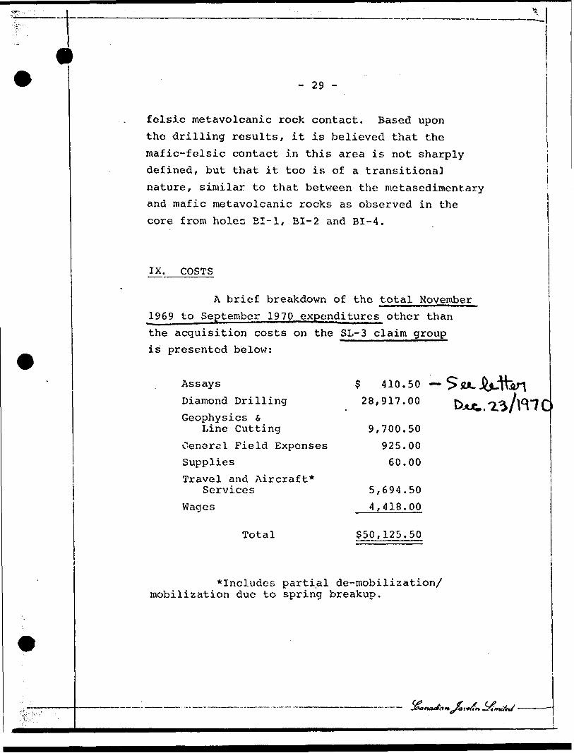
IX. COSTS
A brief breakdown of the total November
1969 to September 1970 expenditures other than
the acquisition costs on the SL-3 claim group is presented below:
Assays
Diamond Drilling
Geophysics S Line Cutting
Cenerel Field Expenses SuppliesTravel and Aircraft*
Services
Wages
Total
$ 410.50
28,917.00
9,700.50
925.00
60.00
5,694.50
4,418.00
$50,125.50
*Includes partial de-mobilization/ mobilization due to spring breakup.
- 30 -
X. SUMMARY and CONCLUSIONS
The SL-3 groug^ of 48 unpatented mining
claims^ in the Sturgeon Lake area, Patricia Mining
Division, Ontario, was purchased from L. K. Smith^
and E. O. Dearden in October 1969.______ ^ __________ ______—^—^.^***~****
An airborne EM and magnetic survey was
conducted over the property by McPhar Geophysics
in early-November 1969, and the line cutting,
ground EM and magnetic survey totalling 28.1
line miles were completed in Janauary and February
1970 by Dearex Limited.
The McPhar airborne survey detected
three major conductive zones striking conformably
with the map indicated rock units within the
claim group. Two of the anomalies are parallel
to the north-westward trending axis of Post Lake,
and the northernmost of these exhibits strong
magnetic responses coincident with the conductivity,
suggestive of the presence of iron formation as
indicated on O.D.M. Map 2169.
The second anomaly was indicated as
occurring near and parallel to the south shores
of Post and Willet Lakes, for an overall length
of approximately l 3/4 miles.
The third anomaly was outlined as being
conformable with the nose of a map indicated fold
'- 4.'- "t
- 31 -
structure and mafic-felsic metavolcanic rock
contact in the vicinity of Hump Lake and its northwest arm.
The Dearex survey concentrated on the
portion of the group situated generally south of the longitudinal axis of Post Lake, as it was
considered that the northernmost anomaly,
(associated with the magnetic high) picked up by
the airborne survey, was due to iron formation. Within the area examined, the Dearex survey
delineated the conductive zone parallel to the
south shore of Post and Willet Lakes, but even
with a 300 foot coil separation for greater
depth penetration, it did not pick up a conductor
north of Hump Lake in the region of the inferred
favourable contact zone.
A supplemental EM survey using a Ronka
EM-16, was carried out by Bison Petroleum S Minerals Limited. This program did outline a conductor in the so-called favourable contact
area north of Hump Lake, as well as precisely locating the (iron formation) anomaly north of
the center line of Post Lake. The eventual decision to tie down the "iron formation"
anomaly was based upon the desire to arill it, thereby verifying the cause of the conductivity.
The diamond drilling program commenced
in mid-March 1969 and was suspended in mid-April

- 32 -
for spring breakup. Drilling was resumed in
late-May and terminated in June 1970 with a
total of 2/989 feet being completed on the pro
perty. The drilling program resulted in six
holes, three of which tested the long conductive
zone adjacent to the south shore of Post and
Willet Lakes, one tested the iron formation
anomaly, while two tested the conductive zone
determined by .he supplemental survey in the
area of the inferred mafic-felsic metavolcanic
rock contact northwest of Hump Lake.
Holes BI-1, BI-2 and BI-4 were drilled
in a transitional contact zone between meta-
sedimentary and mafic metavolcanic rocks, and
encountered graphitic horizons with moderate
associated pyrite and phrrhotite mineralization
as being the cause of the conductivity detected
by the EM surveys. Hole BI-3 was drilled in the
more typical metasedimentary rock sequence and
encountered banded magnetite iron formation as well as a graphitic horizon, which account for
the anomalous magnetic and EM responses in that
area.
Holes BI-5 and BI-6 were drilled in a
transitional contact zone between mafic and felsic
metavolcanic rocks, and determined that the con
ductivity was due to weak to moderate disseminated
pyrite and pyrrhotite mineralization associated
with rhyolitic horizons.
- 33 -
Although sulphide mineralization was moderately strong in the sampled sections of
all holes except BI-3, assays did not reveal
the presence of commercial quantities of copper, zinc, nickel, gold or silver.
It is believed that the mafic-felsic metavolcanic contact, although transitional and
not sharply marked, has been reasonably well
located by geophysical methods. Drilling in this contact area within the SL-3 group has
indicated the presence of disseminated sulphide mineralization, although none of a commercial
nature,. If stronger sulphide mineralization is
associated with the contact zone, it is probably
too deeply buried to have been detected by the
geophysical equipment utilised in the ground surveys.
Based upon the geophysical surveys
completed to date, there are no untested
anomalous areas on the SL-3 claim group.
XI. RKCOMMENDATION S
The 1970 geophysical work on the SL-3
claim group outlined three major areas of interest
and all of the targets have been drilled, resulting in the determination that graphitic horizons, iron formation and pyrite-pyrrhotite mineralization
were responsible for the anomalous magnetic and
- 34 -
EM responses determined by the surveys. The
exploration program has provided sufficient
assessment work credit to maintain a major
portion of the claims in good standing for
over two years. It is recommended that the
company defer additional expenditures on the
claim group until sufficient additional work is
performed on the adjacent groups held by Canadian
Javelin Limited and Norlex Mines Limited. If,
in the near future, either of the above companies
conduct on I.P. Survey across the favourable
mafic-felsic metavolcanic rock contact, it would
be advisable to run an I.P. check on the cross
lines in the contact area on the SL-3 group.
Respectfully submitted,
November 25th, 1970. W. B. Blakeman, M. Se., Geologist.

V
- 35 -
REFERENCE MATERIAL
1. Ontario Department of Mines, Report Number 24 - Metionga Lake Area (includes Map 2044) by David P. Rogers - 1964.
2. Geological Survey of Canada, Paper 68-45 - Geology of the Sioux Lookout Map-Area, A Part of the Superior Province of the Pre cambrian Shield by R. Skinner - 1968.
3. Ontario Department of Mines - PreliminaryGeological Map P-353 - The Minnitaki-Sturgeon Lake Sheet, Districts of Kenora and Thunder Bay, compiled by J. C. Davies and A. P. Pryzlak 1966.
4. Ontario Department of Mines Map 2169 - The Sioux Lookout-Armstrong Sheet - 1970.
5. Geological Survey of Canada Aero-magnetic Series
Sheets 1117G - Bell Lake 1127G - Watcomb
6. Northern MinerIssue dated November 6th , 3 969.
7. Bateman, A. M. - Econom.i o Mineral Deposits, J. Wiley s Sons, New York - 1952.
8. Putnam, D. F. and K'^rr, D. P., A RegionalGeography of Canada, j. M. Dent S Sons, Toronto 1966.
9. Report on the Jombined Airborne Magnetic and Electromagnetic Survey, Post Lake Area, Patricia Mining Division, Ontario by McPhar Geophysics -- 1970, Report Number 580.
10. Report for Canadian Javelin Limited and Bison Petroleum s Minerals Limited covering Magnetic and Electromagnetic surveys' over a portion of their Sturgeon Lake Area claim groups, Patricia Mining Division, Ontario by Crone Geophysics - 1970, Report Number 613.

V
Assaying Norlex SL-1
and Bison SL-3
Total Assay charges - Bondar-Clegg f, Co. Ltd. (See Attached invoices.)
- $931.50
Assay man days @ l man day per $15.00931.50 divided by 15.00 equals 62 man days.
Determinateons:
Norlex Bison
98104
or or
491
Man Day Distribution based on Above:
Norlex
Bison
30 divided by 49 equals approx imately .6 :.ian days per claim.32 divided Ly 38 equals approx imately .b man days per claim.
iam B. Blakeman

EXHIBITS

DRILL CORD
COXPAKYBISON PETROLEUM S MINERALS LTD? R0J2CT
RSXARKS :A2.
220 0 Mag
INCL.
JLS:COORDINATES
L 24W/31+25N
ELEVATION Tost
Hole No. 1
.. h .ch. 282/S29
D r i 1 1 b y :
F o o L aiize!
R 'j c o v e i1 y
' ? 3SJ5LrL.? 0 .. - IJ4^i T " TO l 4 l 4 l
j D a t e j F r o r.i
atteiair ~-T ToLog&ed by: Dace
From ToAssay R 2 s . i,
nmort r K. 9 ;;
DESCRIPTION
•21SL .l - 4 .:... i li LI 0,1, loo
i! 111|117 6 100
-C.asJLncL.
,-l^ed-dark..gr,.oQ,n. f ,]^andod,g-nd Amygdaloidal nhioritiiy.&d r?Ri hi r;tuffs w/chloritized shear faces and minor x-cutting quartz veins. Very minor diss py and pyrr w/very minor bleb of chalco in quartz"Vel.T~a"t 14.5' . l"^zones~"or banded and" diss py and* pvrrr "@ 58.0 1 , 61.0 1 , 75.0', 82.5', banded 45O TGA @ 24', 50O TGA @ 77.0'
Med gray^, medium to v-fg, very finely banded to massive quartzdiorite w/chloritized shear faces which carry strong pyrite mineralization.
.117 279.5 162 5 100
'279.5 282 2.5 100
Same as 4-111, but, slightly..m.QTg-jRiaS-^iA'.e;-,less v.'el]_handed ..-ind..^ non-amygdaloidal. Weak to moderate l"-3" zones banded and diss py and pyrr @ 117', 118.5', 120.5', 122.5', 140.2', 147.5'.lTd~dTs~s~p7~alTa~p ./T^lTo w/l L/2 1 missive py @ 173.75. Sampled 171-176. Banded 50O TCA @ ISO'.
Veined and massive quartzose zone greater than .60^ quartz w/moderate di3 S and banded py and pyrr.

COMPANYBISON
D R I L
PROJECT
E C O R D
SL-3
REMARKSAZ. INCL . COORDINATES ELEVATION
Hole No. l
Sheet ^C. 2
Depth: 325/529
Drill by: Dater' 7" O . TO
Logged by: DateFrom To
Recovery i A s s r. y Res.
l FrnrJ To ! Feed DESCRIPTION
l l i i l j 2S2 : 283.5 1.5- 100 l
i
Banded, contorted and brecciated carbonaceous (black) graphiticmaterial w/moderate to strong diss and banded py and pyrr.
i
283.5! 289.5 6 ! 100 i Same as 279.5-282, but w/strong massive sulfides 287.5-288.5.
285.5! 297.5 8 ! 100 Banded/ contorted and brecc.i,fte^ black carbonaceous graphiticzone w/weak to moderate banded and diss py and pyrr.
1 ii il1
]
' i 297.5 309 ! 11.5 100
i
i
31 u,. 'i 7. S
i ti 316.5 325
l il
i1 1
.S. 5
;: Coarse to med arained cru'i texture w/minor weak to
ji
^nn ; ; M e d gray, m- f g diorite -ii , '
! "' '
100 ' Coarse to 'mcd orained au i graphitic seams carrying |! 322.75' , 323' , and 323.5
artz diorite , aranitic-norohvroblasticmoderate banded py and pyrr.
*
no mineralization.
art?, dioritepy and pyrr
i*
but w/rflvhr^arprm*-@ 317' , 322.25' , 322.5' ,
|;
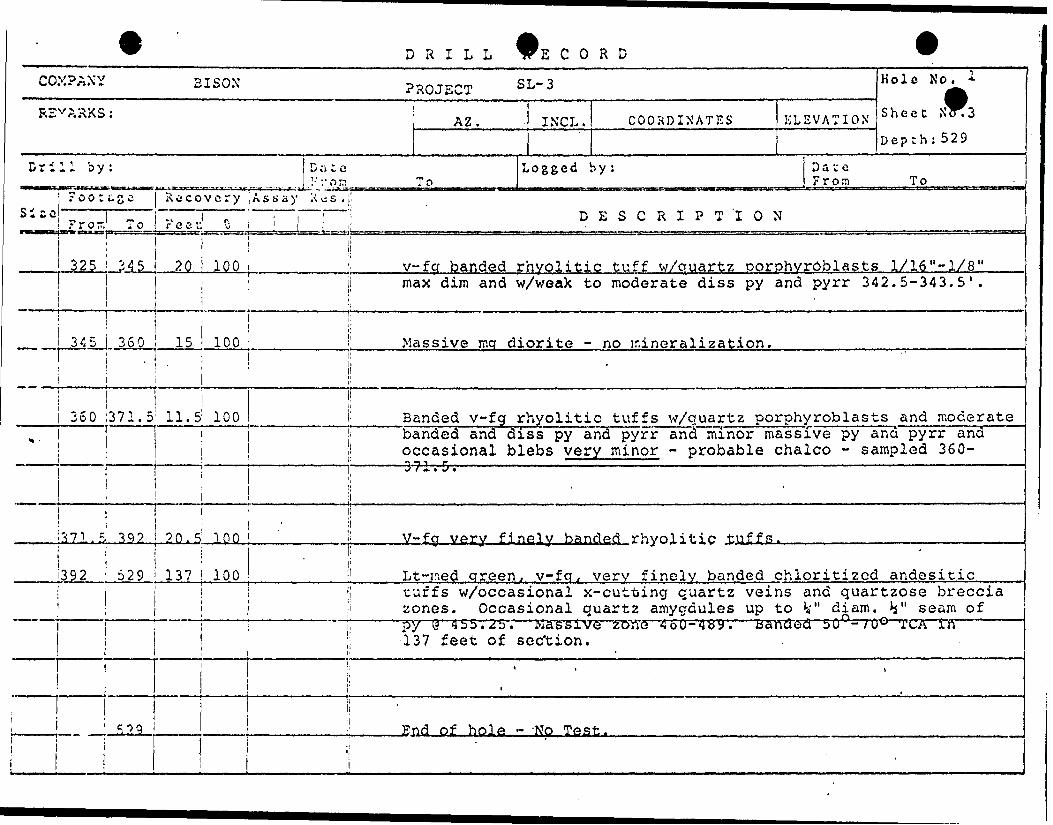
DRILL 'E C O R D
COMPANY BISON PROJECT SL- 3
RSV ?..^KS: AZj INCL. COORDINATES EL EVA
Drill by: JDate Logged by: Da- . - .- .-..TT. I ...^...... ,, , , , J 1-ron i ii . ii i iMiii| To r , I M m m iii| n i I IIIM 1 IB ^ ,,, ,, ,, ,, Fr
Footage | Iscjcovery Assay X s . !Si - c i ^ m p . ! : DESCRIPTION i Fro- To Feet: *i ; u !
Hole No. 1
TION s^ ecc ^^3
Depth: 529
t Qoro To
pa- ^
325 345 20 i 100 '' v-fcj banded rhvolitic tuff w/quartz oorphvroblasts 1X16"-1X8"j max dim and w/weak to moderate diss py and pyrr 342.5-343.5'.
i i, i ii i
345 360 15 i 100 ' Massive mq diorite - no ir.ineralization.i i ' i i *i ' i i
i i ' 360 1371.5 1 11.5 100 : Banded v-fg rhyolitic tuffs w/quartz porphyroblasts and moderate
,,. ' banded and diss py and pyrr and minor massive i ! occasional blebs very minor - probable chalco' - - '' ^ "S T f" " j . . . . . .. .. . -. . -.. J/ivL'.-
ii o? 1 1 392 20. 5: 100 - ; V-fg very finely banded rhyoliti,p tVlffp.
py and pyrr and - sampled 360-
\ i
392 529 137 100 i Lt-ned qreen, v-fq,, very finely banded chloritized andesitic! i tuffs w/occasional x-cutting quartz veins and
' zones. Occasional quartz amygdules up to ^ "quartzose breccia
diam. V seam offi . , ^ .i : -" i py @' 455. 25. Massive zone 460-48y. banded 5u--;uw TCA in
137 feet of sec'tion.l i'
:; * , i
i i I.. ' 529 ! End of hole - -No Test.
1 j!i
'

.r
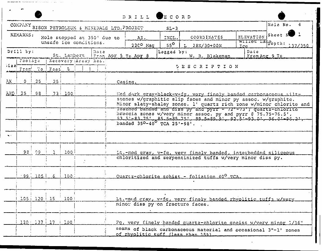
COMPANY: B/SOMPETROLEUM* M/MERALS L/M/TED .D.H.NO.: &I ~
220" MAG. SIZE: AXQLINE: 24- + OO W.
23o-269.sr'- f
CCX.PAXY
DRILL
BISON PETROLEUM i .MINERALS LTD PROJECT
CORD
SL-3
REMARKS : AZ.
22O0 MagINC L,450
COORDINATES
L 4CW/32+0ON Ice
Hole No.
Sheet N
Depth; 189/511
Drill by: D .1 u eFrom Mar 23 To Mar 26
Logged by: Date
Recovery jAssay Res.,:i ise!
l ?rosi' To l Feet| t lp^B. .j^., , . ——^.. , —— ^ -^.- -.——-*-,.- ——l. -^. .1 M ...-^ l*——-^——
DESCRIPTION
"i Sri? EX. s50 i 90
AXQ ! 90 ;122.5 32.6 10C:
Casing
Lt-dark gray v-fq f inely^ banded silicified aad chlorJL.tji.gec'l.tuffs w/minor carbonate (calcite) banding and prominent quartz porphyroblasts up to V max dim. scattered weak py mineralize ti on
~Wedk""tcnnoderate ' barrdefi'~an'ct~iSl"S"S'~py~cnfra pyrir 103-111". 5
1122.5' 147 l 24.5: 100; V-fg very finely banded slaty carbonaceous graphitic....r.\ate^.icLLinterbedded w/light gray v-fg, very finely banded silicified tuffs. Fracturing parallels banding. Fracture faces are
hltlC TCA~py
.11? a7?.. s! ?.s.fc Lt-rcftd', ,gr.ay, .-medium, t o v-fg, finoJ.y...,banded-sillcXXd. w/minor diss py banded 45O TGA @ 157'.
a?2.5! 176 i 3.5 i 100: Dark gray v-fg silicified tuffs interbedded w/slaty, black.carbonaceous graphitic material. Fracture faces are graphitic.
: 17C , 189 i 13 l 100 Same as 14-7-172.5.
DRILL E C O R D
CO.XPAXY BISON PROJECT SL-3
REMARKS: Az IXCL. COORDINATES ELEVA
Drill by: lDa:e Logged by: Da1 F r or, To F r
roocas^ Recovery ;Assay Res.Si*C' i ' r " ; 1 DESCRIPTION ; ? r o r. 1 T o F e e c ^ .[ir
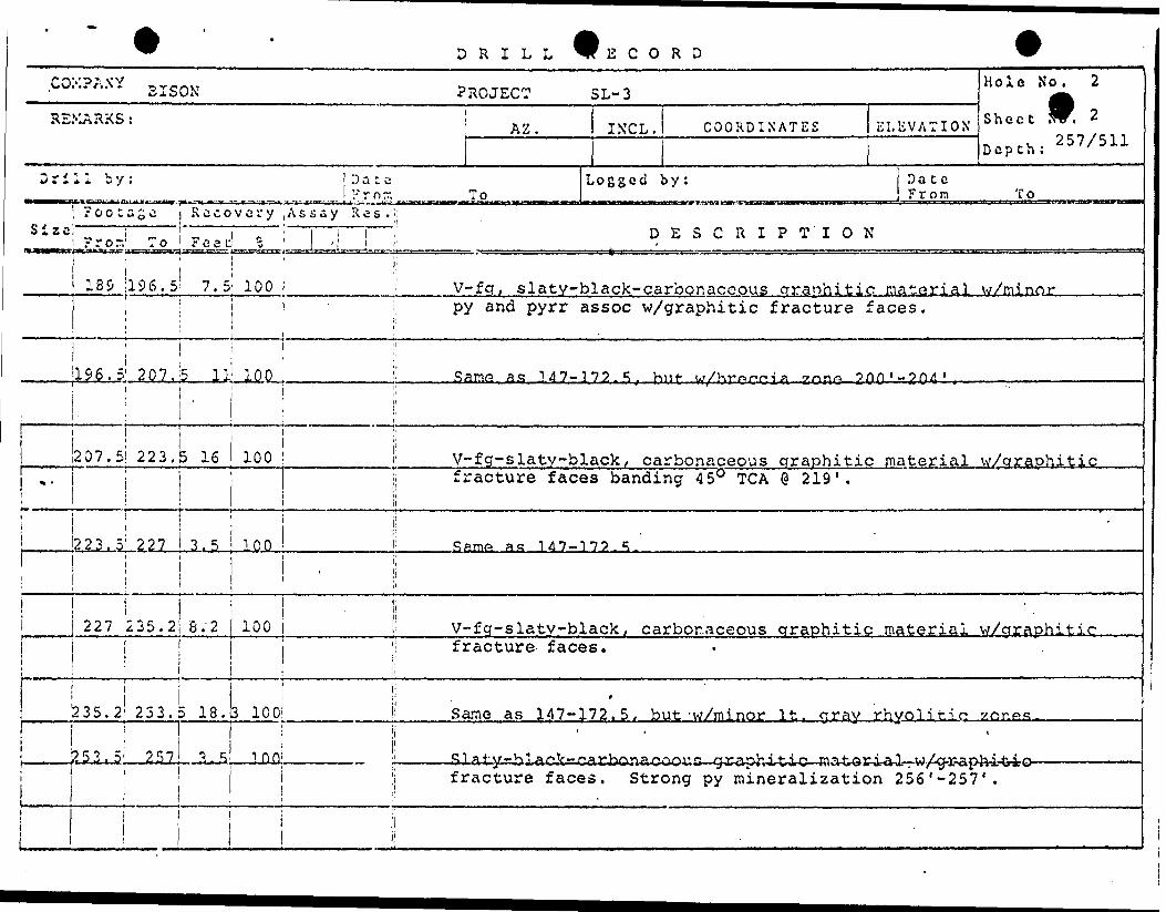
Hole No. 2
* 0i iU-X
Depth: 2 57 /511
ceom To
139 ;196.5' 7.5 100 | '. V-fg, slaty-black-carbonaceous graphitic materials/minori | j -i py and pyrr assoc w/graphitic fracture faces.1 ' i! 1 li
- - 1 1 't h '!i !
J196.5 1 207.5 111 100 ;! San^ as 347-172.5, hiif w/Kr^^i^ Zon^ 2^0'-?^II j ^
4 ' . ,, - ,,..-. .......-
! i i ^ 207.5! 223.5 16 100 ' V-fg-slaty-black , carbonaceous graphitic material w/araohitic
|j fracture faces banding 450 TGA @ 219'.
i i i ;l ! i
'223. 5 1 227 3.5 T 00 '- S ame as 347-372.5.'ii i
i ' i
L - l227 J235.2 8. '2 100 |! V-fg-slatv-black, carbonaceous graphitic material w/araohitic1 'l fracture- faces.li! i:————— ——————————— . ———————————
^35.2*233.5 18. b 100 ' Same as 147-172.5, but -w/minor It. cray rhyol:i i ji '
J. \
| ! fracture faces. Strong py mineralization 256
Ltiq .zone*?..
-257' .
i j
DRILL E C O R D
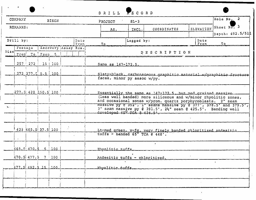
COMPANY BISON PROJECT ' SL-3 H OlC N O 2 -
RSXARKS : AZ. INCL. COORDINATES ELEVATION S heet N o 'Depth: 492.5/51
Drill by: Date Logged by: Date ?rotr, To From To
SizeXCMBBC
rootage Recovery Assay Res.!^ __ - - ,. . 1 i! DESCRIPTION r ?o:r. ; o ;* ee L v [ :i
i i
257 272 15 1001 i
272 2 11,1 5 .5 100i
1
277.5 423 iiiO.5 100
i|
li 1 Same as 147-172.5.
•' Slaty-black, carbnnar.Arnic; grsphiti^- 'mat^ri^] JJ/ora^hdrti'C— fc-r-tVC^U-E^i faces, minor py assoc w/py.
1i Essentially the same as 1^7-175.5. hnf- mp-d crrainprt na^cs-i v/r,
' ! (less well banded) more siliceous and w/minor rhyolitic zones, ! and occasional zones w/prom. quartz porphyroblasts. 2" seam: massive py g 3b2', l'1 seams massive py @ 377', 378.5' and 379.5',
; 3" seam massive py @ 391.5', 2V seam @ 425.5'. Banding well——— j ———————————————— | ————————————— d^v^Uop^d 450 TGA e-4 2-4-r^-. ————————————————————————————————
j 1 '
423 '465.5 37.5 100
,i
465. 5 470. S 5 100
470.5 477.5 7 100
! 1 77*^ *92.. 5 15 10 0
jLt-med cjr"een, v-fo^ very finely banded chloriti?,e{i anflftsiti f.
j tuffs - banded 65W TGA @ 448'.i
li - * Rhyolitir1 t^iff*?
l!' ^ 9
i Andesitic tuffs - chloritized.li
i
11
11
DRILL E CORD
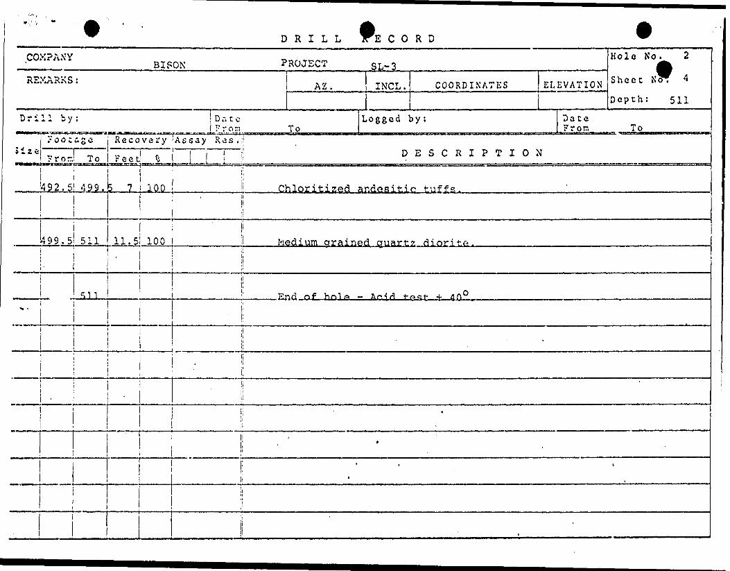
COMPANY
REMARKS
Drill by
iizft
Hole No, 2BISON PROJECT SL- 3 ^5 AZ. INCL. COORDINATES ELEVATION S heec N3^
Depth: 511
: Dace Loggedby; Dace From To From To
?ooca S e
?ror
49?- 5
499.5i i
--
i1
Recovery
To reel 5
! 499,
511
? 7
11.5'
51 1
100
Assay Res .;!j j ! DESCRIPTION
ii| Chloritized andesitie tuffs.i
ji 100 ; Medium arained quartz diori to .
i i
t
1
l
i;
i.
\
li 1
1l
l ' 9 .
\\
i '
L * * t
i 1
j!
i

eCOMPANY: B /SOA/ PETROLEUM*MMZ3ALS LTD.
2O C
ttll
2 O Oo
*
c(O
z8

DRILL i C O R D
COM?ANY BISON PETROLEUM E, MINERALS LTD.PROJECT S L-3REMARKS: AZ.
22 O0 Mag
INCL. COORDINATES
L 12W/48+50N
ELEVATION10'
Irakis'
Hole No. 3
Sheet NcVl
Depth: 294/600
Drill by:Lambert..
Dale ?ro-.Mar 28 ToMar 31
Logged by:B
Date From M Tp Apr 1/70,
Foocas a i Recovery (Assay Res.i'DESCRIPTION
AX i O i 61 6 i Casing.^i j i
AXQ l 6 1 245.5 239.5 100 ..L t,-med,.gre,en-gray,,, y- f g- yje.ry, f ing .ly... Xnterband ed.. chlnr.i tl?.p.ri...jr.uf f.
245.5 277 ! 31.a 100
and calcitic siltstones, scattered l"-2" zones in which light min, is quartz rather than calcite. Dark min. is generally chlorite. "ClTTartrl1 z 1e1 (S' 1 '- 1"S'llp""- 1 "s~h~elir" races" carry1 minor" py minor v-i 11 x-cutting quartz veins. Gneissic texture {quartz-bio-chlorite-
s) ...l 82' - 3 8 c-' . Mi nor- --* S-'---l-.-5-L-225'. Banded: 400-50O TCA 6'-50', 40O TCA @ 70', 50O TCA @ 94', 550 TCA @ 123', 550 TCA @ 174', 55O TCA @ 216'. Quartz breccia
V-f(?-black~slatv, contorv.ed, fractured and sheared carbonaceousgraphitic material w/very minor diss, py on strong graphitic slip-shear faces.
1279 ! 2 l 100 |
!27Q '-i- q inn
1282.5 294 11. 5' 100 i
...Chlor i-tJ
.Sa.me as ^6 ' -245,. 5 ' f j,,bu.t V//6 , 2 "r 4", ZOAQS ...y-f g j very finely cherty sedimentary iron formation, very magnetic.

DRILL 'E C O R D
COMPANY BISON PROJECT SL-3
R2XARXS: AZ INCL . COORDINATES ELEVATION
Hole No.
Sheet NW
Depth: 600
3
2
Drill by:To
Logged by: Dace From To
.ize? c o c s s ! Recovery !Assay Res
Prod To ! Feet DESCRIPTION
AXQ. 294 366 72 100 V-fg-yery finely banded, alternating black and gray bands 1/16"-1/8" cherty-slaty sedimentary iron formation, very magnetic.l' Quartz-chlorite schist 334-335 and 6" zone 347-347.5'. BandedGO TGA Q 348' .—————————————————————————————————————————————
366 l 404 38 100 Same as 282.5-294.0, w/solitary V8"-174" bands of iron formationand l"-6" zones banded iron formation in chloritized tuffs and siltstones banded 65O TGA @ 394'.
i4041 600 i 196 100 Lt. green-gray v-fg, very finely banded chloritized tuffs and
siltstones" w/bccasional 1/16 "-1/8*"" s earns bif iron formation, i.e., one seam each 5'-10' of core and occasional l'-2' gneissic
o 500-550', banded 70O TGA Q 4.25'-474' r-300 TGA 6 540'-600'.
600 i End pf hole - test taken, but suspect that hole flattened

c
PETRQLEUMeMINERALS LTD. - 5'Z. - 3 O.O.H.NO.: &I -3
ENDED: AMcj/31, i?7O
D.D.H*3
Grahitic, stone tecraa'srf
formation
6 J ~
f /"-G'' .Zone* o?' gafjaffd' /.-on fbr.r.af.
^ G Z "-c" 'toffs - C/irrfy Vffy f 'in f Grai/i
for/tialiofi , Very . Wa
-t i -vvsj' " ' PC , T1'
'-fr^ of c*re.
W D R I L L 1rnvp; vv
' "'BISON PETROLEUM l MINERALS LTD. PROJECT-^yj^.^,,, .
Dri
^ V ."•A
AXQ
H -
Hole stopped at 350' due to A2 .unsafe ice conditions. ^-s^n ,, 2 2 C 0 Mag
1 1 b y ; Date St. Lambert F r or, Aor 5 To Aor 8
7 o o t a g e Recovery iA f- say Res.!:i ' l ' l | ! F r or:.1 To i Feet ro j ^ "
i i !! 0 ; 25 25 !: Casinq.
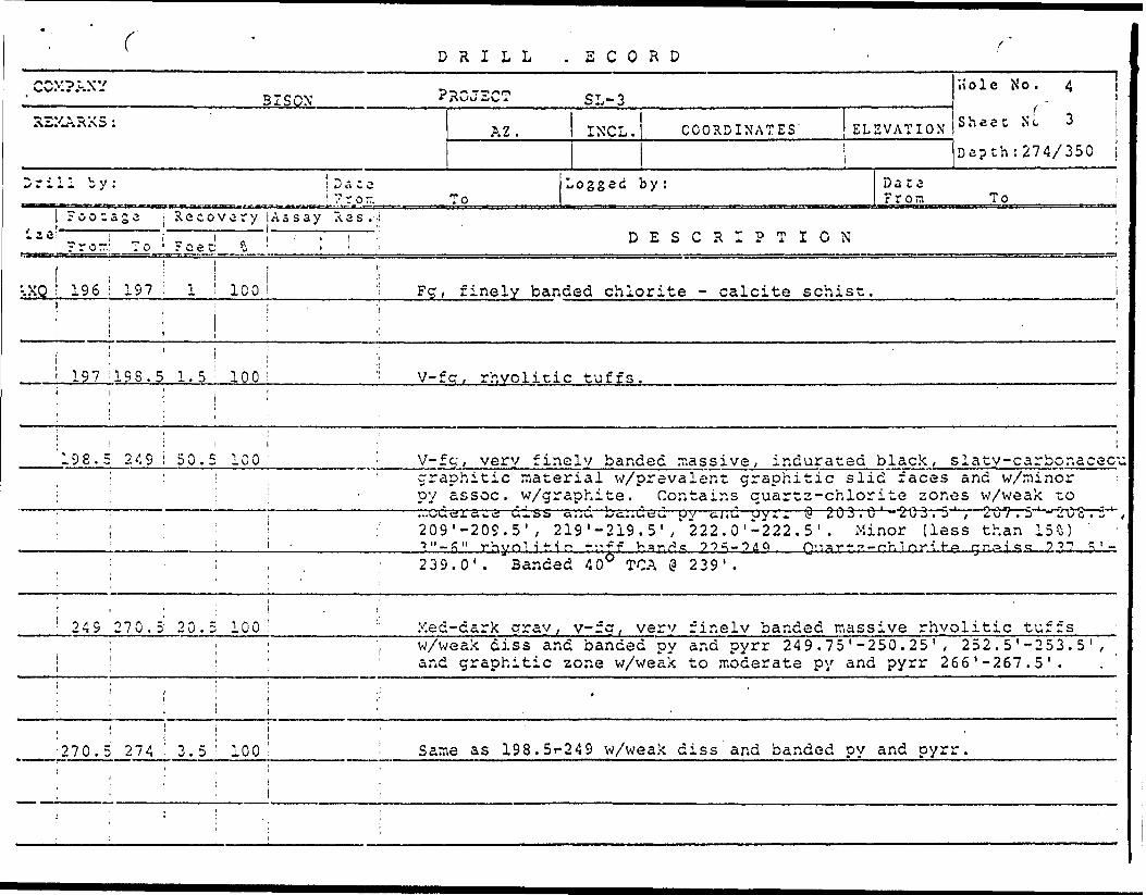
^E CORD V
Hole No. 4 SL~ 3 *A
IXCL. COORDINATES ELEVATION S hcet N" LWillet La. ;e f...
550 L 28E/30+OON ice drepcn. 1 37 y 350Logged by: Date
W. B. Blakeman From Any 9 To
DESCRIPTION
' ! 25 i 98 73 100 i! Ked dark crray-black-v-fa , very finely banded car bon arsons ?,ilt-
\ s tones w/graphitic slip faces and minor py assoc. w/graphite. j Minor slaty-shaley zones. 1' quartz rich zone w/minor chlorite and
i ; ' l 1 leached banflefl and "fil'SS py 'and pytif - /^'-/j 1 ; c^uartz-chiorite 'j j; breccia zones w/very minor assoc. py and pyrr @ 75.75-76.5',
i ! j banded 35O-40O TCA 25 '-98'.
•:
l i li98 09 1 100 \ Lt.-med qray, v-fq, verv finely banded/ interbedded siliceous
i i i j ;l chloritized and serpentinized tuffs w/very minor diss py.t , j;
i | t
1 '99' 105 6 100 i ; 1 Ouartz-chlorite schist - foliation 40O TCA.lil j!
i i !:105 i 120 15 100 : Lt.-mc-:d crav.
l i f; minor diss py -
120 ; 137 17 100 ii ?q, very fine!
t
v-fq f very- finely banded rhyolitic tuff.3 w/veryon fracture faces.
y banded quartz-chlorite qneiss w/very minor 1/16"| i; seams Of black carbonaceous material and occasional 3"-!' zones ' ;' of rhyoj.itic tuff npc;^ fhsn i^s-^

DRILL E C O R D
COMPANY BISON PROJECT SL-3
REXARXS: A z ^ INCL. COORDINATES
Drill by: Dace Logged by:.mm F r o m To
] Footage i Recovery Assay Res. li
Hole No. 4
ELEVATION S hcct N"^ 2
Depth: 196/350
Dace From To
fiZC Fro, To Fee, 6 | ! DESCRIPTION
i j i AXQ 127jn8.5 1,5 100 \\ Ouartz-chlorite schist.li! i!li( ! 'l
j j . 1
•138.5 146. '5 8 100 i i S^me as 1^0-137, l^vit- gr^at-i^r t-hAn pna. rhy rili^-ii"1 t-iTf^c\ -\
p|ii
J ij146.5 147.75 1.25 100 )| Med-dark rjr^n, y-fg/ v^ry finely banded,
;! quartzose-chloritized tuffs w/very minor i -i! pyrr.
banded and diss py and
| i t .
! : j . li 147.75 187 39.25 100, ' . i Predominantly {greater than, Rfi*) hlap.k,,v ,. , ,-f r.', \rfri-v f i nrO \ r . K,i /-l^/-!
li to massive carbonaceous material (siltstone) with graphitic j! shead-slid faces and minor assoc. py. Minor zones of interbedded
j : i :, v-fcj, vex'y zineiy Danaea rn.yoiitic and chioritized tuffs w/weak j to moderate diss and banded py and pyrr @ 149 . 5 '-152 .0 ' , 154.75'-
i '' , :' , , 156 0' bmndod •lO TCA @ 151'. -.. ,- .^..i ' ' *
ii; ; *i 187 '189.5: 2.5 100 ; Ma, quarts - f elds - bio. nneiss.
t
i '' ' l 1 1189. 51 196 5.5 100 i 1 V-fg, very finely banded - massive rhyolitic tuffs.
i i! -
c DRILL S C O R D
CCXPAXY
REXARXS :
Drill by:
j ?oo:ase-. z e ; j-
! ? r o r.: To1
".XQ l 196 i 197j , i! 11 ; 1
i 197 1198.5i i
i '198.5 2491 i
1
Recovery.
reef S!
1 i ICO
i1. 5 ' 100
l
50.5 100
^ H o 1 e N o . 4ilSON PROJECT SL-3
AZ. l INCL. COORDINATES' ELEVATION S heec N cDe?th:2747350
Dace jLogged by; Dace 7ro- To From To
Assay A s s . 'ii . i .- DESCRIPTIONi i
i|!
: ; Fg, finely banded chlorite - calcite schist.•ji*
i ( ' l v-fcr, rhyolitic tuffs.
V-fg, verv finelv banded massive, indurated black, slaty-carbonacecgraphitic material w/prevalent graphitic slid faces and w/minor oy assoc. w/graphite. Contains cuartz-chlorite zones w/weak zo: : - uy tissue, w/giapr.
, , ' I M "' "•;:.ccc!ra iw'S i~ id iiss a;ju ; i ; - :' 209'-209.5' , 219' : : i -J "-P" rhynl-jMo *1 ; j : ' . ' 2 39.0' . Banded 4
! 249 270.5 20.5 100' :; Med-dark gray, y-
iv.e. v.onzair.s quar*.z-cno.orj. ue ^or.es w/weci^; *.o
-219.5' ," 222.0'-222.5' . Minor (less than 15S)\". f f ^ ~H''"! ^ ?^^— "54^ Q'lArt" 7 — f'n 1 HTI i*A qnAicvt? ? ^-7 c ' -
O6 TGA @ 239' .
rg, verv finelv banded massive rhyolitic tuffsi ; : ; ; 'i w/weak diss and banded py and pyrr 249 .75 ' -250.25 ' , 252 . 5 ' -253. 5 ' ,
i ; ; ' and graphitic zone w/weak to moderate py and pyrr 266 '-267.5'.
i ; l i 1 ; ; * ' '. li 1 .; i i i j : 270.5 274 ! 3.5 : 100 ' - Same as 198.5r249 w/weak diss and banded py and pyrr.
' \ - ': ' \ '~
; . ' , l :
: ; ; - .
c r .cCOMPANY: BISON PETROLEUM s MMZRALS LTD,
S/era/to* ' Wrf/ft Late i l z e.
Ye s y /"//fg J2a*a'ftji' Car&os/a to/fti
CA'iis: i,7z.t\*' Ti/rYbAify f/nor
DRIL.L^ECO•*
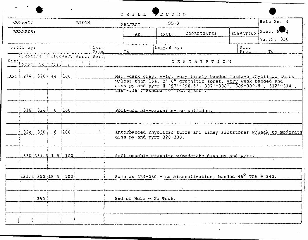
COMPLY BISON PROJECT S L- 3 H OlC * *
X&A™*'' \ AZ. INCL.i
. , ,. , .. ,, . M. , J^————
COORDINATES ELEVATION S hect N^4Depth; 350
i) v i 1 1 b y : "^-. u a L o g g o d b y : Date— - — ...- ...-,... .-.....-..r ... n . .. . . ..., , J'.r.o."..... ^.To,,,,, .....- ,, M l , n t* t on T o _ ,
l' o o t c. z z i R t c o v t r y ! A s t, a y R a s . rS 123 i ' ' : 1 ' i " T " T - ". n
? r or/ To i Fceti f- ; . ! - !
1 r i :! AXO 274 i 318 44 100 j Ked.-dark arav, v-fa.
ESCRIPTION
verv finelv banded massive jrhvolitic tuffs ,! . :i w/less than 15^, 2"-6" graohitic zones, very weak banded and i j , diss py and pyrr @ 2g7'-298.5', 307 ( -308', 309-309. 5', 312'-314',l 1 ' i ;' 316 ' -318 ' '.""Banded" 40 "
i ': iTC'A \S J UU ' .
318' 324 ! 6 ;100 Sof t-crumbly-qraphite- no sulfides. . . ... .i i i 1
j | i
i l .
324 : 330 6 100 1 ' !' Interbanded rhyolitic tuffs and limey siltstones w/weak to moderate1 j ' ; i 1 diss py and pyrr 328-330.1 ' l
'- i 1 'ii 1 i'330 : 331, 5 1.5 100^ : Soft crumbly graphite w/rnoderate diss DY and pvrr.
: i i i . i; - "i '. 1
! ' i 1 .' 331.5 350 3.8.5 100: ,i Same as 324-330 - no mineralization, banded 45O TGA @ 343.
! : ' i i i,i . 1 ;- i ^ i 'ii : ! 'i ! 350 i ' End of Hole ~, No Test.
iii''
l i li l
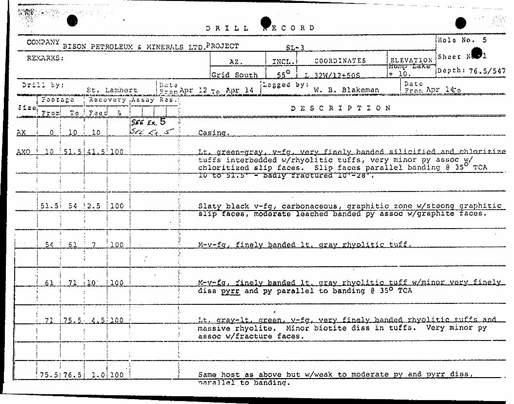
* DRILL E C O R D*"*f} V "^ j^v BISON PETROLEUM fi, MINER/vLS LTD.P^OJECTREMARKS: AZ.
Grid South
SL-3
INCL,55'
COORDINATES
L 32M/12+5QS
ELEVATION
10.
Hole No. 5
Sheec x9l
Depth: 76.5/547
Drill by:St. Latr.bert
u a t eFrom Apr 12 TO Apr 14
Legged by:W. B, Blakeman
Dater1 r o TV. Apr 14;o
Recovery i Assay Res.
l Frorr.! To \ F eed-
r.X O ! 10 i 10 i. 5
DESCRIPTION
Casing.
AXO JLO ': 51.51 41.5; 100 t,., gr.gen~gray,j, y— f g, very finely, silicified and ch.lnri t.i.7.ecltuffs interbedded w/rhyolitic tuffs, very minor py assoc w/ chloritized slip faces. Slip faces parallel banding @ 35 TGA TOT6 bl.b 1 - badly tractured JLO'-iJtt 1 .————————————————————
51.51 54 2.5 i 100 i
l
slaty black v-fg , carbonaceous, gr aph i tic zone w/steong g r aph i t i c slip 'faces, moderate leached banded py'assoc w/graphite faces.
54 ! 61 ' 7__i 100 M-vfq. finely banded It. gray rhyolitic tuff.
61 i 71 10' 1100 M-v-fg, finely banded It. gray rhyolitic tuff w/minor very finely. diss pyrr and py parallel to banding @ 35O TCA
71 i 75.5 - 4 .5 100 Lt. gray-It, green, v-fcr. very finely banded rhyolitic tuffs andmassive rhyolite. Minor biotite diss in tuffs. Very minor py assoc w/fracture faces.
75. 5(76. 51 l.OilOO Same host as above but w/weak to moderate py and pyrr diss , narallel to banding.

DRILL E C O R D
COMPANYBISON PROJECT SL-S
REXARXS AZ. CNCL. COORDINATES ELEVATION'
Hole No. 5
Sheet N
Depth: 360.5/541
Drill by: Dace "' r o r. To
Size!'Footage Recovery .Assay Res.ii
Logged by: Date From To
?ro-' To Fee DESCRIPTION
AXQ ! 76.5; 91 14.5! 10Cii i
Same as 71 to 75.5.
91 ;94.5! 3.5! 100 Same as 75.5 to 76.5 but with me derate py and pyrr diss parallel to banding.
y . 3 ! . l 3 B : O Same as 71 to 75 t 5. no diss sulfides, graphitic zone 112 to 112.75. banded 40O TGA @ 143.
158 ' 218 : 60 ; lOOi Essentially same ,mineralogy as 71 to 75. 5 but w/gneissic-porphyroblastic texture. Prominent angular quartz fragments 1/64" to 1/8", commonly well foliated appearance, moderate •cis's-pyrr "and py '161.75 "tu "l6"3 y 16^9 v 5 tu~ -17O .'S ,' V fc-rdiss pyrr - 176 to 177.75, moderate diss pyrr 177.75 to 178,Waak di sg pyrr '.ft A fn Ift^ h*nrJori A ^ TPR Q '. 7 d .——————————————
iiL.
!218 22S.5 11.5 100! Well foliated m-calcite - no
m~v-fg, chlorite qu art z jC eldspar schist w/very mino- culfides, foliated 2"20^TCA @ 220'.
229.5 : 360.5 100i
Same as 158 tQ,218, but, w/5%. to 101 massive rhyolite and 10V.to 15% banded rhyolite, very weak diss pyrr 232 to 242.5, scattered blebs calco noted @ 236; weak diss^oy.rr. and py 252.5 to j
DRILL RECORD
COMPANY BISON PROJECTREMARKS :
Dri
Size
11 by
Foot
? r or.
417
-
see
To
DateFrom
Recovery
Feet *
i
t
1 439 22
i
il
439 456! 17
459ii
459 4*,1
3
f\
100
100
Assay Res."
____ i .
AZ.
To
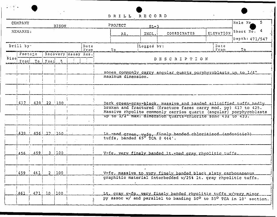
zones commonly
Hole No 5 SL-3 ^
INCL . COORDINATES ELEVATION S hect X o 'Depth: 471/547
Logged by: Date From To
D1
ESCRIPTION
carry anaular cmartz oorohvroblasts uo to 1/4"j maximum dimension.i|
'' Dark qreen-aray-black . masfiivf* and handed silicified tuffs hadlv; broken and fractured- (fracture faces carry mod. py) 417 to 425.
j; Massive rhyolite commonly carries quartz (angular) porphyroblastsj; up to 1/2" max
i!
. dimension Quar'tz-chlorite zono 4 32 to 433.
Tf-*^ f i HP'1 w han^or! oh 1 o-r i i- -i .^.o/? /.^nr'./a.cj. i t- i r-*? \
l! tuffs, banded 65 TGA'i
@ 444' .
1.1: ' i1 i'100 i: V-fq, verv finely banded It.-med arav rhvolitic tuf^s.
100l
i!i
i:
li V-fg, massive to verv1; 9 ra
finely banded blacX .slaty...c.arbonacfiousphitic material interbedded w/25% It. gray rhyolitic tuffs.
461 471 10 100 Lt. gray vr-fq, very finely banded ,wZvg,yy,. PUi, py assoc w/ and parallel to banding 50O to 55O TGA in 10' section.

DRILL RECORD
cox? AX yREMARKS
Drill by
Size1 1.- - r-jx.
BISON PROJECT SL-3 H olG * * '^t AZ. INCL. COORDINATES ELEVATION S hcet N o ' 5
Depth: 517
: Dace Logged by: Dace Froir. To From To
?oo cage
?ror
471
To
547
Recovery Assay Res i i!Feet fc ! f i "i DESCRIPTION
76
i
i
;l ;i
100 !' Med-dark qreen, v-fcr, very finelv banded chloritized (andesitic?)
l
1
j
1 1 '
l
1
"
ji tuffs w/minor diss py assoc w/ and parallel to banding as well as i cross cutting fractures. Massive andeiitic zones at 484' to 494 ',
———————————— 525' Lo 528'; 532.75 Lu 534.2-5', blebs of py asijoc w/cM^lTtYelS —— ! slip faces at 532 to 533' banded 45O TGA @ 544'.
i!,/
|i
J;
i i!
] 1
1 ____
i i i i
j;
j! '
| j
i' ' . .i j
S ' i

DRILL E C O R D
COV? I*NV' Hole No. SBISON . PROJECT SL-3 ^
REMARKS :-. . . .. . ,..,-,.. — —— — — — - —— i — , , , — —... ...,. -.. . .,. . ^^—
A2. l INCL. COORDINATES ELEVATION S heet N^Depth; 417/547
Drill by: Dace Logged by: Date From To From To
? o o t s g i j Recovery | Assay Res.ls *2ej i : j j | | DESCRIPTION 1 From' To i Feet! S i J l i
J 4
|
360.
t
l -.r-,' 3 67
: 371
!
375t
1
j
1 381
! i j
i : . 254.5. 261.5 -to 2fi4. 765 ^ ? fi q . 5 71 t o ? 7 ^ . v nrv wpalc ^isc; nvrrl
j
^ 367 ' 6.5
ii t
371: 4
i
37: i 4;
381 6
! and py 276 to 277, 278 to 284, 303.5 to 304.5 chloritic zone" i 343.5 to 344.5. Banded 60O TGA @ 299'.i1 i!1 ' i i
ji
100 : Same as above (229.5 to 360.5} but interbedded w/30% to 353, v-fcr.i ;; slaty/ black, carbonaceous graphitic material, minor py assoc
i w/graphite.i -;
i . 'i
100 ' ' Same as 158 to 218 feet.i pj i ; ii
- - i 1 100! ' Same as 360.5 to 367, but w/40% to 501 slaty carbonaceous qraphitic
i- material w/minor py. banded 60" TGA O 374 feet.1 i
100' V-fg, banded rhyolitic tuffs w/30% slaty black carbonaceousi j . : graphitic material.1 !:i i
417! t g
.1 ' "•"' " ' - ' ' - i
inn ; ;: T,t. . rrrAAn-lt-.- rrr^v rh T nr i t i 7.&A s nr? RI T i ri f i Pr3 Anrfps -i t- -i r ^ '?^
i j j j; tuffs interbedded w/10% to 151 v-fg rhyolitic tuffs. Rhyolitic

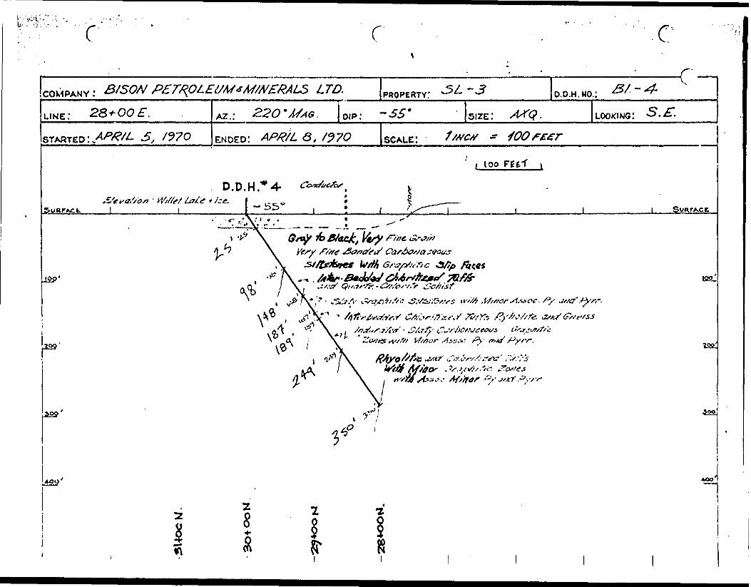
COMPANY: BISON PETROLEUM * MINERALS LTD. PROPERTY: - 3 O.D.H.HO,: &I ~ So
L.ME: 32+OOW. AZ . 220 OIP . SIZE: LOOKING:
STARTED: ENDED: SCALE:
D.D.H."5\'0
0 g/tretibs: t/t/mp tate -no'j___SvurAcc
i IQO'
////.r^- tfsatffj, Z. iff Si/ Gray - Gff** 1/ss/ .f/ae Gra/fi
r J Tuffs
M,-ticr f'ofifi of
102:a tf/i/o/S/t'c 7irSf AV/yo/tfe

}'o Moo's rvfc Pyr/. o^tr f^tfirc
S.yM /c Mce&urrt Gsft* f"'/ fit f Gtw, Mv CSifartfizet/ Ti/ffc mM M/'aos Py Axsoc.
Afassire
f.DRILL RECORD
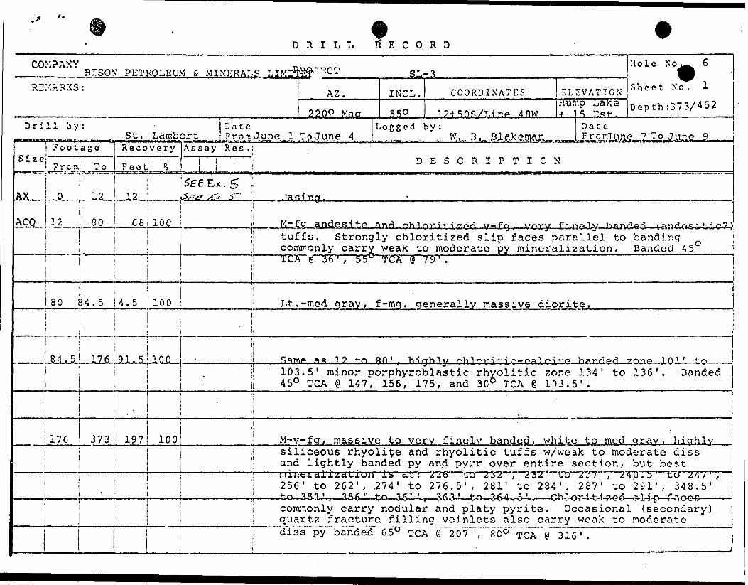
COV?ANVBISON' PETROLEUM S, MINERALS LIMIIt?#'""7:CT
REMARKS :
Drill by:
Sizenmmasss.
ACQ
? o o t a z c'mi
Fret:icaa— .'*-3m
0
1 To
12
12 80
St.Date
Lambert From June 1Recovery
Feet
™JL2^.
68
it
80 84.5i
4.5
84.5 176j
i
176 373
91.5
197
fci
Assay Res.!:
1 i M
AZ.
2 2 O0 Mag
ToJune 4
Hole N o^^ 6SL-3 ^
INCL.
550
COORDINATES ELEVATION S heet N o 'dump L3Ke D e pth 5373/4 52 la + SOS/T.inP 4RW 4-1^ T?R^.. u t lj '- 11 --" '
Logged by : Date
D ESCRIPTICN
Z)f?t? ^."x S~ ' i /asincf.1
100 i i' K- f a andesite anri r-.h 1 nr 1! f i v nA \r-fn. \rm-\r f i^olx/ Kanr^Ari i n /-Ir. .n -i J- . .i s~ ?
;| tuffs. Strongly chloritized slip faces parallel to banding j ,! commonly carry weak to moderate py mineralization. Banded 45li iij!
100 i Lt.
100
1 * 3b', 55^
-med gray,
TGA @ '79'.
f-mg. generally massive diorite.1;
' j
|
j
- j Same SK 12 to. RO 1 . hiahTv fihlnr i l-.i ,--r-^ 1 r--! t-. r* hanrlprt ?.nnA.- 1 m ' -Hoj; 103.5' minor porphyroblastic rhyolitic zone 134' to 136'. Banded i 450 TGA @ 147, 156, 175, and 3Cb TGA @ 153.5'.
!100
. ..
, i
: M-v-fq, massive to very finely banded, whito to med qray, hicrhlyj ! siliceous rhyolite and rhyolitic tuffs w/woak to moderate diss !| and lightly banded py and pyrr over entire section, but best
: jiiiutJi. cilization .is cit : j; 256' to 262' , 274' to
/..'b' CO 1 61' , m. tO A 11 , .^U.S 1 tO fi 1 ,276. 5 1 , 281' to 284', 287' to 291', 348.5'
Ij commonly carry nodular and platy pyrite. Occasional (secondary) ;| quartz fracture filling voinlets also carry weak to moderatei di s s py banded
____________ l _ ———————— —T—65W TGA @ 207', 8CO TGA @ 316'.

j^^^v~iDRILL R'E C O R D
COM? ANY BISON PROJECT
REMARKS :
D r i 1 1 b y : Date ••.in Frorp,
iise
tfQ
Footage Recovery
Fro x' To Feet
373 424-
45
Assay R e s . |!
A. ____ L L
100 ; ; Lt
AZ.
SL-3 H 01C N 0 6
INCL. COORDINATES ELEVATION S hcec X o ' 2Depth : 452
Logged by: Date To F r o Tii T o
-med areen*
DESCRIPTION
v-fa, verv finelv banded Chloritized (andesitic?);; tuffs w/ about 10'%'to 154 calcitic bands (white) 1/16" - 1/8" p in width. Chloritized slip faces commonly carry minor nodular
1 •™" - — -f jr jL-a.'^.*sv" l -ucuiucw"UV — uv— y v — '"i U'rv j.n~ a uv,nii?ii L. iiwxv; x o.u. L. v-i-nxjiy .i' 1'
i i •••"•••i ••""•~ r ' -~ . . . - ,, - - . . . . -; l
1 ' i'424 '428.5 4.5 100 ! Lt.-med arav v-fa massive rhvolite w/verv minor diss DV.
428.5 452 23.5i 4
100 l Same as 346 to 424, but more massive w/only about 20?; finelyi. banded Chloritized tuffs.li
i
452
i
t i
1 End of hple, Angle Test equals 5O ! 1-!|
i 1
it *i'

Bay
BISON PROPERTYCLAIM GROUP SL.3
, noyi LOOKOUT
100 VO
126.3 M IUS TO 1HE
r;*
FEB.
BISOK PETROLEUM E MINERALS LTD.GENERAL LOCATION OF
STURGEON LAKE AREA CLAIM GROUPPROVINCE OF ONTARIO, CANADA EXHIBIT l

21
X
UJ

4V52/30'
V! 11 887
2H67I
CLAIM GROUPSL.3
48 CLAIMS
H a so
y. 1 1 &S.O
2 11 B.V)
2IIR5C
r G////er
BISON PETROLEUM r MINERALS LTD.i
CLAIM GROUP SL-3STURGEON LAKE AREA j PATRiC/A MINING DIVIS/ON.ONT.
FEB. 1^70 SCALE \ " -^ M ILE .^ M'L6
\
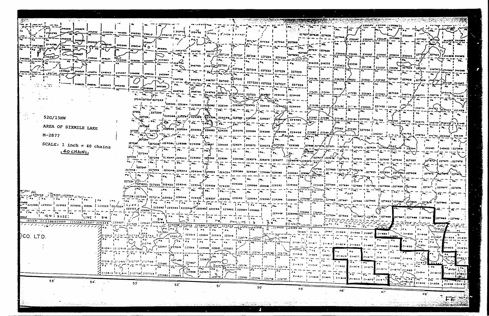
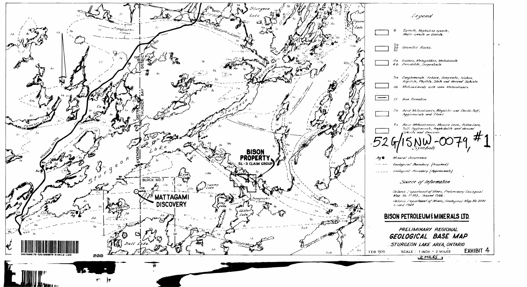
-V
A* ^y ^*C^.
xx
O
g
It
la 4as
SCD
in
fi i
fa/rt
i l*
-^
/tf.^^
/a;
^
t*
1a
/ft 61a
5\
/a
fa
56
1*
IIINIIIIIIIIIIIIIIIIIIIIIIIIIIIIIIIIIII in52G16NW9I79 62QI6NWM79 SIXMILE LAKE 200
BISON PROPERTY," "CLAIM GROUP
~'.a
MATTAGAMI" ~ ~" "r ' DISCOVERY
o/-
5/J GrantSsc Se
Arfe/ayaAAro,
3 a Cany/o/nerafe, Ar/t&se,A/ysS/s/t, P/ly/frfe, S/a/e a*a/
If
?a Ac s rf A/cfa Rhyo/jfir cr/td Dacrftc-
ff, Ayy/o/ne"ra /e,
Ma^ .{/o. j
(M'fas/0
BISON PETROLEUM?MINERALS IIP,
PRELIMINARY REGIONAL
GEOLOGICAL BASE MAP. STURGEON LAKE AREA, ONTARIO
FEB 1^70 SCALE : 1 INCH ' 2 MILES EXHIBIT