table of contents - healthy people, strong communities · incompatible development and...
TRANSCRIPT


Table of Contents Executive Summary ............................................................................................................................. 4
Introduction ......................................................................................................................................... 6
Why – Importance of Forests to Lamoille County .................................................................................... 6
Lamoille County Forest Stewardship Steering Committee ....................................................................... 6
Objectives.................................................................................................................................................. 7
Lamoille County Regional Characteristics ............................................................................................. 9
Location and Demographic Trends ........................................................................................................... 9
Land Use Trends and Future Land Use ..................................................................................................... 9
Economic Trends ..................................................................................................................................... 10
Regional Forest Characteristics ............................................................................................................... 10
Existing Forest‐Based Land Uses ............................................................................................................. 14
Natural Environment Characteristics ...................................................................................................... 14
Forest Resource Values ...................................................................................................................... 16
Introduction ............................................................................................................................................ 16
Forest Productivity and Economic Values ............................................................................................... 16
Recreational Resources ........................................................................................................................... 27
Scenic Resources ..................................................................................................................................... 30
Wildlife Habitat ....................................................................................................................................... 30
Ecosystem Strength ................................................................................................................................ 31
Water Resources ..................................................................................................................................... 35
Cultural Resources .................................................................................................................................. 37
Landscape Zones and Priority Areas ....................................................................................................... 37
Urban Landscape Zone ........................................................................................................................ 38
Vermont Forest Resources Plan Priorities for the Urban Landscape Zone ......................................... 38
1

Lamoille County Urban Landscape Zone Priority Areas ...................................................................... 38
Rural Residential Landscape Zone ...................................................................................................... 39
Vermont Forest Resources Plan Priorities for the Rural Residential Landscape Zone ....................... 40
Lamoille County Rural Residential Landscape Zone Priority Areas ..................................................... 40
Rural Landscape Zone ......................................................................................................................... 41
Vermont Forest Resources Plan Priorities for the Residential Landscape Zone ................................. 41
Lamoille County Rural Residential Landscape Zone Priority Areas ..................................................... 41
Threats, Barriers, and Limitations ...................................................................................................... 42
Environmental Threats ............................................................................................................................ 42
Incompatible Development and Fragmentation .................................................................................... 45
Economic Conditions .............................................................................................................................. 48
Existing Forest Conservation Measures .............................................................................................. 51
Conserved Lands ..................................................................................................................................... 51
Regional Plan ........................................................................................................................................... 59
Local Plans and Land Use Regulations .................................................................................................... 59
Local Conservation Commissions and other Conservation Organizations ............................................. 59
Forest Product Associations .................................................................................................................... 60
Private Landowner Associations ............................................................................................................. 61
Advocacy Organizations and Associations .............................................................................................. 62
Additional Forest Stewardship Strategies ........................................................................................... 64
Land Use Regulations .............................................................................................................................. 64
Road Policies ........................................................................................................................................... 67
Regional Policies ..................................................................................................................................... 67
Act 250 and Other State/Federal Regulations ........................................................................................ 67
Ownership of Land/Ddevelopment Rights .............................................................................................. 67
UVA and other tax incentive programs ................................................................................................... 68
2

Cooperative Management and Marketing ............................................................................................. 68
Strong Forest Resources Based Businesses ‐ Economic Opportunities .................................................. 69
Education and Outreach ......................................................................................................................... 72
Other Forestry, Natural Resources, and Sustainability Initiatives .......................................................... 73
Summary of Forest Stewardship Strategies and Initiatives .................................................................... 74
Appendix A: Regional Plan ................................................................................................................. 80
Appendix B: Local Plans ..................................................................................................................... 85
Conservation/Forest Reserve Districts ................................................................................................... 85
Planned Unit Development ..................................................................................................................... 86
Subdivision Regulations .......................................................................................................................... 86
Ensure Forest Products Industries are allowed in Community ............................................................... 86
Forest Practices ....................................................................................................................................... 88
Definitions of Important or Significant Resources .................................................................................. 88
Education (Non‐Regulatory) ................................................................................................................... 89
Map and Inventory Forest Lands, Wildlife Corridors (Non‐Regulatory) ................................................. 89
Purchase or Transfer of Development Rights ......................................................................................... 90
Other ....................................................................................................................................................... 91
Citations ............................................................................................................................................ 93
3

Executive Summary According to the Vermont Forest Resource Fact Sheet, more than 70‐percent of Vermont’s 4.6 million acres of forest can be characterized as nonindustrial private forest land (NPIF). This land is divided among an estimated 88,000 landowners, independently managing their properties with unique private interests.i The fragmented nature of Vermont’s NPIF means that forest resource planning occurs at the individual parcel level, which may not be the most effective level. The State of Vermont has identified a need to keep forest land intact to insure habitat connectivity, forest health and productivity, ecosystem protection, and sustainability of forest products. Consequentially, it is imperative to the long‐lasting health of the forest ecosystem that these private forests be managed wisely. Given the vast numbers of private landowners, one‐on‐one outreach was determined not to be the most effective means of achieving the goals and mission of the Forest Stewardship Program; therefore, the landscape stewardship approach evolved as a way to more effectively reach private forest landowners in order to keep forests healthy and viable. Supporting a regionally‐integrated forest stewardship approach is a critical step in ensuring Vermont’s public and privately owned forests are managed in an environmentally responsible way.
Landscape‐Based Forest Stewardship Planning ‐ A Regional Approach, developed a methodology for forest planning based on a landscape‐scale analysis, in order to increase the scale and pace of sustainable management of private forest lands in Vermont, with the ultimate goal of keeping forests as forests. This project was a collaboration between the Vermont Division of Forests and four Vermont regional planning commissions to apply a single system – using geographic information system (GIS) technology and a stakeholder engagement process – to inventory and assess forest resources, identify specific forest landscape types, and produce strategies for each landscape type that will assist regions, municipalities, and forest landowners in the objective of keeping forests as forests. The Regional Planning Commissions involved in the project were Addison, Bennington, Lamoille and Two Rivers‐Ottauquechee; Lamoille County Planning Commission was responsible for the overall coordination of the project.
The state assessment recently completed by the Division of Forests was combined with research conducted in Vermont utilizing forest block and ecological landscape unit analysis and existing GIS data to provide a consistent approach to a regional forest landscape‐scale analysis. Large rural forest blocks, large and small lowland forest tracts, urban and community forests, and ecologically significant landscape types formed the basis for the analysis. The objective was to identify landscape types in each region, initiate a stakeholder engagement process aimed at identifying priority forest landscapes and issues, and develop model forest plans for use by municipalities and landowners.
Each region produced maps that characterize the forest resources in their areas and, based on an analysis of that spatial data, developed descriptions of forest landscape types that provided the basis for subsequent planning. The following GIS coverages were used to help characterize significant forest landscapes: land cover, elevation, soil productivity, water resources (e.g., streams, rivers, headwaters,
4
lakes, ponds, wetlands, groundwater protection areas), wildlife habitats, rare and endangered species sites, unique natural areas, roads, recreation areas, sites, and trails, regional and town land use districts, conserved lands, and Use Value Appraisal parcels where available. In addition, coverages derived from recent landscape‐scale forest research in Vermont were used to help evaluate and delineate priority forest landscapes. Landscape types covered a range of conditions from large tracts of remote and mountain forest to large and small lowland forest tracts, as well as urban and community forests, and ecologically significant forest landscapes.
To effectively represent the interests of all involved parties, this project required collaboration between federal, state, local, and private entities. Four regional stakeholder groups were established to guide local efforts. Stakeholder participants included county foresters, state lands specialists, private forest landowners, consulting foresters, local officials, representatives of forest product industries, environmental/conservation groups, and the Green Mountain National Forest. Each region convened a series of public/stakeholder work sessions to review and discuss the forest landscape maps and data and to identify issues relevant to each. Additionally, staff from all four Regional Planning Commissions came together regularly to discuss progress and address issues and challenges as they arose, and regular meetings were held with the Regional Planning Commissions, state and federal partners to facilitate overall coordination of the project.
The project resulted in regional, landscape‐scale forest stewardship plans that will be used by the Division of Forests, local decision makers and forest landowners to support sustainable forests and will increase the scale and pace of sustainable management of private forest lands in Vermont. The following outcomes were accomplished:
1) Develop and test a GIS‐based methodology for forest planning based on a landscape‐scale 2) Engage local and regional stakeholders in the process to insure local issues are addressed 3) Identify strategies and develop tools for regions, municipalities, and forest landowners to keep forests as forests 4) Develop a process that can be replicated across regions and landscape scales 5) Model a collaborative process across regions and agencies for forest stewardship planning
Many issues identified through the geographic analysis and stakeholder engagement process were universal among the four regions: forests are valued for their ecological, economic, recreational, scenic and cultural richness; forest resources are threatened by increasing fragmentation, unfavorable economic conditions, and environmental factors such as climate change, invasive species and disease. Yet, contrasts were revealed between the four regions with respect to landscape types, economic and demographic conditions, and cultural/social values that resulted in priorities and strategies unique to each region. The resulting Forest Stewardship Plans reflect regional priorities and set the stage for future implementation of regional forest stewardship projects. Consequentially, the outcome of this effort should not be considered an end in itself, but a means toward the overall goal of achieving landscape forest stewardship in these four regions and beyond.
5
Introduction Why – Importance of Forests to Lamoille County Forests in one form or another dominate Lamoille County’s landscape. These forest lands have been important to the historical development of the area, continue to provide important resources today, and will be critical assets in the development of prosperous and sustainable communities in the future. Municipal Plans have generally included a discussion of forests in the section of the plan dealing with a natural resources, but often neglect Because of the extent of forests in our region and because of their pervasive significance in all aspects of the daily lives and economic vitality of the region, a more thorough “landscape stewardship” approach to forest resource planning is warranted. Landscape stewardship forest planning combines several key factors to create a comprehensive understanding of resources while developing strategies that will help to achieve the goal of “keeping forests as forests.” The first step in the process is to recognize that forests exist in a variety of different landscape settings. The vast unbroken forested ridgelines of Mount Mansfield and the Northern Green Mountains and the rugged and roadless landscapes of Worcester Mountains are perhaps the most common images of Lamoille County’s forests. At the same time, the wooded banks of the Lamoille River, smaller woodlots interspersed with farm land in rural valleys, and forested parcels in and around villages and downtown centers represent significant forest resources that provide important, yet different values. A critical component to landscape stewardship planning for forests is to recognize that there are a variety of interest groups and viewpoints that have a stake in the region’s forests. An effective planning process must involve those stakeholders and incorporate the diversity of values represented. Once the forest landscape is understood and values clearly described, a set of strategies designed to protect and enhance the resources that serve those values must be developed. To this end, the Lamoille County Forest Stewardship Steering Committee has played a vital role in developing this report.
Lamoille County Forest Stewardship Steering Committee The Lamoille County Forest Stewardship Steering Committee oversaw and directed this project. The Forest Stewardship Committee consisted of stakeholders with diverse interests in the future of Lamoille County’s forests, including forest landowners, municipal boards and officials, forest and wood products industries, conservation and wildlife organizations, and consulting foresters. Participants in the Steering Committee include:
Name Organization Bruce Butler Johnson Planning Commission Maxfield English Wolcott Planning Commission Lois Frey Johnson Conservation Commission
6

Ken Hagget Elmore Conservation Commission Bob Hawk Staying Connected Initiative Ron Kelly Friends of Green River Reservoir Kim Komer Lamoille Conservation District Bill Morrison Private Landowner Eric Nuse Johnson Conservation Commission Carl Powden Vermont Land Trust Steve Rae Morristown Conservation Commission George Robson Lamoille County Planning Commission Board of Directors Jim Ryan VT DEC, Water Quality Division Fran Sladyk Butternut Mountain Farm, Consulting Forester Ron Stancliff Morristown Development Review Board Todd Thomas Morristown Planner and Zoning Administrator Raymond Toolan Lamoille County Forester Ralph Tursini Tursini Forestry, private woodworker Kate Wanner Trust for Public Land
The Lamoille County Planning Commission (LCPC) provided staff support for this effort. Two staff members were assigned to this project. GIS Planner Melinda Scott developed a series of landscape scale maps depicting different attributes of Lamoille County’s forests. LCPC Senior Planner Seth Jensen helped to facilitate the Steering Committee’s discussions and developed this final report. Regional Planner Steve Munroe and Assistant Planner Jackie Cassino also assisted with this project. LCPC is one of eleven Regional Planning Commissions serving Vermont's local communities. LCPC serves the fifteen municipalities comprising Lamoille County. LCPC’s mission is to ensure the protection of the region's environment and conservation of natural resources and to facilitate sustainable economic development for the benefit of all residents and visitors through a coordinated and cooperative planning process at the local level.
Objectives
As LCPC’s mission statement suggests, the objective of this initiative is not to prescribe any given solution or action to individual communities or landowners. Rather, the objective of this planning effort is to provide information and tools needed by both the public and private sectors to responsibly steward the County’s forests. The following three objectives summarize the overarching goals of this project
Identify Key Forest Resources and Constraints
A necessary first step is to describe and understand the regional context of the forest resources in Lamoille County. The types of forest resources found in the County will be discussed, along with presentation of an overview of prevailing land use patterns and demographic and economic characteristics, including the type and extent of existing forest‐based land uses. The compilation and assessment of forest resource values was based on information derived from consultation with the Forest Stewardship Steering Committee, existing local and State plans, and meetings with municipal
7

8
Conservation Commissions and other interested parties. Those resource values were mapped at a regional scale using LCPC’s geographic information system. Mapping of these resources on a regional scale represents a departure from many past efforts related to forest stewardship. Forest resources have generally been mapped at statewide scale, which is too coarse to highlight important regional issues, or on a fine parcel level scale on which resources and values that cross property boundaries may not be evident, missing the proverbial forest for the trees. The intermediate regional scale provides a broader landscape level picture of the County’s forest with a level of detail that can still be observed. Support and Enhance Important Regional Forest Values
Lamoille County’s forests support a wide array of regional values, including their economic value to the forest products and outdoor recreation industries, the value of ecosystem services such as forests role in cleaning air and groundwater, the value of wildlife habitat, and the intrinsic cultural value of forests. A major objective of this project is to strike a balance between these sometimes competing objectives that both satisfies the needs of various stakeholders and strengthens the long term health of the County’s forests and the communities that depend upon them.
Develop Strategies to “Keep Forests as Forests”
“Keeping forests as forests” does not mean that Lamoille County’s forests and their use will not, or should not, change over time. A forested landscape is a dynamic system that is constantly changing. In fact, as discussed throughout this report, sound land management activities may actually improve the current health of Lamoille County’s forests. Rather, “keeping forests as forests” means proactively addressing the challenges and limitations to sound forest management so that the County’s forests may continue to support these important values. This report ends with a discussion of strategies aimed at encouraging responsible forest stewardship into the future.

Lamoille County Regional Characteristics Location and Demographic Trends
Comprised of the ten towns and five villages encompassing all of Lamoille County (Belvidere, Town and Village of Cambridge, Eden, Elmore, Town and Village of Hyde Park, Village of Jeffersonville, Town and Village of Johnson, Morristown, Village of Morrisville, Town of Stowe, Waterville, and Wolcott) the Lamoille County Region encompasses approximately 475 square miles in north‐central Vermont. The Lamoille region is bordered by the Green Mountain Range including Mt. Mansfield, Vermont’s tallest peak at 4,393, to the west and the Worcester Range to the east. The region is also characterized by rolling hills, open valleys, and forested lands. The region’s rugged mountains and broad river valleys form a stunning natural landscape, attracting tourists from around the world and contributing to the local quality of life. The region is bisected by the Lamoille River from east to west and is uniquely characterized by its borders along Vermont’s most urbanized and rural regions, with urban and suburban Chittenden County to the west, Washington County and the state capital of Montpelier to the southeast, and the rural counties of Franklin, Essex, Orleans, and Caledonia to the northwest and northeast within the Northeast Kingdom.
The region represents approximately 4% of the State’s population, with a population of 24,475 according to the 2010 United States Census. The population grew by 5.3% from 2000 to 2010, which represents significantly slower growth in comparison to 18% growth rate of the 1980’s and 1990’s. Following statewide and national trends, the aging of Lamoille County’s population is a significant social issue with many practical implications, including adapting health care services, transportation services, and land development patterns in order to meet the needs of this demographic. As of the 2010 Census, approximately 16% of the Lamoille County population was between the ages of 45 and 54, with a median age of 39.4.
Land Use Trends and Future Land Use
Lamoille County encompasses a number of significant natural systems, including the Lake Champlain Basin, the Northern Forest Lands, and the Champlain‐Adirondack Biosphere Reserve (CABBR). From an aerial view, the overwhelming majority of the Lamoille County Region is forested. Far from homogeneous, the forests of the region have distinctive characteristics: from vast areas of unbroken, remote forests to large lowland woodlots to small patches of forest in urban areas. Over the past decade development patterns have tended to follow previous development, resulting in heavy clusters of growth centered around existing villages and transportation corridors. Throughout the state, and to a smaller extent within Lamoille County, greenfield development, the creation of planned communities on previously undeveloped land, has led to commercial and residential sprawl, decreasing open space as well as the economic and intrinsic value of the working landscape. Although LCPC strives to promote growth in a manner that enhances the traditional settlement patterns of the region, with development concentrating in or near village centers and available public services, much work is still needed to
9

prevent fragmentation and parcelization. Parcelization refers to the process by which large tracts of land are divided into smaller parcels. Smaller parcels increase the number of people owning a single tract of land. In general, parcelized forests are more difficult to manage than large forest tracts in single ownership, be it for timber, wildlife, or other resource values. Parcelization often results in fragmentation of the landscape through to new housing and infrastructure development. Fragmentation can degrade wildlife habitat and water quality, as well as make active forest management difficult if not impossible.ii
Economic Trends
Reflecting statewide economic‐base changes, the region’s dependence on manufacturing has declined while its dependence on services‐producing sectors and the public sector has increased. According to the Economic Development Council of Northern Vermont, (EDCNV), as of 2010 the largest employers in Lamoille County were Stowe Mountain Resort (650 employed), Copley Hospital (377 employed), Smugglers‘ Notch Resort (300 employed), Springer‐Miller Systems (200 employed), and Trapp Family Lodge (155 employed).iii Overall, Lamoille County’s employment structure changed most significantly between 1981 and 2000 in two sectors: Services and Manufacturing, with promotion of the region as a four season destination significantly contributing to the tourism‐based economy. The share of total jobs represented by the Services sector increased by six percentage points over the 1981‐2000 period, equal to 40% of total private jobs in calendar 2000.iv In 2009, the largest employment sector in Lamoille County was “Management, Professional, and Related Occupations” (37.2% of employed persons). In contrast, “Farming, Fishing, and Forestry Occupations” employed only 1.1% of working people in 2009.v The decline in the number of people working in farming, fishing, or forestry is indicative of the challenges that such industries face and is a reminder of the pressing need for land use planners to develop better tools to support them.
Natural resource based manufacturing accounts for several employers within the Lamoille County Region, including Manchester Lumber, Inc., George F. Adams, and North Woods Joinery. Additionally, many small businesses in the region involve logging, making furniture or other crafts, producing maple syrup, and Christmas tree farming. A detailed listing (as of 2009) may be found in the Lamoille River Watershed Farm and Forest Directory developed by the Lamoille County Conservation District.
Overall, the “annual contribution of forest‐based manufacturing and forest‐related recreation and tourism to the Vermont economy is over $1.5 billion.vi It is estimated that 6,379 Vermonters are employed in forest‐based manufacturing alone; the total number employed in all forest related professions (manufacturing, tourism, and recreation) is approximately 13,000.vii
Regional Forest Characteristics
Biophysical Context
The biophysical regions of Vermont characterize the landscape into distinct units that share features of climate, geology, topography, soils, natural communities, and human history. Although each region has variation within it, all are widely recognized as units that are more similar than they are different.
10

Lamoille County lies almost entirely within the biophysical region of the Northern Green Mountains, with its westernmost corner lying within the Champlain Valley biophysical region.
The Northern Green Mountains are characterized by high elevations, cool summer temperatures, and acidic metamorphic rocks. The characteristic natural communities include Northern Hardwood Forests and the high elevation communities of the Spruce‐Fir Northern Hardwood Forest. The Green Mountain range has a marked influence on the climate of the region, with temperatures in higher elevations typically cooler than at lower elevations and with higher elevations receiving significantly more precipitation than low lying areas.viii The Northern Green Mountains today are comprised of primarily metamorphic rocks, mainly schists, phyllites, gneisses, and quartzites. These rock types are generally acidic. Glaciation has influenced the surface geology and topography of the region. Smugglers Notch is an old stream valley that was significantly enlarged by the passing glaciers. Another pronounced feature created by advancing glaciers is the steeply sloping south peak of Camel’s Hump. As the glaciers advanced over the peak from the northwest they plucked rock from the south‐facing slope, leaving an abrupt drop‐off. Except for the higher elevations of the Northern Green Mountains where there are extensive areas of exposed bedrock, much of the biophysical region is covered with glacial till.ix The Northern Green Mountains host the highest elevation peaks in Vermont. The Chin of Mount Mansfield (4,393 feet) stands the tallest. Other prominent peaks within Lamoille County include Belvidere (3,360 feet), Elmore, Laraway, and Butternut Mountains. Besides the primary range of the Green Mountains, Lamoille County contains the secondary ranges of the Worcester, Sterling, Cold Hollow, and Lowell Ranges. The Worcester Mountains include Elmore Mountain and Mount Hunger and are separated from the main range by the Stowe Valley. The Lowell Mountains extend from near Lake Memphremagog southwest to Eden. The Cold Hollow Range begins just north of Route 109 in Belvidere and extends into Franklin County. The Sterling Range lies just east of Route 108 and south of the Lamoille River valley. Bisecting the Green Mountains, the Lamoille River valley provides topographic diversity in the region. Because of its generally steeply sloping topography, the Northern Green Mountain region has no natural lakes and substantially fewer wetlands than other parts of the state.x The unique geologic and topographic characteristics of the Northern Green Mountain biophysical region have largely shaped the composition of forests now prevalent in Lamoille County (Figure 1, Map 1).
11

Figure 1: USDA Forest Service, Forest Inventory and Analysis, 2010. Northern Hardwood forest, comprising 81% of the forested land area, is the dominant community of the Lamoille County region. It is followed by Spruce/Fir forest at 9% and White/Red Pine at 7%. The remainder is made up of other forest types such as Aspen/Birch and Oak/Pine. Red Oak‐Hardwood Forests are generally restricted to warmer south‐facing slopes in the lower elevations.xi The Northern Green Mountains provide extensive habitat for many species of mammals, including black bear, white‐tailed deer, bobcat, fisher, beaver, and red squirrel. There are also several species of birds that are characteristic nesters in the high elevation forests, especially blackpoll warblers, Swainson’s thrush, and the rare Bicknell’s thrush.xii Land Cover Today, nearly 75%‐80% of the Vermont landscape is forested. In Lamoille County, forestland comprises about 82% (243,227 out of 298,350 acres) of the landscape. The second most abundant land cover is pasture/grassland (7%), followed by cultivated crops (4%). Shrub/scrub, developed, wetlands and water each make up 2% or less of the total land cover in the region.
Figure 2: USGS National Land Cover, 2006
12

Map 1: Biophysical Regions with Land Cover
13
Existing ForestBased Land Uses
According to the U.S. Forest Service, 235,500 acres (98.5%) of the region’s forest is categorized as timberland‐forestland producing. The region is characterized by a diversity of landscapes and elevations, creating a wide variety of vegetative types and natural communities including early succession forests, northern hardwood and spruce‐fir forests, sub‐alpine forests; cliffs, rock outcrops, and wetlands. The most common forests are the northern hardwood forests in the lower elevations and the montane spruce‐fir and spruce‐yellow birch forests in the upper elevations. Overall, the majority of the timberland in the County is dominated by maple, beech, and birch with spruce‐fir occurring mostly at higher elevations. Both a majority of acres and the volume of the region’s timberland are of sufficient size and quality to be considered saw timber. Sugar maple, yellow birch, beech, and red spruce represent the most abundant species in this size class. The region is also characterized by higher elevation forest habitats such as Mansfield’s Alpine Tundra and Boreal Forest.
Other wood related products include maple products and Christmas trees. The region is home to one of the state’s largest producers of maple products with merchandise exported worldwide. Lamoille County has witnessed a significant expansion in the maple products industry over the past decade, characterized by the growth of existing small and medium scale maple sugaring operations as well as the addition of new operations.
Forests provide numerous other public benefits such as critical habitat for game and non‐game wildlife as well as specialized plant communities that play an important function in the ecological integrity of the region. Deer, bear, moose, and other wide ranging species need remote expanses of contiguous forest to meet their daily and seasonal needs. Numerous other species of mammals, birds, reptiles, and amphibians depend on forests as well. The diversity of tree species and ecosystems within the forests is as important as its geographic extent. It is important that forest management maintain both high quality and diversity of forest type to support wildlife.
Forests also serve as a source of recreation and scenic enjoyment. The region is considered to be the “heart of recreational Vermont,” and forests provide a variety of opportunities for Vermonters and tourists alike. From hiking the Long Trail, cross‐country skiing along the Catamount Trail, downhill skiing in Smuggler’s Notch, snowmobiling along the VAST Trail, paddling in the Green River Reservoir, fishing the Lamoille River, to mountain biking the Cady’s Falls trails in Hyde Park, recreational opportunities in the region are endless.
Natural Environment Characteristics
For both Lamoille County and Vermont as a whole, the resource base is the cornerstone of all human activity. Agriculture, forestry, and recreation, the primary components of the County’s economy, are rooted in natural resources. Due to Lamoille County’s dependence on recreation and tourism, farming and forestry and clean air and water are the integral forces that drive employment, housing, and transportation, as well as local tax bases. Lamoille County’s resource base is its economic base.
14

Lamoille County is part of several larger natural regions, most notably the Lake Champlain Basin, the Northern Forest Lands, and the Champlain‐Adirondack Biosphere Reserve (CABR).
Lake Champlain Basin
The natural environment in Lamoille County encompasses a number of significant natural systems. The region falls within the Lake Champlain Basin, one of the ten nationally‐designated water bodies serving as a water quality demonstration area under the Great Lakes Critical Programs Act. This program focuses on coordinating pollution prevention and restoration activities between local, State, and Federal governments in Vermont, New York, and Quebec.
Northern Forest Lands
In addition to being within the Lake Champlain Basin, Lamoille County is also a part of a 26 million acre block of forestland in the Northeastern United States. This forested region was the subject of a Congressionally mandated study of threats to this important national resource. The Northern Forest Lands Study, completed by the U.S. Forest Service in 1990 in conjunction with the Governors’ Task Force on Northern Forest Lands, identified regional ownership patterns, threats to traditional land uses, and personal strategies to address them. In the fall of 1991, Federal legislation was introduced establishing the Northern Forest Lands Council. The Council, comprised of three representatives each from New York, Vermont, New Hampshire, and Maine, has completed a resource inventory of the study area and is developing and suggesting conservation strategies to the four states.
Champlain‐Adirondack Biosphere Reserve (CABR)
Lamoille County is also within the Champlain‐Adirondack Biosphere Reserve (CABR) established in 1989 as part of the United Nations Educational, Scientific, and Cultural Organization’s (UNESCO) Man and the Biosphere (MAB) Program. The MAB Program was established to set up a worldwide system of study areas, representing a variety of ecosystems, to better understand the problems brought about by humans’ impact on nature and to acknowledge the role of people in the biosphere. The CABR is one of the largest and most densely populated reserves in the MAB program and includes both the Lake Champlain Basin and Adirondack Park.
15

Forest Resource Values Introduction
The region’s forest resources provide an important component to the region’s economy, providing food, fresh water, fuel, and fiber. Forests also support numerous systems not easily quantifiable solely in economic terms by contributing to clean air and water, supporting the maintenance of soil fertility, the cycling of nutrients (carbon sequestration and air pollution filtering), and providing habitat for plant and animal life.xiii Forests also represent cultural values and have the potential to serve as an educational resource and a connection to our historic rural‐based economy. They contribute to the quality of life for future generations, providing recreational opportunities, scenic beauty, and a physical place to connect with the natural world. Local community residents have identified specific values supported by the region’s forest land resources. Such values have been acknowledged throughout municipal plans and discussed at length with the project steering committee, local conservation commissions, municipal officials, and at public meetings. This section of the report will describe those values and illustrate the location of key resources within the landscape context of the region.
Forest Productivity and Economic Values
Vermont’s working landscape supports a forest products industry estimated to generate over 1 billion dollars annually in the State and helps private forest land owners cover ownership costs.xiv When considering the economic value of forest production, land is analyzed based on its suitability for sustainable harvests of wood to meet a variety of needs, including lumber, furniture, specialty wood product manufacturing, paper production, biomass energy, and other economic activities such as maple sugaring and Christmas tree farming. Two factors are of overriding importance in determining potential for supporting productive forests: soil quality and land use.
The region’s rural and mountainous landscape contains extensive areas of highly productive forest soils, with the dominant landscape characterized as “forested’ and ‘forested rural residential.” Forested lands are among the most productive soils in the region for a variety of uses. Therefore land use is an important consideration as development can preclude management for forest production even if soil conditions are favorable. Access is another important factor in assessing an area’s suitability for effective forest management. Many of the most important access considerations (e.g. erodibilty, rock outcrops, slopes, soil drainage class) are included in the USDA Natural Resource Conservation Service soil rating, which rates soils in Vermont based on their potential for supporting economically viable forestry activities. Such ratings consider the potential growth of northern hardwoods along with the costs and limitations of managing woodlands on those soils.
The resulting Forest Productivity and Timber Resources map (Map 3) depicts the potential for forest productivity as well as the location of current producers. The Forest Productivity layer was developed by the Vermont Land Trust by initially selecting forest blocks greater than 500 acres and then conducting a weighted spatial analysis using the inputs of geology (30%), elevation (25%), hardiness zones (15%),
16

landforms (15%), slope (10%), and precipitation (5%). Areas of potentially higher forest productivity rates are scattered throughout the central and southern portions of the region and are generally characterized as having suitable access and located in the upland forest areas. Consequently, forest producers tend to locate in these areas. The Town of Wolcott, relative to other towns in the region, has an unusually high percentage of productive forest land. It also has one of the few remaining sawmills in the County. The northeast corner of Elmore is also a highly productive forest. Clearly the potential of these areas as working lands should be explored for stewardship opportunities.
17

Map 3: Forest Productivity and Timber Resources
18

Following discussions with steering committee members, local conservation commissions, and municipal officials, the identified economic value of forest‐based resources included: energy sources; raw materials and value‐added products; cultural and non‐timber forest products; and the contribution to the four‐season tourism industry and recreation.
Timber Harvesting
Approximately 98% of the region’s forests are categorized as timberland.xv In 2010, 11% of the State‘s hardwood harvest was derived from Lamoille County, making it the second highest contributing county in the State.xvi Most of the large scale harvesting operating occurs in the upland forest areas of the region as these areas are characterized by high quality soils and relatively easy access. For example, the Atlas Timberlands consist of approximately 26,789 acres of upland forest that has been actively managed and harvested for at least a century.
Forest Resource Harvest Summaries from the Vermont Division of Forestry provide a picture of how our forest resources are being utilized. As a result, we are able to understand the relationship between forest productivity and the commercial demand for wood by consumers. This information becomes even more critical with increasing economic pressures within the wood product industry. The Harvest Report lists volumes of wood harvested each year by species and the county of origin. Volumes of saw and veneer logs, pulpwood, whole‐tree chips and sawmill residues are all summarized in the report's tables.
The following tables track Lamoille County’s share of the state’s hardwood and softwood sawlog harvest from 2000 thru 2010.
Lamoille County Hardwood Softwood Mills2000 14,198 6,733 122001 12,833 2,880 122002 11,003 4,036 122003 12,675 4,734 102004 11,724 6,440 92005 12,143 4,583 82006 9,624 3,530 82007 7 Missing Data2008 6,766 3,862 52009 9,532 3,497 52010 8,323 3,511 5
Vermont Division of Forestry Harvest DataSawlog and Veneer Harvest 2000-2010 (Mbf)
Figure 3: Lamoille County Sawlog and Veneer Harvest Data, Vermont Forest Harvest Reports, 20002010
19

Vermont Hardwood Softwood Mills2000 118153 128666 1692001 108907 95920 1682002 102990 119396 1852003 116812 107895 1692004 112301 126429 1672005 118589 92840 1552006 90082 104432 1502007 144 Missing Data2008 89232 83871 1052009 89225 103438 1072010 86864 93320 105
Vermont Division of Forestry Harvest DataSawlog and Veneer Harvest 2000‐2010 (Mbf)
0
20000
40000
60000
80000
100000
120000
140000
Hardwood
Softwood
0
50
100
150
200
Mills
Mills
Figure 4: Vermont Sawlog and Veneer Harvest Data, Vermont Forest Harvest Reports, 20002010
Total harvest has declined over the last decade in Lamoille County and the state as a whole. The number of sawmills (both active and dormant) has also decreased reflecting the lower harvest figures. The past decade has been characterized by significant economic challenges to the Vermont sawmill industry, and with only four operating sawmills in the region, Lamoille County has not been immune to such challenges. The decline of the housing market, current recession, and subsequent decline of construction is further compounding this challenge. An inadequate number of sawmills throughout the region undermines quality forest management and forest diversity. As the number of sawmills declines, the increased transportation distance sawlogs must travel to a mill increases the cost of production and harvesting, resulting in decreased profit margin of marginal species and grades. This trend significantly reduces the economic incentive for landowners to actively manage forests, and can contribute to the conversion of forest land to other uses. Currently, the majority of the region’s hardwood is filtered into established major supply routes throughout the Northeast due to the lack of adequate local processing facilities as well as the overall lack of production volume. Much of the local hardwood is transported via Interstate 91 to Canadian sawmills for production. As the number of sawmills declines, there is a point where the number becomes too small to adequately support a diverse market.xvii
According to the U.S. Forest Service, statewide increases in the volume of growing stock are twice that of harvesting rates. Past harvesting practices have selectively removed only the highest quality stems (high‐grading) resulting in roughly 15% of northern Vermont’s growing stock being of such poor quality that it is of little or no commercial value (live‐culls). In combination with irregular markets for wood chips, this places further demand on high‐quality stems. There is a need for sustainable management and harvesting practices that encourage the regeneration of native species in order to improve overall forest quality and value from an economic point of view.
The challenge of an effective and uniform forest management practice is partially due to the amount of privately‐owned forests where standing trees are occasionally sold to the forest products industry as “stumpage.” (stumpage refers the sale of the right to harvest timber to a third party) In 2008, an
20

estimated total sale of stumpage earned by Vermont landowners was about 22 million dollars.xviii In Lamoille County 83% of forests are privately owned. Of this private forest land, 107,123 acres ‐‐ 53% ‐‐ are enrolled in the Use Value Appraisal Program. In addition, 8,035 acres of the Atlas Timberlands are located along the County’s northern border.
Wood for Energy
Throughout the state, the demand for regional pulpwood has significantly declined over the past decade, underlining the challenge of lower grade wood viability.xix At the same time, it is important to note that there has been an overall increase in demand for wood energy, recognized at both the commercial and institutional level, with 35 schools in Vermont converting from fossil fuel to the use of wood chips for heating between 1983 and 2008.xx Personal consumer demands has also increased over the last decade, with one recent study depicting a residential firewood consumption increase from 275,000 cords per year in 1997 to 315,000 cords per year in 2008.xxi Such an increase in demand brings the sustainability of forestry practices concerns to the forefront while simultaneously creating an opportunity for landowners to pursue sustainable forest management.
The figures below show the trends in woodchip production in Lamoille County and in Vermont as a whole from 2000‐2010.
Lamoille County Sawmill Residue Whole Tree Harvest2000 27,701 Missing Data2001 24,465 6,3292002 20,678 7,2222003 16,335 6,1092004 27,800 6,7502005 14,403 6,1932006 15,854 7,0452007 Missing Data2008 8,880 8,4032009 8,555 22,1352010 14,248 14,545
Vermont Division of Forestry Harvest DataWoodchip Production 2000-2010 (Volume in green tons)
Vermont Sawmill Residue Whole Tree Harvest2000 195,983 193,9322001 187,786 101,7482002 237,941 199,2282003 221,782 183,4012004 216,128 195,9772005 208,879 179,8082006 192,563 194,3472007 Missing Data2008 152,452 231,8172009 160,352 365,7672010 191,689 401,245
Vermont Division of Forestry Harvest DataWoodchip Production 2000-2010 (Volume in green tons)
Figure 5: Lamoille County Woodchip Production Data, Vermont Forest Harvest Reports, 20002010
21

Interestingly, the trends in Lamoille County appear to differ somewhat from the statewide trends. Over the last decade Vermont sawmill residue woodchip production remained more or less stable and whole tree chip harvest has increased significantly. However in Lamoille County, sawmill residue shipments declined dramatically while whole tree chip harvest increased with a dramatic spike in 2009. While the reason for this bears further study, it is possible the decrease in sawmill residue shipments is related to the overall decline in sawmill activity within the County.
Wood Product Manufacturing
Vermont sawlogs and other primary forest products such as wood chips are sold and processed all over the northeast, and secondary wood products from Vermont are sold all over the world.xxii As approximately 81% or 240,000 acres of Lamoille County is forested, of which 235,500 acres of the region’s forest is categorized as timberland‐forestland producing or capable of producing crops of industrial wood (>20 cubic ft./ac/year) and not withdrawn from timber utilization, the region has the potential to significantly contribute not only to the local economy, but also the regional and global economy. Most of the timberland in the County is dominated with maple, beech and birch with spruce‐fir occurring mostly at higher elevations. Both a majority of acres and volume of the region’s timberland are of sufficient size and quality to be considered saw timber. Sugar maple, yellow birch, beech and red spruce represent the most abundant species in this size‐class.xxiii
Quarterly Workforce Indicators (QWI) from the Census provide an indicator for Vermont’s forest industry based on employment and salaries. The QWI counts jobs, rather than employed workers, and does not include self‐employed workers and independent contractor employment. The QWI statistics for Lamoille County for the categories Forestry and Logging and Associated Forestry are largely missing, perhaps due to the fact that the vast majority of forest workers in the County are self‐employed. The figures below indicate the employment statistics for the wood products manufacturing industry as a proxy for forestry related employment overall.
Year Vermont Lamoille County2000 Q4 3,042 1112001 Q4 2,766 1082002 Q4 2,712 1062003 Q4 2,516 672004 Q4 2,534 702005 Q4 2,442 662006 Q4 2,303 582007 Q4 2,457 512008 Q4 2,162 342009 Q4 1,696 312010 Q4 1,847 32
Forestry-Related EmploymentQuarterly Workforce Indicators - Bureau of Labor
Wood Products Manufacturing - Quarterly Employment
Figure 6: Wood Products Manufacturing Employment, QWI, 20002010
22

Vermont as a whole experienced a gradual decline in wood products manufacturing employment from 2000 to 2007 followed by a sharp decline from 2007 Q4 to 2009 Q4 and a slight rebound in employment thereafter. The demand for forest products was dropping as existing new construction was sitting unsold. The economic squeeze on the forest industry comes from several sources including rising fuel costs, higher equipment costs, and increases in labor costs in concert with the lack of new residential construction. Without demand, mills closed and loggers and truckers had to make do with less work or get out of the business. The data in the graph only extends to 2010, but appears to show a recovery. After three years of decreasing demand and production, the forest products industry may be stabilizing. Interestingly, the data for Lamoille County shows a much steadier decline from 2000‐2010, indicating that the wood products manufacturing sector was less directly affected by the economic recession beginning in 2007 than by other factors. Another point to note is that Lamoille County represents only a very small fraction of employment in the wood products manufacturing industry relative to other parts of the state, thus the graph may be somewhat misleading. The data table indicates that wood products manufacturing employment in Lamoille County declined by two‐thirds over the last decade, a steeper decline than occurred across the state of Vermont.
Maple Products
While timber harvesting and the wood products industry appear to be in decline, the use of Lamoille County’s forest for maple products appears to be growing. Vermont is the nation’s leading maple syrup producer with operations distributed around the state in small family businesses with a handful of large operations.xxiv Vermont maple syrup production in 2009 was 920,000 gallons, the highest production since 1944, and an increase of 30% from 2008.xxv Vermont has successfully marketed its many maple products and currently produces more than any other state to meet the demand of consumers.xxvi From maple syrup to maple butter, the sap from the sugar maple has been utilized for generations and has become an integral part of the cultural integrity of Vermont
.
Modern sugarmakers rely upon vacuum and tubing sap distribution, reverse osmosis sugar concentration, and super‐efficient evaporation systems. “Sugaring season” still remains a quintessential Vermont tradition. Lamoille County is home to one of the state’s largest producers of maple products with merchandise exported worldwide. Lamoille County has witnessed a significant expansion within the maple products industry over the past decade, characterized by the growth of existing small and medium scale maple sugaring operations as well as the addition of new operations.
23

2002 gallons
020,00040,00060,00080,000
100,000120,000140,000160,000180,000200,000
Vermont Maple Syrup Production by County
2002 gallons
2007 gallons
Figure 7: Maple Syrup Taps and Production by County, New England Agricultural Statistics 2011
Within Vermont, Franklin County has been the largest producing county with 2007 data showing almost 190,000 gallons from over 715,000 taps. Lamoille County’s 2007 portion of the total production ranks second at nearly 100,000 gallons from about 357,000 taps and 62 sugarmakers. This is about 15% of the total Vermont production in 2007.
It is estimated that about 75,000 acres of forest land is involved in the production of maple syrup
24
Figure 8: Maple Syrup Taps in Lamoille County, NewEngland Agricultural Statistics 2011
statewide. If the proportion of taps to forest acreage is constant, then Lamoille County’s sugarbush acreage would be around 9,600 acres. Over 80% (216,498 acres in 2010) of the forested acreage in Lamoille County is northern hardwoods which includes maple, beech, and birch species. With maple tree acreage being over 60% of the hardwood mix it is obvious that there is a potential for increased syrup production if there is demand.
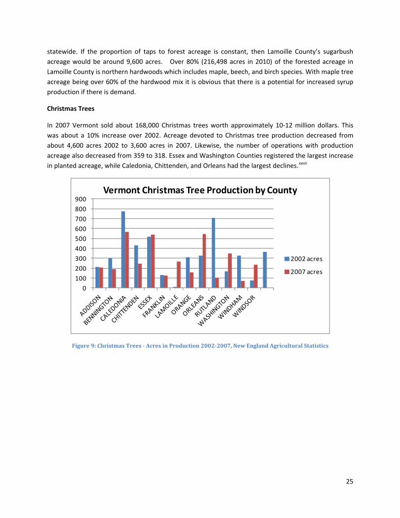
Christmas Trees
In 2007 Vermont sold about 168,000 Christmas trees worth approximately 10‐12 million dollars. This was about a 10% increase over 2002. Acreage devoted to Christmas tree production decreased from about 4,600 acres 2002 to 3,600 acres in 2007. Likewise, the number of operations with production acreage also decreased from 359 to 318. Essex and Washington Counties registered the largest increase in planted acreage, while Caledonia, Chittenden, and Orleans had the largest declines.xxvii
0100200300400500600700800900
Vermont Christmas Tree Production by County
2002 acres
2007 acres
Figure 9: Christmas Trees Acres in Production 20022007, New England Agricultural Statistics
25

0
10,000
20,000
30,000
40,000
Vermont Christmas Tree Harvest by County
2002 trees
2007 trees
Figure 10: Cut Christmas Trees Harvested 20022007, New England Agricultural Statistics
Lamoille County’s acreage in Christmas trees declined slightly from 2002 to 2007, and the total number of trees harvested fell from 9,984 to less than 6,390 representing a loss of 36%. In 2007, Lamoille County comprised 7 % of the statewide land planted in Christmas trees and harvested 4% of the trees.
Cultural and Non‐Timber Forest Products
Figure 11: Lamoille County Christmas Trees – Acres in Production 20022007
Figure 12: Lamoille County Cut Christmas Trees Harvested 20022007
While the term “forest products” is often used synonymously with “wood products,” a wide variety of non‐timber forest resources could be derived from the County’s forests. Maple syrup, discussed previously, is perhaps the most prominent example of a non‐timber forest product. Several examples of existing or potential non‐timber forest products are discussed below.
Harvesting fiddleheads in the spring is a time‐honored Vermont tradition. Once primarily foraged and consumed on a personal level, there is a growing demand for fiddleheads at specialty restaurants and
26

grocery stores. At least one home‐based business in Lamoille County currently sells pickled fiddleheads. Harvesting of fiddleheads, a traditionally foraged food in Vermont, may provide a market opportunity for owners of forested riparian and wetland areas.
Shiitake mushrooms represent another potential food product that can be derived from the County’s forests. Since shiitake mushrooms are often grown in newly cut beech trees, management of beech trees for growing stock through removal of less viable trees could improve the health of those stands as well as associated black bear habitat. As Lamoille County’s climate warms, other commercially grown mushrooms, such as Morels, Chanterelles, and Black Trumpets may be grown in the County’s forests. Due to climatic reasons, Vermont restaurants currently import most of their supplies of these high priced delicacies from the Pacific North West.
Spruce tips were once a traditional ingredient in ale. Harpoon Brewery has begun brewing a draft “Vermont Spruce Tip Ale,” using spruce tips harvested from Downer State Forest in Springfield, Vermont. In the past, Lamoille County’s forests supplied several commercial stills which produced cedar and pine oil. These products were wholesaled to national manufactures. New, smaller scale producers may be able to develop niche markets for Vermont “brand” oils or incorporation into other Vermont value added products.
Other potential non‐timber forest products include medicinal and herbal products such as ginseng and golden seal; decorative products, including holiday greenery and vines; edible products such as ramps, fruits, and nuts various nuts; and specialty products such as brown ash used for basketry.
As noted elsewhere in this Plan, due to past practices of high grading, much of Lamoille County’s existing forests contain timber that is of low commercial value. Non‐timber forest products may represent new opportunities for forest landowners that create an economic incentive to manage and maintain woodlands within the County. Further, since management of a forest for non‐timber products often requires less acreage than management of forest for timber, these products may represent an opportunity to adapt to the challenges related to parcelization.
Recreational Resources
Outdoor recreation and tourism is a major component of Lamoille County’s economy. Forested lands support a variety of recreational activities in the region and are a major economic component at both the regional and state level. As a four season destination, Lamoille County has a multitude of recreational opportunities which contribute to the tourism‐based economy (Map 4 – Recreational Resources). As outdoor recreation continues to grow in popularity throughout the state, over the last two decades there has been a noted shift in the types of outdoor activities in which people are participating.xxviii With increased demand for more diversified facilities like multi‐use trails that support a variety of activities, public land managers are faced with the challenge of maintaining recreational trails and structures in light of the increased and diversified use. This will continue to be a challenge in the future.
27

With two of Vermont’s largest ski resorts, Smugglers Notch Resort and Stowe Mountain Resort, located within the County, and several others located within a half hours drive, the ski industry continues to be a major draw to Lamoille County. In 2007‐2008, Vermont logged over 4.3 million skier visits, with direct spending estimated at 750 million dollars and 700 million dollars in indirect spending for a total economic activity due to skiing of about 1.5 billion dollars.xxix In many ways, the ski industry is the anchor of Lamoille County’s tourism economy. However, as economic pressures and warming winters have impacted the industry, the County has begun to shift toward an economy based on more four season activities.
Maintained recreational trails throughout the state total over 8,100 milesxxx and are located on both public and private lands. Major public access trails within the region include the Long Trail, located within Mount Mansfield State Forest; the Stowe Recreational Path, located within the Town of Stowe; the Catamount Trail, a backcountry ski trail that runs the entire length of Vermont; and the VAST trail throughout the County. In addition, the Lamoille Valley Rail Trail (LVRT), a four‐season, multi‐use recreation path to be built on the corridor of the former St. Johnsbury and Lamoille County Railroad, is currently in the permitting process. The LVRT will provide a recreational route through the heart of Lamoille County and will connect many of the County’s largest villages and downtowns. Additional hiking, biking, skiing, and snowmobiling trail networks can be found throughout the region.
In addition to the trail systems, the region is characterized by significant recreational features including Town and State parks and campgrounds, extensive downhill and cross country ski centers along the Route 108 Corridor, streams, rivers, and lakes with public access points, and unique landscape features such as waterfalls, caves, geological features providing multi‐season climbing and bouldering opportunities, and scenic mountain summits. The County includes a network of lakes and ponds, including Belvidere Bog, Lake Eden, Lake Elmore, Wolcott Pond, and the Green River Reservoir. Some of these ponds are used actively for recreation and are lined with camps and beachfronts. Others, on the other hand, remain more remote and maintain largely undeveloped, forested shorelines.
Wildlife resources and the lands and waters that support them are significant to the quality of life for those who live in and visit Vermont. Wildlife‐based activities including hunting, fishing, viewing, and photography are estimated to have brought more than 383 million dollars to the State’s economy.xxxi The region’s rural characteristics provide ample hunting opportunities for both residents and non‐residents alike. In fact, a new survey says hunters spend more than 189 million dollars in Vermont annually. According to the survey conducted by the U.S. Fish and Wildlife Service and the U.S. Census Bureau, about 151 million dollars is spent on equipment, more than 20 million dollars is trip‐related, and more than 17 million dollars is spent on other items. The State Fish and Wildlife Department reports that in 2010 79,603 people bought Vermont hunting licenses. Nearly 11,000 of those were non‐residents. Most of these licenses are for deer hunting. Vermont ranks third in the nation in participation in wildlife‐related recreation, including hunting, fishing, and wildlife watching.
28

Map 4: Recreational and Scenic Resources
29

Scenic Resources
The value of scenic resources has been identified throughout the region’s municipal plans. The Lamoille region is defined by rugged mountains and gentle rolling river valleys. Lamoille County is bordered by the Green Mountain Range including Mount Mansfield, Vermont’s tallest peak at 4,393, to the west and the Worcester Range to the east. The region is also characterized by rolling hills, open valleys, and forested lands. The region’s rugged mountains and broad river valleys form a stunning natural landscape, attracting tourists from around the world and contributing to the local quality of life.
The region’s forested mountainsides and colorful rural valley woodlots provide a vivid backdrop, with forest types varying by elevation. Lamoille County’s forests include northern hardwood species such as sugar maple, black and yellow birch, and beech, and other species such as white pine, spruce, or eastern hemlock. Hardwood diversity provides a dramatic background in the fall, and the foliage season significantly contributes to the regional economy by attracting visitors from all over the world. The forests contribute to the ecological matrix of plants and wildlife that are dependent on the tree canopy and the small natural clearings along streams, ponds, and wetlands.
Wildlife Habitat
Fragile and natural areas in Vermont comprise many of the irreplaceable components of the State’s habitat’s ecosystems and links to our natural heritage.xxxii The region’s abundance of forested land provides a wide variety of habitat for a diverse range of fish and wildlife species. One of the most important roles for our forested land is as a matrix that supports a wide selection of flora and fauna.xxxiii Many common species are in decline or threatened by a variety of causes, both natural and anthropogenic. Population levels of wood thrush and the Canada warbler have declined at rates of 63% and 55%, respectively.xxxiv There are emerging threats to some of the State’s common trees: hemlocks are threatened by hemlock wooly adelgid; ash by emerald ash borer; and butternuts by butternut canker disease.xxxv
Historically, wildlife conservation efforts have concentrated on conserving specific wildlife habitat areas for game species and endangered species. Recently this management focus has shifted towards protection and management for biodiversity values.xxxvi As the focus of wildlife management in recent years has been on conserving habitats for a variety of species, the correlation to forest management has become more apparent. Both timber management and habitat management are built on natural changes that the forest undergoes, providing an opportunity for landowners and forest and wildlife managers to work together.xxxvii
The majority of the region’s forest landscapes in higher elevations is considered to provide a high quality wildlife habitat as they are characterized by large areas of undeveloped land with few or no roads, the presence of ecological landscape elements (as defined by elevation, landforms, and bedrock geology), and the extensive surface waters in those areas (streams throughout the region and high elevation ponds and wetlands). The Vermont Department of Fish and Wildlife conducted a statewide analysis to delineate and assess the quality of wildlife habitat. Habitat blocks were delineated by selecting blocks of
30

forest from land cover data and were subsequently evaluated using eleven factors to assess their ecological value. Factors considered included cost distance to core areas, ELU (Ecological Land Units) weighted acreage, element occurrence count, percent core, block size, road density, percent ponds, percent wetlands, exemplary aquatic features, density of rivers and streams, and percent of block within a TNC matrix block. All these factors were combined to calculate a weighted score for each habitat block.xxxviii The result is a map depicting the quality of large habitat blocks (Map 5 – Habitat Blocks). Based on this analysis, the areas of the County that stand out as providing high quality habitat blocks include Belvidere, Eden, Waterville west of Route 109, the northernmost part of Johnson, Mount Mansfield State Forest, and the Worcester Range west of Route 12 in Elmore. The road crossing data highlights areas that are important linkages, including Route 12 in Elmore (known locally as “Moose Alley”), Route 108 in Smuggler’s Notch, the intersection of Route 118 and Route 109 in Belvidere, and Route 118 in Eden.
The areas of uninterrupted forest land provide the highest quality of wildlife habitat as they provide the support necessary for the population viability of many species. It is important to note that some species thrive in non‐forested open areas or areas characterized as edge habitat (transitional areas between forested and open lands). Many avian species rely on open areas, and deer migrate from forest cover to open fields to graze. Therefore, the interplay between smaller woodlots and open fields in rural valley and town and village center landscapes is an important component of the overall health and diversity of the region’s wildlife.xxxix The Forest Ecological Resources Map (Map 6) displays the significance of uninterrupted forests as well as the role of edge habitats in supporting a diversity of wildlife. Notably, the deer wintering areas are prevalent in rural lowlands. Johnson, Cambridge, Wolcott, and Stowe each have a large concentration of deer wintering areas, with a large area in Eden as well. These areas are critically important for deer as they provide food and cover during the winter months, and any forest related activities or commercial/residential development should be planned to minimize disturbance of these important habitats.
The more developed areas of Lamoille County (such as in Morrisville and Johnson) exhibit increasing amounts of habitat fragmentation. In these areas, forested corridors along streams and rivers between otherwise fragmented forest blocks in rural valleys provide vital cover and travel routes for numerous wildlife species. Although forests in towns and village centers are relatively small and include fewer critical ecological landscape units and rare or significant species and natural communities, they nonetheless provide some important habitat for small species that should be identified and protected.
Ecosystem Strength
Carbon Sequestration and Storage
Climate change represents a considerable current and future challenge to forest sustainability. At the same time, it represents an opportunity to promote the value of forests in providing temporary mitigation of greenhouse gas emissions (GHG) through carbon sequestration and storage.xl Vermont’s greenhouse gas emissions (GHG) in 2005 were estimated at 9.07 MMtCO2e5 (MMT=million metric tons, CO2e=CO2 equivalents).xli Carbon storage in forests and wood products was estimated at 9.0
31

MMTCO2e, which contributes significantly to reduce total GHG.xlii The implementation of forest management strategies that increase carbon sequestration and storage from forests with low carbon can significantly contribute to GHG reduction throughout the state. Private landowners have the opportunity to significantly contribute to carbon sequestration through sustainable forestry practices. Pressures from forest conversions, harvesting wood for energy, and infestations of non‐native destructive pests or changes in private or public land management can alter the extent of forest mitigation of GHG.xliii
32

Map 5: Forest Habitat Blocks
33

Map 6: Ecological Resources
34

Air Quality
Tree and forest canopies significantly contribute to air quality through the sequestration of air‐borne pollutants. Simultaneously, the release of volatile organic compounds from trees influences the production of ground level ozone. Vermont is currently within national standards for criteria pollutants, but it is important to note that the state is still affected by acid deposition on sensitive forests, poor visibility on warm days, ozone injury on sensitive plants, and increasing atmospheric carbon dioxide.xliv Overall within the region, given the lack of industrial development, local air quality concerns are limited mainly to emissions from traffic, heating systems (e.g. woodstoves), and some agricultural practices. It is important to note that currently, neighboring Chittenden County is at risk for non‐attainment status due to the amount of particulate matter and ground‐level ozone, as the cumulative effect of these sources may increase with additional growth and may have greater impact on local air quality. Other concerns include impacts on air quality resulting from out‐of‐state activities that pose a serious threat to fragile, high elevation ecosystems. In particular, acid rain, caused in part by coal‐fired energy plants operating to the west of Vermont, has damaged plant communities in the vicinity of Mount Mansfield.xlv The region can continue to work to increase canopy cover and reduce stormwater runoff in more developed areas such as Johnson and Morristown, and to support both private and public forestry best management practices.
Water Resources
Water resources are abundant throughout the region (Map 7 – Water Resources) and include the rivers and lakes that support many important recreational uses including fishing, swimming, boating, wildlife observation, hunting, and the enjoyment of aesthetic values; groundwater for private and public water supply; and wetlands to store flood waters and filter natural and man‐made contaminants. Surface waters and wetlands provide numerous habitats for a variety of aquatic and riparian plant and animal communities and support numerous economic activities.xlvi The quality of such waters is essential to the health of the region’s population and economy. Forest cover plays a significant role in the maintenance of water quality and quantity.
Rivers and streams are abundant throughout the region. Upland forests contain the majority of the Class A headwaters in the region as well as many larger streams that include fisheries, waterfalls, swimming holes, and other recreational and scenic resources. The Lamoille River, the state’s third longest, bisects the County from east to west on its way to Lake Champlain. In addition to the Lamoille, the Gihon, Green, Brewster, North Branch, and Wild Branch comprise the major tributaries in the Lamoille River Basin within the region. There is also a small portion of the Missisquoi River Basin in the Towns of Belvidere and Eden.xlvii Lamoille County has over 97 miles of game fish habitat in 26 stream segments. These segments provide an important cold‐water fish habitat primarily for rainbow, brown, and brook trout. Riparian areas also play an important role in the habitats of deer, moose, beaver, otter, mink as well as smaller mammals, waterfowl, and other birds and amphibians. There is also considerable overlap between riparian areas and the habitat of other species such as moose and deer.xlviii
35

Map 7: Water Resources
36

The region is uniquely characterized by the abundance of higher‐elevation mountain ponds, such as Sterling Pond which is one of the highest, if not the highest, elevation trout ponds in the State of Vermont. Lamoille County has 55 lakes and ponds, 13 of which are over 20 acres in size and thus considered public waters subject to State protection. Some notable examples include Wolcott Pond, Belvidere Bog, Green River Reservoir, Lake Eden, Lake Elmore, and Molly’s Bog in Morristown. A small portion of Waterbury Reservoir is located in Lamoille County. These lakes and ponds provide a variety of benefits to County residents and visitors, including boating, swimming, fishing, hydroelectric power, water for fire suppression and wildlife, plant and fisheries habitat.xlix
Lamoille County has 24 delineated wellheads and 11 non‐delineated/radius‐based wellheads. A study funded by the Clean Water Act and prepared by LCPC identified land uses within the region's wellhead protection areas and made recommendations for their protection through municipal planning. While many of these water sources are undeveloped and relatively protected for the short term, recent growth rates and patterns of development suggest that many will need to adopt more long‐term protection measures over the coming years.l Large areas within the rural forested landscape areas support critical public water supply protection areas, including groundwater and surface water protection areas for local municipalities.
Cultural Resources
The working landscape defines Vermont and is apparent in Lamoille County. Forested lands play a significant role in the region’s historical and current cultural heritage. The Vermont tradition of the private landowner making a living off of their land is tied to the sustainability of forestry management practices. The economics are tied to the ecological maintenance of the land. Forested lands provide recreational, wildlife, and timber resources and contribute to the health of watersheds. The forested landscape provides a cultural connection to the natural environment, while at the same time, has the potential to provide a way of life that has been passed down through the generations.
In keeping with Vermont tradition, many private forest landowners in Lamoille County allow the public to access their property. This access is essential for many of the recreational activities enjoyed by Lamoille County residents, be it hunting, hiking, fishing, or mountain biking. For this tradition of public access on private land to continue, it is important that recreational users of private land are respectful of the owner’s wishes. If users are disrespectful or damage property, some landowners may cease to allow the public use of their property. For this reason, it is important to educate different recreational users groups about the proper etiquette for using private property.
Landscape Zones and Priority Areas
A major objectives of this Regional Forest Stewardship Plan is to identify and characterize distinct landscape types. The 2010 Vermont Forest Resources Plan recognizes that forests reflect a continuum from remnant forests and single trees in urban areas to woodlots and small forest blocks in semi‐rural areas to large intact forest blocks in remote rural areas. These different types of forests each play an important role and provide distinct services. In turn, different forest types may require distinct
37

management strategies. Accordingly, in the development of the State Forest Resources Plan the State was classified into three broad landscape zones: Urban, Rural Residential and Rural. The classifications were based upon E911 housing point density data, and indirectly, parcel size. Following the State Plan, we describe the three landscape zones (Map 2 – Landscape Classification) in Lamoille County along with a summary of priority areas by landscape zone.
Urban Landscape Zone
Urban zones are typically located along major river banks where settlement first occurred. Rivers not only provided a means of transportation for early settlers but also provided food and livelihood in fishing. Seasonal flooding of rivers enriched the surrounding soils for growing crops. The broad Lamoille River Valley provided flat level ground that was easily developed. Using the State’s classification scheme in which areas with more than 128 housing units/sq km fall into the Urban Landscape Zone, the Urban Landscape Zone encompasses only a miniscule percentage (.15 %) of Lamoille County. In the Landscape Classification Map, Morrisville represents the largest Urban Landscape Zone, with portions of Johnson Village and Jeffersonville included as very small urban zones. Even though the statewide classification considers only these three areas as “urban,” it may be more appropriate from a regional perspective to treat all villages, downtowns, and town centers in Lamoille County as urban zones.
The urban forest is the “green infrastructure” that includes street trees, residential trees, park trees, and greenbelt vegetation, both on public and private land. Urban and community forestry, viewed as stewardship of the green infrastructure, can improve the quality of life in Vermont’s cities, towns, and villages through comprehensive planning to connect, conserve, manage, enhance, and enjoy the natural resources within them.li
Vermont Forest Resources Plan Priorities for the Urban Landscape Zone
The 2010 Vermont Forest Resources Plan identifies the following “priority areas” within the Urban Landscape Zone: Priority Area 1: Communities with less than average urban tree canopy (UTC) and greater than average population and impervious surface area. Priority Area 2: Communities with storm water impaired watersheds within their boundaries. Priority Area 3: Communities with medium to medium‐high UTC ranking not meeting the four base U.S. Forest Service criteria for sustainable urban forestry programs: management plan, professional staffing, ordinances and policies, and advocacy/advisory organizations. Priority Area 4: Communities with high UTC ranking and high susceptibility risk rating for invasive forest pests.
Lamoille County Urban Landscape Zone Priority Areas
In the 2010 Vermont Forest Resources Plan, the State set a goal to increase the amount of urban tree canopy (UTC) in the state. In addition to its aesthetic benefits, the Urban Tree Canopy, which often consists of street trees and trees in public and semipublic areas, plays an important role in urbanized areas. Urban trees provide a degree of heat and temperature control, providing shade in the summer
38

and wind protection in the winter. The UTC also plays an important role in mitigating impacts of storm water runoff from urban streets and parking lots. Further, street trees have been shown to have a “traffic calming” effect by sending a visual cue to motorists that leads to a reduction in speed. A statewide analysis was performed to identify those communities in greatest need of UTC enhancement based on population density, existing tree canopy, and area of impervious surfaces. The highest priority communities include Burlington, South Burlington, Rutland, and St. Albans due to their high UTC rating and the occurrence of storm water impaired watersheds within their boundaries. Even though, when viewed from a statewide perspective, it would appear that Lamoille County urban zones are very few and low to medium priority areas, when viewed from a regional perspective a different picture emerges. Within Lamoille County the communities of Stowe, Morristown, Hyde Park, Eden, and Wolcott ranked as medium priority for UTC enhancements while the remainder of Lamoille County towns ranked as low priority. Arguably, Morristown should be prioritized for UTC enhancement based on its high percentage of impervious surface, its rank as the highest population density in the County, and the presence of locally impaired waterways like Rodman Brook and Lake Lamoille. Due to the region’s nature, many of Lamoille County’s “urban landscapes” are in actuality small villages located close to undeveloped, rural environments. It is worth noting here that a major plan goal at state, regional, and local levels has long been to focus new development in proximity to existing settlements. As a result, some forested parcels in the urban landscape zone may appropriately be converted to other uses. In other words, not all forests in this area will remain as forests.
Priority areas for forest conservation in the urban zone are those forested landscapes that play a critical role in supporting the human population. Priority areas include those that provide unique recreational values and opportunities (such as Cady’s Forest in Stowe and Moss Woods in Hyde Park) or areas surrounding the ground water recharge areas of public water systems (such as the two forested wellheads in Cambridge Village). These areas are critical to maintaining public health and quality of life in the County’s populated centers.
Rural Residential Landscape Zone
The Rural Residential Landscape Zone totals about 3.5 million acres or about 59% of Vermont’s land base. This is a combination of forested and agricultural lands, most of which has been farmed within the past 120 years. It is where most Vermonters choose to live in dispersed single family homes and small tract developments. It contains most of the mid‐level and lower‐level level streams and rivers, as well as the majority of roads and utility corridors.lii Within Lamoille County, the Rural Residential Landscape Zone totals 156,753 acres or 52% of the land area. Of this, the Non‐forested Rural Residential Zone occupies 45,292 acres (15%) while the Forested Rural Residential Zone occupies 111,461 acres (37%). In Lamoille County, the Rural Residential Landscape Zone consists of landscapes along major State roads ‐Route 15, Route 100, Route 109, Route 108 (excluding Smugglers Notch) and Route 12. The Rural
39

Residential Landscape Zone also encompasses most of the Lamoille River Valley, including lowland areas of Johnson, Morristown, Hyde Park, Wolcott, and Stowe.
Vermont Forest Resources Plan Priorities for the Rural Residential Landscape Zone The 2010 Vermont Forest Resources Plan identifies the following “priority areas” within the Rural Residential Landscape Zone: Priority Area 5: Riparian areas and wetlands. Priority Area 6: Rare and sensitive natural communities and habitats for threatened and endangered species. Priority Area 7: Areas important for the protection of public water supplies. Priority Area 8: Large forested blocks of land. Priority Area 9: Forested lands at high risk to insect and disease attack, invasive plant infestation or regeneration failures. Priority Area 10: Forest land eligible for UVA enrollment. Priority Area 11: Forests providing significant wildlife habitats, including travel corridors.
Lamoille County Rural Residential Landscape Zone Priority Areas
In Lamoille County many areas within the Rural Landscape Zone are exhibiting increasing amounts of habitat fragmentation, particularly in the more developed communities of Morrisville, Johnson, and Cambridge along the Route 15 corridor. In these areas, forested corridors along streams and rivers and between otherwise fragmented forest blocks in rural valleys provide vital cover and travel routes for numerous wildlife species. Although forests in these areas may be small in comparison to the large forest blocks in rural upland areas, they nonetheless provide some important habitat for small species that should be identified and protected. Large, regionally significant deer wintering areas are found in Wolcott and Johnson. These areas generally correspond with the most productive forests in the region as well. Similarly, a critical wildlife corridor between the ridge of Mount Mansfield and the Northern Green Mountains is found at the Cambridge‐Johnson Town Line. These areas should be considered properties within the Rural Residential Landscape Zone. While some of these areas may be conserved by conservation organizations or State/municipal governments, most land will likely remain privately owned. Efforts should be made to promote economically viable forest management that maintains or enhances functional wildlife habitat in the Rural Residential Landscape Zone.
The Rural Residential Landscape Zone in Lamoille Count contains a unique landscape type that is not widely mentioned in the State Forest Resources Plan. A network of lakes, ponds, and bogs, many with intact forested shorelines, stretches along the eastern expanse of the County. The forested shorelines of these water bodies provide important habitat for numerous species, flood control, and erosion protection. The importance of protecting these forested shorelines is noted in the Town Plans of Elmore, Wolcott, Hyde Park, Eden, and Belvidere. Due to the importance of these areas and their potential to provide appropriate recreation for County residents, these areas should be considered a
40

41
priority for public land conservation. Measures to encourage private owners of shorelines to maintain or restore shoreline vegetation should also be developed.
Rural Landscape Zone
The Rural Landscape Zone constitutes over 2.4 million acres or 40% of Vermont’s 5.9 million acre land base. These lands are over 90% forested. Nearly all of Vermont’s largest forested parcels are located in the Rural Landscape Zone. Agricultural and developed lands are rare in the Rural Landscape Zone. The Rural Landscape Zone encompasses Vermont’s high elevation landscapes and landscapes with steep slopes and poor soils which are not well suited for agriculture.liii Within Lamoille County, the Rural Landscape Zone totals 141,093 acres or 47% of the County’s land area. About 38% of it is conserved land, and the vast majority of it is owned by the State (Mount Mansfield State Forest, Putnam State Forest, Long Trail State Forest, and Green River Reservoir). The remaining conserved lands in the Rural Landscape Zone are held by the Vermont Land Trust, other local land trusts, or municipalities,
Vermont Forest Resources Plan Priorities for the Residential Landscape Zone
The 2010 Vermont Forest Resources Plan identifies the following “priority areas” within the Rural Residential Landscape Zone: Priority Area 12: Lands identified as important wildlife corridors, feeding areas, or wintering areas. Priority Area 13: Riparian areas and wetlands. Priority Area 14: Areas important for water source protection and recharge areas. Priority Area 15: Forest land eligible for UVA enrollment. Priority Area 16: Forests at risk from invasive or cyclic forest insects, plants and diseases. Priority Area 17: Lands important in maintaining Vermont’s statewide recreation trail networks. Priority Area 18: Forest habitats at risk from atmospheric pollution or climate change factors.
Lamoille County Rural Residential Landscape Zone Priority Areas
The Rural Landscape Zone contains the County’s highest peaks, ridgelines, and upland areas. Most of the highest peaks in Lamoille County are protected from development through State or municipal ownership or conservation easements. Notable exceptions to this include Butternut Mountain, Mount Belvidere, Laraway Mountain, and the southern peaks of Cold Hollow Mountains. The protection of important resource values of summits should be considered a priority for the upland landscape zone, whether achieved through land conservation or by encouraging sound stewardship by private landowners. While other upland areas are largely in public ownership, public entities are not necessarily sound land stewards. Land stewardship of public lands must be encouraged as well.

Threats, Barriers, and Limitations Environmental Threats
Acid Rain Deposition
The threats of acid deposition to forest sustainability have been documented and understood for many years. Although acid deposition can affect all parts of the forest system (i.e., increased winter injury on red spruce trees), its impacts on soil productivity is of particular concern to forest health. Acid deposition can increase leaching of valuable soil nutrients making them unavailable for tree growth.liv Of particular concern are calcium depletion and aluminum toxicity; both have been shown to adversely affect sugar maple growth.lv Acidic mist of “fog” can reduce the ability of leaves to carry on photosynthesis. These impacts are exacerbated in upland forest landscapes, where soils are steep, thin, and poorly buffered against acidic deposition. This can be seen on Map 8 – Forest Resource Constraints which shows the County’s vulnerability to acidic deposition. Note the correlation between high sensitive areas and forestry declines above 2,500 feet.
Ozone and Fine Particulate Matter
Air pollution is usually thought to be a big city problem, but it can be a concern in rural and small urban areas as well. Chittenden County’s air quality currently meets the National Ambient Air Quality Standards (NAAQS). However, monitoring data for ground‐level ozone and fine particulate pollution indicates that our air quality is close to exceeding acceptable levels. Due to Lamoille County’s mountainous geography, especially during winter months, locally produced air pollutants are sometimes trapped within valley walls through a process called “cold air inversion.” As a result, Lamoille County occasionally experiences “exceedances” of Federal standards for particulate matter. Local sources of ozone and particulate matter come primarily from transportation and wood combustion, though a good quantity of this and other pollutants migrate to Vermont from other areas of the country.
High concentrations of ozone near ground level can be harmful to people, animals, crops, and other materials. In the U.S. periods of high ozone concentration coincide with the growing season when plants are most vulnerable to injury. The airborne transport of ozone to remote forested areas has led to increasing concern about how this pollutant is influencing the health of individual trees and forest ecosystems. Possible impacts of ozone on forest species include reduced growth and vigor, reduced seed production, and increased susceptibility to insects and disease. Long‐term ozone stress may lead to changes in species composition, reduced species diversity, and simplification of ecosystem structure and function.
Climate Change
Since 1900 the average temperature in the Northeast has increased 1.5°F. In the next twenty to thirty years temperatures are projected to continue increasing more in winter (from 2.5°F to 4°F) than in summer (1.5°F to 3.5°F). Currently we experience around five days per year with temperatures
42

exceeding 90°F. By late‐century, we can expect nine times that number, with forty‐five days per year exceeding 90°F.
The Northeast is projected to see a 10% increase (about four inches per year) in annual precipitation by the end of the century. Winter precipitation is expected to increase by 20% to 30%, but because of the prediction of a rise in temperatures, more and more of this precipitation is going to fall as rain. As a consequence of more precipitation in the winter, whether it falls as rain or snow, more flooding of rivers and streams is expected in the springtime.
Species that thrive in particular temperature ranges are likely to migrate from one area to another as temperature ranges change. Therefore, if Vermont has temperatures like those in Virginia in the summer, we can expect to start having the same species that reside in Virginia. In addition, first‐leaf and first‐bloom dates are projected to arrive around two days earlier per decade — arriving almost two weeks earlier by the end of the century.
The impacts of climate change on Vermont and the Northeast range from temperature and precipitation changes, species shifting, including Vermont’s prized sugar maple tree, to detrimental impacts on the ski industry and impacts on infrastructure, among many others. Maple syrup production is expected to be impacted in two ways. First, warmer temperatures diminish the quantity and quality of sap flow. Warmer temperatures shorten the tapping season by creating conditions in which in starts earlier and does not run as long. Second, and perhaps more alarming, as the current climate in Vermont shifts northward sugar maples may shift northward as well, leaving Vermont with a decline in sugar maple trees.lvi
The Northeast’s ski resorts represent one fourth of the U.S. skiing and snowboarding market. During the 2009‐2010 season Vermont hosted 4.1 million skiers, and Vermont ski resorts generate more than 1.1 billion dollars annually. Lamoille County is home to two of the largest ski resorts in the State of Vermont, and the ski industry is a critical component of its economy. Most of the Northeast is projected to lose around 10 snow‐covered days per winter month. Fewer frost days and a severe decrease in snowpack are expected, and that will directly affect the tourism industry in the region.
Changing weather patterns will result in more heavy and intense rainfall and snowmelt. Not only will this lead to flooded basements and disrupted travel due to flooded roads, but it will also tax the capacity of our treatment systems, impacting Lake Champlain and our drinking water supply. More frequent and intense rainfall events can also cause direct flooding damage to above‐ground utility facilities and buried infrastructure. Higher temperatures will also boost demand for cooling systems, adding stress to our regional energy grid and leading to the likelihood of brown‐outs and black‐outs. This, of course, has a financial cost to our community — as does the potential need for additional fire and police services.
Natural Disturbances
Human activities can directly affect forest health and sustainability, but this is not limited to GHG emissions and climate change. Planting monoculture and certain harvesting practices, inadvertent introduction of exotic pests, or creation of habitat that favors undesirable species are also disturbance
43

issues for forests on different levels. Natural disturbances, such as native insects and diseases and extreme weather events, have always impacted forest dynamics, forest products, and services. For example, while not as pronounced in Lamoille County as other regions of Vermont, Tropical Storm Irene resulted in widespread destruction of riparian forest habitat, leaving many riverbanks bare and vulnerable to colonization by invasive species such as Japanese Knotweed. Managing for natural disturbances includes continuing monitoring activities to map disturbances annually, diagnosing forest health problems, surveying changes to native and exotic pest populations, working with partners to develop management tools that reduce long‐term forest health impacts, and providing education and outreach to landowners, foresters, and other groups to promote forest health goals.
Invasive Species
Non‐native invasive species cause irreversible impacts on tree health and biodiversity. Three non‐native insects which currently threaten Vermont are the emerald ash borer, Asian longhorned beetle, and hemlock wooly adelgid. A number of exotic insects and diseases, such as beech bark disease, butternut canker, and gypsy moth, are already established statewide.
Invasive plants in Vermont have also been shown to play a role in regeneration failures of native tree species, (Map 30: Non‐native Invasive Plant Occurrence). They successfully out‐compete native plants and aggressively respond to disturbances that open forest canopies or disturb soils.lvii Invasive plant growth can lead to loss of native flora and fauna.
Conserving genetic diversity within native host species increases potential resiliency in light of invasive pests and other anthropogenic stresses. Several actions are needed to address non‐native invasive species. Among them are preventing new introductions through common pathways such as firewood, nursery stock, and other non‐local products. As an example, the Green River Reservoir only allows firewood harvested within a fifty mile radius of the park to be used at campsites. While the Vermont Department of Forests, Parks, and Recreation recommends that firewood not be transported more than fifty miles, there are no official State regulations related to firewood used at private homes.
Other important actions needed to address non‐native species include preserving the genetic resources of native species that may be impacted by invasive species; working with partners to develop tools for detecting, identifying, evaluating, and managing invasive pests; and responding rapidly if infestations are detected.
Poor Logging and Forestry Practices
Forests can be managed and harvested responsibly, and there are many responsible foresters and loggers in Lamoille County. However, poor forestry practices on one parcel can have negative impacts on water quality and forest health on an entire forest or watershed. Modern logging equipment can do significant damage to forest streams in a short amount of time. High grading, the practice of removing the most marketable timber, reduces long term forest health.
44

Other than compliance with basic water quality standards, nothing in State Statute requires small logging operations to follow sound forestry practices. This is compounded by the fact that under current law, the landowner is responsible for ensuring that environmental rules and regulations are followed during a logging operation. This creates a disincentive for logging operators to know or obey laws that may increase their expenses, as the burden of compliance with these laws is shifted to the landowner.
Many landowners are unaware of the true value of timber and do not have a clear understanding of sound forestry practices or water quality regulations. As a result, they may not insist on fair prices or sound practices. These challenges are faced throughout Vermont but are particularly pronounced in Lamoille County due to the amount of forest land owned by out‐of state second home owners. While second home owners themselves may be interested in good forest stewardship, as a result of not being on site they are more susceptible to scams and disreputable operators.
Incompatible Development and Fragmentation
From 1980 until 2008, the number of Vermont housing units grew by 39%. Developed land grew 42% over a slightly shorter period (1982‐2003). This increase in development was twice as fast as the State’s 21% population growth.lviii Map 8 – Forest Resource Constraints illustrates the current pattern of development across the region, delineated as undeveloped, rural, exurban, suburban, and urban. These areas are delineated based on the number of dwelling units per acre. While Morristown is the only urban area, there is a noticeable concentration of suburban development concentrated along the State highways with pockets of suburban development occurring further out in Morristown and Stowe. Exurban development is ubiquitous in these two towns and is also increasing in other towns, especially in Hyde Park, Cambridge, and Wolcott. Exurban development, occurring in piecemeal fashion, is particularly detrimental to forests as it increases fragmentation of the landscape.
From 1990 to 2007 the average value of land acreage in Vermont rose 351%– higher than the national average of 299%.lix Real estate market growth outside of Vermont has allowed newcomers to the Vermont to sell houses elsewhere at rates high above the cost of comparable properties here in Vermont. This purchasing power inflates the price of rural Vermont real estate and can have dramatic effects on both affordability and land use.
This process is sometimes called “rural gentrification.” Rural gentrification diminishes the productivity of working lands when once‐productive lands are bought by people who do not rely on income from productive use of the land and cease to actively manage the land. Other lands are subdivided from larger parcels in production into smaller parcels which are then taken out of the natural resource economy. Forest fragmentation and increased parcelization have meant that the number of parcels has gone up while their size has gone down, diminishing their economic viability and the ecological services they provide. Lower density development removes less natural vegetation, but the resulting pattern increases fragmentation which may influence a much larger total area of natural landscape. Landscapes that are fragmented by urbanization or low density development are susceptible to multiple stresses such as invasive species and altered fire regimes. Maintaining forests at both local and regional scales is
45

critical to maintaining the full range of values from native ecosystems, including biodiversity and fresh water supplies.
Fragmentation is mainly a local, yet widely dispersed phenomenon: even a small area of resource loss can effectively fragment a large total resource area. The pattern is then often repeated over large areas. In addition, regional forest losses and gains are masked by national aggregates. Eastern forests have been lost to urbanization while forest land has expanded in the parts of the Midwest on former agricultural land.
Lamoille County faces development pressures from several different sources. As home to two of the State’s largest ski resorts, the County has long been popular with second home owners, many of whom are seeking remote, forested get‐a‐ways. As the ski resorts seek to expand and diversify to include more four season activities, it is likely that additional recreational development will be proposed, potentially putting additional pressure on some forested areas.
Lamoille County towns, particularly along the Route 15 corridor, are also in close proximity to the Greater Burlington Area. As land values and housing in Chittenden County have steadily increased, more and more workers are seeking more affordable housing. Since five of the ten towns in Lamoille County do not have zoning regulations and since Act250 only regulates development of ten or more housing units, much of the subdivision of land in Lamoille County is unregulated.
The County’s forests may also face development pressure from renewable energy. A major wind energy development is under construction just beyond the County line on Lowell Mountain. Several other peaks and ridgelines in the County have been identified as having the potential to generate wind energy. Developers have also explored the idea of situating commercial scale solar arrays in upland forest areas in other locations in Vermont. Smugglers Notch Resort recently installed a solar array, and the US EPA is currently studying the feasibility of installing solar arrays at the former VAG mine site in Eden. In addition to the turbines and arrays themselves, these uses would require supporting service roads and transmission lines. These uses are not necessarily incompatible with sound forest management and in some cases may actually allow some large forested parcels to remain in single management (or lead to conservation of large forest parcels through required “mitigation” of the projects’ wildlife impacts). However, forest management concerns should be considered, along with the ecological impacts and economic benefits of such projects.
46

Map 8: Forest Resource Constraints Human and Environmental
47

Economic Conditions
Economic Viability
U.S. timber harvest peaked in the late 1980’s. Timber prices and aggregate market value of wood resources have declined. These national trends are mirrored in Vermont. In 2000 Vermont forest products businesses processed 927,811 cords of wood; in 2008 they processed 584,150, a 37% drop in eight years. The number of mills in Vermont has declined 43% from 185 in 2002 down to 105 in 2008. Mill production also dropped in half over the past decade, going from a high of 260,855 thousand board feet (Mbf) in 1999 to just 133,814 Mbf in 2008. (Note that some timber harvests in Vermont are unreported. These figures are intended to provide information on general trends.)
Figure 13: Flows of wood from the major categories of wood harvested in 2008. Vermont Forest Resources Plan, 2010.
Even with the UVA program, the cost of owning and managing forest land is often nearly the same as the earnings generated by timber management. Prices for various types of lumber are also fluid. Several years ago, the price of maple was high. Landowners who, in the interest of better stewardship, resisted the temptation to cut have now lost value as the price of maple has declined. Similarly, as of the drafting of this Plan, foresters reported that the price of spruce has declined to the point that it is not economically viable to harvest. However, some forest management plans call for the harvesting of spruce for ecological reasons. These examples illustrate how fluctuations in the market and the economic viability of the forestry industry can impact land management decisions.
As discussed earlier, the past practices of high‐grading have removed much of the highest value timber from the County’s forests. This diminishes the potential economic return for current forest owners. Active management over many years will be required for many of the County’s forests to begin producing high quality timber. In order for active management to occur in the meantime, markets for lower quality timber will need to be developed.
The uncertainty of the market also impacts logging operators. During down turns in the industry, many loggers can find higher wages and more stability in other industries. The most skilled loggers are often
48

the most likely to seek better employment opportunities. Over time, this diminishes both the size and skill of the County’s forest industry work force.
Competing in a Global Economy
The new global economy has built commodity structures and competition that have dramatically challenged the viability of Vermont farm and forest enterprises. Vermont’s natural resource economy is not only challenged to compete with lower production costs elsewhere, but also with subsidies and supports in other states and countries that make for an uneven playing field. At the same time, the global economy offers opportunities to build on key natural resource assets and to leverage the Vermont brand. Vermont has not fully capitalized on its advantage of having a market of 65,000,000 people within a day’s drive.
The Interstate 91 corridor represents a major transportation route of raw timber to Canada and finished products to the United States. Much of the millable timber harvesting in Lamoille County is now exported along this corridor to Canada for processing. This trend is likely to continue absent changes in economic conditions and international trade policies beyond the control of Lamoille County or even the State of Vermont. A result of this shift is that larger amounts of timber need to be harvested to be profitably shipped to Canada. This creates a barrier for smaller landowners who have less timber to manage and market.
Even as raw timber is exported to Canada, many finished wood products are imported into the County and State. This includes wood chips for biomass heating which can be made from lower quality wood that is prevalent in Lamoille County’s forests. Currently, only three sawmills are active in Lamoille County. The County has numerous gaps in processing, product aggregation, distribution, and market development for its own forestry products. Absent concerted efforts, these gaps will continue to grow as competition from foreign milled lumber and other forest products continues to put pressure on the industry.
Future outdoor recreation demands
The total number of recreation participants and total days of participation is increasing. The increased demand will put additional pressure on a largely fixed public land and water base. Developed infrastructure, including extensive trail systems, is necessary to accommodate many recreational users. The largest growth in number of participants is projected to occur for activities associated with visiting developed sites and nature viewing, where over 100 million participants may be added by 2060. Outdoor recreation activities projected to have the fastest growth in participation rates include developed skiing, day hiking, and motorized water activities. Recreation preferences may also change in response to the changing demographic composition of the U.S. population. A population with an increasing average age may require additional opportunities for less physically challenging activities.
Lamoille County is seeking to position itself to take advantage of these trends. Both Stowe Mountain Resort and Smugglers Notch Resort are seeking to expand their four season offerings, and efforts are under way to increase summer activities such as mountain biking. In some cases, this may result in
49

50
shifting currently managed forest land to recreational use. However, this may also create opportunities to reduce parcelization of some lands and to develop forest management practices that are compatible with recreation uses.
Generational Transfers
The median age of farm and forest entrepreneurs is in the late 50’s. Fiscal realities create enormous hurdles for the next generation to take over enterprises or, where there are no family members ready to step up, for new entrepreneurs and young people to buy land and enterprises. Many Vermonters can no longer think about land ownership or of continuing the land‐based businesses of their parents’ generation. Young people with natural resource economy vocations don’t always have the resources or opportunities, ranging from courses to apprenticeships, to learn the skills necessary to succeed on the land. Vocational technology programs at the high school and State College level are essential and should be strengthened.

Existing Forest Conservation Measures Conserved Lands
The Lamoille County Region has several large blocks of conserved forestlands that are owned by the State or local governments, or managed via public‐private partnerships. Many smaller private properties have been conserved with the assistance of land trusts. Finally, properties that are 25 acres or more are eligible for enrollment in the State of Vermont’s Use Value Appraisal Program (UVA) (Map 9 – Conserved Lands and Use Value Appraisal Parcels). The UVA program requires landowners to actively manage their forested parcel via the creation of a Forest Stewardship Plan. In exchange, the State allows for a reduction in property taxes (the assessment will be based on use value, rather than the property’s potential value for development). Currently nearly 50% of land in Lamoille County, totaling over 144,000 acres, is enrolled in the UVA program.
Figure 14: Forest Ownership, USDA Forest Service, Forest Inventory and Analysis, 2010.
State Land
Cambridge Pine Woods Natural Area: Located in the Town of Cambridge, this 22 acre stand of old growth white pine and hemlock was purchased in 1944 and designated as a natural area in 1965 by the Forests and Parks Board. As no known harvesting has occurred in this area since 1860, some trees have been estimated to be over 250 years old. The area is considered an important forest community as it offers a view back to what some of Vermont’s original forests may have looked like when the area was first settled.lx This natural area is accessible to the public.
CC Putnam State Forest: Located east of Stowe between State Routes 12 and 100, this area is comprised of 13,355 acres in the Woodbury Mountain region offering spectacular views of the Worcester Mountain Range. The forest offers hunting, hiking, and cross‐country skiing opportunities for those visiting or living near Hardwick, Morrisville, Woodbury, and Stowe. In addition to the magnificent scenery, this is a superb location for trout fishing.
51

Map 9: Use Value Appraisal Parcels and Conserved Lands
52

Elmore State Park: Located in the southeastern part of Lamoille County, the park is comprised of 940 acres. Lake Elmore, 219 acres in size, drains into the Lamoille River through Pond Brook. The lake is a warm water fishery favored by both motorized and paddle boaters. Elmore Mountain’s summit (elev. 2,608 feet) is the site of one of Vermont’s few remaining fire towers. The mountain is part of the “Hogback Range” and offers hikers spectacular views.
Mt. Mansfield State Forest: Mt. Mansfield State Forest is the largest contiguous landholding owned by the Vermont Department of Forests, Parks, and Recreation and one of its most diverse. The forest consists of 39,837 acres and spreads into the counties of Chittenden, Lamoille, and Washington. It is located in the Towns of Bolton, Cambridge, Johnson, Morristown, Stowe, Underhill, and Waterbury. The forest is located north of U.S. Route 2 and U.S. Interstate 89; west of VT Route 100; and south of VT Route 15. Most of the land surrounding Mt. Mansfield State Forest can be characterized as small privately owned parcels. There are a few exceptions: to the southwest is Bolton Valley Ski Area; to the west is the Vermont Army National Guard firing range; and to the northwest are industrial forest lands owned by local sawmills. A management plan was created for Mansfield State Forest in 2002, addressing a broad range of issues including timber resources, recreational use, and the protection of natural resources.
Green River Reservoir: Located in Hyde Park and Eden, Green River Reservoir became a State park in 1999 when 5,110 acres were purchased from the Morrisville Water and Light Department. The 653 acre Reservoir includes about 19 miles of shoreline, one of the longest stretches of undeveloped shorelines in Vermont. Access to the park is in the southern part of the Reservoir off of Green River Dam Road. The Reservoir is designated as a “quiet” lake under Vermont “Use of Public Waters Rules.” Boats powered by electric motors up to 5 mph and human‐powered watercraft (canoes, kayaks, etc.) are allowed. With 28 remote campsites at various locations around the Reservoir, camping is allowed only at designated campsites and can only be reached by boat.
Morristown Bog Natural Area: Located east of Route 100 in the Town of Morristown, this 30 acre area is a large undisturbed black spruce‐tamarack bog with several rare plant species. Originally acquired as a source of peat for the State Tree Nursery (but never mined), it was later designated a Natural Area for its characteristics as an outstanding peatland. It is a State natural area owned by the Vermont Department of Forests, Parks, and Recreation.
Town Forests
Town Forests, or forest land owned and managed by municipalities conserve forest land while providing recreational benefits, wildlife habitat, and in some cases, revenue for Town governments. Town Forests were originally developed as part of a statewide effort to reforest the State and promote good forest management practices.
Town Forests in Lamoille County, include the Gomo Town Forest in Johnson, the Morristown Municipal Forest, Moss Woods in Hyde Park, and Sterling Forest in Stowe. These are described below in more detail. Management of Town Forests varies from community to community and often reflects the goals and vision of the local community. Some communities may use their Town Forests primarily for
53

recreation, while others may emphasize wildlife conservation. Still others may manage their Town Forests primarily for revenues. Some town forests in other regions are managed to provide affordable fire wood for low income residents. At times the different uses of Town Forests may conflict. (For example, providing revenues through timber sales may conflict with promoting recreation). The Town of Morristown has developed an official policy for management of the Town Forest to address these potential conflicts.
Sterling Forest (Stowe‐1,500 +/‐ acres): Sterling Forest was acquired in 1994 and is subject to a forest management plan prepared by the Stowe Conservation Commission. This plan includes detailed information concerning the natural resources found on the property and prescribes ongoing management activities designed to balance timber harvesting with wildlife habitat protection, water quality, and recreation. The Town has recently completed two phases of a three‐phase timber management plan for Sterling Forest. In 2007, lumber cut from Sterling Forest was milled on site and used to build nine bridges along the Catamount Trail in Sterling Forest.lxi
Gomo Farm Town Forest: The Gomo Forest is approximately 141 acres and is owned by the Town of Johnson. The Forest is located along the border between the Towns of Johnson and Waterville and is bounded by the Long Trail State Forest to the north and south; Butternut Mountain to the east; and the North Branch of the Lamoille River valley to the west. The property includes beaver ponds and associated wet meadows and scrub‐shrub wetlands, riparian habitat along several small streams, upland forests, small openings with predominately herbaceous plants and some trees, and some formerly open field habitat that is reverting back to young forest. The Johnson Conservation Commission currently manages the Forest for some timber production, firewood, recreational uses, and habitat enhancement.
Morristown Municipal Forest: The municipal forest, over 300 acres in Mud City, is actively managed for timber, wildlife, and recreation. With the help of the State’s Department of Forests, Parks, and Recreation, recent activities are intended to create a model for local forest management at this site.
Moss Woods: Located in the Village of Hyde Park, this six acre forested area provides a significant cultural contribution and substantial ecological resources to the Village; “Its preservation as an irreplaceable natural area is considered important in maintaining the character of the Village.lxii”
Conservation Easements
A conservation easement is a legally binding agreement between a landowner and a government agency or land protection organization (land trust) that ensures a parcel will be protected indefinitely from certain types of development. Conservation easements are typically created to conserve farm or forest lands, to protect ecologically sensitive areas, or to protect land that has particular importance to an individual, family, or community. Easements are sometimes donated but can also be purchased.
Two Land Trusts are active within Lamoille County. The Vermont Land Trust is a statewide organization that facilitates the implementation of permanent conservation easements to preserve farms, forests, wetlands, and other open space. The Vermont Land Trust has conserved more than 360,000 acres of productive forest lands across the State of Vermont. The Vermont Land Trust was active in the
54
conservation of the Atlas Timber Lands in Eden. The Stowe Land Trust is an active local land trust in the Town of Stowe. Since its creation in 1988, the organization has completed 28 conservation projects, five of which are owned and managed by the Stowe Land Trust, and has conserved over 3,200 acres.
Other land Trusts active in Lamoille County include the Waterville Land Trust, and the Northern Rivers Land Trust, which includes the Lamoille County Towns of Wolcott and Elmore, as well as Craftsbury, Greensboro, Hardwick, and Woodbury. Residents of several other communities have expressed interest in developing a local or countywide land trust. Smaller communities may have difficulty maintaining the resources and expertise necessary to administer a land trust which must raise funds and draft and oversee easements. Even if it is impractical for a community to develop its own land trust, local residents can still play a vital role in land conservation by informally discussing conservation with willing landowners, identifying landowners who might be interested in conserving their land, and raising funds for conservation purchases.
Below are listed some of the private forestlands protected through conservation easements held by local land trusts such as the Vermont Land Trust (VLT) and the Stowe Land Trust:
Molly’s Bog: Located in the Town of Morristown, this area is an exemplary postglacial lowland bog. The bog is two to three acres with peat moss and heaths surrounded by a bog forest of tamarack and black spruce. Rare plant and animal species have been documented here. Molly’s Bog is owned and managed by the University of Vermont
Lamoille Valley Nature Center: Located in Morristown, this 40‐acre nature preserve of diverse habitat owned and operated by Lamoille County Natural Resources Conservation District was established in 1991. The preserve offers two self guided nature trails, a small pond, an amphitheater, a willow nursery, and a council size Sioux tipi where summer programs take place.
Atlas Timber Lands: Conserved in 1997 by the Vermont Land Trust and the Nature Conservancy, this area encompasses 26,789 acres of forestland, 8,035 acres of which lie within Lamoille County. It is now the second largest timberland holding in Vermont. The goal of the Atlas Timberlands Partnership is to sustainably manage timber stock while protecting the land’s ecological integrity and encouraging public access for recreational activities.
The Babcock Nature Preserve: Located ten miles from Johnson in Eden is a 1,000 acre tract of forest land owned and maintained by Johnson State College for scientific and educational study. A large, environmentally significant bog and three large ponds dominate the physical landscape. The Babcock Nature Preserve is a natural laboratory for field biology, ornithology, and environmental sciences courses. The summer field program at the Babcock Nature Preserve features a number of intensive courses designed to provide field experience in the environmental and natural sciences.
Mayo Farm: Located in Stowe and conserved in 1989, the 235 acre site represents the essence of the Stowe community, providing a stunningly beautiful venue for agriculture, cultural activities, and many forms of recreation.
55

Sunset Rock: Located in Stowe and conserved in 1999, this 23.3 acre recreation area within walking distance of Stowe Village provides the Village with a variety of recreation opportunities. There are a series of trails on the property, and trail maps are available on site or from Stowe Land Trust. The sweeping views of the Green Mountains are breathtaking from the summit, and the gradual hiking is perfect for a mellow walk in the woods.
Little River Corridor Easement: Located in Stowe and conserved in 2008, this 2,000 feet of river frontage, including floodplain and agricultural fields encompassing 9.4 acres, significantly contributes to sustainable river ecology. This easement allows the Little River to re‐establish its natural slope and meander pattern and access to natural floodplains, which in turn will reduce erosion hazards, provide flood inundation and fluvial erosion hazard mitigation benefits, improve water quality through hydrologic sediment and nutrient attenuation, and conserve and enhance aquatic and wildlife habitats and natural processes associated with the protected property now and in the future.
Kirchner Woods: Located in Stowe and conserved in 2009, the primary purposes of this 75 acre easement are to conserve forestry values, wildlife habitats, biological diversity, natural communities, wetlands, soil productivity, native flora and fauna, and the ecological processes that sustain these natural resource values on the protected property. It also provides non‐motorized, non‐commercial recreational opportunities and encourages open space values and scenic resources.
Private Lands and the Use Value Appraisal Program
A large portion of Vermont is forested, and most of these woodlands are privately owned by over 80,000 individual landowners. In Lamoille County 83% of forested land is privately owned. Thus individual land owners play a vital role in keeping Vermont forests healthy and maintaining a high quality habitat for Vermont wildlife for the present and into the future.
Private landowners are finding ways to manage their land and keep their resources and services intact. The Use Value Appraisal (Current Use) program, sale of easements, creation of cooperatives, and sustainability certifications are all strategies that can help. Municipalities can also work, through their planning and zoning processes, to balance growth in some areas with conservation and management of larger tracts of the working landscape in other locations.
Lands with high stewardship potential are considered priority areas for the USDA Forest Stewardship Program, as well as for more concentrated conservation, management, and associated planning efforts. The Vermont Department of Forests, Parks, and Recreation, as part of its Forest Resources Plan, has developed a stewardship potential analysis. A component of that analysis, known as the Vermont Forest Stewardship Spatial Analysis Project (SAP), involved creation of a map to be used in determining the private forest lands stewardship potential in Vermont.
Spatial data was used to indicate non‐industrial private forest lands where stewardship could be encouraged or enhanced. The project identified ten factors that play a key role in influencing suitability for forest stewardship. Factors that threaten forest resources include development (conversion to non‐forest uses) and forest health (risk and adaptability to change). Factors that support the potential of
56
forest resources include forest patches, slope, wildlife, biodiversity, riparian corridors, wetlands, priority watersheds, and proximity to publicly owned lands. Using a raster‐based GIS analysis, 30 x 30 meter grid cells were assigned values based on each of the ten parameters to determine their individual forest stewardship potential or threat. The importance of each of these factors was ranked as high, medium, or low. The results were combined in a GIS overlay analysis. The final product is a single data layer which represents the suitability of the land for further stewardship efforts, scored from 3 (high potential for forest stewardship) to 1 (low potential).lxiii
The results of the Spatial Analysis Project for Lamoille County appear on Map 10 – Forest Stewardship Potential. It shows high to moderate forest stewardship potential throughout the region. Areas with high potential include most of the uplands in Cambridge, Waterville, Belvidere, and Eden, as well as significant portions of Wolcott, Elmore, and Johnson. Large portions of these areas are currently enrolled in the Use Value Program. The map also identifies moderate or high areas of forest potential in regions that are currently in agriculture or are adjacent to growing communities. It should be noted that land with high forest stewardship potential may also be valuable for other uses, such as agriculture or housing development. As a result, some land rated as having high forest stewardship potential may currently be in other uses.
Members of the Steering Committee and local Conservation Commissions emphasized that the Use Value Appraisal Program (UVA, also called current use) is the most important program for conservation of active forest land within Lamoille County. Approximately 48% of all land in Lamoille County is enrolled in the current use program. UVA allows landowners to pay the “use value” rather than the development value. Enrolled landowners are required to develop and implement forest management plans developed by a certified forester. Short the UVA program, it is likely that some forest land in Lamoille County would be subdivided and developed. Additional land, particularly large parcels owned by individuals without a direct interest in forestry, would likely cease to be actively managed.
57

Map 10: Forest Stewardship Potential
58

Regional Plan
The 2006 Regional Plan (adopted in 2008) contains a discussion of forestry in the Natural Resources Working Landscapes Section. The full language is found in Appendix A of this report. The Regional Plan emphasizes the importance of the working landscape. The plan identifies the following key issues related to forest stewardship and resources:
• A large quantity of the region’s agriculture, forest, and mineral resources leave the region in a raw form without being processed within the region.
• There is an increasing trend towards the posting of private land and not all public lands are readily accessible to the general public.
• As development increases, the wildlife of the region will be increasingly impacted.
• Typical medium and rural residential densities being used in many zoning ordinances causes fragmentation and inefficient use of the land.
• The agriculture and forestry industries are coming under an increasing number of threats due to the encroachment by uses that are incompatible and/or not desirable for the working landscape.
• Housing development is often scattered across the countryside. Scattered housing can lead to inefficiencies in servicing Lamoille’s growing population. Scattered housing is often situated on lands that are highly productive for agriculture and/or forestry
• The working landscape is not adequately protected.
Local Plans and Land Use Regulations
In the process of developing this report, LCPC reviewed and compared the Local Plans and Land Use Regulations of all communities within Lamoille County. Appendix B provides a summary of existing language related to forest Stewardship found in Local Plans. Plans for the foundation for local Land Use Regulations. Some specific provisions found in local Land Use Regulations are discussed in greater depth below.
Local Conservation Commissions and other Conservation Organizations
Conservation Commissions: The Lamoille County Towns of Johnson, Stowe, Cambridge, Morristown, and Elmore have officially appointed Conservation Commissions. The goals, activities, and agendas of these Conservation Commissions vary from community to community. The Morristown and Johnson Conservation Commissions invited LCPC to discuss the Forest Stewardship Project with them. Both Commissions are active in management of their respective Town Forests.
Lamoille County Conservation District (LCCD): Lamoille County Conservation District (LCCD) was established in 1945 in response to the degradation of natural resources vital to the agricultural
59

livelihood of residents in Lamoille County. Working in partnership with USDA's Natural Resources Conservation Service and Farm Service Agency, the Conservation District works to maintain and improve natural resources; to aid and educate citizens to appreciate and adjust to the changes taking place in the natural resource system; to be a local voice for conservation, preservation, and stewardship of all natural resources; and to work in conjunction with other agencies (private and public) at the grassroots level.
LCCD has several programs related to forest stewardship. LCCD built and rents five portable skidder bridges for loggers. Portable skidder bridges minimize the potential for soil erosion from logging equipment and logs crossing over water bodies. Bridges are currently available in the mid and upper Lamoille watershed at Buffalo Mountain Wood and Transfer in Hardwick and Manchester Lumber in Johnson. LCCD also developed the “Lamoille Valley Farm and Forestry Directory,” a local resource guide to over 200 primary and secondary agricultural and forest product producers within the watershed. LCCD also has several initiatives to re‐vegetate stream banks and floodplains.
Vermont Coverts: Vermont Coverts works to enhance wildlife habitat and promote healthy forest stewardship practices among private landowners in Vermont. The group educates forest owners on how to draft and implement a sound management plan. Part of this work involves hosting workshops on forest management and working with landowners through personal contacts. Vermont Coverts also represents its constituency among State agencies and other forest and wildlife related groups.
Staying Connected Initiative: Staying Connected is an initiative to help safeguard wide‐ranging and forest‐dwelling wildlife such as bear, moose, lynx, marten, and bobcat from the impacts of habitat fragmentation and climate change by maintaining and restoring landscape connections across the Northern Appalachians region. The Initiative focuses on seven priority areas across the Northern Appalachians, including three areas in Northern Vermont – the Northern Green Mountains (VT‐Canada), Worcester Range to the Northeast Kingdom (VT), and the Northeast Kingdom to Northern New Hampshire to the Western Maine mountains (VT‐NH‐ME). Lamoille County is located at a critical point where these three areas intersect.
University of Vermont Land Stewardship Program (LANDS): UVM Lands places teams of student interns from the Rubenstein School of Natural Resources with organizations such as land trusts, conservation commissions, and other land management organizations. In cooperation with the organization, students undertake projects such as natural and cultural resource inventories, development of management recommendations, GIS analysis, invasive species identification and mapping, and educational outreach.
Forest Product Associations
Logger Education to Advance Professionalism (LEAP): The purpose of the Vermont LEAP program is to promote a professional approach to logging by providing the knowledge necessary for loggers to work safely, efficiently, and in an environmentally conscientious manner while harvesting timber in Vermont. LEAP certification is a formal training program for loggers, which includes practice courses in managing and using forest ecosystems, professionalism in forestry, and equipment handling and safety.
60

Vermont Wood Products Marketing Council: The Vermont Wood Products Marketing Council works to promote the quality and craftsmanship of Vermont wood products so that residents and nonresidents may increase their awareness of the outstanding design of the products, the environmental sensitivity of the manufacturers, and their commitment to customer satisfaction. The Wood Products Marketing Council has developed the “Vermont Quality Wood Products” brand and logo. The Council has also created the Essential Buyers Guide for Vermont Wood Products, which allows readers to view furniture, wooden ware, toys and games, building supplies, carvings, and architectural wood products from over 100 Vermont wood artisans. The Cornerstone Resource Manual connects architects, designers, and purchasers with Vermont producers and crafts people. Several Lamoille County based companies are listed in these manuals. The Vermont Wood Products Marketing Council is also the organizer of the Vermont Forest Heritage Trail.
Vermont Forest Heritage Trail and Maple Open House: The Vermont Forest Heritage Trail, an initiative of the Vermont Wood Manufactures Association, spans the state and includes many “stops” at Lamoille County woodworking studios, factories, sawmills, and forests. Tours can help foster better understanding between consumers and producers, as well as encourage participants to buy Vermont made forest products. There are several Lamoille County “stops” on the Trail. A “Sugar Tour” and Maple Open House weekend specifically promote the Maple Sugar Industry. While they do not actively “conserve land,” these trails raise awareness of Vermont’s forests and the people who make a living from them.
Vermont WoodNet: Vermont WoodNet, Inc. is a non‐profit organization established to address the needs of small scale Vermont wood product businesses that produce "Vermont Made" products by creating opportunities for education, joint manufacturing, joint marketing, and increased access to materials and services. Vermont WoodNet provides an online directory which connects wood product businesses with other Vermont businesses which provide services they may need (for example kiln drying and tool and equipment suppliers). Vermont WoodNet also provides a list of Vermont companies that produce and sell Forest Stewardship Council Certified products.
Private Landowner Associations
Vermont Family Forests (VFF): VFF is a non‐profit family forest conservation organization that promotes conscientious forest stewardship to maintain natural ecosystem health. The organization developed the “Forest Health Conservation Checklist” which outlines 43 practices that ensure ecologically sustainable management. This checklist leads to certification ‐‐ a forest can be a “VFF Verified Forest” and can utilize different branding tools, including “NeighborWood” for firewood and “Family Forest” for flooring and other products. VFF brand NeighborWood was used in the new Green Mountain Club Headquarters in Waterbury.
Vermont Woodlands Association (VWA): Vermont Woodlands Association is a private non‐profit whose mission is to advocate for the management, sustainability, perpetuation, and enjoyment of forests through the practice of excellent forestry that employs highly integrated management practices which protect and enhance both the tangible and intangible values of forests. VWA objectives are to
61

communicate the benefits of working forests, to recognize exemplary actions of woodland owners and managers, to provide educational opportunities, and to represent its membership before governmental bodies. Vermont Woodlands Association provides a variety of educational programs, including workshops, woodland tours, and a “Forestry School.” Vermont Woodland Association also provides technical briefs and printed materials. Vermont Woodlands Association oversees the Vermont Tree Farm Program.
Vermont Tree Farm Program: Sponsored by the American Forest Foundation, the National Tree Farm Program promotes native working forests, while receiving advice from leading foresters and environmental specialists. In Vermont, the Tree Farm Program is overseen by the Vermont Woodlands Association.
Advocacy Organizations and Associations
Vermont Trappers Association: The Vermont Trappers Association is an organization of trappers dedicated to conserving wildlife and preserving outdoor heritage for future generations of outdoorsmen and women. It encourages controlled harvest of wild fur bearing animals to maintain healthy populations within the carrying capacity of the environment. It provides trapper education emphasizing the most humane techniques in harvesting fur bearers and giving special consideration to conservation of wildlife species. The Association also provides networking opportunities for trappers, including an annual fall rendezvous and spring fur auction, an online market for fur pelts, and training on trapping practices and etiquette. Several of the Association’s officers are residents of Lamoille County.
Vermont Natural Resources Council (VNRC): The VNRC is a non‐profit environmental advocacy organization and the Vermont‐based wing of the National Wildlife Foundation. While the group works to address several environmental issues (including energy, water, air, etc.), VNRC’s Healthy Forests Program is especially strong. “Recovery of threatened and endangered species, wilderness, ecological reserves, and sustainable forestry are key conservation components in VNRC's forest program.” Most notably, VNRC coordinates the Vermont Forest Roundtable with stakeholders from across the state to discuss threats to forests and brainstorm recommendations to ensure a sustainable future.
Vermont Council on Rural Development (VCRD): The Vermont Council on Rural Development (VCRD) is a non‐profit organization dedicated to the support of the locally‐defined progress of Vermont's rural communities. Currently, the Vermont Working Landscapes Partnership is a major initiative of the VCRD. The Working Landscapes Partnership is a non‐partisan and broad‐based effort to support local agriculture and forestry, grow and attract farm and forest entrepreneurs, and conserve Vermont’s working landscape far into the future.
Center for Northern Woodlands: The mission of the Center for Northern Woodlands education is to advance a culture of forest stewardship in the Northeast and to increase understanding of, and appreciation for, the natural wonders, economic productivity, and ecological integrity of the region’s forests. Programs of the Center for Northern Woodlands include Northern Woodlands Magazine – a quarterly magazine for landowners, forestry professionals, conservationists, and outdoor enthusiasts; Northern Woodlands Goes to School ‐ a program that provides place‐based environmental education
62

63
resources to educators in our region who want to connect their students to the outdoors; The Outside Story ‐ a weekly column on forestry subjects, natural history, and ecology syndicated in dozens of newspapers and now a book of the same name; and The Place You Call Home ‐ a magazine format owner’s manual geared to particular regions or states. The Center for Northern Woodlands is currently working on a publication for woodlot owners titled: More Than a Woodlot: Getting the Most from Your Family Forest.

Additional Forest Stewardship Strategies Land Use Regulations
While forestry practices are generally exempt from local Land Use Regulations, local regulations can have an impact on the land base available for forestry as well as on the industries necessary to support the forestry economy. While this Plan will list regulatory tools available to communities, it is important to note that individual communities must decide which tools are most appropriate for their local circumstances. The Lamoille County Planning Commission will assist communities in determining which tools may be most appropriate and in developing Land Use Regulations language, but it does not seek to require or impose regulations upon local communities.
Develop Alternatives to Large Lot Zoning
As noted elsewhere, fragmentation and parcelization of forest land can make it more difficult to manage a forest be it for timber production, wildlife, recreation, or any other use. Local Land Use Regulations can play a role in both encouraging and discouraging forest fragmentation.
Many communities rely on “Large Lot Zoning” to control densities in rural areas. Large lot zoning often refers to practices that require multi‐acre lots for each residential structure. While large lot zoning can effectively reduce the overall density within a forested area, it may also result in unnecessary fragmentation as each new home site must be accompanied by large amounts of land. Large lot zoning may also require the construction of extensive new road networks to serve new developments, resulting in additional clearing and fragmentation of forests.
Fortunately, there are alternatives to large lot zoning which can maintain low overall densities while reducing forest fragmentation. One commonly used technique is the “Planned Unit Development” or PUD. PUD’s allow a landowner or developer to “cluster” development in one area of a parcel while leaving the remainder of the parcel undeveloped. The undeveloped land is often subject to development restrictions, such as an easement, and may be owned by a homeowners association, an individual, a land trust, or a municipality.
One potential drawback of PUD’s is that they are often most applicable when a sizeable number of lots are developed at the same time and often require some degree of master planning on the part of the applicant. Much of the development in rural towns in Lamoille County occurs in an incremental process in which a landowner may only subdivide a single parcel at a time. In some cases, the benefits of PUD’s may be achieved with a more simplified subdivision process. One option is to allow “density averaging” over an entire parcel.
Also called “fixed area zoning,” density averaging allows a landowner to create new building lots smaller than the district minimum lot size, provided that the total number of new lots does not exceed the number that would usually be allowed within the zoning district. The example below provides an illustration of “density averaging.”
64
A parcel contains 100 acres. The parcel is located in a zoning district with a 10 acre minimum lot size. The owner could create a total of ten lots. Applying fixed area zoning, the owner can create nine one acre building lots over a period of several years, while maintaining ownership of the remaining 91 acres. The remaining 91 acres can continue to be managed as a private forest or sold to another party, but may not be subdivided into additional building lots.
Allow Transfers of Density
Another regulatory tool authorized by statute is a zoning tool called “Transfer of Development Rights” (TDR). Under a TDR, a municipality could identify a critical forest area as a “sending zone.” The allowable density for a parcel in that zone can be “sent” to a different parcel located in a “receiving” zone where the Town desires more dense development.
Again using the hypothetical 100 acre parcel, in a zoning district with a ten acre minimum lot size, the rights to develop ten units of housing on that parcel could be transferred to a parcel in a different area; perhaps in a village center where the availability of infrastructure allows for greater density. A ten acre receiving parcel in a district allowing two units per acre (20 units total) could be developed with 30 units if the development rights were transferred.
TDR’s have had limited success in rural communities, largely due to the lack of large enough receiving zones with the infrastructure needed to accommodate higher density development. This would likely be a challenge in Lamoille County’s more rural communities. However, communities with sewer and water infrastructure in their downtowns and Village Centers may find TDR’s to be a useful tool for conserving forest land while allowing property owners to realize an economic benefit from the development value of their land.
Recognizing the limited applicability of TDR’s, some communities have developed a Hybrid TDR/PUD approach. In this hybrid scheme, the development rights from one parcel can be transferred to another parcel, also in a low‐density rural location. The result is one parcel with a “cluster” of development and another, non‐contiguous parcel that remains undeveloped, basically containing the open space portion of the two‐parcel PUD. This tool allows rural communities to focus development in areas where it is most suited (for example, where soils can support greater onsite septic capacity) while preserving undeveloped tracts of forest land. Wolcott’s Land Use Regulations allow for density transfers through its PUD provisions, while Stowe’s Zoning Regulations contain a traditional TDR approach.
Both traditional TDR’s and Hybrid TDR/PUD’s require the administrative capacity to document and track transfers of development rights. In order to ensure documentation, it may be wise to record such transfers as notes on the actual mylars recorded in the Town Land Records.
Subdivision and Development Standards
Currently, many communities that consider forest resources in their local bylaws use fairly vague terms and often call for “minimizing fragmentation” or placing development on areas with least impact. These are vague terms which provide little guidance for both applicants and reviewers. They may also be
65

difficult to defend under the JAM Golf Decision. Communities could consider requiring developers to submit stand‐level mapping by a professional forester (or use existing stand‐level data from UVA plans) or obtain and submit an evaluation by a certified wildlife biologist/ecologist. Development would then be required to be clustered in stands or areas that have low forestry potential and limited wildlife habitat values. While this would still allow development in forest areas, it would leave the most productive stands intact.
Forestry and Upland Districts
As noted earlier in this Plan, Lamoille County’s ridgelines and hillsides contain much of the County’s forest resources. While not widely used in Lamoille County, communities in other regions of Vermont have developed Forestry and Upland Districts which limit residential development at higher elevations. These districts may require additional review and standards for residential development (such as conditional use review), contain large minimum lot sizes (25 acres or more), or prohibit residential development altogether. Such provisions may help to provide a resource base for forestry by preventing development of large forest blocks in the County’s uplands. Currently, Land Use regulations in the Towns of Elmore and Stowe contain upland or forestry provisions. Through the “Forest Reserve District,” Elmore limits development above 1,300 feet in elevation and prohibits new residential and commercial development above elevations of 1,500 feet. Stowe’s Zoning Regulations contain a “Scenic Hillside and Ridgeline Overlay District” which contains detailed standards to prevent forest fragmentation, erosion, and impacts on scenic resources.
Shoreline and Stream Buffer Protections
As highlighted several times in this Plan, Lamoille County contains numerous lakes and ponds that are an important forest resource for wildlife, recreation, and aesthetics. However, these areas are also prime locations for development. Limiting development close to shorelines and preserving shoreline vegetation is often necessary to preserve these resources. The Vermont League of Cities and Towns has developed a model Shoreline Protection Ordinance designed to maintain forested buffers and reduce erosion along shorelines. Likewise, forested stream buffers provide important benefits such as flood control, wildlife habitat, and improved water quality. Towns can adopt overlay districts or setbacks from stream banks to prevent development encroachment. Land Use Regulations in the Towns of Stowe, Wolcott, Elmore, and Hyde Park contain hard‐line “shoreline districts” which limit development and land clearing within these areas. The Town of Stowe requires a setback of 50 feet and maintenance of an undisturbed buffer along any watercourse within the Town. In the Town of Hyde Park, a unique “Green River Reservoir Viewshed Overlay District” covers areas within the viewshed of the Green River Reservoir, which requires new development to maintain the forested backdrop of the area.
Provisions for Forestry Based Industries
Active forest stewardship is more likely to occur when there is a market for forest products. A working forestry economy requires support industries such as equipment and vehicle servicers and providers, sawmills and other processing facilities such as woodchoppers, pellet manufactures, and other value
66

added manufacturing facilities. Larger facilities may be appropriately located in industrial parks and commercial districts.
However, as noted elsewhere in this Plan, there are a growing number of small scale forest related operations in Lamoille County, including portable and backyard sawmills, small fire wood providers, cottage furniture makers, and other craft industries. In many cases, these small industries are likely run out of someone’s home and are too small to afford space in a commercial park. In addition to providing sufficient space for large industries, it is important that communities ensure that their provisions for home businesses allow these types of activities and that onsite processing of materials is included in the definition of forestry found in local regulations.
Road Policies
Some communities have overweight road restrictions that allow some commercial truck traffic but restrict access by logging trucks. This prevents access and timber management during the spring months. Logging trucks should be given parity with other commercial trucks by local road policies.
Regional Policies
As of the drafting of this report, the Lamoille County Regional Plan is undergoing a major update. As the Regional Plan is updated, it should be amended to reference the priority areas and the increasingly diverse uses and values associated with the County’s forests (i.e timber production, recreation, wildlife habitat, etc.) Further, the Plan should be modified to reflect changing trends in the forest products industry, such as the decline in centralized lumber mills and shift toward production of alternative products including maple syrup, firewood/biomass, and more specialized timber.
Act 250 and Other State/Federal Regulations
Act 250 currently considers impacts on “productive forest soils.” Act 250 also considers impacts on wildlife habitat. However, in practice this is usually limited to deer and bear habitat and rare, threatened, and endangered species. Given the importance of core habitat and wildlife corridors, these issues may warrant consideration in the Act 250 process as well.
One member of the Steering Committee stated on several occasions that “Act 250 has made it impossible to build a new sawmill.” Whether this is true or based on misconceptions it points to the important role support industries play in promoting forest stewardship. The Act 250 process should be clear and predictable enough to allow new businesses to locate and expand in Lamoille County.
Ownership of Land/Ddevelopment Rights
Ownership of land and development rights is one way to conserve forestland. The Existing Forest Conservation Strategies Section of this Plan provides a list of publicly owned land and conservation easements within the County. Public ownership of some areas, particularly priority areas around water bodies, the groundwater recharge areas of public water supplies, and/or in the vicinity of existing publicly owned forest land, could enhance Lamoille County’s existing assets, particularly as they relate to
67

protecting water quality, wildlife corridors, and habitat blocks. Even so, acquiring additional public land and easements is secondary to promoting and encouraging private landowners to actively apply sound forest management practices to their properties. This requires providing incentives, education, and economic opportunities for forest landowners.
UVA and other tax incentive programs
Despite the benefits of the current use program, it is perceived by some as a “rich man’s” program due to the fact that an individual must own 25 acres or more to enroll. In order to maintain public support for UVA, it will be necessary to educate the public about the public benefits associated with maintaining working forest land, including protection of water quality, maintenance of wildlife habitat, flood and erosion control, and air quality.
The current use program can also be used as a nexus of information for landowners, foresters, and loggers on responsible forestry. Additional efforts could be made to educate landowners with property enrolled in UVA about responsible forest management, their rights and responsibilities as landowners as it relates to logging jobs, State water quality laws, how to ensure they receive a fair price for timber harvested from their land, and how to find and select a reputable logger, such as hiring loggers who have completed the Logger Education to Advance Professionalism (LEAP) program.
One challenge of the UVA program is that, while the program requires forest management plans, individual landowners have diverse objectives, such as timber harvesting, syrup production, wildlife habitat, etc. As the size of forested parcels decreases and the number of individual landowners increases, forests may be managed in an increasingly patchwork fashion. The UVA program could be modified to provide incentives for management plans that meet certain statewide or regional objectives. For example, owners of forest land in a critical wildlife corridor or over the recharge area of a public water supply could be given a further reduced tax benefit if their plans are designed to enhance those functions. Further, landowners could be encouraged through incentives to begin cooperatively managing forestland that is owned by multiple property owners. (See below)
Cooperative Management and Marketing
The expense of actively managing a sizeable woodlot can be considerable for a private landowner. Logging companies can find it challenging to maintain a positive cash flow and generate a profit because of large up‐front investments in equipment and high operating costs. Cooperation among landowners and forest products businesses to reduce costs and gain efficiencies should be investigated and encouraged. Landowner cooperatives can help reduce each individual’s land management costs and to facilitate joint marketing of forest products. Landowners who coordinate activities through a cooperative or association can share in road and other infrastructure costs, develop comprehensive management plans, and jointly apply for State or Federal assistance. Cooperative management can also be
68

instrumental in landowners securing better per acre pricing from loggers, obtaining favorable long‐term contracts, and identifying markets for their products. By banding together a group of forest landowners can more effectively “brand” their products and reap the respect and financial benefits of market visibility “branding” can generate. A cooperative, for example, could jointly seek third‐party certification that its lands are being managed in a sustainable fashion. Certification, through an independent audit, by a group such as the Forest Stewardship Council, Vermont Family Forests, or the Sustainable Forestry Initiative has a very real potential for increasing the ability to access markets and command premium prices. The overall forest ecosystem health and protection of the working landscape can also benefit from landowner cooperatives. Coordinating activities over multiple properties can make the properties more attractive to organizations seeking to purchase conservation easements. This cooperative model could help address several of the challenges noted earlier in this report. Landowner cooperatives would provide a mechanism for managing forests on the larger scale necessary for effective timber management, while allowing individuals to maintain ownership of lands that have been previously parcelized. Landowner cooperatives could also address the vulnerability faced by second home owners. While individual landowners may not be able to monitor operations on their property, either due to a lack of technical forestry skills or periodic or seasonal absence from the state, representatives of the cooperative could ensure that appropriate forest management practices are followed during timber harvesting. Representatives of the cooperative could also ensure that landowners are given fair prices for timber on their land and monitor against timber theft and other predatory practices.
Strong Forest Resources Based Businesses Economic Opportunities
Recreation
Outdoor recreation and tourism are major components of the Lamoille County economy. Some recreational activities, such as hiking, mountain biking, snowmobiling, and the relatively new industry of dog sledding, rely heavily upon large tracts of both public and privately owned forest land. Traditional activities such as hunting and trapping also require intact forests.
As noted early in this Plan, many Lamoille County landowners currently allow public access to their property. However, this access could be lost if users are disrespectful or damage property. Efforts should be made to work directly with various recreational groups to educate their members about respectful use of private property.
Lamoille County’s tourism economy and concentration of second home owners also create an opportunity for forest resource businesses. The County’s attraction to affluent visitors and second home owners creates a readily available market for high value, high quality timber products. The Vermont Forest Heritage Trail and the Maple Open House should be better promoted by County
69

business organizations and referenced in regional and local plans. These trails and events could also be promoted through partnerships with inns, restaurants, touring companies, and ski resorts.
Develop New Markets for Forest Products
Over the last decade Lamoille County has lost many of its sawmills. Currently, only three sawmills are active in Lamoille County. Much of the millable timber harvested in Lamoille County is exported to Canada for processing. This trend is likely to continue absent changes in economic conditions and international trade policies beyond the control of Lamoille County or even the State of Vermont. A result of this shift is that larger amounts of timber need to be harvested to be profitably shipped to Canada. This creates a barrier for smaller landowners who have less timber to ship. Concentration Yards such as Buffalo Mountain Wood and Transfer Hardwick, which allow landowners to sell smaller amounts of timber that are then resold to shippers, are one way to address this issue.
If sawmilling is to be economically viable in Lamoille County, it will likely require the development of greater demand for locally milled lumber. When compared to the local foods movement, there is an unmistakable absence of a strong consumer movement for local wood and wood products. Vermont grown and milled timber should become as renown as Vermont cheese and maple products.
Lamoille County may have a ready market, given its proximity to the Greater Burlington Area and the large number of second homeowners within the County. Even if successful, producers are likely to be selling to niche markets and be of a small scale. Mirroring trends in “local agriculture,” some products may be created by “backyard” mills and workshops and sold directly to customers rather than by the large wholesale mills that have typified the lumber industry in the past.
Building such a movement will likely require a coordinated effort by private organizations and regional and State economic development officials. Vermont forest products should be aggressively marketed in local, regional, and national markets. There are many resources currently available to small business start‐ups in Vermont, such as those offered through the Vermont Small Business Assistance Center. Working in partnership with forest and wood product organizations, additional effort should be made to inform County residents interested in developing or expanding forest products based businesses about existing business assistance programs. If there is sufficient demand, workshops and business development programs specifically tailored to the forest products industry should be developed.
“Certified Timber”
One way to differentiate products grown by landowners committed to good forest management is through third‐party verification stands. Under certification standards, independent bodies review forest management practices and give their “stamp of approval” that prescribed stewardship and management standards are met. Certification programs available to Vermont forest owners include the Forest Stewardship Council (FSC), Vermont Family Forests (VFF), and the Vermont Tree Farm System which is the State affiliate of the American Tree Farm System (ATFS.) VFF also offers tailored certification for firewood under its “NeighborWood” Certification. In general, the FSC is more applicable to large forest
70

lands, while the ATFS and VFF are tailored toward smaller landowners. The standards required for third‐party verification can help to ensure better stewardship of forest resources.
While consumers have come to recognize the term “organic” as it applies to food products and while products meeting organic standards can command a premium, certified timber is less well known. If certified timber is to provide an economic benefit to Lamoille County’s wood products industry, more effort will be needed to promote the concept to consumers.
Non‐Timber Forest Products
While the market for milled hardwood and pulpwood is declining, demand for other products is growing. Most notably, maple sugar operations in Lamoille County are growing in both number and overall size. Sugaring has continued to grow despite the current economic recession. The maple syrup industry benefits from national recognition of Vermont maple syrup and existing marketing and technical support. Maple syrup production may represent an alternate economic use of the County’s forests as the timber industry continues to decline.
This viable alternative allows landowners to respond to the decline in the price of maple timber by shifting management focus toward sap production. Identifying and marketing additional non‐timber forest products could insulate owners of other forest types against fluctuations in the timber market. For example, foresters participating in the Steering Committee have stated that the value of spruce has recently declined to the point that it is not economical to harvest for timber. Secondary, non‐timber forest products derived from spruce/fir forest types (such as spruce tips as a brewing median) could potentially provide income from these forests while timber prices recover.
The existing base of small scale manufacturers in the Morrisville area may create opportunities for production of new value‐added, non‐timber forest products. Some forestland owners in Lamoille County may be able to take advantage of the growing market for specialty “local foods,” especially given the number of high end inns and restaurants in Stowe and the County’s proximity to Burlington. Individual entrepreneurs may identify products and currently untapped resources within the County’s forests. In order to encourage entrepreneurs to develop new non‐timber forest products, public entities should begin actively identifying and investigating the commercial viability of non‐timber forest products in Lamoille County.
Biomass, Firewood, and Wood Pellets
Due to past practices of high grading, much of the County’s existing forests contain relatively low quality timber that is not marketable for lumber. In the past, this lower quality wood could be used as pulpwood for paper. However, that market has also declined. Biomass, either for electricity or institutional/district heating, represents a potential new use for lower quality wood, including wood from trees that cannot be economically harvested for firewood. LCPC has inventoried the County for suitable locations for a Combined Heat and Power (CHP) Biomass Facility. Over the long term, responsible cutting of this lower quality wood will improve the overall health of the forest and allow higher timber to grow in the County’s forests.
71

On a smaller scale, many homes can be heated with a single wood or pellet burning stove. Cordwood requires little preparation other than splitting and drying, and is readily available from several Lamoille County based suppliers. Given the potential for cordwood to spread invasive species, it is important to overall forest health that cordwood not be transported long distances. This challenge highlights that “buy local” has benefits for firewood as well as food. Better marketing of locally cut cordwood to Lamoille County residents, visitors to the numerous parks and resorts located in the County, and residents of more populated regions within fifty miles of Lamoille County’s forests could increase opportunities for Lamoille County businesses while also preventing the spread of unwanted pests into the County.
Wood pellets require more energy to produce but burn more efficiently and are easier to store and feed into a stove or furnace. There are currently no local pellet manufacturers in Lamoille County, so pellets must be shipped over considerable distances. Excess heat from biomass electric generators can be used in the pellet manufacturing process, increasing the overall efficiency of both processes. If economically viable, a pellet facility in Lamoille County or a neighboring county could create a new market for lower quality timber.
Education and Outreach
Education and outreach is vital to promoting good forest management practices. One outreach component could be a Lamoille County or state‐wide Forest Stewardship Brochure. Large scale distribution of the brochure could be assured by partnering with Towns and Utilities to enclose the brochure with tax and utility bills. The brochure would include practical advice for landowners regarding responsible forest management, their rights and responsibilities as landowners as it relates to forest management, the benefits of working with a forester and LEAP certified loggers, and the importance of obtaining bids/estimates from loggers. A sample statewide brochure has been developed by the Vermont Woodlands Association that could be modified to reflect regionally specific issues.
Through the UVM Extension Service, or other organization, in‐depth workshops on forest management and small woodlot ownership, similar to UVM’s Master Gardner Program should be developed. The Hogback Community College in Addison County, which organizes workshops on a variety of forestry related topics, is an example of a community based forestry education program that could be developed in Lamoille County. Stewardship of the Urban Landscape (SOUL) courses on urban forestry techniques offered by the Vermont Department of Forests, Parks, and Recreation should be promoted. Graduates of the program could be recruited and encouraged to provide leadership in urban forestry initiatives with the local communities. Shorter topic specific workshops and events, possibly hosted at Town Forests, could be offered on a regular or rotating basis.
Promote Forest Stewardship at Town Forests. Town Forests could once again be used to promote sound forest stewardship practices. Workshops in Town Forests could be used to promote the work of organizations like Vermont Coverts and the Vermont Woodlands Association. Town Forests could also be the site of programs such as the Wildlife Habitat Incentives Program (WHIP). Demonstration forestry projects could be developed and implemented on Town forests, and remote webcams could be
72

installed to track wildlife and other changes within the Town forest. Working with local volunteers or programs such as UVM LANDS, natural resource inventories of each Town Forest in Lamoille County could be developed and shared with area landowners as an example of the types of resources that could be found on their property.
Town Forests can provide an opportunity for positive discussions with property owners about both sound and poor forestry practices without commenting on the condition of any individual’s property or quality of stewardship. Property owners invited to workshops in Town Forests can be educated about sound forest stewardship practices and the various programs and organizations available to assist them in implementing these practices, while maintaining the autonomy of their own property.
In order to coordinate these efforts, a County‐wide Consortium of Town Forests and Conservation Commissions should be formed. This consortium would allow members of local conservation commissions and individuals interested in Town forests to network, share ideas, and organize and promote events. A consortium could hold regular meetings and/or develop and provide an informational list serve.
Other Forestry, Natural Resources, and Sustainability Initiatives
Digital mapping of stand level data using a standardized format may help to provide a better picture of the overall structure of the forest, how it is being managed, and any threats or challenges it may face. Each of Vermont’s eleven Regional Planning Commissions has dedicated GIS Planners and could partner with State Foresters to begin this process. At minimum, data on parcels enrolled in the current use program should be updated to include updated GIS data, the Consulting Forester who developed the management plan, and the overall management objectives of that plan.
Expand the availability of portable skidder bridges. Skidder bridges are installed over water crossings to allow passage of logging equipment without damage to the stream bank. Portable skidder bridges are available to loggers for rent through the Lamoille County Conservation District. However, the number of bridges currently available is insufficient for the County’s needs. Additional bridges should be built and made available. This effort should be coupled with outreach to loggers, foresters, and landowners about the proper use and benefits of skidder bridges.
Address the issue of Timber Theft. Some landowners have been victims of timber theft; that is, unauthorized logging of their land. In addition to loss of the value of the timber, landowners are also responsible for any environmental damage, even if it is caused by illicit logging. Timber theft should be treated equally to other property crimes and prosecuted as larceny.
Shift some responsibility of compliance from landowner to operator. Under current law, the landowner is responsible for ensuring that environmental rules and regulations are followed during a logging operation. This creates a disincentive for logging operators to know or obey laws which may increase their expenses as the burden of compliance is shifted to the landowner. Compliance would be increased if some of this responsibility was shifted to operators.
73
Identify and conserve important wildlife corridors. As noted in earlier sections, much of Lamoille County consists of unfragmented core wildlife habitat. In addition to core habitat, wildlife relies on corridors to travel between one area and another. Human development, notably highway infrastructure, can disrupt this movement. Identification of wildlife corridors is the first step to protecting them. Some communities, such as Craftsbury, Charlotte, Richmond, Underhill, and Jericho, have actively organized citizen volunteers to track and identify important wildlife road crossings. Rutland County has developed a wildlife sightings map that allows both trained and untrained volunteers to report wildlife sightings. These methods could be used in Lamoille County to begin the process of identifying wildlife corridors.
Once identified, wildlife corridors can be enhanced in several ways. Overland corridors can be conserved through purchase of land or easements or by providing property owners with tax incentives to maintain the land as undeveloped (see UVA discussion above). In some cases, enlarging bridges or culverts may provide sufficient passage for wildlife through the highway system. The “Staying Connected Initiative” has identified the Northern Green Mountains and Worcester Range as an important regionally significant area for wildlife connectivity and may be able to assist communities wishing to identify, conserve, and improve wildlife corridors.
Summary of Forest Stewardship Strategies and Initiatives
Goal: Lamoille County Landowners have access to information regarding responsible forest stewardship
• Develop a Lamoille County or state‐wide Forest Stewardship Brochure to be distributed to forest landowners.
Potential Partners: Vermont Woodlands Association, Vermont Family Forests, Lamoille County Conservation District, local Conservation Commissions, County Forester, local listers (tax bill), utilities.
• Develop in‐depth workshops on forest management and small woodlot ownership, similar to UVM’s Master Gardner Program. Provide workshops, events, and demonstration projects at Town Forests and other public lands.
Potential Partners: UVM Extension Service, Vermont Department of Forest,s Parks, and Recreation SOUL program, public land managers, local Conservation Commissions and Town Forest Committees, Vermont Coverts, Vermont Woodlands Association, Vermont Family Forests, Lamoille County Conservation District.
• Develop natural resources inventories of each Town Forest in Lamoille County. Share this information with area landowners to provide an example of the types of resources that could be located on their property.
Potential Partners: Local Conservation Commissions, Staying Connected Initiative, Vermont Department of Fish and Wildlife, UVM LANDS program.
74

• Update GIS data on parcels enrolled in the current use program. Include information such as the consulting forester who developed the management plan and the overall management objectives of the plan.
Potential Partners: County Forester, Landowners, Consulting Foresters
Relationship to the Desired Future Conditions and Goals of the Vermont Forest Resources Plan:
• Forest Health and Productivity: Goal 1: Identify trends in forest ecosystem health and productivity.
• Land Ethic: Goal 1—Encourage public understanding of forest systems; Goal 2—Increase public awareness of the critical roles trees and forests play in sustaining Vermont communities and residents; Goal 3 ‐‐Increase public understanding and the application of exemplary forest management, conservation, and protection; Goal 4 ‐‐ Maintain and enhance forest contributions to communities; Goal 5 ‐‐ Demonstrate exemplary forest management on state lands and encourage sustainable use across all landscapes.
Goal: Regional and local planning efforts and policies support long term forest stewardship and a vibrant forest products industry.
• Promote use of alternatives to “large lot zoning” to control densities in rural areas. Alternatives may include Planned Unit Development (PUD), density averaging/fixed area based zoning, and transfers of density. Appropriate alternatives should be selected based on the needs of the individual community
Potential Partners: Local Planning Commissions
• Ensure that Town zoning regulations and regional Act250 policies allow for the development of forest product processing facilities. Include provisions allowing both larger, central facilities in designated commercial/industrial areas, and smaller scale onsite and “backyard” processing in rural areas.
Potential Partners: Local Planning Commissions, District Environmental Commission, Lamoille Economic Development Corporation.
• Include tools for protection of sensitive forested landscapes, such as upland forested areas, forested shorelines, forested stream buffers, and wildlife habitat and corridors in local plans and Land Use Regulation.
Potential Partners: Local Planning Commissions and Conservation Commissions
• Work with communities to develop uniform overweight road restrictions that provide parity between logging trucks and other commercial vehicles.
Potential Partners: Local Selectboards and Highway Foremen
75

• Develop a County‐wide consortium of Town Forests and Conservation Commissions to support local efforts to develop and maintain Town Forests.
Potential Partners: Local Conservation Commissions, Lamoille County Conservation District.
Relationship to the Desired Future Conditions and Goals of the Vermont Forest Resources Plan:
• Biological Diversity: Goal 1 – Maintain a mix of forest structure and complexity across the landscape; Goal 2 – Protect and conserve natural communities, genetic diversity, rare and endangered species, unique habitats, corridors, and buffers.
• Forest Health and Productivity: Goal 2 – Maintain productive capacity of forests; Goal 3 ‐‐ Retain native flora and fauna across the landscape.
• Forest Products and Ecosystem Services: Goal 1‐‐ Maintain and enhance the production of forest products; Goal 2 –Maintain and Enhance water resources; Goal 3 ‐‐Maintain and enhance recreational opportunities
• Land Ethic: Goal 4 – Maintain and enhance forest contributions to communities.
Goal: Lamoille County develops and maintains a strong, viable forest products industry.
• Develop and strengthen markets for locally harvested and milled timber and wood products. Lamoille County should take advantage of its proximity to the Stowe and Greater Burlington area to develop local markets for wood products.
Potential Partners: Vermont Woodlands Association, Vermont Tree Farm System, Vermont Family Forests, private landowners, Lamoille Economic Development Corporation, Chambers of Commerce, Lamoille County Conservation District
• Support development and expansion of facilities that support an evolving wood products industry, such as concentration yards, onsite and “backyard” sawmills, and specialty workshops. If there is sufficient demand, provide specifically tailored workshops and trainings for businesses in this industry.
Potential Partners: Vermont Wood Products Marketing Council, Lamoille Economic Development Corporation, Vermont Small Business Assistance Center,
• Mirroring the success of the “local foods movement,” promote “certified” timber as an environmentally conscious product. Investigate which certification programs would be most beneficial to Lamoille County forestland owners based on the size and scale of forestry options and the types of timber products produced in the County’s forests.
Potential Partners: Vermont Woodlands Association, Vermont Tree Farm System, Forest Stewardship Council, Vermont Family Forests, private landowners, Lamoille Economic
76

Development Corporation, Chambers of Commerce, Lamoille County Conservation District, Vermont Department of Forests, Park,s and Recreation.
• Create a marketing campaign about the ecological benefits of using local firewood (such as reducing the transportation and spread of invasive species.) Provide firewood that is clearly labeled as originating in Lamoille County at area campgrounds and lodging facilities.
Potential Partners: Vermont Woodlands Association, Vermont Family Forests, fire wood suppliers, Lamoille Economic Development Corporation, Chambers of Commerce, Lamoille County Conservation District, Stowe Area Association, Stowe Mountain Resort, Smugglers Notch Resort.
• Identify and investigate the commercial viability of non‐timber forest products in Lamoille County.
Potential Partners: Lamoille Economic Development Corporation, Johnson State College, Gund Institute of Ecological Economics at UVM, Vermont Sustainable Jobs Fund.
• Research the market potential for a Lamoille County based biomass facility and/or wood pellet manufacturer.
Potential Partners: Lamoille Economic Development Corporation
• Promote events such as the Vermont Maple Open House. Incorporate additional forest and workshop tours with local forest owners and wood products craftsmen into the Vermont Forest Heritage Tour. Connect these tours with local resorts, inns, etc.
Potential Partners: (trail and open house sponsors) Lamoille Economic Development Corporation; Champers of Commerce, Stowe Area Association, Stowe Mountain Resort, Smugglers Notch Resort.
Relationship to the Desired Future Conditions and Goals of the Vermont Forest Resources Plan:
• Forest Health and Productivity: Goal 2 – Maintain productive capacity of forests.
• Forest Products and Ecosystem Services: Goal 1—Maintain and enhance the production of forest products.
• Land Ethic: Goal 2‐‐ Increase public awareness of the critical role trees and forests play in sustaining Vermont communities and residents.
• Legal, Institutional, and Economic Framework: Goal 1 – Encourage public understanding of forest systems; Goal 2 ‐‐ Expand financial opportunities to support forest stewardship; Goal 3 – Increase public understanding and the application of exemplary forest management, conservation, and protection.
77

Goal: Lamoille County’s forests support a diverse array of values, uses, and activities.
• Enhance appropriate use of the County’s forests for recreation and tourism. Develop recreation trail networks on appropriate publicly owned properties to reduce pressures on private property.
Potential Partners: State Land Managers, Local Conservation Commissions and Recreation Committees; State and Local Land Trust, Vermont Mountain Biking Association, Green Mountain Club
• Work directly with recreational groups to educate their members about respectful use of private property. Educate residents that access to private property is a privilege granted by landowners, and educate them to the importance of respecting landowner wishes.
Potential Partners: VAST, Vermont Trappers Association, Vermont Mountain Biking Association, local Conservation Commissions.
• Identify and conserve important wildlife habitat and corridors. Develop incentives for private landowners of these areas to maintain the forest in a way that enhances wildlife connectivity.
Potential Partners: Local Conservation Commissions, Staying Connected Initiative, State and Regional Land Trusts, private landowners.
Relationship to the Desired Future Conditions and Goals of the Vermont Forest Resources Plan:
• Biological Diversity: Goal 1 – Maintain a mix of forest structure and complexity across the landscape; Goal 2 – Protect and conserve natural communities, genetic diversity, rare and endangered species, unique habitats, corridors and buffers.
• Forest Products and Ecosystem Services: Goal 1—Maintain and enhance the production of forest products; Goal 2 –Maintain and Enhance water resources; Goal 3 – Maintain and enhance recreational opportunities; Goal 4‐‐ Maintain and enhance forest carbon; Goal 5—Maintain and enhance air resources.
• Land Ethic: Goal 4: Maintain and enhance forest contribution to communities.
Goal: Landowners are provided with the tools and support necessary to practice responsible forest stewardship.
• Ensure that there are a sufficient number of portable skidder bridges in Lamoille County to meet regional demand. Increase the number of bridges in the County as needed.
Potential Partners: Lamoille County Conservation District; County Forester, Private Consulting Foresters
78

• Develop peer networks, such as s landowner cooperative or consortium, to support landowners wishing to implement responsible forest management practices on their property.
Potential Partners: Landowners, Vermont Woodlands Association, Vermont Family Forests, Lamoille County Conservation District.
• Develop and distribute a list of loggers who have completed the Logger Education to Advance Professionalism (LEAP) program.
Potential Partners: County Forester, LEAP, Lamoille County Conservation District.
• Educate the general public, town officials, and the Lamoille County Delegation to the Vermont State Legislature on the public benefits provided by working forest lands (including but not limited to ground water recharge, flood protection and erosion control, wildlife habitat, and air quality), and the importance of the Use Value Appraisal Program in maintaining these benefits.
Potential Partners: Vermont Woodlands Association, Vermont Family Forests, Lamoille County Conservation District, County Legislators.
• Investigate ways to improve the UVA program to strengthen active forest management and encourage coordinated management of neighboring parcels.
Potential Partners: County Legislators
• Landowners are legally protected against timber theft and poor forestry practices. Timber theft should be treated equally to other property crimes and prosecuted as larceny.
Potential Partners: States Attorney, County Forester, County Legislators
Relationship to the Desired Future Conditions and Goals of the Vermont Forest Resources Plan
• Forest Health and Productivity: Goal 2‐‐ Maintain productive capacity of forests
• Forest Products and Ecosystem Services: Goal 1 ‐‐Maintain and enhance the production of forest products; Goal 2‐‐Maintain and enhance water resources.
• Land Ethic: Goal 1 ‐‐ Encourage public understanding of forest systems; Goal 2 – Increase public awareness of the critical role trees and forests play in sustaining Vermont communities and residents. Goal 4 – Maintain and enhance forest contributions to communities.
• Legal, Institutional and Economic Framework: Goal 2 ‐‐ Expand financial opportunities to support forest stewardship; Goal 3 ‐‐ Strengthen, implement, and enforce Vermont’s forestry policies, rules, and laws; Goal 4 – Encourage and support policies, programs, and initiatives that assist private forest landowners in maintaining the working landscape.
79

Appendix A: Regional Plan The following statement summarizes issues related to forest stewardship as identified in the 2006 Lamoille County Regional Plan Regional Plan:
Perhaps the largest threat to forest and agricultural management, however, is uncertainty. Uncertainty is a critical factor in a business that manages its assets over a very long‐term. In many cases, an investment in forestland may not be fully realized for 30 to 50 years. Rapidly changing regulations and changes in how they are interpreted, applied and enforced create a great deal of uncertainty and thus may create a disincentive to investing in forest management. This uncertainty is perhaps most evident in the marketplace. The timber that is harvested here in Lamoille County enters a global economy for forest resources where changes in the availability of tropical hardwoods can affect the local landowner.
What is needed most to protect the region’s forest for the future is flexibility. Management of forest resources must be encouraged and allowed to be flexible. Changing conditions in the resource and the market require that management activity be able to respond for the industry to remain viable. There also needs to be flexibility in the expansion of existing operations to respond to changing conditions. Certain regulatory conditions concerning forest infrastructure improvements can create substantial disincentives to the expansion and diversification of existing facilities. As difficult as it is to expand existing facilities, it is more difficult to establish new ones. There needs to be opportunities to establish new primary and secondary processing facilities in order to capture changing markets and increase the value of exported commodities. This in turn will create more jobs, tax revenues to state and municipal coffers and further encourage forest management to provide a better quality resource in the future.
The general public needs to better understand the importance of forest and agricultural resources in our everyday lives. The interconnection between the many benefits the public realizes from the forest and the economics to the landowner of preserving the traditional and historic uses of the land cannot be understated. Future policy and planning for our forests must include this relationship between the private and public benefits received from the resource. Forests are living systems which, when properly managed, can provide economic and social benefits for generations.
The following issues and policies relating to forest stewardship are identified in the Regional Plan:
Issue
80

A large quantity of the region’s agriculture, forest, and mineral resources leave the region in a raw form without being processed within the region.
Policies
1) LCPC supports efforts by the Lamoille Economic Development Corporation and others to use secondary and value‐added processing of all resource related products derived from the region before the resources leave the region and to educate the public as to the economic importance of forest and agricultural land management.
2) Workforce training (adult education and votech education) efforts related to value added manufacturing of wood resources are encouraged; especially training related to low value hardwood resources.
3) Incubator and cooperative projects, such as the Vermont Food Venture Center, that provide an opportunity for small scale food producers to establish their businesses are encouraged.
4) Agricultural marketing efforts for locally and regionally grown specialty food products are encouraged.
5) Efforts to further develop local markets are encouraged, such as farmers markets, saw mills, wood manufacturers, etc, regional markets, such as food service suppliers to major regional employers, such as Copley Hospital, Johnson State College, ski resorts, etc., and domestic and international markets and the various distribution systems necessary to support these markets.
6) Efforts to develop viable energy alternatives such as bio‐mass and co‐generation through the use of the region’s natural resources are encouraged.
7) Old unused mine sites could be reclaimed. Sites that still hold potential for viable resource extraction could be utilized. If resource extraction is no longer viable, the site could be put to other use.
8) Proposed operations that will require the transport of heavy truck loads over the public roadways should be considered and mitigated fairly and appropriately.
Issue
There is an increasing trend towards the posting of private land and not all public lands are readily accessible to the general public.
Policies
1) All public lands should be made accessible to the general public.
81

2) Private land owners are encouraged to make their lands available for reasonable uses to the general public.
3) For those properties that are in the Use Value Appraisal Program (current use), property owners should be encouraged not to post their property (except for safety zones) and the public should be encouraged to ask permission of the land owner to use the property.
4) LCPC discourages the use of covenants that remove working lands from production.
Issue
As development increases, the wildlife of the region will be increasingly impacted.
Policies
1) Critical wildlife habitats and corridors and forest lands should be protected; especially threatened, rare and endangered species
2) Land owners should be encouraged to manage their land for wildlife, such as deeryards, riparian areas, etc.
Issue
The typical medium and rural residential densities being used in many zoning ordinances causes fragmentation and inefficient use of the land.
Policies
1) Local zoning ordinances are encouraged to promote densities of at least four (4) units per acre in the Built / Develop Environment where water and sewer facilities are available, at least one (1) unit per 5 acres in the Scattered / Fringe Environment and not greater than one (1) unit per 25 acres in the Working Landscape Environment.
2) Preferably, in the region’s designated working land areas, LCPC supports local planning efforts that allow for one building envelope (see definition below) of not greater than one (1) unit per 2 acres for every 27 acres of land owned. In other words, a land owner that owns 100 acres would be able to create 3 building envelopes of 2 acres each.
Issue
The agriculture and forestry industries are coming under an increasing number of threats due to the encroachment by uses that are incompatible and/or not desirable for the working landscape.
Policies
82
1) Commercial, industrial and institutional uses not requiring a rural location should be directed to a location in the Built/Developed Areas, or to those locations in the Scattered or Fringe Areas that have been significantly developed.
2) Enhancement of the economic base of the rural area should be encouraged through local planning policies that provide for a limited amount of suitable and compatible commercial and industrial activity.
3) Municipal Plans should support the ‘Right‐to‐Farm’ concept. 4) The manufacturing and marketing of value‐added agriculture and forest
products should be encouraged and supported. 5) New economic development should enhance and/or diversify the
region’s economic base through the expansion of existing companies and/or the addition of new companies that represent a good fit with the region’s existing economic base, including value‐added.
6) Municipalities are encouraged to recognize the importance of ensuring the continued economic viability agriculture and forestry operations within the region.
7) Municipalities are encouraged to recognize the importance of ensuring the continued economic viability of sustainable commercial agriculture and forestry operations within the region.
Issue
Housing development is often scattered across the countryside. Scattered housing can lead to inefficiencies in servicing Lamoille’s growing population. Scattered housing is often situated on lands that are highly productive for agriculture and/or forestry
Policies
1) Municipalities are encouraged to include policies and regulations in their planning documents that encourage housing in rural or outlying areas to be clustered in the form of Planned Residential Developments (PRD’s).
2) Municipalities should encourage new rural housing to be sited so as to preserve the greatest amount of open space to blend harmoniously with the natural environment and be situated on lands that are least productive for farming or forestry.
Issue
The working landscape is not adequately protected.
Policies
83

1) Protect the viability of agriculture and forestry lands by supporting development designed to mitigate the impacts from parcel fragmentation and provide continued accessibility to resource lands.
2) Where development of agricultural and forest land is necessary and desirable, development should be clustered in such a way so as not to negatively impact the continued viability of any remaining or adjacent agricultural operations. Consideration should also be given to the visual impact and loss of open space when developing agricultural and forest lands.
84

Appendix B: Local Plans Conservation/Forest Reserve Districts
Town of Waterville
The purpose of the resource district is to protect the natural resource value of lands that are essentially undeveloped; lack direct access to arterial and collector roads; are important for wildlife and wildlife habitat; have high potential for commercial forestry use; are unsuitable for land development; or include irreplaceable, limited, or significant natural, recreational or scenic resources...lxiv
Town of Johnson
The Forest District shall be defined as all land within the Town of Johnson that is above 1,500 feet in elevation and the areas of West Settlement identified on the Land Use Map. This District is specifically designated for forestry, watershed protection, wildlife habitat and low impact recreation. This District may have roads built for commercial forestry purposes but not for residential or other commercial purposes. This Mountain neighborhood shall not have commercial or residential development.lxv
Town of Elmore (2008)
Forest Reserve District Goals: To conserve large parcels of working forestland for future timber management as well as the recreational and wildlife benefits these parcels provide.lxvi To conserve prime and statewide significant soils for use in agriculture and forestry. Policies: Further fragmentation of productive agricultural and forestland is to be avoided; continued access to the productive forest and farmland will be ensured.lxvii
Town of Belvidere (2010)
Belvidere plans to conserve the forest resources in town and encourage responsible management practices, such as those defined by the State of Vermont Accepted Management Practices (AMPS). To achieve this, the Planning Commission has proposed a Forest District which includes those areas best suited for timber management and which are at the same time not well suited for development due to the remote location. This area could be conserved through the purchase of development rights or other agreements from landholders.lxviii
Town of Eden
[Forest Districts] are chosen to conserve forest and wildlife resources. The areas are generally difficult to develop due to wetlands, steep slopes, shallow soils, or distance to roads to be efficiently developed and serviced. They are valuable for forestry and agriculture. In the west there is a greater concern for the protection of scenic values due to the presence of the Long Trail.lxix
85

Planned Unit Development
Town of Stowe
An adequate land base to support present and future forestry and agricultural activities will be maintained through: Encouraging the clustering of residential development, related to the subdivision of existing farm, forest land and open space, to facilitate the preservation of open space and keep productive land without reducing allowable density.lxx
Town of Morristown and Village of Morrisville
Continue to encourage cluster development to ensure that land left open is permanently conserved.lxxi
Town of Hyde Park
Whenever possible, the Planning Commission encourages flexibility within these Subdivision Regulations, through the permitting of PUDs. PUDs allow the Hyde Park DRB to modify dimensional requirements simultaneous with site plan approval, to permit layouts that maximize open space, make efficient use of infrastructure, and create desirable living spaces.lxxii
Town of Belvidere
When landowners are interested, clustering of housing and other efforts to protects open space are encourages.lxxiii
Subdivision Regulations
Town of Stowe
Consider revisions to subdivision and zoning regulations to require the preparation and implementation of forest and/or farm management plans when large lots are set aside as open space or otherwise created as part of a local subdivision or zoning approval.lxxiv
Town of Hyde Park
Additionally, the Town’s Subdivision Regulations help promote orderly community growth, by encouraging sites designs that lead to the preservation of agricultural and meadowland.lxxv
Ensure Forest Products Industries are allowed in Community
Town of Wolcott
The town supports industries which take advantage of our local resources to produce value‐added products. Raw materials should not be exported out of town without some local processing.lxxvi
86
Town of Stowe
Stowe's existing and future economic base should be strengthened and diversified through: d. The strengthening of resource‐based enterprises (farming and forestry) through the protection of the resource base, the manufacture and marketing of value‐added products, and the use of locally grown and manufactured products.lxxvii
Town of Morristown and Village of Morrisville
There are no industrial forests in Morristown, and forestry tends to be a subset of agriculture. The town has at least a dozen certified tree farms. The municipal forest, over 300 acres in Mud City, is actively managed for timber, wildlife, and recreation. With the help of the state’s Department of Forests, Parks, and Recreation, recent activities are intended to create a model for local forest management at this site.lxxviii
Town of Hyde Park
Use of Accepted Management Practices by agriculture and forestry operations is required as established by the state. Hyde Park encourages the use of BMPs to better protect soil resources from erosion or degradation…lxxix Hyde Park supports industries that take advantage of our local resources to produce value‐added products.lxxx
Town and Village of Cambridge
Cambridge’s forest resources contribute directly to the economy through the timber industry and the production of maple syrup. Some of the less quantifiable benefits derived from Cambridge’s forests include habitat for wildlife, water resource protection, recreational opportunities, and scenic beauty. The same tools used for protection of agricultural resources can be used to protect forest resources. In 2002, 13,394 acres were enrolled in current use as productive forestland.lxxxi
Town of Elmore
Use of Accepted Management Practices by agriculture and forestry operations are required as established by the state. Elmore encourages the use of Best Management Practices to better protect soil resources from erosion or degradation.lxxxii
Town of Belvidere
Belvidere encourages landowners to participate in forest improvement incentive programs such as those provided by the Natural Resources Conservation Service, the Vermont Dept of Forestry Current Use program and others to mitigate the burden of taxes of forestland and to encourage the quality of our forests.lxxxiii
87

Forest Practices
Town of Stowe
Sterling Forest and other Town‐owned forests will be managed for sustainable timber harvesting operations in accordance with approved forest management plans.lxxxiv
Town of Morristown and Village of Morrisville
Agriculture and forestry must abide by AAPs and AMPs. Where an activity may have a negative impact on water quality, BMPs are recommended… Further fragmentation of productive agricultural and forestland is to be avoided; continued access to productive lands will be ensured: Morristown encourages the use of Best Management Practices in forestry and farming.lxxxv
Town of Hyde Park
The Planning Commission encourages the sustainable harvest of forest‐based products, in accordance with the regulations established by the Vermont Division of Forestry.lxxxvi
Town and Village of Cambridge
Further fragmentation of productive forestland is to be avoided; continued access to productive forestland will be ensured: Cambridge encourages the use of Best Management Practices where feasible; Cambridge does NOT support the purchase of working forestland by the state or other public entity unless there is an overriding environmental benefit.lxxxvii
Definitions of Important or Significant Resources
Town of Wolcott
Fragile and natural areas must be identified on and integrated into site plans and subdivision plats. Development within or proximate to designated natural areas will take place in such a way as to preserve their value for education, science, research, aesthetics, and recreation.lxxxviii [Five "Natural Areas" are identified: Wolcott Pond; Bear Swamp; North Wolcott Bog; Wolcott Copper Mine; and UVM Wolcott Research Forest.]
Town of Stowe
Stowe has retained important vestiges of its traditional working landscape... Large tracts of productive forest also help to define much of the landscape, and managed forest is still a principal land use in Nebraska and Sterling Valleys, along Ranch Brook, and on many important ridges and knolls including the Worcester Mountain Range, Roundtop Mountain, the Sterling Range and the length of the Green Mountains...The indirect benefits of the working landscape, however, are highly valued in Stowe. The scenic qualities of Stowe's remaining open spaces enhance tourism, property values and the local quality of life.lxxxix
88

Town of Hyde Park
Zack Woods and Zack Woods Pond are a critical habitat for numerous rare plant and animal species, and that preserving the land is consistent with the goals and policies of the 2005 Hyde Park Municipal Development Plan.xc
Education (Non‐Regulatory)
Town of Wolcott
Any foresters in Wolcott interested in obtaining more information or assistance on the AMP's at their sites should contact the Vermont Dept. of Forests, Parks and Rec AMP Program.xci
Town of Stowe
Provide educational opportunities for landowners regarding the tools, techniques, and resources to produce their own food and manage their forest resources.xcii
Town of Morristown and Village of Morrisville
Land Use Plan Recommendations: Hold public information and work sessions on alternatives for protecting public resource values through acquisition of land, easements, cooperative agreements.xciii
Town of Hyde Park
Hyde Park encourages land owners to participate in the Use Value Appraisal Program to help preserve productive farms and forests.xciv
Village of Hyde Park
Many landowners have an ethic to be good stewards of the land. The Planning Commission recognizes that more can be accomplished by educating, advising and assisting landowners with their natural and wildlife resource concerns than could be accomplished through regulations. The Planning Commission will support and provide guidance to any property owners with questions/concerns about their natural resources.xcv
Town of Elmore
Distribute information about the Vermont Land Trust and other land conservation options to land owners of large tracts of land in town.xcvi
Map and Inventory Forest Lands, Wildlife Corridors (NonRegulatory)
Town of Wolcott
The Critical Habitat Map for Wolcott identifies 6 known critical habitat areas in town s well as winter deer range boundaries which encompass 1/3 of the town.xcvii
89

Town of Stowe
Approximately 85% of Stowe is covered by forest...Of the large tracts of forestland that are under active forest management, over 11,000 acres are in state ownership and over 1,600 acres are owned by the Town. Most public forestlands are managed for recreation, wildlife, and timber production.xcviii
Town and Village of Cambridge
The Planning Commission should identify significant forestlands through the development and use of planning tools such as Forest Land Evaluation and Site Assessment (FLESA).xcix
Purchase or Transfer of Development Rights
Town of Wolcott
[T]he Northern Rivers Land Trust (NRLT), which includes the towns of Wolcott, Craftsbury, Elmore, Greensboro, Hardwick and Woodbury. The NRLT intends to purchase conservation easements to protect land from development.c
Town of Waterville
The Waterville Land Trust can be an effective tool for acquiring the land or at least removing growth and development pressure.ci
Town of Stowe
An adequate land base to support present and future forestry and agricultural activities will be maintained through: The transfer of development rights from designated sending areas to appropriate receiving areas inside growth centers…cii The Stowe Conservation Commission and Stowe Land Trust work with the Vermont Land Trust to promote farm, forest, and open space conservation, with over 16,200 acres of public and private conserved land. The Conservation Commission has identified: Productive forestland, especially large parcels characterized by reasonable access and good forest soils that are appropriate for long‐term forest management as a priority conservation area.ciii
Village of Hyde Park
Hyde Park should support efforts of organizations in the purchase of development rights and other conservation techniques provided the land protected meets the objectives of this plan.civ
Town and Village of Cambridge
Cambridge supports the efforts of the Cambridge Conservation Commission in the purchase of development rights and other conservation methods provided the land protected meets the objectives og this plan.cv
90

Village of Jeffersonville
The Village supports efforts of organizations in the purchase of development rights and other conservation methods provided the land protected meets the objectives of this plan… Jeffersonville supports the acquisition of natural or fragile areas by local or state conservation agencies whose goal is protection of the area.cvi
Town of Elmore
Purchase of development rights is supported as a mechanism for preventing fragmentation of the resource while maintaining private ownership and management of timberland.cvii
Town of Belvidere
The long‐term solution to conserve our working landscape would be the purchase of development rights from landowners in the Forest District.cviii
Other
Town of Wolcott
The siting and clustering of development are encouraged…to protect rural and scenic character, and to maintain contiguous tracts of resources and open land…cix Vermont's Current Use Program as of 2006 had 98 total parcels, 10,173 total acreage, with a total recorded taxed saved of $122,475 for Wolcott.cx
Town of Morristown and Village of Morrisville
Further fragmentation of productive agricultural and forestland is to be avoided; continued access to productive lands will be ensured.cxi
Town of Johnson
Pristine natural areas, large blocks of timber, a working agricultural landscape, open spaces, and rivers and streams are essential features of Johnson’s rural character. To protect this rural character as well as enable future economic activity, Johnson needs to design a thoughtful mix of conservation, development and usage policies. Johnson needs to identify lands and areas that are suitable for development and areas that are undevelopable as well as areas worthy of protection.cxii
Village of Hyde Park
Further fragmentation of productive farm and forestland is to be avoided; continues acres to the productive forest and farmland will be ensured...cxiii Hyde Park supports initiatives which will make farming and forestry more economically viable into the future.cxiv
91

Village of Jeffersonville
To maintain the natural diversity of wildlife throughout Jeffersonville through the protection of critical habitats.cxv
Town of Elmore
For Elmore’s forested landscape to be maintained into the future for its value as timberland, recreation, and wildlife habitat.cxvi
Town of Belvidere
Fragmentation of productive forestland and wildlife habitat is to be avoided.cxvii
92

93
Citations i Vermont Department of Forests, Parks and Recreation, “Vermont Forest Resource Fact Sheet.” Website: http://www.na.fs.fed.us/ra/factsheets/vt_brief.pdf iiVermont Natural Resources Council (2007) Roundtable on Parcelization and Fragmentation – Final Report iii Economic Development Council of Northern Vermont (2010 ) Comprehensive Economic Development Strategy 2011‐12. iv Lamoille County Planning Commission (2006) Lamoille County Regional Plan – 2006. v US Census Bureau (2009) American Community Survey vi North East State Foresters Association (2007) The Economic Importance of Wood Flows from Vermont’s Forests vii North East State Foresters Association (2007) The Economic Importance of Wood Flows from Vermont’s Forests viii Thompson E. and Sorenson E. (2005) Wetland, Woodland, Wildland; A Guide to the Natural Communities Of Vermont. ix Thompson E. and Sorenson E. (2005) Wetland, Woodland, Wildland; A Guide to the Natural Communities Of Vermont. x Thompson E. and Sorenson E. (2005) Wetland, Woodland, Wildland; A Guide to the Natural Communities Of Vermont. xi Thompson E. and Sorenson E. (2005) Wetland, Woodland, Wildland; A Guide to the Natural Communities Of Vermont. xii Thompson E. and Sorenson E. (2005) Wetland, Woodland, Wildland; A Guide to the Natural Communities Of Vermont. xiii Vermont Department of Forests, Parks and Recreation (2011). 2010 Vermont Forest Resources Plan. Division of Forests xiv Vermont Department of Forests, Parks and Recreation (2011). 2010 Vermont Forest Resources Plan. Division of Forests xv Lamoille County Planning Commission (2006) Lamoille County Regional Plan – 2006. xvi Economic Development Council of Northern Vermont (2010 ) Comprehensive Economic Development Strategy 2011‐12. xvii Vermont Department of Forests, Parks and Recreation (2011). 2010 Vermont Forest Resources Plan Division of Forests xviii Vermont Current Use Advisory Board (2010) Vermont Current Use Reports xix Vermont Department of Forests, Parks and Recreation (2011). 2010 Vermont Forest Resources Plan. Division of Forests xx Vermont Department of Forests, Parks and Recreation (2011). 2010 Vermont Forest Resources Plan. Division of Forests xxi Vermont Agency of Agriculture (2010) Vermont 25 x ’25 Initiative 2010 Progress Report. xxii Vermont Department of Forests, Parks and Recreation (2011). 2010 Vermont Forest Resources Plan. Division of Forests xxiii Lamoille County Planning Commission (2006) Lamoille County Regional Plan – 2006. xxiv US Department of Agriculture – National Agricultural Statistics Service (2009) New England Agriculture Statistics xxv Vermont Department of Forests, Parks and Recreation (2011). 2010 Vermont Forest Resources Plan. Division of Forests

94
xxvi Vermont Department of Forests, Parks and Recreation (2011). 2010 Vermont Forest Resources Plan. Division of Forests xxvii Vermont Department of Forests, Parks and Recreation (2011). 2010 Vermont Forest Resources Plan. Division of Forests xxviii Vermont Department of Forests, Parks and Recreation (2011). 2010 Vermont Forest Resources Plan. Division of Forests xxix (Vermont Department of Forests, Parks and Recreation (2011). 2010 Vermont Forest Resources Plan. Division of Forests xxx (Vermont Department of Forests, Parks and Recreation (2011). 2010 Vermont Forest Resources Plan. Division of Forests xxxi Vermont Department of Forests, Parks and Recreation (2011). 2010 Vermont Forest Resources Plan. Division of Forests xxxii Lamoille County Planning Commission (2006) Lamoille County Regional Plan – 2006. xxxiii Vermont Department of Forests, Parks and Recreation (2011). 2010 Vermont Forest Resources Plan. Division of Forests xxxiv (Vermont Department of Forests, Parks and Recreation (2011). 2010 Vermont Forest Resources Plan. Division of Forests xxxv Vermont Department of Forests, Parks and Recreation (2011). 2010 Vermont Forest Resources Plan. Division of Forests xxxvi Maine Department of Conservation ‐‐ Forest Service (2000) What Do Trees Have to Do With It? A Forestry Guide for Communities. xxxvii Vermont Department of Forests, Parks and Recreation (2011). 2010 Vermont Forest Resources Plan. Division of Forests xxxviii Osborne, J., Sorenson, E. & Hilke, J. (2009) Habitat Block and Connectivity Analysis. xxxix Vermont Department of Forests, Parks and Recreation (2011). 2010 Vermont Forest Resources Plan. Division of Forests xl Vermont Department of Forests, Parks and Recreation (2011). 2010 Vermont Forest Resources Plan. Division of Forests xli Vermont Governor’s Commission on Climate Change (2007) Final Report and Recommendations xlii Vermont Department of Forests, Parks and Recreation (2011). 2010 Vermont Forest Resources Plan. Division of Forests xliii(Vermont Department of Forests, Parks and Recreation (2011). 2010 Vermont Forest Resources Plan. Division of Forests xliv Vermont Department of Forests, Parks and Recreation (2011). 2010 Vermont Forest Resources Plan. Division of Forests xlv Town of Stowe (2009) Stowe Town Plan xlvi Lamoille County Planning Commission (2006) Lamoille County Regional Plan – 2006. xlvii Lamoille County Planning Commission (2006) Lamoille County Regional Plan – 2006. xlviii Lamoille County Planning Commission (2006) Lamoille County Regional Plan – 2006. xlix Lamoille County Planning Commission (2006) Lamoille County Regional Plan – 2006. l Lamoille County Planning Commission (2006) Lamoille County Regional Plan – 2006. li Vermont Department of Forests, Parks and Recreation (2011). 2010 Vermont Forest Resources Plan. Division of Forests liiVermont Department of Forests, Parks and Recreation (2011). 2010 Vermont Forest Resources Plan. Division of Forests

95
liii Vermont Department of Forests, Parks and Recreation (2011). 2010 Vermont Forest Resources Plan. Division of Forests liv Driscoll, C., Lawrence, G et al. (2001) Acidic Deposition in the Northeastern United States: Sources and Inputs, Ecosystem Effects, and Management Strategies (In BioScience, Vol. 51 No.3) lv Long, R. et al. ( 2009) Sugar maple growth in relation to nutrition and stress in the northeastern United States. (In Ecological Applications 19(6)) lvi Union of Concerned Scientists (2007) Vermont – Confronting Climate Change in the U.S. Northeast lvii Vermont Department of Forests, Parks and Recreation (2011). 2010 Vermont Forest Resources Plan. Division of Forests lviii Bolduc, .V & Kesse, H (2008) Vermont in Transition; A Summary of Social, Economic, and Environmental Trends. Prepared for the Council on the Future of Vermont. lix Bolduc, .V & Kesse, H (2008) Vermont in Transition; A Summary of Social, Economic, and Environmental Trends. Prepared for the Council on the Future of Vermont. lx Town and Village of Cambridge (2008) Cambridge Town/Village Plan lxi Town of Stowe (2009) Stowe Town Plan lxii Village of Hyde Park (2011) Hyde Park Village Plan lxiii Vermont Department of Forests, Parks and Recreation (2011). 2010 Vermont Forest Resources Plan. Division of Forests lxiv Town of Waterville (2009) Waterville Town Plan. (22) lxv Town of Johnson (2006) Johnson Town Plan (74) lxvi Town of Elmore (2008) Elmore Town Plan (15) lxvii Town of Elmore (2008) Elmore Town Plan (14) lxviii Town of Belvidere (2010) Belvidere Town Plan (91) lxix Town of Eden (2007) Eden Town Plan (92) lxx Town of Stowe (2009) Stowe Town Plan (106) lxxi Town of Morristown and Village of Morrisville (2008) Town and Village Plan (122) lxxii Town of Hyde Park (2001) Hyde Park Town Plan (64) lxxiii Town of Belvidere (2010) Belvidere Town Plan (90) lxxiv Town of Stowe (2009) Stowe Town Plan (107) lxxv Town of Hyde Park (2001) Hyde Park Town Plan (64) lxxvi Town of Wolcott (2008) Wolcott Town Plan (23) lxxvii Town of Stowe (2009) Stowe Town Plan (100) lxxviii Town of Morristown and Village of Morrisville (2008) Town and Village Plan (101) lxxix Town of Hyde Park (2001) Hyde Park Town Plan (11) lxxx Town of Hyde Park (2001) Hyde Park Town Plan (41) lxxxi Town and Village of Cambridge (2008) Cambridge Town/Village Plan (11) lxxxii Town of Elmore (2008) Elmore Town Plan (14) lxxxiii Town of Belvidere (2010) Belvidere Town Plan (92) lxxxiv Town of Stowe (2009) Stowe Town Plan (100) lxxxv Town of Morristown and Village of Morrisville (2008) Town and Village Plan (14‐15) lxxxvi Town of Hyde Park (2001) Hyde Park Town Plan (54) lxxxvii Town and Village of Cambridge (2008) Cambridge Town/Village Plan (25)
96
lxxxviii Town of Wolcott (2008) Wolcott Town Plan (84) lxxxix Town of Stowe (2009) Stowe Town Plan (39) xc Town of Hyde Park (2001) Hyde Park Town Plan (65) xci Town of Wolcott (2008) Wolcott Town Plan( 74) xcii Town of Stowe (2009) Stowe Town Plan (107) xciii Town of Morristown and Village of Morrisville (2008) Town and Village Plan (122) xciv Town of Hyde Park (2001) Hyde Park Town Plan (67) xcv Village of Hyde Park Village of Hyde Park (2011) Hyde Park Village Plan (11) xcvi Town of Elmore (2008) Elmore Town Plan (14) xcvii Town of Wolcott (2008) Wolcott Town Plan( 87) xcviii Town of Stowe (2009) Stowe Town Plan( 40) xcix Town and Village of Cambridge (2008) Cambridge Town/Village Plan (30) c Town of Wolcott (2008) Wolcott Town Plan (75) ci Town of Waterville (2009) Waterville Town Plan (24) cii Town of Stowe (2009) Stowe Town Plan (106) ciii Town of Stowe (2009) Stowe Town Plan (42) civ Village of Hyde Park Village of Hyde Park (2011) Hyde Park Village Plan (11) cv Town and Village of Cambridge (2008) Cambridge Town/Village Plan (25) cvi Village of Jeffersonville (2009) Jeffersonville Village Plan (23) cvii Town of Elmore (2008) Elmore Town Plan (15) cviii Town of Belvidere (2010) Belvidere Town Plan (93) cix Town of Wolcott (2008) Wolcott Town Plan (88) cx Town of Wolcott (2008) Wolcott Town Plan (74) cxiTown of Morristown and Village of Morrisville (2008) Town and Village Plan (105) cxii J Town of Johnson (2006) Johnson Town Plan (12) cxiii Village of Hyde Park Village of Hyde Park (2011) Hyde Park Village Plan (11) cxiv Village of Hyde Park Village of Hyde Park (2011) Hyde Park Village Plan (41) cxvVillage of Jeffersonville (2009) Jeffersonville Village Plan (21) cxvi Town of Elmore (2008) Elmore Town Plan (13) cxvii Town of Belvidere (2010) Belvidere Town Plan (95)