surface water/sediment and soil contamination at the ... creek 10-7-2009.pdf · health consultation...
TRANSCRIPT

Health Consultation
Surface Water/Sediment and Soil Contamination at the Heizer Creek Landfill
HEIZER CREEK POCA, PUTNAM COUNTY, WEST VIRGINIA
EPA FACILITY ID: WVD980538656
Prepared by the West Virginia Department of Health and Human Resources
OCTOBER 7, 2009
Prepared under a Cooperative Agreement with the U.S. DEPARTMENT OF HEALTH AND HUMAN SERVICES
Agency for Toxic Substances and Disease Registry Division of Health Assessment and Consultation
Atlanta, Georgia 30333

Health Consultation: A Note of Explanation A health consultation is a verbal or written response from ATSDR or ATSDR’s Cooperative Agreement Partners to a specific request for information about health risks related to a specific site, a chemical release, or the presence of hazardous material. In order to prevent or mitigate exposures, a consultation may lead to specific actions, such as restricting use of or replacing water supplies; intensifying environmental sampling; restricting site access; or removing the contaminated material. In addition, consultations may recommend additional public health actions, such as conducting health surveillance activities to evaluate exposure or trends in adverse health outcomes; conducting biological indicators of exposure studies to assess exposure; and providing health education for health care providers and community members. This concludes the health consultation process for this site, unless additional information is obtained by ATSDR or ATSDR’s Cooperative Agreement Partner which, in the Agency’s opinion, indicates a need to revise or append the conclusions previously issued.
You May Contact ATSDR Toll Free at 1-800-CDC-INFO
or Visit our Home Page at: http://www.atsdr.cdc.gov

HEALTH CONSULTATION
Surface Water/Sediment and Soil Contamination at the Heizer Creek Landfill
HEIZER CREEK
POCA, PUTNAM COUNTY, WEST VIRGINIA
EPA FACILITY ID: WVD980538656
Prepared By:
West Virginia Department of Health and Human Resources Under Cooperative Agreement with the
Agency for Toxic Substances and Disease Registry

i
Table of Contents Foreword ......................................................................................................................................... ii
Summary and Statement of Issues ...................................................................................................1
Background......................................................................................................................................2
Location and Description.............................................................................................................2
Ownership and Site History.........................................................................................................2
Previous Site Investigations/Remediation ...................................................................................3
WVDEP Sampling in June, 2008 and March, 2009 ....................................................................4
ATSDR’s Involvement ................................................................................................................5
Discussion........................................................................................................................................5
Sampling Results .........................................................................................................................5
Exposure Pathways Analysis .......................................................................................................6
Public Health Implication ................................................................................................................7
Children’s Health Consideration....................................................................................................10
Conclusion .....................................................................................................................................10
Preparer of Report..........................................................................................................................12
References......................................................................................................................................14
Appendix A. Figures......................................................................................................................16
Figure 1. Heizer Creek Landfill Site..........................................................................................17
Figure 2. Heizer Creek Landfill Site after 2008 Cleanup (Viewed from Big Curve)................18
Figure 3. Heizer Creek Landfill Site after 2008 Cleanup ..........................................................19
Figure 4. Heizer Creek Landfill Site after 2008 Cleanup ..........................................................20
Figure 5. Heizer Creek Landfill Site after Rain Storms in March 2009....................................21
Figure 6. Heizer Creek Landfill Site after Rain Storms in March 2009...................................22
Figure 7. Heizer Creek Landfill Site after Rain Storms in March 2009....................................23
Figure 8. Heizer Creek Landfill Site after Rain Storms in March 2009....................................24
Appendix B. Tables .......................................................................................................................25
Table 1. Dioxins Results of Sediment Samples (6-23-08, 6-30-08 and 3-31-09 by WVDEP) ...................26
Table 2. VOCs and SVOCs in the Downgradient Sediment Sample (3-30-09 by WVDEP).............27
Table 3. Assumptions for Estimation of Exposure Dose...........................................................28
Table 4. BaP Toxicity Equivalents of PAHs and Estimated Theoretical Cancer Risk.............29
Appendix C. Estimation of Exposure Doses and Excess Cancer Risk ..........................................30
1. Estimation of Exposure Dose.............................................................................................31
2. Estimation of Theoretical Cancer Risk ..............................................................................31
Appendix D. Glossary of Term......................................................................................................33

ii
Foreword
The West Virginia Department of Health and Human Resources (WVDHHR) and the Agency for Toxic Substances and Disease Registry (ATSDR) prepared this health consultation to evaluate potential adverse human hazards related to exposure associated with the Heizer Creek Landfill Site. This document reports our review of recent sampling data of surface water/sediment and soil, and the results of WVDHHR’s evaluation of potential human exposure to environmental contaminants associated with the Heizer Creek Landfill Site.
The steps taken in completing a public health consultation are as follows:
Evaluating exposure: WVDHHR starts by reviewing available information regarding environmental conditions at the site to determine the presence and location(s) of contamination, and assess the likelihood of human exposure. Typically WVDHHR does not collect environmental samples, but rather relies on information provided by the West Virginia Department of Environmental Protection (WVDEP), U.S. Environmental Protection Agency (USEPA), other governmental agencies, businesses, and organizations for accurate and reliable information.
Evaluating health effects: If evidence indicates current or potential human exposure to contamination is likely, WVDHHR will take steps to determine whether such exposures could result in unacceptable impacts upon human health. The evaluation is based on existing scientific information, and is reported in the form of a public health consultation. The health consultation focuses on the health impact in the community.
Developing recommendations: In the public health consultation, WVDHHR sets forth its conclusions regarding any potential health threat posed by the site and offers recommendations for reducing or eliminating human exposure to contaminants. The role of WVDHHR is primarily advisory. Acting in this capacity, it provides recommendations to other agencies for implementation, i.e., WVDEP and USEPA.
Soliciting community input: The evaluation process is interactive. WVDHHR starts by soliciting and evaluating information from various governmental agencies, and/or organizations responsible for cleaning up the site, as well as surrounding communities that may be impacted by onsite contaminants. Any conclusions about the site are shared with groups and organizations providing the information.
If you have questions or comments about this report, we encourage you to write:
Program Manager ATSDR Cooperative Partners Program Office of Environmental Health Services Bureau for Public Health West Virginia Department of Health and Human Resources Capitol and Washington Streets 1 Davis Square, Suite 200 Charleston, West Virginia 25301-1798 or call: (304) 558-2981
ATSDR Heizer Creek Landfill Site Public Health Consultation
1
Summary and Statement of Issues The top priority of WVDHHR/ATSDR at the Heizer Creek Landfill Site is to ensure that the communities nearby have the best information possible to safeguard their health. ATSDR Region III requested the WVDHHR/ATSDR to review the sampling data obtained by WVDEP during the recent remedial activities at the site (June, 2008) to determine if the environmental contamination poses a public health hazard. Also, local residents expressed concerns that hazardous material might be migrating from the Heizer Creek Landfill and adversely affecting, or have affected, their environment and health [1].
All the data analyzed in this health consultation were collected by West Virginia Department of Environmental Protection (WVDEP). Based on the review of the recent sampling results and site information provided by WVDEP, WVDHHR/ATSDR reached three conclusions:
Conclusion 1 The storm water management plan implemented during the 2008 cleanup did not appear to be fully effective.
Next steps
Install better storm water management practice at the landfill so that it effectively prevents the erosion of the cover, and keeps the contaminated soil from moving off-site.
Regularly monitor and inspect the site condition in order to maintain the integrity and effectiveness of any final cover.
Conclusion 2 It cannot currently be determined whether exposure to volatile organic compounds (VOCs), phenolics and metals in soil via accidental ingestion would harm people’s health.
Basis for conclusion The levels of volatile organic compounds (VOCs), phenolics and metals detected from non-residential sediment/soil samples were below their health based CVs. However, the data from the residential properties is required to evaluate the risk to human and reach a conclusion.
Conclusion 3 It cannot currently be determined whether exposure to polychlorinated dibenzodioxins and dibenzofurans (collectively referred to as dioxins), and some of the polycyclic aromatic hydrocarbons (PAHs) in the soil via accidental ingestion would harm people’s health.
Basis for conclusion We evaluated the levels of Dioxins and PAHs detected from the non-residential sediment samples, and found that they were not at levels that are expected to harm people. However, we need the sampling data from the residential properties to evaluate the human exposure and reach a conclusion.
2
Next steps WVDHHR/ATSDR will collaborate with WVDEP to gather additional information, such as sampling data at the residential properties located downgradient of the site on Midway Road, and both sides of the drainage swale.
Background
Location and Description
The Heizer Creek Landfill is located on the north side of Heizer Creek Road, about one-half mile northeast of Poca, Putnam County, West Virginia (Figure 1). Occupying approximately 1.25 acres, the site is situated in the eastern edge of a small hollow overlooking the Pocatalico River. There is an unnamed intermittent tributary that runs through the site from the north-east (NE) to south-west (SW), and feeds the Pocatalico River. This tributary also runs between two residential properties that are located downgradient approximately 300-feet SW of the site on Midway Road. The site is located in a rural area approximately 200 yards north of the Pocatalico River. It bounds to the south by Heizer Creek Road, and north, east and west by a limited access trail road. Approximately 46 acres of wooded area surround the site beyond the trail road to the north and west. The nearest upgradient property is an active cemetery. A trailer home is located approximately 100-feet southeast of the site. It appears to be unoccupied. Downgradient, there are several residences. Estimates about the number of residences closest to the landfill varied. ATSDR estimated in 1999 that approximately 20 homes are located within one-quarter mile of the landfill, and these homes were assumed to be served by a public water system [1]. Monsanto estimated in 2000 that approximately 124 people live in 50 households within a 1/4 mile radius of the site, and that 16 of these 124 people use approximately 7 private wells [2]. The site has been inactive for years but access was completely unrestricted prior to September 2008, when the site remedial operation was completed, and a chain link fence was installed by Monsanto.
Ownership and Site History
The City of Nitro owned and operated the site as a municipal landfill from the 1950s through the early 1960s. Monsanto’s Nitro plant used the facility in 1958 and 1959 to dispose of an estimated 170,000 cubic feet of unknown plant trash and waste. State officials believed that waste present at the site may include 2,4,5-trichlorophenoxyacetic acid (2,4,5-T) manufacturing wastes. Polychlorinated dibenzodioxins and dibenzofurans (collectively referred to as dioxins), including 2,3,7,8-tetrachlorodibenzo-p-dioxin (commonly 2,3,7,8-TCDD, or TCDD), were found as impurities from the production process used to synthesize 2,4,5-T at the Old Monsanto Nitro facility. In addition, burning of 2,4,5-T production wastes can also result in formation and release of dioxins. Open burning, landfilling and drum burial were believed to be the means of disposal used at this plant. Monsanto ceased dumping of waste at the Heizer Creek Landfill approximately 1959.
ATSDR Heizer Creek Landfill Site Public Health Consultation
3
The landfilling operation involved the dumping of material into an abandoned mining hollow from its outer rim. The wastes then fell into the lowest part of the hollow, slowly filling it. Although the landfill has been inactive since 1960, it remained accessible to the public. According to the WVDEP inspector, the site was widely vegetated, including large trees, and the former disposal areas were not readily noticeable prior to the cleanup in 2008.
Previous Site Investigations/Remediation
A Preliminary Assessment was conducted for the USEPA by NUC Corporation in1983. Based on the results of this evaluation, USEPA and Monsanto conducted limited soil sampling in September 1984. The analytical results of the soil study indicated the presence of dioxins and other contaminants such as methylene chloride, phenols, chlorinated benzenes, and N-nitrosodi Phenylamine [3].
In September 1985, Monsanto signed a Consent Agreement and Order with USEPA to conduct a contamination study for addressing the release of dioxins at the site, and to develop a potential work plan for mitigation actions at the Heizer Creek site. Subsequently, surface and subsurface soil samples were collected from 12 sample locations in a grid system over an area of approximately 75 feet by 45 feet. Sampling results indicated that the dioxins concentrations ranged from non-detected (i.e. less than 1 ppb or µg/kg) to 3.79 ppb as TCDD Toxicity Equivalent Quotient (TEQs)a, with four samples above 1.0 ppb. In 1988, Monsanto excavated nine 55-gallon drums of soil with concentrations above 2 ppb of dioxins from the site, as required by the second Consent Agreement and Order signed with USEPA [4].
In November 1998, USEPA conducted a second Preliminary Assessment. The sampling results indicated the continued presence of dioxins on the site. Moreover, the study raised concern over potential offsite migration, based upon the presence of dioxins in a composite sample of ash and soil (21.5 ppb as TEQ), and a sediment sample (0.021 ppb as TEQ) taken from the intermittent stream downgradient receiving runoff from the site [4, 5].
In October 1999, in response to the concerns from local residents, USEPA collected soil samples in the area of two homes that were located immediately downgradient of the Heizer Creek Landfill. The intention of the sampling was to provide a survey of the soil near two residential properties. These properties were located on either side of an unnamed intermittent stream that is thought to be the primary pathway for surface drainage for the landfill. Eight five-point composite samples were collected in the vicinity of the Heizer Creek Landfill, including soils/sediments from the intermittent stream as well as soils from high usage areas of the properties. A reference sample was collected from a nearby cemetery [1].
Analytical data from these samples indicated the presence of dioxins in all of the samples. The reference sample collected at the cemetery border, contained dioxins at 0.077 ppb TEQ. Slightly lower dioxins concentrations (up to 0.051 ppb TEQ) were found in most of the samples obtained from the residential areas. The highest concentration of dioxins (0.379 ppb TEQ) was found on the northern edge of the site (hotspot), between the homes and the landfill and east of the
a. Toxicity equivalency factors (TEFs) represent the toxicity of dioxin/furan congeners relative to that of 2,3,7,8-TCDD. The concentration of each of 17 dioxin/furan congeners is multiplied by its TEF to obtain the Toxicity Equivalent Quotient (TEQ). All TEQs of the 17 congeners are added together to obtain the TCDD TEQ.

4
intermittent stream. The composite sediment/soil sample collected downgradient of the homes, in a small settlement area of the intermittent stream, showed a dioxins level of 0.028 ppb TEQ [1].
In May 2000, in response to the third Consent Agreement and Order issued by USEPA in August 1999, Monsanto conducted a site investigation, which included collecting soil samples from the site, the adjacent drainage swale and background location, and sediment/surface water samples from upstream, midstream and downstream of the drainage swale. The results of this investigation were used to delineate the nature and extent of dioxins contamination.
In July 2006, Monsanto entered into a Settlement Agreement with USEPA to abate, mitigate, and/or eliminate the release or threat of release of dioxins at the site by containing and preventing the migration of dioxins from the site.
Between the summer and autumn of 2008, Monsanto, under state and federal oversight, performed the following cleanup activities at the site [6]:
Sampled sediment and surface water Excavated contaminated soils and consolidating them on-site Placed a vegetative soil cover over the consolidated soil Prepared a storm water management plan that will help prevent erosion of the cover, and
keep the contaminated soil from moving off-site
WVDEP Sampling in June, 2008 and March, 2009
During the 2008 on-site remediation process, WVDEP received a complaint regarding gray water flowing downstream and odors. Inspectors from WVDEP visited the site on June 19, 2008 and returned on June 23 and 30 to collect surface water and sediment samples. The samples were taken from the stream downgradient of the site (the unnamed tributary running from NE to SW crossing the site), in the areas upstream of a hay bale check dam, before crossing under the Heizer Creek Road and flowing into a residential housing area. Both water and sediment samples were analyzed for VOCs and SVOCs, total phenolics, herbicides, pesticides and metals. In addition, the sediment samples were also analyzed for dioxins [7].
A meeting was held on site on June 24, 2008 to discuss concerns raised by WVDEP during the recent site visit. In attendance were representatives from USEPA, WVDEP, Monsanto, Arcadis, and Compass. It was agreed to also apply storm water best management practice (BMP) at the southern end (downgradient) of the site to reduce the potential for migration of sediments [8].
Figure 2, 3, and 4 depict the Heizer Creek Landfill site condition after the 2008 cleanup. These photos were taken on December 31, 2008 when WVDHHR/ATSDR staff along with the WVDEP enforcement inspector visited the site. A vegetative soil cover over the site was in place, and a storm water diversion ditch surrounding the entire area of waste disposal was intact.
On March 30, 2009, WVDEP enforcement inspectors returned to the site and collected additional samples to evaluate the off site migration of the contamination. Figure 5, 6, 7 and 8 (Courtesy of WVDEP enforcement inspectors) illustrate site conditions after rain storms in March, 2009. In these figures, the surface soil appears disturbed, and the soil cap appears to be eroded by groundwater as well as storm water. The failure of the soil cover has created erosion channels exposing the dark waste-like material suggesting that waste has been re-exposed and potentially mobilized during storm event.

ATSDR Heizer Creek Landfill Site Public Health Consultation
5
Two sediment samples were collected on March 30, 2009: one from an area upgradient on the northern end of the site, and one from an off site area downgradient of the site, between residential properties on Midway Road and the bank of the Pocatalico River. Both samples were analyzed for VOCs and SVOCs, total phenolics, herbicides, pesticides, metals and dioxins.
ATSDR’s Involvement
In September 1999, ATSDR released a health consultation in response to the request of USEPA Region III made on August 10, 1999. ATSDR was asked to determine whether the proposed clean-up level for the Heizer Creek Landfill site was protective of human health, and to provide the guidance on defining the extent of the site [9]. This document concluded that “the proposed 1 ppb dioxins clean-up level for residential soil at the Heizer Creek Site is protective of public health. Additional environmental sampling is necessary to assess the public health implication of possible environmental contamination”.
In December 1999, after USEPA’s October 1999 residential soil survey, ATSDR reviewed and evaluated the public health implications associated with the dioxins levels found on the residential properties near the Heizer Creek landfill. In this health consultation, ATSDR concluded that the levels of dioxins found on the residential properties were not likely to lead to adverse health effects, and that the “hotspot” required further investigation and evaluation [1].
In June 2001, USEPA Region III requested ATSDR Region III to review the Monsanto proposed September 2000 Engineering Evaluation/Cost Analysis (EE/CA) for the Heizer Creek Landfill site. This proposal included the May 2000 site sampling results, and the remediation alternatives. The selected remedial action was: limited consolidation of surface debris and individual waste piles within the limits of the waste; grading and installation of a vegetated soil cover system; drainage swale restoration; institutional controls; monitoring and inspection [10].
Based on May 2000 data, ATSDR Region III commented that the hotspots of dioxins soil contamination were relatively distinct, and the offsite migration of dioxins in the drainage pathway was limited [10]. Therefore, they concluded that the proposed action would generally be protective of public health with respect to direct contact with the dioxins found at the site soil and sediment.
Discussion
Sampling Results
On June 23, 2008, samples of surface water and sediment were taken from the stream downgradient of the site, in the areas upstream of a hay bale check dam, before it crosses under Heizer Creek Road and flows to residential areas. The stream is an unnamed tributary running from NE to SW crossing the site. Both samples were analyzed for pesticides, herbicides, VOCs, SVOCs and phenolics. In addition, the sediment was also tested for dioxins.
In the water sample, none of the pesticides, chlorinated herbicides, VOCs and SVOCs compounds were found above their detection limit. All metals detected were below their medium-specific comparison values (CVs). In the sediment sample, no pesticides nor chlorinated herbicides were detected. Among SVOCs, only Bis-(2-ethylhexyl) phthalate (2.14 mg/kg, or ppm), 2,4-Dimethylphenol (0.119 mg/kg), Di-n-octyl phthalate (0.323mg/kg) and N-

6
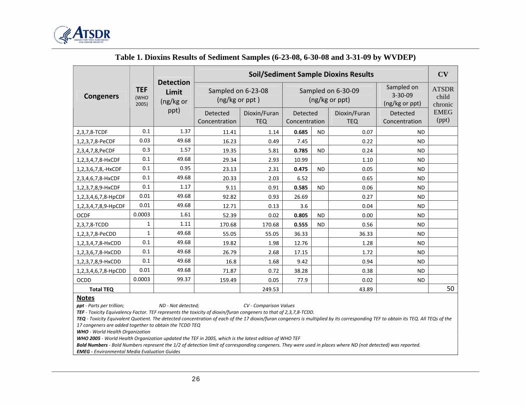
Nitrosodiphenylamine (0.359 mg/kg) were detected. Acetone (34.6 µg/kg), benzene (2.4 µg /kg) and toluene (5.2 µg /kg) were the VOCs detected, while total phenolics were not detected. Of those compounds detected, their concentrations were well below their medium-specific comparison values (CVs). In addition to the chemicals reported above, however, the sediment sample also contained dioxins at a concentration of 0.249 ppb TEQ (See the Table 1 in Appendix B)
On June 30, 2008, water and sediment samples were obtained from the same location sampled a week earlier. Unlike the previous samples, however, these samples were obtained during a rain event. In the water sample, none of the chlorinated herbicides were detected. All metals detected were below their medium-specific comparison values (CVs). Among SVOCs, m,p-cresol(0.0343 mg/L, or ppm), and 2,4-dimethylphenol (0.152 mg/L)were detected, while toluene (1.9 µg/L, ppb) was the only VOC detected. In contrast to the previous samples, phenolics were detected (0.404 mg/L), well below the ATSDR’s level of concern for phenol (20,000 mg/kg).
In the sediment sample, VOCs, pesticides and chlorinated herbicides were not detected. Several SVOCs were detected, including: Bis(2-chlorethy)ether(0.130 mg/kg), Bis(2-ethylhexyl)phthalate (3.05 mg/kg), 2,4-dimethylphenol(0.153 mg/kg), Di-n-octyl phthalate (0.330 mg/kg), N-nitrosodiphenylamine (0.138 mg/kg). Although a few metals were detected in the sediment sample, their concentrations were well below their medium-specific comparison values (CVs). As in the previous round of sampling, dioxins were also present in the sediment sample at 0.0439 ppb TEQ (See the Table 1 in Appendix B).
On March 30, 2009, two sediment samples were collected. In the sample obtained from the upgradient at the northern edge of the site, none of the pesticides, herbicides, SVOCs, VOCs, phenolics and dioxins were detected. Metals detected were below their medium-specific comparison values (CVs). In the sample taken from downgradient between the Midway Road and the bank of the Pocatalico River, no pesticides, herbicides and dioxins were detected. Of the SVOCs, bis(2-ethylhexyl)phthalate(0.955 mg/kg), and several polycyclic aromatic hydrocarbons (PAHs), including benzo(g,h,i)perylene(0.132 mg/kg), benzo(k)flouoranthene(0.114 mg/kg), chrysene(0.190 mg/kg), fluoranthene(0.498mg/kg), indeno(1,2,3-cd)pyrene(0.113 mg/kg), phenanthrene(0.302mg.kg) and pyrene(0.390 mg/kg) were detected. Acetone (30.1 µg/kg) and toluene (1.8 µg/kg) were the VOCs detected. Most metals were detected, but at levels below their medium-specific comparison values (CVs). Total phenolics were detected at the 0.368 mg/kg, well below ATSDR’s level of concern for phenol (20,000 mg/kg). Of those organic compounds detected, only four PAHs were just above their medium-specific health based comparison values (CVs), the remainders were below (See the Table 2 in Appendix B)
Exposure Pathways Analysis
WVDHHR evaluated whether the community has been, is, or could be exposed to harmful levels of contaminants in the environment by identifying the human exposure pathways. An exposure pathway is the route by which a contaminant travels from its source to the human body. It consists of five components:
a source of contamination one or more environmental media through which the contaminant is transported a point of exposure

ATSDR Heizer Creek Landfill Site Public Health Consultation
7
a route of human exposure an exposed population
To determine whether nearby residents are exposed to contaminants migrating from the site, WVDHHR evaluated the environmental and human components that lead to human exposure. Exposure may occur by breathing, eating or drinking the contaminants, or by skin (dermal) contact with the substance. WVDHHR identifies exposure pathways as completed, potential, or eliminated. Completed pathways are those that meet the five elements listed above. A potential pathway exists when one of the above listed five elements is missing, but could exist. Potential pathways indicate exposure to a contaminant may have occurred, may be occurring, or may occur in the future. An eliminated pathway occurs when at least one of the five elements is missing and will never be present.
The primary exposure pathway associated with the site is most likely through the accidental ingestion of contaminated soil. Exposure to the site soil has been eliminated since the fence was installed during the 2008 summer after site remediation operation was completed. However, due to a potential migration of dioxins from the site to the residential properties downgradient of the site, the exposure through the accidental ingestion of residential soil is a potential exposure pathway for the nearby residents, especially the children in the residences.
Public Health Implication
SVOCs, VOCs, Phenolics and Metals
The reported concentrations of SVOCs, VOCs, phenolics and metals in the sediment samples collected from the streams downgradient of the site, were below their health based comparison values. This means the amount of SVOCs, VOCs, phenolics and metals in the sediment is not expected to harm people, regardless of how they might be exposed. Moreover, the area sampled had been fenced since the completion of 2008 clean up. Dioxins
Dioxins were reported in each of the sediment sample collected on June 23 and 30, 2008 from the streams downgradient of the site. In one of the two samples, the dioxins concentration was 0.249 ppb TEQ, which was above the ATSDR’s screening value (0.050 ppb, the ATSDR child chronic Environmental Media Evaluation Guide, EMEG).
ATSDR’s oral chronic Minimal Risk Level (MRL) for dioxin is 1x10⁻⁹ mg/kg/day. The MRL was based upon a chronic (16 month) developmental study performed in monkeys, and was derived utilizing the reported Lowest-Observed-Adverse-Effect-Level (LOAEL) (1.2x10⁻⁷ mg/kg/day ) divided by an uncertainty factor of 90 [11]. The critical effect was altered social behavior.
Assuming soil intake, body weight and exposure duration are 200 mg/day, 16 kg and 6 years for preschool children; 150 mg/day, 55kg and 15 years for teenagers/adolescent; and 100 mg/day, 70 kg and 30 years for adults, the estimated dioxins exposure doses are 3x10⁻⁹ mg/kg/day for preschool children; 7x10⁻¹⁰ for teenagers/adolescent; and 4x10⁻¹⁰for adults (See Appendix C for the methodology of exposure dose estimation, and Table 3 in Appendix B for the assumptions used in the estimation). The dioxins doses for the teenagers/adolescent and the adults were well
8
below the MRL. The dose for the preschool children was slightly above the MRL, but still 40 times below the LOAEL. Therefore, no non-carcinogenic health effects should be expected.
An estimate of excess cancer risk is an extrapolation of the number of additional cases of cancer in a population that may be caused from exposure to dioxins at this site under the assumed exposure scenarios. This estimate is meant to be an estimate of additional cancer cases beyond the expected “background” rate of cancer. Currently, in the U.S. we estimate that 1 out of every 3 Americans will experience a diagnosis of cancer of some type over his or her lifetime. For additional information, go to http://seer.cancer.gov/statfacts/html/all.html). Excess cancer risk calculations are population-based estimates of excess risk and are not predictive for any single individual.
A cancer slope factor (CSF) expressed as risk per dose, in the unit of (mg/kg/day)-1, is a chemical-specific estimate of the incidence of cancer associated with an intake of 1 mg/kg/day. Many uncertainties and conservative assumptions were applied to determine the CSF (see Appendix C). This means the actual risk of cancer is probably lower than the calculated number, perhaps by several orders of magnitude. The true excess cancer risk is unknown and could be as low as zero.
WVDHHR calculated excess cancer risks from oral exposure to the dioxins concentration of 0.249 ppb using USEPA’s cancer slope factor, 1.5 x 10⁵ (mg/kg/d)-1 [12]. The resulting excess cancer risks are 4 in 100,000 for preschool children, 2 in 100,000 for teenagers/adolescent, and 2 in 100,000 for adults. These risk levels are considered very low risk by WVDHHR. (See Appendix C for the methodology of the theoretical excess cancer risk estimation, and Table 3 in Appendix B for the assumptions using in the estimation).
Dioxins are formed during forest fires, backyard burning, chlorine bleaching in paper manufacturing, some chlorinated chemical manufacturing processes, and burning of gasoline and diesel. Because their persistence, dioxins are found in very small amounts almost everywhere in the environment, and are often found in higher amounts in industrial areas. Dioxins tend to bind tightly to soil and sediment, and are found in low amounts in water and in air as a vapor. Dioxins can be accumulated in the food chain, resulting in measurable levels in animal.
Dioxins have been shown to cause a variety of health effects in humans and animals. The effects depend on the amount of exposure and the route of exposure. The most obvious health effect in human exposed to relatively large amounts of dioxins is chloracne, a severe skin disease. Human studies on dioxins’ effects in reproductive and developmental systems have been inconclusive even though these effects have been observed in many animal species. Some of the effects seen in animals are skeletal deformities, kidney defects, altered level of sex hormones, reduced production of sperm, and increased rates of miscarriage [12]. Dioxins have been found to cause cancer in animals but evidence of carcinogenicity in humans is less clear. Three organizations classify dioxin’s carcinogenicity as: “probable human carcinogen” (USEPA), “carcinogenic to humans” (International Agency for Research on Cancer or IRAC), and “known human carcinogen” (National Toxicology Program)
Polycyclic Aromatic Hydrocarbons (PAHs)
Four PAHs compounds were reported at concentrations above their health based comparison values in the sediment sample, collected off-site downstream between Midway Road and the
ATSDR Heizer Creek Landfill Site Public Health Consultation
9
bank of the Pocatalico River. These PAHs were BaP, benzo(a)anthracene, benzo(b)fluoranthene and indeno(1,2,3-cd)pyrene. See Table 2 in Appendix B.
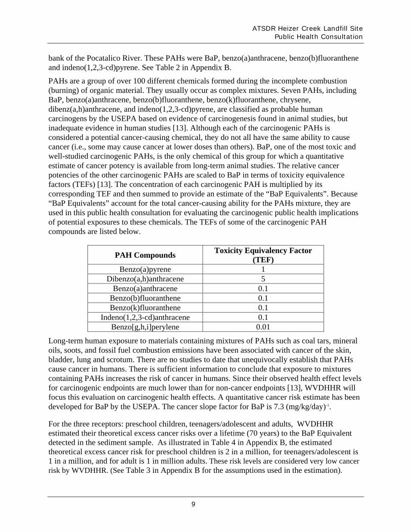
PAHs are a group of over 100 different chemicals formed during the incomplete combustion (burning) of organic material. They usually occur as complex mixtures. Seven PAHs, including BaP, benzo(a)anthracene, benzo(b)fluoranthene, benzo(k)fluoranthene, chrysene, dibenz(a,h)anthracene, and indeno(1,2,3-cd)pyrene, are classified as probable human carcinogens by the USEPA based on evidence of carcinogenesis found in animal studies, but inadequate evidence in human studies [13]. Although each of the carcinogenic PAHs is considered a potential cancer-causing chemical, they do not all have the same ability to cause cancer (i.e., some may cause cancer at lower doses than others). BaP, one of the most toxic and well-studied carcinogenic PAHs, is the only chemical of this group for which a quantitative estimate of cancer potency is available from long-term animal studies. The relative cancer potencies of the other carcinogenic PAHs are scaled to BaP in terms of toxicity equivalence factors (TEFs) [13]. The concentration of each carcinogenic PAH is multiplied by its corresponding TEF and then summed to provide an estimate of the “BaP Equivalents”. Because “BaP Equivalents” account for the total cancer-causing ability for the PAHs mixture, they are used in this public health consultation for evaluating the carcinogenic public health implications of potential exposures to these chemicals. The TEFs of some of the carcinogenic PAH compounds are listed below.
PAH Compounds Toxicity Equivalency Factor
(TEF) Benzo(a)pyrene 1
Dibenzo(a,h)anthracene 5 Benzo(a)anthracene 0.1
Benzo(b)fluoranthene 0.1 Benzo(k)fluoranthene 0.1
Indeno(1,2,3-cd)anthracene 0.1 Benzo[g,h,i]perylene 0.01
Long-term human exposure to materials containing mixtures of PAHs such as coal tars, mineral oils, soots, and fossil fuel combustion emissions have been associated with cancer of the skin, bladder, lung and scrotum. There are no studies to date that unequivocally establish that PAHs cause cancer in humans. There is sufficient information to conclude that exposure to mixtures containing PAHs increases the risk of cancer in humans. Since their observed health effect levels for carcinogenic endpoints are much lower than for non-cancer endpoints [13], WVDHHR will focus this evaluation on carcinogenic health effects. A quantitative cancer risk estimate has been developed for BaP by the USEPA. The cancer slope factor for BaP is 7.3 (mg/kg/day)-1.
For the three receptors: preschool children, teenagers/adolescent and adults, WVDHHR estimated their theoretical excess cancer risks over a lifetime (70 years) to the BaP Equivalent detected in the sediment sample. As illustrated in Table 4 in Appendix B, the estimated theoretical excess cancer risk for preschool children is 2 in a million, for teenagers/adolescent is 1 in a million, and for adult is 1 in million adults. These risk levels are considered very low cancer risk by WVDHHR. (See Table 3 in Appendix B for the assumptions used in the estimation).

10
It is important to note that the exposure doses and excess cancer risks estimated above were assumed as if the dioxins or PAHs was found in the residential properties. In view of lacking sufficient information for the extent of on-site contamination as well as their off-site migration, it may be advisable to confirm or rule out the presence of dioxins or PAHs in the residential properties.
Children’s Health Consideration
ATSDR/WVDHHR considers children in the evaluation of all exposures, and uses health guidelines that are protective for children. In general, children are assumed more susceptible to chemical exposures. In evaluating health effects from the site-specific environmental exposures, children were considered as a special population because:
Children weigh less than adults, resulting in higher doses of chemical exposures;
Children have higher rates of respiration;
Metabolism and detoxification mechanisms differ in both the very young and very old and may increase or decrease susceptibility;
A child’s developing body systems can sustain permanent damage if toxic exposures occur during critical growth stages; and,
Outdoor playing and hand-to-mouth habits increase children’s exposure potential. The fact that children are smaller than adults makes them more susceptible to the dust, soil, and vapors that are close to the ground.
This public health consultation considered these child-specific factors in the evaluation of potential health effects to children, and in the development of conclusions and recommendation for this site.
Conclusion
Based upon the review of the analytical results of samples collected by WVDEP during the remedial operation in June 2008 and after rain storm events in March 2009, WVDHHR/ATSDR reached three conclusions:
Conclusion 1 The storm water management plan implemented during the 2008 cleanup did not appear to be fully effective.
Conclusion 2 It cannot currently be determined whether exposure to volatile organic compounds (VOCs), phenolics and metals in soil via accidental ingestion would harm people’s health.
Conclusion 3 It cannot currently be determined whether exposure to polychlorinated dibenzodioxins and dibenzofurans (collectively referred to as dioxins), and some of the polycyclic aromatic hydrocarbons (PAHs) in the soil via accidental ingestion would harm people’s health.

ATSDR Heizer Creek Landfill Site Public Health Consultation
11
Recommendation
1. Install better storm water management practice at the landfill so that it effectively prevents the erosion of the cover, and keeps the contaminated soil from moving off-site.
2. Regularly monitor and inspect the site condition in order to maintain the integrity and effectiveness of any final cover.
3. Consider additional sampling at the residential properties located downgradient of the site on Midway Road, and both sides of the drainage swale.
Public Health Action Plan
WVDHHR/ATSDR will collaborate with WVDEP to gather additional information, such as sampling data at the residential properties located downgradient of the site on Midway Road, and both sides of the drainage swale.

12
Preparer of Report
Bin Z. Schmitz, M.S., Environmental Toxicologist Radiation, Toxics and Indoor Air Division Office of Environmental Health Services Bureau for Public Health, WVDHHR Reviewers of Report Randy C. Curtis, P.E., Director Anthony Turner, M.S., R.S., Assistant Director Radiation, Toxics and Indoor Air Division Office of Environmental Health Services Bureau for Public Health, WVDHHR Donald S. Thimsen, MD, MPH., Epidemiologist II Office of Environmental Health Services Bureau for Public Health, WVDHHR ATSDR Technical Project Officer CDR Alan G. Parham, REHS, MPH Technical Project Officer Agency for Toxic Substances and Disease Registry 1600 Clifton Road, N.E. MS-E29 Atlanta, Georgia 30333 ATSDR Regional Representatives Lora Siegmann-Werner, MPH, Senior Regional Representative Robert H. Helverson, Regional Representative ATSDR Region III 1650 Arch Street Mail Stop 3HS00 Philadelphia, Pennsylvania 19103


14
References
1. Health Consultation: Dioxin in the Soil in the Vicinity of the Heizer Creek Landfill,
Heizer Creek, Poca, Putnam County, West Virginia, Agency for Toxic Substance and Disease Registry, December 1999
2. Engineer Evaluation/Cost Analysis Work Plan, Heizer Creek Landfill Site, Putnam
County, West Virginia, Arcadis Geraghty & Miller, 29 October 1999
3. Response Action Work Plan, Heizer Creek landfill Site, Putnam County, West Virginia, Arcadis Infrastructure, Environmental, Facilities, Inc. 28 September 2007
4. Administrative Settlement Agreement and Order on Consent for Removal Action,
Heizer Creek Landfill Site, Monsanto Company and Pharmacia Corporation, United States Environmental Protection Agency, PA Docket No. CERC-03-2006-0002DC
5. Trip Report. Kanawha Valley-Dioxin Site, Nitro, Putnam County, West Virginia,
Western, Prepared for U.S Environmental Protection Agency Region III, Removal Response Section, Philadelphia, PA 14 April 1999
6. Ongoing Cleanup Status Update, United States Environmental Protection Agency,
Heizer Creek Landfill Site, Poca, Putnam County, West Virginia, August 2008
7. Memorandum, Sampling of unnamed tributary of Heizer Creek below former Monsanto Landfill, WVDEP, 16 July, 2008
8. Arcadis Progress Report No. 20, Heizer Creek Landfill Site, West Virginia, EPA
Docket No. CERC-03-2006-0002DC, 1 July 2008
9. Health Consultation. Heizer Creek, Poca, Putnam County, West Virginia, Agency for Toxic Substance and Disease Registry, 8 September 1999
10. ATSDR Record of Activity. Heizer Creek, Poca, Putnam County, West Virginia,
Agency for Toxic Substance and Disease Registry Region III, 4 June 2001
11. Agency for Toxic Substance and Disease Registry. Toxicological profile for Chlorinated Dibenzo-p-Dioxins. Atlanta: US Department of health and Human Services; 1998 Dec. Contract No.: 205-93-0606
12. US Environmental Protection Agency. Technology Transfer Network Air Toxics Website
for 2,3,7,8- Tetrachlorodibenzo-p-Dioxin (2,3,7,8-TCDD). Washington, D.C. 2006 Mar [cited 2006 Aug 1] Available from URL://www.epa.gov/ttn/atw/hlthef/dioxin.html

ATSDR Heizer Creek Landfill Site Public Health Consultation
15
13. Agency for Toxic Substance and Disease Registry. Toxicological profile for Polycyclic Aromatic Hydrocarbons (PAHs). Atlanta: US Department of health and Human Services; 1995 Aug. Contract No.: 205-93-0606
14. US Environmental Protection Agency. Exposure factors handbook. Washington, DC: US Environmental Protection Agency; 1999 Feb; USEPA/600/C-99/001.
15. Agency for Toxic Substances and Disease Registry. Public Health Assessment Guidance Manual (update). Atlanta: US Department of Health and Human Services; 2005 Jan.

16
Appendix A. Figures

ATSDR Heizer Creek Landfill Site Public Health Consultation
17
Figure 1. Heizer Creek Landfill Site
Heizer Creek Landfill (aprox.)

18
Figure 2. Heizer Creek Landfill Site after 2008 Cleanup
(Viewed from the Big Curve of Heizer Creek Road, Southwest of the Site)

ATSDR Heizer Creek Landfill Site Public Health Consultation
19
Figure 3. Heizer Creek Landfill Site after 2008 Cleanup
(Viewed from the South of the Site)

20
Figure 4. Heizer Creek Landfill Site after 2008 Cleanup
(The End of the Diversion Ditch at the Downgradient and Southwest of the Site)

ATSDR Heizer Creek Landfill Site Public Health Consultation
21
Figure 5. Heizer Creek Landfill Site after Rain Storms in March 2009
(Trees Fallen from above Diversion Ditch on the Upgradient and Northeast End of the Site, and Water Flowing from the Diversion Ditch to Slip)

22
Figure 6. Heizer Creek Landfill Site after Rain Storms in March 2009
(Sloughed Area)

ATSDR Heizer Creek Landfill Site Public Health Consultation
23
Figure 7. Heizer Creek Landfill Site after Rain Storms in March 2009
(Northern End of Slip – Erosion Channel)

24
Figure 8. Heizer Creek Landfill Site after Rain Storms in March 2009
(Silt Fence near the End of the Diversion Ditch on the Southwest area of the Site)

ATSDR Heizer Creek Landfill Site Public Health Consultation
25
Appendix B. Tables
26
Table 1. Dioxins Results of Sediment Samples (6-23-08, 6-30-08 and 3-31-09 by WVDEP)
Soil/Sediment Sample Dioxins Results CV
Sampled on 6‐23‐08 (ng/kg or ppt )
Sampled on 6‐30‐09 (ng/kg or ppt)
Sampled on 3‐30‐09
(ng/kg or ppt) Congeners
TEF (WHO 2005)
Detection Limit
(ng/kg or ppt) Detected
Concentration Dioxin/Furan
TEQ Detected
Concentration Dioxin/Furan
TEQ Detected
Concentration
ATSDR child
chronic EMEG (ppt)
2,3,7,8‐TCDF 0.1 1.37 11.41 1.14 0.685 ND 0.07 ND 1,2,3,7,8‐PeCDF 0.03 49.68 16.23 0.49 7.45 0.22 ND 2,3,4,7,8,PeCDF 0.3 1.57 19.35 5.81 0.785 ND 0.24 ND 1,2,3,4,7,8‐HxCDF 0.1 49.68 29.34 2.93 10.99 1.10 ND 1,2,3,6,7,8,‐HxCDF 0.1 0.95 23.13 2.31 0.475 ND 0.05 ND 2,3,4,6,7,8‐HxCDF 0.1 49.68 20.33 2.03 6.52 0.65 ND 1,2,3,7,8,9‐HxCDF 0.1 1.17 9.11 0.91 0.585 ND 0.06 ND 1,2,3,4,6,7,8‐HpCDF 0.01 49.68 92.82 0.93 26.69 0.27 ND 1,2,3,4,7,8,9‐HpCDF 0.01 49.68 12.71 0.13 3.6 0.04 ND OCDF 0.0003 1.61 52.39 0.02 0.805 ND 0.00 ND 2,3,7,8‐TCDD 1 1.11 170.68 170.68 0.555 ND 0.56 ND 1,2,3,7,8‐PeCDD 1 49.68 55.05 55.05 36.33 36.33 ND 1,2,3,4,7,8‐HxCDD 0.1 49.68 19.82 1.98 12.76 1.28 ND 1,2,3,6,7,8‐HxCDD 0.1 49.68 26.79 2.68 17.15 1.72 ND 1,2,3,7,8,9‐HxCDD 0.1 49.68 16.8 1.68 9.42 0.94 ND 1,2,3,4,6,7,8‐HpCDD 0.01 49.68 71.87 0.72 38.28 0.38 ND OCDD 0.0003 99.37 159.49 0.05 77.9 0.02 ND
Total TEQ 249.53 43.89 50
Notes ppt ‐ Parts per trillion; ND ‐ Not detected; CV ‐ Comparison Values TEF ‐ Toxicity Equivalency Factor. TEF represents the toxicity of dioxin/furan congeners to that of 2,3,7,8‐TCDD. TEQ ‐ Toxicity Equivalent Quotient. The detected concentration of each of the 17 dioxin/furan congeners is multiplied by its corresponding TEF to obtain its TEQ. All TEQs of the 17 congeners are added together to obtain the TCDD TEQ WHO ‐ World Health Organization WHO 2005 ‐ World Health Organization updated the TEF in 2005, which is the latest edition of WHO TEF Bold Numbers ‐ Bold Numbers represent the 1/2 of detection limit of corresponding congeners. They were used in places where ND (not detected) was reported. EMEG ‐ Environmental Media Evaluation Guides

ATSDR Heizer Creek Landfill Site Public Health Consultation
27
Table 2. Volatile and Semi-Volatile Organic Compounds Detected in the Downgradient Sediment Sample
(3-30-09 by WVDEP)
Detected Concentrations
Comparison Values (mg/kg) VOCs and SVOCs Detected
Values Unit Values Sources
Benzo(a)pyrene 0.188 mg/kg 0.1 ATSDR CREG
Benzo(a)anthracene 0.197 mg/kg 0.15 USEPA Region III RBC for residential soil
Benzo(b)fluoranthene 0.221 mg/kg 0.15 USEPA Region III RBC for residential soil
Benzo(g,h,i)perylene 0.132 mg/kg 0.1 *
Benzo(k)fluoranthene 0.114 mg/kg 1.5 USEPA Region III RBC for residential soil
Chrysene 0.19 mg/kg 15 USEPA Region III RBC for residential soil
Fluoranthene 0.498 mg/kg 30000 ATSDR Adult RMEG
Indeno(1,2,3-cd)pyrene 0.113 mg/kg 0.15 USEPA Region III RBC for residential soil
Phenanthrene 0.302 mg/kg 22,000 WV De Minimis Values for residential soil
Pyrene 0.39 mg/kg 20,000 ATSDR adult RMEG Bis(2-ethylhexyl)phthalate 0.955 mg/kg 35 USEPA Region III RBC for residential soil Acetone 30.1 µg/kg 50,000 ATSDR Child RMEG Toluene 1.8 µg/kg 1,000 ATSDR Child Intermediate EMEG Total phenolics 0.368 mg/kg 20,000 ATSDR Child RMEG Notes
CREG ‐ Cancer Risk Guides
RBC ‐ Risk Based Concentration
RMEG ‐ Reference Dose Media Evaluation Guide
* ‐ ATSDR does not have a CV for B(ghi)P so we used BaP as a surrogate for screening purposes
EMEG ‐ Environmental Media Evaluation Guides VOCs ‐ Volatile Organic Compounds SVOCs ‐ Semi‐Volatile Organic Compounds

28
Table 3. Assumptions for Estimation of Exposure Dose
Exposure Receptors Soil Intake Rate Body Weight Exposure Duration
Time Frame for Cancer Evaluation
200 mg/day Preschool child (non‐pica)
(0.02 tsp/day)
16 kg (35 lbs.) 6 Years
150 mg/day Teenagers/Adolescents
(0.015 tsp/day) 55 kg (122 lbs) 15 Years
100 mg/day Adult
0.01(tsp/day) 70 kg (154 lbs.) 30 Years
70 years
Notes:
Soil intake rates: Pica kids, child and adult soil ingestion rates are based on EPA Exposure Factors Handbook, others are ATSDR or EPA recommended rates (central tendency) for children and adults (EPA Exposure Factors Handbook).
The soil intake rates, as converted to teaspoons, are based on a soil bulk density of 1.5 g/cm3 and a volumetric conversion of 1 tsp = 4.93 cm3.

ATSDR Heizer Creek Landfill Site Public Health Consultation
29
Table 4. BaP Toxicity Equivalents of PAHs and Estimated Theoretical Cancer Risk
Lifetime (70 yrs) Exposure Dose (mg/kg/day)
Contaminants
Toxicity Equivalency
Factor (TEF)
Concentration Detected (mg/kg)
Equivalents of B[a]P (mg/kg) Preschool
children (1-6 yrs)
Teenagers/ Adolescents (7-17 yrs)
Adult
Benzo(a)pyrene(BaP) 1 0.188 0.188
Benzo(a)anthracene 0.1 0.197 0.0197
Benzo(b)fluoranthene 0.1 0.221 0.0221
Benzo(g,h,i)perylene 0.01 0.132 0.00132
Total B[a]P Equivalent NA NA 0.23 2.48E-07 1.35E-07 1.42E-07
Estimated Theoretical Cancer Risk from Exposure
1.8E-06 9.9E-07 1.0E-06
Note:
Estimated theoretical Cancer risk is calculated with cancer slope factor of 7.3 (mg/kg/day)-1 for B(a)P

30
Appendix C. Estimation of Exposure Doses and Excess Cancer Risk

ATSDR Heizer Creek Landfill Site Public Health Consultation
31
1. Estimation of Exposure Dose
Exposure doses are the estimates of how much chemical may enter into a person’s body. The calculations rely on the sample data and assumptions. Generally, those assumptions include exposure duration, exposure frequency, intake rates, and body weights. The exposure durations and frequency are determined based on exposure scenarios. Intake rates and body weights are based on recommendations from the USEPA Exposure Handbook [14], and the ATSDR Public Health Assessment Guidance Manual [15]. Table 3 in Appendix B summarizes the assumptions used in exposure dose estimations in this health consultation.
These assumptions are used to determine the estimated doses for each contaminant. The estimated doses will then be compared to health guidelines and the available scientific literature to determine if health effects are likely to occur.
Exposure doses are expressed as the amount of contaminant that a person intakes daily per unit of body weight. It is expressed as milligrams of chemical per kilogram of body weight per day (mg/kg/day).
The equation and assumptions used to estimate exposure doses from ingesting contaminants in surface soil is as follows [15]:
Equation 1: Exposure Dose for Soil Ingestion
ED = C x IR x EF x CF x BF BW Where:
ED = exposure dose in milligrams per kilogram per day (mg/kg/day) C = chemical concentration in milligrams per kilogram (mg/kg)
IR = intake rate in milligrams per day (mg/day), or liter per day (L/day) for water EF = exposure factor (unitless, acute EF = 100%) CF = conversion factor, 1×10⁻⁶ kilograms/milligram (kg/mg) BF = bioavailability factor (unitless) BW = body weight in kilograms (kg)
2. Estimation of Theoretical Cancer Risk
An estimate of excess cancer risk is an extrapolation of the number of additional cases of cancer in a population that may be caused from exposure to COCs at this site under the assumed exposure scenarios. This estimate is meant to be an estimate of additional cancer cases beyond the expected “background” rate of cancer. Currently, in the U.S. we estimate that 1 out of every 3 Americans will experience a diagnosis of cancer of some type over his or her lifetime. For additional information, go to http://seer.cancer.gov/statfacts/html/all.html). Excess cancer risk calculations are population-based estimates of excess risk and are not predictive for any single individual.
A cancer slope factor (CSF) expressed as risk per dose, in the unit of (mg/kg/day)-1, is a chemical-specific estimate of the incidence of cancer associated with an intake of 1 mg/kg/day. Many uncertainties and conservative assumptions were applied to determine the CSF such as

32
Past exposures to carcinogenic chemicals were the same as those at currently measured levels.
Effects from short exposures are averaged over a 70-year lifetime.
No threshold of exposure for cancer causing chemicals.
The cancer slope factor is based on the most sensitive range of responses, the 95% upper bound risk. The excess cancer risk would be lower if the average response was used to calculate the cancer slope factor.
This means the actual risk of cancer is probably lower than the calculated number, perhaps by several orders of magnitude. The true excess cancer risk is unknown and could be as low as zero.
The equation used to estimate theoretical cancer risk from ingesting contaminants in surface soil is as following [15]:
Equation 2: Estimated Excess Lifetime Cancer Risk
ER = CSF x Dose
Where:
ER = estimated theoretical risk (unitless)
Dose = estimated daily exposure dose (mg/kg/day) for a life time (70 years)
CSF = Cancer Slope Factor (mg/kg/day)-1

ATSDR Heizer Creek Landfill Site Public Health Consultation
33
Appendix D. Glossary of Term

34
Glossary of Terms
ATSDR Agency for Toxic Substances and Disease Registry
BaP Benzo(a)pyrene
BMP Best Management Practice
Cancer Risk A theoretical risk for getting cancer if exposed to a substances every day for 70 years (a lifetime exposure)
Chronic Occurring over a long time. ATSDR defines exposures over a year as the chronic exposures
COCs Contaminant of Concerns
CVs Comparison Values
EE/CA Engineer Evaluation/Cost Analysis
EMEG Environmental media Evaluation Guides
EPA U.S. Environmental Protection Agency
LOAEL Lowest Observed Adverse Effect Level
MRL Minimal Risk Level
PAHs Polycyclic Aromatic Hydrocarbons
ppb Parts per billion, microgram/liter (µg/L) or microgram/kilogram (µg/kg)
ppt Parts per trillion, nanogram/kg
SVOCs Semi-Volatile Organic Compounds
TCDD 2,3,7,8-Tetrachlorodibenzo-p-dioxin
TEF Toxicity Equivalent Factor
TEQ Toxicity Equivalent Quotient
VOCs Volatile Organic Compounds
WHO World Health Organization
WVDEP West Virginia Department of Environmental Protection
WVDHHR West Virginia Department of Health and Human Resources