supplementary ordinary meeting business paper · the notre dame university medical teaching campus....
TRANSCRIPT

s u p p l e m e n t a r y
o r d i n a r y
m e e t i n g
b u s i n e s s
p a p e r
d a t e o f m e e t i n g : 3 1 J u l y 2 0 1 8
l o c a t i o n : c o u n c i l c h a m b e r s
t i m e : 6 : 3 0 p . m .


ORDINARY MEETING - SUPPLEMENTARY
Table of Contents
Meeting Date: 31 July 2018
ORDINARY Table of Contents Page 1
TABLE OF CONTENTS
ITEM SUBJECT PAGE
SECTION 3 – Reports for Determination 3
SUPPLEMENTARY REPORTS 3
Item: 178 CP - Update on Kurmond Kurrajong Investigation Area Structure Plan - (124414, 95498)
3

ORDINARY MEETING - SUPPLEMENTARY
Table of Contents
Meeting Date: 31 July 2018
ORDINARY Table of Contents Page 2

ORDINARY MEETING - SUPPLEMENTARY
SECTION 3 – Reports for Determination
Meeting Date: 31 July 2018
ORDINARY Item: 178 Page 3
SECTION 3 – Reports for Determination
SUPPLEMENTARY REPORTS Item: 192
Item: 178 CP - Update on Kurmond Kurrajong Investigation Area Structure Plan - (124414, 95498)
Previous Item: 40, Ordinary (March 2015)
114, Ordinary (July 2015) 134, Ordinary (August 2015) 199, Ordinary (November 2015) 188, Ordinary (August 2016)
Directorate: City Planning
PURPOSE OF THE REPORT:
The purpose of this report is to provide Council with an update on progress with respect to Structure Planning processes associated with the Kurmond Kurrajong Investigation Area, and in particular provide details of relevant studies, including:
• Kurmond and Kurrajong Landscape Character Study • Ecological/Biodiversity Mapping • Commercial/Retail Findings – Kurmond and Kurrajong.
The report also provides a chronology of relevant dates relating to the Kurmond Kurrajong Investigation Area, including details of individual planning proposals within the Investigation Area. The report also highlights a series of next steps in respect of the Kurmond Kurrajong Investigation Area Structure Planning process, and other recommendations from identified matters within the studies.
EXECUTIVE SUMMARY:
The Hawkesbury Residential Land Strategy 2011 was adopted by Council on 10 May 2011. The Residential Land Strategy mapped investigation areas to identify the potential for general, low density or medium density residential zonings in nominated locations. Through a Mayoral Minute on 3 February 2015, Council resolved to undertake Structure Planning within the Kurmond Kurrajong Investigation Area. This Structure Planning process was to determine the suitability of the identified lands for large lot residential and/or rural residential development. Recent progress with respect to the Kurmond Kurrajong Investigation Area has included a number of associated studies, including: • Kurmond and Kurrajong Landscape Character Study • Ecological/Biodiversity Mapping • Commercial/Retail Findings – Kurmond and Kurrajong. The recommendations from these studies is that the critical next steps to progress the Structure Planning process within the Kurmond Kurrajong Investigation Area include: • Complete landscape character study and establish related controls (Lake Macquarie controls in
Appendix 6 are example controls to consider)

ORDINARY MEETING - SUPPLEMENTARY
SECTION 3 – Reports for Determination
Meeting Date: 31 July 2018
ORDINARY Item: 178 Page 4
• Pursue consolidation of rural zoning (potentially R5 – Large Lot Residential) • Update controls on rural lot sizes • Engage stakeholders in urban design upgrade concepts for the two villages • Establish relevance of outcomes to other rural areas of the council It was also suggested that the approach adopted could be readily applied to all rural areas in the Hawkesbury LGA. These recommendations are supported, in addition to the provision of relevant controls that:
• Retain existing landscape qualities • Provide additional landscaping to enhance landscape character, views and vistas • Provide sufficient setbacks between vegetation and buildings to ensure fire safety • Accommodate on-site sewerage detention and management.
RECOMMENDATION SUMMARY:
That Council: 1. Endorse the Kurmond and Kurrajong Landscape Character Study prepared by Clouston
Associates. 2. Agree to proceed to the next steps in the structure planning process, including preparation of a
planning proposal to amend relevant planning controls for further consideration by Council. 3. Engage with relevant stakeholders to work through the findings of the Kurmond Kurrajong
Landscape Character Study.
REPORT:
Housing Context Whilst Structure Planning for the Kurmond Kurrajong Investigation Area was commenced in 2015, it is important to understand the context in which this ongoing strategy work is being undertaken. This is also the case for the review of the Residential Land Strategy that Council has resolved to undertake. Metropolitan Context Planning for future residential uses in the Hawkesbury Local Government Area (LGA) needs to consider how the LGA itself, and the wider district and region, is expected to grow and change over the next few decades. This requires Council to work within the strategic planning direction set by the NSW Government and the Greater Sydney Commissions for: • Greater Sydney in the Greater Sydney Region Plan - a metropolis of 3 Cities including the
Western Parkland City • The Western City District, of which the Hawkesbury is a part. Greater Sydney Region Plan The Greater Sydney Region Plan forecasts that between 2016 and 2036, the Western City District is expected to grow by 740,000 people in 2016 to 1.1 million people by 2036. This equates to a need for nearly 40,000 new homes in 2016-2021 alone, and nearly 185,000 new homes between 2016 and 2036.

ORDINARY MEETING - SUPPLEMENTARY
SECTION 3 – Reports for Determination
Meeting Date: 31 July 2018
ORDINARY Item: 178 Page 5
Of this, the Western City District Plan sets a five-year housing target for Hawkesbury LGA of 1,150 new homes between 2016 to 2021. However, further work is required to understand the housing and economic impacts of the growing population, with Hawkesbury LGA expected to grow from around 67,000 people in 2016 to just over 85,000 people by 2036. The Greater Sydney Region Plan also notes that flooding in the Hawkesbury-Nepean Valley is one of the most significant natural hazards in Greater Sydney. It states that if the 1867 flood - where the river level reached 19.7 metres at Windsor - were repeated today, 12,000 residential properties would be impacted, 90,000 people would need evacuation and damages would cost an estimated $5 billion. Western City District Plan. The Western City District Plan collectively classes Richmond and Windsor as a strategic centre, recognising its expanded role as a hub for retail and commercial services; major health facilities including the Notre Dame University medical teaching campus. The Plan also identifies a growing tourism opportunity, focused on colonial history, rural character, agriculture and environmental assets including the Greater Blue Mountains World Heritage area, the Hawkesbury River and the surrounding agricultural lands. The Plan sets a baseline target of 12,000 jobs by 2036 (up from 10,300 in 2016) with a higher target of 16,500 jobs. The existing aerospace and defence activities at RAAF Base Richmond is a hub of logistics support for the Australian Defence Force. Over 450 aerospace workers work within the precinct for the Royal Australian Air Force, United States Air Force, Northrop, Airbus Group Australia Pacific, Lockheed Martin, Standard Aero, GEAviation, L3 Aviation Products and CAE. Combined, the RAAF Base, Western Sydney University Hawkesbury campus, TAFE NSW Richmond, and a new STEM ( Science, Technology, Engineering and mathematics) Secondary School will complement business activities around the Badgerys Creek Aerotropolis that will be focused on the planned Western Sydney Airport. North West Growth Area Part of Hawkesbury LGA is within the North West Growth Area, an area designated by the NSW Government as suitable for large scale greenfield land releases. In the case of Hawkesbury, the release areas are also located within a relatively short distance of the Richmond rail line. Western Sydney City Deal Hawkesbury City Council is involved in the Western Sydney City Deal, a 20-year agreement between the Australian and NSW governments and Blue Mountains, Camden, Campbelltown, Fairfield, Hawkesbury, Liverpool, Penrith and Wollondilly councils that will optimise the opportunity of the new airport and focus on connectivity; jobs; skills and education; planning and housing; liveability and environment; and governance. Western Sydney Airport will also create international and domestic tourism opportunities. This will have a positive influence on the Hawkesbury’s visitor economy by better connecting visitors to the places like the Hawkesbury Regional Gallery, heritage areas including the Macquarie towns, visitor experiences such as the Hawkesbury Farm Gate Trails, and exceptional landscapes and waterways. The Hawkesbury’s unique landscape also offers rich soils for agricultural production that can in turn lead to export opportunities that will link to Badgerys Creek Airport. The Western Sydney University at Hawkesbury Campus and AgriPark Research Centre provide tertiary education in medical and forensic science, animal science, natural science, sustainable agriculture and food security with world-class research facilities in grasses, pastures, legumes, insects and ecology. Hawkesbury LGA is, therefore, ready to face the future, which a rich and diverse economy and expected population growth that can be optimised to bring more opportunities and services to more people.

ORDINARY MEETING - SUPPLEMENTARY
SECTION 3 – Reports for Determination
Meeting Date: 31 July 2018
ORDINARY Item: 178 Page 6
Hawkesbury Housing and Employment Strategy. In response to these issues and opportunities, Council needs to develop detailed housing and employment strategies. In the case of housing, planning that focuses housing development in the right locations: • Within the areas of the North West Growth Area located within Hawkesbury • Near existing transport connections or centres • Within easy access of future job locations • Within existing urban areas with good access to existing services such as education, health
and commercial services that minimise risks associated with flooding and bushfires. In the case of employment, planning that focuses economic development in the right locations, that build on: • The areas natural advantages, its rich soils and associated agricultural lands, its areas of
natural beauty and wilderness • Its strengths, the cluster of aerospace, education, research and employment activities
between Windsor and Richmond • Richmond and Windsor as a strategic centre, recognising its expanded role as a hub for retail
and commercial services; major health facilities including the Notre Dame University medical teaching campus
• Growing tourism opportunities, focused on colonial history, rural character, agriculture and environmental assets including the Greater Blue Mountains World Heritage area, the Hawkesbury River and the surrounding agricultural lands.
Background to Kurmond Kurrajong Investigation Area The following has been provided by way of background with respect to the Kurmond Kurrajong Investigation Area. Background in Chronological Order 10 May 2011 Hawkesbury Residential Land Strategy adopted by Council.
The Residential Land Strategy mapped certain areas within the Local Government Area to investigate the potential for General, Low Density or Medium Density residential zonings. The Residential Land Strategy also provided the category to identify investigation areas for future development within and on the periphery of rural villages.
5 February 2013 Council resolved to carry out investigations within the “Kurmond Village large lot residential/rural-residential Investigation Area”. These investigations were to determine the suitability of the identified lands for large lot residential and/or rural residential development.
24 June 2014 Council resolved to review the area for investigation identified by Council on 5 February 2013 and determined that this was to be the first area to have a development/structure plan prepared.
3 February 2015 Mayoral Minute
Council resolved to suspend acceptance of new planning proposals under the Hawkesbury Residential Land Strategy until the key implementation actions of the Residential Land Strategy, in particular structure planning and development contribution planning had been completed for the Kurmond Kurrajong Investigation Area, or 31 July 2015.
ORDINARY MEETING - SUPPLEMENTARY
SECTION 3 – Reports for Determination
Meeting Date: 31 July 2018
ORDINARY Item: 178 Page 7
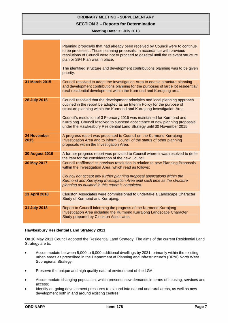
Planning proposals that had already been received by Council were to continue to be processed. Those planning proposals, in accordance with previous resolutions of Council were not to proceed to gazettal until the relevant structure plan or S94 Plan was in place. The identified structure and development contributions planning was to be given priority.
31 March 2015 Council resolved to adopt the Investigation Area to enable structure planning and development contributions planning for the purposes of large lot residential/ rural-residential development within the Kurmond and Kurrajong area.
28 July 2015 Council resolved that the development principles and local planning approach outlined in the report be adopted as an Interim Policy for the purpose of structure planning within the Kurmond and Kurrajong Investigation Area. Council’s resolution of 3 February 2015 was maintained for Kurmond and Kurrajong. Council resolved to suspend acceptance of new planning proposals under the Hawkesbury Residential Land Strategy until 30 November 2015.
24 November 2015
A progress report was presented to Council on the Kurmond Kurrajong Investigation Area and to inform Council of the status of other planning proposals within the Investigation Area.
30 August 2016 A further progress report was provided to Council where it was resolved to defer the item for the consideration of the new Council.
30 May 2017 Council reaffirmed its previous resolution in relation to new Planning Proposals within the Investigation Area, which read as follows: Council not accept any further planning proposal applications within the Kurmond and Kurrajong Investigation Area until such time as the structure planning as outlined in this report is completed.
13 April 2018 Clouston Associates were commissioned to undertake a Landscape Character Study of Kurmond and Kurrajong.
31 July 2018 Report to Council informing the progress of the Kurmond Kurrajong Investigation Area including the Kurmond Kurrajong Landscape Character Study prepared by Clouston Associates.
Hawkesbury Residential Land Strategy 2011 On 10 May 2011 Council adopted the Residential Land Strategy. The aims of the current Residential Land Strategy are to:
• Accommodate between 5,000 to 6,000 additional dwellings by 2031, primarily within the existing
urban areas as prescribed in the Department of Planning and Infrastructure’s (DP&I) North West Subregional Strategy;
• Preserve the unique and high quality natural environment of the LGA; • Accommodate changing population, which presents new demands in terms of housing, services and
access; • Identify on-going development pressures to expand into natural and rural areas, as well as new
development both in and around existing centres;

ORDINARY MEETING - SUPPLEMENTARY
SECTION 3 – Reports for Determination
Meeting Date: 31 July 2018
ORDINARY Item: 178 Page 8
• Identify physical constraints of flood, native vegetation and bushfire risk; and • Ensure that the appropriate infrastructure is planned and provided to cater for future development. The Residential Land Strategy does not rezone land or approve development of areas or localities. Rather it establishes a planning framework to assist in the implementation of the above aims and is to be used to guide the preparation and assessment of rezoning proposals (Planning Proposals). The Residential Land Strategy contains the following commentary and criteria regarding large lot residential / rural residential development.
“2.10 Strategy for Rural Village Development
The Hawkesbury Residential Development Model focuses on future residential development in urban areas and key centres. However, the importance of maintaining the viability of existing rural villages is recognised. As such, the Hawkesbury Residential Strategy has developed a strategy for rural residential development.
Future development in rural villages should be of low density and large lot dwellings, which focus on proximity to centres and services and facilities. Rural village development should also minimise impacts on agricultural land, protect scenic landscape and natural areas, and occur within servicing limits or constraints.”
“3.3.8 Role of Rural Residential Development
Rural residential developments have historically been a popular lifestyle choice within Hawkesbury LGA. However, rural residential development has a number of issues associated with it including:
• Impact on road networks; • Servicing and infrastructure; • Access to facilities and services; • Access to transport and services; • Maintaining the rural landscape; and • Impacts on existing agricultural operations.
Whilst this Strategy acknowledges rural residential dwellings are a part of the Hawkesbury residential fabric, rural residential dwellings will play a lesser role in accommodating the future population. As such, future rural development should be low density and large lot residential dwellings.
Future rural residential development, that is large lot residential dwellings, will be required to:
• Be able to have onsite sewerage disposal; • Cluster around or on the periphery of villages; • Cluster around villages with services that meet existing neighbourhood criteria services as a
minimum (within a 1km radius); and • Address environmental constraints and have minimal impact on the environment.”
“6.5 Rural Village Development Criteria
While the majority of future residential development will occur within existing residential areas or on the periphery of existing urban areas and corridors, it is recognised that there is a need to maintain the ongoing viability of rural villages. Future development within rural villages should be primarily low density and large lot residential dwellings.
Additionally all future low density and large lot residential development in rural villages must:

ORDINARY MEETING - SUPPLEMENTARY
SECTION 3 – Reports for Determination
Meeting Date: 31 July 2018
ORDINARY Item: 178 Page 9
• Be able to have onsite sewerage disposal; • Cluster around or on the periphery of villages; • Cluster around villages with services that meet existing neighbourhood criteria services as a
minimum (within 1km radius); • Address environmental constraints and with minimal environmental impacts; and • Within the capacity of the rural village.”
Council has resolved to review the Residential Land Strategy, and strategy work in this respect is guided by the Housing Context that was outlined earlier in this report. There are a number of ongoing requisite studies to complete this review, including, but not limited to:
• Flood • Bushfire • Ecological/Biodiversity • Agriculture/Rural Lands • Town Centres • Landscape Assessments • Retail • Recreation and Open Space • Transport • Employment Lands • Community Facilities • Conservation Areas • Population and Employment Targets.
Kurmond Kurrajong Investigation Area The Kurmond Kurrajong Investigation Area was not identified within the Residential Land Strategy. However, the Investigation Area was identified by considering the location criteria provided within the Residential Land Strategy (i.e. “within 1km radius” and “cluster around or on the periphery of villages”), undertaking a desk top survey of matters such as slope, existing vegetation, existing road layout and accesses, and zone and property boundaries. Figures 1, 2, 3 and 4 below illustrates the Kurmond Kurrajong Investigation Area

ORDINARY MEETING - SUPPLEMENTARY
SECTION 3 – Reports for Determination
Meeting Date: 31 July 2018
ORDINARY Item: 178 Page 10
Figure 1: Kurmond Kurrajong Investigation Area
Figure 2: Existing Zoning Map Kurmond Kurrajong Investigation Area

ORDINARY MEETING - SUPPLEMENTARY
SECTION 3 – Reports for Determination
Meeting Date: 31 July 2018
ORDINARY Item: 178 Page 11
Figure 3: Lot Size Map of Kurmond Kurrajong Investigation Area
Figure 4: Biodiversity Map of Kurmond Kurrajong Investigation Area Previous and Current Planning Proposals Figure 5 and Table 1 below summarises the details and status of previous and current planning proposals within the Kurmond Kurrajong Investigation Area.

ORDINARY MEETING - SUPPLEMENTARY
SECTION 3 – Reports for Determination
Meeting Date: 31 July 2018
ORDINARY Item: 178 Page 12
Figure 5: Previous and Current Planning Proposals within the Kurmond Kurrajong Investigation Area
Current Planning Proposals within Kurmond Kurrajong Investigation Area Pre-Gateway. No on Map
Application No Date Received
Address Proposed number of Lots
Status of the Planning Proposal
1 LEP017/16 29/11/2016 49 and 56 Longleat Road, Kurmond
10 Applicant advised of Council's resolutions and requested to provide advice as to how they wish to proceed (defer, withdraw, report to Council).
3 LEP009/16 23/03/2016 42 Bells Lane, Kurmond
5 Planning proposal deferred until adoption of policy for KKIA at Ordinary Meeting of 14 February 2017.
4 LEP007/16 09/02/2016 535 Bells Line of Road, Kurmond
2 Applicant requested 6 June 2017 that the planning proposal be deferred.
5 LEP006/16 09/02/2016 98 Bells Lane, Kurmond
4 Planning proposal deferred until adoption of policy for KKIA at Ordinary Meeting of 14 February 2017.
7 LEP003/16 21/01/2016 36 and 42 Vincents Road, Kurrajong
6 Applicant advised of Council's resolutions and requested to provide advice as to how they wish to proceed (defer, withdraw, report to Council).

ORDINARY MEETING - SUPPLEMENTARY
SECTION 3 – Reports for Determination
Meeting Date: 31 July 2018
ORDINARY Item: 178 Page 13
Current Planning Proposals within Kurmond Kurrajong Investigation Area Post-Gateway. No on Map
Application No
Date Received
Address Proposed number of Lots
Status of the Planning Proposal
8 LEP002/15 30/01/2015 79, 95 & 100 Bells Lane, Kurmond
18 Gateway determination issued 23 June 2018.
10 LEP005/14 23/12/2014 2 Inverary Drive, Kurmond
41 Gateway determination issued 28 June 2018.
11
LEP010/16 11/04//2016 74 Longleat Lane, Kurmond
2 Gateway determination issued 23 September 2016. Public exhibition to commence.
13 LEP006/14 18/08/2014 631 Bells Line of Road, Kurrajong
10 Council deferred the matter pending the results of the Comprehensive Traffic Study 11 April 2017.
14 LEP009/13 14/11/2013 377 Bells Line of Road, Kurmond
6 Amended proposal received to be reported to Council.
Planning Proposals within Kurmond Kurrajong Investigation Area Gazetted, Refused or Withdrawn. No on Map
Application No
Date Received
Address Proposed number of Lots
Status of the Planning Proposal
6 LEP005/16 09/02/2016 3 Longleat Road, Kurmond
2 Applicant withdrew planning proposal 26 June 2018.
12 LEP004/16 03/02/2016 452 Greggs Road, Kurrajong
2 Gazetted 8/06/2018.
2 LEP016/16 18/11/2016 72 Bells Lane, Kurmond
- Determined by JRPP to not proceed to Gateway 26 March 2018.
LEP001/16 19/01/2016 1041 Grose Vale Road, Kurrajong
- Withdrawn on 4 October 2016.
9 LEP007/14 24/12/2014 3 Bells Lane, Kurmond
- Withdrawn on 18 December 2017.
18 LEP003/14 09/09/2014 431 and 431A Greggs Road, Kurrajong
8 Gazetted 18 August 2017.
17 LEP002/14 30/05/2014 1420 Kurmond Road, Kurmond
11 Gazetted 23 June 2017.
19 LEP007/13 28/10/2013 136 Longleat Lane, Kurmond
4 Gazetted 9 December 2016.
20 LEP004/13 25/03/2013 1059A Grose Vale Road, Kurrajong
9 JRPP appointed as RPA. Gazetted 9 June 2017.
21 LEP003/13 20/02/2013 1026 Grose Vale Road, Kurrajong
2 Gazetted 16 October 2015.
22 LEP001/12 25/10/2012 396 Bells Line of Road, Kurmond
37 Gazetted 27 January 2017.
23 LEP11-001/12 01/08/2012 1442 and 1442A Kurmond Road, Kurmond
13 Gazetted 9 June 2017.
24 LEP89005/10 15/12/2010 1411 Kurmond Road, Kurmond
5 Gazetted 16 January 2015.
Table 1 – Details and Status of Previous and Current Planning Proposals within the Kurmond Kurrajong Investigation Area

ORDINARY MEETING - SUPPLEMENTARY
SECTION 3 – Reports for Determination
Meeting Date: 31 July 2018
ORDINARY Item: 178 Page 14
Whilst work in relation to the Kurmond Kurrajong Investigation Area has been ongoing, the ability to move forward with relevant strategy work and undertake an effective ‘whole to part’ process has been severely constrained by the acceptance of multiple individual planning proposals. Commercial/Retail Findings – Kurmond and Kurrajong Leyshon Consulting was commissioned by Council to undertake a commercial/retail assessment of the existing villages of Kurmond and Kurrajong. The paper provided by Leyshon Consulting provided a summary of the key observations following a review of relevant data and an inspection of the Kurmond and Kurrajong villages. The key observations included: • Kurmond and Kurrajong centres draw their resident-based sales/business from a common
residential catchment. • A population of 9,086 certainly would be sufficient to support a much larger provision of retail
floor-space in both centres than the amount of retailing which currently exists. • The population of the Kurmond and Kurrajong areas exhibits above average socio-economic
characteristics which is usually indicative of an area having an above average demand for retail floor-space.
• Analysis of 2016 census data indicates the population of Kurmond and Kurrajong and surrounding areas broadly can be described as somewhat older, higher proportion of married persons, higher proportion of traditional families, lower proportion of tertiary educated persons, higher proportion of trade qualified persons, higher proportion of people born in Australia, low unemployment rate and well above average median household income.
• There is sufficient population in the areas surrounding the Kurmond and Kurrajong villages to support a much larger provision of retailing and associated services than currently exists. The fact that both centres remain relatively small, however, is likely to be a function of their location, history and topography as well as competition from larger centres such as North Richmond, Richmond and Windsor.
• That no clear need exists for strategies to be adopted to increase the residential population surrounding the two villages in order to either underwrite their viability or to support a greater range of retail floor-space and services than each currently contains.
The commercial/retail assessment recommended that the Kurmond and Kurrajong village centres do not need significant public capital expenditure at present. It is considered Council’s approach should be based on the concept of applying a “light touch’ as the village centres appear to be working well at this time. The assessment further recommended some greater attention to kerbside landscaping within the centre to be considered. Environmental Assessment Council’s LEP 2012 biodiversity and corridor layer covers a wide area of remnant vegetation as well as existing and potential biodiversity connectivity. It includes areas of small patches of vegetation in properties as well as large tracts of vegetation with state conservation priority across multiple ownerships. Since the development of the layer, a wide variety of more recent biodiversity conservation guidelines, planning documents and policies have evolved that require Council consideration in its provision of regulatory requirements and operational management. Council must be adequately informed in order to be ready to effectively respond to the recent comprehensive changes to NSW biodiversity legislation. This includes Council’s assessment of development proposals that require mandatory biodiversity offsetting for specified development thresholds. Additionally, since the LEP 2012 biodiversity mapping, the extant area of remnant vegetation will have changed, primarily through clearance in intensively developed areas.

ORDINARY MEETING - SUPPLEMENTARY
SECTION 3 – Reports for Determination
Meeting Date: 31 July 2018
ORDINARY Item: 178 Page 15
To support decision making arising from these changes it is required to develop a suite of strategic biodiversity planning tools and supporting information. A biodiversity prioritisation framework identifies the relative conservation significance of areas of native habitat across private and public land tenures which provides an overarching basis for strategic planning products. Prioritisation of biodiversity across the LGA will allow, not only an improved planning decision framework, but will also support a range of other financial, administrative and operational decisions and activities. Council is undertaking this wider project in order to provide an initial biodiversity prioritisation framework and a suite of supporting tools for further development to improve and inform Council decision making and strategic planning. Key objectives of the initial stage of the project include: • Collate and review relevant biodiversity information to support decision making, including
update of extant vegetation mapping • Identify relevant criteria and associated information / data for the development of a
biodiversity prioritisation framework • Prepare an initial biodiversity prioritisation dataset for discussion with Council • Assess a number of pilot sites to test the initial outcomes of the prioritisation framework The framework and tools will take into account new legislation, use updated mapping of biodiversity values and ultimately reflect Council and community priorities to achieve effective long-term conservation outcomes. The approach to prepare the initial prioritisation framework and mapping includes: • Review of existing background information and data suitable for use in the process which has
included: - Vegetation community and condition mapping - Species records and predictive habitat modelling - Drainage / riparian and wetland areas - Lands identified for conservation
• Update extent of latest vegetation mapping • Habitat corridor analysis • Develop criteria for prioritisation framework • Data analysis and prioritisation mapping • Validate prioritisation framework with pilot sites Whilst the final version of this initial work is nearing completion, relevant information for the Kurmond Kurrajong Investigation Area has been provided, and is included as Attachment 1. Landscape Character Study for the Kurmond Kurrajong Investigation Area In order to appropriately inform the Structure Planning process for the Kurmond Kurrajong Investigation Area, Clouston Associates were commissioned to prepare a Landscape Character Study of Kurmond and Kurrajong. The purpose of the Study is to provide a landscape character assessment of Kurrajong and Kurmond that determines what aspects of the streetscapes, landscapes and buildings are positively contributing to make the area identifiable and unique. This Study also directs recommendations for appropriate locations, typical lots sizes and desired built form character for future development in the Investigation Area. The Kurrajong and Kurmond Landscape Character Study prepared by Clouston Associates is provided as Attachment 2. The Kurmond Kurrajong Landscape Character Study has recommended that the critical next steps to progress the study’s recommendations include:

ORDINARY MEETING - SUPPLEMENTARY
SECTION 3 – Reports for Determination
Meeting Date: 31 July 2018
ORDINARY Item: 178 Page 16
• Complete landscape character study and establish related controls (Lake Macquarie controls in Appendix 6 are example controls to consider)
• Pursue consolidation of rural zoning (potentially R5 – Large Lot Residential) • Update controls on rural lot sizes • Engage stakeholders in urban design upgrade concepts for the two villages • Establish relevance of outcomes to other rural areas of the council
It is also recommended in the Study that the approach adopted for the study could be readily applied to all rural areas in the Hawkesbury LGA. These recommendations are supported, in addition to the provision of relevant controls that:
• Retain existing landscape qualities • Provide additional landscaping to enhance landscape character, views and vistas • Provide sufficient setbacks between vegetation and buildings to ensure fire safety • Accommodate on-site sewerage detention and management.
Policy considerations The Hawkesbury Residential Land Strategy provides a guideline for further investigation of the potential for additional general, low density or medium density residential zones. The guideline includes criteria for assessing areas for future residential development potential within a 1km radius of villages with services that meet existing neighbourhood criteria. It should be noted that a review of the Residential Land Strategy is currently underway following a Council resolution to undertake a review. The Western City District Plan has set a dwelling target of 1,150 dwellings for 5 years (2016-2021) for Hawkesbury LGA with anticipated future targets to be announced in the future. A Metropolis of Three Cities sets a District 20-year strategic target of 184,500 dwellings, equating to an average annual supply of 9,225 dwellings over 20 years, or approximately one in four of all new homes in Greater Sydney over the next 20 years. Future Transport 2056 identifies city-shaping transport projects that will, in the long term, improve accessibility to jobs and services and act as a stimulus for additional housing supply. To deliver the 20-year strategic housing target, Councils should in local housing strategies, investigate and recognise opportunities for long term housing supply associated with city-shaping transport corridors; growing, emerging and new centres; and other areas with high accessibility. Consultation Following completion of the Kurmond Kurrajong Investigation Area Structure Plan and preparation of a planning proposal to amend relevant LEP and Development Control Plan provisions, consultation will occur in accordance with Councils Community Engagement Policy 2007 and legislative requirements. Conformance to the Hawkesbury Community Strategic Plan 2017-2036 The report is consistent with the following Focus Areas, Directions and Strategies within the CSP. Our Leadership 1.5 Regulation and Compliance:
1.5.1 Undertake Council initiatives within a clear and fair framework of strategic planning policies, procedures and service standards as required under all regulatory frameworks.
1.5.2 Best practise sustainability principles, accountability and good governance are incorporated in all activities undertaken by Council.

ORDINARY MEETING - SUPPLEMENTARY
SECTION 3 – Reports for Determination
Meeting Date: 31 July 2018
ORDINARY Item: 178 Page 17
Our Environment 3.1 The natural environment is protected and enhanced - Value, protect and enhance our unique natural
environment 3.1.1 Encourage effective management and protection of our rivers, waterways, riparian land,
surface and ground waters, and natural eco-systems through local action and regional partnerships.
3.1.2 Act to protect and improve the natural environment including working with key agency partners.
3.1.3 Minimise our community’s impacts on habitat and biodiversity and protect areas of conservation value.
3.1.4 Use a range of compliance measures to protect the natural environment. Our Future 5.1 Strategic Planning Governance
5.1.1 Council's planning is integrated and long term. 5.1.2 Council's decision making on all matters is transparent, accessible and accountable. 5.1.3 Council will continually review its service provision to ensure best possible outcomes for the
community. 5.1.4 Encourage increased community participation in planning and policy development. 5.1.5 The
needs of our community will be reflected in Local, State and Regional Plans. Financial Implications There are no financial implications in terms of this report. Fit For the Future Strategy Considerations The matter in this report is consistent with Council’s ‘Fit for the Future Strategy, considerations. Sustainable Population Growth - continued implementation of Hawkesbury Residential Land Strategy to concentrate new residential development around existing urban centres and villages. Conclusion Work in relation to the Kurmond Kurrajong Investigation Area has been ongoing, with the ability to move forward with relevant strategy work and undertake an effective ‘whole to part’ process having been severely constrained by the acceptance of multiple individual planning proposals. Recent work associated with the Kurmond Kurrajong Investigation Area has included the following associated studies: • Kurmond and Kurrajong Landscape Character Study • Ecological/Biodiversity Mapping • Commercial/Retail Findings – Kurmond and Kurrajong. The recommendations from those studies is that the critical next steps to progress the Structure Planning process include: • Complete landscape character study and establish related controls (Lake Macquarie controls in
Appendix 6 are example controls to consider) • Pursue consolidation of rural zoning (potentially R5 – Large Lot Residential) • Update controls on rural lot sizes • Engage stakeholders in urban design upgrade concepts for the two villages

ORDINARY MEETING - SUPPLEMENTARY
SECTION 3 – Reports for Determination
Meeting Date: 31 July 2018
ORDINARY Item: 178 Page 18
• Establish relevance of outcomes to other rural areas of the LGA. It was also suggested that the approach adopted could be readily applied to all rural areas in the Hawkesbury LGA. These recommendations are supported, in addition to the provision of relevant controls that:
• Retain existing landscape qualities • Provide additional landscaping to enhance landscape character, views and vistas • Provide sufficient setbacks between vegetation and buildings to ensure fire safety • Accommodate on-site sewerage detention and management.
RECOMMENDATION:
That Council: 1. Endorse the Kurmond and Kurrajong Landscape Character Study prepared by Clouston
Associates. 2. Agree to proceed to the next steps in the structure planning process, including preparation of a
planning proposal to amend relevant planning controls for further consideration by Council. 3. Engage with relevant stakeholders to work through the findings of the Kurmond Kurrajong
Landscape Character Study.
ATTACHMENTS:
AT - 1 Ecological - Biodiversity Priority Rank for Kurmond Kurrajong Investigation Area (distributed under separate cover)
AT - 2 Kurmond and Kurrajong Landscape Character Study (distributed under separate cover)
oooO END OF REPORT Oooo

o rd inary
meet ing
end o f bus iness
paper
This business paper has been produced
electronically to reduce costs, improve efficiency
and reduce the use of paper. Internal control
systems ensure it is an accurate reproduction of Council's official copy of
the business paper.
