subproject no. 3: east coast road (km 0 – km...
TRANSCRIPT

TA No 2-INO Earthquake and Tsunami
Emergency Support Project (Component 12: Roads and Bridges)
Subproject No. 3: East Coast Road
(Km 0 – Km 150)
Land Acquisition and Resettlement Action Plan March 2007
BRR NAD-Nias Infrastructure Development Division
Government of Indonesia

TA No 2-INO
Earthquake and Tsunami Emergency Support Project
(Component 12: Roads and Bridges)
Subproject No. 3: East Coast Road (Km 0 – Km 150)
Land Acquisition and Resettlement Action Plan
March 2007

ADB TA No. 2-INO: Roads and Bridges Component Earthquake And Tsunami Emergency Support Project (ETESP) Subproject No.3 ECR Km 0 - 150
Page No.ii of iv
TABLE OF CONTENTS 1. Introduction................................................................................. 1 1.1 Technical Information ............................................................ 2 2. Scope of Land Acquisition and Resettlement............................. 4 3. Compensation and Rehabilitation Assistance ............................ 5 4. LAR Consultation Process ......................................................... 6 5. LAR Implementation and Institutional Arrangements ................. 7 6. Grievance Procedures................................................................ 8 7. Budget and Financing ................................................................ 8 8. Implementation Timetable .......................................................... 8
ANNEXES
Annex A. Bridge Drawings : Location and general arrangement of 5 Bridges to be widened under ETESP Subproject SP3 - ECR Km 0 - Km 150 Annex B. LAR Documentation :
Copies of documentation pertaining to land acquisition for widening of Kreung Buga and Alue Ketapang bridges
under ETESP Subproject SP3 - ECR Km 0 - Km 150

ADB TA No. 2-INO: Roads and Bridges Component Earthquake And Tsunami Emergency Support Project (ETESP) Subproject No.3 ECR Km 0 - 150
Page No.iii of iv
Acronyms and Common Indonesian Terms
AC Asphaltic Concrete ADB Asian Development Bank AH Affected Households AMDAL Environmental Impact Assessment (Analisa Mengenai Dampak Lingkungan) AP Affected Persons APBN Budget of the National Government AusAID Australian Agency for International Development BAPEDALDA District Environmental Impact Management Agency (Badan Pengendalian Dampak Lingkungan Daerah) BAPPENAS National Development Planning Board (Badan Perencanaan Pembangunan Nasional) BRR Rehabilitation and Reconstruction Agency (Badan Rehabilitasi dan Rekonstruksi) Camat Head of Sub-District Desa RuralVillage Dinas Provincial Sub-Project Management Dinas Praswil Provincial Road Authority Dinas Sosial Social Department DGH Directorate General of Highways DIPA Issuance of spending authority (Daftar Isian Proyek Anggaran) DISNAKERTRANS Regional Office of Manpower and Transmigration Department (Dinas Tenaga Kerja dan Transmigrasi) ECR East Coast Road EIA Environmental Impact Assessment ETESP Earthquake and Tsunami Emergency Support Project GA Grant Agreement Geucik Village Head (Aceh) GOI Government of Indonesia GPS Global Positioning System IEE Initial Environmental Examination IPSA Initial Poverty and Social Analysis JICA Japan International Cooperation Agency JICS Japan International Cooperation System Kabupaten Regency or District Kecamatan Sub-District Kelurahan Urban Village Kerap An elected local committee that handles and monitors reconstruction funds under the Urban Poverty Project Kota City District KRR Krueng Raya Road LAR Land Acquisition and Resettlement LARAP Land Acquisition and Resettlement Action Plan (formerly the Resettlement Plan) Leger Jalan GoI ledger of geometric and technical specifications for national roads, including RoW data LLCB Local Limited Competitive Bidding process MOC Ministry of Communication (Departemen Perhubungan) KLH Ministry of Environment and Population MPW Ministry of Public Works (Departemen Pekerjaan Umum) NAD Nanggroe Aceh Darussalam (Province of Aceh’s official name) NGO Non-Governmental Organization P2JJ Proyek Perencanaan dan Pengawasan Jalan dan Jembatan (Project of Planning and
Supervision Roads and Bridges) PMU Program Management Unit PPK Pejabat Pembuat Komitmen (Commitment Officer / Project Manager for Sub-Project) REA Rapid Environmental Assessment (checklist); requirement of the ADB RoW Right-of-Way for road as defined by law Satker Satuan Kerja or Project Implementation Unit SIEE Summary Initial Environmental Examination SPAR Subproject Appraisal Report SPPR Subproject Preparation Report ULR Ulee Lheue Roads WCR West Coast Road

ADB TA No. 2-INO: Roads and Bridges Component Earthquake And Tsunami Emergency Support Project (ETESP) Subproject No.3 ECR Km 0 - 150
Page No.iv of iv
Schematic Map
Bridges on East Coast Road Km 0 - 150, and Ulee Lheue roads :
Place names and Km markers note the location of bridges. Laguna and Lamjame bridges [Banda Aceh insert] are included in ETESP Subproject 4 – Ulee Lheue
Roads
North

ADB TA No. 2-INO: Roads and Bridges Component Earthquake And Tsunami Emergency Support Project (ETESP) Subproject No.3 ECR Km 0 - 150
Page 1
Land Acquisition and Resettlement Action Plan (LARAP) Subproject No. 3 (RB/03)
East Coast Road Km 0 to Km 150 1. Introduction
1. The 26 December 2004 earthquake centred along a fault line and subduction zone over 1,000Km long, and the resulting tsunami, caused massive damage to western and northern Aceh and significant damage down the east coast. Over 130,000 lives were lost and many people suffered major personal and material injury. The economy of Aceh and the livelihood of many of its people lie in tatters as a result of this natural disaster and some 20 years of social unrest. The world however has come to the aid of Aceh in particular and Indonesia in general and a multibillion US Dollar rehabilitation and reconstruction program has been mounted. Furthermore, peace between opposing parties has been agreed to at the signing of an accord in Helsinki, Finland, in August 2005.
2. The primary objective of the roads and bridges component of the Asian Development Bank’s (ADB) “Earthquake and Tsunami Emergency Support Project” (ETESP), a USD290 million grant covering 12 sectors, is to provide surety of road access to the three key sea ports used for materials supply for the Aceh reconstruction, in a safe manner. It is not a development project, but a reconstruction project as part of the overall post earthquake and tsunami reconstruction of Aceh. The roads are scheduled to carry over 13 million tonnes of tsunami relief and construction materials over a four year period on 1.7million vehicles; i.e. the focus is supply chain management.
3. The focus area of the roads and bridges component is the north-east area of Aceh province: the area along which most of the reconstruction materials and food supplies are reaching the end users. The component (referred to in this document as “The Project”) is valued at USD19.5million of which USD17.8m is designated for road construction works, - commonly called civil works in the Indonesian road sector context.
4. The primary objective of the construction is to carry out work which is most urgently needed to provide secure and safe access, not necessarily a smooth road. The focus is therefore on ensuring deep seated problems such as geotechnical instability, weak culverts and bridges, geo-hydrological problems, surface drainage, and road safety, are properly addressed.
5. The Project has three main focus areas, namely:-
• The national East Coast Road (ECR) from Banda Aceh to the North Sumatra border (490km), which provides access to all parts of Aceh from the large seaport at Belawan, near Medan, in North Sumatra

ADB TA No. 2-INO: Roads and Bridges Component Earthquake And Tsunami Emergency Support Project (ETESP) Subproject No.3 ECR Km 0 - 150
Page 2
• The strategic national road from Banda Aceh to Krueng Raya, which provides access to the important sea port of Malahayati, about 33km to the east of Banda Aceh; and
• The strategic roads joining Banda Aceh to the local port of Ulee Lheue and then on to the West Coast Road (WCR) at Simpang Rima. The WCR supplies the devastated towns along the west coast of Aceh down to Meulaboh.
6. This Land Acquisition and Resettlement Action Plan (LARAP) identifies the process to be used by the BRR to acquire land for the proposed widening of the bridges on the East Coast Road (ECR) Km 0 to Km 150. This report is underpinned by three essential documents provided within the Earthquake and Tsunami Emergency Support Project (ETESP) Grant Agreement, namely:
• The Land Acquisition and Resettlement Policy Framework and Procedural Guidelines (LARAPFPG – Supplementary Appendix B: March 2005)
• Poverty and Social Development Issues (Supplementary Appendix E)
• Land Acquisition and Resettlement Review and Implementation Guidelines for the Roads and Bridges Sector (Revised Draft: December 07, 2005)
7. These documents establish the LAR Objectives, Policy Framework and Entitlements, Grievance Procedures, etc. and provide the authorities for the land acquisition work associated with the ETESP Grant, including the SP3 Bridges.
8. Based on information provided in the Sub-Project Preparation Report (SPPR) and the detailed engineering designs for the works to be carried out under sub-project SP3, land acquisition and compensation are required only in the case of the widening of five bridges as covered hereafter.
1.1 Technical Information 9. Bridges: The bridges on the ECR are generally in reasonable condition but the standard varies considerably. The bridges consist of some Class A steel truss bridges over the major crossings as well as a combination of Class A and Class B precast post tensioned girder and pretension plank bridges over the minor waterways. Class A bridges consist of a 7m wide carriageway and two one-metre wide footways and can carry 100% of the Indonesian live loading. Class B bridges are 6m wide, have no footways and can carry only 70% of the Indonesian live loading.
10. When the bridges were constructed in the 1980s and ‘90s, Class A bridges were to be used on national roads, or where the capacity volume requirements dictated, or on roads in urban areas where there was clearly a need for footways. Now there is an obvious need, for all bridges to be at least 7m wide, to have at least one footway and to be capable of carrying 100% of the Indonesian live loading, simply for capacity and safety reasons. For pedestrian safety purposes, there are no alternatives available which allow for additional slow traffic and foot passenger access. The bridges to be widened are presently too narrow for safe passage on foot.
11. The need for widening is also dictated by the increased traffic volume of heavily loaded trucks bringing reconstruction materials to Banda Aceh from Belawan,

ADB TA No. 2-INO: Roads and Bridges Component Earthquake And Tsunami Emergency Support Project (ETESP) Subproject No.3 ECR Km 0 - 150
Page 3
the major port in Medan. The East Coast Road is the primary access for rehabilitation supplies and is expected to continue as the main supply route for the next three to four years until the West Coast Road is reconstructed.
12. Six of the existing Class B bridges on the east coast road have already been widened by the DGH to 12m wide carriageways thereby complying with ASEAN Class 2 standards for bridges less than 50m in length. It is proposed that for road safety, load and volume capacity and consistency reasons, a number of the existing 6m wide precast concrete bridges are widened to 12m. Alue Ketapang - Bridge to be replaced Kr. Bieng - Bridge to be widened
13. Subproject No. 3 (RB/03) covers km 0 to km 150 of the East coast Road and consists of Packages 3, 4 and 5, with 11 bridges in Package 3. There will be three (3) construction contracts totaling about USD8.7million.
14. The reason for including a special contract package just for the bridges is the different nature of bridge construction compared to normal road construction. This will allow the contractor to gear up for the bridge work, which should see economies of scale and specialisation.
15. One of the bridges originally included in SP3 in the project preparation phase (Lhok Guda) has been widened in the intervening months through use of national budget funds. Therefore five bridges remain to be widened or replaced comprising:
a. Kr. Buga (km 42.70)
b. Alue Ketapang (km 53.60 – note: this bridge will be replaced by a completely new and wider bridge)
c. Alue Ie Mangat (km 62.90)
d. Kr Seuma (km 146.35)
e. Krueng Bieng (km 147.25)

ADB TA No. 2-INO: Roads and Bridges Component Earthquake And Tsunami Emergency Support Project (ETESP) Subproject No.3 ECR Km 0 - 150
Page 4
2. Scope of Land Acquisition and Resettlement 16. A thorough examination of each bridge and its surrounding has confirmed that no resettlement will be required. Two squatter commercial enterprises have been and/or will be assisted to relocate. The land acquisition scope and circumstances of each bridge are described below.
17. Krueng Buga – The original bridge widening design was predicated on widening by 3 meters on each side. Later assessment by the BRR SP3 Satker concluded that this design would result in an unacceptably sharp bridge approach curve, compounding existing dangerous approach road conditions; and it was subsequently decided that the widening would be carried out on one side only to allow for a safer bridge approach. To mitigate this circumstance, 282.5 m² of land has been acquired at IRp p50,000/ m² from the 1 affected person (AP) on the north side of the road heading towards Medan. Compensation has also been paid for 85 meters of fence, 3 coconut and 1 betelnut tree on this land. In addition, self-relocation funding has been provided to an illegal motor repair enterprise operating on the south side of the Krueng Buga approach road from Banda Aceh. Additional land required for bridge widening is on existing government land, owned by the military. Arrangements have been made to use this land.
18. Alue Ketapang – This bridge will be replaced by a complely new and wider bridge, and the land around the bridge site has been acquired to provide safer bridge approaches from both sides. The road alignment will be changed slightly to decrease approach curves. To mitigate this circumstance 397.74 m² of land has been acquired at IRp 50,000 m² from the 5 affected persons (APs) as well as 33 meters of fence, 6 betelnut trees and 2 tebu trees. A banana seller’s warung located in the RoW on the northside of the road to Medan will be assisted by the contractor to move back from the RoW if required. This activity will be monitored by the Project Implementation Consultants (PIC) resettlement specialist.
19. For the remaining bridges, the estimated land required for the bridge widening comprises four sections of 4mx50m (200 m²) each – one section on each corner of the bridge. The total additional land required for each bridge widening thus being in the order of 800 m².
20. Krueng Seuma and Krueng Bieng bridges : for the bridge widening as presently foreseen, based on the Project Preparation Consultant Phase 1 bridge widening designs (i.e. 3 meters on each side), no land acquisition is required as all works will be within the existing RoW . However subsequent engineering assessment has suggested differential widening to improve the alignment of the bridge centre lines with the centre line of the approach roads. Final design will be decided prior to civil works implementation. The Project Implementation Consultants’ resettlement specialist will assist with collation of land acquisition/compensation evidence at that time to further update this LARAP as necessary. Bridgeworks in these cases may also require that portions of aquaculture fish ponds (tambak) in the RoW be compensated. There is no other compensation associated with these bridges.
21. Alue Ie Mangat bridge is located on government land consequently no land acquisition will be required for bridge widening. There are no other compensation requirements associated with this bridge.

ADB TA No. 2-INO: Roads and Bridges Component Earthquake And Tsunami Emergency Support Project (ETESP) Subproject No.3 ECR Km 0 - 150
22. Copies of general arrangement drawings of each bridge are attached to this document as Annex A.
Page 5
23. The completed land acquisition payments as recorded in Annex B to this document cover the requirements for the redesigned widening works for the Krueng Buga and Alue Ketapang bridges.
3. Compensation and Rehabilitation Assistance 24. The following table shows the forms of compensation/rehabilitation assistance to be provided to the APs based on the LARPFPG.
Asset Impact Category Affected People Compensation Entitlement
Less than 10% of land loss with remaining land still viable
Farmer / titleholder Replacement value at pre- or post-Tsunami rates (whichever the higher) in cash or in kind, free of taxes or transfer costs.
Tenant /l easeholder / Informal settlers
1 year gross harvest of land in addition to crops compensation.
More than 10% of land loss Farmer / titleholder Replacement value at pre-tsunami rates at pre- or post-Tsunami rates (whichever the higher) in cash or in kind free of taxes or transfer costs plus a severe impact allowance equal to market value of 1 year gross harvest of land beyond 10%.(additional to crops compensation)
Temporary losses 1 year gross harvest of land in addition to crops compensation
Arable Land
Tenant/leaseholder Severe impact allowance equal to market value of 1 year gross harvest of land beyond 10% (additional to standard tenant compensation and crop compensation) .
Titleholder Replacement value at pre-or post- tsunami rates (whichever the higher) in cash or in kind free of taxes, registration, or transfer costs.
Tenant/leaseholder 3 month rental allowance
Residential /
Commercial
Land
Informal settlers A plot in a government resettlement area or a self-relocation allowance.
Owners including informal settlers
Cash at replacement cost or kind of affected items. For partial impacts: restoration in cash of the structure’s affected section.
Houses,
structures,
facilities Renters Cash equivalent to three months rent at prevailing prices
Crops Crops affected by LAR All AP including informal settlers
Cash at full market value.
Trees Trees affected by LAR All AP including informal settlers
Cash based on type, age and productive value of trees.
Business/ employment
Temporary/permanent loss of business, or employment
All APs including informal settlers
Cash equal to 1 year income. If the loss is permanent. Cash for the time of business interruption, if the loss is temporary
Relocation Transport/livelihood costs All APs affected by relocation
Sufficient cash to cover transport costs and livelihood expenses for 1 month

ADB TA No. 2-INO: Roads and Bridges Component Earthquake And Tsunami Emergency Support Project (ETESP) Subproject No.3 ECR Km 0 - 150
25. Specific compensation measures required in the case of the SP 3 Bridges land acquisition comprise :
Page 6
• purchase of 282.50 m² of land in the case of the Kr. Buga bridge;
• purchase of 397.74 m² of land in the case of the Alue Ketapang bridge;
• payment for fences and banana, coconut and/or betelnut trees in the acquired land sections for the Kr. Buga and Alue Ketapang bridges;
• payment for relocation costs or partial impacts, and/or assistance for moving of warungs away from the revised RoW in the case of the Kr. Buga and Alue Ketapang bridges;
• payment of compensation as and if required, for portions of aquaculture fishponds (tambak) in the revised RoW for the Kreung Bieng and Kreung Seuma bridges that may be affected by the bridge construction works ;
• payment for land acquisition and/or associated compensation measures for the widening of the Kr. Bieng and Kr. Seuma bridges as may prove necessary if design amendments are introduced - the exact location and dimensions of such land acquisition requirements, if any, will be determined following design reviews.
26. The names of the Affected Persons, the specific impacts including valuations and supporting documentation for Kr. Buga and Alue Ketapang are attached to this LARAP as Annex B. Similar documentation will be provided in the LAR Implementation Report to be completed by the responsible Satker with the assistance of the Project Implementation Consultants’ social safeguards and resettlement specialist.
27. At the present time, there are no cases of APs waiving rights to compensation or donating portions of the affected assets.
(ii) Valuation Method: The valuation of the land in both Pidie and Aceh Besar was based on pre-tsunami land prices since the area is outside of the UNDP valuation project and had not been affected by the tsunami or the earthquake to any great extent. Land valuation validation was a component of the consultation process conducted by the BRR Land Acquisition Team earlier in 2006. In independent consultations with the Camat and the Geucik, appropriate land prices were discussed prior to meeting with the APs and the recommended prices per m² of land were then validated by meeting again with the Geucik and the APs.
4. LAR Consultation Process 28. The Head of the Satker is responsible for the coordination of the land acquisition consultation process, which is carried out with support from the PPK (Commitment Officer) appointed for the management of the particular sub-project, and a team of Satker staff 1.
1 In 2006 the responsible Satker and PPK were under the authority of DGH / Dinas Praswil acting as Implementing Agency for the BRR as the Executing Agency: whereas from 2007 onward these will be under the authority of the BRR acting as both Executing and Implementing Agency.

ADB TA No. 2-INO: Roads and Bridges Component Earthquake And Tsunami Emergency Support Project (ETESP) Subproject No.3 ECR Km 0 - 150
29. The Satker team first meet with the responsible Camat for the subdistrict in each bridge location to provide ETESP and SP3 sub-project background; and to request permission to undertake the land acquisition process and meet with the Geuciks and the community members
Page 7
2 or affected persons. The Camat in each location is also requested to identify the villages in which the relevant land owners reside and provide the names of the respective Geuciks.
30. The team then meets with the Geuciks, to provide an overview of the project and obtain the names of the directly Affected Persons. Consultations are then held with these persons to discuss their interest in selling the required pieces of land, and the price they would expect to receive. Compensation is also discussed with those who currently use land located in the existing RoW.
31. Following the meeting between the APs and the Satker team an “in camera” session is held between the Geucik and the APs to discuss the information received from the Satker representatives.
32. If an agreement on acquisition and a price is reached, the Geucik prepares a letter outlining the agreement which is signed by the APs. This letter is then forwarded to the Head of the Satker through the PPK.
33. This letter and supporting documentation is then provided to the responsible Compensation Payment Committee or appointed Government officer required to acknowledge and witness that the agreement has been correctly made.
34. Payment of compensation is made by BRR when the BPN field measurement and registration of land is completed. The BPN registration includes Identification of the APs, description of the land and assets, agreed compensation amounts, signatures of the Affected Persons and their bank account numbers. As further evidence, receipts for payments are included.
5. LAR Implementation and Institutional Arrangements 35. The Head of the Satker is responsible for the implementation of land acquisition activities associated with ETESP Roads and Bridges component sub-projects and the PPKs (Commitment Officers) appointed for the particular sub-projects confirm and coordinate the activities of the Satker teams. The responsibilities of these teams are to:
• identify the portions of land required to complete the road and bridge rehabilitation work programs;
• coordinate BPN activities comprising field measurement surveys and validation of AP’s agreements to sell;
• conduct AP consultations and price negotiations;
• establish compensation payment methods;
• accompany BPN teams to the field and from the APs identify their preferred form of payment (cheque, cash, etc.); and
2 Information on the traditional authority structure in Aceh is provided in the Poverty and Social Development Issues. ETESP Grant Agreement Supplementary Appendix E

ADB TA No. 2-INO: Roads and Bridges Component Earthquake And Tsunami Emergency Support Project (ETESP) Subproject No.3 ECR Km 0 - 150
Page 8
• on behalf of the BRR and Head of the Satker, deal with any grievances or complaints that may arise.
36. This process is a slight variation from the LARPFPG process which identifies a Land Acquisition Committee to undertake the land acquisition process. The variation is due to the size of the pieces of land required i.e. they are less than one hectare, and therefore under Indonesian Government Regulations the land acquisition may be carried out under the authority of an appointed Government Officer, and does not require a Land Acquisition Committee.
37. The other variation is that the BPN measurement and registration activity is not identified in the ETESP LARPFPG. This was the normal procedure conducted for all land purchases prior to the tsunami and has been elected to be followed by the Implementing Agency in this case.
6. Grievance Procedures 38. In the event any APs have grievances or complaints with respect to the land acquisition process and/or outcomes, they will first approach the Geucik who will thereupon inform the Camat of the concerns. The Camat will contact the BRR Head of Satker through the responsible PPK to relay the grievance. The The PPK and Satker staff will then discuss this with the Head of the BRR Satker who will be responsible for the appropriate follow up. Documentation of this process will also follow the same procedure.
39. EMS has also developed Grievance Procedures in consultation with BRR. These procedures will apply to all Land Acquisition activities.
7. Budget and Financing 40. The budget for land acquisition and compensation measures related to the ETESP roads and bridges component SP3 sub-project is the responsibility of BRR.
41. At this time (March 2007) 100% of the required payments for land acquisition and other compensation measures for the SP3 sub-project bridgeworks detailed in this LARAP have been paid by the BRR, at a total cost of IRp 36,159,500 as documented in Annex B.
42. In the event that land acquisition and/or other compensation measures become necessary as a result of design changes introduced, or other future developments subsequent to this LARAP; payment for such will also be the responsibility of the BRR. The process for determining such payments for purchase of land and/or compensation will be the same as detailed in this LARAP
43. In the case of possible design changes for the widening of the Kreung Bieng and Kreung Seuma bridges the potential requirements for land acquisition have been estimated to be not more than 2 x 800 m2 at an estimated cost of IRp 50,000/ m². No other compensation requirements are expected to result from such design changes. The possible additional budget requirement is thus estimated to be not more than IRp 80,000,000
8. Implementation Timetable 44. BRR and ADB have requested that the work on the East Coast Road Km 0 to 150 begin as soon as possible because of the recurrent failures during the
ADB TA No. 2-INO: Roads and Bridges Component Earthquake And Tsunami Emergency Support Project (ETESP) Subproject No.3 ECR Km 0 - 150
2005/2006 wet season and the ever increasing traffic volumes and axle loads. To assist in the process, the responsible Satker Teams under direction of the PPK have fast-tracked some of the bridge widening land negotiation processes.
Page 9
45. The Krueng Buga and Kreung Ketapang land acquisition activities have been completed as documented in Annex B.
46. Earlier compensation consultation discussions held by the BRR Land Acquisition Team with stakeholders having rights to land around the other bridges will be updated as and if deemed necessary due to design changes or other factors. Some changes in the land to be acquired may be required depending on minor design decisions associated with straightening the centre line of the approach roads. The Project Implementation Consultant’s resettlement expert will assist the Satker and PPK in updating the land acquisition information. Redesigned civil works will be permitted to proceed only if the AP agreements are signed and in order, and if payment procedures have been put in motion.
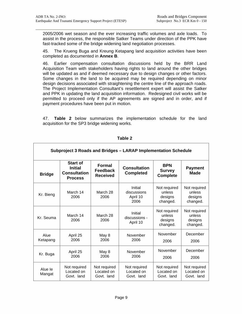
47. Table 2 below summarizes the implementation schedule for the land acquisition for the SP3 bridge widening works.
Table 2
Subproject 3 Roads and Bridges – LARAP Implementation Schedule
Bridge
Start of Initial
Consultation Process
Formal Feedback Received
Consultation Completed
BPN Survey
Complete Payment
Made
Kr. Bieng March 14 2006
March 28 2006
Initial discussions
April 10 2006
Not required unless designs
changed.
Not required unless designs
changed.
Kr. Seuma March 14 2006
March 28 2006
Initial discussions -
April 10
Not required unless designs
changed.
Not required unless designs
changed.
Alue Ketapang
April 25 2006
May 8 2006
November 2006
November
2006
December
2006
Kr. Buga April 25 2006
May 8 2006
November 2006
November
2006
December
2006
Alue Ie Mangat
Not required Located on Govt. land
Not required Located on Govt. land
Not required Located on Govt. land
Not required Located on Govt. land
Not required Located on Govt. land

ADB TA No. 2-INO: Roads and Bridges Component Earthquake And Tsunami Emergency Support Project (ETESP) Subproject No.3 ECR Km 0 - 150
Annexes (on file)
Annex A. Bridge Drawings : Location and general arrangement of 5 Bridges to be widened under ETESP Subproject SP3 - ECR Km 0 - Km 150 Annex B. LAR Documentation :
Copies of documentation pertaining to land acquisition for widening of Kreung Buga and Alue Ketapang bridges
under ETESP Subproject SP3 - ECR Km 0 - Km 150