subdivision and site plan review handbook and... · boards in updating their local subdivision and...
TRANSCRIPT

SUBDIVISION AND SITE PLAN REVIEWHANDBOOK
PREPARED BY THE SOUTHWEST REGION PLANNING COMMISSIONDECEMBER 2001

FOREWARDThis handbook is intended to serve as a guide for PlanningBoards in updating their local subdivision and site plan reviewregulations. The models presented herein incorporate languagebased on changes in the state statutes relative to planningboard procedure and other land use matters, as well asrecommendations and suggestions on ways to deal with particularissues with which Boards may deal on fairly regular basis.
The format of the model regulations includes explanatory notesin the right-hand margin, advising which sections must beincluded in the document and which could be considered optional,along with suggested approaches to that issue. The handbookalso includes several appendices that contain checklists, samplepublic notices, and other administrative tools useful to aPlanning Board.
The “Handbook of Subdivision Review,” published by the NH Officeof State Planning (1996) should be used in conjunction with themodel regulations as a supporting resource.
Staff assistance from SWRPC is available for member communitiesto incorporate these models into local regulations. Anyquestions or comments may be directed to:
SOUTHWEST REGION PLANNING COMMISSION20 Central Square, 2nd Floor
Keene, NH 03431Tel. 603-357-0557FAX 603-357-7440email: [email protected]
THE PREPARATION OF THIS DOCUMENT WAS FINANCED IN PART BY A GRANT FROMTHE NH OFFICE OF STATE PLANNING

TABLE OF CONTENTS
♦ REGULATIONS GOVERNING THE SUBDIVISION OFLAND
♦ SITE PLAN REVIEW REGULATIONS
♦ APPENDICES:
A. ROAD & DRIVEWAY DESIGN AND CONSTRUCTION STANDARDS
B. REQUIREMENTS FOR SOILS AND WETLANDS DATA
C. SAMPLE FORMS FOR PUBLIC NOTIFICATION
D. CRITERIA FOR DETERMINING REGIONAL IMPACT
E. PROCEDURAL FLOWCHART FOR APPLICATION REVIEW
F. PLANNING BOARD RULES OF PROCEDURE

REGULATIONS GOVERNING THESUBDIVISION OF LAND
ADOPTED BY THE PLANNING BOARD ON ____________________, 2002AFTER PUBLIC HEARING ON ___________________, 2002

SUBDIVISION REGULATIONS
TABLE OF CONTENTS
SECTION I. AUTHORITY AND PURPOSE . . . . . SUB 1
SECTION II. PURPOSE AND APPLICABILITY . . . . SUB 1
SECTION III. DEFINITIONS. . . . . . . SUB 1
SECTION IV. GENERAL REQUIREMENTS FOR THE SUBDIVISION OF LAND SUB 4
SECTION V. SUBDIVISION REVIEW PROCEDURES . . . SUB 4
A. Preliminary Conceptual Consultation . Sub 4B. Design Review Phase . . . . Sub 5C. Submission of Completed Application . . Sub 5D. Board Action on Completed Application . Sub 6E. Failure of the Planning Board to Act . Sub 6F. Conditional Approval . . . . Sub 7G. Expedited Review . . . . . Sub 7H. Public Hearing . . . . . Sub 7I. Notification . . . . . . Sub 7J. Fees . . . . . . . Sub 8K. Site Inspections . . . . . Sub 9L. Concurrent and Joint Hearings , , , Sub 9
SECTION VI. SUBMISSION REQUIREMENTS . . . . SUB 9
SECTION VII. SUBDIVISION DESIGN STANDARDS . . . SUB 13
SECTION VIII. DEVELOPMENTS HAVING REGIONAL IMPACT . . SUB 16
SECTION IX. PREVIOUSLY-APPROVED SUBDIVISIONS . . . SUB 16
SECTION X. SPECIAL FLOOD HAZARD AREAS . . . . SUB 17
SECTION XI. PERFORMANCE GUARANTEE . . . . . SUB 17
SECTION XII. REVOCATION OF PLANNING BOARD APPROVAL . . SUB 18
SECTION XIII. ADMINISTRATION AND ENFORCEMENT . . . SUB 18
SECTION XIV. APPEALS . . . . . . . SUB 18
SECTION XV. VALIDITY . . . . . . . SUB 19
SECTION XVI. AMENDMENTS . . . . . . . SUB 19
SECTION XVII. EFFECTIVE DATE . . . . . . SUB 19
SUB - 1
MODEL REGULATIONS GOVERNING THE SUBDIVISIONOF LAND
SECTION I. AUTHORITY
Pursuant to the authority vested in the ____________Planning Board by the voters of the Town of________________ on ______________, 19__ and inaccordance with the provisions of RSA 674:35 of the NewHampshire Revised Statutes Annotated, and as amended, the____________ Planning Board adopts the followingregulations governing the subdivision of land in the Townof ______________, New Hampshire, hereinafter known as____________________ Subdivision Regulations.
SECTION II. PURPOSE AND APPLICABILITY
The purpose of these regulations is to provide for theorderly present and future development of the Town bypromoting the public health, safety, convenience andwelfare of its residents.
These regulations apply to Planning Board review andapproval or disapproval of all subdivisions as defined byRSA 672:14 and minor lot line adjustments or boundaryagreements. They do not apply to voluntary mergers asdefined by RSA 674:39-a.
SECTION III. DEFINITIONS
A. Abutter: Means: (1) any person whose property islocated in New Hampshire and adjoins or is directlyacross the street or stream from the land underconsideration by the local land use board; and (2)affected municipalities and the regional planningcommission(s) in the event of developments havingregional impact. For purposes of receivingtestimony only, and not for purpose ofnotification, the term "abutter" shall include anyperson who is able to demonstrate that his landwill be directly affected by the proposal underconsideration. For purposes of receipt ofnotification by a municipality of a local land useboard hearing, in the case of an abutting propertybeing under a condominium or other collective formof ownership, the term abutter means the officersof the collective or association, as defined in RSA356-B: 3, XXIII.
B. Applicant: Means the owner of record of the landto be subdivided, or his\her designated agent.
Explanatory Notes
These first twosections should notbe consideredoptional. Theydocument the dateand manner by whichthe planning boardwas given theauthority by thevoters to reviewsubdivisions, citethe appropriatestatutes thatgovern the purposeand scope ofsubdivision review,and clearlydescribe thepurpose and intentof suchregulations.
The breadth ofdefinitions used isto some extentlocal choice; theimportant thing,however, is thatthey accuratelyreflect thesubstance of theregulation, andthat they do notconflict withdefinitionscontained in otherland use documentsor regulations.

SUB - 2
C. Application, Complete: Means a final plat and allaccompanying materials and fees as required by theseregulations.
D. Approval: Means recognition by the Planning Board,certified by written endorsement on the plat, thatthe plat meets the requirements of these Regulationsand in the judgment of the Board satisfies allcriteria of good planning and design.
E. Approval, Conditional: Means recognition by thePlanning Board, certified by written endorsement onthe plat, that the plat is not finally approved norready for filing with the Registry of Deeds untilsuch time as certain conditions, set forth by theBoard, are met. This is not to be confused with aplat that has been approved subject to certainconditions that would be met as part of theimplementation of the plan.
F. Board: Means the Planning Board of ____________.
G. Development: Means any construction or gradingactivities on real estate for other thanagricultural and silvicultural (tree care andharvesting) practices.
H. Easement: Means the authorization by a propertyowner for the use by another, and for a specificpurpose, of any designated part of his/her property.
I. Frontage: Means that side of a lot abutting astreet or body of water and ordinarily regarded asthe front of the lot.
J. Lot: Means a parcel of land capable of beingoccupied that is of sufficient size to meet theminimum requirements for use, building coverage, andarea.
K. Lot of Record: Means a parcel, the plat ordescription of which has been recorded at the countyregister of deeds.
L. Lot Line Adjustment: Means adjustments to theboundary between adjoining properties, where no newlots are created.
M. Plat: Means the map, drawing or chart on which theplan of subdivision is presented to the Board forapproval, and which, if approved, will be submittedto the County Register of Deeds for recording.
N. Public Hearing: Means a meeting, notice of whichmust be given per RSA 675:7 and 676:4,I (d), atwhich the public is allowed to offer testimony.
Explanatory Notes

SUB - 3
O. Public Meeting: Means the regular business meetingof the Planning Board as required per RSA 673:10.Notice must be posted at least 24 hours in advanceand the meeting must be open to the public,although participation by the public is at thediscretion of the Board.
P. Right-of-Way: Means a strip of land for whichlegal right of passage has been granted by thelandowner to provide access to a lot which lacksadequate frontage.
Q. Setback: The distance between a building orstructure and the nearest property line, wetland,or sewage disposal system.
R. Sewage Disposal System (Individual): Means any on-site sewage disposal or treatment system thatreceives either sewage or other wastes, or both.For the purposes of this regulation, this means allcomponents of the system, including the leachfield.
S. Street: Means a publicly approved road maintainedfor vehicular travel, or a road that appears on asubdivision plat approved by the Planning Board.
T. Subdivision: Means the division of a lot, tract,or parcel of land into two (2) or more lots, plats,sites, or other divisions of land for the purpose,whether immediate or future, of sale, rent, lease,condominium conveyance or building development. Thedivision of a parcel of land held in common andsubsequently divided into parts among severalowners shall be deemed a subdivision.
U. Subdivision, Major: Means a subdivision of four(4) or more lots, or one which involves thecreation of new streets and/or utilities,regardless of the number of lots.
V. Subdivision, Minor: Means a subdivision of landinto not more than three (3) lots for buildingdevelopment purposes, with no potential forresubdivision on an existing street; or one whichdoes not involve the creation of new streets and/orutilities.
W. Subdivision, Technical: Means a subdivision ofland into two lots or sites for the purpose ofconveying one such lot or site directly to anabutting landowner. The parcel to be conveyeddoes not constitute a separate building lot;however, said parcel may be used for buildingdevelopment in conjunction with contiguous landowned by the abutter.
Explanatory Notes
The distinctionbetween a publichearing and apublic meeting isimportant to note,since noapplication beforethe Board can beacted on without apublic hearing; inaddition, thenotificationrequirements arenot the same – apublic meetingrequires only 24-hour notice, wherasa hearing requires10 days.
SUB - 4
SECTION IV. GENERAL REQUIREMENTS FORSUBDIVISION OF LAND
A. Character of Land for Subdivision: Land of suchcharacter that it cannot, in the judgment of theBoard, be safely used for building developmentpurposes because of exceptional danger to healthor peril from fire, flood, poor drainage,excessive slope, or other hazardous conditions,shall not be platted for residential, commercial,or industrial subdivision, nor for such otheruses as may increase danger to life or property,or aggravate the flood hazard.
B. Premature Subdivision: The Board may provideagainst such scattered or premature subdivisionof land as would involve danger or injury tohealth, safety, or prosperity by reason of thelack of water supply, sewage disposal, drainage,transportation, schools, fire protection, orother public services which necessitate theexcessive expenditure of public funds for thesupply of such services.
C. Preservation of Existing Features: Whereverfeasible, suitable steps shall be taken topreserve and protect significant existingfeatures such as trees, scenic points, stonewalls, rock outcroppings, water bodies, andhistoric landmarks. Where possible, the boundaryline(s) should follow stone walls.
SECTION V. SUBDIVISION REVIEW PROCEDURES
A. Preliminary Conceptual Consultation
1) The applicant may request a meeting withthe Board to discuss a proposal inconceptual form and in general terms.Although this phase is strictly optional,the Board strongly suggests that theapplicant avail him/herself of theopportunity to resolve any issues at thisearly stage that might become a problemlater on. Such preapplication consultationshall be informal and directed toward:
a) Reviewing the basic concepts of theproposal.
b) Reviewing the proposal with regard to themaster plan and zoning ordinance.
c) Explaining the state and local regulationsthat may apply to the proposal.
Explanatory Notes
The generalrequirementsincluded in thissection are largelythose that havebeen commonly usedby local planningboards. Theprovisions onprematuresubdivisions,however, arestatutorilyauthorized, as isthe dedication ofland for parks andplaygrounds.
Section V, A & Bdeal with thestatutorily-definedprocess forpreapplicationreview – WHICH ISSTRICTLY OPTIONALAT THE DISCRETIONOF THE APPLICANT.The applicant maychoose to submit afinal application,as per Paragraph C.
While preliminarydiscussions can bevery helpful, it isimportant to guardagainst thetendency to moveinto specifics thatwould requirepublicnotification, suchas any designissues.
SUB - 5
d) Determination of the proposal as a major,minor, or technical subdivision, and of thesubmission items that would be required.
2) Preliminary conceptual consultation shall notbind the Applicant or the Board. Suchdiscussion may occur without formal publicnotice, but must occur only at a postedmeeting of the Board
B. Design Review Phase
1) Prior to submission of an application forBoard action, an applicant may request to meetwith the Board or its designee for non-bindingdiscussions beyond the conceptual and generalstage, involving more specific design andengineering details of the potentialapplication.
2) The design review phase may proceed only afterproper notification, as set forth in ParagraphI.
3) Statements made by Board members shall not bethe basis for disqualifying said members orinvalidating any action eventually taken onthe application.
4) A rough sketch of the site should be provided,showing:
a) location of lot lines;b) lot measurements; andc) the streets surrounding the site.
C. Submission of Completed Application
1) A completed application shall be filed withthe Planning Board only at its regular monthlymeeting. A completed application shallconsist of all data required in Section VI ofthese regulations.
2) At the next meeting for which notice can beposted – or 30 days from the date of delivery– the Board will determine whether theapplication is complete. If the application isincomplete, the applicant will need toresubmit under a new notification procedure.
3) Acceptance of an application shall only occurat a meeting of the Planning Board after duenotification has been given according toParagraph I. Acceptance will be byaffirmative vote of a majority of the Boardmembers present.
Explanatory Notes
The manner by whichplans will bereviewed forcompleteness shouldbe specified in theregulations. Thisreview may takeplace at a regularmeeting of theBoard, or by adesignee prior tosubmission; howeverthe Board must voteon completeness.
It is important todistinguish thevote on acceptanceof the applicationas COMPLETE fromthe vote on themerits of theproposal.
Accepting theapplication ascomplete means onlythat it complieswith the submissionitems as spelledout in theregulations.
The 65-day timeframe represents asecond-in-a-rowattempt by theLegislature toclear up676:4,I(c)(1).
It is generally notadvisable toconditionallyaccept anapplication, asthat locks theboard into the 65-day timeframeallowed for reviewwhile still waitingfor certainsubmission items.

SUB - 6
4) Once an application has been accepted ascomplete by the Board, the 65-day reviewperiod begins.
D. Board Action on Completed Application
1) The Board shall begin consideration of theCompleted Application upon acceptance. TheBoard shall act to approve, conditionallyapprove, or disapprove the CompletedApplication within 65 days of acceptance.
2) The Board may apply to the Selectmen for anextension not to exceed an additional 90days before acting to approve,conditionally approve or disapprove anapplication. An applicant may waive therequirement for Board action within thetime periods specified in these regulationsand consent to such extension as may bemutually agreeable.
3) Approval of the application shall becertified by written endorsement on thePlat and signed and dated by the Chairmanof the Board. If any application isdisapproved, the grounds for suchdisapproval shall be adequately stated inthe records of the Planning Board and inwritten notice given to the Applicantwithin 144 hours of the decision.
4) An approved plan shall be recorded by thePlanning Board with the County Register ofDeeds of within 90 days of approval. Anysubdivision plan not filed within thistimeframe shall be considered void.
E. Failure of the Planning Board to Act
1) In the event that the Planning Board doesnot act on an accepted application withinthe prescribed time period, the applicantmay petition the Selectmen to issue anorder directing the Planning Board to actwithin 30 days.
2) If the Planning Board fails to act within40 days of receiving this directive fromthe Selectmen, the Selectmen must approvethe application unless they find in writingthat the plan does not comply with a localregulation. In the event the Selectmen failto act, the applicant may petition superiorcourt to approve the plan.
Explanatory Notes
Your regulationshould specify whois responsible forfiling the planwith the countyregister of deeds,and the acceptabletimeframe for thefiling.
If your regulationhas not beenupdated since 1990,pay close attentionto the provisionregarding failureof the board to act- it has beensignificantlyrevised.

SUB - 7
F. Conditional Approval
The Board may grant conditional approval of anapplication, but the plat will not be signed orrecorded until all of the conditions have been met.If the applicant has not complied with theconditions of approval within one (1) year, theapproval is considered null and void and theapplicant must submit a new subdivisionapplication. A further public hearing is notrequired when such conditions:
1) are administrative in nature;
2) involve no discretionary judgment on the part ofthe Board;
3) involve the applicant's possession of permits andapprovals granted by other boards or agencies,such as the Department of Transportation, theWetlands Board, or Water Supply and PollutionControl Division; however, any subsequent changeto the plan required by such approvals wouldconstitute grounds for a new application process.
G. Expedited Review
1) The Planning Board may allow for an expeditedreview of applications for lot lineadjustments, technical subdivisions or minorsubdivisions, as defined in Section III ofthese regulations.
2) The application may be submitted, accepted ascomplete and voted on at the same meeting,provided the public notice so indicates.
3) The Board may waive certain plat requirementsfor lot line adjustments, minor and technicalsubdivisions.
H. Public Hearing
Prior to the approval of an application, a publichearing shall be held. Public hearings may bewaived for lot line adjustments; minor or technicalsubdivisions do not require a public hearing unlessrequested by either the Planning Board, theapplicant or any abutters, except that publicnotice shall be given prior to approval of theapplication.
I. Notification
1) Notice of a Design Review, submission of anapplication, or a Public Hearing shall begiven by the Board to the abutters, theapplicant, holders of conservation,
Explanatory Notes
Note thatconditionalapproval of theplan is not thesame as conditionalacceptance of aplan that does notmeet all submissionrequirements asspelled out in theregulations.
The law calls fornotification to thepublic by postingor publication asrequired by thesubdivisionregulations.
SUB - 8
preservation or agricultural preservationrestrictions, and every engineer, architect,land surveyor or soil scientist whoseprofessional seal appears on any plat.
2) Notice shall be by certified mail, mailed atleast ten (10) days prior to the submission.The public will be given notice at the sametime, by posting at the (Town Hall) and the(Post Office), and publication in the (LocalNewspaper).
3) The notice shall give the date, time, andplace of the Planning Board meeting at whichthe application will be formally submittedto the Board, shall include a generaldescription of the proposal which is to beconsidered, and shall identify the applicantand the location of the proposal.
4) If the notice for the public hearing wasincluded in the notice of submission or anyprior notice, additional notice of thepublic hearing is not required. Additionalnotice is not required of an adjournedsession of a hearing provided that the date,time, and place of the adjourned session wasmade known at the prior meeting.
J. Fees
1) The applicant shall be responsible for allfees incurred by the processing ofapplications. Failure to pay such costsshall constitute valid grounds for the Boardto not accept the application as complete.
2) Upon formal submission of the application,the costs for:
a) the application fee of $___ per lot, and asecretarial fee of $______;
b) the costs of certified mailings andnewspaper notification.
3) Upon approval of the application, the costsfor:
a) making changes to the Town’s tax maps;
b) the cost of recording the mylar with theRegister of Deeds.
4) It shall be the responsibility of theapplicant to pay reasonable fees for specialinvestigative studies, environmental
Explanatory Notes
The list of whom isnotified wasexpanded in 1997 toinclude the holdersof certaineasements and anyperson whose sealappears on theplat.
It is a good ideato follow the samepractice as youwould for a MasterPlan or land useregulation publichearing, so thatthe public becomesaccustomed to thepractice.

SUB - 9
assessments, legal review of documents,administrative expenses and other matterswhich may be required to make an informeddecision on a particular application.
K. Site Inspections
1) Whenever the Board deems it necessary forthe consideration of an application tovisit the site, the Board shall arrange atime that is reasonable for the applicant.
2) Such a site inspection shall be posted asa meeting of the Board pursuant to theRight-to-Know provisions of RSA 91-A. Ifthere is a quorum present at the siteinspection, minutes shall be kept.
3) All applications are conditioned upon theowner allowing access to the property, tothe extent reasonable and necessary toproperly review the application. Denialof access automatically terminates anyfurther consideration of the proposal.
L. Concurrent and Joint Hearings
The applicant or the Planning Board may requesta joint hearing with one or more land use boardsin conjunction with a subdivision hearing ifapproval from all boards is required for thesame project.
SECTION VI. SUBMISSION REQUIREMENTS
A completed application shall consist of the followingitems unless written request for waiver(s) is grantedby the Board:
A. A completed application form, accompanied by:
1. names and addresses of all abutters, takenfrom the town records not more than five(5) days before the day of filing;
2. names and addresses of all persons whosename and seal appears on the plat;
3. names and addresses of all holders ofconservation, preservation or agriculturalpreservation restrictions;
4. payment to cover filing and notificationfees;
Explanatory Notes
The authority ofthe board to visita site is notembodied in itssubdivision reviewauthority. However,any time a quorumof the board ispresent to discussa matter over whichit hasjurisdiction, it isby law considered apublic meeting andmust be noticed assuch.
The question ofallowing the publiconto the site is adifferent matter.At the very least,the applicant’spermission shouldbe requested beforegranting publicaccess to privateland.
Regarding jointhearings, eachboard should haveits own rules thatdescribe theprocedure to befollowed for ajoint hearing. TheChairman of thePlanning Board willchair any jointhearing in whichthis Board isinvolved.
The submissionitems includedherein are acompilation ofcommonly requireditems contained inmany subdivisionregulations, aswell as those thatreflect changes instate and federallaw
SUB - 10
5. one mylar and (____) paper copies of the Plat,prepared according to the standards of the NHLand Surveyors Association and the CountyRegister of Deeds, as follows:
a. Plats shall be at any scale between 1"= 20'and 1"=400'.
b. The outside dimensions of the plat shall be8 ½” X 11”, 11” X 17”, 17” X 22”, or 22” X34”, or as otherwise specified by the CountyRegistry of Deeds.
c. The material composition shall be suitablefor electronic scanning and archiving by theRegisters of Deeds.
d. All plats shall have a minimum ½” margin onall sides.
e. All title blocks should be located in thelower right hand corner, and shall indicate:
1) type of survey
2) owner of record
3) title of plan
4) name of the town(s)
5) tax map and lot number
6) plan date and revision dates;
6. a letter of authorization from the owner, ifthe applicant is not the owner.
B. The plat shall show the following information:
1. Proposed subdivision name or identifyingtitle; name and address of the applicant andof the owner, if other than the applicant.
2. North arrow, scale – written and graphic, dateof the plan; name, license number and seal ofthe surveyor or other person whose sealappears on the plan.
3. Signature block for Planning Boardendorsement.
4. Locus plan showing general location of thetotal tract within the town and the zoningdistrict(s).
5. Boundary survey including bearings, horizontaldistances and the location of permanentmarkers. Curved boundary lines shall showradius, delta, and length.
Explanatory Notes
#A.5. a-e reflectsthe recentlyadopted standardsfor plattingdeveloped by the NHLand SurveyorsAssociation inconjunction withthe NH Register ofDeeds Association
Item #B.5 allowsflexibility forboth the board andthe applicant,e.g.: if a smalllot is beingdivided off of avery large parcel,the board couldrelax the standardsused for thesurvey, based onthe NHLSA.
SUB - 11
6. Names of all abutting subdivisions, streets,easements, building lines, parks and publicplaces, and similar facts regarding abuttingproperties.
7. Location of all property lines and theirdimensions; lot areas in square feet andacres. Lots numbered according to the Towntax map numbering system.
8. Location and amount of frontage on publicrights-of-way.
9. Location of building setback lines.
10. Location of existing and proposed buildingsand other structures.
11. Location of all parcels of land proposed to bededicated to public use.
12. Location and description of any existing orproposed easements.
13. Existing and proposed water mains, culverts,drains, sewers; proposed connections oralternative means of providing water supplyand disposal of sewage and surface drainage.
14. Existing and proposed streets with names,classification, travel surface widths, right-of-way widths. (See Appendix A for roadstandards.)
15. Final road profiles, center line stationingand cross sections.
16. Location and width of existing and proposeddriveways.
17. Water courses, ponds, standing water, rockledges, stone walls; existing and proposedfoliage lines; open space to be preserved; andany other man-made or natural features.
18. Existing and proposed topographic contoursbased upon the USGS topographical data, withspot elevations where necessary.
19. Soil and wetland delineation (see Appendix B).
20. Location of percolation tests and testresults; certification of Town officialwitnessing the tests; and outline of 4,000square-foot septic area with any applicablesetback lines;
Explanatory Notes
#14: The questionof where to placethe road standardswithin theregulation ispurely a matter ofchoice. For manysmall towns, mostsubdivisions willnot include anyroad construction,so the regulationappears more “user-friendly” if theapplicant does notneed to readthrough sectionsthat are notapplicable.
Item #19 reflectsthe most recentrecommendations ofthe Soil ScientistSociety ofNorthern NewEngland.

SUB - 12
21. Location of existing and proposed well,with 75-foot well radius on its own lot.
22. Base flood elevations and flood hazardareas, based on available FEMA maps.
C. Other Information
1) Plan for Stormwater Management and ErosionControl, if applicable (See Section VII).
2) State subdivision approval for septicsystems; septic design approval whereapplicable; or certification by septicdesigner of adequacy of existing system.
3) Alteration of Terrain Permit from NHDepartment of Environmental Services.
4) State/Town driveway permit, as applicable.
5) Report from the Fire Chief, Police Chief,and/or Town Conservation Commission.
6) Approval for municipal water/sewerconnections.
7) Any deed restrictions; and all deedscovering land to be used for publicpurposes, easements and rights-of-way overproperty to remain in private ownership,and rights of drainage across privateproperty, submitted in a form satisfactoryto the Board's counsel.
8) Any other state and/or federal permits.
9) Any additional reports or studies deemednecessary by the Board to make an informeddecision, including but not limited to:traffic, school, fiscal and environmentalimpact analyses. The Board reserves theright to request such information after anapplication has been accepted as complete,as well as before acceptance.
Should the Board determine that some or all ofthe above-described information is to berequired, the applicant will be notified inwriting within ten (10) days of the meeting atwhich the determination was made.
Explanatory Notes
C.2: Be aware oftwo revisions toRSA 485-A: 29,Iregarding stateseptic approval.The new lawrequires localapproval of thesubdivision priorto the DES review.This conflicts withthe usual practiceof making approvalconditional uponthe DES approval.In practice,however, theprocedure appearsto have stayed thesame, in terms ofDES review runningconcurrently withplanning boardreview.
The second changeto the law requiresthe board to submita copy of the finalapproved plan toDES within 30 daysof granting theapproval.
The board has theright, withinreason, to requestany information itneeds in order tomake a reasoneddecision on theapplication.
This statement isintended to protectthe board and theapplicant againstthe appearance ofarbitrary requestsfor moreinformation as thereview processcontinues.

SUB - 13
SECTION VII. SUBDIVISION DESIGN STANDARDS
A. Lots
1. Areas set aside for parks and playgrounds tobe dedicated or reserved for the common useof all property owners shall be ofreasonable size and character forneighborhood playgrounds or otherrecreational uses.
2. Lots shall be laid out and graded toeliminate flood or stagnant water pools. Nowater shall be permitted to run across astreet on the surface, but shall be directedinto catchbasins and pipes underground in apipe of not less than 12 inches in diameter.
B. Reserve Strips: Reserve strips of land that showan intent on the part of the subdivider to controlaccess to land dedicated or to be dedicated topublic use (such as a road) shall not bepermitted.
C. Fire Protection
Applications for new subdivisions shall berequired to address water supply needs for fireprotection. The Fire Chief shall review allproposals to determine whether or not water supplyshould be addressed for that particular proposal;if so, the following requirements apply:
1. The Fire Chief shall complete an inspectionof the proposed site to evaluate theavailability of existing water supply in thearea.
2. The Fire Chief shall implement allapplicable provisions of the National FirePrevention Association’s Standard on WaterSupplies for Suburban and Rural FireFighting.
3. The Fire Chief shall determine the type,location and spacing of any water supply(such as fire ponds, cisterns, etc.)
4. Following the inspection and evaluation, theFire Chief will submit his findings inwriting to the Planning Board.
5. All proposed developments, whether includingthe provision of hydrants or other watersupply facilities, shall be accessible tofirefighting and other emergency equipment.
Explanatory Notes

SUB - 14
D. Septic systems and Water Supply
1. In areas not currently served by public sewersystems, it shall be the responsibility ofthe subdivider to prove that the area of eachlot is adequate to permit the installationand operation of an individual septic system.
2. On new lots of less than five (5) acres, notless than two (2) test pits and at least one(1) percolation test shall be required withinthe 4,000 square-foot area designated for aleach field. The subdivider shall be requiredto provide the necessary equipment and laborfor the making of these tests, which shall beoverseen by the Town Health Officer.
3. In subdividing parcels with existingdwellings, the subdivider must demonstrate tothe satisfaction of the board that theexisting septic system is in good workingorder.
3. All new wells shall have a radius of seventy-five (75) feet, said radius to be locatedentirely on its lot. When that cannot beaccomplished, the protective radius shall bemaximized to the extent practicable. The 75-foot radius may extend over the propertyline(s) with written consent of theabutter(s).
E. Stormwater Management and Erosion Control
1. The applicant shall submit stormwatermanagement and erosion control plan when oneor more of the following conditions areproposed:
a. A cumulative disturbed area exceeding20,000 square feet.
b. Construction of a street or road.
c. A subdivision involving three or moredwelling units.
d. The disturbance of critical areas, such assteep slopes, wetlands, floodplains.
2. Standard agricultural and silviculturalpractices are exempt from this regulation.
3. All stormwater management and erosion controlmeasures in the plan shall adhere to the“Erosion and Sediment Control Design Handbookfor Developing Areas of New Hampshire”,
Explanatory Notes
State approval onlyapplies to lots ofless than five (5)acres. Some townsrequire stateapproval for alllots, regardless ofsize.
While the stateregulates theplacement of newseptic systems, theadequacy ofexisting systemscontinues to beproblematic forplanning boards. Aletter ofcertification froma licensed septicdesigner is one wayto ensure systemadequacy.
Note that anycumulativedisturbed area of100,000 square feet(or 50,000 squarefeet within theprotected shorelandas per RSA 483-B)also requires anAlteration ofTerrain permit fromthe NH Departmentof EnvironmentalServices.

SUB - 15
published by the Rockingham CountyConservation District, and the “ModelStormwater Management and Erosion ControlRegulation”, by the NH Association ofConservation Districts, Water QualityCommittee.
4. The applicant shall bear finalresponsibility for the installation,construction, and disposition of allstormwater and erosion control measuresrequired by the Board. Site developmentshall not begin before the plan is approved.
F. Surveys
All surveys shall be prepared according to theminimum standards for instrument surveys adoptedby the NH Land Surveyors Association for StandardProperty Surveys, as follows:
Condition "1" "2" "3"
Unadjusted Linear Closure1:15,000 1:7,500 1:300
Minimum Scale Graduation of Instrument
20/sec. 30/sec. 1
Distance Measurement EDM/ EDM/ Steel Tape/
Steel Tape Steel Tape Stadia
Elevation Used to DetermineProperty Lines 0.2' +/- 0.5' +/- -----
Condition "1" shall be required for anysubdivision of less than 2 acres thatinvolves building of any kind - i.e.,residential, commercial or industrial.
Condition "2" is adequate for subdivisions of2 acres or more in a rural district.
Condition "3" is acceptable for subdivisionsinvolving woodlots, timber lots, or largetracts being dedicated to preservation orconservation. The standards of Condition"3" may be achievable with a tape & compasssurvey.
In the case of applications that involve largeacreages from which one building lot is beingsubdivided, the Board may, upon written request,waive the requirement for a complete boundarysurvey, when it is apparent that the remaining lot
Explanatory Notes
SUB - 16
can meet existing frontage requirements and issuitable for building.
G. Monumentation
1. Monuments constructed of concrete or stone atleast 4 inches square on the top and at least30 inches long shall be set at all controlcorners.
2. If the subdivision involves the constructionof a roadway, all monumentation shall be inplace before 50% of the surety held for theconstruction is released. If no roadconstruction is involved, all monumentationmust be in place prior to the signing of theplat by the Board Chairman.
3. Pipes shall be set at all lot corners.Concrete or granite bounds shall be set at allpoints of curvature and all points of tangentfor surveying purposes.
4. Monuments shall be tied in to a public streetintersection, a U.S.G.S. benchmark, or otherrecognized existing monument.
SECTION VIII. DEVELOPMENTS HAVING REGIONALIMPACT
A. All applications shall be reviewed for potentialregional impacts. Upon such a finding, the Boardshall furnish the regional planning commission(s)and the affected municipalities with copies ofthe minutes of the meeting at which thedetermination was made. The copies shall be sentby certified mail within 72 hours of the meeting.
B. At least 14 days prior to the scheduled publichearing, the Board shall notify by certified mailthe regional planning commission(s) and theaffected municipalities of the date, time andplace of the hearing, and of their right toappear as abutters to offer testimony concerningthe proposal.
SECTION IX. PREVIOUSLY-APPROVED SUBDIVISIONS
If any land shown on a subdivision plat has been partof any previous subdivision approved, constructed, orcreated by conveyance no more than ____ years prior tothe new proposal, any such previous subdivision will betreated as part of the new proposal for purposes ofanalyzing its effect and applying all review criteria.
Explanatory Notes
Section VIII reflectsa statutory amendmentthat became effectivein 1992. The statutedoes not specifyprecisely whatconstitutes aregional impact, butoffers generalguidelines. A townis free to developits own criteria bywhich thisdetermination couldbe made (see AppendixE). This sectioncould be consideredoptional, but it ishelpful to have thelanguage in theregulation where itis accessible.
Section IX offersguidance to the boardin dealing withconsecutive “minor”subdivisions thateventually add up toa major subdivision.Optional, buthelpful.
SUB - 17
SECTION X. SPECIAL FLOOD HAZARD AREAS
A. The Planning Board shall review the proposeddevelopment to assure that all necessary permits havebeen received from those governmental agencies fromwhich approval is required by Federal or State law,including Section 404 of the Federal Water PollutionControl Act Amendments of 1972, 33 U.S.C. 1334.
B. The Board shall require that all subdivisionproposals and other proposed new developments greaterthan 50 lots or 5 acres, whichever is the lesser,include base flood elevation data. Sufficientevidence (construction drawings, grading and landtreatment plans) shall be submitted so as to allowdetermination that:
1) all such proposals are consistent with the need tominimize flood damage;
2) all public utilities and facilities, such as sewer,gas, electrical, and water systems are located andconstructed to minimize or eliminate flood damage;and
3) adequate drainage is provided so as to reduceexposure to flood hazards.
SECTION XI. PERFORMANCE GUARANTEE
A. As a condition of approval, the Board shall requirethe posting of a security in an amount sufficient todefray the costs of construction of streets andpublic utilities. The amount of the security shallbe based on an estimate of costs provided by thesubdivider and, at the discretion of the PlanningBoard, reviewed by a licensed engineer. All costs ofsuch review shall be paid by the applicant.
B. The security shall be approved by the Board andmunicipal counsel. The amount of the security shallinclude fees to cover the cost of periodicinspections.
C. Where electric lines or other utilities are to beinstalled by a corporation or public utility, aletter of intent shall be required stating that thework will be done in reasonable time and withoutexpense to the Town.
D. Each approved plat shall contain a time limit for thecompletion of streets and public improvements. Theperformance guarantee shall be released in phases asportions of the secured improvements or installationsare completed and approved by the Board or itsdesignee, in accordance with the plan approved by the
Explanatory Notes
Section X reflectsfederal lawregardingdevelopment inflood hazard areas.Any town thatparticipates in theNational FloodInsurance Programand has adopted afloodplainmanagementordinance must havethis language inits regulations.
.
SUB - 18
Board. In the case of road construction, theBoard may require that the security stay in placeuntil one full year has passed after completion ofthe road.
SECTION XII. REVOCATION OF PLANNING BOARDAPPROVAL
An approved and recorded subdivision plat may be revokedby the Board in whole or in part, under the followingcircumstances: (1) at the request of or by agreementwith the applicant; (2) when any requirement orcondition of approval has been violated; (3) when theapplicant has failed to perform any condition ofapproval within the time specified or within four years;(4) when four years have elapsed without any vesting ofrights and the plan no longer conforms to applicableregulations; or (5) when the applicant has failed toprovide for the continuation of adequate security.
SECTION XIII. ADMINISTRATION AND ENFORCEMENT
A. These regulations shall be administered by thePlanning Board. The enforcement of theseregulations is vested with the Selectmen.
B. No subdivision regulation or amendment, adoptedunder RSA 674:35-42, shall be legal or have anyforce and effect until copies of such are filedwith the Town Clerk.
C. Waivers: The requirements of these regulationsmay be waived or modified when, in the opinion ofthe Board, specific circumstances surroundingsubdivision, or the condition of the land in suchsubdivision, indicate that such modifications willproperly carry out the purpose and intent of themaster plan and these regulations.
D. Penalties and Fines: Any violation of theseregulations shall be subject to a civil fine asprovided in RSA 676:16 and 676:17, as amended.
SECTION XIV. APPEALS
Any person aggrieved by a decision of the Planning Boardconcerning a plat or subdivision may appeal saiddecision to the superior court pursuant to RSA 677:15,except when a disapproval by the Board is based uponnon-compliance with the zoning ordinance, in which casean appeal can be taken to the Board of Adjustment.
Explanatory Notes
This provisionbecame effective in1991; it spells outin detail theconditions underwhich planningboard approval maybe revoked.
Sections XIII – XVIshould not beconsideredoptional. Theseprovisions shouldbe included in someform in theregulation

SUB - 19
SECTION XV. VALIDITY
If any section or part of a section or paragraph ofthese regulations shall be declared invalid orunconstitutional, it shall not be held toinvalidate or impair the validity, force or effectof any other section or part of a section orparagraph of these regulations.
SECTION XVI. AMENDMENTS
These regulations may be amended by a majority voteof the Planning Board after at least one (1) publichearing following the notification procedureoutlined in Section IV, H & I.
SECTION XVII. EFFECTIVE DATE
These regulations shall take effect upon theiradoption, and all regulations or parts ofregulations, inconsistent therewith, are herebyrepealed.
Explanatory Notes

Sub - i
APPLICANT NAME/APPLICATION NUMBER______________________________________________
DATE OF APPLICATION_______________________________
CHECKLIST FOR LOT LINE ADJUSTMENT OR TECHNICAL SUBDIVISION
The items on this page are considered to be the minimum requirements for alot line adjustment or technical subdivision, where no new lots are beingcreated. The Board reserves the right, however, to request additionalinformation if, in its judgement, the data are necessary in order to makean informed decision.
SUBMITTED WAIVEDYES NO YES NO
___ ___ 1. Name of subdivision; name and address of subdivider. ___ ___
___ ___ 2. Name, license number and seal of surveyor or other personspreparing the plan. ___ ___
___ ___ 3. Names and addresses of all abutters and all holders ofconservation, preservation, or agricultural preservationeasements on the plat or on separate sheet). ___ ___
___ ___ 4. North arrow, scale, and date of plan. ___ ___
___ ___ 5. Signature block for Planning Board endorsement. ___ ___
___ ___ 6. Locus plan, showing zoning designations. ___ ___
___ ___ 7. Boundary survey and location of permanent markers. ___ ___
___ ___ 8. Location of property lines, lot areas in squarefeet and acres; lots numbered according toTown tax map system. ___ ___
___ ___ 9. Location and amount of frontage on public right-of-way;names, classification of abutting streets. ___ ___
___ ___ 10. Building setback lines. ___ ___
___ ___ 11. Location of existing buildings and other structures. ___ ___
___ ___ 12. Location of existing driveways. ___ ___
___ ___ 13. Location and description of any existing or proposedeasements or public dedications. ___ ___

Sub - ii
APPLICANT NAME/APPLICATIONNUMBER__________________________________________________
DATE OF APPLICATION_______________________________
SUBDIVISION CHECKLIST
This checklist can be used for either a major or minor subdivision. For a minorsubdivision, several of the items would likely be waived by the Planning Board dueto lack of relevancy (e.g., topographic or soils data). The Board, however,reserves the right to require that all items be met if, in its judgement, the dataare necessary in order to make an informed decision.
IS THIS A DEVELOPMENT HAVING REGIONAL IMPACT? ___YES ___NO
SUBMITTED WAIVEDYES NO YES NO
___ ___ 1. Name of subdivision; name and address of subdivider. ___ ___
___ ___ 2. Name, license number and seal of surveyor or other persons;north arrow, scale, and date of plan. ___ ___
___ ___ 3. Signature block for Planning Board endorsement. ___ ___
___ ___ 4. Locus plan, showing zoning designations. ___ ___
___ ___ 5. Names and addresses of all abutters and all holdersof conservation, preservation, or agriculturalpreservation easements (on the plat or onseparate sheet). ___ ___
___ ___ 6. Boundary survey and location of permanent markers. ___ ___
___ ___ 7. Names of abutting subdivisions, streets, driveways, easements, building lines, parks/public spaces,notation of use of abutting land, and similar factsregarding abutting properties. ___ ___
___ ___ 8. Location of property lines, lot areas in square feetand acres; lots numbered according to Town tax mapsystem. ___ ___
___ ___ 9. Location and amount of frontage on publicright-of-way. ___ ___
___ ___ 10. Location of building setback lines. ___ ___
___ ___ 11. Existing and/or proposed buildings, other structures. ___ ___

Sub - iii
Subdivision Checklist – Page 2
SUBMITTED WAIVED
Yes No Yes No
___ ___ 12. Location of any existing or proposed easements, land tobe dedicated to public use. ___ ___
___ ___ 13. Existing and proposed water mains, culverts, drains, sewers;proposed connections or alternative means of providing watersupply and sewage disposal. ___ ___
___ ___ 14. Existing and proposed streets, with names, classification,width of travel surface and rights-of-way. ___ ___
___ ___ 15. Final road profiles, centerline stationing,cross sections. ___ ___
___ ___ 16. Location and width of existing and proposed driveways.___ ___
___ ___ 17. Location of all surface water, wetlands, rock ledges,stone walls, open space to be preserved, and any otherman-made or natural features. ___ ___
___ ___ 18. Existing and proposed topographic contours. ___ ___
___ ___ 19. Soil and wetland delineation (Appendix B). ___ ___
___ ___ 20. Location of perc tests, test results, outline of4,000 square-foot septic area, applicableseptic setback lines. ___ ___
___ ___ 21. Location of existing and proposed wells, with 75-footradius on property. ___ ___
___ ___ 22. Base flood elevations. ___ ___
OTHER:
___ ___ 23. Plans for stormwater management and erosion control. ___ ___
___ ___ 24. Copy of state subdivision approval for septic system. ___ ___
___ ___ 25. Alteration of Terrain Permit. ___ ___
___ ___ 26. Town or DOT Driveway Permit ___ ___
___ ___ 27. Copy of any deed restrictions. ___ ___
___ ___ 28. Any additional reports or studies. ___ ___

SITE PLAN REVIEW REGULATIONS
ADOPTED BY THE PLANNING BOARD ON ____________________, 2002AFTER PUBLIC HEARING ON ___________________, 2002

SITE PLAN REVIEW REGULATIONS
TABLE OF CONTENTS
SECTION I. AUTHORITY . . . . . . . SPR 1
SECTION II. PURPOSE . . . . . . . SPR 1
SECTION III. SCOPE OF REVIEW . . . . . . SPR 1
SECTION IV. DEFINITIONS. . . . . . . SPR 2
SECTION V. APPLICATION PROCEDURES. . . . . SPR 2
SECTION VI. SUBMISSION REQUIREMENTS . . . . SPR 3
SECTION VII. DEVELOPMENTS HAVING REGIONAL IMPACTS . SPR 7
SECTION VIII. SPECIAL FLOOD HAZARD AREAS . . . . SPR 7
SECTION IX. PERFORMANCE GUARANTEE . . . . . SPR 7
SECTION X. GENERAL STANDARDS . . . . . SPR 8
SECTION XI. REVOCATION OF PLANNING APPROVAL . . . SPR 12
SECTION XII. ADMINISTRATION AND ENFORCEMENT . . . SPR 13
SECTION XIII. VALIDITY . . . . . . . SPR 13
SECTION XIV. AMENDMENTS . . . . . . . SPR 13
SECTION XV. EFFECTIVE DATE . . . . . . SPR 13

SPR - 1
MODEL SITE PLAN REVIEW REGULATIONS
SECTION I. AUTHORITY
Pursuant to the authority vested in the Planning Board bythe voters of the Town of ______ on ______________, and inaccordance with the provisions of 674:43 and 44, NewHampshire Revised Statutes Annotated, as amended, the______ Planning Board hereby adopts the followingregulations governing the development or change orexpansion of use of tracts for nonresidential uses ormulti-family dwelling units (more than two units), whetheror not such development includes a subdivision orresubdivision of the site.
SECTION II. PURPOSE
The purpose of the Site Plan Review process is to protectthe public health, safety and welfare; to promote balancedgrowth; to promote the timing of development to preventpremature and uncoordinated development of land withoutthe adequate provision of public services and facilities;to ensure sound site utilization; to avoid developmentwhich may result in negative environmental impacts; and toguide the character of development. The Site Plan ReviewProcedure in no way relieves the developer or his/heragent from compliance with the Zoning Ordinance,Subdivision Regulations or any other ordinance whichpertains to the proposed development. No site plan willbe approved until it complies in all respects with any andall pertinent ordinances and regulations.
SECTION III. SCOPE OF REVIEW
Whenever any development or change or expansion of use ofa site is proposed or whenever any changes are proposedthat differ from an existing site plan as previouslyapproved by the Planning Board; before any construction,land clearing, building development or change is begun andbefore any permit for the erection of any building orauthorization for development on such site shall begranted, the owner of the property or his authorized agentshall apply for and secure from the Planning Boardapproval of such proposed site development in accordancewith procedures outlined in this regulation.
The Planning Board shall have the responsibility formaking the final decision as to the necessity of Site PlanReview. Where there is any doubt as to whether or not aproject requires Site Plan Review, the affected partyshould request a determination from the Board. In an
Explanatory Notes
The first twosections shouldnot be consideredoptional. Thedate and themanner by whichthe boardreceivedauthority toreview site plansshould be spelledout in theregulation, aswell as the scopeof site planreview. It isvery important tonot confuse thescope of siteplan review withsubdivision.
Section III hasbeen added in anattempt to guideplanning boardsfacing the at-times difficultquestion of, whatexactly,constitutes asignificantenough change ofuse to triggersite plan review.
A related andvery importantpoint to bear inmind is that thisdetermination ismade by theplanning board,not theselectmen. Thereis frequentmisunderstandingregarding thisquestion.

SPR - 2
effort to clarify what constitutes a change of use ofsufficient magnitude or impact to trigger PlanningBoard action, the following guidelines will beobserved:
1. If the proposal involves new construction of non-residential or multi-family development.
2. If the proposal involves a change of use category,e.g., from residential to commercial, or fromsingle family to multi-family.
3. If the proposal involves external modifications orconstruction, including parking lots (except forsingle family or duplex housing).
4. If the proposal involves expansion of a buildingor intensification of use that would result in achange in traffic volume or patterns in the area,noise, parking, lighting, etc.
5. If the proposal involves a property that has neverreceived Site Plan Review from the Planning Boardfor previous non-residential or multi-family use.
A. Activities Not Subject to Site Plan Review
1. Proposals that involve no change in use or levelof activity.
2. Internal building modifications to a non-residential use that do not affect the scale orimpact of the existing use.
3. A re-use of a premise for which a Site Plan Reviewhas already been conducted, provided the new useis not different in type or impact.
SECTION IV. DEFINITIONS
The definitions contained in the ____________ ZoningOrdinance and the Subdivision Regulations shall applyto these Regulations.
SECTION V. APPLICATION PROCEDURE
The application procedures as outlined in the_____________ Subdivision Regulations shall apply toSite Plan Review.
A. Expedited Review
The Board may provide for an expedited review ofminor site plans. Criteria the Board will useto determine whether an application qualifies asa minor site plan include, but are not limitedto, the following:
Explanatory Notes
Typically homeoccupations arenot subject toSite Plan Reviewsince, bydefinition theyare secondary to aprimaryresidential use,and one- or two-family developmentis specificallyexempted from SitePlan Review.
These activities/projects wouldlikely not besubject to SitePlan Review,however, this is adecision that mustbe made by thePlanning Board.
Sections IV & Vmay reference theTown SubdivisionRegulations, inthe interest ofreducing paperwork- not, however, atthe expense ofprovidinginformation.There is value inhaving eachregulation standon its own;without referenceto other documentsthe applicant maynot have at his/her disposal.

SPR - 3
1. When there is no new construction.
2. When new construction is no greater than 2,500square feet in area.
3. When site impacts are not expected to besignificant, in terms of traffic, noise, parking,lighting, etc.
Under the expedited review procedure, the Board maywaive certain submission requirements, such as theneed to have an engineered plan, or a plan filedwith the Register of Deeds.
SECTION VI. SUBMISSION REQUIREMENTS
A completed application shall consist of the followingitems unless a written request for waiver(s) is granted bythe Board:
A. A completed application form, accompanied by:
1. names and addresses of all abutters, takenfrom the town records not more than five (5)days before the day of filing;
2. names, addresses and seal of all personspreparing the plat, as applicable;
3. names and addresses of all holders ofconservation, preservation or agriculturalpreservation restrictions;
4. payment to cover filing and notification fees;
5. one mylar and (____) paper copies of the Plat,prepared according to the standards of the NHLand Surveyors Association and the CountyRegister of Deeds, as follows:
a. Plats shall be at any scale between 1"= 20'and 1"=400'.
b. The outside dimensions of the plat shall be 8½” X 11”, 11” X 17”, 17” X 22”, or 22” X 34”,or as may be otherwise specified by theCounty Registry of Deeds.
c. The material composition shall be suitablefor electronic scanning and archiving by theRegisters of Deeds.
d. All plats shall have a minimum ½” margin onall sides.
e. All title blocks should be located in thelower right hand corner, and shall indicate:
Explanatory Notes
The submissionitems are acompilation ofitems that havebeen commonlyrequired by manyboards and othersthat have beenadded to reflectrecent state andfederal statutorychanges.
Note that Item #2does not requirethat a licensedsurveyor preparethe plan. Sometowns do notrequire that siteplans be filedwith the registerof deeds, thus theboard could acceptany plan thatadequatelydescribed theproject. If yourtown does notrequire the filingof site plans, atleast a notice ofthe plan and anyagreements shouldbe filed with theregistry (seeNotes on followingpage).
#A.5 a-e reflectsthe recentlyadopted standardsfor plattingdeveloped by theNH Land SurveyorsAssociation inconjunction withthe NH Register ofDeeds Association.

SPR - 4
1) type of survey2) owner of record3) title of plan4) name of the town(s)5) tax map and lot number6) plan date and revision dates;
6. a letter of authorization from the owner,if the applicant is not the owner.
B. Plat Submission Items
1. Name of project or identifying title; namesand addresses of owners of record; and taxmap and lot number.
2. North arrow, date of the plat, scaleappropriate to the scope of thedevelopment; name and address of personpreparing the plat; signature block forPlanning Board approval.
3. Vicinity sketch at an appropriate scaleshowing the location of the site inrelation to the existing public streets;and the zoning district(s).
4. Physical features and uses of abutting landwithin 200 feet of the site.
5. Boundary lines, their source, approximatedimensions and bearings, and the lot areain acres and square feet.
6. The shape, size, height, location and useof existing and proposed structures locatedon the site and those existing within 200feet of the site.
7. Location, name and widths of any existingand proposed roads on the property andthose existing within 200 feet of the site.New roads shall be constructed inaccordance with the provisions contained inthe _______________ SubdivisionRegulations.
8. Final road profiles, center line stationingand cross sections.
9. Location of existing and proposed sidewalksand driveways, with indication of directionof travel for any which are one-way. Bothvehicular and pedestrian circulation shallbe shown.
Explanatory Notes
"Notice of SitePlan andAgreement"
Notice is herebygiven that theproperty locatedat _______________and owned by___________ hasbeen subject toSite Plan Reviewin the town of_______. Theseproceedings haveresulted in anapproved site plandated ______,entitled ________and stamped by_______. Theseproceedings alsoresulted in anagreement enteredinto by the Townof _______ and_______, dated_______. Both thesite plan and theagreement may bereviewed at thetown officesduring regularbusiness hours.Signed____________,Chair _______Planning Board
.

SPR - 5
10. Identification of access to the site, sightdistance at the access point(s), curb cuts andproposed changes (if any) to existing streets;and copy of any driveway permit(s).
11. Location and total number of parking spaces;loading spaces and other similar facilitiesassociated with the use.
12. A landscape plan, describing the number,location, types, and size of all existing andproposed landscaping and screening.
13. The location, type, and nature of all existingand proposed exterior lighting and signage.
14. Water courses, ponds, standing water, rockledges, stone walls; existing and proposedfoliage lines; open space to be preserved; andany other man-made or natural features.
15. The size and location of all existing andproposed water mains, sewers, culverts,proposed connections or alternative means ofproviding water supply and disposal of sewageand surface drainage.
16. The location and distance to any fire hydrantsand/or fire ponds.
17. Existing and proposed topographic contoursbased upon the USGS topographical data, withspot elevations where necessary.
18. Soil and wetland delineation (see Appendix B).
19. Location of percolation tests and testresults; certification of Town officialwitnessing the tests; and outline of 4,000square-foot septic area with any applicablesetback lines;
20. Location of existing and proposed well, with75-foot radius on its own lot.
21. Copy of certification by a licensed septicdesigner that an existing system is adequateto meet the needs of the proposed use.
22. Location of any existing or proposedeasements, deed restrictions, covenants.
23. Base flood elevations and flood hazard areas,based on available FEMA maps.
Explanatory Notes
Item #18 reflectsthe most recentrecommendations ofthe Soil ScientistSociety ofNorthern NewEngland.

SPR - 6
B. Other
1. Plan for Stormwater Management and ErosionControl, if applicable (See Section X).
2. State subdivision approval for septic systems;septic design approval where applicable; orcertification by septic designer of adequacy ofexisting system.
3. Alteration of Terrain Permit from NH Department ofEnvironmental Services.
4. State/Town driveway permit, as applicable.
5. Report from the Fire Chief, Police Chief, and/orTown Conservation Commission.
6. Approval for municipal water/sewer connections.
7. Any deed restrictions; and all deeds covering landto be used for public purposes, easements andrights-of-way over property to remain in privateownership, and rights of drainage across privateproperty, submitted in a form satisfactory to theBoard's counsel.
8. Any other state and/or federal permits.
9. An impact analysis may be required, which takesinto account the following items to the extent theBoard deems applicable:
a) Demographic Description
b) Community Facilities Impacts
c) Environmental Impacts
10. Any additional reports or studies deemed necessaryby the Board to make an informed decision.
Should the Board determine that some or all of theabove-described information is to be required, theapplicant will be notified in writing within ten (10)days of the meeting at which the determination was made.
C. "As Built" Plans
Supplemental information may be required by the Board toupdate the final plat to reflect "as built" conditionsand details. The plan shall show any easements anddedicated roadways. A security bond may be required toguarantee performance of the applicant's obligations asdescribed herein.
Explanatory Notes
This statement isintended toprotect the boardand the applicantagainst theappearance ofarbitrary requestsfor moreinformation as thereview processcontinues.

SPR - 7
SECTION VII. DEVELOPMENTS HAVING REGIONAL IMPACT
All applications shall be reviewed for potential regionalimpacts. Upon such a finding, the Board shall furnish theregional planning commission(s) and the affectedmunicipalities with copies of the minutes of the meeting atwhich the determination was made. The copies shall be sentby certified mail within 72 hours of the meeting. At least14 days prior to the scheduled public hearing, the Boardshall notify by certified mail the regional planningcommission(s) and the affected municipalities of the date,time and place of the hearing, and of their right to appearwith the status of abutters to offer testimony concerningthe proposal.
SECTION VIII. SPECIAL FLOOD HAZARD AREAS
A. The Planning Board shall review the proposeddevelopment to assure that all necessary permits havebeen received from those governmental agencies fromwhich approval is required by Federal or State law,including Section 404 of the Federal Water PollutionControl Act Amendments of 1972, 33 U.S.C. 1334.
B. The Board shall require that all subdivisionproposals and other proposed new developments greaterthan 50 lots or 5 acres, whichever is the lesser,include within such proposals base flood elevationdata. Sufficient evidence (construction drawings,grading and land treatment plans) shall be submittedso as to allow determination that:
1) all such proposals are consistent with the need tominimize flood damage;
2) all public utilities and facilities, such as sewer,gas, electrical, and water systems are located andconstructed to minimize or eliminate flood damage;and
3) adequate drainage is provided so as to reduceexposure to flood hazards.
SECTION IX. PERFORMANCE GUARANTEE
As a condition of approval, the planning board shallrequire the posting of a security in an amount sufficientto defray the costs of construction of streets and publicutilities. The amount of the security shall be based on anestimate of costs provided by the applicant; the amount ofthe security shall also include fees to cover the cost ofperiodic inspections. At the discretion of the PlanningBoard, the proposed security shall be reviewed by alicensed engineer. All costs of such review shall be paidby the applicant.
Explanatory Note
Section VIIreflects astatutoryamendment thatbecame effectivein 1992. Thestatute does notspecify preciselywhat constitutes aregional impact,but offers generalguidelines. Atown may developits own criteriaby which thisdeterminationwould be made.(See Appendix D)This section couldbe consideredoptional, but itis helpful to havethe language inthe regulationwhere it isaccessible.
Section VIIIreflects federallaw regardingdevelopment inflood hazardareas. Any townthat participatesin the NationalFlood InsuranceProgram and hasadopted afloodplainmanagementordinance, musthave this languagein itsregulations.

SPR - 8
The security shall be approved as to form and sureties bythe Board and the municipal counsel. Where electric linesor other utilities are to be installed by a corporation orpublic utility, a letter of intent shall be requiredstating that the work will be done in a reasonable time andwithout expense to the Town. Each approved plat shallcontain a time limit for the completion of allimprovements. The performance guarantee shall be releasedin phases as portions of the secured improvements orinstallations are completed and approved by the Board orits designee, in accordance with the plan approved by theBoard.
SECTION X. GENERAL STANDARDS
A. Design of development should fit the existing naturaland manmade environments with the least stress:
1. Site preparation is to be conducted withminimal disturbance to existing vegetation.Stripped topsoil is to be piled and reused onthe site where needed. A minimum of 4 inchesof topsoil is to be placed on the disturbedarea. The site shall be adequately landscaped,as delineated in a landscape plan.
2. Landscape treatment shall consist of natural,undisturbed vegetation or features, or newlyinstalled ground cover, shrubs, or trees whereappropriate.
3. Grading and filling must be conducted tominimize the alteration of surface andsubsurface drainage to, toward or acrossabutting properties, unless the written consentof the abutting landowner is obtained.
B. Illumination:
1. Outdoor lighting shall not glare on abuttingproperties or on public highways or streets.
2. Outdoor lighting is restricted to that which isnecessary for advertising and security of theproperty.
C. Pedestrian Safety: Sidewalks shall be provided forpedestrian traffic to provide connection between themain entrances of business, housing or industrialestablishments and parking areas. In the event thatpedestrian shoppers or employees are reasonablyanticipated, provision shall be made for sidewalks
Explanatory Notes
These standardsreflect the mostcommon issues facedduring site planreview; they arenot to beconsidered all-inclusive.

SPR - 9
running from the street line to the establishments.All such sidewalks shall be at least six (6) inchesabove grade and protected by curbing.
D. Off-street Parking and Loading Requirements:
1. Sufficient off-street loading and/orunloading space must be provided, includingoff-street areas for maneuvering ofanticipated trucks or other vehicles.Maneuvers for parking and/or loading orunloading must not take place from a publicstreet.
2. Access, parking and loading areas are to beconstructed so as to minimize dust, erosion,and runoff conditions that would have adetrimental effect on abutting or neighboringproperties.
3. Permeable pavement may be used which mightreduce the need for installation of drainagefacilities to accommodate runoff; however,the Board may require that access, parkingand loading areas be conventionally paved, ifdeemed appropriate.
4. In site plans of more than one (1) use, theaggregate number of parking spaces shall beapportioned based on the various uses, withrespective areas designated on the plan.
E. Screening: Appropriate screening/buffers are to bemaintained or installed to provide privacy andnoise reduction to residential areas abuttingnonresidential sites:
1. Buffer strips (10 feet minimum - distancelargely dependent upon the density ofdevelopment in the area) must be maintainedbetween proposed use and residential uses.Buffer strip between nonresidential andresidential uses must contain vegetation thatwill screen nonresidential uses from sight ofthe residential uses during winter months.
2. Storage areas must be fenced or screened fromon-site or adjoining parking and neighboringproperties.
3. Litter (garbage) collection areas must bescreened.
4. The use of either fencing or hedges ispermitted.
Explanatory Notes

SPR - 10
F. Street Access/Traffic Pattern: Access to publicstreets will meet the requirements of the NHDepartment of Transportation and/or the Town of____________. Any new road construction shallconform to the road standards as specified inthe ____________ Subdivision Regulations. Theinternal traffic pattern will accommodate theproposed use, as well as providing easy,unimpeded access for emergency vehicles.
G. Water Supply and Sewage Disposal Systems must besized to adequately meet the needs of theproposed use under the regulations of the NHWater Supply and Pollution Control Commissionand/or the Town of ____________ regulations. Itshall be the responsibility of the applicant toprovide adequate information to prove that thearea of the lot is adequate to permit theinstallation and operation of an individualsewerage disposal system, and that existingsystems are adequate to serve the needs of theproposed development.
H. Fire Protection
Applications for new subdivisions shall berequired to address water supply needs for fireprotection. The Fire Chief shall review allproposals to determine whether or not watersupply should be addressed for that particularproposal; if so, the following requirementsapply:
1. The Fire Chief shall complete aninspection of the proposed site toevaluate the availability of existingwater supply in the area.
2. The Fire Chief shall implement allapplicable provisions of the National FirePrevention Association’s Standard on WaterSupplies for Suburban and Rural FireFighting.
3. The Fire Chief shall determine the type,location and spacing of any water supply(such as fire ponds, cisterns, etc.)
4. Following the inspection and evaluation,the Fire Chief will submit his findings inwriting to the Planning Board.
5. All proposed developments, whetherincluding the provision of hydrants orother water supply facilities, shall beaccessible to firefighting and otheremergency equipment.
Explanatory Notes
State approval forseptic systems onlyapplies to lots ofless than fiveacres. Some townsrequire that allnew lots,regardless of size,receive stateapproval.
While the Stateregulates andmonitors theplacement of newseptic systems, theadequacy ofexisting systemscontinues to beproblematic forplanning boards.Whatever you decideis appropriateinformation todemonstrate this,be sure that it isspelled out in theregulations.

SPR - 11
I. Stormwater Management and Erosion Control
1. The applicant shall submit stormwatermanagement and erosion control plan when one ormore of the following conditions are proposed:
a. A cumulative disturbed area exceeding 20,000square feet.
b. Construction of a street or road.
c. A subdivision involving three or moredwelling units.
d. The disturbance of critical areas, such assteep slopes, wetlands, floodplains.
2. Standard agricultural and silviculturalpractices are exempt from these provisions.
3. All stormwater management and erosion controlmeasures in the plan shall adhere to the“Erosion and Sediment Control Design Handbookfor Developing Areas of New Hampshire”,published by the Rockingham County ConservationDistrict, and the “Model Stormwater Managementand Erosion Control Regulation”, published bythe NH Association of Conservation Districts,Water Quality Committee.
4. The applicant shall bear final responsibilityfor the installation, construction, anddisposition of all stormwater and erosioncontrol measures required by the Board. Sitedevelopment shall not begin before the plan isapproved.
J. Underground fuel storage tanks shall comply with thestandards of the NH Water Supply and PollutionControl Division, as set forth in Part Env-WS 411, NHCode of Administrative Rules.
K. Noise:
In lieu of any other regulations governing noise inthe Town, the following provisions shall apply:
1. Noise levels shall not exceed the standards setforth below (measured in DB(A)’s):
DAYTIME NIGHTTIMEResidential Uses 60 50Commercial Uses 65 55Industrial Uses 70 65
2. Daytime hours are between 7 A.M. and 8 P.M.Nighttime hours are between 8 P.M. and 7 A.M.
Explanatory Notes
Note that anycumulativedisturbed area of100,000 square feetor 50,000 squarefeet within theprotected shoreland(per RSA 483-B)also requires anAlteration ofTerrain permit fromthe NH Departmentof EnvironmentalServices.

SPR - 12
3. Measurements shall be made at the propertyline, at least four (4) feet from groundlevel, using a soundlevel meter meeting thestandards prescribed by the AmericanNational Standards Institute.
4. Construction authorized by a building permitallows an increase to 75 DBA for daytimehours.
L. Pollution Control: To avoid undesirable andpreventable elements of pollution such as noise,smoke, soot, particulate, or any other dischargesinto the environment which might prove harmful ora nuisance to persons, structures, groundwater, oradjacent properties is that the applicant willemploy the best standards and technologyeconomically available at the time.
M. Protection of Natural and Historic Features: Allsignificant natural and historic features on thesite, such as large or unusual trees, naturalstone outcroppings, stone walls, etc. shall beshown on the plan. Board approval shall beobtained before removal of such features.
N. Where required by law, all buildings shall haveaccess for handicapped persons.
O. Where appropriate, installation of any newutilities and/or transmission lines shall beburied underground.
SECTION XI. REVOCATION OF PLANNING BOARDAPPROVAL
An approved and recorded subdivision plat may be revokedby the Board in whole or in part, under the followingcircumstances: (1) at the request of or by agreementwith the applicant; (2) when any requirement orcondition of approval has been violated; (3) when theapplicant has failed to perform any condition ofapproval within the time specified or within four years;(4) when four years have elapsed without any vesting ofrights and the plan no longer conforms to applicableregulations; or (5) when the applicant has failed toprovide for the continuation of adequate security.
Explanatory Notes
This provisionbecame effective in1991; it spells outin detail theconditions underwhich planningboard approval maybe revoked.

SPR - 13
SECTION XII. ADMINISTRATION AND ENFORCEMENT
A. These regulations shall be administered by thePlanning Board. The enforcement of theseregulations is vested with the Selectmen. TheSelectmen shall not issue any building permitfor construction that requires site planapproval until or unless such plannedconstruction has received site plan approval bythe Board.
B. Waivers: Any portion of these regulations maybe waived or modified when, in the opinion ofthe Board, strict conformity would pose anunnecessary hardship to the applicant and suchwaiver would not be contrary to the spirit andintent of these regulations.
C. Penalties and Fines: Any violation of theseregulations shall be subject to a civil fine asprovided in RSA 676:16 and 676:17, as amended.
D. Appeals: Any person aggrieved by a decision ofthe Planning Board may appeal said decision tothe superior court pursuant to RSA 677:15,except when a disapproval by the Board is basedupon non-compliance with the zoning ordinance,in which case an appeal can be taken to theBoard of Adjustment.
SECTION XIII. VALIDITY
If any provision of these regulations shall be heldinvalid for any reason by a court, such holding shallnot invalidate in any manner any other provisioncontained herein.
SECTION XIV. AMENDMENTS
These regulations may be amended by a majority voteof the Planning Board after at least one (1) publichearing following the notification procedure outlinedin Section IV, H & I.
SECTION XV. EFFECTIVE DATE
These regulations, and any amendments thereto shalltake effect upon their adoption, and all other siteplan review regulations, or part thereof inconsistenttherewith, are hereby repealed.
Explanatory Notes
Sections XII - XVshould not beconsideredoptional. Theseprovisions shouldbe included in someform in theregulation.

SPR - i
APPLICANT NAME/APPLICATION NUMBER______________________________________________
DATE OF APPLICATION_________________________________
SITE PLAN REVIEW CHECKLIST
A. PLAT SUBMISSION ITEMS
SUBMITTED WAIVEDYES NO YES NO
___ ___ 1. Name of project; names and addresses of owners of record;tax map and lot number. ___ ___
___ ___ 2. North arrow, date of plat, scale; name, address andseal of person preparing plat; signature block. ___ ___
___ ___ 3. Vicinity sketch and zoning district(s). ___ ___
___ ___ 4. Names and addresses of all abutters and all holders ofconservation, preservation, or agricultural preservationeasements (on the plat or on separate sheet). ___ ___
___ ___ 5. Boundary lines, approximate dimensions and bearings;lot area in acres and square feet. ___ ___
___ ___ 6. Physical features and use of abutting land within 200 feetof the site. ___ ___
___ ___ 7. Shape, size, height, location and use of existingand proposed structures located on the site and within200 feet of the site. ___ ___
___ ___ 8. Location, name and widths of any existing and proposedroads on the property and within 200 feet of the site.___ ___
___ ___ 9. Location of existing and proposed sidewalks anddriveways, with indication of travel for both pedestrianand vehicular traffic. ___ ___
___ ___ 10. Access to the site, sight distance at access point(s),curb cuts and any proposed changes to existingstreets; copy of driveway permit. ___ ___
___ ___ 11. Location and number of parking spaces; loading spaces.___ ___
IS THIS A DEVELOPMENT HAVING REGIONAL IMPACT? __YES ___NO

SPR - ii
SUBMITTED WAIVEDYES NO YES NO
___ ___ 11. Location, types, size of all existing and proposedlandscaping and screening. ___ ___
___ ___ 12. Location, type and nature of all existing andproposed exterior lighting and signage. ___ ___
___ ___ 13. Surface water, rock ledges, stone walls, existing andproposed foliage lines; open space to be preserved;other natural features. ___ ___
___ ___ 14. Size and location of all existing and proposed watermains, sewers, culverts, and distances to existing firehydrants and/or fire ponds. ___ ___
___ ___ 15. Existing and proposed grades and contours.___ ___
___ ___ 16. Soil and wetland delineation. ___ ___
___ ___ 17. Location of test pits, test results; outline of 4,000square- foot septic area with setback lines. ___ ___
___ ___ 18. Location of existing and proposed on-site well(showing 75-foot radius on the property). ___ ___
___ ___ 19. Location of any existing or proposed easements,deed restrictions, covenants. ___ ___
___ ___ 20. Base flood elevations. ___ ___
B. OTHER
___ ___ 1. Plan for Stormwater Management and Erosion Control. ___ ___
___ ___ 2. State subdivision approval for septic; design approval, and/orcertification of adequacy of existing system(s). ___ ___
___ ___ 3. Alteration of Terrain Permit. ___ ___
___ ___ 4. State/Town Driveway Permit. ___ ___
___ ___ 5. Reports from Police, Fire, Conservation Commission. ___ ___
___ ___ 6. Approval for municipal water/sewer connection. ___ ___
___ ___ 7. Deed restrictions, easements, covenants;deeds for lands devoted to public use. ___ ___
___ ___ 8. Any other state/federal permits. ___ ___
___ ___ 9. Impact Analysis. ___ ___

APPENDICES
A. ROAD & DRIVEWAY DESIGN AND CONSTRUCTION STANDARDS
B. REQUIREMENTS FOR SOILS AND WETLANDS DATA
C. SAMPLE FORMS FOR PUBLIC NOTIFICATION
1. SUBMISSION OF APPLICATION ONLY2. SUBMISSION OF APPLICATION/PUBLIC HEARING ON PROPOSAL3. PUBLIC HEARING ON PROPOSAL4. ABUTTER NOTICES FOR APPLICATION5. APPLICANT NOTICE FOR APPLICATION6. SURVEYOR NOTICE FOR APPLICATION7. APPLICATION FOR WAIVER OF SUBMISSION REQUIREMENT(S)8. NOTICE OF PLANNING BOARD DECISION9. NOTICE OF HEARING TO REVOKE PLANNING BOARD APPROVAL10. DECLARATION OF REVOCATION11. ADOPTION OR AMENDMENT TO SUBDIVISION/SITE PLAN
REVIEW REGULATIONS
D. CRITERIA FOR DETERMINING REGIONAL IMPACT
E. PROCEDURAL FLOWCHART FOR APPLICATION REVIEW
F. PLANNING BOARD RULES OF PROCEDURE

App. A - 1
ExplanatoryNotes
These standardsare intended toaddress thebasics of roaddesign andconstruction.They conform inlarge part to theminimum standardsadopted by the NHDepartment ofTransportation,although moredetail in someareas is offeredhere. Bear inmind, however,that roads canserve differentfunctions in anygiven setting;therefore, itmight beappropriate, toset differentstandards fordifferent roads.A helpfuldiscussion on thebasics of roaddesign can befound in the NHOffice of StatePlanningTechnicalBulletin #12,Spring 1998.
B: The right-of-way should alwaysbe at least 50feet for all newroads, even thosethat will have anarrower travelwidth and/orremain unpaved.This allows forfuture wideningof the road inthe event of moreintensedevelopment.
APPENDIX A:ROAD AND DRIVEWAY DESIGN AND CONSTRUCTION STANDARDS
I. ROAD DESIGN STANDARDS
The purpose of these standards is to ensure safevehicular and pedestrian travel on streets, public orprivate. Proper design requires the blending of saferoadway layout and grade with minimization of impacts onthe existing terrain and environment. These standardsare further intended to be flexible in consideration ofdifferent traffic volumes and terrain conditions.
A. Arrangement of Streets
The streets in a subdivision shall be properlyarranged and coordinated with other existing orplanned streets.
B. Rights-of-Way
No street or highway right-of-way shall be lessthan 50 feet in width and may be required to bemore if a greater width is warranted in theopinion of the Board. The apportioning of thestreet widths among roadway, sidewalks, andpossible grass strips shall be subject to theapproval of the Board.
C. Dead-end Streets/Cul-de-Sacs
Dead-end streets shall be equipped with a turn-around roadway at the closed end, as shown inExhibit 2 following. The maximum grade through acul-de-sac shall be 5%.
D. Intersections
Street intersections shall have a minimum angle ofintersection of 60 degrees, with a preferableangle being 90 degrees. Property line radius atintersections shall be no less than 20 feet.Refer to Table 1 for other requirements.
E. Street Names
1. Streets that extend or are in alignment withstreets of abutting or neighboringproperties shall bear the same names ofexisting streets within the Town of_______________________.
2. Other street names shall be approved by thePlanning Board in a review process, afterconsultation with the Selectmen.

App. A - 2
ExplanatoryNotes
C: Cul-de-sacsare generallyacceptable for20-25 lots; morethan that andthrough-streetsshould beconsidered.
3. Precautions shall be taken to ensure streetnames are not duplicated or so similar toother street names as to cause confusion.
F. Existing Street Conditions
Where a subdivision requires undue expenditures bythe Town to improve existing streets to conform tominimum requirements, the Board may disapprove suchsubdivision until the Selectmen shall certify thatfunds for the improvements have been assured by themunicipality.
G. Minimum Design Requirements
1. New roads shall be designed to conform to theminimum standards established in Table 1 belowand as shown on the attached Typical RoadwayCross Section (Exhibit 1). The roadwaydesigns are based on average daily trafficvolumes (ADT).
TABLE 1:MINIMUM ROAD DESIGN STANDARDS
TRAFFIC LOADADT0-50
ADT50-250
ADT250-400
ADT 400-750(or greater)
Design Speed 20 20 30 35
Centerline CurveRadius
120 150 250 425
Roadway Width 18' 20' 22' 24'Shoulder Width(each side)
2' 2' 3' 4'
Vertical Curve Crest: Sag:K Values
(min)
1524
1524
3040
5050
Sight Distance 150 200 300 350Sight Distance @Road Intersections
200 300 350 400
Profile Grade Minimum: Maximum:
0.5%10%
0.5%9%
0.5%8%
0.5%7%
Minimum Platform @Road Intersections 2%-50' 2%-75' 2%-100' 2%-100'Minimum PavementRadius @Road Intersections
30' 30' 35' 40'

App. A - 3
ExplanatoryNotes
2. ADT should be determined by the manualentitled Institute of TransportationEngineers - Trip Generation. This may besupplemented by actual traffic datacompiled for local roadway networks,applicable to the proposed project.
3. Where streets have the potential forextension through to other lands or otherpotential street networks, appropriateincreases in the traffic volume estimatesmay be required at the discretion of thePlanning Board. The Planning Board shallhave the right and authority to increasedesign standards in such cases and inother cases where it is deemedappropriate.
4. For streets serving commercial/industrialareas, the Planning Board may require morerestrictive requirements than shown inTable 1. These commercial/industrialroads shall at least meet the requirementsof a "collector road."
H. Curbing
1. Curbing may be required by the PlanningBoard where it is deemed appropriate andnecessary for the purposes of drainage,slope stability and/or pedestrian safety.Curbing allowed includes straight granite,sloped granite, and bituminous cape codberm.
2. The construction of curbing shall be inaccordance with the attached details(Exhibits 4, 5, and 6).
I. Sidewalks
When the Planning Board determines thatsidewalks are necessary, they shall be not lessthan four (4) feet in width and conforming tothe grades of the street, and may be constructedon only one or on both sides of the street.
J. Bicycle Paths
Based on subdivision density, traffic volumes,proximity to schools, parks, and other features,the Planning Board may determine that bicyclepaths shall be provided as part of the proposeddevelopment. Such paths shall be a minimum offive (5) feet in width or, in cases wherebicyclists and pedestrians would share a path,the minimum shall be eight (8) feet in width.

App. A - 4
ExplanatoryNotes
K. Steep Grades
Where roadway profiles exceed 5%, specialconsideration will be given to drainage,sedimentation and erosion protection. This mayrequire curbing and special measures such as rip-rapor other erosion protection. In no case shallgrades exceed 5% within at least 50 feet of anintersection.
L. Superelevation
Where superelevation is necessary, the design shallconform to the recommendations of AASHTO for theproposed rate of superelevation, and the DesignEngineer shall provide appropriate documentation andcalculations to demonstrate the safety and adequacyof the proposal.
II. CONSTRUCTION STANDARDS
A. Subgrade:
1. All trees and roots shall be stripped tobelow the base course of pavement andshoulders for the full width of the pavementand shoulders. All soft spots, peat, organicmaterial, spongy soil, and other unsuitablematerials shall be removed and replaced bymaterial approved by the Board or its agent.The subgrade fill or backfill shall becompacted in lifts not exceeding 12 inches indepth. The subgrade shall be graded in thegeneral cross slope configuration shown on theTypical Roads Section (Exhibits 1 or 3).
2. Boulders and/or ledge shall be removed to adepth of 6 inches below the subgrade levelshown on the Typical Road Section (Exhibits 1or 3). After removal to this depth they shallbe covered by a fill material approved by theBoard or its agent and graded and compacted tothe subgrade level.
B. Base Course:
1. Bank-run gravel of good quality shall bespread over the entire width of the proposedpavement and shoulders to a depth of 12inches, plus six (6) inches of crushed gravel.
2. The bank-run gravel and crushed gravel eachshall be placed in lifts not exceeding six (6)inches and in the cross slope configurationshown on the attached Typical Roadway Section(Exhibits 1 or 3).

App. A - 5
ExplanatoryNotesC. Compaction: Roadway subgrade and base courses
shall be compacted to 95% of maximum densityproctor method in accordance with AASHTO T-99.
D. Pavement Materials:
- Base Course of two (2) inches conforming toType B of the NHDOT Specifications.
- "Wearing Course" conforming to Type F of theNHDOT Specifications.
E. Grades of all streets shall conform in generalto the terrain and shall so far as practicablenot exceed eight (8) percent. No street shallhave a grade of less than one-half of onepercent (.05%). Where practical, lots shall begraded toward the streets.
F. All slopes shall be graded, loamed, hayed andseeded. No slope, cut or fill will be greaterthan two horizontal to one vertical in ledge,or three horizontal to one vertical (3:1) inall other materials.
G. All proposed drainage facilities and culvertsshall be installed. Natural watercourses shallbe cleaned and increased in size wherenecessary to take care of storm runoff.Drainage swales at least three (3) feet inwidth and 16 inches in depth at its midpointbelow centerline grade shall be constructed inthe street right-of-way on both sides of thepaved roadway. Drainage facilities must beadequate to provide for the removal of stormwater to prevent flooding of the pavement anderosion of adjacent surfaces. Roadway drainageshall be sized to accommodate the 25-year rainevent; internal drainage shall be sized toaccommodate the 10-year rain event.
H. The recommendations of the Town Road Agentrespecting locations of culverts, drainage, andtype and quality of fill and subfill shall befollowed.
III. DRIVEWAY STANDARDS
A. No driveway shall be constructed within 50 feetof the intersection of two public roads.
B. When two proposed driveways on the same side ofthe road are within 50 feet of each other, thePlanning Board may require a common access tobe used, for reasons of safety andtopographical considerations.
App. A - 6
ExplanatoryNotes
C. The driveway shall have a minimum width of ___feet at the intersection of the street and for adistance of __ feet from the street. In allcases, the driveway shall be wide enough toaccommodate emergency vehicles. The drivewayentrance may be flared as it approaches the road.
D. The driveway entrance shall drop six (6) inchesfrom the center of the road to a point at leastsix (6) feet in back of the ditch line.
E. A minimum of 150 feet all season safe sightdistance in each direction is required.
F. If a culvert is required for proper drainage, theculvert shall be a minimum of 15 inches indiameter and shall be new galvanized steel orconcrete. The culvert shall be long enough tomaintain the driveway width dimensions, or atleast a 3:1 side slope.
G. The culvert may be required to have a catch basinwith a cover at the inlet end and a concrete orstone header at the outlet end. The culvertsshall be installed by the landowner under thesupervision of the Road Agent.
H. Driveways shall not interrupt the natural orditch line flow of drainage water. Where shallowditch lines or natural drainage courses exist,driveways may be swaled at a point beyond theshoulder to accommodate the flow of storm water.
I. The drainage ditch shall be six (6)inches belowthe outlet end of the culvert and drop at leastone-half inch to the foot for a distance to bedetermined by the Road Agent.
J. Any driveway crossing a wetland or body of watershall have all permits required by the NHWetlands Board.
K. All bridges shall be constructed in accordancewith NH State standards and as approved by thePlanning Board.
L. No structures (including buildings), permanent orportable signs, lights, displays, fences, walls,etc. shall be permitted on, over, or under thetown road right-of-way.
M. Driveways providing access for multi-unitresidential, commercial, or industrial uses shallbe designed to conform with good engineeringpractice using the NHDOT manual, Policy andProcedures for Driveways and Other Accesses tothe State Highway System, as a guide.

App. A - 7
ExplanatoryNotes
Section IV isintended toaddress thespecialcircumstance ofdriveways thatserve lots withno legalfrontage –something thatsome townsallow throughtheir zoningordinances.The purpose isto clarify thedistinctionbetween a“road” and adriveway, andfurther toaddresspotentialconflicts thatcould arisebetween
ExplanatoryNotes
This sectionand the onefollowing(Class VIRoads) areincluded hereto provideguidance totowns that doallow somedevelopmentalong otherthan town- orstate-maintainedroads. Themore commonpractice is toprohibitdevelopment onthese roads.If towns do,however, chooseto allow theseroads as legalfrontage, it isadvisable tospell out inthe regulationswhat conditionswould beimposed on thelandowner, suchas withconstructionstandards,maintenance,town liability,etc.
N. The contractor shall give 24-hour notice to the RoadAgent before starting construction.
0. Final approval by the Planning Board will be grantedupon inspection and determination that all work hasbeen satisfactorily completed.
IV. DRIVEWAYS TO BACKLOTS
Driveways to backlots shall be subject to the followingstandards, in addition to any other applicable standardsspelled out in Section III above:
A. Unless existing conditions prevent it, only one curbcut will be allowed for both the front and the backlot.
B. All curb cuts on town streets or private roads are tobe approved by the Road Agent. The location will besuitable, and the use and maintenance of the drivewaywill not create a hazard or nuisance.
C. The edge of the traveled way shall be set back atleast 10 feet from any property lines.
D. Appropriate buffering shall be provided, to protectthe privacy of neighbors and shield them from dust,noise, lighting, etc.
E. There shall be a proper turnaround for emergencyvehicles, subject to approval by the Town Fire Chief.
V. PRIVATE ROADS
In order to encourage interior development as analternative to development exclusively or primarily onmajor roads and streets (so-called strip development), andto allow development at no additional cost to the Town, thePlanning Board may approve the layout of roads to be builtand maintained by the landowner(s) according to thefollowing conditions:
A. Before final approval of a private subdivision road,the Applicant shall post a bond or other surety tocover the cost of construction and maintenance of theroad and utility lines, if any. Said guarantee shallremain in effect for a minimum of ___(__) years andmay be extended by the Planning Board for anadditional period if deemed necessary, after a siteinspection and recommendation by the Town Road Agent.
B. A maintenance agreement shall accompany the plan tobe recorded which states to what extent each parcelor lot is responsible for maintenance of the privateroad. The agreement shall run with the land, and

App. A - 8
ExplanatoryNotes
As with theprovision onthe previouspage dealingwith privateroads, theinclusion ofthis languagedoes not implya town shouldallowdevelopment onClass VI roads– only that ifyou do, thereshould belanguage in theregulation thatsets forth theintent and anyconditions thelandowner willbe required tomeet.
upon any future conveyance of property, theagreement shall be incorporated in and made partof a conveyance binding upon the parties thereto,their successors and assignees.
C. The Board may agree to a lesser standard ofconstruction for a private road, with theunderstanding and agreement of the applicantthat, should the Town ever decide to take overthe road, it would have to be improved to Townroad specifications.
D. The Applicant shall sign a “Statement ofAgreement” with the Town, indicating she/heunderstands that the Town is under no obligationto take over maintenance or ownership of theroad.
E. No private subdivision road will be approved bythe Town or the Planning Board unless adequateprovision is made for any utilities serving thesite. The plan submitted must show the locationand size of necessary utility easements; and ifprivate lines are to be connected to publiclines, a public “turn off” must be installed andmaintained by the Applicant at the end of thepublic line.
VI. CLASS VI ROADS
Subdivision on Class VI roads is generallydiscouraged. The purpose of this section is toallow conditional Planning Board approval ofsubdivisions located on Class VI roads. Any suchapprovals should only be given by the Board whenthe denial would cause unusual hardship or wouldserve no public purpose. A true copy of thefollowing conditions shall be placed on theapproved plat for all such subdivisions.Additional conditions may be added by thePlanning Board as it deems necessary.
"The Planning Board hereby approves thissubdivision subject to the following conditions:
A. Approval of this subdivision in no wayconstitutes an approval of any portion ofthe Class VI roadway as a Class V roadway,nor does it obligate the Town to maintainany portion of the Class VI roadway,including snow plowing, nor does the Townassume any liability for any damagesresulting from the use of said road(s).
App. A - 9
ExplanatoryNotes
B. Prior to the issuance of a building permit, itmay be necessary for the road, or a portionthereof, to be reconstructed to Townspecifications. Any expense therefor shall bethe responsibility of the subdivider or anysuccessor(s) in title for said lot(s).
C. It shall be the duty of every seller of thisland to so inform the potential buyer of anylot of these restrictions prior to the buyermaking any binding commitment to purchase saidlot.
D. Any conditions imposed by the Planning Boardas a part of subdivision approval shall bemade a covenant of the deed(s) conveying allor any part of said subdivision and shall runwith the land.

App. A-10
EXHIBIT 1

App. A-11
EXHIBIT 2

App. A-12
EXHIBIT 3

App. A-13
EXHIBIT 4

App. A-14
EXHIBIT 5
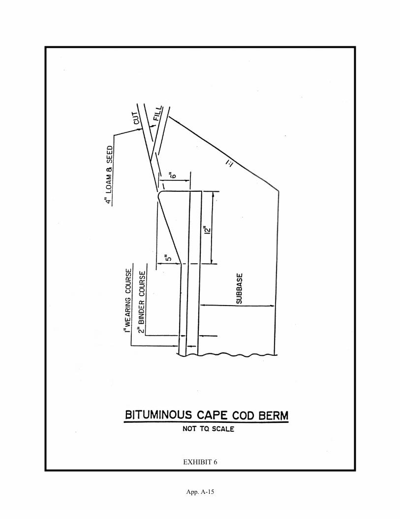
App. A-15
EXHIBIT 6

App. A-16
EXHIBIT 7

App. A-17
EXHIBIT 8

App. A-18
EXHIBIT 9
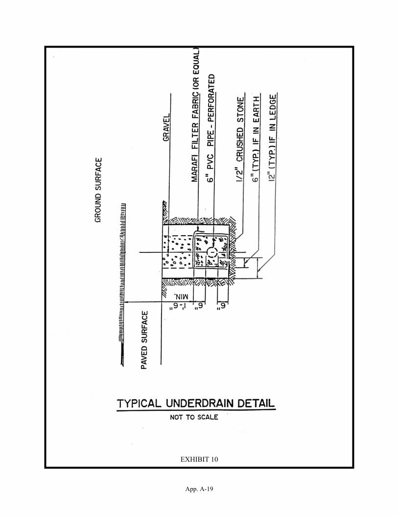
App. A-19
EXHIBIT 10
App.B - 1
APPENDIX B:REQUIREMENTS FOR SOILS AND WETLANDS DATA
SECTION I: DEFINITIONS
“Average area” means the total acreage of the property, exclusive of verypoorly drained soils, divided by the total number of proposed lots. (Useof average acre here assumes that all lots are roughly the same size.)
“Bedrock within 18 inches of the soil surface” meets the definition ofeither lithic or paralithic material. At least 75% of delineated areasmust meet this definition with no more than 15% of the area having soilproperties more limiting (i.e., hydric conditions).
“Indurated” means a rock or soil hardened or consolidated by pressure,cementation, or heat.
“Limiting physical features” means rock outcrops, steep slopes >35%, soilswith bedrock within 18 inches of the soil surface, and very poorly drainedareas.
“Lithic material” means unaltered material that is continuous, coherent,and indurated. The material qualifies for an “R” designation as a masterlayer (USDA soil survey Manual, 1993, pg. 121). Plant and tree rootscannot enter except in cracks. Hand digging with a spade is impractical.Some lithic material can be ripped with heavy power equipment. Thematerial must be in a strongly-cemented or more cemented rupture-resistance class. Granite, quartzite, and indurated limestone orsandstone are examples.
“Non-limiting” means the area, exclusive of very poorly drained soils,rock outcrops, bedrock within 18 inches of the soil surface, and soilswith steep slopes greater than 35 percent.
“Paralithic material” means a relatively unaltered material that has anextremely weakly cemented to moderately cemented rupture-resistance class.The material qualifies for a “Cr” designation as a subordinate distinctionwithin a master soil layer (USDA soil survey Manual, 1993, pg. 124).Cementation or bulk density are such that plant and tree roots cannotenter except in cracks. The material can be hand dug with a spade withmuch difficulty. Commonly these materials consist of weathered or weaklyconsolidated bedrock.
“Soil surface” refers to the top of the first mineral layer.
SECTION II: REQUIREMENTS FOR SOILS AND WETLANDS DATA IN SUBDIVISION/SITE PLANREVIEW REGULATIONS
A. LEVEL 1:
Delineation of Wetlands and Surface Waters for all Subdivision/SitePlan Review Applications
App.B - 2
Information on wetlands and surface waters shall be provided on theplan with identification and delineation of the resources in accordancewith the definitions and standards specified in Step A and B of thissection. The written documentation specified in Step C shall beincluded on the plan and certified by the stamp of a qualifiedprofessional.
Step A: Wetlands Delineations
Wetlands are to be identified and delineated according to the followingstandards and/or methodologies:
Corps of Engineers Wetlands Delineation Manual, Technical Report Y-87-1, Environmental Laboratory, Department of the Army, 1987.
Field Indicators for Identifying Hydric Soils in New England,Version 2, New England Interstate Water Pollution ControlCommission, 1998.
Chapters Wt 100-800 of the NH Code of Administrative Rules, April21, 1997.
Step B: Surface Waters Delineation
Surface Waters are to be identified and delineated in accordance withRSA 485-A: 2, XIV, NH Water Pollution and Waste Disposal and NH Code ofAdministrative Rules pursuant to 485-A.
Step C: Written Documentation
A written statement shall be included on the subdivision or site plan,certified by the stamp of the Certified Wetland Scientist (CWS) orPermitted Septic Designer (PSD), that all wetlands and surface waterson-site have been delineated in accordance with the standards specifiedin Steps A and B above.
B. Additional Information Required Based on the Type of Proposal
1. If a project proposed for subdivision or site plan review isserved by public water and sewer, no additional soils data needsto be submitted for the purpose of determining suitability of thesite for subsurface wastewater disposal systems.
Additionally, if the site development calls for structures and/orimpervious cover or alteration of an area greater than 100,000square feet, or 50,000 square feet within the protectedshoreland, then the applicant should file a site specificapplication under NH Code of Administrative Rules Env-Ws 415 andRSA 485-A: 17, significant alteration of terrain. Approval ofthe permit specified in these rules and statute is required byDES.
2. If the project meets at least one of the following threedevelopment intensity criteria, then the applicant should submitSite Specific Soil Map (SSS Map) information as specified insubsection D:

App.B - 3
a. The average area is less than two (2) acres in area and isnot served by either municipal water or sewer.
b. The average area is less than one (1) acre in area and isserved by municipal water, but not sewer. Or,
c. The non-limiting, upland, contiguous area on any proposedlot is less than 20,000 square feet.
3. For all other projects, the applicant should comply with the datarequirements of Level 2.
C. LEVEL 2:
Confirmation of County Soil Survey Maps and Identification of LimitingPhysical Features
Step A: Identification of Soil Complexes with Dramatically DifferentCharacteristics
If any of the soil map units on the property, as mapped by the NRCScounty soil survey, is a complex of soils with dramaticallydifferent characteristics that would have an impact on use andmanagement of the property, then the applicant must provide SSSMSinformation as required in Level 3.
If the soils mapped by the NRCS county soil survey do not includeone of these complexes, continue to Step B.
Step B: Confirmation of NRCS County Soil Survey Map
The following information is required to be submitted for confirmationof the NRCS county soil survey:
1. A copy of the NRCS county soil survey with the subdivision or siteplan location and approximate boundaries superimposed on the soilmap. The copy of the county soil survey must be provided at thesame scale as the original county soil survey. This is important,so that the limitations of the information provided at the scale ofthe survey are not misunderstood by the users.
2. A representative number of detailed soil profile descriptions tocharacterize variations in the landscape for each mapped unit, basedon NRCS standards as described in the Field Book for Describing andSampling Soils; Version 1.1 National Soil Survey Center, NRCS, 1998.These profile descriptions are to be included in a narrative reportfor the project.
The applicant is required to evaluate and submit detailed soil profiledescriptions to document that the conditions on site are adequate tosupport the proposed use and management of the property. The standardsand/or methodologies for doing this are listed below. These sourcesshould be cited directly on the plan.
If the proposal meets the requirements of Step B, then Level 2information is potentially adequate for local review, provided that the

App.B - 4
NRCS soil survey information is determined to be sufficient for theproposed use and management of the property.
Standards
The required tasks under Level 2 are to be carried out according to thestandards found in the following documents:
Field Book for Describing and Sampling Soils: Version 1.1 NationalSoil Survey Center, NRCS, 1998.
Keys to Soil Taxonomy, Eighth Edition, USDA/NRCS 1998.
NRCS Official Series Description Sheets and/or published map unitdescriptions, USDA/NRCS.
Methods
A minimum of one soil profile description shall be completed per soilmap unit within the plan area, as depicted on the NRCS county soilsurvey. The soil will be described in sufficient detail, so as tosupport or refute that identified properties are within, or similar tothose of the soil series used to name the map unit.
Soils descriptions should be carried out in areas suspected of havingthe greatest likelihood of contrasting soil features. Some map unitswill require more than one soil description to document soilvariability. The map unit purity standards from Site Specific SoilMapping Standards for New Hampshire and Vermont, Version 2.0, Societyof Soil Scientists of Northern New England Publication No. 3, 1999,will apply.
The location(s) of the soil profile description(s) used tocorroborate the NRCS soil series shall be shown on the plan, with areference to the description(s) in the narrative report for theproject.
A detailed comparison between each soil profile description and therepresentative pedon (a description of a small three-dimensionalarea of soil that is typical of the soil series in the county) forthat soil from the county soil survey shall be included in thedetailed narrative for the project. The NRCS Official seriesDescription Sheets and/or NRCS published map unit descriptions foreach mapped unit are to be used as references.
A written statement that the soil profile description(s) from thesite adequately reflect the range of characteristics for the series,as described in the county soil survey. The statement shallindicate that the county soil survey adequately represents soil andlandscape characteristics, such that site specific land usedecisions can be made without further soil investigations. Thisstatement is to be certified by the stamp of the CSS or PSD. Ifthis statement cannot be made, proceed to Level 3.
App.B - 5
A narrative report for the project which summarizes the informationcompiled in Step B. This shall include a determination of whetherlimiting physical features are present on the parcel and indicatethe specific mapped soil units where these occur. If any limitingphysical features are identified on-site, then Step C is required.
If the on-site investigations confirm the nature and properties ofthe soils as reflected by the soil map, consistent with the intendeduse and intensity of development, as Level 2 review is potentiallyadequate for the planning boards’ purposes. However, the planningboard may, at its discretion, require submission of on-site soilsdata.
Step C: Identification of Limiting Physical Features
In addition to the information required in Steps A and B, theinformation specified below is required for identification anddocumentation of limiting physical features. This can either be doneas a stand-alone document or as an amendment or addendum to thenarrative prepared under Step B.
Delineation of the limiting features, specifically rock outcrops,steep slopes >35%, soils with bedrock within 18 inches of the soilsurface, and very poorly drained areas on-site. These features areto be shown on the plan.
A detailed description of each limiting physical feature, based onNRCS standards, in a narrative report for the project, withreference to its location on the plan. This can either be done as astand-alone document or as an amendment or addendum to the narrativeprepared under Step B.
A written statement that t he limiting physical features identifiedabove would not have a significant impact on use and management ofthe property. This statement is to be certified by the stamp of theCSS or PSD. If this statement cannot be made, then proceed to Level3.
A written statement that limiting physical features are present onthe parcel(s) and that either (1) a SSS Map (Level 3) is required,or (2) not required, with supporting documentation for thisposition. This determination is to be certified by the stamp of theCSS or PSD. If a SSS Map is required, then proceed to Level 3.
D. Level 3:
Site Specific Soil (SSS) Map for Intense Development and for Sites withLimiting Features
If required, an applicant shall submit a site specific soil mapprepared in accordance with Site Specific Soil Mapping Standards forNew Hampshire and Vermont Version 2.0, Society of Soil Scientists ofNorthern New England Publication No. 3, 1999. This is to be certifiedby the stamp of the CSS.

App.C - 1
APPENDIX C:SAMPLE FORMS AND PUBLIC NOTIFICATIONS
1. SUBMISSION OF APPLICATION (used only for submission - not publichearing)
Town of _____________LEGAL/PUBLIC NOTICE
Notice is hereby given in accordance with RSA 676:4 that an application for(Subdivision/Site Plan Review - Description of Application; Name ofApplicant; Location of Property; Tax Map and Lot Number) will be submitted tothe Planning Board on (DATE) at (TIME) at the ______________ Town Hall duringa regular meeting of the Board. Upon a finding by the Board that theapplication meets the submission requirements of the _________________(Subdivision/Site Plan Review Regulations), the Board will vote to accept theapplication as complete and schedule a public hearing. Should theapplication not be accepted as complete, another submission meeting will bescheduled. Anyone needing assistance to attend this meeting should contactthe Selectmen’s Office one week prior to the scheduled date.
Per order of the _____________________ Planning Board____________________________,Secretary/Clerk
2. SUBMISSION OF APPLICATION/PUBLIC HEARING ON PROPOSAL (for ExpeditedReview)
Town of _____________LEGAL/PUBLIC NOTICE
Notice is hereby given in accordance with RSA 676:4 & 675:7 that anapplication for (Subdivision/Site Plan Review - Description of Application;Name of Applicant; Location of Property; Tax Map and Lot Number) will besubmitted to the Planning Board on (DATE) at (TIME) at the _____________ TownHall during a regular meeting of the Board. Upon a finding by the Board thatthe application meets the submission requirements of the_______________________ (Subdivision/Site Plan Review Regulations), the Boardwill vote to accept the application as complete, and a public hearing on themerits of the proposal will follow immediately. Should a decision not bereached at the public hearing, this application will stay on the PlanningBoard agenda until such time as it is either approved or disapproved. Anyoneneeding assistance to attend this meeting should contact the Selectmen’sOffice one week prior to the scheduled date.
Per order of the ____________________ Planning Board____________________________,Secretary/Clerk

App.C - 2
3. PUBLIC HEARING ON PROPOSAL
Town of _____________LEGAL/PUBLIC NOTICE
Notice is hereby given in accordance with RSA 676:4 & 675:7 that the____________ Planning Board will hold a public hearing for (Subdivision/SitePlan Review - Description of Application; Name of Applicant; Location ofProperty; Tax Map and Lot Number) on (DATE) at (TIME) at the _____________Town Hall. Should a decision not be reached at the public hearing, thisapplication will stay on the Planning Board agenda until such time as it iseither approved or disapproved. Anyone needing assistance to attend thismeeting should contact the Selectmen’s Office one week prior to the scheduleddate.
Per order of the ____________________ Planning Board____________________________,Secretary/Clerk
4. ABUTTER NOTICES FOR SUBDIVISION OR SITE PLAN REVIEW APPLICATION
Dear _________________,
According to NH Revised Statutes Annotated 676:4,I (d) and the Town of____________ (Subdivision/Site Plan Review), it is required that all abuttersto land intended for (subdivision/site plan review) be notified of theproposal.
You, as an abutter, are hereby notified that an application for(Subdivision/Site Plan Review - Description of Application; Name ofApplicant; Location of Property; Tax Map and Lot Number) will be submitted tothe Planning Board on (DATE) at (TIME) at the ___________ Town Hall during aregular meeting of the Board. Upon a finding by the Board that theapplication meets the submission requirements of the _______________(Subdivision/Site Plan Review Regulations), the Board will vote to accept theapplication as complete, and a public hearing on the merits of the proposalwill follow immediately.
Should a decision not be reached at the public hearing, this application willstay on the Planning Board agenda until such time as it is either approved ordisapproved.
Please be advised that, as an abutter, your right to testify is restricted tothe public hearing. In the case of a public meeting, as opposed to a publichearing, you are allowed by right to be notified and be present, but you donot have the right to offer testimony except at the Planning Board'sdiscretion.
Sincerely,
Planning Board Secretary/Clerk

App.C - 3
5. APPLICANT NOTICE FOR SUBDIVISION OR SITE PLAN REVIEW
Dear _________________,
According to NH Revised Statutes Annotated 676:4,I (d) and the Town of__________ (Subdivision/Site Plan Review Regulations), it is required thatall applicants for land development be sent notice of the public meeting andpublic hearing at which their proposal will be submitted to the Board andreviewed.
You, as the applicant, are hereby notified that your application for(Subdivision/Site Plan Review - Description of Application; Location ofProperty; Tax Map and Lot Number) will be submitted to the Planning Board on(DATE) at (TIME) at the _____________ Town Hall during a regular meeting ofthe Board. Upon a finding by the Board that the application meets thesubmission requirements of the _________________ (Subdivision/Site PlanReview Regulations), the Board will vote to accept the application ascomplete, and a public hearing on the merits of the proposal will followimmediately.
Should a decision not be reached at the public hearing, this application willstay on the Planning Board agenda until such time as it is either approved ordisapproved. Should your application be disapproved, you will receivewritten notice from the Planning Board within 144 hours stating the reasonsfor such disapproval.
Sincerely,
Planning Board Secretary/Clerk
6. SURVEYOR NOTICE FOR SUBDIVISION OR SITE PLAN REVIEW
According to NH Revised Statutes Annotated 676:4,I (d) and the Town of______________ Subdivision/Site Plan Review Regulations, it is required thatany persons who have prepared plans for approval be notified of thesubmission and hearing on the application.
You are hereby notified that an application prepared by you for a(Subdivision/Site Plan Review - Description of Application; Location ofProperty; Tax Map and Lot Number) will be submitted to the Planning Board on(DATE, TIME, PLACE) during a regular meeting of the Board.
Upon a finding by the Board that the application meets the submissionrequirements of the _____________________ Subdivision/Site Plan ReviewRegulations, the Board will vote to accept the application as complete, and apublic hearing on the merits of the proposal will follow immediately.Should a decision not be reached following the public hearing, thisapplication will stay on the Planning Board agenda until such time as it iseither approved or disapproved.
Should this application be disapproved, the applicant will receive writtennotice from the Planning Board within 144 hours stating the reasons fordisapproval, and advising the applicant of what corrective measures would beneeded.
Per order of _________________________, Chairman____________________________Planning Board

App.C - 4
7. APPLICATION FOR WAIVER OF SUBDIVISION/SITE PLAN REVIEW REQUIREMENT
Date:________________________________
To the Chairman and Members of the ________________________ Planning Board:
On (DATE) I submitted a plan for (subdivision/site plan review) approval tothe Board, entitled __________________________ and prepared by_______________________________________. Pursuant to Section X of theBoard's regulations, I am requesting a waiver from the following items forreasons stated below:
1. ____________________________________________________________________________________________________________________________________________________
2. ____________________________________________________________________________________________________________________________________________________
3. ____________________________________________________________________________________________________________________________________________________
4. ____________________________________________________________________________________________________________________________________________________
Respectfully submitted,________________________________________________
8. NOTICE OF PLANNING BOARD DECISION
[Once the Planning Board has held the public hearing and voted on theapplication, the final decision must be put in written form and placed onfile in the Town offices and made available to the public within 144 hours.The Board is not required to notify the applicant individually except in thecase of a denial, in which case the same time limit applies.]
NOTICE OF PLANNING BOARD APPROVAL
On ________________, 199__, after duly-noticed public hearing(s), thePlanning Board voted to APPROVE the Plan for (a 4-lot subdivision) submittedto the Board by____________________________ for property located at (StreetAddress, Tax Map & Lot Number and Zoning District). Any conditions to whichthe plan is subject are listed below:
1.___________________________________________________________________________
2.___________________________________________________________________________
3.___________________________________________________________________________
4.___________________________________________________________________________
5.___________________________________________________________________________
_____________________________, Planning Board Chair

App.C - 5
NOTICE OF PLANNING BOARD DENIAL
On (DATE) after duly-noticed public hearing(s), the Planning Board voted toDENY the Plan for (______________________________) submitted to the Boardby____________________________ for property located at (Street Address, TaxMap & Lot Number and Zoning District). The application was denied for thefollowing reasons:
1.___________________________________________________________________________
2.___________________________________________________________________________
3.___________________________________________________________________________
4.___________________________________________________________________________
5.___________________________________________________________________________
_____________________________, Planning Board Chair
9. NOTICE OF PUBLIC HEARING TO REVOKE PLANNING BOARD APPROVAL
Town of _____________LEGAL/PUBLIC NOTICE
Notice is hereby given in accordance with RSA 676:4-a the Planning Board willhold a public hearing on (DATE) at (TIME) at the _____________ Town Hall forthe purpose of considering whether to revoke a plan previously-approved on_______________, 19__ and filed with the __________________ County Registerof Deeds. The Board is considering revocation for the reasons stated below.Should a decision not be reached at the public hearing, this application willstay on the Planning Board agenda until such time as it is either approved ordisapproved.
Per order of the ____________________ Planning Board____________________________,Secretary/Clerk

App.C - 6
10. DECLARATION OF REVOCATION
[Once the Board has voted to revoke a previously-approved plan, a declarationof revocation must be filed with the county register of deeds no sooner than30 days after written notification to the applicant, or 30 days after thepublic hearing, whichever is later. The declaration must be recorded underthe same name as that on the original approval, dated, endorsed in writing bythe Planning Board, and contain reference to the recording information of theplan being revoked.]
Notice is hereby given that the ________________________ Planning Board votedon (DATE) to revoke the approval of (Plan Name) granted to (Applicant Name)on (DATE). The Plan was recorded in the _______________ County Register ofDeeds as Plan ___________________ and filed on (DATE). The approval wasrevoked for the following reasons:_________________________________________________________________________________________________________________________________________________________________________________________________________________________________________________________________________________________________________________________________________________________________________________________________
Respectfully Submitted,
__________________________________________Planning Board Chair
11. ADOPTION OR AMENDMENTS TO SUBDIVISION OR SITE PLAN REVIEW REGULATIONS
Town of ______________NOTICE OF PUBLIC HEARING
Pursuant to RSA 675:6 & 7, the Planning Board will hold a public hearing on(DATE) (TIME) at the ___________________ Town Hall on a (proposed amendmentor the adoption of the Subdivision or Site Plan Review) Regulation. Theeffect of the (proposed amendment or adoption) will be to:
(Here insert a topical description of the proposed changes)
A full copy of the text of the proposed amendment is available for review inthe Town Clerk's office during regular business hours.
Per order of the ___________ Planning Board____________________________,Secretary/Clerk
APPENDIX D: CRITERIA FOR DETERMINING REGIONAL IMPACT
Impact Criteria shall include, but not be limited to, the following items.These shall in no way be considered exhaustive, but rather guidelines for theBoard to follow in making a determination of impact on a neighboringmunicipality.
A. RESIDENTIAL DEVELOPMENT: Proposals for lots or dwellings that wouldincrease the existing housing stock of the town by more than 25%.
B. COMMERCIAL DEVELOPMENT: Proposals for new or expanded space of 50,000square feet or greater.
C. INDUSTRIAL DEVELOPMENT: Proposals for new or expanded space of 100,000square feet or greater.
D. OTHER FACTORS TO BE CONSIDERED:
1. Proximity to other municipal boundaries.
2. Traffic impacts on the regional road network.
3. Potential effect on groundwater, surface water and wetlands thattranscend municipal boundaries.
4. The potential to disturb or destroy a significant or importantnatural environment or habitat.
5. The necessity for shared public facilities such as schools orsolid waste disposal.
6. Anticipated emissions such as light, noise, smoke, odors, orparticulates.
7. The potential for accidents that would require evacuation of alarge area.
8. The generation and/or use of any hazardous materials.

App. E - 1
APPENDIX E:PROCEDURE FOR APPLICATION REVIEW
I. PREAPPLICATION REVIEW - OPTIONAL
The two stages of preapplication review are optional at the request ofthe applicant. The applicant may choose to engage in both thePreliminary Conceptual Consultation and the Design Review Phase, or anyone of the two.
A. PRELIMINARY CONCEPTUAL CONSULTATION
B. DESIGN REVIEW PHASE
STEP 1:Applicant meets with Planning Board to review plan in terms of
conceptand compliance with the Master Plan and zoning ordinance;
Board determines type of proposal and offers guidance relativeto
state and local requirements.(Public notice is not required).
STEP 2:At this point the applicant may either request the DesignReview Phase or move directly to the formal submission of a
completed application.
STEP 1:Applicant submits a "Request for Preapplication Review " atleast 15 days before the next regularly-scheduled meeting of
the Board.
STEP 3:Board and applicant engage in non-binding discussion
involving specific design and engineering details of thepotential application.
STEP 2:Planning Board notifies abutters and the public 10 days prior
to themeeting that the proposal will be discussed.

App. E - 2
II. APPLICATION PROCEDURE
NOTE: For a minor or technical subdivision, the public hearing may take place on the same evening asthe vote to accept the plan as complete, provided the notice has advised of the possibility.
STEP 1:Application is delivered to Planning Board.
STEP 2:At the next meeting for which notice can be given – or 30 days from delivery
of application – Board determines if application is complete.
Applicant is notified inwriting of reasons,
and advised of next steps.
IFINCOMPLETE
IFCOMPLETE
STEP 3:Planning Board begins formal consideration of theapplication, which could mean moving into public
hearing, or scheduling the public hearing.Applicant may:
♦ Revise and resubmitOR
♦ Appeal to SuperiorCourt or Board ofAdjustment
STEP 4:Within 65 Days
Planning Board must have rendered a decision.
IF NOTAPPROVED
IFAPPROVED
STEP 5:Planning Board files plan with the Registry of Deeds.
Applicant is notifiedin writing within 144hours of the reasons
for disapproval.

App. F - i
APPENDIX F:PLANNING BOARD BY-LAWS
I. MEMBERS & ALTERNATES
A. The ___________ Planning Board (“the Board”) shall consist ofseven members, six elected at Town Meeting and the seventh aSelectmen’s representative, who shall be a member of the Board ofSelectmen chosen by the Selectmen.
B. Except for the Selectmen’s representative, members shall beelected for three-year terms, two members being elected eachyear. Terms of office shall commence at the first regularPlanning Board meeting after the annual Town Meeting.
C. At its first regular meeting following the annual Town Meeting,the Board shall elect from among its members (other than theSelectmen’s representative) a Chairman and Vice-Chairman, and aSecretary. These officers shall serve for one year.
D. The Board may appoint three alternate members for a term of threeyears each. At its second regular meeting following each annualTown Meeting the Board shall appoint one alternate, so that termsare staggered.
E. Vacancies in the Board (other than the Selectmen’srepresentative) shall be filled by appointment by the remainingBoard members until the next Town Meeting.
II. DUTIES OF OFFICERS; MINUTES
A. The Chairman shall preside over meetings and shall be responsiblefor the conduct and decorum of the meeting. The Chairman shallensure that all parties receive a full and fair hearing beforethe Board.
B. Whenever the Chairman is absent or disqualified to act in aparticular case, the duties of chairman shall be performed by theVice-Chairman, or another member designated by the Board.
C. The Secretary shall take and place on file minutes of allmeetings and hearings in accordance with RSA 91-A; and shall beresponsible for all notices, whether by certified letter,newspaper advertisement or posting, for maintaining the Board’srecords, including plats, and for the collection of fees. TheSecretary may be a paid employee of the Board, and may also be aduly-elected member of the Board.
III. MEETINGS; NOTICE
A. Regular meetings of the Board shall be held at _______ p.m. onthe _____ and _______ ________ of each month at the __________Town Hall. The Board may vote to omit not more than one meeting
App. F - ii
in any calendar month, or the change the time and place of aparticular meeting.
B. Special meetings of the Board shall be held at the call of theChairman, or by request of a majority of the members.
C. Notice of all special meetings, of the omission of any regularmeeting, and of any change in the time or place of a regularmeeting shall be posted in not less than two public places withinthe Town of _______________ [see RSA 91-A].
D. A member who is unable to attend a meeting shall secure one ofthe alternate members to attend in the member’s stead.
IV. JOINT MEETINGS AND HEARINGS
A. The Planning Board may hold joint meetings and hearings withother “land use boards”, such as the Board of Adjustment. Eachboard shall have discretion whether or not to hold such jointmeeting or hearing (RSA 676:2)
B. Joint business meetings with another local land use board may beheld at any time when called jointly by the chair of the twoboards.
C. A joint public hearing must be a formal public hearing when thesubject matter of the hearing is within the responsibilities ofthe boards convened.
D. The Planning Board chair shall chair all joint meetings andpublic hearings when the subject matter involves the PlanningBoard.
E. The rules of procedure for joint meetings and hearings shall bethe same as these by-laws except that the order of business shallbe as follows:
1. Call to order by Planning Board Chairman
2. Introduction of members of both boards by the Chairs, PlanningBoard first.
3. Explanation by Planning Board Chair of reason for jointmeeting or hearing.
4. In the case of a public hearing, the applicant shall be calledto present his/her proposal, making clear what is beingrequested/reviewed by each board (for example, specialexception for ZBA, site plan approval from Planning Board).
5. Each board shall deliberate on its own, and make its owndecision, based on its particular criteria for the issue.
App. F - iii
V. SITE VISITS
A. A Site Visit is a visit by the Board, or by one or more membersof the Board, together with the applicant or the applicant’sagent, to a location, which is the subject of an applicationbefore the Board.
B. When the Board schedules a Site Visit for the Board membership,it shall be posted as a meeting of the Board in accordance withRSA 91-A.
C. When the Board deems it necessary for the adequate considerationof an application, the Board shall request the applicant’spermission to make a Site Visit. If such a request is notgranted, the application may be denied by majority vote of theBoard without further hearings.
VI. STANDARDS OF CONDUCT
A. The primary obligation of the Planning Board is to serve thepublic interest, and members should conduct themselves so as tomaintain public confidence in the Planning Board and the conductof its business.
B. To avoid conflict of interest or the appearance of anyimpropriety, a member having a personal interest, financial orotherwise, in any application before the Board shall bedisqualified from participating in the consideration or decisionon that application. “Personal interest” shall include, withoutlimitation, being a relative of an applicant or being the owneror lessee of property abutting the property that is the subjectof an application. [see RSA 673:14]
C. Members disqualified in accordance with Paragraph B above may becounted as “present” if necessary to provide a quorum.
VII. FEES
Fees to cover the costs of notification, filing, and administrationshall be charged on site review and subdivision applications, and shallbe paid by the applicant before approval is granted. The secretaryshall provide a schedule of fees on request.
VIII. AMENDMENTS
These By-Laws may be amended after public hearing by a majority vote ofthe Planning Board.
Adopted by the Planning Board _______________________________________