sturbridge reconnaissance report - mass.gov · sturbridge reconnaissance report ... heritage...
TRANSCRIPT

STURBRIDGE RECONNAISSANCE REPORT
BLACKSTONE VALLEY / QUINEBAUG-SHETUCKET
LANDSCAPE INVENTORY
MASSACHUSETTS HERITAGE LANDSCAPE INVENTORY PROGRAM
Massachusetts Department of Conservation and Recreation
John H. Chafee Blackstone River Valley National Heritage Corridor
Quinebaug and Shetucket Rivers Valley National Heritage Corridor

PROJECT TEAM Massachusetts Department of Conservation and Recreation Jessica Rowcroft, Preservation Planner Division of Planning and Engineering Quinebaug and Shetucket Rivers Valley National Heritage Corridor Robert Levite, UMass Extension Project Consultants Elizabeth Vizza, Elizabeth Vizza Consulting Electa Kane Tritsch, Oakfield Research Daniel Wells, Hyla Ecological Services Inc. Local Project Coordinator Ted Goodwin, Selectman Local Heritage Landscape Participants Mary Blanchard Robert Briere Jean Bubon Carol Childress Penny Dumas Carol Goodwin E. Goodwin Ted Goodwin Steve Halterman Joseph Ouellette Nancy Runkle Lynne Sarty Steve Walker June 2007 Cover Photograph: Blackington Building, Fiskdale Old Burying Ground, Sturbridge Town Common Barrett Farm, Douty Road

CONTENTS Introduction .................................................................................................................. 1 Part I: Sturbridge’s Heritage Landscapes Sturbridge’s Landscape Through Time ................................................................. 2 Community-Wide Heritage Landscape Issues....................................................... 3 Sturbridge Priority Landscapes.............................................................................. 4 Quinebaug River Barrett Farm Fiskdale Theme: Ponds Sturbridge Town Common National Register District Hobbs Property Old Sturbridge Village Part II: Building a Heritage Landscape Toolkit Eight Toolkit Basics............................................................................................. 17 Sturbridge’s Toolkit: Current Status and Future Additions ................................. 18 Conclusion and Implementation.................................................................................... 25 Appendix A: Sturbridge Heritage Landscapes..................................................................... i Appendix B: Guide to Preservation and Planning Tools for Heritage............................... iv Landscapes

INTRODUCTION The 22 Massachusetts communities within the John H. Chafee Blackstone River Valley National Heritage Corridor (BRV) and the Quinebaug and Shetucket Rivers Valley National Heritage Corridor (Q-S) are linked by a common heritage of agriculture and industry powered by the rivers and streams that dominate the landscape of south central Massachusetts. River Corridor towns extend from Mendon on the east to Brimfield on the west. While they range in size from the city of Worcester to the compact town of Hopedale, each is equally shaped by the interaction of nature and culture over time. Heritage landscapes are special places created by human interaction with the natural environment that help define the character of a community and reflect its past. They are dynamic and evolving; they reflect the history of a community and provide a sense of place; they show the natural ecology that influenced land use patterns; and they often have scenic qualities. This wealth of landscapes is central to each community’s character, yet heritage landscapes are vulnerable and ever changing. For this reason it is important to take the first step toward their preservation by identifying those landscapes that are particularly valued by the community – a favorite local farm, a distinctive neighborhood or mill village, a unique natural feature or an important river corridor. To this end, the Massachusetts Department of Conservation and Recreation (DCR) and the two National Heritage Corridors (BRV and Q-S) have collaborated to bring the Heritage Landscape Inventory program to communities in south central Massachusetts. The goals of the program are to help communities identify a wide range of landscape resources, particularly those that are significant and unprotected, and to provide communities with strategies for preserving heritage landscapes. The methodology for the Heritage Landscape Inventory program was developed in a pilot project conducted in southeast Massachusetts and refined in Essex County. It is outlined in the DCR publication Reading the Land, which has provided guidance for the program since its inception. In summary, each participating community appoints a Local Project Coordinator (LPC) to assist the DCR-BRV/Q-S consulting team. The LPC organizes a heritage landscape identification meeting during which residents and town officials identify and prioritize the landscapes that embody the community’s character and its history. This meeting is followed by a fieldwork session including the consulting team and the LPC, accompanied by interested community members. This group visits the priority landscapes identified in the meeting and gathers information about the community. The final project for each community is this Reconnaissance Report. It outlines the community’s landscape history; discusses broader land planning issues identified by the community; describes the priority heritage landscape and issues associated with them; and concludes with preservation recommendations. Two appendices include a list of all the heritage landscapes identified at the community meeting and a reference listing of land protection tools and procedures.

PART I
STURBRIDGE’S HERITAGE LANDSCAPES

Heritage Landscape Inventory Sturbridge Reconnaissance Report 2
STURBRIDGE’S LANDSCAPE THROUGH TIME Sturbridge, located in the southwest corner of Worcester County, is a town of long, narrow ridges that run from northeast to southwest. The Quinebaug River Valley cuts across the town and drains its higher elevations. Sturbridge’s ridge-tops and slopes are covered with Brookfield stony loam, productive of hay, grains, potatoes and orchard crops. A vein of graphite appears in the southwest corner of the town. During the precontact era, part of a regional trail network followed the Quinebaug River Valley and consequently, the area likely hosted a number of small, seasonal hunting and fishing camps. Evidence of only one long-term Native American settlement has been found by local collectors, however, and there is also evidence of precontact graphite quarrying at Tantiusques. In 1644 the colonial government granted the graphite deposit to John Winthrop, Jr. and this extractive industry was the first impetus for Anglo-European settlement of the area. A century later, the land that is now Sturbridge was granted to the town of Medfield for expansion, in place of territory lost to Medway, and agricultural village settlement began in 1730 in the vicinity of the present Sturbridge town common. The Sturbridge Manufacturing Company built the first cotton mill in the area in 1811, but it was the extensive three-story brick Quinebaug Manufacturing Company, built in the late 1820s, that anchored industrial development in Sturbridge. The mill built by Josiah and Henry Fiske on the Quinebaug, together with attendant buildings and worker housing along present Route 20, became known as Fiskdale. In the mid-40s an auger and bit manufactory was established downstream , that became the Snell Manufacturing Co in 1862, giving rise to another small industrial neighborhood known as Snellville. By mid-century nearly a third of the workforce in this formerly agrarian town was employed in manufacturing. At the same time, commercial timbering operations resulted in extensive clear-cutting of land, which became pasture and hayfields. After the Civil War animal husbandry increased while production of the more labor-intensive grain crops declined. The prosperity brought to Sturbridge by manufacturing began to decline in the last two decades of the nineteenth century; the leather industry disappeared, sawmills closed, and production at the textile mills fell. The only industry that prospered was the Snell Manufacturing Company. Nevertheless, the Southbridge & Sturbridge electric street railway began service from Fiskdale through Sturbridge Center in the 1890s. The number of dairy farms increased, as did orchards and market gardens, although significant acreage was allowed to revert from agricultural use to woodland. An Agricultural Fairgrounds east of Snellville attracted regional visitors and commerce to the town. Summer cottage colonies developed around Sturbridge’s ponds. By the 1930s, the streetcar tracks had been paved over on what became Route 131, and other main roads were improved to handle increasing automotive traffic. In 1946 Old Sturbridge Village opened: a historical museum complex, becoming a major employer and revenue source for the town. Through the twentieth century, Sturbridge has become an increasingly residential community, with development concentrated along the shores of the town’s major ponds and near the Rte. 131 corridor between the town center and Southbridge. Construction of the Massachusetts Turnpike (1957) and, more recently, I-84 have created an interstate “crossroads” in the town.
Heritage Landscape Inventory Sturbridge Reconnaissance Report 3
COMMUNITY-WIDE HERITAGE LANDSCAPE ISSUES Concern for heritage landscapes is not new to Sturbridge. The town was among the first to conduct a historic resource inventory, and the Sturbridge Common was recognized as a National Register District in 1977. The town has also recently established a Public Lands Advisory Committee to coordinate planning for a number of large or strategic parcels located throughout town. Another planning effort is underway at Old Sturbridge Village, which is working under a grant to complete a marketing study. Although the study is focused primarily on the museum organization, one of its thrusts is investigation of ways to coordinate OSV and Town of Sturbridge developmental and promotional goals. Sturbridge's Heritage Landscape Identification meeting, attended by interested residents including many representing town boards and local non-profit organizations, was held on February 7, 2007. During the meeting, residents compiled a lengthy list of the town's heritage landscapes, which is included as Appendix A of this report. As the comprehensive list was being created, attendees were asked to articulate the value of each landscape and identify issues relating to its preservation. Residents emphasized broad issues related to heritage landscapes and community character. These issues are town-wide concerns linked to a range or category of heritage landscapes, not just to a single place. In Sturbridge, three related issues stand out.
Managing Rapid Growth: Broadly, citizens and managers alike are interested in finding effective ways to manage rapid growth in the town without losing control of the process and the end result.
Access and Protection: It is desirable to have public access to recreational areas
and open space in town while also protecting the special values – both natural and cultural – of open space parcels.
History and Progress: It is desirable to preserve Sturbridge’s cultural identity as
a historic rural community, but there is also an understanding that economic health and growth are essential to maintaining that identity.

Heritage Landscape Inventory Sturbridge Reconnaissance Report 4
PRIORITY HERITAGE LANDSCAPES Based on information gathered at the community meeting, attendees identified a group of priority landscapes for the consulting team to focus on, through field survey, documentation and planning assessment. Each of the priority landscapes is highly valued and contributes to community character. Each is subject to some or all of the community issues described above. The only one of them that has any permanent form of protection is the Quinebaug River in the areas managed by the Army Corps of Engineers. The landscapes which were given priority status by Sturbridge’s community meeting represent a range of scales and types of resources. Each demonstrates the multiple layers of significance that are common to heritage landscapes. Natural and cultural features, individual and civic histories, combine to present property owners and concerned citizens with a complex combination of present-day issues and opportunities. The descriptions and recommendations that follow are intended to be first steps and constructive examples for what needs to be an ongoing process: to identify what is valued and irreplaceable in the community, and develop strategies that will preserve and enhance Sturbridge’s landscape heritage. Quinebaug River Description: The Quinebaug River cuts from west to east across Sturbridge’s north-south oriented topography. A moderate-flow river, it enters Sturbridge at the Army Corps of Engineers (ACE) East Brimfield Reservoir/Long Pond flood control project, and flows through the steep valley of Fiskdale where it once provided the waterpower that led to the area’s development in the 18th and 19th centuries. The river broadens and becomes marshy through the central plain that includes Old Sturbridge Village, then receives inflow from Cedar Pond and provides enough fall for another small mill site (David Wight’s mill, now part of OSV) before it meanders through the southeastern section of town to the Westville Dam on the town’s border with Southbridge.
Today the river is appreciated for its scenic qualities, fly fishing and good kayaking. It still powers the saw and grist mills at Old Sturbridge Village, while both Long Pond and Westville Lake provide public access for boating and fishing under ACE auspices. The

Heritage Landscape Inventory Sturbridge Reconnaissance Report 5
Grand Trunk rail bed shadows the course of the river, from trestles now beneath the East Brimfield Reservoir, along the south bank through Fiskdale and Snellville, cutting across wetlands in Old Sturbridge Village and level floodplain in the southeastern part of town. Background: The Quinebaug floodplain, like that of its neighboring river, the Quaboag, attracted Native American people well before the area’s occupation by English settlers. Sizable areas of well-drained, fertile, level land encouraged Nipmuc settlement and planting, including the field between Long Pond and the Quinebaug in Sturbridge, which later became colonial planting fields and later still, the Agricultural Fairgrounds. Thus part of the river’s significance has always been the fertile land along its banks. The Quinebaug’s other advantage, especially during the 19th century, was that it had enough drop to provide waterpower for small industries, while still being a narrow enough river to be easily dammed with the engineering of the period. By the late 19th century, the Fiskdale mills were powered by two falls – one 18 feet and the other 20 feet high. By contrast, the slow-flowing level stretch downstream watered an extensive wetland area attractive today as it was in the past to a wide range of water fowl and small mammals. Issues:
Who controls the river? It is generally known by residents that the ACE owns significant sections of riverbank on both sides of the town, but there is no such general understanding as to what agencies or individuals control what goes on between the ACE areas. This is significant in terms of both access and recreational use.
The fate of the “River Lands”: 3 riverfront parcels totaling approximately 140
acres along the south side of the river between Stallion Hill Road and Holland Road. The parcels, all owned by one private realty firm, include the Grand Trunk line. Like Barrett Farm (see below), these parcels are largely unperkable and there is no town sewer in the vicinity. The town of Sturbridge has been interested in acquiring this land for conservation and recreational purposes since 1995, with the intention of coordinating efforts with the ACE to connect the parcels of Grand Trunk already developed as a rail trail on ACE land, with the remainder of the line through Sturbridge. One large section of the line is already on municipal land purchased last year from Old Sturbridge Village.
Public access to the Quinebaug in Fiskdale: Sturbridge currently owns Turner’s
Field, a small parcel of riverfront adjacent to the Fiskdale mill. Its central location and easy water access are perfect for recreational use, but the waterfront is too small for public events such as the annual Run of the River.
Recommendations and Explanations:
Who controls the river? Confusion on this topic is not surprising, as it is fairly arcane. A brief answer to Sturbridge’s immediate question is as follows. Following the flooding in central Massachusetts in 1955, the ACE set out to construct flood control dams on numerous rivers including the Quinebaug and French. Much of the construction actually took place in the early 1960s. The

Heritage Landscape Inventory Sturbridge Reconnaissance Report 6
federal government took by eminent domain only as much land as would or might be inundated by water backing up behind the dam. That included, for instance, the whole of East Brimfield Village (permanently under the resulting reservoir) but also land upstream of reservoirs, lower than a certain elevation - this land might become submerged if high water needed to be held back in times of river flooding. Such is the case at Long Pond, where the roadway is predictably underwater during spring rains and snow melt. The flip side of the ACE policy is that they did not take other land along the same rivers, because it was not in danger of flooding from the new dams. The Army Corps of Engineers has no direct ownership or control over the Quinebaug shores in the Fiskdale area of Sturbridge. An additional complicating factor in the issue of river ownership is that the stream flow itself – the water – of any navigable river is considered to be a state resource, under the control of the Commonwealth of Massachusetts. The river banks or dry land, on the other hand, belong to whoever has bought them: private owners.
Pursue the purchase, recreational development and conservation of the River Lands; they are desirable as highly visible, environmentally significant open space parcels. The town needs to make it clear to the present owner, and to the Massachusetts Court system in charge of the past owner’s bankruptcy proceedings, that Sturbridge is a serious and viable buyer for the property. Sturbridge, in cooperation with the ACE, has already seen a $500,000 appropriation through Congress under the federal highway reauthorization act earmarked for this purchase. The Central Massachusetts Planning Commission is taking action to get disbursement of this funding onto the MassHighway FY08 spending plan. The town needs to continue to emphasize the importance of this financial transaction to all involved.
Work with Fiskdale Mill owners and other Fiskdale landowners to explore possibilities for a public park/picnic area/boat ramp/parking in the vicinity of the mill dam where foot paths already exist, with preference given to an area adjacent to Turner’s Field. Alternatively, the parcel immediately above the dam at the Route 20/148 intersection, is presently undeveloped (part owned by Blackington Building owners).
Barrett Farm (Douty Road) Description: Barrett Farm encompasses 246 acres of primarily open, rolling land, on the north side of Stallion Hill, within sight of the Quinebaug River. The farm extends along both sides of Douty Road, one of Sturbridge’s designated Scenic Roads and approximately 100 acres is under Chapter 61A. According to local sources, most of the Barrett land does not pass percolation testing for residential development and, sewer extension from Commonwealth Avenue is not an option since the current treatment plant is at capacity.

Heritage Landscape Inventory Sturbridge Reconnaissance Report 7
The historic farmhouse on the east side of the road is a two-story, side-gabled building with 8-over-12 windows, a center entrance door with half-round fanlight and two interior stove chimneys. A two-story ell at the rear of the building attaches to a low, one-story shed. The house is aluminum sided. A small well-house stands in the front yard, which is shaded by two mature sugar maples flanking the front walk. Across Douty Road is a group of farm buildings in fair to poor condition, including two wooden barns, a silo and other sheds and outbuildings. Elsewhere on the property are a 1968 gambrel-roofed Cape-style house and a small 20th century electric sawmill. Background: This farm appears to have been part of the Allen family’s extensive colonial-era holdings that stretched down to what is now Fiskdale. The house, dated on town assessor’s records as 1770, appears to have been updated in the 19th century, based on its two small interior chimneys that suggest conversion from fireplace to wood stove heat. In 1872 the owner was C. G. Allen. The property’s present identification as Barrett Farm dates to its purchase by Everett Barrett in 1941. Barrett, succeeded by his son Walter, managed a dairy herd of 100 Holstein and Jersey cows until Walter’s death in 1993. The present owner and her husband are the third generation of the family on the property.
Issues:
The hillside agricultural open space and historic farm buildings are highly visible evidence of Sturbridge’s agrarian history, especially given their juxtaposition to the industrial village of Fiskdale at the foot of the hill.
Barrett Farm is adjacent to another large tract (the River Lands – see above)
owned by a developer. This may be seen as either a cause for concern, or an opportunity, dependent on the fate of the River Lands.
The present owner has indicated her intention to sell the property. Future
disposition of property is unknown.
Heritage Landscape Inventory Sturbridge Reconnaissance Report 8
Recommendations:
Share the findings of this project with the property owner. The owner needs to know that this heritage landscape is highly valued by Sturbridge’s citizens.
Document the landscape and its historic features according to MHC standards, and submit a completed Area Form to the local historical commission and MHC.
Use local funding mechanisms such as CPA funds and/or land trust money to
acquire property, protect frontage lots along scenic Douty Road, resell back lots with Conservation Restrictions for limited development. This option is best engineered in association with the Town’s possible acquisition of the River Lands.
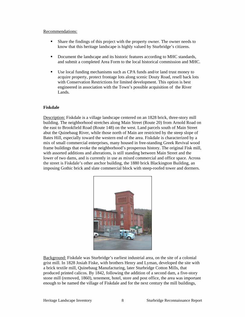
Fiskdale Description: Fiskdale is a village landscape centered on an 1828 brick, three-story mill building. The neighborhood stretches along Main Street (Route 20) from Arnold Road on the east to Brookfield Road (Route 148) on the west. Land parcels south of Main Street abut the Quinebaug River, while those north of Main are restricted by the steep slope of Bates Hill, especially toward the western end of the area. Fiskdale is characterized by a mix of small commercial enterprises, many housed in free-standing Greek Revival wood frame buildings that evoke the neighborhood’s prosperous history. The original Fisk mill, with assorted additions and alterations, is still standing between Main Street and the lower of two dams, and is currently in use as mixed commercial and office space. Across the street is Fiskdale’s other anchor building, the 1880 brick Blackington Building, an imposing Gothic brick and slate commercial block with steep-roofed tower and dormers.
Background: Fiskdale was Sturbridge’s earliest industrial area, on the site of a colonial grist mill. In 1828 Josiah Fiske, with brothers Henry and Lyman, developed the site with a brick textile mill, Quinebaug Manufacturing, later Sturbridge Cotton Mills, that produced printed calicos. By 1842, following the addition of a second dam, a five-story stone mill (removed, 1860), tenement, hotel, store and post office, the area was important enough to be named the village of Fiskdale and for the next century the mill buildings,

Heritage Landscape Inventory Sturbridge Reconnaissance Report 9
worker housing, shops and waterworks in the neighborhood continued to be associated with the cotton textile business under an assortment of names. The mills, vacant after World War II, have since been put to a variety of uses. A second brick mill building, constructed in 1859, was largely razed in 1972 and the remainder is in disrepair. Issues: It was clear to the research team that this area is a focal point of community concern and planning. Fieldwork participants offered extensive observations on the area’s issues and opportunities, and articulated a vision of what they would like to see transpire along Sturbridge’s Main Street. Although the selected priority landscape is defined specifically as Fiskdale, the issues and recommendations noted here are equally applicable to most of the central stretch of Main Street (Route 20) through Sturbridge, and especially to Snellville, the area adjacent to Fiskdale and differentiated only by its specific mill history.
Community members are seeking advice on ways to enhance what already exists in Fiskdale, and incentives for property owners to do so.
Visitors to OSV are, in some ways, a “captive audience” which would be
receptive to recreational and other opportunities elsewhere in Sturbridge. There is an expressed need to draw OSV tourists down the length of Main Street, featuring Fiskdale as the western gateway to the town.
There is community concern about the owners’ long-term intentions for the
Fiskdale mill and associated buildings. Two owners control an area of about 13 acres altogether.
Concern was expressed for protection of and public access to the river (see
Quinebaug discussion above). Concern was also expressed for the future of the south riverbank and rising slope
behind it, a scenic vista treasured by the community (also discussed under Quinebaug River section). The owner (Westville Development Corp.) controls approximately 140 acres in 2 large parcels along the south side of the river.
Recommendations: Numerous examples of individual building improvements, adaptive reuse, and historically sensitive updating are seen throughout Fiskdale, including the Fiskdale Mill, the Blackington Building, and at smaller historic properties being used for commercial purposes such as The Ginger Jar and the Sturbridge Country Inn, to name a few. What is needed now is a coordinated effort by municipal authorities and business owners to unify the village with an attractive, consistent, pedestrian-friendly streetscape, as well as encouragement to other property owners to participate in this community effort.
Investigate possibility of funding streetscape improvements by a Community Development Action Grant through the Massachusetts Department of Housing and Community Development. Such a grant might allow the Town to study and

Heritage Landscape Inventory Sturbridge Reconnaissance Report 10
then put in place enhancements including consistent, attractive, historically appropriate signage, street lighting, sidewalk rehabilitation and fencing.
Coordinate planning and public relations efforts between local businesses, Town
of Sturbridge, and Old Sturbridge Village to develop history- or eco-tourism opportunities in and around Fiskdale.
See Quinebaug section for further discussion of access and south bank
ownership. Theme: Ponds Description: The linear shape of the town of Sturbridge is reflected in the shapes of all its major ponds. Both are dictated by the north-south oriented, glacially formed uplands and valleys that characterize much of this area, across which the Quinebaug cuts and which it drains. Today, all of Sturbridge’s ponds serve recreational purposes. Big Alum has the densest residential development surrounding it, and Long Pond the least, its shoreline being owned by the Army Corps of Engineers.
Background: Leadmine Pond, the north end of Long Pond, Big Alum Pond, Cedar Lake, Walker Pond, and the part of Brookfield’s South Pond that extends into Sturbridge are all natural ponds, documented before industrial development on the 1795 map of the town and legally classified as Commonwealth Great Ponds. Long Pond was at least doubled in size as part of the 1964 East Brimfield Lake flood control project, and Westville Lake was created by a lower dam on the Quinebaug during the same period. The shores of Big Alum Pond – or Lake Pookookapog as it was called – became a vacation cottage site as early as the 1890s. In 1889, a local history described Walker Pond (earlier Saltonstall’s Pond) as a pleasure resort, probably due in part to its proximity to the trails and scenic vista available around Walker Mountain as well as a swimming area on the pond’s west side. These features were incorporated into Wells State Park when the Wells family donated 678 acres to the state in 1962. At present the

Heritage Landscape Inventory Sturbridge Reconnaissance Report 11
pond’s remaining shoreline is developmentally fairly stable, privately owned in sizable parcels and, at the southern end, bordered by the Massachusetts Turnpike. Issues:
A majority of Sturbridge’s ponds are.headwaters of short tributary streams that feed into the Quinebaug River. Thus the water quality of the ponds directly impacts the quality of the whole watershed. There is ongoing concern about the pollutant impact of construction activity and increased residential use around the shoreline.
Where waterfront property is at or near build-out, a second tier of residential
construction is taking place on the hillsides above the shore. This damages the scenic qualities of the surroundings that originally drew people to settle there. This problem is particularly noticeable in the vicinity of Big Alum Pond, where availability of town sewer permits construction on unperkable lots.
Sturbridge is experiencing major pressure on the town’s educational and public
safety infrastructure stemming from widespread conversion of summer cottages to year-round residences, that results in a significant permanent population increase.
Recommendations:
Continue to work with state and federal agencies to closely monitor water quality in each of Sturbridge’s ponds. DCR’s Lakes and Ponds program can be contacted for technical assistance.
Make residents around these ponds fully aware of the town’s Wetlands
Protection Bylaw through public education efforts, such as informational meetings and FAQ flyers.
When updating any Open-Space or Master Planning documents, include
proactive planning measures to counteract foreseeable threats, such as enactment of a seasonal conversion bylaw.
Consider application of neighborhood overlay zoning such as a pond overlay
district to areas within a given distance of pond shorelines. A neighborhood such as Big Alum Pond with its turn of the century cottages
would be an appropriate candidate for a Neighborhood Conservation District (NCD) described in more detail in Appendix B.
Sturbridge Town Common National Register Historic District Description: The historic civic, religious and commercial center of Sturbridge encompasses 138.15 acres including the town’s original six-acre common. It is further defined as the area along Main Street (Route 131) between Hall Road on the east and the I-84 overpass on the west, containing 47 public and privately owned properties. The area was designated a National Register Historic District in 1977. Over the past year, the

Heritage Landscape Inventory Sturbridge Reconnaissance Report 12
Historical Commission and other branches of town government engaged in a successful campaign to obtain Town support and funding for much-needed repairs to the Town Hall and Center School buildings, despite initial resident resistance to the proposal. The funds, for exterior preservation work and interior adaptive reuse, were derived in part from CPA money and also from a debt exclusion. They were approved at the April 2007 Town Meeting. Background: Sturbridge was incorporated as a town in 1738, and the present town common was immediately set off as the site for meetinghouse and burial ground. The common later developed into a center of commerce as well, due to the convergence of roads there. Sturbridge’s original, irregularly shaped common remains intact, surrounded by buildings of compatible sizes and forms in a wide range of styles, with a preponderance of Federal and Greek Revival structures. Properties include public institutions such as the Old Sturbridge Burial Ground (1738), Erasmus Babbit Inn or Publick House (1771), Sturbridge Town Hall (1838), Sturbridge Center School (1855), Joshua Hyde Public Library (1897), and the Federated Church of Sturbridge and Fiskdale (1910), as well as numerous residences. Many of the buildings are of local or regional historical importance, as well as architectural significance.
Issues:
The early date of Sturbridge’s National Register listing means that, by today’s standards, the level of documentation is not up to par.
Within the district, the Center School is the only building that is permanently
protected by a Preservation Restriction (1999). There is no Local Historic District designation and thus, no form of permanent protection for the buildings and features within the district.
The town common landscape is physically stressed by the amount and location of
parking during every community event. Root damage to the common plantings, especially to its older trees, occurs due to uncontrolled parking.

Heritage Landscape Inventory Sturbridge Reconnaissance Report 13
A longer-term potential issue is the threat to the area caused by increased traffic and construction activity if Route 15 (Mashapaug Rd) were commercially developed at some future time.
Recommendations:
The town should make every effort to designate the town common area as a Local Historic District. This designation provides a high level of protection for historic buildings and features. It is a necessary qualification for the town to attain Certified Local Government (CLG) status, which in turn will provide needed funds for public building preservation and rehabilitation.
The Historic Commission should review the status of all buildings, monuments
and landscapes within the district, and develop a set of recommendations to guarantee permanent preservation of these irreplaceable features. It should make an effort to inform private property owners of the values associated with Preservation Restrictions, and it should develop a priority list of town-owned buildings and landscapes – notably the Town Hall and the Old Burial Ground – that should be similarly protected.
National Register: The Historical Commission is encouraged to hire a consultant
to work with the town and MHC to further document the district’s resources and, perhaps most important, more strictly define the district’s boundaries in correlation with current assessor’s records. The review needs to include consideration of the significance of newer buildings between Haynes Road and I-84, and whether they should continue to be included in the district.
Hobbs Property (23 Hall Road) Description: This 23.43 acre property, bordered by Hall Road on the east and Hobbs Brook on the west, is notable for a long stretch of open field that parallels the road and is defined on the east by a tree-lined stone wall that marks the effective edge of beaver-dammed wetlands. The property includes a wood-frame house built by Samuel Hobbs about 1780, with an attached carriage shed and a barn. A tannery also stood near the intersection of Hall Road and East Main Street., although no sign of the business is immediately visible today. Approximately the southern half of the property, which includes the house is located within the Sturbridge Common National Register Historic District.

Heritage Landscape Inventory Sturbridge Reconnaissance Report 14
Background: Samuel Hobbs, a participant in the Boston Tea Party, operated a tannery adjacent to the brook until his death in 1823. Later generations of the family continued the business at least as late as 1870. Sturbridge selectman William Whittemore occupied the house from the late 19th into the 20th century. The property continues to be privately owned. Issues:
Preservation of open field as buffer for Hobbs Brook wetlands and scenic vista on Hall Rd (in contrast to a stretch just north, which has unattractive modern industrial buildings).
Recommendations:
Share the findings of this project with the property owner. The owner needs to know that this heritage landscape is highly valued by Sturbridge’s citizens.
Revise the Town Common NR boundaries to include the whole property.
Encourage present owner to place a Conservation Restriction on his property.
Enact a Scenic Roads Bylaw and list the southern end of Hall Road, to protect the
mature trees and stone walls that define its character. Old Sturbridge Village (1 Old Sturbridge Village Road) Description: A world-renowned open air history museum that combines historic architecture, material culture collections, costumed interpretation and educational programs to interpret New England village life of the early 19th century. OSV was the largest single private landowner in Sturbridge, owning 1,260 acres of land in the center of town plus 52 buildings by 2006, when a substantial portion of the OSV real estate – 814 acres of the Village’s “back land” – was sold to the Town of Sturbridge. The portion still owned by the Village, over 400 acres, includes the core museum landscape with its collection of historic buildings and reconstructed craft shops, as well as associated collections storage, educational, commercial, and administrative buildings fronting on Old Sturbridge Village Road. The landscape includes a stretch of the Quinebaug River and of the Grand Trunk Railway.
(OSV photo)

Heritage Landscape Inventory Sturbridge Reconnaissance Report 15
Background: Old Sturbridge Village was founded in the late 1930s by the Wells family of Southbridge, to house their collections of early 19th century Americana and interpret the life of early industrial-era rural New England (ca. 1790-1840) to the public. The living history museum opened to the public in 1946 on land that had constituted David Wight’s farm in the early 19th century. Wight had dammed the Quinebaug River where it flowed through his land to provide power for a saw and gristmill operation. Currently, OSV is streamlining its museum operations and repositioning itself to better respond to the needs of contemporary museum audiences. Issues: A local official observed: OSV is an essential part of our landscape and our economy; if OSV were to close, the Town of Sturbridge would lose its identity to the outside world.
The economy and identity of Sturbridge are, to an important extent, dependent on supporting OSV in its current repositioning efforts.
Recommendations:
The town needs to bear in mind that they can contribute significantly to OSV repositioning efforts, by providing additional recreational and educational opportunities to broaden and extend a visitor’s stay in town.
To this end, it is vital that the town, Chamber of Commerce, Regional Tourism
Council and OSV should coordinate marketing and tourism planning in Sturbridge to:
1. draw the OSV tourist into other commercial and historic areas of Sturbridge
(such as the Town Common area or Fiskdale).
2. attract tourists with a combination of living history and ecotourism opportunities, such as kayaking and rafting on the Quinebaug; passive recreational activities at the site of Camp Robinson Crusoe; biking and hiking along the Grand Trunk Railway line and other trails already extant.
3. coordinate visitor services and advertising among the numerous recreational
property owners and managers in the town.

Heritage Landscape Inventory Sturbridge Reconnaissance Report 16
PART II
BUILDING A HERITAGE LANDSCAPE TOOLKIT
Heritage Landscape Inventory Sturbridge Reconnaissance Report 17
EIGHT TOOLKIT BASICS As our communities undergo rapid land use changes, heritage landscapes are particularly threatened because they are often taken for granted. There is a broad variety of resources that communities can call upon to protect these irreplaceable resources. Below is a checklist of the basics. Each is discussed in the sections that follow and in Appendix B. 1. Know the resources: Inventory We cannot advocate for something until we clearly identify it – in this case, the physical characteristics and historical development of the town’s historic and archeological resources. The necessary first step is to record information about the resources at the Massachusetts Historical Commission. 2. Gain recognition for their significance: National Register Listing The National Register of Historic Places is the nation’s official list of cultural resources worthy of preservation. Listing brings a number of benefits including recognition, consideration when federally-or state-funded projects may impact the resource, eligibility for tax credits, and qualification for certain grant programs. 3. Engage the public: Outreach, Education and Interpretation In order to create a community of advocates, we need to raise public awareness and broaden the base of support. This includes developing opportunities to learn about and celebrate the places and history of the town, as well as to care for them. 4. Think in context: Comprehensive and Open Space Planning It is important that Open Space Plans and Comprehensive or Master Plans address heritage landscapes as vital features of the community, contributing not only to a unique sense of place but also to environmental, recreational and economic health. 5. Develop partnerships: The Power of Collaboration Protecting community character, respecting history, and promoting smart growth are interrelated concerns that impact heritage landscapes and require collaboration across a broad spectrum of the community. This includes communication among town boards and departments, as well as public-private partnerships. 6. Defend the resources: Zoning, Bylaw and Ordinance Mechanisms Effective and innovative preservation tools exist in the legal and regulatory realm. These range from a wide array of zoning, bylaw and ordinance mechanisms, to incentive programs and owner-generated restrictions on land use. 7. Utilize the experts: Technical Assistance Regulations and creative solutions for heritage landscapes are constantly changing and emerging. Public and private agencies offer technical assistance with the many issues to be addressed, including DCR, MHC, the Heritage Corridor and the Central Massachusetts Regional Planning Commission. 8. Pay the bill: Funding Preservation Funding rarely comes from a single source, more often depending on collaborative underwriting by private, municipal, and regional sources. Each town also has a variety of funding sources that are locally based and sometimes site specific.

Heritage Landscape Inventory Sturbridge Reconnaissance Report 18
STURBRIDGE’S TOOLKIT – Current Status and Future Additions
What follows is a review of the tools that Sturbridge already has in place, as well as a look at a number of additional tools. The tools already in place for Sturbridge provide a good foundation for heritage landscape preservation, but their efficacy as protection for the town’s natural and cultural resources can be significantly improved by strengthening existing measures and putting others in place. Appendix B includes extended descriptions of preservation measures; the specific applications of those tools to Sturbridge’s resources are described below. The appendix also contains a full description of additional avenues and creative approaches that Sturbridge might consider in developing a multi-pronged strategy for preservation. A tool that has been proven to be one of the single most valuable resources in protecting heritage landscapes has been the Community Preservation Act (CPA). Sturbridge has been an excellent model for how a town’s resources can be brought to bear on heritage landscape preservation through the CPA program, in particular allowing the town to purchase the Old Sturbridge Village parcel with $2 million in town funds and $2 million in state matching funds. These tools should be considered in combination with those recommendations made for Sturbridge’s priority landscapes, above.
1. Know the resources: Inventory
Current: According to the Massachusetts Historical Commission, the town’s inventory includes documentation for 215 buildings, structures and sites, a majority in the Sturbridge Common National Register Historic District and along Main Street in Fiskdale and Snellville. In addition, Sturbridge has documented 16 precontact Indian sites and 48 historic archaeological sites on MHC inventory forms. Additions: The inventory process, completed between 1971 and 1974 for Sturbridge is an important beginning of documentation for the town’s historic assets. It is vital that Sturbridge renew this process as soon as possible, by working with the Massachusetts Historical Commission to update its town-wide historic resources survey. The survey should prioritize heritage landscapes such as those listed in this report. It should include representative and significant structures, features and landscapes from all periods of Sturbridge’s history and from all geographic areas. It is recommended that a similar, archaeological survey be completed for the community. Known and potential precontact Native American and historic archaeological sites should be documented in the field for evidence of their cultural association and/or integrity. Funding assistance for both of these efforts would also be available from the MHC Survey and Planning grants, as well as CPA funding
2. Gain recognition for their significance: State and National Register Listing
Current: Sturbridge has 52 properties and features listed in the National Register. Fifty-one of these are within the Sturbridge Common National Register Historic

Heritage Landscape Inventory Sturbridge Reconnaissance Report 19
District (1977) ; the remaining one is the Tantiusques Reservation Site, listed as an individual property in 1983. All are automatically listed in the State Register of Historic Places. The Sturbridge Center School (301 Main Street), the only building in town protected by a Preservation Restriction (1999), is also listed on the State Register of Historic Places. There are no local historic districts in Sturbridge. Additions: It is recommended that the Sturbridge Historical Commission pursue the creation of a Local Historic District around the town common, to provide protection to this area. The town should also work with MHC on the prioritization of areas and sites for additional National Register listing, especially the Fiskdale-Snellville section of Main Street.
3. Engage the public: Outreach, Education and Interpretation
Current: The Town Common Historic District has signage at its approaches, with descriptive plaques on the Common itself, at the Old Burial Ground and at the Center School. A similar historic plaque is located at the Snellville School (now the Senior Center). Two other historical markers include a Massachusetts Tercentenary Commission marker on Route 15 identifying the area as “Tantuisquis”, and a marker on Fiske Hill at McGilpin Road identifying the site of the Fiske Hill School. Additions: One of the five goals of the Open Space Plan is outreach to increase public awareness and support of open space. This goal should be expanded to include increased awareness of heritage landscape values and issues. Expansion of the historic marker program to provide consistent interpretive signage throughout the town will reinforce the wide geographic and chronological range of Sturbridge’s heritage landscapes. Directional signage for tourists and visitors to Old Sturbridge Village, encouraging wider exploration of the town’s historic resources, will help draw visitors both to the Town Common National Register Historic District and along the length of Main Street. This might be included as part of a broader “Now Visit the Other Sturbridge” (or “New Sturbridge Village”) promotional campaign. Preservation Mass, as the statewide preservation advocacy organization, is a source of support for advocacy. They have a program that annually identifies and publicizes the 10 Most Endangered historic resources in the Commonwealth, which is a good way to advocate for resources that are imminently threatened.
4. Think in context: Comprehensive and Open Space Planning
Current: Open Space and Recreation Plan 2005 The Plan underscores the importance of the scenic and historic qualities of Sturbridge to its residents and tourists. It notes that a principal component of that character is the experience of those qualities from the road.

Heritage Landscape Inventory Sturbridge Reconnaissance Report 20
The Plan also significantly emphasizes that, although some of the goals and issues of preservation, conservation, and recreation may be distinct, the three need to be approached in an integrated manner. Additional Planning Some of the Plan’s goals directly relate to the issues and recommendations contained in this report. The first goal concerns Community Character and includes the objective to identify the natural and historic elements that contribute to the Town’s character, and to develop preservation strategies. Other related objectives are to preserve agriculture and to review zoning bylaws in order to mitigate the impact of development. The town is presently undertaking a strategic planning process and zoning bylaw review that will guide development, economic health, and protection of the historical, environmental and rural character of Sturbridge. The recommendations in this report regarding protection mechanisms should be considered during this process.
5. Develop Partnerships: the Power of Collaboration
Current Status
Old Sturbridge Village and the Town of Sturbridge are collaborating on investigating ways that the development and promotional goals of both can be coordinated. Additional Efforts The Open Space Plan proposed that partnerships be explored with garden clubs and other community organizations to help with the purchase of street trees when replacements are needed but beyond the reach of town budget limits – this should be pursued, not only for its obvious scenic benefits, but also because such partnerships develop a large cadre of citizen stewards for the landscape. The Plan also included an objective to continue dialogue and partnerships with state and federal conservation groups and non-profit owners of land in Sturbridge. This is critically important to ensure good stewardship and to advance opportunities for purchase or permanent protection. Individuals and organizations involved with each of the priority landscapes inventoried in this report should seek out collaborative opportunities as, for instance, a cooperative effort between the Chamber of Commerce and Fiskdale to put a streetscape design in place.
6. Defend the Resources: Zoning, Bylaw and Ordinance Mechanisms
Current Mechanisms
Village Center Zoning: A Historic Commercial District overlay applied to the Sturbridge Common area is designed to permit commercial uses consistent with the historic integrity of this National Register District. Design Review and Site Plan Review are applied within this district.
Heritage Landscape Inventory Sturbridge Reconnaissance Report 21
Other Zoning Provisions: The Open Space Plan points out that the town has a provision for multiple dwelling projects that requires 10% of the land to be left as open space. It also, however, recommends that Sturbridge develop flexible or cluster zoning to more effectively protect open space. This is an important tool to pursue.
Shade Tree Bylaw: This bylaw recognizes the aesthetic, environmental, and economic value of street trees. It can be used to prevent the removal of healthy street trees and provides for penalties for unauthorized removal of trees. Sturbridge is also a Tree City USA.
Additional Mechanisms Three basic strategies have consistently proven effective as basic preservation tools in communities throughout Massachusetts.
1. Demolition Delay Bylaws provide a time period in which towns can explore alternatives to demolition of historic buildings. Sturbridge adopted a demolition Delay Bylaw at the April 2007 Town Meeting. The Sturbridge Historical Commission should work with other town groups to publicize the advantages of this bylaw to the community. The most valuable aspect of this bylaw is that it creates space within which to have a conversation about how private and public needs can both be met in the service of preservation. Many towns have found that a delay of one year is the most effective time frame within which to negotiate alternatives to demolition. A majority of the bylaws apply to all structures built over 50 years ago, in accordance with federal standards.
2. Neighborhood Architectural Conservation Districts (NACD), further
explained in Appendix B, are local initiatives that recognize special areas within a community where the distinctive characteristics of buildings and places are preserved and protected. The Sturbridge Historical Commission should work with the MHC staff to determine how an NACD can help to maintain the character of areas which have changed through time, but which retain a valued neighborhood “feel” that may be threatened by incompatible development
3. Local Historic Districts (LHD), further explained in Appendix B, are
also local initiatives and the strongest form of protection to preserve special areas with distinctive buildings and places. Unfortunately, National Register listing provides minimal protection for historic landscapes and structures. Local designation can be tailored to specific community needs, and often protects private investment by enhancing property values. Sturbridge knows well that the key to tourism and, in part, to economic development, is the preservation of its rural and village center character of the town. Establishment of the Town Common as a Local Historic District would go a long was toward assuring that preservation.

Heritage Landscape Inventory Sturbridge Reconnaissance Report 22
Additional mechanisms specific to Sturbridge’s landscapes The following recommendations are organized by the types of resources that Sturbridge has, and measures that should be considered to strengthen their protection. Mill Villages and Industrial Structures A defining characteristic of the Quinebaug Valley and Sturbridge in particular are the mill villages that exhibit the vestiges of the transformative power of the industrial revolution in mills, dams, mill worker housing and transportation elements such as the associated rivers, canals and railroads. Sturbridge exhibits that history in the villages of Fiskdale and Snellville. At present the mills in the Fiskdale/Snellville area actually fall into two distinct zoning districts: those on Route 20 are located in a Commercial Tourist zone that allows for mixed commercial and residential uses. The remaining Fiske mill on Holland Road lies within a General Industrial Zone, however, which does not permit mixed use. It would be beneficial for the Town to adopt a Mill Overlay District in this area to allow for flexibility and consistency in adaptive reuse of its mill buildings. Agricultural Lands Preservation of agricultural landscapes means preservation of the farming activities; otherwise, it simply is the preservation of land as open space. There are instances in which changing technology sometimes requires modifications to existing farm structures or the addition of new ones. It is important to know what the features of an agricultural setting are and which features the community treasures in order to make a case for preservation of these settings. Appendix B has a full list of regulatory tools that should be considered to protect agricultural land; the following highlights important measures to meet the needs of agricultural protection in Sturbridge. 1. Create an Agricultural Commission, a standing committee of town government
created through vote at Town Meeting. This Commission would represent the farming community, promote agricultural-based economic opportunities, and work to protect and sustain agricultural businesses and farmland. NOTE: Sturbridge approved formation of an Agricultural Commission at the April 2007 Town Meeting.
2. Prioritize parcels under Chapter 61A for future acquisition. Should the land owner choose to withdraw a parcel from Ch 61, the town has only 120 days to act on its right of first refusal. The need to pay fair market value makes it challenging for the town to effectively act on this right, although passage of the CPA has greatly enhanced Sturbridge’s position.
3. Strengthen public-private partnerships to preserve farmland through purchase of APRs or CRs.
4. Develop partnerships with land protection organizations including the Opacum Land Trust, to purchase development rights on farms or to assist a farmer in the

Heritage Landscape Inventory Sturbridge Reconnaissance Report 23
restoration of historic farm buildings for which the owner would be required to donate a preservation restriction (PR).
5. Make information about the Massachusetts Department of Agricultural Resources programs available to farmers, including the Farm Viability Enhancement Program (technical assistance, funding) and the Agricultural Environmental Enhancement Program (supports best management practices for agricultural operations to mitigate impacts on natural resources).
6. Adopt Open Space Zoning (also known as Cluster Zoning), as recommended in the Master Plan, which serves the dual purpose of allowing landowners to develop their property, while protecting substantive parcels of open space.
7. Document farms that are considered critical to the character of Sturbridge’s community using MHC survey forms.
8. Adopt a right-to-farm bylaw which allows farmers to carry on farming activities that may be considered a nuisance to neighbors. Refer to Smart Growth Toolkit at: http://www.mass.gov/envir/smart_growth_toolkit/bylaws/Right-to-Farm-Bylaw.pdf
9. Explore Community Supported Agriculture (CSA), a partnership between a farm and a community of supporters. Community members cover a farm’s yearly operating budget by purchasing a share of the season’s harvest. This relationship guarantees farmers a reliable market, while assuring the members high quality produce, often below retail prices.
Scenic Roads Scenic roads are an integral part of the historic fabric of the community, and are highly valued by Sturbridge residents and visitors alike.. Roads must also accommodate modern transportation needs and decisions regarding roadways are often made with travel and safety requirements as the only considerations. Sturbridge has adopted the Scenic Roads Act (MGL Chapter 40-15C) and has designated portions of thirty-one roads for which there need to be review and approval for the removal of trees and stone walls within the right-of-way. In addition to roadway issues, much of what we value about scenic roads – the stone walls, views across open fields and the many scenic historic buildings – is not within the public right-of-way. The preservation and protection of scenic roads therefore requires more than one approach. 1. Complete an inventory with descriptions and photo documentation of each of the
roads in Sturbridge considered to be scenic, including the character-defining features that should be retained.
2. Post attractive road signs that identify the scenic roads in town. 3. Coordinate procedures between Highway Department and Planning Board or
Historical Commission. 4. Consider a Scenic Overlay District which may provide a no-disturb buffer on
private property bordering on scenic roads or adopt flexible zoning standards to protect certain views. Such bylaws would apply to the landscapes bordering state numbered roadways, which would not be protected under the scenic roads designation, as well as to landscapes bordering town roads.
5. Develop policies and implementation standards for road maintenance and reconstruction, including bridge reconstruction, which address the scenic and historic characteristics while also addressing safety. This is an important public process in which the community may have to accept responsibility for certain

Heritage Landscape Inventory Sturbridge Reconnaissance Report 24
costs to implement standards higher than those funded by Mass Highway Department. Such standards should have a section addressing the way in which the local Highway Department maintains roads; for example, requiring a public hearing if any new pavement width is to be added to a town road during reconstruction or repair. Policies can be adopted by local boards having jurisdiction over roads, or can be adopted at Town Meeting through a bylaw. In developing policies consider factors such as road width, clearing of shoulders, walking paths and posted speeds. A delicate balance is required.
8. Pay the Bill: Funding Preservation A list indicating the full range of available governmental and non-profit sources of funding can be found in Appendix B

Heritage Landscape Inventory Sturbridge Reconnaissance Report 25
CONCLUSION AND IMPLEMENTATION Sturbridge’s residents have a strong sense of place, defined by the town’s varied natural features and the historic land use patterns that grew out of them. The town has already begun to document and evaluate its most significant buildings and natural areas. It must now also look beyond these traditional resources to the landscapes, streetscapes, rural roads, neighborhoods and other natural and cultural assets that define the community’s character. Like most municipalities, Sturbridge is facing multiple pressures for change that will have permanent impact on land-based uses and natural resources, especially its remaining farming areas. Special places within the community that were once taken for granted are now more vulnerable than ever to change. The Sturbridge Reconnaissance Report is a critical tool in identifying the rich and diverse heritage landscapes in Sturbridge and in developing creative preservation strategies and partnerships. Sturbridge will have to determine the best ways and sequence in which to implement the recommendations discussed above. The town would do well to form a Heritage Landscape Committee, as described in DCR’s publication, Reading the Land. Landscapes identified in this report, especially the priority landscapes, will benefit from further documentation in accordance with MHC guidelines. The documentation in turn will provide an information base for the local publicity needed to build consensus and gather public support for landscape preservation. Implementing many of the recommendations in this report will require a concerted effort by and partnerships among municipal boards and agencies, local non-profit organizations, and regional and state agencies and commissions. There are no quick fixes for the challenges of managing growth and funding preservation. Many of the recommended tasks and approaches will require cooperation and coordination among a number of municipal, regional and state partners to be successful. They will require time and a good dose of patience, as volunteer schedules, legislative procedures, and funding cycles try to mesh. Circulating this Reconnaissance Report is an essential first step. The recommendations should be presented to the Board of Selectmen, who represented Sturbridge in its application to the Heritage Landscape Inventory program. Copies of the report should be available on the town’s web site and distributed to town departments and boards, particularly Sturbridge 's Historical Commission, Planning Board, and Conservation Commission and will also be useful for the Sturbridge Historical Society, neighborhood associations, local land trusts, and other preservation organizations. Finally, a reference copy belongs in the town library. All of these circulation efforts will broaden citizen awareness, and result in increased interest and support for Sturbridge's heritage landscapes. Finally, the project team suggests that the following recommendations be the top three priorities for Sturbridge as the town works to protect the character of its community:
1. Acquire and protect the River Lands. 2. Develop a streetscape improvement plan for Main Street/Route 20. 3. Establish a permanent working committee with OSV and the ACE to develop
and implement public relations and tourism projects.
Heritage Landscape Inventory Sturbridge Reconnaissance Report i
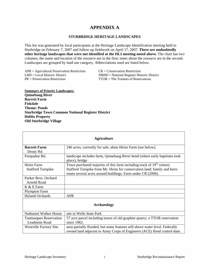
APPENDIX A
STURBRIDGE HERITAGE LANDSCAPES
This list was generated by local participants at the Heritage Landscape Identification meeting held in Sturbridge on February 7, 2007 and follow-up fieldwork on April 17, 2007. There are undoubtedly other heritage landscapes that were not identified at the HLI meeting noted above. The chart has two columns; the name and location of the resource are in the first; notes about the resource are in the second. Landscapes are grouped by land use category. Abbreviations used are listed below. APR = Agricultural Preservation Restriction CR = Conservation Restriction LHD = Local Historic District NRHD = National Register Historic District PR = Preservation Restriction TTOR = The Trustees of Reservations Summary of Priority Landscapes: Quinebaug River Barrett Farm Fiskdale Theme: Ponds Sturbridge Town Common National Register District Hobbs Property Old Sturbridge Village
Agriculture
Barrett Farm Douty Rd.
246 acres, currently for sale; abuts Heins Farm (see below).
Farquahar Rd. landscape includes farm, Quinebaug River bend (where early baptisms took place), bridge
Heins Farm Stafford Turnpike
Town purchased majority of this farm including track of 19th century Stafford Turnpike from Mr. Heins for conservation land; family and heirs retain several acres around buildings. Farm under CR (2006).
Parker Bros. Orchard Arnold Road
K & E Farm Plympton Farm Hyland Orchards APR
Archaeology
Nathaniel Walker House site in Wells State Park Tantiusques Reservation Leadmine Road
57 acre parcel including traces of old graphite quarry; a TTOR reservation since 1962.
Westville Factory Site area partially flooded, but some features still above water level. Federally owned land adjacent to Army Corps of Engineers (ACE) flood control dam.

Heritage Landscape Inventory Sturbridge Reconnaissance Report ii
Burial Grounds and Cemeteries
theme: the cemeteries - St. Anne’s Catholic Cemetery, Arnold Rd: includes burials relocated from
earlier cemetery which is within floodplain of East Brimfield Dam. - North Cemetery: includes Civil War burials; cemetery in good condition - Old Burial Ground: part of town common NRD; earliest stone dated 1733.
Civic / Institutional
Old Sturbridge Village 400 acre history museum complex, established 1938. St. Anne’s Shrine Church St.
“Before there was OSV, there was the shrine. People came from all over to see it.” Includes shrine, open-air pavilion, landscaped grounds.
theme: over 15 schoolhouse sites
Commercial / Industrial
Fiskdale Rte 20 & Holland Rd.
including two mill buildings, pond adjacent to Quinebaug, hill and commercial buildings including Blackington Building. Area abuts 3 river parcels that town is working to acquire.
Cheese House Route 20?
One of 11 cheese-wheel shaped buildings left in the country
Snellville Cedar St to Arnold Rd
mill housing; hand dug diversion canal, and factories
Miscellaneous
Viewscape: from Shepard Rd. at Westville
overlooks Westville Dam, Quinebaug River, historic houses
Viewscape: west from Rte 20 entering town
Fiske Hill - archaeological (rock shelter/Indian camp) - scenic road - vistas - historic buildings
Viewscape: Mt. Dan theme: stone walls Found throughout town View of Stallion Hill from Rte 20
Across the Quinebaug to the back side of Barrett Farm, now wooded; beautiful fall foliage
Open Space/ Recreation/ Parks
Quinebaug River Major waterway through town; mill sites, recreational boating, scenic vistas.

Heritage Landscape Inventory Sturbridge Reconnaissance Report iii
theme: Ponds Big Alum Pond Cedar Lake Leadmine Pond Long Pond South Pond Walker Pond Westville Lake
A number of development issues concern ponds and associated land
Opacum Woods 266 acres donated 2003 to Opacum Land Trust, CR held by DEM. Includes forest, streams, rare and common animal habitat, 20 state-certified vernal pools, old growth forest, historic and prehistoric archeological sites, a beaver pond and a cranberry bog.
Camp Robinson Crusoe First coed youth camp in the US; now part of the 814 acres purchased by the town from OSV.
Long Pond west shore also view from across pond Land offered to the Reverend John Eliot in 1670s for the Quaboag Christian Indian village but village never actually established.
Breakneck Brook including Breakneck Road and hillside Rod & Gun Club Hamilton Rd
Over 60 yrs old – site formerly the home of Deacon John Phillips.
Rte 49/Podunk Pike/Walker Mtn. Ridge
Gateway into town from NE corner. Officially called the Phillip Quinn Memorial Highway
Residential
Hobbs Property Hall Rd.
Includes hayed fields; historic house originally owned by Samuel Hobbs, a Boston Tea Party participant
Auchmoody property Brookfield rd
Previously owned by Monahan. Farmhouse w/ big barn – property likely split when Mass. Turnpike went through.
Oliver Wight House OSV
One of original Wight family buildings within OSV, most recently used as part of the Lodge; currently for sale with cottages and motel at rear.
Transportation
Mile marker Gifford Rd
marks distance to Boston on Stafford Turnpike: 64 miles; now on private property
OSV Access Road (scenic road) Route 20 the public face of Sturbridge that every visitor sees Bay Path Southbridge airport to Brimfield line
portions of path are still walking trails.
Connecticut Path
aka Woodstock Path: Wallace Rd to Fiske Hill Rd
Quaboag Path
aka Brookfield-Woodstock Path: New Boston Road above Rte 20
Village
Town Common NRHD 1977; town hall, church, cemetery, common, school, houses

Heritage Landscape Inventory Sturbridge Reconnaissance Report iv
APPENDIX B
GUIDE TO PRESERVATION AND PLANNING TOOLS FOR HERITAGE LANDSCAPES Preservation planning is a four-step process: identification, evaluation, education and protection. Within the realm of protection, there is a vast array of tools that communities can call upon and that are most effective when used in combination with one another. Stewardship of these resources involves education and community support, planning with a clear set of goals, and regulatory mechanisms. Three useful documents to consult when planning preservation strategies are: Department of Conservation and Recreation, Reading the Land
Massachusetts Historical Commission, Survey Manual
Massachusetts Historical Commission, Preservation through Bylaws and Ordinances
The following eight sections – based on the Toolkit Basics – detail the resources and strategies available for heritage landscape preservation—from documentation and evaluation, to public education, to regulating activities and finding the revenue necessary to fund the effort. 1. KNOW THE RESOURCES: INVENTORY The vital first step in developing preservation strategies for heritage landscapes is to record information about the resources on MHC inventory forms. One cannot advocate for something unless one knows precisely what it is – the physical characteristics and the historical development. Survey methodology has advanced since the early work of the 1980s. If a community had survey work done during that time period, it is time for an inventory update, looking at resources in a more comprehensive and connected way than may have been done at that time. Even if survey work is more recent, there may be a need to document more resources throughout the community. Using the Massachusetts Historical Commission survey methodology:
a. Compile a list of resources that are under-represented or not thoroughly researched, beginning with heritage landscapes.
b. Document unprotected resources first, beginning with the most threatened resources.
c. Make sure to document secondary features on rural and residential properties, such as outbuildings, stone walls and landscape elements.
d. Record a wide range of historic resources including landscape features and industrial resources.
e. Conduct a community-wide archaeological reconnaissance survey to identify patterns of prehistoric and historic occupation and to identify known and probable locations of archaeological resources associated with these patterns. Known and potential precontact and historic archaeological sites should be professionally field-checked to evaluate cultural associations and integrity. A professional archaeologist is one who meets the professional

Heritage Landscape Inventory Sturbridge Reconnaissance Report v
qualifications (950 CMR 70.01) outlined in the State Archaeologist Permit Regulations (950 CMR 70.00).
NOTE: The Inventory of Archaeological Assets of the Commonwealth contains sensitive information about archaeological sites. The inventory is confidential; it is not a public record (G.L. c. 9, ss. 26A (1)). Care should be taken to keep archaeological site information in a secure location with restricted access. Refer to the MHC article "Community-Wide Archaeological Surveys" which appeared in Preservation Advocate, Fall 2005, and which can be found at the following MHC link: http://www.sec.state.ma.us/mhc/mhcpdf/pafall05.pdf.
2. GAIN RECOGNITION FOR THEIR SIGNIFICANCE: NATIONAL REGISTER LISTING Survey work includes evaluation of whether resources meet the qualifications for National Register listing. This will provide new information about the eligibility of properties. Using the information generated in the survey work and the accompanying National Register evaluations, expand your town’s National Register program.
Develop a National Register listing plan, taking into consideration a property’s or area’s integrity and vulnerability. Properties in need of recognition in order to advance preservation strategies should be given priority.
3. ENGAGE THE PUBLIC: OUTREACH, EDUCATION AND INTERPRETATION The best stewards and advocates for heritage landscape protection are members of the community. There are many ways to communicate the importance of these special places to the public, and to connect their preservation with the shared values and goals that community members have already expressed in various planning documents and forums. Think creatively about how to educate the community about the values and threats to heritage landscapes, and how each town resident benefits from these special places. Use a combination of strategies to get the word out about heritage landscapes and preservation of community character, including:
Festivals and Tours – Tours are a great way to draw attention to the history around us, and to engage more people in caring for it. Consider hosting a Heritage Celebration Day including tours and family-friendly activities, or plan a celebration around a particular place or area on a meaningful date. Make sure events are well publicized.
Signage and Banners – Signs are a very effective way to announce special historic sites and
districts. Banners can also bring attention to the significance of an area and make a celebratory statement about its contribution to the town.
Written Materials – Clear, concise and engaging written material with engaging illustrations is a
reliable way to relay information about community character and heritage landscapes. Make use of fact sheets and flyers to get the word out on particular issues such as a town ordinance that protects heritage landscapes, a threat that needs to be addressed, or an upcoming event.
School Curricula – Start teaching at a young age. Children are very receptive to engaging
stories, and there are no better stories to excite childrens’ imaginations and build pride of place than stories of their town’s past and present. Teachers have an opportunity to connect history

Heritage Landscape Inventory Sturbridge Reconnaissance Report vi
with environmental issues through classroom study, hands-on history projects, and field exploration of a town’s heritage landscapes. Subsequently, students have an opportunity to teach their parents that preservation is everybody’s business.
Lectures and Workshops – Use these forums to raise awareness, educate at a deeper level about
the community’s history and its resources, and broaden the base of interest. Website – Keep Historical Commission and local historical organizations’ entries on the town’s
website current, and include information about issues, proposals for preservation strategies, and upcoming events.
Press Releases – Use all avenues including press releases to keep the public informed when a
meeting or event is about to occur. Work with local reporters to develop special interest articles that highlight landscape resources.
Remember that bringing an issue or a heritage landscape to people’s attention once will have only short-term effect. Outreach, education and interpretation must be ongoing concerns that involve preservation and conservation interests, teachers and community organizations in repeated projects to attract and engage the general public. 4. THINK IN CONTEXT: COMPREHENSIVE AND OPEN SPACE PLANNING Communities use a variety of planning exercises and documents to define their goals and vision of the future, address community-wide issues, and recommend measures to respond to them. There are state mandates for towns to prepare Comprehensive or Master Plans and Open Space and Recreation Plans.
Comprehensive or Master Plans provide an important frame of reference for land use decisions, and incorporate all of a community’s issues including economic development, housing and transportation into an integrated plan. Heritage landscapes need to be seen through the lenses of community character, historic preservation, environmental health, and economic viability and growth. Their future and the values they contribute should be addressed within these multiple perspectives, not solely as historical assets of the community.
Like Comprehensive Plans, Open Space Plans look holistically at the community—its history, demographics and growth patterns, and current conditions—to make recommendations that protect open space and natural resources for ecological health and public benefits. The Heritage Landscape Inventory Program provides a framework for looking at these important resources, and this new understanding should be incorporated into Open Space Plans.
5. DEVELOP PARTNERSHIPS: THE POWER OF COLLABORATION Because heritage landscapes encompass such a broad range of resources and issues—from preservation of town centers, scenic roads and river corridors to promotion of smart growth and economic development – stewardship of these resources involves many interests in a community. It is essential that there be good communication between the many departments and committees that address issues related to heritage landscapes. Collaboration between public and private partners is also an essential element in a successful preservation strategy. National Heritage Corridor personnel are helpful guides to partnership opportunities for projects you may have in mind.

Heritage Landscape Inventory Sturbridge Reconnaissance Report vii
Broaden the base. Preservation, particularly preservation of landscapes, is not just for the Historical Commission. It is important that the cause not be marginalized by those who view preservation as opposed to progress, or to personal interests. A look at DCR’s Reading the Land shows the range of organizations and viewpoints that value heritage landscapes.
Nurture public-private partnerships. Friends groups, neighborhood associations, and local land trusts all have important roles to play to spread the word, and to expand the capacity of the public sector to care for heritage landscapes.
Take advantage of forums created to share issues and ideas. For instance, the Massachusetts Department of Agricultural Resources offers a “cluster” format for monthly discussion and information exchange meetings among area farmers.
Share resources across communities. Towns that lack funding for a town planner position, for instance, have found that “sharing” a planner with another community can be quite effective.
6. DEFEND THE RESOURCES; LAWS, BYLAWS AND REGULATIONS A wide range of laws, bylaws and regulations is available to protect heritage landscapes. Following are brief descriptions of some of the most widely used and/or most effective of these tools, arranged alphabetically. Adaptive Reuse Overlay District An Adaptive Reuse Overlay District is superimposed on one or more established zoning districts in order to permit incentive-based reuses of existing built properties. These districts can be created to allow for the adaptive reuse of properties of a certain kind, or within a specified area within a community. As an overlay zone, all regulations pertaining to the underlying zone apply, except to the extent that the overlay zone modifies or provides for alternatives to the underlying requirements. Agricultural Preservation Restrictions (APR) This program, managed by the Department of Agricultural Resources, offers to pay farmers the difference between the "fair market value" and the "agricultural value" of farmland located on prime agricultural soils, in exchange for a permanent deed restriction which precludes any use of the property that will have a negative impact on its agricultural viability. This program is different from the Chapter 61 program, which provides tax incentives for short term restrictions. Community Preservation Act The Community Preservation Act is statewide enabling legislation that allows communities to assemble funds for historic preservation, open space protection and affordable housing through a local property tax surcharge (up to 3%, with some allowable exemptions) and state matching funds. These funds can support a wide variety of activities, including inventory and documentation of historic resources, restoration and acquisition. Conservation Restrictions (CR) A permanent deed restriction between a landowner and a holder - usually a public agency or a private land trust; whereby the grantor agrees to limit the use of his/her property for the purpose of protecting certain conservation values in exchange for tax benefits. EOEEA’s Division of Conservation Services provides assistance to landowners, municipalities, and land trusts regarding conservation restrictions and has produced The Massachusetts Conservation Restriction Handbook as a guide to drafting conservation restrictions.

Heritage Landscape Inventory Sturbridge Reconnaissance Report viii
Corridor Protection Overlay District A Corridor Protection Overlay District is intended to promote appropriate development within a given corridor, serving to protect natural (and sometimes cultural) resources. As an overlay zone, all regulations pertaining to the underlying zone apply, except to the extent that the overlay zone modifies or provides for alternatives to the underlying requirements. The Corridor Protection Overlay District can be used cooperatively by adjoining communities to help maintain continuous protection across town lines. Demolition Delay Bylaw With a Demolition Delay Bylaw, requests for a permit to demolish a historic building must first be reviewed and approved by the local historical commission. Demolition Delay Bylaws are either list-based (applying only to a specific list of buildings that have been previously identified), age based (applying to all buildings that are older than a certain age – typically 50 years), or categorical (applying only to resources that meet a specific criteria, such as having been documented on Massachusetts Historical Commission forms). If the historical commission does not approve of the demolition and deems a structure significant, it can impose a delay period, during which time the property owner is encouraged to explore alternatives to demolition. Delay periods of 6 months are common, although communities are increasingly adopting delay periods of up to one year. Design Review Design Review is a non-regulatory process that is undertaken by a town appointed Design Review Board. The board reviews the design of new construction and additions – typically those taking place in already built-up areas. Recommendations are made to the planning board to help preserve appropriate building patterns and architectural styles, with the goal of maintaining the overall character of a given area. Design Review Boards often limit their review to exterior architectural features, site design and signage. Downtown Revitalization Zoning Downtown Revitalization Zoning seeks to encourage businesses to locate in downtowns. Zoning of this nature is typically written to be attractive to businesses of a certain kind that would work well within the given infrastructure and transportation needs, but can also incorporate some of the same elements as Village Center Zoning (see below), such as encouraging mixed use development at a pedestrian-friendly scale, with minimal setbacks and offsite parking. Flexible Development Zoning Flexible Development Zoning allows for greater flexibility and creativity when subdividing land, to conform and work with the natural and cultural resources of a site and minimize alteration or damage to these resources, rather than follow standard requirements of subdivision regulations. While this does not prevent land from being subdivided, it does allow for the protection of some features, serves to preserve some undeveloped land, and promotes better overall site planning. Local Historic Districts (LHD) LHDs recognize special areas within a community where the distinctive characteristics of buildings and their settings are preserved. They offer the strongest form of protection available for historic resources. LHDs are administered by a Local Historic District Commission (distinct from the community’s Local Historical Commission), which reviews proposed exterior changes to buildings within the district. The kinds of changes that are reviewed vary according to the terms of the local bylaw. Neighborhood Architectural Conservation Districts (NCD) Neighborhood Architectural Conservation Districts (sometimes known as Neighborhood Conservation Districts) are local initiatives that recognize special areas within a community where the distinctive characteristics of the neighborhood are important. They are less restrictive than Local Historic Districts in

Heritage Landscape Inventory Sturbridge Reconnaissance Report ix
that they focus on a few key architectural elements and massing, scale, and setback in an effort to embrace overall neighborhood character. As in Local Historic Districts, changes are reviewed by a Neighborhood Architectural Conservation District Commission. Open Space Zoning Open Space Zoning – also known as Cluster Development Bylaw, Open Space Communities Zoning, Open Space Development Overlay District, Open Space Preservation Subdivision, or Open Space Residential Development – allows greater density than would otherwise be permitted on a parcel, in an effort to preserve open space. Typically, construction is limited to half of the parcel, while the remaining land is permanently protected under a conservation restriction. Rate of Development Bylaw A town may slow the rate of its growth within reasonable time limits to allow the community to engage in planning and preparation for growth. This measure must be used for the purpose of conducting studies and planning for rational development, and not for restraining the rate of growth for a period of unlimited duration. Right to Farm Bylaw A Right to Farm Bylaw asserts the rights of farmers to pursue agricultural activities, provides community support for farming activities and requires dispute resolution so that abutters cannot make nuisance claims. Agricultural landscapes are widely considered to be significant heritage landscapes for which there is constant concern of potential development. This bylaw serves to help active farmers remain just that - active. Scenic Overlay District Zoning Scenic Overlay District Zoning protects scenic vistas by providing for a no-disturb buffer on private lands, thereby helping to maintain specific viewpoints. This type of zoning is more far-reaching than a Scenic Roads Bylaw (see below) and may be applied to numbered routes. Scenic Roads Bylaw The Scenic Roads Bylaw requires that a public hearing be held prior to the removal of any trees or stone walls that fall within the public right of way on a designated scenic road. Depending on how it is written, the bylaw may apply to a predetermined list of roads or encompass all roads in a community (other than numbered routes). The bylaw applies whenever there is any public or private impact to trees or stone walls within the right of way, including activities such as road widening, utility company work or creating private driveways. Scenic Vista Protection Bylaw Scenic Vista Protection Bylaws require additional design criteria for any proposals for new construction in areas that are determined by the town to be a scenic vista. Vistas may encompass natural, cultural and historic features. Shade Tree Act The Shade Tree Act is a part of MGL Chapter 87, which defines all trees within the public way as public shade trees. The municipal Tree Warden is responsible for the care, maintenance and protection of all public shade trees (except those along state highways). Trimming or removal of any public shade trees greater than 1.5” in diameter requires a public hearing. Chapter 87 applies to all communities; however, some communities have adopted their own Shade Tree Act Bylaws that provide stricter regulations than those mandated in Chapter 87.

Heritage Landscape Inventory Sturbridge Reconnaissance Report x
Site Plan Review Site Plan Review provides the planning board (and other boards and committees, depending how the bylaw is written) with an opportunity to consider a variety of community concerns – such as impacts to vehicular circulation, scenic vistas, topography and natural resources – during the permit process. Boards may comment on site plans and request changes to the design. Site Plan Review is typically limited to large scale projects and tied to the special permit process. Smart Growth Zoning – Chapter 40R Smart Growth Zoning (Chapter 40R) provides financial rewards to communities that adopt special overlay zoning districts allowing as-of-right high density residential development in areas near transit stations, areas of concentrated development, or areas that are suitable for residential or mixed use development. Such zoning can help direct compact growth to areas that are already developed – such as historic village centers – thereby discouraging growth in less suitable areas. Transfer of Development Rights (TDR) TDR is a regulatory technique that allows a landowner to separate building or development rights from the property and sell them, receiving compensation for preserving land and allowing for the development to occur in areas selected for higher density projects. In essence, development rights are "transferred" from one district (the "sending district") to another (the "receiving district"). As a result, development densities are shifted within the community to achieve both open space preservation and economic goals without changing overall development potential. Village Center Zoning The goal of Village Center Zoning is to meet the needs of a small-scale, mixed-use, pedestrian-friendly area by encouraging compact development. New construction is required to be built at a scale that is compatible with the neighborhood and to have a reduced (or no) setback from the street. Parking may be directed to discourage large lots in front of buildings. Village Center Zoning shares many similarities with Traditional Neighborhood Development, and the terms are sometimes used interchangeably. Wetlands Protection Act and Bylaws The Wetlands Protection Act (MGL Chapter 131, Section 40) protects wetlands by requiring a careful review by local conservation commissions of proposed work that may alter wetlands. The law also protects floodplains, riverfront areas, land under water bodies, waterways, salt ponds, fish runs and the ocean. Communities may also adopt their own Wetlands Protection Bylaw, providing stricter regulations than those mandated in Chapter 131. 7. UTILIZE THE EXPERTS: TECHNICAL ASSISTANCE Beyond DCR and the Heritage Corridor, technical assistance is available from many governmental and non-profit sources, most often free of charge to municipalities and non-profit organizations.
American Farmland Trust: Clearinghouse of information supporting farmland protection and stewardship.
Central Massachusetts Regional Planning Commission: The regional planning agency charged with assisting communities with local planning efforts in this region.
Citizen Planner Training Collaborative: Provides local planning and zoning officials with training opportunities and online information; they also hold an annual conference to support land use planning.

Heritage Landscape Inventory Sturbridge Reconnaissance Report xi
Green Valley Institute: Provides technical assistance about land use planning to communities within the Quinebaug-Shetucket Heritage Corridor. Web site and publications contain information of use to communities throughout the region.
Massachusetts Historical Commission: Provides technical assistance as well as grants to municipalities and nonprofits for preservation planning and restoration projects.
New England Small Farm Institute: A non-profit dedicated to providing technical assistance, information and training to farmers.
The Trustees of Reservations: Offers conservation and landscape protection workshops, publications and connections through the Putnam Conservation Institute. The Trustees also manages a unique Conservation Buyer Program that links interested sellers with conservation-minded buyers and assists with establishing permanent property protection mechanisms.
Massachusetts Department of Agricultural Resources is the state agency dedicated to supporting the agricultural activities in the state through special initiatives, programs and technical assistance.
The Trust for Public Land is a national non-profit that assists municipalities with land conservation efforts.
University of Massachusetts Extension DCR’s Lakes and Ponds Program works with local groups and municipalities to protect, manage
and restore these valuable aquatic resources. They provide technical assistance to communities and citizen groups, help to monitor water quality at various public beaches to ensure public safety, and provide educational materials to the public about a range of lake issues.
Massachusetts Agricultural Commissions has recently launched a new website that includes helpful information both for communities with Agricultural Commissions and for those learning more about forming one.
UMASS extension (NREC) – Natural Resources and Environmental Conservation) can provide assistance on issues related to land and water resource protection, smart growth/sustainability measures and forestry and farming management.
8. PAY THE BILL: FUNDING PRESERVATION Funding for preservation projects is an important aspect of implementing strategies to protect heritage landscapes. There are local, state, regional, national and non-profit funding programs and resources that can assist communities in preservation and land conservation-related issues. The availability of such assistance varies from year to year and private property is not always eligible for funding. Examples include: Local Funding Assistance
Towns that have adopted the Community Preservation Act (CPA) find it to be an excellent funding source for many heritage landscape projects. While tricky to pass in lean economic times, the number and types of projects that are benefiting across the Commonwealth makes the CPA worthy of consideration. Such projects include MHC inventory, National Register nominations, cemetery preservation, open space acquisition and preservation and restoration of public buildings. The CPA (M.G.L. Chapter 44B) establishes a mechanism by which cities and towns can develop a fund dedicated to historic preservation, open space and affordable housing. Local funds are collected through a 0.5% to 3% surcharge on each annual real estate tax bill. At the state level, the Commonwealth has established a dedicated fund which is used to match the municipality’s collections under the CPA. The amount of the surcharge is determined by ballot vote at a local election.

Heritage Landscape Inventory Sturbridge Reconnaissance Report xii
Adoption of the Community Preservation Act, by a majority vote on a ballot question, fosters partnerships among historic preservationists, conservationists and affordable housing advocates. At least 10% of the funds must be used to preserve historic resources; at least 10% must be used to protect open space; and at least 10% must be used to advance affordable housing. The remaining 70% must be used for one of these three uses as well as recreational needs and can be distributed in varying proportions depending upon the projects that the city or town believes are appropriate and beneficial to the municipality. Additional information about the CPA can be found at www.communitypreservation.org.
Municipalities can establish land acquisition funds, increasing their revenue from sources such as an annual fixed line item in the municipal budget; income from forestry, farming and leasing of town-owned land; gifts and bequests; grants and foundation funding; and passage of the CPA, detailed above.
State Funding Assistance
Funding for a variety of preservation projects, primarily for municipalities and non-profit, is available through the Massachusetts Historical Commission (MHC), the EOEEA Division of Conservation Services (DCS), the Department of Conservation and Recreation (DCR) and other state agencies. Further information on these programs is available on the agency websites.
MHC Survey and Planning Grants support survey, National Register and a wide variety of
preservation planning projects.
The Massachusetts Preservation Projects Fund (MPPF), administered through the MHC, funds restoration and rehabilitation projects.
Towns that have a local historic district bylaw may apply for Certified Local Government (CLG) status which is granted by the National Park Service (NPS) through the MHC. At least 10% of the MHC's yearly federal funding allocation is distributed to CLG communities through Survey and Planning matching grants. To become a CLG, the town completes an application; after being accepted as a CLG, it files a report yearly on the status of applications, meetings, and decisions; in return the town may apply for the matching grant funding that the MHC awards competitively to CLGs annually. Presently 18 cities and towns in Massachusetts are CLGs. NOTE: CLG status is dependent in part on a municipality having at least one Local Historical District as evidence of the community’s commitment to historic preservation.
Open Space Plans, with a requirement of updating the plan every five years, make a community eligible for Executive Office of Energy and Environmental Affairs (EOEEA) grants and technical assistance programs through the Department of Conservation Services.
The Massachusetts Self-Help Program of DCS assists local conservation commissions in
acquiring land for the purposes of natural and cultural resource protection and passive outdoor recreation.
The Massachusetts Urban Self-Help Program, another DCS initiative, is geared toward assisting towns and cities in acquiring and developing land for park and outdoor recreation purposes.

Heritage Landscape Inventory Sturbridge Reconnaissance Report xiii
DCS Conservation Partnership Grants assist non-profits in acquiring interests in land for conservation or recreation, and have also been used in the past to help protect active agricultural lands.
The Federal Land and Water Conservation Fund, distributed through the DCS, can support heritage landscape protection by providing up to 50% of the total project cost for the acquisition or renovation of park, recreation or conservation areas. Municipalities, special districts and state agencies are eligible to apply.
The Department of Conservation and Recreation (DCR) administers a variety of grant programs that can help with heritage landscape preservation:
Urban and Community Forestry grants fund projects which will result in sustained
improvements in local capacity for excellent urban and community forestry management.
The Recreational Trails Grant Program provides funding on a reimbursement basis for a variety of recreational trail protection, construction, and stewardship projects.
The Department of Agricultural Resources Farm Viability Enhancement Program works with farmers to develop sound business plans and funding assistance to implement them.
Regional and Non-Profit Funding Assistance
The John H. Chafee Blackstone River Valley National Heritage Corridor Commission’s Heritage Partnership Program supports projects in corridor towns that further the Corridor goals of historic preservation, community revitalization, ecological restoration, land use planning, riverway development and educating people about the Valley’s heritage. Communities and organizations located within the Corridor are eligible to receive funding, subject to availability.
Quinebaug and Shetucket Rivers National Heritage Corridor provides mini-grants to member towns, supporting preservation of heritage landscapes including projects involving sustainable agriculture, river clean-ups, open space planning and natural resource conservation.
The Greater Worcester Community Foundation provides grants to non-profit organizations for community enhancements.
The Trust for Public Land (TPL) is a national, nonprofit, land conservation organization that conserves land for people to enjoy as parks, community gardens, historic sites, rural lands and other natural places. TPL helps communities identify and prioritize lands to be protected; secure financing for conservation; and structure, negotiate and complete land transactions. TPL’s New England Office recently launched the Worcester County Conservation Initiative, to accelerate the pace of land conservation in central Massachusetts by helping communities plan and finance conservation projects.
The National Trust for Historic Preservation offers a variety of financial assistance programs. Based on the availability of funding, the National Trust awards more than $2 million in grants and loans each year for preservation projects nationwide.

Heritage Landscape Inventory Sturbridge Reconnaissance Report xiv
The Central Massachusetts Regional Planning Commission (CMRPC) does not administer grants, but can work with communities to write grants or help them find funding.
Federal Funding Assistance
The Farmland and Ranchland Protection Program of the U.S. Department of Agriculture has protected 85 farms to date in Massachusetts on 6,335 acres with matching funds. Eligible organizations are federally recognized Indian tribes, states, local government, and non-governmental organizations. They are required to provide 50-50 matching funds for purchase of conservation easements in land with prime, productive soils that are subject to a pending offer, for the purpose of limiting conversion to non-agricultural uses of the land.
All of the communities within the Blackstone Heritage Corridor have been designated
Preserve America communities, making them eligible to receive technical assistance and matching grants related to heritage tourism. Eligible grant activities include research, documentation (e.g., historic resource surveys and National Register nominations), interpretation and education (e.g., signage, exhibits and itineraries), planning, marketing and training. (Communities within the Quinebaug and Shetucket Rivers Valley National Heritage Corridor may want to pursue Preserve America designation in order to take advantage of these funding opportunities.)
The National Park Service’s Rivers & Trails Program provides technical assistance to community groups and government agencies so they can conserve rivers, preserve open space, and develop trails and greenways. The program does not offer grants, but can provide staff to help identify needs, assist partners in navigating the planning process, and help with organizational development and capacity building. The program can serve as a catalyst for successful trail development and conservation efforts.

Quacumquasit Pond
Cranberry Pond Cranberry Meadow Pond
Alum Pond
Cedar Pond
Hamilton Reservoir
Walker Pond
Hamilton Reservoir
East Brimfield Reservoir
East Brimfield Lake
No. 4 Reservoir
Little Alum Pond
Morse Pond
Leadmine Pond
East Brimfield Lake
Cohasse Brook ReservoirNo. 5 Reservoir
Lost Lake
No. 3 Reservoir
Upper Hamant Brook Pond
Sibley Pond (north)
Lebanon Brook Pond
Wells Pond
Baker Pond
Sibley Pond (south)
Old Sturbridge Pond
New Boston Road Pond
Kelly Road Pond
Route 15 Pond
Green Pond
Cemetary Road Pond
Finley Road Pond
Hobbs Brook Pond
Breakneck Road Pond
Shattuck Road Pond
Clemence Hill Road Pond
Holland Pond
Pork Barrel Pond
Carpenter Pond
Prindle Lake
Prindle Lake
CONNECTICUT
§̈¦90
§̈¦84
§̈¦84
§̈¦90
§̈¦84
£¤20
!(49
UV198 UV169
UV131
UV148
UV169
UV169
ROUT
E 49
WILBUR
CROSS
HIGHW
AY
MASSACHUSETTS TURNPIKE
LEAD
MINE
ROA
DMA
SHAP
AUG
ROAD
NEW
BOST
ON R
OAD
EAST
FORD
ROA
D
CEDA
R ST
REET
ARNO
LD RO
AD
HAYN
ES ST
REET
FISKE HILL ROAD
PODUNK ROAD
HOLL
AND
ROAD
ALLE
N ROA
D
GAY R
OAD
ALPIN
E DRI
VE
LAKE ROAD
LEBA
NON
HILL
ROA
D
LITTL
E ALU
M PO
ND R
OAD
MAIN STREET
DENNISON DRIVE
NORTH WOODSTOCK ROAD
ROUTE 20
VINTON ROAD
PLEA
SANT
STR
EET
RIVE
R RO
AD
RICE CORNER ROAD
BREA
KNEC
K ROA
D
ALLE
N HILL
ROA
D
LENO ROAD
CLAR
K RO
AD
BERRY CORNER ROAD
HALL
ROAD
H FOO
T ROA
D
STURBR
IDGE ROAD
TIPTON ROCK ROAD
LADD ROAD
WORC
ESTE
R ST
REET
WEBBER ROAD
HILL ROAD
HIGH
STRE
ET
GUELPH WOOD ROAD
SOUT
H RO
AD
FISKD
ALE R
OAD
PLIMPTON STREET
CHAMPEAUX ROAD
MCGILPIN ROAD
WALL
ACE R
OAD
ELM
STRE
ET
FITZGERALD ROADBR
OOKF
IELD R
OAD
FIVE B
RIDG
E ROA
D
BUTT
ERWO
RTH
ROAD
DENN
ISON L
ANE
STALLION HILL ROAD
SOUTHBRIDGE ROAD
SHATTUCK ROAD
BRIMFIELD ROAD
MORR
IS S
TREE
T
HARR
INGTO
N ROA
D
BUSHNELL ROAD
EAST MAIN STREETSU
LLIVA
N RO
AD
ASHLAND AVENUE
WALKER POND ROAD
ELLIS
ROA
D
SAMP
SON
ROAD
STREE
TER ROAD
HAMILTON ROAD
FARQ
UHAR
ROAD
BENN
ETS R
OAD
CARO
N ROA
D
SHEP
ARD
ROAD
WEST
WOOD
DRI
VE
LEADMINE LANE
DOUTY ROAD
CAMP ROAD
CRICK
ET DR
IVE
CHARLTON STREET
GLENDALE ROAD
COOPER ROAD
PUTNAM ROAD
TORREY ROAD
PARIDISE LANE
TRAIL ROAD
GIFFORD ROAD
MECHANIC STREET
FISKE
STRE
ET
OLD VILLAGE ROAD
FAIRVIEW PARK ROAD
MAY BROOK ROAD
WHITTEMORE ROAD
EVER
ETT S
TREE
T
WEST STREET
MARC
Y STR
EET
MAPL
E STR
EET
CRAIG ROAD
HILLS
IDE R
OAD
HILL
SIDE
DRIV
E
CHAP
IN ST
REET
SOUTH STREET
CAPEN ROAD
TOW
N FA
RM R
OAD
WILLARD ROAD
DURFEE STREET
WARREN ROAD
COLE
AVEN
UE
SHOR
E RO
AD
OVER
THE T
OP R
OAD
PICKER ROAD
BIG AL
UM R
OAD
LAFL
AMME
LANE
SHORE DRIVE
CROS
S STR
EET
HUDS
ON AV
ENUE
LAKE DRIVE
NEW
BOST
ON R
OAD
EXT
NEWE
LL AV
ENUECURBOY ROAD
BRIAR
WOO
D AV
ENUECAREY ROAD
PROU
LX AV
ENUE
JENNINGS ROAD
PARK
AVEN
UE
RAND
ALL S
TREE
T
MCGARGLE ROADDOUTY STREET
ROGE
R STR
EET
SNEL
L STR
EET
SAWYERS PATH
ROOS
EVEL
T DRI
VE
SHEPARD PLACE
ARLAND DRIVE
LONG AV
ENUE
MASSACHUSETTS TURNPIKE
HALL ROAD
STURBRIDGE ROAD
MASHAPAUG ROAD
BROOKFIELD ROAD
SOUT
HBRID
GE R
OAD
PODUNK ROAD
CHAR
LTON
STRE
ET
MAIN STREET
WILB
UR C
ROSS
HIG
HWAY
STURBRIDGE ROAD
HIGH STREET
STURBRIDGE
SOUTHBRIDGE
CHARLTON
BRIMFIELD
HOLLAND
BROOKFIELD
WARREN
EAST BROOKFIELD
STURBRIDGEHERITAGE LANDSCAPE INVENTORY
0 10.5 Miles
¯Priority LandscapeLinear Priority Landscape
# State Register of Historic PlacesState Register of Historic DistrictsMajor RoadRoadConservation RestrictionAgricultural Preservation RestrictionCommonwealth of Massachusetts LandsNon-ProfitFederalMunicipalLand TrustConservation Organization
63
4
2
1
5
7
1. Quinebaug River2. Theme: ponds3. Barrett Farm4. Hobbs Property5. Sturbridge Town Common District6. Old Sturbridge Village7. Fiskdale
P r i o r i t y L a n d s c a p e s
2
2
1
1
11
2
2
2
2
2
1
Map Created By:Hyla Ecological Services, Inc.
(978) 371-1222www.hyla-ecological.com
NOTE RE BOUNDARIES: Priority Landscape outlinesare not legal parcel boundaries; they indicate local
focus of concern. All other GIS data were obtained fromMassGIS and may not include 2007 updates.