study on the effect of coastal forest to tsunami reduction
TRANSCRIPT

京 大 学 災 研 究 所 年 報 第47号 C 平成16年3月Annuals of Disas. Prev. Res. Inst., Kyoto Univ., No. 47 C, 2004
Study on the Effect of Coastal Forest to Tsunami Reduction
Kenji HARADA*, Yoshiaki KAWATA
* COE Researcher, DPRI, Kyoto University
Synopsis In order to utilize coastal forest as tsunami countermeasures, quantitativeevaluation for hydrodynamic effect of coastal forest was examined in this paper.Relation between the forest density and the diameter of trunk is obtained through thefield measurement data of control forest and some previous researches, which is usefulinformation for the evaluation of effects. Numerical simulation including the model ofcontrol forest effect is performed for evaluating the quantitative effect for tsunamireduction and damage. By using simulation results, effects of reducing tsunamis can bequantitatively evaluated in a relation to the tsunami and forest conditions.
Keywords: Coastal forest; Tsunami; Forest width; Forest density Tsunami reduction
1. Introduction
In recent years, demand to coast management isexpanded not only for disaster prevention but also forenvironment and utilization by a rise of theenvironmental consciousness and the citizenparticipation in Japan. On the other hand, artificialcoastal barriers such as seawalls and breakwatershave been constructed along the Japanese coast andhave played an important role in protecting thecoastal area from natural hazards such as tsunamis,tidal waves and high waves. The artificial coastalbarriers have some problems, such as high cost of theconstruction and maintenance, modification of thepresent environment and inconvenience in utilizingthe coastal area. Therefore, the countermeasuresagainst tsunamis by only using the artificial coastalbarriers are not recommended for all coastal areasand in future coast of management. For moreappropriate management to reduce natural disasterand to keep good environment, it is required that anew countermeasure method corresponding to eachcoastal area including the combination of artificialand natural functions. One of new ways is to utilize a
control forest along coast, which is traditionalcountermeasure for long time. However, quantitativeand concrete functions of coastal forest to reduce atsunami are not established and formulated, so that noguidance to use control forest is available. In order touse a coastal control forests more effectively ascountermeasures against tsunamis, it is important toevaluate the hydrodynamic effect of tsunami controlforest, and to further discuss a disaster preventionfunction. Therefore the present study aims to providethe quantitative guidance of tsunami reduction effectfrom numerical simulation including the resistance oftsunami control forest.
2. Evaluation to the effect of tsunami reduction byusing of numerical simulation
2.1 Conditions of coastal control forest in JapanIn order to evaluate the tsunami reduction effect
by the numerical simulation, some conditions ofcoastal forest, based on using actual forest conditions,should be selected. Harada and Imamura (2003)summarized the relation between forest density andtrunk diameter from the field survey data of pine tree

forest in Japan. In general, the diameter of trunk isrelated to the amount of leaves, because the trunktakes the role of pipe between the leaf and root.Therefore, they control themselves and so the forestdensity becomes small when the diameter of trunkbecomes large (Tanaka, 1998). By using this relation,the diameter of trunk can be estimated from the forestdensity. From Figure 1, the trunk diametercorresponding to the forest density are selected to 0.3m and 10 trees /100m2, 0.15m and 30 trees /100m2,and 0.1 m and 50 trees /100m2. Forest width is animportant parameter for tsunami reduction and itvaries from place to place. To examine the forestwidth effect, forest width is selected to be 50, 100,200, and 400m and the forest is put at a distances of100m from shoreline. The tree height and the brunchheight are selected 10, 2m and the projected area rateof leaves is given to be 0.65 from field survey data(Harada and Imamura, 2003). These conditions areused for the evaluation of tsunami reduction effect byusing tsunami numerical simulation. The conditionsof forest are shown in Table 1.
0.5
0.4
0.3
0.2
0.1
0.0
Tru
nk d
iam
eter
(m)
12 3 4 5 6 7 8
102 3 4 5 6 7 8
100Forest density(trees/100m
2)
Shuto(1987)Munakata(1991)Aburaya(2000)Original data
Fig. 1 Relation of forest density and diameter oftrunk (Harada et al, 2003)
Table 1 Conditions of coastal forest for numericalsimulation
Forest density 10, 30, 50 trees/100m2
Trunk diameter 0.3, 0.15, 0.1 mForest width 50, 100, 200, 400 mTree height 10 mBrunch height 2 mProjected area rate 0.65
2.2 Resistance of coastal forest in numericalsimulation
In the numerical simulation, the effect of coastalforest is included as the resistance force inmomentum equation. Harada and Imamura (2000)modeled the resistance force as drag and inertiaforces based on Morison’s equation and modeled theresistance coefficients of coastal forest againsttsunamis by using the results of hydraulic experiment.Equations (1) are the resistance coefficients used bythem, where CD is the drag coefficient; Vo is the
volume of tree under water surface; V is the volumeof water; CM is the inertia coefficient. The relation ofthe inundation depth and the vertical structure oftrunk and leaf change this drag coefficient. Theseresistance coefficients include the effect of treestructure. In the numerical simulation, theseresistance coefficients used to calculate the foresteffect quantitatively.
†
CD = 8.4 Vo
V+ 0.66 0.01£
Vo
V£ 0.07
Ê
Ë Á
ˆ
¯ ˜
CM =1.7
(1)
2.3 Numerical simulation including coastal forestsIn order to evaluate the effect of tsunami
reduction quantitatively, tsunami numericalsimulation of run up including the resistance of thecontrol forest is carried out and the change ofhydraulic values on the land are examined. Thecoastal landform for Sendai Bay is selected as anexample to discuss the effect of the control forest(Fig.2). To evaluate the tsunami reduction effects bycoastal forest, the tsunami height is selected to 1, 2and 3 m and wave period is 10, 20, 30, 40, 50, 60 min.When tsunami heights exceed 4 m, tree would start tobe broken (Shuto, 1987). In this simulation, treesbreaking can not be properly modeled. Therefore,tsunami height is selected smaller than 4 m.
Fig. 2. Conditions for tsunami numerical simulation
Table 2 Conditions of tsunami and landform fornumerical simulation
Tsunami height 1, 2, 3 mTsunami period 10, 20, 30, 40, 50, 60 min
Gradient of sea floor 1/200Gradient of land
surface1/500
The governing equation used for the numericalsimulation is the momentum equation (2) with thehydraulic resistance force by coastal forest (Haradaand Imamura, 2003).
†
∂M∂t
+∂∂x
M 2
DÊ
Ë Á
ˆ
¯ ˜ + gD∂h
∂x+
gn2
D7 3 M / M /
+CD
2AO
Dx ⋅ DyM / M /
D2 + CMVO
V∂M∂t
= 0
(2)

where: M is the flux discharge; D ,the total depth, h,the water level; n, the Manning roughness coefficient.AO, the projected area of trees under the water; Dx, Dy,the grid spatial size; and g, the gravitationalacceleration. The grid spatial size are selected as Dx= Dy =50 m, and time step is Dt =1 sec.
2.4 Results of numerical simulationFigure 3 shows the calculated waveforms
without and with the coastal forest. From Figure 3,tsunami is reflected at the coastal forest and reducedthe inundation depth and the run-up distance behindcoastal forest. In particular, when the inundationdepth is over the leaf and brunch height, thereflection effect on seaside and the reduction effecton inland side become large. The large resistanceforce of the leaf and brunch, which is calculated fromequations, causes these tsunami reduction effects.
4
2
0
-2
Elev
atio
n (m
)
-1000 0 1000Distance from shore line : x(m)
Without forest
Tsunami hight =2mPeriod = 10 min
4
2
0
-2
Elev
atio
n (m
)
-1000 0 1000Distance from shore line : x(m)
With forest
Width=200mForest Density= 30 trees/100m2
Fig.3 Calculated results without and with forest
2.5 Effect of Forest Width to Tsunami ReductionThe spatial distribution of the maximum
inundation depth, current and hydraulic forces areshown quantitatively from the calculated results.Hydraulic force is expressed by the product of fluiddensity, the inundation depth and the square ofcurrent, and used for the estimation of house damage(Hatori, 1984). Figures 4 show the spatial distributionof the rate of maximum inundation depth, current andhydraulic force in the case of forest width of 0, 50,100, 200, and 400m, fixed the wave height 3m, thewave period 10 min and the forest density 30trees/100m2, and the reduction rate of maximumvalues are defined by equation (3).
†
r (Reduction rate of max. values)
=(max. value with forest)
(max. value without forest)
(3)
1.6
1.4
1.2
1.0
0.8
0.6
0.4
0.2
0.0
Redu
ctio
n ra
te o
f max
.inun
datio
n de
pth:
r
8006004002000Distance from Shore Line : x(m)
100m
200m
400m
Tsunami Height =3.0m
Front of the forest
50m
1.6
1.4
1.2
1.0
0.8
0.6
0.4
0.2
0.0
Redu
ctio
n ra
te o
f max
. cur
rent
: r
8006004002000Distance from Shore Line : x(m)
50m
100m
200m
400m
Tsunami Height=3.0m
W=50mW=100mW=200mW=400m
Front of the forest
1.6
1.4
1.2
1.0
0.8
0.6
0.4
0.2
0.0
Redu
ctio
n ra
te o
f max
. hyd
raul
ic fo
rce:
r
8006004002000Distance from shore line : x(m)
50m
100m200m
400m
Tsunami Height=3.0m
Front of the forest
W=50mW=100mW=200mW=400m
Fig. 4 Spatial distribution on reduction rate ofinundation depth, current and hydraulic force (Forest
density: 30 trees/100m2, Trunk diameter: 0.15m,Tsunami height: 3.0m)
The front of the coastal forest is set to be at100m distances from shoreline and the back is variedwith its width. Figures 5 show the relation with forestwidth and reduction rate just behind forest. FromFigures 4 and 5, the reduction rates of inundationdepth just behind the forest are decreased from r=0.86 with forest width 50m to 0.18 with forest width400m. These inundation depths are decreasing with afunction of the forest width (see Figure 5). Thismeans that the increasing of forest width can reducethe inundation damage at the back of coastal forest,which related to inundation depth. The reductionrates of current just behind the forest are decreasedfrom r =0.54 with forest width 50m to 0.24 withforest width 400m. The current at the front isdecreased due to the reflection at front side of forest,and the current at the back is reduced by thereflection and the energy loss passing throw forest.As the hydraulic force is defined by the products ofthe square of current and the inundation depth,hydraulic force is influenced by the current stronglyrather than the inundation depth. Its spatialdistribution inside the forest in Figure 4 isindependent of each forest width, dependent of theforest resistance force. The increasing of forest widthcan reduce the house damage, which related tocurrent and hydraulic force. From these results ofnumerical simulation, it can be shown that the effectsof forest width increasing are large to reduce tsunamiinundation depth, current and hydraulic force. Byusing these numerical simulation results, the effect ofcoastal forest to tsunami reduction can be evaluated

quantitatively. The quantitative evaluation of tsunamireduction would be done in the later section.
1.0
0.8
0.6
0.4
0.2
0.0
Redu
ctio
n ra
te o
f max
. inu
ndat
ion
dept
h: r
5004003002001000Forest width (m)
Tsunami height1m, 2m3m
Tsunami period 10 min
1.0
0.8
0.6
0.4
0.2
0.0
Redu
ctio
n ra
te o
f max
. cur
rent
: r
5004003002001000Forest width (m)
Tsunami height 1m, 2m3m
Tsunami Period 10min
1.0
0.8
0.6
0.4
0.2
0.0
Redu
ctio
n ra
te o
f max
. hyd
raul
ic fo
rce:
r
5004003002001000Forest width (m)
Tsunami height1m2m3m
Tsunami Period 10min
Fig. 5 Effect of forest width to tsunami reduction(Tsunami period 10 min)
2.6 Effect of forest density to tsunami reductionIn this section, the effect of forest density to
reduce tsunami is discussed. Figure 4 shows thespatial distribution of maximum inundation depth,current and hydraulic force with forest density 10,30,and 50 trees/100m2, fixed tsunami height 3m, andthe fixed forest width 50m. The values of them aremade non-dimension by the case without the forest(Equation 3). The reduction rates of inundation depthjust behind of forest (x=150m) are about r =0.8 ineach forest density case of 50m forest width.Therefore it can be said that the effect of forestdensity to reduce inundation depth is small. Thereduction rate of current is decreasing with theincrease of forest density and this rates are r=0.6,0.54, 0.51 in the case of 10, 30, 50 trees/100m2 atjust behind of forest. However the effect of forestdensity to reduce current is not large. As same asinundation depth and current, the hydraulic force atjust behind of forest is decreasing with the increase offorest density. Figures 7 show the relation with forestdensity and reduction rate. The fluctuation ofreduction rate due to forest density in same forestwidth is smaller than the effect of forest width.From these results of numerical simulation, it can beshown that the effects of forest density based onactual forest condition are not large to reduce tsunami.
1.6
1.4
1.2
1.0
0.8
0.6
0.4
Red
uctio
n ra
te o
f m
ax.in
unda
tion
dept
h:r
5004003002001000Distance from shore line : x(m)
50m
Tsunami Height=3.0mFront of the forest
1.6
1.4
1.2
1.0
0.8
0.6
0.4
Red
uctio
n ra
te o
f m
ax. c
urre
nt: r
5004003002001000Distance from shore line : x(m)
50m
Tsunami Height=3.0m
Forest density
10(trees/100m2)30(trees/100m2)50(trees/100m2)
1.6
1.4
1.2
1.0
0.8
0.6
0.4Red
uctio
n ra
te o
f m
ax. h
ydra
ulic
for
ce: r
5004003002001000Distance from shore line : x(m)
50m
Tsunami Height=3.0m
Forest density10(trees/100m2
)
30(trees/100m2)
50(trees/100m2)
Fig. 6 Spatial distribution on reduction rate ofinundation depth, current and hydraulic force (Forest
width: 50m, Tsunami height: 3.0m)
1.0
0.8
0.6
0.4
0.2
0.0
Redu
ctio
n ra
te o
f max
. inu
ndat
ion
dept
h: r
6040200Forest density (trees/100m2)
1.0
0.8
0.6
0.4
0.2
0.0
Redu
ctio
n ra
te o
f max
. Cur
rent
: r
6040200Forest density (trees/100m2)
Forest width 50m, 100m200m, 400m
1.0
0.8
0.6
0.4
0.2
0.0
Redu
ctio
n ra
te o
f max
. hyd
raul
ic fo
rce:
r
6040200Forest density (trees/100m2)
Forest width 50m, 100m200m, 400m
Fig. 7 Effect of forest density to tsunami reduction(Tsunami period 10 min)
2.7 Effect of tsunami period to tsunami reductionIn order to examine the effect of tsunami period
to tsunami reduction, the relation with tsunami periodand reduction rate are shown in Figure 8. When thetsunami period become long, the tsunami reductioneffects become small. In the short period; 10 min, the

reduction effect becomes small caused by theinundation depth, which smaller than leaf and brunchheight. From these results, it can be shown that thetsunami reduction effect by coastal forest becomesmall to long period tsunami.
1.0
0.8
0.6
0.4
0.2
0.0
Redu
ctio
n ra
te o
f Inu
ndat
ion
dept
h: r
6040200Wave period (min)
Forest width 50m100m200m400m
Tsunami height=3m1.0
0.8
0.6
0.4
0.2
0.0Redu
ctio
n ra
te o
f cur
rent
: r
6040200Wave period (min)
Forest width 50m100m200m400m
1.0
0.8
0.6
0.4
0.2
0.0
Redu
ctio
n ra
te o
f hyd
raul
ic fo
rce:
r
6040200Wave period (min)
Forest width 50m100m200m400m
Fig. 8 Effect of tsunami period to tsunami reduction(Tsunami height =3.0m)
2.8 Quantitative evaluation of forest to tsunamireduction
The relationship of the coastal forest damage andthe tsunami intensity or the tsunami height issummarized in Table 3 from the old tsunami disasterreports by Shuto (1992). This table shows that thecoastal forest can stop drifts in the case of theinundation depth smaller than 4 m, or tsunamiintensity is smaller than 2. However, Table 3 does notinclude the quantitative information for the design ofthe control forest and the effect of forest condition totsunami reduction. In this section, the quantitativeeffects to tsunami reduction by coastal forest arediscussed by using the results of tsunami numericalsimulation. Table.4 shows the reduction rates ofmaximum run up distance, inundation depth, currentand hydraulic force just behind the forest. In order toevaluate the effect against tsunami damage, thesehydraulic values are evaluated for 10 min tsunamiperiod. From the Section 2.5, the effect to tsunamireduction is influenced strongly by the forest width.So the effects are evaluated for the forest width andthe tsunami height. As the mature forest conditions,forest density and diameter of trunk are selected 30trees/100m2 and 0.15m.
Table 3 Relation between tsunami intensity andtsunami damage (Shuto, 1992)
Tsunamiintensity
0 1 2 3 4 5
Tsunamiheight (m)
1 2 4 8 16 32
Coastalcontrolforest
Mitigatedamage,Stop drafts,Mitigatetsunami
PartialdamageStopdrifts
Completedamage,No reductioneffect
From Table 4, the run up distance is decreasedfrom 0.86 to 0.57 by the increase of forest width andtsunami height. And the inundation depth is alsodecreased from 0.86 to 0.50 by the increase of forestwidth and tsunami height. These results are the sameresults of Aburaya (2000). For further understandingof the effect of damage reduction by tsunami flow,current and hydraulic force would be evaluated fromcalculated result. The current is decreased from 0.71to 0.34 and the hydraulic force is decreased from 0.53to 0.01 by the increase of forest width and tsunamiheight. However the reduction rates of currents andhydraulic force are larger than run up distance andinundation depth. Additionally, the reduction effectsof hydraulic force are larger than the inundationdepth and the current, which indicate the mosteffective mitigation to the tsunami. This means thatthe reduction effect of coastal forest is larger onhouse damage than on inundation damage. Table 4could compensate quantitatively the effect of coastalforest to tsunami reduction of Table 3 (Shuto, 1992).Additionally Table 4 could evaluate the effect ofcoastal forest to reduction tsunami damage by thecurrent. Moreover, Table 4 can be used for aquantitative standard of the tsunami reduction effectsby coastal forest for the coastal forest planning.
Table 5 shows the evaluation table of foresteffect, which is converted from Table 4. Thereduction rates are categorized by three stages, 0.99-0.7 as “a little effective”, 0.69-0.4 as “effective” and0.39- as “much effective”. The run-up distance andthe inundation depth are considered as the tsunamireduction, and the current and the hydraulic force areconsidered as the damage mitigation. From Table 5,it can be said that the forest width is required to be200 m or more in order to reduce tsunami, the run-updistance and the inundation depth to less than 70%.And the forest width is required to be100 m or morein order to mitigate tsunami damage and current toless than 40%. By using these calculated results oftsunami reduction, the effects can be evaluatedquantitatively related to the tsunami and forestconditions. However, the numerical simulationresults in this section are calculated in the limitedconditions of the tsunami period and the landform. Inorder to plan the costal forest for tsunamicountermeasure, it is needed to further understand thecostal forest effect related to the tsunami period andthe landform.
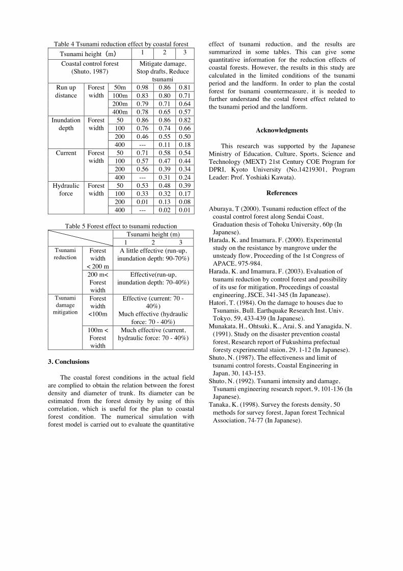
Table 4 Tsunami reduction effect by coastal forestTsunami height(m) 1 2 3Coastal control forest
(Shuto, 1987)Mitigate damage,
Stop drafts, Reducetsunami
50m 0.98 0.86 0.81100m 0.83 0.80 0.71200m 0.79 0.71 0.64
Run updistance
Forestwidth
400m 0.78 0.65 0.5750 0.86 0.86 0.82
100 0.76 0.74 0.66200 0.46 0.55 0.50
Inundationdepth
Forestwidth
400 --- 0.11 0.1850 0.71 0.58 0.54
100 0.57 0.47 0.44200 0.56 0.39 0.34
Current Forestwidth
400 --- 0.31 0.2450 0.53 0.48 0.39
100 0.33 0.32 0.17200 0.01 0.13 0.08
Hydraulicforce
Forestwidth
400 --- 0.02 0.01
Table 5 Forest effect to tsunami reductionTsunami height (m)
1 2 3Forestwidth
< 200 m
A little effective (run-up,inundation depth: 90-70%)
Tsunamireduction
200 m<Forestwidth
Effective(run-up,inundation depth: 70-40%)
Forestwidth
<100m
Effective (current: 70 -40%)
Much effective (hydraulicforce: 70 - 40%)
Tsunamidamage
mitigation
100m <Forestwidth
Much effective (current,hydraulic force: 70 - 40%)
3. Conclusions
The coastal forest conditions in the actual fieldare complied to obtain the relation between the forestdensity and diameter of trunk. Its diameter can beestimated from the forest density by using of thiscorrelation, which is useful for the plan to coastalforest condition. The numerical simulation withforest model is carried out to evaluate the quantitative
effect of tsunami reduction, and the results aresummarized in some tables. This can give somequantitative information for the reduction effects ofcoastal forests. However, the results in this study arecalculated in the limited conditions of the tsunamiperiod and the landform. In order to plan the costalforest for tsunami countermeasure, it is needed tofurther understand the costal forest effect related tothe tsunami period and the landform.
Acknowledgments
This research was supported by the JapaneseMinistry of Education, Culture, Sports, Science andTechnology (MEXT) 21st Century COE Program forDPRI, Kyoto University (No.14219301, ProgramLeader: Prof. Yoshiaki Kawata).
References
Aburaya, T (2000). Tsunami reduction effect of thecoastal control forest along Sendai Coast,Graduation thesis of Tohoku University, 60p (InJapanese).
Harada, K. and Imamura, F. (2000). Experimentalstudy on the resistance by mangrove under theunsteady flow, Proceeding of the 1st Congress ofAPACE, 975-984.
Harada, K. and Imamura, F. (2003). Evaluation oftsunami reduction by control forest and possibilityof its use for mitigation, Proceedings of coastalengineering, JSCE, 341-345 (In Japanease).
Hatori, T. (1984). On the damage to houses due toTsunamis, Bull. Earthquake Research Inst. Univ.Tokyo, 59, 433-439 (In Japanese).
Munakata, H., Ohtsuki, K., Arai, S. and Yanagida, N.(1991). Study on the disaster prevention coastalforest, Research report of Fukushima prefectualforesty experimental staion, 29, 1-12 (In Japanese).
Shuto, N. (1987). The effectiveness and limit oftsunami control forests, Coastal Engineering inJapan, 30, 143-153.
Shuto, N. (1992). Tsunami intensity and damage,Tsunami engineering research report, 9, 101-136 (InJapanese).
Tanaka, K. (1998). Survey the forests density, 50methods for survey forest, Japan forest TechnicalAssociation, 74-77 (In Japanese).

要 旨
海岸林を津波 災対策に活用させるため,本研究では海岸林の流体力学的影 による津波低減効果を定量的に評
価・検討した.評価する際に重要となる樹林密度と胸 直径の関係は,入手できた現地観測結果から条件 定を
行った.これを用い,海岸林の影 を考慮した数値 算を行い,津波の低減効果を定量的に評価・検討を行った.
その結果,いくつかの津波と海岸林の条件による津波低減効果を定量的に検討することのできる表を示した.
キーワード: 海岸林,津波,林帯幅,樹林密度,津波低減効果

COE-11
津波災害低減のための 潮林(自然力)の活用について
河田惠昭・〇原田賢治
1.はじめに
低頻度で広域にわたる津波の対策として,全沿岸
に 大な構造物による対策をとることは不可能であ
る.しかし,物的津波被害の軽減のためには津波の
進入を最小限にとどめる必要があり,構造物に加え
潮林などの自然力も活用した外力低下の対策が必
要である.従来,津波対策において付加的要素とし
てしか着目されてこなかった 潮林の 災機能の再
評価により, 災・環境・利用に配慮した海岸整備
のひとつのツールとして 潮林を活用することがで
きる.ここでは 潮林を考慮した津波数値シミュレ
ーションを用いて,津波・ 潮林の条件による津波
低減の特徴について検討を行う.また, 潮林の活
用についても述べる.
2.津波数値Ầ算
津波数値 算は 線形浅水方程式を Leap-flog 法
により差分化して行った. 潮林を抵抗として運動
方程式に取り込み, 潮林幅,樹林密度,津波 さ,
津波周期を変化させて数値 算を行った. 潮林の
抵抗係数は水理模型実験に基づく抵抗係数モデル
(原田,2003)を用いている.
3. 潮林による津波低減の特徴
算結果の整理の例として,Fig.1,2 に 潮林に
よる津波低減率と 潮林幅,津波周期の関係を示す.
津波の浸水深の低減率は 潮林幅と比例関係にある
事がわかる.200m の 潮林幅ならば,浸水被害に
関係する浸水深を 5~6 割に,流体力による被害に
関係する流速は4~6割に低下させることができる.
また,津波周期が くなると浸水深の低減率は大き
くなる傾向にあるが,周期 20 分以下で 潮林幅
200m 以下の時には周期が短い方が低減率は大きく
なる傾向が見られる.これらの検討結果より 潮林
による津波低減効果を定量的に推定することが可能
となり, 潮林の有効性が示された.
4. 潮林の活用について
津波は 潮林の間を通過することができるので,
潮林だけでは陸上遡上を全て ぐことはできない.
しかし 潮林をひとつの対策ツールとしてとらえ,
構造物による対策等と組み合わせることで, 潮堤
等の構造物の想定津波以上の津波に対しても多段的
な対策をとることができ,津波遡上を低下させ被害
を最小限にすることが可能である. 潮林の活用に
はこのような組み合わせによる対策を地域の津波
災システムの中に取り込んでいく必要がある.具体
例としては,大 市周辺の臨海埋め立て地に見られ
る未利用地を活用し,埋め立て地周辺の堤 と 潮
林を 市公園の一環として整備することにより,
災・環境・利用に配慮した 潮林の利用を期待する
ことができる.
1.0
0.8
0.6
0.4
0.2
0.0
Redu
ctio
n ra
te o
f max
. inu
ndat
ion
dept
h: r
5004003002001000Forest width (m)
Tsunami height1m, 2m3m
Tsunami period 10 min
1.0
0.8
0.6
0.4
0.2
0.0
Redu
ctio
n ra
te o
f max
. cur
rent
: r
5004003002001000Forest width (m)
Tsunami height 1m, 2m3m
Tsunami Period 10min
Fig.1 潮林幅と津波の減衰効果の関係
1.0
0.8
0.6
0.4
0.2
0.0
Redu
ctio
n ra
te o
f Inu
ndat
ion
dept
h: r
6040200Wave period (min)
Forest width 50m100m200m400m
Tsunami height=3m1.0
0.8
0.6
0.4
0.2
0.0Redu
ctio
n ra
te o
f cur
rent
: r
6040200Wave period (min)
Forest width 50m100m200m400m
Fig.2 津波周期と津波低減効果