strategic sewer site assessment stage 3: site suitability ... · woodland adjacent to kensington...
TRANSCRIPT

Protecting residents from flooding
Strategic Sewer Site Assessment Stage 3: Site Suitability Report: SS241 Maclise Road Car Park and Woodland adjacent to Kensington Olympia Station
Document Number C680-AH-00532-RP November 2015
Counters Creek Strategic Sewer Flood Alleviation Scheme

Counters Creek Strategic Storm Relief Sewer/ Site Selection Methodology/ Stage 3/ SS241 SSR: November 2015 Document Number: C680-AH-00532-RP
COUNTERS CREEK STRATEGIC FLOOD ALLEVIATION SCHEME
STRATEGIC SEWER SITE ASSESSMENT STAGE 3: SITE SUITABILITY REPORT: SS241 MACLISE ROAD CAR PARK AND WOODLAND ADJACENT TO KENSINGTON
OLYMPIA STATION
Document Ref C680-AH-00532-RP Status For issue Document Type Report Title/Subject Strategic Sewer Site Assessment Stage 3: SSR Project Counters Creek Strategic Flood Alleviation Scheme Authors TWUL / Aecom / Adams Hendry / Bruton Knowles / London Bridge
Associates / Mott MacDonald Keywords SS241 Maclise Road Car Park and Woodland adjacent to
Kensington Olympia Station Site Suitability Report
REQUIRED APPROVALS
Co-ordinator Reviewer Approver
Chris Colloff Associate, Savills
Mark Mathews
Town Planning Manager, TWUL
Martin Bennett
Project Lead, TWUL
Date 17/11/15 Date 17/11/15 Date 17/11/15

Counters Creek Strategic Storm Relief Sewer/ Site Selection Methodology/ Stage 3/ SS241 SSR: November 2015 Document Number: C680-AH-00532-RP
COUNTERS CREEK STRATEGIC FLOOD ALLEVIATION SCHEME
STRATEGIC SEWER SITE ASSESSMENT STAGE 3: SITE SUITABILITY REPORT: SS241 MACLISE ROAD CAR PARK AND WOODLAND ADJACENT TO KENSINGTON
OLYMPIA STATION
LIST OF CONTENTS
PAGE 0 EXECUTIVE SUMMARY 1 1 INTRODUCTION 3
1.1 PURPOSE OF THIS REPORT 3
1.2 STRUCTURE OF THIS REPORT 4
2 SITE INFORMATION 6 2.1 SITE AND SURROUNDINGS 6
3 PROPOSED USE OF SITE – CONSTRUCTION PHASE 8 3.1 CONSTRUCTION REQUIREMENTS 8
3.2 CONSTRUCTION PROGRAMME 9
3.3 CONSTRUCTION WORKING HOURS 10
3.4 ACCESS AND MATERIAL MOVEMENTS 12
3.5 CONSTRUCTION METHODOLOGY AND ASSOCIATED DIMENSIONS 13
4 PROPOSED USE OF SITE – OPERATIONAL PHASE 20 4.1 PERMANENT INSTALLATIONS 20
4.2 OPERATIONAL REQUIREMENTS 20
4.3 RESTORATION AND AFTER-USE 20
5 ENGINEERING ASSESSMENT 22 5.1 CONSTRUCTION TRAFFIC 22
5.2 CONSTRUCTION WORK CONSIDERATIONS 22
5.3 PERMANENT WORKS CONSIDERATIONS 23
5.4 HEALTH AND SAFETY 23
5.5 SUMMARY 23
6 PLANNING ASSESSMENT 25 6.1 INTRODUCTION 25
6.2 PLANNING APPLICATION AND PERMISSIONS 25
6.3 PLANNING POLICY 27
7 ENVIRONMENTAL ASSESSMENT 30 7.1 INTRODUCTION 30
7.2 TRANSPORT 30

Counters Creek Strategic Storm Relief Sewer/ Site Selection Methodology/ Stage 3/ SS241 SSR: November 2015 Document Number: C680-AH-00532-RP
7.3 NOISE 31
7.4 WATER RESOURCES - HYDROGEOLOGY 31
7.5 WATER RESOURCES – SURFACE WATER AND FLOOD RISK 31
7.6 AIR QUALITY 31
7.7 ARCHAEOLOGY 31
7.8 BUILT HERITAGE 32
7.9 TOWNSCAPE AND VIEWS 32
7.10 ECOLOGY 32
7.11 LAND QUALITY 33
7.12 CUMULATIVE EFFECTS 33
8 SOCIO-ECONOMIC AND COMMUNITY ASSESSMENT 34 8.1 SOCIO-ECONOMIC PROFILE 34
8.2 ISSUES AND IMPACTS 34
8.3 POTENTIAL INTEREST GROUPS 35
8.4 SUMMARY 35
9 PROPERTY ASSESSMENT 36 9.1 INTRODUCTION 36
9.2 CROWN LAND AND SPECIAL LAND COMMENTS 36
9.3 LAND TO BE ACQUIRED 36
9.4 ASSOCIATED PROPERTY COSTS TO PROJECT 36
9.5 COMPENSATION 37
9.6 SUMMARY 37
10 CONCLUSION 38 10.1 ENGINEERING 38
10.2 PLANNING 38
10.3 ENVIRONMENT 38
10.4 SOCIO-ECONOMIC AND COMMUNITY 39
10.5 PROPERTY 39
10.6 RECOMMENDATION 39
APPENDIX 1 BACKGROUND INFORMATION
APPENDIX 2 SITE LOCATION PLAN
APPENDIX 3 INDICATIVE CONSTRUCTION LAYOUT PLAN
APPENDIX 4 INDICATIVE OPERATIONAL LAYOUT PLAN
APPENDIX 5 PLANNING AND ENVIRONMENT PLANS
APPENDIX 6 RELEVANT PLANNING POLICY
APPENDIX 7 ENVIRONMENTAL APPRAISAL TABLES

Strategic Sewer Stage 3 Site Suitability Report: SS241 Maclise Road Car Park and Woodland adjacent to Kensington Olympia Station
Counters Creek Strategic Sewer/ Site Selection Methodology/ Stage 3/ SS241 SSR: November 2015 Document Number: C680-AH-00532-RP
1
0 EXECUTIVE SUMMARY 0.1.1 The Counters Creek Strategic Flood Alleviation Scheme is required to protect
properties from basement flooding within the Counters Creek catchment in the London Borough of Hammersmith and Fulham (LBHF) and the Royal Borough of Kensington and Chelsea (RBKC). The present Counters Creek Flooding Register1 shows that over 1,700 properties are subject to flooding.
0.1.2 A number of strategic solutions are being pursued, each of which plays a role in
providing the relief necessary to guard against basement flooding. The strategic solutions comprise the provision of flooding local improvement projects (FLIPS), the introduction of pilot Sustainable Drainage Systems (SuDS) schemes, the implementation of sewer upgrade works and the construction of a strategic sewer (the ‘strategic sewer’ or ‘the scheme’).
0.1.3 This report relates to the further assessment of sites which have been identified as
being potentially suitable for development as part of the delivery of the strategic sewer. It builds on work undertaken to inform the phase 1 and interim engagement variants of the proposed strategic sewer, and the outcomes of the consultation processes held on those proposals.
0.1.4 Feedback from the interim engagement process identified concerns about a
number of the sites which Thames Water had consulted on. Thames Water has taken the opportunity to consider these issues alongside and other alternative sites suggested by respondents through the interim engagement process, alongside ongoing scheme development and modeling work. An alternative site to intercept the Counters Creek Main Line sewer has also been investigated by Thames Water.
0.1.5 Further longlist and shortlist assessment work was undertaken between July-
October 2015. A list of 16 sites were subjected to the longlist site assessment process, through which five sites were disregarded. The remaining 11 sites were then subjected to further assessment through the shortlist assessment stage and it was concluded that Site Suitability Reports (SSRs) would be prepared for two of those sites.
0.1.6 In addition, Thames Water has updated SSRs for two sites considered as part of
the phase 1 consultation and / or interim engagement processes (SS222 Tesco Hammersmith Superstore Car Park and SS241 Maclise Road Car Park and Woodland adjacent to Kensington Olympia Station) to reflect potential changes to the proposed use of the sites.
0.1.7 Further updating work is also being carried out in respect of proposals for the use
of site SS219 Cremorne Wharf Depot, and whilst those updates are not expected to be complete until late 2015, that updated use is largely consistent with the option A proposals published in November 2014 version of the SSR for that site. For the purpose of initial ongoing engagement work that version of the SSR will therefore be relied on.
1 The Counters Creek flood register is a register of all the properties in the Counters Creek Catchment that have been recorded as being flooded at some point in the past. This register is taken from the Thames Water Sewer Flooding History Database (SFHD). Properties are added to the register based on reported flooding incidents. Incidents are assessed to confirm whether or not the flood event was caused by an operational problem (i.e. a blockage), an extreme rainfall occurrence (greater than the current design criteria), or by a lack of capacity in the sewer.

Strategic Sewer Stage 3 Site Suitability Report: SS241 Maclise Road Car Park and Woodland adjacent to Kensington Olympia Station
Counters Creek Strategic Sewer/ Site Selection Methodology/ Stage 3/ SS241 SSR: November 2015 Document Number: C680-AH-00532-RP
2
0.1.8 This SSR relates to site SS241, Maclise Road Car Park and Woodland adjacent to Kensington Olympia Station located partly in the LBHF and partly in the RBKC. The purpose of this report is to provide a strategic assessment of the opportunities and constraints associated with developing the site for the construction of an interception point to pick up flows from the Hammersmith Storm Relief Sewer (SRS) Duplication Counters Creek Branch. The report also provides a strategic assessment for the use of the site as a drive site for the spur tunnel to the Counters Creek Mainline interception site to the north east and for the provision of a permanent air management building.
0.1.9 In summary, the site has been assessed as being suitable in environmental
(including transport) terms, and less suitable yet capable of mitigation in engineering, planning, socio-economic and community and property terms. It is also noted that the site is considered less suitable with regards specifically to noise. None of the assessments identified the site as being unsuitable.
0.1.10 Accordingly, the site is considered to be less suitable overall yet able to be
mitigated if developed and it is recommended that the site is retained as a possible construction site.

Strategic Sewer Stage 3 Site Suitability Report: SS241 Maclise Road Car Park and Woodland adjacent to Kensington Olympia Station
Counters Creek Strategic Sewer/ Site Selection Methodology/ Stage 3/ SS241 SSR: November 2015 Document Number: C680-AH-00532-RP
3
1 INTRODUCTION 1.1 Purpose of this report 1.1.1 The purpose of this report is to provide a strategic assessment of the suitability of
Strategic Site SS241 Maclise Road Car Park and Woodland adjacent to Kensington Olympia Station (Maclise Road Car Park and Woodland) as a construction site for the Counters Creek strategic sewer (the ‘strategic sewer’ or ‘the scheme’), which forms part of the Counters Creek Flood Alleviation Scheme. The wider background to the scheme is provided in Appendix 1 to this report.
1.1.2 This report assesses the potential for the site to be used for the construction of an
interception point to pick up flows from the Hammersmith SRS Duplication Counters Creek Branch. The report also assesses the potential for the site to be used for a drive site for the construction of a spur tunnel to the Counters Creek Mainline interception site to the north east and for the provision of a permanent air management building.
1.1.3 Section 2 of this report describes the site and its surroundings and Sections 3 and
4 of this report provide details on the proposed use of the site during the construction and operational phases.
1.1.4 This report forms part of the site and options assessment process that has been
undertaken by the Counters Creek team. It builds on work undertaken to inform the phase 1 and interim engagement variants of the proposed strategic sewer, and the outcomes of the consultation processes held on those proposals.
1.1.5 Feedback from the interim engagement process identified concerns about a
number of the sites which Thames Water had consulted on. Thames Water has taken the opportunity to consider these issues alongside and other alternative sites suggested by respondents through the interim engagement process, alongside ongoing scheme development and modeling work. An alternative site to intercept the Counters Creek Main Line sewer has also been investigated by Thames Water.
1.1.6 Further longlist and shortlist assessment work was undertaken between July-
October 2015. A list of 16 sites were subjected to the longlist site assessment process, through which five sites were disregarded. The remaining 11 sites were then subjected to further assessment through the shortlist assessment stage and it was concluded that Site Suitability Reports (SSRs) would be prepared for two of those sites.
1.1.7 In addition, Thames Water has updated SSRs for two sites considered as part of
the phase 1 consultation and / or interim engagement processes (SS222 Tesco Hammersmith Superstore Car Park and SS241 Maclise Road Car Park and Woodland adjacent to Kensington Olympia Station) to reflect potential changes to the proposed use of the sites.
1.1.8 Further updating work is also being carried out in respect of proposals for the use
of site SS219 Cremorne Wharf Depot, and whilst those updates are not expected to be complete until late 2015, that updated use is largely consistent with the option A proposals published in November 2014 version of the SSR for that site.

Strategic Sewer Stage 3 Site Suitability Report: SS241 Maclise Road Car Park and Woodland adjacent to Kensington Olympia Station
Counters Creek Strategic Sewer/ Site Selection Methodology/ Stage 3/ SS241 SSR: November 2015 Document Number: C680-AH-00532-RP
4
For the purpose of initial ongoing engagement work that version of the SSR will therefore be relied on.
1.1.9 Further details regarding the site selection methodology can be found in the
Strategic Sewer Site Selection Methodology Report (Document reference C680-AH-00504-RP), which is summarised in Appendix 1 to this report. The assessment process referred to above is reported in document C680-AH-00537-RP.
1.1.10 This report assesses the suitability of site SS241 in respect of the proposed use, considering engineering issues, planning issues, potential environmental, noise and transport effects, social and community issues and property matters. In brief, the suitability of the site will be considered in the following way: • Suitable: the site is expected to experience minimal constraint or conflict
with the surrounding environment, or encounter minimal constraints in respect of existing conditions at the site, although there may be a requirement for some form of compromise, mitigation and compensation.
• Less Suitable: the site is considered to experience constraints or conflicts with the surrounding environment, or encounter constraints in respect of existing conditions at the site, which will require mitigation and compensation and are anticipated to affect the design and use of the site. It may be necessary to consider the use of this site alongside the availability of alternative locations.
• Unsuitable: the site is considered to experience substantial constraints or conflicts with the surrounding environment, or encounter considerable constraints in respect of existing conditions at the site, which are unlikely to be readily mitigated or compensated. An alternative site(s) should be sought.
1.1.11 These individual assessments then enable an overall judgment to be made, having
regard to all engineering, planning, environment, transport and property issues, whether the site is suitable for the intended use. That overall assessment will also identify any issues where further investigation or mitigation measures may need to be considered and addressed.
1.1.12 The SSRs will assist Thames Water to engage with stakeholders, and to inform decisions on the preferred route option and associated sites for the Phase 2 public consultation due to take place in early 2016.
1.2 Structure of this Report 1.2.1 The report is structured as follows:
• Section 2 – site information: This section provides general information that relates to the site, as the basis for the assessment that follows.
• Section 3 – proposed use of the site – construction phase: This section provides an explanation of how the site will be used during the construction phase, identifying any assumptions that have been made.
• Section 4 – proposed use of the site – operational phase: This section provides an explanation of how the site will be used during the operational phase, identifying any assumptions that have been made.

Strategic Sewer Stage 3 Site Suitability Report: SS241 Maclise Road Car Park and Woodland adjacent to Kensington Olympia Station
Counters Creek Strategic Sewer/ Site Selection Methodology/ Stage 3/ SS241 SSR: November 2015 Document Number: C680-AH-00532-RP
5
• Section 5 – engineering assessment: This section provides an engineering assessment based on the information in Sections 2, 3 and 4, identifying any assumptions that have been made.
• Section 6 – planning assessment: This section provides a planning assessment of the site and its relationship with relevant planning applications and permissions and with relevant planning policies and designations.
• Section 7 – environmental appraisals: This section provides an appraisal of specific environmental topics relevant to the site. An appraisal of potential impacts is provided, along with the identification of potential mitigation measures that may be required. This is based on professional judgment, site investigations and the plans and assumptions included in this SSR.
• Section 8 – socio-economic assessment: This section provides a socio-economic assessment, including consideration of potential community impacts and issues. This is based on professional judgment, site investigations and the plans and assumptions included in this SSR.
• Section 9 – property assessment: This section provides a property assessment that includes landownership, land acquisition processes, procedural risks, and the potential for compensation events.
• Section 10 – conclusions: This section provides conclusions for each of the assessments, together with the overall assessment of the suitability of the site.

Strategic Sewer Stage 3 Site Suitability Report: SS241 Maclise Road Car Park and Woodland adjacent to Kensington Olympia Station
Counters Creek Strategic Sewer/ Site Selection Methodology/ Stage 3/ SS241 SSR: November 2015 Document Number: C680-AH-00532-RP
6
2 SITE INFORMATION 2.1 Site and surroundings 2.1.1 The site lies within two local authority boundaries, the majority of the site is located
within the Royal Borough of Kensington and Chelsea (RBKC) to the east. The remaining section of the site is located within the London Borough of Hammersmith and Fulham (LBHF) to the west. A site location plan is attached in Appendix 2 and an indicative construction layout plan is provided in Appendix 3. An operational layout plan is included in Appendix 4.
2.1.2 The site consists of an area of vegetation containing trees and the northern section of the surface level car park located off Maclise Road (Olympia Motorail Car Park 4). This section of the car park includes hardstanding and there is a portacabin and container sited immediately to the south of the area of vegetation.
2.1.3 The site is located in an area with a mix of land uses. To the west of the site is a
residential area. The site is located adjacent to the residential back gardens of properties along Sinclair Road.
2.1.4 Immediately to the south of the site is the Olympia Motorail Car Park 4, which
comprises hardstanding, a portacabin and infrastructure related to the operation of the car park (ticket machine and barrier, ticket attendant office and substation). There is an awning covering part of the car park (from the site entrance extending some 20m-30m). Adjacent to the car park entrance are a pair of grade II listed telephone boxes.
2.1.5 To the south west of the site beyond the car park is Olympia Exhibition Centre,
which includes the grade II listed Olympia Grand Hall. Earls Court and Olympia Group have undertaken refurbishment works and in December 2011 Olympia West opened following reconstruction work. Olympia Central has also undergone refurbishment and re-opened in September 2012. Additional refurbishments are proposed, which are discussed in Section 6 of this report.
2.1.6 To the east of the site is the railway line (West London railway line) and further
south, adjacent to the entrance of the car park, is Kensington Olympia Station (London Overground, Southern and London Underground District Lines).
2.1.7 The site can be accessed via the Olympia Motorail Car Park 4 to the south. The
car park is accessed off Maclise Road via Olympia Way, both of which are one-way streets. Maclise Road has on-street parking. Hammersmith Road, which provides access to the A4, can be accessed off Blythe Road via Maclise Road. To carry out the works, temporary traffic management measures will need to be put in place. This would require careful planning and management.
2.1.8 The Maclise Road Car Park and Woodland site also requires the use of three
additional satellite sites. Two sites are required for access into and emergency egress from the existing Hammersmith SRS Duplication Counters Creek Branch. These would be located within the public highway at Elsham Road and Masbro Road. An additional site is required for alterations to the cladding of the structure at the south section of the car park prior to the main construction works and would be reinstated at the end of the programme. To carry out the works, temporary

Strategic Sewer Stage 3 Site Suitability Report: SS241 Maclise Road Car Park and Woodland adjacent to Kensington Olympia Station
Counters Creek Strategic Sewer/ Site Selection Methodology/ Stage 3/ SS241 SSR: November 2015 Document Number: C680-AH-00532-RP
7
traffic management measures would need to be put in place. This would require careful planning and management.
2.1.9 Based on the initial construction layout, the nearest residential properties are
within approximately 10m of the site, with the back gardens immediately adjoining the site. Once operational, access to retained infrastructure at the site would be required as shown on site layouts in Appendix 4.
2.1.10 The site is covered by planning and environmental designation in the LBHF Core
Strategy (October 2011) and the RBKC Consolidated Local Plan (July 2015). The site is designated as a Site of Nature Conservation Importance (RBKC) and a Green Corridor (LBHF).
2.1.11 The site lies immediately adjacent to the Lakeside/Sinclair/Blythe Road
Conservation Area. The site is located in Flood Zone 2. All of the mapped designations are shown on the planning and environmental plans in Appendix 5.

Strategic Sewer Stage 3 Site Suitability Report: SS241 Maclise Road Car Park and Woodland adjacent to Kensington Olympia Station
Counters Creek Strategic Sewer/ Site Selection Methodology/ Stage 3/ SS241 SSR: November 2015 Document Number: C680-AH-00532-RP
8
3 PROPOSED USE OF SITE – CONSTRUCTION PHASE 3.1 Construction requirements
Site area and use
3.1.1 The construction site would occupy an area of approximately 3,000m2. The site is proposed for the construction of an interception point to pick up flows from the Hammersmith SRS Duplication Counters Creek Branch. The site is also proposed to be used for a drive site for the construction of a spur tunnel to the Counters Creek Mainline interception site to the north east and for the provision of a permanent air management building.
3.1.2 Three additional satellite sites are also included: one for alterations to the cladding of the structure at the south end of the car park; and two for access into and emergency egress from the existing Hammersmith SRS Duplication Counters Creek Branch. These would be located in:
• Masbro Road (110m2) • Elsham Road (60m2)
3.1.3 The construction site is the only identified site in which the Hammersmith SRS Duplication Counters Creek Branch can be intercepted south of Holland Park Avenue. Scope of permanent works planned at this construction site
3.1.4 The proposed construction phase layout options for this site are attached in Appendix 3, based on preliminary assessments undertaken to date. The following works are planned:
• Strengthening of the existing Hammersmith SRS Duplication Counters
Creek Branch • Alterations to the open building at the south end of the car park (to be
reinstated post construction if required) • Construction of an interception shaft (the ‘North Shaft’) adjacent to the
Hammersmith SRS Duplication Counters Creek Branch, in the wooded area to the north of the Car Park, and a connection to the sewer
• Construction of a drop shaft (the ‘South Shaft’) within the Car Park, through which the new Strategic Sewer will pass
• Construction of a connection tunnel from the South Shaft to the North Shaft • Construction of a connection tunnel from the South Shaft to the site for the
intersection of the Counters Creek Mainline Sewer (to the north east) • Installation of an active air management building, and vent stack • Provision of ancillary equipment Temporary structures within construction site
3.1.5 During the construction period, the site is likely to include the following large structures as shown in Appendix 3:
• 2 No. crawler cranes • A spoil bin, approximately 3m high, with an excavator to load spoil lorries

Strategic Sewer Stage 3 Site Suitability Report: SS241 Maclise Road Car Park and Woodland adjacent to Kensington Olympia Station
Counters Creek Strategic Sewer/ Site Selection Methodology/ Stage 3/ SS241 SSR: November 2015 Document Number: C680-AH-00532-RP
9
• 1 No. large excavator to pitch and drive sheet piles, excavate trenches, install props and pipes and to backfill the trenches
• 3 No. grout or shotcrete silos approximately 8m high • Double stacked offices and welfare, approx. 6m high • A large diameter turntable to allow delivery and spoil lorries to turn around
within the site
3.1.6 During the construction phase, the following plant within the site may be required to operate 24 hours per day:
• Generator (for lighting and security) – this would be super-silenced, and
would not be necessary if a suitable connection to mains power can be made
• Shaft pump and discharge • Shaft ventilation and emergency crane during the crossing of the shaft by
the TBM (tunnel boring machine) for the new Strategic Sewer 3.1.7 The short connection tunnel to the north east (to the site for the intersection of the
Counters Creek Mainline Sewer), will pass beneath the TfL / Network Rail tracks to the east of the site, and it is likely that 24 hour/day work will be required as a condition of the consent for passing beneath. During this period, the following additional plant within the site is anticipated to operate 24 hours per day:
• Crawler crane • Ventilation fan • Grout silos and pump • Compressor • Pumps and water treatment plant • Site vehicles: forklift; excavator
3.1.8 During night work, plant would only be used when required and acoustic shielding will be placed where appropriate.
3.2 Construction programme 3.2.1 The construction site would be required for a total period of approximately 26
months.
3.2.2 The site required for the alterations to the cladding of the building at the south end of the car park would be required for an approximately 2 week period at the start of the programme, and a further approximately 2 week period (for reinstatement) near to the end of the programme.
3.2.3 The two sewer access sites would be required occasionally for short periods within
the overall 26 month period (see below).
3.2.4 Any necessary utility diversion works to enable the construction would need to be carried out by the relevant utility provider in advance of these works, and is not included within the overall 26 months.

Strategic Sewer Stage 3 Site Suitability Report: SS241 Maclise Road Car Park and Woodland adjacent to Kensington Olympia Station
Counters Creek Strategic Sewer/ Site Selection Methodology/ Stage 3/ SS241 SSR: November 2015 Document Number: C680-AH-00532-RP
10
Construction phases
3.2.5 The main stages of construction are described below:
• Utility diversions if required • Alterations to the open building at the south end of the site to provide
sufficient height for the construction vehicles • Strengthening of the existing Hammersmith SRS Duplication Counters
Creek Branch • Site establishment • Shaft sinking (2 shafts) • Construction of a short connection tunnel from the North Shaft to the
Hammersmith SRS Duplication Counters Creek Branch and the construction of a connection chamber
• Construction (by pipejacking) of a tunnel connecting the South and North shafts (driven from the South Shaft)
• Construction of a tunnel connecting the South shaft to the site to the north east where the Counters Creek Mainline would be intersected
• The passing through the shaft by the Tunnel Boring Machine (TBM) from the south, followed by the completion of the shaft / tunnel connection
• The construction of an above ground air management building and a vent stack.
• Installation of the drop pipes, dividing walls, and other structures within the shafts and chambers
• Installation of penstocks and/or isolation gates, a flap valve, and control equipment
• Installation of air management equipment • Site clearance and reinstatement
3.3 Construction working hours 3.3.1 The following working hours are proposed:
Note: Note: A single Working Day = 12 hours between 7am and 7pm. Working hours and days are dependent on the construction programme and local restrictions requiring further consideration with the Local Authority.
Days Hours of work
Site establishment, piling, chamber construction, shaft sinking, finishings and demobilisation
Mon to Fri 07:00 to 19:00
Sat 07:00 to 13:00
Sun No work
Tunnelling (within the zone of influence of the railway or other asset), and during the crossing of the shaft by the main tunnel TBM
Mon to Fri 24 hours
Sat 00:00 to 13:00
Sun No work
Works altering the cladding of the building at the south end of the car park
Mon to Fri 07:00 to 19:00
Works within the existing sewer Mon to Fri 20:00 to 06:00
Strategic Sewer Stage 3 Site Suitability Report: SS241 Maclise Road Car Park and Woodland adjacent to Kensington Olympia Station
Counters Creek Strategic Sewer/ Site Selection Methodology/ Stage 3/ SS241 SSR: November 2015 Document Number: C680-AH-00532-RP
11
3.3.2 Working hours would be agreed with the Local Authority, and it is probable that for a 7am to 7pm dayshift, the first hour would be designated ‘start up’ and the final hour ‘close down’, with ‘noisy’ activities limited to 8am to 6pm. Appropriate mitigation measures will be put in place to reduce noise and prevent disturbance where practical.
3.3.3 It is likely that the short duration works within the Hammersmith SRS Duplication Counters Creek Branch would be carried out during nightshifts when flows are at their lowest. Further detail of these works are given below:
• These works would be carried out within the sewer, and surface works
would be limited to support works and a standby rescue team • Nightshift working would be anticipated to be between 8pm to 6am with the
first and last hour used as set up and close down • It is anticipated that outside of the actual working hours, the site boundaries
could be removed or significantly reduced (for example leaving only a storage container for materials, tools and equipment)
3.3.4 Site for access for the works within the sewer:
• The site set up in Masbro Road would include the occupation of 3 to 4 parking bays on the north side of Masbro Road
• A temporary lane closure around the manhole would be supported by traffic lights to enable traffic flow and a pedestrian diversion around the site
• The parking bay suspension would remain in place during the day when night works were being undertaken, however it is anticipated that the site boundary would be reduced at the end of each working shift to reinstate the pavement
• The site would require equipment for accessing the sewer such as a small generator and a ventilation fan. Any equipment likely to emit noise would be acoustically shrouded to minimise any disturbance
3.3.5 Site for emergency egress from the works within the sewer:
• The site set up in Elsham Road would include the occupation of 3 to 4 parking bays on the south side of Elsham Road
• A temporary lane closure around the manhole would be supported by traffic lights to enable traffic flow and a pedestrian diversion around the site
• The parking bay suspension would remain in place during the day when night works were being undertaken, however it is anticipated that the site boundary would be reduced at the end of each working shift to reinstate the pavement
• The site might require equipment for accessing the sewer such as a small generator and a ventilation fan. Any equipment likely to emit noise would be acoustically shrouded to minimise any disturbance
3.3.6 It is anticipated that these sewer access works would consist of approximately 8
weeks of short term enabling works, the programme for which is yet to be determined, requiring the use of the access site on Masbro Road (and a support emergency exit site at the existing man hole in Elsham Road). These works will take place in three distinct phases and are forecast as follows:

Strategic Sewer Stage 3 Site Suitability Report: SS241 Maclise Road Car Park and Woodland adjacent to Kensington Olympia Station
Counters Creek Strategic Sewer/ Site Selection Methodology/ Stage 3/ SS241 SSR: November 2015 Document Number: C680-AH-00532-RP
12
• Cleaning, installation of monitoring devices, placing of catch nets, installation of strengthening to the existing lining, and breaking out of the internal lining within the existing sewer – 35 No, 8pm to 6am night time shifts over the course of 7 working weeks, which may or may not be continuous, during the first 9 months of the construction period
• Saw cutting of the linings and sealing in of the flume pipe – 4 No, 8pm to 6am night time shifts over the course of 1 working week, around half way through the construction period
• Breaking out of the flume pipe sealing to enable the removal of the flume pipe – 1 No 8pm to 6am night time shift, very near to the end of the construction period
3.3.7 All subsequent works within the sewer would be accessed from the new weir
chamber 3.4 Access and material movements
Transport of excavated material
3.4.1 The site is a considerable distance from the river, and hence is not considered suitable for barge transport.
3.4.2 The site is adjacent to a railway line (London Overground), but in order to use this for the transport of excavated material off site, either a new siding would be required, or loading would need to take place directly onto the mainline during possessions. It is anticipated that the installation and removal of these facilities would cause significant additional disruption, and the operation of these would be disruptive to the operation of the Maclise Road Car Park (Olympia Motorail Car Park 4) by Kensington Olympia. Hence, the transportation of materials by rail is not considered viable.
Transport of materials, plant and equipment 3.4.3 It has therefore been assumed that all materials, plant and equipment would be
brought to site and removed from site by road. Access and egress
3.4.4 The following access and egress options have been identified:
3.4.5 Access to site:
• Approach on the A315 from the East • Turn right into Olympia Way • Drive past Kensington Olympia Exhibition Centre and station • Drive through the Maclise Road Car Park (Olympia Motorail Car Park 4)
and into the site 3.4.6 Alternative access to site in the event that Olympia Way is congested (not for
articulated HGVs): • Approach on the A315 • Turn into Blythe Road

Strategic Sewer Stage 3 Site Suitability Report: SS241 Maclise Road Car Park and Woodland adjacent to Kensington Olympia Station
Counters Creek Strategic Sewer/ Site Selection Methodology/ Stage 3/ SS241 SSR: November 2015 Document Number: C680-AH-00532-RP
13
• Follow Blythe Road, taking two left turns • Turn right into Hazlitt Road • Turn right into Sinclair Road • Turn left into Maclise Road • Turn left into the Maclise Road Car Park (Olympia Motorail Car Park 4) and
into the site
3.4.7 Exit from site:
• HGVs are to be turned on a specially installed vehicle turntable on site • Leave through site entrance • Drive through the Maclise Road Car Park (Olympia Motorail Car Park 4) • Turn right onto Maclise Road • Left into Beaconsfield Terrace Road (becoming Blythe Road) • Turn left onto A315
3.4.8 Access through the Maclise Road Car Park would require coordination with Kensington Olympia to ensure a minimum of disruption to their operations. It is anticipated that this may at times require the short-term suspension of constructions operations or the storage of materials on site such that construction can continue for a few days without HGV access. Alterations to the cladding of the structure at the south end of the car park is expected to be required to facilitate access to the site for the construction vehicles.
3.4.9 It is anticipated that the Maclise Road (in common with other small sites) would be supported by an off-site logistics centre where larger delivery vehicles would be unloaded, and the materials taken on to the Maclise Road on smaller vehicles, at pre-arranged times. Site management and workforce:
3.4.10 The majority of the site management and workforce would arrive by public transport.
3.5 Construction methodology and associated dimensions
Preparation
3.5.1 Existing services would be diverted where necessary.
3.5.2 Alterations would be made to the open building at the south end of the car park to facilitate access to the site for large construction vehicles. This would be likely to consist of the diversion of any necessary services and the removal of the cladding at the southern end of the building. Additional bracing would be installed if required.
3.5.3 Site clearance would include the removal of trees and shrubs where necessary. Wherever possible, trees would be left in-situ but heavily trimmed for protection and to provide working space.
3.5.4 The site would be established with site hoarding, hardstanding, services, and
cabins (a small office, welfare, and store), lighting, and security.
Strategic Sewer Stage 3 Site Suitability Report: SS241 Maclise Road Car Park and Woodland adjacent to Kensington Olympia Station
Counters Creek Strategic Sewer/ Site Selection Methodology/ Stage 3/ SS241 SSR: November 2015 Document Number: C680-AH-00532-RP
14
3.5.5 Special precautions with tall and mobile plant and equipment would need to be taken to minimise risk to the railway, with these measures agreed with Network Rail and TfL.
Strengthening of the existing Hammersmith SRS Duplication Counters Creek Branch
3.5.6 Access into the existing Hammersmith SRS Duplication Counters Creek Branch for
cleaning, maintenance and strengthening works is likely to be required in preparation for, and as a part of, the break-in. This would be undertaken within low (dry weather) flow and potentially with flow diversions in place. Therefore, this activity is likely to be at night and would be weather dependent.
3.5.7 The sites would be set up above the nearest manholes on either side of the Maclise Road site: in Elsham Road and Masbro Road. Access to the sewer would be via these existing manholes using a portable gantry or winching system.
3.5.8 The existing sewer may require the installation of a structural lining, likely to be in
the form of a steel segmental lining bolted together within the existing sewer. The lining would be taken into the sewer in sections and erected within the sewer to form a structural lining along the length being broken into. This would be removed at the end of the works once the permanent connection has been made.
3.5.9 It is currently expected that the manhole in Masbro Road would be the main access to the sewer with the manhole in Elsham Road used for ventilation and as an emergency egress point. The manhole in Masbro Road is located in the highway adjacent to the north footpath near the junction with Sinclair Road. The manhole in Elsham Road is also located in the highway adjacent to the southern footpath near the junction with Addison Gardens.
3.5.10 There would be no direct construction works at surface at either of these locations,
and these would only be used for access for the necessary works within the sewer. The works at these locations would be likely to consist of:
3.5.11 Access site (Masbro Road):
• Installation of site barriers and any necessary diversions • Removal of manhole covers • Installation of access winch over manhole • Installation of ventilation fan together with portable generator and suitable
acoustic shrouding to minimise noise • Provision of a mobile welfare unit (van) • Provision of materials, tools and equipment (van) • Provision of a rescue crew (who would remain on surface in a van) • Lifting of crew, materials, tools and equipment into and out of manhole as
required • Removal of all of the above and sealing of the manhole
3.5.12 Egress site (Elsham Road):
• Installation of site barriers and any necessary diversions • Removal of manhole covers

Strategic Sewer Stage 3 Site Suitability Report: SS241 Maclise Road Car Park and Woodland adjacent to Kensington Olympia Station
Counters Creek Strategic Sewer/ Site Selection Methodology/ Stage 3/ SS241 SSR: November 2015 Document Number: C680-AH-00532-RP
15
• Installation of access winch over manhole • Provision of a mobile welfare unit (van) • Provision of materials, tools and equipment (van) • Provision of a rescue crew (who would remain on surface in a van) • Removal of all of the above and sealing of the manhole
3.5.13 The works are anticipated to be undertaken during a nightshift. When access into
the sewer is not required during the day, it is anticipated that the site boundaries could be reduced to reinstate the footpath. Cladding alteration to building at south end of car park
3.5.14 The cladding at the south end of the building would need to be removed to facilitate access of large plant into the site. This work would be undertaken during standard day shifts and use a mobile platform and crane to remove the cladding in sections. These would be reinstated at the end of the construction period. Shafts
3.5.15 The 10.5mID (Internal Diameter) and approximately 25m deep South Shaft is likely to be constructed using a combination of jacked caisson, underpinning and Sprayed Concrete Lining (SCL) shaft sinking techniques.
3.5.16 The 6.5mID and approximately 12m deep North Shaft is likely to be constructed as a jacked caisson shaft.
3.5.17 In the jacked caisson technique, hydraulic rams are used to push pre-cast
concrete segmental shaft rings into the ground whilst an excavator with a hydraulic grab attachment on surface excavates the ground within the shaft. If groundwater conditions require this, the shaft is excavated underwater (‘flooded’). As the excavation proceeds, additional shaft segments are placed on top of the previous ones to create a complete shaft lining step by step.
3.5.18 When the shaft has been excavated as far as competent London Clay, the
technique may be changed to underpinning. 3.5.19 In the underpinning method, the ground is excavated by excavation plant within
the shaft and the excavated spoil lifted by a crane on surface. Pre-cast concrete shaft lining segments are built at the shaft base, hanging from the previous ones. Following the completion of each ring, the annulus between each shaft segment and the cut ground is filled with a cementitious grout.
3.5.20 It is likely that the lower sections of the South Shaft would be constructed using the
SCL technique. Spoil is removed by an excavator, and rapid setting concrete sprayed onto the exposed ground to form a structural lining. The shaft lining is later completed with a cast in-situ reinforced concrete secondary lining.
3.5.21 The choice of method depends on the ground and groundwater conditions, which
would be the subject of site investigation boreholes. 3.5.22 A thick, reinforced concrete base plug would be cast at the bottom of the shaft,
sized so as to prevent floatation of the shaft from the groundwater pressure.
Strategic Sewer Stage 3 Site Suitability Report: SS241 Maclise Road Car Park and Woodland adjacent to Kensington Olympia Station
Counters Creek Strategic Sewer/ Site Selection Methodology/ Stage 3/ SS241 SSR: November 2015 Document Number: C680-AH-00532-RP
16
3.5.23 The shaft would be capped with a cover slab placed 1 to 2m below surface. Sheet piles would be placed around the shaft to enable excavation around the top of the shaft and the top rings to be removed. Pre-cast concrete units would be placed to form the shaft cover. It is anticipate that vibratory piling techniques will be sufficient.
3.5.24 Ladders, landings, a flap valve and penstocks (valve) would be installed within the
shaft. A drop pipe would be formed in in-situ concrete to take the incoming flow and drop it to the base of the shaft. A stilling basin at the base of the shaft would also be formed in in-situ concrete to slow the flow before passing into the main tunnel.
3.5.25 Backfill would be placed on the shaft cover slab, with ‘chimneys’ of pre-cast
concrete or brickwork placed to bring the required openings to surface. 3.5.26 It is estimated that the following covers would remain permanently on surface for
the South Shaft:
• 1 No. 1.5m2 Manhole cover for man rider access to the shaft • 1 No. 750mm x 750mm Manhole cover for staff egress during an
operational emergency • A number of small 200mm x 200mm manhole covers to protect davit and
safety railing sockets • 1 No. flap valve access hatch
3.5.27 It is estimated that the following covers would remain permanently on surface for
the North Shaft: • 1 No. 1.5m2 Manhole cover for man rider access to the shaft • 1 No. 750mm x 750mm Manhole cover for staff egress during an
operational emergency • A number of small 200mm x 200mm manhole covers to protect davit and
safety railing sockets • 2 No. Penstock access cover Underground Interception Chamber
3.5.28 A connection chamber is required on the existing Hammersmith SRS Duplication Counters Creek Branch, to divert flows into the new Strategic Sewer. It is proposed that this chamber be constructed underground, using ‘hand mining’ techniques.
3.5.29 In this method (which is only suitable for good ground conditions, such as competent London Clay) the ground is excavated in small increments using a small excavator or hand held pneumatic tools, with timber or steel ground support placed as the excavation progresses. Larger excavations can be built up from a combination of smaller ones.
3.5.30 The first excavations would form longitudinal headings which would then be filled
with concrete to form sidewalls, between which the ground is then removed, with soffit (roof) and invert (floor) then formed in in-situ concrete. A steel support frame is fixed around the future opening in the sewer, before the opening is formed in in-situ concrete.

Strategic Sewer Stage 3 Site Suitability Report: SS241 Maclise Road Car Park and Woodland adjacent to Kensington Olympia Station
Counters Creek Strategic Sewer/ Site Selection Methodology/ Stage 3/ SS241 SSR: November 2015 Document Number: C680-AH-00532-RP
17
3.5.31 In preparation for this work, it is likely that access will be required into the sewer for the following works: • Cleaning of the sewer • Placing of an internal support lining before the opening is formed • Removal of this internal support lining once the opening has been formed Connecting tunnel
3.5.32 A 1.8mID connecting pipe is required between the two shafts, and to minimise disruption, this would be driven as a pipejack from the South Shaft to the North Shaft.
3.5.33 In this technique, the tunnel is excavated by a TBM (tunnel boring machine) and lined with a pre-cast concrete pipe which is installed in the drive shaft. The pipe is pushed forwards as the tunnel is excavated, using large hydraulic rams located in the shaft bottom. Once a pipe has been pushed in, the rams are withdrawn, a new pipe added, and the process repeated.
3.5.34 Following the completion of the tunnel, the tunneling machine is removed from the
reception shaft and the annulus between the pipes and the cut ground is filled with a cementitious grout.
Spur tunnel
3.5.35 A 2.85mID spur tunnel is required from the South Shaft to a site to the north east where the Counters Creek Mainline sewer will be intersected. The alignment requires one or more curves, making a pipejack unsuitable. Therefore, this tunnel would be constructed using a TBM (similar to, but smaller than, the new strategic sewer).
3.5.36 The tunnel would be driven by a tunnel boring machine (TBM), which would excavate the ground using a slowly rotating cutterhead fitted with tungsten carbide tipped steel teeth. The excavated material would be transferred by conveyor to skips forming a train on a temporary construction railway running in the tunnel invert (floor). The skips would be tipped at the drive shaft and the excavated material lifted from the shaft using a skip hoisted by the shaft crane.
3.5.37 As the tunnel is excavated, the TBM erects a tunnel lining consisting of a ring of
precast concrete segments. These are erected mechanically within a steel can at the rear of the TBM, to ensure the ground remains fully supported. The concrete segments are cast to a very high standard in a specialist manufacturing facility off site and delivered to site by road.
3.5.38 As excavation progresses, the void between the rear of the concrete ring and the
ground is filled with a cementitious grout, which is batched in a site batching plant. The cement and pulverized fly ash (PFA) for this are delivered to site in bulk tankers and stored on site in silos.
3.5.39 The TBM would be erected in sections, weighing up to 40t each. These would be
delivered to site by road and lifted down the shaft by a mobile crane, where they would be connected, and the various systems tested and commissioned. A

Strategic Sewer Stage 3 Site Suitability Report: SS241 Maclise Road Car Park and Woodland adjacent to Kensington Olympia Station
Counters Creek Strategic Sewer/ Site Selection Methodology/ Stage 3/ SS241 SSR: November 2015 Document Number: C680-AH-00532-RP
18
number of back up gantries are towed behind the TBM, housing plant, equipment and welfare units. These would be delivered to site in sections and assembled before lowering into the shaft.
3.5.40 When the TBM reaches the reception shaft, it is dismantled again, and the
constituent parts lifted and transported off site. Connection to the strategic sewer
3.5.41 The Tunnel Boring Machine (TBM) used to construct the strategic sewer would approach from the south, and would pass through the shaft. In preparation for the arrival of the TBM, temporary works would be placed within the shaft, or the base of the shaft filled with soft concrete or grout.
3.5.42 It is likely that the TBM would remain in the bottom of the shaft for a short time whilst maintenance work is carried out. The TBM would then continue its drive to the north, building tunnel linings through the shaft. A small escape door would be installed in the tunnel linings to enable emergency escape for the tunneling crew (though it is not expected this would be required to be used). Following completion of the driving of the tunnel, the concrete tunnel linings would be removed, and the shaft / tunnel junctions formed using in-situ concrete.
Ventilation and Air management
3.5.43 It is currently anticipated that an active air management system would be required
at this site, however further development of the ventilation mechanism of the tunnel system would be a key aspect in the next design stage. For the tunnel as a whole, a system of active mechanical plant and passive installations would be used to manage the air transfer into and out of the sewer network. The active sites would extract air to create air flow along the length of the sewer. The passive sites would draw air in as a negative pressure, created by the active sites, thus completing a process of air change. The system would aim to accommodate 1 air change per day.
3.5.44 The scale of installation at each of the sites would depend on its function and whether it is an active site or a passive site. At this point there has been no dispersion or computational fluid dynamic (CFD) modelling at any of the sites. However, it is currently anticipated that Maclise Road is likely to be an active site. This is anticipated to include construction of an above ground active air management building.
3.5.45 The air management building is anticipated to include the following:
• 1 No. ventilation column 2.5m diameter and approximately 10m high for the
release of treated air, bypassed untreated air, and for air inflow • Carbon panel filter units • High pressure emergency relief dampers that bypass the carbon filter
panels • Below ground access ducting • Air sampling points before and after the filter panels • Air extracting and control equipment

Strategic Sewer Stage 3 Site Suitability Report: SS241 Maclise Road Car Park and Woodland adjacent to Kensington Olympia Station
Counters Creek Strategic Sewer/ Site Selection Methodology/ Stage 3/ SS241 SSR: November 2015 Document Number: C680-AH-00532-RP
19
3.5.46 The above ground air management building is anticipated to be a steel frame structure of approximately 17m long, 7m wide, and 6m high. The structure will be erected on a reinforced concrete raft, with piles below the support legs where necessary. The materials used would be designed to fit in with the surrounding area.
Ancillary equipment
3.5.47 To facilitate the operation of mechanical equipment installed at the site, a GRP
(glass reinforced plastic) kiosk measuring a maximum of 2m x 1.5m x 2m high would also be installed above ground to house telemetry, and control panels for penstock operation. It may be possible to incorporate this within the air management building.

Strategic Sewer Stage 3 Site Suitability Report: SS241 Maclise Road Car Park and Woodland adjacent to Kensington Olympia Station
Counters Creek Strategic Sewer/ Site Selection Methodology/ Stage 3/ SS241 SSR: November 2015 Document Number: C680-AH-00532-RP
20
4 PROPOSED USE OF SITE – OPERATIONAL PHASE 4.1 Permanent installations 4.1.1 The underground interception chamber, shafts and connection tunnel remain as
permanent structures, containing penstocks. Maintenance access would be required. Ancillary equipment will remain in place as permanent below and above ground structures. The operational layout for the site is provided in Appendix 4.
4.2 Operational requirements Maintenance access
4.2.1 Maintenance access would be required to all shafts, below ground structures, kiosks, the air management building and the vent stack structure. A full inspection of the main sewer alignment is expected to be required at least once every 10 years. These activities would require the use of one or more mobile cranes and a number of support vehicles to enable safe operation.
4.2.2 Regular maintenance of penstocks and flap valves would be required on a more frequent basis and it should be anticipated that access would be required to operate and maintain penstocks and flap valves on a six monthly basis.
4.2.3 The filter media would be changed as and when required. This would be dictated
by the sampled air leaving the chamber, which would be monitored at regular intervals.
4.2.4 CFD and dispersion modelling, together with process design would be used to
ascertain the effective design life of the carbon filter media before it requires replenishing/replacement to establish a maintenance regime. It is expected that replenishing/replacement of the carbon filters would be once every three years. It is anticipated that a number of these maintenance visits would be scheduled to coincide with each other.
4.2.5 Maintenance access would require vehicular access to the site. The operational
activity being carried out would dictate the number of vehicles and personnel required at any one time. It would also dictate when the operation can be carried out. With all sewer operations there is a probability that night time access may be required in the future.
4.3 Restoration and after-use
4.3.1 The site would require permanent at ground and above ground structures as set out in section 3 above, with access and maintenance requirements requiring hard standing areas around the shaft and buried chambers. Where enhancement of the area is possible this would be considered.
4.3.2 It is anticipated that the GRP kiosk would be green in colour according to Thames Water’s standard details, and located towards the reinstated boundary fence. If the location of the kiosk is prominent or intrusive to a sensitive area, it is possible to house this within a small building or other structure. In this case it may be possible to house this within the air management building.

Strategic Sewer Stage 3 Site Suitability Report: SS241 Maclise Road Car Park and Woodland adjacent to Kensington Olympia Station
Counters Creek Strategic Sewer/ Site Selection Methodology/ Stage 3/ SS241 SSR: November 2015 Document Number: C680-AH-00532-RP
21
4.3.3 The above ground air management building would be clad to match the surrounding area, likely in brick work to match other industrial structures along the railway.
4.3.4 All other existing surface features such as tree planting, grassland and perimeter
footpaths and roadways would be returned to their original state and location where possible. Where the physical location of items is not possible they would be relocated as close as possible to the original location.

Strategic Sewer Stage 3 Site Suitability Report: SS241 Maclise Road Car Park and Woodland adjacent to Kensington Olympia Station
Counters Creek Strategic Sewer/ Site Selection Methodology/ Stage 3/ SS241 SSR: November 2015 Document Number: C680-AH-00532-RP
22
5 ENGINEERING ASSESSMENT
5.1 Construction traffic Transport of materials, plant and equipment
5.1.1 The site is not suitable for river transport.
5.1.2 Although adjacent to a rail line, the site is not considered suitable for rail transport.
5.1.3 It is therefore currently assumed that all materials to and from site would be transported by road.
5.2 Construction work considerations
Traffic Management
5.2.1 The effect of traffic to and from Kensington Olympia on site traffic, and of site traffic on traffic to and from Kensington Olympia would need to be reviewed, and close coordination with Kensington Olympia would be required prior to and during the works.
5.2.2 It may be necessary during build up and close down of events at Kensington Olympia to restrict HGV traffic to and from site.
Masbro Road
5.2.3 A lane closure on Masbro Road would be required during the short duration works
to access the existing Hammersmith SRS Duplication Counters Creek Branch. Temporary traffic signals would be used to safely control the traffic during these works, anticipated to be between 8pm to 6am for each nightshift when works are carried out. At the end of each shift, the manhole would be closed and the site boundary reduced to allow reinstatement of the traffic lane and pavement along Masbro Road.
5.2.4 The pavement along the north of Masbro Road would require diversion during the night works. Clear signage would be used to direct pedestrians around the site.
5.2.5 Up to 3 or 4 parking bays on the north side of Masbro Road would require suspension to allow the site set up and access to the existing sewer during these works. These suspensions would not only be required during the overnight works, but would also be maintained during the day between working nightshifts.
Elsham Road
5.2.6 A lane closure would be required intermittently during the short duration works to
access the existing Hammersmith SRS Duplication Counters Creek Branch. Temporary traffic signals would be used to safely control the traffic during these works, anticipated to be between 8pm to 6am for each nightshift when works are carried out. At the end of each shift, the manhole would be closed and the site boundary reduced to allow reinstatement of the traffic lane and pavement along Elsham Road.

Strategic Sewer Stage 3 Site Suitability Report: SS241 Maclise Road Car Park and Woodland adjacent to Kensington Olympia Station
Counters Creek Strategic Sewer/ Site Selection Methodology/ Stage 3/ SS241 SSR: November 2015 Document Number: C680-AH-00532-RP
23
5.2.7 The pavement along the south of Elsham Road would require diversion whilst the works are live. Clear signage would be used to direct pedestrians around the site.
5.2.8 Up to 3 or 4 parking bays on the south side of Elsham Road would require suspension to allow site set up necessary for access to the existing sewer during these works. These suspensions would not only be required during the overnight works, but would also be maintained during the day between working nightshifts.
5.3 Permanent works considerations
5.3.1 Operational and maintenance access would be required at this site. The proposed
above ground structures are detailed in sections 3 and 4. The scope and dimensions of the permanent works would be minimised where possible during the design development process, to reduce the impact on the site, and the wider area.
5.4 Health and safety
5.4.1 In addition to those risks that are normally associated with these types of works, the following health and safety risks must be managed: Working adjacent to the railway
5.4.2 Requirements to ensure the safety of the railway would result in special arrangement during the construction works, including: • A secure vehicle impact barrier along the site boundary • The control of cranes and lifts (including piling) where a collapse could
affect the railway Vehicle movements
5.4.3 Wherever possible, sites should be designed with one way traffic, and no vehicle reversing. These would be difficult to achieve on this site, and an HGV turntable is anticipated to be required.
5.4.4 Effective pedestrian vehicle segregation must be provided.
5.4.5 Precautions are likely to be required to ensure the safety of pedestrians, cyclists, and other road users around Kensington Olympia and the station. Breaking into the sewers
5.4.6 A safe methodology must be adopted for breaking into the existing sewers, ensuring the safety of the workforce and preventing flooding of the works.
5.5 Summary
5.5.1 The site is the only identified site for the interception of the Hammersmith SRS Duplication Counters Creek Branch south of Holland Park Avenue.
5.5.2 The site is adjacent to a railway, which would require special precautions with plant and vehicle siting and movements.

Strategic Sewer Stage 3 Site Suitability Report: SS241 Maclise Road Car Park and Woodland adjacent to Kensington Olympia Station
Counters Creek Strategic Sewer/ Site Selection Methodology/ Stage 3/ SS241 SSR: November 2015 Document Number: C680-AH-00532-RP
24
5.5.3 The site is narrow and would cause difficulties with HGV movements.
5.5.4 The site is at the end of the Maclise Car Park (Olympia Motorail Car Park 4), which is used as an event car park by Kensington Olympia. Close coordination with Olympia will be required in order to minimise the disruption to event build up and take down operations, and this is likely to result in delays or inefficient working on the site.
5.5.5 The site will require the removal of a significant proportion of existing woodland, and suitable reinstatement must be provided. The permanent above ground works must also be designed to be in keeping with the area.
5.5.6 In summary it is considered that the Maclise Road Car Park and Woodland
adjacent to Kensington Olympia Station site (SS241) is less suitable in engineering terms for an interception site and as a drive site for the spur tunnel.
Strategic Sewer Stage 3 Site Suitability Report: SS241 Maclise Road Car Park and Woodland adjacent to Kensington Olympia Station
Counters Creek Strategic Sewer/ Site Selection Methodology/ Stage 3/ SS241 SSR: November 2015 Document Number: C680-AH-00532-RP
25
6 PLANNING ASSESSMENT 6.1 Introduction 6.1.1 The planning assessment covers the following areas:
• Planning applications and permissions • Planning Policy
6.2 Planning applications and permissions 6.2.1 The Earls Court & Olympia Group Limited has a number of proposals to maintain
and enhance Olympia. The second phase of the improvement programme include proposals for The G-Gate site, The Grand Hall entrance, Olympia Way, the multi-storey car park and the Maclise Road car park (Olympia Motorail Car Park 4) including land to the north (i.e. site SS241).
6.2.2 In July 2015 a planning application was approved for the replacement of existing
non original steel shutter and door sets at Grand Hall gates; the installation of a new lift door with opening adjacent to inner K gate of Grand Hall and the replacement of existing non original steel shutter and door sets at the National Hall gates (2015/03134/FUL).
6.2.3 In April 2015 planning permission was granted for the internal refurbishment and
alternation of 5No. visitor toilets and the creation of 2No. visitor toilets with associated external works (2015/01735/FUL).
6.2.4 In November 2014 a planning application was approved for the change of use of
the ground floor of Pillar Hall and the Olympia Room from an exhibition centre (D1) to restaurant use (A3). The proposals also include the demolition of the existing ground floor link buildings and brick wall between Pillar Hall and Grand Hall and other ancillary works (2014/03163/FUL).
6.2.5 In July 2014 planning permission was granted for the erection of a part 7 and part
9 storey hotel building providing 242 bedrooms with ancillary use including a restaurant and bar at first floor and a café at ground floor at the G-Gate site along Hammersmith Road (2013/03806/FUL).
6.2.6 In February 2014, planning permission was granted for public realm improvements
to Olympia Way, including a new cycle way, paving, bollards, lighting, parking areas and associated landscaping (2013/03872/FUL).
6.2.7 In February 2014, permission was also granted at Olympia Exhibition Centre for
the demolition of the existing entrance building and security building (Olympia Way) along with all associated structures and replacement with a new entrance building, hard and soft landscaping, restoration works to the existing to listed building, together with plant and equipment.
6.2.8 At the time of writing this report there are no planning applications registered on
the London Borough of Hammersmith and Fulham or Royal Borough of Kensington and Chelsea online planning database for development on the land to the north of the Maclise Road surface car park (Olympia Motorail Car Park 4).

Strategic Sewer Stage 3 Site Suitability Report: SS241 Maclise Road Car Park and Woodland adjacent to Kensington Olympia Station
Counters Creek Strategic Sewer/ Site Selection Methodology/ Stage 3/ SS241 SSR: November 2015 Document Number: C680-AH-00532-RP
26
6.2.9 In April 2013 an EIA screening opinion was requested from the London Borough of Hammersmith and Fulham for the demolition of the existing Maclise Road surface car park (which includes site SS241), car port and portacabin for the construction of 87 houses and flats, 400sq.m of community space and replacement car parking at the Maclise Road site both at roof level and in a basement (2013/01822/SCREIA). RBKC adopted a screening opinion that the proposals would not constitute EIA development.
6.2.10 It is understood that it is the intention of the Earls Court & Olympia Group Limited
to increase the capacity of the multi-story car park off Maclise Road by 128 parking spaces to accommodate some of the parking displaced by the redevelopment of the surface car park at Maclise Road (Olympia Motorail Car Park 4). The remaining parking that is displaced by development is understood to be re-provided through these proposals as part of basement parking to be constructed within the existing car park site.
6.2.11 As outlined in chapter 2 the entrance to Kensington Olympia Station is adjacent to
the south of the Maclise Road Car Park. A planning application was submitted in September 2015 for the conversion of an old ticket office into a retail unit and an old shop into an ATM facility (2015/04305/FUL). The application also includes the installation of a new shopfront, access door, an ATM machine to the south western elevation of the building and associated external alterations. It is awaiting a decision.
Summary 6.2.12 No permissions have been granted for any alternative use of site SS241 and,
whilst the submission of the screening request indicates an aspiration for residential development of the Maclise Road surface car park, it is considered that at this time there exists the potential for further consideration to be given to the requirements associated with the Counters Creek project and their integration with any future permanent redevelopment of the site.
6.2.13 Should planning permission be approved for application 2015/04305/FUL to provide a commercial unit and ATM machine in the Kensington Olympia Station, the works are not expected to affect the proposals. The application will continue to be monitored.
6.2.14 The consented developments associated with Olympia Exhibition Centre must also
be considered, including the new entrance building to the Olympia Exhibition Centre along Olympia Way, the replacement of steel shutter and door sets at the Grand Hall and National Hall gates and the approved public realm improvements for Olympia Way.
6.2.15 The timing of these works may conflict with the construction works for the Counters
Creek strategic sewer which is programmed to commence in September 2017. If the consented developments are complete by September 2017, particularly the car parking and cycle way, it may reduce the width of the highway and these new developments would have to be considered in terms of any traffic management measures required along Olympia Way and any temporary impacts during construction phase would have to be mitigated.

Strategic Sewer Stage 3 Site Suitability Report: SS241 Maclise Road Car Park and Woodland adjacent to Kensington Olympia Station
Counters Creek Strategic Sewer/ Site Selection Methodology/ Stage 3/ SS241 SSR: November 2015 Document Number: C680-AH-00532-RP
27
6.2.16 Consequently the site is judged to be less suitable in terms of planned developments.
6.3 Planning policy 6.3.1 The strategic spatial planning strategy for the area is provided in the London Plan -
The Spatial Development Strategy for London (consolidated with alterations since 2011) (March 2015).
6.3.2 The site straddles the LBHF and RBKC Borough boundary. Therefore, the local
planning policy context is provided by:
• the LBHF Core Strategy (October 2011); • the LBHF Development Management Local Plan (July 2013); • the RBKC Consolidated Local Plan (July 2015), combines alterations since
the adoption of the Core Strategy (December 2010) incorporating Pubs & Local Character Review (October 2013), Miscellaneous Matters Review (December 2014), Conservation & Design Review (December 2014) and Basements Review (January 2015), and
• saved policies in the RBKC Unitary Development Plan (UDP), adopted in May 2002.
6.3.3 A Regulation 18 Consultation on the draft LBHF Local Plan closed in February
2015. Adoption of the local plan is scheduled for Spring 2016 and once adopted the local plan will replace the existing LBHF Core Strategy and Development Management Plan.
6.3.4 The following analysis does not include the assessment of national planning policy
or guidance, nor borough wide SPGs and SPDs. An assessment of these will be conducted at a later stage once the sites for development have been selected. This assessment does however include analysis of SPDs or SPGs that are site specific and relevant to the site being addressed.
6.3.5 There are a number of relevant planning policies and designations, which define
the proposed development on the site. These policies are tabulated in Appendix 6, and their requirements are summarised below. Key planning and environmental constraints relevant to policies listed below are shown on the planning and environmental constraint drawings provided at Appendix 5 to this report. Amenity
6.3.6 The site is adjacent to, and in proximity to a number of residential properties. The range of effects would include those arising from noise, dust, air quality, vibration, visual and recreational impacts as well as, potentially, the design of any permanent infrastructure. It would therefore be necessary for the proposals to address London Plan policies 6.10, 7.5, 7.14 and 7.15, and RBKC Consolidated Local Plan policies CR4, CL5, CE5, CE6, LBHF Core Strategy policies CC4 and LBHF Development Management Local Plan policies DM E4, DM H8 and DM H9.
Ecology
6.3.7 The western side of the site is designated as a Site of Nature Conservation
Importance and it is therefore necessary to consider RBKC Consolidated Local
Strategic Sewer Stage 3 Site Suitability Report: SS241 Maclise Road Car Park and Woodland adjacent to Kensington Olympia Station
Counters Creek Strategic Sewer/ Site Selection Methodology/ Stage 3/ SS241 SSR: November 2015 Document Number: C680-AH-00532-RP
28
Plan policy CE4, which identifies that Sites of Nature Conservation would be protected. The site is also designated by LBHF as a Green Corridor and therefore policies OS1 (LBHF Core Strategy) and DM E3 (LBHF Management Local Plan) are key in considering the proposals for the site. Policy OS1 seeks to protect and enhance parks, open space and biodiversity in the borough. Policy DM E3 identifies that green corridors would be protected from development likely to cause demonstrable harm to their ecological (habitats and species) value. It is also necessary to consider London Plan policies 2.18 and 7.19. Heritage and Public Realm
6.3.8 The site’s location adjacent to a Conservation Area and in proximity to heritage assets would require sensitive consideration as part of any proposals. The proposals would also have to consider the context of the surrounding environment. As such London Plan policies 7.4 and 7.8, RBKC Consolidated Local Plan policies CR3, CR4, CL1, CL3 and CL4 and LBHF Core Strategy policy BE1 and Development Management Local Plan policy DM G7 should be addressed.
Transportation
6.3.9 The site requires access from London Distributor Roads, the nature of that access
is judged to be appropriate. The site is located off Olympia Way, a one-way street providing access to Olympia, Kensington Olympia station and residential streets. Careful planning and management of construction traffic would be required, particularly during events at Olympia.
6.3.10 The site is adjacent to a railway line (London Overground). However, the site is not considered suitable for rail transport. Consideration of London Plan policy 6.14, RBKC Consolidated Local Plan Policies CT1 and CR4, RBKC Saved UDP policy STRAT35 and LBHF Core Strategy policy T1 and LBHF Development Management Local Plan policies DM J1 and DM J6 are key.
Trees
6.3.11 Development on the site will lead to the loss of trees and therefore it is necessary to consider the policy requirements in respect of protection, loss and compensation, particularly where any trees are identified as being under the provisions of a Tree Preservation Order. In this regard London Plan policies 7.19 and 7.21, the RBKC Consolidated Local Plan policy CR6 and LBHF Development Management Local Plan policy DM E4 would apply.
Sustainable design and Construction
6.3.12 The Development Plan requires development activities to work to the principles of
sustainable construction. In view of the sites proximity to sensitive land uses, the constrictions regarding movement around and into the site, it is key that these issues are addressed as part of the works for the site. London Plan policies 5.3, 5.18, and 5.21, RBKC Consolidated Local Plan policies CL5 and CE3 and LBHF Core Strategy policy CC3 and LBHF Development Management Local Plan policies DM H2 and DM H5 are relevant in this regard.
6.3.13 The proposals include the construction of permanent above ground infrastructure including an air management building. Therefore London Plan policy 7.6, RBKC
Strategic Sewer Stage 3 Site Suitability Report: SS241 Maclise Road Car Park and Woodland adjacent to Kensington Olympia Station
Counters Creek Strategic Sewer/ Site Selection Methodology/ Stage 3/ SS241 SSR: November 2015 Document Number: C680-AH-00532-RP
29
Consolidated Local Plan policies CL1, CL2 and CL12 and LBHF Development Management Local Plan policies DM G1 are also relevant.
Water Quality and Flooding
6.3.14 The development plan generally approaches the issue of water quality and flood
risk to ensure control over development that impacts upon the water environment. However, support is also provided in the development plan for the Counters Creek development proposals, which also needs to be taken into account. Therefore, London Plan policies 5.12, 5.13 and 5.14, the RBKC Consolidated Local Plan policy CE2, LBHF Core Strategy policy CC2 and paragraph 10.21 would be relevant to any development.
Summary 6.3.15 Aside from strategic support in the development plan for the Counters Creek
scheme as a whole there are no specific policies, or site allocations or safeguarded route alignments that benefit from promotion by development plan policy.
6.3.16 Consequently, the strategic sewer development is not itself supported by specific provisions that identify this site and so use of this site for the purposes outlined in Sections 3 and 4 of this report would run counter to existing development plan provisions and require justification of its use by other relevant material considerations. For this reason, use of the site is considered less suitable in planning policy terms.
6.3.17 Furthermore, the proposals are likely to conflict with amenity policies listed above due to proximity to residential development, which would result in amenity impacts during the construction phase, and therefore mitigation would be required. The site is also considered less suitable as the proposed development is on land designated as a Site of Nature Conservation Importance (RBKC) and a Green Corridor (LBHF) and therefore conflicts with London Plan policies 2.18 and local plan policies OS1, DM E3 & CE4.

Strategic Sewer Stage 3 Site Suitability Report: SS241 Maclise Road Car Park and Woodland adjacent to Kensington Olympia Station
Counters Creek Strategic Sewer/ Site Selection Methodology/ Stage 3/ SS241 SSR: November 2015 Document Number: C680-AH-00532-RP
30
7 ENVIRONMENTAL ASSESSMENT 7.1 Introduction 7.1.1 The following sections summarise specialist assessments, which are provided in
Appendix 7 – Environmental Appraisal Tables.
7.2 Transport 7.2.1 Heavy Goods Vehicles (HGVs) will approach the site heading east on the A315,
moving down the one way Olympia Way, past the station and Olympia London (the conference centre) and through the Maclise Road Car Park (Olympia Motorail Car Park 4) at the end of Olympia Way. These roads are busy due to the proximity of the station and Olympia London and pedestrian safety is likely to be an issue particularly when events are taking place. However, there is good visibility along Olympia Way and Maclise Road.
7.2.2 An alternative access is potentially available via the A315 turning into Blythe Road. Vehicles would follow Blythe Road, taking two left turns before turning right into Hazlitt Road, right into Sinclair Road and left into Maclise Road. From Maclise Road they would then turn left into the Maclise Road Car Park and into the site. This alternative is not proposed for articulated HGVs and would be an option in the event that Olympia Way is congested. The route comprises narrow residential roads and therefore pedestrian safety should be taken into account. During a site visit (whilst an event was taking place at Kensington Olympia), sections of Blythe Road were observed to be operating as an exit only and this route may not therefore be available at all times.
7.2.3 Access through the Maclise Road Car Park (Olympia Motorail Car Park 4) would
require coordination with Olympia London to ensure a minimum of disruption to their operations. Close coordination is also required before and during works to minimise the impact on pedestrians/traffic using the station and Olympia Way, particularly during events at Olympia London. Additional traffic management measures will also likely be required and it is recommended that discussions are held with the highway authority and Transport for London (TfL) to discuss this further.
7.2.4 No river access is available within the vicinity of the site. The site is located close
to rail facilities; however, in order to transport spoil from the site by rail a new siding would need to be installed. This would cause substantial disruption to install these facilities and would disrupt the operation of the site and hence it is considered not viable to transport materials by rail. Therefore, all spoil would be transported from the site by road.
7.2.5 Maclise Road is controlled by permit and pay and display parking and there is
limited opportunity for the workforce to park in the vicinity of the site. The site features a good Public Transport Accessibility Level (PTAL) score indicating that staff will be able to access the site by public transport.
7.2.6 On the basis of the information available it is considered that the site is suitable,
as it can be accessed from the existing highway network and is in close proximity to the Transport for London Road Network (TLRN).

Strategic Sewer Stage 3 Site Suitability Report: SS241 Maclise Road Car Park and Woodland adjacent to Kensington Olympia Station
Counters Creek Strategic Sewer/ Site Selection Methodology/ Stage 3/ SS241 SSR: November 2015 Document Number: C680-AH-00532-RP
31
7.3 Noise 7.3.1 This site is less suitable as there are noise sensitive receptors in close proximity
to the site at high floors. Substantial adverse effects are expected at the closest sensitive receptors due to construction noise. Any shielding afforded by site perimeter barriers will be largely ineffectual due to the height of some of these receptors.
7.3.2 At this stage, it should be noted that the predicted noise levels are indicative only, for the purposes of comparison between the sites, and are based on an indicative distance between the centre of the site and the nearest receptor. A further stage of more detailed noise modelling using realistic assumptions for the locations of all construction plant is being undertaken to determine if additional noise mitigation is required at each site. Initial results from the detailed modelling demonstrate that noise levels in reality may be lower than indicated in the SSRs.
7.4 Water resources - hydrogeology 7.4.1 In terms of hydrogeology, this site is suitable because the proposed interception
shaft, underground interception chamber, drop shaft and connecting tunnels would be constructed through the Kempton Park Gravel Formation (upper aquifer) and would be founded in the London Clay Formation (aquiclude). Tunnelling would also be through the aquiclude. Sprayed Concrete Lining (SCL) techniques are anticipated to be required to seal out the upper aquifer and seepages in the aquiclude, where water levels are estimated to be above the base of the excavations. Therefore, no impacts on groundwater levels or flows are anticipated on the upper aquifer.
7.4.2 The excavations are not anticipated to extend into the Chalk Formation (lower aquifer) and therefore no dewatering should be required. Therefore, no impacts on groundwater levels or flows are anticipated on the lower aquifer. In addition, there are no licensed or unlicensed groundwater abstractors, Source Protection Zones or Sites of Special Scientific Interest within 1km of the excavation locations.
7.5 Water resources – surface water and flood risk 7.5.1 In terms of surface water resources, this site is suitable because there is no direct
pathway for pollution to be transmitted to the nearest surface water receptor. In terms of flood risk, the site is suitable as it is defended from flooding from the River Thames and is at low risk of flooding from surface water.
7.6 Air quality 7.6.1 In summary, this site is considered suitable. The sensitivity of the area to dust
soiling effects associated with construction, earthworks and track-out ranges from low to high. However, as described above, it is likely it would require additional site specific mitigation beyond standard mitigation measures if selected.
7.7 Archaeology 7.7.1 The historic map evidence shows that the site was previously undeveloped
throughout the 19th century, until the south eastern corner of the site became a car

Strategic Sewer Stage 3 Site Suitability Report: SS241 Maclise Road Car Park and Woodland adjacent to Kensington Olympia Station
Counters Creek Strategic Sewer/ Site Selection Methodology/ Stage 3/ SS241 SSR: November 2015 Document Number: C680-AH-00532-RP
32
park in the recent past. There is evidence for possible medieval industrial activity close by, but this is likely to be of low significance.
7.7.2 On the basis of the information provided, it is considered that this site is suitable
because there are unlikely to be any archaeological remains present that will prevent development.
7.8 Built heritage 7.8.1 This site lies immediately adjacent to the Lakeside/Sinclair/Blythe Road
Conservation Area. It is considered that there is a low potential for the proposed development to impact on the setting of the Conservation Area. In addition, through the sensitive siting and design of the permanent structures, and use of hoardings during the construction phase, any potential impact on the Conservation Area would be minimised. On this basis it is considered that this site is suitable.
7.9 Townscape and views 7.9.1 There would be temporary adverse townscape and visual impacts over the 28
month construction period, which could be partially mitigated through the use of hoardings and appropriate lighting. However, the character of the site and the visual amenity of nearby residents would be adversely impacted in the short and long-term due to the loss of mature vegetation and introduction of above-ground structures. As much vegetation and mature trees should be retained as possible, particularly along the western boundary of the site to help minimise townscape and visual impacts. Where tree removal occurs, trees should be planted as part of a comprehensive landscape scheme also accommodating ecological habitat creation. The impact of the loss of the trees and vegetation could not be quickly mitigated because any planting or landscape scheme would take years to reach the maturity of the existing landscape. On this basis it is considered that the site is less suitable.
7.10 Ecology 7.10.1 The site is less suitable because it contains a designated SINC (West London
and District Lines SBI - Grade 1). To mitigate for the loss of woodland habitat of the SBI, where space allows, woodland should be re-instated following the construction works with a native species mix. Recommended species for tree planting include alder (Alnus glutinosa), silver birch (Betula pendula), crab apple (Malus sylvestris), holly (Ilex aquifolium), field maple (Acer campestre), pedunculate oak (Quercus robur), rowan (Sorbus aucuparia) and yew (Taxus baccata).
7.10.2 Trees should be planted at a ratio of 50% oak and 10% for each of the other species. This will both retain and improve the current biodiversity value for foraging and commuting bats, mammals, birds and invertebrates, and maintain the existing green corridor along the railway line.
7.10.3 It is recommended that a green roof is installed on the air management building to
provide additional foraging habitat for terrestrial invertebrates, bats and birds. It is also recommended that green walls are installed on some, or all, of the air management building walls. In addition to enhancing biodiversity value, green walls act as a sound absorbing and thermal insulating system, which also

Strategic Sewer Stage 3 Site Suitability Report: SS241 Maclise Road Car Park and Woodland adjacent to Kensington Olympia Station
Counters Creek Strategic Sewer/ Site Selection Methodology/ Stage 3/ SS241 SSR: November 2015 Document Number: C680-AH-00532-RP
33
improves air quality. These will also provide an aesthetic screening effect. In addition, it is recommended that bat and bird boxes are incorporated within the final operational design, along with log piles and standing dead wood (where this can be safely retained) for terrestrial invertebrates. Management of these mitigation and enhancement features will be required.
7.11 Land quality 7.11.1 On the basis of the information available, it is considered that the site is less
suitable. The site is immediately adjacent to an active railway line, station and siding, which has been operational since the late 1800s. Consequently there is potential for pollution to have occurred.
7.11.2 The potential for contaminated Made Ground exists as a result of onsite activities
in the south eastern corner of the site and the nearby offsite garage services and electricity substations. Therefore, a medium risk of contamination has been assigned to this site.
7.12 Cumulative effects
7.12.1 The potential for cumulative effects of the Counters Creek scheme with other
proposed developments will be considered at the planning application stage. A cumulative environmental assessment will consider the likely impacts from other developments, which individually might be minor but when considered together, could give rise to more substantial cumulative effects. It will focus on the impacts of other nearby schemes where construction would be likely to take place during the construction phase of the Counters Creek scheme.
7.12.2 Other development considered will in most cases be limited to development which is in close proximity to the Counters Creek scheme and which has a valid planning permission but is yet to commence. For example, the Tideway Tunnel and the Lots Road Power Station redevelopment will be considered as part of the future baseline at Cremorne Wharf.
7.12.3 Any committed developments within the local area, such as the redevelopment of
Earls Court and Kensington Olympia are also likely to be considered for inclusion within the cumulative environmental assessment.
7.12.4 In particular, it is recognised that without mitigation there could be a cumulative
traffic impact on the surrounding road network and this is something, which is being investigated as part of the ongoing transport and environmental assessments of the Counters Creek scheme.

Strategic Sewer Stage 3 Site Suitability Report: SS241 Maclise Road Car Park and Woodland adjacent to Kensington Olympia Station
Counters Creek Strategic Sewer/ Site Selection Methodology/ Stage 3/ SS241 SSR: November 2015 Document Number: C680-AH-00532-RP
34
8 SOCIO-ECONOMIC AND COMMUNITY ASSESSMENT 8.1 Socio-economic profile 8.1.1 The site is partly within the Addison ward of the LBHF and also partly within the
Holland ward of the RBKC. The socio-economic profile includes statistics from both the Addison ward and the Holland ward.
8.1.2 Statistics from the Office of National Statistics (ONS) 2001 Census data show the following indicators for the ward LBHF Addison ward: • Housing Tenure of 15.31% owner occupied (owns outright) homes, 11.57%
council rented with another 13.31% in other forms of social housing (Housing Associations / Registered Social Landlord)
• In terms of social mix, 55.9% of people in the ward were born in the UK and 72.1% are white (including white British and other)
• The median age of the population in the ward (32 years) is less than that of London (33 years) and England (39 years).
8.1.3 This data also suggests that the site is located within a community with a high
concentration of professionals. The percentage of people (4.2%) with large employers and higher managerial and administrative occupations residing in the ward is more than those in London (2.5%) and in England (2.4%).
8.1.4 Statistics from the Office of National Statistics (ONS) 2001 Census data show the following indicators for the RBKC Holland ward: • Housing Tenure of 28.61% owner occupied (owns outright) homes, 2.85%
council rented with another 9.10% in other forms of social housing (Housing Associations / Registered Social Landlord)
• In terms of social mix, 43.31% of people in the ward were born in the UK and 68.02% are white (including white British and other)
• The median age of the population in the ward (36 years) is less than that of London (33 years) and England (39 years).
8.1.5 This data also suggests that the site is located within a community with a high
concentration of professionals. The percentage of people (7.1%) with large employers and higher managerial and administrative occupations residing in the ward is more than those in London (2.5%) and in England (2.4%).
8.2 Issues and impacts 8.2.1 There are residential properties and gardens in close proximity to the site along
Sinclair Road. Due to the close proximity of residential properties noise mitigation would be required. The site offers a visual amenity to local residents and appropriate mitigation would be required post construction, although some permanent structures will be left on site.
8.2.2 The use of the site would cause additional traffic on Olympia Way and Maclise
Road during the construction phase which may impact on local residents, the Grade II Listed Olympia Centre that is located to the southeast of the site and visitors to the Olympia Centre. The construction traffic route along Olympia Way may also impact on pedestrian access to Kensington Olympia station. There is

Strategic Sewer Stage 3 Site Suitability Report: SS241 Maclise Road Car Park and Woodland adjacent to Kensington Olympia Station
Counters Creek Strategic Sewer/ Site Selection Methodology/ Stage 3/ SS241 SSR: November 2015 Document Number: C680-AH-00532-RP
35
also a retail unit located within the Kensington Olympia station building. Careful planning and management will be required to maintain access and minimise disruption to retail business operations.
8.2.3 Access to the site is from a Local Distributor Road and would require careful
planning and management to minimise traffic impacts, avoid risk of damage to any listed structures and to conserve as far as possible existing trees within the site. Careful planning and management will also be required to maintain the operational use of the Maclise Road surface car park.
8.3 Potential interest groups 8.3.1 There are a number of interest groups functioning in the area, these include the
following: • The Hammersmith and Fulham Historic Buildings Group • The Hammersmith Society • The Fulham Society • Sinclair Road Residents’ Association • Blythe Neighbourhood Forum • Holland Park Residents Association • Holland Ward Safer Neighbourhood Team • Holland Park West Residents Association • Residents’ Amenities Protection Association
8.3.2 To ensure that the views of these interest groups, along with those of the wider
public and of statutory stakeholders, are fully captured and addressed through any detailed development process, a detailed communications strategy will be developed that enables the opportunity for consultation on emerging sites, as the selected Scheme progresses towards submission as a planning application.
8.3.3 This process will need to ensure that consultation reaches both those who will
directly benefit from the development, and those who may not experience any direct benefit but will experience impacts during the construction process.
8.4 Summary 8.4.1 In terms of residential amenity impact the site is considered less suitable due to
the close proximity of residential properties. 8.4.2 The site is also considered less suitable in terms of impacts on community assets
as the proposed construction route along Olympia Way may impact on the Grade II Listed Olympia Centre, visitors to the exhibition centre and pedestrian access to Kensington Olympia Station.

Strategic Sewer Stage 3 Site Suitability Report: SS241 Maclise Road Car Park and Woodland adjacent to Kensington Olympia Station
Counters Creek Strategic Sewer/ Site Selection Methodology/ Stage 3/ SS241 SSR: November 2015 Document Number: C680-AH-00532-RP
36
9 PROPERTY ASSESSMENT 9.1 Introduction
9.1.1 The site consists of an area of vegetation containing trees and a small section of
the surface level car park located off Maclise Road (Olympia Motorail Car Park 4). The majority of the site is located within the RBKC, with a small section within the LBHF.
9.1.2 Access to the site would be required through the Maclise Road car park; the entrance is located off Maclise Road to the southeast of the site. The car park caters for major event parking and deliveries for the London Kensington Olympia events venue; the site is operated by Euro Cars.
9.1.3 A series of emergency access satellite sites are also proposed at Elsham Road &
Masbro Road. A short period of night works will require some temporary pedestrian and vehicular access restrictions along with some temporary parking bay suspensions.
9.2 Crown Land and Special Land comments
9.2.1 None to report at this time.
9.3 Land to be acquired
9.3.1 Assuming the underground works are covered under s168 & 159 of the W.I.A., the
potential impact on the site would be considered limited, though a documented interest in the land will be required for the siting of the air management building within the site. Some further consideration will be needed in respect of the permanent tree and shrub clearance required in respect of the infrastructure that will remain on site.
9.3.2 Permanent rights will be required for the siting of above ground infrastructure, such
as cabins/kiosks and air management building along with access rights for future operational requirements.
9.3.3 The proposed site layout would affect a small area of the Kensington Olympia car
park. The use of the car park is integral to the Olympia’s business operations, which has recently increased significantly with the closure of the Earls Court site. Access and egress to and from the site will need to be managed carefully and integrated with the operational requirements of the Kensington Olympia car park.
9.4 Associated Property costs to project
9.4.1 The infrastructure would require a permanent right of access to be agreed for
Thames Water’s on going operational requirements and documented interest retained in the land for the requirement of an air management building at this location. Costs associated with the careful management of controlled access and egress will also need to be considered.
9.4.2 A number of parking bays suspension will be required to facilitate the night working proposed at the satellite sites at Elsham Road and Masbro Road.

Strategic Sewer Stage 3 Site Suitability Report: SS241 Maclise Road Car Park and Woodland adjacent to Kensington Olympia Station
Counters Creek Strategic Sewer/ Site Selection Methodology/ Stage 3/ SS241 SSR: November 2015 Document Number: C680-AH-00532-RP
37
9.5 Compensation
9.5.1 In light of the adjoining residential properties consideration must be given to the possibility of mitigation costs arising from any s106 agreements.
9.5.2 Olympia is a major events facility and mitigation measures will need to be introduced to minimise any loss of parking and coordinate the managed access and egress relating to the operational business and the current use of the Kensington Olympia Car Park.
9.5.3 The proposed sewer alignment runs along the length of the site and the
Kensington Olympia car park to the south. Recent and on-going discussions with the owners have not highlighted any significant implications that would bring rise to wider compensation events, as the site is not subject to any future development proposals that will be impacted by the strategic sewer route.
9.5.4 The financial considerations associated with this are potentially medium, with a
consideration likely to include documented rights for access and the air management building.
9.6 Summary
9.6.1 The site provides sufficient space for a workable design to be incorporated. The
impact of the access and egress through the Maclise Road car park will need to be carefully managed and any mitigation measures agreed and implemented prior to works commencing. The means, by which an air management building is retained on site, will need to be established pre-construction. Traffic management will need to be agreed for the temporary works proposed on Elsham Road and Masbro Road. In summary it is considered that the site is less suitable in property terms.

Strategic Sewer Stage 3 Site Suitability Report: SS241 Maclise Road Car Park and Woodland adjacent to Kensington Olympia Station
Counters Creek Strategic Sewer/ Site Selection Methodology/ Stage 3/ SS241 SSR: November 2015 Document Number: C680-AH-00532-RP
38
10 SITE CONCLUSIONS 10.1 Engineering 10.1.1 In summary it is considered that the Maclise Road Car Park and Woodland
adjacent to Kensington Olympia Station site (SS241) is less suitable in engineering terms for an interception site and as a drive site for the spur tunnel.
10.2 Planning 10.2.1 No permissions have been granted for any alternative use of site SS241 and,
whilst the submission of the screening request indicates an aspiration for residential development in the future, it is considered that at this time there exists the potential for further consideration to be given to the requirements associated with the Counters Creek project and their integration with any future permanent redevelopment of the site.
10.2.2 The recently permitted developments associated with Olympia Exhibition Centre must be considered, particularly the timing of these works which may conflict with the construction works for the Counters Creek strategic sewer, which is programmed to commence in September 2017. Consequently the site overall is judged to be less suitable in terms of planned developments.
10.2.3 The site is considered less suitable for development from a planning policy
perspective due to proximity to residential development, which would result in amenity impacts and the site includes land designated as a Site of Nature Conservation Importance (RBKC) and a Green Corridor (LBHF) and therefore conflicts with London Plan policies 2.18 and local plan policies OS1, DM E3 & CE4. The site also does not benefit from policy support for its use for the strategic sewer.
10.3 Environment
10.3.1 From a transport perspective, the site is suitable because it can be accessed from
the existing highway network and is in close proximity to the Transport for London Road Network. However, access through the Maclise Road Car Park would require close coordination with Olympia London to ensure a minimum of disruption to their operations and to minimise the impact on pedestrians and traffic using the station and Olympia Way. Additional traffic management measures will also likely be required and it is recommended that discussions are held with the highway authority and Transport for London to discuss this further.
10.3.2 From a noise perspective, the site is less suitable due to the high number of
sensitive receptors located at short distances from the site. Construction noise impacts are considered to be substantial as mitigation measures such as noise barriers would be largely ineffectual beyond the first and second storeys due to the height of some of the receptors.
10.3.3 At this stage, it should be noted that the predicted noise levels are indicative only,
for the purposes of comparison between the sites, and are based on an indicative distance between the centre of the site and the nearest receptor.

Strategic Sewer Stage 3 Site Suitability Report: SS241 Maclise Road Car Park and Woodland adjacent to Kensington Olympia Station
Counters Creek Strategic Sewer/ Site Selection Methodology/ Stage 3/ SS241 SSR: November 2015 Document Number: C680-AH-00532-RP
39
10.3.4 A further stage of more detailed noise modelling using realistic assumptions for the locations of all construction plant is being undertaken to determine if additional noise mitigation is required at each site. Initial results from the detailed modelling demonstrate that noise levels in reality may be lower than indicated in the SSRs.
10.3.5 From an environment perspective, the site is suitable from the perspective of hydrogeology, surface water and flood risk, air quality, archaeology and built heritage. The site is less suitable from the perspective of ecology, townscape and visual and land quality.
10.3.6 Overall the site is considered suitable. Further investigation would be required as
to whether ecology, townscape and visual and land quality could be adequately mitigated. Likely mitigation considerations could include the following:
• Ecology: Compensatory habitat provision will be required to enable works to
proceed within the site such as re-instating the woodland following the construction works and installing a green roof and green walls on the proposed air management building and incorporating bat and bird boxes into the final design;
• Townscape and Visual: Retain as much vegetation and as many mature trees as possible (particularly along the western boundary) and restore tree planting where any removal occurs; and
• Land Quality: Any required remediation of contamination (at this moderate risk site) and/or measures to ensure no mobilisation of contaminants retained in situ.
10.4 Socio-economic and community 10.4.1 In terms of residential amenity impact the site is considered less suitable due to
the close proximity of residential properties. The site is also considered less suitable in terms of impacts on community assets as the proposed construction route along Olympia Way may impact on the Grade II Listed Olympia Centre, visitors to the exhibition centre and pedestrian access to Kensington Olympia Station.
10.5 Property 10.5.1 The site provides sufficient space for a workable design to be incorporated. The
impact of the access and egress through the Maclise Road car park will need to be carefully managed and any mitigation measures agreed and implemented prior to works commencing. The means, by which an Air Management building is retained on site, will need to be established pre-construction. Traffic management will need to be agreed for the temporary works proposed on Elsham Road and Masbro Road. In summary it is considered that the site is less suitable in property terms.
10.6 Recommendation 10.6.1 The site has been assessed as being suitable in environmental (including
transport) terms, and less suitable yet capable of mitigation in engineering, planning, socio-economic and community, and property terms. It is also noted that the site is considered less suitable with regards specifically to noise.

Strategic Sewer Stage 3 Site Suitability Report: SS241 Maclise Road Car Park and Woodland adjacent to Kensington Olympia Station
Counters Creek Strategic Sewer/ Site Selection Methodology/ Stage 3/ SS241 SSR: November 2015 Document Number: C680-AH-00532-RP
40
10.6.2 It is noted that none of the assessments identified the site as being unsuitable. Accordingly, the site is considered to be less suitable overall yet able to be mitigated if developed.
10.6.3 It is recommended that the site is retained for the construction of an interception
point to pick up flows from the Hammersmith SRS Duplication Counters Creek Branch, a drive site for the spur tunnel to the Counters Creek Mainline interception site to the north east and for the provision of an air management building.

APPENDIX 1 BACKGROUND INFORMATION
1.1 Background to the project
The Counters Creek Catchment
1.1.1 Counters Creek is one of the ‘lost rivers’ of London. It was culverted over in the mid 19th Century and connected into the interceptor sewerage network then being developed for London by Sir Joseph Bazelgette. The Counters Creek sewer catchment encompasses parts of Hammersmith and Fulham and Kensington and Chelsea and extends as far north as Westminster, Camden, Brent and Ealing.
1.1.2 This former river, its catchment and the sewer system form part of Thames Water’s sewerage network, drains all surface water from buildings and roads, as well as wastewater.
1.1.3 The sewerage system was constructed to take flows to Beckton Sewage Treatment Works. In early 20th Century, as London grew and the amount of land lying under impermeable surfaces increased, the volumes of flows in times of storms increased significantly.
1.1.4 Since then an extensive and complex sewer system comprising a series of storm
relief sewers (as shown on Figure 1) has been constructed to transfer excess storm flows to the River Thames when the sewers become full. This system has evolved to protect the low-lying land from an increasing risk of flooding caused by urban development.
1.1.5 As Hammersmith and Fulham and part of Kensington and Chelsea are low lying areas in relation to the tidal river levels, it was not possible for the storm relief sewers to discharge into the river by gravity (without pumping). Hammersmith, Lots Road and the Western pumping stations were subsequently constructed to serve the storm relief sewers within the two boroughs (as shown on Figure 1).

Figure 1 The development of the interceptor and storm relief sewerage systems in the Counters Creek Catchment.
Key and timeline for Figure 1
1850 Counters Creek
1930s Walham Green Hammersmith Brook Green
1860s Low Level Nos. 1& 2 Interceptors (dashed green line) – Kings Scholars Pond.
1940s Hammersmith Brook Green
1880s – Ranelagh
1950s Walham Parsons Green
1900s Mid Level 1 & 2 Interceptors (dashed purple line)
1960s Hammersmith, Counters Creek Duplicate
1920s Hammersmith Main Line – North Western
1980s North Western
1.1.6 The continuing growth of outer London resulted in the extension of the sewer
system northward and hence additional flows from the upper catchment entering the sewer system serving the low lying Counters Creek areas.
1.1.7 The additional flows have led to overloading and water levels within the existing sewers and manholes to rise. The increase in the water levels has in turn led to flows backing up the connection pipework into basements that were built at almost the same level as the sewer. The ever-increasing redevelopment of basements from storage areas into habitable properties in recent years has now brought this problem to the fore. The basement flooding problem
1.1.8 Thames Water began investigating the flooding problem following the storms of
2004 and 2007, when the majority of the basement flooding complaints were received. Information was recorded in the Counters Creek flood register, a register
N

of all the properties in the Counters Creek Catchment that have been recorded as being flooded at some point in the past.
1.1.9 This register is in turn taken from the Thames Water Sewer Flooding History Database (SFHD). Properties are added to the register based on reported flooding incidents. Incidents are assessed to confirm whether or not the flood event was caused by an operational problem (i.e. a blockage), an extreme rainfall occurrence (greater than the current design criteria), or by a lack of capacity in the sewer.
1.1.10 The Counters Creek Flooding Register currently shows that over 1,700 properties
are subject to flooding within the London Borough of Hammersmith and Fulham and the Royal Borough of Kensington and Chelsea.
1.1.11 Sophisticated hydraulic models were used to simulate and verify the extent of basement flooding in the area and the results confirmed the existence of a widespread problem. Thames Water has examined the cause of flooding and determined that whilst there was no single cause, the flooding is generally caused by two main factors:
i. When sewers become inundated by storm water runoff, local sewer water
levels rise and back up the connection pipework into basements properties. ii. For many other properties, the hydraulic analysis indicated that flooding
was not solely caused by local surface water inundating the local sewerage network. Under certain storm conditions, storm relief sewers in the area run at full capacity (generally from the flows entering the system from the upper parts of the catchments), leaving inadequate capacity to provide relief for storm flows in the lower parts of the catchment. Therefore, flows build and back up into the connection pipework and then into basement properties.
1.2 Developing a strategic solution to the problem 1.2.1 Figure 2 below shows the locations of properties that have reported basement
flooding (the coloured dots), illustrating that the locations at which flooding occurs are widespread throughout the two boroughs.
1.2.2 The different coloured dots shown in Figure 2 indicate the type of solution proposed for a specific location. The Strategic Options Report (C680-TW-00503-RP) describes how each solution works, how they have been identified, the role they can play, and which solutions have been progressed.
1.2.3 The solutions comprise a strategic storm relief sewer (the strategic sewer) and
associated sewer upgrade works (properties protected by these are represented by purple dots), local package pumping systems known as ‘flooding local improvement projects’ (FLIPs – blue and red dots), local sewer upgrade works (green dots) and Sustainable Drainage Systems (SuDS – yellow dots).
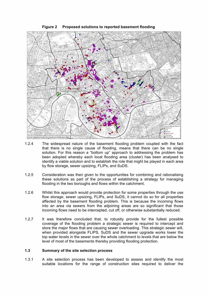
Figure 2 Proposed solutions to reported basement flooding
1.2.4 The widespread nature of the basement flooding problem coupled with the fact
that there is no single cause of flooding, means that there can be no single solution. For this reason a “bottom up” approach to addressing the problem has been adopted whereby each local flooding area (cluster) has been analysed to identify a viable solution and to establish the role that might be played in each area by flow storage, sewer upsizing, FLIPs, and SuDS.
1.2.5 Consideration was then given to the opportunities for combining and rationalising
these solutions as part of the process of establishing a strategy for managing flooding in the two boroughs and flows within the catchment.
1.2.6 Whilst this approach would provide protection for some properties through the use
flow storage, sewer upsizing, FLIPs, and SuDS, it cannot do so for all properties affected by the basement flooding problem. This is because the incoming flows into an area via sewers from the adjoining areas are so significant that those incoming flows need to be intercepted, cut off, or otherwise substantially reduced.
1.2.7 It was therefore concluded that, to robustly provide for the fullest possible coverage of the flooding problem a strategic sewer is required to intercept and store the major flows that are causing sewer overloading. This strategic sewer will, when provided alongside FLIPS, SuDS and the sewer upgrade works lower the top water levels in the sewer over the whole catchment to levels that are below the level of most of the basements thereby providing flooding protection.
1.3 Summary of the site selection process 1.3.1 A site selection process has been developed to assess and identify the most
suitable locations for the range of construction sites required to deliver the

strategic sewer, namely drive shaft site(s), reception shaft site(s), interception shaft site(s), sewer outfall connections or new sewer outfalls, a pumping station and construction compounds.
1.3.2 The process takes account of engineering, environment (including noise and
transport), planning, property, socio-economic and community issues relevant to the selection of the most suitable combination of sites.
1.3.3 It draws upon other methodologies utilised for the Deephams Sewage Works Upgrade and for the Thames Tideway Tunnel to ensure that the approach and issues covered reflect best practice. Regard has also been had to the National Planning Policy Framework and the Development Plan for the area, along with key considerations affecting engineering decision-making and property assessment, when the assessment criteria in the methodology were identified. The methodology is shown diagrammatically in Figure 3 below.
Figure 3 Site Selection Methodology
1.3.4 The methodology follows a sequential multi-stage process, with some stages
undertaken in parallel. There is an iterative relationship between site selection, route alignment and engineering design whereby as the engineering team refines the route options for the storm relief sewer associated restrictions on or requirements for sites are fed into the concurrent site selection process.
1.3.5 An essential part of the methodology is the use of an ongoing review process to revisit and check the validity of previous assessments. This is undertaken as each key stage of the assessment process is completed through document review and stage workshops and enables the assessment of sites (and concurrent assessment of options reported separately) to remain valid as information changes and new information is obtained.

1.3.6 Where, for example, route alignment parameters change or available sites become restricted over time, stages in the process may be repeated (or back-checked) in order to take account of new information or other changes in circumstance.
1.4 Approach to consultation and stakeholder engagement 1.4.1 Community engagement is a key part of the strategic sewer scheme and the public
will be fully engaged with once the assessment work in Stage 3 is completed and sufficient information is available to begin public consultation under Stage 4a.
1.5 Project Programme 1.5.1 The current provisional project programme for the strategic sewer is:
• Evidence gathering / scheme development and testing: Jan – Oct 2014 • Phase 1 consultation on options: Nov 2014 – Jan 2015 • Environmental and planning assessments: July 2014 – May 2015 • Confirmation of the preferred option: May / June 2015 • Phase 2 pre-application consultation: May / June – July / Aug 2015 • Final design, planning and environmental work: July – Oct 2015 • Submission of application(s) for Planning Permission: Nov 2015 • Target for planning permission: July 2016 • Planning Conditions / Obligations discharged / procurement complete: Dec
2016 • Anticipated start on site: Jan 2017

APPENDIX 2 SITE LOCATION PLAN

HAMMERSMITHAND FULHAM
ROYAL BOROUGHOF KENSINGTON
AND CHELSEA
108
204
Communal
29
2
136
30
El
3575
3
58
125
65
50
48
MP .25
141111
38 to 40
34
113
36
375.5m
5.1m
63
99
53
32
PH
6.6m
RICH
MOND
24
WOODSTOCK GROVE
11
30 to
40Kensington House
19
81
Sta
6.8m
SINCLAIR GARDENS
144
17
56
5.4m
Bush Court
1 to 6
21 to 40
Bank
90
79
6.7m
1 to 20
Court
HOLLAND ROAD
11 to
18
Roof Car Park
7 to 17
15 160
150
9
8.2m
Vicarage
16
28
CHARECROFT WAY
21c
98
Addison Park
Hall
22
6.1m
14a
SP
El Sub Sta
4044
Woodstock
23
101
25
18
42
4.8m
14
85
52
67
45
73
FIELDING ROAD
LB
7
17a
135149
Bradford
Garag
e
23a
Shopping Centre
ADDISON GARDENS
4.7m
133
87
62
43
76
39
96
33
92
46
38
97
8
21
60
47
FW
CW
55
121
77
4
41
134
59
1
MILSON ROAD
REDAN STREET4.9m
83
57
FFBoro Const & LB Bdy
CR
31
51126
26
127
69
10
1 to 24
17 to 21
4.5m104
FARO
E ROA
D
80
49
27
72
146
11661
86
13
IRVING ROAD
CAITHNESS ROAD
20
Community Centre
6
158
70
19 to
26
1aBurnand MA
SBRO
' ROA
D
Shepherds Building
100Boswell Court
Addison Primary School
91a to c
Addis
on P
ark M
ansio
ns
1c
Bronte
AYNHOE ROAD
Walpole Court
BOLINGBROKE ROAD
64
APPLEGARTH ROAD
Addison
5.3m
Studio
54
Surgery
a
12
23 to
29
68
SPRING VALE TERRACE5.2m
186
79a
5
Sub Sta
1 to 18
7a NAPIER ROAD
Alcove
OAKWOOD COURT
Pond
Serlby Court
133 to 148
NAPIER PLACE
1 to 7
S Gantry
6a
Depot
3.7m
RUSSELL GARDENS
Post Office Savings Bank
118
Sand Drag
Serlby
3.9m
13b78
HOFLAND ROAD88
OLYMPIA WAY
(PH)
Office
BP
84
Car Park
1 to 1
2
119
PC
MP .5
St
CRESCENT
Eagle
HAZL
ITT RO
AD
TCBs
Church
4.3m
FAIRFAX PLACE
BS
Und
CF
Ward
Bdy
14.7m
6.9m
10.3m
6.2m
82
156
117The Cardinal Vaughan
School
Drain
10.4m
Play Area
10.7m
ABBOTSBURY
5.7m
74
132
Lime Tree Avenue
SINCLAIR ROAD
1 to 5
BEAC
ONSF
IELD
Counters Court
Cann House
66
3.5m1 to 19
Foot Bridge
1 to 17
CEYL
ON RO
AD
3.8m
Porte
n Hou
ses
MP 0.75
35b
Thac
keray
Court
Calcott
Multistorey
Ludwell House
House
RUSSELL GARDENS MEWS
107
Todber House
71
ADDISON ROAD
168
109
95
124
120
Elsham Terrace
1b
8a
LOWER ADDISON GARDENS
10.5m
5.6m
6.5m
11a
6.3m
178
166
Woodsford Square
182
105
HOLLAND VILLAS ROAD
5.8m
ELSHAM ROAD
Redlynch
94
6.0m
TCB
43 to 50
Tk
Car Pk
Farley Court
5.9m
364 to 366
63 to 84
The
TCPs
1 to 14
CLOSE
13 to 24
382 to 386
85 to 100
OAKWOOD LANE
Station
MacliseRoad SiteBoundary
This document was prepared by Mott MacDonald Limited under assignment from Thames Water and the content should not be relied on or used for purposes other than those assigned,without verification from Thames Water. Mott MacDonald Limited does not accept responsibility or liability for use of this document other than that for which it was originally intended.
DRAFT FOR DISCUSSION
FIRST ISSUEDescription Dsgnr Chkd Appd Date
Thames Water Utilities
Clearwater CourtVastern Road, Reading RG1 8DB
CAPITAL DELIVERY
TQ2480OS Reference:
UBRSecurity Reference: Drawn By:
N/ALocation Code:
NETWORKProject Group
WASTEWATERSub Process:
Location/Town:
Site Name:
COUNTERS CREEK FLOOD ALLEVIATION SCHEMEProject Name:
MAIN CONTRACTContract Name:
APPENDIX 2 SITE LOCATION PLANDrawing Title:
XRev:A3Sheet Size:Scale:C680-A1-00000-DRDrawing No:
MACLISE ROAD CAR PARK & WOODLAND ADJACENT TO KENSINGTON OLYMPIA STATION
WEST LONDON
AIss
© Thames Water Utilities Ltd 2006
DO NOT SCALE - IF IN DOUBT ASK © COPYRIGHT: UNAUTHORISED REPRODUCTION PROHIBITED.BASED ON THE ORDNANCE SURVEY MAP WITH THE SANCTIONOF H.M. STATIONERY OFFICE - LICENCE No. 100019345
DT
0 30 60 90 12015
Metres
KEY:MACLISE ROAD CAR PARK &WOODLAND ADJACENT TOKENSINGTON OLYMPIASTATION SITE BOUNDARIESLocal Authority Boundary
17/11/2015GB XX
1:3,000
HP
1:3,000SCALE:

APPENDIX 3 INDICATIVE CONSTRUCTION LAYOUT PLANS


APPENDIX 4 INDICATIVE OPERATIONAL LAYOUT PLANS

APPENDIX 5 PLANNING AND ENVIRONMENT PLANS


APPENDIX 6 RELEVANT PLANNING POLICY

Policy / paragraph Reference
Policy title / Paragraph subject
Summary of relevant policy
The London Plan – The Spatial Development Strategy for London (consolidated with alterations since 2011) (March 2015)1
Policy 2.18 Green Infrastructure: the multi functional network of green and open spaces
The Mayor will work with all relevant strategic partners to protect, promote, expand and manage the extent and quality of, and access to, London’s network of green infrastructure. Development proposals should incorporate appropriate elements of green infrastructure that are integrated into the wider network and encourage the linkage of green infrastructure, including the Blue Ribbon Network, to the wider public realm to improve accessibility for all and develop new links, including green chains, street trees, and other components of urban greening.
Policy 4.12 Improving opportunities for all
The policy seeks to improve employment opportunities for Londoners, to remove barriers to employment and progression and to tackle low participation in the labour market. Strategic development proposals should support local employment, skills development and training opportunities.
Policy 5.2 Minimising carbon dioxide emissions
The policy requires development proposals to make the fullest contribution to minimising carbon dioxide emissions in accordance with the energy hierarchy. All major development proposals should meet the targets set out in the policy for carbon dioxide emissions reduction in buildings. In addition, major proposals should include detailed energy assessment to demonstrate how the minimum targets for carbon dioxide emissions reduction are met.
Policy 5.3 Sustainable design and construction
The highest standards of sustainable design and construction should be achieved in London to improve the environmental performance of new development and to adapt to the effects of climate change over their lifetime. Development proposals should demonstrate that sustainable design standards are integral to the proposal, including its construction and operation, and ensure that they are considered at the beginning of the design process.
Policy 5.6 Decentralised energy in development proposals
Development proposals should evaluate the feasibility of Combined Heat and Power (CHP) systems, and where a new CHP is appropriate examine opportunities to extend the system beyond the site boundary to adjacent sites.
Policy 5.7 Renewable energy The Mayor seeks to increase the proportion of energy generated from renewable sources, and expects that the projections for installed renewable energy capacity outlined in the Climate Change Mitigation and Energy Strategy and in supplementary planning guidance will be achieved in London. Major development proposals should provide a reduction in expected carbon dioxide emissions through the use of onsite renewable energy generation, where feasible.
Policy 5.9 Overheating and cooling
Major development proposals should demonstrate how the design, materials, construction and operation of the development would minimize overheating and also meet its cooling needs.
Policy 5.10 Urban Greening The Mayor will promote and support urban greening, such as new planting to the public realm (including streets, squares and plazas) and green infrastructure, to contribute to the adaption to, and mitigation of, the effects of climate change.
Policy 5.12 Flood Risk Management
Development proposals must comply with the flood risk assessment and management requirements set out in the NPPF and the associated Technical Guidance on flood risk over the lifetime of the development and have regard to measures proposed in Thames Estuary 2100 and Catchment Flood Management Plans.
1 The London Plan – The Spatial Development Strategy for London (consolidated with alterations since 2011) (March 2015) comprises: The London Plan 2011 consolidated with Revised Early Minor Alterations to the London Plan (October 2013) and the Further Alterations to the London Plan (March 2015).

Policy / paragraph Reference
Policy title / Paragraph subject
Summary of relevant policy
Policy 5.13 Sustainable Drainage
Development should utilise sustainable urban drainage systems (SUDS) unless there are practical reasons for not doing so and should aim to achieve Greenfield run-off rates and ensure that surface water runoff is managed as close to its source as possible.
Policy 5.14 Water quality and sewerage infrastructure
Development proposals must ensure that adequate sewerage infrastructure capacity is available. Proposals that would benefit water quality, the delivery of policies in the London Plan and of the Thames River Basin Management Plan should be supported while those with adverse impacts should be refused. Development proposals to upgrade London’s sewerage (including sludge) treatment capacity should be supported provided they utilise the best available technology and energy capture.
Policy 5.18 Construction, excavation and demolition waste
Major development sites are required to recycle CE&D waste on-site, wherever practicable, supported through planning conditions. Waste should be removed from construction sites, and materials brought to the site, by water or rail transport wherever that is practicable.
Policy 5.21 Contaminated Land Appropriate measures should be taken to ensure that development on previously contaminated land does not activate or spread contamination.
Policy 6.1 Transport – Strategic approach
The Mayor will work with all relevant partners to encourage the closer integration of transport and development through a range of means including facilitating the efficient distribution of freight whilst minimising its impact on the transport network and seeking to increase the use of the Blue Ribbon Network, especially the Thames, for passenger and freight use.
Policy 6.3 Assessing effects of development on transport capacity
Development proposals should ensure that impacts on transport capacity and the transport network, at both a corridor and local level are fully assessed. Where existing transport capacity is insufficient to allow for the travel generated by proposed developments, and no firm plans exist for an increase in capacity to cater for this, boroughs should ensure that development proposals are phased until it is known these requirements can be met, otherwise they may be refused. The cumulative impacts of development on transport requirements must be taken into account. Transport assessments will be required in accordance with TfL’s Transport Assessment Best Practice Guidance for major planning applications. Workplace and/or Residential Travel Plans should be provided for planning applications exceeding the thresholds in, and produced in accordance with, the relevant TfL guidance. Construction logistics plans and delivery & servicing plans should be secured in line with the London Freight Plans and should be coordinated with Travel Plans.
Policy 6.10 Walking Ensure pedestrian environments in and around new developments emphasise the quality of pedestrian and street space by referring to Transport for London’s Pedestrian Design Guidance.
Policy 6.14 Freight Development proposals that locate developments that generate high numbers of freight movements close to the major transport routes that promote the uptake of the Fleet Operations Recognition Scheme, construction logistics plans and delivery & servicing plans, and more innovative freight solutions and increase the use of the Blue Ribbon Network for freight transport, will be encouraged.
Policy 7.1 Lifetime Neighbourhoods
Development should be designed so that the layout, tenure, and mix of uses interface with surrounding land and improve people’s access to social and community infrastructure (including green spaces), the Blue Ribbon Network, local shops, employment and training opportunities, commercial services and public transport.
Policy 7.2 An inclusive environment
The Mayor will require all new development in London to achieve the highest standards of accessible and inclusive design. Development proposals should meet the highest standards of accessible and inclusive design and should

Policy / paragraph Reference
Policy title / Paragraph subject
Summary of relevant policy
demonstrate that they meet the principles of inclusive design.
Policy 7.4 Local Character Development should have regard to the form, function and structure of an area, place or street and the scale, mass and orientation of surrounding buildings. It should improve an area’s visual or physical connection with natural features.
Policy 7.5 Public Realm Development should make the public realm comprehensible at a human scale, using gateways, focal points and landmarks to help people find their way. Landscape treatment, furniture and infrastructure should be of the highest quality, have a clear purpose, maintain uncluttered spaces and should contribute to the easy movement of people through the space. Opportunities for the integration of high quality public art should be considered, and opportunities for greening such as through planting of trees and other soft landscaping wherever possible, should be maximised. Treatment of the public realm should be informed by the heritage values of the place, where appropriate. Development should incorporate local social infrastructure such as public toilets, drinking water fountains and seating, where appropriate. Development should also reinforce the connection between public spaces and existing local features such as the Blue Ribbon Network and parks and other that may be of heritage significance.
Policy 7.6 Architecture Buildings and structures should: • be of the highest architectural quality • be of a proportion, composition, scale and orientation that enhances,
activates and appropriately encloses the public realm • compromise details and materials that complement, not necessarily
replicate, the local architectural character • not cause unacceptable harm to the amenity of surrounding land and
buildings, particularly residential buildings, in relation to privacy, overshadowing, wind and microclimate.
• incorporate best practice in resource management and climate change mitigation and adaptation
• provide high quality indoor and outdoor spaces and integrate well with the surrounding streets and open spaces
• be adaptable to different activities and land uses, particularly at ground level
• meet the principles of inclusive design
Policy 7.8 Heritage assets and archaeology
Development should incorporate measures that identify, record, interpret, protect and, where appropriate, present, the site’s archaeology. Development should preserve, refurbish and incorporate heritage assets, where appropriate. New development in the setting of heritage assets, and conservation areas should be sympathetic to their form, scale, materials and architectural detail.
Policy 7.14 Improving Air Quality
Development proposals should promote sustainable design and construction to reduce emissions from the demolition and construction of buildings. Development proposals need to be at least ‘air quality neutral’ and not lead to further deterioration of existing poor air quality.
Policy 7.15 Reducing noise and managing noise, improving and enhancing the acoustic environment and promoting appropriate soundscapes
Development proposals should seek to manage noise by; avoiding significant adverse noise impacts on health and quality of life as a result of new development; mitigating and minimising the existing and potential adverse impacts of noise on, from, within, as a result of, or in the vicinity of new development without placing unreasonable restrictions on development or adding unduly to the costs and administrative burdens on existing of businesses; and promoting new technologies and improved practices to reduce noise at source and on the transmission path from source to receiver.

Policy / paragraph Reference
Policy title / Paragraph subject
Summary of relevant policy
Policy 7.18 Protecting Open Space and addressing deficiency
The policy seeks to resist the loss of protected open space and support the creation of new open space. The loss of protected open spaces must be resisted unless equivalent or better quality provision is made within the local catchment area.
Policy 7.19 Biodiversity and access to nature
Development proposals wherever possible should make a positive contribution to the protection, promotion and management of biodiversity. On sites of Importance for Nature Conservation, the policy gives the highest protection to sites with existing or proposed international designations (SACs, SPAs, Ramsar sites) and national designations (SSSIs, NNRs). The London Plan gives strong protection to Sites of Metropolitan Importance for Nature Conservation (SMIs) and gives Sites of Borough and Local Importance for Nature Conservation the level of protection commensurate with their importance.
Policy 7.21 Trees and Woodlands
Existing trees of value should be retained and any loss as the result of development should be replaced following the principle of ‘right place, right tree’. Wherever possible the planting of additional trees should be included in new developments, particularly large canopied species.
Royal Borough of Kensington and Chelsea’s Adopted Consolidated Local Plan (July 2015)2
Policy C1 Infrastructure Delivery and Planning Obligation
New development will be coordinated with the provision of appropriate infrastructure to support development. The Council will require that there is adequate infrastructure to serve developments, including through the use of planning obligations, working with infrastructure providers and stakeholders to identify requirements.
Policy CR3 Street and Outdoor Life
The Council will require proposals affecting pavements to maintain the free, safe and secure passage of pedestrians.
Policy CR4 Streetscape The Council require all works to, or affecting, the public highway, to be carried out in accordance with the council’s adopted Streetscape Guidance; retain, and seek the maintenance and repair of, historic street furniture such as post boxes and historic telephone kiosks; require that where there is an exceptional need for new street furniture that it is of high quality design and construction; resist adverts that harm amenity or public or road safety; resist freestanding structures such as telephone kiosks where the function for the display of adverts over-dominates the primary purpose for the structure; resist pavement crossovers and forecourt parking; require all major development to provide new public art that is of high quality and wither incorporated into the external design of the new building or carefully located within the public realm.
Policy CR6 Trees and Landscape
The Council will resist the loss of trees and any development which results in the damage or loss of tress of townscape or amenity value. The Council requires that where practicable an appropriate replacement be provided for any tree that is felled.
Policy CL1 Context and Character
The Council will require all development to respect the existing context, character, and appearance, taking opportunities available to improve the quality and character of buildings and the area and the way it functions, including being inclusive for all.
Policy CL2 Design Quality The Council will require all development to be of the highest architectural and urban design quality, taking opportunities to improve the quality and character of buildings and the area and the way it functions. The policy sets outs requirements for development.
2 The Consolidated Local Plan (July 2015) combines alterations since the Core Strategy adoption (December 2010) incorporating the Pubs & Local Character Review (October 2013), the Miscellaneous Matters Review (December 2014), the Conservation & Design Review (December 2014) and the Basements Review (January 2015).
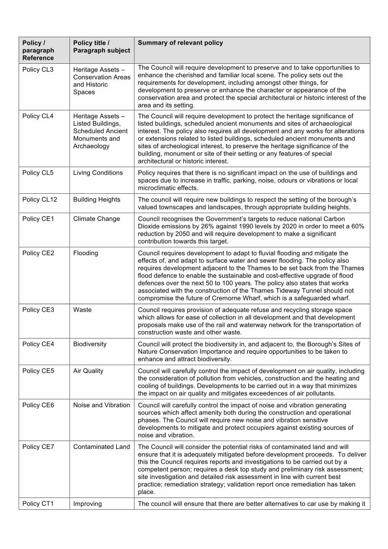
Policy / paragraph Reference
Policy title / Paragraph subject
Summary of relevant policy
Policy CL3 Heritage Assets – Conservation Areas and Historic Spaces
The Council will require development to preserve and to take opportunities to enhance the cherished and familiar local scene. The policy sets out the requirements for development, including amongst other things, for development to preserve or enhance the character or appearance of the conservation area and protect the special architectural or historic interest of the area and its setting.
Policy CL4 Heritage Assets – Listed Buildings, Scheduled Ancient Monuments and Archaeology
The Council will require development to protect the heritage significance of listed buildings, scheduled ancient monuments and sites of archaeological interest. The policy also requires all development and any works for alterations or extensions related to listed buildings, scheduled ancient monuments and sites of archeological interest, to preserve the heritage significance of the building, monument or site of their setting or any features of special architectural or historic interest.
Policy CL5 Living Conditions Policy requires that there is no significant impact on the use of buildings and spaces due to increase in traffic, parking, noise, odours or vibrations or local microclimatic effects.
Policy CL12 Building Heights The council will require new buildings to respect the setting of the borough’s valued townscapes and landscapes, through appropriate building heights.
Policy CE1 Climate Change Council recognises the Government’s targets to reduce national Carbon Dioxide emissions by 26% against 1990 levels by 2020 in order to meet a 60% reduction by 2050 and will require development to make a significant contribution towards this target.
Policy CE2 Flooding Council requires development to adapt to fluvial flooding and mitigate the effects of, and adapt to surface water and sewer flooding. The policy also requires development adjacent to the Thames to be set back from the Thames flood defence to enable the sustainable and cost-effective upgrade of flood defences over the next 50 to 100 years. The policy also states that works associated with the construction of the Thames Tideway Tunnel should not compromise the future of Cremorne Wharf, which is a safeguarded wharf.
Policy CE3 Waste Council requires provision of adequate refuse and recycling storage space which allows for ease of collection in all development and that development proposals make use of the rail and waterway network for the transportation of construction waste and other waste.
Policy CE4 Biodiversity Council will protect the biodiversity in, and adjacent to, the Borough’s Sites of Nature Conservation Importance and require opportunities to be taken to enhance and attract biodiversity.
Policy CE5 Air Quality Council will carefully control the impact of development on air quality, including the consideration of pollution from vehicles, construction and the heating and cooling of buildings. Developments to be carried out in a way that minimizes the impact on air quality and mitigates exceedences of air pollutants.
Policy CE6 Noise and Vibration Council will carefully control the impact of noise and vibration generating sources which affect amenity both during the construction and operational phases. The Council will require new noise and vibration sensitive developments to mitigate and protect occupiers against existing sources of noise and vibration.
Policy CE7 Contaminated Land The Council will consider the potential risks of contaminated land and will ensure that it is adequately mitigated before development proceeds. To deliver this the Council requires reports and investigations to be carried out by a competent person; requires a desk top study and preliminary risk assessment; site investigation and detailed risk assessment in line with current best practice; remediation strategy; validation report once remediation has taken place.
Policy CT1 Improving The council will ensure that there are better alternatives to car use by making it
Policy / paragraph Reference
Policy title / Paragraph subject
Summary of relevant policy
alternatives to car use
easier and more attractive to walk, cycle and use public transport and by managing traffic congestion and the supply of car parking. To deliver this the Council will require Transport Assessments and Travel Plans for larger scale development and ensure that development does not reduce access to, or the attractiveness of, existing footpaths and footpaths used by the public, or land over which the public have a right of way.
Infrastructure Schedule on page 293 The infrastructure Schedule on page 293 of the adopted Core Strategy sets out the key infrastructure requirements within the Borough which include Counters Creek. The Core Strategy states that the Counters Creek sewer upgrade scheme would relieve existing and overcome localized surface flooding problems.
Kensington and Chelsea Unitary Development Plan (UDP) 2002 (2007) Saved Policies
Saved UDP Policy STRAT35
Strategic Policy - Transport
The Council supports an effective London-wide control of night-time and weekend lorry movement. This policy has not been saved. The Consolidated Local Plan (2015) identifies that this policy will be moved to Highways and Transportation document. This document was not available as at October 2015.
Hammersmith and Fulham Local Development Framework Core Strategy Development Plan Document (October 2011) 3
Borough Wide Strategic Policy CF1
Supporting Community Facilities and Services
The Council will work with its strategic partners to provide borough wide high quality facilities and services for the community by generally protecting all existing community facilities and services throughout the borough.
Borough Wide Strategic Policy OS1
Improving and Protecting Parks and Open Spaces
The policy aims to protect and enhance parks, open spaces and biodiversity in the Borough. The site is designated as open space on the Hammersmith and Fulham Core Strategy proposals map.
Borough Wide Strategic Policy BE1
Built Environment This policy requires that all development within the borough should create a high quality environment that respects and enhances its townscape context and heritage assets. In addition, the policy requires an approach to accessible and inclusive urban design that considers how good design, quality public realm, landscaping and land use can be integrated to help regenerate places. The policy also requires all development to be designed to enhance community safety and minimise the opportunities for crime, and be attractive, durable, adaptable, and accessible in order to achieve good sustainable and inclusive design. The site is immediately adjacent to a conservation area. Policy BE1 states that development throughout the borough should protect and enhance the character, appearance and setting of the borough’s conservation areas and its historic environment, including listed buildings, historic parks and gardens, buildings and artefacts of local importance and interest, archaeological priority areas and Fulham Palace Moated Site scheduled ancient monument.
Borough Wide Strategic Policy CC1
Reduce Carbon Emissions and Resource Use and Adapt to Climate Change Impacts
Requires development to make the fullest possible contribution to the mitigation and adaptation to climate change.
Borough Wide Strategic Policy CC2
Water Flooding Requires all developments to minimise current and future flood risk and the adverse effects of flooding on people. The council will strive to reduce the risk of flooding from surface water and foul water and its contribution to fluvial flooding by requiring development proposals to include appropriate sustainable drainage systems and systems to reduce the amount of water discharged to
3 Regulation 18 Consultation on the draft London Borough of Hammersmith and Fulham Local Plan closed in February 2015. Adoption of the local plan is scheduled for Spring 2016 and once adopted the local plan will replace the existing London Borough of Hammersmith and Fulham Core Strategy and Development Management Plan.

Policy / paragraph Reference
Policy title / Paragraph subject
Summary of relevant policy
the foul water drainage.
Borough Wide Strategic Policy CC3
Waste Management
This policy promotes sustainable waste behavior, including sustainable demolition, in new and existing developments. Seeking, where possible the movement of waste and recyclable materials by sustainable means of transport, including the Grand Union Canal.
Borough Wide Strategic Policy CC4
Protecting and Enhancing Environmental Quality
The council will support measures to protect and enhance the environmental quality of the borough including harmful emissions of land, air and water and the remediation of contaminated land. It will work with partner organisations to help deliver this.
Paragraph 10.21
The Core Strategy at Paragraph 10.21 supports Thames Water’s commitment to “improving the Counters Creek Sewer – the principle sewer draining Hammersmith and Fulham and other adjoining boroughs. It is anticipated that improvements to the sewer will be made within Thames Water’s 2015 – 20 budgetary period. The council will work with Thames Water and other stakeholders to ensure that there is adequate water supply, surface water foul drainage and sewerage treatment capacity to serve all new developments”.
Borough Wide Strategic Policy T1
Transport This policy seeks increased use of the Thames for freight use; secure access improvements for all, particularly people with disabilities, as part of planning permissions for new developments, and ensures appropriate parking is provided to meet the essential needs of the development without impacting on the quality of the urban environment.
Hammersmith and Fulham Development Management Local Plan (July 2013) 4
Policy DM B3 Local employment, training and skills development initiative
The council will seek appropriate employment and training initiatives of local people of all abilities in the construction of major developments and in larger employment generating developments, including visitor accommodation and facilities when these are completed.
Policy DM E3 Nature Conservation
The policy seeks to protect nature conservation areas and green corridors from development likely to cause demonstrable harm to their ecological (habitats and species) value. In these areas, development will not be permitted unless: • the proposed development would release a site for built environment
needed to realize a qualitative gain for the local community in pursuance of other physical, social and economic regeneration objectives of the Core Strategy, and measures are included for the protection and enhancement of any substantive nature conservation interest that the site may have so that there is no net loss of habitat; or
• provision is made for replacement nature conservation interest of equal or greater value elsewhere in the locality.
Policy DM E4 Greening the borough
The council will seek to enhance biodiversity and green infrastructure in the borough by maximising the provision of gardens, garden space and soft landscaping and seeking green roofs and other planting as part of new development. The Policy will also seek to prevent the removal or mutilation of protected trees and seeking retention of existing trees and provision of new trees on development sites.
Policy DM G1 Design of New Build
Encourages a high standard of design and compatibility with the scale and character of existing development and its setting. The policy also ensures that all proposals are designed to respect the historical context and townscape setting of the site, and its sense of place.
Policy DM G7 Heritage and Conservation
The Council will aim to protect, restore or enhance the quality, character, appearance and setting of the borough’s conservation areas and its historic environment, including listed buildings, historic parks and gardens, buildings
4 Regulation 18 Consultation on the draft London Borough of Hammersmith and Fulham Local Plan closed in February 2015. Adoption of the local plan is scheduled for Spring 2016 and once adopted the local plan will replace the existing London Borough of Hammersmith and Fulham Core Strategy and Development Management Plan.

Policy / paragraph Reference
Policy title / Paragraph subject
Summary of relevant policy
and artefacts of local importance and interest, archaeological priority areas and the scheduled ancient monument.
Policy DM H2 Promoting sustainable design and construction
The Council require the implementation of sustainable design and construction measures by requiring Sustainability Statements for all major developments to ensure the full range of sustainability measures have been taken into account during the design stage.
Policy DM H5 Sustainable Waste Management
All new developments should include suitable facilities for the management of waste generated by the development, including the collection and storage of separated waste and where feasible on-site energy recovery.
Policy DM H8 Air Quality The Council aim to reduce the potential adverse air quality impacts of new developments by implementing measures, including the requirement of all major developments to provide an air quality assessment that considers the potential impacts of pollution from the development on the site and on neighboring areas.
Policy DM H9 Noise The policy states that noise impacts of developments will be controlled by not permitting noise generating development, if it would be liable to materially increase the noise experienced by the occupants/users of existing or proposed noise sensitive users in the vicinity.
Policy DM J1 Transport Assessments and Travel Plans
The council will require a Transport Assessment, together with a Travel Plan where a development is expected to generate more than a specified number of trips, or during peak hours. Construction Logistics Plans and Delivery and Servicing Plans should be secured in line with TfL’s London Freight Plan and should be coordinated with Travel Plans.
Policy DM J6 Borough road network – hierarchy of roads
Development which will have an effect on the Borough’s road network will be regulated through the hierarchy of roads, which designates Hammersmith Road (A315) as a Local Distributor Roads. The Policy will not permit development if it would prejudice the effectiveness of these roads to distribute traffic to land and property within any local area bounded by the strategic route network and London Distributor roads, or introduce additional traffic on them.

APPENDIX 7 ENVIRONMENTAL APPRAISAL TABLES

Site Suitability Report: [SS241 – Maclise Road Car Park and Woodland adjacent to Kensington Olympia Station]
1
Appendix 8 Environmental Appraisal Tables Transport
Site Considerations Comments Mitigation required and Conclusions
Methodology A number of criteria are used when appraising the suitability of the site. These include access to the road network, which encompasses whether the site is considered to be accessible for Heavy Goods Vehicles (HGVs), whether vehicles could potentially access and egress the site (allowing for mitigation / traffic management where appropriate) and the proximity to the Transport for London Road Network (TLRN). Other criteria include whether the site has good connections to public transport and the potential to utilise rail lines or river transport, as well as the availability of parking for the workforce, the extent of traffic management that would be required and the potential requirement to deliver mitigation. Taking account of these factors and using professional judgement, a balanced view is taken on the suitability of the site.
Access to road network
Access to the site is via Olympia Way from the A315. Olympia Way is one way past Olympia Station. It forms the access for the station and Olympia London (the conference centre). The road layout is suitable for Heavy Goods Vehicles (HGVs). However, the road layout may make it a convoluted trip, due to the one-way configuration. Vehicles would approach the site from the east on the A315 before turning right onto Olympia Way. Vehicles would drive past the station and Olympia London and then through the Maclise Road Car Park and into the site. In the circumstances when Olympia Way is congested an alternative access may be available (not for articulated HGVs) via the A315 turning into Blythe Road. Vehicles
There is a potential issue concerning vehicles needing to pass through the station and Olympia London access area, particularly when events are taking place. The proposed alternative access via Blythe Road, Hazlitt Road and Sinclair Road is through a residential area with parking on both sides of the road. Pedestrian safety is a key issue for both of these routes, with low speeds necessary. There are limited alternative accesses due to the location of the site, which is between houses and the rail line.
The junction of the A315 and Olympia Way may require adaption to include a right turn feeder lane and the junction between Blythe Road and the A315 may require minor modifications in order to ensure it is suitable for HGVs.

Site Suitability Report: [SS241 – Maclise Road Car Park and Woodland adjacent to Kensington Olympia Station]
2
Transport
Site Considerations Comments Mitigation required and Conclusions
would follow Blythe Road, taking two left turns before turning right into Hazlitt Road, right into Sinclair Road and left into Maclise Road. From Maclise Road they would then turn left into the Maclise Road Car Park and into the site. During a site visit (whilst an event was taking place at Kensington Olympia), sections of Blythe Road were observed to be operating as an exit only and this route may not be available at all times. HGVs are to be turned on a specially installed vehicle turntable onsite and would exit through the site entrance driving through the Maclise Road Car Park and turning right onto Maclise Road, where they would take a left onto Beaconsfield Terrace (which becomes Blythe Road) before turning left onto the A315. The junction between Blythe Road and the A315 may require minor modifications to ensure it is suitable for HGVs. From the A315 vehicles can take a left onto the A3220, a TfL Transport for London Road Network (TLRN). The existing access is fenced; the area is street lit and is subject to a 30mph speed limit. There is good visibility onto both Olympia Way and Maclise

Site Suitability Report: [SS241 – Maclise Road Car Park and Woodland adjacent to Kensington Olympia Station]
3
Transport
Site Considerations Comments Mitigation required and Conclusions
Road, by virtue of the access being located on the outside of the corner of these two roads.
Access to river
The site is not located within close proximity of the river.
The site is not considered suitable for access by river.
Access to rail
The site is very close to the rail line (London Overground); however, in order to transport spoil from the site by rail, a new siding would be required or loading would need to take place directly onto the mainline during possessions. This would cause substantial disruption to install these facilities and would disrupt the operation of the site.
The site is located close to rail facilities; however, transporting spoil from the site by rail would cause substantial disruption to the operation of the site. It is therefore concluded that transportation of materials by rail is not considered viable and all spoil is transported from the site by road.
Parking
There is car parking along one side of Maclise Road which is restricted by permits and pay and display which is available for a maximum of 8hrs. There is also car parking on the station side of Olympia Way; however, this is restricted for no unauthorised persons.
The two temporary satellite site areas on Elsham Road and Masbro Road would take several on street parking bays for the duration of these temporary works.
Car parking is restricted within the vicinity of the site. Limited on street car parking may be available for the workforce on Maclise Road.
The location of the two temporary satellite site areas will require the temporary suspension of a number of car parking spaces and consideration to displaced parking would also need to be afforded.
Public transport accessibility
The site is next to Olympia rail station where there is access to the London Overground and Underground networks. Bus stops serving route numbers 9/N9, 10, 27, 28/N28 are located along the A315. The site specific Public Transport Accessibility Level (PTAL) score is 4, which is Good. This site therefore has good access to public
There is good access to public transport providing potential for the workforce to access the site by public transport.

Site Suitability Report: [SS241 – Maclise Road Car Park and Woodland adjacent to Kensington Olympia Station]
4
Transport
Site Considerations Comments Mitigation required and Conclusions
transport, providing potential for the workforce to access the site by public transport.
Traffic Management
There will be a total peak of approximately 70 HGV two-way movements per day (35 to and 35 from the site). Access through the Maclise Road Car Park would require coordination with Olympia London to ensure a minimum of disruption to their operations. This may involve the short-term suspension of construction operations or storage onsite so construction can continue without HGV access.
The station and Olympia Way are likely to be very busy with pedestrians and traffic during events at Olympia London and therefore close coordination is required with Olympia London before and during works. Signing warning pedestrians of construction traffic will be required.
Two temporary satellite sites are also required during construction works. These are located in Elsham Road and Masbro Road to enable access through existing manholes to the Hammersmith SRS Duplication sewer. This will require the suspension of some parking bays and will require traffic management for the duration of these temporary works.
A traffic management plan should be submitted with any proposal.
The satellite sites are located at t-junctions. Consideration of traffic management at these junctions will be required together with any affected on-street cycling provision and one-way streets.
Summary:
Heavy Goods Vehicles (HGVs) will approach the site heading east on the A315, moving down the one way Olympia Way, past the station and Olympia London (the conference

Site Suitability Report: [SS241 – Maclise Road Car Park and Woodland adjacent to Kensington Olympia Station]
5
Transport
Site Considerations Comments Mitigation required and Conclusions
centre) and through the Maclise Road Car Park at the end of Olympia Way. These roads are busy due to the proximity of the station and Olympia London and pedestrian safety is likely to be an issue particularly when events are taking place. However, there is good visibility along Olympia Way and Maclise Road.
An alternative access is potentially available via the A315 turning into Blythe Road. Vehicles would follow Blythe Road, taking two left turns before turning right into Hazlitt Road, right into Sinclair Road and left into Maclise Road. From Maclise Road they would then turn left into the Maclise Road Car Park and into the site. This alternative is not proposed for articulated HGVs and would be an option in the event that Olympia Way is congested. The route comprises narrow residential roads and therefore pedestrian safety should be taken into account. During a site visit (whilst an event was taking place at Kensington Olympia), sections of Blythe Road were observed to be operating as an exit only and this route may not therefore be available at all times.
Access through the Maclise Road Car Park would require coordination with Olympia London to ensure a minimum of disruption to their operations. Close coordination is also required before and during works to minimise the impact on pedestrians/traffic using the station and Olympia Way, particularly during events at Olympia London. Additional traffic management measures will also likely be required and it is recommended that discussions are held with the highway authority and Transport for London (TfL) to discuss this further.
No river access is available within the vicinity of the site. The site is located close to rail facilities; however, in order to transport spoil from the site by rail a new siding would need to be installed. This would cause substantial disruption to install these facilities and would disrupt the operation of the site and hence it is considered not viable to transport materials by rail. Therefore, all spoil would be transported from the site by road. Maclise Road is controlled by permit and pay and display car parking and there is limited opportunity for the workforce to park in the vicinity of the site. The site features a good Public Transport Accessibility Level (PTAL) score indicating that staff will be able to access the site by public transport.
On the basis of the information available it is considered that the site is suitable, as it can be accessed from the existing highway network and is in close proximity to the Transport for London Road Network (TLRN).

Site Suitability Report: [SS241 – Maclise Road Car Park and Woodland adjacent to Kensington Olympia Station]
6
Noise
Site Considerations Comments Mitigation required and Conclusions
Methodology A noise model is used to predict the noise levels likely at the nearest sensitive receptor due to the noise emissions from the anticipated construction works equipment. This model is based on the methodology and information within BS 5228 -1:2009+A1:2014 ‘Code of practice for noise and vibration control on construction and open sites – Part 1: Noise’. When appraising the suitability of the site, a professional judgement is used by taking the predicted noise levels and the following factors into account:
• Number of sensitive receptors in the vicinity of the site; • Whether there are sensitive receptors at higher floors; • Prevailing noise levels (taken from the DEFRA noise maps); • Potential for noise shielding from construction works; • Likely duration of construction works; • Whether there will be night-time working; and • Potential for locating noisy plant away from sensitive
receptors. Noise band level (from Defra noise maps)
Information from Defra noise maps indicates traffic noise levels of below 55 dB(A) LAeq at the residential properties surrounding the site. Railway noise levels are predicted to be between 55 and 60dB(A), at the residential properties to the north-east of the site on Elsham Road, and between 60 and 65 dB(A) to the east, on Russell Gardens Mews, and to the west, on Sinclair Road.
Not applicable.
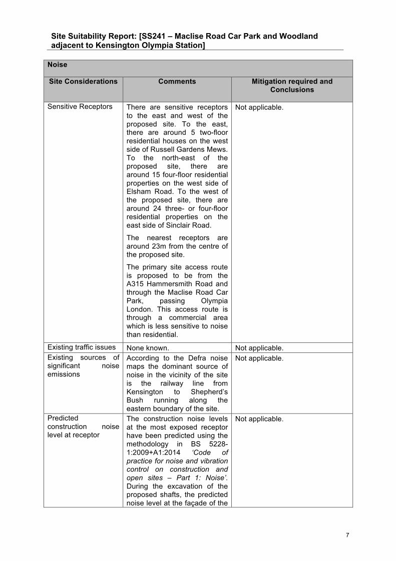
Site Suitability Report: [SS241 – Maclise Road Car Park and Woodland adjacent to Kensington Olympia Station]
7
Noise
Site Considerations Comments Mitigation required and Conclusions
Sensitive Receptors
There are sensitive receptors to the east and west of the proposed site. To the east, there are around 5 two-floor residential houses on the west side of Russell Gardens Mews. To the north-east of the proposed site, there are around 15 four-floor residential properties on the west side of Elsham Road. To the west of the proposed site, there are around 24 three- or four-floor residential properties on the east side of Sinclair Road.
The nearest receptors are around 23m from the centre of the proposed site.
The primary site access route is proposed to be from the A315 Hammersmith Road and through the Maclise Road Car Park, passing Olympia London. This access route is through a commercial area which is less sensitive to noise than residential.
Not applicable.
Existing traffic issues None known. Not applicable. Existing sources of significant noise emissions
According to the Defra noise maps the dominant source of noise in the vicinity of the site is the railway line from Kensington to Shepherd’s Bush running along the eastern boundary of the site.
Not applicable.
Predicted construction noise level at receptor
The construction noise levels at the most exposed receptor have been predicted using the methodology in BS 5228-1:2009+A1:2014 ‘Code of practice for noise and vibration control on construction and open sites – Part 1: Noise’. During the excavation of the proposed shafts, the predicted noise level at the façade of the
Not applicable.

Site Suitability Report: [SS241 – Maclise Road Car Park and Woodland adjacent to Kensington Olympia Station]
8
Noise
Site Considerations Comments Mitigation required and Conclusions
most exposed receptor is predicted to be 79 dB(A). It should be noted that the predicted noise levels are indicative only, for the purposes of comparison between the sites, and are based on an indicative distance between the centre of the site and the nearest receptor.
NOAEL / LOAEL / SOAEL
According to the criteria applied to the HS2 Environmental Impact Assessment for construction noise impacts, the Significant Observed Adverse Effect Level (SOAEL) is defined as ‘Noise outside dwellings from the Proposed Scheme at the facade: 75 dB (LpAeq,12hr) during the day; 65 dB (LpAeq,1hr) during the evening; or 55 dB (LpAeq,1hr) during the night, or above the existing ambient if this is higher.’ The predicted construction noise levels at the most exposed receptor exceed the daytime criterion, which, according to the Explanatory Note to the Noise Policy Statement for England, indicates that exposure to these construction noise impact will result in ‘significant adverse effects on health and quality of life’.
Not applicable.
Potential issues
The construction period is estimated at 26 months. The working hours for the works at surface level (site establishment, shaft sinking, finishings and demobilisation) will be 12 hours (7am – 7pm) Monday to Friday, and 6 hours (7am – 1pm) on Saturday.
Working hours for the
Adherence to the good site practices provided in BS5228.
Siting of noisy equipment and construction activities as far as is practicable from sensitive receptors.
Provision of site boundary noise fences.

Site Suitability Report: [SS241 – Maclise Road Car Park and Woodland adjacent to Kensington Olympia Station]
9
Noise
Site Considerations Comments Mitigation required and Conclusions
tunneling activities will be 24 hours a day, Monday to Friday and 13 hours (midnight – 1pm) on Saturday. However, these activities will be underground; hence no adverse noise impacts due to these activities are anticipated.
A maximum of 70 HGV movements per day are anticipated. This number of vehicle movements is likely to result in adverse noise impacts on nearby sensitive receptors.
The site area is bounded on two sides by sensitive receptors. Whilst the location of the shafts may be fixed, ancillary plant should be sited as far as is practicable from surrounding sensitive receptors, although it is recognised that due to the shape of the site this is unlikely to be possible. Situating plant along the northern area of the eastern boundary of the site would maximise the distance between them and the nearest sensitive receptors that are at higher floor levels, and hence minimise potential disturbance.
Vibration resulting from general construction works is not anticipated to result in an adverse impact. The nearest receptors to the proposed shaft locations are at a distance of approximately 23m and it is unlikely that vibration levels will result in minor cosmetic damage during shaft sinking but may give rise to annoyance. Vibration from tunnelling should be considered on a case by case basis at particular sensitive

Site Suitability Report: [SS241 – Maclise Road Car Park and Woodland adjacent to Kensington Olympia Station]
10
Noise
Site Considerations Comments Mitigation required and Conclusions
locations.
Summary:
This site is less suitable as there are noise sensitive receptors in close proximity to the site at high floors. Substantial adverse effects are expected at the closest sensitive receptors due to construction noise. Any shielding afforded by site perimeter barriers will be largely ineffectual due to the height of some of these receptors.
At this stage, it should be noted that the predicted noise levels are indicative only, for the purposes of comparison between the sites, and are based on an indicative distance between the centre of the site and the nearest receptor.
A further stage of more detailed noise modelling using realistic assumptions for the locations of all construction plant is being undertaken to determine if additional noise mitigation is required at each site. Initial results from the detailed modelling demonstrate that noise levels in reality may be lower than indicated in the SSRs.
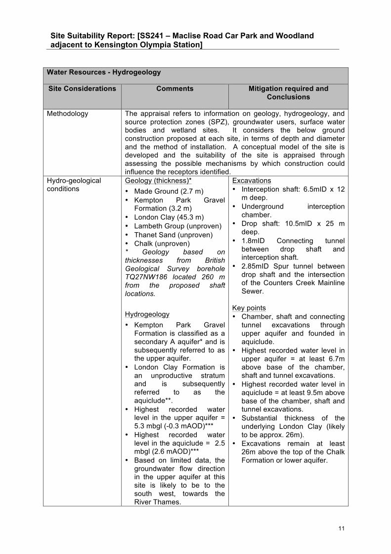
Site Suitability Report: [SS241 – Maclise Road Car Park and Woodland adjacent to Kensington Olympia Station]
11
Water Resources - Hydrogeology
Site Considerations Comments Mitigation required and Conclusions
Methodology The appraisal refers to information on geology, hydrogeology, and source protection zones (SPZ), groundwater users, surface water bodies and wetland sites. It considers the below ground construction proposed at each site, in terms of depth and diameter and the method of installation. A conceptual model of the site is developed and the suitability of the site is appraised through assessing the possible mechanisms by which construction could influence the receptors identified.
Hydro-geological conditions
Geology (thickness)* • Made Ground (2.7 m) • Kempton Park Gravel
Formation (3.2 m) • London Clay (45.3 m) • Lambeth Group (unproven) • Thanet Sand (unproven) • Chalk (unproven) * Geology based on thicknesses from British Geological Survey borehole TQ27NW186 located 260 m from the proposed shaft locations. Hydrogeology • Kempton Park Gravel
Formation is classified as a secondary A aquifer* and is subsequently referred to as the upper aquifer.
• London Clay Formation is an unproductive stratum and is subsequently referred to as the aquiclude**.
• Highest recorded water level in the upper aquifer = 5.3 mbgl (-0.3 mAOD)***
• Highest recorded water level in the aquiclude = 2.5 mbgl (2.6 mAOD)***
• Based on limited data, the groundwater flow direction in the upper aquifer at this site is likely to be to the south west, towards the River Thames.
Excavations • Interception shaft: 6.5mID x 12
m deep. • Underground interception
chamber. • Drop shaft: 10.5mID x 25 m
deep. • 1.8mID Connecting tunnel
between drop shaft and interception shaft.
• 2.85mID Spur tunnel between drop shaft and the intersection of the Counters Creek Mainline Sewer.
Key points • Chamber, shaft and connecting
tunnel excavations through upper aquifer and founded in aquiclude.
• Highest recorded water level in upper aquifer = at least 6.7m above base of the chamber, shaft and tunnel excavations.
• Highest recorded water level in aquiclude = at least 9.5m above base of the chamber, shaft and tunnel excavations.
• Substantial thickness of the underlying London Clay (likely to be approx. 26m).
• Excavations remain at least 26m above the top of the Chalk Formation or lower aquifer.

Site Suitability Report: [SS241 – Maclise Road Car Park and Woodland adjacent to Kensington Olympia Station]
12
Water Resources - Hydrogeology
Site Considerations Comments Mitigation required and Conclusions
* Permeable layers capable of supporting water supplies at a local rather than strategic scale, and in some cases forming an important source of base flow to rivers. ** An aquiclude is an impermeable body of rock or stratum of sediment that acts as a barrier to the flow of groundwater. *** Based on maximum water levels recorded in Thames Tideway Tunnel monitoring borehole PR1117 located at 1.7 km to west of site between Oct. 2009 to Dec. 2010** [nearest available data – may not be representative of site conditions].
Source Protection Zones (SPZs) and groundwater users
Source Protection Zone • Nearest SPZ is
approximately 3km to the east.
EA Licensed groundwater abstractions • There are no licensed
groundwater abstractors within 1km of the shaft locations.
Local Authorities (LA) unlicensed groundwater abstractions • There are no unlicensed
groundwater abstractors within 1km of the shaft locations.
• No SPZ’s, licensed or unlicensed abstractions within 1km of the shaft locations.
Borehole locations and depths
There are 12 historical records of water wells on BGS Geoindex within 1km of the excavation locations: 3 shallow wells (ranging from 8.2m to 8.5m) assumed to be within the upper aquifer and 9 deep wells (ranging from 79.3m to
No impacts are anticipated as there are no licensed or unlicensed abstractions within 1km of the shaft locations.

Site Suitability Report: [SS241 – Maclise Road Car Park and Woodland adjacent to Kensington Olympia Station]
13
Water Resources - Hydrogeology
Site Considerations Comments Mitigation required and Conclusions
182.9m) assumed to be within the Chalk Formation lower aquifer.
Potential impacts on groundwater (resources and quality)
Upper aquifer & aquiclude • Lowering of groundwater
levels. • Creation of pathway for
pollution. • Obstruction to groundwater
flows. • Groundwater flooding. • Seepage into and out of
shaft. • Reduced water quality
(turbidity). Lower aquifer None anticipated.
Upper aquifer & aquiclude • Sealing off upper aquifer &
aquiclude by secant pile cofferdam and Sprayed Concrete Lining (SCL) techniques.
• Water management in line with Code of Construction Practice.
• Breaking out of piling or piping through of flows at end of construction.
• Secondary lining of shaft. • Permeable materials placed
around pipe works. • Rapid setting concrete and
grout products, approved by Environment Agency.
Lower aquifer None required.
Potential impacts on hydro-ecological features. (Note overlap with ecology)
There is a Site of Special Scientific Interest (SSSI) - Barn Elms Wetland Centre which is located approximately 2.3km south-south-west.
Please refer to ecological section for potentially sensitive ecological features.
• No SSSI’s within 1km of the shaft locations. Please refer to ecological section.
Potential issues Upper aquifer & aquiclude • Potential ingress of
groundwater during construction.
• Potential management of contaminated groundwater during construction.
Lower aquifer None anticipated.
See above for likely types of mitigation measures that would be required.

Site Suitability Report: [SS241 – Maclise Road Car Park and Woodland adjacent to Kensington Olympia Station]
14
Water Resources - Hydrogeology
Site Considerations Comments Mitigation required and Conclusions
Summary:
In terms of hydrogeology, this site is suitable because the proposed interception shaft, underground interception chamber, drop shaft and connecting tunnels would be constructed through the Kempton Park Gravel Formation (upper aquifer) and would be founded in the London Clay Formation (aquiclude). Tunnelling would also be through the aquiclude. Sprayed Concrete Lining (SCL) techniques are anticipated to be required to seal out the upper aquifer and seepages in the aquiclude, where water levels are estimated to be above the base of the excavations. Therefore, no impacts on groundwater levels or flows are anticipated on the upper aquifer.
The excavations are not anticipated to extend into the Chalk Formation (lower aquifer) and therefore no dewatering should be required. Therefore, no impacts on groundwater levels or flows are anticipated on the lower aquifer. In addition, there are no licensed or unlicensed groundwater abstractors, Source Protection Zones or Sites of Special Scientific Interest within 1km of the excavation locations.

Site Suitability Report: [SS241 – Maclise Road Car Park and Woodland adjacent to Kensington Olympia Station]
15
Water Resources - Surface Water & Flood Risk Assessment
Site Considerations Comments Mitigation required and Conclusions
Methodology The Environment Agency updated Flood Map for Surface Water and the Flood Map for Planning (Rivers and Sea) are used to determine the suitability of the site. The appraisal has regard to the level of risk of surface water flooding. It also considers if the site is located within the river channel and Flood Zone 3b, which would mean there is a direct pathway for pollution to the River Thames and any construction within the watercourse could potentially result in a displacement of flood water and impact on sediment erosion on the integrity of the flood defences.
Potential impacts on surface water features
The site is located approximately 1.7km to the north east of the River Thames. It is considered that there is no direct pathway to the receptor due to the presence of defences on the River Thames and because of the distance between the site and receptor. The only pollution risk is through site drainage.
Work will need to be undertaken in consideration of Pollution Prevention Guidelines (PPG) – PPG1, PPG5 and PPG23.
Potential impacts on hydro-ecological features. (Note overlap with ecology)
None. None.
Surface Water Flood Risk
According to the Environment Agency updated Flood Map for Surface Water, the site is shown to be at a ‘low’ chance of flooding from surface water (between 1 in 1,000 year and 1 in 100 year event).
The majority of the existing site is a vegetated green space with the south eastern corner of the site as hardstanding. Proposed construction will increase the impermeable area of the site leading to an increase in surface water runoff rates. Options for surface water mitigation should be considered for this site (i.e. Sustainable Drainage Systems) where space and land restraint allows, as required under the National Planning Policy Framework, to ensure runoff rates from the site are similar to pre-construction runoff rates.
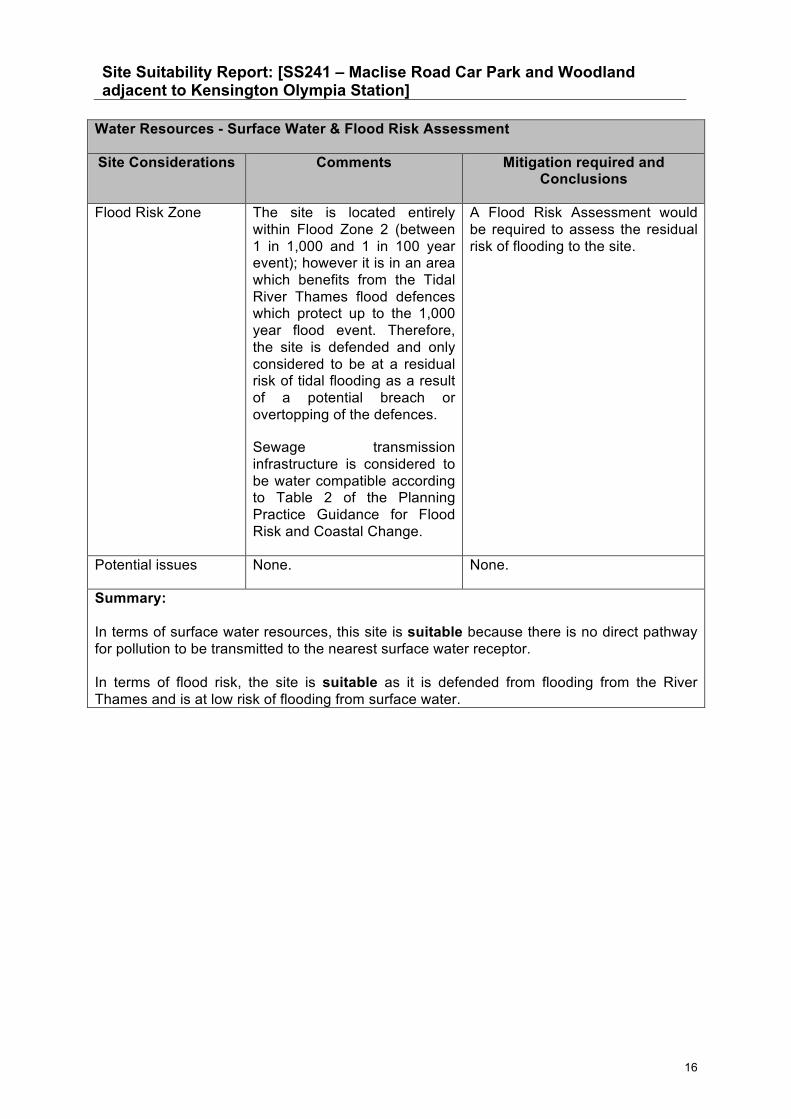
Site Suitability Report: [SS241 – Maclise Road Car Park and Woodland adjacent to Kensington Olympia Station]
16
Water Resources - Surface Water & Flood Risk Assessment
Site Considerations Comments Mitigation required and Conclusions
Flood Risk Zone
The site is located entirely within Flood Zone 2 (between 1 in 1,000 and 1 in 100 year event); however it is in an area which benefits from the Tidal River Thames flood defences which protect up to the 1,000 year flood event. Therefore, the site is defended and only considered to be at a residual risk of tidal flooding as a result of a potential breach or overtopping of the defences.
Sewage transmission infrastructure is considered to be water compatible according to Table 2 of the Planning Practice Guidance for Flood Risk and Coastal Change.
A Flood Risk Assessment would be required to assess the residual risk of flooding to the site.
Potential issues None. None.
Summary: In terms of surface water resources, this site is suitable because there is no direct pathway for pollution to be transmitted to the nearest surface water receptor. In terms of flood risk, the site is suitable as it is defended from flooding from the River Thames and is at low risk of flooding from surface water.

Site Suitability Report: [SS241 – Maclise Road Car Park and Woodland adjacent to Kensington Olympia Station]
17
Air Quality
Site Considerations Comments Mitigation required and Conclusions
Methodology The appraisal considers potential dust impacts using a qualitative risk assessment which is based on the Institute of Air Quality Management (IAQM) Guidance for assessing impacts from construction activities. In this approach the risks of dust generation are considered for sensitive locations around a construction site and for the following activities: Demolition; Earthworks, including handling, working and storage of materials; Construction activities; and the Track-out (the transfer of dust making materials from the site onto the local road network).
Air Quality Management Area (AQMA)
A borough wide AQMA has been declared for NO2 and PM10.
There is a need for more site specific data.
Sensitive Receptors
Following IAQM (2014) guidance, there are 10 to 100 residential properties located on Sinclair Road to the west of the site, which are less than 20 metres from the construction works.
There are also approximately 10 to 100 residential receptors located on Russell Road to the east of the site which are less than 50 metres from the construction works.
There is also St Mary’s Catholic Primary School located 280 metres to the west of the site.
There are 1 to 10 residential properties along Maclise Road, more than 100 residential properties along Blythe Road and Beaconsfield Terrace Road and 10 to 100 residential properties along the A315 near to the junction with Blythe Road. These roads are the proposed construction access routes.
The West London and District Lines Site of Borough Importance (SBI) for Nature Conservation (Grade 1) is located within the proposed site
There are relevant air quality sensitive receptors present along the route the construction traffic is likely to take and also close to the proposed construction works.

Site Suitability Report: [SS241 – Maclise Road Car Park and Woodland adjacent to Kensington Olympia Station]
18
Air Quality
Site Considerations Comments Mitigation required and Conclusions
and is a local designation where the ecological features may be affected by dust deposition.
Existing traffic issues The main traffic issue in this area is exhaust emissions from the A3220 Holland Road, Hammersmith Road which is located 50 metres to the east of the site, and the A315 Hammersmith Road which is located to the south of the site.
Additional vehicle emissions have a high potential to interfere with local air quality action plan policies due to current exceedances of the Air Quality Objective in the vicinity of the site.
Existing sources of significant air pollutants
Main sources of nitrogen oxides and small particle emissions in the area are road traffic, domestic and commercial gas boilers, and small industrial processes.
See above.
Notable gaps in existing air quality monitoring
The nearest available diffusion tube monitoring data is 230 metres from the site and indicated that the air quality objective value for NO2 is exceeded in the area. This site is located adjacent to Addison Gardens.
Collect a minimum of 6 months diffusion tube data at the site access/egress or other point of access to the major road network.
Potential issues
The risk from additional exhaust emissions from construction HGVs is undefined at present. However, it may be necessary during build up and close down events at Olympia London to impose restrictions on HGV traffic to and from the site. There is the potential for additional exhaust emissions due to traffic management required for the construction of two shafts, connection tunnels, interception chamber and installation of an air management building and vent stack. The construction period is approximately 26 months in
Minimise HGV movements on the local road network during the peak hours.
Local residents should be informed in advance of the proposed works with an explanation that dust deposits over the 26 months construction period would be non-hazardous. Residents should be provided with contact details to use should they have any concerns. Standard dust control measures will minimise any effects of fugitive dust on nearby sensitive

Site Suitability Report: [SS241 – Maclise Road Car Park and Woodland adjacent to Kensington Olympia Station]
19
Air Quality
Site Considerations Comments Mitigation required and Conclusions
duration. The potential for adverse impacts due to the construction phase of the assessment are defined below following the IAQM (2014) construction dust guidance. Demolition There are currently no buildings on the site. Therefore, there will be no demolition on the site. Earthworks As the total area of the site is less than 2,500m2, a small dust emission magnitude is likely as a result of potential earthworks at the site (IAQM, 2014). There are between 10 and 100 residential properties within 20 metres of the earthworks. Therefore, the dust soiling effects for earthworks is assessed as low. The West London and District Lines SBI - Grade 1 is located within the proposed site and is a local designation where the ecological features may be affected by dust deposition, and is of low sensitivity. The risk of dust effects on the ecological features is low. There are between 10 and 100 residential properties within 20m of the proposed earthworks and annual mean PM10 background concentrations at the site are currently less than 24 µg/m3, which is well below the air quality objective. Sensitivity of the area to human health impacts due to
receptors.
The generator should be carefully sited as far from residential properties as possible, and ideally be selected on the basis of its emissions, given the urban nature of the site.

Site Suitability Report: [SS241 – Maclise Road Car Park and Woodland adjacent to Kensington Olympia Station]
20
Air Quality
Site Considerations Comments Mitigation required and Conclusions
earthworks is therefore low. Construction As the total volume of the site is less than 25,000m3 threshold (IAQM, 2014), a small dust emission magnitude is likely as a result of potential construction at the site. There are between 10 and 100 residential properties within 20 metres of the construction works. Therefore, the dust soiling effects for construction is assessed as low. There are between 10 and 100 residential properties within 20 metres of the proposed construction works and annual mean PM10 background concentrations are currently less than 24 µg/m3, which is well below the air quality objective. The sensitivity of the area to human health impacts due to construction is therefore low. Trackout There are expected to be over 50 Heavy Duty Vehicle (HDV) (equivalent of HGV movements) per day for approximately two months of the 26 month construction period. This will result in a high dust emission magnitude. There are more than 100 residential properties within 20 metres of trackout routes along Maclise Road, Blythe Road, Beaconsfield Terrace Road and the A315. Therefore, sensitivity of the area around the proposed site to dust soiling effects is considered a high risk.
Site Suitability Report: [SS241 – Maclise Road Car Park and Woodland adjacent to Kensington Olympia Station]
21
Air Quality
Site Considerations Comments Mitigation required and Conclusions
There are expected to be between 10 and 50 HDV movements per day during approximately half of the rest of the 26 month construction period. This will result in a medium dust emission magnitude. There are more than 100 residential properties within 20 metres of trackout routes along Maclise Road, Blythe Road, Beaconsfield Terrace Road and the A315. Therefore, sensitivity of the area around the proposed site to dust soiling effects is considered a high risk. There are expected to be less than 10 HDV movements per day during the remainder of the 26 month long construction period. This will result in a small dust emission magnitude. There are more than 100 residential properties within 20 metres of trackout routes along Maclise Road, Blythe Road, Beaconsfield Terrace Road and the A315. Therefore, sensitivity of the area around the proposed site to dust soiling effects is considered a high risk. There are more than 100 residential properties within 20 metres of trackout routes along Maclise Road, Blythe Road, Beaconsfield Terrace Road and the A315. Annual mean PM10 background concentrations at the site are currently less than 24 µg/m3 which is well below the air quality objective. Sensitivity of the area to human health impacts due to trackout is therefore medium. Generator

Site Suitability Report: [SS241 – Maclise Road Car Park and Woodland adjacent to Kensington Olympia Station]
22
Air Quality
Site Considerations Comments Mitigation required and Conclusions
A generator is expected to operate for 24 hours a day during the construction period for lighting and security purposes. It is currently not known how this generator will be powered. There is a potential for the emission of pollutants to affect nearby existing residential receptors.
Summary: The construction phase is approximately 26 months, and the construction site classified as ‘small’ using the (IAQM, 2014) construction dust guidance. However, the sensitivity of the area to dust soiling effects associated with construction, earthworks and track-out ranges from low to high. Using the same methodology, the sensitivity of the area to human health impacts associated with construction works, earthworks and track-out ranges from medium to low. With standard dust control measures in place the risk of impacts on sensitive receptors can be reduced, but additional site specific measures are also likely to be required such as ensuring vehicles entering and leaving sites are covered to prevent escape of materials during transport.
There is potential for HGV movements on the local road network to cause localised air quality impacts in an area of already poor air quality. This can be somewhat mitigated by minimising the movement of HGVs during peak hours. There may be possible restrictions of HGV traffic near to Olympia London for a short period whilst there are build up and close down sections at Olympia London.
There is the potential for additional exhaust emissions due to traffic management required for the construction of the proposed shafts, connection tunnels, underground interception chamber and installation of an air management building and vent stack; these impacts are undefined at present.
A generator is expected to operate for 24 hours a day during the construction period for lighting and security purposes. It is currently not known how this generator will be powered. There is a potential for the emission of pollutants to affect nearby existing residential receptors.
In summary, this site is considered less suitable. The sensitivity of the area to dust soiling effects associated with construction, earthworks and track-out ranges from low to high. As described above, it is likely it would require additional site specific mitigation beyond standard mitigation measures if selected.

Site Suitability Report: [SS241 – Maclise Road Car Park and Woodland adjacent to Kensington Olympia Station]
23
Archaeology
Site Considerations Comments Mitigation required and Conclusions
Methodology The appraisal uses current Greater London Historic Environment Record (GLHER) point data. The proximity of Archaeological Priority Areas and Conservation Areas is considered and the GLHER record for each receptor within 100m of the proposed site is accessed and interpreted in terms of ‘very high or high’, ‘medium’ or ‘other’ importance. When appraising the suitability of the site, the potential for receptors to extend to within the proposed site is considered. Historic OS mapping (limited to 19th and 20th century origin) is also inspected with a summary of recent historical uses provided to indicate the potential for previous on-site disturbance.
Designations, including Archaeological Priority Areas
The site is not within an Archaeological Priority Area.
The site is located immediately outside the north-eastern part of the Lakeside/Sinclair/Blythe Road Conservation Area, and runs parallel to the Conservation Area boundary.
Not Applicable.
Summary of historical uses
The historic map evidence shows that the site was previously undeveloped throughout the 19th century, until the south eastern corner of the site became a car park in the recent past.
The historic map evidence shows that, to the south of the site, there was land through which ran the West London Junction railway (electric telegraph). It is possible a turntable is located approximately to the south of the site.
In 1874, the land to the south of the site had 3 or 4 tracks to the northern side and a single track running though the southern side and situated to the east of tenement gardens and west of the railway. By 1916, the single
Not Applicable.

Site Suitability Report: [SS241 – Maclise Road Car Park and Woodland adjacent to Kensington Olympia Station]
24
Archaeology
Site Considerations Comments Mitigation required and Conclusions
track and turntable (?) are gone.
Potential receptors of very high or high value with the potential to be directly affected
There are no recorded archaeological receptors onsite. This does not preclude the possibility of their existence.
Not applicable.
Potential receptors of medium value with the potential to be directly affected
There are no recorded archaeological receptors onsite. This does not preclude the possibility of their existence.
Not applicable.
Other receptors with the potential to be directly affected
There are no recorded archaeological receptors onsite. This does not preclude the possibility of their existence.
Not applicable.
Extent of existing disturbance (if known)
The south eastern corner of the site has likely disturbance of modern date but there could be areas which have been preserved, particularly in the remainder of the site which has remained undeveloped.
Not applicable.
Potential issues
Archaeological remains may exist at the site at depth. There is the potential that ground work excavations associated with the development will disturb preserved material.
A desk based assessment already exists (ELO09451) for an area to the south of the site. This should be assessed in the first instance.
In consultation with the Borough Archaeologist, further information (such as a desk based assessment) may be required to support a planning application.
Summary:
The historic map evidence shows that the site was previously undeveloped throughout the 19th century, until the south eastern corner of the site became a car park in the recent past. There is evidence for possible medieval industrial activity close by, but this is likely to be of low significance.
On the basis of the information provided, it is considered that this site is suitable because there are unlikely to be any archaeological remains present that will prevent development.

Site Suitability Report: [SS241 – Maclise Road Car Park and Woodland adjacent to Kensington Olympia Station]
25

Site Suitability Report: [SS241 – Maclise Road Car Park and Woodland adjacent to Kensington Olympia Station]
26
Built Heritage
Site Considerations Comments Mitigation required and Conclusions
Methodology The appraisal uses current Greater London Historic Environment Record (GLHER) point data. The proximity of Conservation Areas, Listed Buildings and Registered Parks and Gardens is stated and the GLHER record for each receptor within 250m of the proposed site with the potential to be directly affected is accessed and interpreted in terms of its importance. When appraising the suitability of the site, potential impacts on the significance of Conservation Areas are considered, alongside any potential perceived or direct impacts on Listed Buildings and their associated curtilage structure or the historic setting of a Listed Building.
Designations including Conservation Areas, including trees
Listed Buildings Grade II listed Church of St. John the Baptist – 200m north. Conservation Areas
The site is located immediately outside the Lakeside/Sinclair/Blythe Road Conservation Area, and runs parallel to the Conservation Area boundary.
Holland Park Conservation Area – 130m east.
Registered Parks and Gardens
There are no registered parks and gardens within 250m.
See below.
Potential receptors of medium to very high importance with the potential to be directly affected
There is a low potential for the Lakeside/Sinclair/Blythe Road Conservation Area to be directly impacted by the proposals by altering part of the setting of the Conservation Area.
Retaining vegetation screening along the western boundary of the site would be likely to help to reduce any potential impact on the setting of the historic terraces in the Lakeside/Sinclair/Blythe Road Conservation Area immediately to the south-west.
Use of hoardings to screen construction works will reduce any potential impact of the proposals on the Conservation

Site Suitability Report: [SS241 – Maclise Road Car Park and Woodland adjacent to Kensington Olympia Station]
27
Built Heritage
Site Considerations Comments Mitigation required and Conclusions
Area during construction.
Other receptors of lesser importance with the potential to be directly affected
There are no locally listed buildings within 250m of the site.
None required.
Particular considerations on sites where new permanent structures are required
Any permanent elements have a low potential to impact on the Lakeside/Sinclair/Blythe Road Conservation Area.
The sensitive design and careful location of any permanent structures within the site should be given consideration and some screening during construction and operation may be required.
The sensitive design and careful location of the permanent elements is expected to minimise any potential long term impacts.
Potential issues The site is situated adjacent to Lakeside/Sinclair/Blythe Road Conservation Area.
Design of the permanent structures to be given careful consideration.
Use of hoardings to minimise any potential impacts during the construction phase.
Summary: This site lies immediately adjacent to the Lakeside/Sinclair/Blythe Road Conservation Area. It is considered that there is a low potential for the proposed development to impact on the setting of the Conservation Area. In addition, through the sensitive siting and design of the permanent structures, and use of hoardings during the construction phase, any potential impact on the Conservation Area would be minimised. On this basis it is considered that this site is suitable.

Site Suitability Report: [SS241 – Maclise Road Car Park and Woodland adjacent to Kensington Olympia Station]
28
Townscape and Views
Site Considerations Comments Mitigation required and Conclusions
Methodology The methodology used is based broadly on guidance within the Guidelines for Landscape and Visual Impact Assessment 3rd Edition (LI and IEMA 2013). Based on the nature of the proposed development, each site is appraised against its sensitivity to changes in townscape character and visual amenity. The sensitivity of townscape resources is determined by features such as Conservation Areas, trees and the quality of the space. Visual receptors are considered in relation to the type and activity of the viewer.
Where the development could potentially involve the loss of mature trees, which could not be replaced in the short term, a time element has been considered to assist in appraising the suitability of the site.
Designations (including TPOs, Registered Historic Parks and Gardens and Protected Views)
The site lies mostly within the Royal Borough of Kensington and Chelsea (RBKC). A strip along the north-western edge of the site is within the London Borough of Hammersmith and Fulham (LBHF).
There are no Registered Historic Parks and Gardens within 250m of the site.
There are no recognised parks or open spaces within 250m of the site.
The site is not within a Conservation Area, although the Lakeside/Sinclair/Blythe Road Conservation Area is located to the west immediately adjacent to the whole of the western edge of the site.
Site clearance would involve the removal of a large number of mature and semi-mature trees.
The proposed development would be likely to have an effect on the setting of the Lakeside/Sinclair/Blythe Road Conservation Area.
Townscape The site is located in the West Kensington area of West London. It is linear in plan and is largely undeveloped mostly comprising semi-mature and mature trees. The south eastern corner of the site is an area of asphalt used for car parking and storage, adjacent to the London
Use of hoardings around the site to minimise townscape impacts during construction. Careful siting and detailed design of the permanent above ground structures. Mature trees within and adjacent to the site should be retained as far as possible, particularly on the

Site Suitability Report: [SS241 – Maclise Road Car Park and Woodland adjacent to Kensington Olympia Station]
29
Townscape and Views
Site Considerations Comments Mitigation required and Conclusions
Overground railway line at Kensington (Olympia) Station.
The site is bounded on its eastern side by the railway line and on the western side by the rear gardens of residential terraced properties along Sinclair Road. On the eastern side of the railway line there are further residential properties overlooking the site along Elsham Road and Russell Gardens Mews.
The site can be accessed via the Olympia Motorail Car Park 4 to the south. The site is noticeably out of character with the wider surrounding areas of Kensington and Hammersmith. The presence of the railway gives the site an open character in a busy and heavily developed part of London.
Construction activity would be likely to have an adverse impact on the character of the area, including the setting of the Conservation Area, as extensive tree clearance would have a substantial direct adverse impact on the character of the site, and the increased traffic would have indirect adverse impacts on the character of Maclise Road. Likewise, there would be indirect adverse impacts on other roads to the south of the site from increased HGV traffic.
The presence and operation of machinery, material stores and buildings would not be totally out of character in the context of the asphalt area in the south
site’s northern and western boundaries, and protected during the works in line with BS5837.
The site is less suitable, as much of the land is undeveloped and comprises a substantial area of mature trees. There would be temporary (26 months) adverse direct impacts from construction, in addition to indirect impacts on the surrounding area from increased traffic. The impact of the loss of the trees would be substantial and could not be easily mitigated. A landscape scheme should be introduced including appropriate surface treatments and planting. However, any planting or landscape scheme would take years to reach the maturity of the existing landscape.

Site Suitability Report: [SS241 – Maclise Road Car Park and Woodland adjacent to Kensington Olympia Station]
30
Townscape and Views
Site Considerations Comments Mitigation required and Conclusions
eastern corner of the site, which is brownfield land adjacent to a railway. Permanent elements once the proposed development is operational would include an interception and drop shaft. Permanent above-ground structures include an air management building (17m long x 7m wide x 5m high), ventilation column (2.5m diameter x 10m high) and a GRP kiosk (2m x 1.5m x 2m high). These elements would not be out of character with railway infrastructure generally and the existing sheds to the south, although the ventilation column will require careful siting and detailed design. However, the substantial loss of semi-mature and mature trees would have a long-term adverse impact on the character of the site.
Views Views of the site from residential properties on Sinclair Road to the west of the site, and on Elsham Road on the eastern side of the railway are currently filtered and screened by intervening mature trees. Some properties on Russell Gardens Mews have open views of the site across the railway corridor. The site is visible briefly for people on trains where it can be seen in the context of the journey through west London.
From publicly accessible land the site is visible from the corner of Maclise Road and Olympia Way, where it can be seen in the distance through the busy shed access point (as illustrated in the photograph below), and from Addison Gardens road
During construction the use of hoardings and appropriate lighting would help minimise the visual impact. Mature trees within and around the site should be retained as far as possible, particularly on the site’s northern and western boundaries where they screen the site from homes along Sinclair Road. The sensitive design and location of permanent structures should be given consideration and if possible a belt of mature trees should be retained along the site’s western boundary. However, the impact of site clearance would cause a long-term adverse visual impact that would take years to mitigate.
The site is less suitable as there
Site Suitability Report: [SS241 – Maclise Road Car Park and Woodland adjacent to Kensington Olympia Station]
31
Townscape and Views
Site Considerations Comments Mitigation required and Conclusions
bridge over the railway line to the north (as illustrated in the photograph below), from where the site is partially visible beyond foreground trees.
Construction activity and machinery would be out of character with existing views of the site, which largely comprises an undeveloped area containing semi-mature and mature trees. Visibility would be mainly restricted to residential properties to the immediate west on Sinclair Road and on Russell Gardens Mews to the east of the site. Mature garden vegetation would continue to provide screening to views from properties on Elsham Road, which have large rear gardens. Although these would be temporary (26 month) adverse impacts, the loss of mature vegetation across the site would impact views in the long-term.
There would be long-term adverse impacts on the immediately surrounding area and visual amenity due to the loss of mature vegetation and the introduction of above-ground structures. In particular this would affect residents of Sinclair Road and Russell Gardens Mews.
would be long-term adverse impacts on the visual amenity of the site.

Site Suitability Report: [SS241 – Maclise Road Car Park and Woodland adjacent to Kensington Olympia Station]
32
Townscape and Views
Site Considerations Comments Mitigation required and Conclusions
Photographs
View from the south of the site through the metal shed access point, from the corner of Maclise Road and Olympia Way. Trees in the background of the photo are within the site.
View of the site from the north on the Addison Gardens road bridge over the railway line.
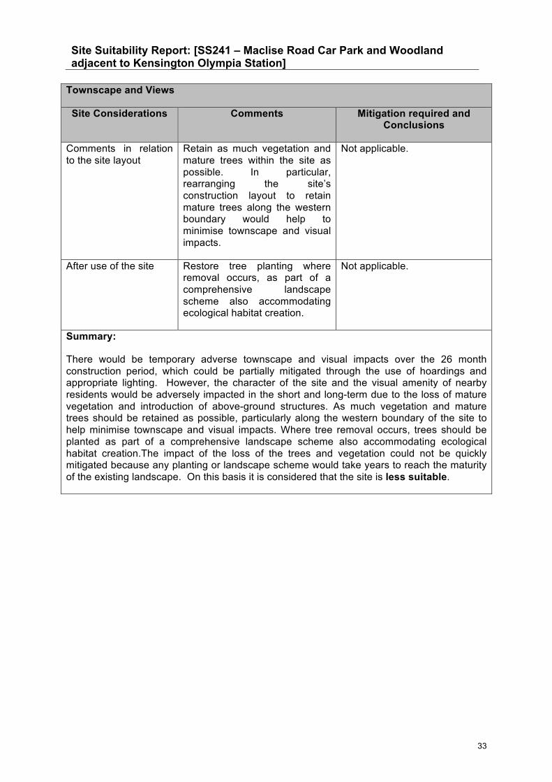
Site Suitability Report: [SS241 – Maclise Road Car Park and Woodland adjacent to Kensington Olympia Station]
33
Townscape and Views
Site Considerations Comments Mitigation required and Conclusions
Comments in relation to the site layout
Retain as much vegetation and mature trees within the site as possible. In particular, rearranging the site’s construction layout to retain mature trees along the western boundary would help to minimise townscape and visual impacts.
Not applicable.
After use of the site Restore tree planting where removal occurs, as part of a comprehensive landscape scheme also accommodating ecological habitat creation.
Not applicable.
Summary:
There would be temporary adverse townscape and visual impacts over the 26 month construction period, which could be partially mitigated through the use of hoardings and appropriate lighting. However, the character of the site and the visual amenity of nearby residents would be adversely impacted in the short and long-term due to the loss of mature vegetation and introduction of above-ground structures. As much vegetation and mature trees should be retained as possible, particularly along the western boundary of the site to help minimise townscape and visual impacts. Where tree removal occurs, trees should be planted as part of a comprehensive landscape scheme also accommodating ecological habitat creation.The impact of the loss of the trees and vegetation could not be quickly mitigated because any planting or landscape scheme would take years to reach the maturity of the existing landscape. On this basis it is considered that the site is less suitable.

Site Suitability Report: [SS241 – Maclise Road Car Park and Woodland adjacent to Kensington Olympia Station]
34
Ecology (terrestrial and aquatic)
Site Considerations Comments Mitigation required and Conclusions
Methodology The ecological appraisal consists of a desk top study to identify habitats within and adjacent to the site. This includes a review of aerial photography and photographs taken within the site to determine habitats present and the potential for these habitats to support protected and/or notable species. Subsequent ecological site visits were conducted in 2015. This document includes reference to these to inform mitigation recommendations. Greenspace Information for Greater London (GIGL) data is used to search for records of Biodiversity Action Plan (BAP) Priority habitats, Sites of Importance for Nature Conservation (SINC) and records of protected and/or notable species within a 2km radius of the site. Natural England’s MAGIC website is also consulted to determine proximity to Statutory Designated sites (i.e. Sites of Special Scientific Interest and Local Nature Reserves).
From reviewing the imagery, the GIGL data search and the MAGIC website, a judgement is made on the potential for the site to support protected and/or notable species and/or habitats. On this basis, the site is appraised in terms of its suitability.
Statutory designations
There are no statutory designations within 2km of the site.
None required.
Non-statutory designated wildlife sites
West London and District Lines Site of Borough Importance (SBI) Grade 1 ~ within the site
Shepherds Bush Green Site of Local Importance (SLI) ~0.4km NW
Holland Park Site of Metropolitan Importance (SMI) ~ 0.5km E
St Paul’s Open Space SLI ~ 0.7km SW
West London and District Lines SBI Grade 1 ~1.2km SE
Loris Road Community Garden SLI ~ 0.65m W
Hammersmith Cemetery SLI ~ 2km SW
Avondale Park Wildlife Garden
West London and District Lines SBI (Grade 1) covers the majority of the site.
It is recommended that any features for which the Site of Importance for Nature Conservation (SINC) is designated are retained where possible.
Loss of SINC habitat will require compensatory provision, particularly where permanent land take occurs. To mitigate for the loss of woodland habitat, where space allows, woodland should be re-instated following the construction works with a native species mix. Recommended species for tree planting include alder Alnus glutinosa, silver birch Betula pendulacrab apple Malus

Site Suitability Report: [SS241 – Maclise Road Car Park and Woodland adjacent to Kensington Olympia Station]
35
Ecology (terrestrial and aquatic)
Site Considerations Comments Mitigation required and Conclusions
SLI ~ 0.9km N
Ladbrooke Grove Gardens Complex SBI Grade 2 ~ 0.9km N
Hammersmith Park SBI Grade 2 ~ 1.2m NW
Central Line West of White City SBI Grade 1 ~ 1.2km N
Normand Park SLI ~ 1.7km S
Godolphin Road Community Garden SLI ~ 1.2km W
Brompton Cemetery SBI Grade 1 ~ 1.9km SW
Disused Trackbed West of Hammersmith SBI Grade 1 ~ 1.1km W
Cathnor Park SLI ~ 1.4km W
White City Community Garden SLI ~ 1.6km NW
Hyde Park and Kensington Gardens SM ~ 1.8km E
Westway Wildlife Gardens SLI ~ 1.6km N
Wormwood Scrubs Railway Embankment SBI Grade 1 ~ 1.7km N
Ravenscroft park SBI Grade 2 ~ 1.6km W
River Thames and Tidal Tributaries SMI ~ 1.7km SW
Fulham Cemetery SLI ~ 2.0km SW
Furnivall Gardens SLI ~ 1.7km
sylvestris, holly Ilex aquifolium, field maple Acer campestre, pedunculate oak Quercus robur, rowan Sorbus aucuparia and yew Taxus baccata. Trees should be planted at a ratio of 50% oak and 10% for each of the other species. This will both retain and improve the current biodiversity value for foraging and commuting bats, mammals, birds and invertebrates, and maintain the existing green corridor along the railway line.
It is recommended that a green roof is installed on the air management building to provide additional foraging habitat for terrestrial invertebrates, bats and birds. It is also recommended that green walls are installed on some, or all, of the air management building walls. In addition to enhancing biodiversity value, green walls act as an acoustic and thermal insulating system, which improves air quality. These would also provide an aesthetic screening effect.
In addition, it is recommended that bat and bird boxes are incorporated within the final operational design, along with log piles and standing dead wood (where this can be safely retained) for terrestrial invertebrates.
Management of these mitigation and enhancement features would be required.

Site Suitability Report: [SS241 – Maclise Road Car Park and Woodland adjacent to Kensington Olympia Station]
36
Ecology (terrestrial and aquatic)
Site Considerations Comments Mitigation required and Conclusions
W
Wormholt Park SLI ~ 1.7km NW
Biodiversity Action Plan (BAP) priority habitats
The site contains London BAP Priority habitats ‘woodland’.
Loss of BAP habitat may require compensatory provision, particularly if permanent land take occurs.
See above recommendations relating to habitat creation.
Protected or otherwise notable species within the Study Area
Protected species within 2km of the site: Fieldfare Turdus pilaris ~ 0.4km SW, Eurasian Hobby Falco subbuteo ~ 1.2km SW, redwing Turdus iliacus ~ 1.2km SW, brambling Fringilla montifringilla ~ 1.2km W. Brown long-eared bat Plecotus auritus ~ 0.6km NE, Common pipistrelle Pipistrellus pipistrellus ~ 1.2km S, Soprano pipistrelle Pipistrellus pygmaeus ~ 1.2km S. Stag beetle Lucanus cervus ~ 0.9km N. Notable species within 2km of the site: House sparrow Passer domesticus (London & UK BAP), common starling Sturnus vulgaris (London BAP), hedge accentor Prunella modularis (London BAP), common redpoll Carduelis flammea (London BAP), lesser redpoll Carduelis cabaret (UK BAP), white ermine Spilosoma lubricipeda (London & UK BAP), brown-spot pinion Agrochola litura (London & UK BAP), dusky brocade Apamea
To ensure no net loss of biodiversity, recommendations are made above.

Site Suitability Report: [SS241 – Maclise Road Car Park and Woodland adjacent to Kensington Olympia Station]
37
Ecology (terrestrial and aquatic)
Site Considerations Comments Mitigation required and Conclusions
remissa (London & UK BAP). An ecological assessment of the site was undertaken in 2015. Trees and vegetation were assessed for their potential to support roosting bats and nesting birds. Vegetation was identified to have potential to support nesting birds. No features with potential to support roosting bats were identified within the site. An ecological assessment was also undertaken for the presence of dead wood both above ground and the potential for buried dead wood which may be used by stag beetles. There was no deadwood present within the site and therefore no mitigation is required for this species.
Potential issues
Features present on site and adjacent habitats such as the railway track, have potential to support foraging and commuting bats, and support features that could be used by roosting bats.
Trees and shrubs present within the site have potential to support nesting birds during the breeding season.
In 2015, bat activity surveys were conducted to determine the numbers of bats and species utilising the site. This identified use of the site by common bat species such as common pipistrelle Pipistrellus pipistrellus and soprano pipistrelle Pipistrellus pygmaeus.
Construction works should commence outside of the nesting bird season (nesting bird season is between March and September). If works are to commence during the nesting birds season, then vegetation should be checked by an ecologist for nesting activity immediately prior to the commencement of any works. If nesting birds are identified, a suitable buffer will need to be retained until after all chicks have fledged. It is recommended that bat boxes are included within the scheme. In addition to this, where space allows, vegetation should be replanted. It is also recommended to incorporate a green roof and green walls

Site Suitability Report: [SS241 – Maclise Road Car Park and Woodland adjacent to Kensington Olympia Station]
38
Ecology (terrestrial and aquatic)
Site Considerations Comments Mitigation required and Conclusions
within the proposed new structures.
Summary:
There are 25 Site of Importance for Nature Conservation (SINC) sites and no statutory sites within 2km of the proposed site. The site is located within the West London and District Lines Site of Borough Importance (SBI - Grade 1). There are no records of protected species within the proposed site, but a number of records of protected species within 2km. These are for: stag beetle (the closest record 0.9km north of the site), three species of bat (the closest record is for brown long-eared bat, 0.7km north east of the site), four species of protected bird (the closest fieldfare located 0.4km south west of the site) and a number of notable species of bird and terrestrial invertebrate. The site contains London Biodiversity Action Plan (BAP) Priority habitats ‘woodland’.
Ecological assessment for the presence of dead wood which might be used by stag beetles has been undertaken. No evidence of deadwood was identified within the site and therefore no mitigation is required for this species. A bat roost potential assessment was undertaken. No trees with features suitable to support roosting bats were identified within the site. Vegetation within the site has potential to support nesting birds. Bat activity surveys were undertaken to determine the use of the site by commuting and foraging bats. This identified use of the site by common bat species such as common pipistrelle Pipistrellus pipistrellus and soprano pipistrelle Pipistrellus pygmaeus. Where trees are to be retained, root protection zones should also be adhered to.
The site is less suitable because it contains a designated SINC (West London and District Lines SBI - Grade 1). To mitigate for the loss of woodland habitat of the SBI, where space allows, woodland should be re-instated following the construction works with a native species mix. Recommended species for tree planting include alder (Alnus glutinosa), silver birch (Betula pendula), crab apple (Malus sylvestris), holly (Ilex aquifolium), field maple (Acer campestre), pedunculate oak (Quercus robur), rowan (Sorbus aucuparia) and yew (Taxus baccata). Trees should be planted at a ratio of 50% oak and 10% for each of the other species. This will both retain and improve the current biodiversity value for foraging and commuting bats, mammals, birds and invertebrates, and maintain the existing green corridor along the railway line. It is recommended that a green roof is installed on the air management building to provide additional foraging habitat for terrestrial invertebrates, bats and birds. It is also recommended that green walls are installed on some, or all, of the air management building walls. In addition to enhancing biodiversity value, green walls act as a sound absorbing and thermal insulating system, which also improves air quality. These will also provide an aesthetic screening effect. In addition, it is recommended that bat and bird boxes are incorporated within the final operational design, along with log piles and standing dead wood (where this can be safely retained) for terrestrial invertebrates. Management of these mitigation and enhancement features will be required.

Site Suitability Report: [SS241 – Maclise Road Car Park and Woodland adjacent to Kensington Olympia Station]
39
Land Quality
Methodology A concise summary of desktop study information including review of; current and historic land uses, geology, hydrogeology and hydrology, registered pollution incidents and contemporary trade entries is provided. A Conceptual Site Model (CSM) identifying potential pollutant-pathway-receptor linkages is used to assess potential contamination risks that could impact on the proposed development. A “Contamination Category” consisting of Category 1 (low risk) sites, Category 2 (medium risk) sites and Category 3 (high risk) sites, is assigned based on the level of risk and subsequently used to appraise the suitability of the site.
Site Location Maclise Road Car Park North
Current Site Use Undeveloped land containing mature trees; the south eastern corner of the site is an area of Olympia Motorail Car Park 4.
Topography Approximately 8m AOD.
Field Evidence of contamination (i.e. visual/olfactory)
Desk based assessment only - site visit not undertaken by Land Quality team.
Current surrounding land use (immediately adjacent to site)
Railway line, shops and services, dense residential housing and Olympia London (conference centre).
Geological and Hydro geological Information
Geological Strata • Made ground (2.7m) • Kempton Park Gravel Formation (3.2m) • London Clay (45.3m) • Lambeth Group (unproven) • Thanet Sand (unproven) • Chalk (unproven) * Geology based on thicknesses from British Geological Survey borehole TQ27NW186 located 260m from proposed shaft locations.
Underlying Aquifer Classes
The site overlies Kempton Park Gravel Formation (Upper Aquifer) which is defined as a Secondary A Aquifer.
Groundwater Vulnerability / Soil Classification (High / Intermediate / Low / Not Applicable)
The site is underlain by Kempton Park Gravel Formation (Upper Aquifer) which is defined as a Secondary A Aquifer with soils with a high leaching potential.
Source Protection Zone Details
The site is not within a Source Protection Zone.
Surface Water Receptor The nearest surface water receptor is the River Thames which is

Site Suitability Report: [SS241 – Maclise Road Car Park and Woodland adjacent to Kensington Olympia Station]
40
Land Quality
1.7km to the southwest of the site.
Registered Abstraction Points
No groundwater or surface water abstractions are recorded within 250m of the site.
Relevant Information within a 250m radius of the site
Historical Potentially Contaminating Activities (based on mapping data)
Onsite
The site was previously undeveloped throughout the 19th century, until the south eastern corner of the site became a car park in the recent past.
Offsite
Residential streets and a railway line are established by 1896, with the Olympia London to the south. A milk depot (to the southwest) and an electricity substation (to the southwest) replaced a section of housing west of Sinclair Road and a garage replaced housing immediately south of the site between 1915 and 1951, seemingly as a result of WWII bombing. A further electricity substation is recorded from 1951 adjacent to Olympia London (to the south).
Pollution Controls There are no Local Authority Pollution Prevention and Controls within 250m of the site.
Landfill Sites There are no recorded historic or current landfill sites within 250m of the site.
Fuel Stations/Depots There are no fuel stations / depots within 250m of the site.
Contemporary Trade Entries
• Garage services x 2 (80m east – inactive) • MOT testing centre (80m east – active) • Antiques repair and restoration (110m east – active) • Fencing manufacturers (160m east – inactive) • Leather manufacturers (15m west – inactive) • Dry cleaners (130m east – active) • Dry cleaners (175m northwest – inactive) • Hygiene and cleansing services (160m north – inactive) • Dry cleaners (130m northwest – inactive)
Registered Waste Licenses
There are no registered waste licenses within 250m of the site.
Registered Radioactive Substances
There are no Registered Radioactive Substances within 250m of the site.
Site Classification Based on Above Information
Activity Distance and Direction to Site
Contaminants

Site Suitability Report: [SS241 – Maclise Road Car Park and Woodland adjacent to Kensington Olympia Station]
41
Land Quality
Potential Site Contaminants derived from surface sources (e.g. contaminants in made ground)
1) Potential for made ground from historic development in the south corner of the site.
2) Potential for contamination from immediately adjacent railway sidings and station area; which has been in use since the late 1800s.
1) Onsite
2) Offsite to east and south
1) Metals, PAHs, TPH 2) Metals, PAHs, TPH
Potential Site Contaminants derived from off-site sources and transported to site
1) Railway line, siding and station 2) Garage services
3) Substations
1) 5m east 2) 80m east
3) Southwest and south
1) Metals, PAHs, TPH
2) Metals, PAHs, TPH
3) PCBs
Potential Contamination Pathways to Site (Conceptual Site Model)1
Source 1 – A1, A2, A3, B4 Source 2 – E1
Contamination Category
Category 2 (medium-risk)
Conclusion: On the basis of the information available, it is considered that the site is less suitable. The site is immediately adjacent to an active railway line, station and siding, which has been operational since the late 1800s. Consequently there is potential for pollution to have occurred.
The potential for contaminated Made Ground exists as a result of onsite activities in the south eastern corner of the site and the nearby offsite garage services and electricity substations. Therefore, a medium risk of contamination has been assigned to this site.
Notes: 1. Refer to schematic Conceptual Site Model for explanation of site-specific source-pathway-receptors.

Site Suitability Report: [SS241 – Maclise Road Car Park and Woodland adjacent to Kensington Olympia Station]
42

Site Suitability Report: [SS241 – Maclise Road Car Park and Woodland adjacent to Kensington Olympia Station]
43