strategic housing land availability assessment 2014
DESCRIPTION
Site Assessment Map BookTRANSCRIPT
© Crown copyright. All rights reserved, Lancaster City Council 100025403
Strategic Housing Land Availability Assessment 2014Site Assessment Map Book
March 2014

Strategic Housing Land Availability Assessment 2014 - Site Assessment Map Book
ContentsIntroduction 1Frequently Asked Questions 2Inset maps 3
Lanc
aste
r
Central Lancaster 5East Lancaster 7Bowerham, Lancaster 9South Lancaster 11Aldcliffe, Lancaster 13West Lancaster 15North Lancaster 17
Mor
ecam
be a
ndHe
ysha
m
Central Morecambe and West Poulton 19Bare and East Poulton 21North Heysham 23South Heysham 25Torrisholme 27White Lund 29Carnforth 31
Sust
aina
ble
rura
l set
tlem
ents
Arkholme 33Bolton-Le-Sands 35Caton and Brookhouse 37Cockerham 39Dolphinholme 41Galgate 43South Galgate 45Halton 47Hest Bank and Slyne 49Hornby 51Middleton 53Nether Kellet 55Over Kellet 57Overton 59Silverdale 61Warton 63Wray 65
Oth
er ru
ral s
ites
Capernwray 67Claughton and Farleton 69Cowan Bridge 71Glasson 73Gressingham 75Harterbeck 77Littledale 79Swarthdale 81Wennington 83Whittington 85Yealand Conyers and Yealand Redmayne 87
Appendix: Index of sites 89
IntroductionThis map book contains the assessment of sites for the Strategic HousingLand Availability Assessment (SHLAA) 2013.
The National Planning Policy Framework (NPPF) requires that councils planfor their full and objectively assessed housing needs during their planperiod. The revocation of the Regional Spatial Strategies has meant thatthe evidence which the housing requirement of 400 new dwellings peryear, or 6,000, over 15 years of the Core Strategy was based upon is nowout of date.
Lancaster City Council instructed Turley Associates to undertake anindependent housing requirements study, which includes an update of thecouncil’s Strategic Housing Market Assessment (SHMA) in 2013. Thisindicated that the district’s new housing requirement is between 564 and659 new homes per year. This figure has yet to be finalised and adoptedby council members.
How the list of site suggestions was assembledThe first stage of the SHLAA involved identifying potential sites across thedistrict. Sites have come from a variety of sources, including numerous Callfor Sites exercises carried out between June 2008 and May 2013.Members of the public and prospective developers were asked to submitdetails of sites to be considered in the assessment. Sites were alsoidentified from the 2009 SHLAA, the National Land Use Database, andplanning applications for housing developments.
Site assessments completed so farIn November 2013 the council published the SHLAA 2013 Site SuggestionsMap Book which displayed all the sites to be assessed that were largerthan 0.15 hectares or could have 4 or more houses built upon it. It alsolisted the sites that were too small to be assessed. Council officers haveassessed the remaining sites, except those within the Arnside andSilverdale Area of Outstanding Natural Beauty (AONB), to see if they canprovide the housing the district needs over the next 15 years. The sites inthe Arnside and Silverdale AONB require additional landscape study beforethey can be assessed.
Status of the assessed sitesThe SHLAA does not make decisions about the future of sites; but thefindings will be used to develop planning policy and in the developmentmanagement process. The SHLAA will be used to decide which sites toidentify in formal development plan documents, particularly, the LandAllocations document. The officer’s assessment of the suitability andavailability of individual sites will also be useful in the determination ofplanning proposals and in demonstrating the availability of a five yearsupply of housing land.
View plans of the site suggestionsAll the sites being considered can be viewed in this map book. The sitesare identified for information purposes only. Please note that sites willonly be allocated through the Land Use Allocations DPD. The SHLAA
together with other evidence, including a Sustainability Appraisal, will beused when deciding which sites to allocate.
Some sites are shown on more than page where the map indexes used tocreate the map book overlap. While every effort has been taken to ensurethe accuracy of site boundaries, if an error has been made please do nothesitate to contact the team.
Provide information that can assist in the assessment processYou can help with the assessment process by letting the council know ifyou own one of the identified sites or have information about that mightaffect its viability (please see the Frequently Asked Questions for moreinformation).
Register for future consultationsIf you want to be kept up to date about the progress of the SHLAA or anyaspects of planning policy, please email [email protected] call the team on 01524 582383 and asked to be added to the mailinglist.
Further information and contactsThe main Strategic Housing Land Availability Assessment webpage can beviewed at www.lancaster.gov.uk/shlaa.
Lancaster City CouncilPlanning and Housing Policy TeamTown HallDalton SquareLancasterLA1 1QR
Telephone: 01524 582383Email address: [email protected]
If you would like a large print version ofthe text of this document or, if youneed assistance with translating thetext of this document, please contactthe Planning and Housing Policy Teamon 01524 582383.All maps contained in this document are reproduced from Ordnance Surveymapping with the permission of the Controller of Her Majesty’s Stationery Office©
Crown copyright. Unauthorised reproduction infringes Crown Copyright and maylead to prosecution or civil proceedings. Lancaster City Council LicenceNo 100025403.
Version 1.0/Regeneration and Planning/February 2014
1

Strategic Housing Land Availability Assessment 2014 - Site Assessment Map Book
Frequently Asked Questions
Why are these sites being published; is the council consulting onthem?This map book accompanies the Strategic Housing Land AvailabilityAssessment (SHLAA) Report 2013 prepared by council officers. It showsthe assessment conclusion for each site originally published in the SiteSuggestions Map Book in November 2013.
The SHLAA Report is an evidence document and not a decision-makingprocess about the future of sites. Its purpose is to discover if there areenough sites that would be suitable and available for housing in thedistrict over the next 15 years. The council will consult on the allocation ofany new housing sites as the Land Allocations DPD is prepared. Separateconsultations will also be held consultation when a planning application isreceived for a site.
What do the plans in the map book show?They show every site as being assessed as one of the following sixcategories:
Sites not included within the housing trajectory:
1. Not Assessed – A size threshold of smaller than 0.15 hectares (ha)or smaller sites for less than 4 dwellings was applied to the sites.
2. Undeliverable – If a site is not being suitable, available orachievable within the next 15 years, it will not be included in thehousing trajectory.
3. Arnside and Silverdale AONB – The sites within the Arnside andSilverdale Area of Outstanding Natural Beauty require a landscapestudy to be carried out before they can be assessed for theirdeliverability.
Sites assessed and included in the housing trajectory4. Deliverable, 1-5 Year Phase – These are sites of 0.15 ha or more
and building is expected to start within the immediate five yearperiod of the housing trajectory.
5. Deliverable, 6-10 Year Phase – These are sites of 0.15 ha or moreand building is expected to start within the middle five year periodof the housing trajectory.
6. Deliverable, 11-15 Year Phase – These are sites of 0.15 ha or moreand building is expected to start within the last five year period ofthe housing trajectory.
The sites are shown in different colours on the plans, is there anysignificance to these colours?Yes, the colours illustrate the six categories above that each site has beenassessed as. Each page of the map book has a legend that matches thesite’s colour to its assessment category.
How many dwellings can be built on the assessed sites?The findings of the SHLAA suggest that approximately 8,153 dwellingscould be built or started to be built on 107 sites over the next 15 years.Brownfield sites (or previously developed land) account for 55% of theland identified.
Can I object to a site which has been identified?This map book shows the outcome of officers’ objective and professionalappraisal of the deliverability of housing sites, and is separate to thedecision-making process to allocate a site. The allocation of housing siteswill be informed by further public consultation of the Local Plan, and whena planning application is submitted for a site.
I own a site that is shown on the plans, I didn't ask for it to beassessed and I don't want it to be developed.Your site might simply be a brownfield site that is listed in the NationalLand Use Database. Please let us know if this is the case, because if a site isnot available then it is not achievable and it should be removed from thelist of potentially developable sites.
If a site is not shown in these plans does it mean that it will not bedeveloped in the next 15 years?No, the assessment is about trying to ensure that there are at least enoughhousing sites, others may well come forward through other processes. Forexample:
A petrol station or a warehouse might close in a couple of years andthe site could be redeveloped for housing;
Areas of land which are adjacent to suggested sites might also besuitable and could sensibly be incorporated to make a larger site;
Additional sites might be suggested when the Land AllocationsDocument is being prepared;
If this list of suggested sites is not be adequate to meet the minimumhousing requirement, additional sites would need to be added infurther stages of the SHLAA; or
The council might bring forward additional or alternative sites inpursuit of objectives to create sustainable communities.
Who will want all these houses - what about the recent recession?Even in difficult market circumstances both existing and prospectiveresidents’ still need housing. The council’s Housing Needs and DemandsStudy (2012) and Strategic Housing Market Assessment (2013) show thatmany people need housing in the district and this need will continue intothe future. The council must ensure that land is available to build homesahead of the economy returning to normal.
The district's population is growing, people are living for longer and morepeople are living alone. Unless more homes are built many will not havethe opportunity to live in a place of their own and will be forced to live inshared accommodation.
The council is responsible for ensuring that it plans for its full housingrequirement. The Strategic Housing Market Assessment 2013 hassuggested that Lancaster district’s new housing requirement is between564 and 659 new homes per year.
What is the SHLAA Partnership - who is in the Partnership?Advice published by the Department for Communities and LocalGovernment states that a SHLAA should be prepared with the assistanceof a partnership, it will:
Help with the preparation of the methodology; Provide a sounding board for the overall process; Permit people who have wider knowledge about housing needs to
make their views known; Help spread knowledge about the process among a wider range of
contacts; and Help keep the process working to a timetable.
Partnership members have no influence at all over the list of sites or theassessment of those sites. Partnership members include: housingassociation representatives, council housing and housing policy officers,housing developers, development control officers, property and surveyingspecialists.
What happens next with the SHLAA?The SHLAA is a significant evidence base document. On the basis ofinformation known at the time of the site assessment, the process hasresulted in a list of sites that are thought to be deliverable over the nextfifteen years: this means that the assessment determined that they wereavailable, suitable and achievable. The great majority of these sites are inlocations that are fully compliant with Core Strategy’s UrbanConcentration approach to development.
Some of the sites may need to be brought forward through thedevelopment plan process by being identified in the forthcoming LandAllocations Document. All development sites also need planning consentbefore they can be developed.
In any event the Council will carefully record dwelling completions in orderto efficiently match the release of additional housing land to theoutstanding dwelling requirement.
I have some questions about the sites in the SHLAA – who should Idirect these questions to?Please contact the Planning and Housing Policy Team:
Telephone: 01524 582383Email: [email protected]: www.lancaster.gov.uk/shlaa
2
© Crown copyright. All rights reserved, Lancaster City Council 100025403
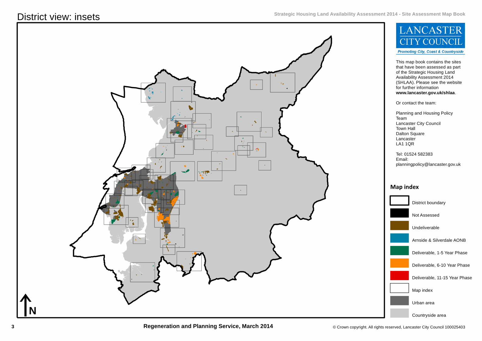
District view: insets Strategic Housing Land Availability Assessment 2014 - Site Assessment Map Book
Regeneration and Planning Service, March 2014
Map indexDistrict boundary
Not Assessed
Undeliverable
Arnside & Silverdale AONB
Deliverable, 1-5 Year Phase
Deliverable, 6-10 Year Phase
Deliverable, 11-15 Year Phase
Map index
Urban area
Countryside area
This map book contains the sitesthat have been assessed as partof the Strategic Housing LandAvailability Assessment 2014(SHLAA). Please see the websitefor further informationwww.lancaster.gov.uk/shlaa.Or contact the team:Planning and Housing PolicyTeamLancaster City CouncilTown HallDalton SquareLancasterLA1 1QRTel: 01524 582383Email:[email protected]
iN3
4
7
5
8 9
23
6
2934
3322
1819
25
17
20
14 1530
42
2431
23
10
32
1311
2627
12
1639
1
43 36
35
28
40
41
21
38
3746
© Crown copyright. All rights reserved, Lancaster City Council 100025403
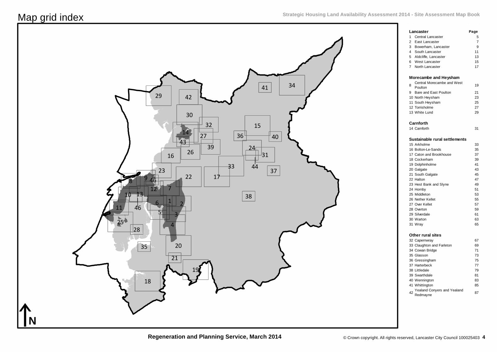
Map grid index Strategic Housing Land Availability Assessment 2014 - Site Assessment Map Book
Regeneration and Planning Service, March 2014
44
46
iN
Page1 Central Lancaster 52 East Lancaster 73 Bowerham, Lancaster 94 South Lancaster 115 Aldcliffe, Lancaster 136 West Lancaster 157 North Lancaster 17
8 Central Morecambe and West Poulton 19
9 Bare and East Poulton 2110 North Heysham 2311 South Heysham 2512 Torrisholme 2713 White Lund 29
14 Carnforth 31
15 Arkholme 3316 Bolton-Le-Sands 3517 Caton and Brookhouse 3718 Cockerham 3919 Dolphinholme 4120 Galgate 4321 South Galgate 4522 Halton 4723 Hest Bank and Slyne 4924 Hornby 5125 Middleton 5326 Nether Kellet 5527 Over Kellet 5728 Overton 5929 Silverdale 6130 Warton 6331 Wray 65
32 Capernwray 6733 Claughton and Farleton 6934 Cowan Bridge 7135 Glasson 7336 Gressingham 7537 Harterbeck 7738 Littledale 7939 Swarthdale 8140 Wennington 8341 Whittington 8542 Yealand Conyers and Yealand
Redmayne 87
Other rural sites
Lancaster
Morecambe and Heysham
Carnforth
Sustainable rural settlements
4
350
321
301
279
365 291
277
286305
394
358
290
357
355
289
265
274
260
356
336
346
287
288
323 318
253
292
308
343
© Crown copyright. All rights reserved, Lancaster City Council 100025403
iN
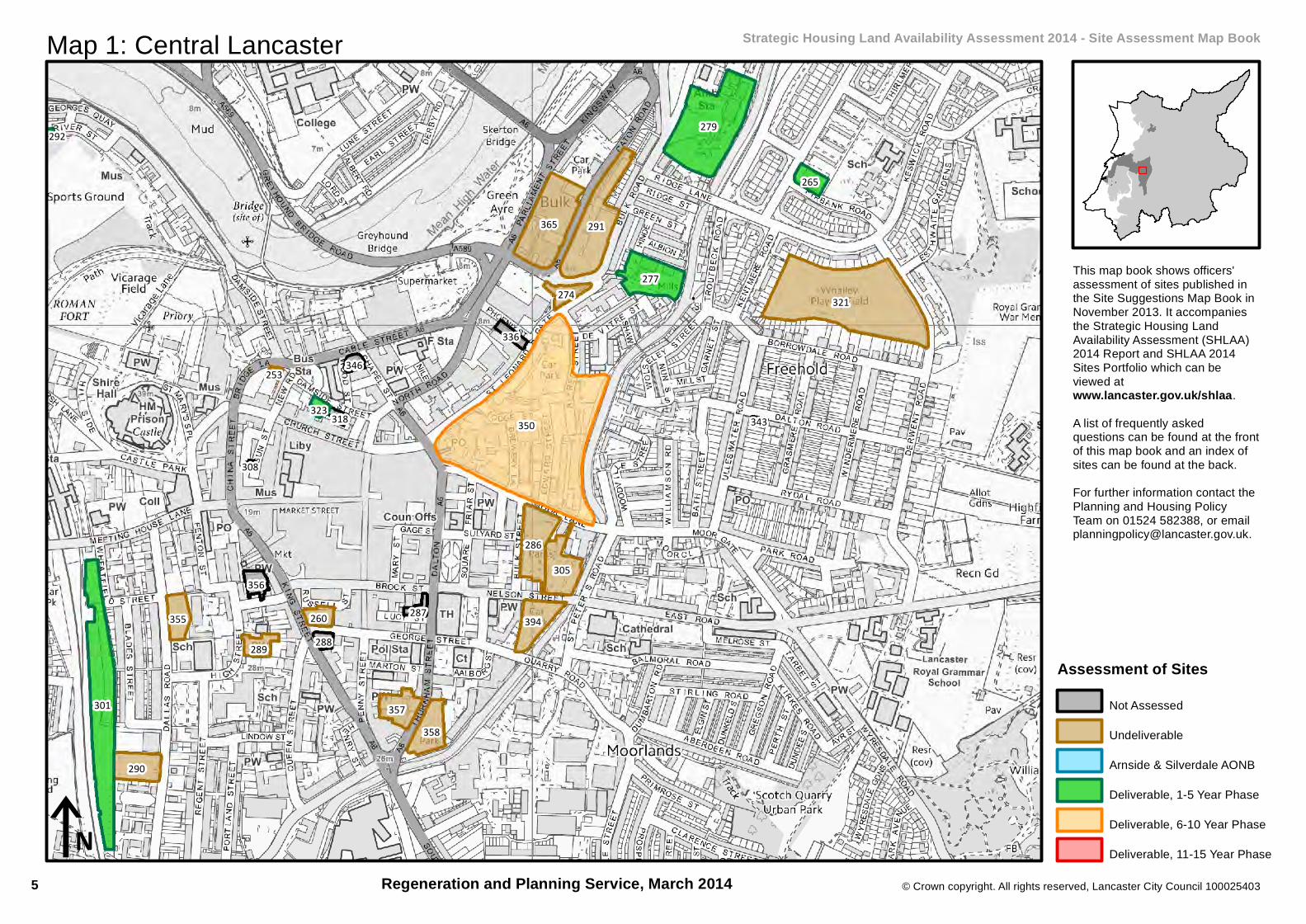
Map 1: Central Lancaster Strategic Housing Land Availability Assessment 2014 - Site Assessment Map Book
This map book shows officers'assessment of sites published inthe Site Suggestions Map Book inNovember 2013. It accompaniesthe Strategic Housing LandAvailability Assessment (SHLAA)2014 Report and SHLAA 2014Sites Portfolio which can beviewed atwww.lancaster.gov.uk/shlaa.A list of frequently askedquestions can be found at the frontof this map book and an index ofsites can be found at the back.For further information contact thePlanning and Housing PolicyTeam on 01524 582388, or [email protected].
Regeneration and Planning Service, March 2014
Assessment of SitesNot Assessed
Undeliverable
Arnside & Silverdale AONB
Deliverable, 1-5 Year Phase
Deliverable, 6-10 Year Phase
Deliverable, 11-15 Year Phase
5

© Crown copyright. All rights reserved, Lancaster City Council 100025403
Constraint Map 1: Central Lancaster Strategic Housing Land Availability Assessment 2014 - Site Suggestions Map Book
Regeneration and Planning Service, March 2014
350
301
279
277
265
323
292
iN
ConstraintsDeliverable SHLAA Site
North Lancashire Green Belt
Ancient Woodland
Defended Flood Area
Flood Zone 2
Flood Zone 3Environmental Designation
International and European
Sites of Special Scientific Interest
Geological Heritage Sites
Biological Heritage Sites
AONB
Nature Improvement Area
Park and Gardens
Conservation Area
Scheduled Monuments
6

328
319
397
257
293
389
338
376
366
378
398
321
379
327
313
391
279
362
265
574
343
© Crown copyright. All rights reserved, Lancaster City Council 100025403
iN
Map 2: East Lancaster Strategic Housing Land Availability Assessment 2014 - Site Assessment Map Book
This map book shows officers'assessment of sites published inthe Site Suggestions Map Book inNovember 2013. It accompaniesthe Strategic Housing LandAvailability Assessment (SHLAA)2014 Report and SHLAA 2014Sites Portfolio which can beviewed atwww.lancaster.gov.uk/shlaa.A list of frequently askedquestions can be found at the frontof this map book and an index ofsites can be found at the back.For further information contact thePlanning and Housing PolicyTeam on 01524 582388, or [email protected].
Regeneration and Planning Service, March 2014
Assessment of SitesNot Assessed
Undeliverable
Arnside & Silverdale AONB
Deliverable, 1-5 Year Phase
Deliverable, 6-10 Year Phase
Deliverable, 11-15 Year Phase
7

© Crown copyright. All rights reserved, Lancaster City Council 100025403
Constraint Map 2: East Lancaster Strategic Housing Land Availability Assessment 2014 - Site Suggestions Map Book
Regeneration and Planning Service, March 2014
328
319
397
293
389
338
376
378
398
391
279
265
574iN
ConstraintsDeliverable SHLAA Site
North Lancashire Green Belt
Ancient Woodland
Defended Flood Area
Flood Zone 2
Flood Zone 3Environmental Designation
International and European
Sites of Special Scientific Interest
Geological Heritage Sites
Biological Heritage Sites
AONB
Nature Improvement Area
Park and Gardens
Conservation Area
Scheduled Monuments
8

328
389
278
397
257
388
338
366
341
379
651
261
312
334
313
329574
264
362
306
© Crown copyright. All rights reserved, Lancaster City Council 100025403
iN
Map 3: Bowerham, Lancaster Strategic Housing Land Availability Assessment 2014 - Site Assessment Map Book
This map book shows officers'assessment of sites published inthe Site Suggestions Map Book inNovember 2013. It accompaniesthe Strategic Housing LandAvailability Assessment (SHLAA)2014 Report and SHLAA 2014Sites Portfolio which can beviewed atwww.lancaster.gov.uk/shlaa.A list of frequently askedquestions can be found at the frontof this map book and an index ofsites can be found at the back.For further information contact thePlanning and Housing PolicyTeam on 01524 582388, or [email protected].
Regeneration and Planning Service, March 2014
Assessment of SitesNot Assessed
Undeliverable
Arnside & Silverdale AONB
Deliverable, 1-5 Year Phase
Deliverable, 6-10 Year Phase
Deliverable, 11-15 Year Phase
9
© Crown copyright. All rights reserved, Lancaster City Council 100025403
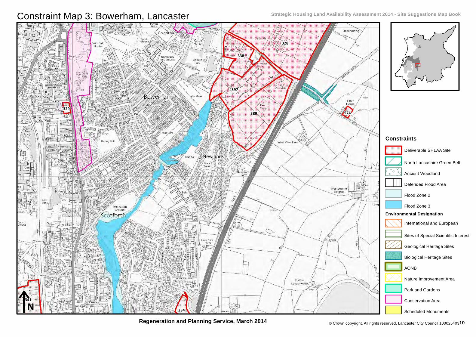
Constraint Map 3: Bowerham, Lancaster Strategic Housing Land Availability Assessment 2014 - Site Suggestions Map Book
Regeneration and Planning Service, March 2014
328
389
397
338
341334
329 574
iN
ConstraintsDeliverable SHLAA Site
North Lancashire Green Belt
Ancient Woodland
Defended Flood Area
Flood Zone 2
Flood Zone 3Environmental Designation
International and European
Sites of Special Scientific Interest
Geological Heritage Sites
Biological Heritage Sites
AONB
Nature Improvement Area
Park and Gardens
Conservation Area
Scheduled Monuments
10
341
334
382
138
278304
386
388
267
139
385
651
261
259
351
302
312
383
251
134
264
© Crown copyright. All rights reserved, Lancaster City Council 100025403
iN
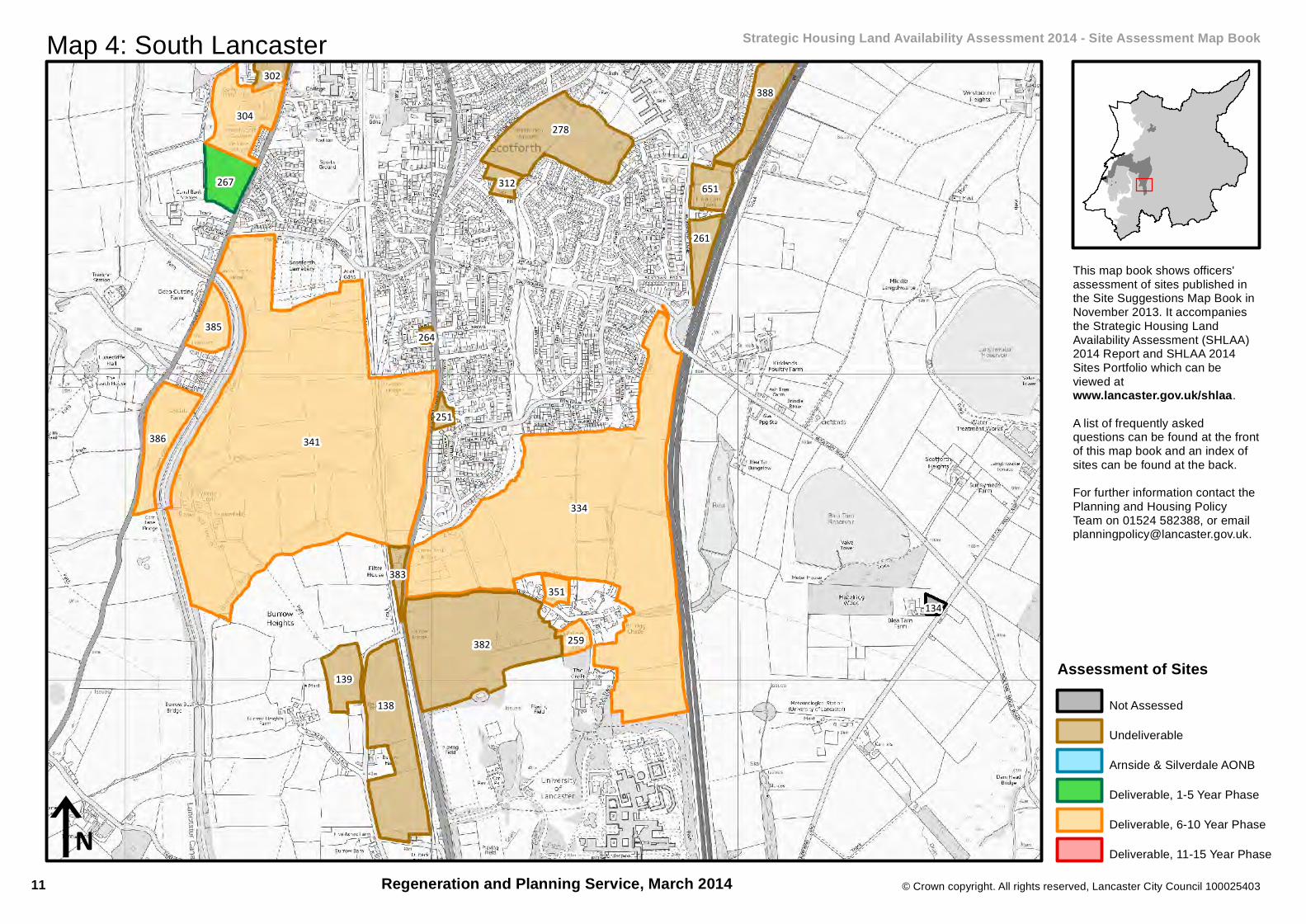
Map 4: South Lancaster Strategic Housing Land Availability Assessment 2014 - Site Assessment Map Book
This map book shows officers'assessment of sites published inthe Site Suggestions Map Book inNovember 2013. It accompaniesthe Strategic Housing LandAvailability Assessment (SHLAA)2014 Report and SHLAA 2014Sites Portfolio which can beviewed atwww.lancaster.gov.uk/shlaa.A list of frequently askedquestions can be found at the frontof this map book and an index ofsites can be found at the back.For further information contact thePlanning and Housing PolicyTeam on 01524 582388, or [email protected].
Regeneration and Planning Service, March 2014
Assessment of SitesNot Assessed
Undeliverable
Arnside & Silverdale AONB
Deliverable, 1-5 Year Phase
Deliverable, 6-10 Year Phase
Deliverable, 11-15 Year Phase
11

© Crown copyright. All rights reserved, Lancaster City Council 100025403
Constraint Map 4: South Lancaster Strategic Housing Land Availability Assessment 2014 - Site Suggestions Map Book
Regeneration and Planning Service, March 2014
341
334
304
386
267
385
351
259
iN
ConstraintsDeliverable SHLAA Site
North Lancashire Green Belt
Ancient Woodland
Defended Flood Area
Flood Zone 2
Flood Zone 3Environmental Designation
International and European
Sites of Special Scientific Interest
Geological Heritage Sites
Biological Heritage Sites
AONB
Nature Improvement Area
Park and Gardens
Conservation Area
Scheduled Monuments
12
2
3
353
381
304
377
267
5
341
302
4
263
301290
329
358
306
© Crown copyright. All rights reserved, Lancaster City Council 100025403
iN
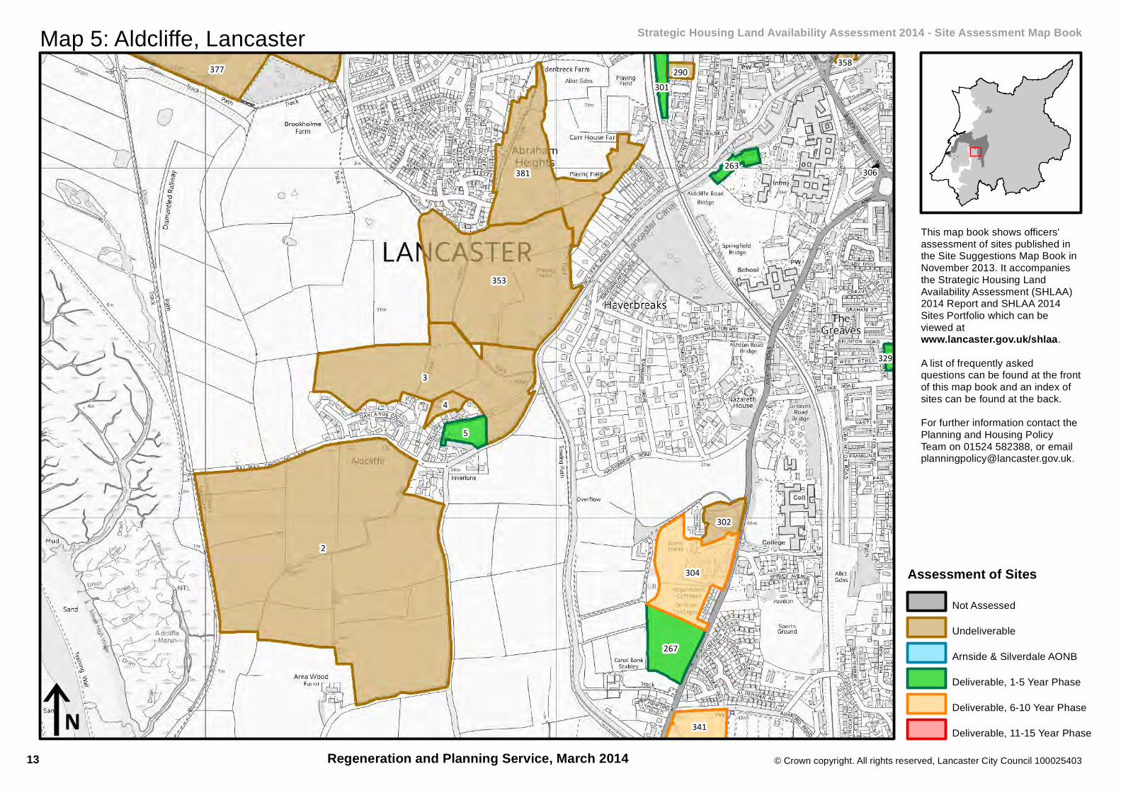
Map 5: Aldcliffe, Lancaster Strategic Housing Land Availability Assessment 2014 - Site Assessment Map Book
This map book shows officers'assessment of sites published inthe Site Suggestions Map Book inNovember 2013. It accompaniesthe Strategic Housing LandAvailability Assessment (SHLAA)2014 Report and SHLAA 2014Sites Portfolio which can beviewed atwww.lancaster.gov.uk/shlaa.A list of frequently askedquestions can be found at the frontof this map book and an index ofsites can be found at the back.For further information contact thePlanning and Housing PolicyTeam on 01524 582388, or [email protected].
Regeneration and Planning Service, March 2014
Assessment of SitesNot Assessed
Undeliverable
Arnside & Silverdale AONB
Deliverable, 1-5 Year Phase
Deliverable, 6-10 Year Phase
Deliverable, 11-15 Year Phase
13

© Crown copyright. All rights reserved, Lancaster City Council 100025403
Constraint Map 5: Aldcliffe, Lancaster Strategic Housing Land Availability Assessment 2014 - Site Suggestions Map Book
Regeneration and Planning Service, March 2014
304
267
5
341
263
301
329
iN
ConstraintsDeliverable SHLAA Site
North Lancashire Green Belt
Ancient Woodland
Defended Flood Area
Flood Zone 2
Flood Zone 3Environmental Designation
International and European
Sites of Special Scientific Interest
Geological Heritage Sites
Biological Heritage Sites
AONB
Nature Improvement Area
Park and Gardens
Conservation Area
Scheduled Monuments
14
377
353
256
330
381
292
373
314
300
301342
263
331
266
296
290
347
355
299395
289
356
296
337
253
3
308
© Crown copyright. All rights reserved, Lancaster City Council 100025403
iN
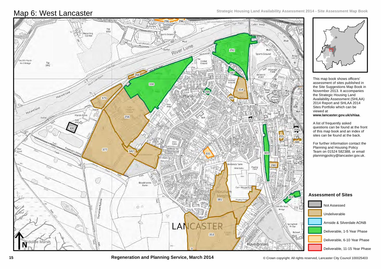
Map 6: West Lancaster Strategic Housing Land Availability Assessment 2014 - Site Assessment Map Book
This map book shows officers'assessment of sites published inthe Site Suggestions Map Book inNovember 2013. It accompaniesthe Strategic Housing LandAvailability Assessment (SHLAA)2014 Report and SHLAA 2014Sites Portfolio which can beviewed atwww.lancaster.gov.uk/shlaa.A list of frequently askedquestions can be found at the frontof this map book and an index ofsites can be found at the back.For further information contact thePlanning and Housing PolicyTeam on 01524 582388, or [email protected].
Regeneration and Planning Service, March 2014
Assessment of SitesNot Assessed
Undeliverable
Arnside & Silverdale AONB
Deliverable, 1-5 Year Phase
Deliverable, 6-10 Year Phase
Deliverable, 11-15 Year Phase
15

© Crown copyright. All rights reserved, Lancaster City Council 100025403
Constraint Map 6: West Lancaster Strategic Housing Land Availability Assessment 2014 - Site Suggestions Map Book
Regeneration and Planning Service, March 2014
330
292
301
263
331
296
347
299
296
iN
ConstraintsDeliverable SHLAA Site
North Lancashire Green Belt
Ancient Woodland
Defended Flood Area
Flood Zone 2
Flood Zone 3Environmental Designation
International and European
Sites of Special Scientific Interest
Geological Heritage Sites
Biological Heritage Sites
AONB
Nature Improvement Area
Park and Gardens
Conservation Area
Scheduled Monuments
16
310
399
349
348
380
281
393
295
326
372
369
384
282
354
315
390
272
© Crown copyright. All rights reserved, Lancaster City Council 100025403
iN
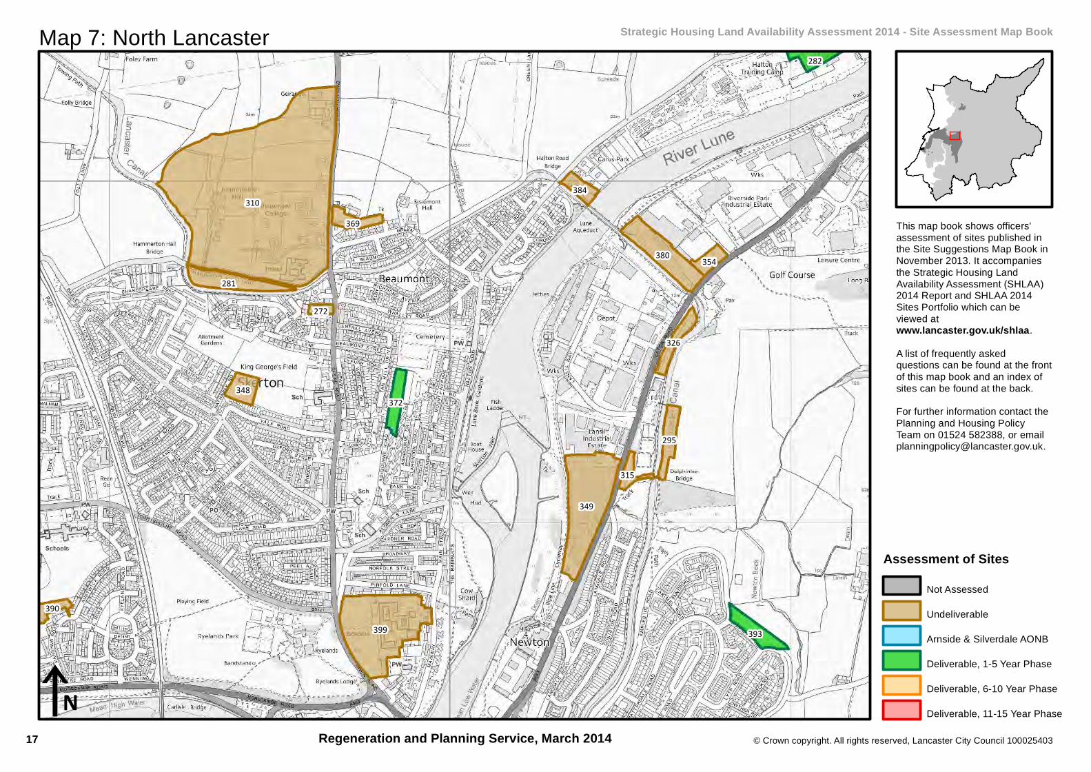
Map 7: North Lancaster Strategic Housing Land Availability Assessment 2014 - Site Assessment Map Book
This map book shows officers'assessment of sites published inthe Site Suggestions Map Book inNovember 2013. It accompaniesthe Strategic Housing LandAvailability Assessment (SHLAA)2014 Report and SHLAA 2014Sites Portfolio which can beviewed atwww.lancaster.gov.uk/shlaa.A list of frequently askedquestions can be found at the frontof this map book and an index ofsites can be found at the back.For further information contact thePlanning and Housing PolicyTeam on 01524 582388, or [email protected].
Regeneration and Planning Service, March 2014
Assessment of SitesNot Assessed
Undeliverable
Arnside & Silverdale AONB
Deliverable, 1-5 Year Phase
Deliverable, 6-10 Year Phase
Deliverable, 11-15 Year Phase
17
© Crown copyright. All rights reserved, Lancaster City Council 100025403
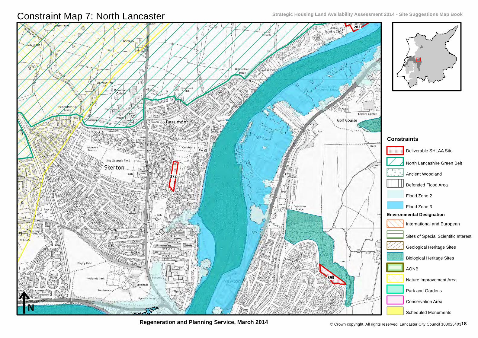
Constraint Map 7: North Lancaster Strategic Housing Land Availability Assessment 2014 - Site Suggestions Map Book
Regeneration and Planning Service, March 2014
393
372
282
iN
ConstraintsDeliverable SHLAA Site
North Lancashire Green Belt
Ancient Woodland
Defended Flood Area
Flood Zone 2
Flood Zone 3Environmental Designation
International and European
Sites of Special Scientific Interest
Geological Heritage Sites
Biological Heritage Sites
AONB
Nature Improvement Area
Park and Gardens
Conservation Area
Scheduled Monuments
18

536
503
500
499
447
480
553
456
481
438
535
547
533
426
462463
439
442
444
497
435
523
540
440232
492
524
437
514
494
473
472
174
483
543
484487
528
190228
517
446
177
© Crown copyright. All rights reserved, Lancaster City Council 100025403
iN
Map 8: Central Morecambe and West Poulton Strategic Housing Land Availability Assessment 2014 - Site Assessment Map Book
This map book shows officers'assessment of sites published inthe Site Suggestions Map Book inNovember 2013. It accompaniesthe Strategic Housing LandAvailability Assessment (SHLAA)2014 Report and SHLAA 2014Sites Portfolio which can beviewed atwww.lancaster.gov.uk/shlaa.A list of frequently askedquestions can be found at the frontof this map book and an index ofsites can be found at the back.For further information contact thePlanning and Housing PolicyTeam on 01524 582388, or [email protected].
Regeneration and Planning Service, March 2014
Assessment of SitesNot Assessed
Undeliverable
Arnside & Silverdale AONB
Deliverable, 1-5 Year Phase
Deliverable, 6-10 Year Phase
Deliverable, 11-15 Year Phase
19

© Crown copyright. All rights reserved, Lancaster City Council 100025403
Constraint Map 8: Central Morecambe and West Poulton Strategic Housing Land Availability Assessment 2014 - Site Suggestions Map Book
Regeneration and Planning Service, March 2014
503
447
553
481
540
iN
ConstraintsDeliverable SHLAA Site
North Lancashire Green Belt
Ancient Woodland
Defended Flood Area
Flood Zone 2
Flood Zone 3Environmental Designation
International and European
Sites of Special Scientific Interest
Geological Heritage Sites
Biological Heritage Sites
AONB
Nature Improvement Area
Park and Gardens
Conservation Area
Scheduled Monuments
20

548
481 547
544
426
462463 534
510
439
444
523
529
524
521
© Crown copyright. All rights reserved, Lancaster City Council 100025403
iN
Map 9: Bare and East Poulton Strategic Housing Land Availability Assessment 2014 - Site Assessment Map Book
This map book shows officers'assessment of sites published inthe Site Suggestions Map Book inNovember 2013. It accompaniesthe Strategic Housing LandAvailability Assessment (SHLAA)2014 Report and SHLAA 2014Sites Portfolio which can beviewed atwww.lancaster.gov.uk/shlaa.A list of frequently askedquestions can be found at the frontof this map book and an index ofsites can be found at the back.For further information contact thePlanning and Housing PolicyTeam on 01524 582388, or [email protected].
Regeneration and Planning Service, March 2014
Assessment of SitesNot Assessed
Undeliverable
Arnside & Silverdale AONB
Deliverable, 1-5 Year Phase
Deliverable, 6-10 Year Phase
Deliverable, 11-15 Year Phase
21
© Crown copyright. All rights reserved, Lancaster City Council 100025403
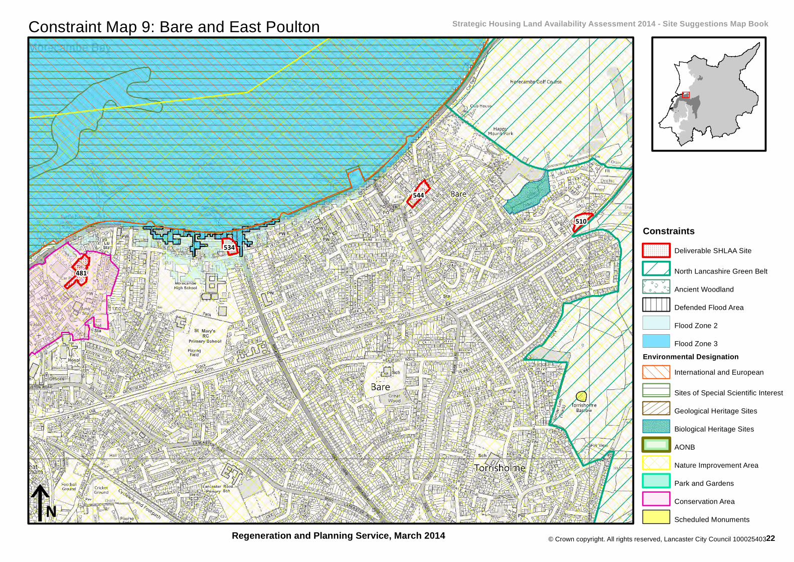
Constraint Map 9: Bare and East Poulton Strategic Housing Land Availability Assessment 2014 - Site Suggestions Map Book
Regeneration and Planning Service, March 2014
481
544
534
510
iN
ConstraintsDeliverable SHLAA Site
North Lancashire Green Belt
Ancient Woodland
Defended Flood Area
Flood Zone 2
Flood Zone 3Environmental Designation
International and European
Sites of Special Scientific Interest
Geological Heritage Sites
Biological Heritage Sites
AONB
Nature Improvement Area
Park and Gardens
Conservation Area
Scheduled Monuments
22
509
500
211
525
194
505
183
221
447
213
449
433 432
187 208
178
174
207
220
440232
508
219
437
456
201
535190
223
228
177
© Crown copyright. All rights reserved, Lancaster City Council 100025403
iN
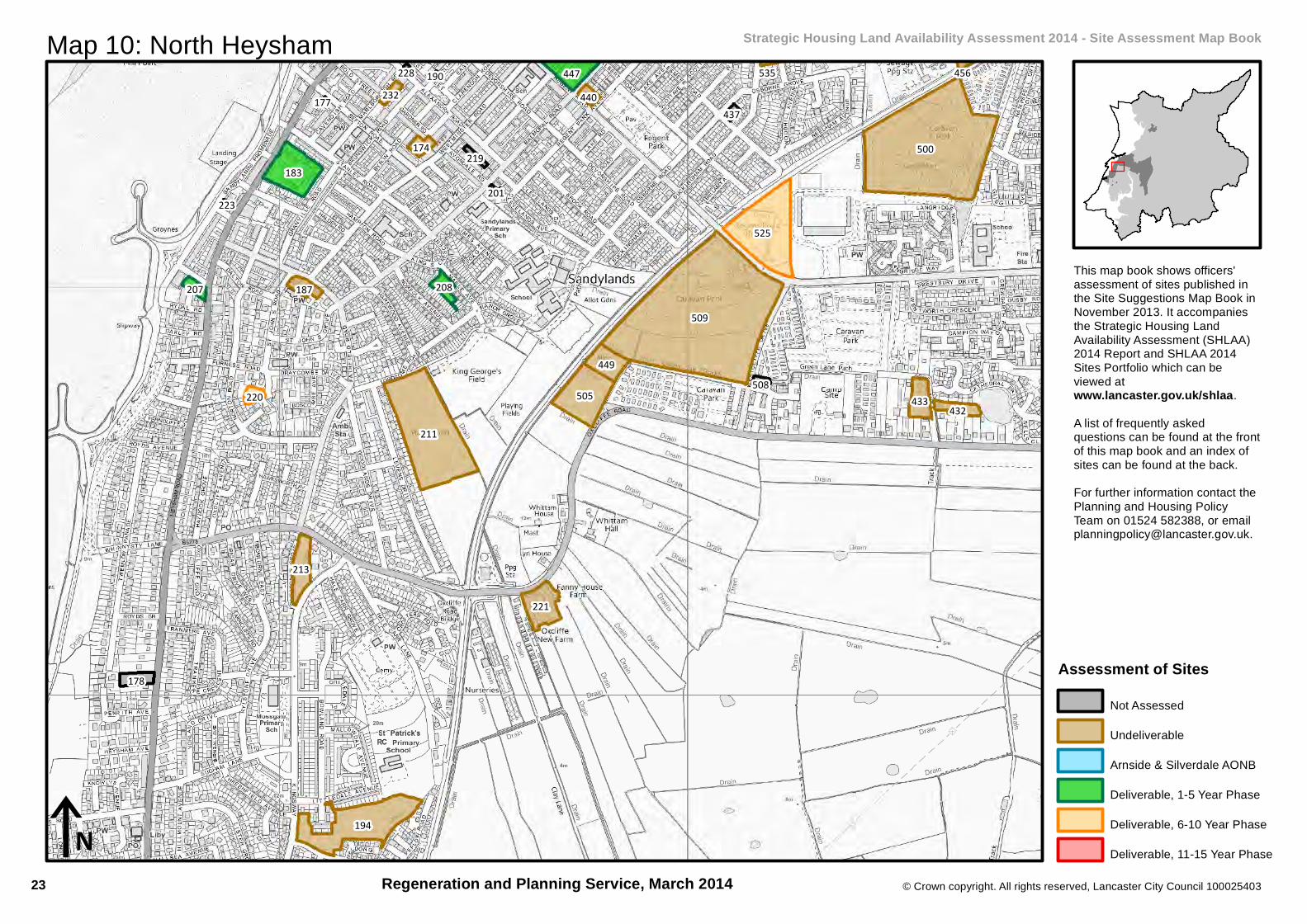
Map 10: North Heysham Strategic Housing Land Availability Assessment 2014 - Site Assessment Map Book
This map book shows officers'assessment of sites published inthe Site Suggestions Map Book inNovember 2013. It accompaniesthe Strategic Housing LandAvailability Assessment (SHLAA)2014 Report and SHLAA 2014Sites Portfolio which can beviewed atwww.lancaster.gov.uk/shlaa.A list of frequently askedquestions can be found at the frontof this map book and an index ofsites can be found at the back.For further information contact thePlanning and Housing PolicyTeam on 01524 582388, or [email protected].
Regeneration and Planning Service, March 2014
Assessment of SitesNot Assessed
Undeliverable
Arnside & Silverdale AONB
Deliverable, 1-5 Year Phase
Deliverable, 6-10 Year Phase
Deliverable, 11-15 Year Phase
23

© Crown copyright. All rights reserved, Lancaster City Council 100025403
Constraint Map 10: North Heysham Strategic Housing Land Availability Assessment 2014 - Site Suggestions Map Book
Regeneration and Planning Service, March 2014
525
183
447
208207
220
iN
ConstraintsDeliverable SHLAA Site
North Lancashire Green Belt
Ancient Woodland
Defended Flood Area
Flood Zone 2
Flood Zone 3Environmental Designation
International and European
Sites of Special Scientific Interest
Geological Heritage Sites
Biological Heritage Sites
AONB
Nature Improvement Area
Park and Gardens
Conservation Area
Scheduled Monuments
24

197
185
182
194
179
200
181
215
227
214
226
212
421
172
233
224
173
180
© Crown copyright. All rights reserved, Lancaster City Council 100025403
iN
Map 11: South Heysham Strategic Housing Land Availability Assessment 2014 - Site Assessment Map Book
This map book shows officers'assessment of sites published inthe Site Suggestions Map Book inNovember 2013. It accompaniesthe Strategic Housing LandAvailability Assessment (SHLAA)2014 Report and SHLAA 2014Sites Portfolio which can beviewed atwww.lancaster.gov.uk/shlaa.A list of frequently askedquestions can be found at the frontof this map book and an index ofsites can be found at the back.For further information contact thePlanning and Housing PolicyTeam on 01524 582388, or [email protected].
Regeneration and Planning Service, March 2014
Assessment of SitesNot Assessed
Undeliverable
Arnside & Silverdale AONB
Deliverable, 1-5 Year Phase
Deliverable, 6-10 Year Phase
Deliverable, 11-15 Year Phase
25
© Crown copyright. All rights reserved, Lancaster City Council 100025403
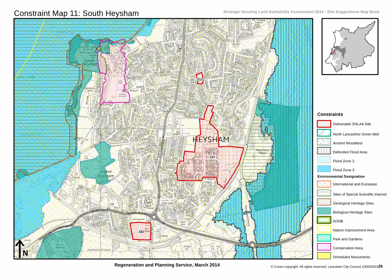
Constraint Map 11: South Heysham Strategic Housing Land Availability Assessment 2014 - Site Suggestions Map Book
Regeneration and Planning Service, March 2014
197
182
212
iN
ConstraintsDeliverable SHLAA Site
North Lancashire Green Belt
Ancient Woodland
Defended Flood Area
Flood Zone 2
Flood Zone 3Environmental Designation
International and European
Sites of Special Scientific Interest
Geological Heritage Sites
Biological Heritage Sites
AONB
Nature Improvement Area
Park and Gardens
Conservation Area
Scheduled Monuments
26

280
538
401 320
436
548
537
262
292
522
339 316
296
390
431
550 296
451
549
310
529
443
© Crown copyright. All rights reserved, Lancaster City Council 100025403
iN
Map 12: Torrisholme Strategic Housing Land Availability Assessment 2014 - Site Assessment Map Book
This map book shows officers'assessment of sites published inthe Site Suggestions Map Book inNovember 2013. It accompaniesthe Strategic Housing LandAvailability Assessment (SHLAA)2014 Report and SHLAA 2014Sites Portfolio which can beviewed atwww.lancaster.gov.uk/shlaa.A list of frequently askedquestions can be found at the frontof this map book and an index ofsites can be found at the back.For further information contact thePlanning and Housing PolicyTeam on 01524 582388, or [email protected].
Regeneration and Planning Service, March 2014
Assessment of SitesNot Assessed
Undeliverable
Arnside & Silverdale AONB
Deliverable, 1-5 Year Phase
Deliverable, 6-10 Year Phase
Deliverable, 11-15 Year Phase
27
© Crown copyright. All rights reserved, Lancaster City Council 100025403
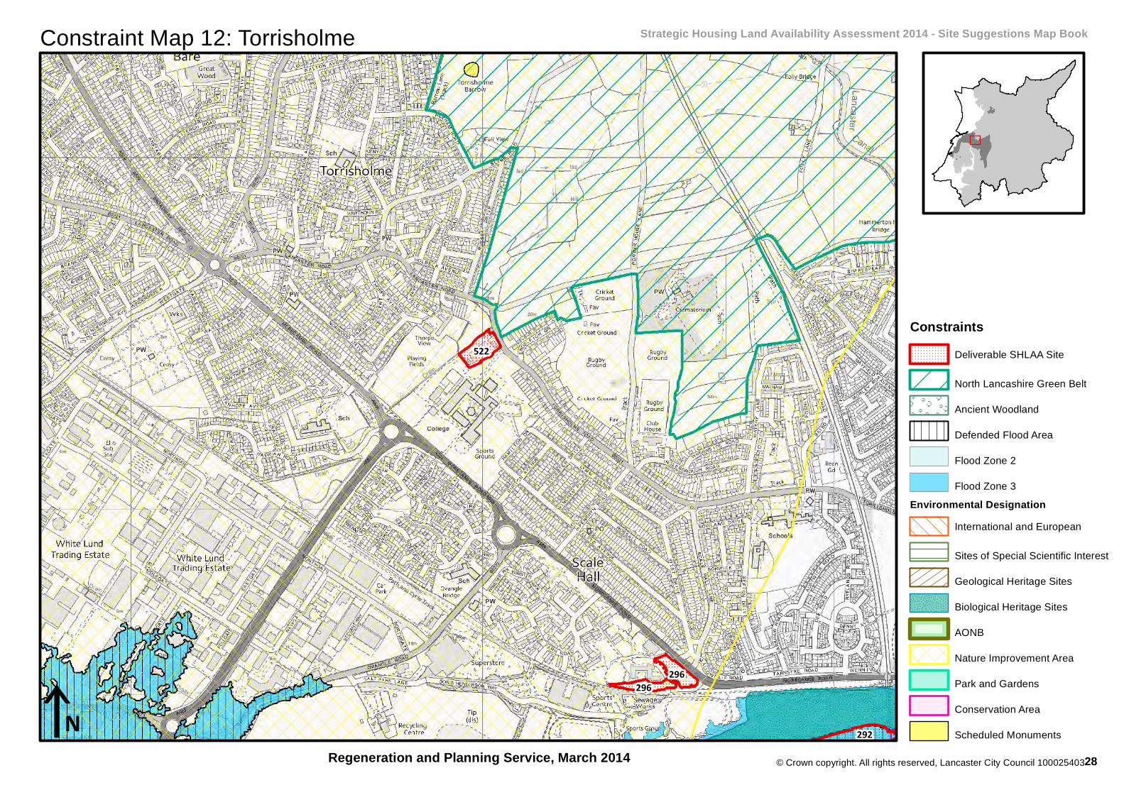
Constraint Map 12: Torrisholme Strategic Housing Land Availability Assessment 2014 - Site Suggestions Map Book
Regeneration and Planning Service, March 2014292
522
296296
iN
ConstraintsDeliverable SHLAA Site
North Lancashire Green Belt
Ancient Woodland
Defended Flood Area
Flood Zone 2
Flood Zone 3Environmental Designation
International and European
Sites of Special Scientific Interest
Geological Heritage Sites
Biological Heritage Sites
AONB
Nature Improvement Area
Park and Gardens
Conservation Area
Scheduled Monuments
28
549
509
500
550
538
431
525436506
535
433
456451
432
511
498
448429
449
542
508
437
© Crown copyright. All rights reserved, Lancaster City Council 100025403
iN
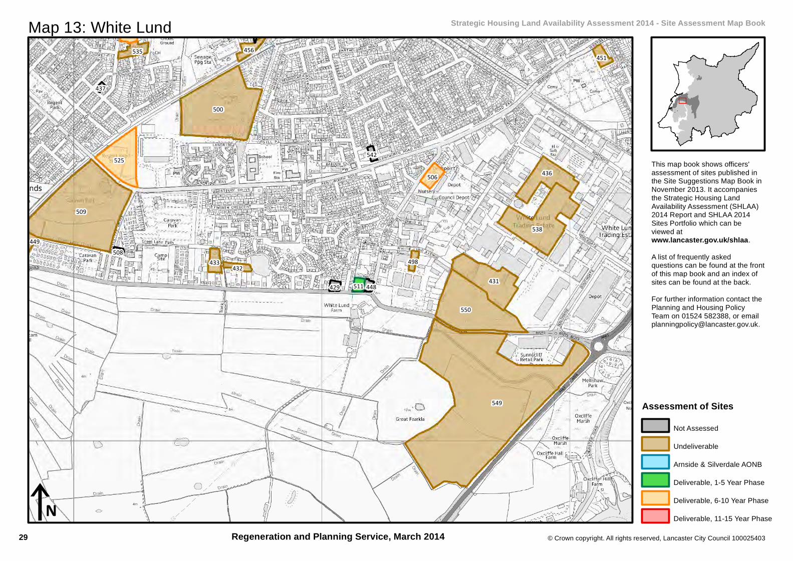
Map 13: White Lund Strategic Housing Land Availability Assessment 2014 - Site Assessment Map Book
This map book shows officers'assessment of sites published inthe Site Suggestions Map Book inNovember 2013. It accompaniesthe Strategic Housing LandAvailability Assessment (SHLAA)2014 Report and SHLAA 2014Sites Portfolio which can beviewed atwww.lancaster.gov.uk/shlaa.A list of frequently askedquestions can be found at the frontof this map book and an index ofsites can be found at the back.For further information contact thePlanning and Housing PolicyTeam on 01524 582388, or [email protected].
Regeneration and Planning Service, March 2014
Assessment of SitesNot Assessed
Undeliverable
Arnside & Silverdale AONB
Deliverable, 1-5 Year Phase
Deliverable, 6-10 Year Phase
Deliverable, 11-15 Year Phase
29

© Crown copyright. All rights reserved, Lancaster City Council 100025403
Constraint Map 13: White Lund Strategic Housing Land Availability Assessment 2014 - Site Suggestions Map Book
Regeneration and Planning Service, March 2014
525506
511
553
iN
ConstraintsDeliverable SHLAA Site
North Lancashire Green Belt
Ancient Woodland
Defended Flood Area
Flood Zone 2
Flood Zone 3Environmental Designation
International and European
Sites of Special Scientific Interest
Geological Heritage Sites
Biological Heritage Sites
AONB
Nature Improvement Area
Park and Gardens
Conservation Area
Scheduled Monuments
30
78
61
43
84
49
614
75
71
42
7448
73
425
51
46
44
625
5747
70
76
56
68
424
45
8382
55
65
59
69
52
60
© Crown copyright. All rights reserved, Lancaster City Council 100025403
iN
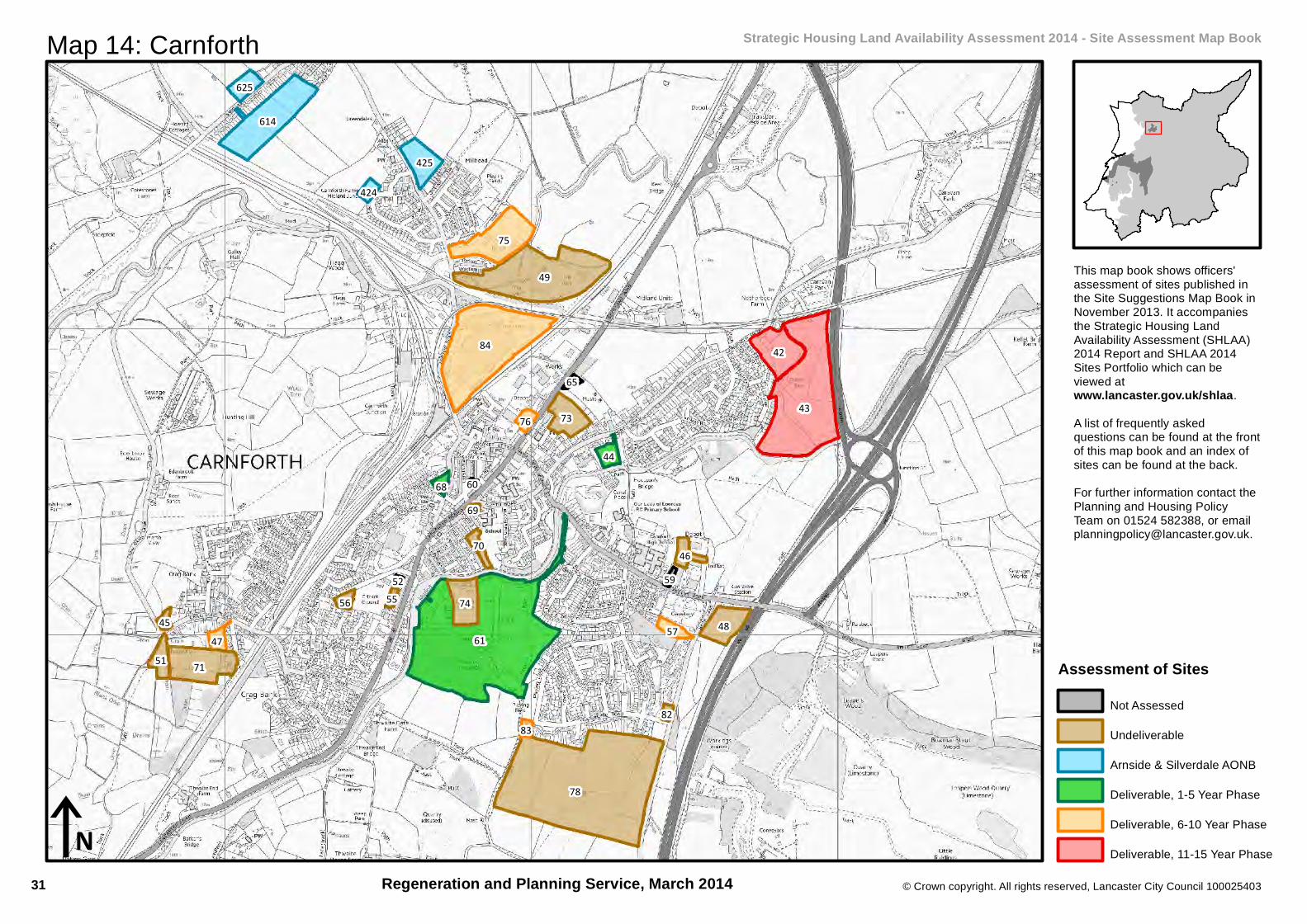
Map 14: Carnforth Strategic Housing Land Availability Assessment 2014 - Site Assessment Map Book
This map book shows officers'assessment of sites published inthe Site Suggestions Map Book inNovember 2013. It accompaniesthe Strategic Housing LandAvailability Assessment (SHLAA)2014 Report and SHLAA 2014Sites Portfolio which can beviewed atwww.lancaster.gov.uk/shlaa.A list of frequently askedquestions can be found at the frontof this map book and an index ofsites can be found at the back.For further information contact thePlanning and Housing PolicyTeam on 01524 582388, or [email protected].
Regeneration and Planning Service, March 2014
Assessment of SitesNot Assessed
Undeliverable
Arnside & Silverdale AONB
Deliverable, 1-5 Year Phase
Deliverable, 6-10 Year Phase
Deliverable, 11-15 Year Phase
31
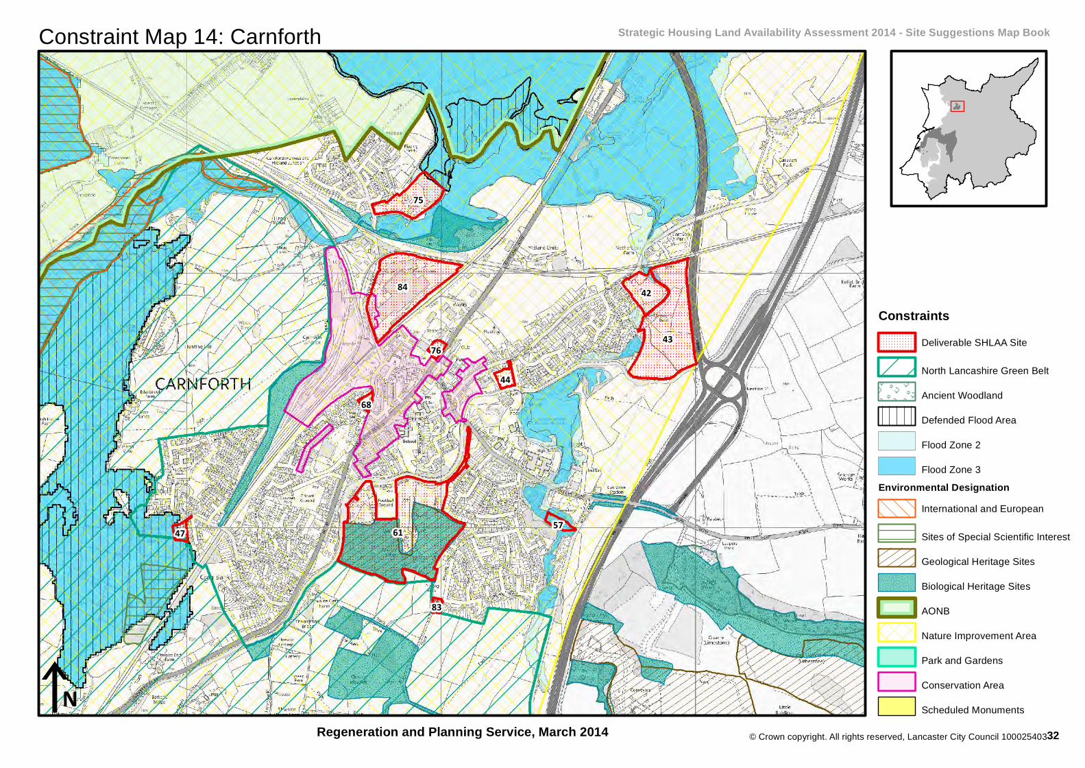
© Crown copyright. All rights reserved, Lancaster City Council 100025403
Constraint Map 14: Carnforth Strategic Housing Land Availability Assessment 2014 - Site Suggestions Map Book
Regeneration and Planning Service, March 2014
61
43
84
75
42
44
5747
76
68
83
iN
ConstraintsDeliverable SHLAA Site
North Lancashire Green Belt
Ancient Woodland
Defended Flood Area
Flood Zone 2
Flood Zone 3Environmental Designation
International and European
Sites of Special Scientific Interest
Geological Heritage Sites
Biological Heritage Sites
AONB
Nature Improvement Area
Park and Gardens
Conservation Area
Scheduled Monuments
32

402
7
404
11
© Crown copyright. All rights reserved, Lancaster City Council 100025403
iN
Map 15: Arkholme Strategic Housing Land Availability Assessment 2014 - Site Assessment Map Book
This map book shows officers'assessment of sites published inthe Site Suggestions Map Book inNovember 2013. It accompaniesthe Strategic Housing LandAvailability Assessment (SHLAA)2014 Report and SHLAA 2014Sites Portfolio which can beviewed atwww.lancaster.gov.uk/shlaa.A list of frequently askedquestions can be found at the frontof this map book and an index ofsites can be found at the back.For further information contact thePlanning and Housing PolicyTeam on 01524 582388, or [email protected].
Regeneration and Planning Service, March 2014
Assessment of SitesNot Assessed
Undeliverable
Arnside & Silverdale AONB
Deliverable, 1-5 Year Phase
Deliverable, 6-10 Year Phase
Deliverable, 11-15 Year Phase
33

© Crown copyright. All rights reserved, Lancaster City Council 100025403
Constraint Map 15: Arkholme Strategic Housing Land Availability Assessment 2014 - Site Suggestions Map Book
Regeneration and Planning Service, March 2014
711
iN
ConstraintsDeliverable SHLAA Site
North Lancashire Green Belt
Ancient Woodland
Defended Flood Area
Flood Zone 2
Flood Zone 3Environmental Designation
International and European
Sites of Special Scientific Interest
Geological Heritage Sites
Biological Heritage Sites
AONB
Nature Improvement Area
Park and Gardens
Conservation Area
Scheduled Monuments
34

34
23
32
18
21
17
22
© Crown copyright. All rights reserved, Lancaster City Council 100025403
iN
Map 16: Bolton-Le-Sands Strategic Housing Land Availability Assessment 2014 - Site Assessment Map Book
This map book shows officers'assessment of sites published inthe Site Suggestions Map Book inNovember 2013. It accompaniesthe Strategic Housing LandAvailability Assessment (SHLAA)2014 Report and SHLAA 2014Sites Portfolio which can beviewed atwww.lancaster.gov.uk/shlaa.A list of frequently askedquestions can be found at the frontof this map book and an index ofsites can be found at the back.For further information contact thePlanning and Housing PolicyTeam on 01524 582388, or [email protected].
Regeneration and Planning Service, March 2014
Assessment of SitesNot Assessed
Undeliverable
Arnside & Silverdale AONB
Deliverable, 1-5 Year Phase
Deliverable, 6-10 Year Phase
Deliverable, 11-15 Year Phase
35

© Crown copyright. All rights reserved, Lancaster City Council 100025403
Constraint Map 16: Bolton-Le-Sands Strategic Housing Land Availability Assessment 2014 - Site Suggestions Map Book
Regeneration and Planning Service, March 2014
34
32
iN
ConstraintsDeliverable SHLAA Site
North Lancashire Green Belt
Ancient Woodland
Defended Flood Area
Flood Zone 2
Flood Zone 3Environmental Designation
International and European
Sites of Special Scientific Interest
Geological Heritage Sites
Biological Heritage Sites
AONB
Nature Improvement Area
Park and Gardens
Conservation Area
Scheduled Monuments
36

40
101
98
100
92
94
99
87
93 38
39
90 89
91
95
103
37
85
© Crown copyright. All rights reserved, Lancaster City Council 100025403
iN
Map 17: Caton and Brookhouse Strategic Housing Land Availability Assessment 2014 - Site Assessment Map Book
This map book shows officers'assessment of sites published inthe Site Suggestions Map Book inNovember 2013. It accompaniesthe Strategic Housing LandAvailability Assessment (SHLAA)2014 Report and SHLAA 2014Sites Portfolio which can beviewed atwww.lancaster.gov.uk/shlaa.A list of frequently askedquestions can be found at the frontof this map book and an index ofsites can be found at the back.For further information contact thePlanning and Housing PolicyTeam on 01524 582388, or [email protected].
Regeneration and Planning Service, March 2014
Assessment of SitesNot Assessed
Undeliverable
Arnside & Silverdale AONB
Deliverable, 1-5 Year Phase
Deliverable, 6-10 Year Phase
Deliverable, 11-15 Year Phase
37
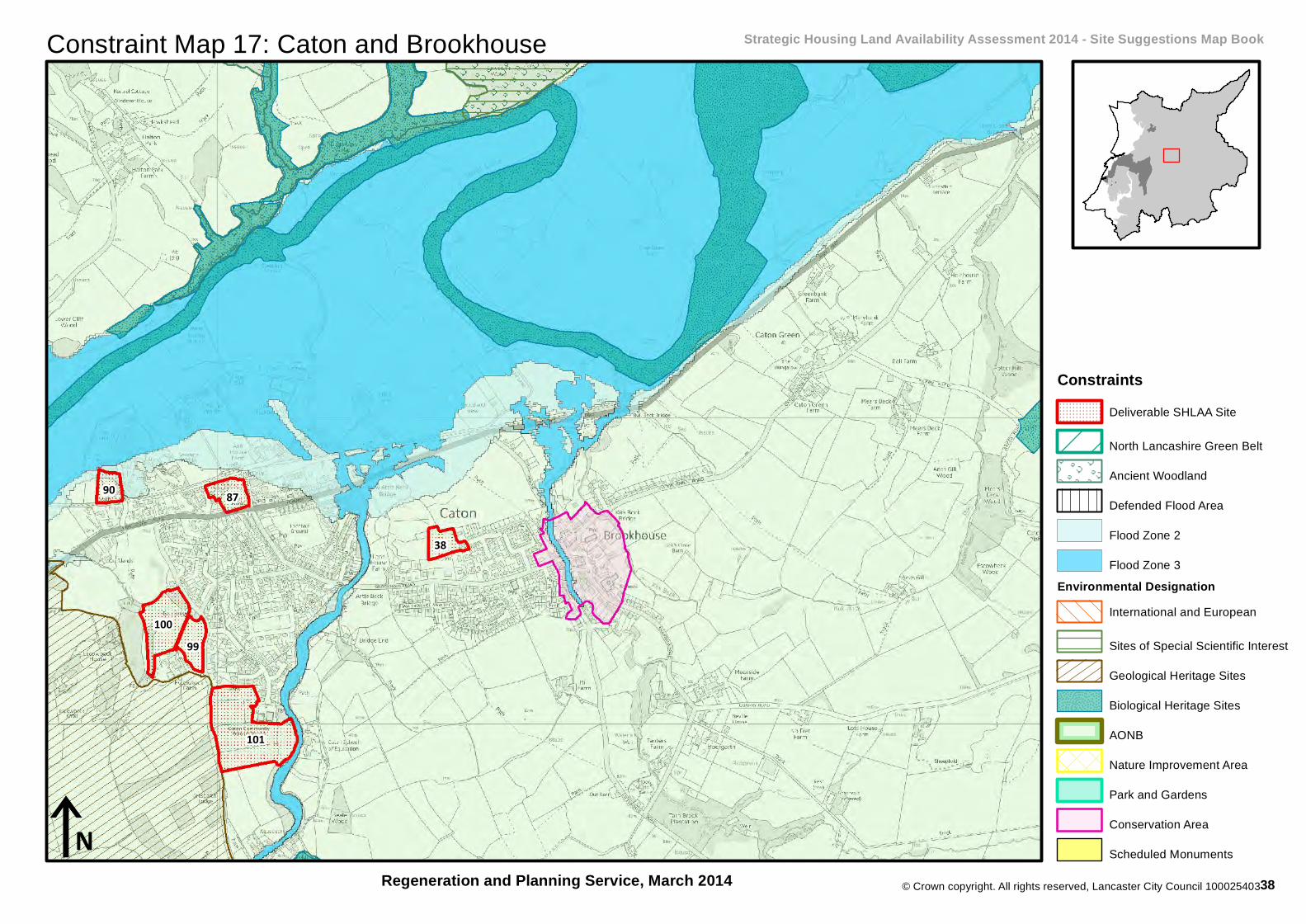
© Crown copyright. All rights reserved, Lancaster City Council 100025403
Constraint Map 17: Caton and Brookhouse Strategic Housing Land Availability Assessment 2014 - Site Suggestions Map Book
Regeneration and Planning Service, March 2014
101
10099
87
38
90
iN
ConstraintsDeliverable SHLAA Site
North Lancashire Green Belt
Ancient Woodland
Defended Flood Area
Flood Zone 2
Flood Zone 3Environmental Designation
International and European
Sites of Special Scientific Interest
Geological Heritage Sites
Biological Heritage Sites
AONB
Nature Improvement Area
Park and Gardens
Conservation Area
Scheduled Monuments
38

111
113
108
105
109
© Crown copyright. All rights reserved, Lancaster City Council 100025403
iN
Map 18: Cockerham Strategic Housing Land Availability Assessment 2014 - Site Assessment Map Book
This map book shows officers'assessment of sites published inthe Site Suggestions Map Book inNovember 2013. It accompaniesthe Strategic Housing LandAvailability Assessment (SHLAA)2014 Report and SHLAA 2014Sites Portfolio which can beviewed atwww.lancaster.gov.uk/shlaa.A list of frequently askedquestions can be found at the frontof this map book and an index ofsites can be found at the back.For further information contact thePlanning and Housing PolicyTeam on 01524 582388, or [email protected].
Regeneration and Planning Service, March 2014
Assessment of SitesNot Assessed
Undeliverable
Arnside & Silverdale AONB
Deliverable, 1-5 Year Phase
Deliverable, 6-10 Year Phase
Deliverable, 11-15 Year Phase
39

© Crown copyright. All rights reserved, Lancaster City Council 100025403
Constraint Map 18: Cockerham Strategic Housing Land Availability Assessment 2014 - Site Suggestions Map Book
Regeneration and Planning Service, March 2014
113
iN
ConstraintsDeliverable SHLAA Site
North Lancashire Green Belt
Ancient Woodland
Defended Flood Area
Flood Zone 2
Flood Zone 3Environmental Designation
International and European
Sites of Special Scientific Interest
Geological Heritage Sites
Biological Heritage Sites
AONB
Nature Improvement Area
Park and Gardens
Conservation Area
Scheduled Monuments
40
137
130127
128
129
16
126
125
© Crown copyright. All rights reserved, Lancaster City Council 100025403
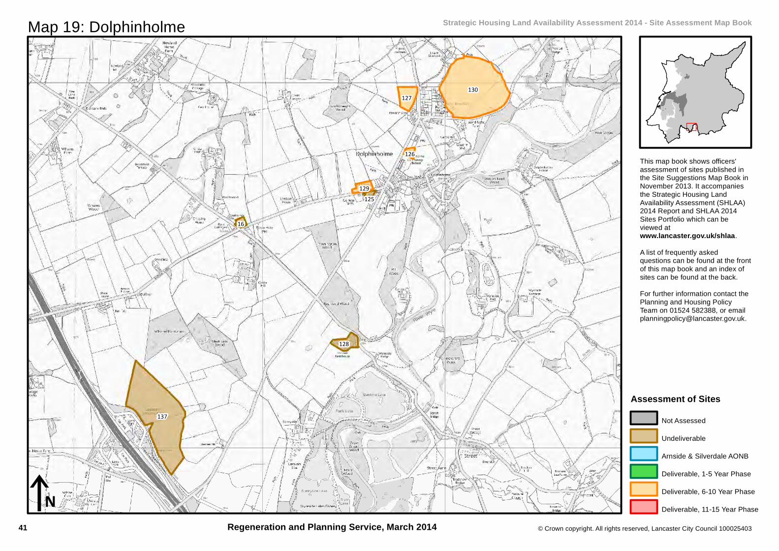
iN
Map 19: Dolphinholme Strategic Housing Land Availability Assessment 2014 - Site Assessment Map Book
This map book shows officers'assessment of sites published inthe Site Suggestions Map Book inNovember 2013. It accompaniesthe Strategic Housing LandAvailability Assessment (SHLAA)2014 Report and SHLAA 2014Sites Portfolio which can beviewed atwww.lancaster.gov.uk/shlaa.A list of frequently askedquestions can be found at the frontof this map book and an index ofsites can be found at the back.For further information contact thePlanning and Housing PolicyTeam on 01524 582388, or [email protected].
Regeneration and Planning Service, March 2014
Assessment of SitesNot Assessed
Undeliverable
Arnside & Silverdale AONB
Deliverable, 1-5 Year Phase
Deliverable, 6-10 Year Phase
Deliverable, 11-15 Year Phase
41
© Crown copyright. All rights reserved, Lancaster City Council 100025403
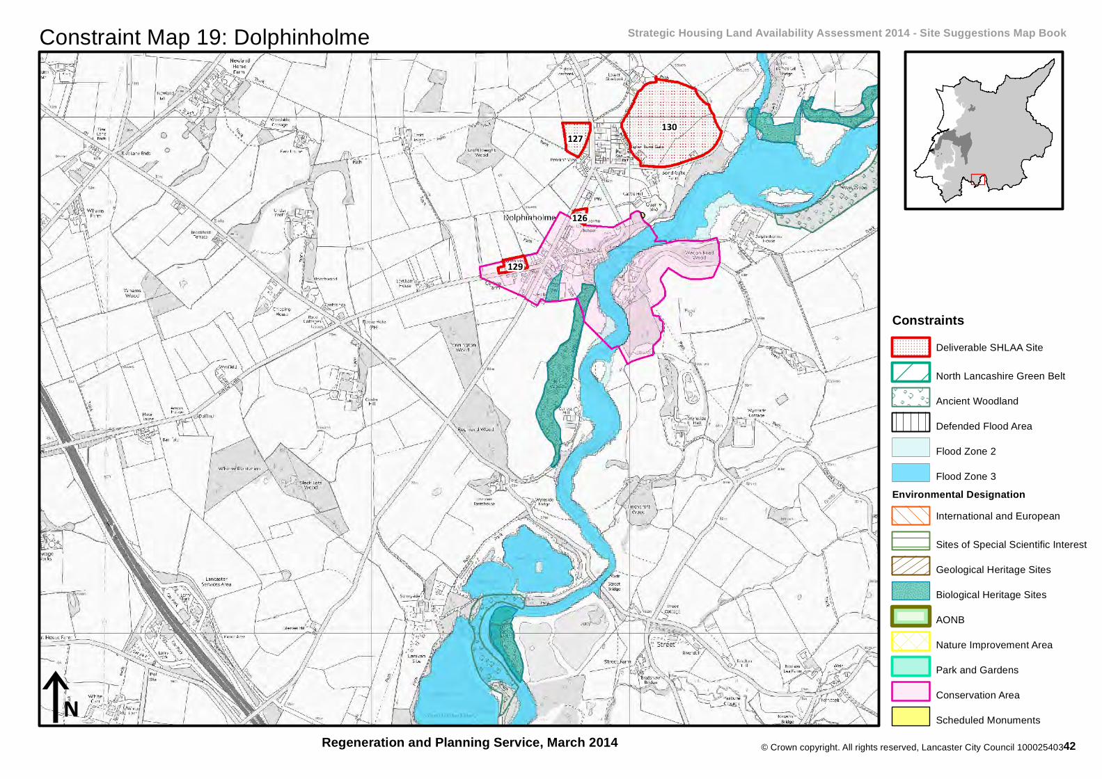
Constraint Map 19: Dolphinholme Strategic Housing Land Availability Assessment 2014 - Site Suggestions Map Book
Regeneration and Planning Service, March 2014
130127
129
126
iN
ConstraintsDeliverable SHLAA Site
North Lancashire Green Belt
Ancient Woodland
Defended Flood Area
Flood Zone 2
Flood Zone 3Environmental Designation
International and European
Sites of Special Scientific Interest
Geological Heritage Sites
Biological Heritage Sites
AONB
Nature Improvement Area
Park and Gardens
Conservation Area
Scheduled Monuments
42

142
149
144
151
148
150
141
136
147
14
146
131
140
135
© Crown copyright. All rights reserved, Lancaster City Council 100025403
iN
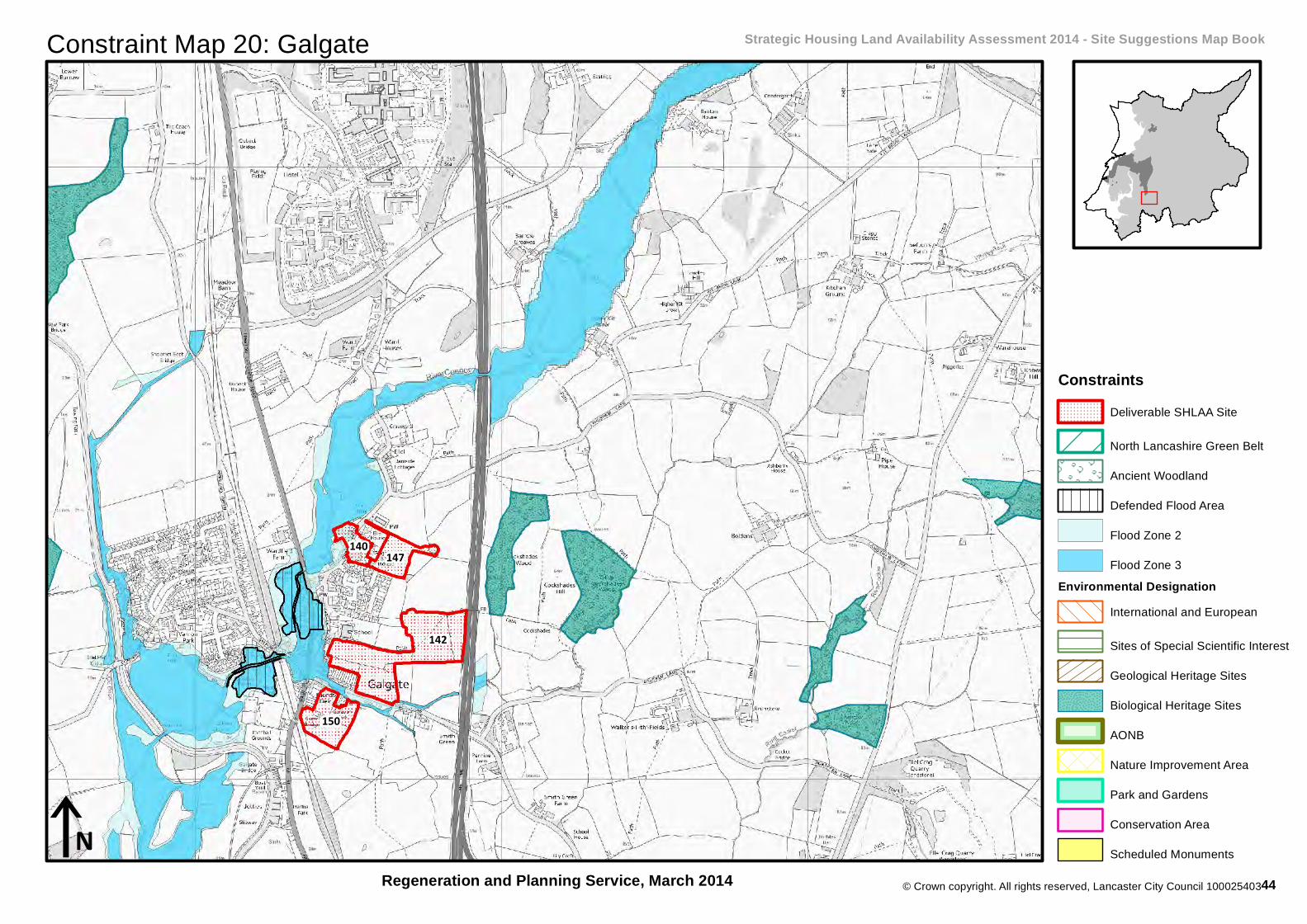
Map 20: Galgate Strategic Housing Land Availability Assessment 2014 - Site Assessment Map Book
This map book shows officers'assessment of sites published inthe Site Suggestions Map Book inNovember 2013. It accompaniesthe Strategic Housing LandAvailability Assessment (SHLAA)2014 Report and SHLAA 2014Sites Portfolio which can beviewed atwww.lancaster.gov.uk/shlaa.A list of frequently askedquestions can be found at the frontof this map book and an index ofsites can be found at the back.For further information contact thePlanning and Housing PolicyTeam on 01524 582388, or [email protected].
Regeneration and Planning Service, March 2014
Assessment of SitesNot Assessed
Undeliverable
Arnside & Silverdale AONB
Deliverable, 1-5 Year Phase
Deliverable, 6-10 Year Phase
Deliverable, 11-15 Year Phase
43
© Crown copyright. All rights reserved, Lancaster City Council 100025403
Constraint Map 20: Galgate Strategic Housing Land Availability Assessment 2014 - Site Suggestions Map Book
Regeneration and Planning Service, March 2014
142
150
147140
iN
ConstraintsDeliverable SHLAA Site
North Lancashire Green Belt
Ancient Woodland
Defended Flood Area
Flood Zone 2
Flood Zone 3Environmental Designation
International and European
Sites of Special Scientific Interest
Geological Heritage Sites
Biological Heritage Sites
AONB
Nature Improvement Area
Park and Gardens
Conservation Area
Scheduled Monuments
44
146
150
© Crown copyright. All rights reserved, Lancaster City Council 100025403
iN
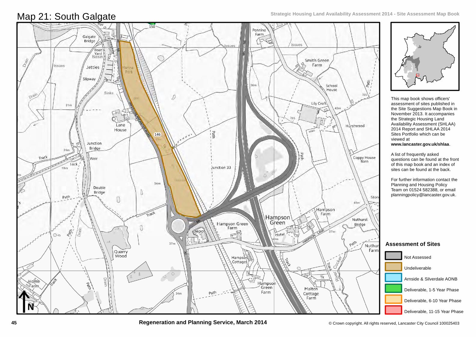
Map 21: South Galgate Strategic Housing Land Availability Assessment 2014 - Site Assessment Map Book
This map book shows officers'assessment of sites published inthe Site Suggestions Map Book inNovember 2013. It accompaniesthe Strategic Housing LandAvailability Assessment (SHLAA)2014 Report and SHLAA 2014Sites Portfolio which can beviewed atwww.lancaster.gov.uk/shlaa.A list of frequently askedquestions can be found at the frontof this map book and an index ofsites can be found at the back.For further information contact thePlanning and Housing PolicyTeam on 01524 582388, or [email protected].
Regeneration and Planning Service, March 2014
Assessment of SitesNot Assessed
Undeliverable
Arnside & Silverdale AONB
Deliverable, 1-5 Year Phase
Deliverable, 6-10 Year Phase
Deliverable, 11-15 Year Phase
45

© Crown copyright. All rights reserved, Lancaster City Council 100025403
Constraint Map 21: South Galgate Strategic Housing Land Availability Assessment 2014 - Site Suggestions Map Book
Regeneration and Planning Service, March 2014
150
iN
ConstraintsDeliverable SHLAA Site
North Lancashire Green Belt
Ancient Woodland
Defended Flood Area
Flood Zone 2
Flood Zone 3Environmental Designation
International and European
Sites of Special Scientific Interest
Geological Heritage Sites
Biological Heritage Sites
AONB
Nature Improvement Area
Park and Gardens
Conservation Area
Scheduled Monuments
46
167
282
162
163
160
© Crown copyright. All rights reserved, Lancaster City Council 100025403
iN
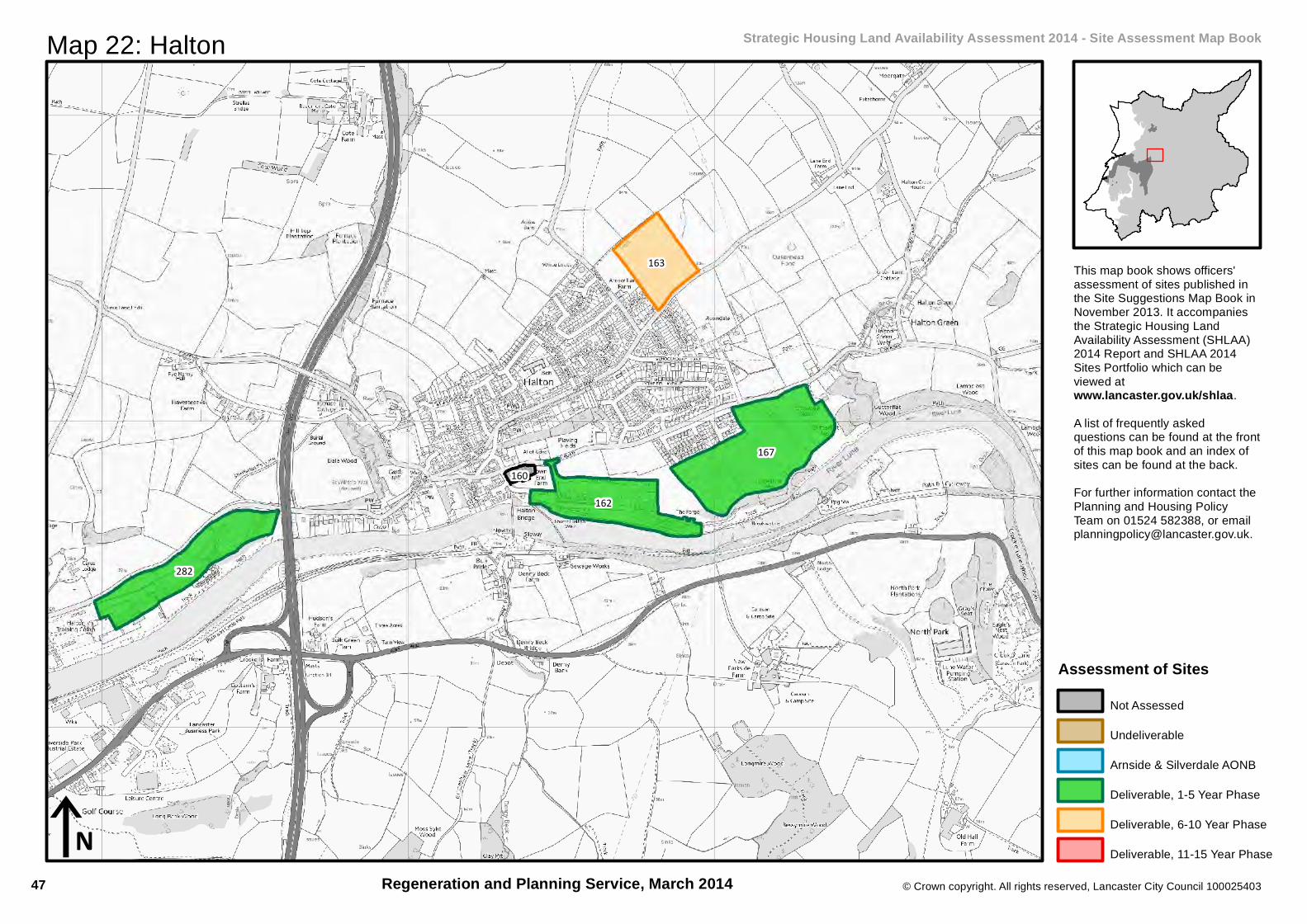
Map 22: Halton Strategic Housing Land Availability Assessment 2014 - Site Assessment Map Book
This map book shows officers'assessment of sites published inthe Site Suggestions Map Book inNovember 2013. It accompaniesthe Strategic Housing LandAvailability Assessment (SHLAA)2014 Report and SHLAA 2014Sites Portfolio which can beviewed atwww.lancaster.gov.uk/shlaa.A list of frequently askedquestions can be found at the frontof this map book and an index ofsites can be found at the back.For further information contact thePlanning and Housing PolicyTeam on 01524 582388, or [email protected].
Regeneration and Planning Service, March 2014
Assessment of SitesNot Assessed
Undeliverable
Arnside & Silverdale AONB
Deliverable, 1-5 Year Phase
Deliverable, 6-10 Year Phase
Deliverable, 11-15 Year Phase
47

© Crown copyright. All rights reserved, Lancaster City Council 100025403
Constraint Map 22: Halton Strategic Housing Land Availability Assessment 2014 - Site Suggestions Map Book
Regeneration and Planning Service, March 2014
167
282
162
163
iN
ConstraintsDeliverable SHLAA Site
North Lancashire Green Belt
Ancient Woodland
Defended Flood Area
Flood Zone 2
Flood Zone 3Environmental Designation
International and European
Sites of Special Scientific Interest
Geological Heritage Sites
Biological Heritage Sites
AONB
Nature Improvement Area
Park and Gardens
Conservation Area
Scheduled Monuments
48

603
171
169
604600
510 170
168
© Crown copyright. All rights reserved, Lancaster City Council 100025403
iN
Map 23: Hest Bank and Slyne Strategic Housing Land Availability Assessment 2014 - Site Assessment Map Book
This map book shows officers'assessment of sites published inthe Site Suggestions Map Book inNovember 2013. It accompaniesthe Strategic Housing LandAvailability Assessment (SHLAA)2014 Report and SHLAA 2014Sites Portfolio which can beviewed atwww.lancaster.gov.uk/shlaa.A list of frequently askedquestions can be found at the frontof this map book and an index ofsites can be found at the back.For further information contact thePlanning and Housing PolicyTeam on 01524 582388, or [email protected].
Regeneration and Planning Service, March 2014
Assessment of SitesNot Assessed
Undeliverable
Arnside & Silverdale AONB
Deliverable, 1-5 Year Phase
Deliverable, 6-10 Year Phase
Deliverable, 11-15 Year Phase
49

© Crown copyright. All rights reserved, Lancaster City Council 100025403
Constraint Map 23: Hest Bank and Slyne Strategic Housing Land Availability Assessment 2014 - Site Suggestions Map Book
Regeneration and Planning Service, March 2014
510
iN
ConstraintsDeliverable SHLAA Site
North Lancashire Green Belt
Ancient Woodland
Defended Flood Area
Flood Zone 2
Flood Zone 3Environmental Designation
International and European
Sites of Special Scientific Interest
Geological Heritage Sites
Biological Heritage Sites
AONB
Nature Improvement Area
Park and Gardens
Conservation Area
Scheduled Monuments
50
244
245
241
238
243
240
236
239
248
237
© Crown copyright. All rights reserved, Lancaster City Council 100025403
iN
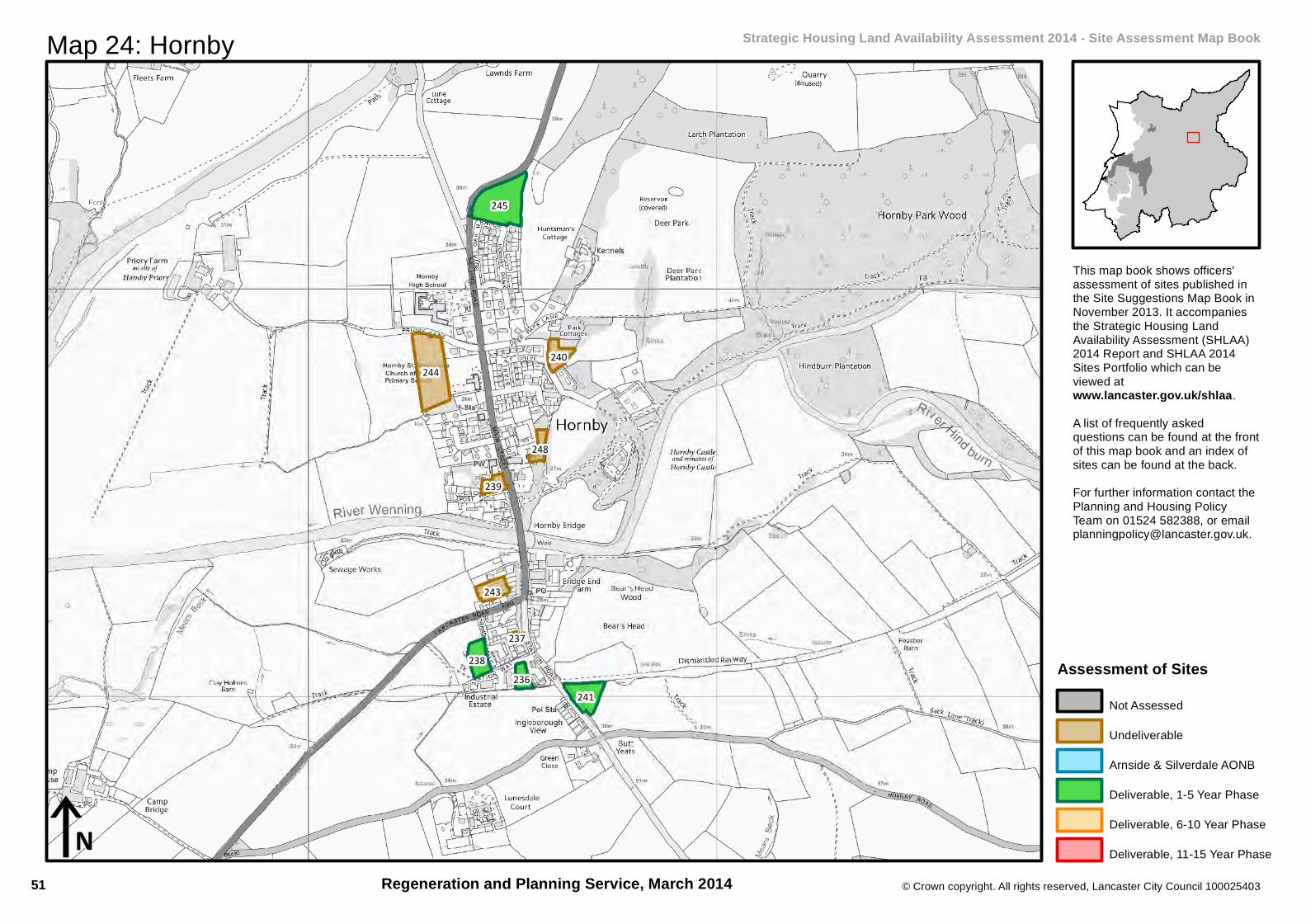
Map 24: Hornby Strategic Housing Land Availability Assessment 2014 - Site Assessment Map Book
This map book shows officers'assessment of sites published inthe Site Suggestions Map Book inNovember 2013. It accompaniesthe Strategic Housing LandAvailability Assessment (SHLAA)2014 Report and SHLAA 2014Sites Portfolio which can beviewed atwww.lancaster.gov.uk/shlaa.A list of frequently askedquestions can be found at the frontof this map book and an index ofsites can be found at the back.For further information contact thePlanning and Housing PolicyTeam on 01524 582388, or [email protected].
Regeneration and Planning Service, March 2014
Assessment of SitesNot Assessed
Undeliverable
Arnside & Silverdale AONB
Deliverable, 1-5 Year Phase
Deliverable, 6-10 Year Phase
Deliverable, 11-15 Year Phase
51

© Crown copyright. All rights reserved, Lancaster City Council 100025403
Constraint Map 24: Hornby Strategic Housing Land Availability Assessment 2014 - Site Suggestions Map Book
Regeneration and Planning Service, March 2014
245
241
238236
iN
ConstraintsDeliverable SHLAA Site
North Lancashire Green Belt
Ancient Woodland
Defended Flood Area
Flood Zone 2
Flood Zone 3Environmental Designation
International and European
Sites of Special Scientific Interest
Geological Heritage Sites
Biological Heritage Sites
AONB
Nature Improvement Area
Park and Gardens
Conservation Area
Scheduled Monuments
52
421
418
198
417
409
423
416
406
410
422
411
185
419
182
413
415
650
420203
200
179
414
407
408
233
© Crown copyright. All rights reserved, Lancaster City Council 100025403
iN
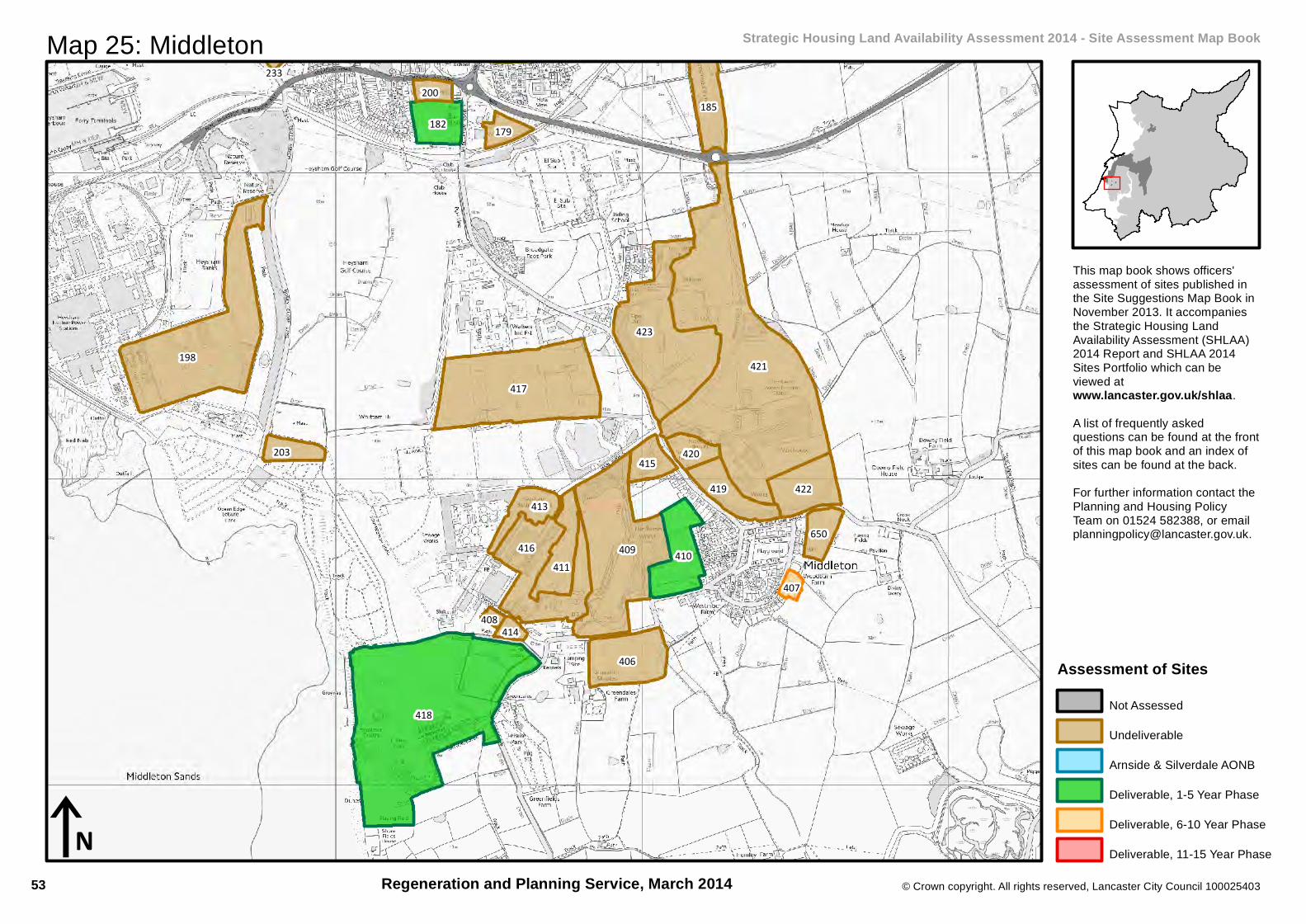
Map 25: Middleton Strategic Housing Land Availability Assessment 2014 - Site Assessment Map Book
This map book shows officers'assessment of sites published inthe Site Suggestions Map Book inNovember 2013. It accompaniesthe Strategic Housing LandAvailability Assessment (SHLAA)2014 Report and SHLAA 2014Sites Portfolio which can beviewed atwww.lancaster.gov.uk/shlaa.A list of frequently askedquestions can be found at the frontof this map book and an index ofsites can be found at the back.For further information contact thePlanning and Housing PolicyTeam on 01524 582388, or [email protected].
Regeneration and Planning Service, March 2014
Assessment of SitesNot Assessed
Undeliverable
Arnside & Silverdale AONB
Deliverable, 1-5 Year Phase
Deliverable, 6-10 Year Phase
Deliverable, 11-15 Year Phase
53

© Crown copyright. All rights reserved, Lancaster City Council 100025403
Constraint Map 25: Middleton Strategic Housing Land Availability Assessment 2014 - Site Suggestions Map Book
Regeneration and Planning Service, March 2014
418
410
182
407
iN
ConstraintsDeliverable SHLAA Site
North Lancashire Green Belt
Ancient Woodland
Defended Flood Area
Flood Zone 2
Flood Zone 3Environmental Designation
International and European
Sites of Special Scientific Interest
Geological Heritage Sites
Biological Heritage Sites
AONB
Nature Improvement Area
Park and Gardens
Conservation Area
Scheduled Monuments
54
556554
© Crown copyright. All rights reserved, Lancaster City Council 100025403
iN
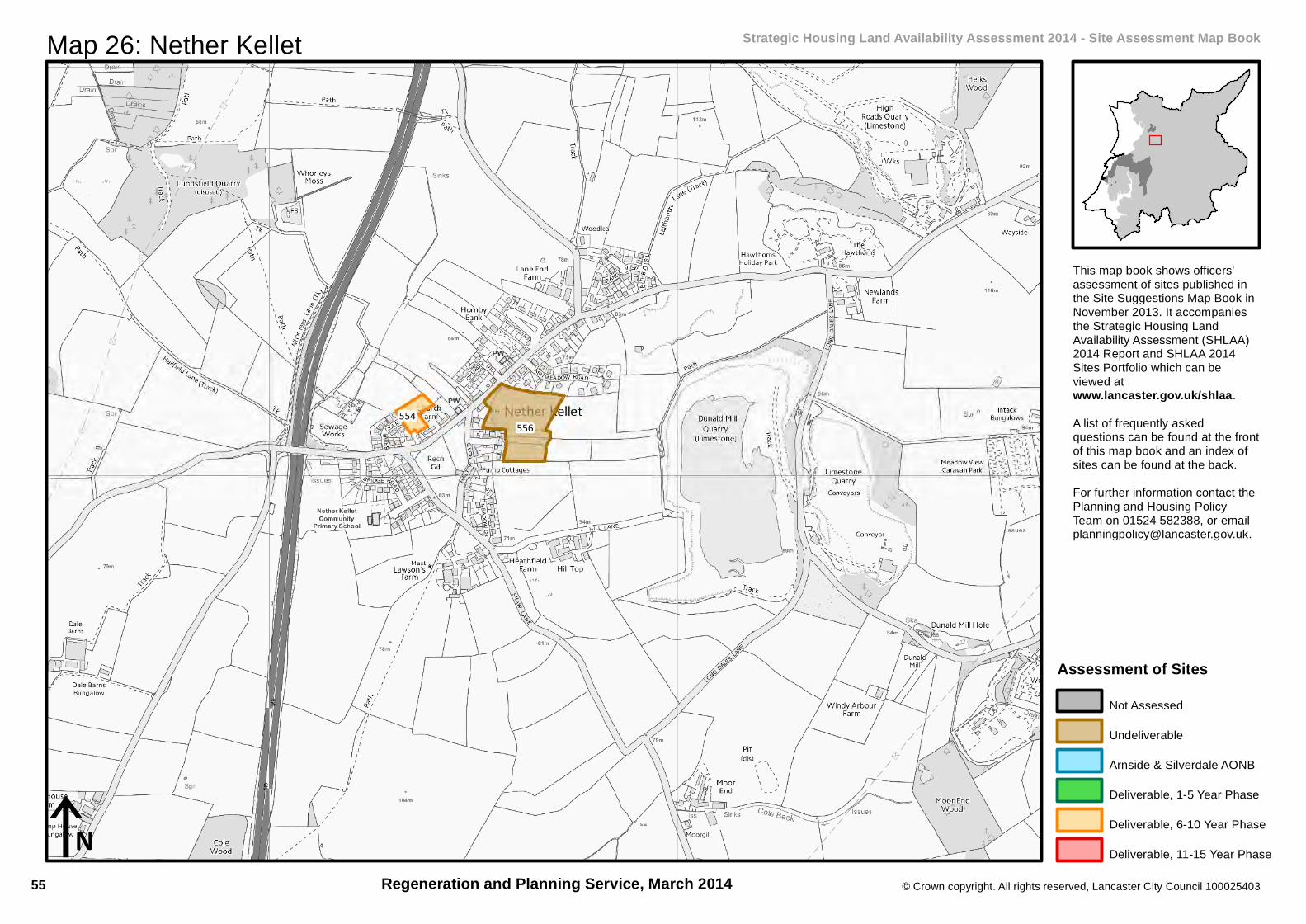
Map 26: Nether Kellet Strategic Housing Land Availability Assessment 2014 - Site Assessment Map Book
This map book shows officers'assessment of sites published inthe Site Suggestions Map Book inNovember 2013. It accompaniesthe Strategic Housing LandAvailability Assessment (SHLAA)2014 Report and SHLAA 2014Sites Portfolio which can beviewed atwww.lancaster.gov.uk/shlaa.A list of frequently askedquestions can be found at the frontof this map book and an index ofsites can be found at the back.For further information contact thePlanning and Housing PolicyTeam on 01524 582388, or [email protected].
Regeneration and Planning Service, March 2014
Assessment of SitesNot Assessed
Undeliverable
Arnside & Silverdale AONB
Deliverable, 1-5 Year Phase
Deliverable, 6-10 Year Phase
Deliverable, 11-15 Year Phase
55

© Crown copyright. All rights reserved, Lancaster City Council 100025403
Constraint Map 26: Nether Kellet Strategic Housing Land Availability Assessment 2014 - Site Suggestions Map Book
Regeneration and Planning Service, March 2014
554
iN
ConstraintsDeliverable SHLAA Site
North Lancashire Green Belt
Ancient Woodland
Defended Flood Area
Flood Zone 2
Flood Zone 3Environmental Designation
International and European
Sites of Special Scientific Interest
Geological Heritage Sites
Biological Heritage Sites
AONB
Nature Improvement Area
Park and Gardens
Conservation Area
Scheduled Monuments
56

560
562
561
559
© Crown copyright. All rights reserved, Lancaster City Council 100025403
iN
Map 27: Over Kellet Strategic Housing Land Availability Assessment 2014 - Site Assessment Map Book
This map book shows officers'assessment of sites published inthe Site Suggestions Map Book inNovember 2013. It accompaniesthe Strategic Housing LandAvailability Assessment (SHLAA)2014 Report and SHLAA 2014Sites Portfolio which can beviewed atwww.lancaster.gov.uk/shlaa.A list of frequently askedquestions can be found at the frontof this map book and an index ofsites can be found at the back.For further information contact thePlanning and Housing PolicyTeam on 01524 582388, or [email protected].
Regeneration and Planning Service, March 2014
Assessment of SitesNot Assessed
Undeliverable
Arnside & Silverdale AONB
Deliverable, 1-5 Year Phase
Deliverable, 6-10 Year Phase
Deliverable, 11-15 Year Phase
57

© Crown copyright. All rights reserved, Lancaster City Council 100025403
Constraint Map 27: Over Kellet Strategic Housing Land Availability Assessment 2014 - Site Suggestions Map Book
Regeneration and Planning Service, March 2014
560
559
iN
ConstraintsDeliverable SHLAA Site
North Lancashire Green Belt
Ancient Woodland
Defended Flood Area
Flood Zone 2
Flood Zone 3Environmental Designation
International and European
Sites of Special Scientific Interest
Geological Heritage Sites
Biological Heritage Sites
AONB
Nature Improvement Area
Park and Gardens
Conservation Area
Scheduled Monuments
58
569
568
564
© Crown copyright. All rights reserved, Lancaster City Council 100025403
iN
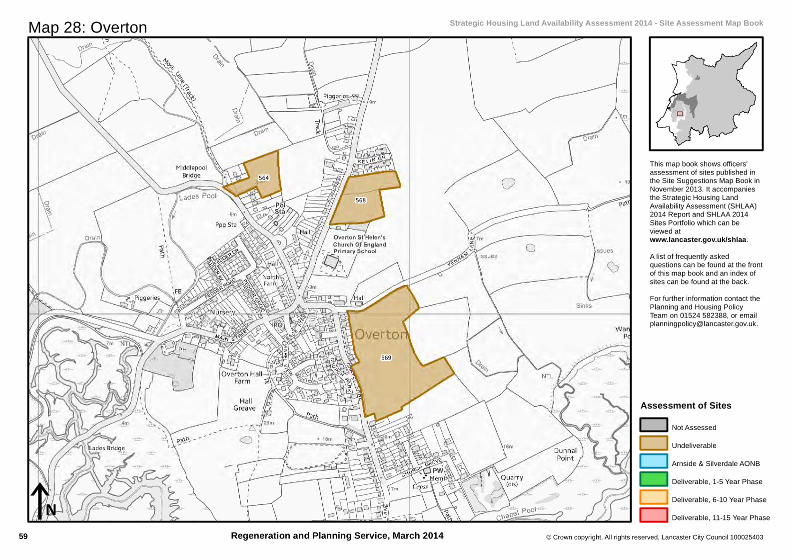
Map 28: Overton Strategic Housing Land Availability Assessment 2014 - Site Assessment Map Book
This map book shows officers'assessment of sites published inthe Site Suggestions Map Book inNovember 2013. It accompaniesthe Strategic Housing LandAvailability Assessment (SHLAA)2014 Report and SHLAA 2014Sites Portfolio which can beviewed atwww.lancaster.gov.uk/shlaa.A list of frequently askedquestions can be found at the frontof this map book and an index ofsites can be found at the back.For further information contact thePlanning and Housing PolicyTeam on 01524 582388, or [email protected].
Regeneration and Planning Service, March 2014
Assessment of SitesNot Assessed
Undeliverable
Arnside & Silverdale AONB
Deliverable, 1-5 Year Phase
Deliverable, 6-10 Year Phase
Deliverable, 11-15 Year Phase
59

© Crown copyright. All rights reserved, Lancaster City Council 100025403
Constraint Map 28: Overton Strategic Housing Land Availability Assessment 2014 - Site Suggestions Map Book
Regeneration and Planning Service, March 2014iN
ConstraintsDeliverable SHLAA Site
North Lancashire Green Belt
Ancient Woodland
Defended Flood Area
Flood Zone 2
Flood Zone 3Environmental Designation
International and European
Sites of Special Scientific Interest
Geological Heritage Sites
Biological Heritage Sites
AONB
Nature Improvement Area
Park and Gardens
Conservation Area
Scheduled Monuments
60

592
597
589
591
588
582
587
598
577
583
581
594
593
595
© Crown copyright. All rights reserved, Lancaster City Council 100025403
iN
Map 29: Silverdale Strategic Housing Land Availability Assessment 2014 - Site Assessment Map Book
This map book shows officers'assessment of sites published inthe Site Suggestions Map Book inNovember 2013. It accompaniesthe Strategic Housing LandAvailability Assessment (SHLAA)2014 Report and SHLAA 2014Sites Portfolio which can beviewed atwww.lancaster.gov.uk/shlaa.A list of frequently askedquestions can be found at the frontof this map book and an index ofsites can be found at the back.For further information contact thePlanning and Housing PolicyTeam on 01524 582388, or [email protected].
Regeneration and Planning Service, March 2014
Assessment of SitesNot Assessed
Undeliverable
Arnside & Silverdale AONB
Deliverable, 1-5 Year Phase
Deliverable, 6-10 Year Phase
Deliverable, 11-15 Year Phase
61

© Crown copyright. All rights reserved, Lancaster City Council 100025403
Constraint Map 29: Silverdale Strategic Housing Land Availability Assessment 2014 - Site Suggestions Map Book
Regeneration and Planning Service, March 2014iN
ConstraintsDeliverable SHLAA Site
North Lancashire Green Belt
Ancient Woodland
Defended Flood Area
Flood Zone 2
Flood Zone 3Environmental Designation
International and European
Sites of Special Scientific Interest
Geological Heritage Sites
Biological Heritage Sites
AONB
Nature Improvement Area
Park and Gardens
Conservation Area
Scheduled Monuments
62

81
80
614
618
622
72
626
425
77
620
625
627
623
628
615612
© Crown copyright. All rights reserved, Lancaster City Council 100025403
iN
Map 30: Warton Strategic Housing Land Availability Assessment 2014 - Site Assessment Map Book
This map book shows officers'assessment of sites published inthe Site Suggestions Map Book inNovember 2013. It accompaniesthe Strategic Housing LandAvailability Assessment (SHLAA)2014 Report and SHLAA 2014Sites Portfolio which can beviewed atwww.lancaster.gov.uk/shlaa.A list of frequently askedquestions can be found at the frontof this map book and an index ofsites can be found at the back.For further information contact thePlanning and Housing PolicyTeam on 01524 582388, or [email protected].
Regeneration and Planning Service, March 2014
Assessment of SitesNot Assessed
Undeliverable
Arnside & Silverdale AONB
Deliverable, 1-5 Year Phase
Deliverable, 6-10 Year Phase
Deliverable, 11-15 Year Phase
63

© Crown copyright. All rights reserved, Lancaster City Council 100025403
Constraint Map 30: Warton Strategic Housing Land Availability Assessment 2014 - Site Suggestions Map Book
Regeneration and Planning Service, March 2014iN
ConstraintsDeliverable SHLAA Site
North Lancashire Green Belt
Ancient Woodland
Defended Flood Area
Flood Zone 2
Flood Zone 3Environmental Designation
International and European
Sites of Special Scientific Interest
Geological Heritage Sites
Biological Heritage Sites
AONB
Nature Improvement Area
Park and Gardens
Conservation Area
Scheduled Monuments
64

643
637
642
638
639
© Crown copyright. All rights reserved, Lancaster City Council 100025403
iN
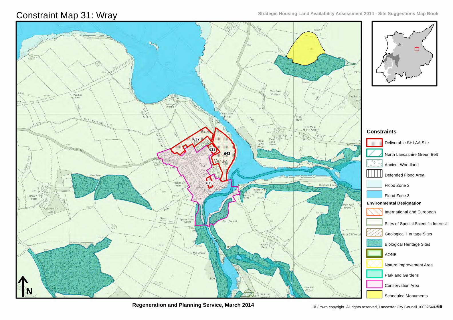
Map 31: Wray Strategic Housing Land Availability Assessment 2014 - Site Assessment Map Book
This map book shows officers'assessment of sites published inthe Site Suggestions Map Book inNovember 2013. It accompaniesthe Strategic Housing LandAvailability Assessment (SHLAA)2014 Report and SHLAA 2014Sites Portfolio which can beviewed atwww.lancaster.gov.uk/shlaa.A list of frequently askedquestions can be found at the frontof this map book and an index ofsites can be found at the back.For further information contact thePlanning and Housing PolicyTeam on 01524 582388, or [email protected].
Regeneration and Planning Service, March 2014
Assessment of SitesNot Assessed
Undeliverable
Arnside & Silverdale AONB
Deliverable, 1-5 Year Phase
Deliverable, 6-10 Year Phase
Deliverable, 11-15 Year Phase
65
© Crown copyright. All rights reserved, Lancaster City Council 100025403
Constraint Map 31: Wray Strategic Housing Land Availability Assessment 2014 - Site Suggestions Map Book
Regeneration and Planning Service, March 2014
643
637638
639
iN
ConstraintsDeliverable SHLAA Site
North Lancashire Green Belt
Ancient Woodland
Defended Flood Area
Flood Zone 2
Flood Zone 3Environmental Designation
International and European
Sites of Special Scientific Interest
Geological Heritage Sites
Biological Heritage Sites
AONB
Nature Improvement Area
Park and Gardens
Conservation Area
Scheduled Monuments
66

64
41
© Crown copyright. All rights reserved, Lancaster City Council 100025403
iN
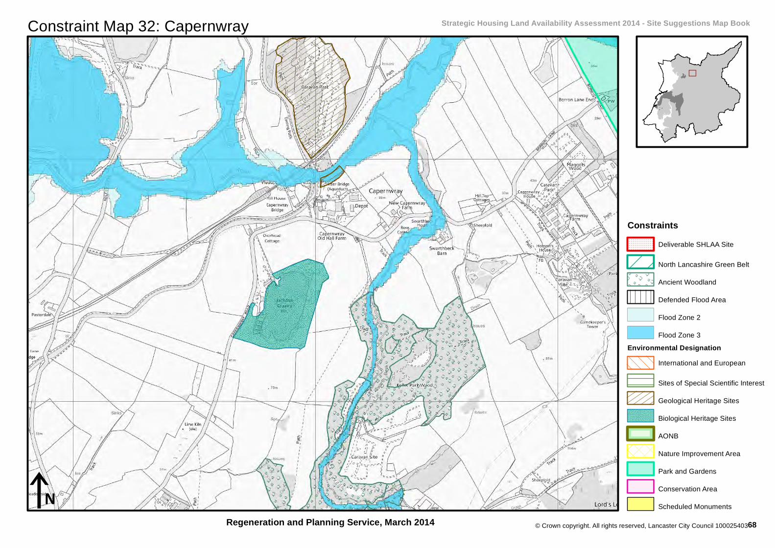
Map 32: Capernwray Strategic Housing Land Availability Assessment 2014 - Site Assessment Map Book
This map book shows officers'assessment of sites published inthe Site Suggestions Map Book inNovember 2013. It accompaniesthe Strategic Housing LandAvailability Assessment (SHLAA)2014 Report and SHLAA 2014Sites Portfolio which can beviewed atwww.lancaster.gov.uk/shlaa.A list of frequently askedquestions can be found at the frontof this map book and an index ofsites can be found at the back.For further information contact thePlanning and Housing PolicyTeam on 01524 582388, or [email protected].
Regeneration and Planning Service, March 2014
Assessment of SitesNot Assessed
Undeliverable
Arnside & Silverdale AONB
Deliverable, 1-5 Year Phase
Deliverable, 6-10 Year Phase
Deliverable, 11-15 Year Phase
67
© Crown copyright. All rights reserved, Lancaster City Council 100025403
Constraint Map 32: Capernwray Strategic Housing Land Availability Assessment 2014 - Site Suggestions Map Book
Regeneration and Planning Service, March 2014iN
ConstraintsDeliverable SHLAA Site
North Lancashire Green Belt
Ancient Woodland
Defended Flood Area
Flood Zone 2
Flood Zone 3Environmental Designation
International and European
Sites of Special Scientific Interest
Geological Heritage Sites
Biological Heritage Sites
AONB
Nature Improvement Area
Park and Gardens
Conservation Area
Scheduled Monuments
68
92
246
104
103
12
© Crown copyright. All rights reserved, Lancaster City Council 100025403
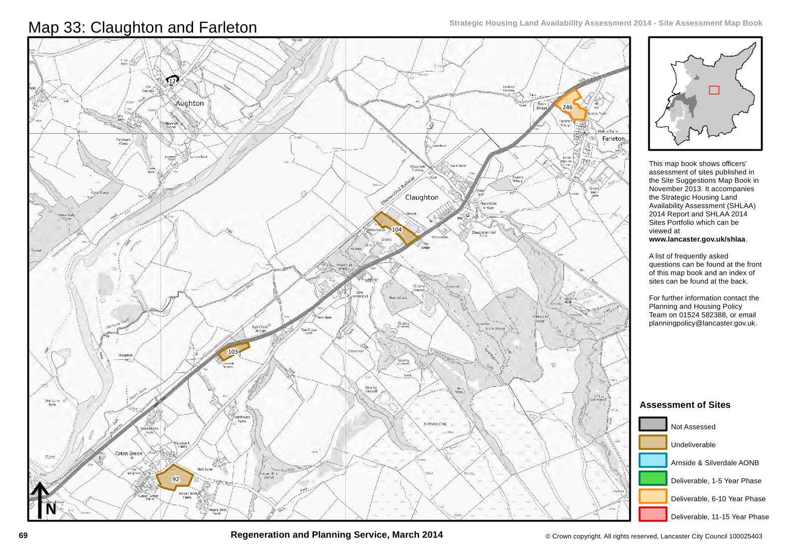
iN
Map 33: Claughton and Farleton Strategic Housing Land Availability Assessment 2014 - Site Assessment Map Book
This map book shows officers'assessment of sites published inthe Site Suggestions Map Book inNovember 2013. It accompaniesthe Strategic Housing LandAvailability Assessment (SHLAA)2014 Report and SHLAA 2014Sites Portfolio which can beviewed atwww.lancaster.gov.uk/shlaa.A list of frequently askedquestions can be found at the frontof this map book and an index ofsites can be found at the back.For further information contact thePlanning and Housing PolicyTeam on 01524 582388, or [email protected].
Regeneration and Planning Service, March 2014
Assessment of SitesNot Assessed
Undeliverable
Arnside & Silverdale AONB
Deliverable, 1-5 Year Phase
Deliverable, 6-10 Year Phase
Deliverable, 11-15 Year Phase
69

© Crown copyright. All rights reserved, Lancaster City Council 100025403
Constraint Map 33: Claughton and Farleton Strategic Housing Land Availability Assessment 2014 - Site Suggestions Map Book
Regeneration and Planning Service, March 2014
246
iN
ConstraintsDeliverable SHLAA Site
North Lancashire Green Belt
Ancient Woodland
Defended Flood Area
Flood Zone 2
Flood Zone 3Environmental Designation
International and European
Sites of Special Scientific Interest
Geological Heritage Sites
Biological Heritage Sites
AONB
Nature Improvement Area
Park and Gardens
Conservation Area
Scheduled Monuments
70

119
118
121122
120
123117
© Crown copyright. All rights reserved, Lancaster City Council 100025403
iN
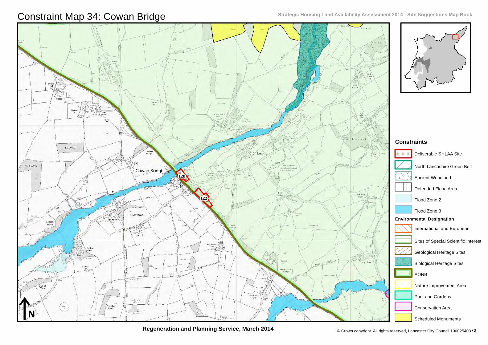
Map 34: Cowan Bridge Strategic Housing Land Availability Assessment 2014 - Site Assessment Map Book
This map book shows officers'assessment of sites published inthe Site Suggestions Map Book inNovember 2013. It accompaniesthe Strategic Housing LandAvailability Assessment (SHLAA)2014 Report and SHLAA 2014Sites Portfolio which can beviewed atwww.lancaster.gov.uk/shlaa.A list of frequently askedquestions can be found at the frontof this map book and an index ofsites can be found at the back.For further information contact thePlanning and Housing PolicyTeam on 01524 582388, or [email protected].
Regeneration and Planning Service, March 2014
Assessment of SitesNot Assessed
Undeliverable
Arnside & Silverdale AONB
Deliverable, 1-5 Year Phase
Deliverable, 6-10 Year Phase
Deliverable, 11-15 Year Phase
71
© Crown copyright. All rights reserved, Lancaster City Council 100025403
Constraint Map 34: Cowan Bridge Strategic Housing Land Availability Assessment 2014 - Site Suggestions Map Book
Regeneration and Planning Service, March 2014
122
120
iN
ConstraintsDeliverable SHLAA Site
North Lancashire Green Belt
Ancient Woodland
Defended Flood Area
Flood Zone 2
Flood Zone 3Environmental Designation
International and European
Sites of Special Scientific Interest
Geological Heritage Sites
Biological Heritage Sites
AONB
Nature Improvement Area
Park and Gardens
Conservation Area
Scheduled Monuments
72
157
152
153
154
156
© Crown copyright. All rights reserved, Lancaster City Council 100025403
iN
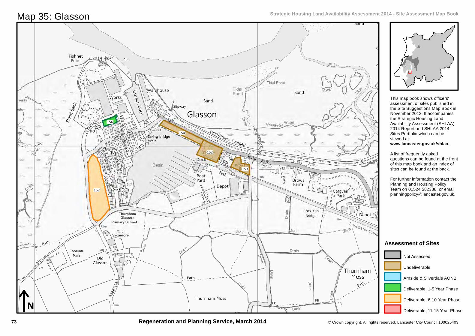
Map 35: Glasson Strategic Housing Land Availability Assessment 2014 - Site Assessment Map Book
This map book shows officers'assessment of sites published inthe Site Suggestions Map Book inNovember 2013. It accompaniesthe Strategic Housing LandAvailability Assessment (SHLAA)2014 Report and SHLAA 2014Sites Portfolio which can beviewed atwww.lancaster.gov.uk/shlaa.A list of frequently askedquestions can be found at the frontof this map book and an index ofsites can be found at the back.For further information contact thePlanning and Housing PolicyTeam on 01524 582388, or [email protected].
Regeneration and Planning Service, March 2014
Assessment of SitesNot Assessed
Undeliverable
Arnside & Silverdale AONB
Deliverable, 1-5 Year Phase
Deliverable, 6-10 Year Phase
Deliverable, 11-15 Year Phase
73

© Crown copyright. All rights reserved, Lancaster City Council 100025403
Constraint Map 35: Glasson Strategic Housing Land Availability Assessment 2014 - Site Suggestions Map Book
Regeneration and Planning Service, March 2014
157
156
iN
ConstraintsDeliverable SHLAA Site
North Lancashire Green Belt
Ancient Woodland
Defended Flood Area
Flood Zone 2
Flood Zone 3Environmental Designation
International and European
Sites of Special Scientific Interest
Geological Heritage Sites
Biological Heritage Sites
AONB
Nature Improvement Area
Park and Gardens
Conservation Area
Scheduled Monuments
74
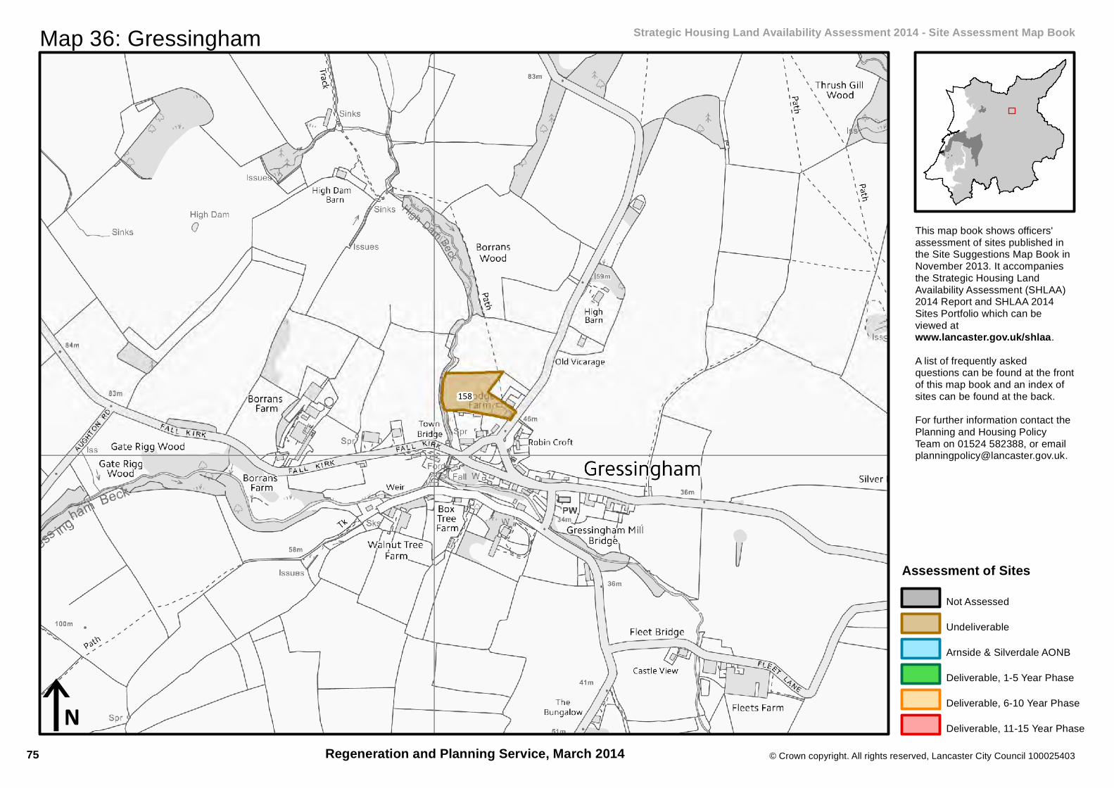
158
© Crown copyright. All rights reserved, Lancaster City Council 100025403
iN
Map 36: Gressingham Strategic Housing Land Availability Assessment 2014 - Site Assessment Map Book
This map book shows officers'assessment of sites published inthe Site Suggestions Map Book inNovember 2013. It accompaniesthe Strategic Housing LandAvailability Assessment (SHLAA)2014 Report and SHLAA 2014Sites Portfolio which can beviewed atwww.lancaster.gov.uk/shlaa.A list of frequently askedquestions can be found at the frontof this map book and an index ofsites can be found at the back.For further information contact thePlanning and Housing PolicyTeam on 01524 582388, or [email protected].
Regeneration and Planning Service, March 2014
Assessment of SitesNot Assessed
Undeliverable
Arnside & Silverdale AONB
Deliverable, 1-5 Year Phase
Deliverable, 6-10 Year Phase
Deliverable, 11-15 Year Phase
75
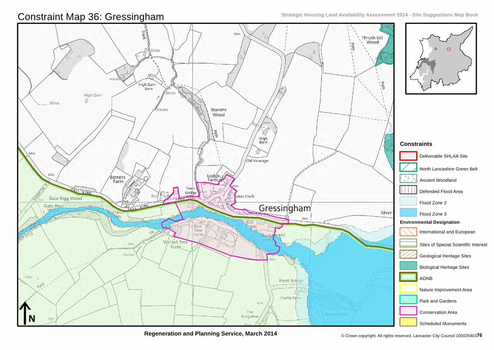
© Crown copyright. All rights reserved, Lancaster City Council 100025403
Constraint Map 36: Gressingham Strategic Housing Land Availability Assessment 2014 - Site Suggestions Map Book
Regeneration and Planning Service, March 2014iN
ConstraintsDeliverable SHLAA Site
North Lancashire Green Belt
Ancient Woodland
Defended Flood Area
Flood Zone 2
Flood Zone 3Environmental Designation
International and European
Sites of Special Scientific Interest
Geological Heritage Sites
Biological Heritage Sites
AONB
Nature Improvement Area
Park and Gardens
Conservation Area
Scheduled Monuments
76
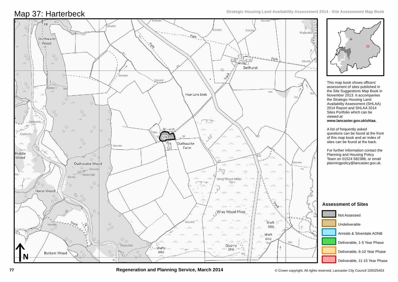
576
© Crown copyright. All rights reserved, Lancaster City Council 100025403
iN
Map 37: Harterbeck Strategic Housing Land Availability Assessment 2014 - Site Assessment Map Book
This map book shows officers'assessment of sites published inthe Site Suggestions Map Book inNovember 2013. It accompaniesthe Strategic Housing LandAvailability Assessment (SHLAA)2014 Report and SHLAA 2014Sites Portfolio which can beviewed atwww.lancaster.gov.uk/shlaa.A list of frequently askedquestions can be found at the frontof this map book and an index ofsites can be found at the back.For further information contact thePlanning and Housing PolicyTeam on 01524 582388, or [email protected].
Regeneration and Planning Service, March 2014
Assessment of SitesNot Assessed
Undeliverable
Arnside & Silverdale AONB
Deliverable, 1-5 Year Phase
Deliverable, 6-10 Year Phase
Deliverable, 11-15 Year Phase
77
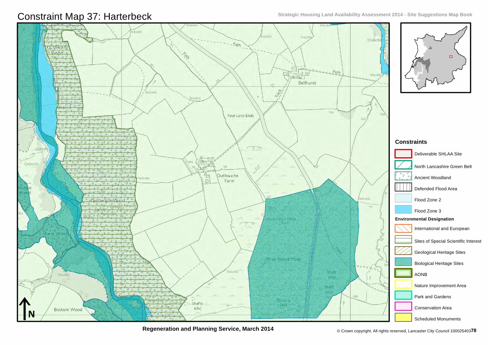
© Crown copyright. All rights reserved, Lancaster City Council 100025403
Constraint Map 37: Harterbeck Strategic Housing Land Availability Assessment 2014 - Site Suggestions Map Book
Regeneration and Planning Service, March 2014iN
ConstraintsDeliverable SHLAA Site
North Lancashire Green Belt
Ancient Woodland
Defended Flood Area
Flood Zone 2
Flood Zone 3Environmental Designation
International and European
Sites of Special Scientific Interest
Geological Heritage Sites
Biological Heritage Sites
AONB
Nature Improvement Area
Park and Gardens
Conservation Area
Scheduled Monuments
78

97
© Crown copyright. All rights reserved, Lancaster City Council 100025403
iN
Map 38: Littledale Strategic Housing Land Availability Assessment 2014 - Site Assessment Map Book
This map book shows officers'assessment of sites published inthe Site Suggestions Map Book inNovember 2013. It accompaniesthe Strategic Housing LandAvailability Assessment (SHLAA)2014 Report and SHLAA 2014Sites Portfolio which can beviewed atwww.lancaster.gov.uk/shlaa.A list of frequently askedquestions can be found at the frontof this map book and an index ofsites can be found at the back.For further information contact thePlanning and Housing PolicyTeam on 01524 582388, or [email protected].
Regeneration and Planning Service, March 2014
Assessment of SitesNot Assessed
Undeliverable
Arnside & Silverdale AONB
Deliverable, 1-5 Year Phase
Deliverable, 6-10 Year Phase
Deliverable, 11-15 Year Phase
79
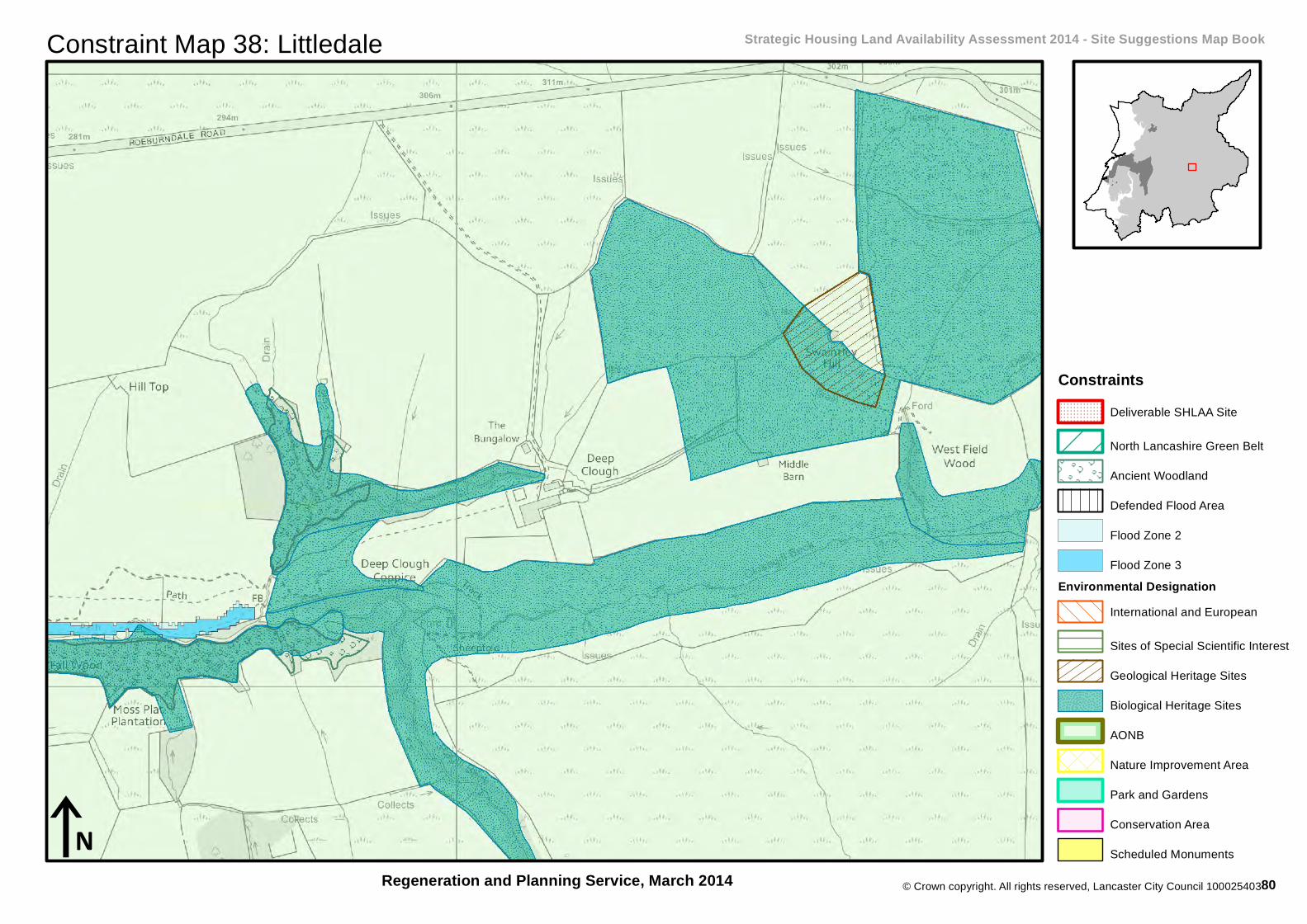
© Crown copyright. All rights reserved, Lancaster City Council 100025403
Constraint Map 38: Littledale Strategic Housing Land Availability Assessment 2014 - Site Suggestions Map Book
Regeneration and Planning Service, March 2014iN
ConstraintsDeliverable SHLAA Site
North Lancashire Green Belt
Ancient Woodland
Defended Flood Area
Flood Zone 2
Flood Zone 3Environmental Designation
International and European
Sites of Special Scientific Interest
Geological Heritage Sites
Biological Heritage Sites
AONB
Nature Improvement Area
Park and Gardens
Conservation Area
Scheduled Monuments
80

605
561
165
© Crown copyright. All rights reserved, Lancaster City Council 100025403
iN
Map 39: Swarthdale Strategic Housing Land Availability Assessment 2014 - Site Assessment Map Book
This map book shows officers'assessment of sites published inthe Site Suggestions Map Book inNovember 2013. It accompaniesthe Strategic Housing LandAvailability Assessment (SHLAA)2014 Report and SHLAA 2014Sites Portfolio which can beviewed atwww.lancaster.gov.uk/shlaa.A list of frequently askedquestions can be found at the frontof this map book and an index ofsites can be found at the back.For further information contact thePlanning and Housing PolicyTeam on 01524 582388, or [email protected].
Regeneration and Planning Service, March 2014
Assessment of SitesNot Assessed
Undeliverable
Arnside & Silverdale AONB
Deliverable, 1-5 Year Phase
Deliverable, 6-10 Year Phase
Deliverable, 11-15 Year Phase
81

© Crown copyright. All rights reserved, Lancaster City Council 100025403
Constraint Map 39: Swarthdale Strategic Housing Land Availability Assessment 2014 - Site Suggestions Map Book
Regeneration and Planning Service, March 2014iN
ConstraintsDeliverable SHLAA Site
North Lancashire Green Belt
Ancient Woodland
Defended Flood Area
Flood Zone 2
Flood Zone 3Environmental Designation
International and European
Sites of Special Scientific Interest
Geological Heritage Sites
Biological Heritage Sites
AONB
Nature Improvement Area
Park and Gardens
Conservation Area
Scheduled Monuments
82

631
631
© Crown copyright. All rights reserved, Lancaster City Council 100025403
iN
Map 40: Wennington Strategic Housing Land Availability Assessment 2014 - Site Assessment Map Book
This map book shows officers'assessment of sites published inthe Site Suggestions Map Book inNovember 2013. It accompaniesthe Strategic Housing LandAvailability Assessment (SHLAA)2014 Report and SHLAA 2014Sites Portfolio which can beviewed atwww.lancaster.gov.uk/shlaa.A list of frequently askedquestions can be found at the frontof this map book and an index ofsites can be found at the back.For further information contact thePlanning and Housing PolicyTeam on 01524 582388, or [email protected].
Regeneration and Planning Service, March 2014
Assessment of SitesNot Assessed
Undeliverable
Arnside & Silverdale AONB
Deliverable, 1-5 Year Phase
Deliverable, 6-10 Year Phase
Deliverable, 11-15 Year Phase
83

© Crown copyright. All rights reserved, Lancaster City Council 100025403
Constraint Map 40: Wennington Strategic Housing Land Availability Assessment 2014 - Site Suggestions Map Book
Regeneration and Planning Service, March 2014iN
ConstraintsDeliverable SHLAA Site
North Lancashire Green Belt
Ancient Woodland
Defended Flood Area
Flood Zone 2
Flood Zone 3Environmental Designation
International and European
Sites of Special Scientific Interest
Geological Heritage Sites
Biological Heritage Sites
AONB
Nature Improvement Area
Park and Gardens
Conservation Area
Scheduled Monuments
84

636
© Crown copyright. All rights reserved, Lancaster City Council 100025403
iN
Map 41: Whittinghton Strategic Housing Land Availability Assessment 2014 - Site Assessment Map Book
This map book shows officers'assessment of sites published inthe Site Suggestions Map Book inNovember 2013. It accompaniesthe Strategic Housing LandAvailability Assessment (SHLAA)2014 Report and SHLAA 2014Sites Portfolio which can beviewed atwww.lancaster.gov.uk/shlaa.A list of frequently askedquestions can be found at the frontof this map book and an index ofsites can be found at the back.For further information contact thePlanning and Housing PolicyTeam on 01524 582388, or [email protected].
Regeneration and Planning Service, March 2014
Assessment of SitesNot Assessed
Undeliverable
Arnside & Silverdale AONB
Deliverable, 1-5 Year Phase
Deliverable, 6-10 Year Phase
Deliverable, 11-15 Year Phase
85

© Crown copyright. All rights reserved, Lancaster City Council 100025403
Constraint Map 41: Whittinghton Strategic Housing Land Availability Assessment 2014 - Site Suggestions Map Book
Regeneration and Planning Service, March 2014
636
iN
ConstraintsDeliverable SHLAA Site
North Lancashire Green Belt
Ancient Woodland
Defended Flood Area
Flood Zone 2
Flood Zone 3Environmental Designation
International and European
Sites of Special Scientific Interest
Geological Heritage Sites
Biological Heritage Sites
AONB
Nature Improvement Area
Park and Gardens
Conservation Area
Scheduled Monuments
86
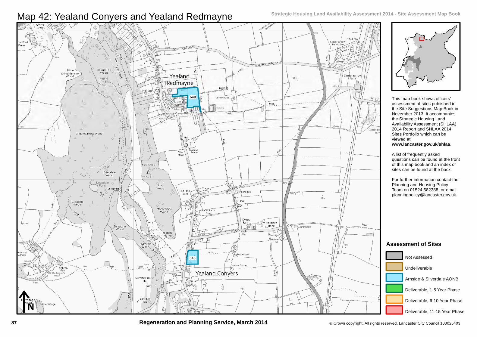
648
645
© Crown copyright. All rights reserved, Lancaster City Council 100025403
iN
Map 42: Yealand Conyers and Yealand Redmayne Strategic Housing Land Availability Assessment 2014 - Site Assessment Map Book
This map book shows officers'assessment of sites published inthe Site Suggestions Map Book inNovember 2013. It accompaniesthe Strategic Housing LandAvailability Assessment (SHLAA)2014 Report and SHLAA 2014Sites Portfolio which can beviewed atwww.lancaster.gov.uk/shlaa.A list of frequently askedquestions can be found at the frontof this map book and an index ofsites can be found at the back.For further information contact thePlanning and Housing PolicyTeam on 01524 582388, or [email protected].
Regeneration and Planning Service, March 2014
Assessment of SitesNot Assessed
Undeliverable
Arnside & Silverdale AONB
Deliverable, 1-5 Year Phase
Deliverable, 6-10 Year Phase
Deliverable, 11-15 Year Phase
87

© Crown copyright. All rights reserved, Lancaster City Council 100025403
Constraint Map 42: Yealand Conyers and Yealand Redmayne Strategic Housing Land Availability Assessment 2014 - Site Suggestions Map Book
Regeneration and Planning Service, March 2014iN
ConstraintsDeliverable SHLAA Site
North Lancashire Green Belt
Ancient Woodland
Defended Flood Area
Flood Zone 2
Flood Zone 3Environmental Designation
International and European
Sites of Special Scientific Interest
Geological Heritage Sites
Biological Heritage Sites
AONB
Nature Improvement Area
Park and Gardens
Conservation Area
Scheduled Monuments
88
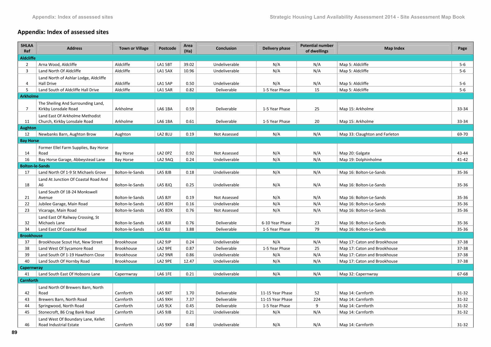
Appendix: Index of assessed sites Strategic Housing Land Availability Assessment 2014 - Site Assessment Map Book
Appendix: Index of assessed sites
SHLAARef Address Town or Village Postcode Area
(Ha) Conclusion Delivery phase Potential numberof dwellings Map Index Page
Aldcliffe2 Arna Wood, Aldcliffe Aldcliffe LA1 5BT 39.02 Undeliverable N/A N/A Map 5: Aldcliffe 5-63 Land North Of Aldcliffe Aldcliffe LA1 5AX 10.96 Undeliverable N/A N/A Map 5: Aldcliffe 5-6
4Land North of Ashlar Lodge, AldcliffeHall Drive Aldcliffe LA1 5AP 0.50 Undeliverable N/A N/A Map 5: Aldcliffe 5-6
5 Land South of Aldcliffe Hall Drive Aldcliffe LA1 5AR 0.82 Deliverable 1-5 Year Phase 15 Map 5: Aldcliffe 5-6Arkholme
7The Sheiling And Surrounding Land,Kirkby Lonsdale Road Arkholme LA6 1BA 0.59 Deliverable 1-5 Year Phase 25 Map 15: Arkholme 33-34
11Land East Of Arkholme MethodistChurch, Kirkby Lonsdale Road Arkholme LA6 1BA 0.61 Deliverable 1-5 Year Phase 20 Map 15: Arkholme 33-34
Aughton12 Newbanks Barn, Aughton Brow Aughton LA2 8LU 0.19 Not Assessed N/A N/A Map 33: Claughton and Farleton 69-70
Bay Horse
14Former Ellel Farm Supplies, Bay HorseRoad Bay Horse LA2 0PZ 0.92 Not Assessed N/A N/A Map 20: Galgate 43-44
16 Bay Horse Garage, Abbeystead Lane Bay Horse LA2 9AQ 0.24 Undeliverable N/A N/A Map 19: Dolphinholme 41-42Bolton-le-Sands
17 Land North Of 1-9 St Michaels Grove Bolton-le-Sands LA5 8JB 0.18 Undeliverable N/A N/A Map 16: Bolton-Le-Sands 35-36
18Land At Junction Of Coastal Road AndA6 Bolton-le-Sands LA5 8JQ 0.25 Undeliverable N/A N/A Map 16: Bolton-Le-Sands 35-36
21Land South Of 18-24 MonkswellAvenue Bolton-le-Sands LA5 8JY 0.19 Not Assessed N/A N/A Map 16: Bolton-Le-Sands 35-36
22 Jubilee Garage, Main Road Bolton-le-Sands LA5 8DH 0.16 Undeliverable N/A N/A Map 16: Bolton-Le-Sands 35-3623 Vicarage, Main Road Bolton-le-Sands LA5 8DX 0.76 Not Assessed N/A N/A Map 16: Bolton-Le-Sands 35-36
32Land East Of Railway Crossing, StMichaels Lane Bolton-le-Sands LA5 8JX 0.76 Deliverable 6-10 Year Phase 23 Map 16: Bolton-Le-Sands 35-36
34 Land East Of Coastal Road Bolton-le-Sands LA5 8JJ 3.88 Deliverable 1-5 Year Phase 79 Map 16: Bolton-Le-Sands 35-36Brookhouse
37 Brookhouse Scout Hut, New Street Brookhouse LA2 9JP 0.24 Undeliverable N/A N/A Map 17: Caton and Brookhouse 37-3838 Land West Of Sycamore Road Brookhouse LA2 9PE 0.87 Deliverable 1-5 Year Phase 25 Map 17: Caton and Brookhouse 37-3839 Land South Of 1-19 Hawthorn Close Brookhouse LA2 9NR 0.86 Undeliverable N/A N/A Map 17: Caton and Brookhouse 37-3840 Land South Of Hornby Road Brookhouse LA2 9PE 12.47 Undeliverable N/A N/A Map 17: Caton and Brookhouse 37-38
Capernwray41 Land South East Of Hobsons Lane Capernwray LA6 1FE 0.21 Undeliverable N/A N/A Map 32: Capernwray 67-68
Carnforth
42Land North Of Brewers Barn, NorthRoad Carnforth LA5 9XT 1.70 Deliverable 11-15 Year Phase 52 Map 14: Carnforth 31-32
43 Brewers Barn, North Road Carnforth LA5 9XH 7.37 Deliverable 11-15 Year Phase 224 Map 14: Carnforth 31-3244 Springwood, North Road Carnforth LA5 9LX 0.45 Deliverable 1-5 Year Phase 9 Map 14: Carnforth 31-3245 Stonecroft, 86 Crag Bank Road Carnforth LA5 9JB 0.21 Undeliverable N/A N/A Map 14: Carnforth 31-32
46Land West Of Boundary Lane, KelletRoad Industrial Estate Carnforth LA5 9XP 0.48 Undeliverable N/A N/A Map 14: Carnforth 31-32
89

Appendix: Index of assessed sites Strategic Housing Land Availability Assessment 2014 - Site Assessment Map Book
SHLAARef Address Town or Village Postcode Area
(Ha) Conclusion Delivery phase Potential numberof dwellings Map Index Page
47Land South Of 24-25 Greengate Lane,Crag Bank Carnforth LA5 9JJ 0.36 Deliverable 6-10 Year Phase 5 Map 14: Carnforth 31-32
48Land South Of Kellet Road And East OfBack Lane Carnforth LA5 9XJ 1.21 Undeliverable N/A N/A Map 14: Carnforth 31-32
49Land North Of Railway Lines, WartonRoad Carnforth LA5 9EZ 5.57 Undeliverable N/A N/A Map 14: Carnforth 31-32
51Land South West Of 109 Crag BankRoad Carnforth LA5 9JB 0.58 Undeliverable N/A N/A Map 14: Carnforth 31-32
52 Land Between 1 And 8 Victoria Street Carnforth LA5 9DP 0.06 Not Assessed N/A N/A Map 14: Carnforth 31-32
55 Land West Of 122-146 Lancaster Road Carnforth LA5 9EA 0.15 Undeliverable N/A N/A Map 14: Carnforth 31-32
56Bowling Green Caravan Park, AlbertStreet Carnforth LA5 9DN 0.26 Undeliverable N/A N/A Map 14: Carnforth 31-32
57Land South Of Carnforth Cemetery,Kellet Road Carnforth LA5 9XL 0.39 Deliverable 6-10 Year Phase 15 Map 14: Carnforth 31-32
59 Carnforth Filter House, Kellet Road Carnforth LA5 9LS 0.12 Not Assessed N/A N/A Map 14: Carnforth 31-3260 Former Co-Op Building, John Street Carnforth LA5 9BX 0.04 Not Assessed N/A N/A Map 14: Carnforth 31-3261 Lundsfield Quarry, Kellet Road Carnforth LA5 9EL 13.44 Deliverable 1-5 Year Phase 200 Map 14: Carnforth 31-3264 Land East Of Kellet Lane Carnforth LA6 1AB 1.82 Undeliverable N/A N/A Map 32: Capernwray 67-6865 Greenbank, Scotland Road Carnforth LA5 9JZ 0.14 Not Assessed N/A N/A Map 14: Carnforth 31-3268 24 Haws Avenue Carnforth LA5 9DD 0.24 Deliverable 1-5 Year Phase 16 Map 14: Carnforth 31-32
69Former Carnforth Methodist Church,Lancaster Road Carnforth LA5 9LE 0.10 Undeliverable N/A N/A Map 14: Carnforth 31-32
70 Travis Perkins, Oxford Street Carnforth LA5 9LG 0.35 Undeliverable N/A N/A Map 14: Carnforth 31-3271 Land West Of 11 Greengate Lane Carnforth LA5 9JJ 2.14 Undeliverable N/A N/A Map 14: Carnforth 31-32
72 Tewitfields Trout Fishery, Burton Road Carnforth LA6 1JJ 0.60 Not Assessed N/A N/A Map 30: Warton 63-6473 Bank Field, Scotland Road Carnforth LA5 9JY 1.18 Undeliverable N/A N/A Map 14: Carnforth 31-32
74Carnforth Rangers Football Ground,Lundfield, Kellet Road Carnforth LA5 9NB 1.24 Undeliverable N/A N/A Map 14: Carnforth 31-32
75 Keer Bridge, Warton Road Carnforth LA5 9HD 2.43 Deliverable 6-10 Year Phase 30 Map 14: Carnforth 31-32
76 Norjac Service Station, Scotland Road Carnforth LA5 9JZ 0.31 Deliverable 6-10 Year Phase 24 Map 14: Carnforth 31-3277 Rickerby, Ltd, Scotland Road Carnforth LA5 9RQ 0.59 Undeliverable N/A N/A Map 30: Warton 63-6478 Land South Of Windermere Road Carnforth LA5 9AR 14.05 Undeliverable N/A N/A Map 14: Carnforth 31-3280 Tewitfield Fisheries, Burton Road Carnforth LA6 1JJ 9.98 Undeliverable N/A N/A Map 14: Carnforth 31-32
81Dock Acres, South Lakeland LeisureVillage Carnforth LA6 1JZ 10.62 Undeliverable N/A N/A Map 14: Carnforth 31-32
82Land At The Corner Back Lane AndWindermere Road Carnforth LA5 9BH 0.16 Undeliverable N/A N/A Map 14: Carnforth 31-32
83 Windermere Road Garages Carnforth LA5 9AR 0.19 Deliverable 6-10 Year Phase 3 Map 14: Carnforth 31-3284 Former TDG Site, Warton Road Carnforth LA5 9EX 6.42 Deliverable 6-10 Year Phase 150 Map 14: Carnforth 31-32
Caton85 Glazedale, Lancaster Road Caton LA2 9QQ 0.18 Undeliverable N/A N/A Map 17: Caton and Brookhouse 37-3887 Moor Platt, Lancaster Road Caton LA2 9RX 1.06 Deliverable 1-5 Year Phase 30 Map 17: Caton and Brookhouse 37-38
90
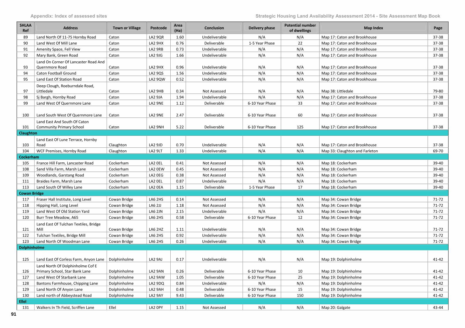
Appendix: Index of assessed sites Strategic Housing Land Availability Assessment 2014 - Site Assessment Map Book
SHLAARef Address Town or Village Postcode Area
(Ha) Conclusion Delivery phase Potential numberof dwellings Map Index Page
89 Land North Of 11-75 Hornby Road Caton LA2 9QR 1.60 Undeliverable N/A N/A Map 17: Caton and Brookhouse 37-3890 Land West Of Mill Lane Caton LA2 9HX 0.76 Deliverable 1-5 Year Phase 22 Map 17: Caton and Brookhouse 37-3891 Amenity Space, Fell View Caton LA2 9RB 0.73 Undeliverable N/A N/A Map 17: Caton and Brookhouse 37-3892 Mary Bank, Green Road Caton LA2 9JG 1.66 Undeliverable N/A N/A Map 17: Caton and Brookhouse 37-38
93Land On Corner Of Lancaster Road AndQuernmore Road Caton LA2 9HX 0.96 Undeliverable N/A N/A Map 17: Caton and Brookhouse 37-38
94 Caton Football Ground Caton LA2 9QS 1.56 Undeliverable N/A N/A Map 17: Caton and Brookhouse 37-3895 Land East Of Station Road Caton LA2 9QW 0.52 Undeliverable N/A N/A Map 17: Caton and Brookhouse 37-38
97Deep Clough, Roeburndale Road,Littledale Caton LA2 9HB 0.34 Not Assessed N/A N/A Map 38: Littledale 79-80
98 Sj Bargh, Hornby Road Caton LA2 9JA 1.94 Undeliverable N/A N/A Map 17: Caton and Brookhouse 37-3899 Land West Of Quernmore Lane Caton LA2 9NE 1.12 Deliverable 6-10 Year Phase 33 Map 17: Caton and Brookhouse 37-38
100 Land South West Of Quernmore Lane Caton LA2 9NE 2.47 Deliverable 6-10 Year Phase 60 Map 17: Caton and Brookhouse 37-38
101Land East And South Of CatonCommunity Primary School Caton LA2 9NH 5.22 Deliverable 6-10 Year Phase 125 Map 17: Caton and Brookhouse 37-38
Claughton
103Land East Of Lune Terrace, HornbyRoad Claughton LA2 9JD 0.70 Undeliverable N/A N/A Map 17: Caton and Brookhouse 37-38
104 WCF Premises, Hornby Road Claughton LA2 9LT 1.33 Undeliverable N/A N/A Map 33: Claughton and Farleton 69-70Cockerham
105 France Hill Farm, Lancaster Road Cockerham LA2 0EL 0.41 Not Assessed N/A N/A Map 18: Cockerham 39-40108 Sand Villa Farm, Marsh Lane Cockerham LA2 0EW 0.45 Not Assessed N/A N/A Map 18: Cockerham 39-40109 Woodlands, Garstang Road Cockerham LA2 0EG 0.38 Not Assessed N/A N/A Map 18: Cockerham 39-40111 Braides Farm, Marsh Lane Cockerham LA2 0EL 0.87 Undeliverable N/A N/A Map 18: Cockerham 39-40113 Land South Of Willey Lane Cockerham LA2 0EA 1.15 Deliverable 1-5 Year Phase 17 Map 18: Cockerham 39-40
Cowan Bridge117 Fraser Hall Institute, Long Level Cowan Bridge LA6 2HS 0.14 Not Assessed N/A N/A Map 34: Cowan Bridge 71-72118 Hipping Hall, Long Level Cowan Bridge LA6 2JJ 1.18 Not Assessed N/A N/A Map 34: Cowan Bridge 71-72119 Land West Of Old Station Yard Cowan Bridge LA6 2JN 2.15 Undeliverable N/A N/A Map 34: Cowan Bridge 71-72120 Burr Tree Meadow, A65 Cowan Bridge LA6 2HS 0.58 Deliverable 6-10 Year Phase 12 Map 34: Cowan Bridge 71-72
121Land East Of Tulchan Textiles, BridgeMill Cowan Bridge LA6 2HZ 1.11 Undeliverable N/A N/A Map 34: Cowan Bridge 71-72
122 Tulchan Textiles, Bridge Mill Cowan Bridge LA6 2HS 0.92 Undeliverable N/A N/A Map 34: Cowan Bridge 71-72123 Land North Of Woodman Lane Cowan Bridge LA6 2HS 0.26 Undeliverable N/A N/A Map 34: Cowan Bridge 71-72
Dolphinholme
125 Land East Of Corless Farm, Anyon Lane Dolphinholme LA2 9AJ 0.17 Undeliverable N/A N/A Map 19: Dolphinholme 41-42
126Land North Of Dolphinholme Cof EPrimary School, Star Bank Lane Dolphinholme LA2 9AN 0.26 Deliverable 6-10 Year Phase 10 Map 19: Dolphinholme 41-42
127 Land West Of Starbank Lane Dolphinholme LA2 9AW 1.05 Deliverable 6-10 Year Phase 25 Map 19: Dolphinholme 41-42128 Bantons Farmhouse, Chipping Lane Dolphinholme LA2 9DQ 0.84 Undeliverable N/A N/A Map 19: Dolphinholme 41-42129 Land North Of Anyon Lane Dolphinholme LA2 9AH 0.48 Deliverable 6-10 Year Phase 15 Map 19: Dolphinholme 41-42130 Land north of Abbeystead Road Dolphinholme LA2 9AY 9.43 Deliverable 6-10 Year Phase 150 Map 19: Dolphinholme 41-42
Ellel131 Walkers In Th Field, Scriffen Lane Ellel LA2 0PY 1.15 Not Assessed N/A N/A Map 20: Galgate 43-44
91
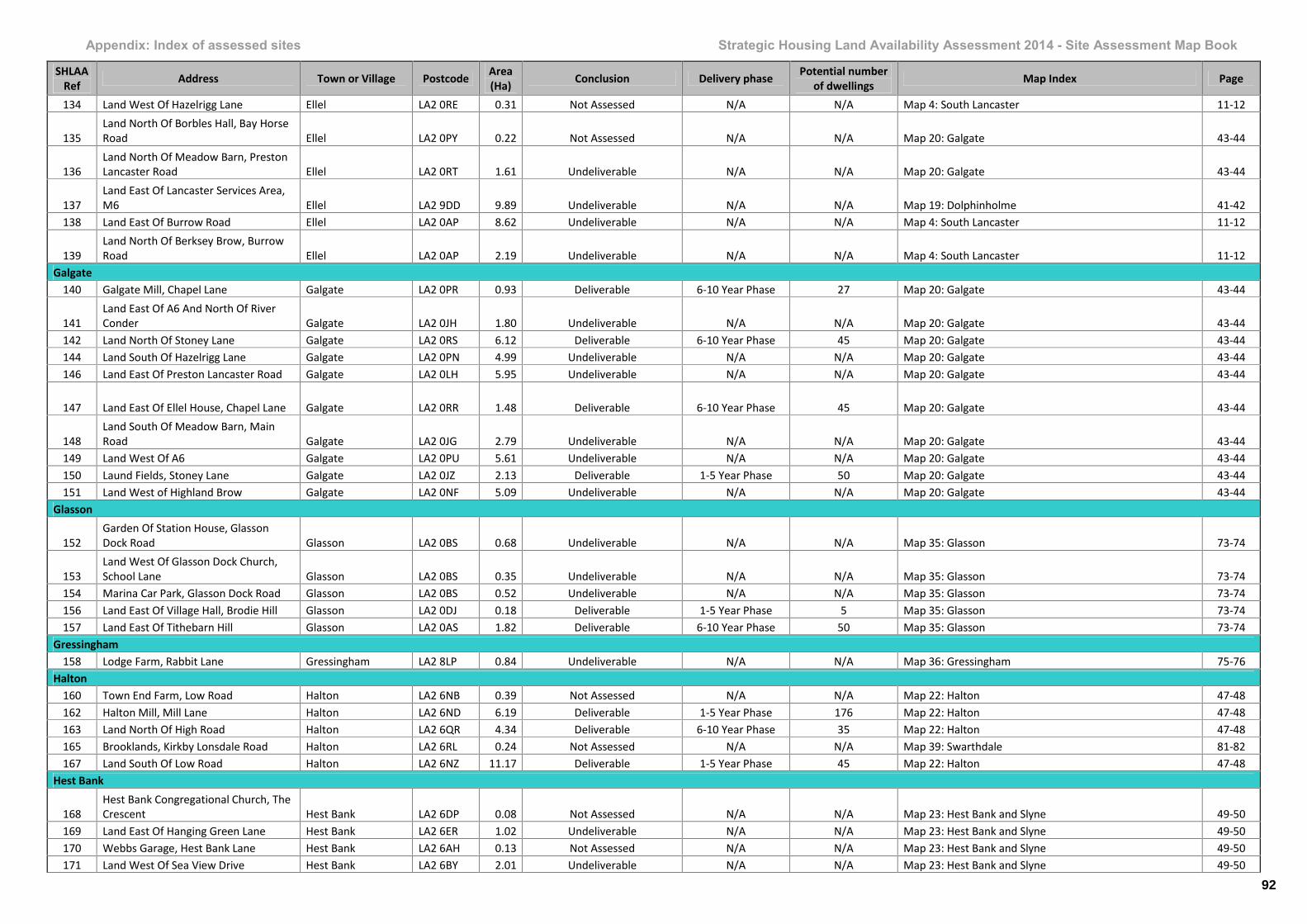
Appendix: Index of assessed sites Strategic Housing Land Availability Assessment 2014 - Site Assessment Map Book
SHLAARef Address Town or Village Postcode Area
(Ha) Conclusion Delivery phase Potential numberof dwellings Map Index Page
134 Land West Of Hazelrigg Lane Ellel LA2 0RE 0.31 Not Assessed N/A N/A Map 4: South Lancaster 11-12
135Land North Of Borbles Hall, Bay HorseRoad Ellel LA2 0PY 0.22 Not Assessed N/A N/A Map 20: Galgate 43-44
136Land North Of Meadow Barn, PrestonLancaster Road Ellel LA2 0RT 1.61 Undeliverable N/A N/A Map 20: Galgate 43-44
137Land East Of Lancaster Services Area,M6 Ellel LA2 9DD 9.89 Undeliverable N/A N/A Map 19: Dolphinholme 41-42
138 Land East Of Burrow Road Ellel LA2 0AP 8.62 Undeliverable N/A N/A Map 4: South Lancaster 11-12
139Land North Of Berksey Brow, BurrowRoad Ellel LA2 0AP 2.19 Undeliverable N/A N/A Map 4: South Lancaster 11-12
Galgate140 Galgate Mill, Chapel Lane Galgate LA2 0PR 0.93 Deliverable 6-10 Year Phase 27 Map 20: Galgate 43-44
141Land East Of A6 And North Of RiverConder Galgate LA2 0JH 1.80 Undeliverable N/A N/A Map 20: Galgate 43-44
142 Land North Of Stoney Lane Galgate LA2 0RS 6.12 Deliverable 6-10 Year Phase 45 Map 20: Galgate 43-44144 Land South Of Hazelrigg Lane Galgate LA2 0PN 4.99 Undeliverable N/A N/A Map 20: Galgate 43-44146 Land East Of Preston Lancaster Road Galgate LA2 0LH 5.95 Undeliverable N/A N/A Map 20: Galgate 43-44
147 Land East Of Ellel House, Chapel Lane Galgate LA2 0RR 1.48 Deliverable 6-10 Year Phase 45 Map 20: Galgate 43-44
148Land South Of Meadow Barn, MainRoad Galgate LA2 0JG 2.79 Undeliverable N/A N/A Map 20: Galgate 43-44
149 Land West Of A6 Galgate LA2 0PU 5.61 Undeliverable N/A N/A Map 20: Galgate 43-44150 Laund Fields, Stoney Lane Galgate LA2 0JZ 2.13 Deliverable 1-5 Year Phase 50 Map 20: Galgate 43-44151 Land West of Highland Brow Galgate LA2 0NF 5.09 Undeliverable N/A N/A Map 20: Galgate 43-44
Glasson
152Garden Of Station House, GlassonDock Road Glasson LA2 0BS 0.68 Undeliverable N/A N/A Map 35: Glasson 73-74
153Land West Of Glasson Dock Church,School Lane Glasson LA2 0BS 0.35 Undeliverable N/A N/A Map 35: Glasson 73-74
154 Marina Car Park, Glasson Dock Road Glasson LA2 0BS 0.52 Undeliverable N/A N/A Map 35: Glasson 73-74156 Land East Of Village Hall, Brodie Hill Glasson LA2 0DJ 0.18 Deliverable 1-5 Year Phase 5 Map 35: Glasson 73-74157 Land East Of Tithebarn Hill Glasson LA2 0AS 1.82 Deliverable 6-10 Year Phase 50 Map 35: Glasson 73-74
Gressingham158 Lodge Farm, Rabbit Lane Gressingham LA2 8LP 0.84 Undeliverable N/A N/A Map 36: Gressingham 75-76
Halton160 Town End Farm, Low Road Halton LA2 6NB 0.39 Not Assessed N/A N/A Map 22: Halton 47-48162 Halton Mill, Mill Lane Halton LA2 6ND 6.19 Deliverable 1-5 Year Phase 176 Map 22: Halton 47-48163 Land North Of High Road Halton LA2 6QR 4.34 Deliverable 6-10 Year Phase 35 Map 22: Halton 47-48165 Brooklands, Kirkby Lonsdale Road Halton LA2 6RL 0.24 Not Assessed N/A N/A Map 39: Swarthdale 81-82167 Land South Of Low Road Halton LA2 6NZ 11.17 Deliverable 1-5 Year Phase 45 Map 22: Halton 47-48
Hest Bank
168Hest Bank Congregational Church, TheCrescent Hest Bank LA2 6DP 0.08 Not Assessed N/A N/A Map 23: Hest Bank and Slyne 49-50
169 Land East Of Hanging Green Lane Hest Bank LA2 6ER 1.02 Undeliverable N/A N/A Map 23: Hest Bank and Slyne 49-50170 Webbs Garage, Hest Bank Lane Hest Bank LA2 6AH 0.13 Not Assessed N/A N/A Map 23: Hest Bank and Slyne 49-50171 Land West Of Sea View Drive Hest Bank LA2 6BY 2.01 Undeliverable N/A N/A Map 23: Hest Bank and Slyne 49-50
92
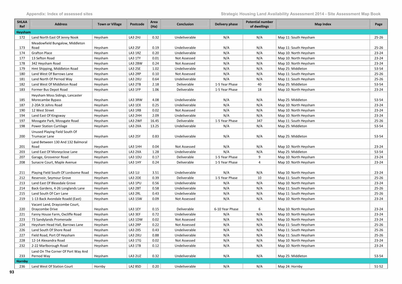
Appendix: Index of assessed sites Strategic Housing Land Availability Assessment 2014 - Site Assessment Map Book
SHLAARef Address Town or Village Postcode Area
(Ha) Conclusion Delivery phase Potential numberof dwellings Map Index Page
Heysham172 Land North East Of Jenny Nook Heysham LA3 2HJ 0.32 Undeliverable N/A N/A Map 11: South Heysham 25-26
173Meadowfield Bungalow, MiddletonRoad Heysham LA3 2SF 0.19 Undeliverable N/A N/A Map 11: South Heysham 25-26
174 Grafton Place Heysham LA3 1RZ 0.20 Undeliverable N/A N/A Map 10: North Heysham 23-24177 13 Sefton Road Heysham LA3 1TY 0.01 Not Assessed N/A N/A Map 10: North Heysham 23-24178 342 Heysham Road Heysham LA3 2BW 0.24 Not Assessed N/A N/A Map 10: North Heysham 23-24179 Hmt Shipping, Middleton Road Heysham LA3 2SE 1.02 Undeliverable N/A N/A Map 25: Middleton 53-54180 Land West Of Barrows Lane Heysham LA3 2RP 0.10 Not Assessed N/A N/A Map 11: South Heysham 25-26181 Land North Of Pernod Way Heysham LA3 2XU 0.64 Undeliverable N/A N/A Map 11: South Heysham 25-26182 Land West Of Middleton Road Heysham LA3 2TB 2.18 Deliverable 1-5 Year Phase 40 Map 25: Middleton 53-54183 Former Bus Depot Road Heysham LA3 1FP 1.06 Deliverable 1-5 Year Phase 18 Map 10: North Heysham 23-24
185Heysham Moss Sidings, LancasterMorecambe Bypass Heysham LA3 3RW 4.08 Undeliverable N/A N/A Map 25: Middleton 53-54
187 2-20A St Johns Road Heysham LA3 1EX 0.25 Undeliverable N/A N/A Map 10: North Heysham 23-24190 12 West Street Heysham LA3 1RB 0.02 Not Assessed N/A N/A Map 10: North Heysham 23-24194 Land East Of Kingsway Heysham LA3 2HH 2.09 Undeliverable N/A N/A Map 10: North Heysham 23-24197 Mossgate Park, Mossgate Road Heysham LA3 2WF 16.45 Deliverable 1-5 Year Phase 347 Map 11: South Heysham 25-26198 Power Station Curtilage Heysham LA3 2XA 13.25 Undeliverable N/A N/A Map 25: Middleton 53-54
200Unused Playing Field South OfTrumacar Lane Heysham LA3 2SY 0.83 Undeliverable N/A N/A Map 25: Middleton 53-54
201Land Between 130 And 132 BalmoralRoad Heysham LA3 1HH 0.04 Not Assessed N/A N/A Map 10: North Heysham 23-24
203 Land East Of Moneyclose Lane Heysham LA3 2XA 1.28 Undeliverable N/A N/A Map 25: Middleton 53-54207 Garage, Grosvenor Road Heysham LA3 1DU 0.17 Deliverable 1-5 Year Phase 9 Map 10: North Heysham 23-24208 Sunacre Court, Maple Avenue Heysham LA3 1HY 0.24 Deliverable 1-5 Year Phase 4 Map 10: North Heysham 23-24
211 Playing Field South Of Lordsome Road Heysham LA3 1JJ 3.51 Undeliverable N/A N/A Map 10: North Heysham 23-24212 Reservoir, Seymour Grove Heysham LA3 2DE 0.39 Deliverable 1-5 Year Phase 10 Map 11: South Heysham 25-26213 Land East Of Bleasdale Grove Heysham LA3 1PU 0.56 Undeliverable N/A N/A Map 10: North Heysham 23-24214 Back Gardens, 4-26 Longlands Lane Heysham LA3 2BT 0.58 Undeliverable N/A N/A Map 11: South Heysham 25-26215 Land South Of Carr Lane Heysham LA3 2RL 0.43 Undeliverable N/A N/A Map 11: South Heysham 25-26219 1-13 Back Avondale Roadd (East) Heysham LA3 1SW 0.09 Not Assessed N/A N/A Map 10: North Heysham 23-24
220Vacant Land, Draycombe Court,Draycombe Drive Heysham LA3 1EY 0.15 Deliverable 6-10 Year Phase 6 Map 10: North Heysham 23-24
221 Fanny House Farm, Oxcliffe Road Heysham LA3 3EF 0.72 Undeliverable N/A N/A Map 10: North Heysham 23-24223 73 Sandylands Promenade Heysham LA3 1DW 0.02 Not Assessed N/A N/A Map 10: North Heysham 23-24224 Heysham Head Hall, Barrows Lane Heysham LA3 2RP 0.22 Not Assessed N/A N/A Map 11: South Heysham 25-26226 Land South Of Shore Road Heysham LA3 2XS 0.43 Undeliverable N/A N/A Map 11: South Heysham 25-26227 Field Road, Port Of Heysham Heysham LA3 2XU 0.88 Undeliverable N/A N/A Map 11: South Heysham 25-26228 12-14 Alexandra Road Heysham LA3 1TG 0.02 Not Assessed N/A N/A Map 10: North Heysham 23-24232 2-22 Marlborough Road Heysham LA3 1TB 0.12 Undeliverable N/A N/A Map 10: North Heysham 23-24
233Land On The Corner Of Port Way AndPernod Way Heysham LA3 2UZ 0.32 Undeliverable N/A N/A Map 25: Middleton 53-54
Hornby236 Land West Of Station Court Hornby LA2 8SD 0.20 Undeliverable N/A N/A Map 24: Hornby 51-52
93
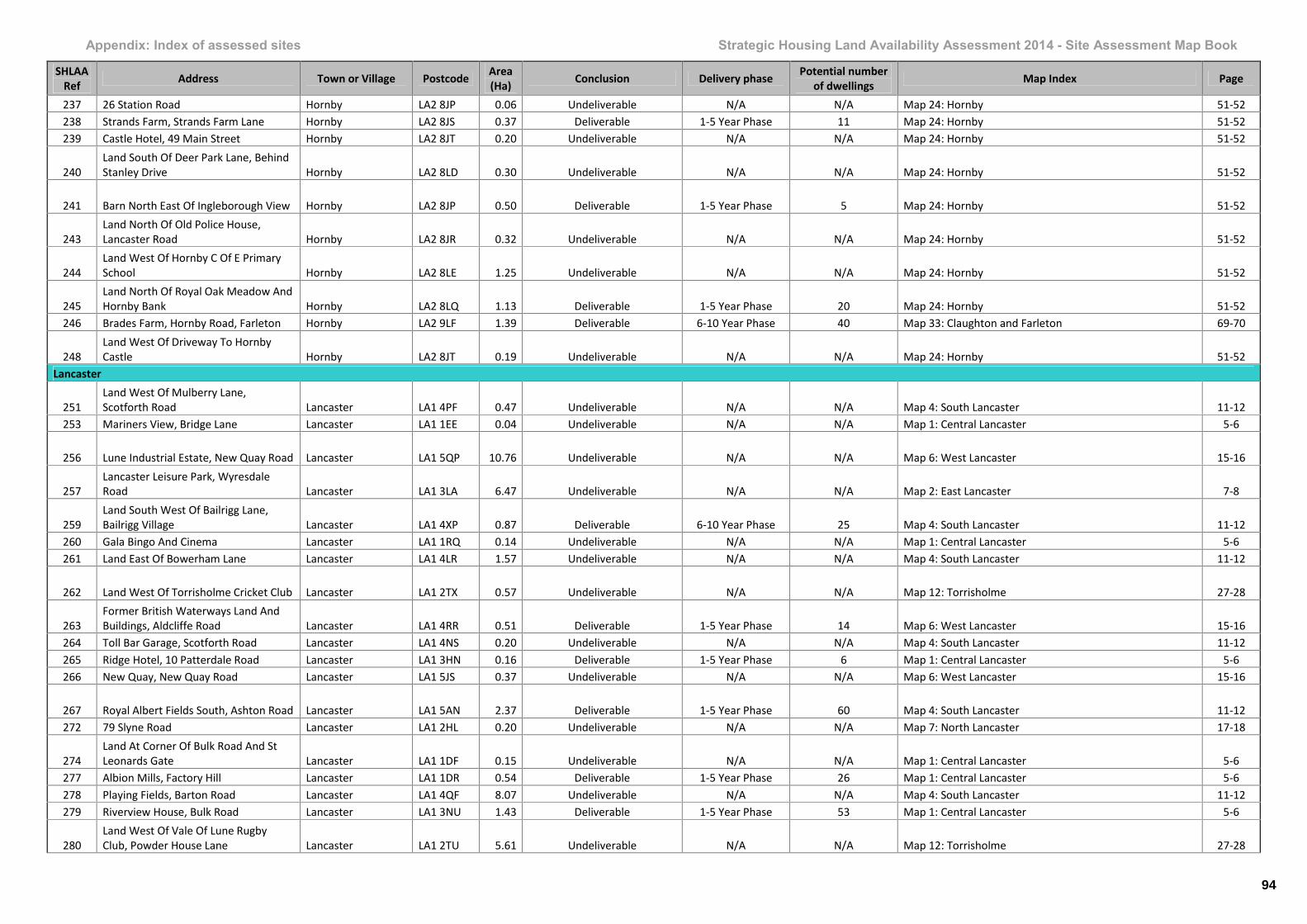
Appendix: Index of assessed sites Strategic Housing Land Availability Assessment 2014 - Site Assessment Map Book
SHLAARef Address Town or Village Postcode Area
(Ha) Conclusion Delivery phase Potential numberof dwellings Map Index Page
237 26 Station Road Hornby LA2 8JP 0.06 Undeliverable N/A N/A Map 24: Hornby 51-52238 Strands Farm, Strands Farm Lane Hornby LA2 8JS 0.37 Deliverable 1-5 Year Phase 11 Map 24: Hornby 51-52239 Castle Hotel, 49 Main Street Hornby LA2 8JT 0.20 Undeliverable N/A N/A Map 24: Hornby 51-52
240Land South Of Deer Park Lane, BehindStanley Drive Hornby LA2 8LD 0.30 Undeliverable N/A N/A Map 24: Hornby 51-52
241 Barn North East Of Ingleborough View Hornby LA2 8JP 0.50 Deliverable 1-5 Year Phase 5 Map 24: Hornby 51-52
243Land North Of Old Police House,Lancaster Road Hornby LA2 8JR 0.32 Undeliverable N/A N/A Map 24: Hornby 51-52
244Land West Of Hornby C Of E PrimarySchool Hornby LA2 8LE 1.25 Undeliverable N/A N/A Map 24: Hornby 51-52
245Land North Of Royal Oak Meadow AndHornby Bank Hornby LA2 8LQ 1.13 Deliverable 1-5 Year Phase 20 Map 24: Hornby 51-52
246 Brades Farm, Hornby Road, Farleton Hornby LA2 9LF 1.39 Deliverable 6-10 Year Phase 40 Map 33: Claughton and Farleton 69-70
248Land West Of Driveway To HornbyCastle Hornby LA2 8JT 0.19 Undeliverable N/A N/A Map 24: Hornby 51-52
Lancaster
251Land West Of Mulberry Lane,Scotforth Road Lancaster LA1 4PF 0.47 Undeliverable N/A N/A Map 4: South Lancaster 11-12
253 Mariners View, Bridge Lane Lancaster LA1 1EE 0.04 Undeliverable N/A N/A Map 1: Central Lancaster 5-6
256 Lune Industrial Estate, New Quay Road Lancaster LA1 5QP 10.76 Undeliverable N/A N/A Map 6: West Lancaster 15-16
257Lancaster Leisure Park, WyresdaleRoad Lancaster LA1 3LA 6.47 Undeliverable N/A N/A Map 2: East Lancaster 7-8
259Land South West Of Bailrigg Lane,Bailrigg Village Lancaster LA1 4XP 0.87 Deliverable 6-10 Year Phase 25 Map 4: South Lancaster 11-12
260 Gala Bingo And Cinema Lancaster LA1 1RQ 0.14 Undeliverable N/A N/A Map 1: Central Lancaster 5-6261 Land East Of Bowerham Lane Lancaster LA1 4LR 1.57 Undeliverable N/A N/A Map 4: South Lancaster 11-12
262 Land West Of Torrisholme Cricket Club Lancaster LA1 2TX 0.57 Undeliverable N/A N/A Map 12: Torrisholme 27-28
263Former British Waterways Land AndBuildings, Aldcliffe Road Lancaster LA1 4RR 0.51 Deliverable 1-5 Year Phase 14 Map 6: West Lancaster 15-16
264 Toll Bar Garage, Scotforth Road Lancaster LA1 4NS 0.20 Undeliverable N/A N/A Map 4: South Lancaster 11-12265 Ridge Hotel, 10 Patterdale Road Lancaster LA1 3HN 0.16 Deliverable 1-5 Year Phase 6 Map 1: Central Lancaster 5-6266 New Quay, New Quay Road Lancaster LA1 5JS 0.37 Undeliverable N/A N/A Map 6: West Lancaster 15-16
267 Royal Albert Fields South, Ashton Road Lancaster LA1 5AN 2.37 Deliverable 1-5 Year Phase 60 Map 4: South Lancaster 11-12272 79 Slyne Road Lancaster LA1 2HL 0.20 Undeliverable N/A N/A Map 7: North Lancaster 17-18
274Land At Corner Of Bulk Road And StLeonards Gate Lancaster LA1 1DF 0.15 Undeliverable N/A N/A Map 1: Central Lancaster 5-6
277 Albion Mills, Factory Hill Lancaster LA1 1DR 0.54 Deliverable 1-5 Year Phase 26 Map 1: Central Lancaster 5-6278 Playing Fields, Barton Road Lancaster LA1 4QF 8.07 Undeliverable N/A N/A Map 4: South Lancaster 11-12279 Riverview House, Bulk Road Lancaster LA1 3NU 1.43 Deliverable 1-5 Year Phase 53 Map 1: Central Lancaster 5-6
280Land West Of Vale Of Lune RugbyClub, Powder House Lane Lancaster LA1 2TU 5.61 Undeliverable N/A N/A Map 12: Torrisholme 27-28
94

Appendix: Index of assessed sites Strategic Housing Land Availability Assessment 2014 - Site Assessment Map Book
SHLAARef Address Town or Village Postcode Area
(Ha) Conclusion Delivery phase Potential numberof dwellings Map Index Page
281Land North Of Canal, Hammerton HallLane Lancaster LA1 2JX 1.13 Undeliverable N/A N/A Map 7: North Lancaster 17-18
282 Halton Training Camp, Halton Road Lancaster LA2 6BL 6.84 Deliverable 1-5 Year Phase 35 Map 22: Halton 47-48286 Bulk Street Car Park Lancaster LA1 1PX 0.53 Undeliverable N/A N/A Map 1: Central Lancaster 5-6287 Lucy Street Car Park Lancaster LA1 1UU 0.07 Not Assessed N/A N/A Map 1: Central Lancaster 5-6288 Spring Garden Street Car Park Lancaster LA1 1RH 0.07 Not Assessed N/A N/A Map 1: Central Lancaster 5-6289 High Street Car Pack Lancaster LA1 1LA 0.16 Undeliverable N/A N/A Map 1: Central Lancaster 5-6
290Playing Field South Of Boys Club,Dallas Road Lancaster LA1 1TR 0.33 Undeliverable N/A N/A Map 1: Central Lancaster 5-6
291 Bulk Road Lancaster LA1 1NN 0.93 Undeliverable N/A N/A Map 1: Central Lancaster 5-6292 Luneside East Lancaster LA1 5SE 6.77 Deliverable 1-5 Year Phase 150 Map 1: Central Lancaster 5-6293 Nightingale Hall Lancaster LA1 3JU 5.69 Deliverable 1-5 Year Phase 100 Map 1: Central Lancaster 5-6295 Private Car Park, Dolphinlee Bridge Lancaster LA1 3PE 0.71 Undeliverable N/A N/A Map 7: North Lancaster 17-18296 Derwent Court, Salt Ayre Lane Lancaster LA1 5JP 0.85 Deliverable 6-10 Year Phase 20 Map 12: Torrisholme 27-28
299Former St Georges Church, WillowLane Lancaster LA1 5TR 0.20 Deliverable 1-5 Year Phase 16 Map 6: West Lancaster 15-16
300 Rose Cottage, New Quay Road Lancaster LA1 5QS 0.50 Not Assessed N/A N/A Map 6: West Lancaster 15-16
301Former Chorley Nissan Garage,Wheatfield Street Lancaster LA1 1TP 1.46 Deliverable 1-5 Year Phase 59 Map 1: Central Lancaster 5-6
302Land North Of Pathfinders Drive,Ashton Road Lancaster LA1 5FB 1.09 Undeliverable N/A N/A Map 4: South Lancaster 11-12
304 Royal Albert Fields North, Ashton Road Lancaster LA1 4JJ 4.56 Deliverable 6-10 Year Phase 120 Map 4: South Lancaster 11-12305 Nelson Street Car Park North Of Lancaster LA1 1QD 0.43 Undeliverable N/A N/A Map 1: Central Lancaster 5-6306 16 South Road Lancaster LA1 4XD 0.03 Not Assessed N/A N/A Map 5: Aldcliffe, Lancaster308 26-28 Sun Street Lancaster LA1 1EW 0.02 Not Assessed N/A N/A Map 1: Central Lancaster 5-6310 Beaumont College, Lancaster Road Lancaster LA2 6AA 20.57 Undeliverable N/A N/A Map 12: Torrisholme 27-28312 Land North Of Lentworth Drive Lancaster LA1 4NJ 0.79 Undeliverable N/A N/A Map 4: South Lancaster 11-12313 Land North Of Wyresdale Road Lancaster LA1 3RP 1.06 Undeliverable N/A N/A Map 2: East Lancaster 7-8314 Giant Axe Field, Long Marsh Lane Lancaster LA1 5PE 1.60 Undeliverable N/A N/A Map 6: West Lancaster 15-16315 Standfast Works Car Park Lancaster LA1 3PE 0.37 Undeliverable N/A N/A Map 7: North Lancaster 17-18316 Land North Of Whernside Road Lancaster LA1 2TA 0.51 Undeliverable N/A N/A Map 12: Torrisholme 27-28
318Damside Street Car Park, North Of 40-48 Church Street Lancaster LA1 1LH 0.05 Not Assessed N/A N/A Map 1: Central Lancaster 5-6
319Lancaster Moor Hospital, QuernmoreRoad Lancaster LA1 3QZ 15.88 Deliverable 1-5 Year Phase 420 Map 2: East Lancaster 7-8
320 Land West Of Watery Lane Lancaster LA1 2SL 3.49 Undeliverable N/A N/A Map 12: Torrisholme 27-28
321Whalley Road Playing Field, DerwentRoad Lancaster LA1 3HJ 2.41 Undeliverable N/A N/A Map 1: Central Lancaster 5-6
323Damside Street Car Park, North Of 50-62 Church Street Lancaster LA1 1LH 0.07 Deliverable 1-5 Year Phase 17 Map 1: Central Lancaster 5-6
326 Lansil Car Park, Caton Road Lancaster LA1 3PE 0.61 Undeliverable N/A N/A Map 7: North Lancaster 17-18
327 Land South East Of Fenham Carr Lane Lancaster LA1 3RP 2.23 Undeliverable N/A N/A Map 2: East Lancaster 7-8328 Land East And West Of Grab Lane Lancaster LA1 3JH 32.24 Deliverable 6-10 Year Phase 450 Map 2: East Lancaster 7-8
95
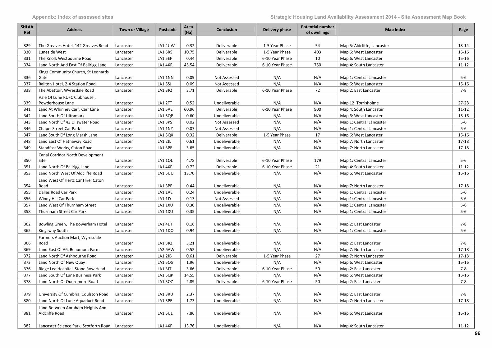
Appendix: Index of assessed sites Strategic Housing Land Availability Assessment 2014 - Site Assessment Map Book
SHLAARef Address Town or Village Postcode Area
(Ha) Conclusion Delivery phase Potential numberof dwellings Map Index Page
329 The Greaves Hotel, 142 Greaves Road Lancaster LA1 4UW 0.32 Deliverable 1-5 Year Phase 54 Map 5: Aldcliffe, Lancaster 13-14330 Luneside West Lancaster LA1 5RS 10.75 Deliverable 1-5 Year Phase 403 Map 6: West Lancaster 15-16331 The Knoll, Westbourne Road Lancaster LA1 5EF 0.44 Deliverable 6-10 Year Phase 10 Map 6: West Lancaster 15-16334 Land North And East Of Bailrigg Lane Lancaster LA1 4XR 45.54 Deliverable 6-10 Year Phase 750 Map 4: South Lancaster 11-12
336Kings Community Church, St LeonardsGate Lancaster LA1 1NN 0.09 Not Assessed N/A N/A Map 1: Central Lancaster 5-6
337 Railton Hotel, 2-4 Station Road Lancaster LA1 5SJ 0.09 Not Assessed N/A N/A Map 6: West Lancaster 15-16338 The Abattoir, Wyresdale Road Lancaster LA1 3JQ 3.71 Deliverable 6-10 Year Phase 72 Map 2: East Lancaster 7-8
339Vale Of Lune RUFC Clubhouse ,Powderhouse Lane Lancaster LA1 2TT 0.52 Undeliverable N/A N/A Map 12: Torrisholme 27-28
341 Land At Whinney Carr, Carr Lane Lancaster LA1 5AE 60.96 Deliverable 6-10 Year Phase 900 Map 4: South Lancaster 11-12342 Land South Of Ultramark Lancaster LA1 5QP 0.60 Undeliverable N/A N/A Map 6: West Lancaster 15-16343 Land North Of 43 Ullswater Road Lancaster LA1 3PS 0.02 Not Assessed N/A N/A Map 1: Central Lancaster 5-6346 Chapel Street Car Park Lancaster LA1 1NZ 0.07 Not Assessed N/A N/A Map 1: Central Lancaster 5-6347 Land South Of Long Marsh Lane Lancaster LA1 5QX 0.32 Deliverable 1-5 Year Phase 17 Map 6: West Lancaster 15-16348 Land East Of Hathaway Road Lancaster LA1 2JL 0.61 Undeliverable N/A N/A Map 7: North Lancaster 17-18349 Standfast Works, Caton Road Lancaster LA1 3PE 3.65 Undeliverable N/A N/A Map 7: North Lancaster 17-18
350Canal Corridor North DevelopmentSite Lancaster LA1 1QL 4.78 Deliverable 6-10 Year Phase 179 Map 1: Central Lancaster 5-6
351 Land North Of Bailrigg Lane Lancaster LA1 4XP 0.72 Deliverable 6-10 Year Phase 21 Map 4: South Lancaster 11-12353 Land North West Of Aldcliffe Road Lancaster LA1 5UU 13.70 Undeliverable N/A N/A Map 6: West Lancaster 15-16
354Land West Of Hertz Car Hire, CatonRoad Lancaster LA1 3PE 0.44 Undeliverable N/A N/A Map 7: North Lancaster 17-18
355 Dallas Road Car Park Lancaster LA1 1AE 0.24 Undeliverable N/A N/A Map 1: Central Lancaster 5-6356 Windy Hill Car Park Lancaster LA1 1JY 0.13 Not Assessed N/A N/A Map 1: Central Lancaster 5-6357 Land West Of Thurnham Street Lancaster LA1 1XU 0.30 Undeliverable N/A N/A Map 1: Central Lancaster 5-6358 Thurnham Street Car Park Lancaster LA1 1XU 0.35 Undeliverable N/A N/A Map 1: Central Lancaster 5-6
362 Bowling Green, The Bowerham Hotel Lancaster LA1 4DT 0.16 Undeliverable N/A N/A Map 2: East Lancaster 7-8365 Kingsway South Lancaster LA1 1DQ 0.94 Undeliverable N/A N/A Map 1: Central Lancaster 5-6
366Farmers Auction Mart, WyresdaleRoad Lancaster LA1 3JQ 3.21 Undeliverable N/A N/A Map 2: East Lancaster 7-8
369 Land East Of A6, Beaumont Farm Lancaster LA2 6AW 0.52 Undeliverable N/A N/A Map 7: North Lancaster 17-18372 Land North Of Ashbourne Road Lancaster LA1 2JB 0.61 Deliverable 1-5 Year Phase 27 Map 7: North Lancaster 17-18373 Land North Of New Quay Lancaster LA1 5QS 1.96 Undeliverable N/A N/A Map 6: West Lancaster 15-16376 Ridge Lea Hospital, Stone Row Head Lancaster LA1 3JT 3.66 Deliverable 6-10 Year Phase 50 Map 2: East Lancaster 7-8377 Land South Of Lune Business Park Lancaster LA1 5QP 14.55 Undeliverable N/A N/A Map 6: West Lancaster 15-16378 Land North Of Quernmore Road Lancaster LA1 3QZ 2.89 Deliverable 6-10 Year Phase 50 Map 2: East Lancaster 7-8
379 University Of Cumbria, Coulston Road Lancaster LA1 3RU 2.37 Undeliverable N/A N/A Map 2: East Lancaster 7-8380 Land North Of Lune Aquaduct Road Lancaster LA1 3PE 1.73 Undeliverable N/A N/A Map 7: North Lancaster 17-18
381Land Between Abraham Heights AndAldcliffe Road Lancaster LA1 5UL 7.86 Undeliverable N/A N/A Map 6: West Lancaster 15-16
382 Lancaster Science Park, Scotforth Road Lancaster LA1 4XP 13.76 Undeliverable N/A N/A Map 4: South Lancaster 11-12
96
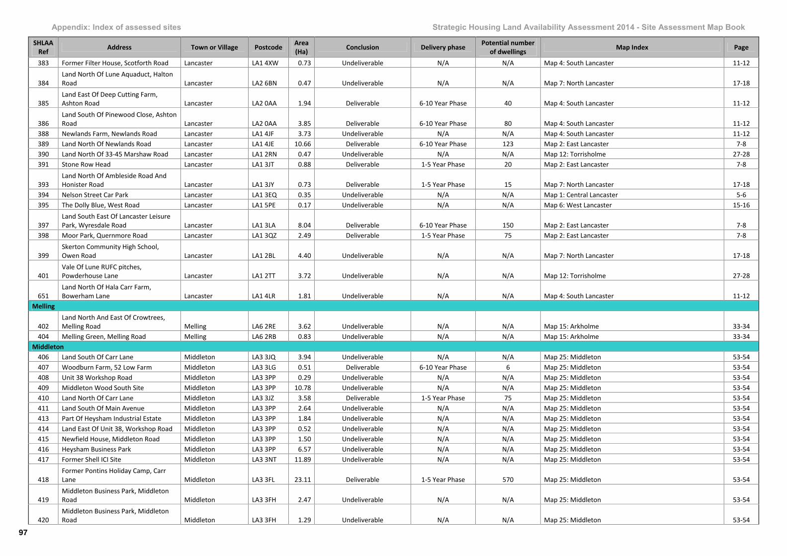
Appendix: Index of assessed sites Strategic Housing Land Availability Assessment 2014 - Site Assessment Map Book
SHLAARef Address Town or Village Postcode Area
(Ha) Conclusion Delivery phase Potential numberof dwellings Map Index Page
383 Former Filter House, Scotforth Road Lancaster LA1 4XW 0.73 Undeliverable N/A N/A Map 4: South Lancaster 11-12
384Land North Of Lune Aquaduct, HaltonRoad Lancaster LA2 6BN 0.47 Undeliverable N/A N/A Map 7: North Lancaster 17-18
385Land East Of Deep Cutting Farm,Ashton Road Lancaster LA2 0AA 1.94 Deliverable 6-10 Year Phase 40 Map 4: South Lancaster 11-12
386Land South Of Pinewood Close, AshtonRoad Lancaster LA2 0AA 3.85 Deliverable 6-10 Year Phase 80 Map 4: South Lancaster 11-12
388 Newlands Farm, Newlands Road Lancaster LA1 4JF 3.73 Undeliverable N/A N/A Map 4: South Lancaster 11-12389 Land North Of Newlands Road Lancaster LA1 4JE 10.66 Deliverable 6-10 Year Phase 123 Map 2: East Lancaster 7-8390 Land North Of 33-45 Marshaw Road Lancaster LA1 2RN 0.47 Undeliverable N/A N/A Map 12: Torrisholme 27-28391 Stone Row Head Lancaster LA1 3JT 0.88 Deliverable 1-5 Year Phase 20 Map 2: East Lancaster 7-8
393Land North Of Ambleside Road AndHonister Road Lancaster LA1 3JY 0.73 Deliverable 1-5 Year Phase 15 Map 7: North Lancaster 17-18
394 Nelson Street Car Park Lancaster LA1 3EQ 0.35 Undeliverable N/A N/A Map 1: Central Lancaster 5-6395 The Dolly Blue, West Road Lancaster LA1 5PE 0.17 Undeliverable N/A N/A Map 6: West Lancaster 15-16
397Land South East Of Lancaster LeisurePark, Wyresdale Road Lancaster LA1 3LA 8.04 Deliverable 6-10 Year Phase 150 Map 2: East Lancaster 7-8
398 Moor Park, Quernmore Road Lancaster LA1 3QZ 2.49 Deliverable 1-5 Year Phase 75 Map 2: East Lancaster 7-8
399Skerton Community High School,Owen Road Lancaster LA1 2BL 4.40 Undeliverable N/A N/A Map 7: North Lancaster 17-18
401Vale Of Lune RUFC pitches,Powderhouse Lane Lancaster LA1 2TT 3.72 Undeliverable N/A N/A Map 12: Torrisholme 27-28
651Land North Of Hala Carr Farm,Bowerham Lane Lancaster LA1 4LR 1.81 Undeliverable N/A N/A Map 4: South Lancaster 11-12
Melling
402Land North And East Of Crowtrees,Melling Road Melling LA6 2RE 3.62 Undeliverable N/A N/A Map 15: Arkholme 33-34
404 Melling Green, Melling Road Melling LA6 2RB 0.83 Undeliverable N/A N/A Map 15: Arkholme 33-34Middleton
406 Land South Of Carr Lane Middleton LA3 3JQ 3.94 Undeliverable N/A N/A Map 25: Middleton 53-54407 Woodburn Farm, 52 Low Farm Middleton LA3 3LG 0.51 Deliverable 6-10 Year Phase 6 Map 25: Middleton 53-54408 Unit 38 Workshop Road Middleton LA3 3PP 0.29 Undeliverable N/A N/A Map 25: Middleton 53-54409 Middleton Wood South Site Middleton LA3 3PP 10.78 Undeliverable N/A N/A Map 25: Middleton 53-54410 Land North Of Carr Lane Middleton LA3 3JZ 3.58 Deliverable 1-5 Year Phase 75 Map 25: Middleton 53-54411 Land South Of Main Avenue Middleton LA3 3PP 2.64 Undeliverable N/A N/A Map 25: Middleton 53-54413 Part Of Heysham Industrial Estate Middleton LA3 3PP 1.84 Undeliverable N/A N/A Map 25: Middleton 53-54414 Land East Of Unit 38, Workshop Road Middleton LA3 3PP 0.52 Undeliverable N/A N/A Map 25: Middleton 53-54415 Newfield House, Middleton Road Middleton LA3 3PP 1.50 Undeliverable N/A N/A Map 25: Middleton 53-54416 Heysham Business Park Middleton LA3 3PP 6.57 Undeliverable N/A N/A Map 25: Middleton 53-54417 Former Shell ICI Site Middleton LA3 3NT 11.89 Undeliverable N/A N/A Map 25: Middleton 53-54
418Former Pontins Holiday Camp, CarrLane Middleton LA3 3FL 23.11 Deliverable 1-5 Year Phase 570 Map 25: Middleton 53-54
419Middleton Business Park, MiddletonRoad Middleton LA3 3FH 2.47 Undeliverable N/A N/A Map 25: Middleton 53-54
420Middleton Business Park, MiddletonRoad Middleton LA3 3FH 1.29 Undeliverable N/A N/A Map 25: Middleton 53-54
97
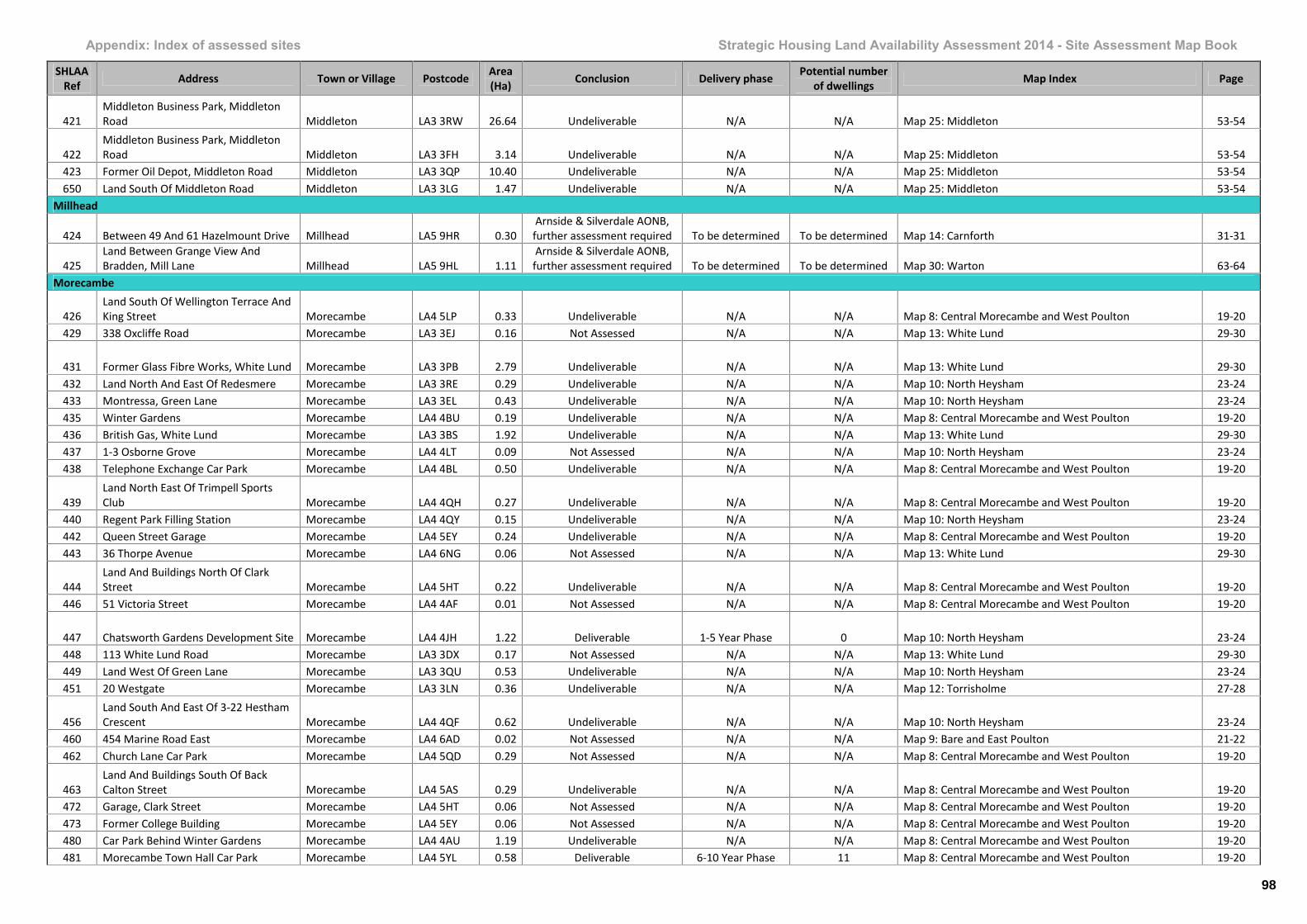
Appendix: Index of assessed sites Strategic Housing Land Availability Assessment 2014 - Site Assessment Map Book
SHLAARef Address Town or Village Postcode Area
(Ha) Conclusion Delivery phase Potential numberof dwellings Map Index Page
421Middleton Business Park, MiddletonRoad Middleton LA3 3RW 26.64 Undeliverable N/A N/A Map 25: Middleton 53-54
422Middleton Business Park, MiddletonRoad Middleton LA3 3FH 3.14 Undeliverable N/A N/A Map 25: Middleton 53-54
423 Former Oil Depot, Middleton Road Middleton LA3 3QP 10.40 Undeliverable N/A N/A Map 25: Middleton 53-54650 Land South Of Middleton Road Middleton LA3 3LG 1.47 Undeliverable N/A N/A Map 25: Middleton 53-54
Millhead
424 Between 49 And 61 Hazelmount Drive Millhead LA5 9HR 0.30Arnside & Silverdale AONB,further assessment required To be determined To be determined Map 14: Carnforth 31-31
425Land Between Grange View AndBradden, Mill Lane Millhead LA5 9HL 1.11
Arnside & Silverdale AONB,further assessment required To be determined To be determined Map 30: Warton 63-64
Morecambe
426Land South Of Wellington Terrace AndKing Street Morecambe LA4 5LP 0.33 Undeliverable N/A N/A Map 8: Central Morecambe and West Poulton 19-20
429 338 Oxcliffe Road Morecambe LA3 3EJ 0.16 Not Assessed N/A N/A Map 13: White Lund 29-30
431 Former Glass Fibre Works, White Lund Morecambe LA3 3PB 2.79 Undeliverable N/A N/A Map 13: White Lund 29-30432 Land North And East Of Redesmere Morecambe LA3 3RE 0.29 Undeliverable N/A N/A Map 10: North Heysham 23-24433 Montressa, Green Lane Morecambe LA3 3EL 0.43 Undeliverable N/A N/A Map 10: North Heysham 23-24435 Winter Gardens Morecambe LA4 4BU 0.19 Undeliverable N/A N/A Map 8: Central Morecambe and West Poulton 19-20436 British Gas, White Lund Morecambe LA3 3BS 1.92 Undeliverable N/A N/A Map 13: White Lund 29-30437 1-3 Osborne Grove Morecambe LA4 4LT 0.09 Not Assessed N/A N/A Map 10: North Heysham 23-24438 Telephone Exchange Car Park Morecambe LA4 4BL 0.50 Undeliverable N/A N/A Map 8: Central Morecambe and West Poulton 19-20
439Land North East Of Trimpell SportsClub Morecambe LA4 4QH 0.27 Undeliverable N/A N/A Map 8: Central Morecambe and West Poulton 19-20
440 Regent Park Filling Station Morecambe LA4 4QY 0.15 Undeliverable N/A N/A Map 10: North Heysham 23-24442 Queen Street Garage Morecambe LA4 5EY 0.24 Undeliverable N/A N/A Map 8: Central Morecambe and West Poulton 19-20443 36 Thorpe Avenue Morecambe LA4 6NG 0.06 Not Assessed N/A N/A Map 13: White Lund 29-30
444Land And Buildings North Of ClarkStreet Morecambe LA4 5HT 0.22 Undeliverable N/A N/A Map 8: Central Morecambe and West Poulton 19-20
446 51 Victoria Street Morecambe LA4 4AF 0.01 Not Assessed N/A N/A Map 8: Central Morecambe and West Poulton 19-20
447 Chatsworth Gardens Development Site Morecambe LA4 4JH 1.22 Deliverable 1-5 Year Phase 0 Map 10: North Heysham 23-24448 113 White Lund Road Morecambe LA3 3DX 0.17 Not Assessed N/A N/A Map 13: White Lund 29-30449 Land West Of Green Lane Morecambe LA3 3QU 0.53 Undeliverable N/A N/A Map 10: North Heysham 23-24451 20 Westgate Morecambe LA3 3LN 0.36 Undeliverable N/A N/A Map 12: Torrisholme 27-28
456Land South And East Of 3-22 HesthamCrescent Morecambe LA4 4QF 0.62 Undeliverable N/A N/A Map 10: North Heysham 23-24
460 454 Marine Road East Morecambe LA4 6AD 0.02 Not Assessed N/A N/A Map 9: Bare and East Poulton 21-22462 Church Lane Car Park Morecambe LA4 5QD 0.29 Not Assessed N/A N/A Map 8: Central Morecambe and West Poulton 19-20
463Land And Buildings South Of BackCalton Street Morecambe LA4 5AS 0.29 Undeliverable N/A N/A Map 8: Central Morecambe and West Poulton 19-20
472 Garage, Clark Street Morecambe LA4 5HT 0.06 Not Assessed N/A N/A Map 8: Central Morecambe and West Poulton 19-20473 Former College Building Morecambe LA4 5EY 0.06 Not Assessed N/A N/A Map 8: Central Morecambe and West Poulton 19-20480 Car Park Behind Winter Gardens Morecambe LA4 4AU 1.19 Undeliverable N/A N/A Map 8: Central Morecambe and West Poulton 19-20481 Morecambe Town Hall Car Park Morecambe LA4 5YL 0.58 Deliverable 6-10 Year Phase 11 Map 8: Central Morecambe and West Poulton 19-20
98

Appendix: Index of assessed sites Strategic Housing Land Availability Assessment 2014 - Site Assessment Map Book
SHLAARef Address Town or Village Postcode Area
(Ha) Conclusion Delivery phase Potential numberof dwellings Map Index Page
483 10 Hestham Crescent Morecambe LA4 4QF 0.03 Not Assessed N/A N/A Map 8: Central Morecambe and West Poulton 19-20484 64-66 Clarendon Road West Morecambe LA3 1QZ 0.02 Not Assessed N/A N/A Map 8: Central Morecambe and West Poulton 19-20487 28 Marine Road West Morecambe LA3 1BY 0.02 Not Assessed N/A N/A Map 8: Central Morecambe and West Poulton 19-20492 Club, Victoria Street Morecambe LA4 4AE 0.10 Not Assessed N/A N/A Map 8: Central Morecambe and West Poulton 19-20494 Edward Street Church Morecambe LA4 4AJ 0.08 Not Assessed N/A N/A Map 8: Central Morecambe and West Poulton 19-20497 Billy Hill Car Park Morecambe LA4 4EW 0.19 Undeliverable N/A N/A Map 8: Central Morecambe and West Poulton 19-20
498Masons Carpets Warehouse, WhiteLund Morecambe LA3 3ED 0.21 Undeliverable N/A N/A Map 13: White Lund 29-30
499 Broomsby Builders And Railway Yard Morecambe LA4 5LL 1.41 Undeliverable N/A N/A Map 8: Central Morecambe and West Poulton 19-20500 Venture Caravan Park Morecambe LA4 4TQ 6.61 Undeliverable N/A N/A Map 10: North Heysham 17-18503 Frontierland, Marine Road West Morecambe LA4 4DP 3.15 Deliverable 6-10 Year Phase 50 Map 8: Central Morecambe and West Poulton 19-20
505Land South East Of Railway Line,Oxcliffe Road Morecambe LA3 3QU 1.24 Undeliverable N/A N/A Map 10: North Heysham 23-24
506Nursery On White Lund Road, WhiteLund Morecambe LA3 3DT 0.50 Deliverable 6-10 Year Phase 9 Map 13: White Lund 29-30
508Land South Of The Bungalow,Westcliffe Drive Morecambe LA3 3NE 0.10 Not Assessed N/A N/A Map 10: North Heysham 23-24
509 Regent Caravan Park Morecambe LA3 3AU 9.16 Undeliverable N/A N/A Map 10: North Heysham 23-24510 Land South Of Betony Road Morecambe LA4 6JD 0.27 Deliverable 1-5 Year Phase 1 Map 23: Hest Bank and Slyne 49-50
511Land West Of 113 White Lund Road,Oxcliffe Road Morecambe LA3 3EJ 0.23 Deliverable 1-5 Year Phase 5 Map 13: White Lund 29-30
514 Plaza Shopping Arcade, Queen Street Morecambe LA4 5EL 0.08 Undeliverable N/A N/A Map 8: Central Morecambe and West Poulton 19-20517 60 Marine Road West Morecambe LA4 4ET 0.01 Not Assessed N/A N/A Map 8: Central Morecambe and West Poulton 19-20521 455 Marine Road East Morecambe LA4 6AD 0.03 Not Assessed N/A N/A Map 9: Bare and East Poulton 21-22522 179 Torrisholme Road Morecambe LA1 2TZ 0.64 Deliverable 6-10 Year Phase 5 Map 12: Torrisholme523 Land North Of Church Walk Morecambe LA4 5QD 0.17 Undeliverable N/A N/A Map 8: Central Morecambe and West Poulton 19-20524 Land South Of Church Walk Morecambe LA4 5PX 0.09 Not Assessed N/A N/A Map 8: Central Morecambe and West Poulton 19-20
525Land East Of Regents Road Bridge,Westgate Morecambe LA4 4TZ 2.22 Deliverable 6-10 Year Phase 66 Map 10: North Heysham 23-24
528 87-88 Marine Road West Morecambe LA4 4ER 0.02 Not Assessed N/A N/A Map 8: Central Morecambe and West Poulton 19-20
529Sainsburys Service Station, LancasterRoad Morecambe LA4 5TN 0.12 Not Assessed N/A N/A Map 9: Bare and East Poulton 21-22
532Marlborough Hotel, 89-90 MarineRoad West Morecambe LA4 4ER 0.01 Not Assessed N/A N/A Map 8: Central Morecambe and West Poulton 19-20
533 Westview Road Car Park Morecambe LA4 4AS 0.34 Undeliverable N/A N/A Map 8: Central Morecambe and West Poulton 19-20534 Broadway Hotel, Marine Road East Morecambe LA4 5AR 0.28 Deliverable 6-10 Year Phase 47 Map 9: Bare and East Poulton 21-22535 Summerville Caravan Park Morecambe LA4 4PW 0.49 Undeliverable N/A N/A Map 8: Central Morecambe and West Poulton 19-20536 Former Bubbles Site, Marine Road Morecambe LA4 4BU 5.58 Undeliverable N/A N/A Map 8: Central Morecambe and West Poulton 19-20537 Land West Of Axa Direct, Northgate Morecambe LA3 3SN 1.07 Undeliverable N/A N/A Map 13: White Lund 29-30538 Former Tip British Gas, White Lund Morecambe LA3 3BS 4.06 Undeliverable N/A N/A Map 13: White Lund 29-30540 Grove Street Depot Morecambe LA4 4DH 0.15 Deliverable 1-5 Year Phase 8 Map 8: Central Morecambe and West Poulton 19-20
542 The William Mitchell, Glentworth Road Morecambe LA4 4TG 0.15 Not Assessed N/A N/A Map 13: White Lund 29-30543 47-49 West End Road Morecambe LA4 4DR 0.03 Not Assessed N/A N/A Map 8: Central Morecambe and West Poulton 19-20544 Elms Hotel, Elms Road Morecambe LA4 6DQ 0.40 Deliverable 1-5 Year Phase 45 Map 9: Bare and East Poulton 21-22
99
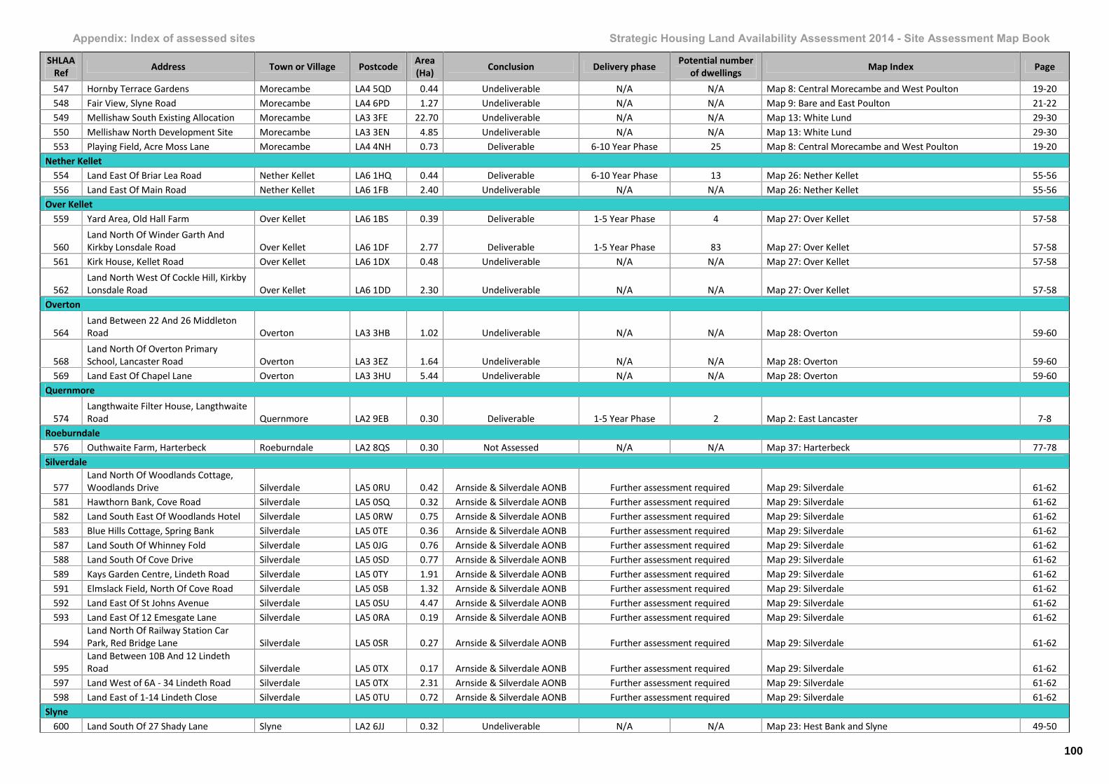
Appendix: Index of assessed sites Strategic Housing Land Availability Assessment 2014 - Site Assessment Map Book
SHLAARef Address Town or Village Postcode Area
(Ha) Conclusion Delivery phase Potential numberof dwellings Map Index Page
547 Hornby Terrace Gardens Morecambe LA4 5QD 0.44 Undeliverable N/A N/A Map 8: Central Morecambe and West Poulton 19-20548 Fair View, Slyne Road Morecambe LA4 6PD 1.27 Undeliverable N/A N/A Map 9: Bare and East Poulton 21-22549 Mellishaw South Existing Allocation Morecambe LA3 3FE 22.70 Undeliverable N/A N/A Map 13: White Lund 29-30550 Mellishaw North Development Site Morecambe LA3 3EN 4.85 Undeliverable N/A N/A Map 13: White Lund 29-30553 Playing Field, Acre Moss Lane Morecambe LA4 4NH 0.73 Deliverable 6-10 Year Phase 25 Map 8: Central Morecambe and West Poulton 19-20
Nether Kellet554 Land East Of Briar Lea Road Nether Kellet LA6 1HQ 0.44 Deliverable 6-10 Year Phase 13 Map 26: Nether Kellet 55-56556 Land East Of Main Road Nether Kellet LA6 1FB 2.40 Undeliverable N/A N/A Map 26: Nether Kellet 55-56
Over Kellet559 Yard Area, Old Hall Farm Over Kellet LA6 1BS 0.39 Deliverable 1-5 Year Phase 4 Map 27: Over Kellet 57-58
560Land North Of Winder Garth AndKirkby Lonsdale Road Over Kellet LA6 1DF 2.77 Deliverable 1-5 Year Phase 83 Map 27: Over Kellet 57-58
561 Kirk House, Kellet Road Over Kellet LA6 1DX 0.48 Undeliverable N/A N/A Map 27: Over Kellet 57-58
562Land North West Of Cockle Hill, KirkbyLonsdale Road Over Kellet LA6 1DD 2.30 Undeliverable N/A N/A Map 27: Over Kellet 57-58
Overton
564Land Between 22 And 26 MiddletonRoad Overton LA3 3HB 1.02 Undeliverable N/A N/A Map 28: Overton 59-60
568Land North Of Overton PrimarySchool, Lancaster Road Overton LA3 3EZ 1.64 Undeliverable N/A N/A Map 28: Overton 59-60
569 Land East Of Chapel Lane Overton LA3 3HU 5.44 Undeliverable N/A N/A Map 28: Overton 59-60Quernmore
574Langthwaite Filter House, LangthwaiteRoad Quernmore LA2 9EB 0.30 Deliverable 1-5 Year Phase 2 Map 2: East Lancaster 7-8
Roeburndale576 Outhwaite Farm, Harterbeck Roeburndale LA2 8QS 0.30 Not Assessed N/A N/A Map 37: Harterbeck 77-78
Silverdale
577Land North Of Woodlands Cottage,Woodlands Drive Silverdale LA5 0RU 0.42 Arnside & Silverdale AONB Further assessment required Map 29: Silverdale 61-62
581 Hawthorn Bank, Cove Road Silverdale LA5 0SQ 0.32 Arnside & Silverdale AONB Further assessment required Map 29: Silverdale 61-62582 Land South East Of Woodlands Hotel Silverdale LA5 0RW 0.75 Arnside & Silverdale AONB Further assessment required Map 29: Silverdale 61-62583 Blue Hills Cottage, Spring Bank Silverdale LA5 0TE 0.36 Arnside & Silverdale AONB Further assessment required Map 29: Silverdale 61-62587 Land South Of Whinney Fold Silverdale LA5 0JG 0.76 Arnside & Silverdale AONB Further assessment required Map 29: Silverdale 61-62588 Land South Of Cove Drive Silverdale LA5 0SD 0.77 Arnside & Silverdale AONB Further assessment required Map 29: Silverdale 61-62589 Kays Garden Centre, Lindeth Road Silverdale LA5 0TY 1.91 Arnside & Silverdale AONB Further assessment required Map 29: Silverdale 61-62591 Elmslack Field, North Of Cove Road Silverdale LA5 0SB 1.32 Arnside & Silverdale AONB Further assessment required Map 29: Silverdale 61-62592 Land East Of St Johns Avenue Silverdale LA5 0SU 4.47 Arnside & Silverdale AONB Further assessment required Map 29: Silverdale 61-62593 Land East Of 12 Emesgate Lane Silverdale LA5 0RA 0.19 Arnside & Silverdale AONB Further assessment required Map 29: Silverdale 61-62
594Land North Of Railway Station CarPark, Red Bridge Lane Silverdale LA5 0SR 0.27 Arnside & Silverdale AONB Further assessment required Map 29: Silverdale 61-62
595Land Between 10B And 12 LindethRoad Silverdale LA5 0TX 0.17 Arnside & Silverdale AONB Further assessment required Map 29: Silverdale 61-62
597 Land West of 6A - 34 Lindeth Road Silverdale LA5 0TX 2.31 Arnside & Silverdale AONB Further assessment required Map 29: Silverdale 61-62598 Land East of 1-14 Lindeth Close Silverdale LA5 0TU 0.72 Arnside & Silverdale AONB Further assessment required Map 29: Silverdale 61-62
Slyne600 Land South Of 27 Shady Lane Slyne LA2 6JJ 0.32 Undeliverable N/A N/A Map 23: Hest Bank and Slyne 49-50
100

Appendix: Index of assessed sites Strategic Housing Land Availability Assessment 2014 - Site Assessment Map Book
SHLAARef Address Town or Village Postcode Area
(Ha) Conclusion Delivery phase Potential numberof dwellings Map Index Page
603 Land West Of Road Slyne LA2 6AU 3.12 Undeliverable N/A N/A Map 23: Hest Bank and Slyne 49-50604 Land North Of Manor Lane Slyne LA2 6RD 0.50 Undeliverable N/A N/A Map 23: Hest Bank and Slyne 49-50
Swarthdale605 Swarthdale Farm, Swarthdale Road Swarthdale LA6 1BQ 0.72 Undeliverable N/A N/A Map 39: Swarthdale 81-82
Warton612 Town End Farm, Main Street Warton LA5 9NT 0.04 Arnside & Silverdale AONB Further assessment required Map 30: Warton 63-64614 Land South East Of 25-79 Sand Lane Warton LA5 9NJ 3.37 Arnside & Silverdale AONB Further assessment required Map 30: Warton 63-64615 Land Between 14 And 48 Main Street Warton LA5 9NS 0.25 Arnside & Silverdale AONB Further assessment required Map 30: Warton 63-64
618Land Between Corfe Farm And TownEnd Farm, Sand Lane Warton LA5 9NN 2.67 Arnside & Silverdale AONB Further assessment required Map 30: Warton 63-64
620 Tewitfield Farm, Burton Road Warton LA6 1JH 0.73 Not assessed N/A N/A Map 30: Warton 63-64
622Land North Of Mill Lane And Town EndFold Warton LA5 9NE 1.47 Arnside & Silverdale AONB Further assessment required Map 30: Warton 63-64
623 184 Main Street Warton LA5 9PT 0.37 Arnside & Silverdale AONB Further assessment required Map 30: Warton 63-64
625Land North West Of Corfe Cottage,Sand Lane Warton LA5 9NJ 0.59 Arnside & Silverdale AONB Further assessment required Map 30: Warton 63-64
626Land South East Of Archbishop HuttonPrimary School Warton LA5 9QT 1.27 Arnside & Silverdale AONB Further assessment required Map 30: Warton 63-64
627 Land West Of Coach Road Warton LA5 9PR 0.45 Arnside & Silverdale AONB Further assessment required Map 30: Warton 63-64628 2 Holly Bank Warton LA5 9PL 0.28 Arnside & Silverdale AONB Further assessment required Map 30: Warton 63-64
Wennington631 Forgewood, Wray Road Wennington LA2 8NN 0.64 Undeliverable N/A N/A Map 40: Wennington 83-84
Whittington636 Harrison Farm, Main Street Whittington LA6 2NX 1.08 Deliverable 6-10 Year Phase 30 Map 41: Whittington 85-86
Wray
637Land North Of Homes, WenningtonRoad Wray LA2 8QL 1.94 Deliverable 11-15 Year Phase 29 Map 31: Wray 65-66
638 Appletree Barn Wray LA2 8QH 0.26 Deliverable 1-5 Year Phase 4 Map 31: Wray 65-66639 Wood Ho Wray LA2 8QQ 0.22 Deliverable 1-5 Year Phase 6 Map 31: Wray 65-66642 Hoskins Farm, Main Street Wray LA2 8RZ 0.54 Undeliverable N/A N/A Map 31: Wray 65-66643 Land East Of Home Farm Close Wray LA2 8RG 3.46 Deliverable 6-10 Year Phase 50 Map 31: Wray 65-66
Yealand Conyers645 Land East Of Yealand Road Yealand Conyers LA5 9SH 0.68 Arnside & Silverdale AONB Further assessment required Map 42: Yealand Conyers and Yealand Redmayne 87-88
Yealand Redmayne
648 Land North And East Of The Meadows Yealand Redmayne LA5 9SY 1.37 Arnside & Silverdale AONB Further assessment required Map 42: Yealand Conyers and Yealand Redmayne 87-88
101

Regeneration and Planning, March 2014