strategic housing land availability assessment (shlaa) 2016/2017 · strategic housing land...
TRANSCRIPT

Strategic Housing Land Availabili ty Assessment (SHLAA) 2016/2017
Site Submissions - Preferred Options Stage
May 2018

Contents PO1a Land at Sellindge West
PO1b Land at Sellindge West
PO2 Cydonia, Newingreen
PO3 Hawkinge East
PO4 Land West of Canterbury Road, Lyminge
PO5 Red House Lane, Lyminge
PO6 Port Lympne Zoo Park
PO7 Land South of Aldington Road, Lympne
PO8 Land rear of Touchwood, Stanford
PO9 Land opposite Underhill Cottages, Peene
PO10 Cherry Gardens, Elham
PO11 Cock Lane, Elham
PO12 Cullens Hill, Elham
PO13 Land at Canterbury Road, Elham
PO14 Land West of Canterbury Road, Elham
PO15 Land East of Canterbury Road, Elham
PO16 Three Acres, Park Farm, Folkestone
PO17 Five Acres, Park Farm, Folkestone
PO18 Land between Hillside and Brandet House, Brenzett
PO19 Land adjacent to Framlea, Brookland
PO20 Cherry Garden, Littlestone
PO21 Land behind Village Hall Car Park, Dymchurch
PO22 Fairfield Court Farm, Brookland
PO23 Land at Harden Road, Lydd
PO24 Land at Harden Road, Lydd
PO25 Land adjacent to Josephs Way, New Romney
PO26 Cemex Station Approach, New Romney
PO27 Recreational Ground, Dymchurch
PO28 Land at St Andrews Road, Littlestone
PO29 Land off Teddars Leas Road, Etchinghill
P030 Land off Boarmans Road, Brookland
PO31 Land off Jenner's Way

Site Form
SHLAA Ref: PO1a SDC Ward:
North Downs West
Site Name/Address:
Land at Sellindge West Source: Places and Policies Preferred Options Submission
Current Use: Agricultural land Area (ha): 0.52
Site Visit: 23 February 2017
Stage 1: Initial Assessment on suitability
A Is the size of the site 0.17ha or over (to enable the development of five or more dwellings)
Yes
B Has the site been allocated for housing; or been identified as suitable in previous assessments; or has had planning permission; or there has been a positive change in circumstances; or is a new site?
New Site
C Is the site within or does it contain any of the following:
· SAC
· SSSI
· National Nature Reserve
· Ramsar
· SPA
· Ancient Woodland
· an Extreme Flood Hazard (as defined in the SFRA for the year 2115)
· Scheduled Monument
· Registered Parks and Gardens
No
Proceed to Stage 2?
Yes

Stage 2: Detailed Assessment on suitability
A Relationship to the settlement hierarchy?
The site adjoins two parts of the fragmented linear settlement boundary of the rural centre of Sellindge.
Physical or Infrastructure Constraints:
i) Can a suitable access to the highway network be created?
Yes – Ashford Road
ii) Is there adequate highway capacity? Yes
iii) Is there water supply? Yes. Connection available from Ashford Road
iv) Is there sewerage? Yes. Connection available from Ashford Road
v) Is there electricity supply? Yes. Connection available from Ashford Road
vi) Are there electricity pylons on site? No
vii) Is there contamination? None known
viii) Are there adverse ground conditions?
None known
ix) Is there any hazardous risk? None known
x) Is there difficult topography?
No
xi) Is there a river near or on the site? No
xii) Is it in flood zone 2? No
xiii) Is it in flood zone 3? If yes hazard rating 2115 with climate change - Nil/Low/Moderate/Significant
No
C Could the development potentially have a detrimental impact on any of the following?
i) Townscape
Yes. Development would create a constant linear form along Ashford Road.
ii) Landscape
Yes. The gaps along the Ashford Road allow glimpse views through to the open countryside, giving a rural feel to the village.
iii) AONB and its immediate setting
Possible impact the setting of the Kent Downs AONB
iv) Kent BAP sites
Unknown
v) Tree Preservation Orders
No
vi) Heritage Assets
In an Area of Archaeological Potential
vii) Historic Park/Garden or Square
No

viii) Local Wildlife Site
No
ix) Protected Open Space
No
D Has the site been identified to be retained in the Employment Land Review?
No
E Is the site safeguarded (including minerals)?
Limestone Hythe Formation (Kentish Ragstone)
F Sustainable Location. How does the site perform against the following criteria?
· Within 800m of a bus stop or railway station
Yes. Ashford Road (50m approx)
· Within 800m of a primary school
Yes. Sellindge Primary School (750m approx)
· Within 800m of a convenience store
Not the main Co op, but it is located 125m (approx) from a farm shop selling a good selection of food items.
· Within 1km of a GP surgery Yes. Sellindge Surgery (900m approx.)
G External Environmental Factors
Would the amenity of residents be adversely affected by any external environmental factors? Is a buffer area required?
No
Proceed to Stage 3?
Yes. Although impacts on the rural landscape and the setting of the AONB need further checks.
Stage 3: Deliverability
A Do any of the following factors affect the availability of the site?
i) Multiple Ownership/Ransom Strip
The site is in single ownship
ii) Existing Tenancy/Lease Agreement
No
iii) Willingness of the Owner(s) to Sell
Not Specified
iv) Willingness of the Developer to Develop
Not Specified
v) Occupied by Use unlikely to Cease
No

Proceed to Stage 4?
Yes
Stage 4: Achievability
A Market Interests
i) Compatible with Adjacent Uses
The site would be compatible with the residential areas to the east and west.
ii) Land Values compared with Existing and Alternative Uses
Residential development on this site would significantly increase the land value, as the site is currently undeveloped.
iii) Attractiveness of Locality
Attractive semi-rural location
iv) Demand CIL Charging Schedule: Zone D £125- Very Good
B Cost
i) site preparation
There does not appear to be any significant site preparation costs associated with the development of this site to residential.
ii) abnormal costs;
There does not appear to be any abnormal costs associated with the development of this site.
iii) planning policy
No
iv) infrastructure
There does not appear to be any specific infrastructure constraints on this site.
C i) Type of dwelling
Not Specified
ii) Quantity
10
D Delivery and Phasing
Is the site ‘deliverable’ (1 - 5 years)?
Yes
Is the site ‘developable’ (6 – 15 years)?

Stage 5: Comments from other organisations
· SDC Internal – Property/Housing/Environmental Health No comments
· KCC Highways This site can accommodate a total of 10 dwellings. An adequate access could be provided with suitable visibility splays of 2.4 metres by 120 metres. There are footpaths on both sides of Ashford Road and bus stops within close proximity of the site.
· Highways Agency No comment
· Environment Agency No comment
· Natural England In setting of Kent Downs AONB, potential to impact on views from AONB. Landscape & Visual Impact Assessment will be necessary. NPPF paragraph 115 will apply.
· Kent Downs AONB Outside of AONB, but within setting. Any development should be of an appropriate scale, design and layout and incorporate adequate landscaping to mitigate impact on AONB.
· Kent Wildlife Trust No comment
· HSE No comment
· Local Authorities (Ashford, Dover, Canterbury, Rother) No Comment
CONCLUSIONS The site is open countryside and an outlying greenfield gap in the linear and sporadic development which has taken place along the Ashford Road (A20) in Sellindge. These gaps allow views to further open countryside and towards the AONB beyond, helping to maintain the rural feel and character of the village. The infill would merge two small pockets of existing development. However the Core Strategy (2013) focused on creating a central village core and a broad location was allocated. It was further suggested that the outlying pockets of development might have their settlement boundaries removed in the future. The allocation of this site would further reinforce the linear nature of the village and the lack of identify this has created in the past.

The site is a fair walk away from the central Sellindge area where most of the facilities are located however it is only a short walk away from the Church, Public House and Potten Farm shop.
Completed by R Chittock.
Signed ...........................................................
Date ...........................................................

Site Form
SHLAA Ref: PO1b SDC Ward:
North Downs West
Site Name/Address:
Land at Sellindge West Source: Places and Policies Preferred Options Submission
Current Use: Agricultural Land Area (ha): 3.16
Site Visit: 23 February 2017
Stage 1: Initial Assessment on suitability
A Is the size of the site 0.17ha or over (to enable the development of five or more dwellings)
Yes
B Has the site been allocated for housing; or been identified as suitable in previous assessments; or has had planning permission; or there has been a positive change in circumstances; or is a new site?
New Site
C Is the site within or does it contain any of the following:
· SAC
· SSSI
· National Nature Reserve
· Ramsar
· SPA
· Ancient Woodland
· an Extreme Flood Hazard (as defined in the SFRA for the year 2115)
· Scheduled Monument
· Registered Parks and Gardens
No
Proceed to Stage 2?
Yes

Stage 2: Detailed Assessment on suitability
A Relationship to the settlement hierarchy?
The site adjoins two parts of the fragmented linear settlement boundary of the rural centre of Sellindge.
Physical or Infrastructure Constraints:
i) Can a suitable access to the highway network be created?
Yes - Ashford Road
ii) Is there adequate highway capacity? Yes
iii) Is there water supply? Yes. Connection available from Ashford Road
iv) Is there sewerage? Yes. Connection available from Ashford Road
v) Is there electricity supply? Yes. Connection available from Ashford Road
vi) Are there electricity pylons on site? No
vii) Is there contamination? None known
viii) Are there adverse ground conditions?
None known
ix) Is there any hazardous risk? None known
x) Is there difficult topography?
No
xi) Is there a river near or on the site? No
xii) Is it in flood zone 2? No
xiii) Is it in flood zone 3? If yes hazard rating 2115 with climate change - Nil/Low/Moderate/Significant
No
C Could the development potentially have a detrimental impact on any of the following?
i) Townscape
Yes. Development would create a constant linear form along Ashford Road.
ii) Landscape
The gaps along the Ashford Road allow glimpse views through to the open countryside giving a rural feel to the village.
iii) AONB and its immediate setting
Possible impact on the setting of the Kent Downs AONB
iv) Kent BAP sites
Unknown
v) Tree Preservation Orders
No
vi) Heritage Assets
In an Area of Archaeological Potential
vii) Historic Park/Garden or Square
No

viii) Local Wildlife Site
No
ix) Protected Open Space
No
D Has the site been identified to be retained in the Employment Land Review?
No
E Is the site safeguarded (including minerals)?
Limestone Hythe Formation (Kentish Ragstone)
F Sustainable Location. How does the site perform against the following criteria?
· Within 800m of a bus stop or railway station
Yes. Ashford Road (50m approx.).
· Within 800m of a primary school
Yes. Sellindge Primary School (750m approx.).
· Within 800m of a convenience store
Not the main Co-op, but it is located 125m from a farm shop selling a good selection of food items.
· Within 1km of a GP surgery Yes. Sellindge Surgery (900m approx.)
G External Environmental Factors
Would the amenity of residents be adversely affected by any external environmental factors? Is a buffer area required?
No
Proceed to Stage 3?
Yes. Although impacts on the rural landscape and the setting of the Kent Downs AONB need further checks.
Stage 3: Deliverability
A Do any of the following factors affect the availability of the site?
i) Multiple Ownership/Ransom Strip
The site is in single ownership
ii) Existing Tenancy/Lease Agreement
Likely agricultural tenancy
iii) Willingness of the Owner(s) to Sell
Not specified
iv) Willingness of the Developer to Develop
Not specified
v) Occupied by Use unlikely to Cease
No

Proceed to Stage 4?
Yes
Stage 4: Achievability
A Market Interests
i) Compatible with Adjacent Uses
The site would be compatible with the residential areas to the east and west.
ii) Land Values compared with Existing and Alternative Uses
Residential development on this site would significantly increase the land value, as the site is currently undeveloped.
iii) Attractiveness of Locality
Attractive semi-rural location
iv) Demand CIL Charging Schedule: Zone D £125- Very Good
B Cost
i) site preparation
There does not appear to be any significant site preparation costs associated with the development of this site to residential.
ii) abnormal costs;
There does not appear to be any abnormal costs associated with the development of this site.
iii) planning policy
No
iv) infrastructure
There does not appear to be any specific infrastructure constraints on this site.
C i) Type of dwelling
Not Specified
ii) Quantity
60 (approx.)
D Delivery and Phasing
Is the site ‘deliverable’ (1 - 5 years)?
Yes
Is the site ‘developable’ (6 – 15 years)?

Stage 5: Comments from other organisations
· SDC Internal – Property/Housing/Environmental Health No comments
· KCC Highways This site can accommodate a total of 60 dwellings. An adequate access could be provided with suitable visibility splays of 2.4 metres by 120 metres. There are footpaths on both sides of Ashford Road and bus stops within close proximity of the site.
· Highways Agency No comment
· Environment Agency No comment
· Natural England In setting of Kent Downs AONB, potential to impact on views from AONB. Landscape & Visual Impact Assessment will be necessary. NPPF paragraph 115 will apply.
· Kent Downs AONB Outside of AONB, but within setting. Any development should be of an appropriate scale, design and layout and incorporate adequate landscaping to mitigate impact on AONB.
· Kent Wildlife Trust No comment
· HSE No comment
· Local Authorities (Ashford, Dover, Canterbury, Rother) No comment
CONCLUSIONS The site is open countryside and an outlying greenfield gap in the linear and sporadic development which has taken place along the Ashford Road (A20) in Sellindge. These gaps allow views to further open countryside and the AONB beyond, helping to maintain the rural feel and character of the village. The infill would merge two small pockets of existing development. The site also extends further back and is not just infill but a large extension into the open countryside and the setting of the AONB beyond. The Core Strategy (2013) focused on creating a central village core and a broad location was allocated. It was further suggested that the outlying pockets of development might have their settlement boundaries removed in the future. The allocation of this site would further

reinforce the linear nature of the village and the lack of identify this has created in the past. The site is a fair walk away from the central Sellindge area where most of the facilities are located however it is only a short walk away from the Church, Public House and Potten Farm shop.
Completed by R Chittock
Signed ...........................................................
Date ...........................................................

Site Form
SHLAA Ref: PO2 SDC Ward:
Hythe Rural
Site Name/Address:
Cydonia Source: Places and Policies Preferred Options Submission
Current Use: Former nursery and residential dwelling
Area (ha): 1.43 ha
Site Visit: 23 February 2017
Stage 1: Initial Assessment on suitability
A Is the size of the site 0.17ha or over (to enable the development of five or more dwellings)
Yes
B Has the site been allocated for housing; or been identified as suitable in previous assessments; or has had planning permission; or there has been a positive change in circumstances; or is a new site?
New Site
C Is the site within or does it contain any of the following:
· SAC
· SSSI
· National Nature Reserve
· Ramsar
· SPA
· Ancient Woodland
· an Extreme Flood Hazard (as defined in the SFRA for the year 2115)
· Scheduled Monument
· Registered Parks and Gardens
No
Proceed to Stage 2?
Yes

Stage 2: Detailed Assessment on suitability
A Relationship to the settlement hierarchy?
Newingreen does not feature on the settlement hierarchy and does not have a settlement boundary
Physical or Infrastructure Constraints:
i) Can a suitable access to the highway network be created?
Yes – Ashford Road
ii) Is there adequate highway capacity? Yes
iii) Is there water supply? Yes. Connection available from the Ashford Road
iv) Is there sewerage? Yes. Connection available from the Ashford Road
v) Is there electricity supply? Yes. Connection available from the Ashford Road
vi) Are there electricity pylons on site? No
vii) Is there contamination? None known
viii) Are there adverse ground conditions?
None known
ix) Is there any hazardous risk? None known
x) Is there difficult topography?
No
xi) Is there a river near or on the site? No
xii) Is it in flood zone 2? No
xiii) Is it in flood zone 3? If yes hazard rating 2115 with climate change - Nil/Low/Moderate/Significant
No
C Could the development potentially have a detrimental impact on any of the following?
i) Townscape
No
ii) Landscape
Possible impact on the openness of the landscape
iii) AONB and its immediate setting
No
iv) Kent BAP sites
Unknown
v) Tree Preservation Orders
No
vi) Heritage Assets
In an Area of Archaeological Potential
vii) Historic Park/Garden or Square
No
viii) Local Wildlife Site
No
ix) Protected Open Space
No
D Has the site been identified to be retained in the Employment Land Review?
No
E Is the site safeguarded (including minerals)?
Sandgate Sandstone Formation
F Sustainable Location. How does the site perform against the following criteria?
· Within 800m of a bus stop or railway station
Yes. Ashford Road, Holiday Extras (700m approx.)
· Within 800m of a primary school
No. Lympne Primary School (1.3m approx.)
· Within 800m of a convenience store
No. Lympne Village Stores (1.2m approx.)
· Within 1km of a GP surgery No. Sellindge Surgery (1.6m approx.)
G External Environmental Factors
Would the amenity of residents be adversely affected by any external environmental factors? Is a buffer area required?
No
Proceed to Stage 3?
No. Site not in a sustainable location.
Stage 3: Deliverability
A Do any of the following factors affect the availability of the site?
i) Multiple Ownership/Ransom Strip
ii) Existing Tenancy/Lease Agreement
iii) Willingness of the Owner(s) to Sell
iv) Willingness of the Developer to Develop
v) Occupied by Use unlikely to Cease
Proceed to Stage 4?

Stage 4: Achievability
A Market Interests
i) Compatible with Adjacent Uses
ii) Land Values compared with Existing and Alternative Uses
iii) Attractiveness of Locality
iv) Demand
B Cost
i) site preparation
ii) abnormal costs;
iii) planning policy
iv) infrastructure
C i) Type of dwelling
ii) Quantity
D Delivery and Phasing
Is the site ‘deliverable’ (1 - 5 years)?
Is the site ‘developable’ (6 – 15 years)?
Stage 5: Comments from other organisations
· SDC Internal – Property/Housing/Environmental Health A contaminated land desk top study would be required as a condition for any proposed planning applications. There may be some noise issues from the commercial units at Benham Water Farm, Ashford Road. Mitigating conditions may be possible to remedy these issues.
· KCC Highways A proposal for 6-8 units is unlikely to generate more vehicle movements than the existing use of the site as nursery. The site is however in an unsustainable location remote from local services.
· Highways Agency No comment

· Environment Agency Groundwater and Contaminated Land Comments Nursery - Preliminary Risk Assessment will be required
· Natural England No comment
· Kent Downs AONB No comment
· Kent Wildlife Trust No comment
· HSE No comment
· Local Authorities (Ashford, Dover, Canterbury, Rother) No comment
CONCLUSIONS The site is unsuitable to be considered for development within the Places and Policies Local Plan document because at present Newingreen is not a sustainable location within the Core Strategy. However this site would be appropriate to look at again in the Core Strategy Review.
Completed by R Chittock
Signed ...........................................................
Date ...........................................................

Site Form
SHLAA Ref: PO3 SDC Ward:
North Downs East
Site Name/Address:
East Hawkinge Lands, Hawkinge
Source: Places and Policies Preferred Options Submission
Current Use: Agricultural field Area (ha): 2.5
Site Visit: 21 February 2017
Stage 1: Initial Assessment on suitability
A Is the size of the site 0.17ha or over (to enable the development of five or more dwellings)
Yes.
B Has the site been allocated for housing; or been identified as suitable in previous assessments; or has had planning permission; or there has been a positive change in circumstances; or is a new site?
Site area has been reduced since previous submission (SHLAA/316)
C Is the site within or does it contain any of the following:
· SAC
· SSSI
· National Nature Reserve
· Ramsar
· SPA
· Ancient Woodland
· an Extreme Flood Hazard (as defined in the SFRA for the year 2115)
· Scheduled Monument
· Registered Parks and Gardens
No. However it is in the Kent Downs AONB
Proceed to Stage 2?
Yes

Stage 2: Detailed Assessment on suitability
A Relationship to the settlement hierarchy?
This site adjoins the settlement boundary of the Service Centre of Hawkinge.
Physical or Infrastructure Constraints:
i) Can a suitable access to the highway network be created?
Yes – ‘The Berries’
ii) Is there adequate highway capacity? Yes
iii) Is there water supply? Yes. Connection available from the adjacent site
iv) Is there sewerage? Yes. Connection available from the adjacent site
v) Is there electricity supply? Yes. Connection available from the adjacent site
vi) Are there electricity pylons on site? No
vii) Is there contamination? None known
viii) Are there adverse ground conditions?
None known
ix) Is there any hazardous risk? None known
x) Is there difficult topography?
No
xi) Is there a river near or on the site? No
xii) Is it in flood zone 2? No
xiii) Is it in flood zone 3? If yes hazard rating 2115 with climate change - Nil/Low/Moderate/Significant
No
C Could the development potentially have a detrimental impact on any of the following?
i) Townscape
Yes. The site is located adjacent to the existing settlement. Development would have the effect extending the village settlement boundary.
ii) Landscape
Yes. Development would be an encroachment into the open countryside and Kent Downs AONB
iii) AONB and its immediate setting
Possible impact on the Kent Downs AONB
iv) Kent BAP sites
Unknown
v) Tree Preservation Orders
No
vi) Heritage Assets
In an Area of Archaeological Potential
vii) Historic Park/Garden or Square
No

viii) Local Wildlife Site
No
ix) Protected Open Space
Policy CO24 Strategic Landscape buffer
D Has the site been identified to be retained in the Employment Land Review?
No
E Is the site safeguarded (including minerals)?
Brickearth (other Areas)
F Sustainable Location. How does the site perform against the following criteria?
· Within 800m of a bus stop or railway station
Yes. Canterbury Road (650m approx)
· Within 800m of a primary school
Yes. Hawkinge Primary School (550m approx)
· Within 800m of a convenience store
Yes. Tesco Express (650m approx)
· Within 1km of a GP surgery Yes. Hawkinge and Elham Valley Practice (600m approx)
G External Environmental Factors
Would the amenity of residents be adversely affected by any external environmental factors? Is a buffer area required?
No
Proceed to Stage 3?
Yes. However the sites impact on the AONB requires specific consideration
Stage 3: Deliverability
A Do any of the following factors affect the availability of the site?
i) Multiple Ownership/Ransom Strip
The site is in single ownership
ii) Existing Tenancy/Lease Agreement
Yes
iii) Willingness of the Owner(s) to Sell
Not Specified
iv) Willingness of the Developer to Develop
Not Specified
v) Occupied by Use unlikely to Cease
The land is let on an agricultural tenancy which has provisions allowing it to taken back for development.
Proceed to Stage 4?
Yes

Stage 4: Achievability
A Market Interests
i) Compatible with Adjacent Uses
The site would be compatible with the residential areas to the west
ii) Land Values compared with Existing and Alternative Uses
Residential development on this site would significantly increase the land value, as the site is currently undeveloped.
iii) Attractiveness of Locality
Attractive semi-rural location.
iv) Demand CIL Charging Schedule: Zone B £50- Medium
B Cost
i) site preparation
There does not appear to be any significant site preparation costs associated with the development of this site to residential
ii) abnormal costs;
There does not appear to be any abnormal costs associated with the development of this site.
iii) planning policy
Policy CO24 Strategic Landscape buffer
iv) infrastructure
There does not appear to be any specific infrastructure constraints on this site.
C i) Type of dwelling
Not Specified
ii) Quantity
50 (approx.)
D Delivery and Phasing
Is the site ‘deliverable’ (1 - 5 years)?
Yes
Is the site ‘developable’ (6 – 15 years)?
Stage 5: Comments from other organisations
· SDC Internal – Property/Housing/Environmental Health No comment
· KCC Highways The site appears to be landlocked with no clear indication of how an access point can be provided from the public highway. Should an access be able to be provided via The Berries then a total of 50 dwellings may be suitable.
· Highways Agency No comment

· Environment Agency No comment
· Natural England No comment
· Kent Downs AONB No comment Within AONB and a greenfield site. Would represent a major development, contrary to NPPF para 116 and would challenge the conservation of the AONB. Not supported.
· Kent Wildlife Trust No comment
· HSE No comment
· Local Authorities (Ashford, Dover, Canterbury, Rother) No comment
CONCLUSIONS The site adjoins the settlement boundary of Hawkinge a rural centre in the North Downs Character Area with good facilities and transport links. The site is relatively close/ walkable to the centre of Hawkinge. The site has once again been revised and reduced in site to respond to the previous SHLAA conclusions, coming down from 10ha to 2.5ha. However the site is a greenfield expansion within the Kent Downs AONB and sequentially would not be a preferred site while there remain brownfield sites or sites within the settlement boundary.
Completed by R Chittock
Signed ...........................................................
Date ...........................................................

Site Form
SHLAA Ref: PO4 SDC Ward:
North Downs West
Site Name/Address:
Land South West of Canterbury Rd
Source: Places and Policies Preferred Options Submission
Current Use: Agricultural Land Area (ha): 3.85
Site Visit: 21 February 2017
Stage 1: Initial Assessment on suitability
A Is the size of the site 0.17ha or over (to enable the development of five or more dwellings)
Yes
B Has the site been allocated for housing; or been identified as suitable in previous assessments; or has had planning permission; or there has been a positive change in circumstances; or is a new site?
New Site
C Is the site within or does it contain any of the following:
SAC
SSSI
National Nature Reserve
Ramsar
SPA
Ancient Woodland
an Extreme Flood Hazard (as defined in the SFRA for the year 2115)
Scheduled Monument
Registered Parks and Gardens
No. However it is in the Kent Downs AONB
Proceed to Stage 2?
Yes.
Stage 2: Detailed Assessment on suitability
A Relationship to the settlement hierarchy?
The site adjoins the settlement boundary of the Rural Centre of Lyminge.
Physical or Infrastructure Constraints:
i) Can a suitable access to the highway network be created?
No. See KCC Highway comments below
ii) Is there adequate highway capacity? Yes
iii) Is there water supply? Yes. Connection available from Canterbury Road
iv) Is there sewerage? Yes. Connection available from Canterbury Road
v) Is there electricity supply? Yes. Connection available from Canterbury Road
vi) Are there electricity pylons on site? No
vii) Is there contamination? None known
viii) Are there adverse ground conditions?
None known
ix) Is there any hazardous risk? None known
x) Is there difficult topography?
No
xi) Is there a river near or on the site? No
xii) Is it in flood zone 2? No
xiii) Is it in flood zone 3? If yes hazard rating 2115 with climate change - Nil/Low/Moderate/Significant
No
C Could the development potentially have a detrimental impact on any of the following?
i) Townscape
Yes. The site is located adjacent to existing settlement. Development would have the effect extending the natural start/end point of the village settlement boundary.
ii) Landscape
Yes. Development would be an encroachment into the open countryside and Kent Downs AONB
iii) AONB and its immediate setting
Possible impact on the Kent Downs AONB
iv) Kent BAP sites
Unknown
v) Tree Preservation Orders
No
vi) Heritage Assets
Partially in an Area of Archaeological Potential
vii) Historic Park/Garden or Square
No

viii) Local Wildlife Site
No
ix) Protected Open Space
No
D Has the site been identified to be retained in the Employment Land Review?
No
E Is the site safeguarded (including minerals)?
No
F Sustainable Location. How does the site perform against the following criteria?
Within 800m of a bus stop or railway station
Yes. Station Road (170m approx)
Within 800m of a primary school
Yes. Lyminge Primary School (550m approx)
Within 800m of a convenience store
Yes. Convenience Store (350m approx)
Within 1km of a GP surgery Yes. New Lyminge Surgery (0.1km)
G External Environmental Factors
Would the amenity of residents be adversely affected by any external environmental factors? Is a buffer area required?
No
Proceed to Stage 3?
Yes however the sites setting in the AONB could result in some potential contraints which could result in site capacity reductions. The boundary trees need to be properly appraised and considered in relation to the possible development of this site.
Stage 3: Deliverability
A Do any of the following factors affect the availability of the site?
i) Multiple Ownership/Ransom Strip
The site is in single ownership
ii) Existing Tenancy/Lease Agreement
To be confirmed
iii) Willingness of the Owner(s) to Sell
Not Specified
iv) Willingness of the Developer to Develop
Not Specified
v) Occupied by Use unlikely to Cease
No
Proceed to Stage 4?
Yes

Stage 4: Achievability
A Market Interests
i) Compatible with Adjacent Uses
The site would be compatible with the residential areas to the west
ii) Land Values compared with Existing and Alternative Uses
Residential development on this site would significantly increase the land value, as the site is currently undeveloped.
iii) Attractiveness of Locality
Attractive rural location
iv) Demand CIL Charging Schedule: Zone D £125- Very High
B Cost
i) site preparation
There does not appear to be any significant site preparation costs associated with the development of this site to residential
ii) abnormal costs;
There does not appear to be any abnormal costs associated with the development of this site.
iii) planning policy
No
iv) infrastructure
There does not appear to be any specific infrastructure constraints on this site.
C i) Type of dwelling
ii) Quantity
50 (approx.)
D Delivery and Phasing
Is the site ‘deliverable’ (1 - 5 years)?
Yes
Is the site ‘developable’ (6 – 15 years)?
Stage 5: Comments from other organisations
SDC Internal – Property/Housing/Environmental Health No Comments
KCC Highways Access would have to be provided from Canterbury Road, which is subject to a 60mph speed limit. There is no footpath along the western side of Canterbury Road. Visibility splays of 2.4 metres by 215 metres would be required, which cannot be provided. KCC Highways would not support an allocation on this site
Highways Agency

No Comments
Environment Agency No Comments
Natural England Together with PO5, presents significant extension of existing settlement at Lyminge and is within Kent Downs AONB. Would need Landscape & Visual Impact Assessment. NPPF paragraphs 115 and 116 will apply.
Kent Downs AONB Within AONB. Development here would result in inappropriate extension of village southwards on prominent site and represent a major development, contrary to NPPF para 116. Not supported.
Kent Wildlife Trust This site is close to LWS SH07, in combination with other planned development between this site and the LWS, this threatens to envelop/surround this LWS with indirect negative impacts on nature conservation. It would be very difficult to adequately mitigate for this.
HSE No Comments
Local Authorities (Ashford, Dover, Canterbury, Rother) No Comments
CONCLUSIONS The site would go against the current urban form in the area, to the south west the pattern of development is currently more open, resulting in encroachment into the countryside. In addition the sites impact on the AONB, potential archaeology and access difficulties require specific consideration and investigate. However Lyminge is a rural centre and has good facilities and transport links, this site adjoins the settlement boundary and is in easy walking distance to all the facilities. Subsequently further investigations needs to be carried out to explore if there are any options to accommodate five (or more) dwellings plus significant landscaping and open spaces in a low density scheme. Footpath HE58 runs along the western edge of the site
Completed by R Chittock
Signed ...........................................................
Date ...........................................................


Site Form
SHLAA Ref: PO5 SDC Ward:
North Downs West
Site Name/Address:
Red House Lane Source: Places and Policies Preferred Options Submission
Current Use: Paddock Area (ha): 0.63
Site Visit: 21 February 2017
Stage 1: Initial Assessment on suitability
A Is the size of the site 0.17ha or over (to enable the development of five or more dwellings)
Yes
B Has the site been allocated for housing; or been identified as suitable in previous assessments; or has had planning permission; or there has been a positive change in circumstances; or is a new site?
New Site
C Is the site within or does it contain any of the following:
SAC
SSSI
National Nature Reserve
Ramsar
SPA
Ancient Woodland
an Extreme Flood Hazard (as defined in the SFRA for the year 2115)
Scheduled Monument
Registered Parks and Gardens
No. However it is in the Kent Downs AONB
Proceed to Stage 2?
Yes.

Stage 2: Detailed Assessment on suitability
A Relationship to the settlement hierarchy?
The site is separated from the settlement boundary of the Rural Centre of Lyminge by the former Elham Valley Railway embankment.
Physical or Infrastructure Constraints:
i) Can a suitable access to the highway network be created?
Yes - Red House Lane
ii) Is there adequate highway capacity? No. See KCC Highway comments below
iii) Is there water supply? Yes. Connection available from Greenbanks
iv) Is there sewerage? Yes. Connection available from Greenbanks
v) Is there electricity supply? Yes. Connection available from Greenbanks
vi) Are there electricity pylons on site? No
vii) Is there contamination? Potential for contamination from adjacent former railway line.
viii) Are there adverse ground conditions?
None known
ix) Is there any hazardous risk? None known
x) Is there difficult topography?
No
xi) Is there a river near or on the site? No
xii) Is it in flood zone 2? No
xiii) Is it in flood zone 3? If yes hazard rating 2115 with climate change - Nil/Low/Moderate/Significant
No
C Could the development potentially have a detrimental impact on any of the following?
i) Townscape
Yes. The site is located adjacent to the existing settlement. Development would have the effect extending the village settlement boundary across the former Elham Valley Railway line.
ii) Landscape
Yes. Development would be an encroachment into the open countryside and Kent Downs AONB
iii) AONB and its immediate setting
Possible impact on the Kent Downs AONB
iv) Kent BAP sites
Unknown
v) Tree Preservation Orders
No
vi) Heritage Assets
Adjacent to the former Elham Valley Railway Line.

In an Area of Archaeological Potential
vii) Historic Park/Garden or Square
No
viii) Local Wildlife Site
No
ix) Protected Open Space
No
D Has the site been identified to be retained in the Employment Land Review?
No
E Is the site safeguarded (including minerals)?
No
F Sustainable Location. How does the site perform against the following criteria?
Within 800m of a bus stop or railway station
Yes. Station Road (300m approx)
Within 800m of a primary school
Yes. Lyminge Primary School (750m approx)
Within 800m of a convenience store
Yes. Convenience store (500m approx)
Within 1km of a GP surgery Yes. New Lyminge Surgery (0.1km approx)
G External Environmental Factors
Would the amenity of residents be adversely affected by any external environmental factors? Is a buffer area required?
No
Proceed to Stage 3?
No. Site would represent encroachment into the countryside / AONB
Stage 3: Deliverability
A Do any of the following factors affect the availability of the site?
i) Multiple Ownership/Ransom Strip
ii) Existing Tenancy/Lease Agreement
iii) Willingness of the Owner(s) to Sell
iv) Willingness of the Developer to Develop
v) Occupied by Use unlikely to Cease

Proceed to Stage 4?
Stage 4: Achievability
A Market Interests
i) Compatible with Adjacent Uses
ii) Land Values compared with Existing and Alternative Uses
iii) Attractiveness of Locality
iv) Demand
B Cost
i) site preparation
ii) abnormal costs;
iii) planning policy
iv) infrastructure
C i) Type of dwelling
ii) Quantity
D Delivery and Phasing
Is the site ‘deliverable’ (1 - 5 years)?
Is the site ‘developable’ (6 – 15 years)?
Stage 5: Comments from other organisations
SDC Internal – Property/Housing/Environmental Health No comments
KCC Highways Red House Lane is single file, no passing places and no footway. KCC Highways would not support an allocation on this site.
Highways Agency No comments

Environment Agency Groundwater and Contaminated Land Comments Railway land - Preliminary Risk Assessment required Flood Risk Comments FZ3 FRA Required
Natural England Together with PO4, presents significant extension of existing settlement at Lyminge and is within Kent Downs AONB. Would need Landscape & Visual Impact Assessment. NPPF paragraphs 115 and 116 will apply.
Kent Downs AONB Within AONB. Greenfield site but modest in scale and enclosed by natural screening. Any development would need to be of exceptional quality and of an appropriate scale, design and layout, with appropriate landscaping and retention of existing trees around perimeter of site.
Kent Wildlife Trust No comments
HSE No comments
Local Authorities (Ashford, Dover, Canterbury, Rother) No comments
CONCLUSIONS This site is ‘the wrong side’ of the former railway and development here would be encroachment into the countryside/ AONB as there is very limited development to the East of Lyminge.
Completed by R Chittock
Signed ...........................................................
Date ...........................................................

Site Form
SHLAA Ref: PO6 SDC Ward:
Hythe Rural
Site Name/Address:
Port Lympne Zoo Car Park, Aldington Road
Source: Places and Policies Preferred Options Submission
Current Use: Port Lympne Zoo Overspill Car Park
Area (ha): 25.25
Site Visit: 23 February 2017
Stage 1: Initial Assessment on suitability
A Is the size of the site 0.17ha or over (to enable the development of five or more dwellings)
Yes
B Has the site been allocated for housing; or been identified as suitable in previous assessments; or has had planning permission; or there has been a positive change in circumstances; or is a new site?
New Site
C Is the site within or does it contain any of the following:
SAC
SSSI
National Nature Reserve
Ramsar
SPA
Ancient Woodland
an Extreme Flood Hazard (as defined in the SFRA for the year 2115)
Scheduled Monument
Registered Parks and Gardens
No
Proceed to Stage 2?
Yes.

Stage 2: Detailed Assessment on suitability
A Relationship to the settlement hierarchy?
Rural Area
Physical or Infrastructure Constraints:
i) Can a suitable access to the highway network be created?
Yes - Aldington Road or Otterpool Lane.
ii) Is there adequate highway capacity? Unknown. See KCC Highway comments below
iii) Is there water supply? Yes. Connection available from adjacent site
iv) Is there sewerage? Yes. Connection available from adjacent site
v) Is there electricity supply? Yes. Connection available from adjacent site
vi) Are there electricity pylons on site? No
vii) Is there contamination? Radon Gas (Class 1)
viii) Are there adverse ground conditions?
Latchgate Area to the south
ix) Is there any hazardous risk? Contamination and land instability to south.
x) Is there difficult topography?
No
xi) Is there a river near or on the site? No
xii) Is it in flood zone 2? No
xiii) Is it in flood zone 3? If yes hazard rating 2115 with climate change - Nil/Low/Moderate/Significant
No
C Could the development potentially have a detrimental impact on any of the following?
i) Townscape
No.
ii) Landscape
Yes. The site is outside of the settlement boundary and would be represent a new isolated development in the countryside and impact on setting of the Kent Downs AONB.
iii) AONB and its immediate setting
Possible impact on the setting of the Kent Downs AONB
iv) Kent BAP sites
Unknown
v) Tree Preservation Orders
No
vi) Heritage Assets
In an Area of Archaeological Potential
vii) Historic Park/Garden or Square
No

viii) Local Wildlife Site
No
ix) Protected Open Space
No
D Has the site been identified to be retained in the Employment Land Review?
No
E Is the site safeguarded (including minerals)?
Limestone Hythe Formation (Kentish Ragstone)
F Sustainable Location. How does the site perform against the following criteria?
Within 800m of a bus stop or railway station
Yes. Aldington Road (100m approx.)
Within 800m of a primary school
No. Lympne Primary School (1500m approx.)
Within 800m of a convenience store
No. Lympne Village Stores (1600m approx.)
Within 1km of a GP surgery No. Sellindge Surgery (2.7km approx.)
G External Environmental Factors
Would the amenity of residents be adversely affected by any external environmental factors? Is a buffer area required?
No.
Proceed to Stage 3?
No. The site does not constitute sustainable development due to the lack of local services within a reasonable walking distance. Whilst currently in use as an overspill car park, the introduction of built form in this location would have a detrimental impact on the existing landscape and on the Kent Downs AONB.
Stage 3: Deliverability
A Do any of the following factors affect the availability of the site?
i) Multiple Ownership/Ransom Strip
ii) Existing Tenancy/Lease Agreement
iii) Willingness of the Owner(s) to Sell
iv) Willingness of the Developer to Develop
v) Occupied by Use unlikely to Cease

Proceed to Stage 4?
Stage 4: Achievability
A Market Interests
i) Compatible with Adjacent Uses
ii) Land Values compared with Existing and Alternative Uses
iii) Attractiveness of Locality
iv) Demand
B Cost
i) site preparation
ii) abnormal costs;
iii) planning policy
iv) infrastructure
C i) Type of dwelling
ii) Quantity
D Delivery and Phasing
Is the site ‘deliverable’ (1 - 5 years)?
Is the site ‘developable’ (6 – 15 years)?
Stage 5: Comments from other organisations
SDC Internal – Property/Housing/Environmental Health No comment
KCC Highways Port Lympne Car Park, Lympne - The site is situated in an unsustainable location, there are no footway links to Lympne Village. Due to the size of the site we are unable to comment on whether or not there is sufficient capacity at the junction of the A20 / Otterpool Lane and Otterpool Lane / Aldington Road to cater for the proposed development. The visibility splays that can be provided out of the Otterpool Lane

junction onto Aldington Road are sub-standard. Two site accesses onto Otterpool Lane would be required due to the size of the development.
Highways Agency No comment
Environment Agency No comment
Natural England Site is adjacent to Kent Downs AONB, potential for significant impact on setting of AONB. Landscape and Visual Impact Assessment will be required. Should also be assessed in combination with Otterpool Park proposals. NPPF paragraph 115 will apply.
Kent Downs AONB Outside of AONB, but within setting. Development would constitute a major development in the countryside outside of any existing settlement that would be highly visible in views from the AONB. Not supported.
Kent Wildlife Trust No comment
HSE No comment
Local Authorities (Ashford, Dover, Canterbury, Rother) No comment
CONCLUSIONS The site lies adjacent on the western side of the Lympne Industrial Estate, completely detached from the settlement boundary of Lympne village. Whilst this site offers few constraints, development in this location would constitute urbanisation of the countryside and impact on the setting of the neighbouring AONB. The distances to the closest services and a lack of pedestrian footways mean that development in this location would not constitute sustainable development. It is considered that this site is not an appropriate location for residential development as part of the Places and Policies Local Plan but could be take into account as part of the upcoming review of the Core Strategy.
Completed by T Bailey.
Signed ...........................................................
Date ...........................................................

Site Form
SHLAA Ref: PO7 SDC Ward:
Hythe Rural
Site Name/Address:
Land South of Aldington Road, Lympne
Source: Places and Policies Preferred Options Submission
Current Use: No previous uses Area (ha): 11.95
Site Visit: 23 February 2017
Stage 1: Initial Assessment on suitability
A Is the size of the site 0.17ha or over (to enable the development of five or more dwellings)
Yes
B Has the site been allocated for housing; or been identified as suitable in previous assessments; or has had planning permission; or there has been a positive change in circumstances; or is a new site?
New Site
C Is the site within or does it contain any of the following:
SAC
SSSI
National Nature Reserve
Ramsar
SPA
Ancient Woodland
an Extreme Flood Hazard (as defined in the SFRA for the year 2115)
Scheduled Monument
Registered Parks and Gardens
No. Although the site is directly adjacent to a SSSI to the South.
Proceed to Stage 2?
Yes.

Stage 2: Detailed Assessment on suitability
A Relationship to the settlement hierarchy?
The site is adjacent to the Primary Village of Lympne
Physical or Infrastructure Constraints:
i) Can a suitable access to the highway network be created?
Yes - Aldington Road
ii) Is there adequate highway capacity? Unknown. See KCC Highway comments below
iii) Is there water supply? Yes. Connection available from Aldington Road
iv) Is there sewerage? Yes. Connection available from Aldington Road
v) Is there electricity supply? Yes. Connection available from Aldington Road
vi) Are there electricity pylons on site? No
vii) Is there contamination? Radon Gas (Class 1)
viii) Are there adverse ground conditions?
The southern part of the site is in a Latchgate Area – land instability
ix) Is there any hazardous risk? None known
x) Is there difficult topography?
The site is level to the north
xi) Is there a river near or on the site? No
xii) Is it in flood zone 2? No
xiii) Is it in flood zone 3? If yes hazard rating 2115 with climate change - Nil/Low/Moderate/Significant
No
C Could the development potentially have a detrimental impact on any of the following?
i) Townscape
Yes. The site is located adjacent to the existing settlement boundary. Development would be a significant expansion of Lympne, extending the village across Aldington Road, resulting in a more built up / urbanised character.
ii) Landscape
Yes. The site is located at the top of the escarpment. Development would represent a large encroachment into the countryside bringing urban form (street lighting and roofscapes) that would be visible from and impact views from the Romney Marsh towards Lympne and detract from the qualities of the AONB. It is also considered that development could detract from the historical

landscape and setting of the Castle complex that directly abuts the proposed development site.
iii) AONB and its immediate setting
Possible impact on the Kent Downs AONB
iv) Kent BAP sites
Unknown
v) Tree Preservation Orders
Yes. The belt of trees on the south and the west boundaries of the site.
vi) Heritage Assets
Development could have detrimental impact on the setting of the adjacent Lympne Conservation Area, which includes a number of listed buildings of architectural and historic merit such as Lympne Castle and St Stephen’s Church. In an Area of Archaeological Potential
vii) Historic Park/Garden or Square
No
viii) Local Wildlife Site
No
ix) Protected Open Space
No
D Has the site been identified to be retained in the Employment Land Review?
No
E Is the site safeguarded (including minerals)?
Yes. Limestone Hythe Formation (Kentish Ragstone)
F Sustainable Location. How does the site perform against the following criteria?
Within 800m of a bus stop or railway station
Yes. Aldington Road (50m approx)
Within 800m of a primary school
Yes. Lympne Primary School (650m approx)
Within 800m of a convenience store
No. Lympne Village Stores (950m approx)
Within 1km of a GP surgery Sellindge Surgery (4km approx)
G External Environmental Factors
Would the amenity of residents be adversely affected by any external environmental factors? Is a buffer area required?
There is no evidence to suggest that the amenity of residents would be adversely affected by any external environmental factors.
Proceed to Stage 3?
No. Whilst the site is in a reasonably sustainable location on the edge of Lympne, development has the potential to impact on the setting of the adjacent AONB and Conservation Area. The southern part of the site is also an identified as an area of land instability.

Stage 3: Deliverability
A Do any of the following factors affect the availability of the site?
i) Multiple Ownership/Ransom Strip
ii) Existing Tenancy/Lease Agreement
iii) Willingness of the Owner(s) to Sell
iv) Willingness of the Developer to Develop
v) Occupied by Use unlikely to Cease
Proceed to Stage 4?
Stage 4: Achievability
A Market Interests
i) Compatible with Adjacent Uses
ii) Land Values compared with Existing and Alternative Uses
iii) Attractiveness of Locality
iv) Demand
B Cost
i) site preparation
ii) abnormal costs;
iii) planning policy
iv) infrastructure
C i) Type of dwelling
ii) Quantity
D Delivery and Phasing
Is the site ‘deliverable’ (1 - 5 years)?
Is the site ‘developable’ (6 – 15 years)?
Stage 5: Comments from other organisations
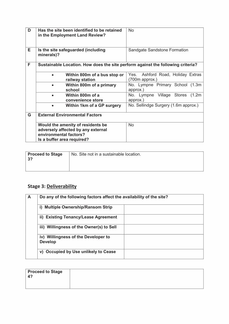
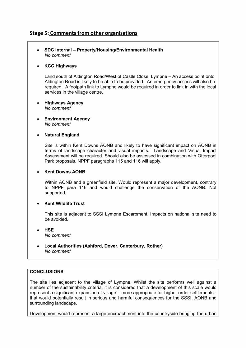
SDC Internal – Property/Housing/Environmental Health No comment
KCC Highways Land south of Aldington Road/West of Castle Close, Lympne – An access point onto Aldington Road is likely to be able to be provided. An emergency access will also be required. A footpath link to Lympne would be required in order to link in with the local services in the village centre.
Highways Agency No comment
Environment Agency No comment
Natural England Site is within Kent Downs AONB and likely to have significant impact on AONB in terms of landscape character and visual impacts. Landscape and Visual Impact Assessment will be required. Should also be assessed in combination with Otterpool Park proposals. NPPF paragraphs 115 and 116 will apply.
Kent Downs AONB Within AONB and a greenfield site. Would represent a major development, contrary to NPPF para 116 and would challenge the conservation of the AONB. Not supported.
Kent Wildlife Trust This site is adjacent to SSSI Lympne Escarpment. Impacts on national site need to be avoided.
HSE No comment
Local Authorities (Ashford, Dover, Canterbury, Rother) No comment
CONCLUSIONS The site lies adjacent to the village of Lympne. Whilst the site performs well against a number of the sustainability criteria, it is considered that a development of this scale would represent a significant expansion of village – more appropriate for higher order settlements - that would potentially result in serious and harmful consequences for the SSSI, AONB and surrounding landscape. Development would represent a large encroachment into the countryside bringing the urban

form across Aldington Road to the ridge of the escarpment. The sites proximity to the SSSI would likely to have significant impact on nature conservation and biodiversity. Whilst the tree belt to the south offers a screen to the site, it is likely that some roofscapes and street lighting would be visible looking into the site from the Romney Marsh and detracting from the qualities of the AONB and historic landscape.
Completed by T Bailey
Signed ...........................................................
Date ...........................................................

Site Form
SHLAA Ref: PO8 SDC Ward:
North Downs West
Site Name/Address:
Land rear of Touchwood, Stone street, Stanford
Source: Places and Policies Preferred Options Submission
Current Use: Small holding Area (ha): 0.96
Site Visit: 23 February 2017
Stage 1: Initial Assessment on suitability
A Is the size of the site 0.17ha or over (to enable the development of five or more dwellings)
Yes
B Has the site been allocated for housing; or been identified as suitable in previous assessments; or has had planning permission; or there has been a positive change in circumstances; or is a new site?
Historic permission for one dwelling. Application ref 89/34/01
C Is the site within or does it contain any of the following:
SAC
SSSI
National Nature Reserve
Ramsar
SPA
Ancient Woodland
an Extreme Flood Hazard (as defined in the SFRA for the year 2115)
Scheduled Monument
Registered Parks and Gardens
No
Proceed to Stage 2?
Yes.

Stage 2: Detailed Assessment on suitability
A Relationship to the settlement hierarchy?
The site adjoins the settlement boundary for Stanford a Primary Village identified in the Core Strategy.
Physical or Infrastructure Constraints:
i) Can a suitable access to the highway network be created?
No. See KCC Highway comments below
ii) Is there adequate highway capacity? Yes
iii) Is there water supply? Yes. Connection available from adjacent site
iv) Is there sewerage? Yes. Connection available from adjacent site
v) Is there electricity supply? Yes. Connection available from adjacent site
vi) Are there electricity pylons on site? No
vii) Is there contamination? None known
viii) Are there adverse ground conditions?
None known
ix) Is there any hazardous risk? None known
x) Is there difficult topography?
No
xi) Is there a river near or on the site? No
xii) Is it in flood zone 2? No
xiii) Is it in flood zone 3? If yes hazard rating 2115 with climate change - Nil/Low/Moderate/Significant
No
C Could the development potentially have a detrimental impact on any of the following?
i) Townscape
Yes. The site is located adjacent to the existing settlement boundary. The site would represent ‘back land’ development.
ii) Landscape
Yes. Development would be encroachment into the open countryside.
iii) AONB and its immediate setting
No
iv) Kent BAP sites
Unknown
v) Tree Preservation Orders
No
vi) Heritage Assets
In an Area of Archaeological Potential
vii) Historic Park/Garden or Square
No

viii) Local Wildlife Site
No
ix) Protected Open Space
No
D Has the site been identified to be retained in the Employment Land Review?
No
E Is the site safeguarded (including minerals)?
Silica Sand/ Construction Sand- Sandstone Folkestone Formation
F Sustainable Location. How does the site perform against the following criteria?
Within 800m of a bus stop or railway station
Yes. Stone Street (800m approx.)
Within 800m of a primary school
No. Lympne Primary School (3.1km miles approx.).
Within 800m of a convenience store
No. WH Smith - Stop 24 (2.5km approx.); Lympne Village Stores (2.7km approx)
Within 1km of a GP surgery No. Sellindge Surgery (4.3km approx.)
G External Environmental Factors
Would the amenity of residents be adversely affected by any external environmental factors? Is a buffer area required?
Proposals for Operation Stack Lorry Park
Proceed to Stage 3?
Yes. Although backland development, the access needs to be checked and there are potential contraints such as an area of archaeological potential.
Stage 3: Deliverability
A Do any of the following factors affect the availability of the site?
i) Multiple Ownership/Ransom Strip
The site is in single ownership
ii) Existing Tenancy/Lease Agreement
No
iii) Willingness of the Owner(s) to Sell
Not Specified
iv) Willingness of the Developer to Develop
Not Specified
v) Occupied by Use unlikely to Cease
No
Proceed to Stage 4?
Yes

Stage 4: Achievability
A Market Interests
i) Compatible with Adjacent Uses
The site would be compatible with the residential areas to the east.
ii) Land Values compared with Existing and Alternative Uses
Residential development on this site would significantly increase the land value, as the site is currently undeveloped.
iii) Attractiveness of Locality
Attractive rural location
iv) Demand CIL Charging Schedule: Zone D £125- Very Good
B Cost
i) site preparation
There does not appear to be any significant site preparation costs associated with the development of this site to residential.
ii) abnormal costs;
There does not appear to be any abnormal costs associated with the development of this site.
iii) planning policy
No
iv) infrastructure
There does not appear to be any specific infrastructure constraints on this site.
C i) Type of dwelling
Not Specified
ii) Quantity
5 (approx.)
D Delivery and Phasing
Is the site ‘deliverable’ (1 - 5 years)?
Yes
Is the site ‘developable’ (6 – 15 years)?
Stage 5: Comments from other organisations
SDC Internal – Property/Housing/Environmental Health No comments
KCC Highways The site is located in an unsustainable location. The proposed access appears to be narrow and would need to be at least 3 metres to serve a total of 5 dwellings.
Highways Agency No Comments

Environment Agency No Comments
Natural England No Comments
Kent Downs AONB Outside of AONB, but within setting. Any development should be of an appropriate scale, design and layout and incorporate adequate landscaping to mitigate impact on AONB.
Kent Wildlife Trust No Comments
HSE No Comments
Local Authorities (Ashford, Dover, Canterbury, Rother) No Comments
CONCLUSIONS This is backland development located behind houses fronting Stone Street, so bounded by gardens on two sides and open countryside. Although centrally located in the village it would act as a freestanding estate and there are very few facilities in Stanford.
Completed by R Chittock
Signed ...........................................................
Date ...........................................................

Site Form
SHLAA Ref: PO9 SDC Ward:
North Downs East
Site Name/Address:
Land Opposite Underhill Cottages
Source: Places and Policies Preferred Options Submission
Current Use: Grazing land Area (ha): 0.24
Site Visit: 21 February 2017
Stage 1: Initial Assessment on suitability
A Is the size of the site 0.17ha or over (to enable the development of five or more dwellings)
Yes
B Has the site been allocated for housing; or been identified as suitable in previous assessments; or has had planning permission; or there has been a positive change in circumstances; or is a new site?
The site was previously non-qualifying as the site size was too small at 0.11, however a larger parcel of land has now been submitted for assessment.
C Is the site within or does it contain any of the following:
SAC
SSSI
National Nature Reserve
Ramsar
SPA
Ancient Woodland
an Extreme Flood Hazard (as defined in the SFRA for the year 2115)
Scheduled Monument
Registered Parks and Gardens
No
Proceed to Stage 2?
Yes

Stage 2: Detailed Assessment on suitability
A Relationship to the settlement hierarchy?
Peene does not feature in the settlement hierarchy, and does not have a settlement boundary
Physical or Infrastructure Constraints:
i) Can a suitable access to the highway network be created?
Yes – Newington Road
ii) Is there adequate highway capacity? Yes
iii) Is there water supply? Yes. Connection available from Newington Road
iv) Is there sewerage? Yes. Connection available from Newington Road
v) Is there electricity supply? Yes. Connection available from Newington Road
vi) Are there electricity pylons on site? No
vii) Is there contamination? None known
viii) Are there adverse ground conditions?
None known
ix) Is there any hazardous risk? None known
x) Is there difficult topography?
No
xi) Is there a river near or on the site? No
xii) Is it in flood zone 2? No
xiii) Is it in flood zone 3? If yes hazard rating 2115 with climate change - Nil/Low/Moderate/Significant
No
C Could the development potentially have a detrimental impact on any of the following?
i) Townscape
No
ii) Landscape
No
iii) AONB and its immediate setting
Possible impact on the Kent Downs AONB.
iv) Kent BAP sites
Unknown
v) Tree Preservation Orders
No
vi) Heritage Assets
No
vii) Historic Park/Garden or Square
No
viii) Local Wildlife Site
No
ix) Protected Open Space
No

D Has the site been identified to be retained in the Employment Land Review?
No
E Is the site safeguarded (including minerals)?
No
F Sustainable Location. How does the site perform against the following criteria?
Within 800m of a bus stop or railway station
No. Ashford Road, A20 (1,200m approx.)
Within 800m of a primary school
No. Cheriton Primary School (1.8m approx.)
Within 800m of a convenience store
No. Tesco (1.7m approx.)
Within 1km of a GP surgery No. Cheriton High Street (2.2m approx.)
G External Environmental Factors
Would the amenity of residents be adversely affected by any external environmental factors? Is a buffer area required?
Noise from Channel Tunnel Terminal / M20
Proceed to Stage 3?
No. This site is not a sustainable location.
Stage 3: Deliverability
A Do any of the following factors affect the availability of the site?
i) Multiple Ownership/Ransom Strip
ii) Existing Tenancy/Lease Agreement
iii) Willingness of the Owner(s) to Sell
iv) Willingness of the Developer to Develop
v) Occupied by Use unlikely to Cease
Proceed to Stage 4?

Stage 4: Achievability
A Market Interests
i) Compatible with Adjacent Uses
ii) Land Values compared with Existing and Alternative Uses
iii) Attractiveness of Locality
iv) Demand
B Cost
i) site preparation
ii) abnormal costs;
iii) planning policy
iv) infrastructure
C i) Type of dwelling
ii) Quantity
D Delivery and Phasing
Is the site ‘deliverable’ (1 - 5 years)?
Is the site ‘developable’ (6 – 15 years)?
Stage 5: Comments from other organisations
SDC Internal – Property/Housing/Environmental Health No comments
KCC Highways The site is located in an unsustainable location. An access point onto Newington Road is likely to be able to be provided.
Highways Agency No comments
Environment Agency Fisheries, Biodiversity and Geomorphology Comments Please consider the stream at the rear of this plot. It flows into Seabrook stream, a

SSSI designated watercourse containing important Priority Species Flood Risk Comments FZ3 FRA required Main River
Natural England No comments
Kent Downs AONB Within AONB. Any development should be of exceptional quality and of an appropriate scale, design and layout and incorporate adequate landscaping.
Kent Wildlife Trust No comments
HSE No comments
Local Authorities (Ashford, Dover, Canterbury, Rother) No comments
CONCLUSIONS This site is not a sustainable location.
Completed by R Chittock.
Signed ...........................................................
Date ...........................................................

Site Form
SHLAA Ref: PO10 SDC Ward:
North Downs East
Site Name/Address:
Cherry Gardens Source: Places and Policies Preferred Options Submission
Current Use: Pasture Area (ha): 0.84
Site Visit: 21 February 2017
Stage 1: Initial Assessment on suitability
A Is the size of the site 0.17ha or over (to enable the development of five or more dwellings)
Yes
B Has the site been allocated for housing; or been identified as suitable in previous assessments; or has had planning permission; or there has been a positive change in circumstances; or is a new site?
No
C Is the site within or does it contain any of the following:
SAC
SSSI
National Nature Reserve
Ramsar
SPA
Ancient Woodland
an Extreme Flood Hazard (as defined in the SFRA for the year 2115)
Scheduled Monument
Registered Parks and Gardens
No. However it is in the Kent Downs AONB
Proceed to Stage 2?
Yes

Stage 2: Detailed Assessment on suitability
A Relationship to the settlement hierarchy?
The site adjoins the settlement boundary of the Rural Centre of Elham.
Physical or Infrastructure Constraints:
i) Can a suitable access to the highway network be created?
No. See KCC Highways comments below
ii) Is there adequate highway capacity? N/A
iii) Is there water supply? Yes. Connection available from the adjacent site
iv) Is there sewerage? Yes. Connection available from the adjacent site
v) Is there electricity supply? Yes. Connection available from the adjacent site
vi) Are there electricity pylons on site? No
vii) Is there contamination? None known
viii) Are there adverse ground conditions?
None known
ix) Is there any hazardous risk? None known
x) Is there difficult topography?
The site is gently sloping
xi) Is there a river near or on the site? No
xii) Is it in flood zone 2? No
xiii) Is it in flood zone 3? If yes hazard rating 2115 with climate change - Nil/Low/Moderate/Significant
No
C Could the development potentially have a detrimental impact on any of the following?
i) Townscape
Yes. The site is located adjacent to the existing settlement. Development would have the effect extending the village settlement boundary.
ii) Landscape
Yes. Development would be an encroachment into the open countryside and Kent Downs AONB
iii) AONB and its immediate setting
Possible impact on the Kent Downs AONB
iv) Kent BAP sites
Unknown
v) Tree Preservation Orders
There is a TPO on a tree in the South Eastern corner of the site
vi) Heritage Assets
Adjacent to Elham Conservation Area.
vii) Historic Park/Garden or Square
No

viii) Local Wildlife Site
No
ix) Protected Open Space
No
D Has the site been identified to be retained in the Employment Land Review?
No
E Is the site safeguarded (including minerals)?
No
F Sustainable Location. How does the site perform against the following criteria?
Within 800m of a bus stop or railway station
Yes. High Street (200m approx.)
Within 800m of a primary school
Yes. Elham Primary School (450m approx.)
Within 800m of a convenience store
Yes. Elham Village Stores (200m approx.)
Within 1km of a GP surgery Yes. Hawkinge and Elham Surgery (500m approx.)
G External Environmental Factors
Would the amenity of residents be adversely affected by any external environmental factors? Is a buffer area required?
No
Proceed to Stage 3?
No. The site is in a sustainable location in Elham; however there is no available access to the public highway.
Stage 3: Deliverability
A Do any of the following factors affect the availability of the site?
i) Multiple Ownership/Ransom Strip
ii) Existing Tenancy/Lease Agreement
iii) Willingness of the Owner(s) to Sell
iv) Willingness of the Developer to Develop
v) Occupied by Use unlikely to Cease
Proceed to Stage 4?

Stage 4: Achievability
A Market Interests
i) Compatible with Adjacent Uses
ii) Land Values compared with Existing and Alternative Uses
iii) Attractiveness of Locality
iv) Demand
B Cost
i) site preparation
ii) abnormal costs;
iii) planning policy
iv) infrastructure
C i) Type of dwelling
ii) Quantity
D Delivery and Phasing
Is the site ‘deliverable’ (1 - 5 years)?
Is the site ‘developable’ (6 – 15 years)?
Stage 5: Comments from other organisations
SDC Internal – Property/Housing/Environmental Health No comments
KCC Highways The site appears to be landlocked with no point of connection to the public highway. A minimum width road of 4.1 metres would be required to serve any development on this site. KCC Highways would not support an allocation on this site
Highways Agency No comments
Environment Agency Fisheries, Biodiversity and Geomorphology Comments

Please consider the Nailbourne, near this site and provide a buffer to the river. Drainage of surface water to the river must be of uncontaminated water only Groundwater and Contaminated Land Comments Telephone exchange - Preliminary Risk Assessment will be required
Natural England No comments
Kent Downs AONB Within AONB. Well related to existing village. Any development should be of exceptional quality and of an appropriate scale, design and layout and incorporate adequate landscaping.
Kent Wildlife Trust No comments
HSE No comments
Local Authorities (Ashford, Dover, Canterbury, Rother) No comments
CONCLUSIONS Whilst the site is in a sustainable location in Elham with access to the essential services; the site is landlocked offering no available access to the public highway.
Completed by R. Chittock
Signed ...........................................................
Date ...........................................................

Site Form
SHLAA Ref: PO11 SDC Ward:
North Downs East
Site Name/Address:
Land at Cock Lane, Elham Source: Places and Policies Preferred Options Submission
Current Use: Agricultural – Grazing Pasture
Area (ha): 0.5 ha
Site Visit: 21 February 2017
Stage 1: Initial Assessment on suitability
A Is the size of the site 0.17ha or over (to enable the development of five or more dwellings)
Yes
B Has the site been allocated for housing; or been identified as suitable in previous assessments; or has had planning permission; or there has been a positive change in circumstances; or is a new site?
New Site
C Is the site within or does it contain any of the following:
SAC
SSSI
National Nature Reserve
Ramsar
SPA
Ancient Woodland
an Extreme Flood Hazard (as defined in the SFRA for the year 2115)
Scheduled Monument
Registered Parks and Gardens
No
Proceed to Stage 2?
Yes.

Stage 2: Detailed Assessment on suitability
A Relationship to the settlement hierarchy?
The site adjoins the settlement boundary of the Rural Centre of Elham
i) Can a suitable access to the highway network be created?
No. See KCC Highways comments below
ii) Is there adequate highway capacity? No. See KCC Highways comments below
iii) Is there water supply? Yes. Connection available from the adjacent site
iv) Is there sewerage? Yes. Connection available from the adjacent site
v) Is there electricity supply? Yes. Connection available from the adjacent site
vi) Are there electricity pylons on site? No
vii) Is there contamination? Radon Gas (Class 4)
viii) Are there adverse ground conditions?
None known
ix) Is there any hazardous risk? None known
x) Is there difficult topography?
No
xi) Is there a river near or on the site? Approximately 80m from Nailbourne River.
xii) Is it in flood zone 2? No
xiii) Is it in flood zone 3? If yes hazard rating 2115 with climate change - Nil/Low/Moderate/Significant
No
C Could the development potentially have a detrimental impact on any of the following?
i) Townscape
The site is currently a grazing pasture for livestock. Development could potentially impact upon the character / setting of this part of the village and conservation area.
ii) Landscape
Whilst situated in the Kent Downs AONB, this ‘triangular shaped’ site is enclosed on two sides by the existing settlement confines. It will not encroach on the countryside and therefore it considered that development will not have a detrimental impact on views of the AONB.
iii) AONB and its immediate setting
Possible impact on the Kent Downs AONB
iv) Kent BAP sites
Unknown

v) Tree Preservation Orders
No
vi) Heritage Assets
Adjacent to Elham Conservation Area. In an Area of Archaeological Potential
vii) Historic Park/Garden or Square
No
viii) Local Wildlife Site
No
ix) Protected Open Space
No
D Has the site been identified to be retained in the Employment Land Review?
No
E Is the site safeguarded (including minerals)?
No
F Sustainable Location. How does the site perform against the following criteria?
Within 800m of a bus stop or railway station
Yes. High Street (250m approx.)
Within 800m of a primary school
Yes. Elham Primary School (250m approx.)
Within 800m of a convenience store
Yes, Elham Valley Stores (200m approx.)
Within 1km of a GP surgery Yes. Hawkinge and Elham Surgery (400m approx.)
G External Environmental Factors
Would the amenity of residents be adversely affected by any external environmental factors? Is a buffer area required?
There is no evidence to suggest that the amenity of residents would be adversely affected by any external environmental factors.
Proceed to Stage 3?
No. The site is in a sustainable location in Elham, however the access is considered to be unsuitable to accommodate additional traffic movements.
Stage 3: Deliverability
A Do any of the following factors affect the availability of the site?
i) Multiple Ownership/Ransom Strip
ii) Existing Tenancy/Lease Agreement
iii) Willingness of the Owner(s) to Sell
iv) Willingness of the Developer to Develop
v) Occupied by Use unlikely to Cease

Proceed to Stage 4?
Stage 4: Achievability
A Market Interests
i) Compatible with Adjacent Uses
ii) Land Values compared with Existing and Alternative Uses
iii) Attractiveness of Locality
iv) Demand
B Cost
i) site preparation
ii) abnormal costs;
iii) planning policy
iv) infrastructure
C i) Type of dwelling
ii) Quantity
D Delivery and Phasing
Is the site ‘deliverable’ (1 - 5 years)?
Is the site ‘developable’ (6 – 15 years)?
Stage 5: Comments from other organisations
SDC Internal – Property/Housing/Environmental Health No comments
KCC Highways Cock Lane is extremely narrow with no footways. There is limited forward visibility along Cock Lane due to the curvature of the lane. KCC Highways would not support an allocation on this site.

Highways Agency No comments
Environment Agency Fisheries, Biodiversity and Geomorphology Comments Please consider the Nailbourne, near this site and provide a buffer to the river. Drainage of surface water to the river must be of uncontaminated water only
Natural England No comments
Kent Downs AONB Within AONB. Well related to existing village. Any development should be of exceptional quality and of an appropriate scale, design and layout and incorporate adequate landscaping.
Kent Wildlife Trust No comments
HSE No comments
Local Authorities (Ashford, Dover, Canterbury, Rother) No comments
CONCLUSIONS The site is located in the urban centre of Elham in the North Downs Character Area. The site offers few constraints and performs well against a number of the sustainability criteria, especially in terms of its proximity to local services. Despite being within the Kent Downs AONB, the site is enclosed on two sides by the existing settlement confines and it is therefore considered that a small low density scheme would not have a detrimental impact on views from the AONB. There are some concerns about impact on the townscape and setting of the conservation area, although this could be mitigated through good design. The key issue regarding the site is access. Cock Lane is a narrow country lane, with pinch points, there is little or no room for two cars to pass one another and is unsuitable for increased traffic movements.
Completed by T Bailey
Signed ...........................................................
Date ...........................................................
Site Form
SHLAA Ref: PO12 SDC Ward:
North Downs East
Site Name/Address:
Land Cullens Hill, Elham Source: Places and Policies Preferred Options Submission
Current Use: Agricultural – Grazing Pasture
Area (ha): 0.21 ha
Site Visit: 21 February 2017
Stage 1: Initial Assessment on suitability
A Is the size of the site 0.17ha or over (to enable the development of five or more dwellings)
Yes
B Has the site been allocated for housing; or been identified as suitable in previous assessments; or has had planning permission; or there has been a positive change in circumstances; or is a new site?
New Site
C Is the site within or does it contain any of the following:
SAC
SSSI
National Nature Reserve
Ramsar
SPA
Ancient Woodland
an Extreme Flood Hazard (as defined in the SFRA for the year 2115)
Scheduled Monument
Registered Parks and Gardens
No
Proceed to Stage 2?
Yes

Stage 2: Detailed Assessment on suitability
A Relationship to the settlement hierarchy?
The site adjoins the settlement boundary of the Rural Centre of Elham.
Physical or Infrastructure Constraints:
i) Can a suitable access to the highway network be created?
No. See KCC Highway comments below
ii) Is there adequate highway capacity? No. See KCC Highway comments below
iii) Is there water supply? Yes. Connection available from the adjacent site
iv) Is there sewerage? Yes. Connection available from the adjacent site
v) Is there electricity supply? Yes. Connection available from the adjacent site
vi) Are there electricity pylons on site? No
vii) Is there contamination? Radon Gas: Class 1 and 3
viii) Are there adverse ground conditions?
None known
ix) Is there any hazardous risk? None known
x) Is there difficult topography?
The site on a ridge sloping north-west to south-east
xi) Is there a river near or on the site? No
xii) Is it in flood zone 2? No
xiii) Is it in flood zone 3? If yes hazard rating 2115 with climate change - Nil/Low/Moderate/Significant
No
C Could the development potentially have a detrimental impact on any of the following?
i) Townscape
Yes. Development would form an extension to the village confines. Removal of hedgerows, resulting in a more urbanised character / entrance to into the village.
ii) Landscape
Yes. The site is in an elevated position following the rising ridge line of Cullen’s Hill. This has potential to impact on long views from the AONB with introduction of roofscape, street lighting into the landscape.
iii) AONB and its immediate setting
Possible impact on the Kent Downs AONB.
iv) Kent BAP sites
Unknown
v) Tree Preservation Orders
No

vi) Heritage Assets
Adjacent to Elham Conservation Area. In an Area of Archaeological Potential
vii) Historic Park/Garden or Square
No
viii) Local Wildlife Site
No
ix) Protected Open Space
No
D Has the site been identified to be retained in the Employment Land Review?
No
E Is the site safeguarded (including minerals)?
No
F Sustainable Location. How does the site perform against the following criteria?
Within 800m of a bus stop or railway station
Yes. Elham High Street (200m approx.)
Within 800m of a primary school
Yes. Elham Primary School (220m approx.)
Within 800m of a convenience store
Yes, Elham Valley Stores (150m approx.)
Within 1km of a GP surgery Yes. Hawkinge and Elham Surgery (170m approx.)
G External Environmental Factors
Would the amenity of residents be adversely affected by any external environmental factors? Is a buffer area required?
There is no evidence to suggest that the amenity of residents would be adversely affected by any external environmental factors.
Proceed to Stage 3?
No. The site is in a sustainable location in Elham, however the access is considered to be unsuitable to accommodate additional traffic movements. Development could potentially impact on the AONB and setting of the adjacent conservation area.
Stage 3: Deliverability
A Do any of the following factors affect the availability of the site?
i) Multiple Ownership/Ransom Strip
ii) Existing Tenancy/Lease Agreement
iii) Willingness of the Owner(s) to Sell
iv) Willingness of the Developer to Develop
v) Occupied by Use unlikely to Cease
Proceed to Stage 4?
Stage 4: Achievability
A Market Interests
i) Compatible with Adjacent Uses
ii) Land Values compared with Existing and Alternative Uses
iii) Attractiveness of Locality
iv) Demand
B Cost
i) site preparation
ii) abnormal costs;
iii) planning policy
iv) infrastructure
C i) Type of dwelling
ii) Quantity
D Delivery and Phasing
Is the site ‘deliverable’ (1 - 5 years)?
Is the site ‘developable’ (6 – 15 years)?
Stage 5: Comments from other organisations
SDC Internal – Property/Housing/Environmental Health No Comments
KCC Highways Cullens Hill is extremely narrow with no footways. The route to Elham village has no footways. KCC Highways would not support an allocation on this site.

Highways Agency No Comments
Environment Agency No Comments
Natural England No Comments
Kent Downs AONB Within AONB. Although well related to village settlement, concerned about elevated nature of site and potential loss of trees along site’s frontage.
Kent Wildlife Trust No Comments
HSE No Comments
Local Authorities (Ashford, Dover, Canterbury, Rother) No Comments
CONCLUSIONS The site is located in the urban centre of Elham in the North Downs Character Area. The site performs well against a number of sustainability criteria, especially in terms of its proximity to local services. However, the site does hold an elevated position on Cullen’s Hill within the Kent Downs AONB, which if developed could impact of the far reaching views of the AONB toward Elham with the introduction of roofscapes and street lighting into the landscape; or removal of the tree lined frontage. There are also some concerns about impact on the townscape and approach to the village, and the effects on rural setting of the village and its conservation area. There are also concerns regarding site access. Cullens Hill is a narrow lane, with little or no room for two cars to pass one another. There is a significant level change between the site and the road meaning it could prove problematic to form a safe access onto Cullens Hill.
Completed by T Bailey
Signed ...........................................................
Date ...........................................................

Site Form
SHLAA Ref: PO13 SDC Ward:
North Downs East
Site Name/Address:
Land at Canterbury Road, Elham
Source: Places and Policies Preferred Options Submission
Current Use: Agricultural use Area (ha): 1.02ha
Site Visit: 21 February 2017
Stage 1: Initial Assessment on suitability
A Is the size of the site 0.17ha or over (to enable the development of five or more dwellings)
Yes
B Has the site been allocated for housing; or been identified as suitable in previous assessments; or has had planning permission; or there has been a positive change in circumstances; or is a new site?
New Site
C Is the site within or does it contain any of the following:
SAC
SSSI
National Nature Reserve
Ramsar
SPA
Ancient Woodland
an Extreme Flood Hazard (as defined in the SFRA for the year 2115)
Scheduled Monument
Registered Parks and Gardens
No
Proceed to Stage 2?
Yes

Stage 2: Detailed Assessment on suitability
A Relationship to the settlement hierarchy?
The site adjoins the settlement boundary of the Rural Centre of Elham.
Physical or Infrastructure Constraints:
i) Can a suitable access to the highway network be created?
Yes. Canterbury Road
ii) Is there adequate highway capacity? Yes. Canterbury Road
iii) Is there water supply? Yes. Connection available from Canterbury Road
iv) Is there sewerage? Yes. Connection available from Canterbury Road
v) Is there electricity supply? Yes. Connection available from Canterbury Road
vi) Are there electricity pylons on site? Overhead wires traversing the site
vii) Is there contamination? Radon Gas Class 3
viii) Are there adverse ground conditions?
None known
ix) Is there any hazardous risk? None known
x) Is there difficult topography?
Yes. The site slopes down to the East
xi) Is there a river near or on the site? No
xii) Is it in flood zone 2? No
xiii) Is it in flood zone 3? If yes hazard rating 2115 with climate change - Nil/Low/Moderate/Significant
No
C Could the development potentially have a detrimental impact on any of the following?
i) Townscape
No
ii) Landscape
Yes. The site is surrounded by open fields and the introduction of built form and domestic paraphernalia in this location would have a detrimental impact on the existing landscape.
iii) AONB and its immediate setting
Yes. The development of this site would have a detrimental impact upon the Kent Downs AONB.
iv) Kent BAP sites
Unknown
v) Tree Preservation Orders
No
vi) Heritage Assets
No
vii) Historic Park/Garden or Square
No

viii) Local Wildlife Site
No
ix) Protected Open Space
No
D Has the site been identified to be retained in the Employment Land Review?
No
E Is the site safeguarded (including minerals)?
No
F Sustainable Location. How does the site perform against the following criteria?
Within 800m of a bus stop or railway station
Yes. Canterbury Road Bus Stop (140m approx.)
Within 800m of a primary school
Yes. Elham Primary School (450m approx.)
Within 800m of a convenience store
Yes. Elham Valley Stores (500m approx.)
Within 1km of a GP surgery Yes. Hawkinge and Elham Surgery (350m approx.)
G External Environmental Factors
Would the amenity of residents be adversely affected by any external environmental factors? Is a buffer area required?
Potential noises from main Canterbury Road. A buffer could be provided
Proceed to Stage 3?
No. Whilst the site is in a sustainable location, the site is surrounded by open fields and the introduction of built form and domestic paraphernalia in this location would have a detrimental impact on the existing landscape and on the Kent Downs AONB.
Stage 3: Deliverability
A Do any of the following factors affect the availability of the site?
i) Multiple Ownership/Ransom Strip
ii) Existing Tenancy/Lease Agreement
iii) Willingness of the Owner(s) to Sell
iv) Willingness of the Developer to Develop
v) Occupied by Use unlikely to Cease
Proceed to Stage 4?

Stage 4: Achievability
A Market Interests
i) Compatible with Adjacent Uses
ii) Land Values compared with Existing and Alternative Uses
iii) Attractiveness of Locality
iv) Demand
B Cost
i) site preparation
ii) abnormal costs;
iii) planning policy
iv) infrastructure
C i) Type of dwelling
ii) Quantity
D Delivery and Phasing
Is the site ‘deliverable’ (1 - 5 years)?
Is the site ‘developable’ (6 – 15 years)?
Stage 5: Comments from other organisations
SDC Internal – Property/Housing/Environmental Health No Comments
KCC Highways The site is located within the 30mph speed limit and Canterbury Road is fairly straight here. Appropriate visibility splays can be provided. There is a footpath connection to the centre of the village and school. Reasonable site in highway terms.
Highways Agency No Comments
Environment Agency No Comments
Natural England

Together with PO14 and 15, present significant development within Kent Downs AONB. Landscape and Visual Impact Assessment will be required. NPPF paragraphs 115 and 116 will apply.
Kent Downs AONB Within AONB. Development would result in inappropriate extension of village southwards that would challenge character of the AONB. Not supported.
Kent Wildlife Trust No Comments
HSE No Comments
Local Authorities (Ashford, Dover, Canterbury, Rother) No Comments
CONCLUSIONS Whilst the site is in a sustainable location, the site is surrounded by open fields and the introduction of built form and domestic paraphernalia in this location would have a detrimental impact on the existing landscape and on the Kent Downs AONB.
Completed by R Chittock
Signed ...........................................................
Date ...........................................................

Site Form
SHLAA Ref: PO14 SDC Ward:
North Downs East
Site Name/Address:
Land west of Canterbury Road, Elham
Source: Places and Policies Preferred Options Submission
Current Use: Agricultural use Area (ha): 1.4ha
Site Visit: 21 February 2018
Stage 1: Initial Assessment on suitability
A Is the size of the site 0.17ha or over (to enable the development of five or more dwellings)
Yes
B Has the site been allocated for housing; or been identified as suitable in previous assessments; or has had planning permission; or there has been a positive change in circumstances; or is a new site?
New Site
C Is the site within or does it contain any of the following:
SAC
SSSI
National Nature Reserve
Ramsar
SPA
Ancient Woodland
an Extreme Flood Hazard (as defined in the SFRA for the year 2115)
Scheduled Monument
Registered Parks and Gardens
No
Proceed to Stage 2?
Yes

Stage 2: Detailed Assessment on suitability
A Relationship to the settlement hierarchy?
The site is outside the settlement boundary of the Rural Centre of Elham.
Physical or Infrastructure Constraints:
i) Can a suitable access to the highway network be created?
No. See KCC Highway comments below
ii) Is there adequate highway capacity? N/A
iii) Is there water supply? No
iv) Is there sewerage? No
v) Is there electricity supply? No
vi) Are there electricity pylons on site? Overhead wires traversing the frontage of the site
vii) Is there contamination? Radon Gas Class 3 (part Class 2)
viii) Are there adverse ground conditions?
None known
ix) Is there any hazardous risk? None known
x) Is there difficult topography?
The site slopes down to the South
xi) Is there a river near or on the site? No
xii) Is it in flood zone 2? No
xiii) Is it in flood zone 3? If yes hazard rating 2115 with climate change - Nil/Low/Moderate/Significant
No
C Could the development potentially have a detrimental impact on any of the following?
i) Townscape
No
ii) Landscape
Yes. The site is surrounded by open fields and the introduction of built form and domestic paraphernalia in this location would have a detrimental impact on the existing landscape.
iii) AONB and its immediate setting
There would be a detrimental impact on the Kent Downs AONB.
iv) Kent BAP sites
Unknown
v) Tree Preservation Orders
No
vi) Heritage Assets
No

vii) Historic Park/Garden or Square
No
viii) Local Wildlife Site
No
ix) Protected Open Space
No
D Has the site been identified to be retained in the Employment Land Review?
No
E Is the site safeguarded (including minerals)?
No
F Sustainable Location. How does the site perform against the following criteria?
Within 800m of a bus stop or railway station
Yes. Canterbury Road Bus Stop (300m approx.)
Within 800m of a primary school
No. Elham Primary School (950m approx.)
Within 800m of a convenience store
No. Elham Village Stores (1000m approx.)
Within 1km of a GP surgery Yes. Hawkinge and Elham Surgery (850m approx.)
G External Environmental Factors
Would the amenity of residents be adversely affected by any external environmental factors? Is a buffer area required?
Potential noises from main Canterbury Road. A buffer could be provided.
Proceed to Stage 3?
No. The site is in an unsustainable location, and is surrounded by open fields and the introduction of built form and domestic paraphernalia in this location would have a detrimental impact on the existing landscape and on the Kent Downs AONB.
Stage 3: Deliverability
A Do any of the following factors affect the availability of the site?
i) Multiple Ownership/Ransom Strip
ii) Existing Tenancy/Lease Agreement
iii) Willingness of the Owner(s) to Sell
iv) Willingness of the Developer to Develop
v) Occupied by Use unlikely to Cease

Proceed to Stage 4
Stage 4: Achievability
A Market Interests
i) Compatible with Adjacent Uses
ii) Land Values compared with Existing and Alternative Uses
iii) Attractiveness of Locality
iv) Demand
B Cost
i) site preparation
ii) abnormal costs;
iii) planning policy
iv) infrastructure
C i) Type of dwelling
ii) Quantity
D Delivery and Phasing
Is the site ‘deliverable’ (1 - 5 years)?
Is the site ‘developable’ (6 – 15 years)?
Stage 5: Comments from other organisations
SDC Internal – Property/Housing/Environmental Health No Comments
KCC Highways The site is located within a 60mph speed limit and visibility splays of 2.4 metres by 215 metres would be required. This cannot be provided due to insufficient site frontage. The site is relatively remote from the village. KCC Highways would not support an allocation on this site.

Highways Agency No Comments
Environment Agency No Comments
Natural England Together with PO13 and 15, present significant development within Kent Downs AONB. Landscape and Visual Impact Assessment will be required. NPPF paragraphs 115 and 116 will apply.
Kent Downs AONB Within AONB. Development would result in inappropriate extension of village southwards that would challenge character of the AONB. Not supported.
Kent Wildlife Trust No Comments
HSE No Comments
Local Authorities (Ashford, Dover, Canterbury, Rother) No Comments
CONCLUSIONS The site is in an unsustainable location, and is surrounded by open fields and the introduction of built form and domestic paraphernalia in this location would have a detrimental impact on the existing landscape and on the Kent Downs AONB.
Completed by ...........................................................
Signed ...........................................................
Date ...........................................................

Site Form
SHLAA Ref: PO15 SDC Ward:
North Downs East
Site Name/Address:
Land east of Canterbury Road, Elham
Source: Places and Policies Preferred Options Submission
Current Use: Agricultural use Area (ha): 2.27ha
Site Visit: 21 February 2017
Stage 1: Initial Assessment on suitability
A Is the size of the site 0.17ha or over (to enable the development of five or more dwellings)
Yes
B Has the site been allocated for housing; or been identified as suitable in previous assessments; or has had planning permission; or there has been a positive change in circumstances; or is a new site?
New Site
C Is the site within or does it contain any of the following:
SAC
SSSI
National Nature Reserve
Ramsar
SPA
Ancient Woodland
an Extreme Flood Hazard (as defined in the SFRA for the year 2115)
Scheduled Monument
Registered Parks and Gardens
No
Proceed to Stage 2?
Yes

Stage 2: Detailed Assessment on suitability
A Relationship to the settlement hierarchy?
The site is outside the settlement boundary of the Rural Centre of Elham.
Physical or Infrastructure Constraints:
i) Can a suitable access to the highway network be created?
No. See KCC Highway comments below
ii) Is there adequate highway capacity? N/A
iii) Is there water supply? No
iv) Is there sewerage? No
v) Is there electricity supply? No
vi) Are there electricity pylons on site? Overhead wires traversing the site
vii) Is there contamination? Radon Gas Class 1, 2 and 3
viii) Are there adverse ground conditions?
None known
ix) Is there any hazardous risk? None known
x) Is there difficult topography?
The site slopes down to the East
xi) Is there a river near or on the site? A watercourse runs to the south eastern boundary of the site.
xii) Is it in flood zone 2? No
xiii) Is it in flood zone 3? If yes hazard rating 2115 with climate change - Nil/Low/Moderate/Significant
No
C Could the development potentially have a detrimental impact on any of the following?
i) Townscape
No
ii) Landscape
Yes. The site is surrounded by open fields and the introduction of built form and domestic paraphernalia in this location would have a detrimental impact on the existing landscape.
iii) AONB and its immediate setting
Yes. The development of this site would have a detrimental impact upon the Kent Downs AONB.
iv) Kent BAP sites
Unknown
v) Tree Preservation Orders
No
vi) Heritage Assets
No
vii) Historic Park/Garden or Square
No

viii) Local Wildlife Site
No
ix) Protected Open Space
No
D Has the site been identified to be retained in the Employment Land Review?
No
E Is the site safeguarded (including minerals)?
No.
F Sustainable Location. How does the site perform against the following criteria?
Within 800m of a bus stop or railway station
Yes. Canterbury Road Bus Stop (300m approx.)
Within 800m of a primary school
No. Elham Primary School (900m approx.)
Within 800m of a convenience store
No. Elham Village Stores (950m approx.)
Within 1km of a GP surgery Yes. Hawkinge and Elham Surgery (850m approx.)
G External Environmental Factors
Would the amenity of residents be adversely affected by any external environmental factors? Is a buffer area required?
Potential noises from main Canterbury Road. A buffer could be provided
Proceed to Stage 3?
No. The site is in an unsustainable location, and is surrounded by open fields and the introduction of built form and domestic paraphernalia in this location would have a detrimental impact on the existing landscape and on the Kent Downs AONB.
Stage 3: Deliverability
A Do any of the following factors affect the availability of the site?
i) Multiple Ownership/Ransom Strip
ii) Existing Tenancy/Lease Agreement
iii) Willingness of the Owner(s) to Sell
iv) Willingness of the Developer to Develop
v) Occupied by Use unlikely to Cease
Proceed to Stage 4?

Stage 4: Achievability
A Market Interests
i) Compatible with Adjacent Uses
ii) Land Values compared with Existing and Alternative Uses
iii) Attractiveness of Locality
iv) Demand
B Cost
i) site preparation
ii) abnormal costs;
iii) planning policy
iv) infrastructure
C i) Type of dwelling
ii) Quantity
D Delivery and Phasing
Is the site ‘deliverable’ (1 - 5 years)?
Is the site ‘developable’ (6 – 15 years)?
Stage 5: Comments from other organisations
SDC Internal – Property/Housing/Environmental Health No Comments
KCC Highways The site is located within a 60mph speed limit and visibility splays of 2.4 metres by 215 metres would be required. This cannot be provided due to insufficient site frontage. The site is relatively remote from the village. KCC Highways would not support an allocation on this site.
Highways Agency No Comments
Environment Agency Fisheries, Biodiversity and Geomorphology Comments

Please consider the Nailbourne, near this site and provide a buffer to the river. Drainage of surface water to the river must be of uncontaminated water only Flood Risk Comments Mostly Z1, but small part FZ3 Nailbourne Main River possible groundwater flooding issues
Natural England Together with PO13 and 14, present significant development within Kent Downs AONB. Landscape and Visual Impact Assessment will be required. NPPF paragraphs 115 and 116 will apply.
Kent Downs AONB Within AONB. Development would result in inappropriate extension of village southwards that would challenge character of the AONB. Not supported.
Kent Wildlife Trust No Comments
HSE No Comments
Local Authorities (Ashford, Dover, Canterbury, Rother) No Comments
CONCLUSIONS The site is in an unsustainable location, and is surrounded by open fields and the introduction of built form and domestic paraphernalia in this location would have a detrimental impact on the existing landscape and on the Kent Downs AONB.
Completed by ...........................................................
Signed ...........................................................
Date ...........................................................

Site Form
SHLAA Ref: PO16 SDC Ward:
Broadmead
Site Name/Address:
Three Acre Site, Park Farm Road, Folkestone
Source: Places and Policies Preferred Options Submission
Current Use: Employment (A1, B2 & B8) Area (ha): 1.24
Site Visit: 21 February 2017
Stage 1: Initial Assessment on suitability
A Is the size of the site 0.17ha or over (to enable the development of five or more dwellings)
Yes
B Has the site been allocated for housing; or been identified as suitable in previous assessments; or has had planning permission; or there has been a positive change in circumstances; or is a new site?
New Site
C Is the site within or does it contain any of the following:
SAC
SSSI
National Nature Reserve
Ramsar
SPA
Ancient Woodland
an Extreme Flood Hazard (as defined in the SFRA for the year 2115)
Scheduled Monument
Registered Parks and Gardens
No
Proceed to Stage 2?
Yes

Stage 2: Detailed Assessment on suitability
A Relationship to the settlement hierarchy?
The site is within the settlement boundary of the sub-regional town of Folkestone
Physical or Infrastructure Constraints:
i) Can a suitable access to the highway network be created?
Yes. Park Farm Road
ii) Is there adequate highway capacity? Yes
iii) Is there water supply? Yes. Existing connection available on site
iv) Is there sewerage? Yes. Existing connection available on site
v) Is there electricity supply? Yes. Existing connection available on site
vi) Are there electricity pylons on site? No
vii) Is there contamination? None known
viii) Are there adverse ground conditions?
None known
ix) Is there any hazardous risk? None known
x) Is there difficult topography?
No
xi) Is there a river near or on the site? Environment Agency indicate watercourse running north-south to the south-east of the site.
xii) Is it in flood zone 2? No
xiii) Is it in flood zone 3? If yes hazard rating 2115 with climate change - Nil/Low/Moderate/Significant
No
C Could the development potentially have a detrimental impact on any of the following?
i) Townscape
No
ii) Landscape
No
iii) AONB and its immediate setting
No
iv) Kent BAP sites
Unknown
v) Tree Preservation Orders
No
vi) Heritage Assets
No
vii) Historic Park/Garden or Square
No
viii) Local Wildlife Site
No

ix) Protected Open Space
No
D Has the site been identified to be retained in the Employment Land Review?
Yes
E Is the site safeguarded (including minerals)?
No
F Sustainable Location. How does the site perform against the following criteria?
Within 800m of a bus stop or railway station
Yes. Park Farm Road Bus Stop (100m approx.)
Within 800m of a primary school
No. Stella Maris Primary School (1.4km approx.)
Within 800m of a convenience store
Yes. Sainsbury’s (250m approx.)
Within 1km of a GP surgery No. Park Farm Surgery (1.1km approx.)
G External Environmental Factors
Would the amenity of residents be adversely affected by any external environmental factors? Is a buffer area required?
Yes. Noise from employment activities and delivery vehicles servicing the neighbouring retail units. Traffic movements / pollution / vibrations from the A259 / A20.
Proceed to Stage 3?
Yes
Stage 3: Deliverability
A Do any of the following factors affect the availability of the site?
i) Multiple Ownership/Ransom Strip
No
ii) Existing Tenancy/Lease Agreement
Yes – Maplin, Howdens, Plumbase
iii) Willingness of the Owner(s) to Sell
Not Specified
iv) Willingness of the Developer to Develop
Not Specified
v) Occupied by Use unlikely to Cease
No
Proceed to Stage 4?

Stage 4: Achievability
A Market Interests
i) Compatible with Adjacent Uses
Adjacent uses compatible with the A1, A3, A4, B1, B8 and D2 mix of uses being promoted. Not with proposed C1 & C3 uses.
ii) Land Values compared with Existing and Alternative Uses
Residential development on this site would increase the land value; although this likely be supressed by situation.
iii) Attractiveness of Locality
Low. The site is situated within a retail / industrial estate.
iv) Demand CIL Charging Schedule: Zone B £50- Medium
B Cost
i) site preparation
Demolition of existing retail / industrial units.
ii) abnormal costs;
Possible decontamination given existing retail / industrial uses.
iii) planning policy
Employment Site (Policies E1 and SS4)
iv) infrastructure
There does not appear to be any specific infrastructure constraints on site.
C i) Type of dwelling
Not Specified
ii) Quantity
Not Specified
D Delivery and Phasing
Is the site ‘deliverable’ (1 - 5 years)?
Yes
Is the site ‘developable’ (6 – 15 years)?
Stage 5: Comments from other organisations
SDC Internal – Property/Housing/Environmental Health No Comments
KCC Highways The site is located within the existing Park Farm Industrial Estate. A suitable access point can be provided onto Park Farm Road. The site is located in a sustainable location close to existing amenities and public transport facilities.
Highways Agency No Comments
Environment Agency

Groundwater and Contaminated Land Comments Works Site - Preliminary Risk Assessment will be required
Natural England No Comments
Kent Downs AONB
Outside of AONB but within setting. The existing site fails to positively contribute to the
setting of the AONB and residential redevelopment could result in an improvement. Some
concern however that displacement of the existing commercial unit(s) could lead to a
requirement for a greenfield site elsewhere in the setting of the AONB.
Kent Wildlife Trust No Comments
HSE No Comments
Local Authorities (Ashford, Dover, Canterbury, Rother) No Comments
CONCLUSIONS The site is located in the Park Farm Industrial Estate, an existing employment designation, on the edge of the settlement boundary of the Folkestone Urban Area. The site promoter is seeking a mixed use allocation comprising of A1, A3, A4, B1, B8, C1, C3
and D2 uses. Park Farm is currently a mix of retail, quasi-retail and industrial uses and therefore (if in accordance with Policy SS4) some form of mixed commercial / industrial development may be reasonable. Whilst the site benefits from a lack of physical and infrastructure constraints; and good access to local services and transport links it is not considered fit for C3 residential uses. It does not adjoin a residential area and any residential element would be isolated amongst a series of retail warehousing and industrial uses which would result in poor residential amenity for any future residents.
Completed by T Bailey
Signed ...........................................................
Date ...........................................................

Site Form
SHLAA Ref: PO16 SDC Ward:
Broadmead
Site Name/Address:
Three Acre Site, Park Farm Road, Folkestone,
Source: Places and Policies Preferred Options Submission
Current Use: Employment (A1, B2 & B8) Area (ha): 1.24
Site Visit: 21 February 2017
Stage 1: Initial Assessment on suitability
A Is the size of the site 0.17ha or over (to enable the development of five or more dwellings)
Yes
B Has the site been allocated for housing; or been identified as suitable in previous assessments; or has had planning permission; or there has been a positive change in circumstances; or is a new site?
New Site
C Is the site within or does it contain any of the following:
SAC
SSSI
National Nature Reserve
Ramsar
SPA
Ancient Woodland
an Extreme Flood Hazard (as defined in the SFRA for the year 2115)
Scheduled Monument
Registered Parks and Gardens
No
Proceed to Stage 2?
Yes
Stage 2: Detailed Assessment on suitability
A Relationship to the settlement hierarchy?
The site is within the settlement boundary of the sub-regional town of Folkestone
Physical or Infrastructure Constraints:
i) Can a suitable access to the highway network be created?
Yes. Park Farm Road
ii) Is there adequate highway capacity? Yes
iii) Is there water supply? Yes. Existing connection available on site
iv) Is there sewerage? Yes. Existing connection available on site
v) Is there electricity supply? Yes. Existing connection available on site
vi) Are there electricity pylons on site? No
vii) Is there contamination? None known
viii) Are there adverse ground conditions?
None known
ix) Is there any hazardous risk? None known
x) Is there difficult topography?
No
xi) Is there a river near or on the site? Environment Agency indicate watercourse running north-south to the south-east of the site.
xii) Is it in flood zone 2? No
xiii) Is it in flood zone 3? If yes hazard rating 2115 with climate change - Nil/Low/Moderate/Significant
No
C Could the development potentially have a detrimental impact on any of the following?
i) Townscape
No
ii) Landscape
No
iii) AONB and its immediate setting
No
iv) Kent BAP sites
Unknown
v) Tree Preservation Orders
No
vi) Heritage Assets
No
vii) Historic Park/Garden or Square
No
viii) Local Wildlife Site
No

ix) Protected Open Space
No
D Has the site been identified to be retained in the Employment Land Review?
Yes
E Is the site safeguarded (including minerals)?
No
F Sustainable Location. How does the site perform against the following criteria?
Within 800m of a bus stop or railway station
Yes. Park Farm Road Bus Stop (100m approx.)
Within 800m of a primary school
No. Stella Maris Primary School (1.4km approx.)
Within 800m of a convenience store
Yes. Sainsbury’s (250m approx.)
Within 1km of a GP surgery No. Park Farm Surgery (1.1km approx.)
G External Environmental Factors
Would the amenity of residents be adversely affected by any external environmental factors? Is a buffer area required?
Yes. Noise from employment activities and delivery vehicles servicing the neighbouring retail units. Traffic movements / pollution / vibrations from the A259 / A20.
Proceed to Stage 3?
Yes.
Stage 3: Deliverability
A Do any of the following factors affect the availability of the site?
i) Multiple Ownership/Ransom Strip
The site is in single ownership
ii) Existing Tenancy/Lease Agreement
Yes – Maplin, Howdens, Plumbase
iii) Willingness of the Owner(s) to Sell
Not Specified
iv) Willingness of the Developer to Develop
Not Specified
v) Occupied by Use unlikely to Cease
No
Proceed to Stage 4?

Stage 4: Achievability
A Market Interests
i) Compatible with Adjacent Uses
Adjacent uses compatible with the A1, A3, A4, B1, B8 and D2 mix of uses being promoted. Not with proposed C1 & C3 uses.
ii) Land Values compared with Existing and Alternative Uses
Residential development on this site would increase the land value; although this likely be supressed by situation.
iii) Attractiveness of Locality
Low. The site is situated within a retail / industrial estate.
iv) Demand CIL Charging Schedule: Zone B £50- Medium
B Cost
i) site preparation
Demolition of existing retail / industrial units.
ii) abnormal costs;
Possible decontamination given existing retail / industrial uses.
iii) planning policy
Employment Site (Policies E1 and SS4)
iv) infrastructure
There does not appear to be any specific infrastructure constraints on site.
C i) Type of dwelling
Not Specified
ii) Quantity
Not Specified
D Delivery and Phasing
Is the site ‘deliverable’ (1 - 5 years)?
Yes
Is the site ‘developable’ (6 – 15 years)?
Stage 5: Comments from other organisations
SDC Internal – Property/Housing/Environmental Health No Comments
KCC Highways The site is located within the existing Park Farm Industrial Estate. A suitable access point can be provided onto Park Farm Road. The site is located in a sustainable location close to existing amenities and public transport facilities.
Highways Agency No Comments

Environment Agency Groundwater and Contaminated Land Comments Works Site - Preliminary Risk Assessment will be required
Natural England No Comments
Kent Downs AONB Outside of AONB but within setting. The existing site fails to positively contribute to the setting of the AONB and residential redevelopment could result in an improvement. Some concern however that displacement of the existing commercial unit(s) could lead to a requirement for a greenfield site elsewhere in the setting of the AONB.
Kent Wildlife Trust No Comments
HSE No Comments
Local Authorities (Ashford, Dover, Canterbury, Rother) No Comments
CONCLUSIONS The site is located in the Park Farm Industrial Estate, an existing employment designation, on the edge of the settlement boundary of the Folkestone Urban Area. The site promoter is seeking a mixed use allocation comprising of A1, A3, A4, B1, B8, C1, C3
and D2 uses. Park Farm is currently a mix of retail, quasi-retail and industrial uses and therefore (if in accordance with Policy SS4) some form of mixed commercial / industrial development may be reasonable. Whilst the site benefits from a lack of physical and infrastructure constraints; and good access to local services and transport links it is not considered fit for C3 residential uses. It does not adjoin a residential area and any residential element would be isolated amongst a series of retail warehousing and industrial uses which would result in poor residential amenity for any future residents.
Completed by T Bailey
Signed ...........................................................
Date ...........................................................

Site Form
SHLAA Ref: PO18 SDC Ward:
Walland & Denge Marsh
Site Name/Address:
Land between Hillside and Brandet House, Rhee Wall Road, Brenzett
Source: Places and Policies Preferred Options Submission
Current Use: Vacant – Former orchard Area (ha): 0.291ha
Site Visit: 1 March 2017
Stage 1: Initial Assessment on suitability
A Is the size of the site 0.17ha or over (to enable the development of five or more dwellings)
Yes
B Has the site been allocated for housing; or been identified as suitable in previous assessments; or has had planning permission; or there has been a positive change in circumstances; or is a new site?
New Site
C Is the site within or does it contain any of the following:
SAC
SSSI
National Nature Reserve
Ramsar
SPA
Ancient Woodland
an Extreme Flood Hazard (as defined in the SFRA for the year 2115)
Scheduled Monument
Registered Parks and Gardens
No
Proceed to Stage 2?
Yes.

Stage 2: Detailed Assessment on suitability
A Relationship to the settlement hierarchy?
The site is located in the Primary Village of Brenzett
Physical or Infrastructure Constraints:
i) Can a suitable access to the highway network be created?
Yes. Rhee Wall Road
ii) Is there adequate highway capacity? Yes
iii) Is there water supply? Yes. Connection available from the adjacent site
iv) Is there sewerage? Yes. Connection available from the adjacent site
v) Is there electricity supply? Yes. Connection available from the adjacent site
vi) Are there electricity pylons on site? No
vii) Is there contamination? None known
viii) Are there adverse ground conditions?
None known
ix) Is there any hazardous risk? None known
x) Is there difficult topography?
No.
xi) Is there a river near or on the site? Drainage ditch channel to South West of site
xii) Is it in flood zone 2? Yes
xiii) Is it in flood zone 3? If yes hazard rating 2115 with climate change - Nil/Low/Moderate/Significant
Yes Nil
C Could the development potentially have a detrimental impact on any of the following?
i) Townscape
No. Development would extend the linear built form and settlement boundary along Rhee Wall Road.
ii) Landscape
Yes. The site is adjacent to open fields and development on the site would introduce built up development in an otherwise open landscape with sporadic housing outside the main built form of Brenzett. However, an adjacent site has been allocated as a preferred option and would lessen the impact of this site on the wider landscape.
iii) AONB and its immediate setting
No
iv) Kent BAP sites
Unknown
v) Tree Preservation Orders
No

vi) Heritage Assets
In an Area of Archaeological Potential
vii) Historic Park/Garden or Square
No
viii) Local Wildlife Site
No
ix) Protected Open Space
No
D Has the site been identified to be retained in the Employment Land Review?
No
E Is the site safeguarded (including minerals)?
Lydd Airport Safeguarding Area
F Sustainable Location. How does the site perform against the following criteria?
Within 800m of a bus stop or railway station
Yes. B2080 (260m approx.)
Within 800m of a primary school
No. Brenzett Primary School (850m approx.)
Within 800m of a convenience store
Yes. Shell Petrol Station (650m approx.)
Within 1km of a GP surgery No. Oak Hall, New Romney (5km approx.)
G External Environmental Factors
Would the amenity of residents be adversely affected by any external environmental factors? Is a buffer area required?
No.
Proceed to Stage 3?
Yes
Stage 3: Deliverability
A Do any of the following factors affect the availability of the site?
i) Multiple Ownership/Ransom Strip
The site is in single ownership
ii) Existing Tenancy/Lease Agreement
There are no existing tenancy / lease agreements.
iii) Willingness of the Owner(s) to Sell
The owner has submitted the land for consideration to develop.
iv) Willingness of the Developer to Develop
No contact with a developer has yet been made.
v) Occupied by Use unlikely to Cease
The site is currently vacant and was previously an orchard.

Proceed to Stage 4?
Yes - available
Stage 4: Achievability
A Market Interests
i) Compatible with Adjacent Uses
Yes, there is existing residential use flanking the development site to the north and south. To the east and west there are open fields.
ii) Land Values compared with Existing and Alternative Uses
Residential development on this site would significantly increase the land value, as the site is currently undeveloped.
iii) Attractiveness of Locality
Attractive rural location on the edge of the village of Brenzett with views across open countryside.
iv) Demand CIL Charging Schedule: Zone B - £50
B Cost
i) site preparation
There does not appear to be any significant site preparation costs associated with the development of this site to residential.
ii) abnormal costs;
There does not appear to be any abnormal costs associated with the development of this site.
iii) planning policy
The site is located in Brenzett which is a Primary Village in the Romney Marsh Area.
iv) infrastructure
There does not appear to be any specific infrastructure constraints on this site.
C i) Type of dwelling
Should be individual dwellings and more than one-storey due to location in Flood Zone 2 and 3. Flats not appropriate.
ii) Quantity
The plans provided shows that the site can accommodate two pairs of semi-dwellings.
D Delivery and Phasing
Is the site ‘deliverable’ (1 - 5 years)?
Yes
Is the site ‘developable’ (6 – 15 years)?
Yes

Stage 5: Comments from other organisations
SDC Internal – Property/Housing/Environmental Health Housing: SDC own properties in Moore Close Brenzett but not from Nos.16 and 27 and beyond. We also own properties at Ranmoore; King Street; and The Haven, Brenzett.
KCC Highways
The site is located within a 40mph speed limit and it appears that a suitable access point can be provided with adequate visibility slays. A footway connection would be required to the existing footway further east to provide a connection to Brenzett village.
Highways Agency No Comments
Environment Agency No Comments
Natural England No Comments
Kent Downs AONB No Comments
Kent Wildlife Trust No Comments
HSE No Comments
Local Authorities (Ashford, Dover, Canterbury, Rother) No Comments
CONCLUSIONS The site is adjacent to open fields and development on the site would introduce built up development in an otherwise open landscape with sporadic housing outside the main built form of Brenzett. However, an adjacent site has been allocated as a preferred option and this would lessen the impact of the development of this frontage site on the wider landscape. These two sites could come forward together for a more cohesive layout.
Completed by S Blacker
Signed ...........................................................
Date ...........................................................


Site Form
SHLAA Ref: PO19 SDC Ward:
Walland & Denge Marsh
Site Name/Address:
Land adjacent to Framlea, Rye Road, Brookland
Source: Places and Policies Preferred Options Submission
Current Use: Vacant. Formerly the Petrol Station. Recently used for storage of cars.
Area (ha): 0.15ha
Site Visit: 1 March 2017
Stage 1: Initial Assessment on suitability
A Is the size of the site 0.17ha or over (to enable the development of five or more dwellings)
No
B Has the site been allocated for housing; or been identified as suitable in previous assessments; or has had planning permission; or there has been a positive change in circumstances; or is a new site?
The site has previously had planning permission for 4x detached dwellings, which has since lapsed. Application ref
C Is the site within or does it contain any of the following:
SAC
SSSI
National Nature Reserve
Ramsar
SPA
Ancient Woodland
an Extreme Flood Hazard (as defined in the SFRA for the year 2115)
Scheduled Monument
Registered Parks and Gardens
No.
Proceed to Stage 2?
The site does not meet the size threshold. However, it may be possible for the site to link with the site to the north and come forward together.

Stage 2: Detailed Assessment on suitability
A Relationship to the settlement hierarchy?
The site is located in the settlement boundary of the Primary Village of Brookland.
Physical or Infrastructure Constraints:
i) Can a suitable access to the highway network be created?
Yes. Rye Road.
ii) Is there adequate highway capacity? Yes.
iii) Is there water supply? Yes. Connection available from the adjacent site
iv) Is there sewerage? No.
v) Is there electricity supply? Yes. Connection available from the adjacent site
vi) Are there electricity pylons on site? Overhead wires traverse the site
vii) Is there contamination? The site was previously a petrol station. Underground tanks removed and a contamination report confirms remediation has been completed. Radon Gas (Class 1)
viii) Are there adverse ground conditions?
None known
ix) Is there any hazardous risk? None known
x) Is there difficult topography?
No
xi) Is there a river near or on the site? No
xii) Is it in flood zone 2? Yes
xiii) Is it in flood zone 3? If yes hazard rating 2115 with climate change - Nil/Low/Moderate/Significant
Yes Nil
C Could the development potentially have a detrimental impact on any of the following?
i) Townscape
Yes. The site is visible from the A259 (Brookland Bypass). Therefore the effects of encroaching suburbanisation would be magnified if it were to be developed.
ii) Landscape
No. Whilst the site is adjacent to the village settlement boundary it is contained by the A259 (Brookland Bypass) and would not encroach on the countryside
iii) AONB and its immediate setting
No
iv) Kent BAP sites
Unknown

v) Tree Preservation Orders
No
vi) Heritage Assets
In an Area of Archaeological Potential.
vii) Historic Park/Garden or Square
No
viii) Local Wildlife Site
No
ix) Protected Open Space
No
D Has the site been identified to be retained in the Employment Land Review?
No
E Is the site safeguarded (including minerals)?
Lydd Airport Safeguarding Area
F Sustainable Location. How does the site perform against the following criteria?
Within 800m of a bus stop or railway station
Yes. A259 (20m approx)
Within 800m of a primary school
Yes. Brookland Primary School (500m approx)
Within 800m of a convenience store
No. Shell Petrol Station (2.3km approx)
Within 1km of a GP surgery No. Oak Hall, New Romney (5km approx.)
G External Environmental Factors
Would the amenity of residents be adversely affected by any external environmental factors? Is a buffer area required?
Potential noise / air pollution from the A259. A buffer required
Proceed to Stage 3?
Yes. Despite not meeting the size threshold there is potential for this site to come forward with the larger site allocated to the north. The site is in a sustainable location adjacent to existing residential use. Planning permission has previously been granted for 4no. Dwellings.
Stage 3: Deliverability
A Do any of the following factors affect the availability of the site?
i) Multiple Ownership/Ransom Strip
The site is in single ownership
ii) Existing Tenancy/Lease Agreement
There are no existing tenancy / lease agreements.
iii) Willingness of the Owner(s) to Sell
Not Specified
iv) Willingness of the Developer to Develop
Discussions with a developer have taken place
v) Occupied by Use unlikely to Cease
No

Proceed to Stage 4?
Yes. The site is deliverable
Stage 4: Achievability
A Market Interests
i) Compatible with Adjacent Uses
Yes, there is existing residential use to the west of the development site. To the east is the main Brookland bypass. Land to the north of the site has been allocated as a preferred option for residential use.
ii) Land Values compared with Existing and Alternative Uses
Previously developed land – vacant site at present. Residential use will increase value of land.
iii) Attractiveness of Locality
Edge of village location but adjacent to main road
iv) Demand CIL Charging Schedule: Zone B - £50
B Cost
i) site preparation
There does not appear to be any significant site preparation costs associated with the development of this site to residential.
ii) abnormal costs;
There does not appear to be any abnormal costs associated with the development of this site.
iii) planning policy
The site is located in Brookland which is a Primary Village in the Romney Marsh Area.
iv) infrastructure
There does not appear to be any specific infrastructure constraints on this site.
C i) Type of dwelling
Two pairs of two-storey, semi-detached dwellings
ii) Quantity
Four two-storey houses
D Delivery and Phasing
Is the site ‘deliverable’ (1 - 5 years)?
Yes
Is the site ‘developable’ (6 – 15 years)?

Stage 5: Comments from other organisations
SDC Internal – Property/Housing/Environmental Health No Comments
KCC Highways The site is located in a 30mph speed limit and adequate visibility splays can be provided. Reasonable facilities are currently available in order that residents can access Brookland village.
Highways Agency No Comments
Environment Agency Groundwater and Contaminated Land Comments Previous use unclear - Preliminary Risk Assessment required. Flood Risk Comments FZ3 FRA Required
Natural England No Comments
Kent Downs AONB No Comments
Kent Wildlife Trust No Comments
HSE No Comments
Local Authorities (Ashford, Dover, Canterbury, Rother) No Comments
CONCLUSIONS Despite not meeting the size threshold, there is potential for this site to come forward with the larger site allocated as a ‘preferred option’ to the north. These two sites could come forward together for a more cohesive layout. The site is in a sustainable location adjacent to existing residential use. Planning permission has previously been granted on the site for 4x dwellings.
Completed by S. Blacker ........................................

Signed ...........................................................
Date ...........................................................
Site Form
SHLAA Ref: PO20 SDC Ward:
New Romney
Site Name/Address:
Cherry Gardens Source: Places and Policies Preferred Options Submission
Current Use: Pasture Area (ha): 0.6
Site Visit: 1 March 2017
Stage 1: Initial Assessment on suitability
A Is the size of the site 0.17ha or over (to enable the development of five or more dwellings)
Yes.
B Has the site been allocated for housing; or been identified as suitable in previous assessments; or has had planning permission; or there has been a positive change in circumstances; or is a new site?
New Site
C Is the site within or does it contain any of the following:
SAC
SSSI
National Nature Reserve
Ramsar
SPA
Ancient Woodland
an Extreme Flood Hazard (as defined in the SFRA for the year 2115)
Scheduled Monument
Registered Parks and Gardens
No. However, the western point of the site is adjacent to a SSSI and Ramsar
Proceed to Stage 2?
Yes

Stage 2: Detailed Assessment on suitability
A Relationship to the settlement hierarchy?
The site adjoins the settlement of New Romney a strategic town in Shepway.
Physical or Infrastructure Constraints:
i) Can a suitable access to the highway network be created?
Yes. Cherry Gardens
ii) Is there adequate highway capacity? Yes
iii) Is there water supply? Yes. Connection available from the adjacent site
iv) Is there sewerage? Yes. Connection available from the adjacent site
v) Is there electricity supply? Yes. Connection available from the adjacent site
vi) Are there electricity pylons on site? No
vii) Is there contamination? None known
viii) Are there adverse ground conditions?
None known
ix) Is there any hazardous risk? None known
x) Is there difficult topography?
No
xi) Is there a river near or on the site? No
xii) Is it in flood zone 2? Yes.
xiii) Is it in flood zone 3? If yes hazard rating 2115 with climate change - Nil/Low/Moderate/Significant
Yes. Nil
C Could the development potentially have a detrimental impact on any of the following?
i) Townscape
No. Whilst the site is adjacent to the settlement boundary, it is contained within the existing built form.
ii) Landscape
No. The site is contained within the built form. Therefore the site could be developed for residential with satisfactory integration subject to sensitive landscape and design.
iii) AONB and its immediate setting
No
iv) Kent BAP sites
Unknown
v) Tree Preservation Orders
Adjoins an area with a blanket TPO covering it. TPO’s on east/ southeast boundary.
vi) Heritage Assets
In an Area of Archaeological Potential
vii) Historic Park/Garden or Square
No

viii) Local Wildlife Site
No. However, the western point of the site is adjacent to a SSSI and Ramsar
ix) Protected Open Space
Policy CO5: Local Landscape Area
D Has the site been identified to be retained in the Employment Land Review
No
E Is the site safeguarded (including minerals)?
Lydd Airport Safeguarding Area
F Sustainable Location. How does the site perform against the following criteria?
Within 800m of a bus stop or railway station
Yes. Littlestone Road (450m approx)
Within 800m of a primary school
No. St Nicholas Primary School (1.6km approx)
Within 800m of a convenience store
No. Sainsburys New Romney (1.5km approx)
Within 1km of a GP surgery No. Church Lane Surgery (1.8km approx)
G External Environmental Factors
Would the amenity of residents be adversely affected by any external environmental factors? Is a buffer area required?
No.
Proceed to Stage 3?
Yes. Although there is concern around whether the site is sustainable, however this is an existing residential location.
Stage 3: Deliverability
A Do any of the following factors affect the availability of the site?
i) Multiple Ownership/Ransom Strip
The site is in single ownership
ii) Existing Tenancy/Lease Agreement
No
iii) Willingness of the Owner(s) to Sell
Not Specified
iv) Willingness of the Developer to Develop
Not Specified
v) Occupied by Use unlikely to Cease
No
Proceed to Stage 4?
Yes

Stage 4: Achievability
A Market Interests
i) Compatible with Adjacent Uses
Yes residential uses to the east, south and west, with the golf course to the north.
ii) Land Values compared with Existing and Alternative Uses
Residential development on this site would significantly increase the land value as it is currently undeveloped.
iii) Attractiveness of Locality
Attractive residential location
iv) Demand CIL Charging Schedule: Zone B £50- Medium
B Cost
i) site preparation
There does not appear to be any significant site preparation costs associated with the development of this site to residential
ii) abnormal costs;
There does not appear to be any abnormal costs associated with the development of this site.
iii) planning policy
iv) infrastructure
There does not appear to be any specific infrastructure constraints on this site.
C i) Type of dwelling
ii) Quantity
10 approx.
D Delivery and Phasing
Is the site ‘deliverable’ (1 - 5 years)?
Yes
Is the site ‘developable’ (6 – 15 years)?
Stage 5: Comments from other organisations
SDC Internal – Property/Housing/Environmental Health No Comments
KCC Highways No highway issues with this site for 10 dwellings, there is already a vehicular access and 2 footpaths into the site. The site is in a sustainable location close to all of the facilities in New Romney.
KCC Heritage

Archaeological mitigation measures may be required and can be accommodated through planning conditions.
KCC Flood Team Seasonal groundwater levels are likely to be reasonably high. Infiltration should still be maximised, but any SuDS scheme schould be properly designed to take into account specific infiltation rate. RMAIDB should be engaged to discuss appropriate discharge rates. FZ2/3 EA consultation required
Highways Agency No Comments
Environment Agency Flood Risk Comments FZ3 FRA Required
Natural England Adjacent to Dungeness, Romney Marsh & Rye Bay Ramsar site. Habitats Regulations Assessment will be required for potential impacts in particular through water quality and quantity.
Kent Downs AONB No Comments
Kent Wildlife Trust This site is adjacent to SSSI Dungeness, Romney marsh and Rye Bay. Impacts on national site need to be avoided.
HSE No Comments
Local Authorities (Ashford, Dover, Canterbury, Rother) No Comments
CONCLUSIONS This site could be well integrated into the existing fabric and there are very few constraints apart from the TPO’s running along the SE boundary. Although there is concern around whether the site is sustainable, in terms of proximity to essentials services.
Completed by R Chittock...........................................................
Signed ...........................................................
Date ...........................................................


Site Form
SHLAA Ref: PO21 SDC Ward:
Romney Marsh
Site Name/Address:
Land behind Village Hall Car Park, Orgarswick Avenue, Dymchurch
Source: Places and Policies Preferred Options SUbmission
Current Use: Overflow Car Park Area (ha): 0.44ha
Site Visit: 1 March 2017
Stage 1: Initial Assessment on suitability
A Is the size of the site 0.17ha or over (to enable the development of five or more dwellings)
Yes
B Has the site been allocated for housing; or been identified as suitable in previous assessments; or has had planning permission; or there has been a positive change in circumstances; or is a new site?
New Site
C Is the site within or does it contain any of the following:
SAC
SSSI
National Nature Reserve
Ramsar
SPA
Ancient Woodland
an Extreme Flood Hazard (as defined in the SFRA for the year 2115)
Scheduled Monument
Registered Parks and Gardens
No. However the site is within significant flooding area in SFRA 2115
Proceed to Stage 2?
Yes. However the site is within the significant flooding area in the SFRA 2115.

Stage 2: Detailed Assessment on suitability
A Relationship to the settlement hierarchy?
The site is within the settlement boundary of the Rural Centre of Dymchurch
Physical or Infrastructure Constraints:
i) Can a suitable access to the highway network be created?
Yes. Orgarswick Avenue.
ii) Is there adequate highway capacity? Yes
iii) Is there water supply? Yes. Connection available from Orgarswick Avenue
iv) Is there sewerage? Yes. Connection available from Orgarswick Avenue
v) Is there electricity supply? Yes. Connection available from Orgarswick Avenue
vi) Are there electricity pylons on site? No
vii) Is there contamination? None known
viii) Are there adverse ground conditions?
None known
ix) Is there any hazardous risk? None known
x) Is there difficult topography?
No
xi) Is there a river near or on the site? Small dyke on north western boundary
xii) Is it in flood zone 2? Yes
xiii) Is it in flood zone 3? If yes hazard rating 2115 with climate change - Nil/Low/Moderate/Significant
Yes The site is located within a significant flooding area in the SFRA 2115
C Could the development potentially have a detrimental impact on any of the following?
i) Townscape
No. The site would be infill and is located within the existing settlement boundary.
ii) Landscape
No. Development would not encroach on the countryside.
iii) AONB and its immediate setting
No
iv) Kent BAP sites
Unknown
v) Tree Preservation Orders
No
vi) Heritage Assets
Adjacent to Dymchurch High Street Conservation Area In an Area of Archaeological Potential
vii) Historic Park/Garden or Square
No

viii) Local Wildlife Site
No
ix) Protected Open Space
No
D Has the site been identified to be retained in the Employment Land Review?
No
E Is the site safeguarded (including minerals)?
Lydd Airport Safeguarding Area
F Sustainable Location. How does the site perform against the following criteria?
Within 800m of a bus stop or railway station
Yes. Bus stop on High Street (180m approx & Dymchurch Light Railway Station (400m approx)
Within 800m of a primary school
Yes. Dymchurch Primary School (500m approx)
Within 800m of a convenience store
Yes. convenience store (200m approx)
Within 1km of a GP surgery Yes. Martello Health Centre (270m approx)
G External Environmental Factors
Would the amenity of residents be adversely affected by any external environmental factors? Is a buffer area required?
Possible. Buffer / screening would be required to separate the car park from the residential use for amenity purposes
Proceed to Stage 3?
Yes. The site is located in a sustainable location and is previously developed land.
Stage 3: Deliverability
A Do any of the following factors affect the availability of the site?
i) Multiple Ownership/Ransom Strip
The site is in single ownership
ii) Existing Tenancy/Lease Agreement
No
iii) Willingness of the Owner(s) to Sell
Not Specified
iv) Willingness of the Developer to Develop
Contact with a developer has been made
v) Occupied by Use unlikely to Cease
No
Proceed to Stage 4?
Yes

Stage 4: Achievability
A Market Interests
i) Compatible with Adjacent Uses
Yes, although screening from the existing car park would be required. There is existing residential use flanking the development site to the north, west and south. To the east is the village hall.
ii) Land Values compared with Existing and Alternative Uses
The site is currently a car park and is previously developed land.
iii) Attractiveness of Locality
Village centre location close to local amenities in a residential area.
iv) Demand CIL Charging Schedule: Zone B - £50
B Cost
i) site preparation
There does not appear to be any significant site preparation costs associated with the development of this site to residential.
ii) abnormal costs;
There does not appear to be any abnormal costs associated with the development of this site.
iii) planning policy
iv) infrastructure
There does not appear to be any specific infrastructure constraints on this site.
C i) Type of dwelling
Should be individual dwellings and more than one-storey due to location in Flood Zone 2 and 3.
ii) Quantity
The plans provided shows that the site can accommodate eight dwellings.
D Delivery and Phasing
Is the site ‘deliverable’ (1 - 5 years)?
Yes
Is the site ‘developable’ (6 – 15 years)?
Stage 5: Comments from other organisations
SDC Internal – Property/Housing/Environmental Health No Comments
KCC Highways The site has an existing access point with adequate visibility splays. The site is situated in a sustainable location close to existing facilities in Dymchurch. Good site in highway terms

Highways Agency No Comments
Environment Agency Flood Risk Comments FZ3 FRA Required
Natural England No Comments
Kent Downs AONB No Comments
Kent Wildlife Trust No Comments
HSE No Comments
Local Authorities (Ashford, Dover, Canterbury, Rother) No Comments
CONCLUSIONS The site is located within the settlement boundary of the Urban Centre of Dymchurch. The site is predominately residential in character, although some industrial/commercial use also exists nearby; it also performs well against a number of sustainability criteria, such as proximity to local services. However, the site falls within area of ‘significant’ flood risk under the SFRA 2115 and there is likely to be sequentially more appropriate alternatives.
Completed by S. Blacker
Signed ...........................................................
Date ...........................................................

Site Form
SHLAA Ref: PO22 SDC Ward:
Walland & Denge Marsh
Site Name/Address:
Fairfield Court Farm, Brack Lane, Brookland
Source: Places and Policies Preferred Options Submission
Current Use: Agriculture Area (ha): 1.1ha
Site Visit: 1 March 2017
Stage 1: Initial Assessment on suitability
A Is the size of the site 0.17ha or over (to enable the development of five or more dwellings)
Yes
B Has the site been allocated for housing; or been identified as suitable in previous assessments; or has had planning permission; or there has been a positive change in circumstances; or is a new site?
New Site
C Is the site within or does it contain any of the following:
SAC
SSSI
National Nature Reserve
Ramsar
SPA
Ancient Woodland
an Extreme Flood Hazard (as defined in the SFRA for the year 2115)
Scheduled Monument
Registered Parks and Gardens
No
Proceed to Stage 2?
Yes

Stage 2: Detailed Assessment on suitability
A Relationship to the settlement hierarchy?
The site is located outside of the settlement boundary of the Primary Village of Brookland
Physical or Infrastructure Constraints:
i) Can a suitable access to the highway network be created?
No. See KCC Highway comments below
ii) Is there adequate highway capacity? No. See KCC Highway comments below
iii) Is there water supply? Yes. Existing connection available on site.
iv) Is there sewerage? No
v) Is there electricity supply? Yes. Existing connection available on site.
vi) Are there electricity pylons on site? Overhead wires traversing the site
vii) Is there contamination? Contamination from fertilisers and other farm related contamination Radon Gas Class 1
viii) Are there adverse ground conditions?
None known
ix) Is there any hazardous risk? None known
x) Is there difficult topography?
No
xi) Is there a river near or on the site? Dyke runs to the north west of the site
xii) Is it in flood zone 2? Yes
xiii) Is it in flood zone 3? If yes hazard rating 2115 with climate change - Nil/Low/Moderate/Significant
Yes Nil in 2115 SFRA
C Could the development potentially have a detrimental impact on any of the following?
i) Townscape
No. The site is located away from the built up form of Brookland.
ii) Landscape
Yes. The site is surrounded by open fields and the introduction of built form and domestic paraphernalia in this location would have a detrimental impact on the existing landscape.
iii) AONB and its immediate setting
No
iv) Kent BAP sites
Unknown
v) Tree Preservation Orders
No
vi) Heritage Assets
In an Area of Archaeological Potential

vii) Historic Park/Garden or Square
No
viii) Local Wildlife Site
No
ix) Protected Open Space
No
D Has the site been identified to be retained in the Employment Land Review?
No
E Is the site safeguarded (including minerals)?
No
F Sustainable Location. How does the site perform against the following criteria?
Within 800m of a bus stop or railway station
No. Salters Lane Bus Stop (1.7m approx.)
Within 800m of a primary school
No. Brookland Primary School (1.6m approx.)
Within 800m of a convenience store
No. Shell Petrol Garage (2m approx.)
Within 1km of a GP surgery No. Oak Hall Surgery (6.5m approx.)
G External Environmental Factors
Would the amenity of residents be adversely affected by any external environmental factors? Is a buffer area required?
Contamination from fertilisers and other farm related contamination
Proceed to Stage 3?
No. The site is not in a sustainable location and is located away from the built up form of Brookland.
Stage 3: Deliverability
A Do any of the following factors affect the availability of the site?
i) Multiple Ownership/Ransom Strip
ii) Existing Tenancy/Lease Agreement
iii) Willingness of the Owner(s) to Sell
iv) Willingness of the Developer to Develop
v) Occupied by Use unlikely to Cease
Proceed to Stage 4?

Stage 4: Achievability
A Market Interests
i) Compatible with Adjacent Uses
ii) Land Values compared with Existing and Alternative Uses
iii) Attractiveness of Locality
iv) Demand
B Cost
i) site preparation
ii) abnormal costs;
iii) planning policy
iv) infrastructure
C i) Type of dwelling
ii) Quantity
D Delivery and Phasing
Is the site ‘deliverable’ (1 - 5 years)?
Is the site ‘developable’ (6 – 15 years)?
Stage 5: Comments from other organisations
SDC Internal – Property/Housing/Environmental Health No Comments
KCC Highways The site is completely isolated from any settlement. Brack Lane is single file in width and not able to accommodate a total of 9 dwellings. The site is unsustainable, remote from services and public transport access. KCC Highways would not support an allocation on this site.
Highways Agency No Comments
Environment Agency Groundwater and Contaminated Land Comments

Agricultural Use _Preliminary Risk Assessment required. Flood Risk Comments FZ3 FRA Required
Natural England Near to Dungeness, Rye and Romney Marsh SSSI/ SPA/ Ramsar site. Proposed development here should be assessed for potential impacts on the designated sites via water quality and quantity.
Kent Downs AONB No Comments
Kent Wildlife Trust Site a short distance to the east of SSSI Dungeness, Romney marsh and Rye Bay. Impacts on national site need to be avoided.
HSE No Comments
Local Authorities (Ashford, Dover, Canterbury, Rother) No Comments
CONCLUSIONS The site is not in a sustainable location and is located away from the built up form of Brookland. The site is surrounded by open fields and the introduction of built form and domestic paraphernalia associated with residential use in this location would have a detrimental impact on the existing landscape.
Completed by S Blacker.
Signed ...........................................................
Date ...........................................................

Site Form
SHLAA Ref: PO23 SDC Ward:
Walland & Denge Marsh
Site Name/Address:
Land at Harden Road, Lydd Source: Places and Policies Preferred Options Submission
Current Use: Commercial/Industrial use Area (ha): 1.01ha
Site Visit: 1 March 2017
Stage 1: Initial Assessment on suitability
A Is the size of the site 0.17ha or over (to enable the development of five or more dwellings)
Yes
B Has the site been allocated for housing; or been identified as suitable in previous assessments; or has had planning permission; or there has been a positive change in circumstances; or is a new site?
New Site
C Is the site within or does it contain any of the following:
SAC
SSSI
National Nature Reserve
Ramsar
SPA
Ancient Woodland
an Extreme Flood Hazard (as defined in the SFRA for the year 2115)
Scheduled Monument
Registered Parks and Gardens
No.
Proceed to Stage 2?
Yes.

Stage 2: Detailed Assessment on suitability
A Relationship to the settlement hierarchy?
The site is located in the Service Centre of Lydd.
Physical or Infrastructure Constraints:
i) Can a suitable access to the highway network be created?
No. See KCC Highway comments below
ii) Is there adequate highway capacity? N/A
iii) Is there water supply? Yes. Connection available from adjacent site.
iv) Is there sewerage? Yes. Connection available from adjacent site.
v) Is there electricity supply? Yes. Connection available from adjacent site.
vi) Are there electricity pylons on site? No
vii) Is there contamination? Unknown if there is site specific contamination due to existing use Radon Gas (Class 1)
viii) Are there adverse ground conditions?
None known
ix) Is there any hazardous risk? None known
x) Is there difficult topography?
No
xi) Is there a river near or on the site? No
xii) Is it in flood zone 2? Yes
xiii) Is it in flood zone 3? If yes hazard rating 2115 with climate change - Nil/Low/Moderate/Significant
Yes. The eastern/south eastern side of the site falls within Flood Zone 3 The majority of the site falls within “Moderate” flooding area in 2115 SFRA
C Could the development potentially have a detrimental impact on any of the following?
i) Townscape
No. The site is located on the edge but within the existing settlement boundary. The redevelopment of the industrial site could have the potential to improve townscape.
ii) Landscape
Yes. Residential development would be more intensive than existing residential uses, which could impact on the landscape.
iii) AONB and its immediate setting
No
iv) Kent BAP sites
Unknown
v) Tree Preservation Orders
No

vi) Heritage Assets
In an Area of Archaeological Potential
vii) Historic Park/Garden or Square
No
viii) Local Wildlife Site
No
ix) Protected Open Space
No
D Has the site been identified to be retained in the Employment Land Review?
Yes, the site is protected for employment use but a new unit will be purchased in Denge Marsh
E Is the site safeguarded (including minerals)?
Lydd Airport Safeguarding Area
F Sustainable Location. How does the site perform against the following criteria?
Within 800m of a bus stop or railway station
Yes. Bus stop on Harden Road (180m approx)
Within 800m of a primary school
No. Lydd Primary School (1,000m approx.)
Within 800m of a convenience store
No. McColl’s (1200m approx.)
Within 1km of a GP surgery Yes. Orchard House Surgery (900m approx)
G External Environmental Factors
Would the amenity of residents be adversely affected by any external environmental factors? Is a buffer area required?
No.
Proceed to Stage 3?
No. There appears to be no suitable available access. The site is also currently protected employment land
Stage 3: Deliverability
A Do any of the following factors affect the availability of the site?
i) Multiple Ownership/Ransom Strip
ii) Existing Tenancy/Lease Agreement
iii) Willingness of the Owner(s) to Sell
iv) Willingness of the Developer to Develop
v) Occupied by Use unlikely to Cease

Proceed to Stage 4?
Stage 4: Achievability
A Market Interests
i) Compatible with Adjacent Uses
ii) Land Values compared with Existing and Alternative Uses
iii) Attractiveness of Locality
iv) Demand
B Cost
i) site preparation
ii) abnormal costs;
iii) planning policy
iv) infrastructure
C i) Type of dwelling
ii) Quantity
D Delivery and Phasing
Is the site ‘deliverable’ (1 - 5 years)?
Is the site ‘developable’ (6 – 15 years)?
Stage 5: Comments from other organisations
SDC Internal – Property/Housing/Environmental Health No Comments
KCC Highways There appears to be no access point to Harden Road. If the access point is provided via Gillett Road then this is unacceptable as cars are parked on Harden Road associated with the garage, blocking visibility splays out of the access. Cars are also parked along Gillett Road, which reduces the access road width to single file, which is unacceptable to serve a total of 30 dwellings. There is no footpath connection to

the site. KCC Highways would not support an allocation on this site.
Highways Agency No Comments
Environment Agency Groundwater and Contaminated Land Comments Works Site - Preliminary Risk Assessment will be required Flood Risk Comments FZ3 FRA Required
Natural England No Comments
Kent Downs AONB No Comments
Kent Wildlife Trust No Comments
HSE No Comments
Local Authorities (Ashford, Dover, Canterbury, Rother) No Comments
CONCLUSIONS The site is forms part of an existing employment designation, on the edge of, but within the settlement boundary of the Service Centre of Lydd. The site is located in a sustainable location and is predominately residential in character, although some industrial/commercial use also exists nearby. It performs well against a number of sustainability criteria, such as proximity to essential services. However, the site currently does not have a suitable access to serve the proposed development. Furthermore, given its protected employment land designation; should an acceptable access arrangement be found an alternative employment site would also need to be identified in order to release this site to come forward for residential use.
Completed by S Blacker.
Signed ...........................................................
Date ...........................................................

Site Form
SHLAA Ref: PO24 SDC Ward:
Walland & Denge Marsh
Site Name/Address:
Land at Harden Road, Lydd
Source: Places and Policies Preferred Options Submission
Current Use: Area (ha): 1.61ha
Site Visit: 1 March 2017
Stage 1: Initial Assessment on suitability
A Is the size of the site 0.17ha or over (to enable the development of five or more dwellings)
Yes
B Has the site been allocated for housing; or been identified as suitable in previous assessments; or has had planning permission; or there has been a positive change in circumstances; or is a new site?
Yes. Part of this site was previously submitted in 2014 which was not taken forward due to poor site access and third party ownership. A larger site area has now been submitted.
C Is the site within or does it contain any of the following:
SAC
SSSI
National Nature Reserve
Ramsar
SPA
Ancient Woodland
an Extreme Flood Hazard (as defined in the SFRA for the year 2115)
Scheduled Monument
Registered Parks and Gardens
No.
Proceed to Stage 2?
Yes. However the submission of this larger site still fails to address the access issues which were identified by KCC Highways in the previous site submission.

Stage 2: Detailed Assessment on suitability
A Relationship to the settlement hierarchy?
The site is located adjacent to the Service Centre of Lydd
Physical or Infrastructure Constraints:
i) Can a suitable access to the highway network be created?
No. See KCC Highway comments below
ii) Is there adequate highway capacity? N/A
iii) Is there water supply? Yes. Connection available from the adjacent site
iv) Is there sewerage? Yes. Connection available from the adjacent site
v) Is there electricity supply? Yes. Connection available from the adjacent site
vi) Are there electricity pylons on site? No
vii) Is there contamination? Radon Gas (Class 1)
viii) Are there adverse ground conditions?
None known
ix) Is there any hazardous risk? None known
x) Is there difficult topography?
No
xi) Is there a river near or on the site? Pond of the eastern boundary
xii) Is it in flood zone 2? Yes. Only the north-west boundary outside
xiii) Is it in flood zone 3? If yes hazard rating 2115 with climate change - Nil/Low/Moderate/Significant
No. Only small intrusions along the south-east boundary Majority of site ‘Nil’. Margins of south-east boundary become ‘moderate’.
C Could the development potentially have a detrimental impact on any of the following?
i) Townscape
Yes. The site is located adjacent to the existing settlement. Development would have the effect extending the village settlement boundary.
ii) Landscape
Yes. Whilst the site would be an encroachment into the countryside, it wouldn’t extend further than the furthermost point of the existing settlement boundary to the south west. Therefore the site could be developed for residential subject to sensitive landscape and design.
iii) AONB and its immediate setting
No
iv) Kent BAP sites
Unknown

v) Tree Preservation Orders
No
vi) Heritage Assets
In an Area of Archaeological Potential
vii) Historic Park/Garden or Square
No
viii) Local Wildlife Site
No
ix) Protected Open Space
No
D Has the site been identified to be retained in the Employment Land Review?
No
E Is the site safeguarded (including minerals)?
Lydd Airport Safeguarding Area
F Sustainable Location. How does the site perform against the following criteria?
Within 800m of a bus stop or railway station
Yes. Bus Stop Harden Road (80m approx)
Within 800m of a primary school
No. Lydd Primary School (950m approx)
Within 800m of a convenience store
No. SPAR (950m approx)
Within 1km of a GP surgery Yes. Orchard House Surgery (0.9km approx)
G External Environmental Factors
Would the amenity of residents be adversely affected by any external environmental factors? Is a buffer area required?
Potential for noise impact from adjacent light industrial works
Proceed to Stage 3?
No. A suitable access cannot be created. KCC unable to support allocation.
Stage 3: Deliverability
A Do any of the following factors affect the availability of the site?
i) Multiple Ownership/Ransom Strip
ii) Existing Tenancy/Lease Agreement
iii) Willingness of the Owner(s) to Sell
iv) Willingness of the Developer to Develop
v) Occupied by Use unlikely to Cease

Proceed to Stage 4?
Stage 4: Achievability
A Market Interests
i) Compatible with Adjacent Uses
ii) Land Values compared with Existing and Alternative Uses
iii) Attractiveness of Locality
iv) Demand
B Cost
i) site preparation
ii) abnormal costs;
iii) planning policy
iv) infrastructure
C i) Type of dwelling
ii) Quantity
D Delivery and Phasing
Is the site ‘deliverable’ (1 - 5 years)?
Is the site ‘developable’ (6 – 15 years)?
Stage 5: Comments from other organisations
SDC Internal – Property/Housing/Environmental Health No Comments
KCC Highways Meadow view access road currently has parking problems and is of narrow width to cater for additional vehicular traffic. There is also no footway provision on Meadow View. KCC Highways cannot support an allocation on this site.
Highways Agency No Comments

Environment Agency Flood Risk Comments FZ3 FRA Required
Natural England Near to Dungeness, Rye and Romney Marsh SSSI/ SPA/ Ramsar site and Dungeness SAC. Proposed development here should be assesed for potential impacts on the designated sites via water quality and quantity.
Kent Downs AONB No Comments
Kent Wildlife Trust This is adjacent to Local Wildlife Site SH35 Lydd Common and Pastures. Any impacts on this site of county importance needs to be avoided. Also adjacent to SSSI Dungeness, Romney marsh and Rye Bay.
HSE No Comments
Local Authorities (Ashford, Dover, Canterbury, Rother) No Comments
CONCLUSIONS The site is located within the settlement boundary of the Service Centre of Lydd. The site could potentially form an extension to the fairly recent Meadow View development to the west. Although this site is some distance from local services. There is also a slight concern over this site due to the potential for encroachment into the countryside. The light industrial works to the south-west will require some mitigation measures and careful site design / screening. However, it is not possible to create a suitable access, as such, KCC cannot support an allocation on this site. Unlike a lot of land in this ward, the site does not fall within Flood Zone 3 and only poses a Moderate Flood Risk the SFRA 2115.
Completed by S. Blacker
Signed ...........................................................
Date ...........................................................

Site Form
SHLAA Ref: PO25 SDC Ward:
The sNew Romney
Site Name/Address:
Land adjacent to Josephs Way, New Romney
Source: Places and Policies Preferred Options Submission
Current Use: Scrub (previously allotments)
Area (ha): 0.69
Site Visit: 1 March 2017
Stage 1: Initial Assessment on suitability
A Is the size of the site 0.17ha or over (to enable the development of five or more dwellings)
Yes.
B Has the site been allocated for housing; or been identified as suitable in previous assessments; or has had planning permission; or there has been a positive change in circumstances; or is a new site?
New Site
C Is the site within or does it contain any of the following:
SAC
SSSI
National Nature Reserve
Ramsar
SPA
Ancient Woodland
an Extreme Flood Hazard (as defined in the SFRA for the year 2115)
Scheduled Monument
Registered Parks and Gardens
No.
Proceed to Stage 2?
Yes

Stage 2: Detailed Assessment on suitability
A Relationship to the settlement hierarchy?
The site is located in the Strategic Town of New Romney
Physical or Infrastructure Constraints:
i) Can a suitable access to the highway network be created?
Yes. Josephs Way, although needs to cross third party land.
ii) Is there adequate highway capacity? Yes
iii) Is there water supply? Yes. Connection available from adjacent site
iv) Is there sewerage? Yes. Connection available from adjacent site
v) Is there electricity supply? Yes. Connection available from adjacent site
vi) Are there electricity pylons on site? No
vii) Is there contamination? Radon Gas (Class 1)
viii) Are there adverse ground conditions?
None known
ix) Is there any hazardous risk? None known
x) Is there difficult topography?
No
xi) Is there a river near or on the site? No
xii) Is it in flood zone 2? Yes
xiii) Is it in flood zone 3? If yes hazard rating 2115 with climate change - Nil/Low/Moderate/Significant
Yes. Nil
C Could the development potentially have a detrimental impact on any of the following?
i) Townscape
No. The site is located within the existing settlement boundary.
ii) Landscape
No. Development would not encroach on the open countryside.
iii) AONB and its immediate setting
No
iv) Kent BAP sites
Unknown
v) Tree Preservation Orders
No
vi) Heritage Assets
In an Area of Archaeological Potential
vii) Historic Park/Garden or Square
No
viii) Local Wildlife Site
No
ix) Protected Open Space
Formerly allotments. Permission to dispose granted

D Has the site been identified to be retained in the Employment Land Review?
No
E Is the site safeguarded (including minerals)?
Lydd Airport Safeguarding Area
F Sustainable Location. How does the site perform against the following criteria?
Within 800m of a bus stop or railway station
Yes. High Street or Station Road (650m approx)
Within 800m of a primary school
No. St Nicholas Primary (1000m approx)
Within 800m of a convenience store
Yes. SPAR (750m approx)
Within 1km of a GP surgery Yes. Church Lane Surgery (500m approx)
G External Environmental Factors
Would the amenity of residents be adversely affected by any external environmental factors? Is a buffer area required?
The land adjacent is identified as a potential employment land opportunity site – for the expansion of Mountfield Industrial Estate.
Proceed to Stage 3?
Yes.
Stage 3: Deliverability
A Do any of the following factors affect the availability of the site?
i) Multiple Ownership/Ransom Strip
The site is in single ownership
ii) Existing Tenancy/Lease Agreement
No
iii) Willingness of the Owner(s) to Sell
Yes
iv) Willingness of the Developer to Develop
Yes. Contact has been made with potential developers
v) Occupied by Use unlikely to Cease
No
Proceed to Stage 4?
Yes.
Stage 4: Achievability

A Market Interests
i) Compatible with Adjacent Uses
The site would be compatible with the residential area to the east; however the adjacent Mountfield Industrial Estate directly to the west may be an issue for residential amenity.
ii) Land Values compared with Existing and Alternative Uses
Residential development on this site would significantly increase the land value, as the site is currently undeveloped.
iii) Attractiveness of Locality
Attractive town location in the Romney Marsh.
iv) Demand CIL Charging Schedule: Zone B - £50
B Cost
i) site preparation
There does not appear to be any significant site preparation costs associated with the development of this site to residential.
ii) abnormal costs;
There does not appear to be any abnormal costs associated with the development of this site.
iii) planning policy
Core Strategy (2013): Policy SS1
iv) infrastructure
There does not appear to be any specific infrastructure constraints on this site.
C i) Type of dwelling
Unspecified. Should match current grain of development in New Romney, consisting of individual dwellings.
ii) Quantity
20 dwellings (approx.)
D Delivery and Phasing
Is the site ‘deliverable’ (1 - 5 years)?
Yes
Is the site ‘developable’ (6 – 15 years)?
Stage 5: Comments from other organisations
SDC Internal – Property/Housing/Environmental Health Shepway owns the roadway leading into Josephs Way between 11 Wiles Avenue and 18 Carey Close and also between 30 and 38 Carey Close according to the Land Terrier on Atlas. It does not look as though SDC owned the land previously that Josephs Way and Bell View Close as Land Terrier is not showing it as disposed of land.

A contaminated land desk top study would be required as a condition for any proposed planning applications. There may be some noise issues from the commercial units located at Mountfield Industrial Estate, New Romney. Mitigating conditions may be possible to remedy these issues.
KCC Highways There is no clear connection point with the public highway. This needs to be clarified if served off the new housing development off Church Lane. Site is reasonably sustainable, close to facilities in New Romney.
Highways Agency No Comments
Environment Agency Groundwater and Contaminated Land Comments Allotments - Preliminary Risk Assessment required. Flood Risk Comments FZ3 FRA Required
Natural England No Comments
Kent Downs AONB No Comments
Kent Wildlife Trust No Comments
HSE No Comments
Local Authorities (Ashford, Dover, Canterbury, Rother) No Comments
CONCLUSIONS The site is located within the settlement boundary of the Strategic Town of New Romney. The ‘triangle’ shaped former allotment site would form an extension to the recent neighbouring ‘Church Lane’ development. It represents an infill site that is well-bounded to the east and west by Mountfield Industrial Estate and existing residential areas respectively; therefore having little or no impact on the local landscape. The site performs well against a number of the sustainability criteria especially its proximity to local services within the town. Whilst its compatibility with the neighbouring employment uses has raise as a potential concern, it is considered that any negative externalities could be minimised and/or mitigated through careful design i.e. screening.

However, the site does not have direct access to the public highway and the site owner does not have an agreement to cross third party land to achieve this. Therefore, the site cannot be allocated for housing at this time.
Completed by T Bailey.
Signed ...........................................................
Date ...........................................................

Site Form
SHLAA Ref: PO26
SDC Ward:
New Romney
Site Name/Address:
Former Cemex Yard, Station Approach, New Romney
Source: Places and Policies Preferred Options Submission
Current Use: Vacant. Area (ha): 1.05
Site Visit: 1 March 2017
Stage 1: Initial Assessment on suitability
A Is the size of the site 0.17ha or over (to enable the development of five or more dwellings)
Yes
B Has the site been allocated for housing; or been identified as suitable in previous assessments; or has had planning permission; or there has been a positive change in circumstances; or is a new site?
New Site
C Is the site within or does it contain any of the following:
SAC
SSSI
National Nature Reserve
Ramsar
SPA
Ancient Woodland
an Extreme Flood Hazard (as defined in the SFRA for the year 2115)
Scheduled Monument
Registered Parks and Gardens
No
Proceed to Stage 2?
Yes

Stage 2: Detailed Assessment on suitability
A Relationship to the settlement hierarchy?
The site is located adjacent to the Strategic Town of New Romney.
Physical or Infrastructure Constraints:
i) Can a suitable access to the highway network be created?
Yes. Station Approach
ii) Is there adequate highway capacity? Yes.
iii) Is there water supply? Yes. Connection available from the adjacent site
iv) Is there sewerage? Yes. Connection available from the adjacent site
v) Is there electricity supply? Yes. Connection available from the adjacent site
vi) Are there electricity pylons on site? No.
vii) Is there contamination? The site appears to have had a previous unknown use. Potential for contamination. Radon Gas (Class 1).
viii) Are there adverse ground conditions?
None known.
ix) Is there any hazardous risk? None known.
x) Is there difficult topography?
No
xi) Is there a river near or on the site? No
xii) Is it in flood zone 2? Yes
xiii) Is it in flood zone 3? If yes hazard rating 2115 with climate change - Nil/Low/Moderate/Significant
Yes Nil
C Could the development potentially have a detrimental impact on any of the following?
i) Townscape
Yes. Development would run perpendicular to the existing urban form, increasing pressure to urbanise and infill the land that currently separates Littlestone from Greatstone
ii) Landscape
Yes. Development would encroach into the undeveloped area and impact on the views from Greatstone to New Romney.
iii) AONB and its immediate setting
No
iv) Kent BAP sites
Unknown
v) Tree Preservation Orders
No

vi) Heritage Assets
In an Area of Archaeological Potential.
vii) Historic Park/Garden or Square
No
viii) Local Wildlife Site
No
ix) Protected Open Space
No
D Has the site been identified to be retained in the Employment Land Review?
No
E Is the site safeguarded (including minerals)?
Lydd Airport Safeguarding Area.
F Sustainable Location. How does the site perform against the following criteria?
Within 800m of a bus stop or railway station
Yes. Station Road (300m approx)
Within 800m of a primary school
No. St Nicholas Primary School (1300m approx)
Within 800m of a convenience store
No. Sainsburys (1200m approx)
Within 1km of a GP surgery No. Church Lane Surgery (1.5km approx)
G External Environmental Factors
Would the amenity of residents be adversely affected by any external environmental factors? Is a buffer area required?
Possibly. Noise generated from neighbouring employment activities on Station Approach and the nearby Mountfield Industrial Estate. Noise, odour and vibrations from the Romney, Hythe and Dymchurch Railway. Sewer treatment work nearby.
Proceed to Stage 3?
No. The site does not constitute sustainable development due to the lack of local services within a reasonable walking distance. Development would potentially act as a standalone estate. Proximity to industrial estate, railway line and sewer treatment works may impact on residential ameniety.
Stage 3: Deliverability
A Do any of the following factors affect the availability of the site?
i) Multiple Ownership/Ransom Strip
ii) Existing Tenancy/Lease Agreement
iii) Willingness of the Owner(s) to Sell

iv) Willingness of the Developer to Develop
v) Occupied by Use unlikely to Cease
Proceed to Stage 4?
Stage 4: Achievability
A Market Interests
i) Compatible with Adjacent Uses
ii) Land Values compared with Existing and Alternative Uses
iii) Attractiveness of Locality
iv) Demand
B Cost
i) site preparation
ii) abnormal costs;
iii) planning policy
iv) infrastructure
C i) Type of dwelling
ii) Quantity
D Delivery and Phasing
Is the site ‘deliverable’ (1 - 5 years)?
Is the site ‘developable’ (6 – 15 years)?

Stage 5: Comments from other organisations
SDC Internal – Property/Housing/Environmental Health A contaminated land desk top study would be required as a condition for any proposed planning applications. There may be some noise issues from the commercial units located at Mountfield Industrial Estate, New Romney. Mitigating conditions may be possible to remedy these issues.
KCC Highways There are issues with on-street car parking at the junction of Station Approach / Station Road, which would need to be resolved to keep Station Approach clear. Improvements to the existing footway network will be required by widening the footway at the southern end of Station Approach to at least 1.5 metres in width to enable a crossing point to the other side of the road. Site is reasonably close to local facilities in Littlestone and New Romney.
Highways Agency No Comments
Environment Agency Groundwater and Contaminated Land Comments Railway land - Preliminary Risk Assessment required Flood Risk Comments FZ3 FRA Required
Natural England No Comments
Kent Downs AONB No Comments
Kent Wildlife Trust No Comments
HSE No Comments
Local Authorities (Ashford, Dover, Canterbury, Rother) No Comments
CONCLUSIONS The site is located adjacent to the settlement boundary of the Strategic Town of New Romney/Littlestone.

Whilst the site appears to be brownfield, it has since become naturalised and blended back into the landscape. The site is likely to require some remediation. Residential development in this location would have the effect of extending the linear development along Station Approach, perpendicular to the existing urban form, gradually increasing the pressure to urbanise the undeveloped area that currently separates Littlestone from Greatstone. In Flood Risk Zone 2&3. Even though only a short distance, the proposed site would be detached from existing properties on Station Approach. It is bounded on two sides by industrial uses and in close proximity to a recycling centre and sewage treatment works resulting in potentially poor residential amenity for future residents. The recent closure of the newsagents in Littlestone means that the site doesn’t perform well against sustainability criteria regarding access to local services.
Completed by T Bailey.
Signed ...........................................................
Date ...........................................................

Site Form
SHLAA Ref: PO27 SDC Ward:
Romney Marsh
Site Name/Address:
Dymchurch Recreational Ground
Source: Places and Policies Preferred Options Submission
Current Use: Playing field Area (ha): 4.5ha
Site Visit: 1 March 2017
Stage 1: Initial Assessment on suitability
A Is the size of the site 0.17ha or over (to enable the development of five or more dwellings)
Yes
B Has the site been allocated for housing; or been identified as suitable in previous assessments; or has had planning permission; or there has been a positive change in circumstances; or is a new site?
New Site
C Is the site within or does it contain any of the following:
SAC
SSSI
National Nature Reserve
Ramsar
SPA
Ancient Woodland
an Extreme Flood Hazard (as defined in the SFRA for the year 2115)
Scheduled Monument
Registered Parks and Gardens
No
Proceed to Stage 2?
Yes

Stage 2: Detailed Assessment on suitability
A Relationship to the settlement hierarchy?
The site is adjacent to Rural Centre of Dymchurch
Physical or Infrastructure Constraints:
i) Can a suitable access to the highway network be created?
Yes. St Mary’s Road
ii) Is there adequate highway capacity? Yes
iii) Is there water supply? Yes. Existing connection available on site.
iv) Is there sewerage? Yes. Existing connection available on site.
v) Is there electricity supply? Yes. Existing connection available on site.
vi) Are there electricity pylons on site? No
vii) Is there contamination? Radon Gas (Class 1).
viii) Are there adverse ground conditions?
None known
ix) Is there any hazardous risk? None known
x) Is there difficult topography?
No
xi) Is there a river near or on the site? No
xii) Is it in flood zone 2? Yes
xiii) Is it in flood zone 3? If yes hazard rating 2115 with climate change - Nil/Low/Moderate/Significant
Yes. Yes. Moderate
C Could the development potentially have a detrimental impact on any of the following?
i) Townscape
Yes. The site is located adjacent to existing settlement boundary. Development would have the effect extending the village settlement boundary across the railway line and into the countryside.
ii) Landscape
Yes. The partial loss of the undeveloped playing field and existing protected open space would be an impact on the landscape.
iii) AONB and its immediate setting
No
iv) Kent BAP sites
Unknown
v) Tree Preservation Orders
No.
vi) Heritage Assets
In an Area of Archaeological Potential

vii) Historic Park/Garden or Square
No
viii) Local Wildlife Site
No
ix) Protected Open Space
Outdoor Sports Facility
D Has the site been identified to be retained in the Employment Land Review?
No
E Is the site safeguarded (including minerals)?
Lydd Airport Safeguarding.
F Sustainable Location. How does the site perform against the following criteria?
Within 800m of a bus stop or railway station
Yes. High Street (600m approx)
Within 800m of a primary school
No. Dymchurch Primary School (1300m approx)
Within 800m of a convenience store
Yes. Tesco (400m approx)
Within 1km of a GP surgery Yes. Martello Health Centre (800m approx)
G External Environmental Factors
Would the amenity of residents be adversely affected by any external environmental factors? Is a buffer area required?
Possibly. Noise, odour and vibrations from the Romney, Hythe and Dymchurch Railway.
Proceed to Stage 3?
No. Development of playing field contrary to NPPF Para 74.
Stage 3: Deliverability
A Do any of the following factors affect the availability of the site?
i) Multiple Ownership/Ransom Strip
ii) Existing Tenancy/Lease Agreement
iii) Willingness of the Owner(s) to Sell
iv) Willingness of the Developer to Develop
v) Occupied by Use unlikely to Cease

Proceed to Stage 4?
Stage 4: Achievability
A Market Interests
i) Compatible with Adjacent Uses
ii) Land Values compared with Existing and Alternative Uses
iii) Attractiveness of Locality
iv) Demand
B Cost
i) site preparation
ii) abnormal costs;
iii) planning policy
iv) infrastructure
C i) Type of dwelling
ii) Quantity
D Delivery and Phasing
Is the site ‘deliverable’ (1 - 5 years)?
Is the site ‘developable’ (6 – 15 years)?
Stage 5: Comments from other organisations
SDC Internal – Property/Housing/Environmental Health No Comments
KCC Highways The site has an existing access point, which can accommodate a total of 13 dwellings. A footway connection is available which goes down to St Mary’s Road. Site is reasonably close to local facilities in Dymchurch.
Highways Agency No Comments

Environment Agency Flood Risk Comments FZ3 FRA Required
Natural England No Comments
Kent Downs AONB No Comments
Kent Wildlife Trust No Comments
HSE No Comments
Local Authorities (Ashford, Dover, Canterbury, Rother) No Comments
CONCLUSIONS The site is located outside the settlement boundary of the Urban Centre of Dymchurch. The site performs well against a number of sustainability criteria, such as proximity to local services. However, the site falls within area of ‘moderate’ flood risk under the SFRA 2115 and there is likely to be sequentially more appropriate alternatives; it is also designated an open sports facility and as such any development on it would be contrary to NPPF.
Completed by T Bailey.
Signed ...........................................................
Date ...........................................................

Site Form
SHLAA Ref: PO28 SDC Ward:
New Romney
Site Name/Address:
Land at St Andrews Road, Littlestone Golf Club
Source: Places and Policies Preferred Options Submission
Current Use: Littlestone Golf Clubhouse, car park and tennis courts
Area (ha): 3.4
Site Visit: 1 March 2017
Stage 1: Initial Assessment on suitability
A Is the size of the site 0.17ha or over (to enable the development of five or more dwellings)
Yes
B Has the site been allocated for housing; or been identified as suitable in previous assessments; or has had planning permission; or there has been a positive change in circumstances; or is a new site?
New site
C Is the site within or does it contain any of the following:
SAC
SSSI
National Nature Reserve
Ramsar
SPA
Ancient Woodland
an Extreme Flood Hazard (as defined in the SFRA for the year 2115)
Scheduled Monument
Registered Parks and Gardens
No. However, site is directly adjacent to Ramsar and SSSI
Proceed to Stage 2?
Yes

Stage 2: Detailed Assessment on suitability
A Relationship to the settlement hierarchy?
Site is located in the Strategic Town of New Romney
Physical or Infrastructure Constraints:
i) Can a suitable access to the highway network be created?
Yes. St Andrews Road
ii) Is there adequate highway capacity? Yes
iii) Is there water supply? Yes. Existing connection available on site
iv) Is there sewerage? Yes. Existing connection available on site
v) Is there electricity supply? Yes. Existing connection available on site
vi) Are there electricity pylons on site? No
vii) Is there contamination? Radon Gas (Class 1)
viii) Are there adverse ground conditions?
None known
ix) Is there any hazardous risk? None known
x) Is there difficult topography?
No
xi) Is there a river near or on the site? No
xii) Is it in flood zone 2? Yes
xiii) Is it in flood zone 3? If yes hazard rating 2115 with climate change - Nil/Low/Moderate/Significant
Yes Nil.
C Could the development potentially have a detrimental impact on any of the following?
i) Townscape
Yes. The site is located adjacent to the existing settlement boundary. Development would have the effect extending the village settlement boundary.
ii) Landscape
Yes. The displacement of existing car park facilities with no evidence about re-provision of car park facility and potential impact on landscape.
iii) AONB and its immediate setting
No
iv) Kent BAP sites
Unknown
v) Tree Preservation Orders
No. Although there are some directly adjacent to site.
vi) Heritage Assets
In an Area of Archaeological Potential
vii) Historic Park/Garden or Square
No

viii) Local Wildlife Site
No. However, the site is adjacent to a SSSI and Ramsar
ix) Protected Open Space
Part of the site an outdoor sports facility (tennis court).
D Has the site been identified to be retained in the Employment Land Review?
No
E Is the site safeguarded (including minerals)?
Storm Beach Gravel. Lydd Airport Safeguarding Area
F Sustainable Location. How does the site perform against the following criteria?
Within 800m of a bus stop or railway station
Yes. Littlestone Road (500m approx).
Within 800m of a primary school
No. St Nicholas Primary School (2000m approx).
Within 800m of a convenience store
No. SPAR (1200m approx).
Within 1km of a GP surgery No. Church Lane Surgery (2.1km approx).
G External Environmental Factors
Would the amenity of residents be adversely affected by any external environmental factors? Is a buffer area required?
No.
Proceed to Stage 3?
No. The site does not constitute sustainable development due to the lack of local services within a reasonable walking distance. Development may impact habitats and wildlife associated with the adjacent Ramsar and SSSI. Partial development of an open sports facility contrary to NPPF Para 74. Displacement of existing car park facilities with no evidence about re-provision of car park facility and potential impact on landscape.
Stage 3: Deliverability
A Do any of the following factors affect the availability of the site?
i) Multiple Ownership/Ransom Strip
ii) Existing Tenancy/Lease Agreement
iii) Willingness of the Owner(s) to Sell
iv) Willingness of the Developer to Develop
v) Occupied by Use unlikely to Cease

Proceed to Stage 4?
Stage 4: Achievability
A Market Interests
i) Compatible with Adjacent Uses
ii) Land Values compared with Existing and Alternative Uses
iii) Attractiveness of Locality
iv) Demand
B Cost
i) site preparation
ii) abnormal costs;
iii) planning policy
iv) infrastructure
C i) Type of dwelling
ii) Quantity
D Delivery and Phasing
Is the site ‘deliverable’ (1 - 5 years)?
Is the site ‘developable’ (6 – 15 years)?
Stage 5: Comments from other organisations
SDC Internal – Property/Housing/Environmental Health No Comments
KCC Highways It is likely that a suitable access point with visibility splays could be provided to serve a total of 21 units. Wider footway connections are however poor and a new footway would be required along St Andrews Road to link in with Blenheim Road and the wider footpath network to New Romney.

Highways Agency No Comments
Environment Agency Flood Risk Comments FZ3 FRA Required
Natural England Adjacent to Dungeness, Romney Marshes & Rye Bay Ramsar site. Habitats Regulations Assessment will be required for potential impacts in particular through water quality and quantity.
Kent Downs AONB No Comments
Kent Wildlife Trust This site is adjacent to SSSI Dungeness, Romney marsh and Rye Bay. Impacts on national site need to be avoided.
HSE No Comments
Local Authorities (Ashford, Dover, Canterbury, Rother) No Comments
CONCLUSIONS The site is located just outside the strategic town settlement confines of New Romney (inc Littlestone). Overall, the site performs poorly against a number of the sustainability criteria. A key constraint would be the sites proximity to the adjacent Ramsar and SSSI and the impact any development may have on their associated wildlife and habitats. The site is also not within walking distance of any local facilities, meaning there would be a reliance on private transport and as such this would not constitute a sustainable location. The proposal would result in the net loss of an opens sports facility and the displacement of the existing car park facilities with no evidence about re-provision would also have a potential impact on landscape. Development would be high density because of the element of flatted development that would be at odds with the existing urban form which is predominately large detached properties in spacious plots; as well as being ‘back land’.
Completed by T Bailey
Signed ...........................................................
Date ...........................................................

Site Form
SHLAA Ref: PO29 SDC Ward:
NDW
Site Name/Address:
Land off Teddars Leas Road
Source: Sub
Current Use: Agricultural Area (ha): 1.2
Site Visit: 21 February 2017
Stage 1: Initial Assessment on suitability
A Is the size of the site 0.17ha or over (to enable the development of five or more dwellings)
Yes
B Has the site been allocated for housing; or been identified as suitable in previous assessments; or has had planning permission; or there has been a positive change in circumstances; or is a new site?
The site has previously been submitted, the circumstances have not changed.
C Is the site within or does it contain any of the following:
SAC
SSSI
National Nature Reserve
Ramsar
SPA
Ancient Woodland
an Extreme Flood Hazard (as defined in the SFRA for the year 2115)
Scheduled Monument
Registered Parks and Gardens
Proceed to Stage 2?
No. The site has previously been submitted, the circumstances have not changed.

Stage 2: Detailed Assessment on suitability
A Relationship to the settlement hierarchy?
Physical or Infrastructure Constraints:
i) Can a suitable access to the highway network be created?
ii) Is there adequate highway capacity?
iii) Is there water supply?
iv) Is there sewerage?
v) Is there electricity supply?
vi) Are there electricity pylons on site?
vii) Is there contamination?
viii) Are there adverse ground conditions?
ix) Is there any hazardous risk?
x) Is there difficult topography?
xi) Is there a river near or on the site?
xii) Is it in flood zone 2?
xiii) Is it in flood zone 3? If yes hazard rating 2115 with climate change - Nil/Low/Moderate/Significant
xiv) Is the site safeguarded (including minerals)?
C Could the development potentially have a detrimental impact on any of the following?
i) Townscape
ii) Landscape
iii) AONB and its immediate setting
iv) Kent BAP sites
v) Tree Preservation Orders
vi) Heritage Assets
vii) Historic Park/Garden or Square
viii) Local Wildlife Site

ix) Protected Open Space
D Has the site been identified to be retained in the Employment Land Review?
E Is the site safeguarded (including minerals)?
F Sustainable Location. How does the site perform against the following criteria?
Within 800m of a bus stop or railway station
Within 800m of a primary school
Within 800m of a convenience store
Within 1km of a GP surgery
G External Environmental Factors
Would the amenity of residents be adversely affected by any external environmental factors? Is a buffer area required?
Proceed to Stage 3?
Stage 3: Deliverability
A Do any of the following factors affect the availability of the site?
i) Multiple Ownership/Ransom Strip
ii) Existing Tenancy/Lease Agreement
iii) Willingness of the Owner(s) to Sell
iv) Willingness of the Developer to Develop
v) Occupied by Use unlikely to Cease
Proceed to Stage 4?

Stage 4: Achievability
A Market Interests
i) Compatible with Adjacent Uses
ii) Land Values compared with Existing and Alternative Uses
iii) Attractiveness of Locality
iv) Demand
B Cost
i) site preparation
ii) abnormal costs;
iii) planning policy
iv) infrastructure
C i) Type of dwelling
ii) Quantity
D Delivery and Phasing
Is the site ‘deliverable’ (1 - 5 years)?
Is the site ‘developable’ (6 – 15 years)?
Stage 5: Comments from other organisations
SDC Internal – Property/Housing/Environmental Health No Comments
KCC Highways There is no footpath down Teddars Leas Road and it has no street-lighting. The site does not provide a safe walking route to Etchinghill village. KCC Highways cannot support an allocation on this site.
Highways Agency No Comments
Environment Agency No Comments

Natural England Within Kent Downs AONB. Landscape and Visual Impact Assessment will be required. NPPF paragraphs 115 and 116 will apply.
Kent Downs AONB Within AONB. Development would result in inappropriate extension of village eastwards that would challenge character of the AONB. Not supported.
Kent Wildlife Trust No Comments
HSE No Comments
Local Authorities (Ashford, Dover, Canterbury, Rother) No Comments
CONCLUSIONS The site has previously been submitted, the circumstances have not changed. Previous conclusions were that the site is ‘the wrong side’ of the former railway and development here would be encroachment into the countryside/ AONB as there is limited development to the NE of Etchinghill. However the plus points with this site are that development already extends all along the other side of the road, some of the land in this strip is relatively close/ walkable to what may be regarded as the centre of Etchinghill with good bus links; the village could remain relatively compact.
Completed by R Chittock
Signed ...........................................................
Date ...........................................................

Site Form
SHLAA Ref: PO30 SDC Ward:
Walland & Denge Marsh
Site Name/Address:
Land off Boarmans Road, Brookland
Source: Places and Policies Preferred Options Submission
Current Use: Agricultural land Area (ha): 0.4
Site Visit: 10 March 2017
Stage 1: Initial Assessment on suitability
A Is the size of the site 0.17ha or over (to enable the development of five or more dwellings)
Yes
B Has the site been allocated for housing; or been identified as suitable in previous assessments; or has had planning permission; or there has been a positive change in circumstances; or is a new site?
New Site
C Is the site within or does it contain any of the following:
SAC
SSSI
National Nature Reserve
Ramsar
SPA
Ancient Woodland
an Extreme Flood Hazard (as defined in the SFRA for the year 2115)
Scheduled Monument
Registered Parks and Gardens
No.
Proceed to Stage 2?
Yes

Stage 2: Detailed Assessment on suitability
A Relationship to the settlement hierarchy?
Site is within the Primary Village of Brookland
Physical or Infrastructure Constraints:
i) Can a suitable access to the highway network be created?
Yes
ii) Is there adequate highway capacity? No. See KCC Highway comments below
iii) Is there water supply? Yes. Connection available from the adjacent site
iv) Is there sewerage? Yes. Connection available from the adjacent site
v) Is there electricity supply? Yes. Connection available from the adjacent site
vi) Are there electricity pylons on site? No
vii) Is there contamination? Radon Gas Class 1
viii) Are there adverse ground conditions?
None known
ix) Is there any hazardous risk? None known
x) Is there difficult topography?
No
xi) Is there a river near or on the site? Yes. Adjacent to drain which serves as existing drainage infrastructure for site.
xii) Is it in flood zone 2? Yes
xiii) Is it in flood zone 3? If yes hazard rating 2115 with climate change - Nil/Low/Moderate/Significant
Yes Nil.
C Could the development potentially have a detrimental impact on any of the following?
i) Townscape
Yes. Development would have the effect of merging the two separate settlement boundaries at Brookland. The site is visible from the A259; therefore the effects of encroaching suburbanisation would be magnified if it were to be developed.
ii) Landscape
No. Whilst the site is adjacent to the village settlement boundary it is contained by the A259 and would not encroach on the countryside
iii) AONB and its immediate setting
No
iv) Kent BAP sites
Unknown
v) Tree Preservation Orders
No

vi) Heritage Assets
In an Area of Archaeological Potential Brookland Conservation Area a short distance to the east
vii) Historic Park/Garden or Square
No
viii) Local Wildlife Site
No
ix) Protected Open Space
No
D Has the site been identified to be retained in the Employment Land Review?
No
E Is the site safeguarded (including minerals)?
Lydd Safeguarding Area
F Sustainable Location. How does the site perform against the following criteria?
Within 800m of a bus stop or railway station
Yes. Bus Stop on Brookland Bypass (50m approx)
Within 800m of a primary school
Brookland Primary School (270m approx)
Within 800m of a convenience store
No. Shell Petro Garage (2.3km approx)
Within 1km of a GP surgery No. Oak Hall, New Romney (5km approx.)
G External Environmental Factors
Would the amenity of residents be adversely affected by any external environmental factors? Is a buffer area required?
Possible noise and air pollution from adjacent to A259 Brookland Bypass. Buffer would be required.
Proceed to Stage 3?
Yes
Stage 3: Deliverability
A Do any of the following factors affect the availability of the site?
i) Multiple Ownership/Ransom Strip
The site is in single ownership
ii) Existing Tenancy/Lease Agreement
No
iii) Willingness of the Owner(s) to Sell
Not Specified
iv) Willingness of the Developer to Develop
Invicta Self and Custom Build
v) Occupied by Use unlikely to Cease
No

Proceed to Stage 4?
Yes
Stage 4: Achievability
A Market Interests
i) Compatible with Adjacent Uses
The site would be compatible with the residential area to the south
ii) Land Values compared with Existing and Alternative Uses
Residential development on this site would significantly increase the land value, as the site is currently undeveloped.
iii) Attractiveness of Locality
Attractive rural location in the Romney Marsh.
iv) Demand CIL Charging Schedule: Zone B - £50
B Cost
i) site preparation
There does not appear to be any significant site preparation costs associated with the development of this site to residential.
ii) abnormal costs;
There does not appear to be any abnormal costs associated with the development of this site.
iii) planning policy
iv) infrastructure
There does not appear to be any specific infrastructure constraints on this site.
C i) Type of dwelling
Not Specified
ii) Quantity
10 dwellings (approx.)
D Delivery and Phasing
Is the site ‘deliverable’ (1 - 5 years)?
Yes
Is the site ‘developable’ (6 – 15 years)?
Stage 5: Comments from other organisations
SDC Internal – Property/Housing/Environmental Health No Comments
KCC Highways

Boarmans Road is not wide enough to cater for an additional 10 dwellings, being single file in width for the last section of road. There is also no footpath link available and street-lighting to provide a safe walking route to Brookland village. KCC Highways cannot support an allocation on this site.
Highways Agency No Comments
Environment Agency Flood Risk Comments FZ3 FRA Required
Natural England No Comments
Kent Downs AONB No Comments
Kent Wildlife Trust No Comments
HSE No Comments
Local Authorities (Ashford, Dover, Canterbury, Rother) No Comments
CONCLUSIONS The site is located in between two separate settlement boundaries for the primary village of Brookland. Whilst the site appears to have few constraints that would prevent it coming forward for development there is concern around whether the site is sustainable, in terms of its proximity to local services. The site is not in walking distance of a convenience shop or doctors surgery; and the local school is also only ‘half form’ entry and over-subscribed. Unlike the other allocations at Brookland (Policies RM11 & RM12), which adjoin existing settlement boundaries, this site is detached and would have the effect of creating a further sporadic cluster of houses.
Completed by T Bailey
Signed ...........................................................
Date ...........................................................

Site Form
SHLAA Ref: PO31 SDC Ward:
Walland & Denge Marsh
Site Name/Address:
Land off Jenner’s Way, St. Mary’s Bay (Site A)
Source: Places and Policies Preferred Options Submission
Current Use: Agricultural land Area (ha): 0.3ha
Site Visit: 1 March 2017
Stage 1: Initial Assessment on suitability
A Is the size of the site 0.17ha or over (to enable the development of five or more dwellings)
Yes
B Has the site been allocated for housing; or been identified as suitable in previous assessments; or has had planning permission; or there has been a positive change in circumstances; or is a new site?
Site A previously submitted for assessment in 2008 call for sites; also submitted as part of larger Site B in 2014.
C Is the site within or does it contain any of the following:
SAC
SSSI
National Nature Reserve
Ramsar
SPA
Ancient Woodland
an Extreme Flood Hazard (as defined in the SFRA for the year 2115)
Scheduled Monument
Registered Parks and Gardens
Yes – part of the northern boundary of the site falls within an Extreme Flood Hazard as defined in the SFRA 2115
Proceed to Stage 2?
Yes. Although the site is partly within an Extreme Flood Hazard, the FRA submitted recommended that with the appropriate mitigation in place, it is concluded that the development site is suitable for its location and could meet the flood risk requirements of the NPPF.

Stage 2: Detailed Assessment on suitability
A Relationship to the settlement hierarchy?
The site is located in the Primary Village of St Marys Bay
Physical or Infrastructure Constraints:
i) Can a suitable access to the highway network be created?
Yes
ii) Is there adequate highway capacity? Yes
iii) Is there water supply? Yes. Connection available from the adjacent site
iv) Is there sewerage? Yes. Connection available from the adjacent site
v) Is there electricity supply? Yes. Connection available from the adjacent site
vi) Are there electricity pylons on site? No
vii) Is there contamination? Radon Gas Class 1
viii) Are there adverse ground conditions?
None known
ix) Is there any hazardous risk? Railway line on western boundary. Substantial drainage channel on northern boundary.
x) Is there difficult topography?
No
xi) Is there a river near or on the site? No. Although watercourses do exist adjacent to site
xii) Is it in flood zone 2? Yes
xiii) Is it in flood zone 3? If yes hazard rating 2115 with climate change - Nil/Low/Moderate/Significant
Yes Majority of site ‘Moderate’. Part of eastern edge ‘Significant’ Northern boundary ‘Extreme’
xiv) Is the site safeguarded (including minerals)?
Lydd Airport Safeguarding Area
C Could the development potentially have a detrimental impact on any of the following?
i) Townscape
No. All existing surrounding construction is late C20th single-storey rural terraced housing uninspired in its aspiration and design.
ii) Landscape
No. Whilst the site is adjacent to the village settlement boundary it is contained by the railway line and would not encroach on the countryside.
iii) AONB and its immediate setting
No
iv) Kent BAP sites
Unknown

v) Tree Preservation Orders
No
vi) Heritage Assets
In an Area of Archaeological Potential
vii) Historic Park/Garden or Square
No
viii) Local Wildlife Site
No
ix) Protected Open Space
No
D Has the site been identified to be retained in the Employment Land Review?
No
E Is the site safeguarded (including minerals)?
Lydd Safeguarding Area
F Sustainable Location. How does the site perform against the following criteria?
Within 800m of a bus stop or railway station
Yes. Dymchurch Road Bus Stop (250m approx.)
Within 800m of a primary school
No. St Nicholas Primary Academy, New Romney (2.8km approx.)
Within 800m of a convenience store
Yes. Beachside Stores (600m approx.)
Within 1km of a GP surgery No. Oak Hall Surgery, New Romney (3km approx.)
G External Environmental Factors
Would the amenity of residents be adversely affected by any external environmental factors? Is a buffer area required?
No
Proceed to Stage 3?
Yes, although the location of the site is considered unsustainable given the distance to nearby services, together with the limited services in the village of St. Mary’s Bay.
Stage 3: Deliverability
A Do any of the following factors affect the availability of the site?
i) Multiple Ownership/Ransom Strip
The site is in single ownership
ii) Existing Tenancy/Lease Agreement
No
iii) Willingness of the Owner(s) to Sell
Not Specified
iv) Willingness of the Developer to Develop
Not Specified
v) Occupied by Use unlikely to Cease
No

Proceed to Stage 4?
Yes
Stage 4: Achievability
A Market Interests
i) Compatible with Adjacent Uses
The site would be compatible with the residential area to the east. The RHDR runs directly to the north but it is considered this would not have an impact on residential amenity.
ii) Land Values compared with Existing and Alternative Uses
Residential development on this site would significantly increase the land value, as the site is currently undeveloped.
iii) Attractiveness of Locality
Attractive semi-rural location
iv) Demand CIL Charging Schedule: Zone B - £50
B Cost
i) site preparation
There does not appear to be any significant site preparation costs associated with the development of this site to residential.
ii) abnormal costs;
There does not appear to be any abnormal costs associated with the development of this site.
iii) planning policy
iv) infrastructure
There does not appear to be any specific infrastructure constraints on this site.
C i) Type of dwelling
Would need to be two-storey given flood zone.
ii) Quantity
10 dwellings (approx.)
D Delivery and Phasing
Is the site ‘deliverable’ (1 - 5 years)?
Yes.
Is the site ‘developable’ (6 – 15 years)?
Stage 5: Comments from other organisations
SDC Internal – Property/Housing/Environmental Health No Comment
KCC Highways The only conceivable point of access could be via Jenner’s Way, which currently serves a small courtyard of late C20th almshouse-style buildings.
Highways Agency No Comment
Environment Agency
Natural England
Kent Downs AONB No Comment
Kent Wildlife Trust
HSE No Comment
Local Authorities (Ashford, Dover, Canterbury, Rother) No Comment
CONCLUSIONS The site is located adjacent to the settlement boundary for the primary village of St. Mary’s Bay. Whilst the site appears to have few constraints that would prevent it coming forward for development there is concern around whether the site is sustainable, in terms of its proximity to local services. The site is not in walking distance of a primary school or doctor’s surgery. Unlike the other allocation in St Mary’s Bay which offers wider community benefits in terms of a coastal park and highways improvements, together with regenerating previously developed land, this site is Greenfield and currently in agricultural use and would offer no wider community benefits. Furthermore, given the settlement hierarchy in which St. Mary’s Bay is identified as a primary village, it is considered that the existing allocation of 85 dwellings in St. Mary’s Bay will meet the needs of the local population in accordance with the Core Strategy objectives.
Completed by S Blacker..........................................
Signed ...........................................................
Date ...........................................................