stoneridge westwood family cellars posted 32219
TRANSCRIPT
COMMUNITY DEVELOPMENT/RESOURCE AGENCY ENVIRONMENTAL COORDINATION SERVICES
County of Placer
3091 County Center Drive, Suite 190 / Auburn, California 95603 / (530) 745-3132 / Fax (530) 745-3080 / email: [email protected]
NOTICE OF INTENT TO ADOPT A MITIGATED NEGATIVE DECLARATION
The project listed below was reviewed for environmental impact by the Placer County Environmental Review Committee and was determined to have no significant effect upon the environment. A proposed Mitigated Negative Declaration has been prepared for this project and has been filed with the County Clerk's office.
PROJECT: Stoneridge Westwood Family Cellars (PLN16-00139)
PROJECT DESCRIPTION: The project proposes eight residential lots and a small winery that would be permitted to produce up to 20,000 cases of wine annually and host six wine club dinners annually.
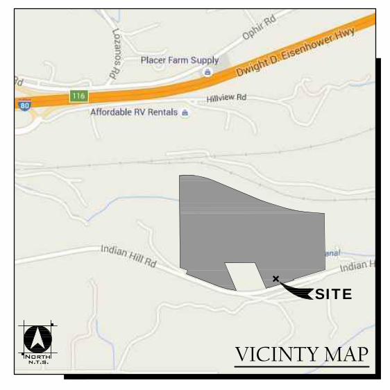
PROJECT LOCATION: Indian Hill Road, 1.5 miles west of the intersection of Auburn-Folsom Road and Indian Hill Road in the Newcastle area, Placer County
APPLICANT: Mike Anderson
The comment period for this document closes on April 22, 2019. A copy of the Mitigated Negative Declaration is available for public review at the County’s web site https://www.placer.ca.gov/2826/Negative-Declarations
Community Development Resource Agency public counter, and at the Penryn Public Library. Property owners within 300 feet of the subject site shall be notified by mail of the upcoming hearing before the Planning Commission. Additional information may be obtained by contacting the Environmental Coordination Services, at (530)745-3132, between the hours of 8:00 am and 5:00 pm. Comments may be sent to [email protected] or 3091 County Center Drive, Suite 190, Auburn, CA 95603.
Delivered to 300’ Property Owners on 3/22/19, 2019
2
1
34
5
6
7
8
RURAL MINOR RESIDENTIAL
TYPICAL SECTION
FILL
CUT
TSD ENGINEERING, INC.
31 Natoma Street, Suite #160Folsom, CA 95630Phone: (916) 608-0707Fax: (916) 608-0701
expect more.
N
S
EW
scale: 1"=100'
TENTATIVE SUBDIVISION MAP
STONE RIDGE
THIS TENTATIVE SUBDIVISION MAP CONFORMSTO SECTION 16.12.040 OF THE LANDDEVELOPMENT MANUAL.
FLOOD ZONEPROJECT IS LOCATED WITHIN FLOOD ZONEDESIGNATED AS X, AREAS DETERMINED TO BEOUTSIDE THE 500-YEAR FLOOD PLAIN PERFLOOD INSURANCE PROGRAM COMMUNITYPANEL NO. 06061C0409F DATED JUNE 8, 1998.
TENTATIVE MAP STATEMENT
"I HEREBY STATE THAT THIS TENTATIVE MAP ACCURATELY DEPICTS THE LOCATION, WIDTH, TYPEAND RECORDING INFORMATION OF ALL RECORD EASEMENTS LISTED IN THE PRELIMINARY TITLE
REPORT ISSUED BY STEWART TITLE OF PLACER, ORDER NO. 34-248610 DATED 8/24/2015. ALL EASEMENTS
PROPOSED TO BE ABANDONED OR EXTINGUISHED ARE IDENTIFIED.
__________ ____________________ ____________SIGN DATE
B.M. S 1200 - PID JS0780A BRASS DISK IN CONCRETE 0.5 MILE EASTALONG THE WESTBOUND TRACK FROMTHE EAST END OF A TUNNEL, IN THE TOPAND 0.6 FOOT EAST OF THE WEST END OFTHE SOUTH CONCRETE HEAD WALL OF APIPE CULVERT UNDER THE TRACK, 8.0 FEETSOUTH OF THE SOUTH RAIL OF THEWESTBOUND TRACK, AND ABOUT 1 FOOTLOWER THAN THE TRACK.
NGVD29 DATUMBENCHMARK: ELEV.=1,068.03
INDIAN HILL RD
VICINTY MAPN.T.S.ORTHN
SITE+
UTILITY PROVIDERS
PARK DISTRICTFACILITY SERVICES
SCHOOL DISTRICTNEWCASTLE ELEMENTARY SCHOOLPLACER UNION HIGH SCHOOL
WATERPLACER COUNTY WATER AGENCY
SANITARY SEWERSEPTIC
STORM DRAINPRIVATE - MAINTAINED BY HOA
ELECTRICPG&E
TELEPHONEAT&T
CABLEWAVE
FIRENEWCASTLE FIRE PROTECTION DISTRICT
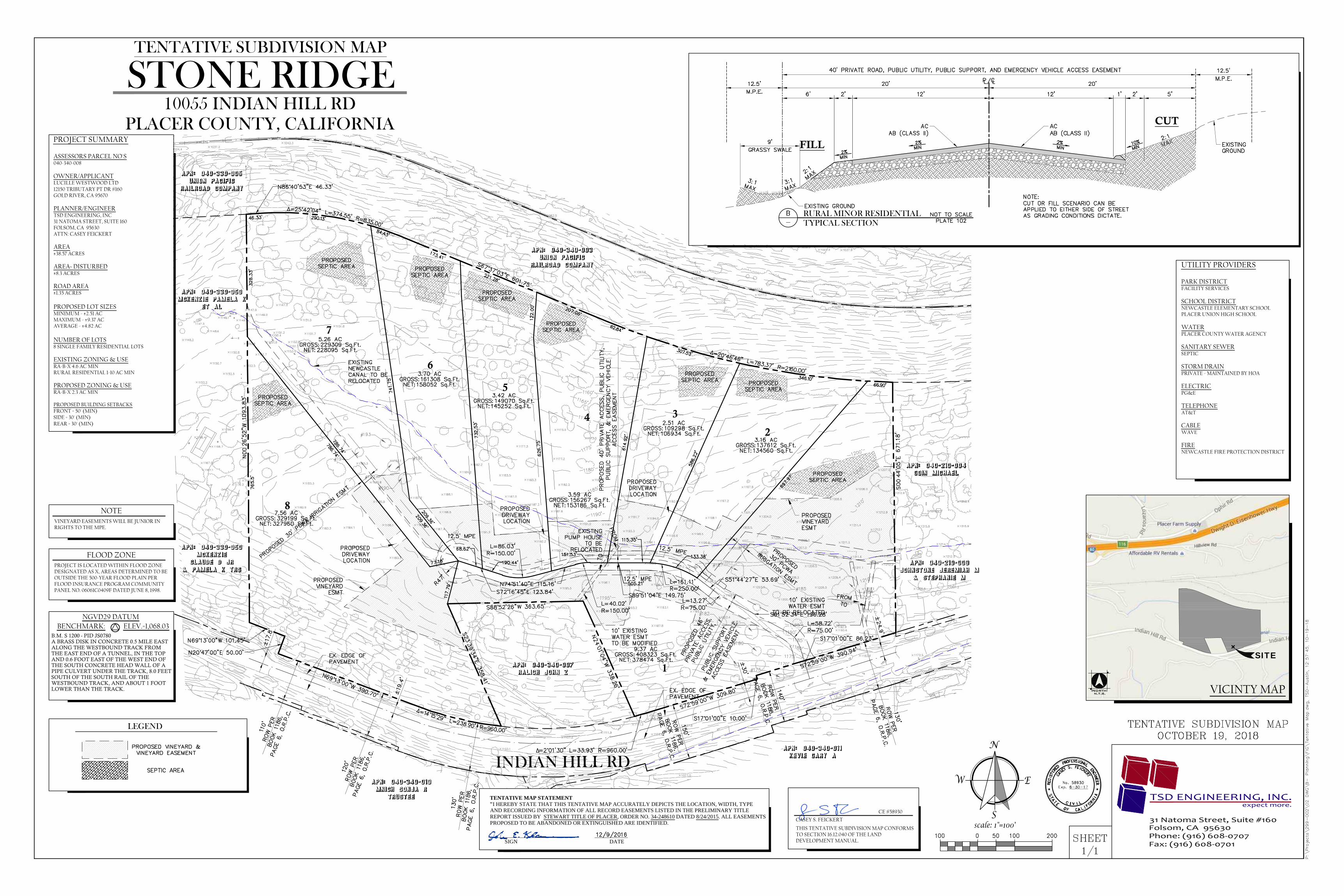
PROJECT SUMMARY
ASSESSORS PARCEL NO'S040-340-008
OWNER/APPLICANTLUCILLE WESTWOOD LTD12150 TRIBUTARY PT DR #160GOLD RIVER, CA 95670
PLANNER/ENGINEERTSD ENGINEERING, INC31 NATOMA STREET, SUITE 160FOLSOM, CA 95630ATTN: CASEY FEICKERT
AREA±38.57 ACRES
AREA~ DISTURBED±8.3 ACRES
ROAD AREA±1.35 ACRES
PROPOSED LOT SIZESMINIMUM - ±2.51 ACMAXIMUM - ±9.37 ACAVERAGE - ±4.82 AC
NUMBER OF LOTS8 SINGLE FAMILY RESIDENTIAL LOTS
EXISTING ZONING & USERA-B-X 4.6 AC MINRURAL RESIDENTIAL 1-10 AC MIN
PROPOSED ZONING & USERA-B-X 2.3 AC MIN
PROPOSED BUILDING SETBACKSFRONT = 50' (MIN)SIDE = 30' (MIN)REAR = 30' (MIN)
10055 INDIAN HILL RD
PLACER COUNTY, CALIFORNIA
CASEY S. FEICKERT
CE #58930
LEGEND
NOTEVINEYARD EASEMENTS WILL BE JUNIOR INRIGHTS TO THE MPE.
COMMUNITY DEVELOPMENT/RESOURCE AGENCY Environmental Coordination Services
County of Placer
MITIGATED NEGATIVE DECLARATION In accordance with Placer County ordinances regarding implementation of the California Environmental Quality Act, Placer County has conducted an Initial Study to determine whether the following project may have a significant adverse effect on the environment, and on the basis of that study hereby finds:
The proposed project will not have a significant adverse effect on the environment; therefore, it does not require the preparation of an Environmental Impact Report and this Negative Declaration has been prepared.
Although the proposed project could have a significant adverse effect on the environment, there will not be a significant adverse effect in this case because the project has incorporated specific provisions to reduce impacts to a less than significant level and/or the mitigation measures described herein have been added to the project. A Mitigated Negative Declaration has thus been prepared.
The environmental documents, which constitute the Initial Study and provide the basis and reasons for this determination are attached and/or referenced herein and are hereby made a part of this document. PROJECT INFORMATION
PUBLIC NOTICE The comment period for this document closes on April 22, 2019. A copy of the Mitigated Negative Declaration is available for public
review at the County’s web site https://www.placer.ca.gov/2826/Negative-Declarations. Community Development Resource Agency public counter, and at the Penryn Public Library. Property owners within 300 feet of the subject site shall be notified by mail of the upcoming meeting before the Planning Commission. Additional information may be obtained
by contacting the Environmental Coordination Services, at (530)745-3132 between the hours of 8:00 am and 5:00 pm at 3091 County Center Drive, Auburn, CA 95603. For Tahoe projects, the document will also be available in our Tahoe Division office, 775 North Lake Blvd., Tahoe City, CA 96145. If you wish to appeal the appropriateness or adequacy of this document, address your written comments to our finding that the project will not have a significant adverse effect on the environment: (1) identify the environmental effect(s), why they would occur, and why they would be significant, and (2) suggest any mitigation measures which you believe would eliminate or reduce the effect to an acceptable level. Regarding item (1) above, explain the basis for your comments and submit any supporting data or references. Refer to Section 18.32 of the Placer County Code for important information regarding the timely filing of appeals.
Title: Stoneridge Westwood Family Cellars Project # PLN16-00139
Description: The project proposes eight residential lots and a small winery that would be permitted to produce up to 20,000 cases of
wine annually and host six wine club dinners annually.
Location: Indian Hill Road, 1.5 miles west of the intersection of Auburn-Folsom Road and Indian Hill Road in the Newcastle area,
Placer County
Project Owner: Lucille Westwood Ltd.
Project Applicant: Mike Anderson
County Contact Person: Shirlee I. Herrington 530-745-3132
2
1
34
5
6
7
8
RURAL MINOR RESIDENTIAL
TYPICAL SECTION
FILL
CUT
TSD ENGINEERING, INC.
31 Natoma Street, Suite #160Folsom, CA 95630Phone: (916) 608-0707Fax: (916) 608-0701
expect more.
N
S
EW
scale: 1"=100'
TENTATIVE SUBDIVISION MAP
STONE RIDGE
THIS TENTATIVE SUBDIVISION MAP CONFORMSTO SECTION 16.12.040 OF THE LANDDEVELOPMENT MANUAL.
FLOOD ZONEPROJECT IS LOCATED WITHIN FLOOD ZONEDESIGNATED AS X, AREAS DETERMINED TO BEOUTSIDE THE 500-YEAR FLOOD PLAIN PERFLOOD INSURANCE PROGRAM COMMUNITYPANEL NO. 06061C0409F DATED JUNE 8, 1998.
TENTATIVE MAP STATEMENT
"I HEREBY STATE THAT THIS TENTATIVE MAP ACCURATELY DEPICTS THE LOCATION, WIDTH, TYPEAND RECORDING INFORMATION OF ALL RECORD EASEMENTS LISTED IN THE PRELIMINARY TITLE
REPORT ISSUED BY STEWART TITLE OF PLACER, ORDER NO. 34-248610 DATED 8/24/2015. ALL EASEMENTS
PROPOSED TO BE ABANDONED OR EXTINGUISHED ARE IDENTIFIED.
__________ ____________________ ____________SIGN DATE
B.M. S 1200 - PID JS0780A BRASS DISK IN CONCRETE 0.5 MILE EASTALONG THE WESTBOUND TRACK FROMTHE EAST END OF A TUNNEL, IN THE TOPAND 0.6 FOOT EAST OF THE WEST END OFTHE SOUTH CONCRETE HEAD WALL OF APIPE CULVERT UNDER THE TRACK, 8.0 FEETSOUTH OF THE SOUTH RAIL OF THEWESTBOUND TRACK, AND ABOUT 1 FOOTLOWER THAN THE TRACK.
NGVD29 DATUMBENCHMARK: ELEV.=1,068.03
INDIAN HILL RD
VICINTY MAPN.T.S.ORTHN
SITE+
UTILITY PROVIDERS
PARK DISTRICTFACILITY SERVICES
SCHOOL DISTRICTNEWCASTLE ELEMENTARY SCHOOLPLACER UNION HIGH SCHOOL
WATERPLACER COUNTY WATER AGENCY
SANITARY SEWERSEPTIC
STORM DRAINPRIVATE - MAINTAINED BY HOA
ELECTRICPG&E
TELEPHONEAT&T
CABLEWAVE
FIRENEWCASTLE FIRE PROTECTION DISTRICT
PROJECT SUMMARY
ASSESSORS PARCEL NO'S040-340-008
OWNER/APPLICANTLUCILLE WESTWOOD LTD12150 TRIBUTARY PT DR #160GOLD RIVER, CA 95670
PLANNER/ENGINEERTSD ENGINEERING, INC31 NATOMA STREET, SUITE 160FOLSOM, CA 95630ATTN: CASEY FEICKERT
AREA±38.57 ACRES
AREA~ DISTURBED±8.3 ACRES
ROAD AREA±1.35 ACRES
PROPOSED LOT SIZESMINIMUM - ±2.51 ACMAXIMUM - ±9.37 ACAVERAGE - ±4.82 AC
NUMBER OF LOTS8 SINGLE FAMILY RESIDENTIAL LOTS
EXISTING ZONING & USERA-B-X 4.6 AC MINRURAL RESIDENTIAL 1-10 AC MIN
PROPOSED ZONING & USERA-B-X 2.3 AC MIN
PROPOSED BUILDING SETBACKSFRONT = 50' (MIN)SIDE = 30' (MIN)REAR = 30' (MIN)
10055 INDIAN HILL RD
PLACER COUNTY, CALIFORNIA
CASEY S. FEICKERT
CE #58930
LEGEND
NOTEVINEYARD EASEMENTS WILL BE JUNIOR INRIGHTS TO THE MPE.
COMMUNITY DEVELOPMENT/RESOURCE AGENCY
Environmental Coordination Services County of Placer
INITIAL STUDY & CHECKLIST
This Initial Study has been prepared to identify and assess the anticipated environmental impacts of the following described project application. The document may rely on previous environmental documents (see Section D) and site-specific studies (see Section J) prepared to address in detail the effects or impacts associated with the project. This document has been prepared to satisfy the California Environmental Quality Act (CEQA) (Public Resources Code, Section 21000 et seq.) and the State CEQA Guidelines (14 CCR 15000 et seq.). CEQA requires that all state and local government agencies consider the environmental consequences of projects over which they have discretionary authority before acting on those projects. The Initial Study is a public document used by the decision-making lead agency to determine whether a project may have a significant effect on the environment. If the lead agency finds substantial evidence that any aspect of the project, either individually or cumulatively, may have a significant effect on the environment, regardless of whether the overall effect of the project is adverse or beneficial, the lead agency is required to prepare an Environmental Impact Report (EIR), use a previously-prepared EIR and supplement that EIR, or prepare a Subsequent EIR to analyze the project at hand. If the agency finds no substantial evidence that the project or any of its aspects may cause a significant effect on the environment, a Negative Declaration shall be prepared. If in the course of analysis, the agency recognizes that the project may have a significant impact on the environment, but that by incorporating specific mitigation measures the impact will be reduced to a less than significant effect, a Mitigated Negative Declaration shall be prepared.
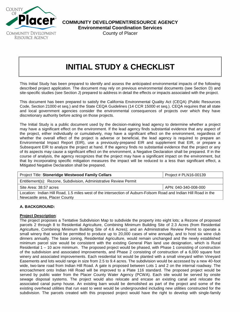
A. BACKGROUND: Project Description: The project proposes a Tentative Subdivision Map to subdivide the property into eight lots; a Rezone of proposed parcels 2 through 8 to Residential Agriculture, Combining Minimum Building Site of 2.3 Acres (from Residential Agriculture, Combining Minimum Building Site of 4.6 Acres); and an Administrative Review Permit to operate a small winery that would be permitted to produce up to 20,000 cases of wine annually, and to host six wine club dinners annually. The base zoning, Residential Agriculture, would remain unchanged and the newly established minimum parcel size would be consistent with the existing General Plan land use designation, which is Rural Residential 1 – 10 acre minimum. The proposed project would be phased, with Phase 1 consisting of construction of the subdivision and associated improvements, and Phase 2 consisting of construction of a 6,000 square foot winery and associated improvements. Each residential lot would be planted with a small vineyard within Vineyard Easements and lots would range in size from 2.5 to 9.4 acres. The subdivision would be accessed by a new 40-foot wide, two-lane road from Indian Hill Road. A gate is proposed between Lots 1 and 2 on the internal roadway. The encroachment onto Indian Hill Road will be improved to a Plate 116 standard. The proposed project would be served by public water from the Placer County Water Agency (PCWA). Each site would be served by onsite sewage disposal systems. The project would also relocate and encase an existing canal and relocate the associated canal pump house. An existing barn would be demolished as part of the project and some of the existing overhead utilities that run east to west would be undergrounded including new utilities constructed for the subdivision. The parcels created with this proposed project would have the right to develop with single-family
Project Title: Stoneridge Westwood Family Cellars Project # PLN16-00139
Entitlement(s): Rezone, Subdivision, Administrative Review Permit
Site Area: 38.57 acres APN: 040-340-008-000
Location: Indian Hill Road, 1.5 miles west of the intersection of Auburn-Folsom Road and Indian Hill Road in the Newcastle area, Placer County
Initial Study & Checklist continued
Initial Study & Checklist 2 of 46
residential uses including secondary dwellings, accessory structures, driveways, buildings pads, and utility connections. All development would be required to comply with Placer County development standards including the Land Development Manual, Zoning Ordinance, and California Building Codes.
Phase 1 Proposed Phase 1 would construct the subdivision road, which would extend from Indian Hill Road west across the middle of the project site, terminating in a cul de sac. The road is required to be paved and constructed to a Placer County Plate 102 Land Development Manual Standard and the cul de sac would be constructed to a Plate 108 standard. The encroachment onto Indian Hill Road is required to be constructed to a Major Plate 116. The required improvements will require steep cuts into the hillside. A nail soil wall is proposed at the project entrance to retain the slope. The required improvements to Indian Hill Road include a Class II bike lane. Lots 2 through 7 would be north of the subdivision road. Lot 8 would be south of the subdivision road, on the southwest corner of the property. The subdivision road bisects Lot 1, which proposes a pad for a home on the south side with the winery proposed on the north side (which would be constructed with Phase 2). In addition to the road, Phase 1 includes relocating Newcastle Canal to within the alignment of the subdivision road and encasing the canal in coordination with the Placer County Water Agency (PCWA). PCWA requires a 30’ wide easement over the canal, which is shown on the Tentative Subdivision Map prepared for the project. Phase 1 Offsite Improvements Phase 1 offsite improvements include constructing a paved, 6-foot wide shoulder where the project fronts Indian Hill Road. These improvements are required along the entire frontage of the property, and then transition/taper beyond the property boundaries. Phase 2 Phase 2 includes the construction and operation of a 6,000 square foot winery with a tasting room, kitchen, processing/bottling area, restrooms, two outside patios, and 35 paved parking spaces. Winery operations would include grape processing, wine fermentation, cellaring, bottling, wine sales and tasting, and food pairing. The winery would have a wine-making capacity of a maximum 20,000 cases per year and would be operated by
Initial Study & Checklist continued
Initial Study & Checklist 3 of 46
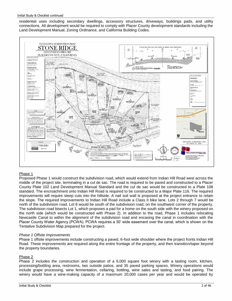
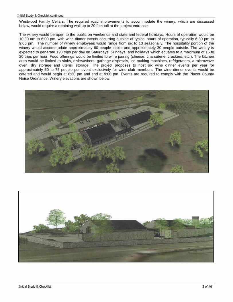
Westwood Family Cellars. The required road improvements to accommodate the winery, which are discussed below, would require a retaining wall up to 20 feet tall at the project entrance. The winery would be open to the public on weekends and state and federal holidays. Hours of operation would be 10:30 am to 6:00 pm, with wine dinner events occurring outside of typical hours of operation, typically 6:30 pm to 9:00 pm. The number of winery employees would range from six to 10 seasonally. The hospitality portion of the winery would accommodate approximately 60 people inside and approximately 30 people outside. The winery is expected to generate 120 trips per day on Saturdays, Sundays, and holidays which equates to a maximum of 15 to 20 trips per hour. Food offerings would be limited to wine pairing (cheese, charcuterie, crackers, etc.). The kitchen area would be limited to sinks, dishwashers, garbage disposals, ice making machines, refrigerators, a microwave oven, dry storage and utensil storage. The project proposes to host six wine dinner events per year for approximately 50 to 75 people per event exclusively for wine club members. The wine dinner events would be catered and would begin at 6:30 pm and end at 9:00 pm. Events are required to comply with the Placer County Noise Ordinance. Winery elevations are shown below.
Initial Study & Checklist continued
Initial Study & Checklist 4 of 46
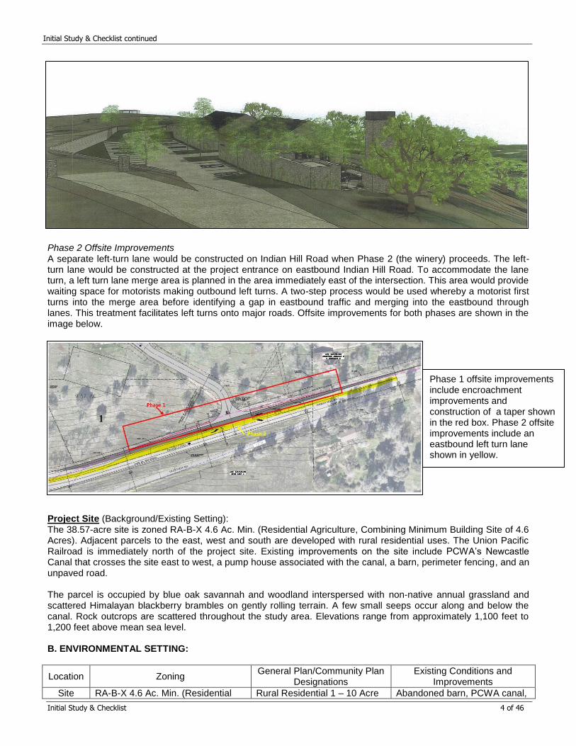
Phase 2 Offsite Improvements A separate left-turn lane would be constructed on Indian Hill Road when Phase 2 (the winery) proceeds. The left-turn lane would be constructed at the project entrance on eastbound Indian Hill Road. To accommodate the lane turn, a left turn lane merge area is planned in the area immediately east of the intersection. This area would provide waiting space for motorists making outbound left turns. A two-step process would be used whereby a motorist first turns into the merge area before identifying a gap in eastbound traffic and merging into the eastbound through lanes. This treatment facilitates left turns onto major roads. Offsite improvements for both phases are shown in the image below. Project Site (Background/Existing Setting): The 38.57-acre site is zoned RA-B-X 4.6 Ac. Min. (Residential Agriculture, Combining Minimum Building Site of 4.6 Acres). Adjacent parcels to the east, west and south are developed with rural residential uses. The Union Pacific Railroad is immediately north of the project site. Existing improvements on the site include PCWA’s Newcastle Canal that crosses the site east to west, a pump house associated with the canal, a barn, perimeter fencing, and an unpaved road. The parcel is occupied by blue oak savannah and woodland interspersed with non-native annual grassland and scattered Himalayan blackberry brambles on gently rolling terrain. A few small seeps occur along and below the canal. Rock outcrops are scattered throughout the study area. Elevations range from approximately 1,100 feet to 1,200 feet above mean sea level. B. ENVIRONMENTAL SETTING:
Location Zoning General Plan/Community Plan
Designations Existing Conditions and
Improvements
Site RA-B-X 4.6 Ac. Min. (Residential Rural Residential 1 – 10 Acre Abandoned barn, PCWA canal,
Phase 1 offsite improvements include encroachment improvements and construction of a taper shown in the red box. Phase 2 offsite improvements include an eastbound left turn lane shown in yellow.
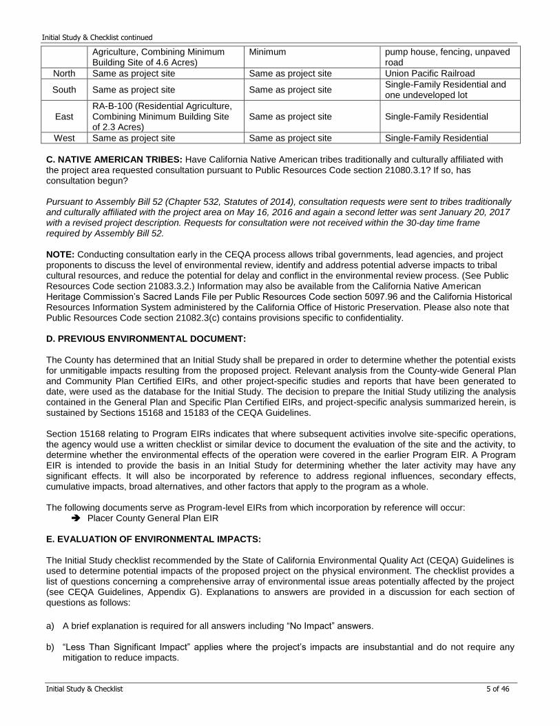
Initial Study & Checklist continued
Initial Study & Checklist 5 of 46
Agriculture, Combining Minimum Building Site of 4.6 Acres)
Minimum pump house, fencing, unpaved road
North Same as project site Same as project site Union Pacific Railroad
South Same as project site Same as project site Single-Family Residential and one undeveloped lot
East RA-B-100 (Residential Agriculture, Combining Minimum Building Site of 2.3 Acres)
Same as project site Single-Family Residential
West Same as project site Same as project site Single-Family Residential
C. NATIVE AMERICAN TRIBES: Have California Native American tribes traditionally and culturally affiliated with the project area requested consultation pursuant to Public Resources Code section 21080.3.1? If so, has consultation begun? Pursuant to Assembly Bill 52 (Chapter 532, Statutes of 2014), consultation requests were sent to tribes traditionally and culturally affiliated with the project area on May 16, 2016 and again a second letter was sent January 20, 2017 with a revised project description. Requests for consultation were not received within the 30-day time frame required by Assembly Bill 52. NOTE: Conducting consultation early in the CEQA process allows tribal governments, lead agencies, and project proponents to discuss the level of environmental review, identify and address potential adverse impacts to tribal cultural resources, and reduce the potential for delay and conflict in the environmental review process. (See Public Resources Code section 21083.3.2.) Information may also be available from the California Native American Heritage Commission’s Sacred Lands File per Public Resources Code section 5097.96 and the California Historical Resources Information System administered by the California Office of Historic Preservation. Please also note that Public Resources Code section 21082.3(c) contains provisions specific to confidentiality. D. PREVIOUS ENVIRONMENTAL DOCUMENT: The County has determined that an Initial Study shall be prepared in order to determine whether the potential exists for unmitigable impacts resulting from the proposed project. Relevant analysis from the County-wide General Plan and Community Plan Certified EIRs, and other project-specific studies and reports that have been generated to date, were used as the database for the Initial Study. The decision to prepare the Initial Study utilizing the analysis contained in the General Plan and Specific Plan Certified EIRs, and project-specific analysis summarized herein, is sustained by Sections 15168 and 15183 of the CEQA Guidelines.
Section 15168 relating to Program EIRs indicates that where subsequent activities involve site-specific operations, the agency would use a written checklist or similar device to document the evaluation of the site and the activity, to determine whether the environmental effects of the operation were covered in the earlier Program EIR. A Program EIR is intended to provide the basis in an Initial Study for determining whether the later activity may have any significant effects. It will also be incorporated by reference to address regional influences, secondary effects, cumulative impacts, broad alternatives, and other factors that apply to the program as a whole.
The following documents serve as Program-level EIRs from which incorporation by reference will occur:
Placer County General Plan EIR
E. EVALUATION OF ENVIRONMENTAL IMPACTS: The Initial Study checklist recommended by the State of California Environmental Quality Act (CEQA) Guidelines is used to determine potential impacts of the proposed project on the physical environment. The checklist provides a list of questions concerning a comprehensive array of environmental issue areas potentially affected by the project (see CEQA Guidelines, Appendix G). Explanations to answers are provided in a discussion for each section of questions as follows:
a) A brief explanation is required for all answers including “No Impact” answers.
b) “Less Than Significant Impact” applies where the project’s impacts are insubstantial and do not require any mitigation to reduce impacts.
Initial Study & Checklist continued
Initial Study & Checklist 6 of 46
c) "Less Than Significant with Mitigation Measures" applies where the incorporation of mitigation measures has reduced an effect from “Potentially Significant Impact" to a "Less than Significant Impact." The County, as lead agency, must describe the mitigation measures, and briefly explain how they reduce the effect to a less-than-significant level (mitigation measures from earlier analyses may be cross-referenced).
d) "Potentially Significant Impact" is appropriate if there is substantial evidence that an effect may be significant. If there are one or more "Potentially Significant Impact" entries when the determination is made, an EIR is required.
e) All answers must take account of the entire action involved, including off-site as well as on-site, cumulative as well as project-level, indirect as well as direct, and construction as well as operational impacts [CEQA Guidelines, Section 15063(a)(1)].
f) Earlier analyses may be used where, pursuant to the tiering, Program EIR, or other CEQA process, an effect has been adequately analyzed in an earlier EIR or Negative Declaration [CEQA Guidelines, Section 15063(c)(3)(D)]. A brief discussion should be attached addressing the following: Earlier analyses used – Identify earlier analyses and state where they are available for review.
Impacts adequately addressed – Identify which effects from the above checklist were within the scope of,
and adequately analyzed in, an earlier document pursuant to applicable legal standards. Also, state whether such effects were addressed by mitigation measures based on the earlier analysis.
Mitigation measures – For effects that are checked as “Less Than Significant with Mitigation Measures,” describe the mitigation measures which were incorporated or refined from the earlier document and the extent to which they address site-specific conditions for the project.
g) References to information sources for potential impacts (i.e. General Plans/Community Plans, zoning ordinances) should be incorporated into the checklist. Reference to a previously-prepared or outside document should include a reference to the pages or chapters where the statement is substantiated. A source list should be attached and other sources used, or individuals contacted, should be cited in the discussion.
Initial Study & Checklist continued
PLN=Planning Services Division, ESD=Engineering & Surveying Division, EHS=Environmental Health Services 7 of 46
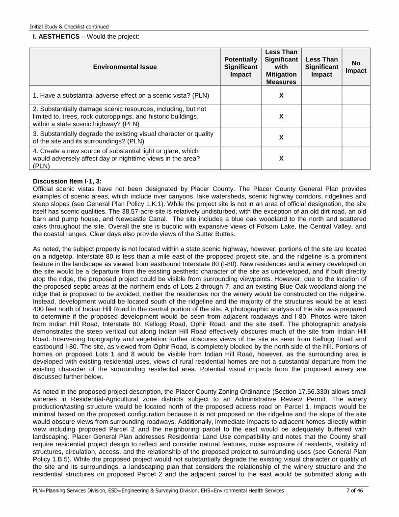
I. AESTHETICS – Would the project:
Environmental Issue Potentially Significant
Impact
Less Than Significant
with Mitigation Measures
Less Than Significant
Impact
No Impact
1. Have a substantial adverse effect on a scenic vista? (PLN) X
2. Substantially damage scenic resources, including, but not limited to, trees, rock outcroppings, and historic buildings, within a state scenic highway? (PLN)
X
3. Substantially degrade the existing visual character or quality of the site and its surroundings? (PLN)
X
4. Create a new source of substantial light or glare, which would adversely affect day or nighttime views in the area? (PLN)
X
Discussion Item I-1, 3: Official scenic vistas have not been designated by Placer County. The Placer County General Plan provides examples of scenic areas, which include river canyons, lake watersheds, scenic highway corridors, ridgelines and steep slopes (see General Plan Policy 1.K.1). While the project site is not in an area of official designation, the site itself has scenic qualities. The 38.57-acre site is relatively undisturbed, with the exception of an old dirt road, an old barn and pump house, and Newcastle Canal. The site includes a blue oak woodland to the north and scattered oaks throughout the site. Overall the site is bucolic with expansive views of Folsom Lake, the Central Valley, and the coastal ranges. Clear days also provide views of the Sutter Buttes. As noted, the subject property is not located within a state scenic highway, however, portions of the site are located on a ridgetop. Interstate 80 is less than a mile east of the proposed project site, and the ridgeline is a prominent feature in the landscape as viewed from eastbound Interstate 80 (I-80). New residences and a winery developed on the site would be a departure from the existing aesthetic character of the site as undeveloped, and if built directly atop the ridge, the proposed project could be visible from surrounding viewpoints. However, due to the location of the proposed septic areas at the northern ends of Lots 2 through 7, and an existing Blue Oak woodland along the ridge that is proposed to be avoided, neither the residences nor the winery would be constructed on the ridgeline. Instead, development would be located south of the ridgeline and the majority of the structures would be at least 400 feet north of Indian Hill Road in the central portion of the site. A photographic analysis of the site was prepared to determine if the proposed development would be seen from adjacent roadways and I-80. Photos were taken from Indian Hill Road, Interstate 80, Kellogg Road, Ophir Road, and the site itself. The photographic analysis demonstrates the steep vertical cut along Indian Hill Road effectively obscures much of the site from Indian Hill Road. Intervening topography and vegetation further obscures views of the site as seen from Kellogg Road and eastbound I-80. The site, as viewed from Ophir Road, is completely blocked by the north side of the hill. Portions of homes on proposed Lots 1 and 8 would be visible from Indian Hill Road, however, as the surrounding area is developed with existing residential uses, views of rural residential homes are not a substantial departure from the existing character of the surrounding residential area. Potential visual impacts from the proposed winery are discussed further below. As noted in the proposed project description, the Placer County Zoning Ordinance (Section 17.56.330) allows small wineries in Residential-Agricultural zone districts subject to an Administrative Review Permit. The winery production/tasting structure would be located north of the proposed access road on Parcel 1. Impacts would be minimal based on the proposed configuration because it is not proposed on the ridgeline and the slope of the site would obscure views from surrounding roadways. Additionally, immediate impacts to adjacent homes directly within view including proposed Parcel 2 and the neighboring parcel to the east would be adequately buffered with landscaping. Placer General Plan addresses Residential Land Use compatibility and notes that the County shall require residential project design to reflect and consider natural features, noise exposure of residents, visibility of structures, circulation, access, and the relationship of the proposed project to surrounding uses (see General Plan Policy 1.B.5). While the proposed project would not substantially degrade the existing visual character or quality of the site and its surroundings, a landscaping plan that considers the relationship of the winery structure and the residential structures on proposed Parcel 2 and the adjacent parcel to the east would be submitted along with
Initial Study & Checklist continued
PLN=Planning Services Division, ESD=Engineering & Surveying Division, EHS=Environmental Health Services 8 of 46
Improvement Plans in accordance with the below mitigation measure. Adequate buffering would be designed in accordance with the Landscape Design Guidelines. Further, the Placer County Zoning Ordinance states that the primary purpose of any winery is the growing and processing of grapes. As such, Parcel 1 is proposed to have approximately five acres of vineyard and would remain agricultural in nature, thereby maintaining an agricultural aesthetic that is compatible with Residential-Agricultural zone districts. In conclusion, the impacts to scenic vistas and degradation of existing visual character and site surroundings result in a less than significant impact with the following mitigation measure: Mitigation Measures Item I-1, 3: MM I.1 A Landscape Plan, prepared by a licensed landscape architect or similar professional, shall be submitted and approved by the Development Review Committee (DRC) and submitted with the project’s Improvement Plans. The Landscape Plan is for the project’s entryway frontage onto Indian Hill Road as well as a minimum 15 foot landscape strip on the west property line of Parcel 1 and a minimum ten foot landscape strip on the east side of the winery and the northeast side of the parking lot. Said Plan shall be submitted with the project’s Improvement Plans. The entryway landscaping shall be installed prior to the County’s acceptance of the subdivision’s improvements. The winery landscaping shall be installed prior to final building permit issuance for the winery. All landscaping shall comply with the state’s Water Efficient Landscape Ordinance and shall consist of native-appearing drought-tolerant plant species with a water-conserving drip irrigation system to be installed by the developer. The irrigation plan shall be designed to prevent over-watering of existing native oaks.
Discussion Item I-2: As noted in the discussion for Item 1-1, 3 above, there are no designated scenic vistas within Placer County. However, blue oak woodland is found at the northern and southern edge of the site and a grove of oaks is located along the west property line with additional scattered oaks throughout the site. Most of the trees removed for the proposed project would be in the center of the site within the building envelopes and vineyard easements and for construction of the subdivision road. The majority of oak woodland on-site would be avoided. However the presence of native oak woodland throughout the site does require tree removal and is considered to be less than significant with mitigation measures. As such a Biological Resources Assessment and Arborist Reports were required to detail the extent of tree removal and tree mitigation is required. The mitigation is detailed below. Mitigation Measures Item I-2: Implement Mitigation Measure IV.3 Discussion Item I-4: Lighting associated with the winery and the subdivision would have the potential to create a new source of light or glare. However, with the following mitigation measures, potential impacts would be less than significant. Mitigation Measures Item I-4: MM I-4.1 Future homeowners shall be notified that all outdoor lighting shall be shielded such that direct rays from the lamp are directed downwards and do not cross property lines. Motion sensor lighting shall be encouraged to minimize night sky pollution and to utilize exterior light sources when necessary. MM I-4.2 All exterior lighting for the winery, 50 watts or greater, shall be a full “cut-off” design so that the light source is fully screened from off-site and is Dark Sky compliant. Roof lighting, backlit awnings, and upward lighting is prohibited. Exterior lights shall not “spill over” onto adjacent properties and streets and shall be mounted such that they point downward without direct rays extending past the parking lot, building entrance, walkway, or area intended to be illuminated. Additional shielding of light sources, which could include installing larger shield fixtures and/or reducing the wattage or lumens of the light source, may be required to satisfy the intent of this Mitigation Measure. MM I-4.3 The Improvement Plans shall contain a Photometric Study for all outdoor lighting associated with the winery. The Photometric Study shall detail the location, lighting type, lumens, wattage, and fixture types and demonstrate that
Initial Study & Checklist continued
PLN=Planning Services Division, ESD=Engineering & Surveying Division, EHS=Environmental Health Services 9 of 46
light does not “spill” onto adjacent properties. II. AGRICULTURAL & FOREST RESOURCES – Would the project:
Environmental Issue Potentially Significant
Impact
Less Than Significant
with Mitigation Measures
Less Than Significant
Impact
No Impact
1. Convert Prime Farmland, Unique Farmland, or Farmland of Statewide or Local Importance (Farmland), as shown on the maps prepared pursuant to the Farmland Mapping and Monitoring Program of the California Resources Agency, to non-agricultural use? (PLN)
X
2. Conflict with General Plan or other policies regarding land use buffers for agricultural operations? (PLN)
X
3. Conflict with existing zoning for agricultural use, a Williamson Act contract or a Right-to-Farm Policy? (PLN)
X
4. Conflict with existing zoning for, or cause rezoning of, forest land (as defined in Public Resources Code section 12220(g)), timberland (as defined by Public Resources Code section 4526), or timberland zoned Timberland Production (as defined by Government Code section 51104(g))? (PLN)
X
5. Involve other changes in the existing environment which, due to their location or nature, could result in the loss or conversion of Farmland (including livestock grazing) or forest land to non-agricultural or non-forest use? (PLN)
X
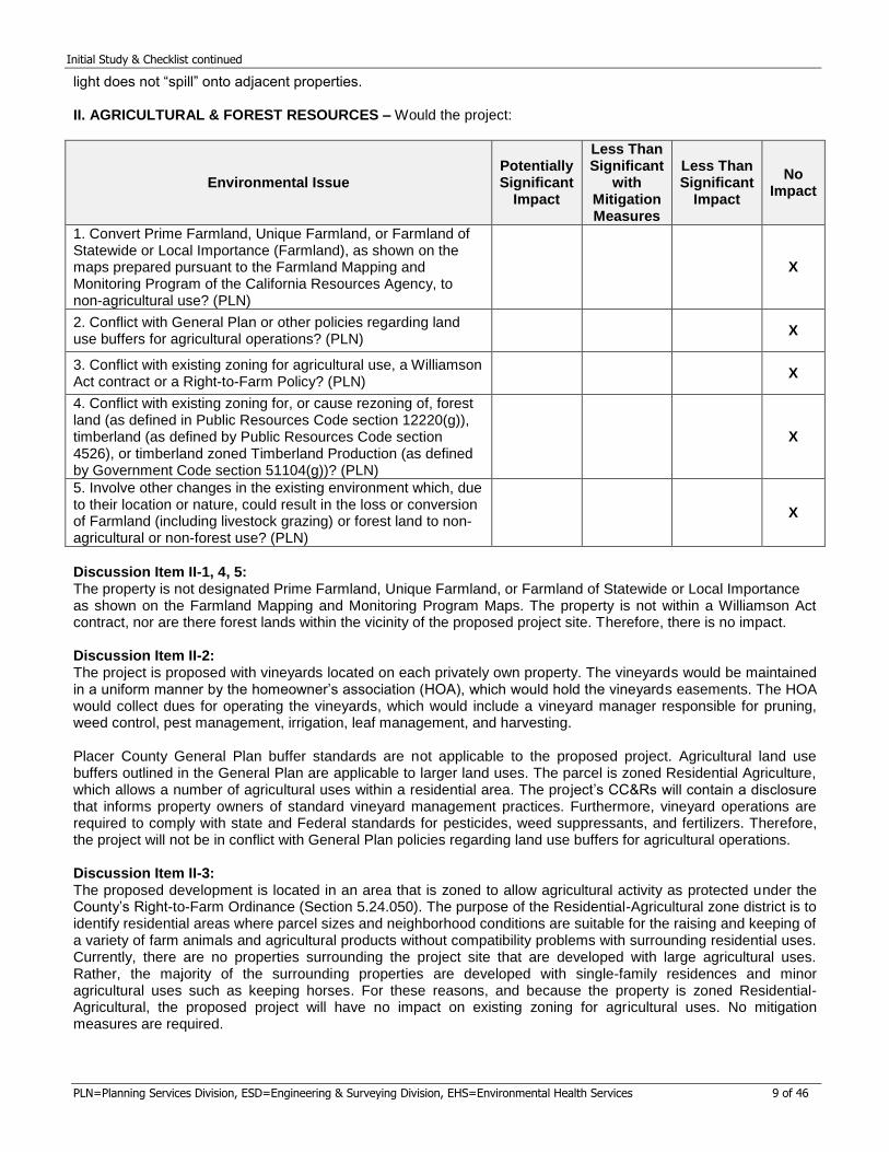
Discussion Item II-1, 4, 5: The property is not designated Prime Farmland, Unique Farmland, or Farmland of Statewide or Local Importance as shown on the Farmland Mapping and Monitoring Program Maps. The property is not within a Williamson Act contract, nor are there forest lands within the vicinity of the proposed project site. Therefore, there is no impact. Discussion Item II-2: The project is proposed with vineyards located on each privately own property. The vineyards would be maintained in a uniform manner by the homeowner’s association (HOA), which would hold the vineyards easements. The HOA would collect dues for operating the vineyards, which would include a vineyard manager responsible for pruning, weed control, pest management, irrigation, leaf management, and harvesting. Placer County General Plan buffer standards are not applicable to the proposed project. Agricultural land use buffers outlined in the General Plan are applicable to larger land uses. The parcel is zoned Residential Agriculture, which allows a number of agricultural uses within a residential area. The project’s CC&Rs will contain a disclosure that informs property owners of standard vineyard management practices. Furthermore, vineyard operations are required to comply with state and Federal standards for pesticides, weed suppressants, and fertilizers. Therefore, the project will not be in conflict with General Plan policies regarding land use buffers for agricultural operations. Discussion Item II-3: The proposed development is located in an area that is zoned to allow agricultural activity as protected under the County’s Right-to-Farm Ordinance (Section 5.24.050). The purpose of the Residential-Agricultural zone district is to identify residential areas where parcel sizes and neighborhood conditions are suitable for the raising and keeping of a variety of farm animals and agricultural products without compatibility problems with surrounding residential uses. Currently, there are no properties surrounding the project site that are developed with large agricultural uses. Rather, the majority of the surrounding properties are developed with single-family residences and minor agricultural uses such as keeping horses. For these reasons, and because the property is zoned Residential-Agricultural, the proposed project will have no impact on existing zoning for agricultural uses. No mitigation measures are required.

Initial Study & Checklist continued
PLN=Planning Services Division, ESD=Engineering & Surveying Division, EHS=Environmental Health Services 10 of 46
III. AIR QUALITY – Would the project:
Environmental Issue Potentially Significant
Impact
Less Than Significant
with Mitigation Measures
Less Than Significant
Impact
No Impact
1. Conflict with or obstruct implementation of the applicable air quality plan? (PLN, Air Quality)
X
2. Violate any air quality standard or contribute substantially to an existing or projected air quality violation? (PLN, Air Quality)
X
3. Result in a cumulatively considerable net increase of any criteria for which the project region is non-attainment under an applicable federal or state ambient air quality standard (including releasing emissions which exceed quantitative thresholds for ozone precursors)? (PLN, Air Quality)
X
4. Expose sensitive receptors to substantial pollutant concentrations? (PLN, Air Quality)
X
5. Create objectionable odors affecting a substantial number of people? (PLN, Air Quality)
X
Discussion Item III-1, 2: The proposed project is located within the Sacramento Valley Air Basin (SVAB) portion of Placer County and is under the jurisdiction of the Placer County Air Pollution Control District (PCAPCD). The SVAB is designated non-attainment for the federal and state ozone standards (ROG and NOx), and nonattainment for the state particulate matter standard (PM10). The winery would be located on 4.29 acres of the full 38.57-acre site, with the remaining acreage in rural residential. The proposed project would include eight residential lots, and 1.3 acres of asphalt paving for parking. The proposed Project would not conflict with or obstruct the implementation of the regional air quality plan, if the proposed project emissions were anticipated within the emission inventory contained in the regional air quality plan, referred to as the State Implementation Plan (SIP), and would not exceed the PCAPCD CEQA thresholds adopted October 13, 2016 as follows: PCAPCD CEQA THRESHOLDS FOR CRITERIA POLLUTANT EMISSIONS
1. Construction Threshold of 82 pounds per day for Reactive Organic Gases (ROG), Oxides of Nitrogen (NOx), and particulate matter smaller than 10 microns (PM10);
2. Operational Threshold of 55 pounds per day for ROG, NOx and 82 pounds per day for PM10; and 3. Cumulative Threshold of 55 pounds per day for ROG, NOx and 82 pounds per day for PM10.
The daily maximum emission thresholds represent an emission level below which the proposed project’s contribution to criteria pollutant emissions would be deemed less than significant. These levels of operational
emissions would be equivalent to a project size of approximately 617 single‐family dwelling units, or a 249,100 square foot commercial building. During construction, various types of equipment and vehicles would temporarily operate. Construction exhaust emissions would be generated from construction equipment, demolition, vegetation clearing and earth movement activities, construction workers’ commute, and construction material hauling. The proposed project construction activities would generate air pollutant emissions of criteria pollutants, including ROG, NOx, PM10 and Diesel Particulate Matter (DPM).
Initial Study & Checklist continued
PLN=Planning Services Division, ESD=Engineering & Surveying Division, EHS=Environmental Health Services 11 of 46
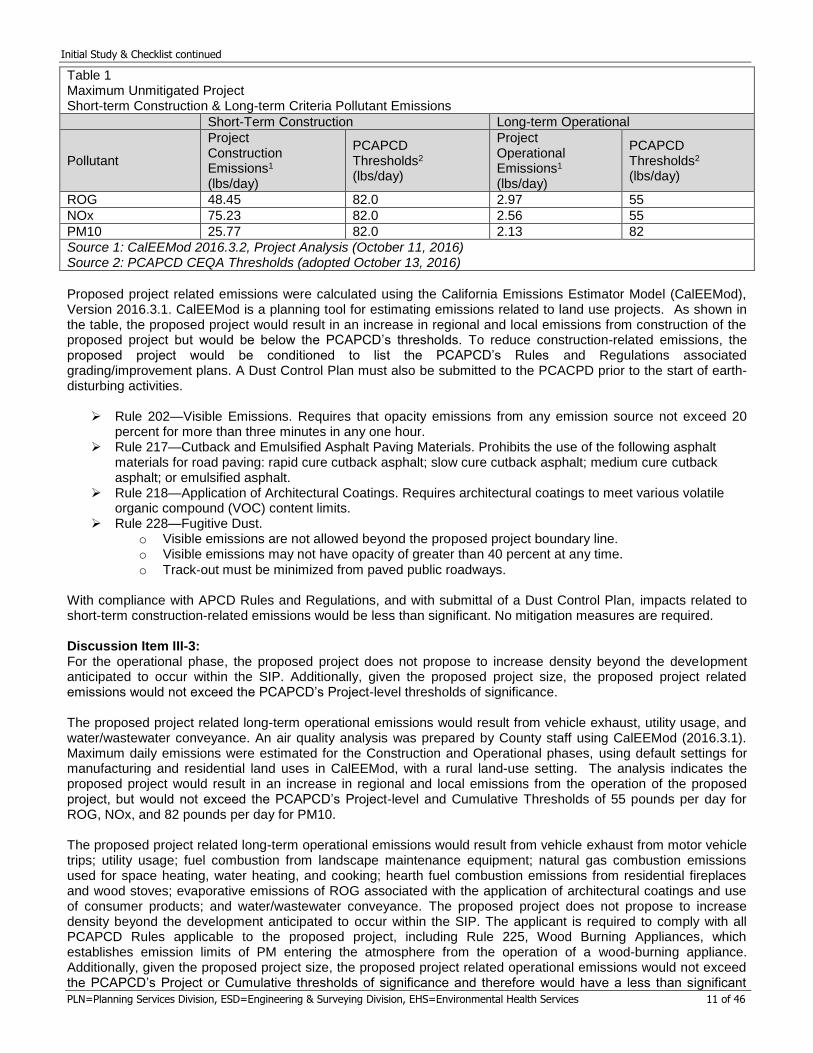
Table 1 Maximum Unmitigated Project Short-term Construction & Long-term Criteria Pollutant Emissions
Short-Term Construction Long-term Operational
Pollutant
Project Construction Emissions1
(lbs/day)
PCAPCD Thresholds2 (lbs/day)
Project Operational Emissions1
(lbs/day)
PCAPCD Thresholds2 (lbs/day)
ROG 48.45 82.0 2.97 55
NOx 75.23 82.0 2.56 55
PM10 25.77 82.0 2.13 82
Source 1: CalEEMod 2016.3.2, Project Analysis (October 11, 2016) Source 2: PCAPCD CEQA Thresholds (adopted October 13, 2016)
Proposed project related emissions were calculated using the California Emissions Estimator Model (CalEEMod), Version 2016.3.1. CalEEMod is a planning tool for estimating emissions related to land use projects. As shown in the table, the proposed project would result in an increase in regional and local emissions from construction of the proposed project but would be below the PCAPCD’s thresholds. To reduce construction-related emissions, the proposed project would be conditioned to list the PCAPCD’s Rules and Regulations associated grading/improvement plans. A Dust Control Plan must also be submitted to the PCACPD prior to the start of earth-disturbing activities.
Rule 202—Visible Emissions. Requires that opacity emissions from any emission source not exceed 20 percent for more than three minutes in any one hour.
Rule 217—Cutback and Emulsified Asphalt Paving Materials. Prohibits the use of the following asphalt materials for road paving: rapid cure cutback asphalt; slow cure cutback asphalt; medium cure cutback asphalt; or emulsified asphalt.
Rule 218—Application of Architectural Coatings. Requires architectural coatings to meet various volatile organic compound (VOC) content limits.
Rule 228—Fugitive Dust. o Visible emissions are not allowed beyond the proposed project boundary line. o Visible emissions may not have opacity of greater than 40 percent at any time.
o Track‐out must be minimized from paved public roadways. With compliance with APCD Rules and Regulations, and with submittal of a Dust Control Plan, impacts related to short-term construction-related emissions would be less than significant. No mitigation measures are required. Discussion Item III-3: For the operational phase, the proposed project does not propose to increase density beyond the development anticipated to occur within the SIP. Additionally, given the proposed project size, the proposed project related emissions would not exceed the PCAPCD’s Project-level thresholds of significance. The proposed project related long-term operational emissions would result from vehicle exhaust, utility usage, and water/wastewater conveyance. An air quality analysis was prepared by County staff using CalEEMod (2016.3.1). Maximum daily emissions were estimated for the Construction and Operational phases, using default settings for manufacturing and residential land uses in CalEEMod, with a rural land-use setting. The analysis indicates the proposed project would result in an increase in regional and local emissions from the operation of the proposed project, but would not exceed the PCAPCD’s Project-level and Cumulative Thresholds of 55 pounds per day for ROG, NOx, and 82 pounds per day for PM10. The proposed project related long-term operational emissions would result from vehicle exhaust from motor vehicle trips; utility usage; fuel combustion from landscape maintenance equipment; natural gas combustion emissions used for space heating, water heating, and cooking; hearth fuel combustion emissions from residential fireplaces and wood stoves; evaporative emissions of ROG associated with the application of architectural coatings and use of consumer products; and water/wastewater conveyance. The proposed project does not propose to increase density beyond the development anticipated to occur within the SIP. The applicant is required to comply with all PCAPCD Rules applicable to the proposed project, including Rule 225, Wood Burning Appliances, which establishes emission limits of PM entering the atmosphere from the operation of a wood-burning appliance. Additionally, given the proposed project size, the proposed project related operational emissions would not exceed the PCAPCD’s Project or Cumulative thresholds of significance and therefore would have a less than significant
Initial Study & Checklist continued
PLN=Planning Services Division, ESD=Engineering & Surveying Division, EHS=Environmental Health Services 12 of 46
effect. No mitigation measures are required. Discussion Item III-4: Certain air pollutants are classified by the ARB as toxic air contaminants, or TACs, which are known to increase the risk of cancer and/or other serious health effects. Localized concentrations of Carbon Monoxide (CO) can be a TAC and are typically generated by traffic congestion at intersections. The anticipated traffic resulting from the proposed project would not impact the nearby intersections ability to operate acceptably and would therefore not result in a substantial concentration of CO emissions at any intersection. The construction of the proposed project would result in short-term diesel particulate matter (DPM) emissions from heavy-duty on-site equipment and off-road diesel equipment. Additionally, DPM emissions would result from monthly testing of the diesel generator. The California Air Resources Board (ARB) has identified DPM from diesel exhaust as a toxic air contaminant, with both chronic and carcinogenic public health risks. The ARB, PCAPCD, and Placer County recognize the public health risk reductions that can be realized by idling limitations for on-road and off-road equipment. The proposed project would be required to comply with the following idling restriction (five minute limitation) requirements from ARB and Placer County Code during construction activity, including the use of both on-road and off-road equipment:
California Air Resources Board (ARB) Section 2449(d)(3) of the ARB’s In-use Off-road Diesel regulation: Off-road diesel equipment shall comply with the five-minute idling restriction. Available via the web: www.arb.ca.gov/regact/2007/ordiesl07/frooal.pdf
Placer County, Code Section 10.14. Available via the web: http://qcode.us/codes/placercounty/ Portable equipment and engines (i.e., back-up generators) 50 horsepower (hp) or greater, used during construction activities and operation require either a registration certificate issued by ARB, based on the California Statewide Portable Equipment Registration Program (PERP) or a District permit to operate. The proposed project would be conditioned to obtain all necessary permits from ARB and PCAPCD prior to construction. Due to the short-term nature of the construction, and infrequent periodic testing of the diesel generator, and with compliance with State and Local regulations, potential public health impacts would be less than significant. No mitigation measures are required. Discussion Item III-5: The proposed project would result in additional air pollutant emissions generated by diesel-powered construction equipment, as well as long-term operational emissions from residents’ vehicle exhaust that could create odors. However, wineries and residential uses are not typically associated with the creation of objectionable odors. Therefore, potential impacts from odors would be less than significant. No mitigation measures are required. IV. BIOLOGICAL RESOURCES – Would the project:
Environmental Issue Potentially Significant
Impact
Less Than Significant
with Mitigation Measures
Less Than Significant
Impact
No Impact
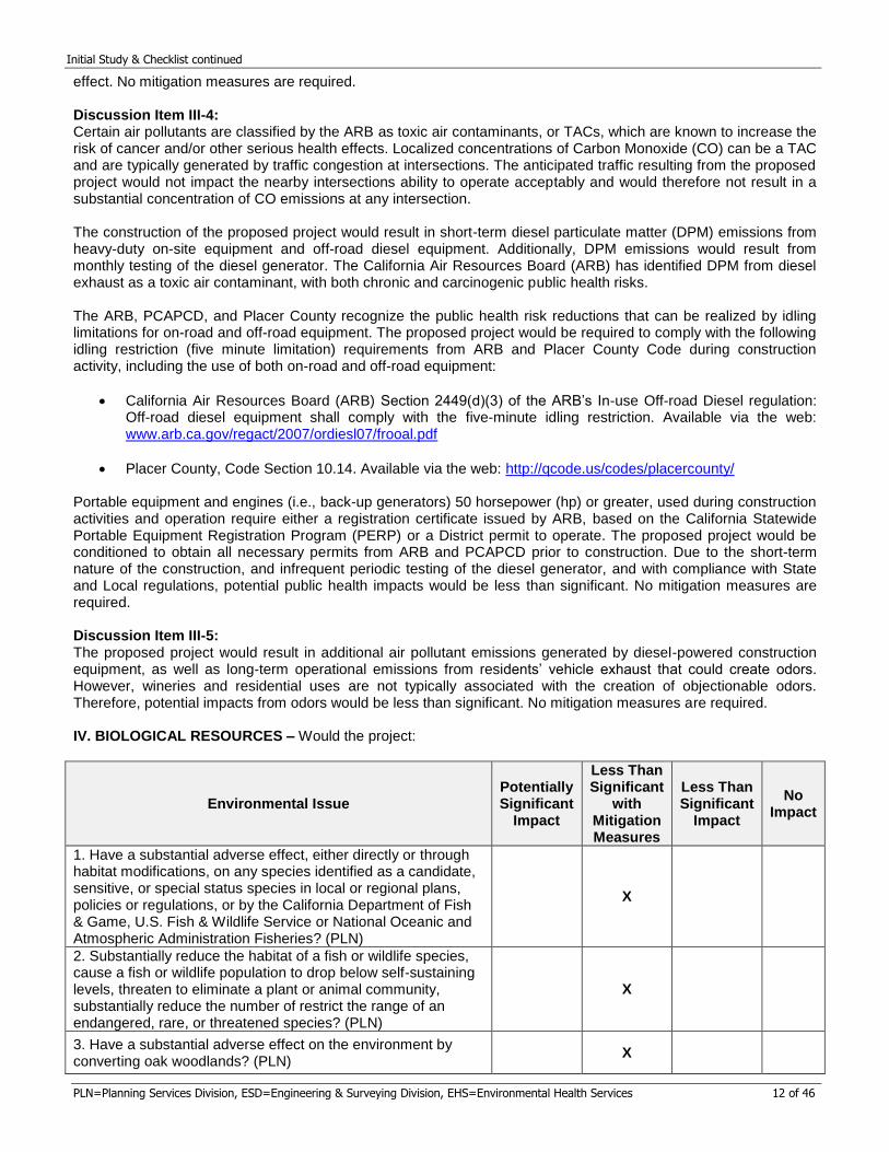
1. Have a substantial adverse effect, either directly or through habitat modifications, on any species identified as a candidate, sensitive, or special status species in local or regional plans, policies or regulations, or by the California Department of Fish & Game, U.S. Fish & Wildlife Service or National Oceanic and Atmospheric Administration Fisheries? (PLN)
X
2. Substantially reduce the habitat of a fish or wildlife species, cause a fish or wildlife population to drop below self-sustaining levels, threaten to eliminate a plant or animal community, substantially reduce the number of restrict the range of an endangered, rare, or threatened species? (PLN)
X
3. Have a substantial adverse effect on the environment by converting oak woodlands? (PLN)
X
Initial Study & Checklist continued
PLN=Planning Services Division, ESD=Engineering & Surveying Division, EHS=Environmental Health Services 13 of 46
4. Have a substantial adverse effect on any riparian habitat or other sensitive natural community, including oak woodlands, identified in local or regional plans, policies or regulations, or by the California Department of Fish & Game, U.S. Fish & Wildlife Service, U.S. Army Corps of Engineers or National Oceanic and Atmospheric Administration Fisheries? (PLN)
X
5. Have a substantial adverse effect on federal or state protected wetlands as defined by Section 404 of the Clean Water Act (including, but not limited to, marsh, vernal pool, coastal, etc.) or as defined by state statute, through direct removal, filling, hydrological interruption, or other means? (PLN)
X
6. Interfere substantially with the movement of any native resident or migratory wildlife species or with established native resident or migratory wildlife corridors, or impede the use of native wildlife nesting or breeding sites? (PLN)
X
7. Conflict with any local policies or ordinances that protect biological resources, including oak woodland resources? (PLN)
X
8. Conflict with the provisions of an adopted Habitat Conservation Plan, Natural Community Conservation Plan, or other approved local, regional, or state habitat conservation plan? (PLN)
X
Discussion Item IV-1, 2, 6: A Biological Resources Assessment was prepared for the proposed project by Madrone Ecological Consulting dated April 2018. The Assessment was prepared based on literature review and field surveys. Field surveys of the proposed project area were conducted on October 26, 2016, to assess the suitability of habitats on-site to support special-status species, and on June 5, 2017, to support special-status plant species. The proposed project area is occupied by Blue Oak Savanna and Woodland interspersed with non-native annual grassland and scattered Himalayan blackberry brambles on gently rolling terrain. A canal bisects the site east to west across the ridgetop. Three small seeps occur along and below the canal. Rock outcrops are scattered throughout the Study Area. Small pits located north of the canal were observed during the survey and may be related to historic mining while others appear more recent and may be the result of soil pits dug for geotechnical exploration purposes. Elevations within the Study Area range from approximately 1,100 feet to 1,200 feet above mean sea level (MSL). Surrounding properties are large, rural residential properties with similar vegetation. The Union Pacific Railroad tracks border the site to the north. The annual brome grassland is dominated by soft brome (Bromus hordeaceus), wild oat (Avena fatua), and yellow star-thistle (Centaurea solstitialis). Other species commonly occurring in this community with the Study Area include ripgut brome (Bromus diandrus), filaree (Erodium botrys), rose clover (Trifolium hirtum), Italian thistle (Carduss pycnocephalus), Canadian horseweed (Erigeron canadensis), prickly lettuce (Lectuca serriola) hedgehog dogtail grass (Cynosurus echinatus), and common madia (Madia elegans). The Blue Oak Woodland within the proposed project area varies from open savannah throughout much of the proposed project area to a denser, closed-canopy woodland along the northern boundary. The canopy of the blue oak woodland is dominated by blue oak (Quercus douglasii) and interior live oak (Q. wizlizenii). Grey pine (Pinus sabiniana), California buckeye (Aesculus californica), and black oak (Quercus kelloggii) are also common. The understory is largely similar to the annual brome grassland described above. Poison oak (Toxicodendron diversilobum), California hoptree (Ptelea crenulata) and wavy-leaved soapplant (Chlorogalum pomeridianum) occur intermittently in the understory of the oak woodland as well. Soil types on-site include Auburn-Sobrante-Rock outcrop complex, 30-50% slopes; Inks cobbly loam, 30-50% slopes; Inks-Exchequer complex, 2-25% slopes; and Inks variant cobbly loam, 2-30% slopes. None of the mapping units are derived from serpentine or gabbro soils. The Assessment determined the site potentially supports habitat for Big-scale balsamroot (Balsamorhiza macrolepis), Sanford’s arrowhead (Sagittaria sanfordii), Swainson’s hawk (Buteo swainsonii), Pallid bat (Antrozous pallidus), Townsend’s big-eared bat (Corynorhinus townsendii townsendii), Silver-haired bat (Lasionycteris
Initial Study & Checklist continued
PLN=Planning Services Division, ESD=Engineering & Surveying Division, EHS=Environmental Health Services 14 of 46
noctivagans), and hoary bat (Lasiurus cinereus). Habitat for nesting migratory birds is also found on-site. Protocol-level surveys conducted in June 2017, during these species’ bloom periods, failed to detect Big-scale balsamroot and Sanford’s arrowhead. Although the trees onsite provide suitable nesting habitat and marginal foraging habitat is present on-site within the annual brome grassland, the site is not expected to be utilized by Swainson’s hawk, as the project site is outside the species’ current known distributional range. Though the site is outside the Swainson’s hawk known distributional range, the site does support suitable nesting and foraging habitat is onsite. Therefore, development of the project would impact nesting and foraging habitat for Swainson’s hawk as well as bats from construction operations including grading, demolishing the barn, and tree removal. However, with the following mitigation measure, potential impacts to these species would be reduced to less than significant. Mitigation Measures Item IV-1, 2, 6: MM IV.1 If ground disturbance, vegetation thinning, or other construction activities are proposed during the bird nesting season (February 1 – August 31), a focused bird survey for nesting raptors and migratory bird nests shall be conducted by a qualified biologist within 7 days prior to the beginning of construction activities in order to identify active nests. This survey shall be conducted within the proposed construction area and all accessible areas within 500 feet of the construction area. If active raptor nests are found, no construction activities shall take place within 500 feet of the nest until the young have fledged. If active passerine (i.e., songbird/perching bird) nests are found, a 100-foot no disturbance buffer will be established. These no-disturbance buffers may be reduced with appropriate basis (e.g., shielding by vegetation or topography, etc.) on approval by the DRC in coordination with the California Department of Fish and Wildlife. The perimeter of the protected area shall be indicated by bright orange temporary fencing or perimeter-flagged with brightly-colored flags. No construction activities or personnel shall enter the protected area, except with the approval of the biologist. If tree removal is necessary, trees containing nests that must be removed as a result of project implementation shall be removed during the nonbreeding season (late September through the end of January) or once a qualified avian biologist has determined that the young have fledged. Advance tree removal outside of the breeding season is permissible if all necessary entitlements have been obtained. If no active nests are found during the focused survey, no further mitigation will be required. MM IV.2 Pre-construction roosting bat surveys shall be conducted by a qualified biologist within 7 days prior to any tree or building removal that will occur during the breeding season (April through August). If pre-construction surveys indicate that no roosts of special-status bat species are present, or that roosts are inactive or potential habitat is unoccupied, no further mitigation is required. If roosting bats are found, exclusion shall be conducted as recommended by the qualified biologist. Methods may include acoustic monitoring, evening emergence surveys, and the utilization of two-step tree removal supervised by the qualified biologist. Two-step tree removal involves removal of all branches that do not provide roosting habitat on the first day, followed by removal of the remaining portion of the tree on the following day. Building exclusion methods may include such techniques as installation of passive one-way doors, or the installation of netting when the bats are not present to prevent their reoccupation. Once the bats have been excluded, tree or building removal may occur. Discussion Item IV-3, 7: Four Arborist Reports were conducted for the proposed project by Sierra Nevada Arborists in April 2016, April 2018, May 2018 and August 2018. The first assessment inventoried trees within 50 feet of, and/or overhanging, the proposed subdivision road. The second assessment inventoried trees within 50 feet of, and/or overhanging the proposed project improvements including the subdivision road and the canal encasement improvements. The April 4, 2018 inventory did not assess the proposed building envelope areas or the proposed onsite sewage disposal areas.. The third assessment inventoried trees within the proposed building envelopes and oaks greater than 24 inches at diameter breast height (DBH). The fourth assessment inventoried trees within the proposed on-site sewage disposal areas. Combined, the assessments inventoried all trees on the property with the exception of the proposed Vineyard Easement areas, as tree removal for bona fide agricultural endeavors as approved by the Agricultural Commissioner are exempt from the Placer County Tree Ordinance. An additional 17 trees are within the Vineyard Easements and are not counted toward the total number of trees impacted by the proposed project. Based on the assessments, a total of 201 protected trees greater than six-inch DBH occur on-site that would be directly affected by construction of the site improvements. One tree is an almond tree and two are foothill pine. These trees are exempt from the Placer County Tree Ordinance requirements and their removal therefore does not require mitigation. Eight trees are recommended for removal due to the nature and extent of defects, compromised health, and/or structural instability and their removal therefore does not require mitigation. A total of 198 protected trees totaling 2,850 inches would be impacted by development of the proposed project including road construction
Initial Study & Checklist continued
PLN=Planning Services Division, ESD=Engineering & Surveying Division, EHS=Environmental Health Services 15 of 46
and improvements, utility installation, relocation and encasement of the canal, and construction of the future homes and the proposed winery. Removal of these 198 protected trees requires mitigation. The Biological Assessment for the proposed project notes that 4.5 acres of oak woodland and 15.1 acres of oak savannah are on-site for a total of 19.6 acres of oak woodland vegetation communities. The remaining area (approximately 19.0 acres) is within the Annual Brome Grassland vegetation community. Both of the oak vegetation communities contain greater than 10% native oak canopy cover and therefore are considered “Oak Woodland.” Impacts to oak woodlands are subject to the Placer County Guidelines for Evaluating Impacts on Oak Woodland, which require two acres of woodland be provided off-site to mitigate every one acre of woodland lost to development. Blue Oak Woodland encompasses the northern portion of the property and a small portion at the southeast corner. The majority of Blue Oak Woodland on-site would remain undisturbed, particularly at the northern end of the property, because the location of the building envelopes is further south to take advantage of the more level areas of the property. In addition, the slope and noise setback lines further prevent development in most of the Blue Oak Woodland. The larger impact is to Oak Savannah, which encompasses more of the site than Blue Oak Woodland. The existing woodland is somewhat fragmented to the south by Indian Hill Road and to the east by existing development. While there is development to the west, the area to the east is more built-out, likely due to its proximity to the City of Auburn and due to steep and uneven topography towards the west. Broader oak woodland connectivity is found at the north end of the property immediately adjacent to the railroad and to the northwest which is less developed. However, the northern area of the property is largely avoided by the proposed project with the exception of the on-site sewage disposal areas for Parcels 2 through 6 and Parcel 8. Impacts to oak woodland would be immediate, however long term impacts would be minimized because once the on-site sewage disposal systems are established, further disturbance is not expected to occur unless a system failure occurs. System failure resulting in leaks are uncommon in newer permitted systems, therefore potential impacts to individual trees from on-site sewage disposal system failure would be negligible. The on-site sewage disposal areas for Parcels 1 and 7 are within the Annual Brome Grassland habitat and creation of the on-site sewage disposal systems for these parcels would not impact oak woodland vegetation communities. The proposed leach fields for Parcels 2 through 8 are within the Blue Oak Woodland and Oak Savannah totaling 0.63 acre of impacts to oak woodlands from the leach fields. Portions of the building envelopes for Parcels 3 through 8 encroach into the Blue Oak Woodland and Oak Savannah vegetation communities totaling 2.9 acres. A building envelope for Lot 1 was not established, however the Grading & Utility Plan prepared for the proposed project identifies a pad where a future home would be. Due to the slope of the parcel, the location of the vineyard easements, the location of the winery, and the required structural setbacks, this pad area is realistically the only place on Lot 1 where a residence could be constructed. Approximately 7,220 square feet, or 0.16 acre, of the south and east portions of the pad on Lot 1 extend into the Oak Savannah vegetation community. Combined, the proposed project would impact approximately 3.69 acres of oak woodland vegetation communities. The proposed project would convert oak woodland to rural residential uses. However, of the 19.6 acres of oak woodland on-site, the proposed project would be impacting 3.69 acres. The majority of oak woodland would be preserved on-site. For these reasons, the loss of oak woodland is not considered a significant conversion of oak woodland, and the impact to oak woodland as well as individual oaks would be less than significant with implementation of the following mitigation measures. Mitigation Measures Item IV-3, 7: MM IV.3 Impacts to 3.69 acres of oak woodland located in areas mapped on Figure 4 of the Biological Resources Assessment (dated April 2018) as Oak Woodland or Oak Savannah: Prior to Improvement Plan approval, the applicant shall obtain a Tree Permit from the Placer County Planning Services Division and shall comply with all requirements of the tree permit. Compensatory mitigation shall occur and shall consist of one of the following, based upon the acreage of oak woodland impact:
a. Submit payment of fees for oak woodland conversion at a 2:1 ratio consistent with Chapter 12.16.080 (C) Placer County Tree Preservation Ordinance – Replacement Programs and Penalties. The fee is $24,000 for each acre of oak woodland impact. Alternatively, the fees may be calculated based upon the current market value of similar oak woodland acreage preservation and an endowment to maintain the land in perpetuity, as determined by qualified professional Arborist.
b. Purchase off-site conservation easements at a location approved by Placer County to mitigate the loss of oak woodlands at a 2:1 ratio.
Initial Study & Checklist continued
PLN=Planning Services Division, ESD=Engineering & Surveying Division, EHS=Environmental Health Services 16 of 46
c. Provide for a combination of payment ($24,000 per acre of impacted oak woodland) to the Tree Preservation Fund and creation of an off-site Oak Preservation Easement.
d. Plant and maintain an appropriate number of trees in restoration of an approved former oak woodland (tree planting is limited to half the mitigation requirement)
MM IV.4 Impacts to trees located in all other areas (i.e., individual trees in the Annual Brome Grassland vegetation community, as identified in Figure 4 of the Biological Resources Assessment): Prior to Improvement Plan approval, for each diameter of tree removed, replacement shall be on an inch-for-inch basis. For example, if 100 diameter inches are proposed to be removed, the replacement trees would equal 100 diameter inches (aggregate). If replacement tree planting is required, the trees must be installed by the applicant and inspected and approved by the Development Review Committee (DRC). At its discretion, the DRC may establish an alternate deadline for installation of mitigation replacement trees if weather or other circumstances prevent the completion of this requirement; or, in lieu of tree planting mitigation for tree removal listed above, a contribution of $100 per diameter at breast height for each tree removed or impacted or the current market value, as established by an Arborist, Forester, or Registered Landscape Architect, of the replacement trees, including the cost of installation, shall be paid to the Placer County Tree Preservation Fund. Discussion Item IV-4, 5: Aquatic resources on-site are largely related to the canal. A total of 0.574 acre of aquatic resources were identified on-site and includes 0.100 acre of seep and 0.474 acre of canal. The Assessment notes that the source of the sub-surface water appears to be the Newcastle Canal for at least two of the three seeps but the source of water for the third seep is unclear, and may either be associated with the canal or from natural perched groundwater. The Geotechnical Report prepared for the proposed project notes that “the water exposed by our excavations does not represent a permanent groundwater table but is a result of surface water (and water leaking from the canal)
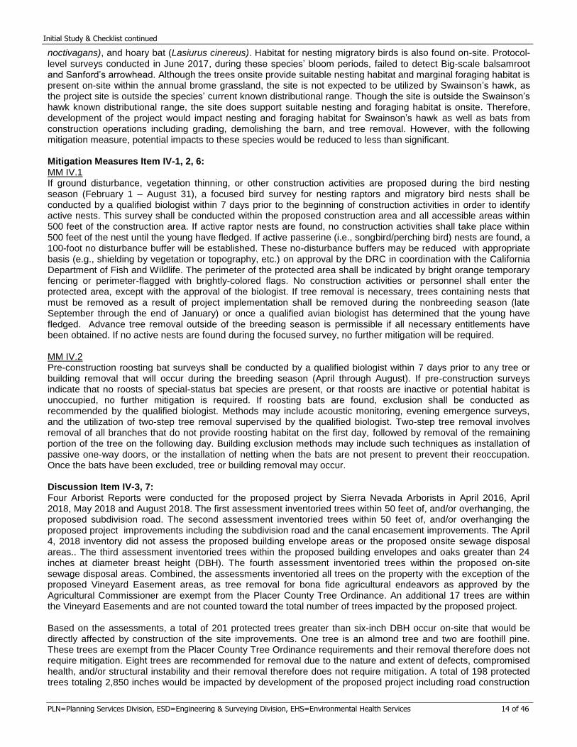
Figure 4 from the Biological Resources Assessment, which identified three vegetation communities onsite. Annual brome grassland is the dominant vegetation community at 19.0 acres, shown in green. Blue oak woodland, shown in purple, encompasses 4.5 acres onsite and oak savannah encompasses 15.1 acres onsite.
Initial Study & Checklist continued
PLN=Planning Services Division, ESD=Engineering & Surveying Division, EHS=Environmental Health Services 17 of 46
accumulating over the relatively impermeable underlying weathered rock surface” (MPE 2015). Dominant plant species in the seeps include dallisgrass (Paspalum dilatatum), Bermuda grass (Cynodon dactylon), and English plantain (Plantago lanceolata). Other species commonly observed in seeps within the proposed project area include jungle rice (Echinochloa colona), Canadian horseweed, common rush (Juncus effuses), bull thistle (Cirsium vulgare), curly dock (Rumex crispus), fiddle dock (R. pulcher), Spanish lotus (Acmispon americanus), hairy hawkbit (Leontodon saxatilis), perennial ryegrass (Festuca perennis), Himalayan blackberry, and Monterey centaury (Zeltnera muehlenbergii). The canal flows east to west across the property and was excavated along the ridgetop through the central portion of the property. The applicant obtained a jurisdictional determination by regulatory staff at the U.S. Army Corps of Engineers (USACE) to verify whether or not the canal and the seeps would be considered jurisdictional and whether a Section 404 permit would be required dated July 23, 2018. The USACE verified that the canal and seeps are a manmade ditch and artificially irrigated wetlands and as such, these resources are not regulated by USACE and a Section 404 permit would not be required. The Assessment notes this feature appears to be perennial and is primarily unlined, with the exception of the eastern and western edges which are lined with concrete. The channel width and depth varies, but is approximately eight inches deep and three feet wide on average. The channel itself is unvegetated, but the banks are densely vegetated, and in places, this vegetation encroaches on the channel. Plant species commonly occurring on the banks of the canal include mosquito fern (Azolla filiculoides), dallisgrass, knotgrass (Paspalum distichum), black flatsedge, common rush, fringed willow-herb (Epilobium brachycarpum), sticktight (Bidens fondosa), and floating water primrose (Ludwigia peploides). Though the canal and seeps are not subject to USACE regulation, the aquatic features would likely still be considered Waters of the State, and as such would be subject to Waste Discharge Requirement (WDR) regulation by the California Regional Water Quality Control Board (RWQCB) under the Porter-Cologne Water Quality Control Act. . Potential impacts to aquatic resources could occur from development of the proposed project including construction of the subdivision road, utility installation, and construction of the future home sites. With implementation of the following mitigation measure, impacts would be less than significant. Mitigation Measures Item IV-4, 5: MM IV.5 Prior to Improvement Plan approval and if deemed necessary by the regulatory agencies, the applicant shall obtain Waste Discharge Requirements from the RWQCB and a Section 1600 Lake and Streambed Alteration Agreement (LSAA) from the California Department of Fish and Wildlife (CDFW). The applicant shall provide written evidence to the County that this measure has been complied with in accordance with any required 404 permit, 401 certification, and/or LSAA. Discussion Item IV-8: Placer County does not currently have an active Habitat Conservation Plan; however, the County is currently preparing the Placer County Conservation Program (PCCP), which is nearing completion. This proposed project would have the option to participate in the PCCP for incidental take coverage and mitigation for effects to waters of the U.S. if the PCCP’s permits are issued and local implementing ordinances adopted prior to the proposed project receiving its entitlements. Therefore, there is no impact. V. CULTURAL RESOURCES – Would the project:
Environmental Issue Potentially Significant
Impact
Less Than Significant
with Mitigation Measures
Less Than Significant
Impact
No Impact
1. Substantially cause adverse change in the significance of a historical resource as defined in CEQA Guidelines, Section 15064.5? (PLN)
X
2. Substantially cause adverse change in the significance of a unique archaeological resource pursuant to CEQA Guidelines, Section 15064.5? (PLN)
X
Initial Study & Checklist continued
PLN=Planning Services Division, ESD=Engineering & Surveying Division, EHS=Environmental Health Services 18 of 46
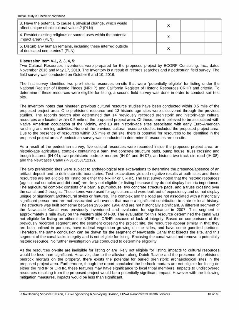
3. Have the potential to cause a physical change, which would affect unique ethnic cultural values? (PLN)
X
4. Restrict existing religious or sacred uses within the potential impact area? (PLN)
X
5. Disturb any human remains, including these interred outside of dedicated cemeteries? (PLN)
X
Discussion Item V-1, 2, 3, 4, 5: Two Cultural Resources Inventories were prepared for the proposed project by ECORP Consulting, Inc., dated November 2016 and May 17, 2018. The Inventory is a result of records searches and a pedestrian field survey. The field survey was conducted on October 6 and 10, 2016. The first survey identified two pre-historic resources on-site that were “potentially eligible” for listing under the National Register of Historic Places (NRHP) and California Register of Historic Resources CRHR and criteria. To determine if these resources were eligible for listing, a second field survey was done in order to conduct soil test pits. The Inventory notes that nineteen previous cultural resource studies have been conducted within 0.5 mile of the proposed project area. One prehistoric resource and 13 historic-age sites were discovered through the previous studies. The records search also determined that 14 previously recorded prehistoric and historic-age cultural resources are located within 0.5 mile of the proposed project area. Of these, one is believed to be associated with Native American occupation of the vicinity, and 13 are historic-age sites associated with early Euro-American ranching and mining activities. None of the previous cultural resource studies included the proposed project area. Due to the presence of resources within 0.5 mile of the site, there is potential for resources to be identified in the proposed project area. A pedestrian survey was conducted to determine if resources are on-site. As a result of the pedestrian survey, five cultural resources were recorded inside the proposed project area: an historic-age agricultural complex containing a barn, two concrete structure pads, pump house, truss crossing and trough features (IH-01); two prehistoric bedrock mortars (IH-04 and IH-07), an historic two-track dirt road (IH-08), and the Newcastle Canal (P-31-1581/1212). The two prehistoric sites were subject to archaeological test excavations to determine the presence/absence of an artifact deposit and to delineate site boundaries. Test excavations yielded negative results at both sites and these resources are not eligible for listing on either the NRHP or CRHR. The first survey noted that the historic resources (agricultural complex and dirt road) are likely not eligible for listing because they do not display historic importance. The agricultural complex consists of a barn, a pumphouse, two concrete structure pads, and a truss crossing over the canal, and 2 troughs. These items were used for agriculture and were built out of expediency and do not display unique or significant architectural styles or features. The complex and the road are not associated with a historically significant person and are not associated with events that made a significant contribution to state or local history. The structure was built sometime between 1956 and 1966 and are not historically significant. A different segment of the Newcastle Canal was previously inventoried and evaluated for significance in 2007. This segment is approximately 1 mile away on the western side of I-80. The evaluation for this resource determined the canal was not eligible for listing on either the NRHP or CRHR because of lack of integrity. Based on comparisons of the previously recorded segment and the segment crossing the project site, the resources appear similar in that they are both unlined in portions, have ruderal vegetation growing on the sides, and have some gunnited portions. Therefore, the same conclusion can be drawn for the segment of Newcastle Canal that bisects the site, and this segment of the canal lacks integrity and is not eligible for listing. Encasing the canal would not remove a potentially historic resource. No further investigation was conducted to determine eligibility. As the resources on-site are ineligible for listing or are likely not eligible for listing, impacts to cultural resources would be less than significant. However, due to the alluvium along Dutch Ravine and the presence of prehistoric bedrock mortars on the property, there exists the potential for buried prehistoric archaeological sites in the proposed project area. Furthermore, though the report concluded the bedrock mortars are not eligible for listing on either the NRHP or CRHR, these features may have significance to local tribal members. Impacts to undiscovered resources resulting from the proposed project would be a potentially significant impact. However with the following mitigation measures, impacts would be less than significant.
Initial Study & Checklist continued
PLN=Planning Services Division, ESD=Engineering & Surveying Division, EHS=Environmental Health Services 19 of 46
Mitigation Measures Item V-1, 2, 3, 4, 5: MM V.1 If subsurface deposits believed to be cultural or human in origin are discovered during construction, all work must halt within a 100-foot radius of the discovery. A qualified professional archaeologist, meeting the Secretary of Interior’s Professional Qualification Standards for prehistoric and historic archaeologists, shall be retained to evaluate the significance of the find, and shall have the authority to modify the no-work radius as appropriate, using professional judgment. The following notifications shall apply, depending on the nature of the find:
a. If the professional archaeologist determines that the find does not represent a cultural resource, work may resume immediately and no agency notifications are required.
b. If the professional archaeologist determines that the find represents a cultural resource from any time period or cultural affiliation, he or she shall immediately notify the federal lead agency and CEQA lead agency, and applicable landowner. The agencies shall consult on a finding of eligibility and implement appropriate treatment measures, if the find is determined to be eligible for inclusion in the NRHP or CRHR. Work may not resume within the no-work radius until the lead agencies, through consultation as appropriate, determine that the site either: 1) is not eligible for the NRHP or CRHR; or 2) that the treatment measures have been completed to their satisfaction.
c. If the find includes human remains, or remains that are potentially human, he or she shall ensure reasonable protection measures are taken to protect the discovery from disturbance (Assembly Bill [AB] 2641). The archaeologist shall notify the Placer County Coroner (as per Section 7050.0 of the Health and Safety Code) and the Placer County Planning Division. The provisions of Section 70505.5 of the California Health and Safety Code, Section 5097.98 of the California PRC, and AB 2641 will be implemented. If the Coroner determines the remains are Native American and not the result of a crime scene, the Coroner will notify the Native American Heritage Commission, which then will designate a Native American Most Likely Descendant (MLD) for the project (Section 5097.98 of the PRC). The designated MLD will have 48 hours from the time access to the property is granted to make recommendations concerning treatment of the remains. If the landowner does not agree with the recommendations of the MLD, the NAHC can mediate (Section 5097.94 of the PRC). If no agreement is reached, the landowner must rebury the remains where they will not be further disturbed (Section 5097.98 of the PRC). This will also include either recording the site with the NAHC or the appropriate Information Center; using open space or conservation zoning designation easement; or recording a reinternment document with the County in which the property is located (AB 2641). Work may not resume within the no-work radius until the lead agencies, through consultation as appropriate, determine that the treatment measures have been completed to their satisfaction.
MM V.2 Prior to construction, a qualified archaeologist shall be retained to both design a monitoring and mitigation program and implement the program during all project-related ground disturbance. The resource monitoring and mitigation program should include construction monitoring by the archaeologist; emergency discovery procedures; sampling and data recovery, if needed; museum curation of any specimens and data recovered; preconstruction coordination; and reporting. Prior to the start of construction, construction personnel involved with earth-moving activities shall be informed that cultural resources may be discovered during excavation and that these resources may be protected by laws, the appearance of such resources, and on proper notification procedures. This worker training should be a Cultural Resource Education Program prepared and presented by a qualified archaeologist or cultural resource professional. Earth-moving construction activities shall be monitored wherever these activities will disturb previously undisturbed areas. Monitoring will not be needed to be conducted in areas where sediments have been previously disturbed or in areas where exposed sediments will be buried, but otherwise not disturbed. VI. ENERGY – Would the project:
Environmental Issue Potentially Significant
Impact
Less Than Significant
with Mitigation Measures
Less Than Significant
Impact
No Impact
1. Result in potentially significant environmental impact due to wasteful, inefficient, or unnecessary consumption of energy resources, during project construction or operation? (PLN)
X
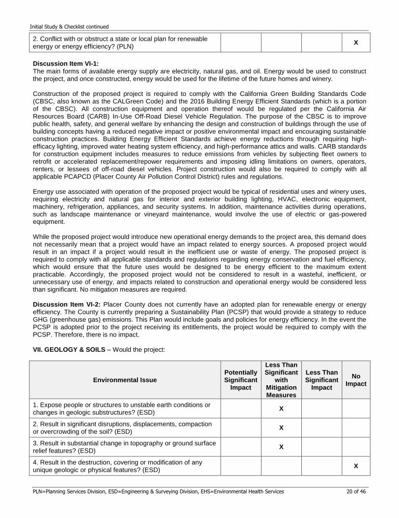
Initial Study & Checklist continued
PLN=Planning Services Division, ESD=Engineering & Surveying Division, EHS=Environmental Health Services 20 of 46
2. Conflict with or obstruct a state or local plan for renewable energy or energy efficiency? (PLN)
X
Discussion Item VI-1: The main forms of available energy supply are electricity, natural gas, and oil. Energy would be used to construct the project, and once constructed, energy would be used for the lifetime of the future homes and winery. Construction of the proposed project is required to comply with the California Green Building Standards Code (CBSC, also known as the CALGreen Code) and the 2016 Building Energy Efficient Standards (which is a portion of the CBSC). All construction equipment and operation thereof would be regulated per the California Air Resources Board (CARB) In-Use Off-Road Diesel Vehicle Regulation. The purpose of the CBSC is to improve public health, safety, and general welfare by enhancing the design and construction of buildings through the use of building concepts having a reduced negative impact or positive environmental impact and encouraging sustainable construction practices. Building Energy Efficient Standards achieve energy reductions through requiring high-efficacy lighting, improved water heating system efficiency, and high-performance attics and walls. CARB standards for construction equipment includes measures to reduce emissions from vehicles by subjecting fleet owners to retrofit or accelerated replacement/repower requirements and imposing idling limitations on owners, operators, renters, or lessees of off-road diesel vehicles. Project construction would also be required to comply with all applicable PCAPCD (Placer County Air Pollution Control District) rules and regulations. Energy use associated with operation of the proposed project would be typical of residential uses and winery uses, requiring electricity and natural gas for interior and exterior building lighting, HVAC, electronic equipment, machinery, refrigeration, appliances, and security systems. In addition, maintenance activities during operations, such as landscape maintenance or vineyard maintenance, would involve the use of electric or gas-powered equipment. While the proposed project would introduce new operational energy demands to the project area, this demand does not necessarily mean that a project would have an impact related to energy sources. A proposed project would result in an impact if a project would result in the inefficient use or waste of energy. The proposed project is required to comply with all applicable standards and regulations regarding energy conservation and fuel efficiency, which would ensure that the future uses would be designed to be energy efficient to the maximum extent practicable. Accordingly, the proposed project would not be considered to result in a wasteful, inefficient, or unnecessary use of energy, and impacts related to construction and operational energy would be considered less than significant. No mitigation measures are required. Discussion Item VI-2: Placer County does not currently have an adopted plan for renewable energy or energy efficiency. The County is currently preparing a Sustainability Plan (PCSP) that would provide a strategy to reduce GHG (greenhouse gas) emissions. This Plan would include goals and policies for energy efficiency. In the event the PCSP is adopted prior to the project receiving its entitlements, the project would be required to comply with the PCSP. Therefore, there is no impact. VII. GEOLOGY & SOILS – Would the project:
Environmental Issue Potentially Significant
Impact
Less Than Significant
with Mitigation Measures
Less Than Significant
Impact
No Impact
1. Expose people or structures to unstable earth conditions or changes in geologic substructures? (ESD)
X
2. Result in significant disruptions, displacements, compaction or overcrowding of the soil? (ESD)
X
3. Result in substantial change in topography or ground surface relief features? (ESD)
X
4. Result in the destruction, covering or modification of any unique geologic or physical features? (ESD)
X
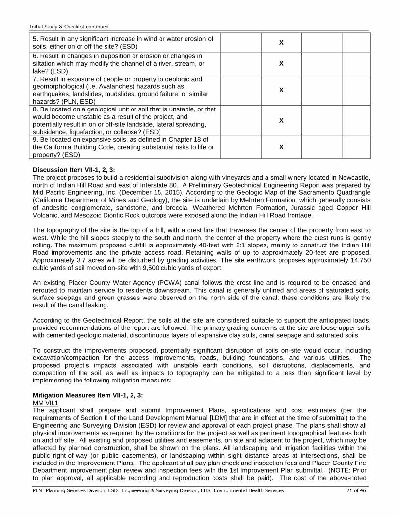
Initial Study & Checklist continued
PLN=Planning Services Division, ESD=Engineering & Surveying Division, EHS=Environmental Health Services 21 of 46
5. Result in any significant increase in wind or water erosion of soils, either on or off the site? (ESD)
X
6. Result in changes in deposition or erosion or changes in siltation which may modify the channel of a river, stream, or lake? (ESD)
X
7. Result in exposure of people or property to geologic and geomorphological (i.e. Avalanches) hazards such as earthquakes, landslides, mudslides, ground failure, or similar hazards? (PLN, ESD)
X
8. Be located on a geological unit or soil that is unstable, or that would become unstable as a result of the project, and potentially result in on or off-site landslide, lateral spreading, subsidence, liquefaction, or collapse? (ESD)
X
9. Be located on expansive soils, as defined in Chapter 18 of the California Building Code, creating substantial risks to life or property? (ESD)
X
Discussion Item VII-1, 2, 3: The project proposes to build a residential subdivision along with vineyards and a small winery located in Newcastle, north of Indian Hill Road and east of Interstate 80. A Preliminary Geotechnical Engineering Report was prepared by Mid Pacific Engineering, Inc. (December 15, 2015). According to the Geologic Map of the Sacramento Quadrangle (California Department of Mines and Geology), the site is underlain by Mehrten Formation, which generally consists of andesitic conglomerate, sandstone, and breccia. Weathered Mehrten Formation, Jurassic aged Copper Hill Volcanic, and Mesozoic Dioritic Rock outcrops were exposed along the Indian Hill Road frontage. The topography of the site is the top of a hill, with a crest line that traverses the center of the property from east to west. While the hill slopes steeply to the south and north, the center of the property where the crest runs is gently rolling. The maximum proposed cut/fill is approximately 40-feet with 2:1 slopes, mainly to construct the Indian Hill Road improvements and the private access road. Retaining walls of up to approximately 20-feet are proposed. Approximately 3.7 acres will be disturbed by grading activities. The site earthwork proposes approximately 14,750 cubic yards of soil moved on-site with 9,500 cubic yards of export. An existing Placer County Water Agency (PCWA) canal follows the crest line and is required to be encased and rerouted to maintain service to residents downstream. This canal is generally unlined and areas of saturated soils, surface seepage and green grasses were observed on the north side of the canal; these conditions are likely the result of the canal leaking.
According to the Geotechnical Report, the soils at the site are considered suitable to support the anticipated loads, provided recommendations of the report are followed. The primary grading concerns at the site are loose upper soils with cemented geologic material, discontinuous layers of expansive clay soils, canal seepage and saturated soils.
To construct the improvements proposed, potentially significant disruption of soils on-site would occur, including excavation/compaction for the access improvements, roads, building foundations, and various utilities. The proposed project’s impacts associated with unstable earth conditions, soil disruptions, displacements, and compaction of the soil, as well as impacts to topography can be mitigated to a less than significant level by implementing the following mitigation measures:
Mitigation Measures Item VII-1, 2, 3: MM VII.1 The applicant shall prepare and submit Improvement Plans, specifications and cost estimates (per the requirements of Section II of the Land Development Manual [LDM] that are in effect at the time of submittal) to the Engineering and Surveying Division (ESD) for review and approval of each project phase. The plans shall show all physical improvements as required by the conditions for the project as well as pertinent topographical features both on and off site. All existing and proposed utilities and easements, on site and adjacent to the project, which may be affected by planned construction, shall be shown on the plans. All landscaping and irrigation facilities within the public right-of-way (or public easements), or landscaping within sight distance areas at intersections, shall be included in the Improvement Plans. The applicant shall pay plan check and inspection fees and Placer County Fire Department improvement plan review and inspection fees with the 1st Improvement Plan submittal. (NOTE: Prior to plan approval, all applicable recording and reproduction costs shall be paid). The cost of the above-noted
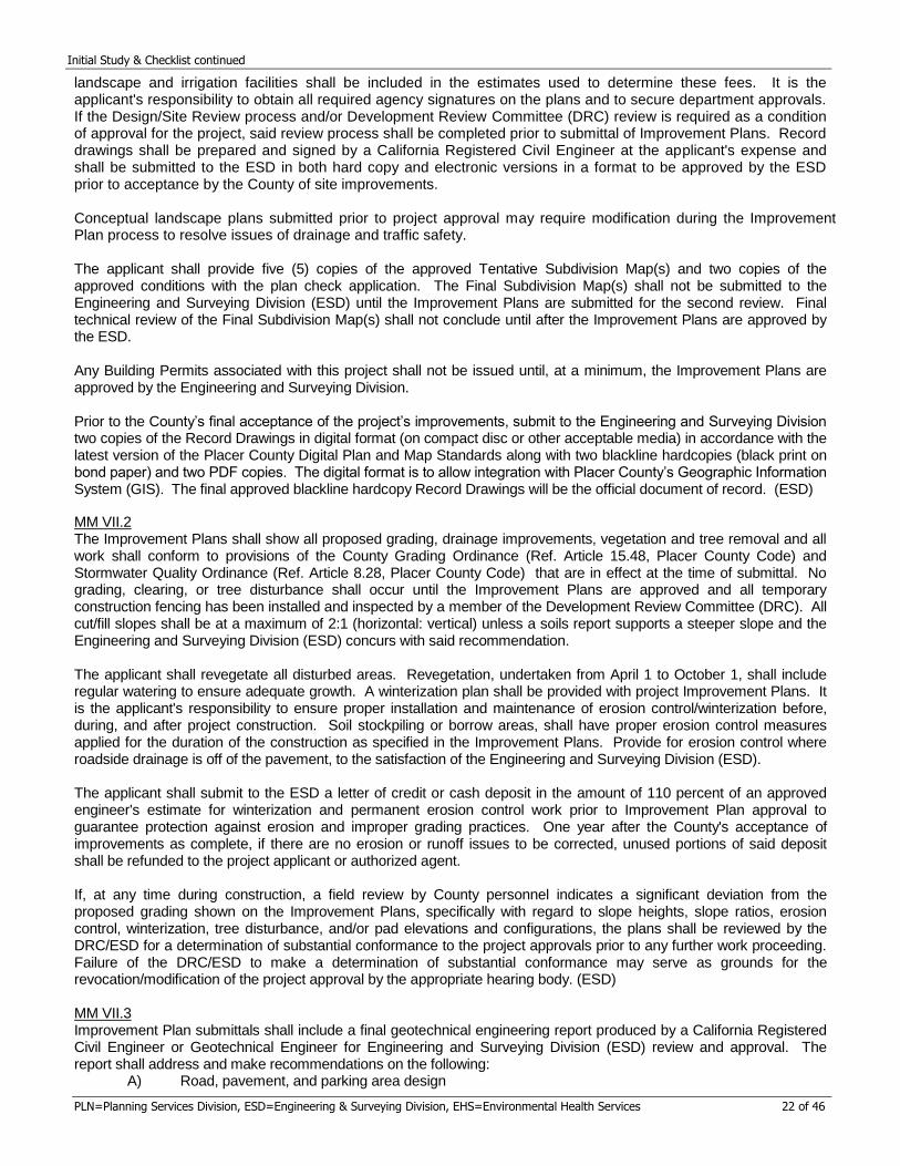
Initial Study & Checklist continued
PLN=Planning Services Division, ESD=Engineering & Surveying Division, EHS=Environmental Health Services 22 of 46
landscape and irrigation facilities shall be included in the estimates used to determine these fees. It is the applicant's responsibility to obtain all required agency signatures on the plans and to secure department approvals. If the Design/Site Review process and/or Development Review Committee (DRC) review is required as a condition of approval for the project, said review process shall be completed prior to submittal of Improvement Plans. Record drawings shall be prepared and signed by a California Registered Civil Engineer at the applicant's expense and shall be submitted to the ESD in both hard copy and electronic versions in a format to be approved by the ESD prior to acceptance by the County of site improvements.
Conceptual landscape plans submitted prior to project approval may require modification during the Improvement Plan process to resolve issues of drainage and traffic safety.
The applicant shall provide five (5) copies of the approved Tentative Subdivision Map(s) and two copies of the approved conditions with the plan check application. The Final Subdivision Map(s) shall not be submitted to the Engineering and Surveying Division (ESD) until the Improvement Plans are submitted for the second review. Final technical review of the Final Subdivision Map(s) shall not conclude until after the Improvement Plans are approved by the ESD.
Any Building Permits associated with this project shall not be issued until, at a minimum, the Improvement Plans are approved by the Engineering and Surveying Division. Prior to the County’s final acceptance of the project’s improvements, submit to the Engineering and Surveying Division two copies of the Record Drawings in digital format (on compact disc or other acceptable media) in accordance with the latest version of the Placer County Digital Plan and Map Standards along with two blackline hardcopies (black print on bond paper) and two PDF copies. The digital format is to allow integration with Placer County’s Geographic Information System (GIS). The final approved blackline hardcopy Record Drawings will be the official document of record. (ESD)
MM VII.2 The Improvement Plans shall show all proposed grading, drainage improvements, vegetation and tree removal and all work shall conform to provisions of the County Grading Ordinance (Ref. Article 15.48, Placer County Code) and Stormwater Quality Ordinance (Ref. Article 8.28, Placer County Code) that are in effect at the time of submittal. No grading, clearing, or tree disturbance shall occur until the Improvement Plans are approved and all temporary construction fencing has been installed and inspected by a member of the Development Review Committee (DRC). All cut/fill slopes shall be at a maximum of 2:1 (horizontal: vertical) unless a soils report supports a steeper slope and the Engineering and Surveying Division (ESD) concurs with said recommendation. The applicant shall revegetate all disturbed areas. Revegetation, undertaken from April 1 to October 1, shall include regular watering to ensure adequate growth. A winterization plan shall be provided with project Improvement Plans. It is the applicant's responsibility to ensure proper installation and maintenance of erosion control/winterization before, during, and after project construction. Soil stockpiling or borrow areas, shall have proper erosion control measures applied for the duration of the construction as specified in the Improvement Plans. Provide for erosion control where roadside drainage is off of the pavement, to the satisfaction of the Engineering and Surveying Division (ESD). The applicant shall submit to the ESD a letter of credit or cash deposit in the amount of 110 percent of an approved engineer's estimate for winterization and permanent erosion control work prior to Improvement Plan approval to guarantee protection against erosion and improper grading practices. One year after the County's acceptance of improvements as complete, if there are no erosion or runoff issues to be corrected, unused portions of said deposit shall be refunded to the project applicant or authorized agent. If, at any time during construction, a field review by County personnel indicates a significant deviation from the proposed grading shown on the Improvement Plans, specifically with regard to slope heights, slope ratios, erosion control, winterization, tree disturbance, and/or pad elevations and configurations, the plans shall be reviewed by the DRC/ESD for a determination of substantial conformance to the project approvals prior to any further work proceeding. Failure of the DRC/ESD to make a determination of substantial conformance may serve as grounds for the revocation/modification of the project approval by the appropriate hearing body. (ESD) MM VII.3 Improvement Plan submittals shall include a final geotechnical engineering report produced by a California Registered Civil Engineer or Geotechnical Engineer for Engineering and Surveying Division (ESD) review and approval. The report shall address and make recommendations on the following: A) Road, pavement, and parking area design
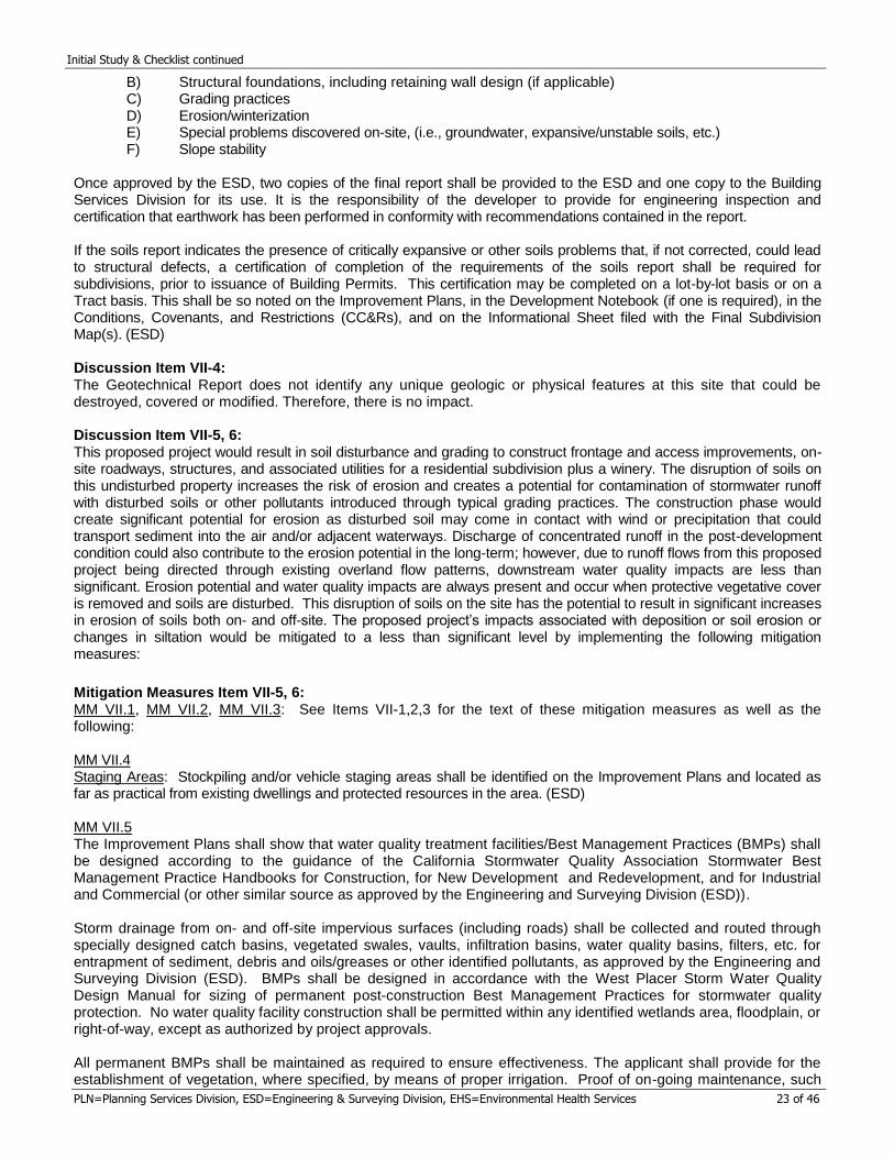
Initial Study & Checklist continued
PLN=Planning Services Division, ESD=Engineering & Surveying Division, EHS=Environmental Health Services 23 of 46
B) Structural foundations, including retaining wall design (if applicable) C) Grading practices D) Erosion/winterization E) Special problems discovered on-site, (i.e., groundwater, expansive/unstable soils, etc.) F) Slope stability Once approved by the ESD, two copies of the final report shall be provided to the ESD and one copy to the Building Services Division for its use. It is the responsibility of the developer to provide for engineering inspection and certification that earthwork has been performed in conformity with recommendations contained in the report. If the soils report indicates the presence of critically expansive or other soils problems that, if not corrected, could lead to structural defects, a certification of completion of the requirements of the soils report shall be required for subdivisions, prior to issuance of Building Permits. This certification may be completed on a lot-by-lot basis or on a Tract basis. This shall be so noted on the Improvement Plans, in the Development Notebook (if one is required), in the Conditions, Covenants, and Restrictions (CC&Rs), and on the Informational Sheet filed with the Final Subdivision Map(s). (ESD) Discussion Item VII-4: The Geotechnical Report does not identify any unique geologic or physical features at this site that could be destroyed, covered or modified. Therefore, there is no impact. Discussion Item VII-5, 6: This proposed project would result in soil disturbance and grading to construct frontage and access improvements, on-site roadways, structures, and associated utilities for a residential subdivision plus a winery. The disruption of soils on this undisturbed property increases the risk of erosion and creates a potential for contamination of stormwater runoff with disturbed soils or other pollutants introduced through typical grading practices. The construction phase would create significant potential for erosion as disturbed soil may come in contact with wind or precipitation that could transport sediment into the air and/or adjacent waterways. Discharge of concentrated runoff in the post-development condition could also contribute to the erosion potential in the long-term; however, due to runoff flows from this proposed project being directed through existing overland flow patterns, downstream water quality impacts are less than significant. Erosion potential and water quality impacts are always present and occur when protective vegetative cover is removed and soils are disturbed. This disruption of soils on the site has the potential to result in significant increases in erosion of soils both on- and off-site. The proposed project’s impacts associated with deposition or soil erosion or changes in siltation would be mitigated to a less than significant level by implementing the following mitigation measures:
Mitigation Measures Item VII-5, 6: MM VII.1, MM VII.2, MM VII.3: See Items VII-1,2,3 for the text of these mitigation measures as well as the following: MM VII.4 Staging Areas: Stockpiling and/or vehicle staging areas shall be identified on the Improvement Plans and located as far as practical from existing dwellings and protected resources in the area. (ESD)
MM VII.5 The Improvement Plans shall show that water quality treatment facilities/Best Management Practices (BMPs) shall be designed according to the guidance of the California Stormwater Quality Association Stormwater Best Management Practice Handbooks for Construction, for New Development and Redevelopment, and for Industrial and Commercial (or other similar source as approved by the Engineering and Surveying Division (ESD)). Storm drainage from on- and off-site impervious surfaces (including roads) shall be collected and routed through specially designed catch basins, vegetated swales, vaults, infiltration basins, water quality basins, filters, etc. for entrapment of sediment, debris and oils/greases or other identified pollutants, as approved by the Engineering and Surveying Division (ESD). BMPs shall be designed in accordance with the West Placer Storm Water Quality Design Manual for sizing of permanent post-construction Best Management Practices for stormwater quality protection. No water quality facility construction shall be permitted within any identified wetlands area, floodplain, or right-of-way, except as authorized by project approvals. All permanent BMPs shall be maintained as required to ensure effectiveness. The applicant shall provide for the establishment of vegetation, where specified, by means of proper irrigation. Proof of on-going maintenance, such
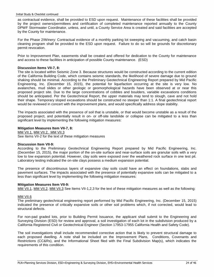
Initial Study & Checklist continued
PLN=Planning Services Division, ESD=Engineering & Surveying Division, EHS=Environmental Health Services 24 of 46
as contractual evidence, shall be provided to ESD upon request. Maintenance of these facilities shall be provided by the project owners/permittees and certification of completed maintenance reported annually to the County DPWF Stormwater Coordinator, unless, and until, a County Service Area is created and said facilities are accepted by the County for maintenance.
For the Phase 2/Winery: Contractual evidence of a monthly parking lot sweeping and vacuuming, and catch basin cleaning program shall be provided to the ESD upon request. Failure to do so will be grounds for discretionary permit revocation.
Prior to Improvement Plan, easements shall be created and offered for dedication to the County for maintenance and access to these facilities in anticipation of possible County maintenance. (ESD) Discussion Items VII-7, 8: The site is located within Seismic Zone 3. Because structures would be constructed according to the current edition of the California Building Code, which contains seismic standards, the likelihood of severe damage due to ground shaking should be minimal. According to the Preliminary Geotechnical Engineering Report prepared by Mid Pacific Engineering, Inc. (December 15, 2015), the potential for liquefaction occurring at the site is very low. No avalanches, mud slides or other geologic or geomorphological hazards have been observed at or near this proposed project site. Due to the large concentrations of cobbles and boulders, variable excavations conditions should be anticipated. Per the Geotechnical Report, the upper materials may tend to slough, cave and not hold their shape. Temporary sloped excavations should be constructed no steeper than 1:1. A final geotechnical report would be reviewed in concert with the improvement plans, and would specifically address slope stability. The impacts associated with the presence of soil that is unstable, or that would become unstable as a result of the proposed project, and potentially result in on- or off-site landslide or collapse can be mitigated to a less than significant level by implementing the following mitigation measures: Mitigation Measures Item VII-7, 8: MM VII.1, MM VII.2, MM VII.3 See Items VII-2 for the text of these mitigation measures Discussion Item VII-9: According to the Preliminary Geotechnical Engineering Report prepared by Mid Pacific Engineering, Inc. (December 15, 2015), the major portion of the on-site surface and near-surface soils are granular soils with a very low to low expansion potential. However, clay soils were exposed over the weathered rock surface in one test pit. Laboratory testing indicated the on-site clays possess a medium expansion potential. The presence of discontinuous layers of expansive clay soils could have an effect on foundations, slabs and pavement surfaces. The impacts associated with the presence of potentially expansive soils can be mitigated to a less than significant level by implementing the following mitigation measures: Mitigation Measures Item VII-9: MM VII.1, MM VII.2, MM VII.3 See Items VII-1,2,3 for the text of these mitigation measures as well as the following: MM VII.6 The preliminary geotechnical engineering report performed by Mid Pacific Engineering, Inc. (December 15, 2015) indicated the presence of critically expansive soils or other soil problems which, if not corrected, would lead to structural defects. For non-pad graded lots, prior to Building Permit Issuance, the applicant shall submit to the Engineering and Surveying Division (ESD) for review and approval, a soil investigation of each lot in the subdivision produced by a California Registered Civil or Geotechnical Engineer (Section 17953-17955 California Health and Safety Code).
The soil investigations shall include recommended corrective action that is likely to prevent structural damage to each proposed dwelling. A note shall be included on the Improvement Plans, Conditions, Covenants and Restrictions (CC&Rs), and the Informational Sheet filed with the Final Subdivision Map(s), which indicates the requirements of this condition.
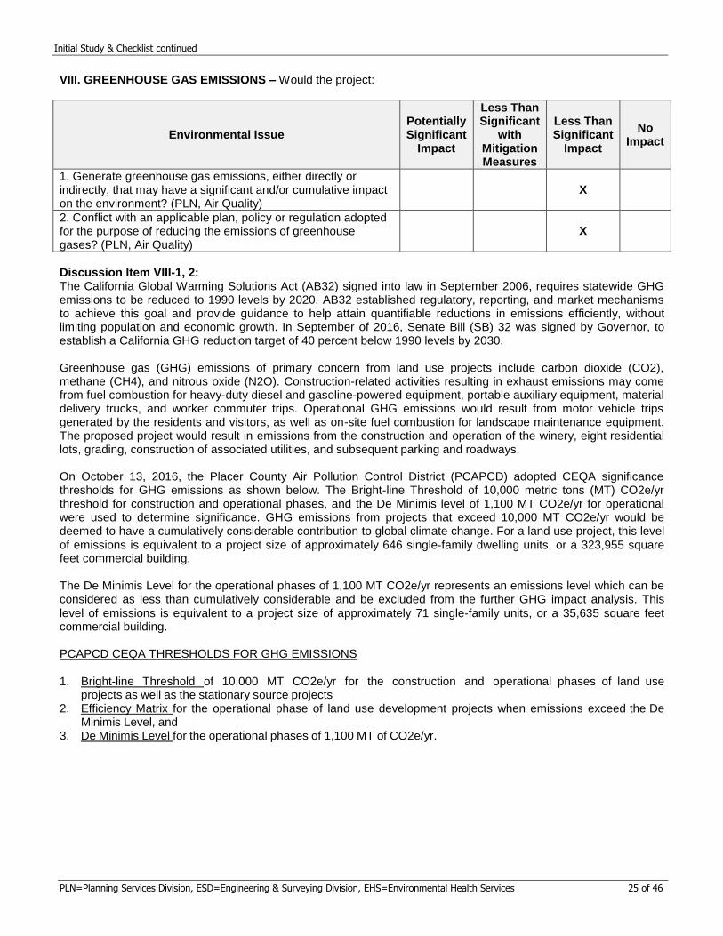
Initial Study & Checklist continued
PLN=Planning Services Division, ESD=Engineering & Surveying Division, EHS=Environmental Health Services 25 of 46
VIII. GREENHOUSE GAS EMISSIONS – Would the project:
Environmental Issue Potentially Significant
Impact
Less Than Significant
with Mitigation Measures
Less Than Significant
Impact
No Impact
1. Generate greenhouse gas emissions, either directly or indirectly, that may have a significant and/or cumulative impact on the environment? (PLN, Air Quality)
X
2. Conflict with an applicable plan, policy or regulation adopted for the purpose of reducing the emissions of greenhouse gases? (PLN, Air Quality)
X
Discussion Item VIII-1, 2: The California Global Warming Solutions Act (AB32) signed into law in September 2006, requires statewide GHG emissions to be reduced to 1990 levels by 2020. AB32 established regulatory, reporting, and market mechanisms to achieve this goal and provide guidance to help attain quantifiable reductions in emissions efficiently, without limiting population and economic growth. In September of 2016, Senate Bill (SB) 32 was signed by Governor, to establish a California GHG reduction target of 40 percent below 1990 levels by 2030. Greenhouse gas (GHG) emissions of primary concern from land use projects include carbon dioxide (CO2), methane (CH4), and nitrous oxide (N2O). Construction-related activities resulting in exhaust emissions may come from fuel combustion for heavy-duty diesel and gasoline-powered equipment, portable auxiliary equipment, material delivery trucks, and worker commuter trips. Operational GHG emissions would result from motor vehicle trips generated by the residents and visitors, as well as on-site fuel combustion for landscape maintenance equipment. The proposed project would result in emissions from the construction and operation of the winery, eight residential lots, grading, construction of associated utilities, and subsequent parking and roadways. On October 13, 2016, the Placer County Air Pollution Control District (PCAPCD) adopted CEQA significance thresholds for GHG emissions as shown below. The Bright-line Threshold of 10,000 metric tons (MT) CO2e/yr threshold for construction and operational phases, and the De Minimis level of 1,100 MT CO2e/yr for operational were used to determine significance. GHG emissions from projects that exceed 10,000 MT CO2e/yr would be deemed to have a cumulatively considerable contribution to global climate change. For a land use project, this level
of emissions is equivalent to a project size of approximately 646 single‐family dwelling units, or a 323,955 square feet commercial building. The De Minimis Level for the operational phases of 1,100 MT CO2e/yr represents an emissions level which can be considered as less than cumulatively considerable and be excluded from the further GHG impact analysis. This
level of emissions is equivalent to a project size of approximately 71 single‐family units, or a 35,635 square feet commercial building. PCAPCD CEQA THRESHOLDS FOR GHG EMISSIONS
1. Bright‐line Threshold of 10,000 MT CO2e/yr for the construction and operational phases of land use projects as well as the stationary source projects
2. Efficiency Matrix for the operational phase of land use development projects when emissions exceed the De Minimis Level, and
3. De Minimis Level for the operational phases of 1,100 MT of CO2e/yr.
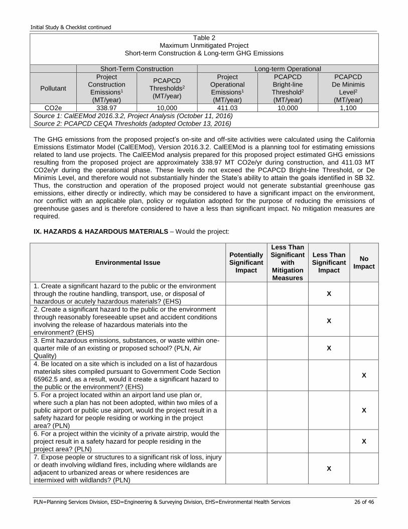
Initial Study & Checklist continued
PLN=Planning Services Division, ESD=Engineering & Surveying Division, EHS=Environmental Health Services 26 of 46
Table 2 Maximum Unmitigated Project
Short-term Construction & Long-term GHG Emissions
Short-Term Construction Long-term Operational
Pollutant
Project Construction Emissions1
(MT/year)
PCAPCD Thresholds2 (MT/year)
Project Operational Emissions1
(MT/year)
PCAPCD Bright-line Threshold2 (MT/year)
PCAPCD De Minimis
Level2
(MT/year)
CO2e 338.97 10,000 411.03 10,000 1,100
Source 1: CalEEMod 2016.3.2, Project Analysis (October 11, 2016) Source 2: PCAPCD CEQA Thresholds (adopted October 13, 2016)
The GHG emissions from the proposed project’s on-site and off-site activities were calculated using the California Emissions Estimator Model (CalEEMod), Version 2016.3.2. CalEEMod is a planning tool for estimating emissions related to land use projects. The CalEEMod analysis prepared for this proposed project estimated GHG emissions resulting from the proposed project are approximately 338.97 MT CO2e/yr during construction, and 411.03 MT CO2e/yr during the operational phase. These levels do not exceed the PCAPCD Bright-line Threshold, or De Minimis Level, and therefore would not substantially hinder the State’s ability to attain the goals identified in SB 32. Thus, the construction and operation of the proposed project would not generate substantial greenhouse gas emissions, either directly or indirectly, which may be considered to have a significant impact on the environment, nor conflict with an applicable plan, policy or regulation adopted for the purpose of reducing the emissions of greenhouse gases and is therefore considered to have a less than significant impact. No mitigation measures are required. IX. HAZARDS & HAZARDOUS MATERIALS – Would the project:
Environmental Issue Potentially Significant
Impact
Less Than Significant
with Mitigation Measures
Less Than Significant
Impact
No Impact
1. Create a significant hazard to the public or the environment through the routine handling, transport, use, or disposal of hazardous or acutely hazardous materials? (EHS)
X
2. Create a significant hazard to the public or the environment through reasonably foreseeable upset and accident conditions involving the release of hazardous materials into the environment? (EHS)
X
3. Emit hazardous emissions, substances, or waste within one-quarter mile of an existing or proposed school? (PLN, Air Quality)
X
4. Be located on a site which is included on a list of hazardous materials sites compiled pursuant to Government Code Section 65962.5 and, as a result, would it create a significant hazard to the public or the environment? (EHS)
X
5. For a project located within an airport land use plan or, where such a plan has not been adopted, within two miles of a public airport or public use airport, would the project result in a safety hazard for people residing or working in the project area? (PLN)
X
6. For a project within the vicinity of a private airstrip, would the project result in a safety hazard for people residing in the project area? (PLN)
X
7. Expose people or structures to a significant risk of loss, injury or death involving wildland fires, including where wildlands are adjacent to urbanized areas or where residences are intermixed with wildlands? (PLN)
X
Initial Study & Checklist continued
PLN=Planning Services Division, ESD=Engineering & Surveying Division, EHS=Environmental Health Services 27 of 46
8. Create any health hazard or potential health hazard? (EHS) X
9. Expose people to existing sources of potential health hazards? (EHS)
X
Discussion Item IX-1, 2: The use of hazardous substances during normal construction and residential activities is expected to be limited in nature, and would be subject to standard handling and storage requirements. Accordingly, impacts related to the release of hazardous substances are considered less than significant. No mitigation measures are required. Discussion Item IX-3: There are no existing or planned school sites located within a quarter mile of the proposed project site. Further, operation of the proposed project does not propose a use that involves activities that would emit hazardous substances or waste that would affect a substantial number of people and is therefore considered to have a less than significant impact. No mitigation measures are required. Discussion Item IX-4: The proposed project is not located on a site which is included on a list of hazardous materials sites compiled pursuant to Government Code Section 65962.5 and would not create a hazard to the public or the environment. Therefore, there is no impact, Discussion Item IX-5, 6: The proposed project is not located within an airport land use plan or within two miles of a public airport, public use airport or private airstrip and would not result in a safety hazard for people residing or working in the proposed project area. The proposed project would have no impact to airports and airstrips. Therefore, there is no impact. Discussion Item IX-7: The proposed project site is located within an area determined by CalFire to be at moderate risk for wildland fires and is located within a California State Responsibility Area. Standard fire regulations and conditions shall apply to the proposed project, including fire sprinklers in single-family residences and standard fire safe setbacks. With the implementation of said regulations and fire safe practices, impacts related to wildland fires would be reduced. No mitigation measures are required. Discussion Item IX-8: The proposed project would not create a health hazard. Uses for the proposed parcels are for single family residential development, as well as a winery. Therefore, there is no impact. Discussion Item IX-9: Environmental Health reviewed a “Soils Sampling and Analysis Report”, dated September 5, 2018, as well as a “Chlordane Delineation Report”, dated October 11, 2018, for this property, both prepared by Wallace Kuhl and Associates. Initial soil sampling data showed chlordane was reported in sample S-2 at 1.4 milligrams per kilogram (mg/kg), above the residential California Department of Toxic Substances Control (DTSC) Human and Ecological Risk Office (HERO) Human Health Risk Assessment (HHRA) Note 3 screening level of 0.44 mg/kg. In order to further investigate the extent of the chlordane impacts in the vicinity of sample S-2, an additional nine step out surface samples were collected including a duplicate sample location adjacent to sample S-2. One additional sample was collected at a depth of one foot adjacent to sample S-2 to evaluate the vertical extent of the chlordane detection. Chlordane was not reported above the laboratory detection limit for any of the additional samples. Wallace Kuhl and Associates concluded that the volume of soil with elevated chlordane is limited to ½ to ¾ cubic foot in an area that would be developed as a vineyard. Based on the limited extent of identified impacts, no additional soil sampling related to past land use is required. Uses for the proposed parcels are for single family residential development, as well as a winery, and health hazards related to the proposed project are anticipated to be less than significant. No mitigation measures are required.
Initial Study & Checklist continued
PLN=Planning Services Division, ESD=Engineering & Surveying Division, EHS=Environmental Health Services 28 of 46
X. HYDROLOGY & WATER QUALITY – Would the project:
Environmental Issue Potentially Significant
Impact
Less Than Significant
with Mitigation Measures
Less Than Significant
Impact
No Impact
1. Violate any federal, state or county potable water quality standards? (EHS)
X
2. Substantially deplete groundwater supplies or interfere substantially with groundwater recharge such that there would be a net deficit in aquifer volume or a lessening of local groundwater supplies (i.e. the production rate of pre-existing nearby wells would drop to a level which would not support existing land uses or planned uses for which permits have been granted)? (EHS)
X
3. Substantially alter the existing drainage pattern of the site or area? (ESD)
X
4. Increase the rate or amount of surface runoff? (ESD) X
5. Create or contribute runoff water which would include substantial additional sources of polluted water? (ESD)
X
6. Otherwise substantially degrade surface water quality?(ESD) X
7. Otherwise substantially degrade ground water quality? (EHS) X
8. Place housing within a 100-year flood hazard area as mapped on a federal Flood Hazard boundary or Flood Insurance Rate Map or other flood hazard delineation map? (ESD)
X
9. Place within a 100-year flood hazard area improvements which would impede or redirect flood flows? (ESD)
X
10. Expose people or structures to a significant risk of loss, injury or death involving flooding, including flooding as a result of the failure of a levee or dam? (ESD)
X
11. Alter the direction or rate of flow of groundwater? (EHS) X
12. Impact the watershed of important surface water resources, including but not limited to Lake Tahoe, Folsom Lake, Hell Hole Reservoir, Rock Creek Reservoir, Sugar Pine Reservoir, French Meadows Reservoir, Combie Lake, and Rollins Lake? (EHS, ESD)
X
Discussion Item X-1, 2: This proposed project would not rely on groundwater wells as a potable water source. Potable water for this proposed project would be treated water from the Placer County Water Agency. The proposed project would not violate water quality standards with respect to potable water. Therefore, there is no impact. Discussion Item X-3, 4: The 35.9-acre site is currently undeveloped. The topography of the site is the top of a hill, with a crest line that traverses the center of the property from east to west. While the hill slopes steeply to the south and north, the center of the property where the crest runs is gently rolling. Newcastle Canal extends through the middle of the property. A new paved access road, winery building, and associated utilities are proposed to be constructed as a part of the phased project. A Preliminary Hydrologic and Hydraulic Study was prepared for the proposed project by TSD Engineering Inc. (September 26, 2018). According to the study, the proposed conveyance and attenuation facilities
Initial Study & Checklist continued
PLN=Planning Services Division, ESD=Engineering & Surveying Division, EHS=Environmental Health Services 29 of 46
on-site and along the internal street consist entirely of vegetative and bioretention swales. No underground drainage system is proposed for this site. The outfall from the roadside bioretention swale would include a linear dry well on Lot 8 that is configured so that post-project flows are similar to existing sheet flow conditions. The outfall from the winery development would be treated and conveyed to Indian Hill Road via roadside ditch. While internal drainage patterns may be altered, the overall site drainage patterns would remain consistent with existing patterns on the parcel, draining away from the crest line at the center of the property. Runoff to the north would ultimately discharge into the Auburn Ravine watershed and runoff to the southwest eventually discharges into Secret Ravine/Dry Creek watershed. According to the Post-construction Storm Water Quality Plan prepared by TSD Engineering Inc. (August 17, 2018) the proposed project would construct or replace approximately two acres of impervious surfaces. The hydraulic calculations presented in the Preliminary Hydrologic and Hydraulic Study (September 26, 2018) indicate that the proposed project discharges are reduced compared to the peak runoff of the pre-development site conditions for both the ten and 100 year storm events. The proposed project has the potential to increase the peak stormwater runoff amount and volume, however, the proposed project includes LID strategies to infiltrate, evapotranspire or biotreat stormwater runoff, which provides protection to downstream receiving waters from adverse impacts. A final drainage report would be prepared and submitted with the site improvement plans for County review and approval. The proposed project’s impacts associated with altering the existing drainage patterns of the site as well as increases in peak flow runoff and volume can be mitigated to a less than significant level by implementing the following mitigation measures: Mitigation Measures Item X-3, 4: MM VII.1, MM VII.2, MM VII.5 See Items ViI-1,2,3 and Items ViI-5,6, for the text of these mitigation measures, as well as the following: MM X.1 Per the State of California NPDES Phase II MS4 Permit, this project is a Regulated Project that creates and/or replaces 5,000 square feet or more of impervious surface. A final Storm Water Quality Plan (SWQP) shall be submitted, either within the final Drainage Report or as a separate document that identifies how this project will meet the Phase II MS4 permit obligations. Site design measures, source control measures, and Low Impact Development (LID) standards, as necessary, shall be incorporated into the design and shown on the Improvement Plans. In addition, per the Phase II MS4 permit, projects creating and/or replacing one acre or more of impervious surface (excepting projects that do not increase impervious surface area over the pre-project condition) are also required to demonstrate hydromodification management of stormwater such that post-project runoff is maintained at equal or below pre-project flow rates for the 2 year, 24-hour storm event, generally by way of infiltration, rooftop and impervious area disconnection, bioretention, and other LID measures that result in post-project flows that mimic pre-project conditions. MM X.2 As part of the improvement plan submittal process, the preliminary Drainage Report provided during environmental review shall be submitted in final format. The final Drainage Report may require more detail than that provided in the preliminary report, and will be reviewed in concert with the improvement plans to confirm conformity between the two. The report shall be prepared by a Registered Civil Engineer and shall, at a minimum, include: A written text addressing existing conditions, the effects of the proposed improvements, all appropriate calculations, watershed maps, changes in flows and patterns, and proposed on- and off-site improvements and drainage easements to accommodate flows from this project. The report shall identify water quality protection features and methods to be used during construction, as well as long-term post-construction water quality measures. The final Drainage Report shall be prepared in conformance with the requirements of Section 5 of the Land Development Manual and the Placer County Storm Water Management Manual that are in effect at the time of improvement plan submittal. MM X.3 This project is subject to the one-time payment of drainage improvement and flood control fees pursuant to the "Dry Creek Watershed Interim Drainage Improvement Ordinance" (Ref. Article 15.32, Placer County Code.) The current estimated development fees are: a one-time fee of $475 per residence (Phase 1) and $2,179 per acre (Phase 2), payable to the Engineering and Surveying Division prior to recordation of Building Permit issuance. The actual fee shall be that in effect at the time payment occurs.
Initial Study & Checklist continued
PLN=Planning Services Division, ESD=Engineering & Surveying Division, EHS=Environmental Health Services 30 of 46
MM X.4 This project is subject to payment of annual drainage improvement and flood control fees pursuant to the "Dry Creek Watershed Interim Drainage Improvement Ordinance" (Ref. Chapter 15, Article 15.32, Placer County Code). Prior to Recordation of Building Permit issuance, the applicant shall cause the subject property to become a participant in the existing Dry Creek Watershed County Service Area for purposes of collecting these annual assessments. The current estimated annual fee is $73 per residence (Phase 1) and $344 per acre (Phase 2). Discussion Item X-5, 6: The proposed project would construct approximately two acres of impervious surfaces for the paved access roadways, winery structures, and associated utilities, according to the preliminary Storm Water Quality Plan (SWQP) prepared by TSD Engineering Inc. (August 17, 2018). The SWQP demonstrates how the proposed project would meet the Phase II MS4 permit obligations. Site design measures, source control measures and Low Impact Development (LID) were identified, including bioretention swales. Because the residential lots are anticipated to be custom built, each individual parcel would be required to provide a SWQP for their own residential construction. Individual lot developers shall obtain a grading permit prior to building permit issuance, which shall include a SWQP and identify permanent on-site water quality BMPs to be maintained by the homeowner. The water quality of all natural waterways is important to maintain for public health and safety and the health of the ecosystem. Potential water quality impacts are present both during the proposed project construction and after the proposed project development. Construction activities would disturb soils and cause potential introduction of sediment into stormwater during rain events. Through the implementation of Best Management Practices (BMPs) for minimizing contact with potential stormwater pollutants at the source and erosion control methods, this potentially significant impact would be reduced to less than significant levels. In the post-development condition, the proposed project could potentially introduce contaminants such as oil and grease, sediment, nutrients, metals, organics, pesticides, and trash from activities such as driveway runoff, outdoor storage, landscape fertilizing and maintenance, and refuse collection. During construction, the road and building improvements would potentially cause erosion, sediment, and water quality impacts to the watershed. Erosion potential and water quality impacts are always present and occur when protective vegetative cover is removed and soils are disturbed. This disruption of soils on the site has the potential to result in significant increases in erosion of soils both on- and off-site. The proposed project’s impacts associated with soil erosion would be mitigated to a less than significant level by implementing the following mitigation measures: Mitigation Measures Item X-5, 6: MM VII.1, MM VII.2, MM VII.5, MM X.1, MM X.2 See Item VII-1, 2, 3 Items VII-5, 6, and Items X-3, 4 for the text of these mitigation measures MM X.5 Prior to construction commencing, provide evidence to the Engineering and Surveying Division of a WDID number generated from the State Regional Water Quality Control Board’s Stormwater Multiple Application & Reports Tracking System (SMARTS). This serves as the Regional Water Quality Control Board approval or permit under the National Pollutant Discharge Elimination System (NPDES) construction stormwater quality permit. MM X.6 This project is located within the permit area covered by Placer County’s Small Municipal Separate Storm Sewer System (MS4) Permit (State Water Resources Control Board National Pollutant Discharge Elimination System (NPDES)), pursuant to the NPDES Phase II program. Project-related stormwater discharges are subject to all applicable requirements of said permit. The project shall implement permanent and operational source control measures as applicable. Source control measures shall be designed for pollutant generating activities or sources consistent with recommendations from the California Stormwater Quality Association (CASQA) Stormwater BMP Handbook for New Development and Redevelopment, or equivalent manual, and shall be shown on the Improvement Plans. The project is also required to implement Low Impact Development (LID) standards designed to reduce runoff, treat stormwater, and provide baseline hydromodification management as outlined in the West Placer Storm Water Quality Design Manual. MM X.7 Prior to issuance of a building permit on each residential Lot, individual residential lot developers shall obtain a grading permit for the installation of permanent water quality BMPs. A final Storm Water Quality Plan (SWQP) for the individual
Initial Study & Checklist continued
PLN=Planning Services Division, ESD=Engineering & Surveying Division, EHS=Environmental Health Services 31 of 46
residential lot shall be submitted that identifies how the site will meet the Phase II MS4 permit obligations. Site design measures, source control measures, and Low Impact Development (LID) standards, as necessary, shall be incorporated into the design and shown on the Grading Plan. Maintenance of these facilities shall be provided by the homeowner. A note shall be included on the Improvement Plans and Conditions, Covenants and Restrictions (CC&Rs), which indicates the requirements of this condition. Discussion Item X-7: The proposed project will not rely upon new water wells, nor will the project generate contaminants that could degrade groundwater quality. As such, this project is considered to have no impacts with regard to ground water quality. Therefore, there is no impact. Discussion Item X-8, 9, 10: The proposed project development area is not located within a 100-year flood hazard area as defined and mapped by the Federal Emergency Management Agency (FEMA) and no housing is proposed to be placed within a 100-year flood hazard area as mapped on a federal Flood Hazard boundary or Flood Insurance Rate Map or other flood hazard delineation map. Improvements would not be placed within a 100-year flood hazard area which would impede or redirect flood flows. People or structures would not be exposed to a significant risk of loss, injury or death involving flooding, including flooding as a result of the failure of a levee or dam. Therefore, there is no impact. Discussion Item X-11: The proposed project would not alter the direction or rate of flow of groundwater as the proposed project does not propose any new wells. It is anticipated that there would be no impact to the direction or rate of flow of groundwater. Therefore, there is no impact. Discussion Items X-12: This proposed project is located within the Dry Creek and Auburn Ravine Watersheds. Mitigation measures are proposed for reducing impacts to water quality degradation to a less than significant level. The proposed project would not significantly impact a watershed of important surface water resources. None of the listed water bodies are located within the vicinity of this proposed project Therefore, the proposed project’s impact related to the watershed of important surface water resources is less than significant. No mitigation measures are required. XI. LAND USE & PLANNING – Would the project:
Environmental Issue Potentially Significant
Impact
Less Than Significant
with Mitigation Measures
Less Than Significant
Impact
No Impact
1. Physically divide an established community? (PLN) X
2. Conflict with General Plan/Community Plan/Specific Plan designations or zoning, or Plan policies adopted for the purpose of avoiding or mitigating an environmental effect? (EHS, ESD, PLN)
X
3. Conflict with any applicable habitat conservation plan or natural community conservation plan or other County policies, plans, or regulations adopted for purposes of avoiding or mitigating environmental effects? (PLN)
X
4. Result in the development of incompatible uses and/or the creation of land use conflicts? (PLN)
X
5. Affect agricultural and timber resources or operations (i.e. impacts to soils or farmlands and timber harvest plans, or impacts from incompatible land uses)? (PLN)
X
6. Disrupt or divide the physical arrangement of an established community (including a low-income or minority community)? (PLN)
X
7. Result in a substantial alteration of the present or planned land use of an area? (PLN)
X
Initial Study & Checklist continued
PLN=Planning Services Division, ESD=Engineering & Surveying Division, EHS=Environmental Health Services 32 of 46
8. Cause economic or social changes that would result in significant adverse physical changes to the environment such as urban decay or deterioration? (PLN)
X
Discussion Item XI-1, 3, 5, 6, 8: The proposed project includes the creation of an eight lot residential subdivision and a winery. The project is proposing a rezone for Lots 2 through 8 from Residential Agriculture, Combining Minimum Building Site of 4.6 Acres to Residential Agriculture, Combining Minimum Building Site of 2.3 Acres. The proposed project site is currently undeveloped. Rural residential uses are to the east, west, and south. To the north is the Union Pacific Railroad and further north of the railroad is an industrial area an Interstate 80. The proposed project would not divide an established community or disrupt the physical arrangement of an established community. There are no existing agricultural or timber resources or operations within or adjacent to the project site. The Important Farmland Mapper does not identify the project area to contain soils that would be considered farmland. The proposed project would not cause economic or social changes that would result in an adverse physical changes to the environment. Placer County does not currently have an active Habitat Conservation Plan; however, the County is currently preparing the Placer County Conservation Program (PCCP), which is nearing completion. This proposed project would be able to participate in the PCCP for incidental take coverage and mitigation for effects to waters of the U.S. if the PCCP’s permits are issued and local implementing ordinances adopted prior to the proposed project receiving its entitlements. Therefore, there is no impact. Discussion Item XI-2, 4, 7: The project proposes a rezone to reduce the required minimum parcel size on Lots 2 through 8 from 4.6 acres to 2.3 acres. The base zoning, Residential Agriculture, would remain unchanged and the newly established minimum parcel size would be consistent with the General Plan land use designation, which is Rural Residential 1 -10 Acre Minimum. The properties immediately east of the proposed project are zoned Residential Agriculture, Combining Minimum Building Site of 2.3 acres and the proposed project would be consistent with the existing rural residential uses. In addition to the eight residential lots, the project proposes to construct a 6,000 square foot winery with a wine tasting/hospitality area, outdoor patio, wine production area, kitchen, and storage. The applicant is also proposing to host six annual wine club dinners. With implementation of mitigation measures noted below for noise and traffic, in conjunction with the proposed ending hour of 9:00 PM, lighting restrictions and use of vegetative screening, the proposed project would have a less than significant impact with regards to incompatible uses, and would not result in a substantial alteration of the present or planned land use of the area. Mitigation Measures Item XI-2, 4, 7: MM I-4.1, I-4.2, I-4.3, XIII-1, 3, XVIII.1, XVIII.2, VII-1 See items I-4; XIII-1, 3; XVIII-1; XVIII-2; VII-1, 2, 3, 4 for the text of these mitigation measures.
XII. MINERAL RESOURCES – Would the project result in:
Environmental Issue Potentially Significant
Impact
Less Than Significant
with Mitigation Measures
Less Than Significant
Impact
No Impact
1. The loss of availability of a known mineral resource that would be of value to the region and the residents of the state? (PLN)
X
2. The loss of availability of a locally-important mineral resource recovery site delineated on a local general plan, specific plan or other land use plan? (PLN)
X
Discussion Item XII-1, 2: A Mineral Resources memorandum was prepared for the proposed project by Mid Pacific Engineering, Inc., (MPE) dated December 7, 2016. The results of the memorandum are based on information from the California Department of Conservation, Division of Mines and Geology, DMG Open File Report 83-37, “Mineral Land Classification of the Auburn 15’ Quadrangle, El Dorado and Placer Counties, California (1984) and DMG Open File Report 95-10, “Mineral Land Classification of Placer County, California” (1995).
Initial Study & Checklist continued
PLN=Planning Services Division, ESD=Engineering & Surveying Division, EHS=Environmental Health Services 33 of 46
Two mineral resource classifications occur on-site: MRZ-3a and MRZ-4. MRZ-3a is defined as “areas containing known mineral occurrences of undetermined mineral resource significance. Further exploration work within these areas could result in the reclassification of specific localities into MRZ-2a or MRZ-2b categories.” MRZ-4 is defined as “areas of no known mineral occurrences where geologic information does not rule out either the presence or absence of significant mineral resources.” The memorandum concludes that the proposed project site is not located within a State-designated MRZ where significant mineral deposits are present or where it is judged that a high likelihood for their presence exists. While a portion of the site appears to be located in MRZ-3a, no mineral extraction operations exist in the proposed project area and there are no known mineral resources on the proposed project site. Mineral extraction would be allowed in the Residential Agriculture zone district with approval of a Conditional Use Permit, however the proposed project is not proposing mineral extraction. The proposed project site has never been mined and no valuable, locally important mineral resources have been identified on the proposed project site. Therefore, implementation of the proposed project would result in less than significant impacts to mineral resources. No mitigation measures are required. XIII. NOISE – Would the project result in:
Environmental Issue Potentially Significant
Impact
Less Than Significant
with Mitigation Measures
Less Than Significant
Impact
No Impact
1. Exposure of persons to or generation of noise levels in excess of standards established in the local General Plan, Community Plan or noise ordinance, or applicable standards of other agencies? (PLN)
X
2. A substantial permanent increase in ambient noise levels in the project vicinity above levels existing without the project? (PLN)
X
3. A substantial temporary or periodic increase in ambient noise levels in the project vicinity above levels existing without the project? (PLN)
X
4. For a project located within an airport land use plan or, where such a plan has not been adopted, within two miles of a public airport or public use airport, would the project expose people residing or working in the project area to excessive noise levels? (PLN)
X
5. For a project within the vicinity of a private airstrip, would the project expose people residing or working in the project area to excessive noise levels? (PLN)X
X
Discussion Item XIII-1, 3: The proposed project is located in an area of rural residential land uses. Noise generating activities from the proposed project include short-term, temporary impacts from construction of the proposed project and periodic impacts from the proposed project operations including the winery and wine club dinners and typical noise associated with single-family residential uses. The Union Pacific Railroad is immediately north of the proposed project site and noise from the railroad could impact the future residents. Union Pacific Railroad An Environmental Noise Assessment was prepared by j.c. brennan & associates, Inc. dated September 25, 2015. The intent of this Assessment was to determine the potential railroad noise levels on the proposed project site. The Assessment identified a Noise Contour Line, in which residences built beyond this Line would not be exposed to noise levels in exceedance of Noise Ordinance standards. The result of a relatively recent court case, California Building Industry v. Bay Area Air Quality Management District (CBIA v. BAAQMD), determined that CEQA analyses are generally intended to analyze the impact of existing environmental conditions on a project’s future users or residents. In this instance, noise generated from the railroad would not be considered an existing environmental condition requiring analysis under CEQA. However, the project has the potential to expose future residents to noise impacts generated from the railroad. Furthermore, the Placer
Initial Study & Checklist continued
PLN=Planning Services Division, ESD=Engineering & Surveying Division, EHS=Environmental Health Services 34 of 46
County Noise Ordinance establishes noise levels and in the event a project or activity exceeds those noise levels, then conditions are imposed to reduce potential impacts from the noise source to a receptor. Additionally, the Placer County General Plan Noise Element sets forth land use compatibility criteria for various land uses. For noise generated by transportation noise sources such as railroads, the Noise Element specifies that residential land uses are compatible with exterior noise levels of up to 60 dB Ldn without the need for noise mitigation. The 60 dB Ldn noise level is considered an acceptable noise environment for residential outdoor activities. Where the exterior noise level from transportation sources is predicted to exceed 60 dB Ldn, the Noise Element specifies that residential uses should be permitted only after careful study and inclusion of noise reduction, or attenuation measures as needed. In these instances, an exterior noise level of 65 dB Ldn may be allowed in outdoor activity areas provided that all practical noise reduction measures are applied. The Noise Element identifies an interior noise level criteria of 45 dB Ldn for residential land uses exposed to transportation noise sources. The Environmental Noise Assessment conducted noise measurements at two sites. Site 1 was 500 feet from the centerline of the railroad tracks and Site 2 was 400 feet from the centerline of the tracks. The train operations resulted in noise levels of 55 dB Ldn at Site 1 and 54 dB Ldn at Site 2. Based on the data collected from the measurements, the worst case 60 dB Ldn railroad noise level contour would extend approximately 232 feet from the centerline of the UPRR track, meaning residences located closer to the centerline of the UPRR track would be exposed to noise levels exceeding the Placer County Noise Ordinance and the Placer County General Plan Noise Element. The Assessment notes that standard construction practices in compliance with the California Building Code would provide an exterior to interior noise level reduction of approximately 25 dB, assuming that air conditioning is included for each unit which allows residents to close windows for the required acoustical isolation. Therefore, as long as noise levels at the building facades would not exceed 60 dB Ldn, the interior noise levels would comply with the interior noise level standard of 45 dB. However, in order to reduce potential impacts to receptors from exterior noise levels, the following Condition of Approval would be imposed on the proposed project:
The building envelopes for the residential subdivision shall be outside of the 60 dB Ldn railroad noise contour as shown on Figure 1 of the Environmental Noise Assessment prepared by j.c. brennan & associates, Inc. dated September 25, 2015.
Construction Noise Noise generated from construction would temporarily increase ambient noise levels in the area and nearby residences may be impacted. However, this impact is considered to be temporary and less than significant. The following standard note would be required on the Improvement Plans and the Grading Plans and would reduce any potential impacts from construction noise to less than significant:
Construction noise emanating from any construction activities for which a Grading Permit is required is prohibited on Sundays and Federal Holidays, and shall only occur: a) Monday through Friday, 6:00 am to 8:00 pm (during daylight savings) b) Monday through Friday, 7:00 am to 8:00 pm (during standard time) c) Saturdays, 8:00 am to 6:00 pm In addition, temporary signs 4 feet X 4 feet shall be located along the perimeter of the proposed project, as determined by the Development Review Committee, at key intersections depicting the above construction hour limitations. Said signs shall include a toll free public information phone number where surrounding residents can report violations and the developer/builder would respond and resolve noise violations.
No mitigation measures are required for construction noise. Winery Operations The proposed winery would be located on Lot 1, which encompasses the entire east portion of the proposed project site. The winery proposes to have an outdoor patio area on the west side of the winery and also proposes to host six annual wine club dinners that would begin at 6:30 PM and end at 9:00 PM. The project is also allowed to have additional events limited to three consecutive days or two times on one location in a calendar year subject to approval of a Temporary Outdoor Event (TOE) permit. TOE permits would be held to the same standard as the wine dinners. Three residences to the east and south have the potential to be directly impacted from noise generated from the winery, particularly during the proposed wine club dinners when noise from on-site traffic and circulation activities and sound generated by amplified speech or music at the winery could occur. Additional noise associated with the winery would be generated from weekly shipments during the non-harvest season; all shipments are required to
Initial Study & Checklist continued
PLN=Planning Services Division, ESD=Engineering & Surveying Division, EHS=Environmental Health Services 35 of 46
only occur during normal business hours. The project description does not discuss amplified events for either the wine club dinners or for typical winery operations. However the project will be conditioned to prohibit amplified speech or sound outdoors including the patio. Amplified sound or speech indoors is required to comply with the Placer County Noise Ordinance. The closest home is on APN 040-210-009-000 immediately south and east from the winery and is 158 feet from the southeast corner of the winery. The next closest home is on APN 040-240-004-000 and is 293 feet from the northeast corner of the winery. A third home south of the proposed project across Indian Hill Road is on APN 040-220-018-000 and is 347 feet south of the winery. These residences are the most likely to be impacted by noise generated from the winery. However, these residences are each more than 100 feet from the winery. Furthermore, wine club dinners would only occur six times per year, with limited hours as noted below, and the winery itself would have limited operational hours of 10:30 am to 6:30 pm on weekends and State and Federal holidays. Nonetheless, the following mitigation measures are included to minimize the propagation of noise levels generated from this facility at the nearest residences to less than significant: Mitigation Measures Item XIII-1, 3: MM XIII.1
1. All special events shall end by 9:30 P.M. and all on-site activities shall be completed by 10:00 P.M. 2. Amplified speech and sound shall comply with the Placer County Noise Ordinance. Amplified speech and
sound shall not occur outdoors, including the patio. 3. Non-amplified speech and sound may occur on the patio. Amplified speech and sound shall not be allowed
outdoors at the winery including the patio. 4. Deliveries shall occur during normal business hours, 8:00 am to 5:00 PM.
Discussion Item XIII-2: The project proposes six events of 50 to 75 people annually. The Traffic Impact Study prepared for the proposed project determined that based on wineries in Napa County of a similar size, the winery would attract approximately 60 to 120 trips per day. Spread out over the 8 hours that the tasting room could be open this would equate to a maximum of 13-20 trips per hour on a Saturday. The winery would have limited operational hours on weekends and state and Federal holidays and the tasting room would not be open during the weekdays. Since wine club dinners are limited to a certain number per year, and the winery is proposing limited operational hours, the proposed project would not create a sustained, substantial permanent increase in ambient noise levels in the proposed project vicinity. With implementation of mitigation measure MM XIII.1 above, impacts would be less than significant. Mitigation Measures Item XIII-2: MM XIII.1, See Item XIII-1, 3 above for full text of mitigation Discussion Item XIII-4: The proposed project is not located within an airport land use plan or within two miles of a public airport and would not expose people residing or working in the proposed project area to excessive noise levels. Therefore, there is no impact. Discussion Item XIII-5: The proposed project is not located within the vicinity of an airstrip and would not expose people residing or working in the proposed project area to excessive noise levels. Therefore, there is no impact. XIV. PALEONTOLOGICAL RESOURCES – Would the project:
Environmental Issue Potentially Significant
Impact
Less Than Significant
with Mitigation Measures
Less Than Significant
Impact
No Impact
1. Directly or indirectly destroy a unique paleontological resource or site or unique geologic feature? (PLN)
X
Initial Study & Checklist continued
PLN=Planning Services Division, ESD=Engineering & Surveying Division, EHS=Environmental Health Services 36 of 46
Discussion Item XIV-1: A Paleontological Records Search and Preconstruction Assessment was prepared for the proposed project by ECORP Consulting, Inc. and is dated November 7, 2016. The records search was requested from the University of California Museum Scientist (Microfossil Collections) Ken Finger, Ph.D. The search included a review of the institution’s paleontology specimen collection records for the proposed project area and vicinity. In addition, a query of the UCMP online catalog records, a review of regional geologic maps from the California Geological Survey, and a review of existing literature on paleontological resources of Placer County was conducted. The purpose of the assessment was to determine the sensitivity of the proposed project area, whether known occurrences of paleontological resources are present within or immediately adjacent to the proposed project area, and whether implementation of the proposed project could result in significant impacts to paleontological resources. Paleontological resources include mineralized (fossilized) or unmineralized bones, teeth, soft tissues, shells, wood, leaf impressions, footprints, burrows, and microscopic remains. The Assessment notes that the geologic deposits that underlie the proposed project area are classified as the Merhten Formation. Merhten Formation rocks are composed of volcanic conglomerate and tuffaceous sandstone and siltstone derived from andesitic source material in the Sierra Nevada. This formation, present in other areas of the Central Valley, has been known to contain paleofloral fossils. The record search determined that no fossil vertebrate localities have been previously recorded in or within a 0.5-mile radius of the project area. The Merhten Formation underlying the project area, however, is considered to have a high potential for containing significant nonrenewable fossiliferous resources. In addition, the project may require excavation up to 15 feet below the surface, which may potentially affect the formation because it is located at bedrock depth possibly beginning between 18 and 55 inches (1.5-4.5 feet) below the surface on-site. Based on on-site geology and soil data, there is high potential for significant nonrenewable fossiliferous resources to be recovered. As a result, the potential for damage to unique paleontological resources during earth-moving activities at the project would be considered a significant impact requiring mitigation. The applicant has the option to either assume the entire project site is underlain by the Merhten Formation and hire a paleontologist to monitor all earth-moving activities, or hire a paleontologist to define the boundaries of the Merhten Formation and apply mitigation accordingly. With implementation of the following mitigation measure, potential impacts would be less than significant. Mitigation Measures Item XIV-1: MM XIV.1 Before the start of any earth-moving activities for the project, a qualified professional vertebrate paleontologist (as defined by Society of Vertebrate Paleontology (SVP) 2010 guidelines) shall conduct field surveys to specifically determine boundaries of the Mehrten Formation within the project. Alternatively, the presence of the Mehrten Formation can be assumed within the entirety of the project area. A qualified professional vertebrate paleontologist shall monitor all earth-moving activities to observe the stratigraphy and any fossils exposed by excavations; this will not be required in areas where sediments will be buried but not otherwise disturbed. Should any evidence of paleontological resources (e.g., fossils) be encountered, work shall be suspended within 100 feet of the discovery, the Placer County shall be notified immediately. During this time, the paleontologist shall assess the resource and provide appropriate management recommendations. Work cannot continue within the no-work radius until a paleontologist conducts sufficient research and data collection. Recommendations could include, but are not limited to, salvage and treatment. This treatment shall include preparation, identification, determination of significance, and curation into an established accredited public museum repository with permanent retrievable paleontological storage. A technical report of findings shall be prepared with an appended itemized inventory of identified specimens and submitted with the recovered specimens to the curation facility. XV. POPULATION & HOUSING – Would the project:
Environmental Issue Potentially Significant
Impact
Less Than Significant
with Mitigation Measures
Less Than Significant
Impact
No Impact
1. Induce substantial population growth in an area, either directly (i.e. by proposing new homes and businesses) or indirectly (i.e. through extension of roads or other infrastructure)? (PLN)
X
Initial Study & Checklist continued
PLN=Planning Services Division, ESD=Engineering & Surveying Division, EHS=Environmental Health Services 37 of 46
2. Displace substantial numbers of existing housing, necessitating the construction of replacement housing elsewhere? (PLN)
X
Discussion Item XV-1: The proposed project includes the development of eight single-family residential lots and a winery, which would result in a slight increase to population growth. The project is proposing to rezone Lots 2 through 8 from Residential Agriculture, Combining Minimum Building Site of 4.6 Acres, to Residential Agriculture, Combining Minimum Building Site of 2.3 Acres. This is a relatively minor change, as the lots would remain large-lot rural residential and the rezone would not result in substantial population growth. This impact is considered less than significant. No mitigation measures are required. Discussion Item XV-2: The proposed project would not displace existing housing. The proposed project involves the creation of eight residential parcels and winery. Therefore, there is no impact. XVI. PUBLIC SERVICES – Would the project result in substantial adverse physical impacts associated with the provision of new or physically altered governmental services and/or facilities, the construction of which could cause significant environmental impacts, in order to maintain acceptable service ratios, response times or other performance objectives for any of the public services?
Environmental Issue Potentially Significant
Impact
Less Than Significant
with Mitigation Measures
Less Than Significant
Impact
No Impact
1. Fire protection? (ESD, PLN) X
2. Sheriff protection? (ESD, PLN) X
3. Schools? (ESD, PLN) X
4. Maintenance of public facilities, including roads? (ESD, PLN) X
5. Other governmental services? (ESD, PLN) X
Discussion Item XVI-1: No new fire protection facilities are proposed as part of this proposed project. The Newcastle Fire Protection District has provided a will-serve letter dated December 5, 2016, during environmental review of this proposed project and would require that the proposed project incorporate design features necessary for adequate emergency access and fire suppression capability. Therefore, this impact is less than significant. No mitigation measures are required. Discussion Item XVI-2: The proposed project would result in the creation of eight new single-family residential lots and a winery, and would increase the number of residents in the proposed project area. However, this increase would not result in an adverse effect to Sheriff Protection facilities because the small increase in the number of residents is considered negligible and is not beyond the number of residents that were analyzed in the Placer County General Plan. Therefore, there is no impact. Discussion Item XVI-3: The proposed project would result in the creation of eight new single-family residential lots and a winery and would increase the number of residents in the proposed project area. However, this increase would not result in an adverse effect to schools in the area. This is because the increase in the number of residents is minimal and does not exceed those numbers analyzed and planned for in the Placer County General Plan. Therefore, there is no impact.
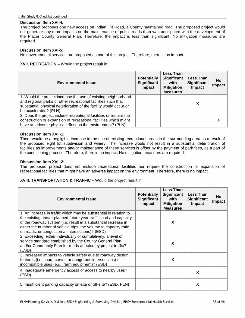
Initial Study & Checklist continued
PLN=Planning Services Division, ESD=Engineering & Surveying Division, EHS=Environmental Health Services 38 of 46
Discussion Item XVI-4: The project proposes one new access on Indian Hill Road, a County maintained road. The proposed project would not generate any more impacts on the maintenance of public roads than was anticipated with the development of the Placer County General Plan. Therefore, the impact is less than significant. No mitigation measures are required. Discussion Item XVI-5: No governmental services are proposed as part of this project. Therefore, there is no impact. XVII. RECREATION – Would the project result in:
Environmental Issue Potentially Significant
Impact
Less Than Significant
with Mitigation Measures
Less Than Significant
Impact
No Impact
1. Would the project increase the use of existing neighborhood and regional parks or other recreational facilities such that substantial physical deterioration of the facility would occur or be accelerated? (PLN)
X
2. Does the project include recreational facilities or require the construction or expansion of recreational facilities which might have an adverse physical effect on the environment? (PLN)
X
Discussion Item XVII-1: There would be a negligible increase in the use of existing recreational areas in the surrounding area as a result of the proposed eight lot subdivision and winery. The increase would not result in a substantial deterioration of facilities as improvements and/or maintenance of these services is offset by the payment of park fees, as a part of the conditioning process. Therefore, there is no impact. No mitigation measures are required. Discussion Item XVII-2: The proposed project does not include recreational facilities nor require the construction or expansion of recreational facilities that might have an adverse impact on the environment. Therefore, there is no impact. XVIII. TRANSPORTATION & TRAFFIC – Would the project result in:
Environmental Issue Potentially Significant
Impact
Less Than Significant
with Mitigation Measures
Less Than Significant
Impact
No Impact
1. An increase in traffic which may be substantial in relation to the existing and/or planned future year traffic load and capacity of the roadway system (i.e. result in a substantial increase in either the number of vehicle trips, the volume to capacity ratio on roads, or congestion at intersections)? (ESD)
X
2. Exceeding, either individually or cumulatively, a level of service standard established by the County General Plan and/or Community Plan for roads affected by project traffic? (ESD)
X
3. Increased impacts to vehicle safety due to roadway design features (i.e. sharp curves or dangerous intersections) or incompatible uses (e.g., farm equipment)? (ESD)
X
4. Inadequate emergency access or access to nearby uses? (ESD)
X
5. Insufficient parking capacity on-site or off-site? (ESD, PLN) X
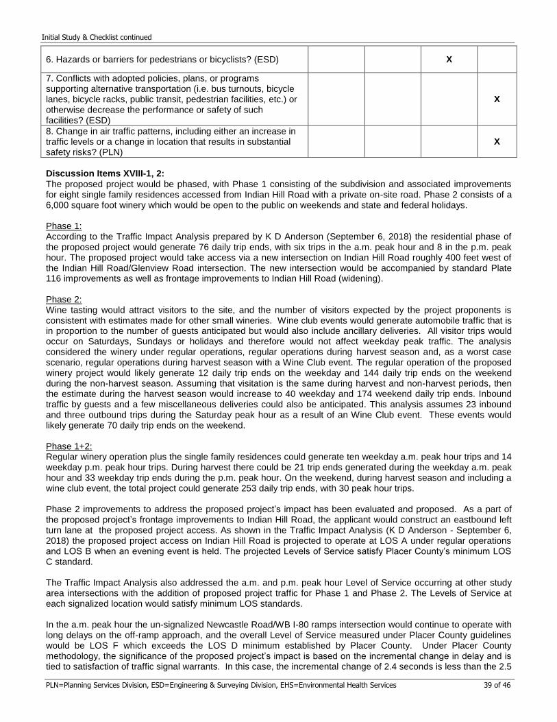
Initial Study & Checklist continued
PLN=Planning Services Division, ESD=Engineering & Surveying Division, EHS=Environmental Health Services 39 of 46
6. Hazards or barriers for pedestrians or bicyclists? (ESD) X
7. Conflicts with adopted policies, plans, or programssupporting alternative transportation (i.e. bus turnouts, bicycle lanes, bicycle racks, public transit, pedestrian facilities, etc.) or otherwise decrease the performance or safety of such facilities? (ESD)
X
8. Change in air traffic patterns, including either an increase intraffic levels or a change in location that results in substantial safety risks? (PLN)
X
Discussion Items XVIII-1, 2: The proposed project would be phased, with Phase 1 consisting of the subdivision and associated improvements for eight single family residences accessed from Indian Hill Road with a private on-site road. Phase 2 consists of a 6,000 square foot winery which would be open to the public on weekends and state and federal holidays.
Phase 1: According to the Traffic Impact Analysis prepared by K D Anderson (September 6, 2018) the residential phase of the proposed project would generate 76 daily trip ends, with six trips in the a.m. peak hour and 8 in the p.m. peak hour. The proposed project would take access via a new intersection on Indian Hill Road roughly 400 feet west of the Indian Hill Road/Glenview Road intersection. The new intersection would be accompanied by standard Plate 116 improvements as well as frontage improvements to Indian Hill Road (widening).
Phase 2: Wine tasting would attract visitors to the site, and the number of visitors expected by the project proponents is consistent with estimates made for other small wineries. Wine club events would generate automobile traffic that is in proportion to the number of guests anticipated but would also include ancillary deliveries. All visitor trips would occur on Saturdays, Sundays or holidays and therefore would not affect weekday peak traffic. The analysis considered the winery under regular operations, regular operations during harvest season and, as a worst case scenario, regular operations during harvest season with a Wine Club event. The regular operation of the proposed winery project would likely generate 12 daily trip ends on the weekday and 144 daily trip ends on the weekend during the non-harvest season. Assuming that visitation is the same during harvest and non-harvest periods, then the estimate during the harvest season would increase to 40 weekday and 174 weekend daily trip ends. Inbound traffic by guests and a few miscellaneous deliveries could also be anticipated. This analysis assumes 23 inbound and three outbound trips during the Saturday peak hour as a result of an Wine Club event. These events would likely generate 70 daily trip ends on the weekend.
Phase 1+2: Regular winery operation plus the single family residences could generate ten weekday a.m. peak hour trips and 14 weekday p.m. peak hour trips. During harvest there could be 21 trip ends generated during the weekday a.m. peak hour and 33 weekday trip ends during the p.m. peak hour. On the weekend, during harvest season and including a wine club event, the total project could generate 253 daily trip ends, with 30 peak hour trips.
Phase 2 improvements to address the proposed project’s impact has been evaluated and proposed. As a part of the proposed project’s frontage improvements to Indian Hill Road, the applicant would construct an eastbound left turn lane at the proposed project access. As shown in the Traffic Impact Analysis (K D Anderson - September 6, 2018) the proposed project access on Indian Hill Road is projected to operate at LOS A under regular operations and LOS B when an evening event is held. The projected Levels of Service satisfy Placer County’s minimum LOS C standard.
The Traffic Impact Analysis also addressed the a.m. and p.m. peak hour Level of Service occurring at other study area intersections with the addition of proposed project traffic for Phase 1 and Phase 2. The Levels of Service at each signalized location would satisfy minimum LOS standards.
In the a.m. peak hour the un-signalized Newcastle Road/WB I-80 ramps intersection would continue to operate with long delays on the off-ramp approach, and the overall Level of Service measured under Placer County guidelines would be LOS F which exceeds the LOS D minimum established by Placer County. Under Placer County methodology, the significance of the proposed project’s impact is based on the incremental change in delay and is tied to satisfaction of traffic signal warrants. In this case, the incremental change of 2.4 seconds is less than the 2.5
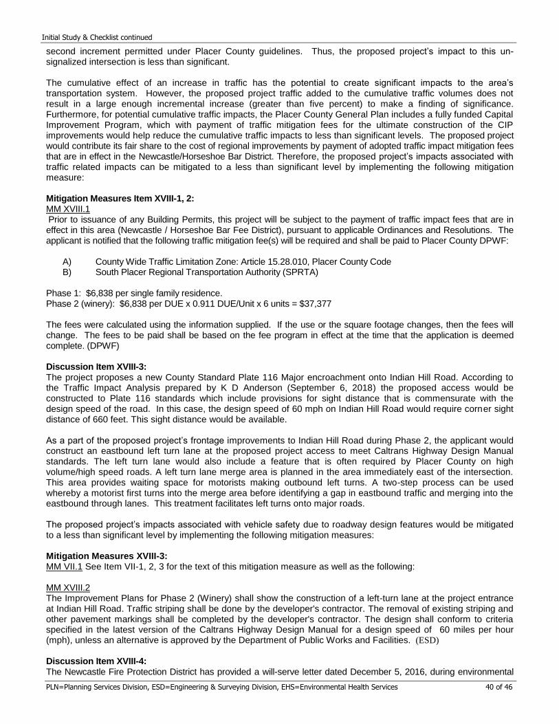
Initial Study & Checklist continued
PLN=Planning Services Division, ESD=Engineering & Surveying Division, EHS=Environmental Health Services 40 of 46
second increment permitted under Placer County guidelines. Thus, the proposed project’s impact to this un-signalized intersection is less than significant.
The cumulative effect of an increase in traffic has the potential to create significant impacts to the area’s transportation system. However, the proposed project traffic added to the cumulative traffic volumes does not result in a large enough incremental increase (greater than five percent) to make a finding of significance. Furthermore, for potential cumulative traffic impacts, the Placer County General Plan includes a fully funded Capital Improvement Program, which with payment of traffic mitigation fees for the ultimate construction of the CIP improvements would help reduce the cumulative traffic impacts to less than significant levels. The proposed project would contribute its fair share to the cost of regional improvements by payment of adopted traffic impact mitigation fees that are in effect in the Newcastle/Horseshoe Bar District. Therefore, the proposed project’s impacts associated with traffic related impacts can be mitigated to a less than significant level by implementing the following mitigation measure:
Mitigation Measures Item XVIII-1, 2: MM XVIII.1
Prior to issuance of any Building Permits, this project will be subject to the payment of traffic impact fees that are in effect in this area (Newcastle / Horseshoe Bar Fee District), pursuant to applicable Ordinances and Resolutions. The applicant is notified that the following traffic mitigation fee(s) will be required and shall be paid to Placer County DPWF:
A) County Wide Traffic Limitation Zone: Article 15.28.010, Placer County CodeB) South Placer Regional Transportation Authority (SPRTA)
Phase 1: $6,838 per single family residence. Phase 2 (winery): $6,838 per DUE x 0.911 DUE/Unit x 6 units = $37,377
The fees were calculated using the information supplied. If the use or the square footage changes, then the fees will change. The fees to be paid shall be based on the fee program in effect at the time that the application is deemed complete. (DPWF)
Discussion Item XVIII-3: The project proposes a new County Standard Plate 116 Major encroachment onto Indian Hill Road. According to the Traffic Impact Analysis prepared by K D Anderson (September 6, 2018) the proposed access would be constructed to Plate 116 standards which include provisions for sight distance that is commensurate with the design speed of the road. In this case, the design speed of 60 mph on Indian Hill Road would require corner sight distance of 660 feet. This sight distance would be available.
As a part of the proposed project’s frontage improvements to Indian Hill Road during Phase 2, the applicant would construct an eastbound left turn lane at the proposed project access to meet Caltrans Highway Design Manual standards. The left turn lane would also include a feature that is often required by Placer County on high volume/high speed roads. A left turn lane merge area is planned in the area immediately east of the intersection. This area provides waiting space for motorists making outbound left turns. A two-step process can be used whereby a motorist first turns into the merge area before identifying a gap in eastbound traffic and merging into the eastbound through lanes. This treatment facilitates left turns onto major roads.
The proposed project’s impacts associated with vehicle safety due to roadway design features would be mitigated to a less than significant level by implementing the following mitigation measures:
Mitigation Measures XVIII-3: MM VII.1 See Item VII-1, 2, 3 for the text of this mitigation measure as well as the following:
MM XVIII.2 The Improvement Plans for Phase 2 (Winery) shall show the construction of a left-turn lane at the project entrance at Indian Hill Road. Traffic striping shall be done by the developer's contractor. The removal of existing striping and other pavement markings shall be completed by the developer's contractor. The design shall conform to criteria specified in the latest version of the Caltrans Highway Design Manual for a design speed of 60 miles per hour (mph), unless an alternative is approved by the Department of Public Works and Facilities. (ESD)
Discussion Item XVIII-4: The Newcastle Fire Protection District has provided a will-serve letter dated December 5, 2016, during environmental
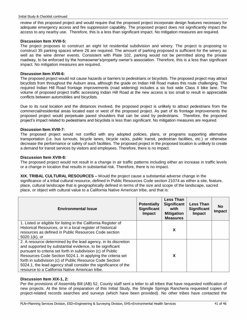
Initial Study & Checklist continued
PLN=Planning Services Division, ESD=Engineering & Surveying Division, EHS=Environmental Health Services 41 of 46
review of this proposed project and would require that the proposed project incorporate design features necessary for adequate emergency access and fire suppression capability. The proposed project does not significantly impact the access to any nearby use. Therefore, this is a less than significant impact. No mitigation measures are required.
Discussion Item XVIII-5: The project proposes to construct an eight lot residential subdivision and winery. The project is proposing to construct 35 parking spaces where 26 are required. The amount of parking proposed is sufficient for the winery as well as the wine dinner events. Consistent with Plate 102, parking would not be permitted along the private roadway, to be enforced by the homeowner’s/property owner’s association. Therefore, this is a less than significant impact. No mitigation measures are required.
Discussion Item XVIII-6: The proposed project would not cause hazards or barriers to pedestrians or bicyclists. The proposed project may attract bicyclists from throughout the Auburn area, although the grade on Indian Hill Road makes this route challenging. The required Indian Hill Road frontage improvements (road widening) includes a six foot wide Class II bike lane. The volume of proposed project traffic accessing Indian Hill Road at the new access is too small to result in appreciable conflicts between automobiles and bicyclists.
Due to its rural location and the distances involved, the proposed project is unlikely to attract pedestrians from the commercial/residential areas located east or west of the proposed project. As part of its frontage improvements the proposed project would perpetuate paved shoulders that can be used by pedestrians. Therefore, the proposed project’s impact related to pedestrians and bicyclists is less than significant. No mitigation measures are required.
Discussion Item XVIII-7: The proposed project would not conflict with any adopted policies, plans, or programs supporting alternative transportation (i.e. bus turnouts, bicycle lanes, bicycle racks, public transit, pedestrian facilities, etc.) or otherwise decrease the performance or safety of such facilities. The proposed project in the proposed location is unlikely to create a demand for transit services by visitors and employees. Therefore, there is no impact.
Discussion Item XVIII-8: The proposed project would not result in a change in air traffic patterns including either an increase in traffic levels or a change in location that results in substantial risk. Therefore, there is no impact.
XIX. TRIBAL CULTURAL RESOURCES – Would the project cause a substantial adverse change in thesignificance of a tribal cultural resource, defined in Public Resources Code section 21074 as either a site, feature, place, cultural landscape that is geographically defined in terms of the size and scope of the landscape, sacred place, or object with cultural value to a California Native American tribe, and that is:
Environmental Issue Potentially Significant
Impact
Less Than Significant
with Mitigation Measures
Less Than Significant
Impact
No Impact
1. Listed or eligible for listing in the California Register ofHistorical Resources, or in a local register of historical resources as defined in Public Resources Code section 5020.1(k), or
X
2. A resource determined by the lead agency, in its discretionand supported by substantial evidence, to be significant pursuant to criteria set forth in subdivision (c) of Public Resources Code Section 5024.1. In applying the criteria set forth in subdivision (c) of Public Resource Code Section 5024.1, the lead agency shall consider the significance of the resource to a California Native American tribe.
X
Discussion Item XIX-1, 2: Per the provisions of Assembly Bill (AB) 52, County staff sent a letter to all tribes that have requested notification of new projects. At the time of preparation of this Initial Study, the Shingle Springs Rancheria requested copies of project-related records searches and surveys (which have been provided). No other tribes have contacted the
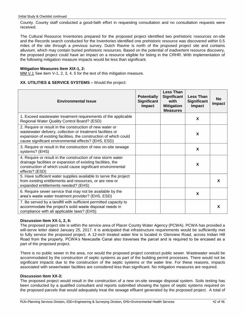
Initial Study & Checklist continued
PLN=Planning Services Division, ESD=Engineering & Surveying Division, EHS=Environmental Health Services 42 of 46
County. County staff conducted a good-faith effort in requesting consultation and no consultation requests were received.
The Cultural Resource Inventories prepared for the proposed project identified two prehistoric resources on-site and the Records search conducted for the Inventories identified one prehistoric resource was discovered within 0.5 miles of the site through a previous survey. Dutch Ravine is north of the proposed project site and contains alluvium, which may contain buried prehistoric resources. Based on the potential of inadvertent resource discovery, the proposed project could have an impact on a resource eligible for listing in the CRHR. With implementation of the following mitigation measure impacts would be less than significant.
Mitigation Measures Item XIX-1, 2: MM V.1 See item V-1, 2, 3, 4, 5 for the text of this mitigation measure.
XX. UTILITIES & SERVICE SYSTEMS – Would the project:
Environmental Issue Potentially Significant
Impact
Less Than Significant
with Mitigation Measures
Less Than Significant
Impact
No Impact
1. Exceed wastewater treatment requirements of the applicableRegional Water Quality Control Board? (ESD)
X
2. Require or result in the construction of new water orwastewater delivery, collection or treatment facilities or expansion of existing facilities, the construction of which could cause significant environmental effects? (EHS, ESD)
X
3. Require or result in the construction of new on-site sewagesystems? (EHS)
X
4. Require or result in the construction of new storm waterdrainage facilities or expansion of existing facilities, the construction of which could cause significant environmental effects? (ESD)
X
5. Have sufficient water supplies available to serve the projectfrom existing entitlements and resources, or are new or expanded entitlements needed? (EHS)
X
6. Require sewer service that may not be available by thearea’s waste water treatment provider? (EHS, ESD)
X
7. Be served by a landfill with sufficient permitted capacity toaccommodate the project’s solid waste disposal needs in compliance with all applicable laws? (EHS)
X
Discussion Item XX-1, 2, 6: The proposed project site is within the service area of Placer County Water Agency (PCWA). PCWA has provided a will-serve letter dated January 25, 2017. It is anticipated that infrastructure requirements would be sufficiently met to fully service the proposed project. A 12-inch treated water line is located in Glenview Road, across Indian Hill Road from the property. PCWA’s Newcastle Canal also traverses the parcel and is required to be encased as a part of the proposed project.
There is no public sewer in the area, nor would the proposed project construct public sewer. Wastewater would be accommodated by the construction of septic systems as part of the building permit processes. There would not be significant impacts due to the construction of the septic systems or the water line. For these reasons, impacts associated with sewer/water facilities are considered less than significant. No mitigation measures are required.
Discussion Item XX-3: The proposed project would result in the construction of a new on-site sewage disposal system. Soils testing has been conducted by a qualified consultant and reports submitted showing the types of septic systems required on the proposed parcels that would adequately treat the sewage effluent generated by the proposed project. A total of
Initial Study & Checklist continued
PLN=Planning Services Division, ESD=Engineering & Surveying Division, EHS=Environmental Health Services 43 of 46
eight sewage disposal systems would be located on a total parcel area of 38-acres in size and thus the impacts from these septic systems are considered to be less than significant. No mitigation measures are required.
Discussion Item XX-4: The project proposes additional storm drainage collection and conveyance facilities to convey stormwater. The applicant has demonstrated through a Preliminary Drainage Report by TSD Engineering Inc. (Sept. 26, 2018), that the proposed storm drain facilities are adequate to handle this proposed project’s flows. These drainage improvements would be constructed with the proposed project improvements and grading impacts have been analyzed elsewhere in this document. The proposed project’s impacts associated with the construction of storm water drainage facilities are less than significant. No mitigation measures are required.
Discussion Item XX-5: The agency charged with providing treated water has indicated their requirements to serve the proposed project. These requirements are routine in nature and do not represent significant impacts. Typical project conditions of approval require submission of a “will-serve” letter from the water agency. Therefore, there is no impact.
Discussion Item XX-6: Sewer service is not available for this proposed project as it lies in a rural residential area served by on-site sewage disposal systems. Therefore, there is no impact.
Discussion Item XX-7: The proposed project would be served by a landfill with sufficient permitted capacity to accommodate the proposed project’s solid waste disposal needs. Therefore, there is no impact.
XXI. WILDFIRE – If located in or near state responsibility areas or lands classified as very high fire hazard severityzones, would the project:
Environmental Issue Potentially Significant
Impact
Less Than Significant
with Mitigation Measures
Less Than Significant
Impact
No Impact
X
1. Substantially impair an adopted emergency response plan oremergency evacuation plan? (PLN)
X
2. Due to slope, prevailing winds, and other factors, exacerbatewildfire risks, and thereby expose project occupants to, pollutant concentrations from a wildfire or the uncontrolled spread of a wildfire? (PLN)
X
3. Require the installation or maintenance of associatedinfrastructure (such as roads, fuel breaks, emergency water sources, power lines or other utilities) that may exacerbate fire risk or that may result in temporary or ongoing impacts to the environment? (PLN)
X
4. Expose people or structures to significant risks, includingdownslope or downstream flooding or landslides, as a result of runoff, post-fire slope instability, or drainage changes? (PLN)
X
Discussion Item XXI-1: The proposed project would not substantially impair an adopted emergency response plan or emergency evacuation plan. Therefore there is no impact.
Discussion Item XXI-2, 3: The proposed project is within a moderate fire severity zone and is surrounded by properties with the same designation. The site is on top of a ridge, however the project site itself is relatively flat. Though there is woodland on site, the woodland is not as dense as the existing vegetation to the north adjacent to the railroad. The vegetation adjacent to the railroad is fragmented and does not connect to a larger forest or broader vegetation community. The area north of the project site and north of the railroad is largely disturbed with an existing industrial area, Interstate
Initial Study & Checklist continued
PLN=Planning Services Division, ESD=Engineering & Surveying Division, EHS=Environmental Health Services 44 of 46
80, and residential uses. The subdivision road is required to be designed to a Plate 102 Land Development Manual Standard, which requires a 24-foot wide road with a surface base capable of supporting the weight of an 80,0000 fire truck. The project is also required to install fire hydrants and is required to comply with Public Resources Code 4291 for creating Defensible Space. The project following Condition of Approval would be imposed on the project for fuel breaks:
Defensible space standards shall be met pursuant to PRC 4291. The minimum 100 foot defensible space requirements of PRC 4291 shall be increased to 200 feet on down slope sides of structures on slopes exceeding 15% grade and increase to 300 foot on slopes exceeding 30% grade, as determined by the serving fire agency at the time of Final Map recordation and prior to Certificate of Occupancy on new residences and residential accessory structures.
The majority of the lots exhibit a slope of 4% to 8% and therefore a 100 foot defensible space requirement would apply. Lots 1 and 8 have steep slopes on their southern portions, and therefore would be subject to the increased defensible space standards.
Construction of the subdivision road and creation of the fuel breaks would not exacerbate fire risk and are intended to reduce wildfire risk. The project is proposing to underground the utility lines that run east to west across the property. One pole near the northwest boundary would remain as it serves a neighboring property. Existing transmission lines along the western boundary will remain and are not proposed to be undergrounded. The construction of the subdivision road would be a temporary environmental impact. Impacts from road construction including drainage, erosion, and dust are addressed in Geology and Soils, Hydrology and Water Quality, and Air Quality, and mitigation measures imposed to reduce impacts to less than significant. Creation of the fuel breaks around structures would be within the building envelopes for the parcels and would involve tree removal. Impacts to protected trees including oak woodland and individual trees are addressed in Section IV: Biology. Therefore, the impact would be less than significant and no mitigation measures are required.
Discussion Item XXI-4: The topography of the site is the top of a hill, with a crest line that traverses the center of the property from east to west. While the hill slopes steeply to the south and north, the center of the property where the crest runs is gently rolling. All buildings are proposed along the crest to avoid the steeper portions of the site, reducing the risk to people and structures from flooding and landslides as a result of runoff, post-fire slope instability, or drainage changes.
All finished slopes will be constructed at a maximum slope of 2:1 and Section VII: Geology and Soils, proposes mitigation measures to erosion, unstable soils, and landslides. Changes to drainage patterns are discussed in Section X: Hydrology and Water Quality, with mitigation measures imposed to reduce impacts to drainage patterns. Therefore the impacts to wildfire related runoff, slope instability, or drainage can be mitigated to a less than significant level by implementing the following mitigation measures:
Mitigation Measures Item XXI- 4: MM VII.1, MM VII.2, MM VII.3, MM VII.5, MM X.1, MM X.2 See Items VII-1,2,3 Items VII-5,6, and Items X-3,4 for the text of these mitigation measures.
F. MANDATORY FINDINGS OF SIGNIFICANCE:
Environmental Issue Yes No
1. Does the project have the potential to degrade the quality of the environment,substantially impact biological resources, or eliminate important examples of the major periods of California history or prehistory?
X
2. Does the project have impacts that are individually limited, but cumulativelyconsiderable? (“Cumulatively considerable” means that the incremental effects of a project are considerable when viewed in connection with the effects of past projects, the effects of other current projects, and the effects of probable future projects.)
X
Initial Study & Checklist continued
PLN=Planning Services Division, ESD=Engineering & Surveying Division, EHS=Environmental Health Services 45 of 46
3. Does the project have environmental effects, which will cause substantialadverse effects on human beings, either directly or indirectly?
X
G. OTHER RESPONSIBLE AND TRUSTEE AGENCIES whose approval is required:
California Department of Fish and Wildlife Local Agency Formation Commission (LAFCO)
California Department of Forestry National Marine Fisheries Service
California Department of Health Services Tahoe Regional Planning Agency
California Department of Toxic Substances U.S. Army Corps of Engineers
California Department of Transportation U.S. Fish and Wildlife Service
California Integrated Waste Management Board
California Regional Water Quality Control Board
H. DETERMINATION – The Environmental Review Committee finds that:
Although the proposed project COULD have a significant effect on the environment, there WILL NOT be a significant effect in this case because the mitigation measures described herein have been added to the project. A MITIGATED NEGATIVE DECLARATION will be prepared.
I. ENVIRONMENTAL REVIEW COMMITTEE (Persons/Departments consulted):
Planning Services Division, Kally Kedinger-Cecil, Chairperson Planning Services Division-Air Quality, Angel Green Engineering and Surveying Division, Sarah Gillmore Department of Public Works and Facilities-Transportation, Amber Conboy DPWF-Environmental Engineering Division, Huey Nham DPWF-Flood Control and Water Conservation District, Brad Brewer DPWF-Facility Services-Parks Division, Ted Rel HHS-Environmental Health Services, Joey Scarbrough Placer County Fire Planning/CDF, Mike DiMaggio
Signature Date Leigh Chavez, Environmental Coordinator
J. SUPPORTING INFORMATION SOURCES: The following public documents were utilized and site-specific studies prepared to evaluate in detail the effects or impacts associated with the project. This information is available for public review, Monday through Friday, 8am to 5pm, at the Placer County Community Development Resource Agency, Environmental Coordination Services, 3091 County Center Drive, Auburn, CA 95603.
County Documents
Air Pollution Control District Rules & Regulations
Community Plan
Environmental Review Ordinance
General Plan
Grading Ordinance
Land Development Manual
Land Division Ordinance
Stormwater Management Manual
Tree Ordinance
Trustee Agency Department of Toxic Substances Control
3/21/19
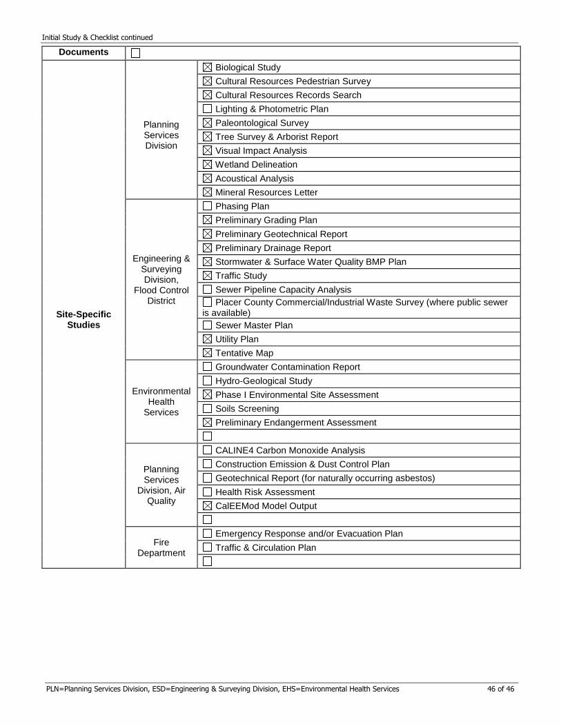
Initial Study & Checklist continued
PLN=Planning Services Division, ESD=Engineering & Surveying Division, EHS=Environmental Health Services 46 of 46
Documents
Site-Specific
Studies
Planning Services Division
Biological Study
Cultural Resources Pedestrian Survey
Cultural Resources Records Search
Lighting & Photometric Plan
Paleontological Survey
Tree Survey & Arborist Report
Visual Impact Analysis
Wetland Delineation
Acoustical Analysis
Mineral Resources Letter
Engineering & Surveying Division,
Flood Control District
Phasing Plan
Preliminary Grading Plan
Preliminary Geotechnical Report
Preliminary Drainage Report
Stormwater & Surface Water Quality BMP Plan
Traffic Study
Sewer Pipeline Capacity Analysis
Placer County Commercial/Industrial Waste Survey (where public sewer is available)
Sewer Master Plan
Utility Plan
Tentative Map
Environmental Health
Services
Groundwater Contamination Report
Hydro-Geological Study
Phase I Environmental Site Assessment
Soils Screening
Preliminary Endangerment Assessment
Planning Services
Division, Air Quality
CALINE4 Carbon Monoxide Analysis
Construction Emission & Dust Control Plan
Geotechnical Report (for naturally occurring asbestos)
Health Risk Assessment
CalEEMod Model Output
Fire Department
Emergency Response and/or Evacuation Plan
Traffic & Circulation Plan