statewide watershed management framework document for … · watershed management framework...
TRANSCRIPT

Draft Draft Draft Draft Draft Draft Draft Draft Draft Draft Draft Draft Draft Draft Draft
DRAFT
STATEWIDE WATERSHED MANAGEMENT FRAMEWORK DOCUMENT
FOR THE STATE OF NEW JERSEY
Prepared by
New Jersey Department of Environmental Protection Office of Environmental Planning
Christine Todd Whitman, Governor Robert C. Shinn, Jr., Commissioner
Robert A. Tudor, Administrator Daniel J. Van Abs, Assistant Administrator
January 1997
i

Draft Draft Draft Draft Draft Draft Draft Draft Draft Draft Draft Draft Draft Draft Draft
EXECUTIVE SUMMARY Since the passage of the federal Clean Water Act and Safe Drinking Water Act over twenty years ago, the New Jersey Department of Environmental Protection (NJDEP) has made significant progress in protecting and restoring the physical, chemical and biological integrity of our State’s waters. Much of that progress is attributable to efforts to control pollution from industrial and municipal wastewater treatment facilities. However, persistent issues remain, including nonpoint source pollution, headwaters destruction, air deposition of pollutants to waterways, and habitat degradation. Today’s problems require more creative, comprehensive solutions -- solutions that take into account not only today’s needs, but also those of future generations. This concept, referred to as sustainable management, is a cornerstone of Governor Christine Todd Whitman’s efforts to ensure the health of New Jersey’s environment, the state’s future economic strength and a high quality of life for generations to come. Sustainable management is designed to conserve environmental quality, account for economic costs and prevent social inequities. It calls for comprehensive planning through an inclusive public process that involves citizens, businesses, scientists, governments and other stakeholders. It identifies long-range goals and indicators -- or measurable markers for tracking progress toward these goals -- and is supported by sound scientific data. The National Performance Partnership System, or NEPPS, is playing a major role in helping New Jersey work toward sustainable management. Under NEPPS, the US Environmental Protection Agency (USEPA) enters into performance partnership agreements with participating states that allow new flexibility in addressing environmental challenges. NEPPS incorporates some of the same basic principles as sustainable management: long-range goal and priority setting, the development of environmental indicators to measure progress, reliance on meaningful scientific data and increased public involvement. Under the direction of Commissioner Robert C. Shinn, Jr., New Jersey has joined with the USEPA and others in the private and public sectors to promote a watershed management approach as a means to further restore and maintain the physical, chemical and biological integrity of our waters. Using sustainable management principles and the NEPPS process, the NJDEP is moving toward a more holistic, rather than site-specific, approach to most effectively protect our water resources today and well into the future. Watersheds are “nature’s boundaries”. They are the areas of land that drain to surface water bodies. Watershed management is the process of managing all of the water resources within the entire area of a watershed, rather than on a site-specific basis. A watershed management approach is based on three key components: 1) a geographic focus; 2) continuous improvement based on sound science; and 3) partnerships/stakeholder involvement. The benefits of a watershed management approach include:
ii

Draft Draft Draft Draft Draft Draft Draft Draft Draft Draft Draft Draft Draft Draft Draft
• Environmental: A watershed management approach places greater attention on the resource
and the achievement of real ecological results, rather than administrative requirements. • Cooperation and Collaboration: Stakeholder involvement helps focus on the priority issues
and needs of the watershed and provide lasting solutions by promoting partnerships, local implementation and stewardship.
• Cost Savings: Watershed management generates efficiencies in monitoring, permitting, and
reporting, saving state agencies, industry and taxpayers time and money. • Predictability for the Regulated Community: The watershed management process helps
provide the regulated community with a better understanding of water resource management priorities for a given geographic region and how industrial and other activities (as well as certain management practices) relate to those priorities. There are also opportunities for cost savings through reinvestment from site-specific analysis to contributions to watershed-based solutions.
The Draft Statewide Watershed Management Framework Document for the State of New Jersey provides a framework for implementing watershed management on a statewide basis. Key elements of this statewide framework include: • Watershed Management Areas: This framework document proposes that the state be divided
into 20 watershed management areas and five water regions for the implementation of watershed management activities on a targeted, cyclical basis.
• Strategic Monitoring: Monitoring activities will be strategically coordinated by watershed to
address various needs including water quality assessment, prioritization, watershed modeling, air deposition and evaluation.
• Watershed-based Permitting: The 20 watershed management areas will be grouped into 5
water regions to facilitate implementation of watershed-based permitting. NJDEP will begin to issue permits and renewals for discharges to surface water (DSW) within the same water region so that the permits expire in the same fiscal year. Watershed-based DSW permits will be issued/renewed in five year cycles.
• Watershed-based Stormwater Management Plans: Watershed-based stormwater
management plans will be developed to address regional stormwater concerns and will be integrated as elements of watershed management plans. These plans offer potential to reduce flooding, prevent pollution, and produce cost efficiencies through development of regional/watershed-based solutions in lieu of site-specific requirements.
• Watershed Management Plans: Watershed management plans will be developed for each of
the 20 watershed management areas. Plans will include: baseline information, water resource trends and priority concerns, watershed goals and objectives, selected management
iii

Draft Draft Draft Draft Draft Draft Draft Draft Draft Draft Draft Draft Draft Draft Draft
strategies, including pollution trading agreements where appropriate, and implementation schedules.
• Geographic Information Systems (GIS): The transition to a statewide watershed
management framework will be facilitated by the use of GIS for data development, data updates and enhancements, assessment and modeling, and improved data sharing.
The Draft Framework Document defines the geographic boundaries that will be used to target and focus statewide and regional watershed management activities. It also provides an implementation schedule and begins a process for coordinating and integrating existing NJDEP programs for the implementation of statewide watershed management activities and for achieving the water resource goals, objectives and milestones developed under NEPPS and articulated in the New Jersey 1996 Performance Partnership Agreement with USEPA Region 2. The implementation schedule proposes the following statewide watershed management activities: • Preliminary characterization and assessment for each of the 20 watershed management areas
in Year 1 and Year 2. • Watershed management plan development and implementation in each watershed
management area by Year 10. • Watershed permitting cycles for each of the five water regions by Year 5. • Watershed-based total maximum daily loads (TMDLs) issued for impaired waterways in
each water region by Year 6 (excluding Delaware Estuary, Harbor Estuary, and Whippany River Watershed, which will be completed sooner).
The implementation schedule is built on assumptions that watershed management is a dynamic process and watershed management plans will continue to evolve over time. Watersheds transcend political, social and economic boundaries. The watershed management process should involve all stakeholders, including representatives from all levels of government, public interest groups, business and industry, academic institutions, private landowners, concerned citizens, and others. The Draft Statewide Watershed Management Framework Document for the State of New Jersey is intended to initiate a dialogue with the citizens of this state and other stakeholders on the development and implementation of statewide watershed management. This dialogue will formally commence at the New Jersey Watershed Forum. and will continue through public review and comment on the draft document. The final version of this document, incorporating public and internal comments, is expected to be published by NJDEP in July 1997.
iv

Draft Draft Draft Draft Draft Draft Draft Draft Draft Draft Draft Draft Draft Draft Draft
ACKNOWLEDGMENTS The Department of Environmental Protection would like to take this opportunity to the thank various individuals listed below for their efforts and contributions on the Draft Statewide Watershed Management Framework Document for the State of New Jersey. This document represents a great deal of preparation and hard work on the part of the NJDEP Watershed Steering Committee, the NJDEP Watershed Characterization and Assessment Team, and the Whippany Watershed Partnership The development of the statewide watershed management framework was ordered by NJDEP Commissioner Robert C. Shinn, Jr. The development of this document was overseen by NJDEP’s Office of Environmental Planning, under the direction of Assistant Commissioner for Policy and Planning, Lewis J. Nagy:
Administrator: Robert A. Tudor Assistant Administrator: Daniel J. Van Abs, Ph.D. Principal Author: Sandra P. Cohen, Supervising Environmental Specialist
NJDEP Watershed Steering Committee: Robert Tudor, Chair; Narinder Ahuja and Dennis Hart Division of Water Quality; Hank Garie, Office of Information Resources Management; James Hamilton, Water Compliance and Enforcement; Haig Kasabach, New Jersey Geological Survey ; Leslie McGeorge, Division of Science and Research; Jim Mumman, Water Monitoring Management; Steven Nieswand, Water Supply; Kerri Ratcliffe, Natural & Historic Resources; Daniel J. Van Abs, and Sandra Cohen, Resource Staff to the Steering Committee. NJDEP Statewide Watershed Characterization and Assessment Team: Narinder Ahuja, and Daniel J. Van Abs, co-chairs; Kevin Berry, Gene Callahan, Bob Canace, Bob Connel, Jan Gheen, Bill Guthe,; Greg Herman, , Barbara Hirst, Bill Honachefsky, Shing-Fu Hsueh, Marjorie Kaplan, Nancy Kempel, Tom McKee, Karen Schaffer, and Scott Tyrell. Whippany Watershed Partnership: Barbara Harris, Policy Advisory Group Chair; Vincent Dee, Project Development Committee Chair; Pat Matarazzo, Public Education and Outreach Committee Chair; Tavit Najarian, Technical Advisory Committee Chair; and George Van Orden, Watershed Characterization Committee Chair. Whippany River Watershed Project Core Staff: Sandra Cohen, Project Manager; Kimberly Cenno, Kyra Hoffmann, Shing-Fu Hsueh, Joseph Kocy, Philip Liu, and Colleen Thomas.
v

Draft Draft Draft Draft Draft Draft Draft Draft Draft Draft Draft Draft Draft Draft Draft
Contributing authors: Martin A. Bierbaum, Ph.D., NJDEP Office of the Commissioner Gene Callahan, NJDEP Water and Hazardous Waste Enforcement Bud Cann, NJDEP Water Monitoring Management Barry Chalofsky, NJDEP Division of Water Quality Trevor Clements, Cadmus Group and USEPA Office of Water Steve Doughty, Land Use Regulation Dona DeLeon, Office of Air Quality Management Theresa Fenton, NJDEP Bureau of Municipal Wastewater Assistance Hank Garie, Office of Information Resources Management Mary Gastrich, Ph.D., NJDEP Office of Environmental Planning Bill Guthe, Office of Information Resources Management Jim Hamilton, NJDEP Water and Hazardous Waste Enforcement Kyra Hoffmann, NJDEP Office of Environmental Planning William Honachefsky, NJDEP Water Monitoring Management Shing-Fu Hsueh, Ph.D., NJDEP Office of Environmental Planning Brenda Jogan, NJDEP Division of Water Quality Haig Kasabach, NJ Geological Survey Al Korndoerfer, NJDEP Water Monitoring Management Judy Louis, Ph.D, NJDEP Division of Science and Research Leslie McGeorge, NJDEP Division of Science and Research Monmouth County Planning Board James Mumman, NJDEP Water Monitoring Management Charlie Pietarinen, Air Monitoring Management Jeff Reading, NJDEP Division of Water Quality Elizabeth Rosenblatt, NJDEP Office of Policy and Planning Karen Schaffer, NJDEP Division of Science and Research State of Nebraska Department of Environmental Quality Daniel J. Van Abs, Ph.D., NJDEP Office of Environmental Planning Thomas Vernam, NJDEP Water Monitoring Management Melisse Wilusz, NJDEP Division of Water Quality Nicholas P. Zripko, NJDEP Office of Environmental Planning Cover layout: Erin Brodel Cover photography: Tina Marie Bozzi GIS Mapping: Gail Carter, Bill Guthe, Greg Herman, Thomas McKee and Nancy Rubin Special thanks to: Susan Knapp, secretary; and the entire Office of Environmental Planning staff, especially: Kevin Berry, Jim Gaffney, Robert Kecskes, and Joseph Kocy, for general comments and suggestions; Terry Fowler, Terri Romagna and Anne Witt (fellow watershed project managers), for general assistance and support; and Kimberly Cenno, for extensive assistance and support on the Whippany Project. Special acknowledgments and appreciation are extended to all other individuals and agencies not listed above who provided information and assistance with this document.
vi

Draft Draft Draft Draft Draft Draft Draft Draft Draft Draft Draft Draft Draft Draft Draft
TABLE OF CONTENTS EXECUTIVE SUMMARY .......................................................................................................... ii
ACKNOWLEDGMENTS .............................................................................................................v
TABLE OF CONTENTS ........................................................................................................... vii
TABLE OF FIGURES...................................................................................................................x
LIST OF ACRONYMS ............................................................................................................... xi
CHAPTER 1: INTRODUCTION..........................................................................................................1 1.1 NJDEP’s Commitment to Protection and Management of Natural Resources......................2 1.2 New Jersey's Decision to Implement a Statewide Watershed Management Approach........3 1.3 What Is A Watershed Management Approach?.....................................................................4 1.4 Key Components of A Watershed Management Approach...................................................6 1.5 Benefits of A Watershed Management Approach: ...............................................................6 1.6 Developing New Jersey’s Watershed Management Approach..............................................7
1.6.1 Initial Efforts Toward Developing a Watershed Management Approach for New Jersey .......................................................................................................................................7 1.6.2 Long-term Vision For New Jersey’s Watershed Management Approach ......................9
CHAPTER 2: IMPLEMENTING A STATEWIDE WATERSHED MANAGEMENT FRAMEWORK .......10 2.1 New Jersey Watersheds, Watershed Management Areas and Water Regions ....................10 2.2 The Watershed Management Cycle ...................................................................................12 2.3 Implementation Schedule.....................................................................................................15 2.4 How will NJDEP Implement a Statewide Watershed Management Approach? .................18
2.4.1 Initial Focus of the Statewide Watershed Management Framework............................18 2.4.2 Strategic Watershed Monitoring Program ...................................................................20 2.4.3 Air Deposition As An Element Of Watershed Management ........................................23
2.5 Goals for A Statewide Watershed Management Framework ..............................................28 CHAPTER 3: DETAILED ACTION STEPS FOR STATEWIDE WATERSHED MANAGEMENT ............31
3.1 Initial Planning: Stakeholder Involvement ..........................................................................31 3.1.1 Preliminary Watershed Characterization and Assessment ..........................................31 3.1.2 Forming a Watershed Partnership ...............................................................................31
3.2 Monitoring and Data Collection .........................................................................................33 3.2.1 Technical Work Plan ....................................................................................................33
3.3 Watershed Characterization and Assessment .....................................................................36 3.4 Goal Setting and TMDL Development................................................................................38 3.5 Watershed Management Strategy Development..................................................................39 3.6 Watershed Management Plan Development and Implementation.......................................40
3.6.1 Developing a Watershed Management Plan ................................................................40 3.6.2 TMDL Implementation and NJPDES Permitting .........................................................42 3.6.3 Stormwater Management and Nonpoint Source Pollution Control.............................44 3.6.4 Stormwater Permitting..................................................................................................46 3.6.5 Nonregulatory measures...............................................................................................46
3.7 Evaluation and Refinement..................................................................................................48
vii

Draft Draft Draft Draft Draft Draft Draft Draft Draft Draft Draft Draft Draft Draft Draft
CHAPTER 4: ROLES AND RESPONSIBILITIES..............................................................................51 4.1 Federal and State Agency Coordination ..............................................................................51
4.1.1 US Environmental Protection Agency ..........................................................................51 4.1.2 United States Geological Survey ..................................................................................52 4.1.3 Natural Resources Conservation Service .....................................................................53
4.2 NJDEP Key Program Roles And Responsibilities .............................................................54 4.2.1 Office of Environmental Planning ...............................................................................56 4.2.2 Division of Science and Research.................................................................................56 4.2.3 Air Quality Management and Air Quality Permitting ..................................................60 4.2.4 Division of Water Quality ............................................................................................61 4.2.5 Water Compliance and Enforcement ..........................................................................62 4.2.6 Water Supply Element...................................................................................................63 4.2.7 Bureau of Geographic Information and Analysis.........................................................64 4.2.8 Internal NJDEP Coordination......................................................................................65 4.2.9 Expansion of Watershed Management Framework Program Coverage......................69
4.3 Other State Agencies ...........................................................................................................70 4.4 Building Watershed Partnerships.........................................................................................72
4.4.1 County and Regional Agencies and Organizations:.....................................................72 4.2.2 Local Government Agencies, Organizations and Partnerships....................................75
CHAPTER 5: NEXT STEPS ............................................................................................................77 5.1 Finalizing the Draft Framework Document.........................................................................77 5.2 Beginning to Implement a Watershed Management Approach...........................................77 5.3 Conclusion ...........................................................................................................................78
Error! Bookmark not defined.Error! Bookmark not defined.Error! Bookmark not defined.Error! Bookmark not defined.Error! Bookmark not defined.Error! Bookmark not defined.Error!
Bookmark not defined.Error! Bookmark not defined.Error! Bookmark not defined.Error! Bookmark not defined.Error! Bookmark not defined.Error! Bookmark not defined.Error! Bookmark not defined.Error! Bookmark not defined.Error! Bookmark
not defined.Error! Bookmark not defined.Error! Bookmark not defined.Error! Bookmark not defined.Error! Bookmark not defined.Error! Bookmark not defined.Error! Bookmark
not defined.Error! Bookmark not defined.Error! Bookmark not defined.Error! Bookmark not defined.Error! Bookmark not defined.Error! Bookmark not defined.Error!
Bookmark not defined.Error! Bookmark not defined.Error! Bookmark not defined.Error! Bookmark not defined.Error! Bookmark not defined.Error! Bookmark
not defined.Error! Bookmark not defined.Error! Bookmark not defined.Error! Bookmark not defined.Error! Bookmark not defined.Error! Bookmark not defined.Error! Bookmark not defined.Error! Bookmark not defined.Error! Bookmark not
defined.Error! Bookmark not defined.Error! Bookmark not defined.Error! Bookmark not defined.Error! Bookmark not defined.Error! Bookmark not defined.Error! Bookmark not defined.Error! Bookmark not defined.Error! Bookmark not defined.Error! Bookmark not defined.Error! Bookmark not defined.Error! Bookmark not defined.Error! Bookmark not defined.Error! Bookmark not defined.Error! Bookmark
not defined.Error! Bookmark not defined.Error! Bookmark not defined.Error! Bookmark not defined.Error! Bookmark not defined.Error! Bookmark not defined.Error!
viii

Draft Draft Draft Draft Draft Draft Draft Draft Draft Draft Draft Draft Draft Draft Draft
Bookmark not defined.Error! Bookmark not defined.
ix

Draft Draft Draft Draft Draft Draft Draft Draft Draft Draft Draft Draft Draft Draft Draft
TABLE OF FIGURES Figure 1: The Emerging Framework................................................................................................5 Figure 2: New Jersey's Watersheds, Watershed Management Areas and Water Regions ............11 Figure 3: The Watershed Management Cycle ...............................................................................13 Table 1: The Statewide Watershed Management Implementation Schedule (First Cycle) ...........16 Table 2: Key NJDEP Program Responsibilities Matrix ................................................................55 Table 3: NJDEP Coordination with Other State Agencies ............................................................71
x

Draft Draft Draft Draft Draft Draft Draft Draft Draft Draft Draft Draft Draft Draft Draft
LIST OF ACRONYMS AMNET ambient biomonitoring network AWRA American Water Resources Association BGIA Bureau of Geographic Information and Analysis (NJDEP) BMP best management practice BSDW Bureau of Safe Drinking Water (NJDEP) BWA Bureau of Water Allocation (NJDEP) CAFRA Coastal Area Facility Review Act CEHA County Environmental Health Act CSO combined sewer overflow CWA Federal Clean Water Act DGW discharge to ground water DSR Division of Science and Research (NJDEP) DSW discharge to surface water EBB electronic bulletin board EQIP Environmental Quality Incentive Program (USDA NRCS) ERHA Environmental Research and Health Assessment (NJDEP) FY fiscal year GIS geographic information system GPS global positioning units HUC hydrologic unit code IDI index of biotic integrity LA load allocation MOU memorandum of understanding MWA Municipal Wastewater Assistance (NJDEP) NADP National Acidic Deposition Program NDDP National Dry Deposition Program NEPPS National Environmental Performance Partnership System NGO nongovernmental organization NJ New Jersey NJAC New Jersey Administrative Code NJBIA New Jersey Business and Industry Association NJDEP New Jersey Department of Environmental Protection NJPDES New Jersey Pollutant Discharge Elimination System NJGS New Jersey Geological Survey NJSA New Jersey Statutes Annotated NPDES National Pollutant Discharge Elimination System NPS nonpoint source NRCS Natural Resources Conservation Service (USDA) OEP Office of Environmental Planning (NJDEP) OSHA Occupational Safety and Health Act OTAG Ozone Transport Assessment Group PAHs polycyclical aromatic hydrocarbons PCBs polychlorinated biphenyls PPA Performance Partnership Agreement (under NEPPS)
xi

Draft Draft Draft Draft Draft Draft Draft Draft Draft Draft Draft Draft Draft Draft Draft
PPG Performance Partnership Grant (under NEPPS) PPM parts per million QA/QC quality assurance and quality control RCRA Resource Conservation and Recovery Act REPC Regional Environmental Planning Council SCD Soil Conservation District SDRP State Development and Redevelopment Plan SIP State Implementation Plan SRF state revolving fund TMDL total maximum daily load USEPA United States Environmental Protection Agency USDA United States Department of Agriculture USGS United States Geological Survey WCEE Water Compliance and Enforcement Element (NJDEP) WLA wasteload allocation WMA watershed management area WMM Water Monitoring Management
xii

DRAFT Statewide Watershed Management Framework Document
For the State of New Jersey Chapter 1: Introduction Since the passage of the federal Clean Water Act and Safe Drinking Water Act over twenty years ago, the New Jersey Department of Environmental Protection (NJDEP) has made significant progress in protecting and restoring the physical, chemical and biological integrity of our State’s waters. Much of that progress is attributable to efforts to control pollution from industrial and municipal wastewater treatment facilities. However, persistent issues remain, including nonpoint source pollution, headwaters destruction, air deposition of pollutants to waterways, and habitat degradation. Today’s problems require more creative, comprehensive solutions -- solutions that take into account not only today’s needs, but also those of future generations. This concept, referred to as sustainable management, is a cornerstone of Governor Christine Todd Whitman’s efforts to ensure the health of New Jersey’s environment, the state’s future economic strength and a high quality of life for generations to come. Sustainable management is designed to conserve environmental quality, account for economic costs and prevent social inequities. It calls for comprehensive planning through an inclusive public process that involves citizens, businesses, scientists, governments and other stakeholders. It identifies long-range goals and indicators -- or measurable markers for tracking progress toward these goals -- and is supported by sound scientific data. The National Performance Partnership System, or NEPPS, is playing a major role in helping New Jersey work toward sustainable management. Under NEPPS, the US Environmental Protection Agency (USEPA) enters into performance partnership agreements with participating states that allow new flexibility in addressing environmental challenges. NEPPS incorporates some of the same basic principles as sustainable management: long-range goal and priority setting, the development of environmental indicators to measure progress, reliance on meaningful scientific data and increased public involvement. Under the direction of Commissioner Robert C. Shinn, Jr., New Jersey has joined with the USEPA and others in the private and public sectors to promote a watershed management approach as a means to further restore and maintain the physical, chemical and biological integrity of our waters. Using sustainable management principles and the NEPPS process, the NJDEP is moving toward a more holistic, rather than site-specific, approach to most effectively protect our water resources today and well into the future This document provides a framework for implementing watershed management in New Jersey on a statewide basis. This framework defines the geographic boundaries that will be used to target and focus statewide and regional watershed management activities. This framework also provides an implementation schedule and begins a process for coordinating and integrating

Draft Draft Draft Draft Draft Draft Draft Draft Draft Draft Draft Draft Draft Draft Draft
existing NJDEP programs for the implementation of statewide watershed management activities. Finally, the framework document identifies internal coordination issues to be addressed by NJDEP in order to fully implement a statewide watershed management approach. This document is intended to foster a dialogue with the citizens of this state and other stakeholders on the development and implementation of statewide watershed management. It builds upon recent multi-party stakeholder discussions about reforming the New Jersey Pollutant Discharge Elimination System (NJPDES) rules and permit program. However, this document does not provide a cookbook or specific guidance for every aspect of developing watershed management plans for each watershed management area of the state. Such guidance will emerge as we begin to implement the statewide framework. The framework document does provide enough information to guide watershed management activities for those who wish to initiate or continue such efforts locally or regionally. The Draft Statewide Watershed Management Framework Document for the State of New Jersey complements several recent initiatives to improve NJDEP so that its environmental programs are administered more efficiently and effectively. The Draft Framework Document and the watershed management approach are, in fact, implementation vehicles for, and key components of, the New Jersey 1996 Environmental Performance Partnership Agreement between NJDEP and USEPA Region 2, under NEPPS. The Draft Framework Document recommends a process for implementing the steps needed to achieve the goals and milestones articulated in the NEPPS agreement for managing New Jersey’s water resources. Other initiatives, such as NJDEP’s “priority-based budgeting” and “process improvement teams”, provide a means for targeting and allocating or reallocating resources as needed to implement a watershed management approach in conformance with the NEPPS agreement. 1.1 NJDEP’s Commitment to Protection and Management of Natural Resources NJDEP is dedicated to improving, enhancing, and protecting the quality of our natural environment, and to ensuring equitable and beneficial uses of the state’s waters. Protecting the integrity of our natural resources for their intrinsic value, sustainable use, as well as the public health, is essential to the quality of life for the residents of New Jersey. It is an integral part of New Jersey's commitment to the environment, embodied in Governor Whitman’s sustainable management initiative and the New Jersey 1996 Environmental Performance Partnership Agreement signed by NJDEP and USEPA Region 2 on March 7, 1996. NJDEP’s mission is to assist the residents of New Jersey in preserving, sustaining, protecting and enhancing the environment to ensure the integration of high environmental quality, public health and economic vitality, and to accomplish these goals in partnership with the general public, business, environmental community and all levels of government. The mission of NJDEP is soundly based in New Jersey statutes, specifically the New Jersey Water Pollution Control Act (58:10A-2), the New Jersey Water Quality Planning Act (NJSA 58:11A-1) and the Water Supply Management Act, which respectively direct the agency to (among other things):
... restore, enhance and maintain the chemical, physical, and biological integrity of [the state’s] waters, to protect public health, to safeguard fish and aquatic life
2

Draft Draft Draft Draft Draft Draft Draft Draft Draft Draft Draft Draft Draft Draft Draft
and scenic and ecological values, and to enhance the domestic, municipal, recreational, industrial and other uses of the water.
... [establish] a continuing planning process ... [and] coordinate and integrate water quality management plans with related Federal, State, regional and local comprehensive land use, functional and other relevant planning activities, programs and policies; and ... [provide] opportunities for meaningful public participation ... during all phases of the water quality planning management process.
and also directs that:
... the water resources of the State are public assets of the State held in trust for its citizens and are essential to the health, safety, economic welfare, recreational and aesthetic enjoyment, and general welfare of the people of New Jersey; ...the water resources of the State and any water brought into the State must be planned for and managed as a common resource from which the requirements of the several regions and localities in the State shall be met; ... [and] it is necessary to insure that within each basin there exists adequate water supplies to accommodate present and future needs...
NJDEP is empowered to protect the state's environmental resources by several state and federal laws, but the laws most critical to the overall protection of the state's waters are the federal Clean Water Act (CWA) and its New Jersey counterparts, the Water Pollution Control Act and the Water Quality Planning Act. The objective of the Water Pollution Control Act Amendment of 1972 is to restore and maintain the chemical, physical, and biological integrity of the Nation's waters and, where attainable, to achieve a level of water quality that provides for the protection and propagation of fish, shellfish, and wildlife, and for recreation in and on the water. The CWA contains many statutory provisions to control sources of pollution to help achieve this goal. In particular, the CWA authorizes states to assume responsibility for federal regulatory programs to implement and enforce controls on point source discharges, stormwater runoff, and discharges of dredged or fill material. It was amended in 1987 to establish state nonpoint source management programs aimed at reducing pollution from agricultural, forested land, mining, and urban runoff. However, the CWA is primarily intended for surface water protection. The NJDEP considers ground water protection to be a critical component of water resource protection and watershed management. The programs and policies of the CWA, the New Jersey Water Pollution Control Act, the New Jersey Water Quality Planning Act, and the Water Supply Management Act provide the foundation for environmental protection for all of New Jersey's waters. Other laws, such as the Freshwater Wetlands Protection Act, the Soil Erosion and Sediment Control Act, the Stormwater Management Act, and floodplain and coastal zone management statutes, also play important roles. 1.2 New Jersey's Decision to Implement a Statewide Watershed Management Approach
3

Draft Draft Draft Draft Draft Draft Draft Draft Draft Draft Draft Draft Draft Draft Draft
To implement a more comprehensive approach to the enhancement of New Jersey’s water quality, NJDEP, under the direction of Commissioner Robert C. Shinn, Jr., is instituting a watershed-based approach for managing New Jersey’s water resources and the surrounding ecosystems on a statewide basis. This initiative will improve protection of New Jersey's surface and ground water resources by better integrating existing water resource management programs among governmental entities and between the public and private sectors. This watershed management approach is not an entirely new concept. Elements of a watershed-based approach to water resources management were present in Sections 201, 208, 303 and 320 of the Federal CWA, as well as the New Jersey Water Quality Planning Act, but were never utilized to their full potential as integrated water resources planning and management programs. On February 5, 1996, NJDEP published a comprehensive rule proposal that would reform its water resources management programs, including discharge permitting, water quality management planning, surface water quality standards, and enforcement (see 28 NJR 330-747). A key aspect of this program reform was to conform to a watershed-based approach to water resources management. In the rule proposal, NJDEP committed to produce a separate document explaining how a process for statewide watershed management would be developed and implemented in the State of New Jersey. With the publication of this document, NJDEP will focus on a dialogue involving citizens and stakeholders in the development of a watershed management approach. 1.3 What Is A Watershed Management Approach? Watershed management is the process of managing all of the water resources within the entire area of a watershed, rather than on a site-specific basis. A watershed management approach is not a new regulatory program; rather it is a strategic approach to operating existing regulatory and nonregulatory programs more efficiently and effectively to protect, enhance and restore the state’s water resources. Accordingly, watershed management is often referred to in this document as an “approach” or a “management framework”. A watershed management approach is created by establishing a framework that integrates existing programs statewide and coordinates their management activities geographically by watersheds, watershed management areas and water regions. Figure 1 illustrates the relationship between an overall goal of environmental protection, the watershed management framework, and existing management programs and activities. The peak of the pyramid represents New Jersey’s goal of water resource protection, as articulated in the New Jersey 1996 Environmental Performance Partnership Agreement with USEPA Region 2. The next level of the pyramid illustrates how progress towards achieving this goal will be measured through a system of indicators and milestones, including water quality criteria and standards established to protect designated and existing uses. As indicated by its position between the overall goal and NJDEP’s implementing programs, the watershed management approach provides a coordination framework targeting these programs on priority watersheds and
4

Draft Draft Draft Draft Draft Draft Draft Draft Draft Draft Draft Draft Draft Draft Draft
Figure 1: The Emerging Framework
Overall Goal*: Our waters will support human health and uses, such as swimming, fishing, drinking water supply, agriculture and industry. Our waters will also support ecosystem health by sustaining healthy communities of plants, fish, insects and other animals that depend on the water. We will conserve existing wetlands and protect threatened and endangered species. It is the goal of the state to restore, maintain and enhance the chemical, physical and biological integrity of its waters, to protect the public health, to safeguard the aquatic biota, protect scenic and ecological values, and to enhance the domestic, municipal, recreational, industrial, agricultural and other reasonable uses of the state’s waters. Criteria for Protection Measures of Progress
Coordination Framework
Implementation Tools
* As articulated in the New Jersey Environmental Performance Partnership Agreement with USEPA Region 2, March 1996.
Water Resource Protection
Watershed Management Approach: Geographic Focus Targeting Multi-Media
Integrated Solutions Stakeholder Involvement
Water Quality Planning Monitoring Green Acres Water and Air Quality Standards Point Source Controls
Nonpoint Source Controls Stormwater Management TMDLs Source Protection Lands Management Education and Outreach
Stormwater Permitting Financing/Grants & Incentives Enforcement State Development and Redevelopment Plan Coastal Zone Management
Restoration Site Remediation Regional Air Transport Control Strategy Headwaters Protection Aquifer/Well Head Protection Land Use Management Wetlands and Flood Areas Protection Water Allocation Permitting Clean Lakes
NEPPS Milestones: Designated Uses
Criteria and Standards Environmental Indicators
Water Quality Air Quality
5
Draft Draft Draft Draft Draft Draft Draft Draft Draft Draft Draft Draft Draft Draft Draft
watershed issues statewide. The existing programs and their management activities will also be used as implementation tools for customized watershed management plans and strategies within water regions and watershed management areas. 1.4 Key Components of A Watershed Management Approach A watershed management approach is based on the following three key components: Geographic focus: Watersheds are “nature’s boundaries”. They are the areas that drain to surface water bodies. A watershed generally includes lakes, rivers, estuaries, wetlands, streams, and the surrounding landscape. Ground water resources are also included where they are linked to the surface water system. Air deposition of pollutants and its impact on watersheds will also be addressed. Continuous Improvement Based on Sound Science: Sound scientific data, monitoring and other tools and techniques are critical to providing information that supports the process. Actions to be undertaken include characterizing watersheds and identifying priority problems and solutions, developing management plans, and evaluating their effectiveness within the watershed. Partnerships/Stakeholder Involvement: Watersheds transcend political, social and economic boundaries. Therefore, it is important to involve all the affected interests in designing and implementing goals for the watershed. Watershed advisory groups should include representatives from all levels of government, public interest groups, business and industry, academic institutions, private landowners, concerned citizens, and others. 1.5 Benefits of A Watershed Management Approach: A watershed management approach will result in the following overall benefits: Environmental: • Focus on the Resource: A watershed management approach places greater attention on the
resource and the achievement of real ecological results, rather than administrative requirements.
• Emphasis on Priority Problems: A more thorough understanding of threats and conditions in
each watershed provides a stronger basis for targeting priority concerns.
Community Building: • Cooperation and Collaboration: Watershed partners gain a sense of common purpose in
working out solutions. Stakeholder involvement helps focus on priority issues and needs of each watershed and provides lasting solutions by promoting partnerships, local implementation and stewardship.
Cost Savings:
6

Draft Draft Draft Draft Draft Draft Draft Draft Draft Draft Draft Draft Draft Draft Draft
• Streamlining Requirements: Watershed management generates efficiencies in monitoring, permitting, and reporting, saving state agencies, industry and taxpayers time and money.
• Predictability for the Regulated Community and the General Public: The watershed
management process helps provide the regulated community and the public with a better understanding of the water resource management priorities for a given geographic region and how industrial and other activities (as well as certain management practices) are related to those priorities. There are also opportunities for cost savings through reinvestment from site-specific analysis to contributions to watershed-based solutions.
1.6 Developing New Jersey’s Watershed Management Approach 1.6.1 Initial Efforts Toward Developing a Watershed Management Approach for New Jersey In March 1993, three regional discussion groups were convened by NJDEP to consider the “Working Paper on Water Quality Management Planning Reform”. The purpose of the discussion groups was to assess the existing water quality management planning program; to develop programmatic goals for better water resource protection; and to improve coordination with other water resource management programs. The outcome of the discussion groups was overwhelming support for a watershed-based approach to water resources planning and management that would integrate and coordinate existing water resources programs; develop an improved database for planning and permitting; develop or clarify environmental criteria and objectives; provide a more streamlined and predictable, policy-driven permit process; and address a broad array of environmental concerns, including nonpoint source pollution, secondary and cumulative impacts, water supply and pollution prevention. Since then, there have been many forums hosted by NJDEP and other organizations to focus on issues related to watershed management. These forums include joint public hearings of the New Jersey Clean Water Council and the New Jersey Water Supply Advisory Council, the New Jersey Business and Industry Association, the National Governors Association, the League of Women Voters of the Morristown Area, the Association of New Jersey Environmental Commissioners, the Commissioner’s Green and Gold Task Force, the Commonwealth of New Jersey, the New Jersey Section of the American Water Resources Association, the Morris County Watershed Symposium, etc. In October 1993, NJDEP initiated the Whippany River Watershed Project as a pilot project in watershed management. The Whippany River Watershed Project is designed to help NJDEP, in collaboration with other interested parties (i.e. stakeholders), to develop a comprehensive watershed management planning process that can be replicated in other watersheds throughout the state. The Project will produce a comprehensive watershed management plan for the Whippany River Watershed. The watershed management plan will identify and prioritize water resource issues and problems in the Whippany River Watershed as well as management strategies to be implemented in order to address these issues. Strategies will include a combination of regulatory and nonregulatory mechanisms, including best management practices for nonpoint source pollution, implemented at different levels of government. Voluntary compliance and education programs, as well as innovative
7
Draft Draft Draft Draft Draft Draft Draft Draft Draft Draft Draft Draft Draft Draft Draft
solutions to pollution problems (e.g. pollution trading), will be key components of the watershed management plan. This Project is being conducted as a collaborative process with the watershed community through the formation of a "Partnership" between NJDEP and Project stakeholders. The Whippany Watershed Partnership consists of representatives of local, county, regional, state and federal government agencies; local and regional businesses and industries; academia; environmental and civic groups; and area residents. Public outreach efforts are being conducted to increase awareness about the Project and the Whippany River Watershed and also to enhance public involvement and participation in the watershed management planning process. Stakeholder involvement is expected to yield better planning and decision-making, and increase the success of local implementation efforts and compliance with watershed management measures. This project has been instrumental in developing the Draft Statewide Watershed Management Framework Document for the State of New Jersey, particularly in developing and refining methods for data collection, water quality screening, characterization and assessment, and public education and outreach, as well as building trust among stakeholders and with NJDEP, and developing mutual respect for the contributions of all the stakeholders involved. Other watershed management initiatives have also been undertaken by NJDEP, in collaboration with stakeholders, including the New York/New Jersey Harbor Estuary, Delaware Estuary and Barnegat Bay Watershed Estuary Programs, as well as various nonpoint source pollution demonstration and riparian restoration projects around the state, such as the Navesink River Project. These projects are helping to develop effective tools for watershed management that can be implemented under the statewide watershed management framework.. The NJDEP administers the National Estuary Program, an estuarine management program, as part of the CWA Section 320, including the geographic areas of the New York/New Jersey Harbor Estuary and the New York Bight, the Delaware Estuary, and the Barnegat Bay Watershed Estuary. (Programs were initiated for these estuaries in 1988, 1989, and 1995, respectively.) These efforts are important because, while they focus on the coastal region and shoreline of the State (essentially all of New Jersey’s marine and coastal waters), they are watershed-based, consensus-based, and utilize many of the same principles and elements proposed under the statewide watershed management framework. The Navesink River Project recently resulted in the re-opening of long-closed shellfish waters, due to cooperative efforts between NJDEP, the New Jersey Department of Agriculture, and local municipal officials and landowners to develop and implement appropriate and effective nonpoint source best management practices (BMPs). Most recently, on May 8, 1996, NJDEP sponsored a Watershed Fair to promote watershed management activities occurring around the state. Representatives of federal, state, and regional governments, as well as watershed associations, business and environmental organizations, and NJDEP staff, participated. A break-out session was held with the watershed associations to identify their concerns and recommendations for a statewide watershed management process. A meeting of the watershed associations’ outreach coordinators was held on August 22, 1996 to begin educating and promoting watershed education and outreach on a grass-roots level while the statewide watershed management framework is being developed. The New Jersey Watershed Forum will provide an opportunity for public input into the continued development
8

Draft Draft Draft Draft Draft Draft Draft Draft Draft Draft Draft Draft Draft Draft Draft
and implementation of the Draft Statewide Watershed Management Framework Document for the State of New Jersey. 1.6.2 Long-term Vision For New Jersey’s Watershed Management Approach NJDEP Commissioner Shinn envisions the implementation of a systems management approach to environmental protection. The approach would initially focus on watersheds as well-defined geographic units that recognize all of the interconnections that define the hydrologic cycle, including surface and ground water, as well as wetlands. However, this approach would eventually be expanded beyond water resources to reflect all of the traits that make each geographic unit unique, including: assessment of air deposition of pollutants and precipitation patterns, topography, soil and geological characteristics, and land use/land cover. Components of such a comprehensive management system would include: water supply, water quality, water conservation, flood protection, land use management, air quality, solid and hazardous waste management, open space and recreation resource management, and protection of fish and wildlife resources. The statewide watershed management framework provides a structure and process that can be built upon to enable government agencies, organizations, and the public to participate in this approach. It is envisioned that the statewide watershed management framework will accelerate improvements in the quality of our natural resources as a result of the increased coordination and pooling of resources which will result from this approach.
9

Draft Draft Draft Draft Draft Draft Draft Draft Draft Draft Draft Draft Draft Draft Draft
Chapter 2: Implementing A Statewide Watershed Management Framework Watershed management is an ongoing process that occurs on both statewide and watershed levels concurrently. It is a process that focuses activities and resources on particular geographic regions based on statewide and local priorities. Therefore, for practical reasons, NJDEP cannot initiate watershed management simultaneously in all watersheds across the state at the same time. Instead, NJDEP proposes to implement a watershed management framework as a phased, rotating cycle of activities that will occur on several different levels simultaneously. NJDEP has delineated a set of boundaries for targeting specific types of watershed management activities to the appropriate geographic area and scale. Watershed management activities at both regional and watershed levels will be sequenced incrementally across the state. This will help to balance program workloads. While many management activities will occur at the watershed or subwatershed level, certain aspects of the statewide framework are more appropriately implemented at the regional, statewide, or sometimes interstate level. The following sections describe the nature and sequence of management activities that will occur on these different levels across the state. However, not all watershed management activities need to be conducted by NJDEP. The sequencing of management activities does not preclude early stakeholder efforts to initiate watershed management activities based on their local needs and resources, and that support this statewide watershed management framework. NJDEP will provide support and guidance for locally initiated efforts to the maximum extent possible. This Framework Document is the first step in providing such guidance. Targeting of management activities, especially intensive monitoring and modeling efforts, to specific segments of the state creates a more efficient and effective operating framework. For this purpose, the state has been divided into watersheds, watershed management areas, and water regions; in order to produce a reasonable timetable for the implementation of watershed management activities at the appropriate levels of concern and management. The delineation of watersheds, watershed management areas, and water regions; the cycle of watershed management activities; and the implementation schedule are described in the sections that follow. 2.1 New Jersey Watersheds, Watershed Management Areas and Water Regions In order to implement a watershed management framework, the State of New Jersey has been divided into 96 watersheds, 20 watershed management areas and 5 water regions. The boundaries reflect different groupings or aggregates of watersheds into manageable planning areas and regions. The boundaries also reflect a “hierarchy” of aggregates of hydrogeologic boundaries developed by the US Geological Survey (USGS), as outlined below and illustrated in Figure 2.
1. USGS hydrologic subunit system 2. USGS HUC-11 hydrologic subunits 3. watersheds (96) 4. watershed management areas (20) 5. water regions (5)
10

Draft Draft Draft Draft Draft Draft Draft Draft Draft Draft Draft Draft Draft Draft Draft
Figure 2: New Jersey's Watersheds, Watershed Management Areas and Water Regions
11

Draft Draft Draft Draft Draft Draft Draft Draft Draft Draft Draft Draft Draft Draft Draft
The HUC-11 hydrologic subunits delineations were developed by USGS through a national system. The boundaries of the 96 watersheds were delineated for New Jersey by NJDEP using common river/stream names, based on the USGS hydrologic HUC-11 subunits and other considerations. The boundaries of the 20 watershed management areas were delineated based on aggregations of the 96 watersheds which reconciled watershed boundaries with other related planning and program area boundaries currently applied under various water resource management programs (including political boundaries, designated areawide Water Quality Management Planning areas, water supply planning area boundaries, etc.). The 20 watershed management areas were then aggregated into five water regions. Management plans will generally be developed for each watershed management area, while water regions will be primarily used for permit coordination, monitoring and resource allocation. Certain watershed management areas, water regions or issues may involve inter-state agencies and cooperative efforts. Examples include The New York/New Jersey Harbor Estuary and Bight Program and The Delaware Estuary Program. These programs have already developed cooperative agreements and management practices consistent with the principles and elements of the statewide watershed management framework. Additional refinement of inter-state watershed management and integration of the National Estuary programs will be addressed through implementation of the statewide watershed management framework. 2.2 The Watershed Management Cycle NJDEP will begin implementing a statewide watershed management framework by first working with the stakeholders in each water region to collaboratively develop the priorities and implementation schedules for the watershed management areas within each region. However, the watershed management framework assumes that a systematic sequence of watershed management activities will occur within each watershed management area and each water region over a given period of time, and then repeat itself in an iterative process. This cycle of watershed management activities includes the fundamental planning steps of data collection and assessment, problem identification, strategy development, implementation and evaluation (see Figure 3).
12

Draft Draft Draft Draft Draft Draft Draft Draft Draft Draft Draft Draft Draft Draft Draft
Figure 3: The Watershed Management Cycle
Plan Refinement
Monitoring
Implementation
Planning
Assessment
TMDL Development
Plan Development
Stakeholder Involvement
Evaluative Monitoring
13

Draft Draft Draft Draft Draft Draft Draft Draft Draft Draft Draft Draft Draft Draft Draft
However, the cycle of watershed management activities is actually a more detailed set of sequential steps, each containing a set of related management activities that must be coordinated. These steps and activities are outlined below:
Sequence of Watershed Management Steps and Activities
Step 1: Initial Planning/Stakeholder Involvement • Preliminary Watershed Characterization • Form a Watershed Partnership
Step 2: Monitoring and Data Collection • Technical Work Plan Development • Screening/Targeted Monitoring
Step 3: Watershed Characterization And Assessment • Detailed Watershed Characterization and Assessment • Modeling and Analysis • Problem Identification and Prioritization
Step 4: Goal Setting • Develop TMDLs and Establish Goals • Establish Environmental Objectives and Evaluative Criteria
Step 5: Management Strategy Development • Simulations/forecasting models • Alternatives Analysis • BMP Options • Cost-benefit Analysis
Step 6: Watershed Management Plan Development • Plan Formulation • Plan Proposal and Adoption
Step 7: Watershed Management Plan Implementation • Permit Issuance • Stormwater Management • Targeted Site Remediation • Nonregulatory Measures • Financing
Step 8: Evaluation And Refinement • Monitoring • Evaluation • Plan Refinement • Enforcement
This outline of watershed management activities provides a step-by-step sequence of implementation activities that will occur both on a statewide basis, by water region, and also for each watershed management area within a region. The scope and complexity of these activities will vary, depending on the issues, needs and resources of each watershed/region. While NJDEP will provide leadership, oversight, guidance and support for implementing the statewide
14

Draft Draft Draft Draft Draft Draft Draft Draft Draft Draft Draft Draft Draft Draft Draft
watershed management framework, many of these watershed management activities may be initiated and/or implemented locally or regionally, using the framework document as guidance. 2.3 Implementation Schedule NJDEP has also developed an implementation schedule (see Table 1) for the sequence of steps and activities that make up the statewide watershed management framework. This implementation schedule targets regions of the state where preliminary watershed management activities will be initiated on a priority basis. Four priority areas were identified by NJDEP Commissioner Shinn for initial implementation of the watershed management framework, in order to expand upon prior and ongoing watershed management-related activities and investment, as well as to focus on statewide and regional environmental concerns. These areas include: The New York/New Jersey Harbor Estuary, The Barnegat Bay Watershed Estuary, the Delaware Estuary and the Passaic River Basin (encompassing several watershed management areas). The sequencing of watershed management activities among the five water regions, as shown in Table 1, reflects this set of priorities. Ongoing initiatives located in these priority areas are shown at the top of Table 1. These initiatives include the Whippany River Watershed Project, NJDEP’s pilot project in watershed management, which is located in the Passaic River Basin. These initiatives are shown as commencing before implementation of the statewide watershed management framework. In addition, plans are proposed to begin a new federally-funded initiative in the Rahway River Watershed, which is located in the Raritan Water Region. While these projects are watershed-based and are related to the statewide framework, they are preceding on a separate timetable from the statewide implementation schedule. Some of these initiatives have been underway for several years and have generated useful information and results or “lessons” (e.g. stakeholder development, education and outreach, monitoring and modeling, characterization and assessment) that were used to develop this framework document.. Since these projects and initiatives are ongoing, they will eventually become integrated into the overall statewide watershed management framework. In Table 1, the two left hand columns show the five water regions (numbered 1-5) in order of priority, as explained above. Watershed management activities are represented by symbols defined in the legend at the bottom of the table (e.g. P for Planning). Table 1 depicts the priority ranking of the five regions, and shows an example of how activities could be sequenced for watershed management areas within each region. However, this sequence is for illustrative purposes only. The actual sequence of activities within each water region will depend on the ranking of watershed management areas and the prioritization of watershed issues that will be accomplished through NJDEP’s initial outreach to stakeholders within each water region and the development of a preliminary watershed characterization and assessment for each of the 20 watershed management areas in the state.
15

Draft Draft Draft Draft Draft Draft Draft Draft Draft Draft Draft Draft Draft Draft Draft
Table 1: The Statewide Watershed Management Implementation Schedule (First Cycle)
16
Draft Draft Draft Draft Draft Draft Draft Draft Draft Draft Draft Draft Draft Draft Draft
NJDEP will initiate this preliminary step in Year 1 of the statewide watershed management framework. The preliminary characterization and assessment process will allow NJDEP to work with the stakeholders to prioritize watershed management activities within each water region and among the watershed management areas of each region. In this way, the stakeholders in collaboration with NJDEP will be determining the watershed management priorities, and targeting subsequent watershed management activities, within each water region. While NJDEP is working with stakeholders to develop priorities and implementation schedules for the watershed management areas within each region, NJDEP will be preparing to implement regional watershed management activities in five-year cycles. By the end of Year 5 of implementing the statewide watershed management framework, NJDEP plans to have initiated watershed management activities in each watershed management area statewide. And while watershed management plans will be developed on a priority basis within each region, watershed management plans should be completed for every watershed management area statewide by Year 10. Management measures identified in the watershed management plans will be implemented upon adoption of the plans, although some measures may be administered sooner under separate authority (e.g. stormwater management ordinances). Implementation of certain management measures may span several years (e.g. construction of regional stormwater facilities) before completion and evaluation. However, the second cycle of the statewide watershed management framework, including monitoring to evaluate plan effectiveness and plan refinement, should commence by Year 11. The second cycle of statewide watershed management activities should be underway statewide by Year 14. This implementation schedule was chosen from several scenarios, all of which were developed from a ranking of environmental and programmatic concerns, including: regulatory mandates (e.g. point and nonpoint source control); priority concerns (e.g. 303(d) list of impaired waterbodies), resource values (e.g. pristine or threatened waterways or habitat); and public uses of the water resources. Under the proposed implementation schedule, regions exhibiting the most water quality impairment and containing the greatest number of NJPDES permitted surface water discharges would receive priority consideration. While the initial emphasis may appear to be water quality control of point source discharges, the watershed management process, once underway would address all water resource issues, including water supply, flooding, and nonpoint source pollution (including air deposition of pollutants), that are identified in the watershed management area. This implementation schedule allows resources for watershed management activities to be targeted to where they are most needed. A watershed ranking methodology is necessary to identify the most serious water resource concerns at State, regional, and watershed levels. It will guide the allocation of resources to be used in an efficient and effective manner to address priority concerns on a Statewide basis. The methodology may also be applied on a watershed level to identify environmental issues and target resources for watershed management activities within a subwatershed or watershed management area. In ranking and prioritizing watershed management areas within each water region, this methodology will help NJDEP and stakeholders evaluate indicators and trends and identify issues, concerns and opportunities within and among watersheds. For instance,
17

Draft Draft Draft Draft Draft Draft Draft Draft Draft Draft Draft Draft Draft Draft Draft
watersheds that contain water quality-impaired waterbodies due to point source pollution may be subject to more complex planning and permitting requirements (and require more resources) than other watersheds. The ranking methodology will also help identify watersheds that require more intensive study and analysis so that resources can be allocated more efficiently. 2.4 How will NJDEP Implement a Statewide Watershed Management Approach? The Draft Statewide Watershed Management Framework Document for the State of New Jersey provides a coordinating framework for environmental management that focuses public and private sector efforts and resources to address the highest priority concerns within hydrologically-defined geographic areas, taking into consideration both ground and surface water flow, point and nonpoint sources of pollution, air deposition of pollutants, and land and water uses and impacts. This framework will allow NJDEP to operate existing regulatory and nonregulatory programs more efficiently and effectively through a watershed-based approach to protect, enhance and restore the state's water resources. The statewide watershed management framework will enable NJDEP to realize such efficiencies by: focusing on a set of core programs for initial implementation; expanding to other programs in the future; integrating and coordinating current monitoring and data collection efforts through a Strategic Watershed Monitoring Plan; and establishing a set of goals for environmental and programmatic improvements that can be achieved through implementation of a watershed management approach. The statewide watershed management framework also provides a “map” or outline for the public to see where statewide watershed management activities will be targeted and implemented, so that local, regional, state and national efforts may be coordinated, as appropriate. However, the statewide framework and its implementation schedule do not preclude other watershed management efforts from being initiated or continuing with other resources and leadership. Mandated regulatory programs will also proceed, as required, until such time as they are coordinated with the statewide framework, or integrated with other watershed management activities. 2.4.1 Initial Focus of the Statewide Watershed Management Framework Commissioner Shinn has made a commitment for NJDEP to develop and implement a statewide watershed management framework for New Jersey. This commitment is reflected in several strategic planning and information documents, including the New Jersey Environmental Performance Partnership Agreement signed by NJDEP and USEPA Region 2 on March 7, 1996; and in the Performance Partnership Grant applications and other work plans. The NJDEP Office of Environmental Planning will be the lead in developing a watershed management approach and building a statewide watershed management framework, as well as coordinating with other environmental management activities for future integration with additional programs within NJDEP, other agencies and organizations, and local or “grass-roots” efforts. Initial emphasis of the statewide watershed management framework will be on coordinating a core set of programs solidly based in the authority and precedence of the Federal Clean Water Act and New Jersey’s water resource protection statutes, including:
18

Draft Draft Draft Draft Draft Draft Draft Draft Draft Draft Draft Draft Draft Draft Draft
• CWA Section 106 Water Quality Monitoring Program • CWA Section 208 Water Quality Management Planning • CWA Section 303(d) TMDL Program • CWA Section 305(b) Water Quality Assessment and Reporting • CWA Section 314 Clean Lakes Program • CWA Section 319 Nonpoint Source Management Program • CWA Section 320 National Estuary Program • CWA Section 402 NPDES Permit and Compliance Program • CWA Section 402(p) Stormwater Permitting Program • New Jersey Ambient Surface Water Monitoring Network • New Jersey Ambient Biological Monitoring Network • New Jersey Water Quality Management Planning Program • New Jersey Stormwater Management Program • New Jersey Sewage Infrastructure Improvement Program • New Jersey Pollutant Discharge Elimination System • New Jersey Industrial Stormwater Permitting Program • New Jersey Municipal Wastewater Assistance Program • New Jersey Ground Water Protection Program • New Jersey Well Head Protection Program • New Jersey Aquifer Recharge Program • New Jersey Safe Drinking Water Program • New Jersey Water Supply and Water Supply Planning Programs In the future, as watershed management plans are developed, additional programs, including but not limited to the following, will be added to address watershed-specific issues and management strategies: CWA Section 404 wetlands protection programs, New Jersey stream encroachment and flood hazard area protection programs, Federal Coastal Zone Management Act Section 6217 coastal nonpoint source management programs, New Jersey Coastal Area Facilities Review Act (CAFRA) programs, source protection areas management, riparian buffers, natural and historic resource protection, air quality planning and air discharge permitting programs, site remediation and solid waste management programs, pollution prevention programs and implementation of the New Jersey State Development and Redevelopment Plan. While the concept is not new, aspects of the statewide watershed management framework will require changes in attitudes and operations that may require additional time for some programs, staff and stakeholders to develop consensus on implementation issues. Optimizing initial framework size increases the likelihood for early success that, in turn, will add credibility to the approach. Early success and added credibility should attract increased involvement in the future from other programs within NJDEP, such as those listed above; as well as from other state and federal agencies, including the New Jersey Departments of Agriculture, Transportation, Community Affairs, and Treasury; and the USDA Natural Resources Conservation Service, the US Fish and Wildlife Service, and the US Army Corps of Engineers.
19

Draft Draft Draft Draft Draft Draft Draft Draft Draft Draft Draft Draft Draft Draft Draft
2.4.2 Strategic Watershed Monitoring Program Many of the criteria used in ranking watersheds, as well as multi-media and other environmental criteria and objectives developed through the watershed management process, rely on water quality data generated by the state's surface water ambient monitoring network, operated cooperatively by NJDEP and the US Geological Survey (USGS), New Jersey District. NJDEP and USGS have operated a cooperative, ambient water quality network for over twenty years. This network has provided a historic database for water quality assessment and the tracking of water quality trends over time. USGS also collects stream flow data through its stream gauging network (see section 4.1.2). NJDEP is already using the surface water ambient monitoring network to develop water quality data on a watershed basis. A statewide watershed strategic monitoring program is currently being developed to modify the surface water ambient monitoring network to better serve the needs of the statewide watershed management framework. The strategic watershed monitoring program will be crucial to the success of the statewide watershed management framework. Specific features to be considered in the redesigned monitoring network, under this new program, include: l. A revised ambient surface water monitoring network, including randomly-located
monitoring stations to provide generalized water quality data for statewide assessments; 2. A targeted intensive or synoptic component to support watershed initiatives; 3. A design to more fully develop the relationship between ground water quality and surface
water quality; and 4. An expansion of the network into the tidal waters of the state. The proposed surface water monitoring network would consist of both fixed and synoptic stations located in all five water regions. Fixed stations would be located on small streams in the headwaters areas (indicator sites) and near the downstream end of the large rivers (integrator sites). Water quality data would be collected at these fixed stations on a regular basis, year after year. The water quality data collected from the upstream, indicator sites would provide an indication of the water quality associated with the land-use, soils, geology and hydrologic characteristics of a small portion of the watershed (the headwaters area), while the water quality data collected at the downstream, integrator sites would represent an integration of all the activities and pollution sources (point and nonpoint) occurring throughout the watershed. The fixed station monitoring network would provide the baseline data for trend analysis, establish relationships between water quality and watershed characteristics and provide a check on water quality in the major rivers with heavy use. This baseline data would be supplemented by biological data from Ecoregion reference stations and the ambient biomonitoring network (AMNET). Additional synoptic monitoring stations would be added to more clearly define water quality issues. Synoptic stations are general survey-type stations used for concurrent sampling and would be assigned on a targeted, rotating basis among the watershed management areas. Each synoptic station would consist of an indicator site component and a random site component. The synoptic stations would be sampled during two consecutive years in a longer cycle to establish a broader database to support watershed management activities, including detailed watershed characterization and assessment and water quality modeling. Both the statewide ground water
20

Draft Draft Draft Draft Draft Draft Draft Draft Draft Draft Draft Draft Draft Draft Draft
monitoring program and the AMNET program would be coordinated with the synoptic water quality sampling to significantly increase the usefulness of the data collected. The AMNET program has established a network of lotic (running water) stations in every watershed in the state. Under the current AMNET program, each watershed will be biomonitored for benthic macroinvertebrate populations on a five year rotation schedule. At least one monitoring station is located on every second-order stream and all first-order stream at least three miles in length. (First-order streams are those with no tributaries; second-order streams are those that have only first-order streams as tributaries.) To the greatest extent possible, the ambient biomonitoring network incorporates existing USGS and NJDEP ambient surface water monitoring stations so that correlation of the data sets can be maximized. Furthermore, the network was designed with mainstem (second or third-order) stations located before the confluence of major tributaries and with stations located so as to assess the impacts of larger lakes. Known sources of contamination, and significant natural features (e.g. freshwater wetlands, preserves, Fish and Game Management Areas, etc.) are also considered when selecting sampling locations. All stations are positioned via Global Positioning System (GPS) units, and are mapped using NJDEP’s Geographic Information System (GIS) capabilities. The combination of a fixed monitoring network with an intensive monitoring network, including both ground water and biological monitoring capabilities, as well as synoptic indicator stations and fixed indicator stations, will significantly expand and enhance the state’s water quality database, which is needed for implementation of the statewide watershed management framework. Monitoring on a watershed basis will also result in more efficient use of data and data collection resources by first collecting baseline information for watershed characterization and assessment, screening for issues of concern, and targeting more intensive data collection efforts for assessing issues, developing remediation strategies and evaluating strategy effectiveness. Watershed-based monitoring should also result in increased reliability of data, through stakeholder collaboration and oversight of data collection and assessment methodologies, as well as provide opportunities for data and resource sharing; all of which should result in more thorough investigation and analysis of priority issues and solutions. The random synoptic component will provide a database for assessing “average” water quality in New Jersey. To expand the assessment potential of the ambient surface water network's database, it must also be integrated with other information sources such as biomonitoring data, NJPDES compliance data, rainfall data, GIS data coverages, and air deposition data (see Section 2.4.3). Action Steps: Accurate monitoring data are needed for several purposes, including establishing use support status, identifying positive or negative water quality trends, screening existing or emerging water quality problems, locating and quantifying pollutant sources, characterizing the extent of environmental contamination, evaluating the effectiveness of management actions, and calibrating models for use in defining and distributing a watershed's assimilative capacity (i.e., TMDL development). The strategic watershed monitoring program will coordinate data collection activities within and across NJDEP programs and with other monitoring efforts, such
21
Draft Draft Draft Draft Draft Draft Draft Draft Draft Draft Draft Draft Draft Draft Draft
as discharger, purveyor and volunteer water monitoring activities, as well as air deposition monitoring, to meet watershed management objectives and to maximize efficient use of resources. Ambient monitoring will be conducted, as described above, at strategically located sites for the purpose of assessing water quality, documenting trends, screening problems, and evaluating the overall effectiveness of management controls. Intensive surveys will be integrated with watershed monitoring and modeling to identify adverse impacts from conventional and toxic pollutants or other stressors. Intensive surveys will be targeted as needed to locate and quantify pollutant sources, measure the effect and fate of pollutants, and characterize and assess watershed management areas. Biological monitoring will be employed as an indicator and screening tool to target areas where actual adverse water quality impacts or use impairments are evident. Chemical monitoring will be used to identify the location and relative amounts of specific contaminants in the water column so that inferences regarding the source(s) of the water quality impairments can be made. Targeted sediment sampling will be conducted as a screening tool to identify where more intensive monitoring for toxics may be necessary. Physical monitoring may also be used to provide additional information about adverse impacts to the aquatic ecosystem (e.g. habitat loss, erosion) or use impairment. The strategic monitoring program will help NJDEP and stakeholders develop the water quality, flow and other data needed to identify priority water quality and quantity issues. The strategic watershed monitoring program will also provide data to support watershed modeling efforts that will facilitate development of watershed goals (e.g. TMDLs) and management strategies to be implemented through watershed management plans and NJPDES permits. Finally, the strategic watershed monitoring program will address any special studies needed to address impaired waters for purposes such as problem quantification, TMDL development, and measuring program success. In certain cases, special studies may need to be performed in watersheds outside their designated monitoring period. Examples include nonpoint source (NPS) pollution control demonstration projects evaluating long-term NPS impacts or evaluating best management practice (BMP) effectiveness (such as for the Barnegat Bay Watershed Estuary, Musconetcong River, and Whippany River Watershed projects) or long-term TMDL development studies (such as the New York/New Jersey Harbor Estuary and the Delaware Estuary projects) that may take several years to complete. The strategic watershed monitoring program will also explore and develop opportunities for coordinating and supplementing NJDEP monitoring resources through a variety of arrangements, including discharger monitoring consortiums, integration of compliance and ambient monitoring, and volunteer monitoring efforts. Examples of additional monitoring opportunities include biological screening conducted by qualified watershed associations and non-regulatory, experimental monitoring where detection limits are too low for traditional monitoring applications. The South Branch Watershed Association has been conducting a volunteer monitoring program, based on NJDEP field training protocol and USEPA program guidance, for several years. The New Jersey Harbor Dischargers (draining to the New York/New Jersey Harbor), in cooperation with NJDEP, USEPA and New York agencies, have conducted sensitive experimental monitoring for polychlorinated biphenyls (PCBs) and other organic chemicals of concern in discharge systems and ambient waters of the Harbor as part of a non-regulatory “track
22

Draft Draft Draft Draft Draft Draft Draft Draft Draft Draft Draft Draft Draft Draft Draft
down and clean up” effort that parallels the regulatory TMDL/WLA approach. This approach has been used extensively in New York State ambient waters (e.g. the Great Lakes Program) and recently in the New York City discharge system. 2.4.3 Air Deposition As An Element Of Watershed Management Atmospheric deposition can significantly affect the acidity, nutrient content, and toxicity of water bodies. Such deposition occurs when air pollutants are released from point or mobile sources, transported away from the source, and eventually deposited to a water body or a land area that drains into a water body. Air pollutants can be released from either local or distant sources such as industrial smokestacks, power plants, residential woodburning, pesticide applications on agricultural fields, and vehicle exhaust. Data collected elsewhere indicate that, for certain parameters, air deposition may have a substantial impact on water quality. USEPA’s Office of Air and Radiation has issued a draft report entitled, “Nitrogen Oxides Impacts on Public Health and the Environment” (November 1996). According to this report, “Atmospheric deposition direct to surface waters and deposition to watersheds and subsequent transport to tidal waters has been documented to contribute from 12 to 44 percent of the total nitrogen loadings to U.S. coastal waterbodies.” This report also found that “ ... [nitrogen] emissions contribute directly to the widespread accelerated eutrophication of U.S. coastal waters and estuaries.” NJDEP will assess national and regional air transport models and other air deposition data and determine the range of impact of air deposition on New Jersey’s watersheds. Air Deposition of Contaminants to Water Bodies There has been an increased interest in exploring the contribution of atmospheric deposition to water bodies as a result of the Great Lakes and Chesapeake Bay studies, which have identified atmospheric deposition as a significant contributor to the contamination found in those fresh and coastal waters. As indicated above, researchers have found that deposition may be significant in three distinct areas -- acidity, nutrient content, and toxicity (primarily metals and persistent organic chemicals such as polycyclic hydrocarbons and chlorinated hydrocarbons). Acidity: In the early 1980s, acid deposition was recognized as an important cause of the increasing acidity of lakes and the decline in health of trees. Sulfate and nitrate are two important ions that are monitored in New Jersey in both wet and dry forms. The wet sulfate and nitrate levels are determined from samples of precipitation and it is possible to compute the actual amount of these ions being deposited on land and water ecosystems by precipitation. Typical deposition rates for sulfate are 13 to 30 pounds per acre per year, while nitrate deposition from precipitation ranges from about 9 to 20 pounds per year. Deposition rates for dry or particulate forms of nitrate and sulfate are much more difficult to calculate. Concentrations of these ions in air average anywhere from 0.2 micrograms per cubic meter (ug/m3) to 1.5 ug/m3 for nitrate whereas sulfate concentrations run from about 3 to 8 ug/m3. Generally speaking nitrates are 15 to 40% of the total of the two ions in wet and dry phases. However this is affected by many parameters including type of pollutant, meteorological parameters, amount of rainfall, and surface characteristics. For example the following chart shows the relationship between the two ions in the atmosphere depending on whether they are in wet or dry form.
23

Draft Draft Draft Draft Draft Draft Draft Draft Draft Draft Draft Draft Draft Draft Draft
Relative % of Sulfate and Nitrate
in New Jersey
Wet Dry
Sulfate (SO4) 55% 15%
Nitrate (NO3) 45% 85%
Sulfate and nitrate concentrations are related to emissions of sulfur dioxide and nitrogen oxides from fossil fuel combustion. The 1990 Amendments to the Clean Air Act require major reductions in sulfur dioxide emissions. Sulfur dioxide is converted in air to sulfate ion which is a major reason for acid rain. A preliminary assessment of the 1995 acid deposition data collected in New Jersey, indicates that the pH in wet deposition samples showed an increase for the first time (meaning a decrease in acidity). This is a preliminary indication that emission controls are working in controlling acid rain, a regional air quality issue. Nutrient Content: Air deposition of nitrogen compounds is of particular concern in New Jersey because of the role that nitrogen, along with phosphorus, plays in eutrophication. The eutrophication process is enhanced by nutrient enrichment which can cause a range of adverse ecological impacts, ranging from nuisance algal blooms and the depletion of oxygen with resultant fish kills. Eutrophication is a major concern for both freshwater lakes and coastal waters. USEPA’s Office of Air and Radiation has issued a draft report entitled, “Nitrogen Oxides Impacts on Public Health and the Environment” (November 1996) which concludes “Atmospheric deposition direct to surface waters and deposition to watersheds ands subsequent transport to tidal waters has been documented to contribute from 12 to 44 percent of the total nitrogen loadings to U.S. coastal water bodies.” This report also found that “...[nitrogen] emissions contribute directly to the widespread accelerated eutrophication of U.S. coastal waters and estuaries.” NJDEP will assess national and regional air transport models and other air deposition data and determine the range of impact of air deposition on New Jersey watersheds. Researchers have determined that the primary nutrient of concern in eutrophication of coastal waters is nitrogen; while in freshwater lakes, phosphorus concentration is the limiting factor for eutrophication. Studies in the Chesapeake Bay have shown that 28-40% of the nitrogen load comes from air deposition. A similar study in Delaware Bay, a more urbanized area, has estimated that direct and indirect atmospheric deposition provides about 14% of the annual nitrogen input to that water body. Air deposition of nitrogen compounds is likely to also be a significant issue in the coastal watersheds of Barnegat Bay and Newark Bay. Its impact on freshwater watersheds is yet to be established. In New Jersey, the concentration of various forms of nitrogen deposited from wet deposition is higher than the concentration of phosphorus deposited from wet deposition. Therefore, it is
24

Draft Draft Draft Draft Draft Draft Draft Draft Draft Draft Draft Draft Draft Draft Draft
likely that nitrogen loading to New Jersey’s coastal watersheds is currently the overriding issue regarding air deposition. In 1994, New Jersey’s acid deposition network monitored nitrate, ammonia, and phosphate at three stations. The two nitrogen species that were monitored are ammonia and nitrate. Over a one year time period, the ammonia concentrations varied from 0.097 to 0.636 mg/l of precipitation, while nitrate concentrations ranged from 1.03 to 2.66 mg/l. In contrast, phosphate concentrations were much lower ranging from 0.05 to 0.09 mg/l. Toxicity: Atmospheric deposition adds to the toxicity of water bodies by contributing particles (most commonly metals) and gas phase or aerosols such as chlorinated and polycyclic hydrocarbons. Metals: Atmospheric deposition studies on the Great Lakes and Chesapeake Bay have focused on three metals: mercury, cadmium, and lead. Mercury is the most studied metal, and it is unique because it exists in the atmosphere predominantly in the vapor phase. Mercury has the ability to biomagnify as it moves up the food chain. In humans, mercury is associated with adverse neurological effects, therefore, its presence in fish is an important human health concern. From 1992 to 1994, the NJDEP’s Division of Science and Research conducted a pilot study to assess trace levels of mercury in New Jersey precipitation and in lakes. Mercury in precipitation was monitored at a total of seven locations, including both urban and rural sites, during all four seasons. The precipitation data measured in this study show that levels of mercury at the tested locations generally fall in line with the limited data reported elsewhere in the United States and Canada. The project also included a detailed study of three "background" New Jersey lakes, all located in rural areas. A multimedia sampling strategy was followed which included the collection of samples from surface water, near-shore soils, sediments, aquatic vegetation, and fish. As expected, mercury concentrations in the lower trophic level forage fish were 10-fold lower than in bass, a higher trophic level fish. Thus, mercury is biomagnified as it moves up the food chain. As more data become available, accurate bioconcentration ratios can be developed which can be used to compare and assess lake-to-lake data. The mercury levels measured in New Jersey lakes were comparable to other published mercury levels in areas not directly impacted by local sources. Major point sources of mercury in the air include waste incinerators and fossil fuel combustion. New Jersey has required carbon injection controls on all major waste incinerators. this control technology has been successful in reducing mercury emissions by more than 85%. Since New Jersey has already documented a problem with mercury in fish, evaluation of the air deposition pathway is essential in order to gain a full understanding of the sources and routes of mercury contamination. In 1992-1993, the Division of Science and Research sponsored an Academy of Natural Resources of Philadelphia screening survey of mercury concentrations in freshwater fishes throughout the state of New Jersey. The study showed mercury levels greater than the 1.0 part per million (ppm) US Food and Drug Administration tolerance level in samples of fish taken from 15 of the 55 water bodies tested. This has resulted in the issuance of fish advisories for many New Jersey lakes. Air deposition of mercury and other metals is an important issue for both freshwater lakes and coastal waterways.
25

Draft Draft Draft Draft Draft Draft Draft Draft Draft Draft Draft Draft Draft Draft Draft
Chlorinated Hydrocarbons and Polycyclic Aromatic Hydrocarbons: The occurrence of several chlorinated hydrocarbons, such as polychlorinated biphenyls (PCBs), DDT/DDE, chlordane, lindane, toxaphene, dioxin, and polycyclic aromatic hydrocarbons (PAHs) in the Great Lakes is thought to result, at least in part, from air deposition. PCBs, because of their association with neurological problems in children, are particularly important contaminants. In the Great Lakes, air deposition of PCBs is thought to account for between 13-89% of the PCBs present in the water body. Although use of these chemicals has been essentially eliminated in the United States, they remain significant problems because of their persistence and ability to bioaccumulate. The amount of PCBs in the air over the upper Great Lakes has not changed much since the late 1970's, suggesting a cycling of these semivolatile organic compounds between air and terrestrial sinks. PCBs have been found in sediment samples in New Jersey waters as well as in fish tissue. Air deposition of PCBs and other chlorinated hydrocarbons is likely to be an issue for both freshwater lakes and coastal waterways. Deposition-Related Air Monitoring NJDEP’s Bureau of Air Monitoring has conducted ambient monitoring for a variety of parameters relevant to the issue of air deposition. Much of this effort was initiated in connection with acid deposition studies conducted both nationally and within the state. Air deposition is often associated with precipitation (wet deposition, acid precipitation, acid rain) and wet deposition samples are collected using a bucket with a lid that retracts when moisture is detected by a special sensor. Wet deposition is important because the pollutants in precipitation are deposited directly to terrestrial and aquatic ecosystems. Wet deposition samples have been collected since 1981 when a National Acid Deposition Program (NADP) site was established in Washington’s Crossing State Park. Additional wet deposition sites were later added at Ancora State Hospital in Camden County, Millville in Cumberland County, and Lebanon State Park in Burlington County. The Millville site, which was privately operated, was closed in 1991, leaving three sites currently in operation. These sites measure total precipitation, pH, conductivity, and selected ions (calcium, magnesium, potassium, sodium, ammonium, nitrate, chloride, sulfate, and phosphate). Dry deposition is also an element of air deposition to water bodies. Dry deposition occurs by the settling of particulate phase contaminants from the atmosphere or by the transfer of gas phase pollutants from air to the water or land. It is a more difficult parameter to measure because settling velocities and transfer mechanisms vary by pollutant, particle size, weather conditions, etc. New Jersey has one dry deposition site, which was added at Washington Crossing in 1989 as part of the National Dry Deposition Program (NDDP). This site measures sulfate, nitrate and other contaminants related to acid deposition. In addition to these measurements, filters from the Bureau’s particulate sampling network are analyzed for a number of compounds that may be significant in terms of air deposition. Sulfates and nitrates have been measured from selected sites since 1986 and data on concentrations of some heavy metals are available from 1978. Benzo(alpha)pyrene (BaP) is a tracer for a group of combustion products called polycyclic aromatic hydrocarbons. BaP measurements on particulates have been measured since 1987. Metals for which data are available include cadmium, chromium (total), copper, iron, lead, magnesium, manganese, nickel and zinc. Much
26

Draft Draft Draft Draft Draft Draft Draft Draft Draft Draft Draft Draft Draft Draft Draft
of the metals work was discontinued in 1996, however, as levels for many of these substances were consistently at or below detection limits. Future Atmospheric Deposition Research and Monitoring Over the next six months, NJDEP staff will be working with Dr. Steven Eisenreich at Rutgers University, to develop a New Jersey Atmospheric Deposition Assessment Document. The purpose of this document is to evaluate available air deposition information from existing New Jersey studies, as well as nearby regional studies from areas such as the Chesapeake Bay and Delaware Bay. Extrapolation of relevant data from the Great Water studies to New Jersey will also be included as appropriate. In addition, Dr. Eisenreich expects to set up two air deposition sites in the near future, one in South Amboy and one in New Brunswick. Although these stations will provide useful information to the state, the location of these stations will not be sufficient for New Jersey to fully assess regional air deposition. After this assessment of currently available data relevant to air deposition in New Jersey, a baseline atmospheric deposition network will be deployed. It is anticipated that a baseline network will consist of two to three stations that will monitor a broad range of pollutants and some weather parameters. These sites will likely be deployed north to south throughout the state to provide necessary baseline data on general levels of contaminants of interest to New Jersey, including acidity; nutrients such as nitrate, metals; and toxic organic species. These sites will be linked whenever possible to existing air and water monitoring stations. Additional monitoring will be conducted within specific watersheds depending on the priority water quality problem identified through the watershed management process. These watershed-specific sites would likely measure a subset of the parameters monitored at the baseline stations and, in most cases, would not be established as permanent monitoring sites. It is anticipated that the data assessment document will be completed within six months, after which deployment of the baseline network would commence. The two or three baseline sites would be operational within a year of the baseline assessment. A pilot watershed will be selected to assess the feasibility and time requirements of this watershed-specific monitoring approach. This approach will be integrated with the strategic watershed monitoring program under the statewide watershed management framework. Air Deposition Monitoring and TMDL Development While NJDEP is assessing existing air deposition data and initiating the baseline network to generate new data, air deposition will still be considered in TMDL development and watershed modeling. The rate of deposition can be estimated by taking into account dry deposition and wet deposition monitoring data, depth of the mixed atmospheric layer and rain intensity, along with assumed values in chemical reactions. An empirical approach may also be applied to describe the cause-effect association between the amount of an atmospheric pollutant and its effect on a water body. The latter approach was applied in the nitrogen analysis for the Chesapeake Bay. All these calculations require considerable conjecture and numerous simplifying assumptions. However, an objective analysis supported through the National Acid Precipitation Assessment
27
Draft Draft Draft Draft Draft Draft Draft Draft Draft Draft Draft Draft Draft Draft Draft
Program reinforces the hypothesis that atmospheric nitrogen is likely a major contributor to surface water quality Integration of air monitoring, water monitoring and water quality modeling programs will ensure the advancement of the technology needed to assess the impacts of air deposition on surface water quality. NJDEP intends to apply all air deposition data and analysis to the extent feasible in the development of watershed-based Total Maximum Daily Loads (TMDLs) and watershed models. The following will be committed as part of the statewide watershed management framework:
1. Compile and analyze all air monitoring and water monitoring data to review their
possible interrelationships; 2. Review and select the appropriate procedures and pollution parameters based on
either analytical approach or empirical approach to assess the loadings due to air deposition;
3. Use the available watershed models to identify possible sources of pollution due to air deposition and develop submodel(s) as needed to include the loadings from air deposition based on literature or other available data/information;
4. Identify the opportunities to integrate air monitoring and water monitoring to ensure the optimal use of the available resources and data; and
5. Assess USEPA’s Ozone Transport Assessment Group’s (OTAG) 37 state Urban Airshed Model V for impact patterns of air deposition and determine range of impact on New Jersey’s watersheds.
6. Consider use of existing scientific data and literature for air deposition loadings in developing watershed-based TMDLs.
2.5 Goals for A Statewide Watershed Management Framework NJDEP hopes to achieve the following goals through instituting a statewide watershed management framework. These goals are consistent with, and expand upon, the water resources goals and milestones articulated in the New Jersey 1996 Environmental Performance Partnership Agreement (PPA) signed by NJDEP and USEPA Region 2 on March 7, 1996. Goal 1: Improve protection of water resources for designated uses The statewide watershed management framework incorporates the water resource protection goal established through the PPA, including the subgoal of improving the protection of water resources for designated human uses (including public health, water supply, fish and shellfish consumption, and recreation) as well as aquatic life uses (see Section 1.1 and Figure 1). Improved protection of water resources includes pollution prevention and maintenance of high quality water resources, as well as restoration of impaired water resources. The statewide watershed management framework provides for the improved protection of water resources for designated uses through the coordination and integration of water resources protection programs on a watershed basis, and through the targeting of watershed management activities to priority watershed issues like use impairment. Goal 2: Improve Public Participation
28

Draft Draft Draft Draft Draft Draft Draft Draft Draft Draft Draft Draft Draft Draft Draft
The statewide watershed management framework provides a process that will increase public awareness of water-related issues and be more responsive to citizen concerns. Public input will be incorporated into management decisions involving the allocation of resources and the establishment of watershed management goals and plans for specific watershed management areas. Public input will also be used to identify appropriate measures of success for documenting improvements to the watershed. Goal 3: Integrate Management Programs By focusing management efforts from several programs on the same geographic area and coordinating those efforts around a fixed schedule of activities within the watershed management cycle, water resource management programs will function at an unprecedented level of integration. Furthermore, the statewide framework should help to integrate management efforts across federal, state, regional and local levels of government by providing a common point of reference and creating a common set of management priorities. Goal 4: Be Proactive Rather Than Reactive The cyclical, priority-based nature of the watershed management framework reduces the tendency to operate in a reactive or "crisis" mode. A proactive management capability provides the opportunity to target and allocate resources to priority issues and concerns, and to evaluate more prudent, innovative and cost-effective solutions, including formation of partnerships and resource-sharing. On a statewide level, this process enables state economic planners to help direct high- and low-impact development to appropriate sites within the state; while on a local level, watershed management provides an opportunity for municipalities to plan for long-term growth and water and wastewater needs, while still meeting mutually agreed-upon environmental objectives on a regional basis. Goal 5: Improve Working Relationships at All Levels of Government NJDEP anticipates that coordinating management programs and activities around a geographic focus will lead to improved working relationships among different levels of government. The statewide watershed management framework facilitates cooperation through planned outreach and stakeholder participation in watershed management strategy development and implementation. Also, the watershed management planning and permitting cycles, as well as written watershed management plans, provide common points of reference for all participants. This added element of structure and the corresponding open lines of communication should foster improved working relationships at all levels of government. Goal 6: Improve Program Efficiency Implementing a statewide watershed management framework will streamline the use of resources as roles are clarified and coordinated within and across programs and agencies. Redundancy in program activities should be eliminated. Streamlining should also occur as agency resources are geographically focused on specific watershed management areas and water regions.
29
Draft Draft Draft Draft Draft Draft Draft Draft Draft Draft Draft Draft Draft Draft Draft
Goal 7: Increase Program Effectiveness The statewide watershed management framework focuses public and private sector efforts and resources to address the highest priority concerns within specific geographic areas, thus providing a process and structure for integrating existing programs statewide and coordinating management activities geographically by watershed management areas and water regions, for example: strategic watershed monitoring to support watershed assessment, prioritization and the development of wasteload and load allocations; linking water supply and water quality planning to provide a direct connection between the development, allocation and protection of water resources; as well as improved water resource management solutions, and improved consistency and continuity of management decisions. Goal 8: Improved Data Management The coordination of data collection activities on a watershed basis will improve NJDEP’s data management capabilities, including the collection, storage, integration, analysis, and assessment of data to support watershed management. The relationships between improved data management and watershed management decisions will be made more explicit through watershed planning process, compelling programs to improve information management system development and coordination.
30

Draft Draft Draft Draft Draft Draft Draft Draft Draft Draft Draft Draft Draft Draft Draft
Chapter 3: Detailed Action Steps For Statewide Watershed Management 3.1 Initial Planning: Stakeholder Involvement NJDEP intends to initiate watershed planning activities in each of the 20 watershed management areas in the first year of implementing the statewide watershed management framework. In order to conduct these planning activities in a collaborative fashion with the watershed community (i.e. “the stakeholders”), NJDEP must develop tools to organize and communicate with the stakeholders. Preliminary watershed characterization and assessment reports can serve as a tool for both communicating and educating the stakeholders as well as NJDEP staff. An organized and representative group of stakeholders (i.e. a “watershed partnership”) is essential to effective communication and collaboration in watershed management planning and implementation. 3.1.1 Preliminary Watershed Characterization and Assessment The NJDEP will prepare a preliminary watershed characterization and assessment report for each of the 20 watershed management areas, based on its existing GIS database and other available data sources. Pertinent natural resources will be identified, as will significant cultural, social, and demographic features. Known environmental “problem areas” will also be identified. These preliminary reports will be used to facilitate watershed-specific dialogues between NJDEP staff and stakeholders that will serve both to expand the information available to identify problems and issues within each watershed management area, and also to prioritize watershed management issues and target activities within each of the 5 water regions. Watershed ranking and assessment methodologies developed by NJDEP for the statewide watershed management framework can be applied to this collaborative process with the stakeholders to identify and prioritize watershed management issues within each water region. Improved assessment and application of the ranking methodology will produce scientifically justified management priorities, including the allocation or targeting of resources to areas where they are most needed to address environmental problems. Initial outreach will provide stakeholders with opportunities early in the watershed planning process to submit relevant information, identify potential data, commit to participation in data collection where appropriate, or provide other feedback. This exchange of information will lay the foundation for the mutual development of an implementation schedule within each of the 5 water regions as well as a watershed management plan for each of the 20 watershed management areas. 3.1.2 Forming a Watershed Partnership Every watershed community will be made up of a wide array of diverse and sometimes competing interests. However, these diverse interests must all be represented in developing a watershed management plan. In order to represent the watershed community, a “watershed partnership” should be organized that includes representatives of all the different interests including, but not limited to: residents, tourists/recreationists, business and industry, environmental, civic, local and regional government, other government agencies, professional groups, academics, and students. The watershed partnership should work collaboratively to:
31

Draft Draft Draft Draft Draft Draft Draft Draft Draft Draft Draft Draft Draft Draft Draft
identify the specific issues and needs within the watershed management area/water region; develop goals, objectives and strategies for addressing those issues; implement appropriate watershed management activities and protective/restorative measures; and develop an ongoing stewardship program for continued evaluation and refinement of the watershed management plan. Action steps: NJDEP will hold public meetings in each of the five water regions, and in watershed management areas as needed, to identify stakeholders and to present a summary of the preliminary watershed characterization and assessment that has been conducted for each of the 20 watershed management areas based on existing data and information available to NJDEP. Stakeholders will be asked to identify data gaps, provide additional information or sources of information where known, and to collaborate in identifying issues of concern and determining initial watershed management priorities within each of the five water regions. (Subsequent steps will result in the identification of watershed management priorities within each of the 20 watershed management areas.) Action steps for organizing stakeholders include: public announcements; public meetings; contacting/coordinating with existing organizations; determining the appropriate watershed management organizing units; forming core advisory groups and working teams (as appropriate); and collaboratively determining intra-regional priorities and scheduling watershed management activities within each region. If a watershed association, community or other organized group does not already exist, a core group of willing participants should emerge in response to the public meetings and announcements to serve as a Policy Advisory Group for each watershed management area or group of areas. This volunteer core, along with representatives and staff of the various participating governmental agencies, constitutes the watershed partnership. NJDEP will work with the community, where necessary, to ensure that the watershed partnership provides a balanced representation of all stakeholder interests, and to recruit additional volunteers as needed. The watershed partnership determines the vision, mission and goals for the watershed management area, which drives the watershed management process; and also advises NJDEP (or other regulatory entity) on how the various phases and components of the process should be applied to the watershed/watershed management area. The watershed partnership may find it necessary to subdivide into functional working groups in order to manage the various phases of the watershed management process. The watershed partnership should include, at a minimum, a Policy Advisory Group, a Technical Advisory Committee and a Public Education and Outreach Coordinator. However, a Watershed Characterization Committee, a Project Development Committee and a Public Education and Outreach Committee are also recommended to focus on critical (and time-consuming) watershed management issues. The Technical Advisory Committee should include individuals with expertise and local and/or general knowledge about environmental, ecological, public health, and water quality-related issues that may be addressed in the watershed management plan. This Committee will be responsible for developing a technical work plan for collecting and reviewing data and
32

Draft Draft Draft Draft Draft Draft Draft Draft Draft Draft Draft Draft Draft Draft Draft
information needed to characterize and assess the watershed management area. This includes refining the preliminary watershed characterization, filling data gaps and providing baseline information to assess the current condition of the watershed. The technical work plan will include methodologies for collection of new data through monitoring and modeling (as necessary), screening for suspected contaminants, and targeting issues of concern. An outreach coordinator is strongly recommended for each watershed management area. The outreach coordinator would be responsible for organizing and coordinating regular communication and activities to educate and involve municipal officials and the broader watershed community in the watershed management planning process. These activities may include: newsletters and newspaper articles, watershed walks, storm drain stenciling, watershed festivals and various educational programs. The outreach coordinator provides a needed link between and among the watershed partnership, the greater watershed community, NJDEP and the general public. The outreach coordinator can also devote time and energy to educating the community about the efforts of the watershed partnership and the development of the watershed management plan, and to increase community awareness and support for the implementation of local watershed management measures. Forming a watershed partnership is a crucial first step for watershed management, since implementation of certain management measures may be initiated prior to the completion of a comprehensive watershed management plan, depending on the nature of the problem to be addressed and the authority and resources to implement such measures prior to adoption of a watershed management plan. Examples of such implementation measures include stormwater management plans and minimum requirements (see Section 3.6.3), certain nonpoint source control measures, and educational best management practices (see Section 3.6.5). Implementation of such measures would require support of both NJDEP and the stakeholders; therefore, such measures must be identified and considered early in the watershed planning process, and should be reflected in the final watershed management plan. The proposed Water Quality Management Planning Phase II rules (NJAC 7:15), to be published by NJDEP in January 1997, will formalize roles and the decision-making process both inside and outside of NJDEP regarding implementation of the statewide watershed management framework and individual watershed management plans. NJDEP is currently seeking guidance from stakeholders in developing this rule proposal (see Chapter 4 for more detailed discussion on roles). 3.2 Monitoring and Data Collection In the watershed management cycle, the next step after initial planning and stakeholder involvement is monitoring and data collection. While monitoring is an ongoing activity at the statewide level, specific monitoring and data collection activities are needed to provide information in each watershed management area and water region. NJDEP will work collaboratively with all watershed stakeholders and partnerships to develop technical work plans that meet the monitoring and data collection needs of each watershed management area and water region. 3.2.1 Technical Work Plan
33

Draft Draft Draft Draft Draft Draft Draft Draft Draft Draft Draft Draft Draft Draft Draft
A technical work plan describes the tasks necessary to collect and assess data and information needed to support subsequent watershed management activities, including trends analysis and problem identification; goal setting; strategy development and implementation; and evaluation. Technical work plans will vary in scope and complexity depending on the distinct needs of each watershed management area; however, required components include: compilation and evaluation of existing data; and development of new baseline data, screening or targeted intensive monitoring, and model development, as appropriate to meet the needs of the watershed management planning process. Technical work plans may also be combined for watershed management areas in a given region, if it is determined that the data collection and assessment needs are similar and can be addressed through a combined technical work plan. The technical work plan also discusses the allocation of resources for the various types of monitoring needed to support watershed management activities in the watershed management area. In doing so, the technical work plan serves as the basis for coordinating monitoring by stakeholders outside of NJDEP who wish to play a role or who can provide valuable information. In-stream monitoring required of point source discharges through NJPDES permit conditions, monitoring by other government agencies, or voluntary monitoring efforts by citizen or industrial groups can be applied as effective tools to supplement NJDEP data collection activities if objectives are mutually established and resources expended in ways that augment the technical work plan. The technical work plan will be updated as appropriate to incorporate monitoring efforts that are identified through outreach and stakeholder involvement. NJDEP favors efforts that pool resources among stakeholders, thereby providing more comprehensive monitoring of larger segments of the watershed management area/water region. Regarding water supply facilities, 1996 amendments to the Federal Safe Drinking Water Act include new monitoring requirements to assess threats to water supply sources, both surface and ground water. Monitoring for watershed management, well head protection, and source water assessment activities will be linked through the technical work plan to provide maximum cost-effectiveness. Action steps: The range of activities needed for monitoring and data collection will depend on a number of factors, including but not limited to: the amount of information already available from existing water quality and water supply studies; discharger or purveyor information; data accuracy, validity, availability and compatibility; and the number of different water resource characteristics, features or issues within the watershed management area. For instance, collection of water quality data could require organization and evaluation of current and historical data already available, or could require new comprehensive watershed monitoring and modeling. Where new monitoring data is needed, the amount of effort required will depend on the diversity of land uses and land cover characteristics, water resource uses, and water quality problems. Collection of air quality data, and the utilization of air quality monitoring and modeling capabilities, will also be necessary to assess any contributions and impacts to water quality and use impairment from atmospheric deposition. Existing information should be collected from a variety of sources to identify: key attributes; current conditions; trends; and issues within the watershed management area. Examples of data/information
34
Draft Draft Draft Draft Draft Draft Draft Draft Draft Draft Draft Draft Draft Draft Draft
sources include: USGS stream flow data; OTAG air deposition and modeling data; compliance monitoring/discharger monitoring reports (DMRs); purveyor monitoring reports; areawide Water Quality Management Plans; other water quality studies; and county and local planning boards, soil conservation districts, environmental commissions, and local environmental groups (e.g. Water Watch). There is a wide variety of information on NJDEP’s GIS; in addition, many counties, municipalities, water utilities and others have developed and maintained extensive spatial data. The following GIS data layers are particularly important to watershed management. • Watershed Boundaries: The USGS, along with NJDEP and the Natural Resources
Conservation Service (NRCS), recently completed the delineation of surface water hydrologic units in New Jersey, each of which is identified by a Hydrologic Unit Code (HUC). Over 3,500 different small units were delineated. These hydrologic units can be aggregated upwards to larger watersheds, such as the 96 selected by NJDEP. It is critical that all NJDEP programs use the USGS delineations for database consistency; each program may choose to aggregate the units to suit its particular needs.
• Hydrography: Water bodies were identified on the USGS topographic quadrangles and
entered into NJDEP’s GIS. Some water body locations are being corrected based on a variety of more accurate data.
• Geology and Soils: The New Jersey Geological Survey (NJGS) has compiled geologic
information; soils data have been gathered on GIS for all Counties except Essex, Hudson and Cumberland. Soils data will be compiled for all remaining counties in the near future.
• Land Use/Land Cover: Land use and land cover classification based on 1986 aerial
photographs was recently completed for all of New Jersey. This classification is generic, and was developed for multiple needs by different entities. In some counties, the NJGS has expanded upon this classification to analyze aquifer recharge and for other purposes.
• Freshwater Wetlands: Using 1986 aerial photographs and other information, freshwater
wetlands were delineated and entered into the NJDEP GIS at a scale of 1:12,000. The wetlands are classified by water regime and vegetation, yielding over four hundred categories of wetland. This database is of extremely high quality.
• Ecology: NJDEP’s Division of Fish, Game and Wildlife maintains a variety of information
on species locations and habitats. The Natural Heritage Program maintains an extensive data base on threatened, endangered and rare species and communities. Aquatic species are sampled by NJDEP’s Water Monitoring Management program as indicators of water quality.
• Water Uses and Supply: The New Jersey Statewide Water Supply Plan contains 23 Regional
Water Resource Planning Areas which have been entered into the NJDEP GIS; information on water supply, demand, surplus and deficits can be linked directly into the GIS to produce maps and other displays. NJDEP’s GIS also contains the locations of facilities permitted to discharge to surface and ground water. In some cases, the locations of individual outfalls have also been entered.
35

Draft Draft Draft Draft Draft Draft Draft Draft Draft Draft Draft Draft Draft Draft Draft
• Water Quality: NJDEP’s Water Monitoring Management program maintains a wealth of
information on ambient surface and ground water quality. GIS is used routinely to generate reports and to analyze patterns of ambient water quality.
3.3 Watershed Characterization and Assessment Data and information collected from existing sources and new monitoring will be organized into a detailed watershed characterization and assessment report that: describes specific features and resources within the watershed management area, including natural resources and infrastructure; identifies past and present trends in water quality and other water resource management concerns, demographics and human activities; and assesses the current state of the watershed management area. The watershed characterization and assessment report will also identify any additional data needed to establish baseline information necessary to develop a vision and goals for the future of the watershed management area. Watershed characterization and assessment will enable NJDEP and the stakeholders to target and prioritize watershed issues to be addressed through the watershed management process. Environmental criteria will be developed to help identify and target priority water resource concerns and to determine present and future problems or trends. Data gaps identified during this phase may require new monitoring and modeling efforts to both verify current water resource trends; to project future trends; and to identify water resource issues, problems and pollution sources. New data and information will continue to be generated throughout the watershed management process and may require refinements to the watershed characterization and assessment report, the technical work plan and the watershed management plan, as part of the continuing planning process. A mechanism for ongoing data management should be developed to ensure that such refinements are made as needed (see Section 4.2.7 under Data Coordination and Management). NJDEP has developed several methodologies for identifying, ranking and assessing watershed information and concerns. A ranking methodology may be used as a tool for comparing different and/or competing water resource uses and values in order to determine priorities at different scales, including water region, watershed management area, watershed or subwatershed. Predictive models may be used as tools for simulating current and future trends for assessment and planning purposes. 3.3.1 Watershed Modeling Models may be used to simulate the watershed ecosystem and the impact of human uses on water resources, including adverse impacts on water quality and quantity. Watershed models are used to make projections about a pollutant's fate in the receiving water, through its chemical, physical and biological reactions. These cause-and-effect relationships may be simulated through the application of mathematical water quality or other models. Calibrated water quality models can be used to simulate impacts to receiving waters from different types and sources of pollution. Other types of models, including GIS land-use correlations and mass-balance models, can be used to develop correlations between different uses of the watershed, such as land use activities, and positive or adverse impacts to the watershed. The type and complexity of the models used depends on the
36

Draft Draft Draft Draft Draft Draft Draft Draft Draft Draft Draft Draft Draft Draft Draft
assumptions made about the system to be modeled and on factors such as hydrology, hydrogeology, hydrodynamics, dispersion, soil chemistry, air deposition, and number and type of pollutants discharged into the receiving waters. In using water quality models for watershed management, the factors that need to be considered include: water quality criteria, water classification, antidegradation policies and reserve capacity. The model should depict the fate of nonconservative pollutants and the dissolved oxygen water quality indicator in the receiving water system, and should quantify both point and nonpoint source contributions. Since the type of model used will have a significant impact on the ultimate allocation of assimilative capacity of the watershed (through the development of total maximum daily loads (TMDLs), wasteload allocations (WLAs) and load allocations (LAs)), public participation in the development of the watershed model will be a key part of the watershed management planning process. While water quality modeling is a complicated method of determining discharge limits, it provides a sound method of analysis of the impact of all pollutant discharges on the receiving waters, as well as the impacts of other uses, such as surface water withdrawals or ground water or atmospheric deposition contributions. Water supply modeling may also be necessary, for surface water, ground water or both, where the watershed management area is a significant source of water supply and is known or expected to face stresses from overuse. Wherever possible, integration of data and modeling needs for water supply issues should be integrated with similar needs for water quality and stormwater, to reduce costs. Action Steps: NJDEP will prepare preliminary watershed characterization and assessment reports for each of the 20 watershed management areas, based on existing and available information, including CWA Section 305(b) Statewide Water Quality Inventory Reports, the Section 303(d) list of water quality-impaired water segments, and Section 208 Areawide Water Quality Management Plans, in addition to existing data accessible through NJDEP’s GIS. The Statewide Water Supply Plan and any existing regional feasibility studies and water supply assessments can be used to assess water supply issues. These reports will include a preliminary assessment of water quality and other trends and problems in the watershed management area. NJDEP staff will meet with stakeholders in each water region or watershed management area to expand and refine the preliminary report. NJDEP will work with the stakeholders to develop a technical work plan for collecting and assessing information needed to develop consensus on the current state of the watershed, establish goals and environmental objectives, and identify and prioritize watershed issues. The watershed characterization and assessment will be expanded and refined through this collaborative effort and through the collection of new water resource and other data, where necessary. Historical information assessing water resources should be included where available. Where both historical and new data is available, the watershed assessment should note any changes in trends over time. Documentation of positive as well as adverse trends should be made, along with discussion of possible causes. Environmental criteria used as a basis for the assessment should be identified and explained. Modeling may also be used to predict future trends in water quality and the overall watershed ecosystem, which should facilitate goal-setting and strategy-development for the watershed management plan.
37
Draft Draft Draft Draft Draft Draft Draft Draft Draft Draft Draft Draft Draft Draft Draft
To the extent feasible, watershed models should be used to simulate the watershed under current conditions and to serve as predictive tools to simulate different scenarios and management alternatives for the watershed management plan. Water quality models can be used to develop Total Maximum Daily Loads (TMDLs) for impaired waterbodies, including wasteload allocations (WLAs) for point source discharges, and load allocations (LAs) for nonpoint source discharges. GIS models can be used to correlate land use information with nonpoint source pollution data to predict future water quality impacts from land use activities within the watershed. Water supply models can be used to correlate certain land and water activities with the impact on water supply, either through depletive or consumptive uses. Air quality modeling, or the integration of atmospheric deposition with water quality models, may be necessary to determine the extent, if any, of atmospheric deposition contributions to pollutant loadings and water quality impacts. Under certain conditions, water quality and other modeling studies can be consolidated within watershed management areas or water regions to reduce overall time in model development and execution. Model consolidation, where feasible, should increase the number of modeled waters over time. The technical work plan should explain all steps and methods to be used to collect and analyze data for watershed characterization and assessment and watershed management plan development. Where predictive models are used, the technical work plan should identify: the type of model(s) to be used; reasons for choosing the model(s); modeling methodology and assumptions; data input needs; data output applications; and any qualifications or limitations of the model. The modeling methodology should also describe the process to be used for model calibration, verification, validation and forecasting. 3.4 Goal Setting and TMDL Development Once a baseline has been established for the current state of the watershed management area, and water resource trends and issues have been identified, measurable goals and objectives should be set for addressing priority issues identified through a detailed watershed characterization and assessment. Environmental indicators will be developed to help target current and future impacts to water resources and their designated uses and to determine whether watershed goals are being met. Environmental objectives should also be developed to determine how priority issues will be addressed and to translate watershed management goals into effective management strategies. Action steps: The detailed watershed characterization and assessment will result in a set of priority issues of concern for each watershed management area, to be addressed by the watershed management plan. Specific water resource goals and measurable environmental objectives (e.g. 20% reduction in phosphorous loadings, or elimination of projected water supply deficits, over a specified time period) will be developed for each issue. In certain watershed management areas and water regions, watershed goals will be formalized through the development of Total Maximum Daily Loads (TMDLs). TMDLs represent the assimilative or carrying capacity of the receiving water taking into consideration point and nonpoint sources of pollution, as well as surface water withdrawals, and ground water and atmospheric deposition impacts on receiving waters. A TMDL is developed as a mechanism for identifying all the contributors to surface water quality impacts and setting goals for load reductions for specific pollutants as necessary to meet surface water quality standards.
38

Draft Draft Draft Draft Draft Draft Draft Draft Draft Draft Draft Draft Draft Draft Draft
Where TMDLs are required to address documented surface water quality impairment, allocations are made to the varying sources contributing to the water quality problem in order to reduce the total pollutant load received by the waterbody. Load reduction goals established through TMDLs are achieved through the issuance of wasteload allocations (WLAs) for points source discharges, load allocations (LAs) for nonpoint source discharges, and water allocations for surface water withdrawals. In watershed management areas that are predominantly impacted by nonpoint source pollution, TMDLs may not be required. In such cases, watershed goals will be realized through the implementation of best management practices (BMPs) and local ordinances for stormwater management and nonpoint source pollution control, headwaters protection practices, or other mechanisms for addressing the priority issues of concern. In either case, impacts to surface water quality contributed from transport of airborne pollutants, as documented through air deposition monitoring and modeling, will be addressed through air pollution reduction strategies required under the 1990 Clean Air Act and required under OTAG. 3.5 Watershed Management Strategy Development Once the goals and objectives have been developed, predictive models can be used to depict different scenarios and project future impacts to the watershed management area. These models can be used to compare management strategy options for addressing priority watershed issues and attaining watershed goals and objectives. Watershed management strategies will vary depending on watershed priorities, goals and objectives. Strategies may include a variety of best management practices (BMPs) for nonpoint source pollution; pollution trading agreements between point source dischargers, or involving point and nonpoint source control measures; local land use ordinances; voluntary compliance measures; financial incentives; public education; water conservation or supply development; or any combination of these and other measures that would address the particular needs and concerns of the watershed management area. Stakeholder involvement in the development of watershed management strategies should foster consideration of innovative programs and management measures that may be more effective in addressing priority issues and concerns of individual watershed management areas. This partnering should also result in more effective implementation and increased compliance with the selected management measures, resulting in better protection, enhancement, and restoration of water resources statewide. Action steps: Using models or other means of developing future scenarios for the watershed, NJDEP will work with stakeholders to develop appropriate management strategies and measures to be implemented to achieve watershed goals and objectives for each watershed management area. Strategies should be developed that address all priority problems identified through the detailed watershed characterization and assessment process, including point source loadings, nonpoint source loadings, surface or groundwater withdrawals, water conservation, etc. Management strategies should consider a variety of regulatory and nonregulatory means for meeting watershed goals and objectives. In developing watershed management strategies, consideration should also be given to resource availability, feasibility and cost of implementation, implementation options, compliance,
39

Draft Draft Draft Draft Draft Draft Draft Draft Draft Draft Draft Draft Draft Draft Draft
and management/oversight responsibility. A cost-benefit analysis may be conducted to compare various best management practices (BMPs) or alternative management strategies. Water quality and other appropriate models may be used as predictive tools to simulate different scenarios and management strategy options for meeting watershed goals and objectives. Watershed models can be used to translate existing point and nonpoint source pollutant loadings, atmospheric depositions, and surface and ground water allocations into quantifiable predictions of receiving water quality impacts. They can also be used to correlate various land use and other activities and their anticipated impacts on water resources, to assist in the development and evaluation of management strategies and best management practices to be implemented through the watershed management plan. Watershed management strategy options will be evaluated for their relative effectiveness in achieving watershed goals and objectives through the use of predictive modeling or other methods, where appropriate. Regulatory as well as non-regulatory measures should be considered, as needed to meet watershed goals and objectives. Selected management strategies should outline mechanisms for implementing controls, time frames, anticipated costs, sources of finding, monitoring strategies, and compliance tracking and enforcement methods. NJDEP will work with stakeholders to arrive at a consensus on watershed goals and objectives, such as specific waterbody segments to be restored or protected, loading reductions to be achieved, or the amount of habitat to be restored; and to establish feasible combinations of point and nonpoint source controls and other management measures necessary to achieve watershed goals. Watershed goals, objectives and management strategies should all be formalized through the development and adoption of a watershed management plan for each watershed management area. 3.6 Watershed Management Plan Development and Implementation 3.6.1 Developing a Watershed Management Plan Preparing A Draft Watershed Management Plan: A draft watershed management plan will be prepared for each watershed management area to document and formalize the results of all preceding watershed management activities including: watershed characterization and assessment; problem/issue identification and prioritization; environmental criteria and indicators, watershed goals and objectives (e.g. TMDLs); implementation options; and selected management strategies and implementation mechanisms. The watershed management plan will utilize existing water resources management programs and regulatory requirements as implementation tools (e.g. NJPDES permits and stormwater management ordinances) along with nonregulatory mechanisms like voluntary compliance, financial incentives and local education and outreach, to implement management measures and obtain compliance. The watershed management plan will address all identified priority problems. Plan scope could include: wastewater management, water supply and conservation, stormwater management, ground water protection (including well-head and aquifer recharge area protection); coastal planning (where required), and an assessment of State Development and Redevelopment Plan (SDRP) designated planning areas. However, the watershed management plan will also be used to coordinate and
40

Draft Draft Draft Draft Draft Draft Draft Draft Draft Draft Draft Draft Draft Draft Draft
integrate a broader array of regulatory and nonregulatory tools and programs in order to effectively implement the watershed management process. Additional regulatory tools and programs may include: land use regulation (CAFRA, wetlands, stream encroachment, county and municipal master plans, municipal land use regulations), infrastructure financing, solid waste, hazardous waste, and pollution prevention. In addition, nonregulatory measures implemented through these programs will also be incorporated into the plans, for example: education and outreach or local ordinances on: stormwater management, nonpoint source pollution control, septic system maintenance, riparian corridor and open space protection. The watershed management plan would not replace these programs, but would identify where and how such regulatory and nonregulatory mechanisms can be used most effectively to achieve watershed goals. The watershed management plan will include an implementation scheme that identifies all of the measures that will be implemented to achieve watershed goals and objectives. The implementation scheme will explain the methods and means for implementation of the management strategies identified in the watershed management plan. This component of the plan should also identify parties responsible for implementing protection or restoration measures, milestone dates and deadlines for implementation, sources of funding and other resources, methods and means for tracking compliance with regulatory and nonregulatory measures, available enforcement authorities for ensuring compliance with regulatory requirements, and evaluation of success/effectiveness of implementation measures. The watershed management plan should also include a methodology for evaluative monitoring, after a specified period of time for plan implementation, to measure the success of plan implementation and to evaluate areas that were not assessed during the previous cycle. The evaluation methodology should be coordinated with the strategic watershed monitoring program, and should be designed to evaluate the effectiveness, individually and collectively, of the selected watershed management strategies in meeting the goals and objectives of the watershed management plan. The environmental criteria and objectives developed in earlier phases of the process should be used to evaluate whether the watershed management plan is effective, if problems and issues were successfully addressed, and if new (or overlooked) issues have arisen that require refinement of the watershed management plan. Public Review and Plan Adoption: Each watershed management plan will be submitted to NJDEP and proposed for public review and comment as an amendment to the appropriate Areawide Water Quality Management Plan, pursuant to NJAC 7:15. The plans may also supplement or amend the NJ Statewide Water Supply Plan regarding recommended actions. The watershed management plan will replace relevant sections of existing water quality management plans and wastewater management plans for the watershed management area. Total maximum daily loads (TMDLs) will also be included in the draft watershed management plan, as appropriate, and proposed as a plan amendment pursuant to NJAC 7:15 (see Section 3.6.2). Meetings, announcements and guidance will be provided by NJDEP and stakeholders to explain provisions and implications of the watershed management plan to the general public. As with all plan amendments adopted by NJDEP, public comments on the draft watershed management plan (and TMDL) will be incorporated upon adoption of the final plan, as appropriate. Proposed amendments to NJAC 7:15 (known as the
41

Draft Draft Draft Draft Draft Draft Draft Draft Draft Draft Draft Draft Draft Draft Draft
Phase II Water Quality Management Planning rules), to be published by NJDEP, will formalize the watershed management plan decision-making process. NJDEP is currently seeking guidance from stakeholders in developing this rule proposal. Implementation: For certain management measures, implementation may be initiated at any time during the watershed management planning process, depending on the nature of the problem to be addressed and the authority and resources to implement such measures prior to adoption of a watershed management plan. Implementation of such measures will require the support of NJDEP and the stakeholders, and should be reflected in the final watershed management plan. Examples of such implementation measures include stormwater management plans and minimum requirements (see Section 3.6.3), certain nonpoint source control measures, and educational best management practices (see Section 3.6.5). Other management measures will be implemented following the schedule adopted in the watershed management plan. Certain measures, such as installation of new pollutant source controls or best management practices, may require several years to implement. Watershed monitoring and enforcement programs should allow sufficient time for implementation of the various management measures before evaluating compliance and effectiveness. The statewide watershed management framework implementation schedule estimates a three-year period for implementation prior to evaluative monitoring, assessment and plan refinement (see Table 1). In general, management measures to be implemented under the watershed management plans will include: issuance of watershed-based NJPDES surface water discharge permits, development and implementation of watershed-based stormwater management plans, implementation of appropriate nonpoint source pollution control measures and best management practices, education and outreach and distribution of state and federal funds for addressing prioritized watershed issues (e.g. state wastewater assistance program loans to prioritized entities and allocation of CWA Section 319 funds to prioritized nonpoint source problem areas). To the maximum extent feasible, financing decisions, including federal and state-issued grants and loans, should be consistent with, and supportive of, the management strategies contained within the watershed management plan. 3.6.2 TMDL Implementation and NJPDES Permitting Where Total Maximum Daily Loads (TMDLs) have been developed as watershed management goals, they will be adopted in the watershed management plan along with the corresponding Waste Load Allocations (WLA) for point source discharges and Load Allocations (LAs) for nonpoint source discharges. WLAs are implemented through the issuance of NJPDES discharge permits. NJPDES permit limits will be developed as tools where appropriate to address water quality problems identified through the watershed characterization and assessment steps of the process that are appropriately addressed through discharge treatment requirements. Permit limits would be tailored towards reductions in pollutant loads that are achievable through wastewater and stormwater treatment and would be developed in conjunction with other methods
42

Draft Draft Draft Draft Draft Draft Draft Draft Draft Draft Draft Draft Draft Draft Draft
for pollutant reductions, including best management practices for stormwater management and nonpoint source pollution control and pollution trading and taking into account any pollutant loadings determined to be contributed from air deposition. LAs may be implemented through a variety of regulatory and nonregulatory measures that address stormwater management and nonpoint source pollution control. These measures may include municipal ordinances governing land use, stormwater runoff, or other activities that create nonpoint source pollution; zoning; and local citizen education efforts. For point source-dominated watersheds, issues related to point source discharges and their impacts on the watershed will be considered collectively through the issuance of permits for all discharges within a watershed within the same permit cycle. For nonpoint source-dominated watersheds, a different type of watershed-based approach will be applied that does not rely exclusively on NJPDES permits for implementation, but instead utilizes existing land management opportunities at the local, regional and state levels; best management practices; education and other non-regulatory approaches to watershed protection (see Section 3.6.3). Even though a TMDL may still be required for certain nonpoint source parameters in impaired waterbodies, management measures may include both regulatory and nonregulatory measures to implement load allocations for nonpoint source pollution. Retrofitting to modify existing conditions and infrastructure may also occur. This process will facilitate a cooperative process between NJDEP and the regulated community that should result in data-sharing and the development of innovative and cost-effective solutions to address both point and nonpoint sources on a regional basis. Action Steps: For management strategies addressing point source discharges, permit limits will be developed based on the current regulatory requirements. However, NJDEP will begin issuing NJPDES permits and permit renewals for all major and minor discharges to surface water (DSW) within the same water region so that the permits expire in the same year, to the extent possible. The watershed permitting cycle is described in more detail in the proposed amendments to the NJPDES rules, NJAC 7:14A; the Surface Water Quality Standards, NJAC 7:9B; the Statewide Water Quality Management Planning rules; NJAC 7:15 and Water Pollution Control (enforcement) provisions under NJAC 7:14-8 (see 28 NJR 330-747, also commonly referred to as the “mega-rule”). NJPDES permit notices will be consolidated by water region to reduce the number of publication documents needed. Similarly, public meetings will be coordinated to cover multiple permits, as well as plan amendments and other regulatory actions (to the extent practicable) for a given geographic zone. The synchronized permit schedule will allow for consolidation of permit public notices and public meetings, which will make the process more efficient and provide the public with the opportunity to see the "big picture" of point source controls within their water region. The watershed permitting process will also facilitate a broader dialogue between NJDEP and the permittees to address the permit-related issues common to all dischargers within a water region prior to permit issuance. This will also provide opportunities for collaboration and innovative management methods, including collaborative monitoring and modeling efforts, pollution trading, BMP development, and exploring regional methods to reduce transportation of air-borne pollutants that contribute to the degradation of New Jersey’s water quality.
43
Draft Draft Draft Draft Draft Draft Draft Draft Draft Draft Draft Draft Draft Draft Draft
The statewide watershed management implementation schedule synchronizes TMDL development with watershed management plan development in each of the five water regions (see Table 1). NJPDES permits would be issued under the implementation phase of each watershed management cycle. Once TMDLs have been adopted through the watershed management plan, individual permits will be issued/revised as soon as administratively possible to reflect the wasteload allocations (WLAs) derived from the TMDLs. Load allocations (LAs) will be addressed by the appropriate regulatory and/or nonregulatory mechanism identified in the watershed management plan and could include stormwater permits and appropriate nonpoint BMPs, including watershed-based stormwater management planning, municipal ordinances, public education. The issuance of NJPDES discharge to ground water (DGW) permits will be synchronized with NJPDES/DSW permits where appropriate, plus additional NJPDES/DGW permits will be issued according to the following priority: proposed new construction and/or expansion; well head protection areas; aquifer recharge areas; and capture zones in priority watersheds. Initially, it will not be possible to effectively coordinate NJPDES/DGW permit issuance throughout the entire water region within a given watershed management cycle. However, NJDEP hopes to complete full synchronization of NJPDES point source discharge to surface water permits with appropriate NJPDES/DGW permits within the first five-year watershed management cycle for each water region. 3.6.3 Stormwater Management and Nonpoint Source Pollution Control Whether watersheds are dominated by point sources or nonpoint sources of pollution, every watershed management plan will have to include strategies for stormwater management. Stormwater management deals with both water quantity (flooding, runoff and erosion) and quality (nonpoint source pollutants, sediments, etc.). Traditional stormwater management measures rely on site-specific, pre-development structural controls, such as detention basins and, generally, requirements for stormwater runoff are instituted on a site-by site basis, resulting in an emphasis on costly and maintenance-intensive structural solutions. Watershed management plans should include a stormwater management planning component that would instead establish effective and implementable stormwater management strategies, including best management practices, that could prevent and abate flooding and stormwater-related point and nonpoint sources of pollution. Developing the stormwater management component of a watershed management plan would require the cooperation and coordination of neighboring political entities to implement stormwater management measures on a watershed or sub-watershed level (rather than municipal or site-specific). Cooperation and collaboration among stakeholders from neighboring municipalities within the watershed management area would be necessary to administer watershed-based stormwater management measures such as: regional stormwater detention/retention basins, retrofitting already urbanized or developed areas, or implementing uniform pre- and post-development runoff restrictions or other ordinances. The appropriate level of sophistication and detail of the stormwater management component should be determined based on the current and projected stormwater generation from land uses within the specific watersheds. Plans may range from entirely narrative to heavily dependent on highly sophisticated modeling.
44

Draft Draft Draft Draft Draft Draft Draft Draft Draft Draft Draft Draft Draft Draft Draft
NJDEP is developing watershed-based stormwater management planning criteria that will be proposed as amendments to the Municipal Stormwater Management Rules. Incentives for the development of watershed-based stormwater runoff controls have already been incorporated into the Coastal Area Facility Review Act (CAFRA) and Stream Encroachment Rules, as well as the Department of Agriculture’s Soil Erosion and Sediment Control Standards. Incentives will also be provided in the Site Improvement Standards and Stormwater Management Rules, once promulgated. These incentives may include: exemption from potentially more stringent statewide stormwater management standards based on an approved stormwater management plan or watershed management plan (containing appropriate stormwater management provisions); and increased feasibility of nonstructural solutions such as stream corridor protection across municipal and county boundaries. Action steps: Every watershed management plan will include a stormwater management component, however, the development and implementation of watershed-based stormwater management measures does not need to wait for the plan development and implementation. Stormwater management is a generic issue that will need to be addressed in every watershed management area, in addition to any particular nonpoint source pollution problems that may be identified through the watershed planning process. Watershed-based stormwater management plans, including problem identification and strategy development, should be developed as soon as possible in each watershed management area. Stormwater management plans and implementation measures will ultimately become incorporated into the watershed management plan prior to plan adoption. Counties or other appropriate local and regional agencies are encouraged to initiate and lead this stormwater management planning process, and to coordinate it with the watershed stakeholders or Partnership as the watershed management process gets underway. Watershed-based stormwater management plans will contain measures to reduce water quality degradation and increases in existing runoff rates, depths, and velocities caused by land development and redevelopment, similar to municipal stormwater management plans. However, a watershed-based stormwater management plan is not limited to on-site stormwater management measures, and should be generated through a detailed analysis of alternative stormwater management measures conducted on a watershed, watershed management area or water region basis. A watershed-based stormwater management plan may include measures such as regional stormwater management facilities, flood control works, stream restoration and erosion control measures, and watershed-wide nonstructural programs and best management practices. In addition, remedial measures may also be included to address existing flooding, erosion, water quality, or other stormwater-related problem. Whether developed initially as a stand-alone stormwater management plan, or as a component of a watershed management plan, watershed-based stormwater management measures must address institutional, social and economic issues regarding implementation and effectiveness. County and inter-municipal involvement and coordination is recommended in order to adequately address these issues and the stormwater management needs of the watershed and the water region. NJDEP is developing watershed-based stormwater management planning criteria that will be proposed as amendments to the Municipal Stormwater Management Rules. Incentives for the development of watershed-based stormwater runoff controls have already been incorporated into the
45

Draft Draft Draft Draft Draft Draft Draft Draft Draft Draft Draft Draft Draft Draft Draft
CAFRA and Flood Hazard Area Act Stream Encroachment Rules, as well as the Department of Agriculture’s Soil Erosion and Sediment Control Standards. Incentives will also be provided in the Site Improvement Standards (Department of Community Affairs) and Municipal Stormwater Management Rules, once they are promulgated. These incentives include: exemption from potentially more stringent statewide stormwater management standards where based on an approved stormwater management plan or watershed management plan (containing appropriate stormwater management provisions) exists;, and increased feasibility of nonstructural solutions such as stream corridor protection across municipal and county boundaries. To the extent that nonpoint source pollution or stormwater runoff contribute pollutants originating from air deposition, pollutant load reductions will be achieved through the implementation of regional air pollutant controls directed under the 1990 amendments to the federal Clean Air Act and through OTAG. According to a recent USEPA report, “... atmospheric deposition direct to surface waters and deposition to watersheds and subsequent transport to tidal waters has been documented to contribute from 12 to 44 percent of the total nitrogen loadings to U.S. coastal waterbodies.” This report also found that “ ... [nitrogen] emissions contribute directly to the widespread accelerated eutrophication of U.S. coastal waters and estuaries.” NJDEP will assess national and regional air transport models and other air deposition data and determine the range of impact of air deposition on New Jersey’s watersheds. 3.6.4 Stormwater Permitting Certain point source discharge of stormwater are currently regulated under CWA Section 402(p) and are issued NJPDES permits under NJDEP’s Industrial Stormwater Permitting Program (see Section 4.1.3). Permitting of stormwater discharges on a watershed or municipal basis represents an important implementation mechanism for priority watersheds or areas where stormwater issues have been determined to be the principal source of water quality impairment. These permits would build on the planning conducted through the regional or watershed-based stormwater management plans, and would focus on activities that are cost effective and appropriate to the watershed. Agencies would be able to choose management practices that are consistent with their individual needs and would be encouraged to concentrate their efforts on pollution prevention and regional storm sewer system management. NJPDES permits would be used as an implementation tool where necessary to address high priority stormwater management issues or where nonregulatory mechanisms have failed to resolve stormwater problems. Where stormwater permits are applied, they would allow for flexibility from one watershed to the next. For example, coastal communities may choose to focus on floatables reduction, while inland communities may concentrate on more effective measures for stormwater management that would be facilitated by grants for watershed-based stormwater projects, as well as loans for construction of stormwater and nonpoint source pollution controls. 3.6.5 Nonregulatory measures Nonregulatory measures can be important components of watershed management, especially with regards to stormwater management and nonpoint source pollution (NPS) control. Nonregulatory measures for stormwater and NPS pollution should emphasize pollution
46
Draft Draft Draft Draft Draft Draft Draft Draft Draft Draft Draft Draft Draft Draft Draft
prevention through innovative planning and site design techniques, source controls (e.g. proper landscaping and street cleaning methods), and public education on the nature, source and impacts of NPS pollution. Sound land use and site planning are some nontraditional means of controlling water pollution as part of a watershed management plan. Municipalities need to begin examining and revising local master plans, zoning ordinances and subdivision and site review procedures to guide development in ways that are compatible with the natural features of the area. Using these planning tools as a basis, responsible development starts with sound site planning techniques based on the identified physical conditions of the site, and land use design and allocation that is compatible with surrounding natural features. A technique as simple as maintaining natural drainage patterns on a development site can prevent water-related problems. Proper stormwater/NPS management also considers the anticipated origin, nature and quantity of potential pollutants. Development proposals which follow these basic principles will generate stormwater runoff and its associated pollutants in significantly lower quantities than traditional projects. Environmentally sound planning starts with the master plan, involves changes to zoning ordinances, and includes strong subdivision and site plan approval procedures as well as enforcement. When properly coordinated, land use planning can establish development patterns that are consistent with water quality goals while providing for economic growth. Source controls, such as alternative landscaping and street sweeping prevent NPS at the source by keeping pollutants out of stormwater runoff, thereby mitigating the need for treatment. Source control best management practices (BMPs) often involve changes in the way we perform our daily activities. For example, replacing lawn areas with natural cover (native trees, shrubs and ground covers) reduces the need for fertilizers and pesticides. Education and lifestyle changes are necessary for this class of BMPs to become widespread and effective. Other source controls, such as using alternatives to road salts, may require state, county or local agency policy changes. At present, public awareness of NPS, including air deposition of pollutants, and its impact on water quality is limited. Individuals often fail to understand how they contribute to NPS pollution. The average person tends to associate water pollution with such point sources as industrial facilities and sewage treatment plants, as well as hazardous waste sites. This perception is due to the considerable attention that has been given to these issues over the past two decades. Until recently, little consideration has been given to NPS pollution and its impact on water quality. Watershed management plans will play a crucial role in increasing public awareness about NPS pollution. Public education will play a crucial role in the success of the overall NPS reduction goals of watershed management plans. Plans should include NPS educational programs designed to reach all sectors of society and emphasize the importance and benefits of reducing NPS pollution and encourage voluntary NPS pollution prevention. All sectors of society need to gain a better understanding of both how they contribute to NPS pollution and how they can contribute to its reduction. The specific educational goals should include: 1) emphasis on a ecological/watershed perspective; 2) recognition of the need for life style changes through implementation of best
47

Draft Draft Draft Draft Draft Draft Draft Draft Draft Draft Draft Draft Draft Draft Draft
management practices; 3) active citizen/stakeholder involvement and 4) cooperation among various agencies and organizations, and 5) cooperation among states and USEPA to address the reduction of air transported pollutants. Since NPS is primarily a “people problem”, NPS education must achieve a better understanding of the impact of human activity on the natural environment, particularly our water resources. For example, as individuals realize that the stormwater systems commonly empty directly into local waterways without any treatment, they may be less likely to throw their trash down the storm drain. Once people make the connection between the impact of their actions and their ability to achieve their watershed goals, they are more likely to support and participate in NPS reduction programs. People need to understand that minimizing NPS pollution may require changes in lifestyle, habits, land use policies and, in certain instances, significant economic investment. An educated public, aware of the benefits and costs of NPS control programs, and involved in the watershed planning process, will be more likely to support these programs. Similar efforts should be made through the watershed management plan to address nonregulatory measures for septic system operation and maintenance, and lake restoration and protection. Public education can be an effective method for preventing localized water pollution problems such as septic system failures and lake eutrophication. NJDEP has developed educational materials and programs focusing on pollution prevention, including the: Household Hazardous Waste Program, Used Oil Recycling Program, Pesticide Control/Pesticide Education Program, Golf Course Turf BMP Manual, and Ground Water Protection Practice Booklets. In addition, programs involving citizens and stakeholders in educational and outreach activities have been very successful in increasing public awareness and compliance with nonregulatory pollution control measures. Examples of such programs include: the Water Watch Program, the Clean Communities Program, Operation Clean Shores, Adopt-A-Beach Program, Coastal Cooperative Monitoring Program, the Storm Drain Stenciling Program, and the Watershed Walk Program. Many of these programs were developed by NJDEP, but are used by a variety of agencies and organizations and are easily adaptable to implementation at the local and watershed level. (Guidance materials and literature explaining these programs is available through the attached supplemental reading list.) Watershed management plans should incorporate these programs as needed to address priority issues, where nonregulatory measures are appropriate and effective (e.g. nonpoint source pollution control). 3.7 Evaluation and Refinement Watershed management plans provide critical direction and reference for the statewide watershed management framework. Plans document water quality conditions, trends in watershed development, management priorities and goals, and management strategies to achieve those goals. However, watershed management plans are unlikely to address every concern in each watershed management planning area in their first iteration. Stakeholders should recognize
48

Draft Draft Draft Draft Draft Draft Draft Draft Draft Draft Draft Draft Draft Draft Draft
that information gaps and resource constraints will still exist after the statewide watershed management framework is instituted. The statewide watershed management implementation schedule reflects an iterative process and timetable such that issues and priorities that are not addressed in the first cycle can be addressed in the next. The implementation schedule is built on assumptions that watershed management is a dynamic process and watershed management plans will continue to evolve over time. The watershed management cycle ensures that an ongoing evaluation and refinement process will occur, including regular updates of assessments, priorities, management plans, and implementation strategies, to be initiated every five years from the beginning of the watershed management planning process. This will ensure that watershed management plans are updated on a regular basis to make them better long-term references for planning and determining regulatory requirements. Watershed management strategies will be evaluated for effectiveness based on the criteria and timetable established in the watershed management plan. Watershed goals and objectives should also be reevaluated and refined as needed to address the changing trends, priorities and issues within the watershed, thus repeating the watershed management planning cycle. Where management strategies were not implemented in accordance with the watershed management plan, enforcement action should be pursued prior to evaluating the effectiveness of those strategies and any related watershed goals. Action steps: Evaluation of watershed management plans should occur on two levels: evaluation of the individual management strategies, and evaluation of the vision and goals for the watershed/watershed management area. Individual management strategies will be evaluated for their success in meeting plan objectives. For example, it should be determined whether public education and outreach efforts were successful in increasing awareness and changing behavior and if individual BMPs achieved expected load reductions. Where objectives are not achieved within the specified period of time, causes should be determined (e.g. lack of implementation, lack of maintenance, or implementation of inadequate control measures) and appropriate actions should be identified and implemented through revisions to the watershed management plan (e.g. compliance agreement/enforcement action, operation and maintenance agreements, or implementation of new/additional control measures). In addition, the effectiveness of the watershed management plan in achieving overall goals for the watershed/watershed management area should also be evaluated. For example, it should be determined whether restoration, maintenance and/or protection goals were achieved and if waters are being utilized for their designated uses. Where watershed goals are not achieved, the watershed management plan should be reevaluated to determine if goals are feasible, objectives are achievable, issue identification and prioritization is accurate and complete, and selected management strategies are appropriate and effective. The Strategic Watershed Monitoring Program should provide sufficient data to evaluate the effectiveness of the watershed management plans in achieving watershed goals (see Section 2.3.3).
49

Draft Draft Draft Draft Draft Draft Draft Draft Draft Draft Draft Draft Draft Draft Draft
Coordination with local and regional entities will be needed to monitor and evaluate the effectiveness of regulatory and nonregulatory management measures implemented at the local level, especially for the evaluation of nonregulatory BMPs such as education and outreach. Watershed advisory groups and partners will work closely with local and regional agencies to develop the information needed to evaluate locally implemented management measures. Opportunities exist for partnerships between county and local health agencies with individual or groups of dischargers, purveyors and other regulated entities that generate water quality data; student and other volunteer monitoring efforts; and other regulatory agencies. For example, many purveyors, health departments and watershed associations conduct local monitoring programs, as well as outreach and educational activities, to identify changes and trends in water quality and to educate the public about the impact of everyday activities on watershed health. Evaluation and watershed management plan refinement are necessary steps to an iterative planning process. The watershed management cycle ensures update of assessments, priorities, management plans, and implementation strategies every five years. As part of that cycle, watershed management plans would be updated every five years to make them better long-term references for planning and determining regulatory requirements. Watershed management plans will be refined based on an assessment of the most recent monitoring conducted under the Strategic Watershed Monitoring Program. Plan refinement should reflect new ideas or information that emerges through the iterative process, including: new data, new stakeholders, changes in trends, updates to problem identification and prioritization, changes in goals and objectives, acknowledgment of successful remediation or improvements/alternatives to inadequate management measures, etc. Plan refinement should also document watershed goals and objectives that have been achieved, or successful strategies that have been modified from restorative to maintenance measures.
50
Draft Draft Draft Draft Draft Draft Draft Draft Draft Draft Draft Draft Draft Draft Draft
Chapter 4: Roles And Responsibilities Chapters 2 and 3 explained the sequence of steps necessary to implement a statewide watershed management framework and began to link the watershed management approach to existing water resource management programs. Many of the programs, and the agencies and offices responsible for administering them, will need to take on new or different roles in order to provide effective tools for implementation watershed management activities. This chapter explains the roles and responsibilities of the various agencies, offices and interests proposed under the Statewide Watershed Management Framework. The proposed Water Quality Management Planning Phase II rules (NJAC 7:15), to be published by NJDEP, will formalize roles and the decision-making process both inside and outside of NJDEP regarding implementation of the statewide watershed management framework and individual watershed management plans. NJDEP is currently seeking guidance from stakeholders in developing this rule proposal. While NJDEP will play the lead role in administering the Statewide Watershed Management Framework for New Jersey, statewide watershed management is intended to be a collaborative process involving all watershed stakeholders at a variety of levels. Active participation and leadership by all stakeholders is imperative in order to successfully implement the statewide watershed management framework. The watershed community, including residents, local and county governments, business and industry, environmental groups, and state and federal agencies must all play an active role in driving the watershed management process. Watershed-related activities may be conducted by federal, state, regional or local agencies, as well as by watershed associations, environmental commissions, or other “grass-roots” organizations. 4.1 Federal and State Agency Coordination From the federal and state level, NJDEP will be responsible for close coordination with USEPA Region 2, USGS and the USDA Natural Resources Conservation Service (NRCS). NJDEP will oversee the day-to-day operations, and federal agencies, such as USEPA Region 2, will oversee allocation of federal funds to support New Jersey watershed management activities, and compliance with federal mandates, regulations, and assistance with implementation of monitoring and assessment of air deposition. Work plan agreements between USEPA and NJDEP, and cooperative funding agreements with other federal agencies, will continue to be used as the mechanism for coordinating federally funded, cooperative and/or mandated activities (i.e. work tasks in the agreements should reflect statewide watershed management activities as scheduled under the watershed management implementation schedule (see Table 1). Financing decisions, including federal and state-issued grants and loans, should also be (to the maximum extent feasible) consistent with, and support the management strategies contained within the individual watershed management plans. 4.1.1 US Environmental Protection Agency Close coordination with the US Environmental Protection Agency (USEPA) will help to ensure ongoing support for the watershed management framework. NJDEP already maintains a working relationship with USEPA’s Region 2 office, located in New York, New York. USEPA has
51
Draft Draft Draft Draft Draft Draft Draft Draft Draft Draft Draft Draft Draft Draft Draft
delegated authority to NJDEP to administer CWA water quality programs, and the USEPA regional office oversees NJDEP’s adherence to federal mandates. Additionally, the regional office manages federal grants that partially support NJDEP’s water resources programs. Other forms of USEPA assistance include training, program implementation support, and expert consultation. However, USEPA Region 2’s role has changed under the National Environmental Performance Partnership System (NEPPS) away from oversight and towards assisting NJDEP is addressing key environmental issues. A Performance Partnership Agreement has been signed formalizing NJDEP’s and USEPA’s roles in meeting water resource goals and milestones set forth in the agreement. A Performance Partnership Grant system will combine numerous USEPA categorical grants into a single grant to provide flexibility to NJDEP to allocate resources to the most pressing environmental problems, as well as reducing the administrative burden of managing numerous grants. USEPA’s renewed emphasis on watershed protection should continue to create opportunities for the regional office to support and facilitate New Jersey's watershed management framework, strengthening this partnership. Examples of USEPA Region 2’s role in statewide watershed management framework, as articulated in the fiscal year (FY) 1996 NEPPS agreement includes: • Provide ambient monitoring support, working with NJDEP Water Monitoring Bureau, to
sample priority water bodies during low flow periods and assess the actual levels of heavy metals. Given experiences in the Whippany River and New York/New Jersey Harbor, some of the metals may be de-listed based on new data using clean methods monitoring protocol.
• Provide staff support to watershed management activities in the Passaic River Basin. • Provide technical assistance to the State and/or subgrantees in documenting BMP
implementation, biological and chemical monitoring. • Apply sampling and inspection resources in support of New Jersey’s compliance monitoring
program. • Provide National Program Guidance • Continue active involvement in the New York/New Jersey Harbor Estuary Program, the
Delaware Estuary Program and the Barnegat Bay Estuary Program. • Support of the 37 state Regional Ozone Transport Assessment Group’s work on transport of
airborne pollutants. NJDEP and USEPA Region 2 will continue discussions on strengthening this partnership through the development of the FY 97 NEPPS agreement. It is expected that these agreements will continue to be streamlined to facilitate and support development and implementation of the New Jersey’s statewide watershed management framework. 4.1.2 United States Geological Survey The United States Geological Survey (USGS) has been a long-term partner with NJDEP on the ambient ground water and ambient surface water monitoring programs. Additionally, the USGS maintains a stream gauging network, a ground water level network, and a laboratory with special
52
Draft Draft Draft Draft Draft Draft Draft Draft Draft Draft Draft Draft Draft Draft Draft
low level metals analysis capabilities. NJDEP has entered into multi-million dollar contracts with USGS to conduct a wide range of special projects related to water quality and hydrologic monitoring, etc. NJDEP also benefits from consultation with USGS associated with various watershed initiatives, including the Whippany River Watershed Project. USGS has played an important role in assisting NJDEP in the development and implementation of various watershed assessment methodologies. 4.1.3 Natural Resources Conservation Service The Natural Resources Conservation Service (NRCS), formerly known as the Soil Conservation Service, represents the U.S. Department of Agriculture on the New Jersey Conservation Partnership, which is composed of the NRCS, the State Soil Conservation Committee of the New Jersey Department of Agriculture, the 16 Soil Conservation Districts (SCDs) and the New Jersey Association of Conservation Districts. The mission of the New Jersey Conservation Partnership is to provide leadership and administer programs to help people conserve, improve, and sustain our natural resources and environment. The Conservation Partnership’s most recent efforts have involved developing a Northeast Region Conservation Partnership Strategic Plan, which will serve as a vehicle for establishing a regional conservation program and future agency priorities on a national level. The NRCS provides technical assistance to help land users manage soil, water and related natural resources. In New Jersey, the NRCS works within the Conservation Partnership to help reduce erosion, improve water quality, prevent flood damage, promote good land use, and conserve soil, water and related natural resources. The technical services of the NRCS in New Jersey is led by the State Conservationist, and provides assistance through its State Office, 11 field offices, and the 16 SCDs. Over the past few years, the role of the NRCS has changed (reflected by the agency’s new name), to address broader, water resources management concerns. The role of the NRCS now includes providing technical leadership on: implementing watershed management; promoting partnerships, cooperative agreements and strategic plans; public involvement; protection, enhancement and restoration of natural resources to sustain productive capability; and effective use of all available financial assistance. Technical assistance programs provided by the NRCS include: conservation technical assistance, water quality, soil surveys, small watershed operations, river basin surveys, resources conservation and development, emergency watershed protection, and plant materials management. The NRCS is also responsible for establishing policies, priorities, and guidelines for the Environmental Quality Incentives Program (EQIP), established under Title III of the Federal Agricultural Improvement and Reform Act of 1996 (also known as the 1996 Farm Bill), and for implementing this program in conjunction with its other mandates: the Wetlands Reserve Program, the Wildlife Habitat Incentives Program and the Farmland Protection Program. The State Technical Committee, under the leadership of the State Conservationist, will advise the NRCS on establishing criteria and priorities for implementing EQIP and these other programs at the state level. NJDEP is represented on the State Technical Committee. EQIP is intended to make funding available for priority environmental projects, including water resource and watershed management activities. Priorities will be established locally by stakeholders
53

Draft Draft Draft Draft Draft Draft Draft Draft Draft Draft Draft Draft Draft Draft Draft
working with their local Soil Conservation Districts (SCDs). NJDEP will be working with the NRCS and the SCDs to coordinate stakeholder involvement, problem identification and prioritization activities under the statewide watershed management framework with the EQIP Program, to the maximum extent feasible, and to enable funding to be directed towards watershed management strategies where appropriate to address environmental priorities established under EQIP. In addition to EQIP, the NRCS has played a critical role in the development and implementation of a watershed management approach in New Jersey, through their technical assistance and support of several ongoing watershed projects, including the Whippany River Watershed Project and the Rockaway River Watershed. The NRCS is also working with NJDEP to identify projects and activities that may be eligible for funding under the PL 566 Small Watershed Project federal assistance program. 4.2 NJDEP Key Program Roles And Responsibilities As described earlier in this document, the steps to implementing the statewide watershed management framework are: Initial Planning/Stakeholder Development; Monitoring and Data Collection; Watershed Characterization and Assessment; Goal Setting; Management Strategy Development; Watershed Management Plan Development; Implementation; and Evaluation and Refinement. These steps fall under the jurisdiction of NJDEP programs with functional responsibility for: Planning, Permitting, Monitoring, Financing and Enforcement. Table 2 outlines the roles and responsibilities of each of these key programs in implementing the statewide watershed management framework. Many of the steps require a coordinated or “team” effort involving several programs/offices. This table will be expanded as roles of additional NJDEP programs and other stakeholders are identified and integrated into the framework. Descriptions of NJDEP key program roles and responsibilities, including identification of lead programs/offices, are provided in Sections 4.2.1- 4.2.6. Program coordination is perhaps the most important key to success for the watershed management framework. The large number of participants and wide range of activities involved in the watershed management framework will require a great deal of coordination. Focus on distinct geographic units (i.e., watersheds, watershed management areas and water regions and the overall watershed management framework activity schedule ) will provide the framework for coordination. Programs and individual participants will be responsible for adhering to the schedule and carrying out their duties in a coordinated manner. Program coordination issues are discussed in more detail in Section 4.2.7.
54

Draft Draft Draft Draft Draft Draft Draft Draft Draft Draft Draft Draft Draft Draft Draft
Table 2: Key NJDEP Program Responsibilities Matrix
Participating Program P M A T D I E R Office of Environmental Planning Statewide Program Development X X X X X X Water Regions X X X X X X X X Standards Analysis & Modeling X X X X X X Division of Science and Research Environmental Research & Health Assessment
X X X X X X X
NJ Geological Survey X X X X Water Monitoring Management X X X X X X X Division of Water Quality Bureau of Watershed Permitting X X X X X X X X Bureau of Standard Permitting X X X X X Bureau of Stormwater Permitting X X X X Bureau of Ground Water Permits X X X Municipal Wastewater Assistance X X X Water Compliance and Enforcement X X X X Water Supply X X X X X X Bureau of Safe Drinking Water X X X X X X X Bureau of Water Allocation X X X X X Bureau of Geographic Information And Analysis
X X X X X X
Air Quality Management Bureau of Air Monitoring X X X Bureau of Air Quality Planning X X X X X Air Quality Permitting X X P = Planning M = Monitoring A = Assessment T = TMDL Development D = Plan Development I = Implementation E = Evaluative Monitoring R = Plan Refinement
55

Draft Draft Draft Draft Draft Draft Draft Draft Draft Draft Draft Draft Draft Draft Draft
4.2.1 Office of Environmental Planning The Office of Environmental Planning (OEP) is under the Assistant Commissioner for Policy and Planning within NJDEP. OEP has been designated the lead within NJDEP for developing and implementing the Statewide Watershed Management Framework Document. OEP staff are responsible for drafting the framework document in collaboration with managers and staff from key water resources programs within NJDEP. OEP Water Region staff will have the lead for initiating the planning process in each of the twenty watershed management areas by organizing stakeholders, conducting education and outreach activities, and coordinating with the Division of Science and Research on the development of preliminary watershed characterization and assessment reports and public meetings. OEP’s Water Region staff will be responsible for organizing and coordinating Public Advisory Groups and Technical Advisory Committees, in collaboration with other key NJDEP staff, in the development of watershed goals, objectives, technical work plans, management strategies, and ultimately, watershed management plans. OEP Standards Analysis and Modeling will be the lead program for conducting water quality and water supply modeling for TMDLs, trends analysis and forecasting; and coordinating the Statewide Water Quality Inventory Report and water quality assessments with the watershed characterization and assessment process. OEP is also responsible for administering many of the programs that will serve as implementation tools for the watershed management plans, including the Statewide Water Quality Management Planning Program, and the Identification and Setting of Priorities for Water Quality-Limited Waters, and the Statewide Water Quality Inventory Report (CWA Sections 208, 305(b) and 303(d) respectively); water quality modeling and TMDL development; water quality criteria and standards development; aquifer recharge, well head and ground water protection programs; water supply planning, stormwater management planning; nonpoint source pollution control implementation; administration of the Sewage Infrastructure Improvement Act and the Watershed Moratorium Act; and Coastal Zone Management and National Estuary Programs. OEP staff are currently developing amendments to the Stormwater Management Act Regulations (NJAC 7:8), and the Statewide Water Quality Management Planning Rules (NJAC 7:15) to make those programs consistent with, and support the implementation of the Framework Document. 4.2.2 Division of Science and Research The Division of Science and Research (DSR) is also under the Assistant Commissioner for Policy and Planning. DSR contains Environmental Research & Health Assessment, the New Jersey Geological Survey and Water Monitoring Management. DSR will have the lead within NJDEP for organizing preliminary watershed characterization and assessment reports across the state and supporting the development of detailed watershed characterization and assessment reports for each of the 20 watershed management areas. Because of the critical role of stakeholders on characterization and assessment, DSR will closely coordinate these activities with OEP staff to maximum stakeholder outreach, education and involvement. In addition, since characterization and assessment provides the baseline and foundation for all subsequent watershed planning and management activities, DSR will also closely coordinate with NJDEP
56

Draft Draft Draft Draft Draft Draft Draft Draft Draft Draft Draft Draft Draft Draft Draft
technical staff involved in planning, water quality assessment, water quality and water supply modeling, stormwater management and nonpoint source pollution control, and permitting. Environmental Research and Health Assessment: Environmental Research and Health Assessment (ERHA) will play an important role in providing technical support for the may of the steps of the watershed management process. In initiating the planning process, ERHA will work with OEP staff to help identify and evaluate communication approaches for outreach to the watershed community (i.e. the stakeholders) and help develop understandable messages for communicating environmental issues for meaningful dialogue. For watershed characterization and assessment, ERHA will help determine trends and patterns in land use; correlate patterns of nonpoint source pollution with land use patterns; assist with modeling for toxics based on mass balance information; evaluate the air to water pathway to determine contaminants from air pollution sources; and assess human exposure to contaminants in fish tissue and conduct detailed studies where mercury or other substances pose a hazard. In the goal-development step, ERHA will help evaluate the status and trends for existing chemical and biological data collection and data management methods; evaluate watershed assessment methods; and develop indicators for environmental and economic milestones. In the strategy and plan development steps, ERHA will apply comparative risk and cost-benefit analyses to help evaluate best management practices; help assess risks and develop standards for toxics exposure; help facilitate negotiation, conflict resolution and decision-making among stakeholders; and identify overlap with other environmental policy and program issues such as coastal policy, implementation of the State Development and Redevelopment Plan, etc. ERHA can also provide field demonstrations of certain remediation and restoration techniques, apply innovative in situ technologies for cleaning up contaminated sediments along waterways, and develop innovative technologies for point and nonpoint source discharges along stream and river corridors, as needed. New Jersey Geological Survey: The New Jersey Geological Survey (NJGS) will play a key role in developing both preliminary and detailed watershed characterization and assessment reports for each of the watershed management areas. A critical part of watershed characterization and assessment is knowing the quantity and quality of ground water within the watershed. This knowledge requires scientific evaluation of the geologic framework and hydrologic properties of aquifers. Essential information for watershed characterization includes the location and extent of aquifers, ground water recharge and discharge rates, and naturally-occurring ground water quality. The NJGS will provide this information for each watershed management area. The NJDEP Geographic Information System will be used to display data and graphics conveying information on essential hydrogeologic properties. Specific contributions to the watershed characterization and assessment process will include 1:100,000 scale geologic maps and associated text describing the geology and aquifer characteristics of each watershed management area. Ground water recharge maps or maps of soil hydrologic groups will be generated for each watershed. Ground water recharge maps will
57

Draft Draft Draft Draft Draft Draft Draft Draft Draft Draft Draft Draft Draft Draft Draft
be combined with aquifer maps to produce aquifer recharge potential maps using 1981 Water Supply Bond Act funding. Natural ground water quality data will be displayed for areas already studied. Ambient networks will be established for priority watersheds to collect information on both natural ground water quality and ambient quality. This information will serve as the basis for assessing nonpoint ground water source loading to surface streams. In order to help facilitate protection of potable water and identify high-risk point sources, ground water capture zones will be mapped for priority watersheds. This will permit an assessment of hydrologic system stress based on water use. Water table maps will be produced for priority watersheds, which will support identification of source areas for wells and base stream flow. Other contributions to the watershed management and characterization process will depend upon regional objectives and concerns. Water Monitoring Management: Water Monitoring Management (WMM) includes the Bureau of Marine Water Classification & Analysis and the Bureau of Water Monitoring. The Bureau of Water Monitoring administers the Ambient Monitoring, Biological Monitoring and Clean Lakes Programs for the State of New Jersey. WMM has the lead responsibility for developing, coordinating and implementing the Strategic Watershed Monitoring Program described in Section 2.5.2. This program is a crucial component of the statewide watershed management framework. Under the Strategic Watershed Monitoring Program, WMM will be the lead agency responsible for conducting and coordinating ambient and biological monitoring, intensive surveys, and sediment screening. WMM, along with NJGS and ERHA, will coordinate with OEP and other NJDEP staff to coordinate the collection and assessment of data and ensure its application throughout the watershed management process. WMM staff will work closely with the OEP and the stakeholders in developing technical work plans for monitoring and modeling, and in evaluating monitoring results for watershed characterization and assessments. WMM will also support OEP efforts to organize and coordinate monitoring consortiums, data-sharing agreements, and volunteer information-gathering efforts. WMM will work closely with Water Enforcement and the Division of Water Quality in developing evaluative monitoring programs and criteria and in integrating compliance monitoring efforts with watershed monitoring. WMM will work with OEP staff to make sure that the Clean Lakes Program is coordinated closely and integrated with watershed management activities under the statewide watershed management framework. New Jersey Ambient Surface Water Monitoring Network: The Bureau of Water Monitoring is responsible for administering, in cooperation with the US Geological Survey, the Ambient Surface Water Monitoring Network. Much of the current water quality monitoring conducted in New Jersey is in the form of ambient networks. State and federal ambient water quality monitoring networks for surface water include 79 monitoring locations in streams across the state. Ambient chemical monitoring is supplemented by biological assessments, also conducted by the Bureau of Water Monitoring, at over 700 stations statewide. New Jersey Ambient Biomonitoring Network (AMNET): Biological monitoring, including monitoring of wildlife and shellfish habitat, changes in species diversity, and fish mortality, provides important information about water quality impacts that cannot be obtained from the
58

Draft Draft Draft Draft Draft Draft Draft Draft Draft Draft Draft Draft Draft Draft Draft
water column, especially information on water quality impacts caused by nonpoint source pollution. The Bureau of Water Monitoring administers the AMNET program, which has established a network of lotic (running water) stations in every watershed in the state. Each watershed will be biomonitored for benthic macroinvertebrate populations on a five year rotation schedule (see Section 2.5.2). Additional biological monitoring tools, useful for the characterization of watersheds and follow-up evaluative monitoring, include sediment toxicity testing and fish community analysis (Index of Biotic Integrity). The Bureau of Water Monitoring is currently establishing a network of sediment toxicity testing stations which are designed to correlate with the AMNET stations. In this way, a determination can be made as to whether or not the level of impairment noted in the AMNET results is due to the presence of toxic materials in stream sediments. Likewise, the Bureau is establishing a network of ambient stations for the collection of fish community structure information, designed in accordance with the USEPA Rapid Bioassessment Protocol for Fish Biosurveys. The results, index of biotic integrity (IBI), can be correlated with the other biomonitoring data either for use in the watershed characterization or the follow-up watershed evaluation phase of the statewide watershed management framework. New Jersey Clean Lakes Program: The Bureau of Water Monitoring also administers New Jersey's Clean Lakes Program. County and local governments, regional planning boards and lake commissions may apply for federal and/or state funds, when available, for lake restoration projects. Lake restoration projects are funded and administered in two distinct phases. Phase I is a Diagnostic - Feasibility Study. The objectives of the Phase I study are: 1) to determine the present condition (trophic status) of the lake; 2) to determine the factors which have caused lake water quality to deteriorate; and 3) to develop a restoration/management plan for the lake and its watershed. The Phase I Study normally includes one year of intensive monitoring of the lake and the tributaries which feed it. Considerable emphasis is placed on defining land use in the lake's watershed and quantifying the inputs of sediment and nutrients to the lake. Phase II is the implementation of the lake restoration/management plan. In-lake Phase II activities may include lake bottom dredging, weed harvesting and/or the installation of aeration systems. Phase II watershed activities may include installation of detention basins and/or bank stabilization (erosion control) on lake tributaries, storm sewer upgrades, introduction of septic management plans and best management practices to control non-point source pollution. Federal and State Clean Lake Programs require watershed management activities with all Phase II projects to ensure that any in-lake restoration activities are preserved. Project proposals (applications) are reviewed and prioritized by NJ Clean Lakes personnel. Prioritization for available federal or state grants is based on NJDEP’s priority ranking system. Criteria used in ranking applications lake use and recreational potential, local and county populations and local interest/involvement. The greatest emphasis is placed on local interest/involvement in the project. Local involvement includes volunteer monitoring, project administration and the carrying out of BMPs necessary for a restoration project to be successful and maintained. Successful restoration projects such as Lake Hopatcong, Sussex and Morris Counties, Alcyon Lake, Gloucester County, Greenwood Lake, Passaic County, Hammonton
59

Draft Draft Draft Draft Draft Draft Draft Draft Draft Draft Draft Draft Draft Draft Draft
Lake, Atlantic County and Swartswood Lake, Sussex County, all benefit from strong local involvement (volunteers). 4.2.3 Air Quality Management and Air Quality Permitting The Office of Air Quality Management The Office of Air Quality Management is under the Assistant Commissioner for Policy and Planning within NJDEP. Air Quality Management consists of the Bureau of Air Quality Planning, Bureau of Air Monitoring, Bureau of Transportation Control and the Rule Development Section. Air Quality Management is responsible for developing the State Implementation Plan (SIP) plan to attain and maintain National Ambient Air Quality Standards. Although the SIP is designed to meet public health standards in ambient air, the planning methodology (i.e. monitoring, emission monitoring and modeling) is very similar to what would be employed for the development of a watershed management plan. Air Quality Management is also heavily involved in issues regarding the long range transport of airborne pollutants, which has been shown to significantly affect air quality in the eastern United States. Deposition of airborne pollutants to waterbodies and to lands that drain to waterbodies has significant implications for surface water quality. A recent USEPA Office of Air and Radiation draft report found that “ ... atmospheric deposition direct to surface waters and deposition to watersheds and subsequent transport to tidal waters has been documented to contribute from 12 to 44 percent of the total nitrogen loadings to U.S. coastal waterbodies.” This report also found that “ ... [nitrogen] emissions contribute directly to the widespread accelerated eutrophication of U.S. coastal waters and estuaries.” Air Quality Management will assess national and regional air transport models and other air deposition data, including data from new air monitoring conducted in New Jersey, and determine the range of impact of air deposition on New Jersey’s watersheds. Air Quality Management staff, along with NJDEP Commissioner Shinn, represent New Jersey on a 37 state advisory body to USEPA known as the Ozone Transport Assessment Group (OTAG). OTAG has been charged with the responsibility of recommending to USEPA strategies for reducing ozone precursor emissions, including oxides of nitrogen in the OTAG region. Ambient Air Monitoring Networks in New Jersey: The Bureau of Air Monitoring operates and maintains the state’s ambient air monitoring network. The network consists of 28 stations where one or more air pollutants are continuously measured, and a variety of sampling stations for particulates, lead, heavy metals, acid deposition, hydrocarbons, and dry sulfate and nitrate. In addition there are two USEPA monitoring sites located in New Jersey at Washington’s Crossing that monitor deposition daily. One station measures precipitation only while the other station estimates both wet and dry deposition rates. A number of weather parameters are also monitored at several sites within New Jersey including an upper air radar profiler at the Rutgers University. The Bureau of Air Monitoring, along with Air Quality Permitting, is responsible for monitoring and implementing air toxic control strategies. Air Quality Permitting
60
Draft Draft Draft Draft Draft Draft Draft Draft Draft Draft Draft Draft Draft Draft Draft
Air Quality Permitting is under the Assistant Commissioner for Environmental Regulation within NJDEP. Air Quality Permitting is responsible for, among other things, monitoring the progress of the USEPA acid rain program, which is designed to reduce the oxides of sulfur nationwide and which will assume implementation responsibilities after 1999. Air Quality Permitting is responsible for monitoring and implementing air toxic control strategies, along with the Bureau of Air Monitoring. 4.2.4 Division of Water Quality The Division of Water Quality is under the Assistant Commissioner for Environmental Regulation in NJDEP. The Division of Water Quality includes both the Wastewater Facilities Regulation Program and the Municipal Wastewater Assistance Program. The Wastewater Facilities Regulation Program: The Wastewater Facilities Regulation Program is responsible for administering the New Jersey Pollutant Discharge Elimination System (NJPDES), for both surface and ground water discharges. For discharges to surface water, NJPDES requires the establishment of effluent limitations on point source discharges to directly regulate the level of pollutants introduced to waters of the State from individual point sources. Amendments the NJPDES surface water rules were proposed on February 5, 1996. The proposed rules would, among other things, establish a watershed-based permit issuance cycle and would provide for the issuance of NJPDES permits as a tool for implementing watershed management plans. For discharges to ground water, NJPDES requires the establishment of effluent limitations, ground water monitoring requirements, or both, depending upon the type and volume of discharge and the sensitivity of the receiving aquifer. Amendments to the NJPDES ground water rules were also proposed. The ground water rules incorporate Federal requirements for municipal solid waste landfills and facilities subject to the Resource Conservation and Recovery Act (RCRA). The ground water rules also facilitate the development of ground water protection plans by interested applicants for incorporation into NJPDES/DGW permits. The NJPDES Permitting Program will play a key role in issue identification, priority setting, technical work plan and management strategy development with special emphasis on point source management and its relationship with nonpoint source pollution control and stormwater management. The Bureau of Watershed Permitting will be involved in every step of the watershed management process, from initial planning and stakeholder development through plan evaluation and refinement. Staff from the Bureau’s of Watershed, Standard and Stormwater Permitting, and Operational Ground Water Permits will ensure that permit development is coordinated with watershed management plan development; that permit issuance is synchronized with the watershed management cycle; and that proposed discharge control measures are effectively communicated to stakeholders within the watershed management area and the water region. NJPDES permitting staff will also coordinate with OEP and WMM staff in the consideration and development of monitoring consortiums, pollution trading, best management
61

Draft Draft Draft Draft Draft Draft Draft Draft Draft Draft Draft Draft Draft Draft Draft
practices, or other innovative arrangements designed to comply with permit requirements and/or water quality criteria. Municipal Wastewater Assistance Program The Municipal Wastewater Assistance (MWA) program facilitates the upgrade of treatment works, combined sewers overflows and conveyance facilities, as well as the new component for stormwater/nonpoint source management projects, through the administration of financing programs related to various federal and state sources of funds. These financing programs include the State Revolving Fund (SRF); ongoing activities to complete projects financed under the CWA Section 201 construction grants program; and administration of state-funded wastewater and water quality improvement financing programs including $190 million dollars from the 1985 Wastewater Bond Act, $50 million dollars from the 1992 Bond Act, a $30 million dollar grant/loan program under the 1985 Pinelands Bond Act, and planning and design grants and construction projects funded under the Sewage Infrastructure Improvement Act/1989 Stormwater Management and CSO Abatement Bond Act. The MWA will coordinate with the OEP and other NJDEP programs to assure that financing is targeted, to the extent feasible, to address water resource priorities identified through the statewide watershed management framework, that funds are allocated to support management strategies needed to address priorities within watershed management areas, and that grant and loan-funded projects are consistent with watershed management plans. 4.2.5 Water Compliance and Enforcement The Water Compliance and Enforcement Element is under the Assistant Commissioner for Enforcement in NJDEP. The Water Compliance and Enforcement Element (WCEE) is responsible for inspecting all discharges to surface waters and conducting appropriate sampling of these discharges. The WCEE provides compliance assistance to help facilities become familiar with their discharge permits and requirements. Assistance is provided during routine or special inspections; when permits are issued, renewed or modified; or through compliance assistance audits which can be requested by permittees. The WCEE is also responsible for taking appropriate enforcement action on all surface water discharge permits to make sure that dischargers comply with all permit conditions, including construction schedules where necessary, and effluent limitations. The WCEE will serve as a significant resource to NJDEP and stakeholders as they assess watershed conditions and develop watershed management plans, since WCEE staff are directly involved with, and knowledgeable about, individual dischargers and their compliance status, as well as other compliance strategies or watershed conditions that effect water quality. WCEE staff will participate in appropriate working committees for developing watershed management plans. WCEE also have familiarity with facility sampling requirements and assist in the coordination of watershed monitoring especially with respect to the individual discharges. The proposed amendments to the NJPDES rules would allow for reduced monitoring of discharges in compliance to assist in ambient monitoring. The WCEE would help coordinate these activities and may assist in sampling discharges during watershed monitoring events.
62

Draft Draft Draft Draft Draft Draft Draft Draft Draft Draft Draft Draft Draft Draft Draft
While watershed management planning is being conducted, the WCEE will continue to monitor the status of all discharges and watershed conditions. For any watershed management plans or permits that require facilities to upgrade their treatment capabilities, the WCEE will monitor their progress and, if necessary, take appropriate enforcement action to ensure compliance with plan and permit requirements. 4.2.6 Water Supply Element The Water Supply Element is under the Assistant Commissioner for Environmental Regulation at NJDEP. The Water Supply Element includes the Bureau of Safe Drinking Water and the Bureau of Water Allocation. The Bureau of Safe Drinking Water: The Bureau of Safe Drinking Water (BSDW) administers New Jersey’s Safe Drinking Water Program, which insures that public water systems comply with federal and state drinking water standards and that adequate public supplies are available to meet peak demand conditions. All new drinking water sources of water are tested for compliance with appropriate standards prior to delivery to the consumer. Then, periodic monitoring data provided by over 4000 public water systems are evaluated to assure that the water delivered to the consumer meets the standards on a continuous basis. Permits are issued to insure that all new water treatment plants and water distribution systems are designed to meet NJDEP standards. Source waters used for potable purposes throughout New Jersey vary in their quality and quantity. Some of the ground water sources used for drinking water do not require any treatment prior to use, while others, especially surface water sources, require more extensive treatment processes to remove particulate and chemical constituents. NJDEP efforts aimed at preventing pollution of the water resources of the state, such as stormwater management, will result in further improvements to surface water and ground water sources. Watershed protection programs are an important component of the “multiple barrier approach” for surface water systems. Each additional barrier represents increased protection to the consumer. Water treatment techniques and nonpoint source protection programs are examples of barriers. The watershed management framework will provide the BSDW and water utilities with an important planning tool for identifying barriers. For groundwater resources, the BSDW has developed a vulnerability assessment database to store information on public community and nontransient noncommunity wells. The database, developed for a federal regulatory sampling waiver process, contains well construction information, the susceptibility of the wells to contamination as determined by a USGS model and recent water quality test results. This database is being shared with the NJDEP well head protection program. BSDW staff will continue to locate community wells for the well head protection program using Global Positioning System (GPS) technology. In addition to the water treatment and water quality aspects of water supply, watershed management will enable NJDEP to link water supply and water quality planning with the State
63

Draft Draft Draft Draft Draft Draft Draft Draft Draft Draft Draft Draft Draft Draft Draft
Development and Redevelopment Plan. This will affect the future approval of projects for new and expanded water supply facilities. Bureau of Water Allocation: The Bureau of Water Allocation (BWA) issues permits for all proposed new wells and maintains well construction records for all wells in the state drilled since 1947. The regulations contain stringent construction standards to protect all aquifers in New Jersey from surface contamination as well as licensing requirements for well drillers and boring contractors. The BWA is planning to have its well records transferred to optical disk. A well drilling record contains important information about the well construction that can be used by other programs. Once the records are transferred, the numbers and types of wells within each watershed can be easily identified. Through the permit process, the BWA regulates all water users in the State who withdraw over 100,000 gallons of water per day. The BWA has funded studies and ground water models in the past and is currently funding surface aquifer studies and ground water models to map and define water use and ground and surface water relationships within specific drainage basins. The areas studied to date were identified because they contained sensitive aquifers or are expected to be high growth areas, with rapidly increasing water demand. The BWA also funds a regional water level and chloride network, where many wells in each major artesian aquifer in Southern New Jersey are monitored once every five years to detect changes in static water levels and the movement of salt fronts. The BWA will play a significant role under the statewide watershed management framework. The BWA recognizes the increasing use of shallow aquifer systems in both the southern and northern portions of the State; therefore, the BWA will be actively involved in the development of watershed management plans where this is a priority issue. However, a significant portion of watersheds in the State have either withdrawals from, or recharge into, deep confined aquifer systems which cut across surface water drainage area (i.e. watershed) boundaries. The relationship between surface aquifers and confined aquifers, including leakage between major aquifers, must continue to be defined within a watershed management framework. 4.2.7 Bureau of Geographic Information and Analysis The Bureau of Geographic Information and Analysis (BGIA) is within NJDEP’s Office of Information Resources Management, under the Commissioner’s Chief of Operations. The BGIA provides Geographic Information System (GIS) support for NJDEP and its environmental programs. Since its beginnings in 1987, GIS has become an integral part of many departmental activities. GIS continues to grow in the amount and types of data available, and in the variety of ways it can help NJDEP. In providing GIS support for NJDEP, BGIA is responsible for maintenance and support of equipment and software needed to run NJDEP’s GIS, as well as program support in the development of tailored software applications, and training of program staff, for the use of GIS to support program activities. The level of GIS support in NJDEP programs related to watershed management varies substantially; some programs have extensive experience and staff dedicated to GIS support, while others have little or no resources assigned to GIS.
64

Draft Draft Draft Draft Draft Draft Draft Draft Draft Draft Draft Draft Draft Draft Draft
In order to implement a watershed-management approach in New Jersey, substantial resources must be allocated to integrate spatial and non-spatial information. The BGIA will maintain NJDEP’s GIS network and provide technical support to NJDEP programs needed to implement the statewide watershed management framework. Program personnel trained in GIS will identify applications and data needs, and compile their program's information to make it spatially accurate and useful across program boundaries. GIS staff will assist in the development of GIS software applications and training of other NJDEP staff to develop skills in GIS database development, data exchange, and data management. For example, ambient water quality information is linked directly to the GIS, and regularly updated. NJDEP’s GIS will also be valuable in analyzing data and producing maps for the watershed management framework; however, GIS skills should be developed within other programs to maximize efficient and effective use of GIS staff and technical capabilities. GIS capabilities for mapping, presentation and modeling also need to be developed among NJDEP staff in order to effectively implement the statewide watershed management. For example, Water Monitoring Management uses GIS extensively for public communication. GIS has been used for the Whippany River Watershed Project and for developing the draft Statewide Watershed Management Framework Document, and supporting information, including the identification of the watershed management areas, the watershed ranking methodology, and preliminary procedures for watershed characterization and assessment. To fully implement watershed-based management, it must be easy to extract data by watershed boundaries, and display the data in ways accessible to other programs and the public. The BGIA will work with other NJDEP programs to develop customized applications that make it easier to display information for people within and outside of NJDEP. Partnerships with other agencies may help support this effort. To this end, the BGIA administers the Nongovernmental Organization (NGO) Information Exchange Program. This program is designed to develop GIS capabilities among non-governmental entities to increase public access to environmental data and the NJDEP GIS network. Under the NGO program, the BGIA distributes the GIS software, provided free of charge to qualified non-governmental entities along with training and access to NJDEP’s GIS Network, in exchange for a signed agreement to share all information developed on GIS with NJDEP. To date, 55 organizations are participating in the NGO program, enhancing watershed management, data sharing and other planning capabilities among local and regional organizations and expanding the NJDEP GIS database as well. 4.2.8 Internal NJDEP Coordination It is important that all aspects of the statewide watershed management framework be coordinated among the key programs in NJDEP, so that tasks are not duplicated and data are shared. Roles and responsibilities of these programs were described above. However, successful coordination under the statewide watershed management framework will require flexibility, open communication and vigilance to manage the changes needed to move to a watershed management approach. An internal Watershed Management Steering Committee has been formed within NJDEP, consisting of Directors and Administrators from all the key programs under the statewide watershed management framework, as well as other managers and
65

Draft Draft Draft Draft Draft Draft Draft Draft Draft Draft Draft Draft Draft Draft Draft
resource staff as needed. While the initial directive to this Committee was to develop the Statewide Watershed Management Framework Document, they will play a continued role in overseeing coordination within NJDEP as it implements the statewide watershed management framework. Several coordination issues have already been identified that need to be addressed by this Committee. The following list will likely grow as the watershed management framework development process continues and more partnerships are formed. Monitoring: Development and implementation of the Strategic Watershed Monitoring Program will require extensive coordination with various agencies, offices and entities inside and outside of NJDEP, including the ambient monitoring network (NJDEP and USGS), NJPDES permitted dischargers, purveyors, county health departments, watershed associations and volunteer groups. Water Monitoring Management within NJDEP has already begun to address this coordination issue by organizing annual “Water Summits” that bring together all entities involved in water monitoring, to become familiar with each other and begin to address issues like data collection methods, quality assurance and quality control, data management and software compatibility, data sharing and information exchange. In addition, internal coordination needs to be managed to provide program efficiencies related to monitoring resources by determining statewide and regional monitoring needs; planning where, when, and how monitoring should occur; coordinating on-site activities; and sharing results with other programs to facilitate their management decisions.
Point Source Waste Load Allocations: Waste Load Allocations (WLAs) influence decisions on permit effluent limitations and conditions, and decisions on where to use the Municipal Wastewater Assistance Program to identify and fund treatment system upgrade or expansion needs.
Nonpoint Source Load Allocations: While the watershed-based TMDL process should identify contributions from both point and nonpoint sources, methods need to be developed to achieve nonpoint source reductions once nonpoint source loads have been quantified through load allocations (LAs). While NJDEP has published a guidance manual on nonpoint source best management practices (BMPs), few BMPs have documented, quantifiable load reduction capabilities. Additional research is needed to generate this information, as well as data and guidance on the assessment of air deposition impacts and effective reduction methods. Stormwater Management: Coordination between the development of watershed-based stormwater management plans and watershed management plans will be critical to successful implementation of regional stormwater management measures. For example, coordination between nonpoint source (NPS) pollution control demonstration projects, stormwater management planning, stormwater permitting, and ground water permitting programs will be critical to developing and implementing appropriate NPS and stormwater BMPs through watershed management plans. Ground Water Protection: Relatively few program interactions between surface water and ground water programs have been explicitly identified. Integration of ground water protection
66

Draft Draft Draft Draft Draft Draft Draft Draft Draft Draft Draft Draft Draft Draft Draft
issues and strategies through watershed management planning will be critical to address watershed issues in large portions of the state. Communicating respective program issues, priorities, and management strategies will be necessary throughout the planning process, however, to inform stakeholders in a consistent, coordinated manner. Air Quality and Water Quality: Historically, there has not been much integration of the water and air pollution programs within NJDEP. This was primarily due to the organization of programs, regulations and funding along media specific lines. Efforts have been made to address this problem, including a reorganization so that planning, permitting and enforcement are now functionally organized within NJDEP. However, internal coordination between air and water programs is still needed. The National Environmental Performance Partnership System (NEPPS) is also changing the way NJDEP and USEPA interact, which will in turn affect interaction between NJDEP programs. More flexibility to address multimedia issues is being given to the state along with a more flexible means to fund them. It will be necessary for all elements of the air and water programs to work together in planning, monitoring, and implementing watershed management. Financial incentives for watershed management strategies: Mechanism need to be identified and administered to provide financial incentives for implementation of watershed management strategies for priority problems, particularly where non-regulatory mechanisms are appropriate (e.g. education). Financial incentives could include cost reductions for fees, or offset costs for regulatory requirements, among surface water dischargers in exchange for contributions towards implementation of NPS and stormwater management measures (where those are significant contributors to water resource impacts). Incentives could also be provided for activities such as monitoring consortiums, where certain permit monitoring requirements would be waived in exchange for watershed monitoring conducted by the permitted dischargers within the water region. Funding: Financing decisions, including allocation of federal and state-issued grants and loans, should be (to the maximum extent feasible) consistent with, and support the management strategies contained within the watershed management plans. Increased coordination is needed identify where grant and other funds should be applied to carry out watershed management strategies, based on the problems and priorities identified through the watershed management planning process. For example, CWA Section 319 funds for NPS projects should be consistent with NPS priorities identified in the watershed management areas. Increased coordination is needed between the Municipal Wastewater Assistance Program and watershed planning to ensure that financial decisions are made that support, and are consistent with, the statewide watershed management framework. Section 105 of the federal Clean Air Act specifies how grants to states in support of air pollution control efforts are to be used. The Act allows such funds to be used for “...implementing programs for the prevention and control of air pollution or implementation of national primary and secondary ambient air quality standards.” The use of these funds for activities related to air deposition has been allowed and even encouraged in certain areas, but to support a significant effort in New Jersey, NJDEP would need to apply for special funding set aside under the “Great Waters” section of the Act. As NJDEP and USEPA move away from “categorical” grants for air, water, etc. to the new “Performance Partnership Grant” system under
67
Draft Draft Draft Draft Draft Draft Draft Draft Draft Draft Draft Draft Draft Draft Draft
NEPPS, the state should have more flexibility to shift federal funds to issues like air deposition which affects air, water and terrestrial ecosystems. Data coordination and management: Data management issues will require more attention be paid to data collection, data storage and software applications in order for information to be shared and used for a variety of purposes, including stakeholder involvement. Efforts to develop GIS capabilities within participating programs will need to be prioritized and coordinated. Below are some examples of data coordination and management issues that need to be addressed through internal coordination. • Data Development and Compilation: Ambient water quality information is linked directly to
the GIS, and regularly updated. Water Monitoring Management personnel are proficient in compiling data. Water Planning, Permitting and Enforcement programs do not yet have personnel with full-time or part-time responsibilities for GIS data compilation. Water supply information is now compatible with GIS software. Discharge Monitoring Reports and other data related to permitted dischargers are not accessible from the GIS at this time. There are substantial data gaps that must be filled in order to implement watershed-based management. Staff resources within BGIA and other NJDEP programs must be found to develop these data; in some cases, NJDEP can partner with water utilities or Counties to develop necessary information. Some digital data is now being submitted by regulated parties, including Computer-Assisted Drafting (CAD) drawings that can be accessed by the GIS. NJDEP needs to encourage the submittal of CAD drawings. As interactive documents that can be viewed within the GIS, these drawings are very useful to NJDEP programs. However, they must be reviewed and maintained by the appropriate program, and made accessible to other programs in the Department.
The Bureau of Air Monitoring updates the GIS hourly with data from its continuous
monitoring network. This data is by site and is not stored for historical purposes. Long term storage of air quality data is accomplished through the Aerometric Information Retrieval System (AIRS) which is a federal EPA database. This data base has more that 20 years of air quality information by site. The Bureau needs to have this data transformed into a data layer for the GIS or have software developed to allow the GIS to access AIRS. This may be more feasible in the near future as AIRS is currently being reengineered. Air quality data is generally grouped by Consolidated Metropolitan Statistical Area (CMSA) and this would have to be resolved to be consistent with water data. Training on the GIS is currently limited to three persons within Air Quality Management and this would need to be expanded. In addition, better software for viewing and analyzing upper air meteorological data would be needed as well as programs for trajectory analysis. Computer modeling capability would have to be enhanced to include models which incorporate deposition algorithms. Emissions data, especially from upwind states would also be critical to modeling efforts and this is and area when data has historically been difficult to handle. Emission inventories can have large uncertainties, and inconsistencies from one state to another.
• Analysis: Although there are many opportunities where GIS can support modeling and
analysis, most GIS applications in NJDEP have been restricted to displaying data and selecting geographic features based on common characteristics. Staff in the BGIA and in
68

Draft Draft Draft Draft Draft Draft Draft Draft Draft Draft Draft Draft Draft Draft Draft
Water Planning have identified a pilot project which would use GIS for a variety of analyses. Additional resources are needed to support this project and further expand GIS use for environmental analysis. To use the full potential of GIS during this transition, NJDEP will need to define appropriate niches for each relevant program involved in the watershed management process. Tasks appropriate to the BGIA include: • Maintenance of the existing GIS, including systems administration, database
management, and technical support; • Oversight and management of any contracts to update land use and land cover, as well as
other data creation projects not related to geology; • Coordination of spatial data among programs to maximize its usefulness to all NJDEP
activities; • Support for the incorporation of GIS technology with environmental models; • Development of statistical and other methods to describe spatially-related data; • Assistance to individual programs in preparing their data for use on the GIS.
Tasks appropriate to individual programs include: • Identification of opportunities to improve productivity, efficiency and environmental
management through the use of GIS; • Involvement in GIS applications for the program, working directly with BGIA staff to
customize GIS with other software to best meet the program's needs; • Assignment of program staff to GIS, to ensure the appropriate integration of program
data with the GIS, and to provide direct technical assistance to individuals in the program.
Other programs with active GIS components, such as the NJGS and Water Monitoring Management, would identify additional tasks within the overall process. As the list of key interactions grows, participating programs should consider developing agreements or memoranda of understanding (MOUs) so that coordination needs are formally recognized and addressed to keep activities flowing smoothly.
Additional issues will also be identified through the internal and public review of The Draft Statewide Watershed Management Framework Document. It will be the role of NJDEP Watershed Management Steering Committee to address these issues through continued public and internal dialogue, and through refinement and implementation of the statewide watershed management framework 4.2.9 Expansion of Watershed Management Framework Program Coverage NJDEP plans to expand the statewide watershed management framework in the future to include additional NJDEP programs, as appropriate. The Draft Statewide Watershed Management Framework Document will be used to initiate a dialogue within NJDEP on the extent to which additional programs can be integrated into the statewide framework, the projected timeline for framework expansion, and role each additional program will play in implementing the expanded framework. Examples of programs that should be considered for future integration include Land Use Regulation, Green Acres, and Air Quality Planning and Regulation. Coordination activities
69

Draft Draft Draft Draft Draft Draft Draft Draft Draft Draft Draft Draft Draft Draft Draft
under the expanded framework could range from total integration of a program with watershed management activities, to coordinating field visits and permit review among NJDEP staff. Possible future goals for the expanded framework include: • Integrated planning: cross media planning that integrates watershed planning with airshed
planning and development of appropriate management strategies. • Coordinated permitting: permit coordination among water regions or watershed management
areas that expands beyond NJPDES permits to include programs and activities such as land use regulation (freshwater wetlands, water quality certificates, stream encroachment and waterfront development permits), air quality permitting, and solid and hazardous waste regulation. For example, permitting activities could be aligned with the watershed management cycle to the extent possible to facilitate issuance of multi-media permits that better serve facilities and help ensure better coordination and integration among NJDEP programs.
• Coordinated enforcement: In addition to coordinated monitoring (discussed under Section
4.2.4), coordinated enforcement could include coordinated complaint response to allow personnel from different programs to assist each other in responding to complaints in areas where program activities have already been scheduled. Use of global positioning system (GPS) units by enforcement and other field personnel during site inspections could dramatically increase the accuracy of site location data within NJDEP’s GIS database and among permitting and other program databases.
4.3 Other State Agencies NJDEP already coordinates with several other state agencies in implementing water resource protection programs. Key departments are shown in Table 3, along with some of the programs for which coordination efforts need to be expanded to reflect the statewide watershed management framework. Such efforts are already underway. Examples include collaborative efforts with the New Jersey Department of Agriculture to develop and implement effective, watershed-based stormwater management and nonpoint source control methods, as well as coordinating the statewide watershed management framework with the development of the Northeast Region Conservation Partnership Strategic Plan; participation in the Whippany River Watershed Project; and administration of various nonpoint source demonstration projects by Rutgers University and Rutgers Cooperative Extension. The Draft Statewide Watershed Management Framework Document will be used to initiate a dialogue within other state agencies on the extent to which programs and activities can be integrated into the statewide framework, the projected timeline for framework expansion, and role each additional program/agency will play in implementing the expanded framework.
70
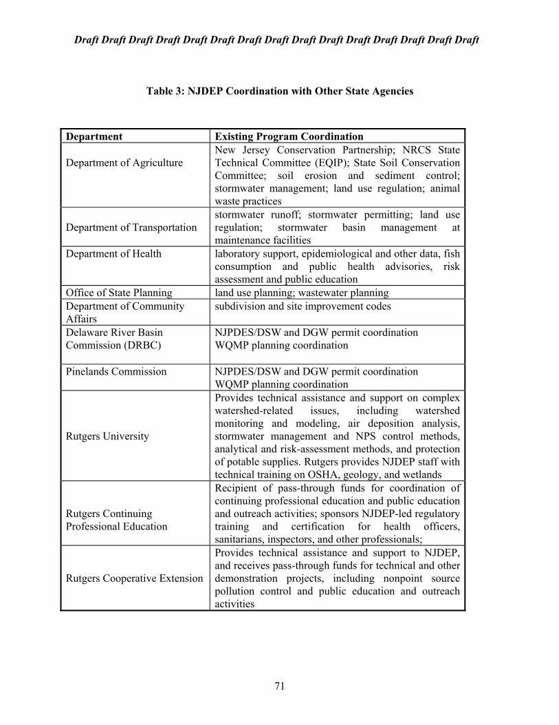
Draft Draft Draft Draft Draft Draft Draft Draft Draft Draft Draft Draft Draft Draft Draft
Table 3: NJDEP Coordination with Other State Agencies
Department Existing Program Coordination Department of Agriculture
New Jersey Conservation Partnership; NRCS State Technical Committee (EQIP); State Soil Conservation Committee; soil erosion and sediment control; stormwater management; land use regulation; animal waste practices
Department of Transportation
stormwater runoff; stormwater permitting; land use regulation; stormwater basin management at maintenance facilities
Department of Health
laboratory support, epidemiological and other data, fish consumption and public health advisories, risk assessment and public education
Office of State Planning land use planning; wastewater planning Department of Community Affairs
subdivision and site improvement codes
Delaware River Basin Commission (DRBC)
NJPDES/DSW and DGW permit coordination WQMP planning coordination
Pinelands Commission
NJPDES/DSW and DGW permit coordination WQMP planning coordination
Rutgers University
Provides technical assistance and support on complex watershed-related issues, including watershed monitoring and modeling, air deposition analysis, stormwater management and NPS control methods, analytical and risk-assessment methods, and protection of potable supplies. Rutgers provides NJDEP staff with technical training on OSHA, geology, and wetlands
Rutgers Continuing Professional Education
Recipient of pass-through funds for coordination of continuing professional education and public education and outreach activities; sponsors NJDEP-led regulatory training and certification for health officers, sanitarians, inspectors, and other professionals;
Rutgers Cooperative Extension
Provides technical assistance and support to NJDEP, and receives pass-through funds for technical and other demonstration projects, including nonpoint source pollution control and public education and outreach activities
71
Draft Draft Draft Draft Draft Draft Draft Draft Draft Draft Draft Draft Draft Draft Draft
4.4 Building Watershed Partnerships The long-term success of New Jersey’s Statewide Watershed Management Framework will depend equally on coordination among different levels of government, non-profit and volunteer organizations, private agencies and organizations, private citizens, and other stakeholders. This coordination can occur through the formation of formal or informal watershed “partnerships”, where different stakeholders work together to achieve a common goal. Partnerships can include policy advisory groups and working committees; monitoring consortiums; resource sharing and information and data exchange networks, etc. Effective outreach is key to building partnerships, by communicating and education different stakeholders about the goals and objectives they share, and the benefits and cost-effectiveness, of working towards those goals together. Watershed management plans will include a combination of regulatory and nonregulatory mechanisms, including best management practices for nonpoint source pollution, that will be implemented at different levels of government. Voluntary compliance and education programs, as well as innovative solutions to pollution problems, will be key components of watershed management plans as well as the statewide watershed management framework. Watershed partnerships are essential to ensuring that watershed management plans and strategies reflect the interests of the individual watersheds and their stakeholders, and are implementable and effective in meeting watershed goals and objectives. Stakeholder involvement through the formation of partnerships for watershed management will yield better planning and decision-making, as well as increase the success of local implementation efforts and compliance with watershed management measures. Since nonpoint source pollution will be a priority issue in many watersheds in the state, partnerships with county and local government agencies will be essential to the development and successful implementation of watershed-based stormwater management plans and nonpoint source pollution control measures, both regulatory and nonregulatory. The Draft Statewide Watershed Management Framework Document for New Jersey will initiate a dialogue among stakeholders that will provide a basis for creating, expanding and strengthening NJDEP partnerships with other stakeholders. Stronger partnerships are likely with New Jersey's Soil Conservation Districts (SCDs), county and local governments, watershed associations, county planning boards and health agencies, and local environmental commissions and other interest groups on watershed characterization, monitoring and assessment, issue identification and strategy development. In addition, NJDEP would like to continue to explore options for leveraging its resources with other stakeholders to achieve shared resource goals. Current joint monitoring and assessment projects among several stakeholders (e.g., USGS) provide an example of what could be accomplished on a statewide scale under, the watershed management framework. 4.4.1 County and Regional Agencies and Organizations: Since watersheds management moves away from site-specific and municipal boundaries to a more regional perspective, county agencies play can play an important leadership role in promoting, supporting and directing watershed management activities at the regional level. While county government is still limited in the extent of land use decision-making, it does have
72

Draft Draft Draft Draft Draft Draft Draft Draft Draft Draft Draft Draft Draft Draft Draft
direct authority and influence over certain activities that impact local land-use planning and which should be integrated into a watershed management framework. Proposed stormwater management rules recommend county agencies as the lead in coordinating the development of watershed-based stormwater management plans (see Section 3.6.3). County government can also serve as a liaison to the various municipal officials within their jurisdiction, providing a focal point for stakeholder development, partnership building, oversight and evaluation. Most county health departments have already assumed certain oversight responsibility for compliance with environmental health ordinances under the County Environmental Health Act (CEHA). Since these health ordinances include water pollution control, it is appropriate for county health agencies to play a leadership role in the identification and prioritization of watershed issues, and the development, implementation and evaluation of appropriate management strategies. In addition, most counties are equipped to provide GIS-based information networks between county and state agencies, and between county and local government agencies. Most of New Jersey’s counties are already involved in data-sharing networks with NJDEP under the CEHA program. This type of partnership between the counties and NJDEP provides the following benefits: 1) the ability to establish priorities and needs for database development at both the state and the county level so that data development can be targeted to specific data gaps, rather than general coverage, and avoid duplication of effort; and 2) the technology exchange provided by the GIS program in terms of base maps, map development, map-making standards and protocol, training, etc. Soil Conservation Districts: New Jersey’s 16 Soil Conservation Districts (SCDs) are special purpose subdivisions of the State. In cooperation with the State Soil Conservation Committee, they are empowered to conserve and manage soil and water resources and address stormwater, soil erosion, and sedimentation problems that result from land disturbance activities. In response to growing public concern for water quality, the SCDs have become the primary local government agencies responsible for controlling nonpoint sources of pollution associated with agriculture, construction, and mining. The technical services of the NRCS and other resource agencies are made available through the SCDs. The SCDs also assist in education and outreach activities related to natural resources conservation and water resources management. For example, the Morris County SCD has played a leadership role in working with NJDEP and the Whippany Watershed Partnership to develop a Storm Drain Stenciling Program that educates the public about the adverse impact to water quality from dumping garbage and other pollutants down storm drains. The Stenciling Program was developed as a pilot as part of the Whippany River Watershed Project, but has been developed into a statewide educational program. The Morris County SCD has sponsored seminars and training sessions on residential, municipal and corporate campus lawn care practices, and is currently working with NJDEP, the NRCS, and the Morris County Planning Board to develop a county-wide watershed sign posting project to identify the boundaries of the three major watersheds located in Morris County and to increase the public’s awareness of their “watershed address”.
73

Draft Draft Draft Draft Draft Draft Draft Draft Draft Draft Draft Draft Draft Draft Draft
Two examples of strong county roles in watershed management are Morris County and Monmouth County. Morris County Planning Board has assumed a leadership role in both the Whippany River Watershed Project and the statewide watershed management framework. In particular, the Board of Chosen Freeholders sponsored a Morris County Watershed Symposium in May 1996, which included a full day of presentations and discussion about watershed management efforts in Morris County, throughout New Jersey, and across the country. The Freeholders passed a resolution declaring May to be “Watershed Awareness Month”. The Board also approved a resolution in July 1996 allowing the County to act as a contractor to receive a federal pass-through grant from NJDEP and subcontract with a local consulting firm to conduct complex nonpoint source monitoring and modeling for the Whippany River Watershed Project. Regional Environmental Planning Councils: Monmouth County Planning Board has conducted a watershed planning project that delineated watershed and subwatershed boundaries for the entire county, and organized the planning board’s management units on a watershed basis. The goal of this project is to be able to review site-specific subdivision and site improvement proposals and evaluate potential water quality impacts on each watershed in the county. The Monmouth County Planning Board and its advisory council, the Monmouth County Environmental Council, have established nine Regional Environmental Councils to facilitate regional planning and management of natural resources. The Planning Board and Environmental Council are working with the regional councils to involve municipalities and develop new local environmental commissions and regional councils. To date, 44 municipalities have appointed representatives to the Regional Environmental Planning Councils (REPCs). Seven REPCs have petitioned and received formal recognition by the Monmouth County Planning Board. The REPC will act as a liaison between the county and the municipalities; provide a forum for municipalities to discuss regional environmental issues; undertake environmental data collection programs and assist in educating the general public on regional environmental concerns. REPCs have begun assembling volunteer networks to collect stream discharge and water quality data as indicators for the impacts of development. The County Planning Board and Environmental Council provide the needed training and technical support. Private and corporate sponsors, municipalities, grants, and utility authorities have provided seed money to purchase test equipment for the data collection projects. A11 the data is collected and managed by the County Planning Board. To assist in the data collection efforts, the County Planning Board's staff mapped the sub-watersheds and watersheds for each region and located appropriate data collection stations. Over 200 data collection stations were recommended in the 174 subwatersheds under development pressure. A countywide data collection workshop was provided to train the regional council members and their volunteers. County Planning Board's staff is developing computerized procedures to manage the so it can be analyzed and used to provide baseline information in each subwatershed. The County Health Department is working with Planning Board staff to make it through the County GIS system to NJDEP and other interested groups. In addition, the Monmouth County Planning Board has mapped land use/land cover for all nine regions. This has been accomplished using student interns from the County's community
74

Draft Draft Draft Draft Draft Draft Draft Draft Draft Draft Draft Draft Draft Draft Draft
college. In addition, county-wide soils have been mapped according to their hydrologic soil groups and their infiltration soil groups and entered into the County GIS system at the County Health Department. Composite maps showing land use/land cover and soil groups are being developed both annually and by computer. The map work will be used to compute run-off and infiltration volumes for each of the sub-watersheds in the County on a region by region basis. The data collection and mapping initiatives are the first steps towards the development of Environmental Resource Inventories (ERI) for each of the regions. The first Environmental Resource Inventory for the South Coast Region is close to completion. It will serve as a prototype for the remaining eight regions. Watershed Associations: NJDEP recognizes that many local and regional organizations have emerged from the “grass-roots” level and have been conducting watershed management activities, including public education and monitoring, for many years. In May 1996, NJDEP invited all watershed associations to attend a Watershed Fair was sponsored by NJDEP to promote watershed management activities occurring around the state. Representatives of federal, state, and regional governments, business and environmental organizations, and NJDEP staff, also participated in the Fair. At the fair, a special session was for watershed associations to identify their concerns and make recommendations for the emerging statewide watershed management framework. It was agreed that regular meetings of the watershed associations, as well as their outreach coordinators, should be held on a regular basis to share information and coordinate activities. The first meeting of the watershed associations’ outreach coordinators was held on August 22, 1996. As a result of this meeting, The Watershed Partnership for New Jersey was formed. Regular meetings of this group will be scheduled to promote and support watershed education and outreach efforts across the state. The Watershed Partnership for New Jersey currently consists of the following organizations and groups: Barnegat Bay Watershed Association; Great Swamp Watershed Association; Hackensack Estuary & Rivertender Corporation; Hackensack Meadowlands Development Commission; Monmouth County Planning Board; NJ Audubon Society; NJ Coalition of Lake Associations; NJDEP; North Jersey Resource Conservation & Development; Passaic River Coalition; Rancocas Creek Conservancy; South Branch Watershed Association; Stony Brook - Millstone Watershed Association; The Wetlands Institute; and Whippany Watershed Partnership. 4.2.2 Local Government Agencies, Organizations and Partnerships Many of our current water pollution problems are related to nonpoint source (NPS) pollution, pollution that does not emanate from a single, discernible source like a discharge pipe, but instead comes from a variety of sources like lawn runoff, parking lots, and soil erosion. Involvement of local government and citizens in the development and implementation of effective NPS measures is critical to the success of the statewide watershed management framework. In order to address NPS pollution, we must look beyond the traditional, site-specific regulatory programs to more innovative approaches for protecting our water resources. These innovative approaches include collaboration with all the interested members of a watershed community and forming partnerships with local governments, industry and concerned citizens to
75
Draft Draft Draft Draft Draft Draft Draft Draft Draft Draft Draft Draft Draft Draft Draft
develop and implement watershed management strategies that include nonregulatory as well as regulatory mechanisms for point and nonpoint source pollution control. These approached may also include evaluation of land use planning decisions and practices, education, and lifestyle changes. Watershed management involves everyone in the watershed community. Many watershed activities can be initiated at the local level through a variety of forums. Examples include: local governance, partnerships with other agencies, educational programs and outreach activities. Local stormwater management measures are discussed in Section 3.6.3. The following are examples of community-based activities for watershed management that can begin now, in concurrence with the statewide watershed management framework: • Local ordinances for watershed protection • Tree farming/tree planting for stream corridor restoration and revegetation projects • Water educational programs for schools, libraries, museums, scout troops, student/civic
clubs. • Watershed Clean-ups (in coordination with Clean Communities Programs) • Storm Drain Stenciling • Watershed Walks • Identification of storm sewer outfalls through global positioning system (GPS). • Coordinated review of local stormwater management ordinances with soil conservation
service staff to incorporate best management practices for watershed-based stormwater management.
• “Nature-scaping” and other landscaping and water conservation practices for corporate and municipal campuses.
• Participation in the USDA Natural Resources Conservation Service (NRCS) Conservation Plan Certification and Forest Stewardship Programs
• Tree farming/tree planting for stream corridor restoration projects The statewide watershed management framework must reach a broad range of potential participants, including federal agencies, state agencies and organizations, local agencies and organizations, and other stakeholders including: academia, industry, citizen organizations, private landowners and the general public. NJDEP will strive to provide opportunities for stakeholder involvement in refining and implementing the watershed management framework and individual watershed management plans. Development and implementation of effective management strategies will often require cooperative or voluntary efforts by one or more stakeholders. Success will depend on outreach. Outreach is also critical to the development of individual watershed management plans. The principal mechanism for outreach among the water regions and the watershed management areas will be through the formation of stakeholder Policy Advisory Groups and Technical Advisory Committees. NJDEP will work with the stakeholders through these Groups and Committees to collect watershed information, establish watershed management goals, identify environmental concerns and monitoring needs, develop management strategies, target resources to address highest priorities, identify measures of success, and solicit public participation in volunteer programs.
76

Draft Draft Draft Draft Draft Draft Draft Draft Draft Draft Draft Draft Draft Draft Draft
Chapter 5: Next Steps 5.1 Finalizing the Draft Framework Document The Draft Statewide Watershed Management Framework Document for New Jersey is only the beginning of a dialogue with the citizens of this state and other stakeholders on the emerging statewide watershed management framework. This dialogue will formally commence at the New Jersey Watershed Forum. This Forum will provide an opportunity for public discussion and comment on the draft framework document. NJDEP will provide an overview of statewide watershed management and will provide details of regarding implementation of the framework document. This New Jersey Watershed Forum will build upon prior public input and will address issues raised in previous forums, including roundtable discussions on reforming the Statewide Water Quality Management Planning Program (1991), the Statewide Water Quality Management Planning Rules (1994-1996) and the NJPDES rules (1994-1996); joint public hearings of the New Jersey Clean Water Council and the Water Supply Advisory Council (1995-1996), the League of Women Voters of Morristown Area Watershed Management Forum (September 1995), the NJ Section AWRA Conference (October 1996), Commissioner’s Green and Gold Task Force (1996), the NJ Business and Industry Association (1996), the Commonwealth of New Jersey (1996), the Morris County Watershed Symposium (May 1996), the NJDEP Watershed Fair and break-out session with watershed associations (May 1996). Formal and informal discussions and input from both inside and outside NJDEP will continue through extensive public review and comment through the New Jersey Watershed Forum. Concurrently, public and targeted stakeholder discussions will continue on both the proposed NJPDES rules, the Surface Water Quality Standards, the Stormwater Management rules and the Water Quality Management Planning rules, including elements related to the implementation of the statewide watershed management framework. The results of those discussions, and any subsequent changes to those rule proposals, will be incorporated into the final framework document. In addition, The Draft Statewide Watershed Management Framework Document for New Jersey, as well as the proposed NJPDES and WQMP rules, will be downloaded onto the NJDEP electronic bulletin board (EBB), making them accessible to a much broader range of individuals than could be reached through the Forum or discussion group meetings. The final Statewide Watershed Management Framework Document for New Jersey, incorporating public and internal comments, is expected to be published in July 1997, after which official implementation of the statewide watershed management framework will commence. 5.2 Beginning to Implement a Watershed Management Approach Transition to a watershed management approach officially began for many core NJDEP water resource programs in the late 1980’s as part of the New York/New Jersey Harbor Estuary Project as well as the Delaware Estuary Project and the Barnegat Bay Watershed Project, the last of which was also recently included in the National Estuary Program. All of these programs required departmental coordination and collaboration with stakeholders on a watershed basis. In addition, NJDEP initiated in 1994 a series of watershed-based demonstration project for
77

Draft Draft Draft Draft Draft Draft Draft Draft Draft Draft Draft Draft Draft Draft Draft
nonpoint source pollution control, starting with the Musconetcong River watershed and then moving to the Whippany River/Great Swamp watersheds and the Toms River/Metedeconk Creek watersheds. A total of over $1.8 million in grants have been approved for these multi-year projects. While each of these efforts involved many of the watershed management steps outlined in this framework document, a comprehensive watershed management process was first outlined in October 1993 with the initiation of the Whippany River Watershed Project. This project required close coordination among planning, monitoring, modeling, permitting and GIS programs in order to develop and implement a pilot watershed management project in close collaboration with stakeholders. Proposed initiation of the statewide watershed management framework will be phased in across the state over the next five years (see Section 2.3), beginning with stakeholder development in the Passaic Water Region. Some changes for core programs will occur immediately; others will be phased in as the watershed management cycle progresses. Still other aspects of watershed management will be added as New Jersey’s framework expands beyond NJDEP’s core water resource programs. Initial implementation will focus on stakeholder outreach, the development of preliminary watershed characterization and assessment reports, and the development of TMDLs for priority impaired water bodies (i.e. Water Region 1). 5.3 Conclusion The Draft Statewide Watershed Management Framework Document for New Jersey represents New Jersey’s first formal step to implement a statewide watershed management approach to water resources protection. The completion of this document achieves a milestone that was established in the 1996 Performance Partnership Agreement between NJDEP and USEPA Region 2, and places New Jersey at the forefront of a national movement towards performance and ecosystem based environmental protection. This draft document proposes 20 watershed management areas and 5 water regions as the geographic boundaries that will be used to target and focus statewide and regional watershed management activities. This document also proposes an implementation schedule and begins a process for coordinating and integrating existing NJDEP programs for the implementation of statewide watershed management activities. Watersheds transcend political, social and economic boundaries; therefore, the watershed management process should involve all stakeholders, including representatives from all levels of government, public interest groups, business and industry, academic institutions, private landowners, concerned citizens, and others. The Draft Statewide Watershed Management Framework Document for New Jersey will begin a dialogue with the citizens of this state and other stakeholders on the emerging statewide watershed management framework. This dialogue will formally commence at the New Jersey Watershed Forum and will continue through public review and comment on the draft document. A final version of this document, incorporating public and internal comments, is expected to be published in July 1997.
78