state of alaska department of natural resources...
TRANSCRIPT
STATE OF ALASKA DEPARTMENT OF NATURAL RESOURCES DIVISION OF MINING, LAND, AND WATER
LAND SALES & CONTRACT ADMINISTRATION SECTION
PRELIMINARY DECISION Proposed Change in the Method of Conveyance for the Future Reoffer of 173 Parcels Statewide
AS 38.05.045
COMMENT PERIOD ENDS 4 PM DECEMBER 4, 2014 I. Proposed Actions and Amendments and Scope of the Decision The State of Alaska, Department of Natural Resources, Division of Mining, Land, and Water issues this Preliminary Decision as an amendment, update, and complement to prior Final Finding and Decisions that originally authorized the sale of various project areas statewide within which 173 parcels identified herein are located.
Attachment A: Public Notice Attachment B: List of Parcels Attachment C: Map of Parcel Locations
The scope of this decision is limited to the following proposed action:
1. To change the method of conveyance (where needed for uniformity and to conform to current statutes and regulations) and to provide notice to the public of the State’s intention to dispose of these parcels in a future reoffering.
For the proposed action, all of the parcels in this proposal have previously been through a complete decision process that included public notice and review. Many of the parcels encompassed by this decision were offered for sale through previous State land disposal programs, but were subsequently returned to State ownership through relinquishment or termination of a lease or contract. The remaining parcels were identified through other offerings, such as administratively surveyed parcels from other land sales programs. As described in Section IV. History of this document, many of these programs are no longer active or the statutes may have been repealed. This Preliminary Decision serves to change the method of sale to the current statutes, regulations, and programs. DNR DMLW does not intend to impose deed restrictions to control post-patent land use. Pursuant to AS 38.05.945 Notice, the public is invited to comment on this proposed action. See Section VIII Submittal of Public Comments and Attachment A: Public Notice for details on how to submit a comment for consideration. If, after consideration of timely written comments, this proposed action is approved, the Department will issue a Final Finding and Decision without further notice, except to those that provide timely, written comment. The failure to approve a proposal specific to any individual parcel(s) shall not affect the approval of the action for the rest of the parcels in this decision. II. Authority The State of Alaska, Department of Natural Resources has the authority under AS 38.05.045 Generally [Sale of Land] to sell State-owned land if, on preparation and issuance of a written finding, it is
determined to be in the best interest of the State, as required by AS 38.05.035(e) Powers and Duties of the Director. III. Administrative Record The administrative record for the proposed actions consists of the individual case files for each parcel identified with a separate Alaska Division of Lands (ADL) number in Attachment A: List of Parcels, as well as relevant area plans, Preliminary Decisions, and Final Finding and Decisions for each the parent projects. IV. History The following descriptions summarize the programs under which the parcels may have been offered in the past:
• Public Outcry Auctions: In the 1960s and early 1970s, DNR leased or sold subdivided parcels of land, mostly by public outcry auction.
• Sales of Future Borough Land: From 1964 to 1975, DNR subdivided and sold parcels for land proposed to go to new boroughs to jump start the new boroughs’ income streams.
• Open-to-Entry Staking Program: Between 1968 and 1973, the State’s first “stake-it-yourself” program allowed people to stake, survey, and purchase their own parcel of land in designated staking areas. This program has since been discontinued and the statutes that authorized this program were repealed. Therefore, the possibility of reoffering parcels as originally intended under the open-to-entry program is no longer an option.
• Homesite Program: Started in 1977, the State’s first “prove-up” program allowed Alaskans to build a dwelling and occupy the land for a certain number of years. If they completed the requirements, they only paid the costs to survey and plat the parcel to complete the purchase. While the statutes are still in place, the program is inactive.
• Lottery Sales: In the late 1970s, DNR was directed by the legislature to sell State-owned land by lottery. While the statutes are still in place, the program is inactive.
• Remote Parcel Program: In the late 1970s, the Open-to-Entry Staking Program was restructured and became the Remote Parcel Program. This program has since been discontinued and the statutes that authorized this program were repealed. Therefore, the possibility of reoffering parcels as originally intended under the remote parcel program is no longer an option.
• Homestead Program: In 1984, this program replaced the Remote Parcel Program. The Homestead Program allowed participants to stake larger parcels and included a “prove-up” option. While the statutes are still in place, the program is inactive.
• Long-Term Residential Lease/Preference Right Parcels: Some parcels were originally issued for long-term residential lease with a preference right to purchase. Some of these leases were relinquished, terminated, or closed without moving to purchase. DNR no longer offers this type of residential lease.
• Remote Recreational Cabin Sites: This is the latest version of the “stake-it-yourself” program started in 2001 with no prove-up necessary to complete the land purchase. Alaskans are authorized to select and stake Remote Recreational Cabin Sites in designated areas at designated times. Authorizations are awarded through a drawing that gives all eligible participants an equal chance at acquiring a staking authorization for an area. Occasionally, parcels surveyed under this program return to State ownership through relinquishment or termination. Additionally, administrative parcels were created by DNR DMLW staff during Remote Recreational Cabin Sites offerings to:
1. reduce per-parcel survey costs by increasing the number of parcels included in a State-
issued survey contract;
2. survey desirable parcels bounded by existing parcels and natural features where the additional parcel does not increase mobilization costs or costs associated with setting additional monuments;
3. complete survey of previously staked parcels when monuments have been set; and 4. maximize the number of parcels allowed under the decision to offer the staking area.
Sales of parcels under the related regulations, 11 AAC 67.815 (b) Offering Remote Recreational Cabin Sites require purchasers to reimburse the Division for the cost of surveying, platting, and appraising the site within 30 days of being notified of a successful purchase, in addition to the usual minimum down payment. That is to say, that the State would not finance the reimbursable survey, platting, and appraisal costs. To maintain this requirement without allowing for the differing method of sale of subdivided parcels under AS 38.05.045 Generally [Sale of Land] would create an unrealistic burden upon purchasers and hinder the marketability of the property. This proposal seeks to eliminate this potentially unfeasible requirement and create uniformity across the reofferings.
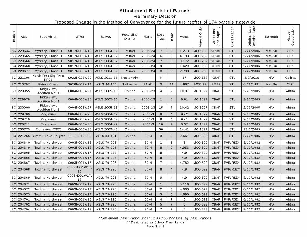
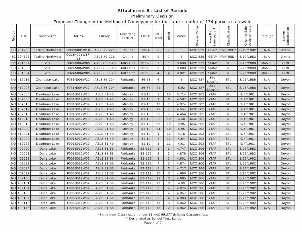
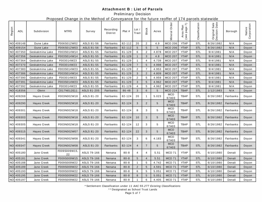
V. Description A summary of pertinent identifying information is included on Attachment B: List of Parcels. Due to the varied nature, broad geographic reach, and limited scope of this proposal as a complement to prior Decisions, we will not delineate detailed, parcel-specific data, such as USGS map coverage, coastal issues, topography, geologic hazards, seismic activity, soils, vegetation, fire hazards, flood zones, tides, anadromous waters, other constraints, detailed legal descriptions, etc. Where known, pertinent information will be made part of the brochures in which the parcels will be advertised. DNR DMLW strongly encourages any persons interested in purchasing a reoffered parcel to first visit the site so that they have a good understanding of the unique features and characteristics of each parcel. Location: See Attachment C: Map and Attachment B: List of Parcels. Legal Descriptions: See Attachment B: List of Parcels for parcel-specific information. Boroughs/Municipalities: See Attachment B: List of Parcels for parcel-specific information. Native Regional and Village Corporations: Relevant Native Regional Corporations are identified in Attachment B: List of Parcels. Relevant Native Regional Corporations will be notified of this proposal during the public notice process. Title: All parcels will have a current title report completed before they are reoffered for sale. This will ensure that all parcels are free and clear from any cloud on title at the time of reoffering.
Tentatively Approved Lands: The State of Alaska may not yet have received final patent from the Federal government for some of the land in these reofferings. Title for parcels on tentatively approved lands will be conditioned upon the State of Alaska receiving patent from the Federal government. In accordance with 11 AAC 67.015 Land Available, in addition to selling, leasing, or granting patented land, DNR DMLW may conditionally sell, lease, or grant land that has been tentatively approved by the Federal government for patent to the State, but that is not yet patented. DNR regulations provide that if for any reason the State of Alaska is denied patent to the land, a sale, lease, or grant on this conditional basis will be canceled and the money paid to purchase the land will be refunded. The State of Alaska has no further liability to the purchaser, lessee, or any third party for termination of the contract. Money paid to the State to purchase such land will be refunded, or may be applied to the purchase of another parcel. Additionally, the State is in no way liable for any damage that may be done to the land by the purchaser, lessee, or grantee, or liable for any claim of any third party or for any claim that may arise from ownership. If the State does
receive title to the land, as anticipated, the conditional sale, lease, or grant then has the same effect as other sales, leases, or grants. Title to tentatively approved lands will be conveyed via quitclaim deed. Ordinarily, there is little risk of loss of title associated with tentatively approved lands, however, there may be practical problems including:
1. title insurance companies might not provide title insurance unless this contingency is “excepted” from coverage; and
2. banks might not loan money for construction on, or the purchase of tentatively-approved lands.
DNR DMLW strongly encourages any persons interested in purchasing a reoffered parcel to fully investigate these matters prior to purchase. Retention of to Mineral Estate: In accordance with Section 6 (i) of the Alaska Statehood Act and AS 38.05.125 Reservation [of Rights to the State], the State retains ownership of the mineral estate that may be in or upon the land that it sells. This retention is for all minerals, including both locatable minerals (such as gold, copper, and silver) and non-locatable minerals (such as oil, gas, coal, ore, minerals, fissionable material, geothermal resources, and fossils).
Planning and Classification: The parcels are spread throughout the State and are classified by, and subject to, the applicable area plan, management units within those plans, and a classification order. The parcels have been classified as Settlement lands or an equivalent classification according to 11 AAC 55.277 Existing Classifications. See Attachment B: List of Parcels for parcel-specific area plan information. The proposed reoffering of these parcels is consistent with area-wide land management policies and general management intent of the area plans and their specific management units. Mineral Orders: All parcels have been closed to mineral entry via mineral orders. Mineral orders that close an area to new mineral entry, where they have been established, close that area to new exploration and development of locatable minerals such as gold, copper, platinum, etc. Mineral orders do not apply to non-locatable minerals, including oil and gas leasing, coal leasing, shallow gas leasing, or exploration licensing for such, nor do they preclude reasonable land estate access to these resources. However, AS 38.05.130 Damages and Posting of Bond stipulates that the land estate owner will be compensated for damages resulting from exploration and development. See Attachment A: List of Parcels for specific mineral order information. Mining activity would be incompatible with the proposed land disposal. To allow new mineral location within the boundaries of the parcels encompassed by this decision could create serious conflicts between land estate and mineral estate users. Area plan mineral estate management policy states that, in general, areas scheduled for disposal will be closed to mineral entry prior to sale to minimize potential conflict between land and mineral estate users. When appropriate, land sales brochures generally note mineral activity identified in the vicinity of an offering.
Reservation and Access of Mineral Estate: In accordance with Section 6(i) of the Alaska Statehood Act and AS 38.05.125 Reservation [of Rights to Alaska], the State, in this decision, reserves unto itself the mineral estate, including oil and gas, and the rights expressed in the reservation clause of the statute, that being the right to reasonable access to the surface for purposes of exploring for, developing, and producing the reserved mineral resources. This access is superior to any and all surface uses. The State may also lease the mineral estate. Any exploration and development that could occur would be consistent with AS 38.05.130 Damages and Posting of Bond and any other applicable statutes and regulations, which provide that the land estate owner be compensated for damages resulting from mineral exploration and development.
Traditional Use Findings: For those parcels located within an organized borough, a traditional use finding is not required. For those parcels located within the Unorganized Borough, a traditional use finding is required under AS 38.05.830 Land Disposal in the Unorganized Borough. The proposed disposal and use of these parcels is consistent with past land uses within and around the proposed parcels and all of the parcels in this proposal have been through a previous, complete notice, review, and decision process. It is anticipated that the resale of these parcels will not change the traditional uses. Should we identify any conflicts through the new public notice process, we will address these issues and proposed mitigation measures, if needed, in the subsequent Final Finding and Decision. Access: Access to individual parcels varies. Pertinent access and location information will be part of the brochures in which individual parcels for sale are described. DNR DMLW will ensure that all parcels have legal access prior to sale, but does not ensure that the access has been developed or is practical to use. It is the responsibility of the interested party to investigate the existing and allowable access before purchase. DNR DMLW strongly encourages any persons interested in purchasing a parcel to first visit the site so that they have a good understanding of any potential issues concerning the parcel’s access. Easements, Setbacks, Restrictions, and Reserved Areas: Parcels may be subject to a variety of easements, setbacks, restrictions and reserved areas. DNR DMLW will provide pertinent information regarding these types of restrictions as part of the brochures in which individual parcels for sale are described. Much of this information is also available on the recorded survey plats; plat recording information for each parcel is listed in Attachment B. DNR DMLW strongly encourages any persons interested in purchasing a parcel to visit the parcel and review the plat and all other associated documents so that they have a good understanding of any potential issues concerning the parcel. Those parcels located within organized boroughs or incorporated municipalities may be subject to local ordinances which affect development or use of the parcel. Hazardous Materials and Potential Contaminants: Interested parties are encouraged to inspect the property and familiarize themselves with the condition and quality of the land. There are no known environmental hazards present within the parcels encompassed by this proposal. However, the State of Alaska makes no representations or warranties, expressed nor implied, concerning the existence or absence of any hazardous substances, hazardous wastes, contaminants, or pollutants on the land proposed for conveyance. The State further assumes no liability for the removal of hazardous substances, hazardous wastes, contaminants, or pollutants, nor for the remediation of the site should such substances be eventually found. DNR DMLW recognizes there are potential environmental risks when previously vacant land is occupied. Many of the activities increasing these potential risks are regulated by other agencies. Given that this land was specifically designated Settlement for transfer into private ownership, and given the high degree of interest from both the legislature and citizens in transferring State-owned land into private ownership, DNR DMLW is of the opinion that the benefits outweigh the potential risks. Surveys: All parcels have been surveyed. See Attachment A: List of Parcels for parcel-specific information. Appraisals: In accordance with AS 38.05.840 Appraisal, an appraisal meeting Department standards will be required within two years of the date fixed for the sale for each parcel. Should any parcels have known improvements, these will be identified in the brochure if and when the parcels are reoffered for resale. If any improvements appraise at $10,000 or more, these parcels and their improvements will be managed under AS 38.05.090 Removal or Reversion of Improvements Upon
Termination of Leases (including those relinquished or terminated from land sale contracts). Purchases of these parcels will require that the successful bidder pay for the improvements, in full, upon notification of apparent high bid or application drawn. VI. Agency Comments Agency review is being conducted concurrently with the public notice for this Preliminary Decision. If, after consideration of timely written comments, this proposed action is approved, the Department will issue a Final Finding and Decision, addressing all comments received therein. A copy of the Final Finding and Decision will be provided to those that provide timely, written comment. VII. Submittal of Public Comments See Attachment A: Public Notice for specific instructions and conditions regarding notice and how to submit comment for consideration. Pursuant to AS 38.05.945 Notice, the Department will issue public notice inviting comment on this Preliminary Decision. In accordance with AS 38.05.946 Hearings, a municipality or corporation entitled to receive notice under AS 38.05.945 (c) may hold a hearing within 30 days after receipt of the notice. If a hearing is held, the Department Commissioner (or representative) shall attend the hearing. The Commissioner has discretion whether or not to hold a public hearing. The Division will consider all timely, written comments. If the comments indicate the need for significant changes to the Preliminary Decision, additional public notice for the affected lands will be given before a Final Finding & Decision is issued. Reducing the amount of land offered and making minor changes to the proposal will not be considered significant changes requiring additional public notice. If the proposal is approved and no significant change is required, the Preliminary Decision, including any deletions, minor changes, and summary of comments and our responses, will be issued as a subsequent Final Finding and Decision without further notice Only persons from whom the Department receives timely, written comment during the identified comment period will be eligible to file an appeal of a Final Finding and Decision. Upon approval and issuance of a Final Finding and Decision, a copy of the decision will be made available online at http://landsales.alaska.gov and sent to any party who provides timely written comment.
DEADLINE TO SUBMIT WRITTEN COMMENT IS COMMENT PERIOD ENDS 4 PM DECEMBER 4, 2014
VIII. Alternatives and Discussion DNR DMLW is considering the following alternatives:
• Alternative 1: Approve the proposed action.
• Alternative 2: Approve only part of the proposed action.
• Alternative 3: Do not approve the proposed actions.
Article VIII, Section 1 of the Alaska Constitution states, in part, that “…it is the policy of the State to encourage the settlement of its land…” Furthermore, AS 38.05.045 Generally [Sale of Land] has placed this charge with the Commissioner of DNR. Alternative 1 provides an equitable method for DNR to help meet the obligations laid out in the Constitution and statute. The lands affected by this decision have been deemed appropriate for settlement through a previous best interest finding with related

public process wherein these parcels were previously identified as appropriate for sale. DNR is now conducting a new notice to the public under this proposal to change the method of sale for uniformity and compliance with current law. Alternatives 2 and 3 will not allow the resale of some or all these lands due to changes in statutes, regulations, and policies and thus the lands would be retained. Retention of these parcels would be contrary to the previous processes that identified these lands as appropriate for disposal and would inhibit DNR from meeting its Constitutional and legislative obligations. For the aforementioned reasons, Alternative 1 is the preferred alternative. Recommendation follows.
IX. Recommendation This Preliminary Decision for the proposed action described throughout this document and its attachments are consistent with the overall management intent for State-owned land; potential changes to public resources and the public interest as a result of the proposal are acceptable; and the proposed action are in the best interest of the State. It is hereby recommended to proceed to public notice. /s/ Dan Beutel 10/15/2014 Prepared by: Dan Beutel Natural Resource Specialist I Land Sales and Contract Administration Section Division of Mining, Land, and Water Department of Natural Resources State of Alaska
Date
/s/ Kathryn Young 10/15/2014 Approved by: Kathryn Young Natural Resource Manager III Land Sales and Contract Administration Section Division of Mining, Land, and Water Department of Natural Resources State of Alaska
Date
STATE OF ALASKA DEPARTMENT OF NATURAL RESOURCES DIVISION OF MINING, LAND, AND WATER
LAND SALES & CONTRACT ADMINISTRATION SECTION
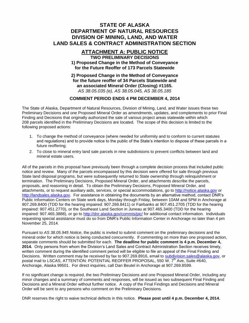
ATTACHMENT A: PUBLIC NOTICE TWO PRELIMINARY DECISIONS
1) Proposed Change in the Method of Conveyance for the Future Reoffer of 173 Parcels Statewide
2) Proposed Change in the Method of Conveyance for the future reoffer of 34 Parcels Statewide and
an associated Mineral Order (Closing) #1165. AS 38.05.035 (e), AS 38.05.045, AS 38.05.185
COMMENT PERIOD ENDS 4 PM DECEMBER 4, 2014 The State of Alaska, Department of Natural Resources, Division of Mining, Land, and Water issues these two Preliminary Decisions and one Proposed Mineral Order as amendments, updates, and complements to prior Final Finding and Decisions that originally authorized the sale of various project areas statewide within which 208 parcels identified in the Preliminary Decisions are located. The scope of this decision is limited to the following proposed actions:
1. To change the method of conveyance (where needed for uniformity and to conform to current statutes and regulations) and to provide notice to the public of the State’s intention to dispose of these parcels in a future reoffering;
2. To close to mineral entry land sale parcels in nine subdivisions to prevent conflicts between land and mineral estate users.
All of the parcels in this proposal have previously been through a complete decision process that included public notice and review. Many of the parcels encompassed by this decision were offered for sale through previous State land disposal programs, but were subsequently returned to State ownership through relinquishment or termination. The Preliminary Decisions, Proposed Mineral Order, and attachments describe the parcels, proposals, and reasoning in detail. To obtain the Preliminary Decisions, Proposed Mineral Order, and attachments, or to request auxiliary aids, services, or special accommodations, go to http://notice.alaska.gov or http://landsales.alaska.gov. For assistance in obtaining the documents by an alternative method, contact DNR’s Public Information Centers on State work days, Monday through Friday, between 10AM and 5PM in Anchorage at 907.269.8400 (TDD for the hearing impaired: 907.269.8411) or Fairbanks at 907.451.2705 (TDD for the hearing impaired: 907.451.2770), or the Southeast Land Section in Juneau at 907.465.3400 (TDD for the hearing impaired: 907.465.3888), or go to http://dnr.alaska.gov/commis/pic/ for additional contact information. Individuals requesting special assistance must do so from DNR’s Public Information Center in Anchorage no later than 4 pm November 25, 2014. Pursuant to AS 38.05.945 Notice, the public is invited to submit comment on the preliminary decisions and the mineral order for which notice is being conducted concurrently. If commenting on more than one proposed action, separate comments should be submitted for each. The deadline for public comment is 4 p.m. December 4, 2014. Only persons from whom the Division’s Land Sales and Contract Administration Section receives timely, written comment during the identified comment period will be eligible to file an appeal of the Final Finding and Decisions. Written comment may be received by fax to 907.269.8916, email to [email protected], or postal mail to LSCAS, ATTENTION: POTENTIAL REOFFER PROPOSAL, 550 W. 7
th Ave, Suite #640,
Anchorage, Alaska 99501. For direct inquiries, call Dan Beutel in Anchorage at 907.269.8599. If no significant change is required, the two Preliminary Decisions and one Proposed Mineral Order, including any minor changes and a summary of comments and responses, will be issued as two subsequent Final Finding and Decisions and a Mineral Order without further notice. A copy of the Final Findings and Decisions and Mineral Order will be sent to any persons who comment on the Preliminary Decisions. DNR reserves the right to waive technical defects in this notice. Please post until 4 p.m. December 4, 2014.
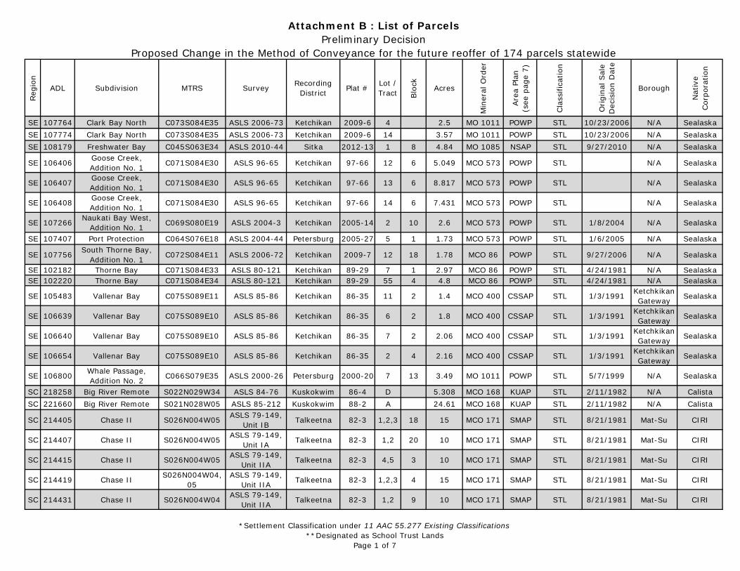
*Settlement Classification under 11 AAC 55.277 Existing Classifications**Designated as School Trust Lands
Page 1 of 7
Reg
ion
ADL Subdivision MTRS Survey Recording District Plat # Lot /
Tract Blo
ck Acres
Min
eral
Ord
er
Are
a Pl
an
(see
pag
e 7)
Cla
ssifi
catio
n
Origi
nal S
ale
Dec
isio
n D
ate
Borough
Nat
ive
Cor
pora
tion
SE 107764 Clark Bay North C073S084E35 ASLS 2006-73 Ketchikan 2009-6 4 2.5 MO 1011 POWP STL 10/23/2006 N/A SealaskaSE 107774 Clark Bay North C073S084E35 ASLS 2006-73 Ketchikan 2009-6 14 3.57 MO 1011 POWP STL 10/23/2006 N/A SealaskaSE 108179 Freshwater Bay C045S063E34 ASLS 2010-44 Sitka 2012-13 1 8 4.84 MO 1085 NSAP STL 9/27/2010 N/A Sealaska
SE 106406 Goose Creek, Addition No. 1 C071S084E30 ASLS 96-65 Ketchikan 97-66 12 6 5.049 MCO 573 POWP STL N/A Sealaska
SE 106407 Goose Creek, Addition No. 1 C071S084E30 ASLS 96-65 Ketchikan 97-66 13 6 8.817 MCO 573 POWP STL N/A Sealaska
SE 106408 Goose Creek, Addition No. 1 C071S084E30 ASLS 96-65 Ketchikan 97-66 14 6 7.431 MCO 573 POWP STL N/A Sealaska
SE 107266 Naukati Bay West,Addition No. 1 C069S080E19 ASLS 2004-3 Ketchikan 2005-14 2 10 2.6 MCO 573 POWP STL 1/8/2004 N/A Sealaska
SE 107407 Port Protection C064S076E18 ASLS 2004-44 Petersburg 2005-27 5 1 1.73 MCO 573 POWP STL 1/6/2005 N/A Sealaska
SE 107756 South Thorne Bay,Addition No. 1 C072S084E11 ASLS 2006-72 Ketchikan 2009-7 12 18 1.78 MCO 86 POWP STL 9/27/2006 N/A Sealaska
SE 102182 Thorne Bay C071S084E33 ASLS 80-121 Ketchikan 89-29 7 1 2.97 MCO 86 POWP STL 4/24/1981 N/A SealaskaSE 102220 Thorne Bay C071S084E34 ASLS 80-121 Ketchikan 89-29 55 4 4.8 MCO 86 POWP STL 4/24/1981 N/A Sealaska
SE 105483 Vallenar Bay C075S089E11 ASLS 85-86 Ketchikan 86-35 11 2 1.4 MCO 400 CSSAP STL 1/3/1991 Ketchkikan Gateway Sealaska
SE 106639 Vallenar Bay C075S089E10 ASLS 85-86 Ketchikan 86-35 6 2 1.8 MCO 400 CSSAP STL 1/3/1991 Ketchkikan Gateway Sealaska
SE 106640 Vallenar Bay C075S089E10 ASLS 85-86 Ketchikan 86-35 7 2 2.06 MCO 400 CSSAP STL 1/3/1991 Ketchkikan Gateway Sealaska
SE 106654 Vallenar Bay C075S089E10 ASLS 85-86 Ketchikan 86-35 2 4 2.16 MCO 400 CSSAP STL 1/3/1991 Ketchkikan Gateway Sealaska
SE 106800 Whale Passage,Addition No. 2 C066S079E35 ASLS 2000-26 Petersburg 2000-20 7 13 3.49 MO 1011 POWP STL 5/7/1999 N/A Sealaska
SC 218258 Big River Remote S022N029W34 ASLS 84-76 Kuskokwim 86-4 D 5.308 MCO 168 KUAP STL 2/11/1982 N/A CalistaSC 221660 Big River Remote S021N028W05 ASLS 85-212 Kuskokwim 88-2 A 24.61 MCO 168 KUAP STL 2/11/1982 N/A Calista
SC 214405 Chase II S026N004W05 ASLS 79-149, Unit IB Talkeetna 82-3 1,2,3 18 15 MCO 171 SMAP STL 8/21/1981 Mat-Su CIRI
SC 214407 Chase II S026N004W05 ASLS 79-149, Unit IA Talkeetna 82-3 1,2 20 10 MCO 171 SMAP STL 8/21/1981 Mat-Su CIRI
SC 214415 Chase II S026N004W05 ASLS 79-149, Unit IIA Talkeetna 82-3 4,5 3 10 MCO 171 SMAP STL 8/21/1981 Mat-Su CIRI
SC 214419 Chase II S026N004W04, 05
ASLS 79-149, Unit IIA Talkeetna 82-3 1,2,3 4 15 MCO 171 SMAP STL 8/21/1981 Mat-Su CIRI
SC 214431 Chase II S026N004W04 ASLS 79-149, Unit IIA Talkeetna 82-3 1,2 9 10 MCO 171 SMAP STL 8/21/1981 Mat-Su CIRI
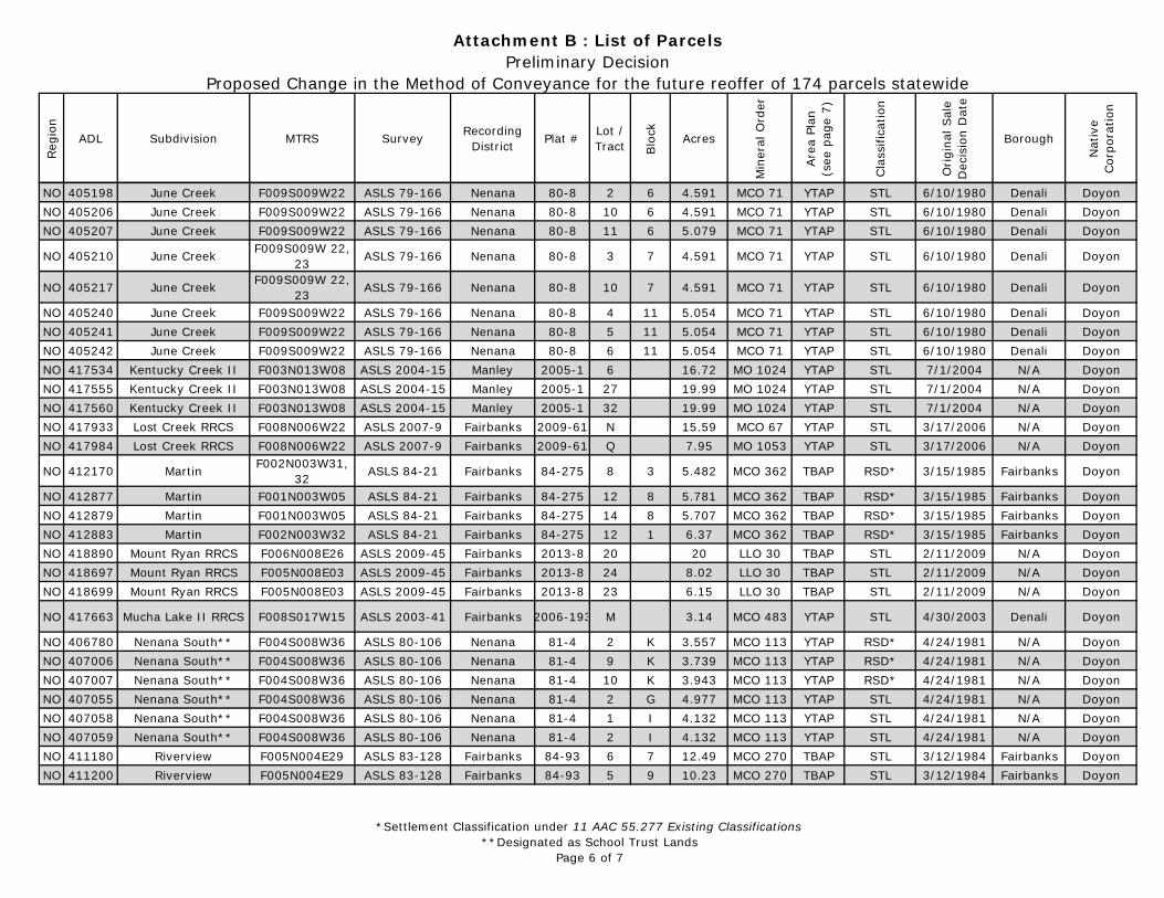
Attachment B : List of ParcelsPreliminary Decision
Proposed Change in the Method of Conveyance for the future reoffer of 174 parcels statewide

*Settlement Classification under 11 AAC 55.277 Existing Classifications**Designated as School Trust Lands
Page 2 of 7
Reg
ion
ADL Subdivision MTRS Survey Recording District Plat # Lot /
Tract Blo
ck Acres
Min
eral
Ord
er
Are
a Pl
an
(see
pag
e 7)
Cla
ssifi
catio
n
Origi
nal S
ale
Dec
isio
n D
ate
Borough
Nat
ive
Cor
pora
tion
Attachment B : List of ParcelsPreliminary Decision
Proposed Change in the Method of Conveyance for the future reoffer of 174 parcels statewide
SC 214435 Chase II S026N004W08 ASLS 79-149, Unit IIB Talkeetna 82-3 1,2 10 10 MCO 171 SMAP STL 8/21/1981 Mat-Su CIRI
SC 214438 Chase II S026N004W08 ASLS 79-149, Unit IIB Talkeetna 82-3 3,4,5 11 15 MCO 171 SMAP STL 8/21/1981 Mat-Su CIRI
SC 214442 Chase II S026N004W08 ASLS 79-149, Unit IIB Talkeetna 82-3 1,2 13 10 MCO 171 SMAP STL 8/21/1981 Mat-Su CIRI
SC 214446 Chase II S026N004W08 ASLS 79-149, Unit IIB Talkeetna 82-3 4,5 14 10 MCO 171 SMAP STL 8/21/1981 Mat-Su CIRI
SC 214448 Chase II S026N004W08 ASLS 79-149, Unit IIB Talkeetna 82-3 3,4 15 10 MCO 171 SMAP STL 8/21/1981 Mat-Su CIRI
SC 214451 Chase II S026N004W09 ASLS 79-149, Unit IIC Talkeetna 82-3 1,2,3 17 14.782 MCO 171 SMAP STL 8/21/1981 Mat-Su CIRI
SC 214453 Chase II S026N004W09 ASLS 79-149, Unit IIC Talkeetna 82-3 6,7 17 10 MCO 171 SMAP STL 8/21/1981 Mat-Su CIRI
SC 229893 Chignaki Pond S018N001W20 ASLS 2004-17 Palmer 2007-3 9 1 2.12 MCO 239 SESAP STL 12/6/2004 Mat-Su CIRISC 229914 Chignaki Pond S018N001W20 ASLS 2004-17 Palmer 2007-3 11 3 1.04 MCO 239 SESAP STL 12/6/2004 Mat-Su CIRI
SC 230339 Chignaki Pond,Phase II S018N001W20 ASLS 2006-12 Palmer 2008-37 1 6 1.03 MCO 239 SESAP STL 12/6/2004 Mat-Su CIRI
SC 229482 Crosswind Lake,RRCS C006N004W20 ASLS 2005-25 Chitina 2007-6 3 5.01 MO 787 CBAP PUR/STL 4/30/2003 N/A Ahtna
SC 229484 Crosswind Lake,RRCS C006N004W05 ASLS 2005-25 Chitina 2007-6 6 6 5 MO 787 CBAP PUR/STL 4/30/2003 N/A Ahtna
SC 231141 Happy Creek S003S014W04 ASLS 2009-11 Homer 2011-6 8 2 MO 1099 KAP STL 4/7/2009 Kenai Pen. CIRISC 210351 Indian River S033N002W16 ASLS 80-131 Talkeetna 81-50 2 2 4.87 MCO 91 SMAP STL 4/24/1981 Mat-Su CIRISC 210353 Indian River S033N002W16 ASLS 80-131 Talkeetna 81-50 4 2 4.693 MCO 91 SMAP STL 4/24/1981 Mat-Su CIRISC 210355 Indian River S033N002W16 ASLS 80-131 Talkeetna 81-50 6 2 3.808 MCO 91 SMAP STL 4/24/1981 Mat-Su CIRI
SC 210356 Indian River S033N002W15, 16, 21 ASLS 80-131 Talkeetna 81-50 7 2 4.418 MCO 91 SMAP STL 4/24/1981 Mat-Su CIRI
SC 210357 Indian River S033N002W15, 16, 21 ASLS 80-131 Talkeetna 81-50 8 2 3.851 MCO 91 SMAP STL 4/24/1981 Mat-Su CIRI
SC 65264 Kasilof** S004N012W36 EPF 54-12 Kenai 83-166 8 4 3.42 MO 1041 KAP STL Kenai Pen. CIRISC 65279 Kasilof** S004N012W36 EPF 54-12 Kenai 83-166 2 3 2.07 MO 1041 KAP STL Kenai Pen. CIRISC 228525 Mystery S017N002W18 ASLS 2002-28 Palmer 2004-58 7 3 2.1 MCO 239 SESAP STL 7/18/2003 Mat-Su CIRISC 228539 Mystery S017N002W18 ASLS 2002-28 Palmer 2004-58 1 4 2.14 MCO 239 SESAP STL 7/18/2003 Mat-Su CIRISC 229623 Mystery, Phase II S017N002W18 ASLS 2004-32 Palmer 2006-24 4 1 1 MCO 239 SESAP STL 2/24/2006 Mat-Su CIRISC 229629 Mystery, Phase II S017N002W18 ASLS 2004-32 Palmer 2006-24 2 2 1.28 MCO 239 SESAP STL 2/24/2006 Mat-Su CIRISC 229632 Mystery, Phase II S017N002W18 ASLS 2004-32 Palmer 2006-24 5 2 1.274 MCO 239 SESAP STL 2/24/2006 Mat-Su CIRI
*Settlement Classification under 11 AAC 55.277 Existing Classifications**Designated as School Trust Lands
Page 3 of 7
Reg
ion
ADL Subdivision MTRS Survey Recording District Plat # Lot /
Tract Blo
ck Acres
Min
eral
Ord
er
Are
a Pl
an
(see
pag
e 7)
Cla
ssifi
catio
n
Origi
nal S
ale
Dec
isio
n D
ate
Borough
Nat
ive
Cor
pora
tion
Attachment B : List of ParcelsPreliminary Decision
Proposed Change in the Method of Conveyance for the future reoffer of 174 parcels statewide
SC 229634 Mystery, Phase II S017N002W18 ASLS 2004-32 Palmer 2006-24 7 2 1.273 MCO 239 SESAP STL 2/24/2006 Mat-Su CIRISC 229665 Mystery, Phase II S017N002W18 ASLS 2004-32 Palmer 2006-24 6 5 4.193 MCO 239 SESAP STL 2/24/2006 Mat-Su CIRISC 229666 Mystery, Phase II S017N002W18 ASLS 2004-32 Palmer 2006-24 7 5 3.172 MCO 239 SESAP STL 2/24/2006 Mat-Su CIRISC 229668 Mystery, Phase II S017N002W18 ASLS 2004-32 Palmer 2006-24 9 5 1.629 MCO 239 SESAP STL 2/24/2006 Mat-Su CIRISC 229677 Mystery, Phase II S017N002W18 ASLS 2004-32 Palmer 2006-24 8 6 2.798 MCO 239 SESAP STL 2/24/2006 Mat-Su CIRI
SC 231106 North Fork Big River RRCS S022N028W30 ASLS 2011-16 Kuskokwim H 17 MCO 168 KUAP STL 2/2/2010 N/A Calista
SC 210757 Peters Creek S026N008W14 ASLS 80-144 Talkeetna 81-61 3 11 4.967 MCO 98 SMAP STL 6/16/1981 Mat-Su CIRI
SC 229955 Ridgeview,Addition No. 1 C004N006W27 ASLS 2005-16 Chitina 2006-23 4 2 10.91 MO 1027 CBAP STL 2/23/2005 N/A Ahtna
SC 229978 Ridgeview,Addition No. 1 C004N006W26 ASLS 2005-16 Chitina 2006-23 1 6 9.81 MO 1027 CBAP STL 2/23/2005 N/A Ahtna
SC 230000 Ridgeview,Addition No. 1 C004N006W27 ASLS 2005-16 Chitina 2006-23 15 7 10.42 MO 1027 CBAP STL 2/23/2005 N/A Ahtna
SC 229709 Ridgeview C004N006W26 ASLS 2004-42 Chitina 2006-3 8 4 9.42 MO 1027 CBAP STL 2/23/2005 N/A AhtnaSC 229710 Ridgeview C004N006W26 ASLS 2004-42 Chitina 2006-3 9 4 9.41 MO 1027 CBAP STL 2/23/2005 N/A AhtnaSC 229711 Ridgeview C004N006W26 ASLS 2004-42 Chitina 2006-3 10 4 9.37 MO 1027 CBAP STL 2/23/2005 N/A AhtnaSC 230779 Ridgeview RRCS C004N006W28 ASLS 2009-46 Chitina 30 14.41 MO 1027 CBAP STL 12/3/2009 N/A Ahtna
SC 221255 Summit Lake Heights F020S012E30 ASLS 84-101 Chitina 85-4 3 2 2.661 MCO 306 CBAP STL 3/22/1985 N/A Ahtna
SC 204640 Tazlina Northwest C003N001W18 ASLS 79-226 Chitina 80-4 1 1 5 MCO 529 CBAP PVR/RSD* 8/10/1982 N/A AhtnaSC 204649 Tazlina Northwest C003N001W18 ASLS 79-226 Chitina 80-4 8 2 4.956 MCO 529 CBAP PVR/RSD* 8/10/1982 N/A AhtnaSC 204665 Tazlina Northwest C003N001W17 ASLS 79-226 Chitina 80-4 5 4 4.9 MCO 529 CBAP PVR/RSD* 8/10/1982 N/A AhtnaSC 204666 Tazlina Northwest C003N001W17 ASLS 79-226 Chitina 80-4 6 4 4.9 MCO 529 CBAP PVR/RSD* 8/10/1982 N/A AhtnaSC 204667 Tazlina Northwest C003N001W17 ASLS 79-226 Chitina 80-4 7 4 4.782 MCO 529 CBAP PVR/RSD* 8/10/1982 N/A Ahtna
SC 204668 Tazlina Northwest C003N001W17, 18 ASLS 79-226 Chitina 80-4 8 4 4.9 MCO 529 CBAP PVR/RSD* 8/10/1982 N/A Ahtna
SC 204669 Tazlina Northwest C003N001W17, 18 ASLS 79-226 Chitina 80-4 9 4 4.9 MCO 529 CBAP PVR/RSD* 8/10/1982 N/A Ahtna
SC 204671 Tazlina Northwest C003N001W17 ASLS 79-226 Chitina 80-4 1 5 5.116 MCO 529 CBAP PVR/RSD* 8/10/1982 N/A AhtnaSC 204672 Tazlina Northwest C003N001W17 ASLS 79-226 Chitina 80-4 2 5 4.963 MCO 529 CBAP PVR/RSD* 8/10/1982 N/A AhtnaSC 204673 Tazlina Northwest C003N001W17 ASLS 79-226 Chitina 80-4 3 5 4.896 MCO 529 CBAP PVR/RSD* 8/10/1982 N/A AhtnaSC 204701 Tazlina Northwest C003N001W18 ASLS 79-226 Chitina 80-4 4 7 5 MCO 529 CBAP PVR/RSD* 8/10/1982 N/A AhtnaSC 204702 Tazlina Northwest C003N001W18 ASLS 79-226 Chitina 80-4 5 7 5 MCO 529 CBAP PVR/RSD* 8/10/1982 N/A AhtnaSC 204704 Tazlina Northwest C003N001W18 ASLS 79-226 Chitina 80-4 7 7 5 MCO 529 CBAP PVR/RSD* 8/10/1982 N/A Ahtna
*Settlement Classification under 11 AAC 55.277 Existing Classifications**Designated as School Trust Lands
Page 4 of 7
Reg
ion
ADL Subdivision MTRS Survey Recording District Plat # Lot /
Tract Blo
ck Acres
Min
eral
Ord
er
Are
a Pl
an
(see
pag
e 7)
Cla
ssifi
catio
n
Origi
nal S
ale
Dec
isio
n D
ate
Borough
Nat
ive
Cor
pora
tion
Attachment B : List of ParcelsPreliminary Decision
Proposed Change in the Method of Conveyance for the future reoffer of 174 parcels statewide
SC 204705 Tazlina Northwest C003N001W18 ASLS 79-226 Chitina 80-4 8 7 5 MCO 529 CBAP PVR/RSD* 8/10/1982 N/A Ahtna
SC 204706 Tazlina Northwest C003N001W17, 18 ASLS 79-226 Chitina 80-4 9 7 5 MCO 529 CBAP PVR/RSD* 8/10/1982 N/A Ahtna
SC 231087 Vita S024N004W05 ASLS 2008-23 Talkeetna 2011-8 2 1 3.688 MCO 239 SMAP STL 2/26/2008 Mat-Su CIRISC 231088 Vita S024N004W05 ASLS 2008-23 Talkeetna 2011-8 3 1 3.688 MCO 239 SMAP STL 2/26/2008 Mat-Su CIRISC 231094 Vita S024N004W05 ASLS 2008-23 Talkeetna 2011-8 4 2 3.821 MCO 239 SMAP STL 2/26/2008 Mat-Su CIRI
NO 412915 Chandalar Lake F031N005W22 ASLS 85-224 Fairbanks 86-53 6 5 MCO 427 Site Specific STL 3/26/1986 N/A Doyon
NO 412927 Chandalar Lake F031N004W17 ASLS 85-224 Fairbanks 86-53 21 5.02 MCO 427 Site Specific STL 3/26/1986 N/A Doyon
NO 407585 Deadman Lake F001S012W10 ASLS 81-40 Manley 81-10 3 10 3.714 MCO 202 YTAP STL 9/4/1981 N/A DoyonNO 407606 Deadman Lake F001S012W04 ASLS 81-40 Manley 81-10 1 6 4.597 MCO 202 YTAP STL 9/4/1981 N/A DoyonNO 407616 Deadman Lake F001S012W09 ASLS 81-40 Manley 81-10 18 7 4.374 MCO 202 YTAP STL 9/4/1981 N/A DoyonNO 407617 Deadman Lake F001S012W09 ASLS 81-40 Manley 81-10 19 7 4.557 MCO 202 YTAP STL 9/4/1981 N/A DoyonNO 407618 Deadman Lake F001S012W09 ASLS 81-40 Manley 81-10 20 7 4.464 MCO 202 YTAP STL 9/4/1981 N/A DoyonNO 419018 Deadman Lake F001S012W10 ASLS 81-40 Manley 81-10 32 10 4.48 MCO 202 YTAP STL 9/4/1981 N/A DoyonNO 419019 Deadman Lake F001S012W10 ASLS 81-40 Manley 81-10 33 10 4.95 MCO 202 YTAP STL 9/4/1981 N/A DoyonNO 419020 Deadman Lake F001S012W10 ASLS 81-40 Manley 81-10 34 10 4.95 MCO 202 YTAP STL 9/4/1981 N/A DoyonNO 419021 Deadman Lake F001S012W10 ASLS 81-40 Manley 81-10 1 11 4.78 MCO 202 YTAP STL 9/4/1981 N/A DoyonNO 419022 Deadman Lake F001S012W10 ASLS 81-40 Manley 81-10 2 11 4.64 MCO 202 YTAP STL 9/4/1981 N/A DoyonNO 419023 Deadman Lake F001S012W10 ASLS 81-40 Manley 81-10 3 11 4.61 MCO 202 YTAP STL 9/4/1981 N/A DoyonNO 409090 Dune Lake F006S012W02 ASLS 81-56 Fairbanks 82-112 1 3 4.747 MCO 206 YTAP STL 8/26/1982 N/A DoyonNO 409091 Dune Lake F006S012W02 ASLS 81-56 Fairbanks 82-112 2 3 4.876 MCO 206 YTAP STL 8/26/1982 N/A DoyonNO 409092 Dune Lake F006S012W02 ASLS 81-56 Fairbanks 82-112 3 3 4.801 MCO 206 YTAP STL 8/26/1982 N/A DoyonNO 409093 Dune Lake F006S012W02 ASLS 81-56 Fairbanks 82-112 4 3 4.874 MCO 206 YTAP STL 8/26/1982 N/A DoyonNO 409094 Dune Lake F006S012W02 ASLS 81-56 Fairbanks 82-112 5 3 4.717 MCO 206 YTAP STL 8/26/1982 N/A DoyonNO 409099 Dune Lake F006S012W02 ASLS 81-56 Fairbanks 82-112 10 3 4.896 MCO 206 YTAP STL 8/26/1982 N/A DoyonNO 409100 Dune Lake F006S012W02 ASLS 81-56 Fairbanks 82-112 11 3 4.985 MCO 206 YTAP STL 8/26/1982 N/A DoyonNO 409101 Dune Lake F006S012W02 ASLS 81-56 Fairbanks 82-112 12 3 4.99 MCO 206 YTAP STL 8/26/1982 N/A DoyonNO 409104 Dune Lake F006S012W02 ASLS 81-56 Fairbanks 82-112 2 4 4.975 MCO 206 YTAP STL 8/26/1982 N/A DoyonNO 409105 Dune Lake F006S012W02 ASLS 81-56 Fairbanks 82-112 3 4 4.957 MCO 206 YTAP STL 8/26/1982 N/A DoyonNO 409107 Dune Lake F006S012W02 ASLS 81-56 Fairbanks 82-112 5 4 4.983 MCO 206 YTAP STL 8/26/1982 N/A DoyonNO 409113 Dune Lake F006S012W03 ASLS 81-56 Fairbanks 82-112 11 5 4.962 MCO 206 YTAP STL 8/26/1982 N/A DoyonNO 409146 Dune Lake F006S012W02 ASLS 81-56 Fairbanks 82-112 18 2 4.962 MCO 206 YTAP STL 8/26/1982 N/A Doyon
*Settlement Classification under 11 AAC 55.277 Existing Classifications**Designated as School Trust Lands
Page 5 of 7
Reg
ion
ADL Subdivision MTRS Survey Recording District Plat # Lot /
Tract Blo
ck Acres
Min
eral
Ord
er
Are
a Pl
an
(see
pag
e 7)
Cla
ssifi
catio
n
Origi
nal S
ale
Dec
isio
n D
ate
Borough
Nat
ive
Cor
pora
tion
Attachment B : List of ParcelsPreliminary Decision
Proposed Change in the Method of Conveyance for the future reoffer of 174 parcels statewide
NO 409148 Dune Lake F006S012W02 ASLS 81-56 Fairbanks 82-112 20 2 4.9 MCO 206 YTAP STL 8/26/1982 N/A DoyonNO 409154 Dune Lake F006S012W03 ASLS 81-56 Fairbanks 82-112 5 5 5 MCO 206 YTAP STL 8/26/1982 N/A DoyonNO 407350 Geskakmina Lake F003S014W14 ASLS 81-55 Fairbanks 81-129 6 2 4.878 MCO 207 YTAP STL 9/4/1981 N/A DoyonNO 407356 Geskakmina Lake F003S014W14 ASLS 81-55 Fairbanks 81-129 1 3 4.8 MCO 207 YTAP STL 9/4/1981 N/A DoyonNO 407364 Geskakmina Lake F003014W23 ASLS 81-55 Fairbanks 81-129 1 4 4.739 MCO 207 YTAP STL 9/4/1981 N/A DoyonNO 407370 Geskakmina Lake F003014W23 ASLS 81-55 Fairbanks 81-129 7 5 4.998 MCO 207 YTAP STL 9/4/1981 N/A DoyonNO 407383 Geskakmina Lake F003S014W23 ASLS 81-55 Fairbanks 81-129 2 7 4.953 MCO 207 YTAP STL 9/4/1981 N/A DoyonNO 407386 Geskakmina Lake F003S014W14 ASLS 81-55 Fairbanks 81-129 3 2 4.809 MCO 207 YTAP STL 9/4/1981 N/A DoyonNO 407390 Geskakmina Lake F003014W23 ASLS 81-55 Fairbanks 81-129 2 5 4.959 MCO 207 YTAP STL 9/4/1981 N/A DoyonNO 407391 Geskakmina Lake F003S014W23 ASLS 81-55 Fairbanks 81-129 3 5 4.962 MCO 207 YTAP STL 9/4/1981 N/A DoyonNO 407392 Geskakmina Lake F003014W23 ASLS 81-55 Fairbanks 81-129 4 5 4.962 MCO 207 YTAP STL 9/4/1981 N/A DoyonNO 418356 Glenn C017N012E11 ASLS 81-205 Fairbanks 86-48 3 6 5 MCO 224 TBAP STL 1/12/1983 N/A Doyon
NO 409269 Hayes Creek F003N002W18 ASLS 81-20 Fairbanks 82-124 20 1 5.023 MCO 67A03 TBAP STL 8/26/1982 Fairbanks Doyon
NO 409290 Hayes Creek F003N002W18 ASLS 81-20 Fairbanks 82-124 3 2 5 MCO 67A03 TBAP STL 8/26/1982 Fairbanks Doyon
NO 409301 Hayes Creek F003N002W18 ASLS 81-20 Fairbanks 82-124 8 3 5 MCO 67A03 TBAP STL 8/26/1982 Fairbanks Doyon
NO 409303 Hayes Creek F003N002W18 ASLS 81-20 Fairbanks 82-124 10 3 5 MCO 67A03 TBAP STL 8/26/1982 Fairbanks Doyon
NO 409305 Hayes Creek F003N002W18 ASLS 81-20 Fairbanks 82-124 12 3 5 MCO 67A03 TBAP STL 8/26/1982 Fairbanks Doyon
NO 409315 Hayes Creek F003N002W07 ASLS 81-20 Fairbanks 82-124 22 3 5 MCO 67A03 TBAP STL 8/26/1982 Fairbanks Doyon
NO 409341 Hayes Creek F003N002W08 ASLS 81-20 Fairbanks 82-124 3 6 4.183 MCO 67A03 TBAP STL 8/26/1982 Fairbanks Doyon
NO 409347 Hayes Creek F003N002W08 ASLS 81-20 Fairbanks 82-124 4 7 5 MCO 67A03 TBAP STL 8/26/1982 Fairbanks Doyon
NO 405180 June Creek F009S009W15, 22 ASLS 79-166 Nenana 80-8 4 4 5.51 MCO 71 YTAP STL 6/10/1980 Denali Doyon
NO 405181 June Creek F009S009W15 ASLS 79-166 Nenana 80-8 5 4 5.51 MCO 71 YTAP STL 6/10/1980 Denali DoyonNO 405188 June Creek F009S009W22 ASLS 79-166 Nenana 80-8 1 5 4.742 MCO 71 YTAP STL 6/10/1980 Denali DoyonNO 405189 June Creek F009S009W22 ASLS 79-166 Nenana 80-8 2 5 4.591 MCO 71 YTAP STL 6/10/1980 Denali DoyonNO 405193 June Creek F009S009W22 ASLS 79-166 Nenana 80-8 6 5 5.051 MCO 71 YTAP STL 6/10/1980 Denali DoyonNO 405195 June Creek F009S009W22 ASLS 79-166 Nenana 80-8 8 5 5.051 MCO 71 YTAP STL 6/10/1980 Denali DoyonNO 405197 June Creek F009S009W22 ASLS 79-166 Nenana 80-8 1 6 4.405 MCO 71 YTAP STL 6/10/1980 Denali Doyon
*Settlement Classification under 11 AAC 55.277 Existing Classifications**Designated as School Trust Lands
Page 6 of 7
Reg
ion
ADL Subdivision MTRS Survey Recording District Plat # Lot /
Tract Blo
ck Acres
Min
eral
Ord
er
Are
a Pl
an
(see
pag
e 7)
Cla
ssifi
catio
n
Origi
nal S
ale
Dec
isio
n D
ate
Borough
Nat
ive
Cor
pora
tion
Attachment B : List of ParcelsPreliminary Decision
Proposed Change in the Method of Conveyance for the future reoffer of 174 parcels statewide
NO 405198 June Creek F009S009W22 ASLS 79-166 Nenana 80-8 2 6 4.591 MCO 71 YTAP STL 6/10/1980 Denali DoyonNO 405206 June Creek F009S009W22 ASLS 79-166 Nenana 80-8 10 6 4.591 MCO 71 YTAP STL 6/10/1980 Denali DoyonNO 405207 June Creek F009S009W22 ASLS 79-166 Nenana 80-8 11 6 5.079 MCO 71 YTAP STL 6/10/1980 Denali Doyon
NO 405210 June Creek F009S009W 22, 23 ASLS 79-166 Nenana 80-8 3 7 4.591 MCO 71 YTAP STL 6/10/1980 Denali Doyon
NO 405217 June Creek F009S009W 22, 23 ASLS 79-166 Nenana 80-8 10 7 4.591 MCO 71 YTAP STL 6/10/1980 Denali Doyon
NO 405240 June Creek F009S009W22 ASLS 79-166 Nenana 80-8 4 11 5.054 MCO 71 YTAP STL 6/10/1980 Denali DoyonNO 405241 June Creek F009S009W22 ASLS 79-166 Nenana 80-8 5 11 5.054 MCO 71 YTAP STL 6/10/1980 Denali DoyonNO 405242 June Creek F009S009W22 ASLS 79-166 Nenana 80-8 6 11 5.054 MCO 71 YTAP STL 6/10/1980 Denali DoyonNO 417534 Kentucky Creek II F003N013W08 ASLS 2004-15 Manley 2005-1 6 16.72 MO 1024 YTAP STL 7/1/2004 N/A DoyonNO 417555 Kentucky Creek II F003N013W08 ASLS 2004-15 Manley 2005-1 27 19.99 MO 1024 YTAP STL 7/1/2004 N/A DoyonNO 417560 Kentucky Creek II F003N013W08 ASLS 2004-15 Manley 2005-1 32 19.99 MO 1024 YTAP STL 7/1/2004 N/A DoyonNO 417933 Lost Creek RRCS F008N006W22 ASLS 2007-9 Fairbanks 2009-61 N 15.59 MCO 67 YTAP STL 3/17/2006 N/A DoyonNO 417984 Lost Creek RRCS F008N006W22 ASLS 2007-9 Fairbanks 2009-61 Q 7.95 MO 1053 YTAP STL 3/17/2006 N/A Doyon
NO 412170 Martin F002N003W31, 32 ASLS 84-21 Fairbanks 84-275 8 3 5.482 MCO 362 TBAP RSD* 3/15/1985 Fairbanks Doyon
NO 412877 Martin F001N003W05 ASLS 84-21 Fairbanks 84-275 12 8 5.781 MCO 362 TBAP RSD* 3/15/1985 Fairbanks DoyonNO 412879 Martin F001N003W05 ASLS 84-21 Fairbanks 84-275 14 8 5.707 MCO 362 TBAP RSD* 3/15/1985 Fairbanks DoyonNO 412883 Martin F002N003W32 ASLS 84-21 Fairbanks 84-275 12 1 6.37 MCO 362 TBAP RSD* 3/15/1985 Fairbanks DoyonNO 418890 Mount Ryan RRCS F006N008E26 ASLS 2009-45 Fairbanks 2013-8 20 20 LLO 30 TBAP STL 2/11/2009 N/A DoyonNO 418697 Mount Ryan RRCS F005N008E03 ASLS 2009-45 Fairbanks 2013-8 24 8.02 LLO 30 TBAP STL 2/11/2009 N/A DoyonNO 418699 Mount Ryan RRCS F005N008E03 ASLS 2009-45 Fairbanks 2013-8 23 6.15 LLO 30 TBAP STL 2/11/2009 N/A Doyon
NO 417663 Mucha Lake II RRCS F008S017W15 ASLS 2003-41 Fairbanks 2006-193 M 3.14 MCO 483 YTAP STL 4/30/2003 Denali Doyon
NO 406780 Nenana South** F004S008W36 ASLS 80-106 Nenana 81-4 2 K 3.557 MCO 113 YTAP RSD* 4/24/1981 N/A DoyonNO 407006 Nenana South** F004S008W36 ASLS 80-106 Nenana 81-4 9 K 3.739 MCO 113 YTAP RSD* 4/24/1981 N/A DoyonNO 407007 Nenana South** F004S008W36 ASLS 80-106 Nenana 81-4 10 K 3.943 MCO 113 YTAP RSD* 4/24/1981 N/A DoyonNO 407055 Nenana South** F004S008W36 ASLS 80-106 Nenana 81-4 2 G 4.977 MCO 113 YTAP STL 4/24/1981 N/A DoyonNO 407058 Nenana South** F004S008W36 ASLS 80-106 Nenana 81-4 1 I 4.132 MCO 113 YTAP STL 4/24/1981 N/A DoyonNO 407059 Nenana South** F004S008W36 ASLS 80-106 Nenana 81-4 2 I 4.132 MCO 113 YTAP STL 4/24/1981 N/A DoyonNO 411180 Riverview F005N004E29 ASLS 83-128 Fairbanks 84-93 6 7 12.49 MCO 270 TBAP STL 3/12/1984 Fairbanks DoyonNO 411200 Riverview F005N004E29 ASLS 83-128 Fairbanks 84-93 5 9 10.23 MCO 270 TBAP STL 3/12/1984 Fairbanks Doyon
*Settlement Classification under 11 AAC 55.277 Existing Classifications**Designated as School Trust Lands
Page 7 of 7
Reg
ion
ADL Subdivision MTRS Survey Recording District Plat # Lot /
Tract Blo
ck Acres
Min
eral
Ord
er
Are
a Pl
an
(see
pag
e 7)
Cla
ssifi
catio
n
Origi
nal S
ale
Dec
isio
n D
ate
Borough
Nat
ive
Cor
pora
tion
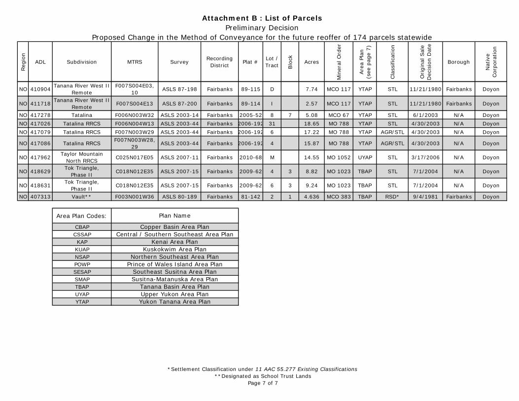
Attachment B : List of ParcelsPreliminary Decision
Proposed Change in the Method of Conveyance for the future reoffer of 174 parcels statewide
NO 410904 Tanana River West II Remote
F007S004E03, 10 ASLS 87-198 Fairbanks 89-115 D 7.74 MCO 117 YTAP STL 11/21/1980 Fairbanks Doyon
NO 411718 Tanana River West II Remote F007S004E13 ASLS 87-200 Fairbanks 89-114 I 2.57 MCO 117 YTAP STL 11/21/1980 Fairbanks Doyon
NO 417278 Tatalina F006N003W32 ASLS 2003-14 Fairbanks 2005-52 8 7 5.08 MCO 67 YTAP STL 6/1/2003 N/A DoyonNO 417026 Tatalina RRCS F006N004W13 ASLS 2003-44 Fairbanks 2006-192 31 18.65 MO 788 YTAP STL 4/30/2003 N/A DoyonNO 417079 Tatalina RRCS F007N003W29 ASLS 2003-44 Fairbanks 2006-192 6 17.22 MO 788 YTAP AGR/STL 4/30/2003 N/A Doyon
NO 417086 Tatalina RRCS F007N003W28, 29 ASLS 2003-44 Fairbanks 2006-192 4 15.87 MO 788 YTAP AGR/STL 4/30/2003 N/A Doyon
NO 417962 Taylor Mountain North RRCS C025N017E05 ASLS 2007-11 Fairbanks 2010-68 M 14.55 MO 1052 UYAP STL 3/17/2006 N/A Doyon
NO 418629 Tok Triangle, Phase II C018N012E35 ASLS 2007-15 Fairbanks 2009-62 4 3 8.82 MO 1023 TBAP STL 7/1/2004 N/A Doyon
NO 418631 Tok Triangle, Phase II C018N012E35 ASLS 2007-15 Fairbanks 2009-62 6 3 9.24 MO 1023 TBAP STL 7/1/2004 N/A Doyon
NO 407313 Vault** F003N001W36 ASLS 80-189 Fairbanks 81-142 2 1 4.636 MCO 383 TBAP RSD* 9/4/1981 Fairbanks Doyon
Area Plan Codes:
CBAPCSSAPKAP
KUAPNSAPPOWPSESAPSMAPTBAPUYAPYTAP Yukon Tanana Area Plan
Plan Name
Prince of Wales Island Area PlanSoutheast Susitna Area PlanSusitna-Matanuska Area Plan
Tanana Basin Area PlanUpper Yukon Area Plan
Copper Basin Area PlanCentral / Southern Southeast Area Plan
Kenai Area PlanKuskokwim Area Plan
Northern Southeast Area Plan
"
"
"^
^^
^
^^̂^
^
^^
^^
^
^
^
^
^^^^
^
^
^
^
^
^
^
^
^
^
^
^
^
^
^
^
^
^
^
^^
^
^
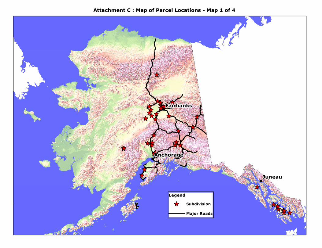
Juneau
Fairbanks
Anchorage
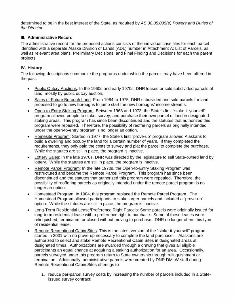
Legend^ Subdivision
Major Roads
Attachment C : Map of Parcel Locations - Map 1 of 4
"
"
"
^
^
^
^
^
^
^
^
^
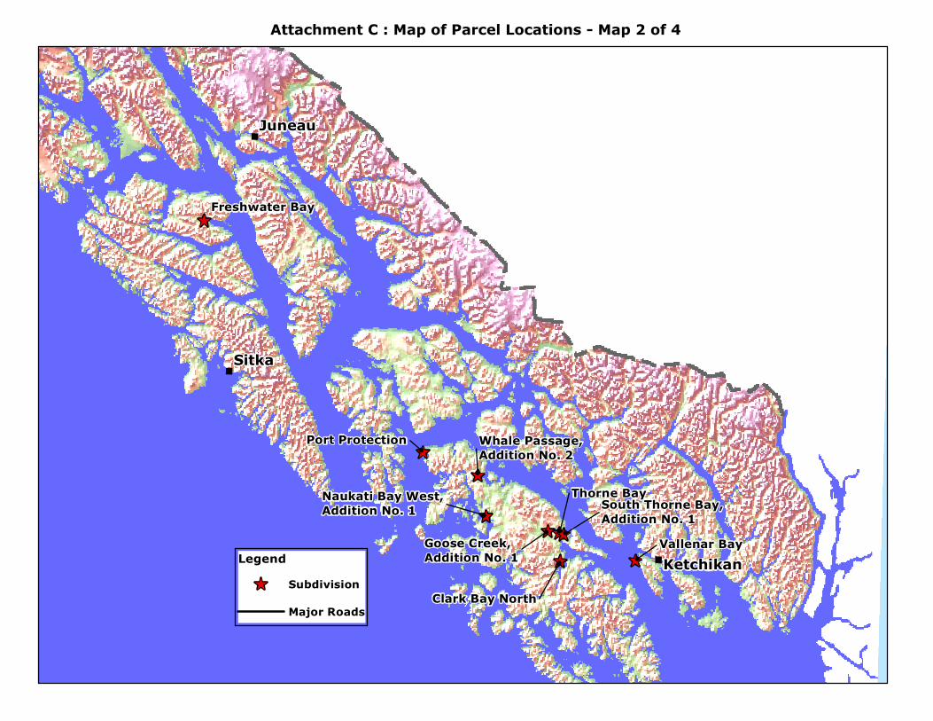
Thorne Bay
Vallenar Bay
Freshwater Bay
Clark Bay North
Port Protection
Goose Creek, Addition No. 1
Whale Passage,Addition No. 2
South Thorne Bay,Addition No. 1
Naukati Bay West,Addition No. 1
Sitka
Juneau
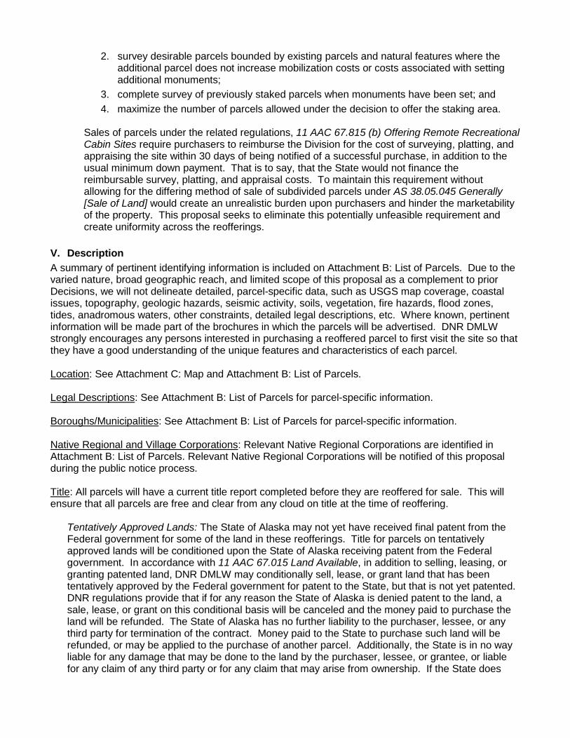
KetchikanLegend^ Subdivision
Major Roads
Attachment C : Map of Parcel Locations - Map 2 of 4
"
^^
^
^
^
^
^
^^
^
^
^
^
^
^
^
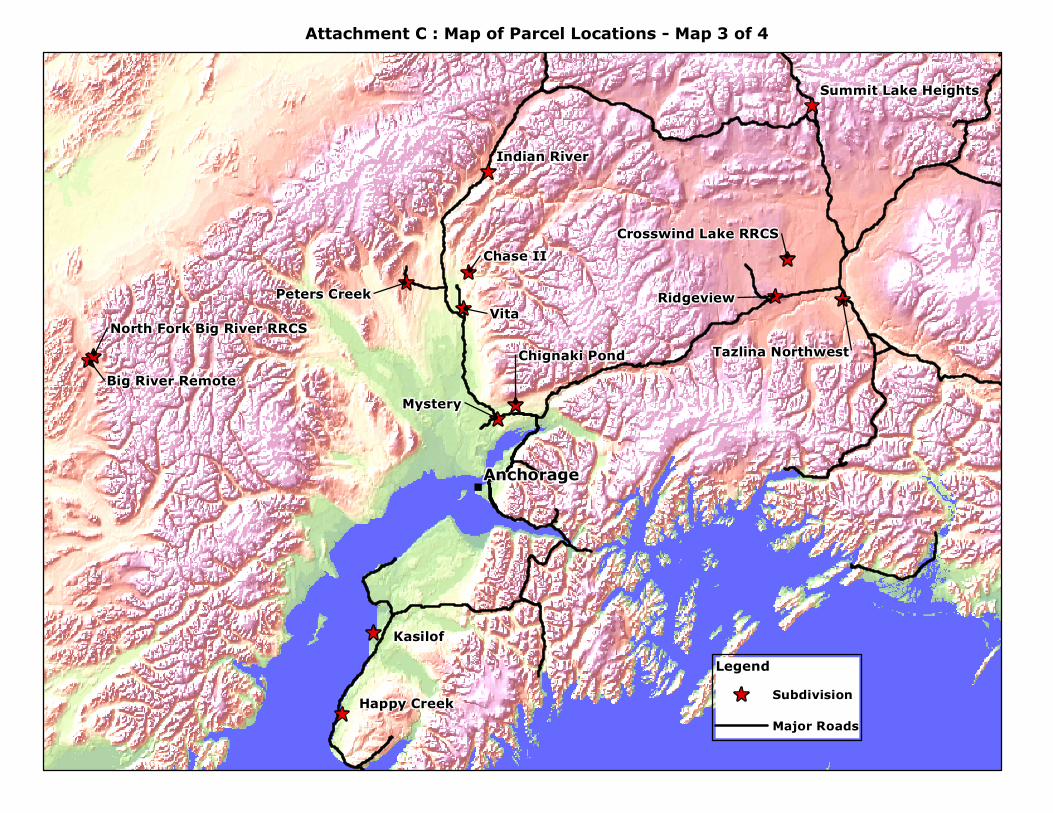
GlennTok Triangle, Phase II
Vita
Kasilof
Mystery
Chase II
Ridgeview
Happy Creek
Indian River
Peters Creek
Chignaki Pond Tazlina Northwest
Crosswind Lake RRCS
Summit Lake Heights
Big River Remote
North Fork Big River RRCS
Anchorage
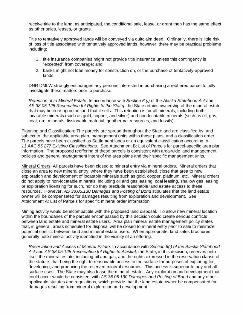
Legend^ Subdivision
Major Roads
Attachment C : Map of Parcel Locations - Map 3 of 4
"
^
^
^
^
^
^
^
^
^
^
^
^
^
^
^
^
^
^
^
^^
^
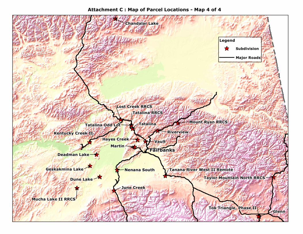
Glenn
VaultMartin
TatalinaRiverview
Dune LakeJune Creek
Hayes Creek
Nenana South
Deadman Lake
Tatalina RRCS
Chandalar Lake
Mount Ryan RRCS
Lost Creek RRCS
Geskakmina Lake
Tatalina Odd LotKentucky Creek II
Mucha Lake II RRCSTok Triangle, Phase II
Taylor Mountain North RRCSTanana River West II Remote
Fairbanks
Legend^ Subdivision
Major Roads
Attachment C : Map of Parcel Locations - Map 4 of 4