market value appraisal - alaska department of...
TRANSCRIPT
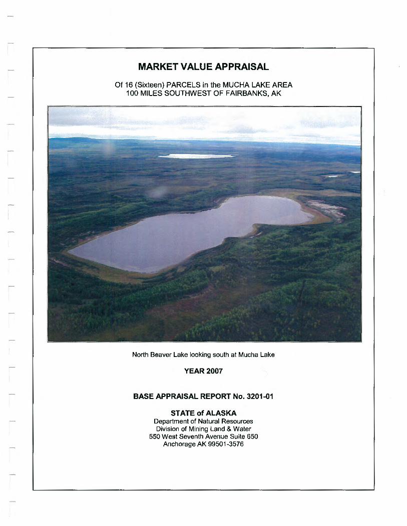
MARKET VALUE APPRAISAL
Of 16 (Sixteen) PARCELS in the MUCHA LAKE AREA 100 MILES SOUTHWEST OF FAIRBANKS, AK
North Beaver Lake looking south at Mucha Lake
YEAR2007
BASE APPRAISAL REPORT No. 3201-01
STATE of ALASKA Department of Natural Resources Division of Mining Land & Water
550 West Seventh Avenue Suite 650 Anchorage AK 99501 -3576

• STATE OF ALASKA
APPRAISAL REVIEW
STATEMENT DEPARTMENT OF NATURAL RESOURCES
A. SUMMARY OF APPRAISAL NO. 3201-01
1. ADL NO(S): See table below
2. SIZE: Various. as noted in table
3. APPLICANT: N/A
4. LOCATION: Remote parcels around Mucha Lake, 100 miles southwest of Fairbanks. AK
5. LEGAL DESCRIPTION(S): Various lots within Mucha Lake II subdivision. ASLS 2003-41. specific tract as noted in table
6. INTEREST APPRAISED: Fee Simple Title less Mineral Rights
7. PURPOSE OF THE APPRAISAL: Estimate Market Value
8. APPRAISED BY: Michael R. Ward
9. DATE of REPORT: April15. 2007
10. DATE ofVALUE(S): August 15.2006
11. APPRAISED VALUE(S):
ADL S/D MTRS ASLS ACRES TRACT VALUE
417650 MUCHA LAKE II F008S017W6 ASLS 2003-41 13.25 A $22,500
417651 MUCHA LAKE II F008S017W6 ASLS 2003-41 10.49 B $19,300
417652 MUCHA LAKE II F008S017W6 ASLS 2003-41 6.79 c $15,600
417654 MUCHA LAKE II F008S017W6 ASLS 2003-41 7.00 D $16,100
471655 MUCHA LAKE II F008S017W6 ASLS 2003-41 5.61 E $12,900
417656 MUCHA LAKE II F008S017W7 ASLS 2003-41 6.14 F $14,100
417657 MUCHA LAKE II F008S017W29 ASLS 2003-41 7.89 G $14,500
417658 MUCHA LAKE II F008S017W29 ASLS 2003-41 6.49 H $13,000
417659 MUCHA LAKE II F008S017W29 ASLS 2003-41 5.96 I $11 ,900
417660 MUCHA LAKE II F008S017W14 ASLS 2003-41 5.35 J $11 ,400
417661 MUCHA LAKE II F008S017W14 ASLS 2003-41 5.13 K $11,200
417662 MUCHA LAKE II F008S017W14 ASLS 2003-41 5.07 L $11,200
417664 MUCHA LAKE II F008S017W15,16,21 ASLS 2003-41 8.49 N $15,100
417665 MUCHA LAKE II F008S017W16,21 ASLS 2003-41 8.38 0 $1 5,100
417666 MUCHA LAKE II F008S017W21 ASLS 2003-41 18.62 p $23,800
417667 MUCHA LAKE II F008S017W22 ASLS 2003-41 17.11 Q $22,900
G:\Reviews\3201-01 Muchal k.doc 5/18/2007 Page 1 of 3

DEPARTMENT OF NATURAL RESOURCES APPRAISAL REVIEW
STATE OF ALASKA STATEMENT
B. SUMMARY OF REVIEW
1. DATE of REVIEW: May 18.2007
2. REVIEWER'S CLIENT: [8'J DNR 0 Other:
3. INTENDED USERS of the REVIEW: [8'J DNR [8'J General Public OOther: __
4. INTENDED USE of the REVIEW: Establish minimum bid price for sealed bid auction
5. PURPOSE of REVIEW: [8'J Evaluate for Technical Compliance with DNR Instructions & US PAP
D Evaluate for Technical Compliance with UASFLA
Other:
D Develop Independent Estimate of Value
6. SCOPE OF REVIEW: I Inspected the Subject on__ I Did Not Inspect the Subject [8'J
I Inspected the Comparable Sales on__ I Did Not Inspect the Comparable Sales [8'J
I Independently Verified the Comparable Sales in the Report DYes [8'J No
Data and Information Considered in Addition to that Contained in the Report: [8'J None D See Sections C thru F
Extraordinary Assumptions, Hypothetical Conditions, & Other Limiting Conditions for this review:
[8'J None D See Section G Related appraisals reviewed: __
Proofread DNR data entry: DYes [8'J No
7. RESULTS OF REVIEW: 0 Not Approved [8'J Approved Approved Value: As noted in previous table
C. COMPLETENESS OF APPRAISAL MATERIAL WITHIN SCOPE OF WORK APPLICABLE TO THE ASSIGNMENT/CONFORMANCE with APPRAISAL INSTRUCTIONS: Adequate.
D. ADEQUACY and RELEVANCE of APPRAISAL DATA and PROPRIETY OF ADJUSTMENTS: Adequate
E. APPROPRIATENESS OF APPRAISAL METHODS and TECHNIQUES: Adequate.
F. ANALYSES, OPINIONS, and CONCLUSIONS ARE APPROPRIATE and REASONABLE, except: Appropriate
G. REVIEWER'S ASSUMPTIONS AND LIMITING CONDITIONS
1. This review is based on data and information contained in the appraisal report as well as any additional data from other sources that is identified in this review.
2. The reviewer assumes that the data and information in the appraisal are factual and accurate. 3. The reviewer reserves the right to consider any additional data or information that may subsequently become available,
and to revise an opinion or conclusion, if such data and information warrant a revision. 4. All assumptions and limiting conditions contained in the appraisal report are part of this review unless otherwise
stated. 5. A title report has not been provided to the appraiser and the reviewer. Unless specifically noted in the report or this review,
it is assumed that the only easements and restrictions that affect the property are those shown on the plat. 6. The value of commercial timber, if any, is specifically excluded from the final conclusion of value.
G:\Reviews\320 1-01 MuchaLk.doc 5/18/2007 Page 2 of 3

DEPARTMENT OF NATURAL RESOURCES APPRAISAL REVIEW
STATE OF ALASKA STATEMENT
REVIEW APPRAISER'S CERTIFICATION APPRAISAL NO. 3201..01
I certify that, to the best of my knowledge and belief: • The facts and data reported by the reviewer and used in the review process are true and correct. • The analyses, opinions, and conclusions in this review report are limited only by the assumptions and limiting
conditions stated in this review report, and are my personal, unbiased professional analyses, opinions, and conclusions.
• I have no present or prospective interest in the property that is the subject of this report and I have no personal interest or bias with respect to the parties involved.
• I have no bias with respect to the property that is the subject of this report or to the parties involved with this assignment.
• My engagement in this assignment was not contingent upon developing or reporting predetermined results. • My compensation is not contingent on an action or event resulting from the analyses, opinions, or conclusions in, or
use of, this review. • My analyses, opinions, and conclusions were developed and this review report was prepared in conformity with the
Uniform Standards of Professional Appraisal Practice. • I did 0 did not ~ personally inspect the subject property of the report under review. • No one provided signific t professional assistance to the person signing this review report.
I
Date - -=s:..;.-)'-,....::8~h-=D'-2.c....-_ I 7
cc: Dan Beck Dorothy Melambianakis
G:\Reviews\3201-01Muchalk.doc 5/18/2007 Page 3 of 3
MUCHA LAKE STAKING AREA APPRAISAL BASE REPORT No. 3201-01
MEMORANDUM State of Alaska
Department of Natural Resources
Tel (907) 269-8514 Fax (907) 269-8914 Michael [email protected]
DATE: April15, 2007
TO: Kevin Hindmarch Review Appraiser ~
FROM: Michael R. Ward, Appraise~
Division of Mining, Land and Water 550 West th Avenue, Suite 650 Anchorage AK 99501-8914
SUBJECT: Appraisal of 16 (Sixteen) Parcels in the Mucha Lake Area Located 100 miles southwest of Fairbanks, AK
As requested, I have completed a market valuation for 16 (sixteen) parcels in the referenced area. understand that this appraisal will be used to determine the minimum purchase price for recreational parcels to be offered in a sealed bid auction. I am submitting this report for your review and approval.
The appraisal was completed in accordance with the "Uniform Standards of Professional Appraisal Practice" of the Appraisal Foundation and in accordance with the General Appraisal Instructions DNR May 2006. This is a complete, summary report based on the General Assumptions and Limiting Conditions stated in the report, as well as the facts, analyses and reasoning leading to the opinions of value.
I have inspected the subject area from the air as well as ground inspections of ten of the sixteen parcels. Only a small percentage of the comparable sales used in this report were inspected. Physical descriptions of the subject area are based on aerial photography and topographic maps. Based on my observations and analyses of all available data, I have formed an opinion of the market value as of the effective date of value.
1:\MRW RRCSFiles\Mucha Lake\Mucha Lake MASTER 2007.doc 1
MUCHA LAKE STAKING AREA
INTRODUCTION
Title Page Letter of Transmittal Table of Contents
TABLE OF CONTENTS
Staking Area Location Map Appraisal Summary, Key Lot Values, and Adjustments
PREMISE OF THE APPRAISAL
Type of Appraisal and Report Purpose and Use of the Appraisal Definition of Market Value Client and User Identity Property Identification Property Rights Appraised Definition of Market Value Effective Date of Value Estimate Scope of the Appraisal Assumptions and Limiting Conditions
PRESENTATION OF DATA
Area Analysis General Property Description
OAT A ANALYSIS AND CONCLUSION
Highest and Best Use Valuation Methodology Key Parcel Method Explanation of Adjustments Description and Valuation of Key Parcel Parcel Valuations Certification of Value
ADDENDA Comparable Sale Forms Appraisal Instructions Appraiser Qualifications
1:\MRW RRCSFiles\Mucha Lake\Mucha Lake MASTER 2007.doc
APPRAISAL BASE REPORT No. 3201-01
1 2 3
4 4 4 4 4 4 4 4 5 6
7 11
15 16 16 16 17 18 20
2
MUCHA LAKE STAKING AREA APPRAISAL BASE REPORT No. 3201-01
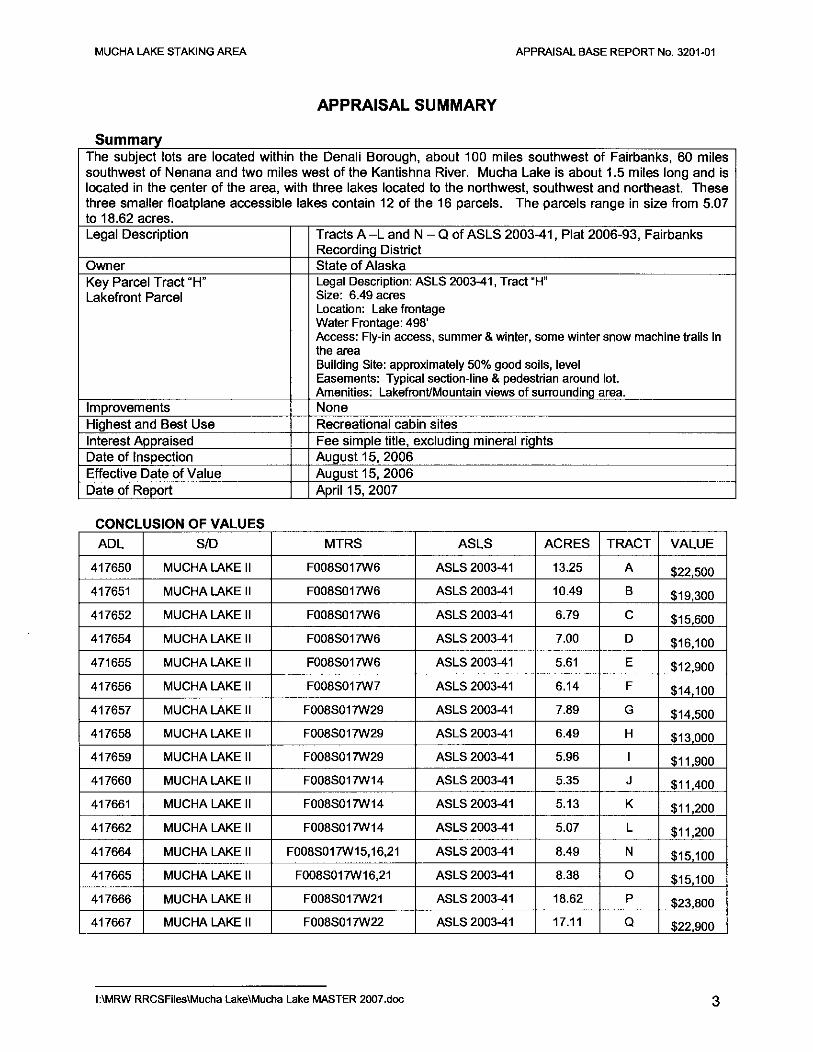
APPRAISAL SUMMARY
s urn mary The subject lots are located within the Denali Borough, about 100 miles southwest of Fairbanks, 60 miles southwest of Nenana and two miles west of the Kantishna River. Mucha Lake is about 1.5 miles long and is located in the center of the area, with three lakes located to the northwest, southwest and northeast. These three smaller floatplane accessible lakes contain 12 of the 16 parcels. The parcels range in size from 5.07 to 18.62 acres. Legal Description Tracts A -L and N - Q of ASLS 2003-41, Plat 2006-93, Fairbanks
Recording District Owner State of Alaska Key Parcel Tract "H" Legal Description: ASLS 2003-41, Tract "H" Lakefront Parcel Size: 6.49 acres
Location: Lake frontage Water Frontage: 498' Access: Fly-in access, summer & winter, some winter snow machine trails in the area Building Site: approximately 50% good soils, level Easements: Typical section-line & pedestrian around lot. Amenities: Lakefront/Mountain views of surrounding area.
Improvements None Highest and Best Use Recreational cabin sites Interest Appraised Fee simple title, excluding mineral rights Date of Inspection August15,2006 Effective Date of Value August15,2006 Date of Report April 15, 2007
CONCLUSION OF VALUES
ADL SID MTRS ASLS ACRES TRACT VALUE
417650 MUCHA LAKE II F008S017W6 ASLS 2003-41 13.25 A $22,500
417651 MUCHA LAKE II F008S017W6 ASLS 2003-41 10.49 B $19,300
417652 MUCHA LAKE II F008S017W6 ASLS 2003-41 6.79 c $15,600
417654 MUCHA LAKE II F008S017W6 ASLS 2003-41 7.00 D $16,100
471655 MUCHA LAKE II F008S017W6 ASLS 2003-41 5.61 E $12,900
417656 MUCHA LAKE II F008S017W7 ASLS 2003-41 6.14 F $14,100
417657 MUCHA LAKE II F008S017W29 ASLS 2003-41 7.89 G $14 500
417658 MUCHA LAKE II F008S017W29 ASLS 2003-41 6.49 H $13,000
417659 MUCHA LAKE II F008S017W29 ASLS 2003-41 5.96 I $11,900
417660 MUCHA LAKE II F008S017W14 ASLS 2003-41 5.35 J $11,400 r 417661 MUCHA LAKE II F008S017W14 ASLS 2003-41 5.13 K $11,200
417662 MUCHA LAKE II F008S017W14 ASLS 2003-41 5.07 L $11,200
417664 MUCHA LAKE II F008S017W15, 16,21 ASLS 2003-41 8.49 N $15,100
417665 MUCHA LAKE II F008S017W16,21 ASLS 2003-41 8.38 0 $15,100
417666 MUCHA LAKE II F008S017W21 ASLS 2003-41 18.62 p $23,800
417667 MUCHA LAKE II F008S017W22 ASLS 2003-41 17.11 Q $22,900
I :\MRW RRCSFiles\Mucha Lake\Mucha Lake MASTER 2007 .doc 3
MUCHA LAKE STAKING AREA APPRAISAL BASE REPORT No. 3201-01
PREMISES OF THE APPRAISAL
Type of Appraisal This is a summary appraisal report prepared in accordance with Standard Rules 1 and 2 of the Uniform Standards of Professional Appraisal Practice, Appraisal Foundation, and in accordance with General Appraisal Instructions, DNR 2006.
Purpose of Appraisal The purpose of this appraisal is to estimate the current market value of the properties described in this report.
Client and Intended Users This appraisal is prepared for the State of Alaska, Department of Natural Resources and the general public.
Intended Use of Appraisal This appraisal will be used to determine the minimum purchase price for parcels to be offered in a sealed bid auction under the land sale program (AS 38.05.055).
Property Rights Appraised The rights appraised are the fee simple estate less the mineral rights reserved to the State of Alaska under AS 38.05.125(a). Fee simple estate is defined 1 as:
"Absolute ownership unencumbered by any other interest or estate, subject only to the limitations imposed by the governmental powers of taxation, eminent domain, police power, and escheat. H
AS 38.05.125(a) states2:
ResetVation. (a) Each contract for the sale, lease or grant of state land ... is subject to the following resetVations: "[sic] the party of the first part, Alaska, hereby expressly saves, excepts and resetVes ... unto itself, its lessees, successors, and assigns forever, all oils, gases, coal, ores, minerals, fissionable materials, geothermal resources, and fossils of evety name, kind or description, and which may be in or upon said land ... [and the right] to occupy as much of said land as may be necessaty or convenient ... to render beneficial and efficient the complete enjoyment of the property and rights hereby expressly resetVed.
Definition of Market Value3
The most probable price, as of a specified date, in cash, or in terms equivalent to cash, or in other precisely revealed terms, for which the specified property rights should sell after reasonable exposure in a competitive market under all conditions requisite to a fair sale, with the buyer and seller each acting prudently, knowledgeably, and for self-interest, and assuming that neither is under undue duress.
In accordance with instructions from the State of Alaska, market value for the appraised property is estimated in terms of seller financing typical for the property type as of the date of appraisal.
Effective Date of Value August15,2006
Date of Report April 1 0, 2007
Scope of Work
1 The Appraisal of Real Estate, Eleventh Edition, Appraisal Institute, 1996, p.7 2 Alaska Statutes Title 38. Public Land Article 5, State of Alaska, 1998, pp. 561-62 3 The Appraisal of Real Estate, Eleventh Edition, Appraisal Institute, 1996, p.22
1:\MRW RRCSFiles\Mucha Lake\Mucha Lake MASTER 2007.doc 4
MUCHA LAKE STAKING AREA APPRAISAL BASE REPORT No. 3201-01
The area and all subject lots were inspected from the air on August 15, 2006. On the ground inspections that day included lots on Mucha Lake, North Mucha Lake and Chappelle Lake.
DNR appraisal records were searched for recent sales of similar parcels. Interviews were conducted with real estate agents, appraisers, and other individuals who provided data about trends in values, supply and demand. The recorder's office was also searched to identify any recent sales. Sellers and buyers were contacted to verify sale prices and other transaction details.
After analysis of all available data, appropriate sales were selected for comparison with a key parcel of the subject properties being appraised. Due to geographic dispersion and weather conditions, inspection of the comparables was not possible. Ample satellite data and sales information was available to confidently utilize the values indicated by the sales comparables. The lack of inspections does not reduce the reliability of the values concluded within this report. The market value estimate is based on the following assumptions and conditions.
1:\MRW RRCSFiles\Mucha Lake\Mucha Lake MASTER 2007.doc 5

r
MUCHA LAKE STAKING AREA APPRAISAL BASE REPORT No. 3201-01
ASSUMPTIONS AND LIMITING CONDITIONS
1. The property is appraised as vacant land without structural or site improvements.
2. Some parcels may contain saw timber but not necessarily in commercial quantities. The estimated market value does not include the value of commercial timber, if any.
3. The data and conclusions embodied in this report are a part of the whole valuation. Each part of this appraisal is only part of the evidence upon which final judgement is based. Therefore, no part should be used out of context and by itself alone.
4. The appraiser, by reason of this appraisal, is not required to give further consultation, testimony, or be in attendance in court with reference to the property in question, unless prior arrangement has been made and adequate time is provided to review the appraisal.
5. The estimate of value in this report is not based in whole or in part upon the race, color, or national origin of the present owners or occupants of the properties in the vicinity of the property appraised.
6. In this valuation various mathematical calculations were used to formulate the opinion of value. These calculations are only aids for the formulation of the opinion of value by the appraiser. Therefore, in the application of these calculations, certain arithmetical figures are rounded to the nearest significant amount.
7. The information furnished by others is believed to be reliable but it is not warranted for its accuracy. Plats of lease areas in this report are included for illustration only and may not be to scale.
8. It is assumed that there are no hidden or apparent conditions of the property, subsoil, or structures that render it more or less valuable. No responsibility is assumed for such conditions, or for arranging engineering studies to discover them.
9. Unless otherwise stated in this report, the appraiser does not know about the existence of hazardous materials or toxic substances, which may or may not be present on the property. The appraiser is not qualified to detect such substances. No responsibility is assumed for any such conditions or for any expertise or engineering knowledge required to discover them.
10. The appraiser assumes no responsibility for legal matters. The subject lots are assumed to be free and clear of encumbrances, except as otherwise noted, and title is assumed to be marketable.
1:\MRW RRCSFiles\Mucha Lake\Mucha Lake MASTER 2007.doc 6
MUCHA LAKE STAKING AREA APPRAISAL BASE REPORT No. 3201-01
PRESENTATION OF DATA AREA ANALYSIS
General Location and Physical Features The broad area is Nenana/Healy and the remote area westward. Nenana is about 60 air miles east/northeast; Healy is about 60 miles east/southeast. Both communities are located along the Parks Highway. Additionally, the smaller communities of Anderson, Clear and the Clear Earl Warning Center are located near Mile 283.5 Parks Highway. The entrance to Denali National Park is located at Mile 237, about 30 miles further south.
Current Population: Incorporation Type: Borough Located In: School District: Regional Native Corporation:
Location:
Nenana Community Overview 359 (Est. December 2006, by State Demographer DOLIMW) Home Rule City Unorganized Nenana City Schools Doyon, Limited
Nenana is located in Interior Alaska, 55 road miles southwest of Fairbanks on the George Parks Highway. Nenana is located at mile 412 of the Alaska Railroad, on the south bank of the Tanana River, just east of the mouth of the Nenana River. It lies 304 road miles northeast of Anchorage. It lies at approximately 64.56389° N Latitude and -149.09306° W Longitude. (Sec. 14, T004S, R008W, Fairbanks Meridian.) Nenana is located in the Nenana Recording District. The area encompasses 6.0 sq. miles of land and 0.1 sq. miles of water. Nenana has a cold, continental climate with an extreme temperature range. The average daily maximum during summer months is 65 to 70; the daily minimum during winter is well below zero. The highest temperature ever recorded is 98; the lowest is -69. Average precipitation is 11.4 inches, with 48.9 inches of snowfall annually. The River is ice-free from mid-May to mid-October.
History: Nenana is in the western-most portion of Tanana Athabascan Indian territory. It was first known as Tortella, an interpretation of the Indian word "Toghotthele," which means "mountain that parallels the river." Early explorers such as Allen, Harper and Bates first entered the Tanana Valley in 1875 and 1885. However, the Tanana people were accustomed to contact with Europeans, due to trading journeys to the Village of Tanana, where Russians bartered Western goods for furs. The discovery of gold in Fairbanks in 1902 brought intense activity to the region. A trading post/roadhouse was constructed by Jim Duke in 1903, to supply river travelers and trade with Indians. St. Mark's Episcopal mission and school was built upriver in 1905. Native children from other communities, such as Minto, attended school in Nenana. A post office opened in 1908. By 1909, there were about 12,000 residents in the Fairbanks area, most drawn by gold mining activities. In 1915, construction of the Alaska Railroad doubled Nenana's population. The Nenana Ice Classic - a popular competition to guess the date and time of the Tanana River ice break-up each spring- began in 1917 among surveyors for the Alaska Railroad. The community incorporated as a City in 1921. The Railroad Depot was completed in 1923, when President Warren Harding drove the golden spike at the north end of the 700-foot steel bridge over the Tanana River. Nenana now had a transportation link to Fairbanks and Seward. According to local records, 5,000 residents lived in Nenana during this time, however, completion of the railroad was followed by an economic slump. The population in 1930 was recorded at 291. In 1961, Clear Air Force Station was constructed 21 miles southwest, and many civilian contractors commuted from Nenana. A road was constructed south to Clear, but north, vehicles were ferried across the Tanana River. In 1967 the community was devastated by one of the largest floods ever recorded in the valley.
Culture: The population of Nenana is a diverse mixture of non-Natives and Athabascans. The majority of residents participate in subsistence activities. Severallditarod sled dog race competitors and former champions are residents of Nenana.
Economy: Over 50% of the year-round jobs are government-funded, including the City, Nenana School District, Yukon-Koyukuk School District, and DOT highway maintenance. Nenana has a strong private sector
1:\MRW RRCSFiles\Mucha Lake\Mucha Lake MASTER 2007.doc 7

MUCHA LAKE STAKING AREA APPRAISAL BASE REPORT No. 3201-01
economy with a seasonal fluctuation as the center of rail-to-river barge transportation center for the Interior. Yutana Barge Lines is the major private employer in Nenana, supplying villages along the Tanana and Yukon Rivers each summer with cargo and fuel. 27 residents hold commercial fishing permits. The City is developing a tourist economy, with the Alaska Railroad Museum, the Golden Railroad Spike Historic Park and Interpretive Center, the historical Episcopal Church, lditarod dog kennels, and a replica of the sternwheeler Nenana. A heritage center is also under development. The Nenana Ice Classic administration provides short-term employment for nearly 100 locals. The majority of Native households rely on subsistence foods, such as salmon, moose, caribou (by permit), bear, waterfowl and berries.
Facilities: Water is derived from two wells, is treated and distributed via circulating loops. A piped gravity system collects sewage, which is treated at a secondary treatment plant. Most of the City is connected to the piped water and sewer system -- 215 homes and the school are served. The remaining homes have individual wells and septic systems. The City has asked for funding to connect the sewer system to 15 homes, and water to 24 homes, to complete the service. Refuse is collected by a private firm, and hauled to the new Denali Borough regional landfill, located south of Anderson.
Transportation: Nenana has excellent air, river, road and railroad access. The George Parks Highway provides road access to Fairbanks and Anchorage. The railroad provides daily freight service. The Nenana Municipal Airport offers a 5,000' paved and lighted runway, with float plane and ski plane landing areas. The Nenana Port Authority operates the dry cargo loading and unloading facilities, dock, bulkhead, and warehouse. The Tanana River is shallow, with a maximum draft for loaded river barges of 4.5 feet; by comparison, the Yukon River has very few shallow areas.
Climate: Nenana has a cold, continental climate with an extreme temperature range. The average daily maximum during summer months is 65 to 70; the daily minimum during winter is well below zero. The highest temperature ever recorded is 98; the lowest is -69. Average precipitation is 11.4 inches, with 48.9 inches of snowfall annually. The River is ice-free from mid-May to mid-October.
Population and Economic Base Being on the Tanana River, the town of Nenana is primarily a shopping and river-shipping hub. The community of Healy came about because of the discovery of coal deposits in the early 1900's. The railroad was completed a few years later, which added in transporting coal north to Fairbanks. The Usibelli Coal Mine is the economic base for the area and the main employer for the community of about 650-year round residents.
Land Ownership and Development The most significant land designation in the area is the Denali National Park. The Usibelli Coal Mine leases over 25,000 acres from the State of Alaska. It leases other land from the Alaska Railroad and the Mental Health Lands Trust.
Government and Services In addition to the school, there is a clinic/hospital and a mental health clinic. There is also a volunteer fire/EMS squad. There is senior center and an ice hockey rink.
I :\MRW RRCSFiles\Mucha Lake\Mucha Lake MASTER 2007 .doc 8

I i I .
I !
MUCHA LAKE STAKING AREA
Current Population: Incorporation Type: Borough Located In: School District: Regional Native Corporation:
Location:
APPRAISAL BASE REPORT No. 3201-01
Healy Community Overview 993 (Est. December 2006, by State Demographer DOL/MW)
Unincorporated Denali Borough Denali Borough Schools Not Applicable
Healy lies at the mouth of Healy Creek on the Nenana River, 78 miles southwest of Fairbanks. It is located on a spur road, just north of the entrance to the Denali National Park and Preserve on the George Parks Highway. It lies at approximately 63.85694° N Latitude and -148.96611° W Longitude. (Sec. 20, T012S, R007W, Fairbanks Meridian.) Healy is located in the Nenana Recording District. The area encompasses 669.0 sq. miles of land and 0.4 sq. miles of water. Interior Alaska experiences seasonal temperature extremes. January temperatures range from -22 to -2; July temperatures range from 50 to 72. Average annual precipitation is 11.3 inches.
History: Healy was developed by the Usibelli Coal Mine in 1918, and has grown to become Alaska's largest coal mining operation. The mine supplies 800,000 tons of coal a year, to Golden Valley Electric, the University of Alaska Fairbanks, the military, and South Korea. The Usibelli Coal Mine began a successful environmental reclamation program in 1971. Dall sheep now graze where there was once a strip mine.
Culture: Healy is a coal mining town that has evolved into an economically-diverse community. Tourism also greatly affects the economy during summer months.
Economy: The Usibelli Coal Mine has dominated the economy of Healy for over 50 years, and employs 145 positions. The mine produces 1.6 million tons per year, half is shipped to Korea via the Port of Seward, and half is used in the Interior region. Golden Valley Electric Assoc. and the Railbelt School District are also major employers in Healy. Tourism at nearby Denali Park also supports local RV Parks, guided rafting trips, helicopter tours and other retail trade and services. Unemployment is low. The $274 million Healy Clean Coal Power Plant was completed in November 1997, but has sat idle since 2000. To lower the costs per kilowatt hour and be economically viable, the plant needs retrofits and modifications costing another $50 to $80 million. The Plant is owned by the Alaska Industrial Development and Export Authority, an independent state corporation.
Facilities: The large majority of homes use individual wells and septic systems. Over 80% are fully plumbed. Usibelli Mine and the Healy Clean Coal Project have individual water well systems. Refuse is hauled to the new Borough regional landfill located just south of Anderson.
Transportation: The George Parks Highway provides access, and cargo is delivered by rail or truck. The State-owned Healy River Airport provides a 2,920' asphalt runway. Local services provide helicopter or air tours of the Denali Park. Companies based in Anchorage and Fairbanks also provide bus tours to the Park.
Climate: The general area has a cold, continental climate with maritime influences in the summer. The average high temperature during July is from 66 to 70; the average low during January is -6 to -24. Extreme temperatures have been measured from -63 to 98. Average annual precipitation is 12.7 inches, with annual snowfall of 49.3 inches.
1:\MRW RRCSFiles\Mucha Lake\Mucha Lake MASTER 2007.doc 9

I !
MUCHA LAKE STAKING AREA
Current Population: Incorporation Type: Borough Located In: School District: Regional Native Corporation:
Location:
APPRAISAL BASE REPORT No. 3201-01
Anderson Community Overview 279 (Est. December 2006, by State Demographer DOLIWD) 2nd Class City Denali Borough Denali Borough Schools Not Applicable
Anderson lies on a spur road which spans 6 miles west off the George Parks Highway, 76 miles southwest of Fairbanks and 285 miles north of Anchorage. Clear Air Force Station is located within the City boundaries. It lies at approximately 64.34417° N Latitude and -149.18694° W Longitude. (Sec. 05, T007S, R008W, Fairbanks Meridian.) Anderson is located in the Nenana Recording District. The area encompasses 1,697.2 sq. miles of land and 263.9 sq. miles of water. Anderson has a cold, continental climate with maritime influences in the summer. The average high temperature during July is from 66 to 70; the average low during January is -6 to -24. Extreme temperatures have been measured from -63 to 98. Average annual precipitation is 12.7 inches, with annual snowfall of 49.3 inches.
History: The city is named for Arthur Anderson, one of several homesteaders who originally settled in the area in the late 1950s. In 1959, Mr. Anderson subdivided his 80-acre homestead into 1/4 acre lots for sale. Most of these lots were purchased by civilian workers from Clear Air Force Station, a ballistic missile early warning site, completed in 1961. An elementary school was established in the community in 1961, and Anderson incorporated as a City in 1962. A road was completed between Anderson and Nenana, which allowed easy access to Fairbanks. North, vehicles were ferried across the Tanana River at Nenana until 1968, when a $6 million steel bridge was completed. By 1971, the George Parks Hwy. was constructed, which enabled road access to Anchorage.
Culture: Most of Anderson's residents are non-Native military personnel or civilian employees of Clear Air Force Station and their families. Nearly one-third of all residents live in Clear AFS group quarters.
Economy: Clear Air Force Station, the school, City, and other government positions employ over 92% of the residents of Anderson. A $106.5 million intercontinental ballistic missile radar warning system is under construction at Clear AFS. "PAVE PAWS" will identify and warn of missiles launched from Asia and Europe. The Clear Fish Hatchery provides small stocks of gamefish to area streams and lakes, and has been the only commercial hatchery to rear sheefish. Residents often travel to Fairbanks to purchase goods and services.
Facilities: All homes have individual wells, septic systems and plumbing. Water is also derived from a well at the Anderson School. Clear Air Force Station provides piped water and sewer to all base facilities. Riverside Park offers camp sites along the river with scenic views of Mount McKinley and the surrounding foothills, with restroom and shower facilities. Anderson has requested funding for a waste oil containment site; the oil would be collected to heat the City shop. A permitted RV disposal lagoon and sludge disposal site is provided by the City. Refuse is hauled to the new Borough regional landfill located just 2 miles south of Anderson.
Transportation: The George Parks Highway provides access to Anchorage and Fairbanks. The Alaska Railroad serves Anderson and Clear. A State-owned 4,000' lighted asphalt runway is located at Clear Airport, 4 miles south of town along the access road. Charters and private aircraft serve the airstrip. A private 2,500' dirt strip is located at Clear Sky Lodge. Lost Slough, a large slough of the Nenana River is located less than a mile west of town. It is used for fishing, but the river is too shallow for cargo transportation.
1:\MRW RRCSFiles\Mucha Lake\Mucha Lake MASTER 2007.doc 10

Wean W<lgnetlc Ded.-,otlon 27' E. USGS Kontlahno
RIYW" A-2 1952
TRACT B
TRACT A d&SM-4' I.J.2S .Acr.-
WCMCI, 11!.A. I>A !AT M'15"~1 l..lllt; I!IO'!II'tt: OWl 1t27)
WCMC:t, T&C, AS1.S 2a05-41 !AT M't4'41.7fl1• N ' 0 l..lllt; 1~J5.837" w (IWl 1127) II
0 ... \...
TJpical MarldDp Primary Monument.
Set ThY Surnly
All primary monument. Mt this survey ore 3 1/Jo." diameter olumlnum cope on 2 1 /2" diameter aluminum pipe,
30" l~ng: .. Mt ~- to. 30" in .the.

r
I I
MUCHA LAKE STAKING AREA APPRAISAL BASE REPORT No. 3201-01
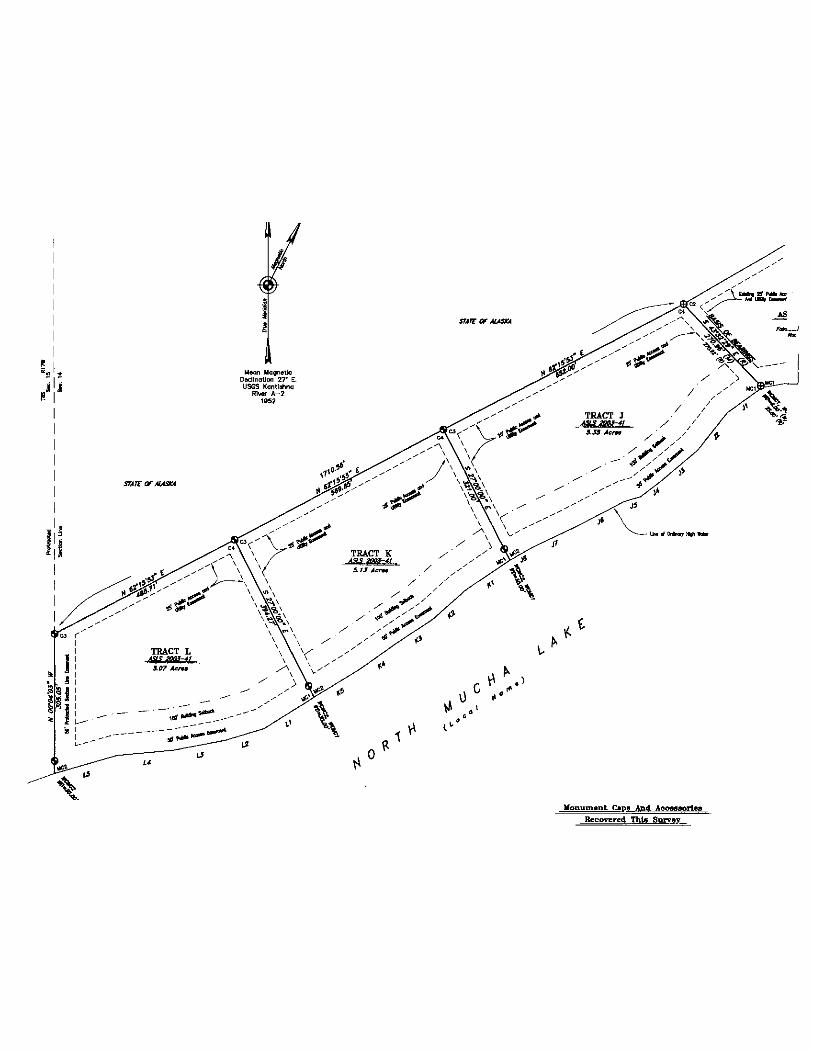
SITE DESCRIPTION Location The subject tracts are located approximately 2 miles west of the Kantishna River, approximately 130 miles southwest of Fairbanks and 60 miles southwest of Nenana. These subject lake front parcels are located within sections 14, 15, 16, 21, 22 and 29 of Township 8 South, Range 17 West, Fairbanks Meridian.
Beaver Lake Tracts A- F. Location arrows are approximate. The plat for Tracts D, E & F
The subject lots are identified below.
ADL MTRS ASLS ACRES TRACT FRONTAGE 417650 FOOBS017W6 ASLS 2003-41 13.25 A Beaver Lake 500'
417651 F008S017W6 ASLS 2003-41 10.49 B Beaver Lake 692'
417652 F008S017W6 ASLS 2003-41 6.79 c Beaver Lake 513'
417654 F008S017W6 ASLS 2003-41 7.00 D Beaver Lake 81 0'
471655 F008S017W6 ASLS 2003-41 5.61 E Beaver Lake 508'
417656 F008S017W7 ASLS 2003-41 6.14 F Beaver Lake 684'
417657 F008S017W29 ASLS 2003-41 7.89 G Chapple Lake 650'
417658 F008S017W29 ASLS 2003-41 6.49 H Chapple Lake 498'
417659 F008S017W29 ASLS 2003-41 5.96 I Chapple Lake 653'
417660 F008S017W14 ASLS 2003-41 5.35 J N. Mucha Lake 687'
417661 F008S017W 14 ASLS 2003-41 5.13 K N. Mucha Lake 577'
417662 F008S017W14 ASLS 2003-41 5.07 L N. Mucha Lake 660'
417664 F008S017W15, 16,21 ASLS 2003-41 8.49 N Mucha Lake 541' •
1:\MRW RRCSFites\Mucha Lake\Mucha Lake MASTER 2007.doc 11

w..,n llagno\le DodlnQ\Ion 27" E. USGS KQntlohna
RIVW" A-2 19~2
' '
3 1 /4~~~~mAJ=\j~ri;:~ ~onume,t. 4473-S. Rocovt..-d Thio Survey
3 1/ 4: Di~~· .Aiumi~m .cop l?_n ~ 2(2" Diom.
' ' ' '
' ' ' '
MUCHA LAKE STAKING AREA APPRAISAL BASE REPORT No. 3201-01
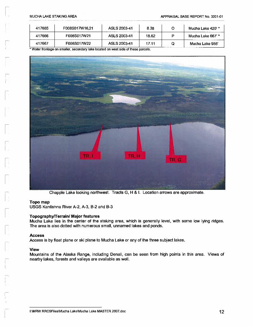
417665 F008S017W16,21 ASLS 2003-41 8.38 0 Mucha Lake 420' *
417666 F008S017W21 ASLS 2003-41 18.62 p Mucha Lake 667' *
417667 F008S017W22 ASLS 2003-41 17.11 Q Mucha Lake 956'
• Water frontage on smaller, secondary lake located on west s1de of these parcels.
Chapple Lake looking northwest. Tracts G, H & I. Location arrows are approximate.
Topo map USGS Kantishna River A-2, A-3, B-2 and B-3
Topographyfferrain/ Major features Mucha Lake lies in the center of the staking area, which is generally level, with some low lying ridges. The area is also dotted with numerous small, unnamed lakes and ponds.
Access Access is by float plane or ski plane to Mucha Lake or any of the three subject lakes.
View Mountains of the Alaska Range, including Denali, can be seen from high points in this area. Views of nearby lakes, forests and valleys are available as well.
1:\MRW RRCSFiles\Mucha Lake\Mucha Lake MASTER 2007.doc 12
STATC or AIA.WA
STATC OF AIASAI4
--------------------

MUCHA LAKE STAKING AREA APPRAISAL BASE REPORT No. 3201-01
Climate The area has a cold, continental climate with an extreme temperature range. The average daily maximum during summer months is 65 to 70 degrees F; the daily minimum during winter is well below zero. The highest temperature ever recorded is 98 degrees F; the lowest is -69 degrees F. Average precipitation is 11.4 inches with 48.9 inches of snowfall annually.
North Mucha Lake looking northeast. Tracts J, K & L. Location arrows are approximate.
Soils The soils are well-drained and alluvial on high spots, with permafrost likely in low lying areas. During ground inspections, soils surrounding Beaver Lake were found to be sandier and supported stands of hardwoods. Soils fronting the other three lakes contained an organic material that supported spruce trees only. Given the on the ground inspections, those parcels on Beaver Lake are superior to the other three lakes.
Vegetation Vegetation in low-lying areas consists mainly of black spruce and native shrubs and bushes.
Water source Ground water quality and depth unknown. Several lakes ponds and streams are in the area.
1:\MRW RRCSFiles\Mucha Lake\Mucha Lake MASTER 2007.doc 13

'Ill-Magnetic O.::Unat~ 27" E. USGS Kae1tTat\na
Rr_. A-2 1~52:
Tract A A.SUI No. 87-188 f'IWNt.~,. fJID
····-··-······-······-··S"-··-······-
N.u"C
s s.rr N,...W
NOTC SU'C s •r w
sn-c
""""" NM"W
NSZ"C s ,,. c Ntr w
N.JrC
SV'C NWW
.... •.. .... .... .,.
&J' ,,,. ,,.
4.Z' s.s' u·
.f"'!Spnln ····-··, ......... , .........
······-····-s"-
N T4" C
$ 24'" £ HSI-' W
.,.. .. SU"W NWW
SN'C
s s.r" JID7" If'
, ltr £ s~w
SWi:
7.7'
ti.J'' r.s·
=·· 1.2' l.t•
4.S' 240' :1.1'
...... su' St.l'
•.. ~·· ,,,...
...... ...... ........ .....
(M)
""
.,.,_ car alGIMUilD ~.TL .. ol.ldt1--a.M WQICI n,.N. AN ~1
' ' '
Ji 1/4~ Dic.m. Aluminum Cap 0" Allill'linL.Im Pr:.t .PrimGry t.b'!ument, 447.1-5 o..- 5032.-S, ~ Thl• Surwy
Ji 1/4• Diem, Numinl,.ltl"j Cap On 2 1/2~ Oia...,. By JO• Lon; Aluminum Post Primary Monumont, 5032-S, S.l Thlo SuN.y
SL.I.....,.ad llno
Um11mry.d EaMrrMnt Uno
C<>mpo.~ttd Ti•
100' B11lldl1"19 Sotbock lJJM (S.. Nato 5)
50' Protroclod Sectlon Uno E:~
50' Pvbllc Ace.. EaNmont
25' Ploblk: Ace- ar~d Utility Ea•m•nl
1 Of/ Building Setback (S.. ""ot. 5)
Roconi Dlmol'lafon Pot AdjolnbjJ Plat M rndlcat.d
Mtoe....-.4 Dlm~n
Comp.~t.d OimM1Ion
0 ,.... 2001
All ~IT1CI1J n1vn11m-*o ..t lhio aurN)' oro 3 1p.• d!Qm~ alymlll.l.lft't oop1 on 2 1/2• diamotor aluminum pipo,
30· lo!'lg, Mt 25· to ..10• ltl tho IJ'C)Und wiU, a c'MP 1 moogMt <rl. lh• bc:l .. and o cor.onit. 'ltiVI .. , po.t <:~d;oo.nt to VII morNm•nt.
Sheet 0 Nota
1) The natural mean.-.. of U.. lino of otdi~ary ~iQh wotll" of lllucho LaQ oncl tho unnamed lalcll 1DITI'I tha tNII bol;ndo o1 u,_ b'oct.. Tho Q<;JprwdmQ{o- llno g( onlirl'CIJY hi\lh ~t q• ohQllrt i:t for areo QOrl'l~,.,, oni)', •l'th tM trut troct c:omiiW .tMiniJI on the extension of the tract oidl~t\111 and thlir inl«Mct.iOfl with tho r.otu~ meandora..
2)
l)
Tho prWvetod ooc&n lin• werl wk:o.lkrUd buood on the protrncted pooltior.a of the c:amr of Sections 9, 10, , ~. ond , 15, «M comr of S.c:Uono 1~. 16, 21. Cll'od 22, end the comer o1 S.C:t>ono 115, 17, 20, <1nd 21 r~latiw to tho booTs of coot'dinatw ond the bo:~ls o1 boort"'JJ• oo •hown CX't lhia •I'IMt for Tr"CCda W tl'u'OIIgh Q.
Troct N, on ""-'<:ho lo• ond U'l• 1,1~ed lokt, Is roswwd by tho Stno at Ala,lla fM 9Ublfc. occe. betw.., thti two lakes.
.a&.S 91-248 WOI ~rded M: ~No. Sll-7 on January 20, 1983, ASLS 87-1!8 wa1 recorded <II P~ No. 88-81 on s.;.t.mbw 27, Hie&, ASlS 8'7-21'0 was~ Gs Plot Jt4o. 1!1&-103 on O.C:ombw 1.1, 11M. all Tn lhll rairbanU Recanting tJT.trlct..
NQ •ttuc::tum w. t.::J be c:onotrudod wlthtn on. hundr~ r..t of th• ordinary hi~h "at. ~n• of t.luchq L.akl end tto.e ordlr.oty high wcrt.r ~,. of th• uf)ncmed toQ.
Gon.-ol Not• cppiic:oblo to oH oh..tt of thio wrwy appear on Sheet No.. 2:.
' ' ' ' ' ' ' ' '
' '
' ' '
' ' '
lltou'\Uilent
..Jl«
s\5 87-r&. 't- <9
wcw~ ;m.c l \COR.-4
I !
MUCHA LAKE STAKING AREA APPRAISAL BASE REPORT No. 3201-01
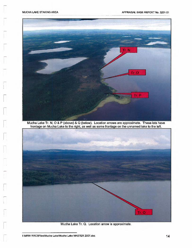
Lo1:;ation ,n._.,,.,.,, are approximate. These lots have trnnt<>>n<> on the unnamed lake to the left.
Mucha Lake Tr. Q. Location arrow is approximate.
1:\MRW RRCSFiles\Mucha Lake\Mucha Lake MASTER 2007.doc 14

r I
MUCHA LAKE STAKING AREA APPRAISAL BASE REPORT No. 3201-01
DATA ANALYSIS and CONCLUSION
Highest and best use analysis identifies the most profitable and competitive use of the property. Therefore, highest and best use is a market driven concept that is fundamental to the valuation of a property.
HIGHEST AND BEST USE
Highest and best use is defined as:
the reasonably probable and legal use of vacant land or an improved property that is physically possible, legally permissible, appropriately supported, financially feasible, and that results in the highest value. 4
The highest and best use of a site must meet four criteria. The highest and best use of a property must be:
• legally permissible, • physically possible, • financially feasible, and • maximally productive.
The value of land is generally estimated as though vacant and available for development to its highest and best use. The appraisal of improvements (when present on the site) is based on their actual contribution to the total value of the property. The appraised property is vacant and unimproved.
HIGHEST and BEST USE of SITE as VACANT
Legally Permissible There are no local zoning laws limiting the development of this parcel. Development of well and septic systems must comply with the requirements of the Department of Environmental Conservation. The subject parcel could be developed for almost any legal use.
Physically Possible The subject size and physical characteristics are adequate to support all reasonable and probable uses.
Financially Feasible Surrounding land use is primarily recreational. Development of the parcel depends on the amount of resources the owner is willing to allocate for recreational needs.
Maximally Productive Surrounding land use is primarily recreational. Maximally productive use is the use that produces the maximum return from the proceeds of a sale or lease.
Highest And Best Use Of Land As Vacant Based on the foregoing analysis, the highest and best use of the subject parcel as vacant would be for almost any legal use, primarily a private recreation cabin site.
4 The Appraisal ot Real Estate Twelfth Edition Appraisal Institute, 2001, p305
1:\MRW RRCSFiles\Mucha Lake\Mucha Lake MASTER 2007.doc 15