state lease co111rol · full de cr!pt!o ' [abstract. block, township, ... {hereinafter called...
TRANSCRIPT
Leasing: C.rf A nalyst: Gi,-f
Maps:
GIS: zc, DocuS /wre:
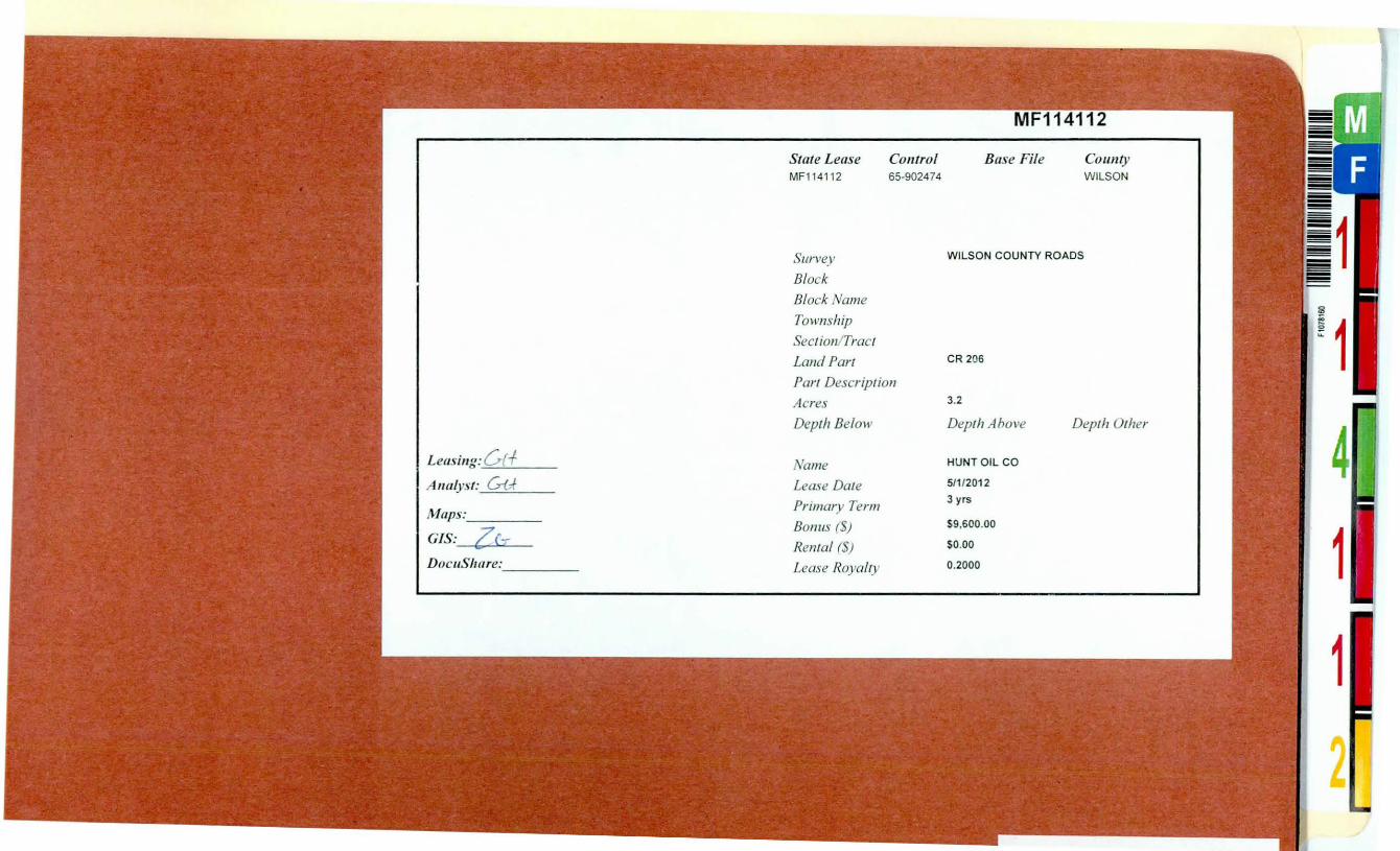
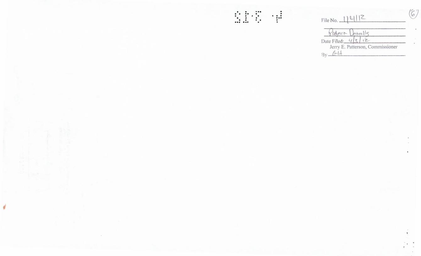
State Lease MF1141 12
Survey
Block
Block Name
Township
Sect ion/ Tract
Land Part
Co111rol 65-902474
Part Description
Acres
Depth Below
Name
Lease Date
Primary Term
Bonus {5)
Rental (5}
Lease Royalry
Base File County WILSON
WILSON COUNTY ROADS
CR 206
3.2
Depth A hove Depth Other
HUNT OIL CO
5/1/2012
3yrs
$9,600.00
$0.00
0.2000
2

, - '
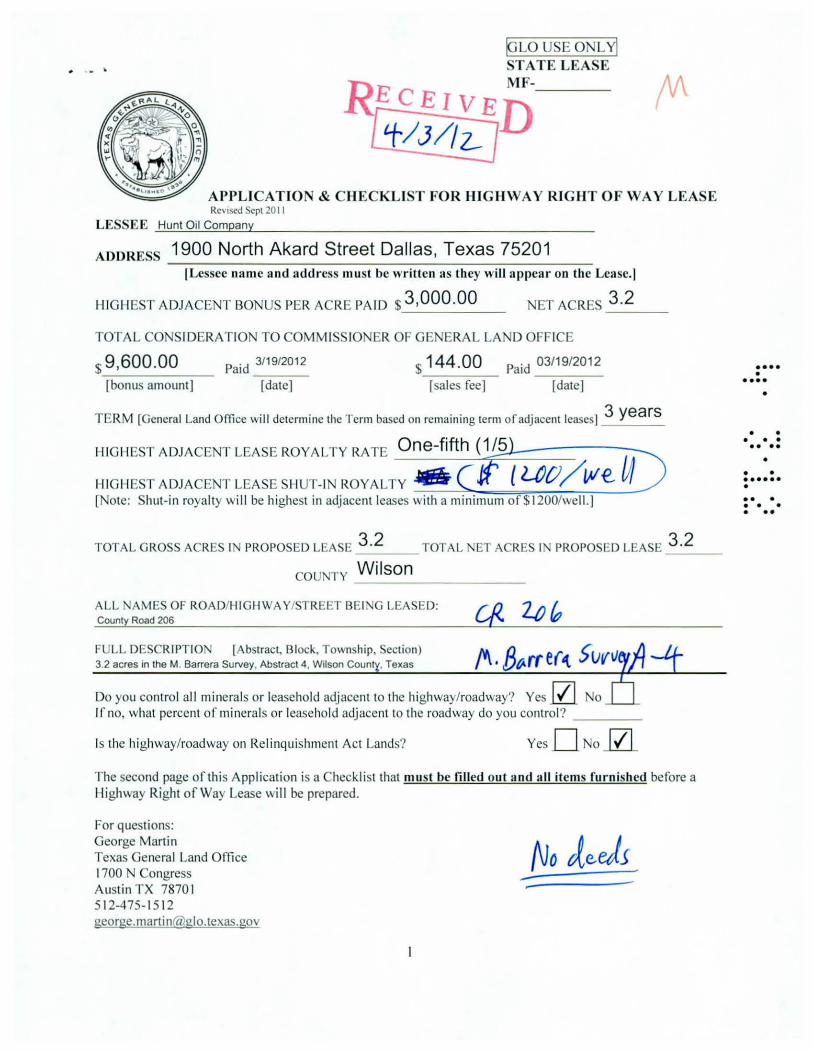
APPLICATION & CHECKLI T FOR HIGHWAY RIGHT OF WAY LEA E Rc' 1scd Sept 20 I I
LE EE Hunt Oil Company
ADORE 1900 North Akard Street Dallas, Texas 75201
!Lessee name a nd ad dress must be written as they will appear on the Lease.!
HIGIIE T ADJACE T 80 US PER ACRE PA ID $ 3 ,000 .00 ET ACRE
TOTAL CO IDERATIO TO COMM I 10 ER OF GE ERAL LA D OFF ICE
$ 9 ,600 .00
[bonus amount]
Paid 3/19/2012
[date]
$ 1 44 .00 Paid 03/19/2012
[sales fee] [date]
3 .2
TERM [General Land Office will determine the Term based on remaining term of adjacent leases] 3 years
HIG II E T ADJACENT LEASE ROYALTY RATE One-fifth ( 1 /51~------
HIG II E T ADJACE T LEASE SHUT-I ROYALTY Jll!& { L()CJ / IJI€, u [ ote: hut-in royalty wi ll be highest in adjacent leases with a minimum of$ 1200/well.]
TOTAL GROSS ACRES li PROPOSED LEA E ~ TOTAL ET ACRE I PROPO ED LEA E _3_.2 __
cou TY Wilson
ALL AME OF ROAD/H!GHWA Y/ TREET BE! G LEA ED: County Road 206
FULL DE CR!PT!O ' [Abstract. Block, Township, ection) 3.2 acres in theM. Barrera Survey, Abstract 4 , Wilson County, Texas
Do you control al l minerals or leasehold adjacent to the highway/roadway? Yes JZl 0
If no, what percent of mi nerals or leasehold adjacent to the roadway do you control? ___ _
Is the highway/roadway on Relinquishment Act Lands? Yes 0 olZl_
The second page of this Application is a Checklist that must be fi lled out a nd a ll items furnished before a Highway Right of Way Lease will be prepared.
For questions: George Martin Texas General Land Office 1700 Congress Aust in TX 7870 I 512-475- 15 12 george.martin@ glo.texas.gov
•••• • •••• •
• • • • • •• •• •
• • •••••• • •• • • • • • ••

.. ... ... . IGLO u E 0 LYI STATE LEASE MF------
APPLICATION & CHECKLIST FOR HIGHWAY RlGHT O F WAY LEASE Rev1scd cpt 20 II
JZL I. Cover lener CHECKLIST
JZL2. Application for Highway Right of Way (HROW) Lease
_0_3. Plat showi ng boundaries and dimensions of right of way tract wi th highway/roadway labeled. will be used to prepare an exhibi t to the lease.]
JZL 4. Processing fee - check attached
J£]_s. Check to Commissioner of General Land Office for total consideration.
lll 6. Check to Commissioner of General Land Office for 1-1 /2% sales fee.
_D_7. Executed Waivers of Preferent ial Right to Lease, if necessary.
JZL 8. Executed Affidavit of Consideration
_0_9. Copies of all highway deeds, clipped together
JZI.10. Copies of adjacent leases, cl ipped together.
[This
Put tabs on the leases with the highest bonus per acre, highest royalty, highest shut-in royalty and highl ight those items on the tabbed page.
JZI.1 1. Exhibit '·A" to be attached to the lease describing the area being leased (see Guidel ines 8.)
Include all the above information in one package and ma il or deliver to: George Martin Texas General Land Office 1700 Congress, Suite 840 Austin TX 7870 1
If you a re pooling or unitizing a t a ny tim e after the State lease has been issued , the following must be provided to the GLO:
il1. Filled out Information for Highway Right-of-Way Uni t Declaration
il2. Copy of recorded unit designation
_D_3. Copy of unit plat
For questions a bout pooling: Beverly Boyd Texas General Land Office 5 12-463-652 1 beverly.boyd@ glo.texas.gov
2
• ••• • •••• •
• • • • • •• •• •
• • •••••• • •• • • • • • ••

• • ••• • • •• • • • • • • • • .. : .:. . .. • • • • • ••• • •
File No. I Jl-1}1?....

~u.sttn, \!Cexa.s
PAID-UP OIL AND GAS LEASE NO. (MF 114112)
GENERAL LAND OFFICE AUSTIN, TEXAS
HROW Revised 8/06
TH IS AGREEMENT made and entered into by and between the Commiss ioner of the General Land Office of the State of Texas, whose address is Stephen F. Austin Building, 1700 North Congress, Austin, Texas, 78701 , hereinafter called "Lessor", hereunto authorized by the School Land Board, pursuant to the provisions of Chapters 32 and 52 of the Natural Resources Code {hereinafter called N.R.C.), and amendments thereto, and all applicable rules promulgated by the School Land Board and Hunt Oil Company, whose address is 1900 North Akard Street, Dallas, TX 75201 hereinafter called "Lessee".
1. Lessor, in consideration of Nine Thousand Six Hundred and 00/100 ($ 9,600.00) , receipt of which is hereby acknowledged, and of the covenants and agreements of Lessee hereinafter contained, does hereby grant, lease, and let unto Lessee the land covered hereby for the purposes and with the exclusive right of exploring, drilling, mining and operating for, producing and owning oil, gas, and all other hydrocarbons, produced from the land covered hereby. The land covered hereby, herein called "said land" is located in the County of Wilson, State of Texas, and is described as follows:
3.2 acres of land, more or less, known as, si tuated in said Wilson County Texas, more particularly described in Exhibit "A" attached hereto and made a part hereof together with a plat, attached hereto as Exhibit "B", depicting said right-of-way and surrounding area for purposes of illustration only.
For the purpose of determining the amount of any bonus or other payment hereunder, said land shall be deemed to contain 3.2 aces, whether actually containing more or less, and the above recital of acreage shall be deemed to be the true acreage thereof. Lessor accepts the bonus as lump sum consideration for this lease and all rights and options hereunder.
2. PRIMARY TERM: This lease, which is a "paid up" lease requiring no rentals, shall remain in force for a term of three years, from May 1st, 2012 hereinafter called "primary term", and as long thereafter as operations, as hereinafter defined, are conducted upon said land with no cessation for more than ninety (90) consecutive days.
3. ROYAL TIES: As royalty Lessee covenants and agrees:
(a) To deliver to the credit of Lessor, in the pipe line to which Lessee may connect its well, the equal 20% part of all oil produced and saved by Lessee from said land, or from time to time, at the option of Lessee, to pay Lessor the average posted market price of such 20% part of such oil at the wells as of the day it is run to the pipe line or storage tanks, Lessor's interest, in either case, to bear none of the cost of treating oil to render it marketable pipe line oil ;

HROW Revised 8/06 (b) To pay Lessor on gas and casing head gas produced from said land (1) when sold by lessee 20% of the amount
realized by Lessee, computed at the mouth of the well , or (2) when used by Lessee off said land or in the manufacture of gasoline or other products, the market value, at the mouth of the well , of 20% of such gas and casing head gas.
(c) If, at the expiration of the primary term or at any time or times thereafter, there is any well on said land or on lands with which said land or any portion thereof has been pooled, capable of producing oil or gas, and all such wells are shut-in, this lease shall, nevertheless, continue in force as though operations were being conducted on said land for so long as said wells are shut-in , and thereafter this lease may be continued in force as if no shut-in had occurred
(d) Lessee covenants and agrees to use reasonable diligence to produce, utilize, or market the minerals capable of being produced from said wells, but in the exercise of such diligence, Lessee shall not be obligated to install or furnish facilities other than well facilities and ordinary lease facilities of flow lines, separator, and lease tank, and shall not be required to settle labor trouble or to market gas upon terms unacceptable to Lessee.
(e) If at any time or times after the expiration of the primary term, all such wells are shut-in for a period of ninety consecutive days, and during such time there are no operations on said land, then at or before the expiration of said ninety day period, lessee shall pay or tender, by check of lessee, as royalty, the sum of$ 1,200.00 per well. Lessee shall make like payments or tenders at or before the end of each anniversary of the expiration of said ninety day period if upon such anniversary this lease is being continued in force solely by reason of the provisions of this paragraph. Each such payment or tender shall be made to the parties who at the time of payment would be entitled to receive the royalties which would be paid under this lease if the wells were producing. Nothing herein shall impair lessee's right to release as provided in paragraph 5 hereof. In the event of assignment of this lease in whole or in part, liability for payment hereunder shall rest exclusively on the then owner or owners of this lease, severally as to acreage owned by each.
(f) All royalties not taken in kind shall be paid to the Commissioner of the General Land Office at Austin, Texas, in the following manner:
Royalty on oil is due and must be received in the General Land Office on or before the 5th day of the second month succeeding the month of production, and royalty on gas is due and must be received in the General Land Office on or before the 15th day of the second month succeeding the month of production, accompanied by the affidavit of the owner, manager, or other authorized agent, completed in the form and manner prescribed by the General Land Office and showing the gross amount and disposition of all oil and gas produced and the market value of the oil and gas, together with a copy of all documents, records or reports confirming the gross production, disposition and market value including gas meter readings, pipeline receipts, gas line receipts and other checks or memoranda of amount produced and put into pipelines, tanks, or pools and gas lines or gas storage, and any other reports or records which the General Land Office may require to verify the gross production, disposition and market value. In all cases the authority of a manager or agent to act for the Lessee herein must be filed in the General Land Office. Each royalty payment shall be accompanied by a check stub, schedule, summary or other remittance advice showing by the assigned General Land Office lease number the amount of royalty being paid on each lease. If Lessee pays his royalty on or before thirty (30) days after the royalty payment was due, the Lessee owes a penalty of 5% on the royalty or $25.00, whichever is greater. A royalty payment which is over thirty (30) days late shall accrue a penalty of 10% of the royalty due or $25.00, whichever is greater. In addition to a penalty, royalties shall accrue interest at a rate of 12% per year; such interest will begin accruing when the royalty is sixty (60) days overdue. Affidavits and supporting documents which are not filed when due shall incur a penalty in an amount set by the General Land Office administrative rule which is effective on the date when the affidavits or supporting documents were due. The Lessee shall bear all responsibility for paying or causing royalties to be paid as prescribed by the due date provided herein. Payment of the delinquency penalty shall in no way operate to prohibit the State's right of forfeiture as provided by law nor act to postpone the date on which royalties were originally due. The above penalty provisions shall not apply in cases of title dispute as to the State's portion of the royalty or to that portion of the royalty in dispute as to fair market value. The State shall have first lien upon all oil and gas produced from the area covered by this lease to secure the payment of all unpaid royalty and other sums of money that may become due to the State hereunder.
4. POOLING: (a) Lessee is hereby granted the right, at its option, to pool or unitize any land covered by this lease with any other land covered by this lease, and/or with any other land, lease, or leases, as to any or all minerals or horizons. Units pooled for oil hereunder shall not exceed 160 acres each in area, and units pooled for gas hereunder shall not exceed in area 640 acres each plus a tolerance often percent (10%) thereof, unless oil or gas units of a greater size are allowed under or prescribed by rules of the Railroad Commission of Texas. A unit established hereunder shall be valid
2

HROW Revised 8/06
and effective for all purposes of this lease even though there may be mineral, royalty, or leasehold interests in lands within the unit, which are not effectively pooled or unitized. Any operations conducted on any part of such unitized land shall be considered, for all purposes, except the payment of royalty, as operations conducted upon said land under this lease. There shall be allocated to the land covered by this lease within each such unit (or to each separate tract within the unit if this lease covers separate tracts within the unit) the proportion of the total production of unitized minerals from the unit, after deducting any used in lease or unit operations, which the number of surface acres in such land (or in each such separate tract) covered by this lease within the unit bears to the total number of surface acres in the unit, and the production so allocated shall be considered for all purposes, including payment or delivery of royalty, overriding royalty and any other payments out of production, to be the entire production of unitized minerals from the land to which allocated in the same manner as though produced there from under the terms of this lease. The owner of the reversionary estate of any term royalty or mineral estate agrees that the accrual of royalties pursuant to this paragraph or of shut-in royalties from a well on the unit shall satisfy any limitation of term requiring production of oil or gas. The formation of any unit hereunder which includes land not covered by this lease shall not have the effect of exchanging or transferring any interest under this lease (including, without limitation, any shut-in royalty which may become payable under this lease) between parties owning interests in land covered by this lease and parties owning interests in land not covered by this lease. Neither shall it impair the right of Lessee to release as provided in paragraph 5 hereof, except that Lessee may not so release as to lands within a unit while there are operations thereon for unitized minerals unless all pooled leases are released as to lands within the unit. At any time while this lease is in force Lessee may dissolve any unit established hereunder by filing for record in the public office where this lease is recorded a declaration to that effect, if at that time no operations are being conducted thereon for unitized minerals. Subject to the provisions of th is paragraph 4, a unit once established hereunder shall remain in force for so long as any lease subject thereto shall remain in force. If this lease now or hereafter covers separate tracts, no pooling or unitization of royalty interests as between any such separate tracts is intended or shall be implied or result merely from the inclusion of such separate tracts within this lease but Lessee shall nevertheless have the right to pool or unitize as provided in this paragraph 4 with consequent allocation of production as herein provided. As used in this paragraph 4, the words "separate tract" mean any tract with royalty ownership differing, now or hereafter, either as to parties or amounts, from that as to any other part of the leased premises.
(b) Neither unit production of oil or gas, nor unit operations, nor payment of shut-in royalties from a unit gas well, shall serve to hold the lease in force as to any area outside the unit, regardless of whether the production, maintenance of a shut-in gas well , or operations are actually located on the State tract or not.
(c) Lessee agrees to file with the General Land Office a copy of any unit designation, wh ich th is lease is included within ninety (90) days of such designation.
5. RELEASE: Lessee may relinquish the rights granted hereunder to the State at any time by recording the relinquishment in the county where this area is situated and fil ing the recorded relinquishment or certified copy of same in the General Land Office within ninety (90) days after its execution accompanied by the prescribed filing fee. Such relinquishment will not have the effect of releasing Lessee from any liability theretofore accrued in favor of the State.
6. REWORK: If at any time or times during the primary term operations are conducted on said land and if all operations are discontinued, this lease shall thereafter terminate at the end of the primary term or on the ninetieth day after discontinuance of all operations, whichever is the later date, unless on such later date either (1) Lessee is conducting operations or (2) the shut-in well provisions of paragraph 3 or the provisions of paragraph 9 are applicable. Whenever used in this lease the word "operations" shall mean operations for and any of the following: drilling, testing , completing , reworking , recompleting, deepening, plugg ing back or repairing of a well in search for or in an endeavor to obtain production of oil or gas, or production of oil or gas in paying quantities.
7. MINERAL USE: Lessee shall have the use, free from royalty, of oil and gas produced from said land in all operations hereunder.
8. NOTICE: In the event Lessor considers that Lessee has not complied with all its obligations hereunder, both express and implied, Lessor shall notify Lessee in writing, setting out specifically in what respects Lessee has breached this contract. Lessee shall then have sixty (60) days after receipt of said notice within which to meet or commence to meet all
3

HROW Revised 8/06
or any part of the breaches alleged by Lessor. The service of said notice shall be precedent to the bringing of any action by Lessor on said lease for any cause, and no such action shall be brought until the lapse of sixty (60) days after service of such notice on Lessee. Neither the service of said notice nor the doing of any acts by Lessee aimed to meet all or any of the alleged breaches shall be deemed an admission or presumption that Lessee has failed to perform all its obligations hereunder. If this lease is canceled for any cause, it shall nevertheless remain in force and effect as to (1) sufficient acreage around each well as to which there are operations to constitute a drilling or maximum allowable unit under applicable governmental regulations, (but in no event less than forty acres), such acreage to be designated by Lessee as nearly as practicable in the form of a square centered at the well, or in such shape as then existing spacing rules require; and (2) any part of said land included in a pooled unit on which there are operations.
9. FORCE MAJEURE: If, while this lease is in force, at, or after the expiration of the primary term hereof, it is not being continued in force by reason of the shut-in well provisions of paragraph 3 hereof, and Lessee is not conducting operations on said land by reason of (1) any law, order, rule or regulation , (whether or not subsequently determined to be invalid) or (2) any other cause, whether similar or dissimilar, (except financial) beyond the reasonable control of Lessee, the primary term shall be extended until the first anniversary date hereof occurring ninety (90) or more days following the removal of such delaying cause, and this lease may be extended thereafter by operations as if such delay had not occurred.
10. LESSER ESTATE CLAUSE: If this lease covers a less interest in the oil or gas in all or any part of said land than the entire and undivided fee simple estate (whether lessors interest is herein specified or not), or no interest therein, then the royalties, and other monies accruing from any part as to which this lease covers less than such full interest, shall be paid only in the proportion which the interest therein, if any, covered by this lease bears to the whole and undivided fee simple estate therein.
II. ASSIGNMENTS: This lease may be transferred at any time. All transfers must reference the lease by file number and must be recorded in the county where the land covered hereby is located, and the recorded transfer or a copy certified to by the County Clerk of the county where the transfer is recorded must be filed in the General Land Office within ninety (90) days of the execution date, as provided by N.R.C. Section 52.026, accompanied by the prescribed filing fee. Every transferee shall succeed to all rights and be subject to all obligations, liabilities, and penalties owed to the State by the original Lessee or any prior transferee of the lease, including any liabilities to the State for unpaid royalties.
12. WELL INFORMATION: Lessee agrees to forthwith furnish Lessor, upon written request, with copies of all drilling logs, electrical logs, cores and core records and other information pertaining to all wells drilled by lessee either on the leased premises or acreage pooled therewith, when requested to do so. Said information shall remain confidential as required by statute.
13. SURFACE: Notwithstanding anything herein to the contrary, it is agreed that Lessee wi ll not conduct any exploration or drilling on the surface of the leased premises or use the surface in the exercise of any rights herein granted. Any development of said land shall be by means of a directional well located off the leased premises, or by pooling of said land with other land, lease or leases as hereinabove provided.
14. COMPENSATORY ROYALTY: Lessee shall pay a compensatory royalty if this lease is not being held by production on the leased premises, by production from a pooled unit, or by payment of shut-in royalties in accordance with the terms of this lease, and if oil or gas is sold or delivered in paying quantities from a well located within 2,500 feet of the leased premises and completed in a producible reservoir underlying the area leased hereunder or in any case in which drainage is occurring. Such compensatory royalty shall be paid at the royalty rate provided in this lease based on the value of production from the well as provided in the lease on which such well is located. The compensatory royalty shall be paid in the same proportion that the acreage of this lease has to the acreage of the proration unit surrounding the draining well plus the acreage of this lease. The compensatory royalty shall be paid monthly to the Commissioner of the General Land Office on or before the last day of the month after the month in which the oil or gas is sold and delivered from the well causing the drainage or from the well located within 2500 feet of the leased premises and completed in a producible reservoir under this lease. Notwithstanding anything herein to the contrary, compensatory royalty payable hereunder shall
4

I IROW Revised 8/06
be no less than an amount equal to double the shut-in, and shall maintain this lease in effect for so long as such payments are made as provided herein.
15. FORFEITURE: If Lessee shall fail or refuse to make payment of any sum within thirty (30) days after it becomes due, or if Lessee or an authorized agent should knowingly make any false return or false report concerning production or drilling, or if Lessee shall fail or refuse to drill any offset well or wells in good faith as required by law and the rules and regulations adopted by the Commissioner of the General Land Office, or if Lessee should fail to file reports in the manner required by law or fail to comply with rules and regulations promulgated by the General Land Office, or refuse the proper authority access to the records pertaining to operations, or if Lessee or an authorized agent should knowingly fail or refuse to give correct information to the proper authority, or knowingly fail or refuse to furnish the General Land Office a correct log of any well , or if this lease is pooled or assigned and the unit designation or assignment is not filed in the General Land Office as required by law, the rights acquired under this lease shall be subject to forfeiture by the Commissioner, and he shall forfeit same when sufficiently informed of the facts which authorize a forfeiture, and when forfeited the area shall again be subject to lease. However, nothing herein shall be construed as waiving the automatic termination of this lease by operations of law or by reason of any special limitation arising hereunder. Forfeitures may be set aside and this lease and all rights there under reinstated before the rights of another intervene upon satisfactory evidence to the Commissioner of the General Land Office of future compliance with the provisions of the law and of th is lease and the rules and regulations that may be adopted relative hereto.
IN TESTIMONY WHEREOF, witness the signature of the Commissioner. o the General Land Office of the State of Texas under the seat of the General Land Office. £
App.Mv ML:
~~
JERRY E. PATTERSON MISSIO ER, GENERAL LAND OFFICE
5

FP.NTIER SURVEYING COMPANY
710 Buffalo St, Ste. 700 Corpus Christi, TX 78401
www.frontlersurveying .c om Office: 361 /881-8044
Fax: 361 /881-8340
3.2 ACRE ROAD
heet 2 of2
Field otes Descrip tion
A 3 2 acre road descnption , County Road 206, for llunt Oil Company, bemg m theM Barrera Survey, Abstract4, snuated appro"imately 7 13 miles southwest ofPoth, m Wilson County, Te"as
Bemg more fully described by metes and bounds as follows
BEGINNING: at a point, (Y ~ 422.804.28, X - 2.268.017.3 1). on the onhwest R 0 W of County Road 206, for the Nonhwest comer of th1s herem descnbed secuon of County Road.
THE CE:
THENCE:
THENCE:
THENCE:
THENCE:
THE CE:
THE CE:
THE CE:
THENCE:
' 58"28'42" E - 1,158.19 feet to a pomt, for an angle comer ofth1s herem descnbed seeuon of County Road,
' 58"28'3 1" E - 2.011.59 feet 10 a pomt, for an mtenor comer of th1s herem descnbed secuon of County Road,
13"22'59" E- 106.21 feet to a pomt, for the onheast comer ofth1s herem dcscnbed secuon of County Road,
S 31 "25'40" E - 75.22 feet to a pomt, for an angle comer of th1s herem descnbed secuon of County Road,
29042'2 1" E - 119.22 feet to a pomt, for the Southeast comer ofth1s herem descnbed secuon of County Road,
' 72°31' 11" W - I 05.56 feet to a pomt, for an mtenor comer of th1s herem descnbed secuon of County Road,
58"22'52" W - 1,203.45 feet to a pomt, for an angle comer of th1s herem descnbed seeuon of County Road,
58"29'25" W - 1,97 1.56 feet to a pomt, for the Southwest comer of th1s herem descnbed seeuon of County Road,
N 26°46'57" W - 41.15 feet to the POINT OF BEGINNI G, conuumng WJthm these metes and bounds a 3 2 acre section of County Road 206.
NOTE A Survey Plat reprcsenung a graph1c 1mage of th1s descnptlon Styled as "JAMES WIATREK #Ill," accompan1es th1s document The BaSIS ofBeanng IS Texas State Plane Coordmate System NAD 27, South Central Zone
Th1s F1eld Notes Descnpuon constitutes a legal document, and, unless 1t appears m us entirety, m Its ongmal form, includmg preamble, seal and s•gnature, surveyor assumes no respons1b1hty or hab1hty for Its correctness It IS strongly recommended, for the continuity of future surveys, that th1s document be mcorporated m all future conveyances, wuhout ony rev1stons or de/euons Th1s descnptlon and the accompanymg Survey Plat were prepared from record data fum1shed b) the client and was done Without the benefit of a Title Report. Surveyor has made no mvesugauon or search for easements or other maners of record that a T1tle Repon would disclose and th1s survey does not represent a warrant) of utle or a guarantee of ownership
March 13, 2012 Job o. 1202044 M.C.

N I ,
0
~ g D..
SHEET 1 OF 2
... z ::; t: z :::1
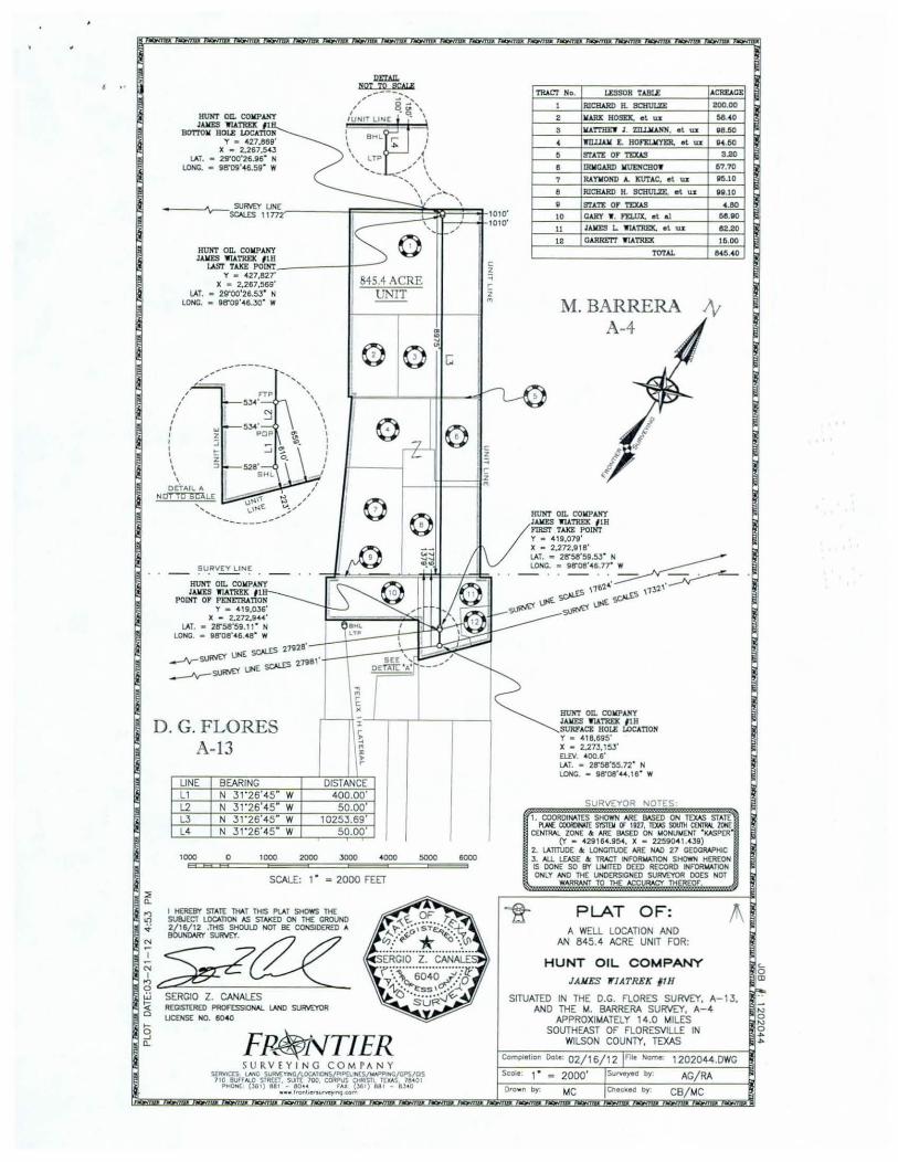
PARTIAL 845 .4 ACRE UNIT
.s.H.Qm!
PO INT or BEGINNINDI I y c 422,804 28 X - 2.268.01?.3 1
L1
UNE BEARING
LB
L1 N 56'26 42" E L2 N 56'26'31 E L3 N 13'22' 59 " E L4 S 31 '25'40" E L5 s 29' 42 21
FP~vTIER SU RVEY I N G C O M PANY
~ff~S=~~~(S~~{~ PliOH( ,..)61) Ul IOU r.u ~ 881 altO
• • • hOflloiw~com
E
COUNTY ROAD 206
DISTANCE LINE 1156 .19 L6 2011.59 L7
106.21 L6 75.22 L9
119.22
250 0
M.BARRERA A -4
L2
L7
BEARING DISTANCE N 72' 3 1'11 w 105.56' s 56'22'52" w 1203.45' s 56' 29' 25" w 197 1.56' N 26'46 57" W 41 . 15 '
250 !!00 750 1000
SCALE: 1 • • 500 FEET
1250
c z ::; ,. i ,.,
1500
JOB N: 1202044
TliiS PlAT IS N-1 OffiCE SUIM:Y N-ID WloS COIIPILO FROII A COI.IBIHATlON OF 1ll£ IIOST RECENT DESCR!PllONS AVMASU. NIO THE USE OF THE AERIALS AVMN!IL MS PlAT IS FOR UNIT DESIGNATION PURPOSES ONLY AND IS NOT IN ANY WAY A ' BOUNDARY SUIM:Y".
SERGIO Z. CANALES RECISTEIRID PROf'ESSIONAL LNIO SURVEYOR UCENSE NO. 60-40
SURVEYOR NOTES
I. COORDINATES SHOWN ARE BASED ON TEXAS STATE PlM: CXlOfUW! smt11 or 1121. TOOS SOU1II aJII1W. zON£
CENTRAl ZONE & ARE !I.'&D ON UONUUENT ' KASPER' fY • • 2816H5•. X • 225eo• t.438)
2. IAITTUOE & lONCITUOE ARE HAD 27 CEOCRAPHIC 3 . All lEioSE & TRACT INFORW.TlON SHOWN HEREON IS DONE SO BY Ut.IITED DEED RECORD IN FORW.llON ONLY N-10 THE UNDERSICNID SURVEYOR OO£S NOT
WARRANT TO THE ACCURACY THEREOF.
PLAT OF: A 3.2 ACRE ROAD FOR:
HUNT OIL COMPANY JAMES 'ff /ATREK IIH
SITUATED IN THE M. BARRERA SURVEY, A-14. APPROXIMATELY 7. 13 MILES
SOUTHEAST OF POTH IN WILSON COUNTY, TEXAS
ComploUon Dolo 02/ 22/ 12 IFll• Name 12020« M&B
Scale 1 • • 500' ISun.oyod by AG/ RA Drown by: MC IChec:.ked by KS/ CB
:::1: a..
IIUHT on. COIIPANT J.ua:s "'ll.I.TREX 11
IIOTIOII BOLE LOCATION y - 427,869'
X • 2,267,543 LAT. • 29'00'26.!16" N
LONG. • 98'09'46.59" W
IIUHT On. COIIPANT JAIIES 1114TREX l lB
LASf TAXE POINT-----+ -y - 427,827'
X • 2,287,569' lAT. • 29'00'26.53" N
LONG. • 98'09'46.30" W
--------
SURVEY LIN£
Blll!T on. COIIPANT I AllES YIATREX I I
POINT Of PEl!E'I'IU TION y - 419,036'
X - 2.272.9_.' LAT. • 28'58'59. 11 " N
LONG. • 98'08'46.48" W
..... ....... , ,
' \ \ \ I I I I I I I I
I
845.4 ACRE UNIT
sOtES 27928' _....,.., UI'IE •
-'lr"""'~ ' sOtES 1.7!181
--JV-SlJI<'IE" UtiE
D. G. FLORES A-13
UNE BEARING L1 N 31'26'45" W L2 N 31 ' 26'45" W L3 N 31'26'45" W L4 N 31 ' 26'45" W
1000 0 1000
,..
DISTANC E 400.00
50.00 10253.69
50.00
SCALE: 1 • = 2000 FEET
:ri ~:~klHA~~~~~~~
L~ez· w SERGIO Z. CANALES ~ RECISIDIED PROft:SSIOAAL LAN!) SURVEYOR
LIC£IIS( NO. 8040
b ..J a..
I
6000
c: z
" ,.. 2 "'
TIIACT No. LESSOR TABLE ACREAGE
I RICIWID IL 9CHIJI.ZE 200.00
2 IWIX HOSEX. el lilt 68.40
3 IIA 1'TIIE'f J 2IU.IU.NN, et \D 88.60
4 1IIUllll E. HOf'llLIIYEJ!. el lilt 94.60
5 STAn: or n:xAS :1.20
8 IRII.GARD IIUENCBOY 57.'10
7 RA YWOND A. ICI1l'AC, e l u.z 9~.10
8 RICHARD IL SCHULZE. el u.z 99.10
9 STATE or TEXAS 4.80
10 CARY Y. n:LUX. el al 58.90
u JAIIES L WIATREK. e l wt 82.20
12 GARRET!' 'lfiA TREX 15.00
T01'A.L 845.40
M . BARRERA 1\; A-4
IIUHT o n. COIIPANT J.UO:S WIATREX I IH miST TAKII POINT y - 419,079 ' X • 2.272,918' LAT. • 28'58'5!1.53" N~ LONC. • 98'08'46.n" W
- · · - · · - ~ ~ 116'2~· ,,~2"
~¢~1.J4{.~
Blll!T On. COIIPANT I AllES 'IU.TREX I I B SI1RI'ACE BOLE LOCATION y - 418,695' X • 2,273,153' EUV. 400.6' LAT. • 28'58'55.72" H LOHC. • li8'08'L4.16" W
SURVEYOR NOTES
1. COOROIAATES SHOWN ARE &\SED ON lDCAS STAT£ 1'1)1£ COOfDIW! S'ISTlll (f ltV, lWS swnt COI1RAl ZOH£
CEH1RAI. ZONE & ARE BASED ON t.IONUMOO "KASPER" (Y • 429 164.954, X • ~9041 .439)
2. LAllTliD£ & LONcmJD£ ARE NAO 27 CEOCIIAPHIC 3. ALL LEASE & TRACT INI'ORIMllON SHOW1I HEREOH IS OONE SO S'Y UMITEO DEED RECORD INI'ORIIAllON OHLY NolO THE UNDERSIGNED SURVEYOR DOES NOT
WARRANT TO THE ACCURACY THEREOF.
PLAT OF: A WELL LOCATION AND
AN 845.4 ACRE UNIT FOR:
HUNT OIL COMPANY
JANES 1f/ATREK 11H
SITUATED IN THE D.G. FLORES SURVEY. A-13, AND THE M. BARRERA SURVEY, A-4
APPROXIMATELY 14.D MILES SOUTHEAST OF FLORESVILLE IN
WILSON COUNTY, TEXAS
1202044.0WG
Scoleo 1" 2000' AG/RA O•own by. MC CB/MC
c.. 0 CD
"' 0
"' 0 ... ...

File No. I) Lf. [ ((_
Date Filed: __ s~/~~'+/....:1-=Z..=----:------Jen·l E. Patterson, Commissioner
By 6-t'

03/26/2012
Texas General Land Office Attn : George Martin 1700 N Congress, Suite 840 Austin , TX 78701
Dear Mr. Martin:
HUNT OIL COMPANY 1900 North Akard Street Dallas, TX 75201-2300
21 4-978-8873
This letter and the enclosed information is intended to represent the application and supporting documentation required by the General Land Office of the State of Texas to acquire an oil and gas lease for County Road 206, Wilson County, Texas. Hunt Oil Company has active oi l and gas leases on adjacent lands to the north and south of County Road 206.
Enclosed you will find the following :
1. Completed Application and Checklist for Highway Right of Way Lease 2. Plat showing the boundaries and dimensions of the County Road 206 tract Hunt Oil proposes to
lease. 3. Check made payable to the Commissioner of the General Land Office for the Processing Fee of
$500. 4. Check made payable to the Commissioner of the General Land Office in the amount of
$9,744.00, representing the highest bonus Hunt Oil Company pa id to lease lands adjacent to County Road 206 plus a 1.5% sales fee based on the total bonus.
5. Notarized Affidavit of Consideration 6 After extensive research m the Wilson County Courthouse deeds conveying the premises could
not be located 7. Certified copies of Memorandums of Oil and Gas Leases covering the lands leased by Hunt Oil
Company and adjacent to County Road 206. 8. Plat of County Road 206 as it relates to the location of Hunt Oil Company leases. 9. Metes and Bounds description of the 3.2 acre tract to be used as Exhibit "A" and attached to the
lease. 10. Addendum to be attached to the lease addressing horizontal pooling
It is my understanding that the General Land Office will supply Hunt Oil Company with an oil and gas lease covering the proposed 3.2 acre County Road 206 tract. If there is any further information that you require from Hunt Oil Company please do not hesitate to contact me at any time.
Thank you in advance for your consideration and attention to this matter.
Chance Turner, PL Hunt Oil Company 214-978-8873 (direct) cturner@huntoil .com
•••• • •••• •
• • • • • .. .. •
• • •••••• • .. . • • • • ••

H.UNT Olt,. C0 MPANY DALLAS,TX 75201
This Voucher Is In Full Settlement Of Items Below
INVOICE NO DATE DOC NO
Totals -- ---
VENDOR NO VENDOR NAME
BONUS- CR 206, WILSON CO. TX
fh!M 12 7 0 9 6 0 1 CHECK NO: 0001000405
PAYMENT DOC NO:
GROSS DISCOUNT NET
0.00 0.00 9,744.00
0.00 0.00 •••• - -
TEXAS GENERAL LAND OFFICE CHECK DATE 03/27/2012 •
• • rv .. () ..
\ . . . •••••• • •• • • • • . ..

HUt.fr Oll COMPANY 12 7 0 g 6 0 O DALLAS.TX 75201
This Voucher Is In Full Settlement Of Items Below
INVOICE NO DATE DOC NO
Totals
VENDOR NO VENDOR NAME TEXAS GENERAL LAND OFFICE
PROCESSING FEE, WILSON CO. TX
CHECK NO: 0001000406
PAYMENT DOC NO:
GROSS DISCOUNT 0.00 0.00
0.00 0.00
NET 500.00
•••• • •••• •
• • • • • •• •• •
• • •••••• • •• • • • • • ••
00.00
CHECK DATE 03/27/2012

• • • • •• ••• • • • • • • • • • • • • • • • • ••• ••• ••• • • . .
File No ___;l~l _t..(~l_l L. ______ _
(e~RvLE-~.&vtvS e Fees Date Fild: qh I rz.
Jerry E. P~tte.rson, Commissionc1
B) 6-1-!
LV
..

2,000
Highway Right-of-Way Plat of CR 206
3.2 acres MF114112
Wilson County, Texas
1,000 0 2,000 Feet
GASPAR FLORES A-13
OLSON UNTY
The Texas General Land Office makes no rapresantations 0( warranties regardong the accuracy or completeness of the onformaoon depoded on thos map or the data fr«n which n was prodJced. Thos map IS NOT suotable for navogational purposes and does not purpon to depict or establosh boundaroes between povate and pubHc land
KARNES COUNTY
- . . "
Map Generated by: Zeke GUlDen IS/BAS/GIS May 2012

® File No. _..:..l_l_lf..:....;/I_'L:___ ____ _
Date Filed:_Ll;.J..)s~[ ...:\C.::.._ ___ _
JeiTY E. Patterson, Commissioner
By G-tt""

AFFIDA VlT OF H IG HE T CONSfDERA TION PAID HIG HWAY RJGHT OF WAY LEASE
TATE OF TEXAS
COUNTY OF h\\o..~ BEFORE ME, the unders igned authority, o n this day per onally appeared
(bo.ce... \'\. ~ne£ (Affiant), known to me to be a c redible per on and of lawfu l age, who be ing by me fir t duly sworn , deposes and says:
That his/her name is Cboc q tt\ \ , H( Ae..Y . And that, Affiant is personally familiar ~ith and knowl~eable o f th e te rm and conditions o f the o il and gas lease(s) which adjoin(s) Col ) 0 hl ngod c90b
( [common name( ) of highway/roadway]
s ituated in W; \Son Cou nty, Texa , said highway/roadway being described on Exhi bit '·A" attached hereto and made a part hereof. And that the highest and best terms for any lea e adjoining lands described in Exhibit "A'' are as follows :
00 Bonus Consideration Pa id (Per Acre):$ 3 OOCJ-
Primary Term: S 'le.G.c5
I R 'l5 Roya ty ate: __ --~-'_d.......__ __ _
De lay Renta ls: $ __ --'--~=+~ A'---'r------
The above statements are with in my persona l knowledge and are true and correct.
Furthcr,m.eth not.
[signature of affiant}
c~Q..r\C..~ 1"\ . 1:',.1'\1( ... [printed or typed name of affiant}
ta te o f Texas
County o f Do..l\£;5
worn to and subscribed before me o n the f:il!: day of Mo...-c.~ CL-..c.l\.c.t. M _ fwrtU" (name of Affiant).
o tary Public's ignature
' 20 ll::_, by
... .. • ••••
• . . . ~ · .. . . ..... ., • •• • . . , . ..

...}/-£) \f. JrlliO!~"~LlllUOJ ·uosJ~llCcJ ·3 -\JJ~f
)'1 :p::>{!.::{ ::llBQ
• ·-------<..-J...,....t ~h~\-.,)~ "ON~ ·:
•
. ..... . . ~ . . . . . . . . . • •• • • . . .. ~
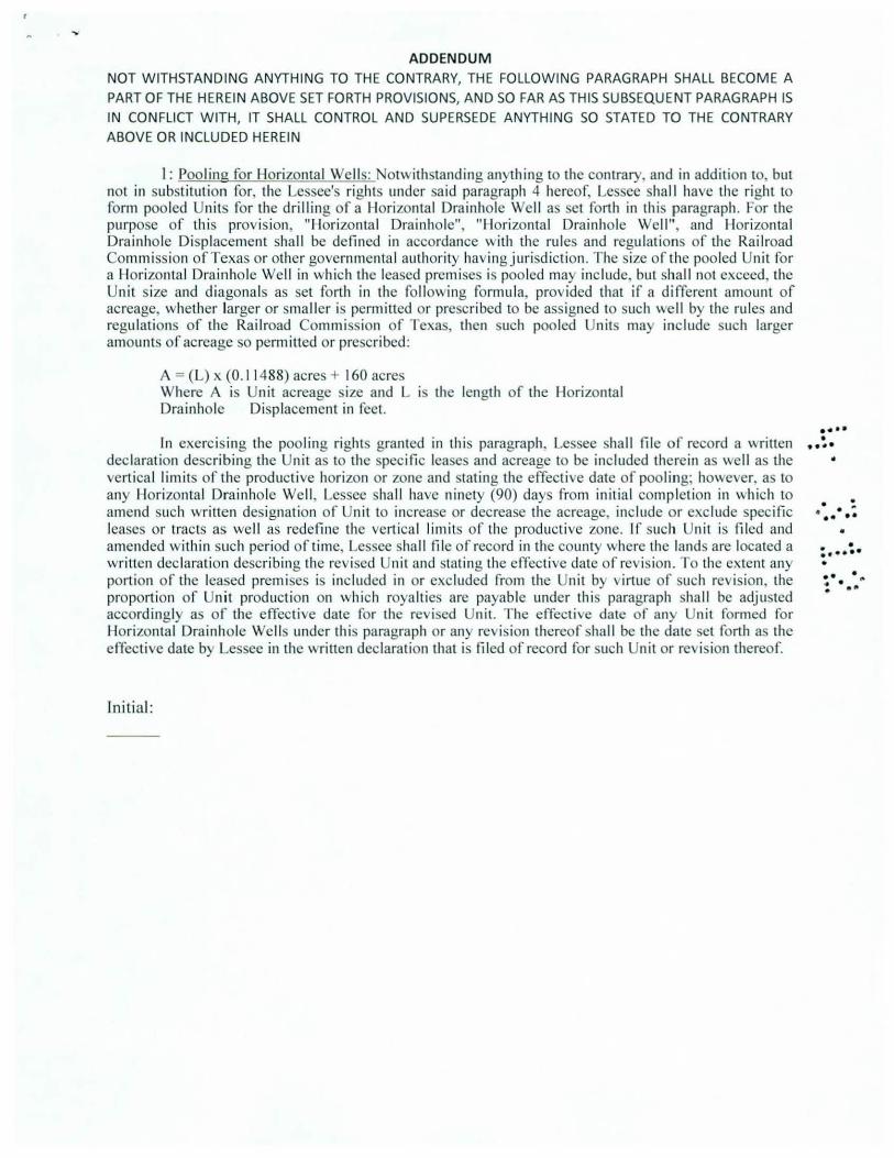
ADDENDUM NOT WITHSTANDING ANYTHING TO THE CONTRARY, THE FOLLOWING PARAGRAPH SHALL BECOME A
PART OF THE HEREIN ABOVE SET FORTH PROVISIONS, AND SO FAR AS THIS SUBSEQUENT PARAGRAPH IS IN CONFLICT WITH, IT SHALL CONTROL AND SUPERSEDE ANYTHING SO STATED TO THE CONTRARY ABOVE OR INCLUDED HEREIN
I : Pooling for Horizontal Wells: otwith tanding anything to the contrary, and in addition to, but not in substitution for, the Lessee' right under sa id paragraph 4 hereof, Le ee shall have the right to form pooled Unit for the drilling of a l lori zontal Drainhole Well as et forth in thi paragraph. For the purpose of this prov ision, "Horizontal Drainho le", "llorizontal Dra inhole Well ", and llorizontal Drainho le Displacement shall be defined in accordance with the rules and regulation of the Railroad Commission of Texas or other governmental authority having jurisdiction. The size of the pooled Unit for a llorizonta l Drainhole Well in wh ich the lea ed prcmi e i poo led may inc lude, but hall not exceed, the Unit ize and diagonals as set forth in the fo llowing formu la, provided that if a different amount of acreage, whether larger or smaller i permitted or pre cribed to be assigned to such well by the rules and regulations of the Railroad Commission of Texa , then uch pooled Unit may include uch larger amounts of acreage so permitted or pre cribed:
A = (L) x (0. 11 488) acres + 160 acre Where A is Unit acreage ize and L the length of the Horizontal Drainhole Displacement in feet.
In exercising the pooling right granted in th is paragraph. Le see hall fil e of record a \Hitten declaration describing the Unit as to the pecific lea e and acreage to be included there in as ''e ll as the vertical limits o f the productive horizon or zone and tating the effective date of pool ing; however, a to any llorizontal Drainhole Well. Lessee hall have ninety (90) days from initial completion in which to amend uch writ1en designation of Unit to increa c or decrea e the acreage, include or exclude spec ific lease or tracts as well as redefine the vert ical limits o f the productive zone. If such Unit is filed and amended within such period o f time, Les ee hall fil e of record in the county" here the land are located a written declaration describing the rev ised Uni t and tating the effective date of revi ion. To the extent any porti on of the leased premi e i included in or excluded from the Unit by irtue of uch re i ion, the proportion of Unit production on "hich roya ltie are payable under this paragraph ha ll be adjusted accordingly as of the effecti e date for the revised Unit. The effective date of any ni t formed for Horizonta l Drainhole Wells under this paragraph or any revision thereof shall be the date et forth a the effective date by Les ee in the written declaration that i filed of record for uch Unit or revi ion thereof.
Ini tial:
••• • • 9 ....
•
. . . ~ •••••
• : ... ~. • :· .. ,. . -~

Vol• 1646
NOTICE OF CONFIDENTIALITY RIGHTS: IF YOU ARE A NATURAL PERSON, YOU MAY REMOVE OR STRIKE ANY OF THE FOLLOWING INFORMATION FROM TIDS INSTRUMENT BEFORE IT IS FILED FOR RECORD IN THE PUBLIC RECORDS: YOUR SOCIAL SECURITY NUMBER AND YOUR DRIVER'S LICENSE NUMBER
MEMORANDUM OF OIL AND GAS LEASE
THE STATE OF TEXAS
COUNfY OF WILSON
§
§
THlS 1\ffiMOR..ANDUM of Oil and Gas Lease, by and between William E. Hoefelmeyer and wife, Carolyn L. Hoefelmeyer, whose address is 7147 FM 1344, Floresville, TX 78114, hereinafter called "Lessor" , and Hunt Oil Company, whose address is 1900 North Alcud Street, Dallas, Texas 75201-2300, hereinafter called "Lessee".
Wl1NESSETH: That Lessor, for a valuable consideration and in consideration of the covenants of the Lessee set forth in that ceruin Oil and Gas Lease m2de and entered into the E ffective Date of Jaowuy 16, 2012, by and between the parties hereto covering the lands hereinafter described in EXHIBIT "A" attached hereto and by reference made a part hereof, does hereby grant, lease and let exclusively unto said Lessee for the purpose of exploring, drilling. operating for and producing oil and gas from, all th2t certain tract of land containing 94.40 acres, more or less, as descnbed on the a.ttachcd EXHIBIT "A" and being situated in Wilson County, T exas. _
The teon of said Oil and Gas Lease is from the aforesaid Effective Date until January 16, 2015 and so long thereafter as oil and/or gas is being produced in paying quantities from the Leased Premises, or land pooled therewith, or so long thereafter as drilling, deepening or reworking operations for the production of oil or gas are being conducted hereon, as therein provided.
Refe.rence is hereby nude to executed copy of said Oil and Gas Lease in possession of Lessor and Lessee, respectively, for all o f the provisions thereof, and by this reference same are incorporated herein and m2de a part hereof in all respects as ·though fully set forth herein. Said Lease refc.rred in this Memorandum shall be governed by its own covenants and this Memorandum is executed for the purpose of filing this instrument o f record in the Official Public Records of Wtlson County, Texas, to give notice to aU third parties dealing with Lessor or Lessee or with the lands described in EXHIBIT "A" attached hereto o f the existence of the O il and Gas Lease. The Oil and Gas Lease and this Memorandum shall be binding upon Lessor and Lessee and their respective heirs, successors, representatives, and assigns.
IN WITNESS WHEREOF, the parties hereto have caused this Memorandum of Oil and Gas Lease to be executed this ~day of ::fA,.......,_ It r /' , 2012
LESSOR:
ACKNOWLEDGMENT
STATE OF TEXAS
COUNTY OF 0J ·, ~ S 6 t-J
§
§
./-\,.. -s-This instrument was acknowledged before me on th~<. S day of ""-'"' v "" ..r '1 2012, by William E.
Hoefelmeyer and wife, Carolyn L. Hoefelmeyer. -1
Notary Public. State of Texas . 1
ANot!.E- ~ · bA...V<"orv Nota~'s name (printed);
I.- I o -~o \ ~ Notary's Coaun.ission expires
,-~~r;~,, ANDRE I . DAWSON f·~~··· ·-~~.- Notary Public. State of :rex as ~ ,:. .=.. My Commission E~tptres '-~il tl;..... Jonuory 1 o, 2013 .........
• PG 832
••• 1
• •••• •
• • . . ' •••• •
• • •••••• • • • • • • • • ••
.. . ...., ........ ~ -· ... "'"'
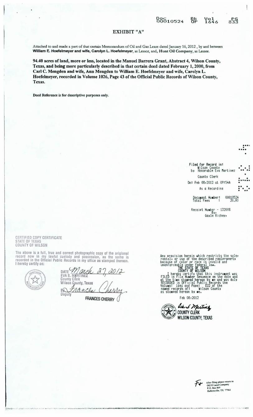
EXHIBIT "A"
Doc 0 001 0524
Vol 1646
Attached to and mad~ a part of that certain Memorandum of Oil and ~s Lease dated January 16, 2012, by a.nd between William E. Hoefelmeyer and wife, Carolyn L Hoefelmeyer, as Lessor, and, H u nt O il Company, as Lessee.
94.40 acres of land, more or less, located in the Manuel Barrera Grant, Abstract 4, Wilson County, Texas, and being more particularly described in that certain deed dated February 1, 2000, from Carl C. Mengden and wife, Ann Mengden to William E. Hoefelmeyer and wife, Carolyn L. Hoefelmeyer, recorded in Volume 1026, Page 43 of tbe Official Public Records of Wilson County, Texas.
Deed Reference ~ for descriptive purposes only.
Filed for Record in : II i lson Count~
b~ Honorable Eva Mart inez
Count~ Clerk
• •• • • ••••
• • • • • • • • • •
• • •••••• • On : Feb 08t2012 at 09 : S~A
As a Recording •• • . . .
CERTIFIED COPY CERTIFICATE STATE OF TEXAS COUtJTY OF WILSON
The above is a full , true and correct photographic copy of the orlgional record now in my lawful custody and possession, as the same is recorded in the OffiCiill Public Records in my ollice as stamped thereon. I hereby certifY on:
~Cl~~ ;q ao /J-caunty Cl rk Wilson C unty, Texas
B &.
Oocurent Huaber : Toto Fees :
. . .. 0001052~
20 .00
ReceiPt Huab~r - 132008 I)~ I
Ga~le Ri o:he!it
An~ Prov ision herein wh ich restricts the salet rentnl t or use of the described rea lProPer t~ because of ~1olor or race i~ invalid and unenforceab e under federal law.
l~HY~A6f ~L~~s I ~er~b!! 1:er t if~ that this i nstrua!!nt was
FILED 1n File Huaber Sequence on the date and at th';_ ti t~e !i.tai!Pt:d h~reQI\ b~ ae and was du l~ RECORuEO 1n Off1c1ol Publ1~ Recprds the Voluae: 16~6 and Page : t32 of the naMed records of : Wilson Count~ as staaPed hereon b~ ae.
Feb 0Br2012
1~..1 M-~7~~ COUNlYCLf~ WILSON COUNTY, TEXAS
Af•cr rm .. , plc.a.u n1Unl .. OC~I Land C ... pony P.O. Bool49 ll t tl<ll>'ill<· TX 77W
";;.•"'¥41;....... ~ .. ,. ~ ••• ... ,_ 1 . '"' •• ..,. ., -~· ., • •- ••' ___ __ .,.,......_~l''•·•~_.........,_ __ ,.,....._,.~,.~..,.. ................. ~< ' • .. · • .... ,,......., ..... ""~' 1'..,.._ _ __ .,...., .._ - -- ·-~•-.. 10'· .. ... ,....,. ' ·• • '•"• .. <JII/"'~

. ·.
MAY
: YOUR .:o I 0
L..::..=...~:.:..:.:=-==-=-.:....:.=-.:....::-=--=-.:_...:...._.:_ ____ ________ _________________ --'.,1 ,·;
.... MEMORANDUM OF OIL AND GA LEA E
TilE STATE OP T EXAS §
CO NTY OF WILSON §
THIS t-. IEt-. lORANDUt-.1 of Otl and Gas Lease, by and berween lrmgard Mue nchow, a widow, dealing in her sole a nd sepa ra te property, by Theresa M. Lee, Attorney-in-Fact, whose address 1s 7272 FM 1344, Floresville, TX 781 14, heremafter called "Lessor". and TJun t O il Company, whose address IS 1900 North Akard tree t, D a llas, Texas 75201-2300, hereinafter called "Lessee".
WITNESSETII: Thar Lessor, for a valuable cons1derauon and 111 cons1derauon of the covenants of the Lessee get forrh 1n that certain Otl and Gas Lease made and cmcted 11110 the Effccuvc Date of February 16, 2012, by and between the parucs hereto covenng the lands hetCJnafter dcscnbecl m EXJ JJBIT "-\" auached he1eto and b}' tcference made a patt heteof, dues he1·eby gtam, lease and ler exclus1vely unto said Lessee fot the purpose of explonng, dttlLng, operaung for and producmg otl and gas fmm, all that cena1n tract of land cont:un1ng 58.00 acres, more or less, as described on the attached EX.l!IBrr "J\'' and bemg sm1atcd 111 Wilson Counry, Texas.
The tcun of s:ud Oil and Gas Lease IS from the aforcsmd Effecuve Date unul February LG, 2015 and so long thereafter as otl and/ or gas IS bemg pLOducecl u1 paymg tluanuues from the Leased Ptcnugcs, or land pooled thcrcwnh, 01
so long thereafter as dulling, deepenmg 01 teworking operations for the proclucuon of oil or gas ate bctng conducted hereon, as thetetn ptov1ded.
1-' CCl C:.• ...a
-'---
:··· •••• •
• • • • • •••• •
Refetence IS hereby made to executed copy of srud Oil and Gas Lease in possessiOn of Lessot and Lessee, : ••• :. respectively, for all of the provisions theteof, and by tlus reference same arc mcotporatecl herell1 and made a pall herco( •
• 111 all respects as though fully set fort.h herem. Said Lease referred m this Memorandum shall be governed by 1ts ow1--: • •• • covenants and this Memorandum IS executed for the pULpose of fiLng thts u1strumcnt of tecorcl 111 the Off1c1al Publ.tc Records of \\ltlson Coun ry, Texas, to g1vc nouce to all tlurd parues deall!1g wnh Lessor or Lessee or w!lh the lands described 1n EXJ IlBIT "A" a reached hereto of the existence of the Ou and Gas Lease. The 01l and Gas Lease and tlus Memorandum shall be bindtng upon Lessor and Lessee and the1r rcspecuvc hcus, successors, tepresentauves, and ass1gns.
IN WITNESS WHEREOF, t.he parues hereto have caused th1s l'vlemorandum of Ot.l and Gas Lease tO be executed thts -7- clay of 01. A-Re ~I , 2012.
LESSOR:
lrm a rd Mue nchow, a widow, by T heresa M. Lee, Attorn ey-in-Fac t
ACKNOWL EDGMENT
ST,\TE O J· TEXAS §
COUNTYOF~ §
This lnsu-ument was acknowledged before me on the]_ day of 'l\,1\a v(JJ. Lee, Attorney-in-Fac t fo r lrmgard Muenchow, a widow.
:. IAH ( r TEXAS, COUNTY OF WILSON I ... ~o t iNtCIId CTIO c:l!'l c- r tc;;B:~~ cn t.:;
• n 1111 ~~~ oo:t 111 V...-.JO (.u'·r.
~' • Eva S. Mat11nez Court
• • W~son .tyoorlty. lex~ • .4/ '1:::!f7-t~/L
• Oa ORALIA VELA
2012, by Theresa M.
j
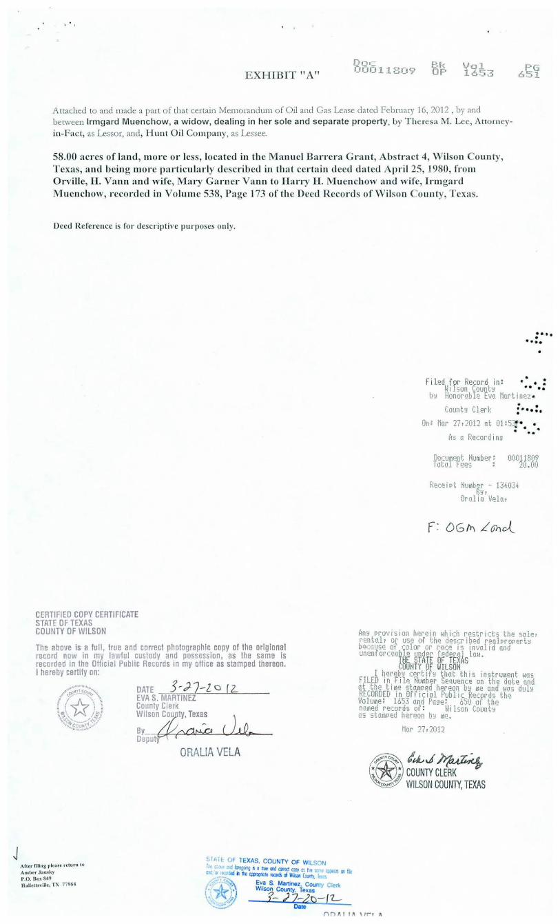
EXHIBIT II A" Doc 000118()9 Bk
OF' Vol 1653
PG 651
A LLached LO and made a part of that cenain Memoranuum of Oil and Gas Lease dated february 16, 20 12 , by and between lrmgard Muenchow, a widow, dealing in he r sole and separate property, by T heresa M. Lee, Atto rneyin-Fact, as Lessor, and, Hunt O il Company, as Lessee.
58.00 act·es of land , more or le s, loca ted in the Manuel Ban-era G t·ant, Abstr·act 4, Wit on ount)', Texas, and being more particularly de cri bed in that certain deed dated April 25, 1980, from Orville, H. Vann and wife, Mat-y Gamer Vann to llan-y H. Muenchow and wife, lrmgat·d M uenchow, recot·ded in Volume 538, Page 173 of the Deed Record of Wilson Coun ty , Texas.
Deed Reference i fo r descriptive purpo cs only.
CERTIFIED COPY CERTIFICATE STATE OF TEXAS COUNTY OF WILSON
The above is a full, true and correct photographic copy of the orlglonal record now in my lawful custody and possession, as the same Is recorded in the Official Public Records in my office as stamped thereon. I hereby certify on:
Aflt.t filing pl~nse ··c.t urn to Ambt r Jansky P.O. llox 849 Hnlleu sville. TX 77964
DATE 3 ~,) 2 -l 0 ( 2... EVA S. MARTINEZ County Clerk
Wilson c~t Tex~ sy {t~aHvD Deput
(1.Q,_
ORALIA VELA
~IAlt OF TEXAS. COUNTY OF WILSON eX • a.j ~fP'J a o tue Cl'ld c~ea CO!I'f c: r.e " 1;;1.!:1\ IJI ~
~ n 1111 C~lt IOds o/ Vlo11011 (O<I'•f,
1 *• ~';:. Eva S. Mat1lnez. COI/I" ric j' . ':) Wtlson County, Texas \' ,/ f.-) 2~2p-( 1.-~ o ••
:··· •••• •
Filed for Record in: • • • : Wilson Count!! •• ••
bY Honorable Eva Marttnez•
CountY Clerk • • :-.... On: Mar 27r2012 at 01:5~·· •
• 1 . .. As a Re.:ord tn9
D!KU(~ent tlumber: 00011809 Total Fees : 20.00
Receirt Humber - 134034 B:,~r
Oralia Velar
AnY Provtsion herein which restricts the saler rentalr or use of the des•:r i bed reo.lprorert::J because of color or race is invalid and unenrorcea~A~ ~?art firdrt~Aslaw.
COUHTY OF WILSOH I hereby cer tifY that this instrumPnt was
FILED in.File Hu~tber Sequence on the date and at the ttme stamPed hereon bY me and was dulY RECORDED in Qfficial Public Records the Volume: 165J and Pa9e: 650 of the named records of: Wilson CountY as stamPed hereon b~ me.
Mar 27r2012
~~..~~ COUNTY CLERK WILSON COUNTY, TEXAS
l"'nll t lll\lr-rA

Doc Bk 00040524 OP
Vol 1490
NOTICE OF CONFIDENTIALITY RIGHTS: IF YOU ARE A NATURAL PERSON, YOU MAY REMOVE OR STRIKE ANY OF THE FOLLOWING INFORMATION FROM THIS INSTRUMENT BEFORE IT IS FILED FOR RECORD IN THE PUBLIC RECORDS: YOUR SOCIAL SECURITY NUMBER AND YOUR DRIVER'S LICENSE NUMBER
MEMORANDUM OF OIL AND GAS LEASE
THE STATE OF T E XAS
COUNTY OF WILSON
§
§
THIS MEMORANDUM of Oil and Gas Lease, by and between Mark H osek and wife, Rose H osek, whose address is 3428 CR 206, Floresville, Texas 78114, hereinafter called "Lessor", and Hunt Oil Company, whose address is 1900 North Akard Street, Dallas, Texas 75201-2300, hereinafter called "Lessee".
WI1NESSETH: That Lessor, for a valuable consideration and in consideration of the covenants of the Lessee set forth in that certain O il and Gas Lease made and entered into the Effective Date of December 8, 2008, by and between the parties hereto covering the lands hereinafter described in EXHIBIT "A" attached hereto and by reference made a part hereof, does hereby grant, lease and let exclusively unto said Lessee for the purpose of exploring, drilling, operating for and producing oil and gas from, all that certain tract of land containing 99.84 acres, more or less, as described on the attached EXHIBIT "A " and being situated in Wilson County, Texas.
The term of said Oil and Gas Lease is from the aforesaid Effective Date until December 8, 2011, also being subject to the terms o f the said lease and so long thereafter as oil and/ or gas is being produced in paying quantities from the Leased Premises, or land pooled therewith, or so long thereafter as drilling, deepening or reworking operations for the production of oil or gas are being conducted hereon, as d1erein provided.
• ••• • •••• •
• • • • • • ••• •
• • •••••• • Reference is hereby made to executed copy of said Oil and Gas Lease in possession of Lessor and Lessee, respectively, for all of the provisions thereof, and by this reference same are incorporated herein and made a part hereo f in •• • • • • all respects as though fully set forth herein. Said Lease referred in this Memorandum shall be governed by its own • • • covenants and this Memorandum is executed for the purpose of filing this instrument of record in the Official Public Records of Wilson County, Texas, to give not.ice to all third parties dealing wid1 Lessor or Lessee or with the lands described in EXHIBIT "A" attached hereto of the existence of the Oil and Gas Lease. The Oil and Gas Lease and this Memorandum shall be binding upon Lessor and Lessee and their respective heirs, successors, representatives, and ass1gns.
IN WITNESS WHEREOF, d1e parties hereto have caused this Memorandum of Oil and Gas Lease to be e..xecuted December 8, 2008.
LESSOR
Mark Hosek Rose Hosek
PORTiONS OF TH/ NOT BE LEGIBL S DOCUMENT MAY WHEN RECEivEf(REPROOUCiBLE
ACKNOWLEDGMENT FOR RECORDING
STATE OF TEXAS
COUNTY OF WlLSON
§
§
This instrument was acknowledged before me on the 8 day of "De~Q.Mb:..r 2008,
by Maik Hosek and wife, Rose H osek.
Od# otary Public, State ofTe..xas
Notary's name (piinted); Notary's Commissio n expires
------------ -----------·-----
BRADLEY l. TYLER Notary Public, State of Texas
My Commission Expires September 29, 2010

EXHIBIT "A"
Doc Bk 00040624 OP
Vol 1490
Attached to and made a part of that certain Memorandum of Oil and Gas Lease dated December 8, 2008, by and between Mark H osek and wife, Rose Hosek, as Lessor, and, Hunt Oil Company, as Lessee.
99.84 acres, more or less, located in the D. G. Flores Grant, Abstract 13, Wilson County, Texas, and being described in that certain Warranty Deed dated October 19, 1994, from Harvey H. Doege to Herbert Doege, ct al, recorded in Volume 868, Page 565 of the Deed Records of Wilson Coun ty, Texas.
Deed Reference is for descriptive purposes only.
F1l ed1tor Record 1n:
Wi son County by Eva S. Mar·tine.z
Count y Cl er·k
• ••• • ..... •
. . . . ••••
• • • •••••• • •• • . . . . . ..
On: J an 13, BLJtC!19 at fM:31 P
/ Please return to: Brusca to-Tyler Land & Title, Inc. P. 0. Box 760728 San Anton io, Texas 78245
CERTIFIED COPY CERTIFICATE STATE OF TEXAS COUNTY OF WILSON
~s a Recor·ding
Document Number·: Tot al Fees
00@4@624 21..11.'. 12itlt
Receipt· Nurnber - 85762 By,
bayl e Richey,
l~ftlli'Ovisio~. h~rt>in1wutll restricts tht sajP,_ rn1a1L or m ot he •leSITlbM rea pNp<rty bemse ot co or or racf I' iuralid a!1d uuenforcPablP wxfer tedetal lall. •
ll£ SlAl E If TEllS lll.tHY tf WIW
. I hEreby certify that this instruunl Mils FilED in Ill~ lf11b!r Sl>queoce on the dab a!ld a' the tise sta'p~d hmon ily n and was duly Fll!illiiil in llfficiai Public kPt11Til~ tl1~ Voluat: WJS aJ:d ~age : :!43 of the nmd l'fc~ros of: Wihon County as sla•J*d her~on by t P.
Jan B, 2009
ei~J~ COUNTY CLERK CJ
WILSON COUNTY, TEXAS

Doc Bk 00039375 OP
Vol 1483
NOTICE OF CONFIDENTIALITY RIGHTS: IF YOU ARE A NATURAL PERSON, YOU MAY REMOVE OR STRIKE ANY OF THE FOLLOWING INFORMATION FROM THIS INSTRUMENT BEFORE IT IS FILED FOR RECORD IN THE PUBLIC RECORDS: YOUR SOCIAL SECURlTY NUMBER AND YOUR DRIVER'S LICENSE NUMBER
MEMORANDUM OF OIL AND GAS LEASE
THE STATE OF TEXAS
COUNTY OF WILSON
§
§
THIS lvffiMORANDUM of Oil and Gas Lease, by and between Matthew J. Zillmann, et ux Virginia M. Zillrnann, whose address is 7040 FM 1344, F loresville, Texas 78114, hereinafter called "Lessor", and Hunt Oil Company, whose address is 1900 N orth Akard Street, Dallas, Texas 75201-2300, hereinafter called "Lessee".
WI1NESSETH: That Lessor, for a valuable consideration and in consideration of the covenants of the Lessee set forth in that certain Oil and Gas Lease made and entered into the Effective Date of September 11, 2008, by and between the parties hereto covering the lands hereinafter described in EXHIBIT "A" attached hereto and by reference made a part hereof, does hereby grant, lease and let exclusively unto said Lessee for the purpose of exploring, drilling, operating for and producing oil and gas from, all that certain tract of land containing 100 acres, more or less, as described on the attached EXHIBIT "A" and being situated in Wilson County, Texas.
The term of said Oil. and Gas Lease is from the aforesaid Effective Date until Sep tember 11, 2011, also being subject to the terms of the said lease and so long thereafter as oil. and/ or gas is being produced in paying quantities from the Leased Premises, or land pooled therewith, or so long thereafter as drilling, deepeoing or reworking operations for the production of oil or gas are being conducted hereon, as therein provided
Reference is hereby made to e.:<ecuted copy of said Oil. and Gas Lease in possession of Lessor and Lessee, respectively, for all of the provisions thereof, and by this reference same are incorporated herein and made a part hereof in all respects as though fully set forth herein. Said Lease referred in this Memorandum shall be governed by its own covenants and this Memorandum is executed for the purpose of filing this instrument of record in the Official Public Records of Wilson Couory, Texas, to give notice to all third parties dealing with Lessor or Lessee or with the lands described in EXHIDIT "A" attached hereto of the existence of the Oil and Gas Lease. The Oil and Gas Lease and this Memorandum shall be binding upon Lessor and Lessee and their respective heirs, successors, representatives, and ass1gns.
IN WITNESS WHEREOF, the parties hereto have caused this Memorandum of Oil and Gas Lease to be executed September 11, 2008.
LESSOR
, u
Matthew J. i ann
2 -2.3-2LJI~ t3,(:
J
•••• • • ••• •
• • • • • •• •• •
• • •••••• • • • • • • • • ••
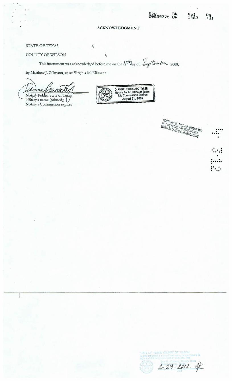
STATE OF TEXAS §
COUNTY OF WILSON
ACKNOWLEDGMENT
§
Doc Bk 00039375 OP
This instrument was acknowledged before me oo the /(#Jay of ~ ~ 2008,
by Matthew J. Zillmann, et ux Virginia M. Zillmann.
DIANNE BRUSCATO-TYLER Notery Public, State of Tex,s
My Commission Expires AUgust 2l, 2009
Vol 1483
•••• • •••• •
• • • • • •• •• •
• • •••••• • • • • • • • • ••
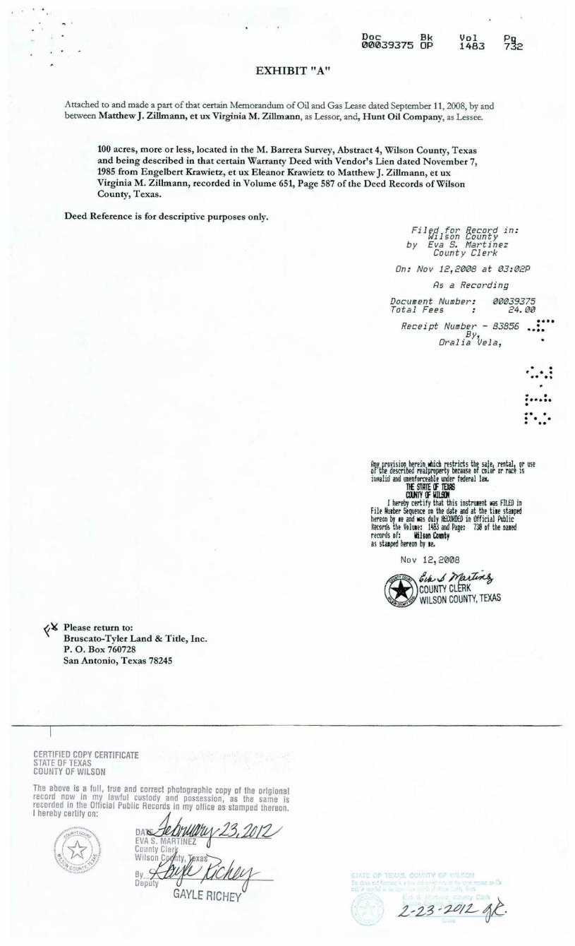
EXHIBIT "A"
Doc Bk 00039375 OP
Vol 1483
Attached co and made a part of that certain Memorandum of Oil and Gas Lease dated September 11, 2008, by and between Matthew J. Zillmann, et ux Vtrginia M . Zillmann, as Lessor, and, Hunt Oil Company, as Lessee.
100 acres, more or less, located in theM. Barrera Survey, Abstract 4, Wilson County, Texas and being described in that certain Warranty Deed with Vendor's Lien dated November 7, 1985 from Engelbert Krawietz, et ux Eleanor Krawietz to Matthew J. Zillmann, et ux Virginia M. Zillmann, recorded in Volume 651, Page 587 of the Deed Records ofWilson County, Texas.
Deed Reference is for descriptive purposes only.
~~ P lease return to: Bruscato-Tyler Land & Tide, Inc. P . 0. Box 760728 San Antonio, Texas 78245
CERTIFIED COPY CERTIFICATE STATE OF TEXAS COUNTY OF WILSON
The above Is a full, true and correct photographic copy of the orlgional record n~w In my lawful _custody and possession, as the same Is recorded 1n !he Of11cial Public Records In my office as stamped thereon. I hereby certify on: ~
/.;,;_:;;;_;;~ ~~ S. MAR~J, Jf!V • (~ \, £ County Cler \ <~ ~ I"'! Wil C I ...... ~:-... .. / ... .::-'" son 1 y, xas ~·{+co~'-t.~ .. ·'
'••, I ,.,,,1•
Filed for Record in : Wi 1 son County
by Eva S. Martinez County Clerk
On: Nov 12,20@8 at @3:02P
~s a Recording
Docu11ent Number : Total Fees
0@rt139375 24. 00
Receipt Number· - 83856 By,
Or•alia Vela,
•••• • -··· • • • • • •• ••
. . f • • •••
• . . . • • • • ••
~f. lll'D~i~iOII hmin ~c:D rtstricts the sajr1 mt~1 qr us! of tilt descr1~ realpropmy bmase of 1.1 or 1r T'GCt IS invalid and unntemablt WK!rr federal law.
11£ STATE Cf lEif6 aufJY IF IIJlSJI
l hfreby cmify tM this instl"'ll!llt vas Fl!.£D in Filt l«lrb!r Stqu!ntt DR the dab illd at tllr ti~r staJjltd henon by If and lli!S d•ly emro io Official Pllblic KK'fl~ U,t Vtlun: 148:! a00 Page: 7'J of tbe Dilled rft'Ol'ds af: ltilhll Caaty as sta~ptd hrmn by I f.
Nov 12,2008
@!~J~ COUNT'i CLERK v
WILSON COUNT'i, TEXAS
• • 4 ~· . . .. . . . . . • • • • • • • ••• • •• •
• . • • • • •• • . File No. l ) 'L\ II 'Z._
•

May 16,2012
Mr. Chance Turner Hunt Oi l Company 1900 North Akard Street Dallas TX 7520 1
Dear Mr. Turner,
Re: State ofTexas HROW Lease # MF 114112
Enclosed you will fi nd an origina l executed Highway Right-of-Way lease in Wilson Coun ty.
Please proof read the lease before filing of record and refer to this lease number with all correspondence.
Please have your client provide the GLO with a copy of the Unit Designation after this lease has been added and the unit designation recorded.
If you have any questions p lease fee l free to contact my direct phone number, or email address li sted below, or contact George Martin at his direct number (5 12) 475-1512.
Best regards,
Beverly Boyd Energy Resources Minera l Leasing 5 12-463-652 1 beverly. [email protected]. tx.us
rcphcn F. Austin Building · 1700 lorrh Congress t\ vcnuc · Austin, Texas 78701- 1495
Po~t Office Box 12873 • 1\ usti n, Texas 78711 -2873
512- -t63 -5001 • 800-998- 4G LO
www.glo.statc. tx. us

File No. 1 I L-r 11 -z:...
Date Filed: 5 /tw /t-z-JeiTY E. Patterson, Commissioner
By &If
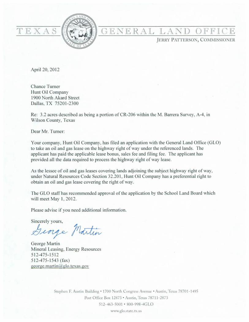
April 20, 20 12
Chance Turner Hunt Oi l Company 1900 North Akard Street Dallas, TX 7520 1-2300
Re: 3.2 acres described as being a portion of CR-206 within theM. Barrera Survey, A-4, in Wilson County, Texas
Dear Mr. Turner:
Your company, Hunt Oil Company, has fi led an application with the General Land Office (GLO) to take an oi l and gas lease on the highway ri ght of way under the referenced lands. The applicant has paid the applicable lease bonus sales fee and filing fee. T he appli cant has provided all the data required to process the highway right of way lease.
As the lessee of oil and gas leases covering lands adjoining the subject highway ri ght of way, under Natural Resources Code Secti on 32.20 I , Hunt Oi l Company has a preferential right to obtain an o il and gas lease covering the ri ght of way.
T he GLO staff has recommended approval of the application by the School Land Board which will meet May f , 20 12.
Please advise if you need additional information.
Sincerely yours,
1;~~ George Martin Mineral Leasing, Energy Resources 512-475- 15 12 5 12-475- 1543 (fax) george.martin@ glo. texas .gov
·tcphcn F. Austin Bui ld in~ · 1700 \Jorth Congrc~~ \ venue · r\usrin,Tcxa~ 78701-1495
Posr Orti~:c Box 12873 · Austin, Tcxa; 78711-2871
512- 463-5001 • 800-998-4C IJO
WW\\.glo.sr:nc.tx. u;

File No. l } L(f ( 'L-

.i
Unit N umber
DO NOT DESTROY
Texas General Land Office
UNIT AGREEMENT MEMO
5898
H UNT OIL COMPANY
C()()()()()239R
PA12-427
Effective Date 6/812012
Unitized For Oil & Gas
Unit Term 0 Months
Operator Name
Customer ID
Unit Name
County}
James Wiatrek #1 H
Wilson Old Unit Number Inactive Status Date
County 2
County 3
RRC District: OJ
Unit Type: Permanent
State Royalty Interest:
State Part in Unit:
All
0.0016853157
0.0084265783
Well: Other
0
0
0
0
0
Unit Depth
Below Depth
Above Depth
0 8340
Formation: Correlative Well- EaPie Ford I
Participation Basis: Surface A creaPe
{If Exclusions Apply: See Remarks}
MF Number 114112 Tract Number 13
Lease Acres 2.9 I Total Unit Acres 723.9
Tract Participation: 0.0040061 X Lease Royalty 0.2 Manual Tract Participation: Tract Royalty Participation 0.0008012 Manual Tract Royalty:
No Tract Royaly Reduction
Tract Royalty Rate
Tract On-Line Date:
Friday, August/0, 2012
0
PA12-427 Unit Number 5898
L = = = = 0i See Remarks! r----<>1
Page I of2
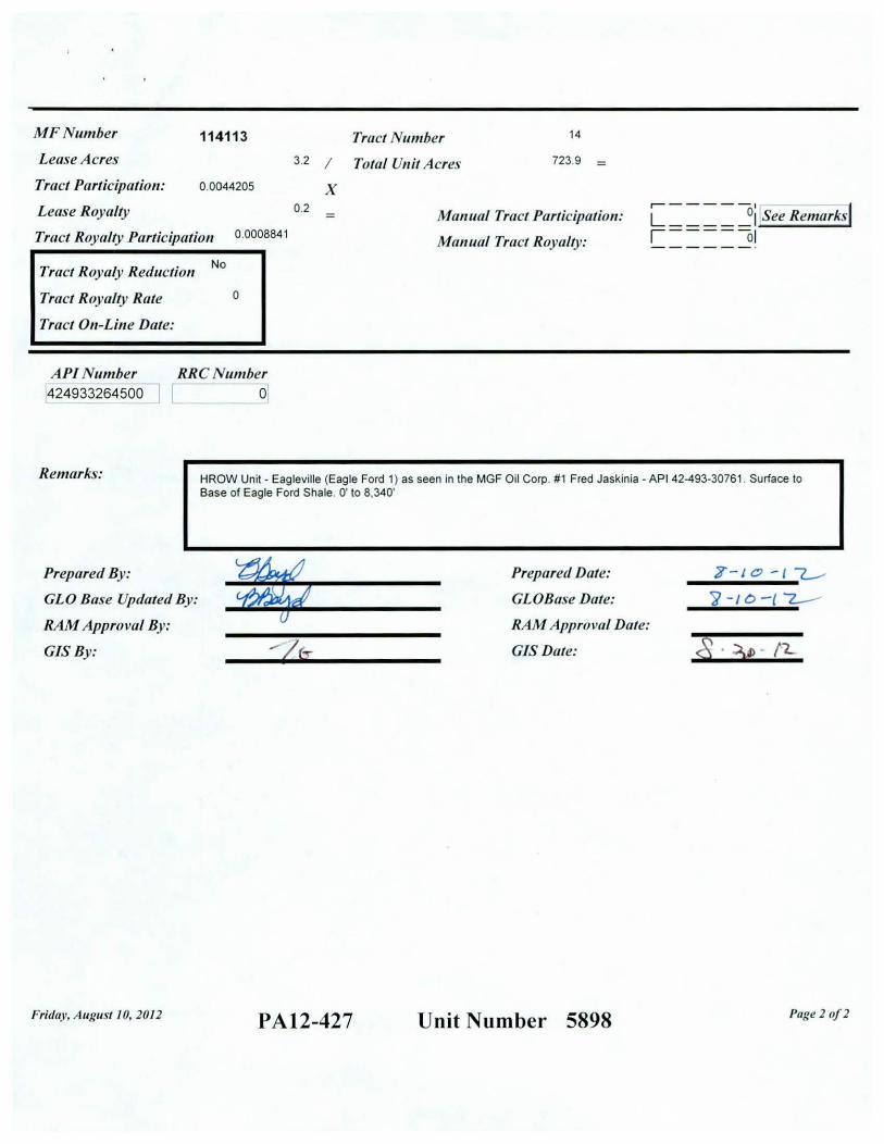
MF Number
Lease Acres
114113 Tract Number 14
Tract Participation: 0.0044205
Lease Royalty
Tract Royalty Participation 0.0008841
No Tract Royaly Reduction
Tract Royalty Rate
Tract On-Line Date:
API Number 424933264500
0
RRCNumber 0
3.2 I Total Unit Acres 723.9
X 0.2 Manual Tract Participation:
Manual Tract Royalty : L = = = = 0i See Remarks! ~----ol
Remarks: HROW Unit- Eagleville (Eagle Ford 1) as seen in the MGF Oil Corp. #1 Fred Jaskinia - API 42-493-30761 . Surface to Base of Eagle Ford Shale. 0' to 8,340'
Prepared By :
~ Prepared Date: 7-Jo-t-z_....
GLO Base Updated By : GLOBose Date: ~ _, 0 -{ '7....-
RAM Approval By: RAM Approval Date:
GIS By: -i.J. ... GIS Date: ;s ~j) /?....
Friday, August 10, 2012 PA12-427 Unit Number 5898 Page 2 of2

,•
STATE OF TEXAS
COUNTY OF WILSON
UNIT DES IGNATIO .
JAM ES WI A T REK # I H OIL AI"'D GAS U fT W ILSO CO U TV, T EXA
§ § §
KNOW ALL MEN BY THESE PRESENTS:
WHEREAS, Hunt Oil Company, ("llunt"), whose address is 1900 North Akard Street, Dallas, Texas 75201-2300 and Marubeni Eagle Ford LP, ("Marubeni") whose address is 2800 Post Oak Boulevard, Suite 6000, Houston, Texas 77056, (collectively Hunt and Marubeni, the " Lessees") are the present owners of the Oil and Gas Leases (the "Leases" or "Unit Leases") described in Exhibit "A" anached hereto; and
WHEREAS, under the terms of each of the Leases, the owner of the Leases has the right to consolidate, pool and unitize the lands covered thereby or ponions thereof into one or more drilling or production units for the exploration for, development and production of oil, gas, condensate and all associated hydrocarbons produced therewith (collectively, "Oil"); and
WHEREAS, in lhe judgment of Hunt, acting on its behalf and on behalf of Marubeni, it is necessary and advisable to pool or unitize the Leases, insofar and only insofar as the Leases or ponions thereof cover 723 .9 acres, the boundaries of which are portrayed on the plat anached hereto as Exhibit "B" (the "Unit Area"), in order to properly explore, develop, produce and operate the Unit Area for and to promote the conservation of Oil.
NOW, TIIEREFORE, pursuant to the rights, power and authority granted in the Leases and by virtue of this Unit Designation, the Lessees do hereby pool, combine and unitize the Unit Area into a single pooled unit for the exploration for, development and production of Oil and all other productS from said oil well. The production of such Oil and other products from an oil "ell from any part of said unit acreage shall constirute production of such products li'om all of the Leases contained in such unit. This des ignated oil unit is named the "James Wiarrek # I H" and consists of the Unit Area, as to the stratigraphic equivalent of the depths, sands and formations lying between the surface of the eanh down 10 and including 8,340' subsurface (surface to the base of the Eagle Ford Shale Formation) as seen on the log for the MGF Oil Corporation Il l Fred Jaskinia (API #42-493-30761 located in Abstract-4, Wilson County, Texas) for the purpose of conducting drilling or reworking operations and for the production and handling of pooled Oil therefrom.
The entire acreage pooled and combined into the James Wiatrek # I H Unit as created by this Unit Designation and all drilling and other operations conducted upon, and production of Oil from such acreage, shall for all purposes be treated and considered as if such acreage was covered by, and such drilling and other operations were being conducted upon, or such production was being derived from, each of the Unit Tracts and each of the Leases. The Leases, any amendments or ratifications thereof, and all contracts and agreements concerning or relating thereto which pertain to the leasehold, mineral, royalty, overriding royalty and/or production estates and rights in and under the 723.9 acres comprising the James Wiatrck # I H Unit, and each and everyone of the Unit Tracts, arc hereby pooled, combined and unitized for the purpose of creating said James Wiarrek # I H Unit. The production of Oil from the James Wiatrek # I II Unit shall be allocated to the Unit Tracts in the proportion that the surface area of each Unit Tract bears to the total surface area of the James Wiatrek # Ill Unit.
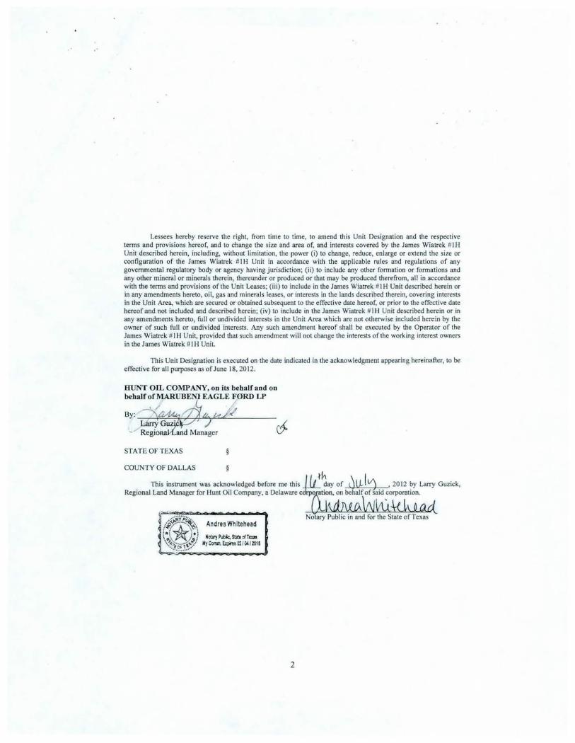
Lessees hereby reserve the right, from time to time, to amend this Unit Designation and the respective terms and provisions hereof, and to change the size and area of, and interests covered by the James Wiatrck # I H Unit described herein, including, without limitation, the power (i) to change, reduce, enlarge or extend the size or configuration of the James Wiatrck # I H Unit in accordWlce with the applicable rules and regulations of any governmental regulatory body or agency having jurisdiction; (ii) to include any other formation or formations and any other mineral or minerals therein, thereunder or produced or that may be produced therefrom, all in accordWlce with the terms and provisions of the Unit Leases; (iii) to include in the James Wiatrek # I H Unit described herein or in any amendments hereto, oil, gas and minerals leases, or interests in the lands described therein, covering interests in the Unit Area, which are secured or obtained subsequent to the effective date hereof, or prior to the effective date hereof and not included and described herein; (iv) to include in the James Wiatrek III II Unit described herein or in any amendments hereto, full or undivided interests in the Unit Area which are not otherwise included herein by the owner of such full or undivided interests. Any such amendment hereof shall be executed by the Operator of the James Wiatrek # IH Unit, provided that such amendment will not change the interests of the working interest owners in the James Wiatrek # I H Unit.
This Unit Designation is executed on the date indicated in the acknowledgment appearing hereinafter, to be effective for all purposes as of June 18, 2012.
HUNT On.. COMPANY, on iu behalf and on behalfofMARUBEN1 EAGLE FORD LP
STATE OF TEXAS §
COUNTY OF DALLAS §
This instrument was acknowledged before me this //1 t~ay of ~IJ.J tj , 2012 by Larry Guzick, Regional Land Manager for llunt Oil Company. a Delaware c~:n behalf of said corporation.
vll\ffiWhlkl o ad_ Notary Public in and for the State of Texas
2

.·
Exhibit "A"
THE LEASES
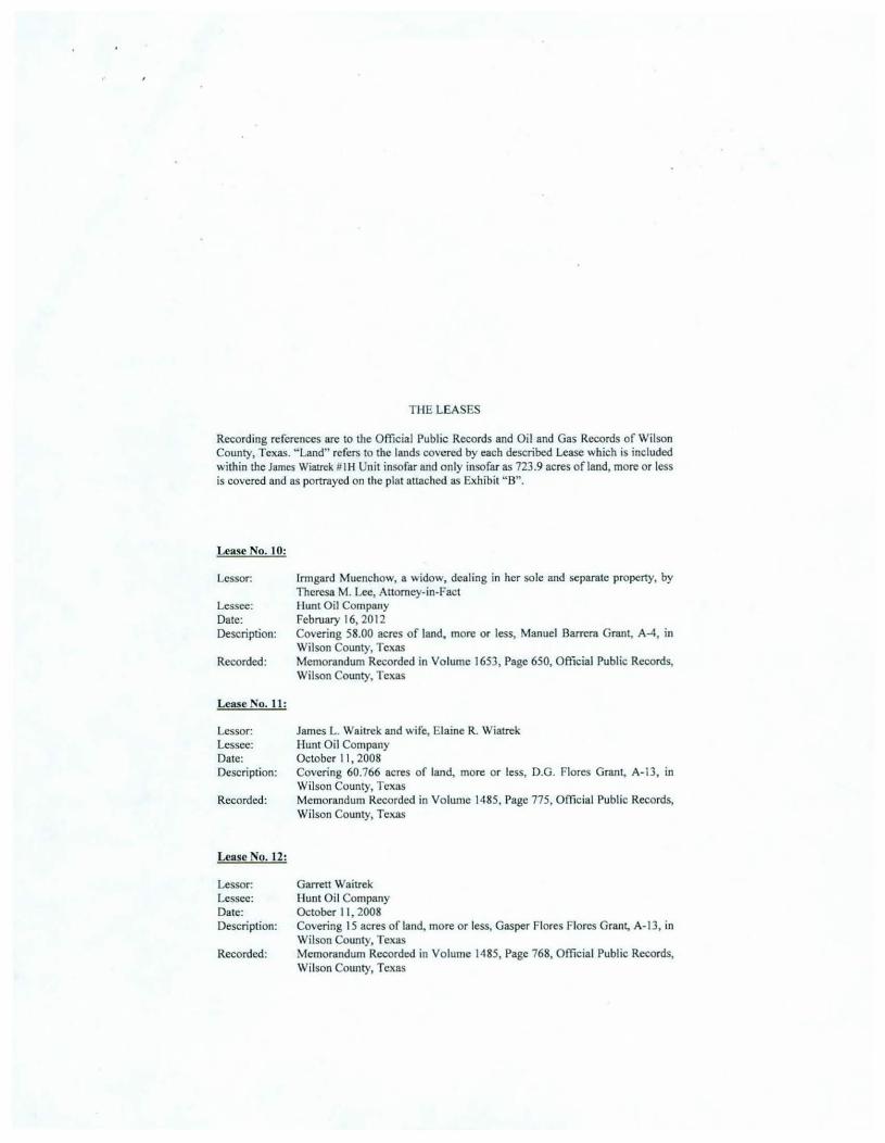
Recording references are to the Official Public Records and Oil and Gas Records of Wilson County, Texas. " Land" refers to the lands covered by each described Lease which is included within the James Wiatrek # IH Unit insofar and only insofar as 723.9 acres efland, more or less is covered and as portrayed on the plat attached as Exhibit "8 ".
Lease No. 1:
Lessor: Lessee: Date: Description:
Recorded:
Lease No.2:
Lessor: Lessee: Date: Description:
Recorded:
Lease No.3:
Lessor: Lessee: Date: Description:
Recorded:
Richard 1-1. Schulze, dealing in his sole and separate property Hunt Oil Company September 3, 2009 Covering 200 acres of land, more or less, M. Barrera Grant, A-4, in Wilson County, Texas Memorandum Recorded in Volume I 524, Page 733, Official Public Records, Wilson County, Texas
Mark Hosek and wife, Rose Hosek Hunt Oil Company December 8, 2008 Covering 99.84 acres of land, more or less, D.G. Flores Grant, A-13, in Wilson County, Texas Memorandum Recorded in Volume 1490, Page 343, Official Public Records, Wilson County, Texas
Matthew J. Zillmann, ET UX Virginia M. Zillmann Hunt Oil Company September II , 2008 Covering 100 acres of land, more or less, M. Barrera Survey, A-4, in Wilson County, Texas Memorandum Recorded in Volume 1483, Page 730, Official Public Records, Wilson County, Texas

THE LEASES
Recording references are to the Official Public Records and Oil and Gas Records of Wilson County, Texas. "Land" refers to the lands covered by each described Lease which is included \\ ithin the James Wiatrck HI H Unit insofar and o nly insofar as 723.9 acres of land, more or less is covered and as portrayed on the plat attached as Exhibit " B".
Lease No. 4:
Lessor: Lessee: Date: Description:
Recorded:
Lease No. 5:
Lessor: Lessee: Date: Description:
Recorded:
Lease No. 6:
Raymond A. Kutac and wife, Jacqueline M. Kutac I lunt Oil Company September 26, 2008 Covering 94.7 acres of land, more or less, Manuel Barrera Grant, A-4, in Wilson County, Texas Memorandum Recorded in Volume 1487, Page 774, Official Public Records, Wilson County, Texas
Richard I I. Schulze and his wife, Carolyn F. Schulze Hunt Oi l Company October 3, 2008 Covering 99.61 acres of land, more or less, M. Barrera Grant, A-4 , in Wilson County, Texas Memorandum Recorded in Volume 1499, Page 528, Official Public Records, Wilson County, Texas
Lessor: Gary W. Felux and wife, Christine E. Felux Lessee: Hunt Oil Company Date: October 17,2008 Description: Covering 161.74 acres of land, more or less, D.G. Flores Grant, A-13, in
Wilson County, Texas Recorded: Memorandum Recorded in Volume 1489, Page 85 I, Official Public Records,
Wilson County, Texas

THE LEASES
Recording references are to the Official Public Records and Oil and Gas Records of Wilson County, Texas. "Land" refers to the lands covered by each described Lease which is included within the James Wiatrck #Ill Unit insofar and only insofar as 723.9 acres ofland, more or less is covered and as portrayed on the plat attached as Exhibit "B".
Lca.~e No.7:
Lessor: Lessee: Date: Description:
Recorded:
Lease No. 8:
Lessor: Lessee: Date: Descriplion:
Recorded:
Lease No.9:
Lessor: Lessee: Date: Description:
Recorded:
Evca Lauren Haass llunt Oil Company July I, 2009 Covering 190.91 acres of land, more or less, D.G. Flores Grant, A-13, in Wilson County, Texas Memorandum Recorded in Volume ISIS, Page IS4, Official Public Records, Wilson County, Tcl(IIS
Jean Caroline llaass Hunt Oil Company July I, 2009 Covering 190.91 acres of land, more or less, D.G. Flores Grant, A-13, in Wilson County, Texas Memorandum Recorded in Volume IS IS, Page IS6, Official Public Records, Wilson County, Texas
William E. Hoefelmeyer and w ife, Carolyn L. Hoefelmeyer Hunt Oil Company January 16,2012 Covering 94.40 acres of land, more or less, Manuel Barrera Grant, A-4, in Wilson County, Texas Memorandum Recorded in Volume 1646, Page 832, Official Public Records, Wilson County, Texas
TilE LEASES
Recording references are to the Offic ial Public Records and Oil and Gas Records of Wilson County, Texas. "Land" refers to the lands covered by each described Lease which is included within the James Wiatrek III H Unit insofar and only insofar as 723.9 acres of land, more or less is covered and as portrayed on the plat attached as Exhibit " B" .
Lease No. 10:
Lessor:
Lessee: Date: Description:
Recorded:
Lease No. 11 :
Lessor: Lessee: Date: Description:
Recorded:
Lease No. 12:
Lessor: Lessee: Date: Description:
Recorded:
lrmgard Muenchow, a widow, dealing in her sole and separate property, by Theresa M. Lee, Anomey-in-Fact Hunt Oil Company February 16, 20 12 Covering 58.00 acres of land, more or less, Manuel Barrera Grant, A-4, in Wilson County, Texas Memorandum Recorded in Volume 1653, Page 650, Official Public Records, Wilson County, Texas
James L. Waitrek and wife, Ela ine R. Wiatrek Hunt Oil Company October I I, 2008 Covering 60.766 acres of land, more or less, D.G. Flores Grant, A- 13, in Wilson County, Texas Memorandum Recorded in Vo lume 1485, Page 775, Official Public Records, Wilson County, Texas
Garrett Waitrek Hunt Oil Company October I I, 2008 Covering I 5 acres of land, more or less, Gasper Flores Flores Grant, A-13, in Wilson County, Texas Memorandum Recorded in Vo lume 1485, Page 768, Official Public Records, Wilson County, Texas

Ti lE LEASES
Recording references are to the Official Public Records and Oil and Gas Records of Wilson County, Texas. "Land" refers to the lands covered by each described Lease which is included witl1in the James Wialrek FIll Unit insofar and only insofar as 723.9 acres of land, more or less is covered and as portrayed on the plat anached as Exhibit "B".
Lease No. 13:
Lessor: Lessee: Date: Description:
Recorded:
Lease No. 14:
Lessor: Lessee: Date: Description:
Recorded:
State of Texas Hunt Oi l Company May I, 20 12 Covering 4.8 acres of land, more or less, D.G. Flores Survey, A-13, in Wilson County, Texas Lease Recorded in Volume 1667, Page 263 , Official Public Records, Wilson County, Texas
State ofTexas Hunt Oil Company May I, 20 12 Covering 3.2 acres of land, more or less, M. Barrera Survey, A-4, in \ ilson County, Texas Lease Recorded in Volume 1667, Page 252, Official Public Records, Wilson County, Texas

, , I
Attached hereto and made a part of the James Wiatrek Il l H Unit Designation to made etlecuve lor all purposes as of June IS, 20 12
,,.,'""' , -------- ',,
',, \
\
Exhibit " B"
TRACT No
2
3
• 6
8
7
8 UNIT LIN[ '
10
11
12
lESSOR TABU!
RICHARD H. SCII\IL2E
WARX HOSEX. • l u IIATT!U!W l . Zll.LIIANif. el ux
WIIUAll E. HOI:I'IlJII:YER. ot
STATE OY TlllCAS
llUICARil IIUI:NCl10 W
RA YIIOICD A.. KUTAC, ol ""
RtC'HARD H. SCKUL%1, .t u:J:
STAn! 01' n:lWI
GARY W. FELliX. cl a1 JAMES L.. 1ftATREX.. et. us
CARJtETT WIATREl<
TOTAL
,~-==r-\ I I I I I I I I
I
r: :z ::; 1
I I I I I I I I \
..J
723.9ACRE U:-IIT
.... i "'
ACREAGE
200.0
51.6
88.6
78.1
2.8
57.7
37.3 88.1
3.2
18.3
82.2 1$.1
723.8
DETAIL 'A. "arT!f11l:!)Q[
g a.
' ........ _______ .., HUHT OIL COIIPAIIY l.ure5 WIATREIC 118 BO'!TOII HOI.& LOCA110N y • • 23,338' X • 2,270,278 LAT. • 28'59'41.88' N
--v----~1~~~~----+-t--====!~~---f-1011 ' lONe . • 88'08'18.1 4' 'II
HUNT OIL C:OliPAIIY lAIIES 'IIIATRI!K 1 1
PO!IIT or P~110N y • 4 UJ,134'
X • 2,272,8 15' LAT. • 28'58'00.08' N
LONC. • 98'08'47.93' 'II
D. G. FLORES A-13
1000 1000 2000
., ... ~ )(
4000
SCALE: 1" ~ 2000 FEET
5000
HUHT OIL CO liP AliY
~~~oJlll y - 423,108' X • 2,270,4-<a'
M.BARRERA A-4
LAT. • 28'58'J8.61" N L.ONC • • se·o8' ~<.28' w
HUHT OIL COIIPAIIY
=T~~Ui y - 41 9.270' X - 2,272,7 4 t' LAT. • 28'59'01.«' N LDNC. • 98'08 '48,75' 'II
15491'--\r---
HUNT OIL COIIPAifY IAILI:S 1IIA1REK 11H S\IRI'J.CI UOLE LOCAl10H y - -418,695' X • 2,27J, 15J' El.LV. 400.8' LAT. • 28'58'55.72' N LONC. • SHS"08' -4-4 .16. W
SURVEYOR NOTES:
1. COO!tOINATtS SHOWN AA£ 8A5W OH lUCAS STATE PUH: CIXlRilfW'( MIDI fS' IW. T00S SOOil4 CDt!IUI. lO£
CEN11W. ZOH£ & AA£ ~ OH WONUIIOO 'K.<SP£R ('f • 429184.954, X • 2259041.439)
2. l.ATTTIJOC ,. LOHCIT\JDE AA£ IWl 27 CEOGIW'HC J. All lEASE & TRACT INF'ORIIATIOH SHOWN HEREON IS OOHE SO BY UUITED OEEO RECORD INFORIIATION ONLY IJll THE UNOERSICNED SURYE\'OR 00£5 NOT
WARIWIT TO THE THEREOf.
PLAT OF: AN />S DRILLED LOCATION AND
AN 723.9 ACRE UNIT FOR:
HUNT OIL COt.4PANY
JAJIES '1/'JATREK #fH
SITUATED IN THE D.G. FLORES SURVEY, A-13, AND THE M. BARRERA SURVEY, A- +
APPROXIMATELY 14 .0 MILES SOUTHEAST OF FLORESVIU£ IN
WILSON COUNTY, TEXAS
12020-H.OWG
Scale· 1 • • 2000' AG/ RA
Drown oy MC/RN CB/MC
<-0 OJ

.·
Attached hereto and made a part oflhe James Wiatrek #l H Unit Designation to made effective for all purposes as of Junel8. 2012
Exhibit "B"
F~NTIER SURVEYING COMPANY
710 Buffalo St, Ste. 700 Corpus Christl, TX 78401
www.frontloraurveylng.com Office: 361/881-8044 Fax: 361 /881·8340
723.9 ACRE UNIT
Sheel2 of2
Field Notes Description
A 723.9 acre unit, JAMES WlATREK #lH, for Hunt Oil Company, being in the D.G. Flores Survey, Abstract 13, and the M. Barrera Survey, Abstract 4, situated approximately 14 miles Southeast of Floresville, in Wilson County, Texas.
Being more fully described by metes and bounds as fo llows:
BEGINNING: at a point, (Y a 426,744.45, X • 2,265,507.85}, for the Northwest comer of this herein described unit;
THENCE:
THENCE:
THENCE:
THENCE:
THENCE:
THENCE:
THENCE:
THENCE:
THENCE:
THENCE:
THENCE:
THENCE:
THENCE:
58°36'05" E - 3,333. 11 feet to a point, for the Northeast comer of this herein described unit;
S 31 °23'29" E - 2,608.21 feet to a point, for an angle comer of this herein described unit;
S 31°25'-10" E - 2,055.29 feet to a point, for an angle comer of this herein described unit;
S 29"42'21 " E - 119.22 feet to a point, for an angle comer of this herein described unit;
S 31°33'23" E: - 1,963.90 feet to a point, for an angle comer of this herein described unit;
S 31°13'58" E - 148.36 feet to a point, for an angle comer of this herein described unit;
S 31 °26'1 0" E - 2,253.66 feet to a point, for an interior comer of this herein described unit;
N SS021 '40" E - 288.78 feet to a point, for an exterior comer of this herein described unit;
S 31°32'02" E - 1,594.04 feet to a point, for the Southeast comer of this herein described unit;
S 43°46'29" W - 1,883.02 feet to a point, for the Southwest comer of this herein described unit;
32° 12'45" W - 996.44 feet to a point, for an interior comer of this herein described unit;
S 58°23' 17" W - 674.42 feet to a point, for an exterior comer of this herein described unit;
' 39°46'35" W - 7,692.17 feet to a point, for an angle comer of this herein described unit;

' Attached tu:rcto and made a part of the Jam.es Wiatrek # I H Unit Designation to made effective for all
pwposes as of June I 8, 20 12
THENCE:
Exhibit "B"
N 31"23'29" W - 2,619.34 feet to the POTNT OF BEGINNTNG, conlllining within these metes and bounds a 723.9 acre unil
NOTE: A Survey Plat rq>resenting a graphic image of this description styled as .. JAMES WIATREK litH," accompanies this document. The Basis of Bearing is Texas State Plane Coordinate System NAD 27, South Central Zone.
This Field Notes Description constitutes a legal document, and, unless it appears in its entirety, in its original form, including preamble, seal and signature:, surveyor assumes no responsibility or liability for its correctness. It is strongly recommended, for the continuity of future surveys, that this document be incorporated in all future conveyances, without any revisions or deletions. This description and the accompanying Survey Plat were prq>ared from record data furnished by the client and was done without the benefit of a Title Report. Surveyor has made no investigation or search for easements or other matters of record that a Title Repon would disclose and this survey does not represent a warranty of title or a guarantee of ownership.
July 9, 2012 Job No. 1202044 RN

I I I
I I I \ \ \
OdAtt..•A.• NclTl'1T1:lrJtlC
........... ,, ' ' ' \
\ \ I
\ I I I I
I
723.9 1\CRE UNIT
T'RACT No IZSSOR TJJl!Z
RICIWID H. BC!M.U
IU.IUt H OSJ:IC. o t .a IUmflW I 7ltJ.JU.l'Of, l lW
'II1LUAII !. HOJ:I'IUU:YER, ot u
sun: or 'l'l:l!,4
!RliG.IRD IIVE"C/IOW
IUYWOHD A. lallAC, ot U>
RICKIJUl II. SCIIIJW , ot ux
0 sr•n o•· TW~ to C}JtY 'W, n:wx. •\ .J,
II IUII!8 t. lflATI!!:" ot 1U
12 CARJU:I'T IIA'l'!U:K
HVI'T oa. COIO'.li<Y
~~W~~~llON y • <2-l,J:l&' x - 7,J?o.nv tAl • • 111'50'41 .811' "
!OTAt.
~CIIUC'l:
200.0 e1 e ou 78.t u
617 S?.S
oat
n 18.G
ea. a 181
?23.11
~s~""f'1 ~~~~----+~,_--====IKi~l--~toll' \.OHG. • oB'oo'l&.l<' w
1--g C>.
KVl<T OIL COIII'.o<Y 1/JlES trU.TiliiX 1111
POUlT or "~r:rn.mo11 Y .. 4HI.1.H'
X • 2,272.815' LAT. - 2e·~~·oo.oe· H
LONe. - ua·oa'<7.0J ' w
D. G. FLORES A-1 3
1000 1000 2000
SCALE: 1" ~ 2000 FEET
\l ¢~--f-1011' II1JliT 011. COIIPAIN 1/J<t:S WV.TIIEK IIH U3l' T.>XI POIIIT Y • U J ,IO!I'
M. BARRERA A-4
X • 7,270,<48' tAl • • 111'~'.)9. ll. " l~. • 98"09' U .J6• W
tttll<f on. COWJ>.o<Y IAII.CS 'llATIWC I IH nMT TAXI PO!liT y • 41G,270' X • 2,272,741' v.r. - u ·,;·o, . .u· " LONO. • 08'08'4!,75' w
1 ~ · ···~
HUII7 OlL COIO'l.'<T IAIIU ru TIWC I I H SUVACC 1101.1 l.OCA110~ Y • •us.cos· X • >,273,15.)'
I:U:V. -~· t.AI. • 28'58'55.72 ' H LONG. • V8'08'44, u · W
"'IJil\lfVOR NOI CS
PLAT OF: AN AS DRILLED LOCATION ANO
AN 723.9 ACRE UNIT FOR:
H UNT OIL COMPANY JAIIES 'lf/ATREK IIH
S TUATED IN THE D.G. FLORES SURVEY, A-13. AND THE M. BARRERA SURVEY, A-4
APPROXIMATELY H.O MILES SOUTHEAST OF FLORESVILLE IN
WILSON COUfffi', TEXAS
12020H.DWG S<olo: 1 " - 2000' AG/RA Otoon toy. MC/RN CB/MC
<-0 al

7'
; . ' , .
Information for Highway Right-of-Way Unit Declaration Texas General Land Office Jerry Patt erson, Commissioner 1700 North Congress Avenue Austin, Texas 78701-1495
OPERATOR INFORMATION
Contact Name: Melissa Caldwell Phone (214 ) 978-81 16
Name of Pooled unit James Wiatrek #1 H
Operator of Pooled Unit Hunt Oil Company County Wilson
Operator TAX ID # -----
Effective Date of Unit Declaration : 06/1 8/2012
../ HROW LEASE(S) IN UNIT
Tota l Lease HROW Lease HROW Lease Acreage
Stat~ Lease No. ~ Ie.an BQ:x:al t :x: Acreag~ !n..!..!Iill Lessee
gf B~cQrQ
rv\f \\4\1~ 5 ·\·l-;} 3,1{ d-en <) ~ -?. ~ ·I ~1-0i\ G
W\f \\1\\~ 6 ·l·t? 3iv d.D[o 4.<6 3 .d. ~tOi\ Co
Tota l HROW Acreage In Unit = 6.1 A c.
State's Net Revenue I nterest In Unit: - - Total Private Acreage In Unit = 717.8 Ac.
b . 0 0 \ ~<6 '5 3 ~ Total Acreage In Pooled Unit = 723.9 Ac.
At tach a plat showing the pooled unit outline, unit well(s) location, and HROW lease t racts .
Type of Mineral Pooled : 0 0 11 0 Gas [iJ Oil & Gas
Pooled Interval : All Depths Top Depth Base Depth 8340'
If pooling a Format lon(s) please list Formation Name:
RRC Field Name(s): Eagleville (Eagle Ford 1)
UNIT WELL(S)
API # 42493326450000 RRC ID# Permit # 7381 55
API # RRC ID#
API # RRC ID#
API # RRC ID#
?S- 1() z, ll7'!

r ·' ·
To: HUNT OIL COMPANY 1900 North Akard Street Dallas, Toxas 75201-2300
Property Number: 100930 Property Name: James Wiatrek #1 H Operator: Hunt Oil Company County and State: Wilson County, Texas
Based on NADOA Model Form Division Order (Modified 11/1998)
DIVISION ORDER
Date: July 12, 2012 Effective Date: Next Payment
Property Description: 723.9 acres situated in the D.G. Flores Survey, A-13, and theM. Barrera Survey, A-4, Wilson County, TX
Production=Oil: __ __,_X-'----- Gas: _ __ x..,_ ___ Other:-------
Owncr Nnme: State of Texas Owner Address: General Land Office
Stephen r. Austin Building 1700 N. Congress Ave. Austin, Texas 78701
Owner Number: I 0 I 0000518 Type of Interest: Royally Decimal Interest: 0.00168532
The undersigned certifies the ownership of their decimal interest In production or proceeds as described above payable by Hunt Oil Company (Payor).
Payor shall be notified, In writing, of any change In ownership, decimal Interest, or payment address. All such changes shall be effective the first day of the month following receipt of such notice.
Payor is authorized to withhold payment pending resolution of a title dispute of adverse claim asserted regarding the interest In production claimed herein by the undersigned. The undersigned agrees to indemnify and reimburse Payor any amount attributable to an interest to which the undersigned Is not entitled.
Payor may accrue proceeds until the total amount equals one hundred dollars ($100), or pay bi-annually In April and October, whichever occurs first, or as required by applicable state statute.
THIS DIVISION ORDER DOES NOT AMEND ANY LEASE OR OPERATING AGREEMENT BETWEEN THE UNDERSIGNED AND THE LESSEE OR OPERATOR OR ANY OTHER CONTRACTS FOR THE PURCHASE OF OIL ORGAS.
In addition to the terms and conditions of this Division Order, the undersigned and Payor may have certain statutory rights under the laws of the state in which the property Is located.
Special Clauses: None WITNESSES : (Two witnesses per signature)
Owner(s) Signatures(s):
Owner Address Correction:
Owner's Social Security Number:
Owner's Daytime Telephone Number: --------------
Owner's Alternate Telephone Number:
Owner's Email:
Failure to furn ish your proper Social Security/Tax I.D. Number on IRS Form W-9 wil l result In income tax withhold ing in accordance w ith federal law, and an tax withheld will not be refundable b Payor.
