staff report date: 06/27/14 - montgomery planning board...the property, identified as lot 1, block...
TRANSCRIPT

This plan was deferred by the Planning Board on September 19, 2013, when it was reviewed as a three lot plan. The Applicant has revised the application and now proposes two lots. The two lots are analyzed with the Resubdivision analysis from Chapter 50-29(b)(2) and are found by Staff to be of a similar character to existing lots in the surrounding neighborhood.
Forest conservation plan with 0.81 acres of on-site category 1 easement proposed, including 0.67 acres of forest retention and 0.14 acres of forest planting.
Summary
MONTGOMERY COUNTY PLANNING DEPARTMENT
THE MARYLAND-NATIONAL CAPITAL PARK AND PLANNING COMMISSION
MCPB Item No. Date: 07-10-14
Preliminary Plan, 120070480: Ancient Oak West
Benjamin Berbert, Senior Planner Area 3, [email protected], (301) 495-4644
Richard Weaver, Supervisor Area 3, [email protected], (301) 495-4544
John Carter, Chief Area 3
Preliminary Plan No. 120070480: Ancient Oak West
Request to create two lots from an existing
undeveloped three acre recorded lot; located at the
south-east corner of the intersection of Darnestown
Road and Chestnut Oak Drive; 3 acres; R-200 zone;
Potomac Subregion Master Plan.
Staff recommendation: Approval with conditions
Applicant – Yukon & Jing Huang Submitted date – 12/14/2006
Description
Staff Report Date: 06/27/14
2
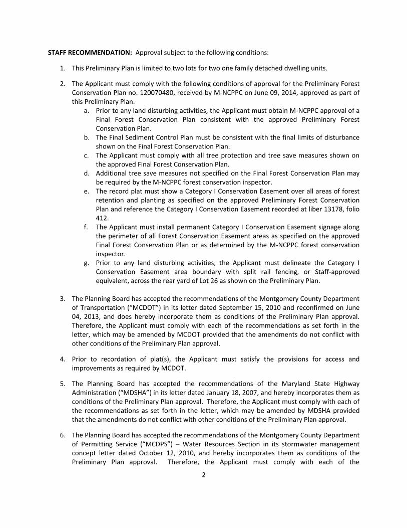
STAFF RECOMMENDATION: Approval subject to the following conditions:
1. This Preliminary Plan is limited to two lots for two one family detached dwelling units.
2. The Applicant must comply with the following conditions of approval for the Preliminary Forest Conservation Plan no. 120070480, received by M-NCPPC on June 09, 2014, approved as part of this Preliminary Plan.
a. Prior to any land disturbing activities, the Applicant must obtain M-NCPPC approval of a Final Forest Conservation Plan consistent with the approved Preliminary Forest Conservation Plan.
b. The Final Sediment Control Plan must be consistent with the final limits of disturbance shown on the Final Forest Conservation Plan.
c. The Applicant must comply with all tree protection and tree save measures shown on the approved Final Forest Conservation Plan.
d. Additional tree save measures not specified on the Final Forest Conservation Plan may be required by the M-NCPPC forest conservation inspector.
e. The record plat must show a Category I Conservation Easement over all areas of forest retention and planting as specified on the approved Preliminary Forest Conservation Plan and reference the Category I Conservation Easement recorded at liber 13178, folio 412.
f. The Applicant must install permanent Category I Conservation Easement signage along the perimeter of all Forest Conservation Easement areas as specified on the approved Final Forest Conservation Plan or as determined by the M-NCPPC forest conservation inspector.
g. Prior to any land disturbing activities, the Applicant must delineate the Category I Conservation Easement area boundary with split rail fencing, or Staff-approved equivalent, across the rear yard of Lot 26 as shown on the Preliminary Plan.
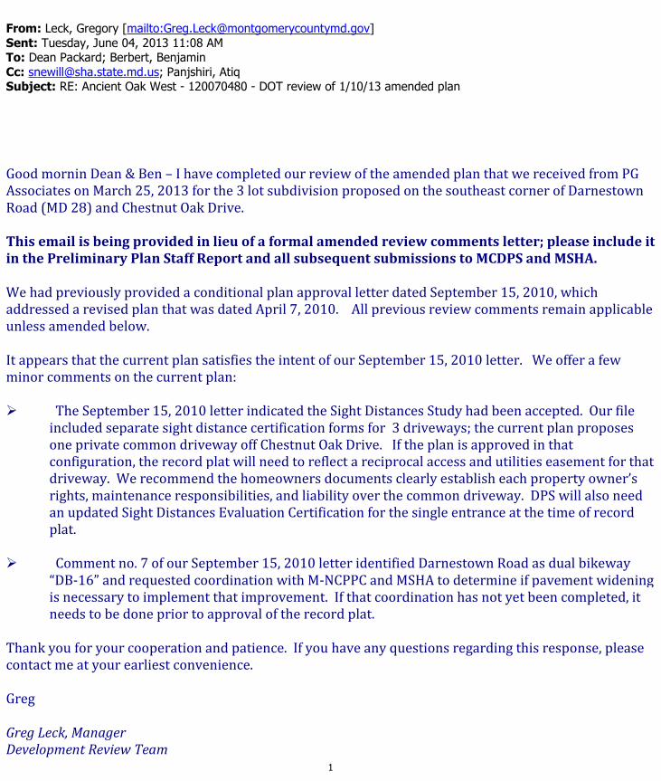
3. The Planning Board has accepted the recommendations of the Montgomery County Department of Transportation (“MCDOT”) in its letter dated September 15, 2010 and reconfirmed on June 04, 2013, and does hereby incorporate them as conditions of the Preliminary Plan approval. Therefore, the Applicant must comply with each of the recommendations as set forth in the letter, which may be amended by MCDOT provided that the amendments do not conflict with other conditions of the Preliminary Plan approval.
4. Prior to recordation of plat(s), the Applicant must satisfy the provisions for access and improvements as required by MCDOT.
5. The Planning Board has accepted the recommendations of the Maryland State Highway Administration (“MDSHA”) in its letter dated January 18, 2007, and hereby incorporates them as conditions of the Preliminary Plan approval. Therefore, the Applicant must comply with each of the recommendations as set forth in the letter, which may be amended by MDSHA provided that the amendments do not conflict with other conditions of the Preliminary Plan approval.
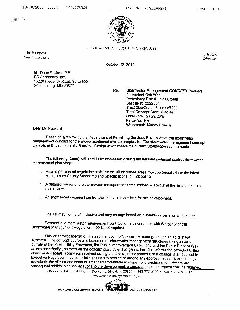
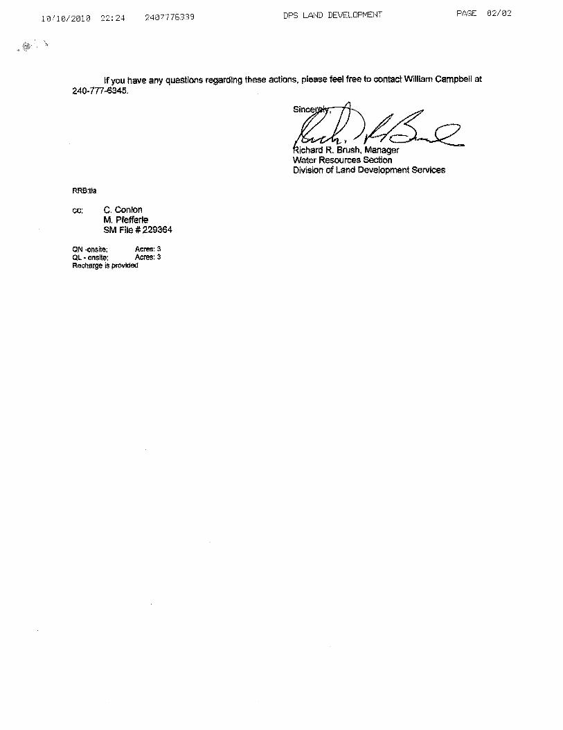
6. The Planning Board has accepted the recommendations of the Montgomery County Department of Permitting Service (“MCDPS”) – Water Resources Section in its stormwater management concept letter dated October 12, 2010, and hereby incorporates them as conditions of the Preliminary Plan approval. Therefore, the Applicant must comply with each of the

3
recommendations as set forth in the letter, which may be amended by MCDPS – Water Resources Section provided that the amendments do not conflict with other conditions of the Preliminary Plan approval.
7. The certified Preliminary Plan must contain the following note:
“Unless specifically noted on this plan drawing or in the Planning Board conditions of approval, the building footprints, building heights, on-site parking, site circulation, and sidewalks shown on the Preliminary Plan are illustrative. The final locations of buildings, structures and hardscape will be determined at the time of issuance of building permits. Please refer to the zoning data table for development standards such as setbacks, building restriction lines, building height, and lot coverage for each lot. Other limitations for site development may also be included in the conditions of the Planning Board’s approval.”
8. The record plat must show necessary easements.
9. The Subject Property is within the Northwest High School cluster area. The Applicant must make a School Facilities Payment to MCDPS at the high school level at the single-family detached unit rates for all units for which a building permit is issued and a School Facilities Payment is applicable. The timing and amount of the payment will be in accordance with Chapter 52 of the Montgomery County Code.
10. The Adequate Public Facility (APF) review for the preliminary plan will remain valid for eighty-
five (85) months from the date of mailing of the Planning Board resolution.

4
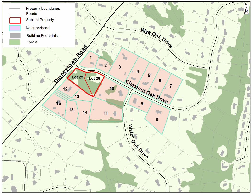
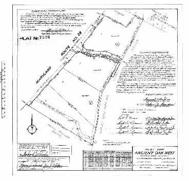
SITE DESCRIPTION The property, identified as Lot 1, Block B, Plat One, Ancient Oak West (Plat 7576)(Attachment A), is located in the southeastern corner of the intersection of Darnestown Road (MD 28) and Chestnut Oak Drive (“Property” or “Subject Property”). The Property is three acres in size, zoned R-200 and located within the 2002 Potomac Subregion Master Plan (Figure 1). Currently the Property is unimproved and almost completely tree covered. There are no sensitive environmental features on the Property, and the topography slopes moderately from the highest elevation along Darnestown Road in the west down towards the lowest elevation in the east. The Property is located in the Muddy Branch Watershed which is a Use I-P watershed (Figure 2).
The Subject Property is surrounded on all sides by one-family detached houses. The zoning on the southeast side of Darnestown Road is R-200, while the zoning on the northwest side of Darnestown Road is a combination of RE-2 and RC Zones. The Property is approximately 1/3 of a mile to the northeast of Darnestown Elementary School and 2/3 of a mile east of the intersection of Darnestown Road and Seneca Road. This Property and all of the adjacent and confronting properties on either side of Darnestown Road are in sewer service category S-6, making them ineligible for public sewer service. However, properties with frontage along Darnestown Road, including the Subject Property are in the W-1 water category and have access to a water main located under Darnestown Road (Figure 3).
Figure 1

5
Figure 2
Figure 3
6
PROJECT DESCRIPTION Background The Subject Property was first designated Preliminary Plan No. 120070480, Ancient Oak West (“Application” or “Preliminary Plan”) on December 12, 2006. The Application requested subdividing the existing lot into three lots, each one acre in size. The Preliminary Plan was brought before the Planning Board on September 19, 2013 (“Hearing”) with Staff recommending approval with conditions of the proposed three lot Application (Attachment B) and associated resubdivision analysis. At the Hearing, citizens raised concerns over the compatibility of three lots on the Subject Property, and with the shape of the neighborhood analyzed as part of the resubdivision process. The Planning Board found there was not a strong enough correlation between lot size of the proposed lots and the larger neighborhood to find that the proposed lots were of the same character of the lots in the neighborhood given the Subject Property’s location. The Planning Board also found the neighborhood used for resubdivision analysis needed to include more lots along Chestnut Oak Drive and fewer lots along Darnestown Road. The Applicant asked for a deferral, agreeing to change the Application to two lots and to changing the size and shape of the neighborhood of analysis for resubdivision. Current Plan The Preliminary Plan now proposes creating two lots on the Subject Property; lot 25 at approximately 1.08 acres and lot 26 at approximately 1.92 acres (Attachment C and Figure 4). The Application shows a shared driveway to Chestnut Oak Drive at the same location shown on the previous version of the Preliminary Plan. The new lots will have use public water but will require on-site private septic systems. The Application as submitted proposes 0.81 acres of Category 1 Forest Conservation Easement to be located on the private lots.
Figure 4

7
ANALYSIS AND FINDINGS – Chapter 50 Conformance to the Master Plan The Application substantially conforms to the recommendations set forth in the Potomac Subregion Master Plan (“Master Plan”). This Property is located in the Darnestown Triangle and Vicinity section of the Master Plan area, which is discussed on pages 96-98. The Master Plan recommends retaining the existing R-200 Zoning and allows for limited access to public water service, and generally prohibits public sewer service except for public health reasons. The purpose of making specific recommendations on public water and sewer extensions in the Darnestown Triangle was to create development with a variety of lot sizes which would vary depending on the area required for a septic system, and either private wells or public water on a given property. This variety of lot sizes is envisioned to create a transition from higher densities to the east of the Darnestown Triangle, which have sewer service, to the lower densities to the west. This Application is for two lots, one at 47,010 sq. ft. and the other at 83,670 sq. ft., which are larger than the minimum 20,000 square foot lot size for the R-200 Zone and are consistent with the Master Plan. The proposed lots have access to public water, and can be adequately served by on-site septic systems. As envisioned by the Master Plan, the proposed lot sizes are related to the area required by MCDPS to accommodate the septic tank, initial septic trench and reserve septic trench fields on each proposed lot, and they are compatible with adjacent lots.
The Master Plan identifies Darnestown Road as a Major Highway, intended to be two lanes wide with 120 feet of right-of-way. The road and Master Plan right-of-way width already exists therefore, no further dedication is necessary. The Master Plan also identifies this section of Darnestown Road as bikeway designation PB-1, which calls for a Class I off road bike path. The Master Plan describes this off-
Figure 5 – credit Google StreetView
8
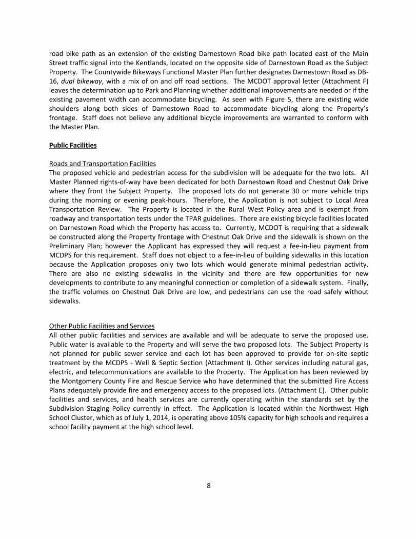
road bike path as an extension of the existing Darnestown Road bike path located east of the Main Street traffic signal into the Kentlands, located on the opposite side of Darnestown Road as the Subject Property. The Countywide Bikeways Functional Master Plan further designates Darnestown Road as DB-16, dual bikeway, with a mix of on and off road sections. The MCDOT approval letter (Attachment F) leaves the determination up to Park and Planning whether additional improvements are needed or if the existing pavement width can accommodate bicycling. As seen with Figure 5, there are existing wide shoulders along both sides of Darnestown Road to accommodate bicycling along the Property’s frontage. Staff does not believe any additional bicycle improvements are warranted to conform with the Master Plan. Public Facilities Roads and Transportation Facilities The proposed vehicle and pedestrian access for the subdivision will be adequate for the two lots. All Master Planned rights-of-way have been dedicated for both Darnestown Road and Chestnut Oak Drive where they front the Subject Property. The proposed lots do not generate 30 or more vehicle trips during the morning or evening peak-hours. Therefore, the Application is not subject to Local Area Transportation Review. The Property is located in the Rural West Policy area and is exempt from roadway and transportation tests under the TPAR guidelines. There are existing bicycle facilities located on Darnestown Road which the Property has access to. Currently, MCDOT is requiring that a sidewalk be constructed along the Property frontage with Chestnut Oak Drive and the sidewalk is shown on the Preliminary Plan; however the Applicant has expressed they will request a fee-in-lieu payment from MCDPS for this requirement. Staff does not object to a fee-in-lieu of building sidewalks in this location because the Application proposes only two lots which would generate minimal pedestrian activity. There are also no existing sidewalks in the vicinity and there are few opportunities for new developments to contribute to any meaningful connection or completion of a sidewalk system. Finally, the traffic volumes on Chestnut Oak Drive are low, and pedestrians can use the road safely without sidewalks.
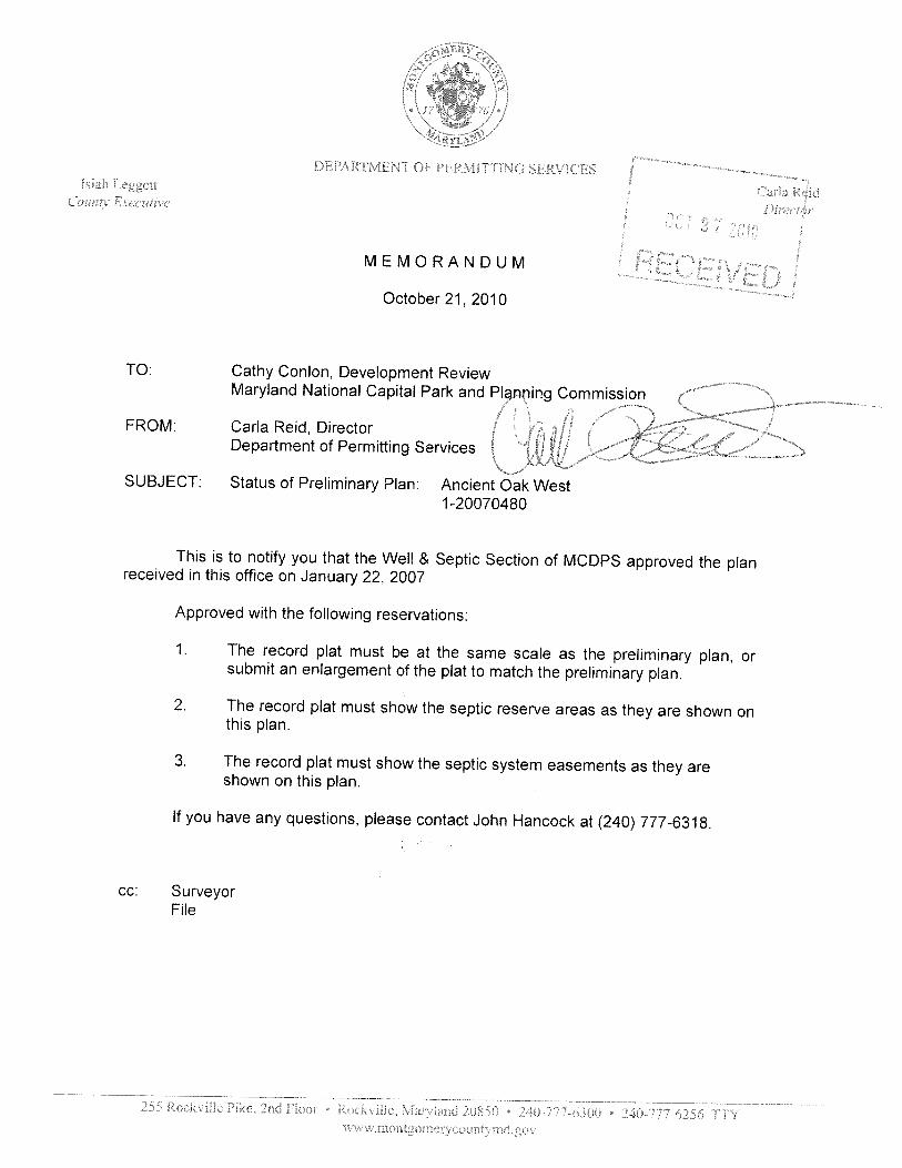
Other Public Facilities and Services All other public facilities and services are available and will be adequate to serve the proposed use. Public water is available to the Property and will serve the two proposed lots. The Subject Property is not planned for public sewer service and each lot has been approved to provide for on-site septic treatment by the MCDPS - Well & Septic Section (Attachment I). Other services including natural gas, electric, and telecommunications are available to the Property. The Application has been reviewed by the Montgomery County Fire and Rescue Service who have determined that the submitted Fire Access Plans adequately provide fire and emergency access to the proposed lots. (Attachment E). Other public facilities and services, and health services are currently operating within the standards set by the Subdivision Staging Policy currently in effect. The Application is located within the Northwest High School Cluster, which as of July 1, 2014, is operating above 105% capacity for high schools and requires a school facility payment at the high school level.

Environment Environmental Guidelines The Natural Resource Inventory/Forest Stand Delineation (NRI/FSD) #420082240 for the Property was originally approved on January 18, 2006 and was recertified on January 9, 2012 (No. 420061720). A NRI/FSD is normally only valid for a period of two years unless it is recertified or superseded by a forest Conservation plan (FCP). The NRI/FSD identifies the environmental constraints and forest resources on the Subject Property which include 1.48 acres of forest, but no trees greater than 24” diameter at breast (DBH). There are two specimen trees offsite with critical root zones that extend onto the Subject Property but no impacts are proposed with this Application. The Subject Property’s topography is sloping from west to east, with the highpoint in the western corner along Darnestown Road. There are no streams, wetlands, or environmental buffers on the Subject Property. The Subject Property is located within the Muddy Branch watershed; a use I-P watershed. Forest Conservation A preliminary forest conservation plan (PFCP) (Attachment D) was submitted for review as part of the Application. The Subject Property’s total tract area is 3.04 acres, and it contains 1.48 acres of forest. The submitted PFCP shows 0.81 acres of forest removal and 0.67 acres of forest retention. Based on the forest conservation worksheet and the High Density Residential (HDR) land use category, the project generates a 0.14 acre planting requirement which the Applicant plans to meet on-site. The 0.67 acres of forest retention and 0.14 acres of forest planting will be placed in a Category 1 Conservation Easement. To protect the Conservation Easement from disturbance the Applicant must build a split rail fence along the easement boundary as it crosses through rear yards. With the proposed forest planting and retention, the Application as conditioned meets the requirements of Chapter 22A.
Stormwater Management The MCDPS – Water Resources Section sent a letter approving the proposed stormwater management concept for the Property on October 12, 2010 (Attachment H). The concept proposes Environmental Site Design technology that meets the current stormwater requirements pursuant to Chapter 19 of the County Code. Compliance with the Subdivision Regulations and Zoning Ordinance This Application has been reviewed for compliance with the Montgomery County Code, Chapter 50, the Subdivision Regulations. The Application meets all applicable sections, including the requirements for resubdivision as discussed below. For reasons discussed in the Master Plan section of this report, the proposed lots size, width, shape and orientation are appropriate for the location of the subdivision given the recommendations in the Darnestown Triangle section of the Potomac Subregion Master Plan. The Application has been reviewed by other applicable county agencies, all of whom have recommended approval of the plan.
The lots were reviewed for compliance with the dimensional requirements for the R-200 Zone as specified in the Zoning Ordinance. The lots as proposed will meet all the dimensional requirements for area, frontage, and width, and new homes can meet the setbacks in that zone. A summary of this review is included in Table 1 below.
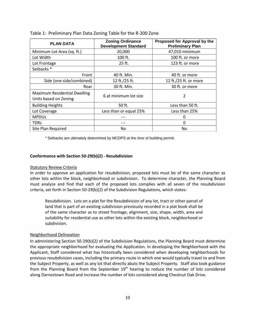
10
Table 1: Preliminary Plan Data Zoning Table for the R-200 Zone
* Setbacks are ultimately determined by MCDPS at the time of building permit.
Conformance with Section 50-29(b)(2) - Resubdivision Statutory Review Criteria In order to approve an application for resubdivision, proposed lots must be of the same character as other lots within the block, neighborhood or subdivision. To determine character, the Planning Board must analyze and find that each of the proposed lots complies with all seven of the resubdivision criteria, set forth in Section 50-29(b)(2) of the Subdivision Regulations, which states:
Resubdivision. Lots on a plat for the Resubdivision of any lot, tract or other parcel of land that is part of an existing subdivision previously recorded in a plat book shall be of the same character as to street frontage, alignment, size, shape, width, area and suitability for residential use as other lots within the existing block, neighborhood or subdivision.
Neighborhood Delineation
In administering Section 50-29(b)(2) of the Subdivision Regulations, the Planning Board must determine the appropriate neighborhood for evaluating the Application. In developing the Neighborhood with the Applicant, Staff considered what has historically been considered when developing neighborhoods for previous resubdivision cases, including the primary route in which one would typically travel to and from the Subject Property, as well as any lot that directly abuts the Subject Property. Staff also took guidance from the Planning Board from the September 19th hearing to reduce the number of lots considered along Darnestown Road and increase the number of lots considered along Chestnut Oak Drive.
PLAN DATA Zoning Ordinance
Development Standard Proposed for Approval by the
Preliminary Plan
Minimum Lot Area (sq. ft.) 20,000 47,010 minimum
Lot Width 100 ft. 100 ft. or more
Lot Frontage 25 ft. 123 ft. or more
Setbacks *
Front 40 ft. Min. 40 ft. or more
Side (one side/combined) 12 ft./25 ft. 12 ft./25 ft. or more
Rear 30 ft. Min. 30 ft. or more
Maximum Residential Dwelling Units based on Zoning
6 at minimum lot size 2
Building Heights 50 ft. Less than 50 ft.
Lot Coverage Less than or equal 25% Less than 25%
MPDUs --- 0
TDRs --- 0
Site Plan Required No No
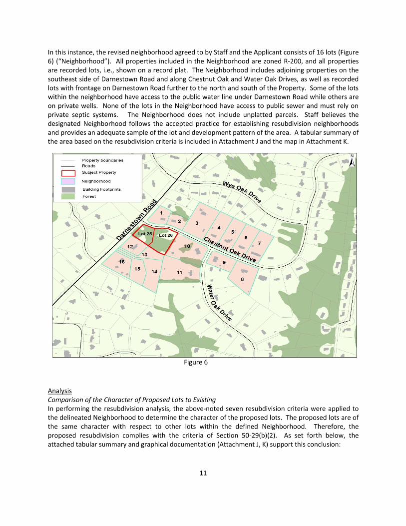
11
In this instance, the revised neighborhood agreed to by Staff and the Applicant consists of 16 lots (Figure 6) (“Neighborhood”). All properties included in the Neighborhood are zoned R-200, and all properties are recorded lots, i.e., shown on a record plat. The Neighborhood includes adjoining properties on the southeast side of Darnestown Road and along Chestnut Oak and Water Oak Drives, as well as recorded lots with frontage on Darnestown Road further to the north and south of the Property. Some of the lots within the neighborhood have access to the public water line under Darnestown Road while others are on private wells. None of the lots in the Neighborhood have access to public sewer and must rely on private septic systems. The Neighborhood does not include unplatted parcels. Staff believes the designated Neighborhood follows the accepted practice for establishing resubdivision neighborhoods and provides an adequate sample of the lot and development pattern of the area. A tabular summary of the area based on the resubdivision criteria is included in Attachment J and the map in Attachment K.
Analysis Comparison of the Character of Proposed Lots to Existing In performing the resubdivision analysis, the above-noted seven resubdivision criteria were applied to the delineated Neighborhood to determine the character of the proposed lots. The proposed lots are of the same character with respect to other lots within the defined Neighborhood. Therefore, the proposed resubdivision complies with the criteria of Section 50-29(b)(2). As set forth below, the attached tabular summary and graphical documentation (Attachment J, K) support this conclusion:
Figure 6
12
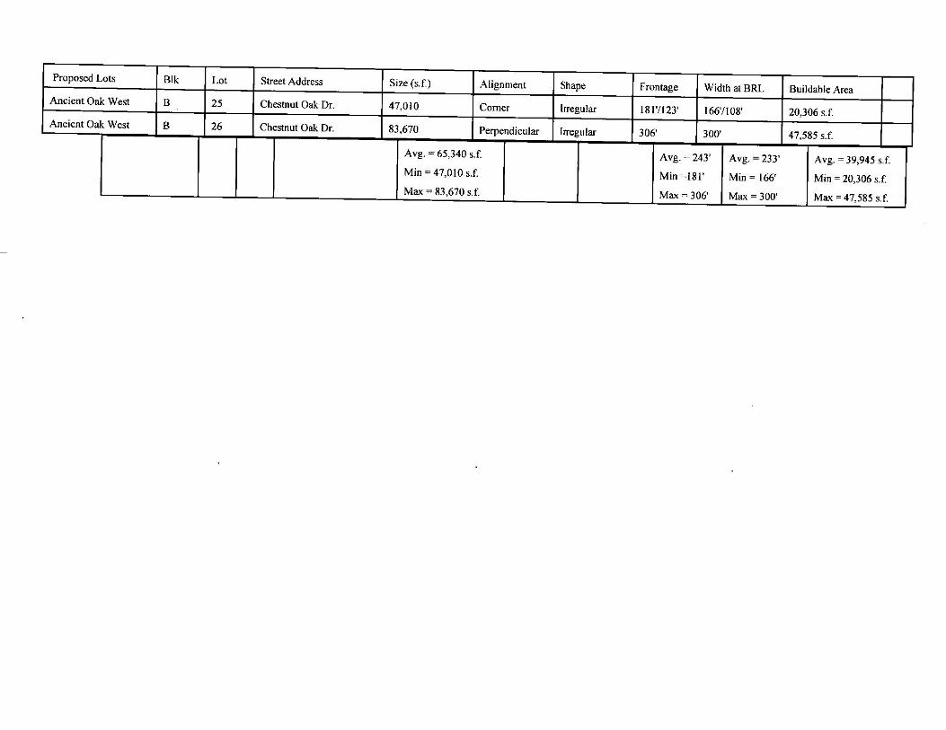
Frontage: The proposed lots will be of the same character as existing lots in the Neighborhood with respect to lot frontage. The proposed frontages fall within the range of existing lots within the Neighborhood. The range in frontage is between 25 feet for the flag lots along Darnestown Road, to 412 feet on a corner lot with Chestnut Oak Drive. The proposed lot frontages are 123 and 306 feet along Chestnut Oak Drive. Alignment: The proposed lots are of the same character as existing lots in the Neighborhood with respect to the alignment criterion. The two proposed lots are perpendicular in alignment, with one of the lots on a corner. The alignments of the other lots in the Neighborhood are a mix of angular, perpendicular and radial in nature. Size: The proposed lot sizes are in character with the size of existing lots in the Neighborhood. The sizes of lots in the Neighborhood range between 42,264 square feet and 145,887 square feet. The two proposed lots are 47,010 and 83,670 square feet. The proposed lots fall toward the lower end of the range of existing lot sizes within the Neighborhood but are not the smallest. Shape: The shapes of the proposed lots will be in character with shapes of the existing lots in the Neighborhood. The two proposed lots are irregular in shape. The existing lots in the Neighborhood are various shapes including irregular pipestems, and rectangular. Width: The proposed lots will be in character with existing lots in the Neighborhood with respect to width. The range of width at building line in the Neighborhood is between 160 feet and 405 feet. The proposed lot widths at building line falls within the range of widths within the Neighborhood at 166 and 300 feet. Area: The proposed lots will be of the same character as existing lots in the Neighborhood with respect to buildable area. In the Neighborhood the variation in buildable area available is between 15,504 and 102,728 square feet. The proposed lots fall toward the lower end of the range of existing lot buildable areas within the Neighborhood at 20,306 and 47,585 square feet, but they are not the smallest. Suitability for Residential Use: The existing lots in the Neighborhood and the proposed lots by this Application are zoned R-200 and are recorded lots suitable for residential use.
Citizen Correspondence and Issues This Application was submitted and noticed in accordance with all Planning Board adopted procedures. The Application was originally submitted in 2006, prior to the Planning Department requiring pre-submission meetings; however a letter of notice was sent out to all adjacent property owners dated December 12, 2006 as part of the initial submission. Subsequently, a notice was sent out to adjacent

13
property owners and civic groups June 3, 2013, to inform surrounding property owners that this Application was still active and actively pursuing a Planning Board Date. With the three lot plan that was heard before the Planning Board on September 19, 2013, Staff received five pieces of written correspondence. Four of the letters (from three households) were adjoining property owners, and the final letter was from the Architectural Review Committee within the Ancient Oak West community. Staff has also received one phone call regarding the Application from a Darnestown civic association, speaking against this Application for resubdivision. The primary concern is the Application as proposed will negatively change the community character and does not meet the criteria for resubdivision. Staff acknowledged the community-raised concerns but did not feel the proposed subdivision would be out of character for the area, and provided a Neighborhood analysis that confirms this. Staff also looked at the larger regional lot pattern, the provision of public water and the implication on lot size that may have, the Property’s frontage on Darnestown Road, and the scope of the original Plat. The Planning Board however agreed with the citizen testimony that although the neighborhood analysis may show support for a three lot subdivision, the neighborhood chosen by Staff and the Applicant placed too much emphasis on Darnestown Road and not enough emphasis on the Ancient Oak West community, and that three lots felt too dense for the entrance to the Ancient Oak West community. Parties of interest have since been noticed on the two lot subdivision currently proposed, including a revised resubdivision neighborhood and analysis table. As of the publishing of this report, staff has received no additional correspondence from the community. CONCLUSION The proposed lots meet all requirements established in the Subdivision Regulations and the Zoning Ordinance and substantially conform to the recommendations of the Potomac Subregion Master Plan. Section 50-29(b)(2) of the Subdivision Regulations specifies seven criteria with which resubdivided lots must comply: street frontage, alignment, size, shape, width, area and suitability for residential use within the existing block, neighborhood or subdivision. As set forth above, the two proposed lots are of the same character as the existing lots in the defined Neighborhood with respect to each of the resubdivision criteria, and therefore, comply with Section 50-29(b)(2) of the Subdivision Regulations. Access and public facilities will be adequate to serve the proposed lots, and the Application has been reviewed by other applicable county agencies, all of whom have recommended approval of the Application. Staff recommends approval of the Application with the conditions specified above.

14
Attachments Attachment A – Plat 7576 Attachment B – Previous Preliminary Plan Attachment C – Current Preliminary Plan Attachment D – PFCP Attachment E – Fire Marshal Approval Attachment F – MCDOT Letter & reconfirmation Attachment G – MDSHA Letter Attachment H – MCDPS Stormwater Attachment I – MCDPS Well & Septic Attachment J – Resubdivision Analysis Table Attachment K – Lot pattern map \\mcp-mro-fs1\shared1\AREA_3\REGULATORY PLANNING\Ancient Oak West\120070480 Ancient Oak West\2 Lot Plan\StaffReport_Ancient Oak West_120070480_2LOTFINAL.docx


1
Berbert, Benjamin
To: Leck, Gregory
Subject: RE: Ancient Oak West - 120070480 - DOT review of 1/10/13 amended plan
From: Leck, Gregory [mailto:[email protected]]
Sent: Tuesday, June 04, 2013 11:08 AM To: Dean Packard; Berbert, Benjamin
Cc: [email protected]; Panjshiri, Atiq Subject: RE: Ancient Oak West - 120070480 - DOT review of 1/10/13 amended plan
Good mornin Dean & Ben – I have completed our review of the amended plan that we received from PG
Associates on March 25, 2013 for the 3 lot subdivision proposed on the southeast corner of Darnestown
Road (MD 28) and Chestnut Oak Drive. This email is being provided in lieu of a formal amended review comments letter; please include it
in the Preliminary Plan Staff Report and all subsequent submissions to MCDPS and MSHA. We had previously provided a conditional plan approval letter dated September 15, 2010, which
addressed a revised plan that was dated April 7, 2010. All previous review comments remain applicable
unless amended below. It appears that the current plan satisfies the intent of our September 15, 2010 letter. We offer a few
minor comments on the current plan: � The September 15, 2010 letter indicated the Sight Distances Study had been accepted. Our file
included separate sight distance certification forms for 3 driveways; the current plan proposes
one private common driveway off Chestnut Oak Drive. If the plan is approved in that
configuration, the record plat will need to reflect a reciprocal access and utilities easement for that
driveway. We recommend the homeowners documents clearly establish each property owner’s
rights, maintenance responsibilities, and liability over the common driveway. DPS will also need
an updated Sight Distances Evaluation Certification for the single entrance at the time of record
plat. � Comment no. 7 of our September 15, 2010 letter identified Darnestown Road as dual bikeway
“DB-16” and requested coordination with M-NCPPC and MSHA to determine if pavement widening
is necessary to implement that improvement. If that coordination has not yet been completed, it
needs to be done prior to approval of the record plat. Thank you for your cooperation and patience. If you have any questions regarding this response, please
contact me at your earliest convenience. Greg Greg Leck, Manager Development Review Team

2
Division of Traffic Engineering and Operations Montgomery County Department of Transportation 100 Edison Park Drive, 4th floor Gaithersburg, Maryland 20878 [email protected] office: 240-777-2197 fax: 240-777-2080