sport quarterly jan-mar 2016 · the mrms precipitation is to give ... well-received overview...
TRANSCRIPT

National Aeronautics and Space Administration
SPoRT QuarterlyJanuary – March 2016
The SPoRTREPORTShort-term Prediction Research and Transition (SPoRT) CenterNASA Marshall Space Flight Center (MSFC), Huntsville, ALhttp://weather.msfc.nasa.gov/sport/
Join SPoRT on: NWSChat @ nasa_sport or blog
with us @ http://nasasport.wordpress.com/
The SPoRT Center is a NASA- and NOAA-funded project to transition unique observations and research capabilities to the operational community to improve short-term weather forecasts on a regional scale. While the direct beneficiaries of these activities are selected Weather Forecast Offices (WFOs) and National Centers, the research leading to the transitional activities benefits the broader scientific community.
Quarterly Highlights
Operations Proving Ground Himawari AssessmentDuring three separate weeks in March and April, Dr. Andrew Molthan, Dr. Emily Berndt, and Kevin Fuell traveled to the NWS Operations Proving Ground (OPG) to participate in an evaluation to introduce forecasters to multiple spec-tral bands in anticipation of upcoming GOES-R capabilities. The purpose of the evaluation, “Evaluating Operational Applications of Multiple Spectral Bands for the GOES-R Era”, was to gain NWS forecaster feedback on using multiple spectral bands and RGB imagery in the forecast process. For this evaluation, the RGB imagery was generated live on AWIPS II, rather than using pre-gen-erated products, such as those that SPoRT and other groups in the commu-nity have been providing to forecasters. Training was also made available and viewed though the Integrated Training AWIPS-II plugin developed by Jason Burks. The evaluation used imagery from the Himawari-8 Advanced Himawari Imager (AHI), a proxy for the GOES-R Advanced Baseline Imager
(ABI). Forecasters had the opportunity to gain insight into which spectral bands, channel differences, and multi-spectral imagery offer operational value.
Use of client-side generated RGBs allowed forecasters to evaluate whether local dynamic generation of RGBs had a negative impact on system performance
…continued on page 7
Figure 1. OPG exercise comparing the three water vapor channels (top displays) that will be available in the GOES-R era and the Air Mass RGB (lower left display). Forecasters could access training material (lower right display) while working though the AWIPS-II Integrated Training Plugin.

January – March 20162 The SPoRT Quarterly Report
Transitions and Assessments
AVHRR RGB imagery to support MODIS & VIIRSThe use of MODIS and VIIRS Nighttime Microphysics (NtMicro) RGB imagery has proven valuable to short-term forecasts of low clouds and fog, but the low frequency of the product is a limitation. The NOAA POES-19 and EUMETSAT MetOp-A and -B satellites have the AVHRR instrument which is able to produce this same RGB. SPoRT transitioned the NtMicro RGB product from these satellites (data via University of Alaska Fairbanks (UAF)/Geographic Information Network for
Alaska (GINA) to Alaska WFOs for a trial evaluation for February and March 2016. The additional AVHRR data provided cloud analysis between VIIRS and MODIS retrievals and its impact was mentioned in several Area Forecast Discussions (AFD) as well as via direct communication with SPoRT staff. For example, on March 17 the Fairbanks WFO indicated “… Last night was a good example of the usefulness of the AVHRR (NtMicro) product. The 17/1503z product added a larger area to the south than the MODIS or VIIRS provided [Fig. 2]. This was very useful
in forecasting the weather system that is moving east out of the central inte-rior of Alaska, ….. this impacted the forecasts for the zones in that area.” Additional satellites (NOAA POES-15 and -18) also have AVHRR and could be added to this suite. The increased frequency of the NtMicro RGB via AVHRR promoted the use of VIIRS and MODIS data with Alaska users. The low frequency of passes by polar-or-biting satellites, had been a regular complaint of CONUS forecasters who receive even less overpasses of compared to Alaska users.
Figure 2. Nighttime Microphysics RGB over Alaska for 17 March 2016 from MODIS, AVHRR, and VIIRS; shown in AWIPS/CAVE
NESDIS Merged Snowfall Rate ProductThe final year of a NASA Data for Operations and Assessment proposal to develop new capabilities for a Snowfall Rate (SFR) product derived from passive microwave sounder satellite observations was held from mid-January to mid-March. This product has been developed by the NOAA National Environmental Satellite Data and Information Service (NESDIS). During this assessment, forecasters from offices in Eastern Region, Western Region, and Alaska Region evaluated a blended radar/satellite product combining radar- and gauge-based snowfall from the Multi-Radar Multi-Sensor (MRMS) product with the previously-eval-uated satellite-only snowfall rate products. The capability to loop the
product was requested during the previous two assessments of this product. The advantage of including the MRMS precipitation is to give forecasters the ability to loop the snowfall to see continuous snowfall values with the satellite filling in the gaps in radar coverage. This product was used by forecasters who found the product very valuable for filling in the radar gaps both in the Western U.S. and a small radar gap west of the Washington, D.C. metro area. The product was used heavily during the blizzard in late January, where parts of D.C. picked up more than two feet of snow (Fig. 3). Luis Rosa, one of the forecasters at the Sterling, VA WFO, included the SFR product as part of a public forecast: “Heavy snow and near or whiteout conditions will continue in the comma head region and
deformation band in the area between Interstates 81 and 95 and north of I-66. In this area…NESDIS Merged Snowfall Rate Product currently shows snowfall rates of 1-2 inches per hour.”
Figure 3. NESDIS SFR Product depiction of the evolution of a late January 2016 winter storm that produced blizzard conditions along the East Coast. The SFR product was able to identify the heaviest snow bands and nicely captured the extent of snowfall from this storm.
January – March 2016 3The SPoRT Quarterly Report
Recent Accomplishments
Natural Environments Day of Launch Working Group Meeting
SPoRT participated in the NASA Natural Environments Day of Launch Working Group, which was hosted this year in SPoRT’s Visualization and Collaboration Laboratory at the National Space Science Technology Center. Ryan Decker and Barry Roberts from Marshall Space Flight Center’s Natural Environments group were the conveners of the meeting, which brought together operational decision makers from NASA and the Air Force from launch facilities at Kennedy Space Center, Wallops Flight Facility, and Vandenberg Air Force Base with research entities that support launch
operations. Discussions focused on new instrumentation opportunities and ongoing research activities to support wind and lightning forecasting and situational awareness. SPoRT gave a well-received overview presentation on some of its remote sensing, total lightning, and modeling research expertise and capabilities in an effort to educate this operational community of our R2O history. This presentation and discussions during the meeting enabled identification of current research gaps in range operations where SPoRT may have appropriate expertise to support R2O for launches.
SPoRT Seminars
• February 17: “DeepVision: Using Deep Learning for Earth Science Image Classification/Retrieval” by Manil Maskey (UAH)
Presentations
SPoRT team members made a number of presentations at the 2016 American Meteorological Society Annual Meeting in New Orleans, LA on 10-14 January. A full list of posters and presentations for this meeting can be found on the SPoRT website at http://weather.msfc.nasa.gov/sport/conference/.
ProposalsAccepted ProposalsSPoRT team members were involved with three Step-1 proposals to the NASA ROSES15 SERVIR Applied Science Team solicitation that were invited to submit Step-2 proposals. The Step-1 proposals were announced in January, and Step-2 proposals are due at the end of April.
These proposals are:
• “An Innovative Weather and Climate Based Vector-Borne Disease Forecast System for Dengue Fever and Other Public Health Concerns” PI: Dr. Jeff Luvall (NASA/MSFC), Co-Is: Dr. Dale Quattrochi (NASA/MSFC), Dr. Cory Morin (USRA), and Bradley Zavodsky (NASA/MSFC)
• “Developing tools and training to enhance lightning safety in SERVIR-East Africa”; PI: Dr. Geoffrey Stano
(ENSCO, Inc.); Co-Is: Jonathan Case (ENSCO, Inc.), Dr. Eugene McCaul (USRA), Paul Meyer (NASA/MSFC), and Anita LeRoy (UAH); Collaborator: Jordan Bell (UAH)
• “Monitoring Intense Thunderstorms in the Hindu-Kush Himalayan Region”; PI: Dr. Patrick Gatlin (NASA/MSFC); Co-Is: Jonathan Case (ENSCO), Jordan Bell (UAH), Dr. Dan Cecil (NASA/MSFC), Dr. Walt Petersen (NASA/MSFC); Collaborators: Dr. Andrew Molthan (NASA/MSFC), Bhupesh Adhikary (ICIMOD/SERVIR-Himalaya), Harri Pietarila (Finnish Meteorological Institute)
A white paper proposal entitled “NASA Imagery and Capabilities for DHS/USCG Disaster Response” by PI Jordan Bell (UAH) and Co-Is Kevin McGrath (ESSSA) and Paul Meyer (NASA/MSFC) was awarded
funding by the NASA Applied Science Disasters program to support transition of select satellite products related to disaster activities for the Department of Homeland Security (DHS) and United States Coast Guard (USCG). This proposal was submitted following Mr. Bell’s participation in a USCG-sponsored hurricane response exercise in Houston, TX in late February.
ROSES NDOA SolicitationNASA ROSES16 includes a solicitation entitled NASA Data for Operations and Assessment (NDOA; NNH16ZDA001N-NDOA), which includes a section for community PIs to collaborate with SPoRT to transition mature satellite and modeling products to the operational weather community. Full proposals are due to NASA by May 20. More details can be found on NASA’s NSPIRES website (https://nspires.nasaprs.com/).

January – March 20164 The SPoRT Quarterly Report
Satellite Proving Ground Activities
GOES-RIn February, Dr. Geoffrey Stano was formally nominated to be SPoRT’s satellite liaison to the NOAA Proving Grounds (PGs) to support Southern Region NWS WFOs. His unique blend of expertise in total lightning and liaison activities as part of SPoRT over the last few years were attractive qualities noted by the PG management. Dr. Stano has participated in satellite liaison training and activities at two meetings: a total lightning working group technical inter-change meeting in Norman, OK and an RGB training activity in Kansas City. Dr. Stano has also been designated as the lead for development of foun-dational training through the Satellite Training Advisory Team (STAT) on use of Geostationary Lightning Mapper (GLM) data in the NWS AWIPS deci-sion support system. He will also be a subject matter expert on training that introduces GLM and its capabilities.
The SPoRT team remains very active in GOES-R Proving Ground activities as the October 2016 launch date quickly approaches. It has been a busy quarter with SPoRT engaged in a wide range of work including publications, training, assessments, and other preparations. SPoRT has continued to maintain its collaborations between the various lightning mapping arrays and opera-tional end users to support transition of Geostationary Lightning Mapper (GLM) proxy observations. This effort has resulted in a publication submission focusing on the pseudo-GLM (PGLM) product and the Aviation Weather Center. SPoRT is also collaborating with the Houston Center Weather Service Unit (CWSU) on a case study of an event that impacted the Houston area airports on 1 September 2015. The PGLM and updated training has been submitted to the Hazardous Weather Testbed in preparation for
the Experimental Warning Program (EWP), which starts in mid-April. SPoRT also continues to support transition and training activities for the GOES-R Convective Initiation product developed at UAH for evaluation activities at the EWP. In collaboration with the NWS Pacific Region, SPoRT is aiming to transition new Quantitative Precipitation Estimate (QPE) products developed by NOAA NESDIS that are based on Himawari data. SPoRT and Pacific Region evaluated the GOES-West version of QPE in 2014, but in its original form was not ready for a full transition. With additional spectral channels and better spatial resolution, this enhanced QPE product is expected to perform better. Coordinating with Pacific Region, SPoRT has set up an oper-ational domain to test this version of QPE over the Guam Weather Forecast Office. As has been noted previously, AHI is almost identical to the GOES ABI, so this evaluation is a test of the oper-ational utility of geostationary-based QPE in anticipation of ABI.
JPSSSPoRT remains engaged in providing demonstrations of the utility of VIIRS imagery, multispectral false color (RGB) composites targeting specific forecast challenges, and the use of NUCAPS soundings in various applications. Recent efforts by SPoRT have built upon collaborations with the UAF/GINA to make better use of imagery made available through their direct broadcast receipt system, and to support the transition to client-side generation of RGB products in AWIPS. The SPoRT team has also facilitated the delivery of additional AVHRR products for RGBs that add to the number of observations per day, providing additional temporal resolution to products available from AVHRR, MODIS, and VIIRS platforms, as described in more detail in an
earlier section. These applications are bolstered by additional blog posts contributed by forecasters and the creation of an Applications Library, which will host short use case examples populated by SPoRT team members and NWS forecasters as a means of providing operationally relevant exam-ples to partners in both CONUS and Alaska WFOs. The contents of this Applications Library will be folded into the Integrated Training that has was discussed in the lead article on OPG and in previous quarterlies. In addition, the team continues to develop means of providing limb and bias correction to the various VIIRS and MODIS bands used in generation of RGBs. The team also continues development of new RGBs that will leverage the solar-reflected component of the 3.9 um channel as a means of identifying low clouds, fog, and snow cover during daylight hours common at high latitudes in the spring and summer months. SPoRT continues to lead a multi-organizational team that is developing unique visualiza-tion capabilities for temperature and moisture soundings from CrIS/ATMS, called NUCAPS. Gridded NUCAPS soundings have been made available to the Hazardous Weather Testbed Experimental Warning Program and tools have been developed to support aviation interests related to detecting cold air temperature aloft. A final project is investigating the relationship between stratospheric air intrusions apparent on the air mass RGB to the vertical structure of temperature and moisture, along with their impact on the transition between tropical and extratropical cyclones. This work has led to case studies of Hurricanes Arthur (2014) and Sandy (2012) that have demonstrated the use of ozone products from CrIS and OMPS to identify this transition.
January – March 2016 5The SPoRT Quarterly Report
WFO Corner
Social Media Corner
Wide World of SPoRT BlogSixteen posts were made to The Wide World of SPoRT Blog during the first quarter of 2016. As might be expected during the winter, most posts involved products to diagnose phenomena asso-ciated with synoptic scale winter storms, such as snowfall and flooding. Several posts during the quarter included a closer evaluation of these data for oper-ational purposes or potential benefit. A post by Jeff Hovis at the Charleston, WV NWSFO, provided a case study during a snowfall event in the upper Ohio and central Appalachian Region where the SFR product detected snow well in parts of the region, but snowfall was absent in the product across portions of Ohio, Kentucky and West Virginia where surface and radar observations indi-cated snow was indeed falling. NESDIS product developer Huan Meng was able to use a comment in the blog to discuss what was being observed in the product. This is one example of the value of the blog as tool for facilitating communica-tion between product developers and end-users. WFO Albuquerque made a number of outstanding posts detailing the value added in radar void areas, such as the Four Corners region and northeastern New Mexico.
The SPoRT configuration of the NASA Land Information System (LIS) continues to be a successful SPoRT
core product and is continuing to be used by select offices as an effective tool for helping with drought diagnosis and for assessing the risk of areal and basin flooding potential. Relatively recent data to be transferred within the SPoRT LIS package to NWSFOs are a couple of soil temperature data sets: 0-10 cm soil temperature and skin surface temperature. In AWIPS, radar data can be overlain on the SPoRT LIS soil temperature data. Thus, a forecaster can observe surface and soil temperatures as the precipitation reaches the surface. One post during the first quarter, titled, “LIS Soil Temps and the Unfolding Winter Storm…” highlighted the use of these data in AWIPS for monitoring the threat of accumulating frozen precipitation. One limitation of the data (in a very short-term operational sense) is the three –hourly temporal resolution and two to eight hour latency, as was discussed in the post. Nevertheless, this is superior to many other options available for assessing region-wide soil temperatures at high spatial resolution.
Other interesting and informative posts were made during the quarter, including a post about future lightning data derived from the International Space Station Lightning Image Sensor (ISS-LIS) and the GLM. The post included a photograph from NASA Commander Scott Kelly about the ISS
that showed lightning within the core of a departing low pressure system off the East Coast in the early morning hours of January 23rd (Fig. 4). Other sample posts included GOES-R and JPSS Proving Ground RGB products for the detection of various phenomena such as rapidly developing cyclones, blowing dust in the Southern High Plains, and even a rare but interesting river/lake effect snow event on the Tennessee River in northern Alabama.
Figure 4. GOES East IR imagery from 0945 UTC on 23 January 2016. Red plus signs indicate the location of 4 in-cloud strokes as observed by the Earth Networks Total Lightning Network that represent the location of the flash in the ISS photo from Saturday on (https://twitter.com/stationcdrkelly/status/690905921980080130).
These and other informative posts can be found on the SPoRT blog at http://nasasport.wordpress.com. The SPoRT group is very appreciative of the efforts of all of our collaborative authors. If you would like privileges to post on the SPoRT blog, please send an email to Kris White ([email protected]). Thanks and we hope you’ll keep reading!
Tweets of the QuarterSPoRT tweets using @NASA_SPoRT. Please follow us to see more exciting, regular and timely imagery examples and other news related to the project. Below are a couple of select examples of how our end-users are using our products shared via Twitter.
January – March 20166 The SPoRT Quarterly Report
Congratulations
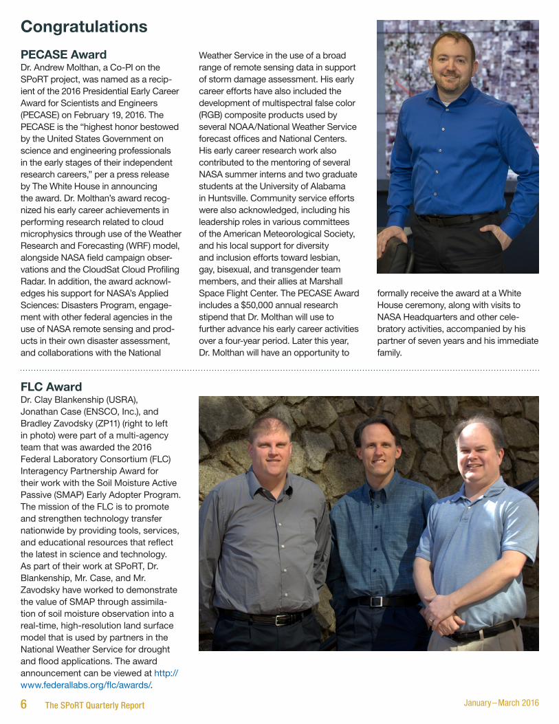
PECASE AwardDr. Andrew Molthan, a Co-PI on the SPoRT project, was named as a recip-ient of the 2016 Presidential Early Career Award for Scientists and Engineers (PECASE) on February 19, 2016. The PECASE is the “highest honor bestowed by the United States Government on science and engineering professionals in the early stages of their independent research careers,” per a press release by The White House in announcing the award. Dr. Molthan’s award recog-nized his early career achievements in performing research related to cloud microphysics through use of the Weather Research and Forecasting (WRF) model, alongside NASA field campaign obser-vations and the CloudSat Cloud Profiling Radar. In addition, the award acknowl-edges his support for NASA’s Applied Sciences: Disasters Program, engage-ment with other federal agencies in the use of NASA remote sensing and prod-ucts in their own disaster assessment, and collaborations with the National
Weather Service in the use of a broad range of remote sensing data in support of storm damage assessment. His early career efforts have also included the development of multispectral false color (RGB) composite products used by several NOAA/National Weather Service forecast offices and National Centers. His early career research work also contributed to the mentoring of several NASA summer interns and two graduate students at the University of Alabama in Huntsville. Community service efforts were also acknowledged, including his leadership roles in various committees of the American Meteorological Society, and his local support for diversity and inclusion efforts toward lesbian, gay, bisexual, and transgender team members, and their allies at Marshall Space Flight Center. The PECASE Award includes a $50,000 annual research stipend that Dr. Molthan will use to further advance his early career activities over a four-year period. Later this year, Dr. Molthan will have an opportunity to
formally receive the award at a White House ceremony, along with visits to NASA Headquarters and other cele-bratory activities, accompanied by his partner of seven years and his immediate family.
FLC AwardDr. Clay Blankenship (USRA), Jonathan Case (ENSCO, Inc.), and Bradley Zavodsky (ZP11) (right to left in photo) were part of a multi-agency team that was awarded the 2016 Federal Laboratory Consortium (FLC) Interagency Partnership Award for their work with the Soil Moisture Active Passive (SMAP) Early Adopter Program. The mission of the FLC is to promote and strengthen technology transfer nationwide by providing tools, services, and educational resources that reflect the latest in science and technology. As part of their work at SPoRT, Dr. Blankenship, Mr. Case, and Mr. Zavodsky have worked to demonstrate the value of SMAP through assimila-tion of soil moisture observation into a real-time, high-resolution land surface model that is used by partners in the National Weather Service for drought and flood applications. The award announcement can be viewed at http://www.federallabs.org/flc/awards/.

Operations Proving Ground Himawari Assessment
and forecaster workflow. In addition, forecasters provided feedback on the usefulness and effectiveness of the AWIPS Integrated Training capability. With this capability, forecasters had the opportunity to view SPoRT-developed Quick Guides and Articulate modules right in AWIPS as they viewed case study imagery. During days one and two of the evaluation, forecasters evalu-ated the array of single bands available in the GOES-R era and were incre-mentally introduced to multispectral
…continued
composites such as the True Color and Natural Color RGBs. During day three, forecasters were introduced to the three water vapor channels that will be available in the GOES-R era. During one exercise, forecasters compared the three water vapor channels to the Air Mass RGB (Fig. 1; front page). In the figure, notice the training readily available to forecasters while evaluating the new channels and RGB imagery. Day four focused on low cloud and fog applications with a focus on CIRA’s
GeoColor imagery in conjunction with the Night-time Microphysics RGB. Throughout the week, forecasters were introduced to new imagery and capa-bilities and expressed excitement about the increased spatial and temporal resolution that will be available in the GOES-R era and the possibility of accessing training material directly in AWIPS. Initial feedback has been very positive; more details on outcomes of the evaluation will be made available next quarter.
PublicationsFuell, K.K., B.J. Guyer, D. Kann, A.L.
Molthan, and N. Elmer, 2016: Next generation satellite RGB dust imagery leads to operational changes at NWS Albuquerque. J. Operational Meteor., 4 (6), 75–91 [Available online at http://dx.doi.org/10.15191/nwajom.2016.0406].
Terborg, A., and G.T. Stano, (in review): Impacts to Aviation Weather Center
operations using total lightning observations from the pseudo-GLM. Submitted to J. Operational Meteor.
Zavodsky, B., G.T. Stano, and W.W. Vaughan, 2016: Flash of Genius. Met. Tech. International, April 2016, 32-36 [Available online at http://viewer.zmags.com/publication/2d183b22#/2d183b22/34].
VisitorsLaura MeyersDr. Laura Meyers, the Executive Director of the Center for Advanced Public Safety at the University of Alabama, visited with SPoRT to discuss potential collaborative activities related to socio-economic benefits. Dr. Meyers and two members of her team were briefed on SPoRT’s R2O/O2R paradigm and they provided a description of work that they had done following the April 27, 2011 tornado outbreak to better understand the response of the public to severe weather warnings. The outcome of this meeting was identification of areas of potential collaboration between Dr. Meyers’s group and SPoRT to identify ways that operational impacts of SPoRT data products can be better quantified.
Lisa Huddleston and Launa MaierDrs. Lisa Huddleston and Launa Maier of the Kennedy Space Center visited SPoRT as part of their participation in the Day of Launch Working Group Meeting. Drs. Huddleston and Maier are part of the group previously known as the Applied Meteorology Unit (AMU) that organized and assigned tasks to support launch operations at Cape Canaveral. These meetings involved some detailed discussion on remote sensing, lightning, modeling, and deci-sion support tools needed to support Cape launch operations and potential opportunities for collaboration.
Upcoming Calendar of Events• April 4-5, 2016: 4th SMAP Early Adopters Workshop and Tutorial (Austin, TX)
• April 5-6, 2016: 7th NOAA Testbed and Proving Ground Workshop (College Park, MD)
• April 18-May 13, 2016: Hazardous Weather Testbed Experimental Warning Program (Norman, OK)
• April 26-27, 2016: NASA Water Resources Meeting (Tuscaloosa, AL)
• May 9-13, 2016: GOES R/JPSS User Readiness Meeting (Norman, OK)
• June 14-16, 2016: NASA Disasters Flood Workshop (College Park, MD)
• June 27-30, 2016: GOES-R/JPSS OCONUS Meeting (Honolulu, HI)
National Aeronautics and Space Administration
George C. Marshall Space Flight CenterHuntsville, AL 35812www.nasa.gov/marshall
www.nasa.gov
NP-2016-04-45-MSFCG-157844