spatiotemporal geochemical hydrocarbons (sgh)detection limits at low ppt (pg/g) levels are possible...
TRANSCRIPT

www.actlabs.com
Spatiotemporal Geochemical Hydrocarbons (SGH)
SCOPE YOUR CLAIM
▼
▼▼
▼

Spatiotemporal Geochemical Hydrocarbons (SGH)
2
Our Spatiotemporal Geochemical Hydrocarbon (SGH) analysis is a high performance deep penetrating geochemistry which
has successfully shown the presence of deeply buried mineral or petroleum deposits. In a Canadian Mineral Research
Organization (CAMIRO) project initiated in 1997, nine of ten mineral deposits were successfully detected at study sites that
were specifically chosen where other geochemical methods were previously unsuccessful. These study sites included
Gold, VMS, Nickel, Copper, Kimberlite, Uranium, Lithium Pegmatites, IOCG, Silver, SEDEX, Tungsten, Platinum,
Molybdenum, and Polymetallic-type dposits, Wet gas plays, Oil plays and Coal. In the follow-up CAMIRO Project 01E02,
Kimberlites, IOCG, Sedex, more magmatic Cu, Ni and VMS deposit types were successful at identifying the deposit and
provided a unique fingerprint. This level of high performance and proven success has become the norm with SGH.
The SGH technique involves collection of soil samples in the field and then desorbing the weakly bound heavy
hydrocarbons in the C5-C17 carbon series range (pentane through to heptadecane) at the laboratory. Using a new
technology developed by Actlabs, the desorbed organic compounds are collected and introduced into a Gas Chromatograph/
Mass Spectrometer (GC/MS) where over 160 of these heavier hydrocarbon compounds are measured. Heavy
hydrocarbons are used instead of light hydrocarbons (C1-C4 or methane through to butane) as they are much less
affected by decaying biogenic material and diurnal variability. SGH is also more robust in terms of sample collection,
shipping and storage conditions. Detection limits at low ppt (pg/g) levels are possible by this technology which allows back-
ground levels to be readily determined.
Actlabs’ research and development into the applicability of SGH for exploration has resulted in the availability of a cost-
effective method which can be used in tandem with geophysics to improve your success rate.
Sampling and Analysis
l SGH is capable of analyzing soil, rock and core (after milling), peat, vegetation, fully submerged lake sediments and even
snow from a very wide variety of climates. Only snow surveys require special sampling instructions.
l An SGH survey is unique in geochemistry as it can use a mixture of different sample types in the same survey. There is
no data leveling required for samples taken in swampy conditions (i.e. Humus samples) to samples of till or soil from drier
areas. Contact Actlabs for a more complete explanation.
l Only one trip to the field is necessary to locate and collect the samples. A “fist” size sample is all that is needed for
analysis. Samples may be collected in canvas, Kraft, or Ziploc bags. Wet samples can be drip-dried in the field. No
preservation is needed for shipping.
l Samples are air dried at < 40°C and sieved to -60 mesh in the laboratory or on-site.
l In the laboratory, a sub-sample is accurately weighed and an extraction is done analogous to a weak leach.
l The extracted samples are analyzed by a High Resolution Gas Chromatography/Mass Spectrometer (HRGC/MS).
l This HRGC/MS method is highly specific and highly sensitive as each compound has a “Reporting Limit” of 1 part-per-
trillion (ppt).
l Each sample is analyzed for 162 target hydrocarbons that have been specifically picked to define a variety of buried
mineral or petroleum signatures. This selection of specific hydrocarbon compounds also eliminates interferences from
sampling, shipping, handling and from general cultural activities.
Soil samples are preferably taken in a grid. One or two line transects
provide much less information. Sample locations must be provided
as UTM’s or relative coordinates with the submission of samples.
Samples should be taken to a distance at least the full width of the
predicted target on either side, e.g. a 200 m diameter target would
have samples taken at least 200 m further on each side of the target.
For smaller targets, such as for Kimberlite or Uranium pipes, two
intersecting transects in a cross formation might be used which
provides for a significantly better interpretation than from a single
transect but has less confidence than from using a grid. The
minimum sample spacing for SGH is 20 or 25 m to a maximum of
1,500 metres depending on the type of target. To determine the
correct spacing please contact our laboratory.Canadian Diamondiferous Kimberlite Pipe

Overview
3
l SGH - A geochemical analysis researched and developed
since 1996. Backed with 35+ years experience in HRGC/MS
related research and development.
l Organic Hydrocabons are absorbed onto near surface
material (i.e. soil, till, humus, sand, etc.) which act as a long-
term collector of the hydrocarbon flux.
l Only one trip to the field is necessary.
l The laboratory procedure detects 162 specific organic
compounds in the C5 - C17 carbon series range. This highly
sensitive and specific Nanotechnology uses a Reporting Limit
of 1 part-per-trillion (ppt, nanograms/kilogram).
e.g. C5 = Pentane - a compound made up of a
straight chain of 5 carbons
l SGH is made up of 19 chemical classes of hydrocarbons.
Specific classes are pathfinders for specific types of
mineralization. Unique combinations of these classes provide
specific signatures of mineralization.
l SGH are not gaseous compounds at room temperature but
may migrate to the surface by various processes and may be
in a vapour form at depth.
l SGH uses a weak leach to extract only the surficial bound
hydrocarbon compounds from the sample particulate that are
mobile and have moved upward from depth. These
hydrocarbons are the decomposition products of bacteria and
microbes that have been leaching mineralization at depth to
support their metabolism.
l Compounds in the C5 - C17 carbon range are less affected
by weathering by bacterial and UV degradation, or by
seasonal water washing. It is thus a significant improvement
over early methods of analyzing gaseous compounds from soil
(soil gas) i.e. CO2, O2, and C1 through C4 compounds, etc.
SGH is a dual purpose method that can locate a buried
target as well as identify the type of target present. A pattern
recognition approach to the data has resulted in defining
specific SGH signatures for various types of targets. The SGH
signatures in surveys over Gold, VMS, Nickel, Copper,
Kimberlite, Uranium, Lithium Pegmatites, IOCG, Silver,
SEDEX, Tungsten, Platinum, Molybdenum, and Polymetallic
type deposits, Wet gas plays, Oil plays and Coal have been
extensively studied.
What does an SGH signature look like?
The following example illustrates the connection between the
SGH signature in ore and the comparable signature one might
observe from surficial soils at surface. This example does not
illustrate the interpretation procedure used with SGH. This
SGH soil sample signature contains a “visible” portion of
the buried VMS target signature found in the ore.
Consistent SGH target signatures.
Similar signatures are in the ore as in these VMS rock
speciments samples from different locations and of various
ages.
SGH target, different location?
Another SGH soil sample signature that contains the same
“visible” portion of the buried VMS target signature.
SGH is a DUAL purpose tool used to vector to the location
of a target through the use of Geochromatography and used
to confirm the identity of a target through the specific mix of
SGH classes found.
SGH Gold Anomaly – Near Dryden Ontario

Location: 30 km southeast of Kambalda, Australia
Climate: Hyperarid environment
Mineralization: Paleochannel gold mineralization
(1 Mt @ 2.5 g/t); Occurs almost exclusively in a
gabbro: Minor mineralization in volcanic sediments
Deposit: Consists of a series of stacked flat-lying
structures host to the mineralization ~ 25 m to the
top of the first structure
Cover: Consolidated dune sands with a poor
developed B-horizon
Survey Design: 310 samples - B-horizon soils 25 m over mineralization 50 m over background; 100 m between sample
lines. Note: regular spacing is the preferred approach.
Case Studies
Gold - Diana (WMC)
Ore Body
SGH Snow Survey for Gold in the Hemlo District
Intersection of 2.5 g/t of gold-in-bedrock at a drill depth of
650 metres confirmed the central SGH signal in this
symmetrical nested segmented halo anomaly. The SGH
method has a high level of confidence even in areas of deep
cover where conventional soil geochemistry is ineffectual.
At Rous Lake, over 200 metres of overburden including
raised beach sands covers most of the property.
Drill Target
SGH Symmetrical Anomalies
Gold - Rous Lake (Entourage Metals Ltd.)
Gold - Mali
Grass Roots Discovery – SGH Gold Signature – Mali
A lengthy pitting operation over a ppb concentration Gold in soil
anomaly could not discover a vector to source mineralization.
A claim-wide 6 x 3 km grid of soil samples analyzed for SGH
discovered this outstanding halo anomaly 10’s of metres away
and upslope. Pitting operations here encountered a basalt cap.
Drilling through the basalt cap intersected Gold mineralization.
This location is now one of the new mines in Mali.
SGH thus did not respond to a transported Gold anomaly. SGH
was able to find the source of the Gold mineralization.
Success – drilled and mine developed
4

Case Studies
Copper and Gold - Mt. Milligan
Ni-Cu - Montcalm (Outokumpu Mines)
Geoscience BC Report 2010-8 “Assessment of Soil
Geochemical Methods for Detecting Copper-Gold Porphyry
Mineralization Through Quaternary Glaciofluvial Sediments
at the MBX and 66 Zones, Mt. Milligan, North-Central British
Columbia.”
SGH and the analysis of Calcium were the only methods
that worked at Mt. Milligan in this research study. SGH was
the only geochemistry able to distinguish the Gold zone
within the larger Copper zone.
This is one SGH
Pathfinder Class map
related to Copper.
Multiple SGH classes
agree with the observa-
tion of a rabbit-ear dis-
persion anomaly over
these two high grade
copper ore zones.
This is one SGH
Pathfinder Class map
related to Gold. Multiple
SGH Gold Signature
classes agree with the
observation of an apical
anomaly directly over
the high gold content
66 Zone.
Location: Montcalm Township, Ontario,
Canada
Commodity: Nickel-Copper, 7 Mt of 1.6% Ni
and 0.7% Cu hosted in norite and
gabbroic units.
Cover and Thickness: An average of 30 m
of transported overburden, consisting of peat,
clay, clay-silt-sand with basal sands and
gravel. Thickness of cover rock -
approximately 100 m in this cool boreal
climate. SGH provided a symmetrical
nested-segmented-halo response with an
associated high level of confidence.Ore Body Zone
Cu-Pb-Zn-VMS
SGH Confidence Rating of 5.0 of 6.0
Irish Style Carbonate Hosted VMS with
segmented halo anomaly delineating
extent of VMS deposit surrounding
centralized apical anomaly of mineraliza-
tion.
Strong structural control resulted in a
brecciated pipe like formation.
80 samples taken with a spacing of 100
metres x 150 metres.
Nested-segmented-halo
massive sulphide zone
Central SGH anomaly
for Pb mineralization
5

Case Studies
Copper - Poston Butte (BHP)
Copper - Namibia, Africa
Copper - Northern Saskatchewan
SGH Confidence Rating of 5.5 of 6.0
Sedimentary hosted Copper deposit in Northern
Saskatchewan.
55 samples taken in swamp with a spacing of 100
metres x 50 metres. SGH successfully indicated
the mineralized copper trend in this survey grid.
Location: 65 km southeast of Phoenix,
Arizona, USA
Commodity: 360 Mt @ 0.34% Cu
Cover and Thickness: Mineralization is
covered by ~140’ to >1,000’ of mineralized
conglomerate and weakly mineralized
colluviums shed from nearby outcropping
porphyry copper deposits in this semi-arid
climate. SGH delineated the copper ore
zone.
Redox zone with SGH-Copper Signature
Apical Anomaly
SGH Signature rating relative to
“Copper Target” = 5.5 of 6.0
positively identifying and
locating this ore zone.
Anolalous zone but does
not have SGH-Copper
Signature
SGH Signature rating relative to
“Copper Target” = 1.5 of 6.0
SGH correctly indicated the lack
of copper mineralization in this
survey.
Steeply Dipping Ore Zone Boundary
6
Zone of Copper
Mineralization

Case Studies
Ni-Cu - Birchtree (INCO)
Location: Thompson Nickel Belt, Manitoba
Climate: Subarctic with scattered permafrost
Mineralization: 48.5 Mt of 2.0% Ni, 0.13%
Cu and 0.005% Co Pyrrhotite-pentlandite
lenses (10-20 m of 2% Ni) in a steeply west-
ward dipping, blind (200 m below
bedrock/overburden contact) peridotite
boudin bounded by Archean gneisses to the
west and Proterozoic metasediments on the
east. Ore mineral assemblage is pentlandite,
pyrrhotite, pyrite and chalcopyrite. Host rocks
are a serpentinized peridotite or pelitic
schists.
Cover: ~ 25 m glaciolacustrine clay silt, ~ 50 m of basal till with poor water drainage , ~ 200 m below bedrock/overburden
Survey Design: 190 samples, B-horizon soils 50 m over background, 25 m approaching mineralization, 12.5 m over and
adjacent to mineralization
Ore Body
Nickel target - Northern Ontario
Ni-VHMS - Northern Ontario
A Symmetrical Segmented-nested-halo
anomaly in Northern Ontario.
Observations of Symmetry improves confidence
and increases SGH Rating Scores.
SGH Pathfinder Class Map
associated with Nickel targets.
Observations of Symmetry
improves confidence and
increases SGH Rating Scores.
This SGH anomaly lead to a
successful drill intersection.
Highest SGH Confidence Rating
Central Nickel “nested” anomaly surrounded by symmetrical
segmented halo anomaly delineating the extent of the
VHMS deposit.
Total of 53 samples with spacing of 100 x 100 metres in
Northern Ontario. Successful drill intersection at SGH
anomaly.
7
Interpreted target area
Case Studies
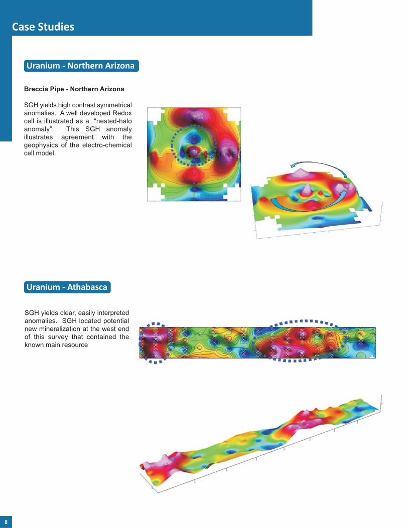
Uranium - Athabasca
Uranium - Northern Arizona
Breccia Pipe - Northern Arizona
SGH yields high contrast symmetrical
anomalies. A well developed Redox
cell is illustrated as a “nested-halo
anomaly”. This SGH anomaly
illustrates agreement with the
geophysics of the electro-chemical
cell model.
SGH yields clear, easily interpreted
anomalies. SGH located potential
new mineralization at the west end
of this survey that contained the
known main resource
8

Case Studies
Uranium - Screech Lake Project (Ur Energy)
Ur Energy’s Screech Lake Project, Thelon Basin, NWT, Canada
SGH depicts a nested-segmented halo as the Redox Cell. This SGH
group of hydrocarbons are part of the SGH signature of hydrocarbons
that has been associated with Uranium targets. The observation of
this highly symmetrical anomaly adds confidence to the SGH
interpretation.
Redox Cell
Organo-Sulphur Geochemistry - Silver
The 3D-view of this OSG Class
map related to Silver illustrates the
excellent definition of the central
location of the Redox zone. OSG
has proven to be outstanding for
Silver exploration.
This may be an excellent drill target
for consideration at Aura Silver’s
Greyhound Project in Nunavut.
9

Case Studies
Kimberlite ‐ Northern Ontario
Snow Sampling Case Study
SGH Snow Survey for Gold in the
Timmins Camp
This snow survey in the Timmins Gold
camp illustrates the outstanding
symmetry of the SGH anomalies.
From a 3D-SGH interpretation the
observation of symmetry significantly
increases the confidence of the
results and the interpretation.
Gold
Drill Target
Highest SGH Confidence Rating
Beneath 25 metres of James Bay
overburden in Northern Ontario.
SGH matches the location of Mag
high results.
Spacing is 25 metres.
Templates have been developed that describe the SGH signatures for Gold, VMS, Nickel,Copper, Kimberlite, Uranium, Lithium Pegmatites, IOCG, Silver, SEDEX, Tungsten, Platinum,Molybdenum, and Polymetallic type deposits, Wet gas plays, Oil plays and Coal.
10
Location of Kimberlite Pipe

Case Studies
Petroleum
SGH can be used for Petroleum
exploration. Although the SGH
signature is different than for mineral
targets, the geochromatography is the
same. This transect of soil samples,
taken in February and March of 2005,
was taken along the road right-of-way.
There was no interference to the SGH
data from activity on this paved road.
A second case study again
showed excellent agreement
with the location of a nearby gas
well. Samples were taken from
the road right-of-way for this
client by Actlabs’ personnel. The
SGH signature contained
compounds that were consistent
with the condensate of this “wet
gas” play.
Gas well intersected two zones at 410
m and 535 m that reached down into
the Grimsby formation, Ontario.
“Wet Gas
Signature”
SGH anomaly was directly adjacent
to another gas producing well from
this roadside sampling conducted in
the same township.
Producing
Gas Well
SGH Pathfinder Class Map for Petroleum – a
Symmetrical Segmented-nested-halo anomaly
SGH located a new Petroleum play at a depth of
4,725 metres (15,500 feet) in Florida.
11

Benefits of Spatiotemporal Geochemical Hydrocarbons (SGH)
This geochemistry is rugged to sampling procedures
This geochemistry is rugged to geographical features
This geochemistry is rugged to cultural activity
The SGH geochromatography “vectors” to the deposit
SGH Pathfinder Classes “identify” the type of deposit
Has been used to further define the latest Redox/electrochemical cell theory
Has lead to the creation of a new Organo-Sulphide Geochemistry (OSG)
Compatible with previously collected samples
Can delineate mineral extensions for known deposits
Use snow surveys in areas of very difficult terrain
Effective for a wide range of lithologies & geographic regions
Successful in grassroots projects
Can approximate depth in some surveys
Succeeds in areas were other geochemistry's have been ineffective
Regional surveys possible
Zero environmental footprint
For additional information or a custom quotation on your project, contact us at:
Phone: 1.905.648.9611
Toll Free: 1.888.228.5227 (ACTLABS)
Fax: 1.905.648.9613
Activation Laboratories Ltd. (Actlabs)
41 Bittern Street
Ancaster, Ontario CANADA
L9G 4V5
This SGH Geochemisty has a success rate of over 90%.This SGH Geochemisty has a success rate of over 90%.