spatio-temporal variations of sea level around the mekong
TRANSCRIPT

—60—
Hydrological Research Letters 10(2), 60–66 (2016)Published online in J-STAGE (www.jstage.jst.go.jp/browse/hrl). DOI: 10.3178/hrl.10.60
Spatio-temporal variations of sea level around the Mekong Delta: their causes and consequences on the coastal environment
Danet Hak1, Kazuo Nadaoka1, Lawrence Patrick Bernado2, Vo Le Phu3, Nguyen Hong Quan4, To Quang Toan5, Nguyen Hieu Trung6, Duong Van Ni6 and Van Pham Dang Tri6
1School of Environment and Society, Tokyo Institute of Technology, Japan2Graduate School of Science and Engineering, Tokyo Institute of Technology, Japan
3Faculty of Environment & Natural Resources, Ho Chi Minh City University of Technology – Vietnam National University, Vietnam
4Institute for Environment and Resources (IER) – Vietnam National University of Ho Chi Minh City, Vietnam5Training & International Coordination Department, Southern Institute of Water Resources Research, Vietnam
6College of Environment and Natural Resources, Can Tho University, Vietnam
Abstract:
This paper presents a comprehensive analysis of sea level variations around the Mekong Delta, and their causes and consequences on the environment, based on the tidal records from several stations. The results of the analysis revealed significant spatio-temporal sea level variations along the delta coast. Tidal fluctuations showed their local peaks around the river mouth with shallow bottom areas. The pre-vailing winds were identified as the factor governing the remarkable seasonal variability of the mean sea levels along the southern coast of the delta. From 1985 to 2010, the rela-tive sea level along the southern coast of the delta rose by about 3.3 mm y–1. This rate of rise combined with the effect of land subsidence renders the Mekong Delta alarmingly susceptible to frequent inundation. Moreover, the immediate impacts, including saline intrusion and occasional inunda-tion due to seasonal sea level fluctuation, are also found to be critical and require urgent attention. These findings suggest the need to revise coastal management strategies to prioritize the immediate effects of short-term sea level fluctuations and to increase the focus on local management issues such as groundwater pumping causing land subsidence and local sea level trends in addition to the global threats.
KEYWORDS sea surface level; tidal variation; meteorological influence; coastal inundation; saline intrusion; Mekong Delta
INTRODUCTION
Understanding sea level rise is crucial for the Mekong Delta region. Given its average elevation of about 0.3–0.7 m above the mean sea level, this delta region is very suscepti-ble to inundation and other coastal hazards. With the pre-dicted global sea level rise (based on Representative Concentration Pathway, RCP, 2.6) of about 0.28–0.61 m by the year 2100 (Intergovernmental Panel on Climate Change, IPCC, 2013), almost the entire Mekong Delta will be perma-nently inundated in less than a century. However, given that the sea level trend at the regional scale can deviate sur-
prisingly from the global mean (Dangendorf et al., 2013; Merrifield et al., 2009; Cazenave and Narem, 2004), this predicted global mean may not be sufficient to predict sea level rise impacts in this delta region. For this reason, under-standing the sea level trend around the delta is of great inter-est. Furthermore, the seasonal and much shorter time scale sea level fluctuations need to be investigated, given that they define the magnitude of immediate impacts such as storm surge, coastal inundation, and saline intrusion. Despite this great interest, very few studies have been conducted to investigate the local sea level trend around this deltaic region. Most studies rather focus on a wider scale (e.g., Amiruddin et al., 2015; Feng et al., 2015; Dangendorf et al., 2014; Wei et al., 2010) or on nearby regions (e.g., Luu et al., 2015; Suriyan and Tal, 2014; Sojisuporn et al., 2013). In this study, the inter-decadal and seasonal trends as well as the spatial distribution of the sea level along the Mekong Delta coast were investigated. Furthermore, the impacts of local atmospheric conditions on the sea level seasonality and their potential to increase the risk of saline intrusion and occa-sional coastal flooding were also evaluated.
DATA AND ANALYSIS
Three types of data were used in this study; (i) sea level; (ii) atmospheric parameters such as precipitation, air tem-perature, humidity, pressure, and wind speed and direction; and (iii) river discharge and salinity. Daily, sub-daily and hourly records of the above information were collected at various locations of the study area according to the availabil-ity of the data and the objective of the analysis. Detailed information regarding the above data and relevant monitor-ing stations are given in Supplement Table SI.
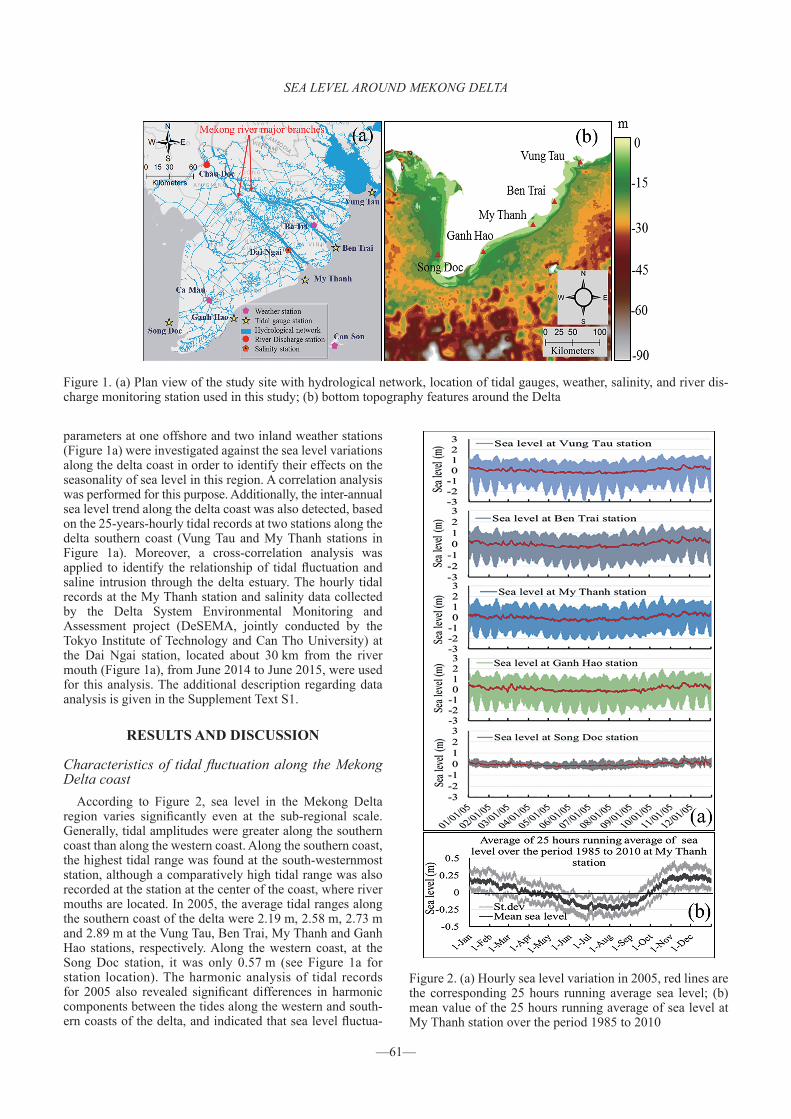
The spatial, seasonal and shorter-time scale sea level vari-ations along the Mekong Delta coast were examined based on the hourly tidal record at four stations along the southern coast and one station on the western coast of the delta (Figure 1a). Given the limited availability of the spatially represen-tative data only the records from year 2005 were used for this analysis. Furthermore, daily and sub-daily atmospheric
Correspondence to: Danet Hak, School of Environment and Society, Tokyo Institute of Technology, W207, Ookayama west 8 Building, 2-12-1 Ookayama, Meguro-ku, Tokyo 152-8552, Japan. E-mail: [email protected]
Received 13 January, 2016Accepted 28 March, 2016
Published online 25 May, 2016©2016, Japan Society of Hydrology and Water Resources.
SEA LEVEL AROUND MEKONG DELTA
—61—
parameters at one offshore and two inland weather stations (Figure 1a) were investigated against the sea level variations along the delta coast in order to identify their effects on the seasonality of sea level in this region. A correlation analysis was performed for this purpose. Additionally, the inter-annual sea level trend along the delta coast was also detected, based on the 25-years-hourly tidal records at two stations along the delta southern coast (Vung Tau and My Thanh stations in Figure 1a). Moreover, a cross-correlation analysis was applied to identify the relationship of tidal fluctuation and saline intrusion through the delta estuary. The hourly tidal records at the My Thanh station and salinity data collected by the Delta System Environmental Monitoring and Assessment project (DeSEMA, jointly conducted by the Tokyo Institute of Technology and Can Tho University) at the Dai Ngai station, located about 30 km from the river mouth (Figure 1a), from June 2014 to June 2015, were used for this analysis. The additional description regarding data analysis is given in the Supplement Text S1.
RESULTS AND DISCUSSION
Characteristics of tidal fluctuation along the Mekong Delta coast
According to Figure 2, sea level in the Mekong Delta region varies significantly even at the sub-regional scale. Generally, tidal amplitudes were greater along the southern coast than along the western coast. Along the southern coast, the highest tidal range was found at the south-westernmost station, although a comparatively high tidal range was also recorded at the station at the center of the coast, where river mouths are located. In 2005, the average tidal ranges along the southern coast of the delta were 2.19 m, 2.58 m, 2.73 m and 2.89 m at the Vung Tau, Ben Trai, My Thanh and Ganh Hao stations, respectively. Along the western coast, at the Song Doc station, it was only 0.57 m (see Figure 1a for station location). The harmonic analysis of tidal records for 2005 also revealed significant differences in harmonic components between the tides along the western and south-ern coasts of the delta, and indicated that sea level fluctua-
Figure 1. (a) Plan view of the study site with hydrological network, location of tidal gauges, weather, salinity, and river dis-charge monitoring station used in this study; (b) bottom topography features around the Delta
Figure 2. (a) Hourly sea level variation in 2005, red lines are the corresponding 25 hours running average sea level; (b) mean value of the 25 hours running average of sea level at My Thanh station over the period 1985 to 2010

D. HAK ET AL.
—62—
tions along this deltaic coast are driven by a mixed diurnal- semidiurnal component, M2, K1, O1, and S2 (Table I provides detailed information and definition of these constituents). The semi-diurnal constituent, M2, prevailed along the south-ern coast with an amplitude range of 77–91 cm, followed by K1, O1, and S2, which have amplitude ranges of 59–63 cm, 39–45 cm and 29–35 cm, respectively. On the western coast, the diurnal constituent, K1, is dominant, followed by O1, M2, and S2, with respective amplitudes of 18 cm, 10 cm, 9 cm and 2 cm. These patterns explained that the differences in tidal range between the southern and western coasts of the delta result from the difference in tidal regimes, which are themselves governed by tidal waves propagated from the South China Sea (SCS) and within the Gulf of Thailand (GOT), respectively. Figure 3 shows the spatial distribution of the M2 amplitude around the Mekong Delta based on the Oregon State University (OSU) tidal prediction software (Egbert and Erofeea, 2002), indicating a peak at the Mekong River mouth area. Similar features were found for the spatial distributions of K1, O1, and S2. The high tidal range around the river mouth is likely to be associated with the shallow bottom feature in that area (Figure 1b), which is an intrinsic factor amplifying the tidal amplitude in the river mouth zone. This reflects the role of sedimentation processes of the
Mekong River in controlling tidal dynamics along the delta front.
Inter-decadal trend of mean sea level along the Mekong Delta coast
The tidal records from 1985 to 2010 show that mean sea level at My Thanh and Vung Tau stations rose by about 3.1 mm y–1 and 3.5 mm y–1, respectively (Figure 4). These rates are relatively higher compared to the observed global rate during similar period (1985–2009) which is around 2.8 mm y–1 (Church and White, 2011). These higher rates of sea level rise are probably influenced by the land subsidence observed inside the delta region (Fujihara et al., 2016; Erban et al., 2014), which may extend to the two stations. The pres-ent land subsidence rate of 1–4 cm y–1 inside the delta (Erban et al., 2014), together with the effect of reduced sediment input from the upper Mekong basin (Kondolf et al., 2015; Kummu and Varis, 2007) and the anticipated sea level rise of the order of 1 mm y–1 indicate that the Mekong Delta is in imminent danger of permanent inundation.
Seasonal variation of sea surface levelAs found in Figure 2, the 25-hours mean sea level along
the entire Mekong Delta coast shows remarkable seasonal-ity, although this seasonality is much stronger on the south-ern coast than on the western coast. Generally, mean sea
Table I. Characteristics of harmonic constituents of tide along the coast of Mekong Delta (M2: principal lunar semi-diurnal constituent having two high and two low tides per day; K1: lunisolar diurnal constituent having one high and one low tide per day; O1: lunar diurnal constituent having one high and one low tide per day; S2: principle solar semi-diurnal constituent hav-ing two high and two low tides per day)
Tidal gauge station
M2 K1 O1 S2
Amplitude (m)
Phase (degree)
Amplitude (m)
Phase (degree)
Amplitude (m)
Phase (degree)
Amplitude (m)
Phase (degree)
Vung Tau 0.77 35.40 0.59 312.20 0.45 262.60 0.30 77.70
Ben Trai 0.78 66.10 0.57 328.30 0.41 277.60 0.29 110.00
My Thanh 0.83 73.30 0.57 334.60 0.39 285.20 0.31 121.30
Ganh Hao 0.91 78.00 0.63 339.80 0.43 290.80 0.35 126.40
Song Doc 0.09 93.70 0.18 38.00 0.10 3.10 0.02 172.40
Figure 3. Spatial distribution of M2 amplitude around the Delta based on OSU Tidal Prediction Software. Yellow stars indicate the location of tidal stations
Figure 4. Inter-decadal trend of mean sea level at My Thanh and Vung Tau station, along the southern coast of the Mekong Delta

SEA LEVEL AROUND MEKONG DELTA
—63—
levels showed decreasing trends from early January until the end of June. Then, they started to gradually increase until around mid-November, when they attained their highest peaks, after which they begin to drop again in mid-December. This variation pattern is very similar to that of the prevailing wind (Figure 5), indicating the influence of the monsoon wind regime on the sea level seasonality. In particular, low and high sea level episodes coincided with the periods of the southwest (northeastward wind) and northeast monsoons (southwestward wind), respectively. Observed records for the period from 1985 to 2010 indicate that the average direc-tions of prevailing winds at the Ca Mau, Ba Tri, and Con Son stations (see Figure 1a for their locations) range between 72.67° and 89.09° from the north during the northeast mon-soon and between 252.67° and 269.09° from the north during the southwest monsoon. This reversal of the prevailing wind direction may explain the impacts of Ekman transport phe-nomena, which may further result in geostrophic currents in the later stage of development. Specifically, at the beginning of the northeast monsoon, the prevailing wind starts to blow southwestward, causing the sea surface waters to move onshore, 90° clockwise to wind direction due to the Ekman transport effect, which in turn raises the sea level along the delta coast. The raised sea level near the coast generates an offshore-ward pressure gradient, which may further result in the formation of geostrophic currents toward southwest (Hu et al., 2000). Likewise, during the southwest monsoon, winds start to blow in the opposite direction (northeastward), and the reverse phenomenon occurs, causing a decrease in the sea level along the delta coast (see Supplement Figure
S1 for graphical illustration). In addition to the above, the results of the correlation analysis (Table II) show signifi-cantly strong correlation between the seasonal component of prevailing wind and sea level fluctuation both for the year 2005 (at all stations) and for the 1985–2010 (at Vung Tau and My Thanh stations) observations with respective cor-relation ranges of 0.46–0.80 and 0.63–0.90 (α = 0.001). A minimum correlation of 0.46 was identified at Song Doc sta-tion, indicating that the effect of monsoon wind on sea level at the delta western coast is minimal. This is because the effect of monsoon wind on generating sea level seasonal fluctuation through Ekman transport mechanism is most sig-nificant along the delta southern coast, while at the western coast this impact is very small due to the relative shoreline direction to prevailing wind (Supplement Figure S1 explains this mechanism). On the other hand, the magnitude of cross-shore wind appeared to have a relatively low significant cor-relation (r ≈ 0.19 to 0.31, α = 0.001) with the short-term sea level fluctuation along the delta coast, suggesting that aside from the strong effect of prevailing wind on the seasonality of sea level, cross-shore wind also influences shorter-time scale sea level fluctuation. In contrast, although monsoon wind may potentially affect the seasonal variation of sea level along the delta coast, other atmospheric parameters including precipitation, humidity, air temperature and pres-sure seem to give no appreciable effects. Based on the cor-relation analysis results, precipitation and humidity show no significant correlation with sea level meaning that the amount of local rainfall is too small to influence sea level (hence, it is not included in Table II). Air temperature and
Figure 5. Daily values of atmospheric parameters averaged over the period 1985 to 2010 at Ca Mau, Con Son and Ba Tri sta-tion (from left to right); positive wind speed indicates wind blowing to southwest direction

D. HAK ET AL.
—64—
pressure show a relatively strong correlation with sea level. However, this correlation seems to contradict the effect of temperature and pressure on sea level. This implies that these two parameters do not affect the seasonal sea level pat-tern on this deltaic coast. These findings match the results from previous studies, which found that seasonal variation of sea level in the GOT (Suriyan and Tal, 2014) and along the continental shelf of SCS (Amiruddin et al., 2015) are mainly driven by prevailing wind. Thus, it can be concluded that the prevailing wind is the primary local atmospheric component affecting the seasonal variability of sea level along the Mekong Delta coast.
Impact of tidal fluctuation on coastal inundation and saline intrusion
Figure 6a depicts the variations in salinity observed at the Dai Ngai station and the tidal fluctuation at the My Thanh tidal gauge from June 2014 to June 2015 (refer to Figure 1a for the station locations). According to this figure, during the rainy season (June 2014–October 2014), the salinity level at the observed station was almost zero and did not show any significant fluctuation. This low rainy season salinity explained that the larger amount of river discharge (Figure 7) from the Mekong River during this season overcame the effects of salt-water intrusion from the sea. In contrast, during the dry season (November 2014–May 2015), salinity in the estuary could be as high as 10‰ and fluctuated signifi-cantly. This significantly high salinity may eventually sup-press the livelihood of the Mekong Delta community, given that the salinity threshold for paddy and a majority of crops is only around 4‰ (Food and Agriculture Organization, 2015). Furthermore, the peak salinity levels seem to be closely related to the spring-neap tidal cycle, which indi-cates the effect of tidal amplitude variation on saline intru-sion in this coastal region. The strong cross-correlation of r = –0.62 (with a 4-day time lag) between dry season salinity and tidal amplitude (Figure 6b) also confirmed this relation-ship. These findings suggest that, under the effects of land subsidence and relative sea level rise, salt-water may intrude further inland, resulting in more severe impacts of saline intrusion in the future.
The strong seasonality of sea level is likely to increase the chances of coastal inundation from mid-October to the end of December. As indicated in Figure 2b and 7a, the sea level along the delta coast reaches the highest peak in mid- November (about 45 days later than the peak period of sea-sonal flood (Figure 7a) and remains high until the end of the
year. Based on these trends, severe inundation along the delta coast during high sea level episode is very probable if there is any delay of the seasonal flood. Remarkably, from 2000 to 2007, the seasonal flood already showed significant
Table II. Correlation between seasonal variations of sea surface level and atmospheric components (all are significant correla-tion at α = 0.01, bold values indicate the correlation with offshore weather at Con Son station)
Sea levelAtmospheric parameters
Air temperature Air pressure Prevailing wind magnitude (based on year 2005 data)
Prevailing wind magnitude (based on 25-year data)
Tide at Vung Tau –0.60, –0.65 N/A, 0.43 0.65, 0.80 0.63, 0.78
Tide at Ben Trai –0.53, –0.58 N/A, 0.36 0.57, 0.73
Tide at My Thanh –0.54, –0.61 N/A, 0.40 0.74, 0.77 0.76, 0.90
Tide at Ganh Hao –0.56 0.52 0.78
Tide at Song Doc –0.66 0.30 0.46
Figure 6. (a) Variations of sea level and tidal amplitude at My Thanh station and salinity at Dai Ngai station from June 2014 to June 2015; (b) dry season pattern of tidal amplitude at My Thanh station, salinity at Dai Ngai station and cross-correlation between them

SEA LEVEL AROUND MEKONG DELTA
—65—
Figure 7. (a) Mean of 25 hours running average sea level at My Thanh station over the period 1985 to 2010 and daily mean of river discharge at Chau Doc station from 2000 to 2007; (b) variation of river discharge at Chau Doc station showing the delay in peak flood period between 2000 and 2007
CONCLUSIONS
This study provides an in-depth understanding of the characteristics of sea level fluctuation around the Mekong Delta coast and related risks of coastal inundation and saline intrusion based on observed records in various time scales. The significant seasonality of sea level observed in this delta region was found to be primarily governed by the monsoon wind variations. The sea level trends observed along the southern coast of the delta from 1985 to 2010 revealed that sea level in this region has risen by about 3.3 mm y–1. This increasing trend combined with anthropogenic impacts (e.g., land subsidence) put the Mekong Delta at great risk of frequent inundation. The short-term sea level fluctuations, including seasonal variations, were found to be strongly associated with saline intrusions through the delta estuary and are likely to increase the chances of severe coastal inun-dation just after the peak period of annual flooding events. Furthermore, the strong pattern of sea level seasonality found along the southern coast of the delta stress that the impacts of sea level fluctuation on seasonal flooding even inside the delta should not be neglected. The finding on the above immediate effects highlights the need for urgent miti-gation and management measures for the impacts of short-term sea level fluctuation along with that of the long-term trend of sea level rise.
ACKNOWLEDGEMENTS
This study was supported by the ASEAN University Network of Southeast Asia Engineering Education Development Network Project (AUN/SEED-Net) JICA pro-gram, the Japan Society for Promotion of Science (JSPS) Core-to-Core Program (B. Asia-Africa Science Platforms) and a Grant-in-Aid for Scientific Research (A) (No. 25257305) from the JSPS.
SUPPLEMENTS
Text S1. Additional explanation on data analysisFigure S1. Graphical illustration of Ekman transport phe-
nomena and resulting geostrophic current due to seasonal wind blowing
Table SI. Dataset used in this study
REFERENCES
Amiruddin AM, Haigh ID, Tsimplis MN, Calafat FM, Dangendorf S. 2015. The seasonal cycle and variability of sea level in the South China Sea. Journal of Geophysical Research: Oceans 120: 5490–5513. DOI: 10.1002/2015JC010923.
Cazenave A, Narem RS. 2004. Present-day sea level change: obser-vations and causes. Reviews of Geophysics 42: RG3001. DOI: 10.1029/2003RG000139.
Church JA, White NJ. 2011. Sea-level rise from the late 19th cen-tury to the early 21st century. Surveys in Geophysics 32: 585–602. DOI: 10.1007/s10712-011-9119-1.
Dangendorf S, Mudersbach C, Wahl T, Jensen J. 2013.
delay in its peak period (Figure 7b). Although the cause of this delay is unclear, its appearance marks the possibility of further postponement of seasonal flooding event, which could significantly trigger coastal inundation as explained earlier. Furthermore, considering the coincidence of storm surge, which is also possible due to climate change impacts, this inundation scenario can be much more aggressive com-pared to the usual seasonal flood. It should be noted that global climate change may alter the regional climate condi-tions including the monsoon system, and the associated pre-cipitation patterns among others, which may in turn vary the magnitudes and peak periods of seasonal variations of sea level and floods with the resultant changes in the flood risk and saline intrusion. Therefore, the likelihood of occurrence of this devastating incident and its consequences should be closely investigated.

D. HAK ET AL.
—66—
Characteristics of intra-, inter-annual and decadal sea-level variability and the role of meteorological forcing: the long record of Cuxhaven. Ocean Dynamics 63: 209–224. DOI: 10.1007/s10236-013-0598-0.
Dangendorf S, Bender J, Quan NH, Jensen J. 2014. On analyzing the marine-hydrological boundary conditions for the flood risk in the Thi-Vai region. In EWATEC-COAST: Technologies for environmental and water protection of coastal zones in Vietnam. Contributions to the 4th international conference for environment and natural resources-ICENR 2014, Meon G, Pätsch M, Phuoc NV, Quan NH (eds.). Cuvillier, Göttingen, Germany; 181–193.
Erban LE, Gorelick SM, Zebker HA. 2014. Groundwater extraction, land subsidence, and sea level rise in the Mekong Delta, Vietnam. Environmental Research Letter 9: 084010. DOI: 10.1088/1748-9326/9/8/084010.
Egbert GD, Erofeeva SY. 2002. Efficient inverse modeling of baro-tropic ocean tides. Journal of Atmospheric and Oceanic Technology 19: 183–204. DOI: 10.1175/1520-0426(2002)019 <0183:EIMOBO>2.0.CO;2.
Feng X, Tsimplis MN, Marcos M, Calafat FM, Zheng J, Jorda G, Cipollin P. 2015. Spatial and temporal variation of the seasonal sea level cycle in the northwest Pacific. Journal of Geophysical Research: Oceans 120: 7091–7112. DOI: 10.1002/2015JC011154.
Food and Agriculture Organization (FAO). 2002. Agricultural drainage water management in arid and semi-arid areas. http://www.fao.org/docrep/005/y4263e/y4263e0e.htm. Last access November 14, 2014.
Fujihara Y, Hoshikawa K, Fujii H, Kotera A, Nagano T, Yokoyama S. 2016. Analysis and attribution of trends in water levels in the Vietnamese Mekong Delta. Hydrological Processes 30: 835–845. DOI: 10.1002/hyp.10642.
Hu J, Kawamura H, Hong H, Qi Y. 2000. A review on the currents in the South China Sea: seasonal circulation,
South China Sea warm current and Kuroshio intrusion. Journal of Oceanography 56: 607–624. DOI: 10.1023/A: 1011117531252.
Intergovernmental Panel on Climate Change (IPCC). 2013. Climate Change: The physical science basis. Contribution of working group I to the fifth assessment report of the intergovernmental panel on climate change. Cambridge University Press, Cambridge, United Kingdom and New York, NY, USA; 1533. DOI: 10.1017/CBO9781107415324.
Kondolf GM, George A, Zan R. 2015. Sediment starvation from dams in the lower Mekong river basin: magnitude of the effect and potential mitigation opportunities. E-proceeding of The 36th IAHR World Congress June 28–July 3, 2015, The Hague, Netherland.
Kummu M, Varis O. 2007. Sediment-related impacts due to upstream reservoir trapping, the lower Mekong River. Geomorphology 85: 275–293. DOI: 10.1016/j.geomorph. 2006.03.024.
Luu QH, Tkalich P, Tay TW. 2015. Sea level trend and variability around the Peninsular Malaysia. Ocean Science Discussion 11: 1519–1541. DOI: 10.5194/osd-11-1519-2014.
Merrifield MA, Merrifield SA, Mitchum GT. 2009. An anomalous recent acceleration of global sea level rise. Journal of Climate 22: 5772–5781. DOI: 10.1175/2009JCLI2985.1.
Sojisuporn P, Chalermrat S, Gullaya W. 2013. Recent estimate of sea-level rise in the Gulf of Thailand. International Journal of Science Technology 7: 106–113.
Suriyan S, Tal E. 2014. Spatial variations of sea level along the coast of Thailand: impacts of extreme land subsidence, earth-quakes and the seasonal monsoon. Global and Planetary Change 122: 70–81. DOI: 10.1016/j.gloplacha.2014.08.012.
Wei Z, Xie SP, Wang D, Taguchi B, Aiki H, Sasaki H. 2010. Intraseasonal variability in sea surface height over the South China Sea. Journal of Geophysical Research 115: C04010. DOI: 10.1029/2009JC005647.