spatio-temporal modeling for knowledge discovery in ... · spatio-temporal modeling for knowledge...
TRANSCRIPT
Spatio-Temporal Modeling for KnowledgeDiscovery in Satellite Image Databases
Wadii Boulila*,** — Imed Riadh Farah*,** — Karim SahebEttabaa* — Basel Solaiman** — Henda Ben Ghézala*
* National School of Computer Science, RIADI laboratory , Tunisia
{Wadii.Boulila,karim.sahebettabaa}@riadi.rnu.tn
{riadh.farah,henda.benghezala}@ensi.rnu.tn
** TELECOM-Bretagne, ITI laboratory, France
RÉSUMÉ. L’extraction automatique des connaissances à partir des images satellitaires dans uncontexte spatio-temporel est un défit majeur pour le domaine de la télédétection. Dans cecontexte, nous présentons une approche haut-niveau pour la modélisation des connaissancesspatio-temporelles à partir des images satellitaires. Nous proposons, aussi, d’utiliser une seg-mentation multi-approche comportant plusieurs méthodes de segmentation pour améliorer lamodélisation et l’interprétation des images. Les expérimentations montrent que les résultatsde la segmentation issues de l’approche proposée sont meilleurs que celles des méthodes clas-siques.
ABSTRACT. Knowledge discovery from satellite images in spatio-temporal context remains one ofthe major challenges in the remote sensing field. It is, always, difficult for a user to manually ex-tract useful information especially when processing a large collection of satellite images. Thus,we need to use automatic knowledge discovery in order to develop intelligent image interpre-tation systems. In this paper, we present a high-level approach for modeling spatio-temporalknowledge from satellite images. We also propose to use a multi-approach segmentation involv-ing several segmentation methods which help improving images modeling and interpretation.The experiments, made on LANDSAT scenes, show that our approach outperforms classicalmethods in image segmentation and are able to predict spatio-temporal changes of satelliteimages.
MOTS-CLÉS : Modélisation spatio-temporelle, extraction connaissances, segmentation.
KEYWORDS: Spatio-temporal modeling, knowledge discovery, segmentation, remote sensing.
W. Boulila, I. R. Farah, K. S. Ettabaa, B. Solaiman and H. B. Ghézala
1. Introduction
Advances in satellite image acquisition and storage technology have led to a vastamount of data. This data, when analyzed, can reveal to useful information in severalfields such as the land cover detection, land cover change, deforestation, desertifica-tion, etc. Using these information in a spatio-temporal context is a highly desired goalfor efficient interpretation of changes in dynamic phenomena (Barnes et al., 2007)(Tang et al., 2007) (Umamaheshwaran et al., 2007). The spatio-temporal concept de-notes the combination of the spatial and temporal concepts and this by recording thespatial view in time. However, the complexity of data remains a challenging problemwhen we attempt to discover knowledge from satellite images. This involves severaloperations (e.g. segmentation, features computing, etc.) in order to be able to inter-pret automatically images. Moreover, geographic objects in remotely sensed images,have always, spatio-temporal relations which can be metric (i.e. distance), non metric(i.e. direction) or temporal (i.e. before and after). These relations must be conside-red when analyzing this type of images. The third problem is the emergence of thevery high-resolution sensors (i.e. spatial, spectral, and temporal resolution). So, themanual interpretation of images captured by these sensors become a very hard task.In order to resolve these problems, several researches consider using automatic sys-tems for knowledge discovery from satellites images (Barnes et al., 2007) (Tang etal., 2007). However, this requires converting images data to data understandable bythese systems. Much work has been invested in modeling image data. (Ettabaa et al.,2008) presents a metadata based approach for mining and interpreting spatio-temporalknowledge. Authors suggested using only one algorithm to segment satellite images.This assumes that this algorithm is reliable and well adapted to all images ; which isnot always the case. (Huang et al., 2008) proposed a two-steps method for knowledgediscovery from satellite images. Authors start by segmenting images, then compu-ting features of extracted objects. This approach allows retrieving objects accordingto their features and spatial relations. However, this approach allows, only, processingspatial features of images. The spatial/temporal evolution is not treated. In (Forestieret al., 2008), authors recommended a collaborative segmentation approach for datamining in satellite images. They presented a framework allowing unifying segmenta-tion results in order to generate an ontology describing a given image. However, thetemporal aspect in the approach presented in (Forestier et al., 2008) is also not trea-ted. The study on the State-of-the-Art of several knowledge discovery systems fromsatellite images depicts the benefices of using a model describing images. This mo-del allows for a better processing, analyzing, and interpretation of images. But, theobvious observation for most works related to this field shows that spatio-temporalfeatures of images has not been thoroughly studied. Moreover, segmentation (key pro-cess in knowledge discovery from images) is not well investigated.In this paper, we propose to automate the generation of models describing satelliteimages. The generated models take into account spatial/temporal features. Besides, wefollow a multi-approach segmentation involving several segmentation methods whichhelp improving images modeling and interpretation.The remainder of the paper is structured as follows : in Section 2 we review images
Spatio-Temporal Modeling in Satellite Images
segmentation. We detail our proposed approach for spatio-temporal model generationfrom satellite images in Section 3. Section 4 is devoted to validation. In this section,we highlight the role of the generated models in predicting spatio-temporal changesof satellite images. This paper closes with concluding remarks and future work.
2. A Review of Image Segmentation
Segmentation refers to the process of partitioning a satellite image into homoge-neous regions of interest (also known as segments, clusters, objects) (Gançarski et al.,2007). In this paper, we choose the "objects" term as results of the image segmen-tation. An extracted object from a satellite image can be a "lake", a "vegetation", an"urban site", a "forest", etc.Several works have investigated this challenging domain (Umamaheshwaran et al.,2007). The main objective of these works is to provide a segmentation of a satelliteimage which is close enough to the reality (Boubou, 2006) (Forestier et al., 2008)(Gançarski et al., 2007). We distinguish five methods of segmentation : hierarchicalmethods, partition-based methods, grid-based methods, density-based methods, andmodel-based methods (Boubou, 2006).The hierarchical segmentation builds the hierarchy by establishing which two pixelsare the closest together, then combining these into a single node and repeating until thetree is completed and image is segmented. Hierarchical algorithms are based on twoconcepts : grouping similar objects (done by the Descending Hierarchical Clustering(DHC) algorithm) and dividing dissimilar objects (done by Ascending HierarchicalClustering (AHC) algorithm) (Boubou, 2006).Partition-based algorithms determine a partition of the patterns into K groups or ob-jects such that the patterns in an object are more similar to each other than patterns indifferent objects (Boubou, 2006) (Nuzillard et al., 2007).Density-based methods rely on neighborhood notion to determine objects (Boubou,2006). These methods deal with objects as regions of dense pixels which are separa-ted by less dense regions. Here, the density is represented by the number of pixels inthe whole image. The purpose of the density-based algorithms is to detect anomaliesand to identify individuals which constitute "outliers".The grid segmentation is based on a concept of multi-level granularity (Boubou,2006). The key idea is to divide data space into a finite number of cells and to groupneighboring cells in terms of distance. The grid-based segmentation algorithms allowa spatial classification of data using statistic information of pixels.The last method of segmentation is the model-based method which affects to each ob-ject a model then it verifies each model to select the best one (Boubou, 2006). Model-based algorithms allow discovering understandable objects rather than defining simi-larity measures to minimize distances intra-objects and to maximize distances inter-objects.
W. Boulila, I. R. Farah, K. S. Ettabaa, B. Solaiman and H. B. Ghézala
3. The Proposed Approach
In (Boulila et al., 2009b), the issue of spatiotemporal knowledge discovery fromsatellite images is discussed. This allows building decision, prevision and postdictionmodels useful in Satellite Image Time Series interpretation. Whereas, in (Boulila et al.,2009a), the issue of taking into account imperfections related to discovering changesmade throughout time is addressed. Different KDD methods are used to discover spa-tiotemporal changes. Each method presents a partial point of view of the evolution ofa query model. In order to combine these points of view, the evidence fusion theoryis used. This provides global decisions about changes which are more accurate andcomplete.In this paper, we present a high-level approach for modeling spatio-temporal know-ledge from satellite images. The proposed approach is a key step which prepares datafor the knowledge discovery process. This study emphasizes the spatio-temporal mo-del generation based on multi-approach segmentation. The proposed approach is pre-sented as a process which is divided in two steps : spatio-temporal model generationand spatio-temporal model query steps.
3.1. The Spatio-temporal Model Generation
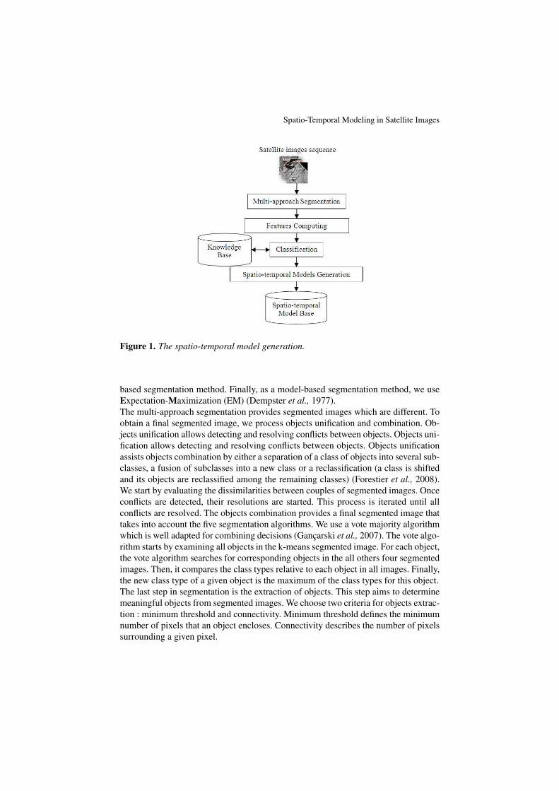
The model generation step ensures learning of the proposed approach through thepreparation of spatio-temporal models representing satellite images. These modelsare stored in a model base. The model generation step is based on a multi-approachsegmentation allowing the identification of objects, features processing allowing des-cribing extracted objects and model building allowing the construction of spatio-temporal models. Figure 1 describes the spatio-temporal model generation.
3.1.1. The Multi-approach Segmentation
The key step in our approach is the multi-approach images segmentation. As seenpreviously, there are five methods of segmentation in the literature. However, one ma-jor problem of these methods is their inabilities to generate objects which are closeenough to the reality. The main problem of the segmentation is the loss of informationwhen we attempt to model satellite image. In order to reduce this loss of informa-tion, we apply, simultaneously, the five segmentation methods detailed in section 2.Each applied method has its own algorithm which can be more appropriate to seg-ment certain images. Also, applying several methods of segmentation helps discovernew knowledge not discovered when applying only one method.Our approach uses the five segmentation methods : hierarchical, partition-based, grid-based, density-based, and model-based methods. We use the k-means algorithm (Har-tigan, 1979) as a hierarchical segmentation method. We choose the Balanced IterativeReducing and Clustering (BIRCH) algorithm (Zhang et al., 1996) as a partition-basedmethod. We use STatistical INformation Grid (STING) algorithm as a grid-based seg-mentation method (Wang et al., 1997). We apply Density Based Spatial Clustering ofApplications with Noise (DBSCAN) algorithm (Ankerst et al., 1999) for the density-
Spatio-Temporal Modeling in Satellite Images
Figure 1. The spatio-temporal model generation.
based segmentation method. Finally, as a model-based segmentation method, we useExpectation-Maximization (EM) (Dempster et al., 1977).The multi-approach segmentation provides segmented images which are different. Toobtain a final segmented image, we process objects unification and combination. Ob-jects unification allows detecting and resolving conflicts between objects. Objects uni-fication allows detecting and resolving conflicts between objects. Objects unificationassists objects combination by either a separation of a class of objects into several sub-classes, a fusion of subclasses into a new class or a reclassification (a class is shiftedand its objects are reclassified among the remaining classes) (Forestier et al., 2008).We start by evaluating the dissimilarities between couples of segmented images. Onceconflicts are detected, their resolutions are started. This process is iterated until allconflicts are resolved. The objects combination provides a final segmented image thattakes into account the five segmentation algorithms. We use a vote majority algorithmwhich is well adapted for combining decisions (Gançarski et al., 2007). The vote algo-rithm starts by examining all objects in the k-means segmented image. For each object,the vote algorithm searches for corresponding objects in the all others four segmentedimages. Then, it compares the class types relative to each object in all images. Finally,the new class type of a given object is the maximum of the class types for this object.The last step in segmentation is the extraction of objects. This step aims to determinemeaningful objects from segmented images. We choose two criteria for objects extrac-tion : minimum threshold and connectivity. Minimum threshold defines the minimumnumber of pixels that an object encloses. Connectivity describes the number of pixelssurrounding a given pixel.
W. Boulila, I. R. Farah, K. S. Ettabaa, B. Solaiman and H. B. Ghézala
Algorithm 1 depicts the process of objects extraction. For each type of object class(the type of object class involves all objects having the same nature ; the same la-bel), we start by separating all objects. Then, objects having a pixel number less thanthe minimum threshold (ExtractionThresh) and a connectivity less than the connec-tivity threshold (ConnectivityThresh) are disregarded. Achieved objects belonging tothe same type of object class are registered in a separate object structure (StructObjs).
Algorithm 1 Objects Extraction AlgorithmRequire: ImageSegmente, ExtractionThresh, ConnectivityThreshEnsure: StructObjs
1: for all Objects classes in an image I do2: Separate each objects class3: Eliminate regions having a less number of pixels than ExtractionThresh4: Only keep pixels having a connectivity greater than ConnectivityThresh5: Divide each object into a separate image6: Register objects belonging to the same class in a separate structure StructObjs7: end for
3.1.2. Features Processing
Geographic objects, usually, evolve according to three axes : spatial, temporal, andthematic. To follow object evolution according to these axes, we represent each objectby five features : radiometry, geometry, texture, spatial localization, and acquisitioncontext (Aksoy et al., 2005) (Boulila et al., 2009a) (Chitrakala et al., 2009) (Ettabaaet al., 2008).
1) Radiometric FeaturesThe radiometry of an object depends on its spectral composition. Among the featureswe use in our work : the mean radiometric, the standard deviation, the swekness, andthe kurtosis (Chitrakala et al., 2009).Let us suppose a satellite image I having a size of Np ∗ Nq pixels. I={Ipq| p=1, . . .,Np ; q=1, . . ., Nq}, Ipq∈{0,. . ., L-1} where L represent the number of gray level.The mean radiometric X1 is defined as
X1 =1
NpNq
Np∑p=1
Nq∑q=1
Ipq [1]
The standard X2 deviation is defined as
X2 =
√√√√ 1NpNq
Np∑p=1
Nq∑q=1
(Ipq −X1)2 [2]
The swekness X3 is defined as
X3 =1
NpNqX32
Np∑p=1
Nq∑q=1
(Ipq −X1)3 [3]
Spatio-Temporal Modeling in Satellite Images
The kurtosis X4 is defined as
X4 =1
NpNqX42
Np∑p=1
Nq∑q=1
(Ipq −X1)4 [4]
2) Geometric FeaturesGeometric features describe the shape of a geographic object independently of sensorsand points of observation. Among these features, we list length, width, perimeter, andarea. For the length and width, we use the Minimum Bounding Rectangle (MBR).
3) Textural FeaturesTextual features are related to the contrast of processed images. The textural featurescan be used to differentiate between objects having the same color. Among these fea-tures, we used the Haralick and Gabor features (Manjunath et al., 1996). Haralickfeatures are computed based on co-occurrence matrix. We use five attributes fromthese features which are : energy, entropy, correlation, homogeneity, and contrast. TheGabor filters represent a visual perception model of texture. Gabor features are themean and variance of the filtered image.
4) Spatial FeaturesThe spatial description highlights neighborhood relations between objects extractedfrom satellite image. The spatial features concern the arrangement, spatial relation,and position of the objects to be detected. In our study, we work with two types ofspatial relations : directional and metric relations (Aksoy et al., 2005).Directional relations describe the spatial position of an object with regard to anotherobject. These relations give information about the organization of objects indepen-dently from their size, shape or distance. Directional relations can be formulated withnumerical values specifying where an object is located inside the reference object.Here the angle between two considered objects is computed while referring to theirrespective centroids.Metric relations depict the distances between objects in satellite images. In the pro-posed approach, the distance between two objects obj1 and obj2 corresponds to thedistance between their respective centroids (Bedel et al., 2008).
5) Acquisition Context FeaturesThe acquisition context features encloses a set of characteristics describing the cir-cumstances, conditions, and environmental features of the acquisition context. Amongthese features, we list : image description (e.g. resolution, name, information, etc.),sensor description (e.g. type, spectral interval, degree of certainty, etc.), and atmos-pheric condition (e.g. temperature, pressure, moisture, etc.).
3.1.3. Spatio-temporal Model Building
For each object extracted of a satellite image, we compute the five features descri-bing a given object : radiometric, geometric, textural, spatial, and acquisition contextfeatures. The feature attributes are calculated for each image-acquisition date and thentranslated into an XML file. Let us suppose that we have an object obj extracted froma satellite image ; this object can be a lake, vegetation, urban, etc.
W. Boulila, I. R. Farah, K. S. Ettabaa, B. Solaiman and H. B. Ghézala
For each date, obj is identified through a set of attributes value (A1, . . ., AN ) descri-bing the five features. At a given date, the set of attribute values define the state of obj.In the proposed approach a model Mp is a set of object states relative to a particularobject. The equation (5) presents the form of a model Mp.
Mp =
t1
A1
A2
...AN
...
tn
A1
A2
...AN
[5]
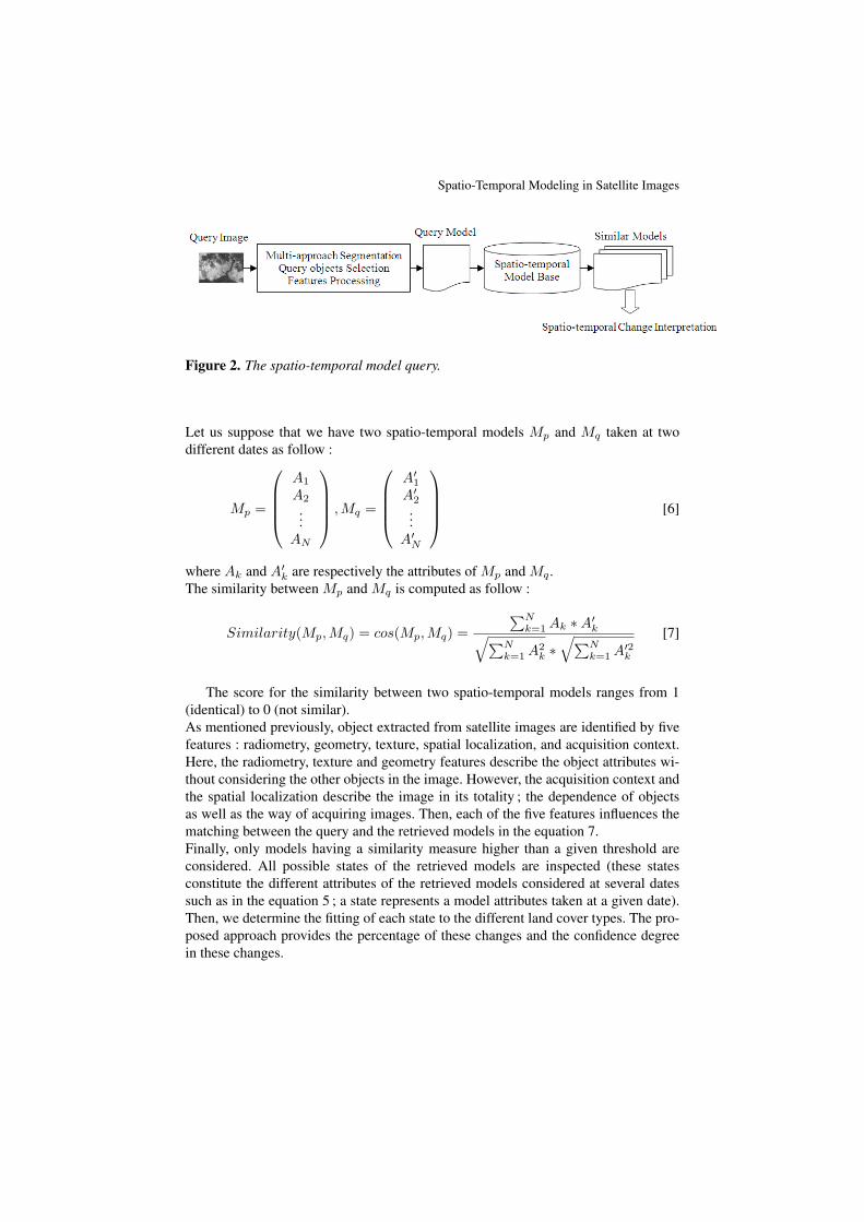
3.2. The Spatio-temporal Model Query
The model query step ensures prediction of changes throughout time for a querymodel (Boulila et al., 2009a) (Boulila et al., 2009b). It tracks the same process (asthe model generation step) in order to obtain the spatio-temporal models. In thisstep, the most similar models to the query one are retrieved. The proposed approachprocess takes advantages of the application of several knowledge mining methods toprovide local decisions about the change made throughout time for a given object.The multi-approach model mining is based on four steps : fuzzy clustering, similaritymeasure, fuzzy classification and spatio-temporal change tree building. The fuzzyclustering is used to decompose the whole model base into several sub-bases havingeach one models with similar behavior and close attributes. The second sub-step isthe similarity measure. This step has as objective to rank models in the consideredsub-bases according to their resemblance to a query model. Thus, we obtain aset of similar models at different dates. The fuzzy classification sub-step providesconfidence degrees representing the fitting of a state to the different land cover types.The last step, the spatio-temporal change tree building, provides the possible changesof a query model Mp to these land-cover types. It also provides the percentage ofthese changes and the confidence degree in these changes.Figure 2 depicts the spatio-temporal model query process.
The similarity measure is ensured by the normalized cosine distance. Cosine si-milarity is used for calculating the resemblance between two spatio-temporal models.It is often used to limit the dimensionality of the problem. Cosine similarity is morepractical for potential applications and online processing unlike other approaches likeEuclidean distance-based algorithm, where data need to be normalized first (Dong etal., 2006).
Spatio-Temporal Modeling in Satellite Images
Figure 2. The spatio-temporal model query.
Let us suppose that we have two spatio-temporal models Mp and Mq taken at twodifferent dates as follow :
Mp =
A1
A2
...AN
,Mq =
A′1A′2...
A′N
[6]
where Ak and A′k are respectively the attributes of Mp and Mq .The similarity between Mp and Mq is computed as follow :
Similarity(Mp,Mq) = cos(Mp,Mq) =∑N
k=1 Ak ∗A′k√∑Nk=1 A2
k ∗√∑N
k=1 A′2k
[7]
The score for the similarity between two spatio-temporal models ranges from 1(identical) to 0 (not similar).As mentioned previously, object extracted from satellite images are identified by fivefeatures : radiometry, geometry, texture, spatial localization, and acquisition context.Here, the radiometry, texture and geometry features describe the object attributes wi-thout considering the other objects in the image. However, the acquisition context andthe spatial localization describe the image in its totality ; the dependence of objectsas well as the way of acquiring images. Then, each of the five features influences thematching between the query and the retrieved models in the equation 7.Finally, only models having a similarity measure higher than a given threshold areconsidered. All possible states of the retrieved models are inspected (these statesconstitute the different attributes of the retrieved models considered at several datessuch as in the equation 5 ; a state represents a model attributes taken at a given date).Then, we determine the fitting of each state to the different land cover types. The pro-posed approach provides the percentage of these changes and the confidence degreein these changes.
W. Boulila, I. R. Farah, K. S. Ettabaa, B. Solaiman and H. B. Ghézala
4. Validation
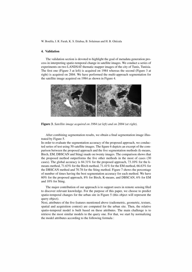
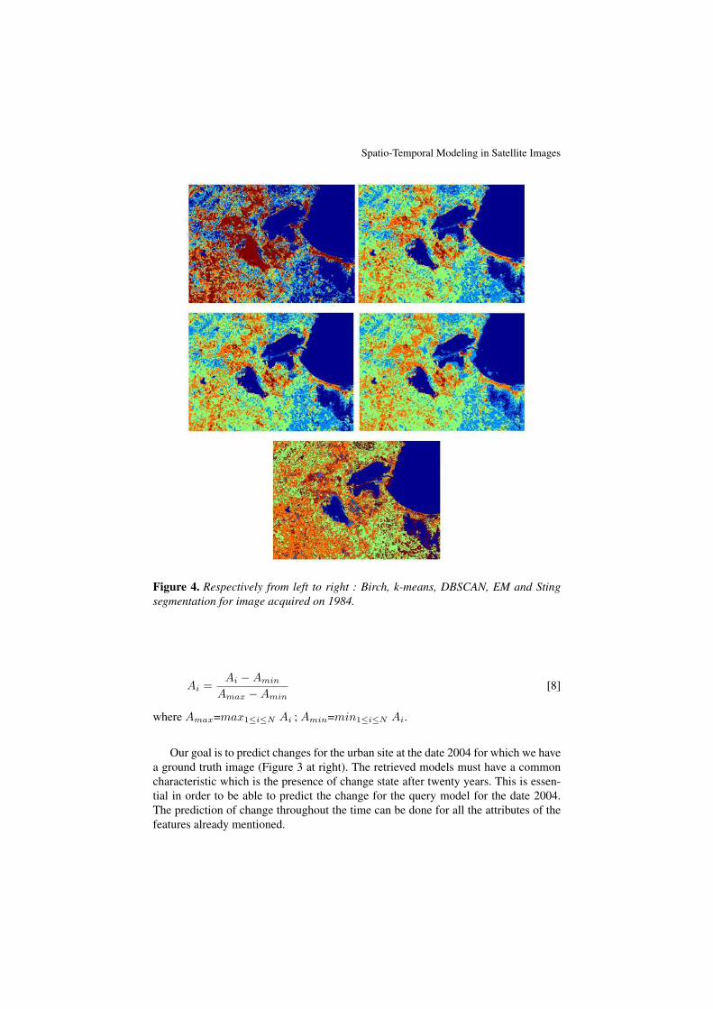
The validation section is devoted to highlight the goal of metadata generation pro-cess in interpreting spatio-temporal change in satellite images. We conduct a series ofexperiments on two LANDSAT thematic mapper images of the city of Tunis, Tunisia.The first one (Figure 3 at left) is acquired on 1984 whereas the second (Figure 3 atright) is acquired on 2004. We have performed the multi-approach segmentation forthe satellite image acquired on 1984 as shown in Figure 4.
Figure 3. Satellite image acquired on 1984 (at left) and on 2004 (at right).
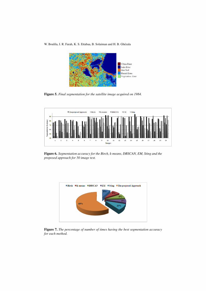
After combining segmentation results, we obtain a final segmentation image illus-trated by Figure 5.In order to evaluate the segmentation accuracy of the proposed approach, we conduc-ted series of test using 50 satellite images. The figure 6 depicts an excerpt of the com-parison between the proposed approach and the five segmentation methods (k-means,Birch, EM, DBSCAN and Sting) made on twenty images. The comparison shows thatthe proposed method outperforms the five other methods in the most of cases (30cases). The global accuracy is 84.31% for the proposed approach, 73.10% for the k-means method, 71.63% for the Birch method, 71.41% for the EM method, 66.63% forthe DBSCAN method and 70.78 for the Sting method. Figure 7 shows the percentageof number of times having the best segmentation accuracy for each method. We have60% for the proposed approach, 8% for Birch, K-means, and DBSCAN, 6% for EMand 10% for Sting.
The major contribution of our approach is to support users in remote sensing filedto discover relevant knowledge. For the purpose of this paper, we choose to predictspatio-temporal changes for the urban site in Figure 5 (this object will represent thequery object).Next, attributes of the five features mentioned above (radiometric, geometric, texture,spatial and acquisition context) are computed for the urban site. Then, the relativespatio-temporal model is built based on these attributes. The main challenge is toretrieve the most similar models to the query one. For that, we start by normalizingthe model attributes according to the following formula :
Spatio-Temporal Modeling in Satellite Images
Figure 4. Respectively from left to right : Birch, k-means, DBSCAN, EM and Stingsegmentation for image acquired on 1984.
Ai =Ai −Amin
Amax −Amin[8]
where Amax=max1≤i≤N Ai ; Amin=min1≤i≤N Ai.
Our goal is to predict changes for the urban site at the date 2004 for which we havea ground truth image (Figure 3 at right). The retrieved models must have a commoncharacteristic which is the presence of change state after twenty years. This is essen-tial in order to be able to predict the change for the query model for the date 2004.The prediction of change throughout the time can be done for all the attributes of thefeatures already mentioned.
W. Boulila, I. R. Farah, K. S. Ettabaa, B. Solaiman and H. B. Ghézala
Figure 5. Final segmentation for the satellite image acquired on 1984.
Figure 6. Segmentation accuracy for the Birch, k-means, DBSCAN, EM, Sting and theproposed approach for 50 image test.
Figure 7. The percentage of number of times having the best segmentation accuracyfor each method.
Spatio-Temporal Modeling in Satellite Images
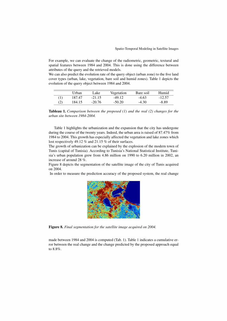
For example, we can evaluate the change of the radiometric, geometric, textural andspatial features between 1984 and 2004. This is done using the difference betweenattributes of the query and the retrieved models.We can also predict the evolution rate of the query object (urban zone) to the five landcover types (urban, lake, vegetation, bare soil and humid zones). Table 1 depicts theevolution of the query object between 1984 and 2004.
Urban Lake Vegetation Bare soil Humid(1) 187.47 -21.15 -49.12 -4.63 -12.57(2) 184.15 -20.76 -50.20 -4.30 -8.89
Tableau 1. Comparison between the proposed (1) and the real (2) changes for theurban site between 1984-2004.
Table 1 highlights the urbanization and the expansion that the city has undergoneduring the course of the twenty years. Indeed, the urban area is raised of 87.47% from1984 to 2004. This growth has especially affected the vegetation and lake zones whichlost respectively 49.12 % and 21.15 % of their surfaces.The growth of urbanization can be explained by the explosion of the modern town ofTunis (capital of Tunisia). According to Tunisia’s National Statistical Institute, Tuni-sia’s urban population grew from 4.86 million on 1990 to 6.20 million in 2002, anincrease of around 28 %.Figure 8 depicts the segmentation of the satellite image of the city of Tunis acquiredon 2004.In order to measure the prediction accuracy of the proposed system, the real change
Figure 8. Final segmentation for the satellite image acquired on 2004.
made between 1984 and 2004 is computed (Tab. 1). Table 1 indicates a cumulative er-ror between the real change and the change predicted by the proposed approach equalto 8.8%.
W. Boulila, I. R. Farah, K. S. Ettabaa, B. Solaiman and H. B. Ghézala
5. Conclusion
In this paper, we presented our approach for spatio-temporal modeling of satelliteimages.Our contribution resides in : (i) automating the process of spatio-temporal modelingof satellite images, (ii) taking into account the spatial/temporal features of objects ex-tracted from images, (iii) improving the identification of objects by following a multi-approach segmentation. The proposed approach takes advantages of the redundanciesand complementarities of segmentation methods in order to decrease imperfectionsrelated to images and therefore improving the prediction of changes for objects in sa-tellite images.The proposed approach is evaluated by two LANDSAT images representing the cityof Tunis, Tunisia. Experiments show different applications of spatio-temporal modelsgenerated by our approach.As future works, we consider testing our approach on several images of different do-mains such as medical one. In addition, we plan to improve the accuracy of the objectsidentification by finding good features describing these objects.
6. Bibliographie
Aksoy S., Koperski K., Tusk C., Marchisio G., Tilton J. C., « Learning bayesian classifiers forscene classification with a visual grammar », IEEE Transactions on Geoscience and RemoteSensing, vol. 43, n˚ 3, p. 581-589, 2005.
Ankerst M., Breunig M. M., Kriegel H. P., Sander J., « Optics : Ordering points to identify theclustering structure », SIGMOD Conference, p. 49-60, 1999.
Barnes C., Fritz H., Jeseon Y., « Hurricane disaster assessments with image-driven data mi-ning in high-resolution satellite imagery », IEEE Transactions on Geoscience and RemoteSensing, vol. 45, n˚ 6, p. 1631-1640, 2007.
Bedel O., Ferré S., Ridoux O., « Handling Spatial Relations in Logical Concept Analysis toExplore Geographical Data », Int. Conf. Formal Concept Analysis, vol. LNAI 4933, p. 241-257, 2008.
Boubou M., Contribution aux methodes de classification non supervisee via des approchespretopologiques et d’agregation d’opinions, Phd thesis, Université Claude Bernard, LyonI, 2006.
Boulila W., Ettabaa K. S., Farah I. R., Solaiman B., Ghézala H. B., « Vers un système multi-approche d’extraction de connaissances spatio-temporelles incertaines en imagerie satelli-taire », SETIT 2009 5th International Conference : Sciences of Electronic, Technologies ofInformation and Telecommunications, Tunisia, 2009a.
Boulila W., Farah I. R., Ettabaa K. S., Solaiman B., Ghézala H. B., « Improving spatiotemporalchange detection : A high level fusion approach for discovering uncertain knowledge fromsatellite image databases », ICDM’09 : International Conference on Data Mining, Venice,Italy, vol. 58, p. 222-227, 2009b.
Spatio-Temporal Modeling in Satellite Images
Chitrakala S., Shamini P., Manjula D., « Multi-class enhanced image mining of heterogeneoustextual images using multiple image features », IACC 2009, IEEE International Conferenceon Advance Computing, p. 496-501, March, 2009.
Dempster A., Laird N. M., Rubin D. B., « Maximum likelihood from incomplete data via theem algorithm », Journal of Royal Statistical Society B, vol. 39, p. 1-38, 1977.
Dong Y., Sun Z., Jia H., « A cosine similarity-based negative selection algorithm for time seriesnovelty detection », Mechanical Systems and Signal Processing, vol. 20, p. 1461-1472,2006.
Ettabaa K. S., I. R. Farah M. B. A., Solaiman B., « Mining spatio-temporal metadata for sa-tellite images interpretation », ICTTA’08 3rd International Conference on Information andCommunication Technologies : From Theory to Applications, p. 1-6, April, 2008.
Forestier G., Wemmert C., Gançarski P., « Multisource images analysis using collaborativeclustering », EURASIP Journal on Advances in Signal Processing, vol. 133, p. 1-11, 2008.
Gançarski P., Wemmert C., « Collaborative multi-step mono-level multi-strategy classifica-tion », Multimed Tools Appl, vol. 35, p. 1-27, 2007.
Hartigan J., « Algorithm as 136 : a k-means clustering algorithm », Applied Statistics, vol. 28,n˚ 1, p. 100-108, 1979.
Huang Y., Zhang L., Zhang P., « A framework for mining sequential patterns from spatio-temporal event data sets », IEEE Trans. Knowledge and Data Eng., vol. 20, n˚ 4, p. 433-448,2008.
Manjunath B., Ma W., « Texture features for browsing and retrieval of image data », IEEE Transon Pattern Analysis and Machine Intelligence, vol. 18, p. 837-842, 1996.
Nuzillard D., Lazar C., « Partitional clustering techniques for multi-spectral image segmenta-tion », Addison-Wesley, vol. 2, n˚ 10, p. 1-8, 2007.
Tang J., Wang L., Yao Z., « Spatio-temporal urban landscape change analysis using the markovchain model and a modified genetic algorithm », International Journal of Remote Sensing,vol. 28, n˚ 15, p. 3255-3271, 2007.
Umamaheshwaran R., Bijker W., Stein A., « Image mining for modeling of forest fires frommeteosat images », IEEE Trans. Geosci. Remote Sens., vol. 45, n˚ 1, p. 246-253, 2007.
Wang W., Yang J., Muntz R. R., « Sting : A statistical information grid approach to spatialdata mining », Twenty-Third International Conference on Very Large Data Bases, Athens,Greecep. 186-195, 1997.
Zhang T., Ramakrishnan R., Livny M., « Birch. an efficient data clustering method for verylarge databases », SIGMOD’96 : Proceedings of the 1996 ACM SIGMOD internationalconference on Management of data, ACM Press, New Yorkp. 103-114, 1996.