southern sydney offshore artificial reef
TRANSCRIPT

FISHERIES NSW | FISHERIES ENHANCEMENT PROGRAM
Southern Sydney Offshore Artificial Reef
Long term management plan

Published by the NSW Department of Primary Industries
Southern Sydney offshore artificial reef – Long term management plan
First published August 2018
More information
www.dpi.nsw.gov.au
Cover Image: Installation of the Port Macquarie offshore artificial reef in February 2016 (DPI – Fisheries)
© State of New South Wales through the Department of Industry, Skills and Regional Development, 2018. You may copy, distribute and otherwise freely deal with this publication for any purpose, provided that you attribute the NSW Department of Primary Industries as the owner.
Disclaimer: The information contained in this publication is based on knowledge and understanding at the time of writing (August 2018). However, because of advances in knowledge, users are reminded of the need to ensure that information upon which they rely is up to date and to check currency of the information with the appropriate officer of the Department of Primary Industries or the user’s independent adviser.

Southern Sydney offshore artificial reef – Long Term Management Plan
Contents Contents ...................................................................................................................................... i
List of Figures ............................................................................................................................. iii
List of Tables............................................................................................................................... iv
Long term management plan ...................................................................................................... 1
1 Introduction .......................................................................................................................... 1
1.1 Project planning ............................................................................................................ 2
1.2 Consultation with relevant Commonwealth, State and Local Government agencies and interested non-government organisations ................................................................................ 3
2 Project goals and objectives................................................................................................. 5
2.1 Vision for the activity ..................................................................................................... 5
2.2 Goals for the activity...................................................................................................... 5
3 Risk assessment .................................................................................................................. 5
3.1 Introduction ................................................................................................................... 5
3.2 Methods ........................................................................................................................ 5
4 Southern Sydney offshore artificial reef management area .................................................. 8
4.1 Socioeconomic considerations ...................................................................................... 8
4.2 Environmental considerations ..................................................................................... 10
4.3 Biological considerations ............................................................................................. 15
5 Module design, reef configuration and construction............................................................ 23
5.1 Material ....................................................................................................................... 23
5.1.1 Reef layout and module dimensions .................................................................... 24
5.1.2 Reef construction and staging methodology ......................................................... 24
5.1.3 Fabrication hardstand and inspection site ............................................................ 25
5.2 Reef Deployment site .................................................................................................. 26
5.2.1 Map of deployment site ........................................................................................ 26
5.2.2 Photographs and/or video of the proposed site prior to deployment ..................... 28
5.2.3 Geographical position (latitude and longitude) ..................................................... 29
5.2.4 ‘As-built’ location confirmation .............................................................................. 29
5.2.5 Depth of water over the reef ................................................................................. 29
5.2.6 Distance from nearest land .................................................................................. 29
5.2.7 Biological characteristics ...................................................................................... 30
5.2.8 Characteristics of the sea bottom at the site, and impact of material on biota at the placement site or other areas potentially affected by the creation of the artificial reef......... 30
5.2.9 Relation of proposed site to features of importance for amenity, navigation, or exploitation of cultural, historic or scientific interest, fishing, endangered, rare or migratory species or sensitive habitats (such as coral reefs or seagrass beds) ................................. 33
i NSW Department of Primary Industries, August 2018

Southern Sydney offshore artificial reef – Long term management plan
5.2.10 Ocean currents, tides and prevailing weather conditions ...................................... 51
5.2.11 Summary of the reasons for selection of proposed site ........................................ 56
6 Scope, duration and timeframes for monitoring .................................................................. 58
6.1 Priorities ...................................................................................................................... 58
6.2 Monitoring timeframes ................................................................................................. 59
6.2.1 Structural integrity and stability monitoring ........................................................... 60
6.3 Performance monitoring and review ............................................................................ 62
6.3.1 Performance indicators ........................................................................................ 62
6.3.2 External drivers .................................................................................................... 62
6.3.3 Trigger points ....................................................................................................... 62
7 Environmental management .............................................................................................. 66
7.1 Environmental reporting .............................................................................................. 66
7.1.1 Logs and registers ............................................................................................... 66
7.2 Offshore artificial reef user education and awareness guidelines ................................ 67
7.3 Fouled gear (debris) removal strategy ......................................................................... 67
7.3.1 Inspection timing .................................................................................................. 67
7.3.2 Inspection ............................................................................................................ 67
7.3.3 Debris removal triggers ........................................................................................ 67
7.3.4 Debris removal ..................................................................................................... 68
7.4 Contingency measures ............................................................................................... 68
7.5 Emergency contacts and response ............................................................................. 68
7.6 Decommissioning ........................................................................................................ 69
7.7 Project reporting .......................................................................................................... 69
7.8 Long term management plan review ........................................................................... 70
REFERENCES ......................................................................................................................... 71
Southern Sydney offshore artificial reef – Long term management plan
List of Figures Figure 1. Artist impression of newly deployed artificial reef modules on the sea floor .................. 2 Figure 2. Southern Sydney offshore artificial reef EA team ......................................................... 3 Figure 3. General location for proposed deployment of the reef .................................................. 8 Figure 4. Average (± SE) fishing effort at the OAR site per season for the two sampling years (year 1 is June 2012- May 2013; year 2 is June 2013- May 2014) .............................................. 9 Figure 5. Combined wave rose of Long Reef and Botany Bay offshore wave datasets from 1992-2016 (Technical Report C) ........................................................................................................ 11 Figure 6. Probability of exceedance for significant wave height (Hs) for the Botany Bay waverider buoy from 1992-2016 (Technical Report C)............................................................................... 12 Figure 7. Seabed bathymetry derived from swath acoustic surveys (derived from Technical Reports D and E) ...................................................................................................................... 14 Figure 8. ReefTempleTM module with a 6.5m vertical relief (including tower) and arrangement of the 20 ReefTempleTM modules installed to form the Port Macquarie offshore artificial reef ........ 23 Figure 9. Flow modification testing of the Reef Temple at the University of WA, Flume Tank .... 24 Figure 10. Fabrication ‘hard-stand’ reef module site at Port Kembla in December 2014 ............ 25 Figure 11. Tug setting deployment barge anchors at the Shoalhaven offshore artificial reef site in January 2015 ............................................................................................................................ 26 Figure 12. Map of geographical locations for each of the proposed reef modules ..................... 27 Figure 13. Baited remote underwater video deployment on the proposed offshore artificial reef centrepoints (top: northern reef set; bottom: southern reef set). A number of Blue-spotted Flathead and a Banjo Ray can been seen around the baits (Image: DPI – August 2016) .......... 28 Figure 14. Map showing proposed reef location and distances to nearest land ......................... 30 Figure 15. Boat ramps in the study region ................................................................................. 35 Figure 16. Location of areas of conservation significance in relation to the proposed southern Sydney offshore artificial reef .................................................................................................... 50 Figure 17. Pre and post deployment weighted mean wave direction along the Royal National Park shoreline (Technical Report C).......................................................................................... 52 Figure 18. Impacts of reef structures on peak near-bed current speed and near-bed change during 100 year ARI event (southwesterly wind direction) at peak bed current of 0.78 m/sec at Sydney OAR site (Technical Report C) ..................................................................................... 54 Figure 19. Providential Head near-bed current rose (top) and probability of exceedance (top) from a depth of 30 m [39] .......................................................................................................... 55 Figure 20. Potential deployment area identified through constraints analysis (Technical Report A) .............................................................................................................................................. 57 Figure 21. Vemco VR4 with a 10 year battery life and remote download capabilities fitted to the Sydney offshore artificial reef .................................................................................................... 59 Figure 22. Inspections of the Sydney (upper image - 7 May 2015) and Shoalhaven (lower image - 18 May 2015) OARs following an intense east coast low that produced waves up to 15 m (Hmax) ...................................................................................................................................... 61

Southern Sydney offshore artificial reef – Long term management plan
List of Tables Table 1. Consultation letter distribution details ............................................................................ 4 Table 2. Risk analysis matrix ....................................................................................................... 7 Table 3. Threatened and protected species in the southern Sydney area ................................. 17 Table 4. Geographical position of the proposed reef patches*................................................... 29 Table 5. Risk assessment of soft sediment assemblages considered in the reef assessment ... 32 Table 6. Risk assessment of rocky reef assemblages considered in the reef assessment ........ 33 Table 7. Boat ramps and facilities within 25 km of the proposed southern Sydney offshore artificial reef site ........................................................................................................................ 34 Table 8. Risks and mitigation associated with clearance ........................................................... 36 Table 9. Risks and mitigation associated with increased vessel traffic ...................................... 36 Table 10. Risks and mitigation associated with conflict with areas of spiritual significance/dreaming’s ............................................................................................................. 37 Table 11. Submerged shipwrecks known to occur within the southern Sydney region .............. 38 Table 12. Risks and mitigation associated with loss of commercial fishing grounds .................. 39 Table 13. Risks and mitigation associated with conflict between user groups ........................... 39 Table 14. Risks and mitigation associated with the offshore artificial reef not achieving its goals.................................................................................................................................................. 41 Table 15. Risks and mitigation associated with gear hook-up ................................................... 41 Table 16. Risks and mitigation associated with impacts on commercial fish stocks ................... 42 Table 17. Risks and mitigation associated with injury or drowning (spearfishing) ...................... 42 Table 18. Risks and mitigation associated with invasive marine pests ...................................... 43 Table 19. Risk assessment of threatened and protected species considered in the risk assessment ............................................................................................................................... 48 Table 20. Distances of proposed offshore artificial reef to areas of conservation significance ... 49 Table 21. Risks and mitigation associated with inshore wave climate and change to beach erosion/deposition ..................................................................................................................... 52 Table 22. Design 10 minutes average wind speeds (m/s) at the Caltex Jetty in Botany Bay ..... 53 Table 23. Risks and mitigation associated with local scouring/deposition around units ............. 56 Table 24. Tidal planes at the proposed OAR deployment site (m LAT) ..................................... 56 Table 25. Research priorities and description ............................................................................ 58 Table 26. Environmental monitoring and timeframes proposed on the southern Sydney offshore artificial reef............................................................................................................................... 60 Table 27. Trigger points ............................................................................................................ 64

Southern Sydney offshore artificial reef – Long term management plan
Long term management plan The NSW Department of Primary Industries (DPI) is responsible for the operation, including management, monitoring and maintenance of the southern Sydney offshore artificial reef. This long term management plan has been developed to provide clear direction on the implementation of environmental management best practices during the construction/installation, and operation of the reef.
This plan has been developed as part of the environmental assessment (EA) process and DPI is committed to carrying out the mitigation measures outlined in this plan and Section 9 of the EA. As such, detailed assessment of ecological, biological and socio‐economic impacts have been considered and addressed by the EA and are summarised in this plan. For a more detailed description, reference should be made to the EA.
1 Introduction DPI aims to improve recreational fishing opportunities in NSW through the development of offshore artificial reefs in offshore locations. DPI manages recreational fishing in ocean waters off NSW under the Fisheries Management Act 1994 (FM Act) and the Offshore Constitutional Settlement. The primary objective of the FM Act is ‘to conserve, develop and share the fishery resources of the State for the benefit of present and future generations’. Further objectives under the Act include promoting ‘ecologically sustainable development, including the conservation of biological diversity’ and promoting ‘quality recreational fishing opportunities’. The deployment of artificial reefs as a fisheries enhancement tool is consistent with these objectives.
Recreational fishing is an important leisure activity for approximately 12% of the NSW population (approximately 849,000 people over the age of 15) and provides significant social and economic benefits, with an estimated $3.42 billion generated in economic activity in NSW each year creating approximately 14,000 full-time equivalent jobs. Almost half (45%) of all recreational fishers in NSW reside in the Sydney region. Total recreational fishing expenditure is highest by anglers living in Sydney ($903m) accounting for 56% of total expenditure in NSW.
In NSW, approximately 22% of the total fishing effort takes place between the shoreline and 5 km offshore. The creation of new, high quality fishing areas through the deployment of offshore artificial reefs will enhance fishing opportunity by creating high relief, complex fish habitats. Recreational reefs will provide additional fishing locations and an alternative to heavily fished natural reefs. They also have the potential to increase the abundance and productivity of some demersal and reef species found there.
The proposal is considered an ‘activity’ under Part 5 of the NSW Environmental Planning and Assessment Act 1979 (EP&A Act). The deployment of the offshore artificial reef structure requires a licence under Section 34 of the Crown Lands Act 1989, given the proposed deployment site is located in State waters (within 3 nautical miles) on unzoned land. Concurrence is required from the NSW Office of Environment and Heritage (OEH) under the Coastal Protection Regulation 2011, to carry out work on the open coast below mean high water mark where the top of the objects after placement will be less than 30 metres below mean sea level. The proposal also requires a permit under Commonwealth legislation, as the construction of artificial reefs is regulated under the Commonwealth Environment Protection (Sea Dumping) Act 1981 (EP (SD) Act).
In addition to approval under Section 19 of the EP (SD) Act (Commonwealth), other permits and licences required for the project to proceed, may include:
• towing permit from NSW Roads and Maritime Services to transport the reef structure – responsibility of installation contractor;
1 NSW Department of Primary Industries, August 2018
Southern Sydney offshore artificial reef – Long term management plan
• aquatic licence from NSW Maritime for exclusive use of the waters for the purposes of sinking and/or monitoring the structures – responsibility of installation contractor and,
• authorisation under Section 13T of the Maritime Services Act 1935 for buoys or moorings associated with the offshore artificial reefs – for deployment purposes only and are the responsibility of installation contractor.
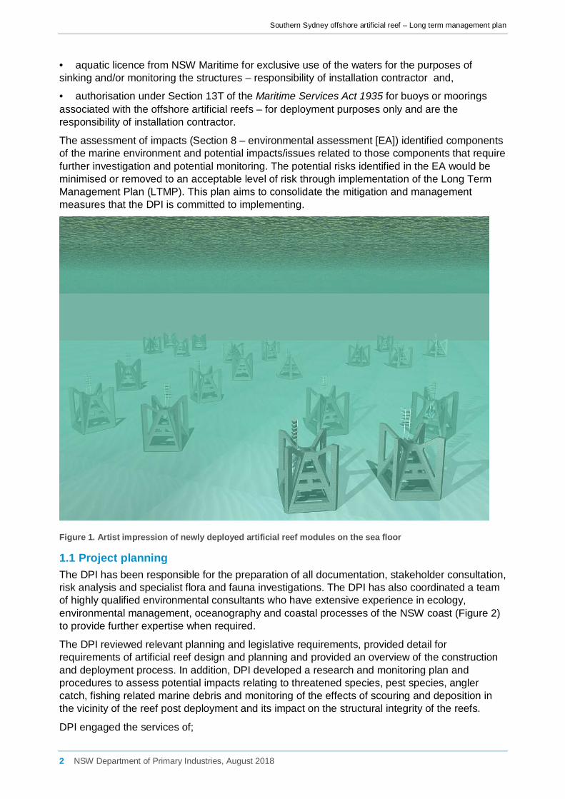
The assessment of impacts (Section 8 – environmental assessment [EA]) identified components of the marine environment and potential impacts/issues related to those components that require further investigation and potential monitoring. The potential risks identified in the EA would be minimised or removed to an acceptable level of risk through implementation of the Long Term Management Plan (LTMP). This plan aims to consolidate the mitigation and management measures that the DPI is committed to implementing.
Figure 1. Artist impression of newly deployed artificial reef modules on the sea floor
1.1 Project planning The DPI has been responsible for the preparation of all documentation, stakeholder consultation, risk analysis and specialist flora and fauna investigations. The DPI has also coordinated a team of highly qualified environmental consultants who have extensive experience in ecology, environmental management, oceanography and coastal processes of the NSW coast (Figure 2) to provide further expertise when required.
The DPI reviewed relevant planning and legislative requirements, provided detail for requirements of artificial reef design and planning and provided an overview of the construction and deployment process. In addition, DPI developed a research and monitoring plan and procedures to assess potential impacts relating to threatened species, pest species, angler catch, fishing related marine debris and monitoring of the effects of scouring and deposition in the vicinity of the reef post deployment and its impact on the structural integrity of the reefs.
DPI engaged the services of;
2 NSW Department of Primary Industries, August 2018

Southern Sydney offshore artificial reef – Long term management plan
• Cardno Pty Ltd to provide technical expertise and participate in the risk assessments for the process, to compile a constraining features report (Technical Report A), to provide expertise in coastal processes including wave behaviour and sediment movement and circulation (Technical Report C) and to compile a report on infauna and epifauna communities found in the vicinity of the reef and potential impacts on those communities post deployment (Technical Report F).
• Umwelt Pty Ltd was contracted to investigate the cultural significance of the site and potential impacts on Indigenous heritage (Technical Report B).
• The Office of Environmental and Heritage – Habitat Mapping Branch was contracted to complete acoustic swath mapping to provided maps of habitats in the vicinity of the proposed reef locations (Technical Reports D and E).
Southern Sydney offshore artificial reef team
DPI (Fisheries)
Stakeholder consultation, environmental assessment
and management, threatened species
assessment, risk assessment
Umwelt Pty Ltd Indigenous heritage, Indigenous consultation
Office of Environment and Heritage
Seabed habitat mapping and sedimentary structure
Cardno Pty Ltd
Constraints mapping,;benthic ecology; wave behaviour, sediment movement and
circulation; and risk assessment
TBC Construction process,
construction and deployment of reef
Figure 2. Southern Sydney offshore artificial reef EA team
1.2 Consultation with relevant Commonwealth, State and Local Government agencies and interested non-government organisations
Consultation was carried out by letter (a total of 332 letters were distributed), email, phone calls and through stakeholder consultation meetings (Table 1). Fisheries enhancement and the proposed offshore artificial reef were also included as agenda items as part of regular stakeholder meetings (e.g. The Recreational Fishing NSW Advisory Council [RFNSW] and the Recreational Fishing Saltwater Trust Expenditure Committee [RFSTEC]). In addition, consultation relating to the Indigenous Cultural Heritage Assessment was carried out by Umwelt Pty Ltd and outcomes of this consultation were summarised in the corresponding report (Technical Report B).
Additionally, a webpage specifically relating to the proposed southern Sydney offshore artificial reef was launched at the beginning of the consultation period on the DPI fisheries webpage (www.fisheries.nsw.gov.au). The website was used to provide updates on the progress of the proposal and information regarding the environmental assessment, and a dedicated email
3 NSW Department of Primary Industries, August 2018

Southern Sydney offshore artificial reef – Long term management plan
address ([email protected]) was provided as an additional avenue for community feedback.
Responses from the statutory and non-statutory groups consulted were received via telephone, email and from the stakeholder consultation meetings. Not all groups contacted during the consultation responded. However, the proposal was generally well-received in terms of the location and design of the reef and the processes used in selecting these.
Table 1. Consultation letter distribution details
Group Number
Recreational fishing stakeholders (including line and spear fishing clubs, recreational fishing associations and charter operators in the southern Sydney area)
116
Commercial fishing stakeholders (including fishing business owners, nominated fishers, professional associations and fishermen’s co-operatives)
114
Conservation 9
Diving (retailers, charters) 13
Boating/sailing 10
Surf lifesaving clubs 7
Statutory authorities (including local, state and federal government) 17
Recreational licence agents (in the southern Sydney area) 35
Universities 5
Businesses/voluntary organisations 6
Total 332
The results of cultural heritage investigations and consultations with relevant stakeholders by Umwelt Pty Ltd in accordance with the Due Diligence Code of Practice for the Protection of Aboriginal Objects in NSW (due diligence code, [1]) are presented in Technical Report B. The due diligence code considered any potential impact the proposal may have on Aboriginal cultural values and activities (such as fishing) in the area. The key findings were however that the seafloor within the project area is currently 30 metres underwater, and is understood to be functionally flat, sandy, with no exposed surfaces that may formerly have been ground surface prior to inundation, significant vegetation or other ecological considerations. Given the depth and distance from shore, it is considered that:
• there is negligible potential for the presence of in-situ Aboriginal objects within the project area;
• there is a low possibility of Aboriginal objects being transported to the project area by natural or assisted means; and
• if Aboriginal objects are present within the project area, they are likely to have been buried by natural coastal processes.
Technical Report B summarised that the project is considered to have a very low likelihood of resulting harm to Aboriginal objects. This is a result of the location of the project area off shore and the minimal ground disturbance associated with the project.
Site selection of the reef has been refined to the current location to ensure that it will have nil impact upon the safe surface navigation of commercial traffic. The Australian Maritime Safety Authority (AMSA) were consulted with and have not raised any concern.
For further information on the consultation conducted as part of the EA and the results of this refer to Section 5 of the EA.
4 NSW Department of Primary Industries, August 2018
Southern Sydney offshore artificial reef – Long term management plan
2 Project goals and objectives 2.1 Vision for the activity The long-term vision for the deployment of offshore artificial reefs is: ‘An activity that provides effective enhancement of saltwater recreational fishing in NSW; that supports conservation outcomes for fish and fish habitat; and that is undertaken within a clear management framework and consistent with the principles of ecologically sustainable development and ecosystem management’.
2.2 Goals for the activity The proposed goals that have been designed to achieve this vision for the activity are as follows:
1) To manage the activity in a manner that minimises impacts on ecological sustainability and aquatic biodiversity and improves the knowledge of the activity and ecosystems in which it operates.
2) To enhance fishing opportunities through cost-effective reef deployment which complements other existing DPI programs to ensure sustainable fisheries resources and that maximise social benefits, consistent with achieving outcomes aligned with the priorities of the NSW State Plan.
3) To ensure the consistent production, deployment and monitoring of appropriate quality reefs.
3 Risk assessment 3.1 Introduction As part of the Environmental Assessment, a risk analysis workshop was held on 9 September 2016 and attended by representatives of Cardno Pty Ltd including Dr Marcus Lincoln-Smith and the DPI. The aim of the workshop was to identify potential issues/hazards associated with the proposed southern Sydney offshore artificial reef, to assess the likelihood of occurrence of such hazards and the consequence to key receptors if these hazards eventuated.
The initial risk analysis considered potential impacts relating to coastal processes and oceanography, ecosystem processes, contamination, fisheries (commercial and recreational) and interference with existing coastal infrastructure, obstructions and exclusion zones. The constraints mapping process (Technical Report A) sought to minimise or eliminate a number of potential risks associated with existing infrastructure, obstructions and exclusion zones (such as deepwater ocean outfalls, port restrictions, spoil grounds and historical shipwrecks), by selecting locations away from such areas. This process also minimised potential risks associated with threatened species by avoiding critical habitats and marine protected areas. Risks associated with stability were reduced by selecting areas consisting predominantly of sand/coarse sand and avoiding known reef habitats, although this required further survey work due to a lack of fine-scale seabed habitat information.
The risk assessment focusses on issues identified through the risk assessment workshop, during consultation and those identified for consideration through both State and Commonwealth legislation.
3.2 Methods Environmental or ecological risk assessment has become an important means for identifying the likelihood and relative consequence of potential hazards associated with human activities. It is also now being widely advocated as beneficial for fisheries management ([2]). The following risk
5 NSW Department of Primary Industries, August 2018

Southern Sydney offshore artificial reef – Long term management plan
assessment was based on the principles of Australian Standards for Risk Management 4360:2004 and Fletcher ([2]).
Typically, assessment of risk entails the identification of a potential hazard (i.e. some aspect of the activity that could affect the environment), a judgement of the likelihood that the hazard has of occurring and a judgement of the consequence of that hazard, if it did result from the proposed activity. Frequently, scientists and managers also consider those aspects of the environment that might be subject to the hazard; such aspects are often referred to as receptors.
Key points that need to be recognised in relation to the general risk assessment:
• The risk assessment benefited greatly from the initial site selection and constraints mapping (Technical Report A) which resulted in avoidance of major biological constraints, such as areas of natural reef and areas of conservation significance, navigational hazards and exclusion zones.
• The risk assessment was done at a generic level. • Risk is often scale-dependent; therefore the risks were assessed using scales where they
were thought to have the greatest potential impact. To reduce the subjectivity of this analysis, the scale on which each of the risks was assessed is listed in the risk assessment table.
• The risk analysis methodology deals mainly with impacts on the environment. However, the methodology has also been used to analyse relevant health and safety issues.
• The risk analysis (and environmental assessment) is based on the proposed reef design as given in Section 3.2 of the EA.
Table 2 gives the rationale for scoring probability/likelihood of a hazard occurring and of the consequence if the hazard eventuated. Scores of likelihood and consequence may then be combined into a matrix to provide a subjective judgement of significance. Based on this, each hazard/risk is identified as being of very low, low, medium or high significance. The result of the risk assessment does not mean that the project should not proceed, i.e. if the level of risk is high, but rather that the issue may need greater or less effort in management/mitigation or that further research on the receiving environment is required. Note that health and safety impacts are assessed on a different scale to environmental impacts.
6 NSW Department of Primary Industries, August 2018

Southern Sydney offshore artificial reef – Long term management plan
Table 2. Risk analysis matrix
Likelihood
A Almost certain Is expected to occur as a result of the project under most circumstances >1 / month
B Likely Will probably occur as a result of the project in most circumstances >1 / year
C Possible Could occur and has occurred in similar circumstances 1–10 years
D Unlikely Could occur as a result of the project but is not expected 10 – 100 years
E Rare Could occur only in exceptional circumstances <1/100 years
Consequence (Environmental)
1 Catastrophic Widespread extreme impact beyond the deployment area; limited prospect of full recovery
2 Major Substantial impact/serious harm within the immediate deployment area; limited prospect of full recovery
3 Moderate Serious/significant impact; recovery longer than 3 years
4 Minor Localised harm; recovery measurable within 1-3 years.
5 Minimal No impact on the baseline environment; minimal or no mitigative actions required
Consequence (Health and Safety)
1 Catastrophic Single or multiple fatalities
2 Major Catastrophic illness or injury
3 Moderate Extensive/major injury
4 Minor Minor injury e.g. medical treatment required
5 Minimal No medical treatment required
Scale
Sub – Local 30 m radius from the reef modules
Local 400 m x 400 m (16 HA)
Intermediate 0 – 3 km
Large 3 – 10 km
Regional > 10 km
Likelihood
A B C D E
Almost certain Likely Possible Unlikely Rare
Con
sequ
ence
1 Catastrophic A1 B1 C1 D1 E1
2 Major A2 B2 C2 D2 E2
3 Moderate A3 B3 C3 D3 E3
4 Minor A4 B4 C4 D4 E4
5 Minimal A5 B5 C5 D5 E5
H High Risk Risk is significant and requires significant cost-effective measures for risk reduction and/or management.
M Moderate Risk Routine and cost effective measures required to reduce and/or manage risk. Risk may be acceptable.
L Low Risk Risk can be managed by routine procedures and/or no further measures to manage the risk are required.
VL Very Low Risk Risk is accepted, no further measures to manage the risk are required.
7 NSW Department of Primary Industries, August 2018

Southern Sydney offshore artificial reef – Long term management plan
4 Southern Sydney offshore artificial reef management area The location of the proposed reef complex deployment site is situated off the coast of the Royal National Park between Port Hacking (Jibbon) Point and Marley Point, south-south-east of Cronulla, at an approximate depth of 29-30 m LAT (Figure 3). It is proposed that an artificial reef complex consisting of two separate reef sets situated 500 m apart will be installed. The two reef sets will be located within a single reef management area of 37.8 ha. Each reef set will comprise of up to 20 concrete reef modules spread between five clusters and the centre points for each set are 34°05.659’ S, 151°10.657’ E and 34°05.932’ S, 151°10.439’ E (WGS84). A licence to occupy the site for the purpose of the artificial reef has been requested from NSW Crown Lands. For individual reef patch/cluster centre points coordinates refer to Table 4.
Figure 3. General location for proposed deployment of the reef
4.1 Socioeconomic considerations In the southern Sydney region, recreational fishing represents an important leisure activity for the local population. It has been estimated that 8.6% of Sydney’s 4.3 million population and 18.2% from the Illawarra area situated just south of the deployment area participate in recreational fishing each year ([3]). It is anticipated that the OAR will have a high visitation rate based on the fact that it will be based adjacent to the largest metropolitan area in Australia of Sydney, which has a population of approximately 4.3 million. The vast majority of recreational fishing effort in the Sydney region is attributed to Sydney residents (91%) with some visitation from the Hunter region (4%) and Illawarra (3%) accounting for most of the remainder ([3]).
The southern Sydney region provides a wide variety fishing locations across a number of different types of aquatic habitats, including open ocean, ocean beaches, rocky headlands, rivers, coastal embayments and freshwater streams. Botany Bay located within the region is a recreational fishing haven. The recreational fishing havens have been closed to commercial fishing operations by the NSW Government in order to improve the recreational fishing
8 NSW Department of Primary Industries, August 2018

Southern Sydney offshore artificial reef – Long term management plan
experience ([4]). The expansion of infrastructure within Port Botany in recent years has however led to a reduction in access for recreational fishing.
Trip expenditures by anglers are classified as being either directly attributable to fishing (tackle, bait/berley etc.), indirectly attributed (accommodation, travel, boat fuel and hire), and other expenses (eating out, other entertainment, food and drinks etc.). Total recreational fishing expenditure is highest by anglers living in Sydney ($903m) accounting for 56% of total expenditure in NSW ([5]). These results clearly indicate the economic and social importance of recreational fishing to the Sydney community and economy.
An example of the potential visitation rates and usage of offshore artificial reefs can be derived from monitoring results of fishing effort from the Sydney offshore artificial reef with a significant increase in visitation rates over the first two years of its operation associated with the rapid community development of fish on the structure. It is estimated that approximately 1765 and 2460 hours of fisher effort were expended on the OAR during the survey years of 2012/13 and 2013/14, equating to a higher levels of recreational usage intensity than many natural NSW estuarine systems ([6]). Greater levels of effort were observed during 2013/14 compared to the previous year, with effort also more evenly distributed across seasons (Figure 4). The trailer-boat ramp survey indicated that most fish harvested from the OAR consist of large reef associated species and pelagics with this pattern consistent during both 2012/13 and 2013/14.
Figure 4. Average (± SE) fishing effort at the OAR site per season for the two sampling years (year 1 is June 2012- May 2013; year 2 is June 2013- May 2014)
The southern Sydney offshore artificial reef is expected to deliver similar direct social and broader economic benefits by providing increased recreational fishing opportunities in the region. The following have been identified as beneficiaries of the reef:
• recreational fishers who have an interest in healthy fish stocks and a quality marine environment;
• tourism and charter operators who base their businesses around the quality of the fishing experience and the abundance of fish; and
• tackle and boating industry that depend on having sustainable fish resources in the southern Sydney area.
9 NSW Department of Primary Industries, August 2018

Southern Sydney offshore artificial reef – Long term management plan
4.2 Environmental considerations The Hawkesbury Shelf Marine Bioregion runs from Stockton in the north (32°54’S) to Shellharbour (34°35’S) in the south. It includes all coastline, estuaries, coastal lakes and lagoons, beaches and ocean waters to the edge of the continental shelf (approx. 200 m) deep. This section deals primarily with the part of the bioregion in NSW waters, out to 3 nm or approx. 5.56 km offshore
Cardno Pty Ltd initially undertook a constraints analysis and site selection exercise (Technical Report A) to investigate the suitability of the southern Sydney region for the deployment of an offshore artificial reef. Specifically, the report was to outline major physical, oceanographic and biological constraints on site selection, including descriptions; provide high-quality maps identifying constraints and suitable deployment sites at appropriate scales; recommend sites either with potential for deployment of the reef or which require further investigation and/or ground truthing, if required.
Reef siting and design should incorporate a variety of biological, economic, and physical sciences and engineering factors ([7]). Size, relief, complexity, location and biological factors can all influence assemblages of fishes on artificial reefs ([8]). Biological principles that should be considered include habitat limitation ([9]), habitat complexity ([10], [11]) and refuge from predators ([12]). Physical principles deal with the size of the reef structure ([13]) and the strength and stability of the reef materials. Reef size and its influence on species abundance is an ongoing debate. Where biomass has been reported in association with large artificial reefs, it may be composed of large but few individuals ([14]). Conversely, greater densities of fish on smaller artificial reefs have also been reported ([8]). The vertical relief, relative to water depth of an artificial reef, can also influence abundance and diversity. In temperate waters, diversity has been shown to be greater on low-relief artificial structures than on natural structures ([15]). Conversely, a study of high-relief reefs found greater diversity on natural reefs than on artificial reefs ([16]). Psychological, social and economic aspects of human behaviour are also important when considering reef design, taking into account the requirements of possible end user groups ([17], [18], [19]). Refer to Section 2.4 of the EA for additional information.
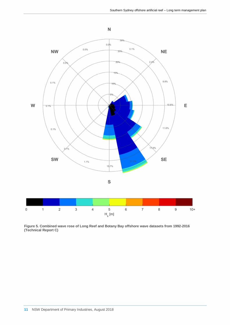
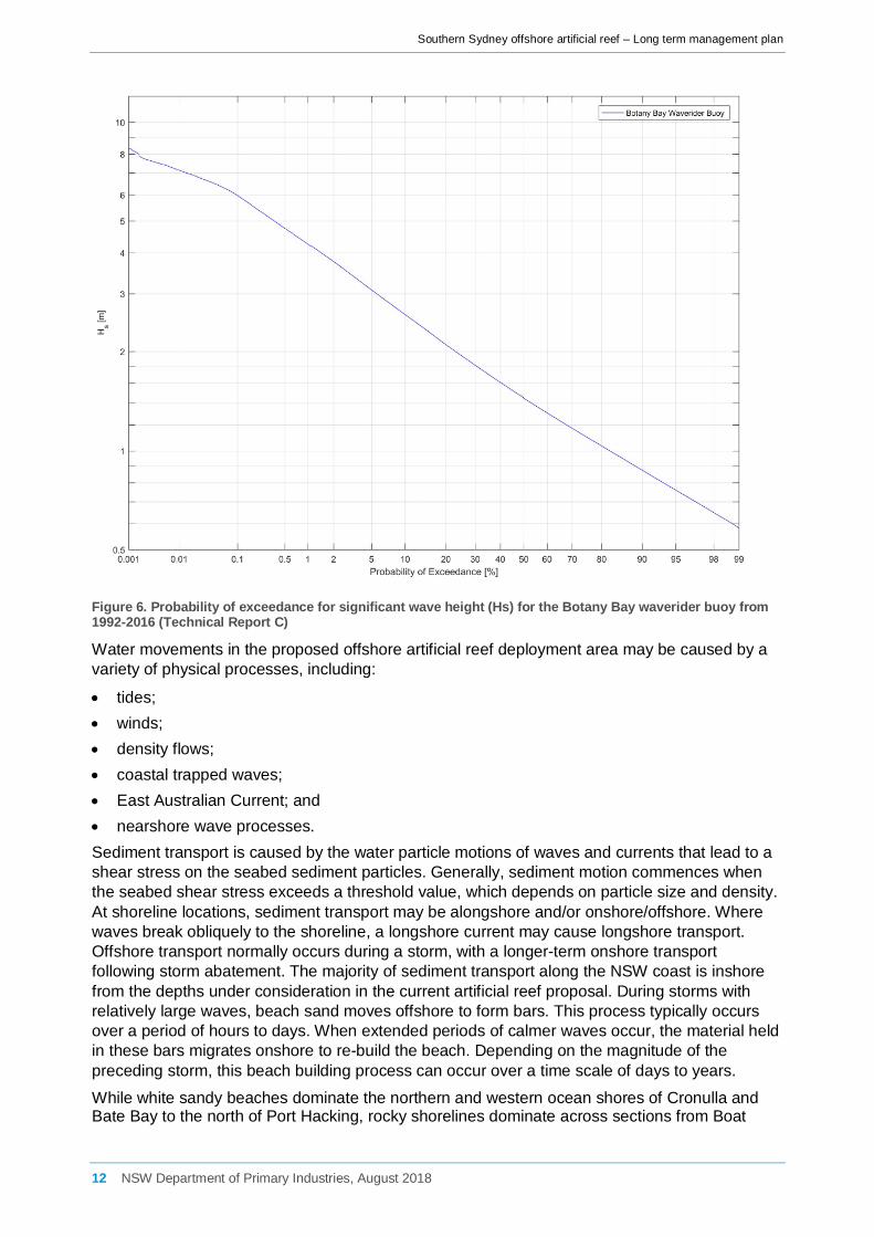
Storm events with a return interval of 100 years are expected to produce a significant wave height offshore of Sydney and Providential Head of 9.6 m. This parameter is to be taken into consideration as a primary design specification for the reef and its modules. Measured wave data collected from waverider buoys at Long Reef and off Botany Bay were combined to reflect wave directions in the region (Figure 5). The prevailing wave direction offshore of Sydney is from the south-south-east. A probability of exceedance graph for significant wave height for the Botany Bay waverider buoy is presented in Figure 6.
10 NSW Department of Primary Industries, August 2018
Southern Sydney offshore artificial reef – Long term management plan
Figure 5. Combined wave rose of Long Reef and Botany Bay offshore wave datasets from 1992-2016 (Technical Report C)
11 NSW Department of Primary Industries, August 2018
Southern Sydney offshore artificial reef – Long term management plan
Figure 6. Probability of exceedance for significant wave height (Hs) for the Botany Bay waverider buoy from 1992-2016 (Technical Report C)
Water movements in the proposed offshore artificial reef deployment area may be caused by a variety of physical processes, including:
• tides; • winds; • density flows; • coastal trapped waves; • East Australian Current; and • nearshore wave processes. Sediment transport is caused by the water particle motions of waves and currents that lead to a shear stress on the seabed sediment particles. Generally, sediment motion commences when the seabed shear stress exceeds a threshold value, which depends on particle size and density. At shoreline locations, sediment transport may be alongshore and/or onshore/offshore. Where waves break obliquely to the shoreline, a longshore current may cause longshore transport. Offshore transport normally occurs during a storm, with a longer-term onshore transport following storm abatement. The majority of sediment transport along the NSW coast is inshore from the depths under consideration in the current artificial reef proposal. During storms with relatively large waves, beach sand moves offshore to form bars. This process typically occurs over a period of hours to days. When extended periods of calmer waves occur, the material held in these bars migrates onshore to re-build the beach. Depending on the magnitude of the preceding storm, this beach building process can occur over a time scale of days to years.
While white sandy beaches dominate the northern and western ocean shores of Cronulla and Bate Bay to the north of Port Hacking, rocky shorelines dominate across sections from Boat
12 NSW Department of Primary Industries, August 2018

Southern Sydney offshore artificial reef – Long term management plan
Harbour to Potter Point in the north and sandstone cliffs with relatively few beaches to the south. There are several submerged reefs in Bate Bay including Osborne Shoal and Merries Reef which is an almost linear feature that cuts north-south across the northern quarter of the bay, parts of which are exposed at low tide. Several hundred metres to the south-east of Port Hacking’s southern entrance is Jibbon Bombora, a significant shallow reef feature that is marked on navigational charts. The Jibbon Bombora is subtidal but swell breaks across it in all except relatively benign conditions. Barren’s Hut, a popular local dive site, lies approximately 1 km further to the south. The area of seafloor identified as the potential OAR deployment site lies approximately 2-3 km south of the entrance to Port Hacking. Immediately south of the site (3-4 km) lie the beaches of Marley and Little Marley. According to existing multi-beam surveys (OEH) and aerial photogrammetry (Oil Spill Response Atlas; Statewide Habitat Mapping), subtidal reefs, other than those associated with Jibbon Bombora, are limited to within 100 m of the shoreline. Cliffs drop into the sea and then rocky shelves to subtidal reefs on to sands at depths of <20-25 m. Generally, the seabed south of Jibbon and to 3 NM offshore is dominated by unconsolidated sediments to as far south as Garie Beach and Burning Palms.
Habitat mapping undertaken by Jordan et al. ([20]) shows a large nearshore reef system, predominantly at intermediate depths, which extends south from Cape Solander (Kurnell) around the headland into shallow depths within Bate Bay at Cronulla. Small, isolated areas of deep reef are present throughout the area offshore of Bate Bay occurring between 1.5 and 2 km offshore. South of Jibbon Head, a narrow strip of shallow nearshore reef has been mapped shoreward of the proposed OAR study area between Bundeena and Stanwell Park. The authors noted, however, that it is likely that some of this reef may extend further offshore than mapped, beyond the 15–20 m depth limit of the aerial photography which has been found to occur with other reef systems mapped along the Sydney coast.
Technical reports D and E were commissioned to look in detail at the seafloor within the vicinity of the proposed reef deployment site and involved the collation and analyses of existing broadscale bathymetric and marine sediment datasets, and seabed habitat data defined from previous single-beam and SWATH acoustic surveys and aerial photogrammetry. The information was combined with new SWATH acoustic data collected using the OEH interferometric sidescan sonar system, allowing the development of high-resolution maps of the seabed bathymetry and habitats. Seabed habitat mapping within the Bate Bay and Royal National Park study region was carried out during October 2015 and July 2016 (Technical Reports D and E). The aim of the surveys was to complement a previous survey of the region in 2012 and provide a complete description of the physical characteristics of the sea floor within the direct study areas, highlighting the presence of unsuitable substratum, i.e. reefs, obstructions, or items of heritage significance e.g. shipwrecks. Complete swath acoustic surveys, using sidescan sonar, were carried out to provide bathymetry, backscatter, slope, and aspect data for the direct study area of at least 7.9 km² of sea floor surrounding the proposed reef location (refer to Section 6.1.1 of the EA for more detailed information). Depths for the October 2015 Bate Bay survey ranged from 29.3 m below Australian Height Datum (AHD) off Jibbon Bombora to 74.3 m in the south-eastern corner of the survey area. Depths for the July 2016 survey ranged from 3.5 m adjacent to the coast to 36.6 m in the south-eastern corner of the survey area. At the proposed artificial reef site the water depth was ~29-30 m. The bathymetry indicates natural reefs lie due south of the site at a distance of ~2.5km. Bathymetry data from these and previous surveys indicate natural reef to the west and north at Jibbon Bombora and the entrance to Port Hacking. The majority of the area surveyed was a relatively uniform planar area of seabed likely to comprise of unconsolidated marine sediments.
Both spatial layers of bathymetry and backscatter were imported into ArcGIS v10.1 and converted into raster images. The bathymetry was viewed as a hill-shaded relief (90-120° azimuth and 30-45° elevation) to provide a quasi three-dimensional image to aid interpretation of
13 NSW Department of Primary Industries, August 2018

Southern Sydney offshore artificial reef – Long term management plan
the images. Backscatter, viewed as a greyscale image, was also used to support the interpretation. Backscatter data assists in the delineation of reef and non-reef in areas based on seabed “hardness”. Generally, rocky reef areas are characterised by regions of relief, greyscale heterogeneity (texture) and higher backscatter intensity (i.e. darker areas). Generally, unconsolidated substrates form regions of low relief, with variable to homogeneous textural complexity and weaker (lighter) backscatter. Slope and aspect raster imagery was generated using ArcGIS Spatial Analyst. Bathymetric data was re-sampled to a grid bin size of 10 metres prior to generating slope and aspect imagery (Figure 7).
Figure 7. Seabed bathymetry derived from swath acoustic surveys (derived from Technical Reports D and E)
14 NSW Department of Primary Industries, August 2018

Southern Sydney offshore artificial reef – Long term management plan
4.3 Biological considerations Soft sediment and rocky reef assemblages
A benthic ecology survey (Technical Report F) was undertaken on 18-19 July 2016 to focus on the proposed reef deployment location and undertake a preliminary assessment of impacts of the proposed reef on benthic ecology. A total of 2356 individual animals comprising 78 taxa were recorded from the 60 samples collected from within the southern Sydney study project area. The infaunal assemblage sampled was populated by a range of taxa including 37 families of crustaceans (including a large proportion of amphipods as well as isopods, tanaids, cumaceans, copepods and ostracods); 21 families of bivalve and gastropod molluscs; 11 families of polychaete worms; four groups of ‘other worm’ phyla (including nematodes, nemerteans, oligochaetes and sipunculids); and two groups of echinoderms (including ophiuroids and echinoids). Other taxa recorded but identified to broader taxonomic groups included ascidians, bryozoans and juvenile fish. In terms of percentage contribution, crustaceans (78%) were the most numerically abundant of the major taxonomic groups, followed by molluscs (16%), polychaetes (3%) and echinoderms, other worm phyla and other phyla, all of which contributed approximately 1% of total abundance. Results indicated that the assemblages sampled at the proposed OAR and control locations were fairly typical of sandy soft sediment assemblages expected to occur offshore of Sydney.
In NSW a few common groups make up the fish fauna of sandy areas ([21]). The elasmobranchs are often represented by Urolophid and Rhinobatid rays. There may also be many small planktivorous fishes. Other common and commercially important groups are the flatheads (Platycephalidae), which are voracious predators and whiting (Sillaginidae), which are benthic feeders. These groups, especially the flatheads, were shown to be abundant across the proposed reef deployment area by site video surveys conducted by DPI.
Offshore artificial reefs are likely to be most effective if habitat is a limiting factor for population growth. Subtidal rocky reefs harbour fishes that depend on this habitat for food, shelter and/or spawning sites at some stage during their lives. Many species are affected by the topography of the reef and are more abundant in areas of greater physical complexity. Some reef fishes may be very active, including wrasses and leatherjackets, and can traverse large areas of reef. There are also many less mobile, reef associated, species, which spend most of their time on or near the bottom and cryptic species that remain within caves, overhangs and crevices.
Fish surveys were conducted by DPI on the proposed offshore artificial reef deployment site and control sites representative of natural reef found adjacent to the reef deployment area using baited remote underwater video (BRUV) units. Results from these surveys indicated that the natural rocky reef supported a fish community that was significantly different to the community identified on either of the proposed reef deployment site or representative sandy habitats. In total, 19 species were identified on the natural reef sites, 13 on the artificial reef sites and 7 on the sand sites. Mean relative abundances were higher on the natural reef sites than either the artificial reef or sand sites. Species richness and diversity was also found to be higher on the natural reef than on adjacent artificial reef and sand sites. The only commercially and recreationally important species observed at the proposed offshore artificial reef site were Flathead (Platycephalus spp.), Sand Whiting (Sillago ciliata) and Yellowtail Scad (Trachurus novaezelandiae). On the natural reef sites, Snapper (Pagrus auratus), Yellowtail Scad (T. novaezelandiae), Silver Trevally (Pseudocaranx dentex), Yellowfin Bream (Acanthopagrus australis) and Tarwhine (Rhabdosargus sarba) were all observed.
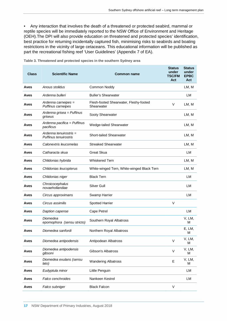
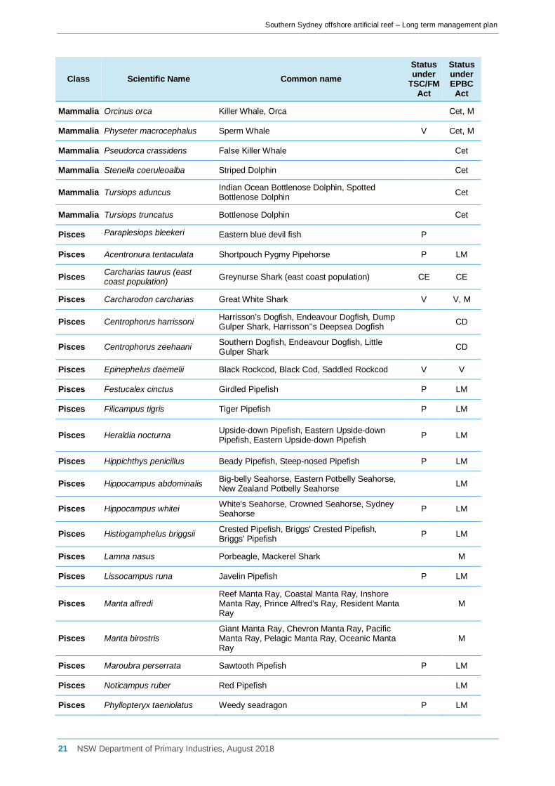
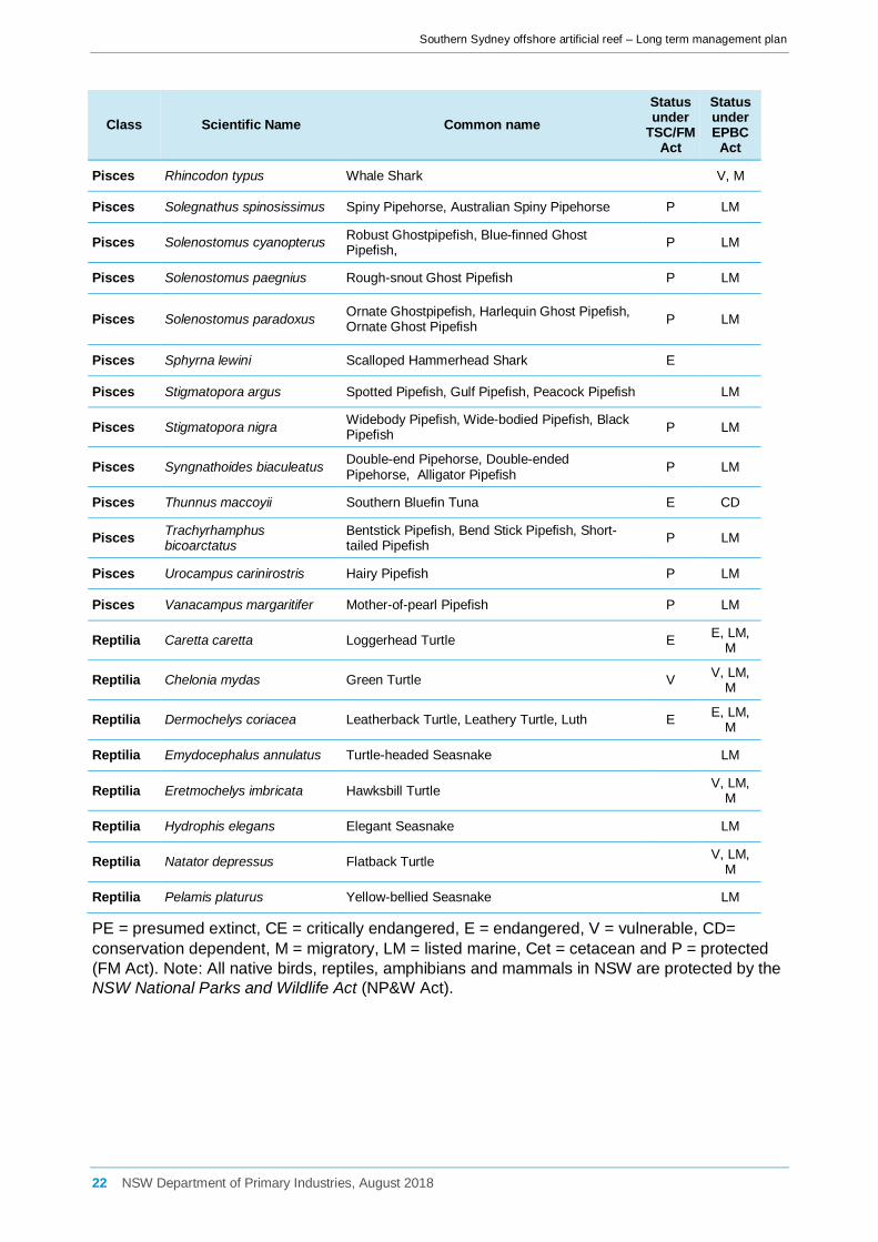
Threatened and protected species, populations and endangered ecological communities
Results of the database searches indicated that there are 34 species of fish (including seahorses, pipefish and ghost pipefish), 25 species of marine mammal (including whales, dolphins and seals) and eight species of marine reptiles (including turtles and seasnakes)
15 NSW Department of Primary Industries, August 2018

Southern Sydney offshore artificial reef – Long term management plan
currently listed as either threatened or protected in the area (Table 3). New South Wales and Commonwealth registers of critical habitats were also searched within and beyond the study region. The Greynurse Shark critical habitat at Magic Point (Maroubra) and the critical habitat for the endangered population of Little Penguins at Manly were identified, approximately 18 and 33 km respectively from the southern Sydney OAR site. Only threatened species (from the initial search) that were known or considered likely to occur in the wider study area (based on general species distribution databases) and/or known to utilise habitat in the study area, were considered for further Assessment of Significance. Overall, 6 species of fish, 3 species of marine turtle, 4 species of cetacean, 1 sirenian and 2 species of pinnipeds were assessed according to OEH and DPI threatened species assessment guidelines ([22], [23]) (individual species assessments are provided in Appendix 5 of EA). A total of 8 species of fish, 5 species of marine turtle, 6 species of cetacean, 1 sirenian and 2 species of pinnipeds were assessed individually under the EPBC Act (individual species assessments are provided in Appendix 6 of EA).
A threatening process is something that threatens, or could potentially threaten, the survival or evolutionary development of a species, population or ecological community [24]. Key Threatening Processes (KTPs) identified as being potentially relevant to the proposal are entanglement or ingestion of anthropogenic debris in marine and estuarine environments (TSC Act); injury and fatality to vertebrate marine life caused by ingestion of, or entanglement in, harmful marine debris (EPBC Act); and hook and line fishing in areas important for the survival of threatened fish species (FM Act).
Searches for seabirds likely to forage offshore and in the proposed reef deployment area were also carried out. Intertidal and wading birds, such as sandpipers, curlews and plovers, were excluded from the assessment as they are unlikely to be affected by the proposal. A total of 91 bird species were identified comprising of seabirds and birds of prey. The main groups of seabirds that were found to occur in the study region included albatrosses, petrels, shearwaters, terns, skuas, prions, gulls and gannets.
The risk assessment considered that the incidental capture of sea birds was very unlikely on the offshore artificial reef. From experience from the Sydney, Shoalhaven and Port Macquarie offshore artificial reefs, zero reports of interactions with sea birds have been reported. For this reason, no direct mitigation measure is considered to be required. If increased interactions with sea birds is reported and verified by DPI, an appropriate management response including but not limited to restrictions on some fishing practices (i.e. floating of surface baits) may be considered.
The artificial reef may potentially increase the risk of lost fishing gear and harmful marine debris entering the marine environment in the vicinity of the proposed reef. Threatened species including seabirds can ingest or become entangled in marine debris, such as plastics. In order to reduce this potential impact on seabirds, education using the reef user guidelines and existing DPI education programs would be provided on the potential impacts of harmful marine debris on marine life and the responsible disposal of litter and discarded fishing gear (refer Table 19).
Following deployment of the reef, it is proposed for any incidents, recorded or reported interactions with threatened or protected fish species to be reported at 6 monthly intervals to the DPI Threatened Species Unit for further assessment as detailed in this plan. Incidents involving threatened and/or protected species include:
• Reports from reef users of incidental capture;
• Visual identification reports from reef users;
• Interaction with any of the DPI monitoring protocols including baited remote video, unbaited video drops, ROV, diver census or acoustic interactions of tagged animals with the VR4 receiver attached to the reef;
16 NSW Department of Primary Industries, August 2018
Southern Sydney offshore artificial reef – Long term management plan
• Any interaction that involves the death of a threatened or protected seabird, mammal or reptile species will be immediately reported to the NSW Office of Environment and Heritage (OEH).The DPI will also provide education on threatened and protected species’ identification, best practice for returning incidentally captured fish, minimising risks to seabirds and boating restrictions in the vicinity of large cetaceans. This educational information will be published as part the recreational fishing reef ‘User Guidelines’ (Appendix 7 of EA).
Table 3. Threatened and protected species in the southern Sydney area
Class Scientific Name Common name Status under
TSC/FM Act
Status under EPBC
Act
Aves Anous stolidus Common Noddy LM, M
Aves Ardenna bulleri Buller’s Shearwater LM
Aves Ardenna carneipes = Puffinus carneipes
Flesh-footed Shearwater, Fleshy-footed Shearwater V LM, M
Aves Ardenna grisea = Puffinus griseus Sooty Shearwater LM, M
Aves Ardenna pacifica = Puffinus pacificus Wedge-tailed Shearwater LM, M
Aves Ardenna tenuirostris = Puffinus tenuirostris Short-tailed Shearwater LM, M
Aves Calonextris leucomelas Streaked Shearwater LM, M
Aves Catharacta skua Great Skua LM
Aves Chlidonias hybrida Whiskered Tern LM, M
Aves Chlidonias leucopterus White-winged Tern, White-winged Black Tern LM, M
Aves Chlidonias niger Black Tern LM
Aves Chroicocephalus novaehollandiae Silver Gull LM
Aves Circus approximans Swamp Harrier LM
Aves Circus assimilis Spotted Harrier V
Aves Daption capense Cape Petrel LM
Aves Diomedea epomophora (sensu stricto) Southern Royal Albatross
V, LM, M
Aves Diomedea sanfordi Northern Royal Albatross E, LM,
M
Aves Diomedea antipodensis Antipodean Albatross V V, LM, M
Aves Diomedea antipodensis gibsoni Gibson's Albatross V V, LM,
M
Aves Diomedea exulans (sensu lato) Wandering Albatross E V, LM,
M
Aves Eudyptula minor Little Penguin LM
Aves Falco cenchroides Nankeen Kestrel LM
Aves Falco subniger Black Falcon V
17 NSW Department of Primary Industries, August 2018

Southern Sydney offshore artificial reef – Long term management plan
Class Scientific Name Common name Status under
TSC/FM Act
Status under EPBC
Act
Aves Fregata ariel Lesser Frigatebird LM, M
Aves Fregetta grallaria grallaria White-bellied Storm-Petrel (Tasman Sea), White-bellied Storm-Petrel (Australasian) V V
Aves Fulmarus glacialoides Southern Fulmar LM
Aves Garrodia nereis Grey-backed Storm-Petrel LM
Aves Gelochelidon nilotica Gull-billed Tern LM, M
Aves Gygis alba White Tern V LM
Aves Haliaeetus leucogaster White-bellied Sea-Eagle LM
Aves Haliastur indus Brahminy Kite LM
Aves Haliastur sphenurus Whistling Kite LM
Aves Halobaena caerulea Blue Petrel V, M
Aves Hieraaetus morphnoides Little Eagle V
Aves Hydroprogne caspia Caspian Tern LM, M
Aves Larus dominicanus Kelp Gull LM
Aves Larus pacificus Pacific Gull LM
Aves Lophoictinia isura Square-tailed Kite V
Aves Macronectes giganteus Southern Giant-Petrel E E, LM, M
Aves Macronectes halli Northern Giant-Petrel V V, LM, M
Aves Morus serrator Australasian Gannet LM
Aves Oceanites oceanicus Wilson’s Storm-Petrel LM, M
Aves Onychoprion fuscata Sooty Tern V LM
Aves Pachyptila belcheri Slender-billed Prion LM
Aves Pachyptila desolata Antarctic Prion LM
Aves Pachyptila salvini Salvin’s Prion LM
Aves Pachyptila turtur Fairy Prion LM
Aves Pachyptila turtur subantarctica Fairy Prion (southern) V
Aves Pachyptila vittata Broad-billed Prion LM
Aves Pandion cristatus = haliaetus Eastern Osprey V LM, M
Aves Pelagodroma marina White-faced Storm-Petrel LM
Aves Pelecanoides urinatrix Common Diving-Petrel LM
18 NSW Department of Primary Industries, August 2018

Southern Sydney offshore artificial reef – Long term management plan
Class Scientific Name Common name Status under
TSC/FM Act
Status under EPBC
Act
Aves Pelecanus conspicillatus Australian Pelican LM
Aves Phaethon lepturus White-tailed Tropicbird LM
Aves Phoebetria fusca Sooty Albatross V V, LM, M
Aves Procellaria cinerea Grey Petrel LM, M
Aves Procellaria westlandica Westland Petrel LM, M
Aves Procelsterna cerulea Grey Ternlet V LM
Aves Pseudobulweria rostrata Tahiti Petrel LM
Aves Pterodroma cervicalis White-necked Petrel LM
Aves Pterodroma cookii Cook’s Petrel LM
Aves Pterodroma lessonii White-headed Petrel LM
Aves Pterodroma leucoptera leucoptera Gould's Petrel V E, LM
Aves Pterodroma macroptera Great-winged Petrel LM
Aves Pterodroma mollis Soft-plumaged Petrel V, LM
Aves Pterodroma neglecta neglecta Kermadec Petrel (western) V V
Aves Pterodroma nigripennis Black-winged Petrel V LM
Aves Pterodroma solandri Providence Petrel V LM
Aves Puffinus assimilis Little Shearwater V LM
Aves Puffinus gavia Fluttering Shearwater LM
Aves Puffinus griseus Sooty Shearwater LM, M
Aves Puffinus huttoni Hutton’s Shearwater LM
Aves Stercorarius longicaudus Long-tailed Jaegar, Long-tailed Skua LM, M
Aves Stercorarius parasiticus Arctic Jaegar, Arctic Skua LM, M
Aves Stercorarius pomarinus Pomarine Jaegar, Pomarine Skua LM, M
Aves Sterna hirundo Common Tern LM, M
Aves Sterna paradisaea Arctic Tern LM
Aves Sterna striata White-fronted Tern LM
Aves Sternula albifrons Little Tern E LM, M
Aves Sternula nereis nereis Australian Fairy Tern V
Aves Sula leucogaster Brown Booby LM, M
Aves Thalassarche bulleri Buller's Albatross, Pacific Albatross V, LM,
M
19 NSW Department of Primary Industries, August 2018

Southern Sydney offshore artificial reef – Long term management plan
Class Scientific Name Common name Status under
TSC/FM Act
Status under EPBC
Act
Aves Thalassarche cauta cauta Shy Albatross, Tasmanian Shy Albatross V V, LM, M
Aves Thalassarche cauta steadi White-capped Albatross V, LM,
M
Aves Thalassarche chlororhynchos Atlantic Yellow-nosed Albatross LM, M
Aves Thalassarche chrysostoma Grey-headed Albatross E, LM, M
Aves Thalassarche eremita Chatham Albatross E, LM,M
Aves Thalassarche impavida Campbell Albatross, Campbell Black-browed Albatross
V, LM, M
Aves Thalassarche melanophris Black-browed Albatross V V, LM, M
Aves Thalassarche salvini Salvin's Albatross V, LM,
M
Aves Thalasseus bergii Crested Tern LM
Mammalia Arctocephalus forsteri New Zealand Fur-seal, Long-nosed Fur-seal V LM
Mammalia Arctocephalus pusillus doriferus Australian Fur-seal, Australo-African Fur-seal V LM
Mammalia Arctocephalus tropicalis Subantarctic Fur-seal V, LM
Mammalia Balaenoptera acutorostrata Minke Whale Cet
Mammalia Balaenoptera edeni Bryde's Whale Cet, LM
Mammalia Balaenoptera musculus Blue Whale E E, Cet, LM
Mammalia Caperea marginata Pygmy Right Whale Cet, LM
Mammalia Delphinus delphis Common Dolphin, Short-beaked Common Dolphin Cet
Mammalia Dugong dugon Dugong E LM, M
Mammalia Eubalaena australis Southern Right Whale E E, Cet, M
Mammalia Grampus griseus Risso's Dolphin, Grampus Cet
Mammalia Hydrurga leptonyx Leopard Seal LM
Mammalia Kogia breviceps Pygmy Sperm Whale Cet
Mammalia Kogia sima Dwarf Sperm Whale Cet
Mammalia Lagenorhynchus obscurus Dusky Dolphin Cet, M
Mammalia Lobodon carcinophagus Crab-eater Seal LM
Mammalia Megaptera novaeangliae Humpback Whale V V, Cet, M
Mammalia Mesoplodon densirostris Blainville’s Beaked Whale, Dense-beaked Whale Cet
Mammalia Mirounga leonina Southern Seal V, LM
20 NSW Department of Primary Industries, August 2018
Southern Sydney offshore artificial reef – Long term management plan
Class Scientific Name Common name Status under
TSC/FM Act
Status under EPBC
Act
Mammalia Orcinus orca Killer Whale, Orca Cet, M
Mammalia Physeter macrocephalus Sperm Whale V Cet, M
Mammalia Pseudorca crassidens False Killer Whale Cet
Mammalia Stenella coeruleoalba Striped Dolphin Cet
Mammalia Tursiops aduncus Indian Ocean Bottlenose Dolphin, Spotted Bottlenose Dolphin Cet
Mammalia Tursiops truncatus Bottlenose Dolphin Cet
Pisces Paraplesiops bleekeri Eastern blue devil fish P
Pisces Acentronura tentaculata Shortpouch Pygmy Pipehorse P LM
Pisces Carcharias taurus (east coast population) Greynurse Shark (east coast population) CE CE
Pisces Carcharodon carcharias Great White Shark V V, M
Pisces Centrophorus harrissoni Harrisson’s Dogfish, Endeavour Dogfish, Dump Gulper Shark, Harrisson’’s Deepsea Dogfish CD
Pisces Centrophorus zeehaani Southern Dogfish, Endeavour Dogfish, Little Gulper Shark CD
Pisces Epinephelus daemelii Black Rockcod, Black Cod, Saddled Rockcod V V
Pisces Festucalex cinctus Girdled Pipefish P LM
Pisces Filicampus tigris Tiger Pipefish P LM
Pisces Heraldia nocturna Upside-down Pipefish, Eastern Upside-down Pipefish, Eastern Upside-down Pipefish P LM
Pisces Hippichthys penicillus Beady Pipefish, Steep-nosed Pipefish P LM
Pisces Hippocampus abdominalis Big-belly Seahorse, Eastern Potbelly Seahorse, New Zealand Potbelly Seahorse LM
Pisces Hippocampus whitei White's Seahorse, Crowned Seahorse, Sydney Seahorse P LM
Pisces Histiogamphelus briggsii Crested Pipefish, Briggs' Crested Pipefish, Briggs' Pipefish P LM
Pisces Lamna nasus Porbeagle, Mackerel Shark M
Pisces Lissocampus runa Javelin Pipefish P LM
Pisces Manta alfredi Reef Manta Ray, Coastal Manta Ray, Inshore Manta Ray, Prince Alfred’s Ray, Resident Manta Ray
M
Pisces Manta birostris Giant Manta Ray, Chevron Manta Ray, Pacific Manta Ray, Pelagic Manta Ray, Oceanic Manta Ray M
Pisces Maroubra perserrata Sawtooth Pipefish P LM
Pisces Noticampus ruber Red Pipefish LM
Pisces Phyllopteryx taeniolatus Weedy seadragon P LM
21 NSW Department of Primary Industries, August 2018
Southern Sydney offshore artificial reef – Long term management plan
Class Scientific Name Common name Status under
TSC/FM Act
Status under EPBC
Act
Pisces Rhincodon typus Whale Shark V, M
Pisces Solegnathus spinosissimus Spiny Pipehorse, Australian Spiny Pipehorse P LM
Pisces Solenostomus cyanopterus Robust Ghostpipefish, Blue-finned Ghost Pipefish, P LM
Pisces Solenostomus paegnius Rough-snout Ghost Pipefish P LM
Pisces Solenostomus paradoxus Ornate Ghostpipefish, Harlequin Ghost Pipefish, Ornate Ghost Pipefish P LM
Pisces Sphyrna lewini Scalloped Hammerhead Shark E
Pisces Stigmatopora argus Spotted Pipefish, Gulf Pipefish, Peacock Pipefish LM
Pisces Stigmatopora nigra Widebody Pipefish, Wide-bodied Pipefish, Black Pipefish P LM
Pisces Syngnathoides biaculeatus Double-end Pipehorse, Double-ended Pipehorse, Alligator Pipefish P LM
Pisces Thunnus maccoyii Southern Bluefin Tuna E CD
Pisces Trachyrhamphus bicoarctatus
Bentstick Pipefish, Bend Stick Pipefish, Short-tailed Pipefish P LM
Pisces Urocampus carinirostris Hairy Pipefish P LM
Pisces Vanacampus margaritifer Mother-of-pearl Pipefish P LM
Reptilia Caretta caretta Loggerhead Turtle E E, LM, M
Reptilia Chelonia mydas Green Turtle V V, LM, M
Reptilia Dermochelys coriacea Leatherback Turtle, Leathery Turtle, Luth E E, LM, M
Reptilia Emydocephalus annulatus Turtle-headed Seasnake LM
Reptilia Eretmochelys imbricata Hawksbill Turtle V, LM,
M
Reptilia Hydrophis elegans Elegant Seasnake LM
Reptilia Natator depressus Flatback Turtle V, LM,
M
Reptilia Pelamis platurus Yellow-bellied Seasnake LM
PE = presumed extinct, CE = critically endangered, E = endangered, V = vulnerable, CD= conservation dependent, M = migratory, LM = listed marine, Cet = cetacean and P = protected (FM Act). Note: All native birds, reptiles, amphibians and mammals in NSW are protected by the NSW National Parks and Wildlife Act (NP&W Act).
22 NSW Department of Primary Industries, August 2018

Southern Sydney offshore artificial reef – Long term management plan
5 Module design, reef configuration and construction Final reef module design, project staging and load out facilities would be confirmed following completion of a public design and construct tender by DPI. A summary of the fabrication and installation process is provided below based on experiences gained from the successful installation and operation of the Sydney, Shoalhaven and Port Macquarie offshore artificial reefs.
5.1 Material The preferred module design to be used for the southern Sydney offshore artificial reef would include both vertical relief and ample void spacing to provide a highly effective reef. In response to this and the unique challenges of installation of reefs in Australia’s harsh coastal environment, tenders by prospective design, fabrication and deployment contactors would need to be detailed and address all tender specifications set my DPI. For example, the winning reef modules design for the Shoalhaven and Port Macquarie offshore artificial reefs (won and executed by Subcon Technologies Pty Ltd) resulted in the development of the ReefTemple™ module that optimised fabrication and installation parameters while maintaining its performance in terms of structural stability and biological attributes as a fish habitat (Figure 8). AS3600 requires a minimum concrete strength of 50 MPa for marine applications in harsh environments and as a result the minimum design life of the concrete is 30 years.
A minimum 28 day curing period during fabrication is used to ensure full structural strength for the 50MPa concrete and stabilised pH prior to deployment.
The contractors design, construct and install management team contracted by the DPI for this project would be required to demonstrate extensive experience in Offshore Construction, Marine Science, Concrete Fabrication and Offshore Installation to provide the highest safety and quality standards for marine operations based on industry best practices.
Figure 8. ReefTempleTM module with a 6.5m vertical relief (including tower) and arrangement of the 20 ReefTempleTM modules installed to form the Port Macquarie offshore artificial reef
23 NSW Department of Primary Industries, August 2018

Southern Sydney offshore artificial reef – Long term management plan
5.1.1 Reef layout and module dimensions Final modules numbers and dimensions would be known following completion of the design and construct tender. Specifications for the reef design would provide for a multicomponent reef with up to 40 modules with a 3200 m3 total volume arranged in 10 clusters. It is proposed that an artificial reef complex consisting of two separate reef sets situated approximately 500 m apart would be installed within a single reef management area of 37.8 ha. Each reef set would comprise of up to 20 concrete reef modules spread between five clusters (Figure 8). The artificial reef modules will be of a design that will be constructed of reinforced concrete; have a vertical relief of 5–10 m; self-weighted with no requirement for additional anchoring weighing up to 25 tonne; stable, free standing and open shaped; create shade and modified water flow; and have a minimum life span of 30 years.
The module would be required to be constructed from appropriately reinforced 50MPa concrete to AS3600 for marine environments designed to withstand a 1 in 100 year storm event. The modules would be required to provide vertical relief whilst providing a highly complex habitat for permanently recruiting nearshore finfish species including Yellowtail Scad, Yellowtail Kingfish, Mulloway and Snapper.
The modules would need to create shade and modify lateral water flow as demonstrated by tank tests at University of Western Australia (UWA) on the Reef Temple design (Figure 9) on the ReefTemple™ design and would be required to operate effectively in a mobile sand substrate environment. No Annex 1 or Annex II substances (under Schedule 1 of the Sea Dumping Act), i.e. heavy metals, oils and grease, radioactive material or plastics are to be used in the fabrication of the modules.
Figure 9. Flow modification testing of the Reef Temple at the University of WA, Flume Tank
5.1.2 Reef construction and staging methodology The following is a guide to the anticipated fabrication and deployment process. Following the public release of an open Request for Tender (RFT) by DPI for the design, construction and deployment of the proposed offshore artificial reef and subject to DPI approval, one contractor would be appointed to undertake and oversee all stages of the project. This would include:
• selection of an appropriate site for the fabrication of the structures;
24 NSW Department of Primary Industries, August 2018

Southern Sydney offshore artificial reef – Long term management plan
• pre-construction inspection and planning; • fabrication; • loading and transportation; • deployment; and • decommissioning of the land-based construction site.
Figure 10. Fabrication ‘hard-stand’ reef module site at Port Kembla in December 2014
5.1.3 Fabrication hardstand and inspection site The units would be prefabricated on land at an approved construction and fabrication yard, close to the load out facility. Post fabrication, each unit would be independently inspected and certified fit for use.
Once fabrication and certification are complete, the units would be loaded onto a barge for transportation to the offshore location. The method of load out shall be at the contractor’s discretion and the contractor would be fully responsible for the structural integrity of the structures during this process.
It is estimated that the load out and subsequent transportation and deployment of the units would occur over a 1 week period (weather dependent). If the load out location is located within 20 km of the site, it is feasible that once load out is completed, the units could be transported and installed within <5 days. If the fabrication and load out facility is situated a larger distance from the southern Sydney reef site, a greater deployment period may be required.
The contractor would consult the weather forecast for NSW coastal waters to ensure weather conditions are suitable for deployment. Deployment of the units would not be permitted unless the current sea state and its direction is less than the maximum safe values determined by the transport stability analysis and unit lift analysis. Once the units have reached the offshore location, the units would be inspected to ensure no damage has occurred prior to deployment. If any damage has occurred, it may be necessary to return the units to shore to carry out repairs or, alternatively, minor repairs could be conducted on board the barge.
25 NSW Department of Primary Industries, August 2018

Southern Sydney offshore artificial reef – Long term management plan
Once the units have reached the reef site the barge would be anchored in position at the required coordinates using DGPS and an anchor handling tug (Figure 11). Once the barge is secured in position, the units would be lifted by crane and lowered into the sea to their final resting position on the seabed. A surface remote camera inspection would then be carried out to ensure the units are in the required position. During the lifting procedure, appropriate temporary navigational aids would be provided on the structure and surrounding vessel. Anchor buoys would also be positioned at the anchor locations. Within 2 weeks of completion of the reef installation, a hydrographic survey of the reef site would be completed including a detailed bathymetry map with safe vessel clearances (LAT) and supplied to the Naval Hydrographic Office for inclusion in coastal marine chart updates and released as a Notice to Mariners. This information would also be supplied to the NSW Roads and Maritime Service.
Figure 11. Tug setting deployment barge anchors at the Shoalhaven offshore artificial reef site in January 2015
5.2 Reef Deployment site The location of the proposed reef deployment is situated off the coast of the Royal National Park between Port Hacking (Jibbon) Point and Marley Point, approximately 3 km south of Port Hacking at a depth of 29-30 m LAT. The size of the deployment and management area is 37.8 ha with proposed centre points for each reef set to be located at 34°05.659’ S, 151°10.657’ E and 34°05.932’ S, 151°10.439’ E (WGS84) (Figure 12). The corner point co-ordinates (WGS84) for the reef management area will be situated at 34° 05.594′ S, 151° 10.576′ E (NW), 34° 05.594′ S, 151° 10.848′ E (NE), 34° 06.000′ S, 151° 10.247′ E (SW) and 34° 06.000′ S, 151° 10.520′ E (SE).
5.2.1 Map of deployment site The location of the proposed southern Sydney offshore artificial reef deployment site is shown in Figure 12. The deployment site falls within the waters displayed in Australian hydrographic charts AUS808 Jervis Bay to Port Jackson and AUS197 Approaches to Port Jackson - Port Hacking to The Skillion.
26 NSW Department of Primary Industries, August 2018

Southern Sydney offshore artificial reef – Long term management plan
Figure 12. Map of geographical locations for each of the proposed reef modules
27 NSW Department of Primary Industries, August 2018

Southern Sydney offshore artificial reef – Long term management plan
5.2.2 Photographs and/or video of the proposed site prior to deployment Fish surveys were conducted by DPI in March 2015 at the centre points of the two proposed offshore artificial reef sets (34°05.659’ S, 151°10.657’ E and 34°05.932’ S, 151°10.439’ E) and control sites representative of natural reef found adjacent to the reef deployment area using baited remote underwater video (BRUV) units (Figure 13). The co-ordinates of these centre points would be used as reference points for future monitoring once the artificial reef has been deployed. Results from these initial surveys indicated that the natural rocky reef supported a fish community that was significantly different to the community identified on either of the proposed reef deployment site or representative sandy habitats.
The site specific surveys conducted by DPI consistently supported the hypothesis that it is expected that the new offshore artificial reef would support a wide variety of reef associated fish species. However, the community is likely to be made up of a larger number of species with greater diversity as the structure would likely provide ample space for both sand and reef associate species.
Refer to section 6.1.2.5 ‘Fish assemblages’ in the EA for further information.
Figure 13. Baited remote underwater video deployment on the proposed offshore artificial reef centrepoints (top: northern reef set; bottom: southern reef set). A number of Blue-spotted Flathead and a Banjo Ray can been seen around the baits (Image: DPI – August 2016)
28 NSW Department of Primary Industries, August 2018

Southern Sydney offshore artificial reef – Long term management plan
5.2.3 Geographical position (latitude and longitude)
Table 4. Geographical position of the proposed reef patches*
Reef set Reef patch Latitude (Deg. Min. Sec.)
Longitude (Deg. Min. Sec.)
Latitude (Deg. Dec. Min.)
Longitude (Deg. Dec. Min.)
Latitude (Dec. Deg.)
Longitude (Dec. Deg.)
North Northern 34º05’37.95”S 151º10’39.45”E 34º05.632’S 151º10.657’E -34.093874 151.177624
North Western 34º05’39.57”S 151º10’37.50”E 34º05.660’S 151º10.625’E -34.094325 151.177082
North Centre 34º05’39.57”S 151º10’39.45”E 34º05.660’S 151º10.657’E -34.094325 151.177624
North Eastern 34º05’39.57”S 151º10’41.40”E 34º05.660’S 151º10.690’E -34.094325 151.178166
North Southern 34º05’41.19”S 151º10’39.45”E 34º05.687’S 151º10.657’E -34.094776 151.177624
South Northern 34º05’54.30”S 151º10’26.34”E 34º05.905’S 151º10.439’E -34.098417 151.173983
South Western 34º05’55.93”S 151º10’24.39”E 34º05.932’S 151º10.406’E -34.098868 151.173441
South Centre 34º05’55.93”S 151º10’26.34”E 34º05.932’S 151º10.439’E -34.098868 151.173983
South Eastern 34º05’55.93”S 151º10’28.29”E 34º05.932’S 151º10.471’E -34.098868 151.174525
South Southern 34º05’57.55”S 151º10’26.34”E 34º05.959’S 151º10.439’E -34.099319 151.173983
*Coordinates are presented in Datum WGS84
5.2.4 ‘As-built’ location confirmation Differential GPS (DGPS) would be used for surface positioning of the vessel and a frame mounted sonar and cameras for subsea positioning of the modules. The final ‘as-built’ survey would be conducted by independent survey of the reef site. DGPS would be used to provide a position for each of the individual artificial reef modules.
5.2.5 Depth of water over the reef A depth range of greater than 20 m (LAT) on the continental shelf is a requirement in order to avoid creating a navigational hazard. Suitable depth is also important for the stability of the modules (in terms of ability to withstand certain hydrodynamic forces), accessibility to recreational fishers (via boat) and would also influence the type of fish which would aggregate around the structure. Clearance depth over the artificial reef post deployment would be no less than 20 m (LAT). This would be confirmed post reef deployment.
Refer to section 3.2.1 ‘Constraints mapping and site selection’ in the EA for further information.
5.2.6 Distance from nearest land The proposed southern Sydney offshore artificial reef is to be located within State waters approximately 4.7 km (2.5 nm) west of the 3 nm limit. The location of the proposed reef deployment site is situated 0.9 km offshore of the Royal National Park, 2.3 km south-south-east of Jibbon Point (entrance to the Hacking River) and 12.0 km south-west of the entrance to Botany Bay as shown in Figure 14.
29 NSW Department of Primary Industries, August 2018
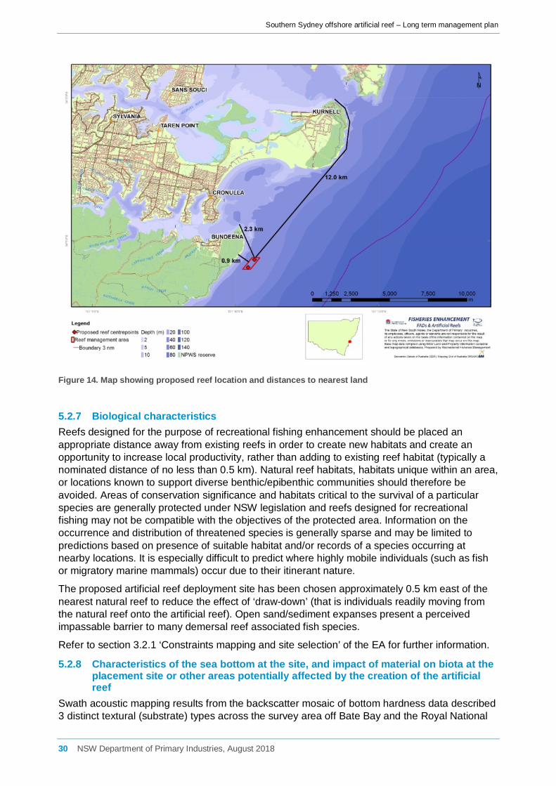
Southern Sydney offshore artificial reef – Long term management plan
Figure 14. Map showing proposed reef location and distances to nearest land
5.2.7 Biological characteristics Reefs designed for the purpose of recreational fishing enhancement should be placed an appropriate distance away from existing reefs in order to create new habitats and create an opportunity to increase local productivity, rather than adding to existing reef habitat (typically a nominated distance of no less than 0.5 km). Natural reef habitats, habitats unique within an area, or locations known to support diverse benthic/epibenthic communities should therefore be avoided. Areas of conservation significance and habitats critical to the survival of a particular species are generally protected under NSW legislation and reefs designed for recreational fishing may not be compatible with the objectives of the protected area. Information on the occurrence and distribution of threatened species is generally sparse and may be limited to predictions based on presence of suitable habitat and/or records of a species occurring at nearby locations. It is especially difficult to predict where highly mobile individuals (such as fish or migratory marine mammals) occur due to their itinerant nature.
The proposed artificial reef deployment site has been chosen approximately 0.5 km east of the nearest natural reef to reduce the effect of ‘draw-down’ (that is individuals readily moving from the natural reef onto the artificial reef). Open sand/sediment expanses present a perceived impassable barrier to many demersal reef associated fish species.
Refer to section 3.2.1 ‘Constraints mapping and site selection’ of the EA for further information.
5.2.8 Characteristics of the sea bottom at the site, and impact of material on biota at the placement site or other areas potentially affected by the creation of the artificial reef
Swath acoustic mapping results from the backscatter mosaic of bottom hardness data described 3 distinct textural (substrate) types across the survey area off Bate Bay and the Royal National
30 NSW Department of Primary Industries, August 2018

Southern Sydney offshore artificial reef – Long term management plan
Park. Reef was described by highly variable backscatter or range of backscatter intensities over a small (10s of m) distance and was evident directly adjacent to the coast in the Royal National Park survey (Technical Report E) and in sections in the northern end of the Bate Bay survey (Technical Report D). Irregular areas of relatively strong seabed returns (dark grey) described a second textural type. These areas of moderate backscatter were relatively small and adjacent to reefs in the north of the survey area and seaward of the shore attached reefs, likely to describe areas of harder seabed and intermediate (coarse sand, gravel, pebble, cobble) substrate types. A third substrate type covered the largest proportion of the survey area including the proposed deployment site and was observed as areas of relatively uniform moderate-high scatter low seabed return (medium to light grey) within the mosaic indicating areas of unconsolidated seabed types usually characterised by medium-coarse marine sands. BRUV surveys of the site undertaken by the DPI confirmed these results with a fine silty sediment layer identified at the proposed artificial reef site. Sediment grab samples from the benthic samples collected at the site (Technical Report F) also noted the seabed in the vicinity consisted of unconsolidated, apparently bare, fine to medium grained, well-sorted sand. This presents an ideal site for the installation of artificial reef modules located an adequate distance from natural reef with no underlying rocky reef identified.
Impacts on soft sediment assemblages
Offshore artificial reefs are considered to be most effective when placed in bare, sandy, ‘rocky-reef habitat limited’ environments. Selection of reef sites has therefore focussed on areas known or likely to consist of sandy substratum away from areas of naturally occurring reef. Soft sediment habitats can support extremely diverse macrofaunal assemblages. Results of the benthic ecology survey (Technical Report F) undertaken on 18-19 July 2016 revealed some locational differences in abundance and assemblage structure but not taxonomic richness at the broad scale across study and reference sites (i.e. several km), however a higher level of uniformity was observed within locations (i.e. 70- 100 m). Sediment characteristics at all locations sampled within the potential deployment area were generally similar in terms of grain size, colour, sorting and roundness, consisting of fine to medium grained, well-sorted sand. Subtle differences in colour from light brown to reddish brown were observed however it is considered unlikely that colour influenced these differences given the observed similarities in sediment characteristics between sites. Results indicated that the assemblages sampled at the proposed OAR and control locations were fairly typical of sandy soft sediment assemblages expected to occur offshore of Sydney.
Initial deployment of the OAR units is expected to cause localised disturbance and re-suspension of sandy sediment in the area where the units are installed which may result in mobile macroinvertebrates being temporarily displaced. A large proportion of animals living within the direct footprint of where individual modules are placed would also be lost through smothering. This would be limited to an area of <640 m2. This loss of sandy habitat occupied by the reef modules, would, however, be negligible when considered in context with the extensive areas of similar habitat within and surrounding the reef installation area. Soft-bottom habitats adjacent to artificial reefs would be partially affected by current patterns and some minor scouring and deposition which may consequently affect grain size. It is possible that species numbers and/or diversity in sandy habitat adjacent to the reefs may decrease as a result of increased predation by benthic and demersal fish or decapods attracted to and/or growing on the reef, feeding in the adjacent sandy habitat. This effect is known as a ‘feeding halo’. Halo effects of reefs may be confined to areas very close to a reef (within a few metres) or extend over a much larger area and may depend on the size of the reef and/or the trophic structure of fish occupying it. Furthermore, the habitat will continue to support a wide variety of marine organisms found living on or over soft sandy substrata. Increased predation on benthos is therefore not considered to have a significant impact within the wider study area.
31 NSW Department of Primary Industries, August 2018

Southern Sydney offshore artificial reef – Long term management plan
Table 5. Risk assessment of soft sediment assemblages considered in the reef assessment
Environmental Aspect
Scale Risk description Risk Level
Mitigative measure Treatment type
Risk Level
Flora and fauna
Benthos Sub-Local Direct loss of habitat A4 Careful selection of habitat type for deployment location. Efficient design of footprint to minimise loss of sedimentary habitat.
Accept A4
Benthos Sub-Local Change to benthic fauna from changes to sedimentary characteristics
C4 Accept Accept C4
Benthos Sub-Local Changes to benthic assemblages
B4 Accept Accept B4
Benthos Sub-Local Increased predation by fishes from the OAR on benthos
A4 Accept Accept A4
Sediments and water
Local Leaching of contaminants elevating levels in marine environment
D5 Australian Standards for marine concrete to be used.
Accept D5
Impacts on adjacent rocky reef assemblages
It is considered likely that initial increases in fish numbers would be a result of attraction and aggregation, but that over time (once the reef has become established), the reefs would contribute to overall production. The extent of impact on neighbouring natural reef may also depend on the size of the natural reef with impacts likely to be greater for a smaller neighbouring reef than a larger one. As a precautionary measure, maximum separation of the offshore artificial reef units from existing natural reef was aimed for as part of the constraints mapping in order to minimise potential draw-down effects. The convenience and likely popularity of the offshore artificial reefs could attract more recreational fishers, increase participation and length of time fishing and thus increase fishing effort rather than simply redistributing it. However it is much more likely that fishing effort would not increase as a result of the deployment of the reef. Rather, it would merely transfer from other areas as access to the reef would be limited to boat based fishers. This transfer of fishing effort could result in an increase in fishing pressure on a localised scale but would in turn potentially offer some relief to other areas that would have previously been fished. Therefore an increase in fishing effort is not considered to have a significant impact within the wider study area. In summary, the site specific surveys conducted by DPI supported the hypothesis that it is expected that the new offshore artificial reef will support a wide variety of reef associated fish species. However, the community is likely to be made up of a larger number of species with greater diversity as the structure will likely provide ample space for both sand and reef associate species. Impacts on soft sediment and rocky reef assemblages are discussed in detail in Section 8.2.2 of the EA.
32 NSW Department of Primary Industries, August 2018
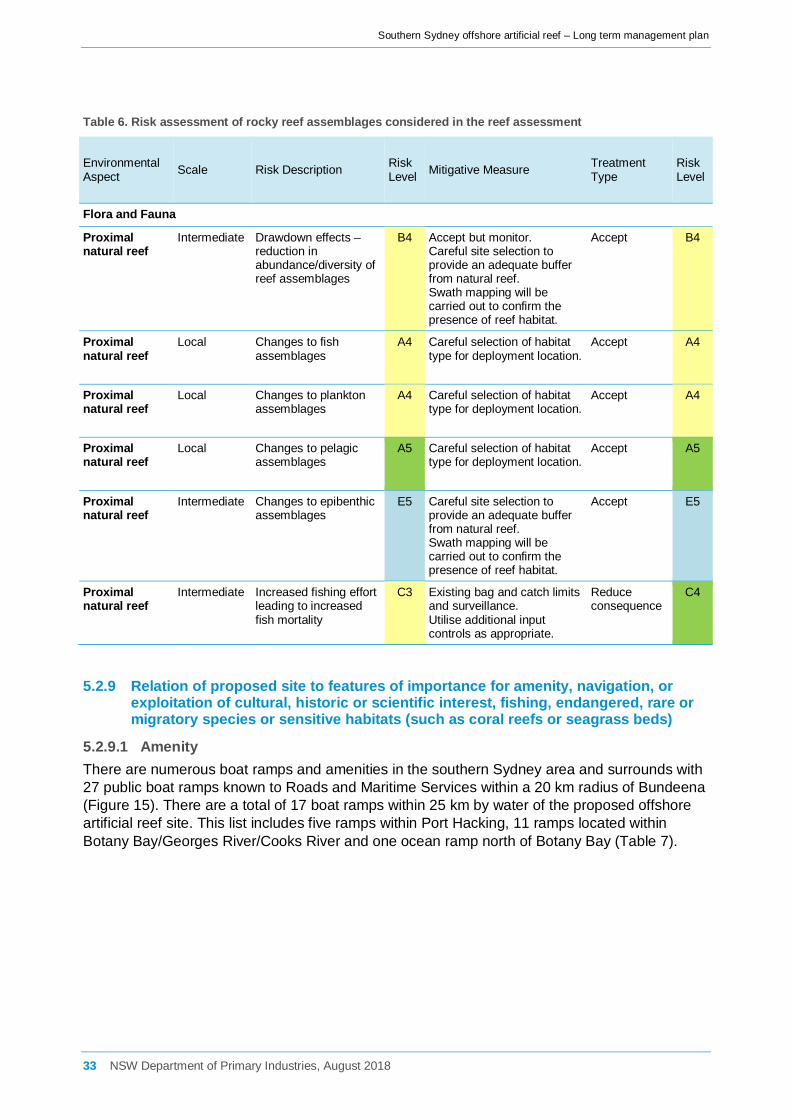
Southern Sydney offshore artificial reef – Long term management plan
Table 6. Risk assessment of rocky reef assemblages considered in the reef assessment
Environmental Aspect Scale Risk Description Risk
Level Mitigative Measure Treatment Type
Risk Level
Flora and Fauna
Proximal natural reef
Intermediate Drawdown effects – reduction in abundance/diversity of reef assemblages
B4 Accept but monitor. Careful site selection to provide an adequate buffer from natural reef. Swath mapping will be carried out to confirm the presence of reef habitat.
Accept B4
Proximal natural reef
Local Changes to fish assemblages
A4 Careful selection of habitat type for deployment location.
Accept A4
Proximal natural reef
Local Changes to plankton assemblages
A4 Careful selection of habitat type for deployment location.
Accept A4
Proximal natural reef
Local Changes to pelagic assemblages
A5 Careful selection of habitat type for deployment location.
Accept A5
Proximal natural reef
Intermediate Changes to epibenthic assemblages
E5 Careful site selection to provide an adequate buffer from natural reef. Swath mapping will be carried out to confirm the presence of reef habitat.
Accept
E5
Proximal natural reef
Intermediate Increased fishing effort leading to increased fish mortality
C3 Existing bag and catch limits and surveillance. Utilise additional input controls as appropriate.
Reduce consequence
C4
5.2.9 Relation of proposed site to features of importance for amenity, navigation, or exploitation of cultural, historic or scientific interest, fishing, endangered, rare or migratory species or sensitive habitats (such as coral reefs or seagrass beds)
5.2.9.1 Amenity There are numerous boat ramps and amenities in the southern Sydney area and surrounds with 27 public boat ramps known to Roads and Maritime Services within a 20 km radius of Bundeena (Figure 15). There are a total of 17 boat ramps within 25 km by water of the proposed offshore artificial reef site. This list includes five ramps within Port Hacking, 11 ramps located within Botany Bay/Georges River/Cooks River and one ocean ramp north of Botany Bay (Table 7).
33 NSW Department of Primary Industries, August 2018

Southern Sydney offshore artificial reef – Long term management plan
Table 7. Boat ramps and facilities within 25 km of the proposed southern Sydney offshore artificial reef site
NA
ME
WA
TER
WA
Y
WA
TER
AC
CES
S
CO
NST
RU
CTI
ON
CO
ND
ITIO
N
SIZE
LA
NES
NO
. TR
AIL
ER S
PAC
ES
FEE
PAYA
BLE
LIG
HTI
NG
WA
STE
BIN
S
FISH
CLE
AN
FUEL
BB
Q
TOIL
ETS
Tonkin Park – Cronulla
Port Hacking
Shallow at times Bitumen Poor 1 11-20
Wally’s Wharf – Dolans Bay
Port Hacking
Shallow at times Bitumen Good 2 <10
Water Street – Caringbah
Port Hacking
Shallow at times Bitumen Good 1 <10
Yowie Bay Port Hacking All times Concrete Good 2 11-20
Swallow Rock – Grays Point
Port Hacking All times Concrete Good 2 21-50
Fishermans Rd - Malabar
Ocean All times Concrete Good 1
Bonna Point - Kurnell
Botany Bay
Shallow at times Concrete Fair 2 21-50
Port Botany – Foreshore Drive
Botany Bay All times Concrete Good 4 >51
Kyeemagh Cooks River All times Concrete Good 4 >51
Tempe Basin Cooks River
Shallow at times Concrete Poor 1 <10
Hawkesbury Reserve – Sylvania Waters
Georges River Shallow
at times Concrete Good 2 21-50
Holts Point Place – Sylvania
Georges River
High tide only Concrete Good 1
Tom Uglys Bridge - Sylvania
Georges River All times Concrete Good 3 11-20
Horse Rock Point – Sylvania
Georges River All times Concrete Good 2 11-20
Dover Park – Blakehurst
Georges River All times Concrete Good 2 11-20
Kogarah Bay – Sans Souci
Georges River
Shallow at times Concrete Good 1 <10
Connells Bay (Donnelly Park)
Georges River
High tide only Concrete Fair 3 <10
34 NSW Department of Primary Industries, August 2018

Southern Sydney offshore artificial reef – Long term management plan
Figure 15. Boat ramps in the study region
5.2.9.2 Navigation Port Botany port limits were considered in the initial constraints analysis report (Technical Report A) and the proposed reef location was subsequently situated outside of port limits and away from commercial shipping lanes. However, the proposed offshore artificial reef location has the potential to impinge on recreational and commercial vessel operations. The potential impacts of the proposed fishing reef on navigation and vessels are listed below.
5.2.9.3 Clearance There is a potential risk that vessels transiting over the offshore artificial reefs may be damaged or damage the reef structures if their hull or propeller comes into contact with the structures. However, this would be mitigated by ensuring sufficient clearance at all tides and in high wave conditions. A minimum of 20 m clearance from the uppermost part of the offshore artificial reef at Lowest Astronomical Tide (LAT) is ensured for the proposed southern Sydney offshore artificial reef.
Anchoring in the vicinity of the reefs would be strongly advised against. Target user groups would be informed about general boating rules in the vicinity of the reefs and recommended against anchoring in the area.
The potential impact of a vessel striking the reef has been prevented by ensuring suitable clearance from the upper part of the structures. It is not possible to completely remove the risk of anchor fouling/loss on the structures as the actions of recreational boat operators are hard to control.
35 NSW Department of Primary Industries, August 2018
Southern Sydney offshore artificial reef – Long term management plan
Table 8. Risks and mitigation associated with clearance
Environmental Aspect
Scale Risk Description Risk Level
Mitigative Measure Treatment Type
Risk Level
Navigation and Safety
Local Clearance D4 Sufficient clearance between the upper part of the reef and transiting vessels in severe weather conditions and under Lowest Astronomical Tide (LAT) would be ensured through constraints mapping process and swath mapping. Appropriate site selection, consultation and mapping on navigation charts.
Reduce Likelihood
E4
5.2.9.4 Increased vessel traffic It is possible that there would be an increase or aggregation of small fishing vessels in the vicinity of the proposed offshore artificial reef locations which could increase the risk of collision or boating accidents. The proposed modular design of up to 40 individual reef modules spread between 10 reef clusters will increase the area to spread fishing effort.
A code of conduct and guidelines would be published to promote awareness of boating safety within the reef area and minimise navigational hazards such as anchor fouling and collisions. Recreational fishing vessels should give way to movement of commercial vessels and all other normal RMS boating rules and regulations apply.
The location of the fishing reef would not be marked with a buoy and light, because such markers can become a navigation hazard to small boats.
Table 9. Risks and mitigation associated with increased vessel traffic
Environmental Aspect
Scale Risk Description Risk Level
Mitigative Measure Treatment Type
Risk Level
Navigation and safety
Local Increased vessel traffic A4 Spread effort through artificial reef design. Observe boating regulations. Surveillance, monitoring and education (user guidelines and code of practice), adaptive management.
Reduce consequence
A5
Navigation and safety
Local Collision from crowding C3 Spread effort through artificial reef design. Observe boating regulations. Surveillance, monitoring and education (user guidelines and code of practice), adaptive management.
Reduce consequence
C4
5.2.9.5 Exploitation of cultural, historic or scientific interest Conflict with areas of spiritual significance/dreamings
The current coastline was formed when the sea level stabilised approximately 10,000 years ago, inundating the project area and any archaeological record of human occupation that may have been present there [25]. The seafloor within the project area is currently approximately 30 metres underwater, and is understood to be functionally flat, sandy with no exposed surfaces that may formerly have been ground surface prior to inundation, significant vegetation or other ecological considerations. Given the depth and distance from shore, it is considered that:
• there is negligible potential for the presence of in-situ Aboriginal objects within the project area;
36 NSW Department of Primary Industries, August 2018
Southern Sydney offshore artificial reef – Long term management plan
• there is a low possibility of Aboriginal objects being transported to the project area by natural or assisted means; and
• if Aboriginal objects are present within the project area, they are likely to have been buried by natural coastal processes.
Technical Report B considered that the project has a very low likelihood of resulting harm to Aboriginal objects. This is a result of the location of the project area off shore and the minimal ground disturbance associated with the project.
Cultural heritage investigations and consultations with relevant stakeholders in accordance with the Due Diligence Code of Practice for the Protection of Aboriginal Objects in NSW (due diligence code, [1]), which considered any potential impact the proposal may have on Aboriginal cultural values and activities (such as fishing) in the area (Technical Report B), resulted in the following recommendations. These were made with reference to the requirements of the NPW Act, the NPW Regulation, the due diligence code and consultation with relevant Aboriginal stakeholders:
• The DPI should ensure that all parties involved in the project are aware that it is an offence under Section 86 of the NPW Act to harm or desecrate an Aboriginal object unless that harm or desecration is the subject of an Aboriginal Heritage Impact Permit;
• The project may proceed without any further cultural heritage investigations provided that the impacts and extent of the project are consistent with those discussed in this report; and
• The DPI should inform local Aboriginal groups identified through this assessment process on the completion of the Project.
Additionally, due diligence recommendations usually entail contingency measures to follow in the event that an Aboriginal object (or objects) is uncovered during the project, particularly with regard to potential burial sites, or potential human skeletal material. However, given the negligible potential for Aboriginal objects to be located within the project area or impacted by the project, further detail in this regard is considered unnecessary. If, in the highly unlikely event, an Aboriginal object (or objects) is uncovered during the project, it is recommended that the proponent contact OEH (Greater Sydney Region) for further advice.
Table 10. Risks and mitigation associated with conflict with areas of spiritual significance/dreaming’s
Environmental Aspect
Scale Risk Description Risk Level
Mitigative Measure Treatment Type
Risk Level
Heritage Intermediate Impacts on submerged Aboriginal deposits
C4 Appropriate site selection identified through consultation and Aboriginal cultural heritage due diligence report.
Reduce likelihood
E4
Heritage Intermediate Conflict with areas of spiritual significance/dreamings
C4 Appropriate site selection identified through consultation and Aboriginal cultural heritage due diligence report.
Reduce likelihood
E4
Historic shipwrecks
A desktop review of shipwrecks known or potentially occurring in the direct study areas was carried out in the constraints analysis report (Technical Report A). Information was obtained from a range of sources including the Australian National Shipwreck Database [26] (Table 11).
37 NSW Department of Primary Industries, August 2018

Southern Sydney offshore artificial reef – Long term management plan
The locations of 16 vessels have been identified in the wider study area with two wrecks located within 5km of the proposed deployment area. These vessels are:
• the Wooden Barge which was wrecked off Port Hacking approximately 2.0 km north-north-west of the proposed artificial reef site in unknown year. Few details are available for the wreck.
• the Tuggerah which was wrecked between Marley Beach and Wattamolla approximately 4.7 km south of the proposed artificial reef site in 1919. The 749 ton Tuggerah was a screw steamer carrying a cargo of coal when it foundered in heavy seas, capsized and sank. Part of the hull still remains intact lying on sand in 48 m of water. The Tuggerah is protected by Commonwealth Historic Shipwrecks Act 1976.
The shipwrecks listed in Table 8 which are older than 75 years are protected through the Historic Shipwrecks Act 1976 and fall some distance outside of the proposed deployment area such that no modification to the deployment area is necessary to avoid impact or interaction with historic wrecks. Unfound wrecked vessels from within the southern Sydney area pose a potential deployment concern for the offshore artificial reef as the placement of the reef must not impede upon a historical shipwreck. The swath acoustic mapping of the proposed final deployment site confirmed that there are no unreported or undiscovered historic sites within the deployment area (Technical Reports D and E).
Table 11. Submerged shipwrecks known to occur within the southern Sydney region
Vessel name Vessel type Year wrecked Wreck location
Bantam Twin screw steamer 1946 Sydney, Disposal Area
Belbowrie Twin screw steamer 1939 Sydney, Maroubra, Mistral Point
Goolgwai Twin screw steamer 1955 Sydney, Long Bay, Malabar, north side
Hereward Sailing vessel 1898 Sydney, Maroubra Beach, Lurline Bay
Hilda Twin screw steamer 1893 Port Hacking, north head, near shore
Kelloe Twin screw steamer 1902 Sydney, Botany Bay (Off Little Bay)
Magnet Sailing vessel 1874 Sydney, Botany Bay, off
Malabar Motor vessel 1931 Sydney, Long Bay, Miranda Point
Minmi Twin screw steamer 1937 Sydney, Botany Bay, Cape Banks
Sir William Broughton Sailing vessel 1820 Botany Bay Heads, south
St Albans Single screw steamer 1882 Sydney, Long Bay, on North Head
Tekapo Twin screw steamer 1899 Sydney, Maroubra Bay, Magic Pt, 1.5m to Herw'd
Try One Launch 1947 Sydney, Malabar Point
38 NSW Department of Primary Industries, August 2018
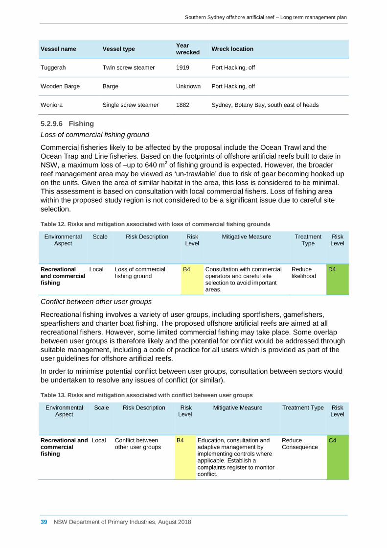
Southern Sydney offshore artificial reef – Long term management plan
Vessel name Vessel type Year wrecked Wreck location
Tuggerah Twin screw steamer 1919 Port Hacking, off
Wooden Barge Barge Unknown Port Hacking, off
Woniora Single screw steamer 1882 Sydney, Botany Bay, south east of heads
5.2.9.6 Fishing Loss of commercial fishing ground
Commercial fisheries likely to be affected by the proposal include the Ocean Trawl and the Ocean Trap and Line fisheries. Based on the footprints of offshore artificial reefs built to date in NSW, a maximum loss of –up to 640 m2 of fishing ground is expected. However, the broader reef management area may be viewed as ‘un-trawlable’ due to risk of gear becoming hooked up on the units. Given the area of similar habitat in the area, this loss is considered to be minimal. This assessment is based on consultation with local commercial fishers. Loss of fishing area within the proposed study region is not considered to be a significant issue due to careful site selection.
Table 12. Risks and mitigation associated with loss of commercial fishing grounds
Environmental Aspect
Scale Risk Description Risk Level
Mitigative Measure Treatment Type
Risk Level
Recreational and commercial fishing
Local Loss of commercial fishing ground
B4 Consultation with commercial operators and careful site selection to avoid important areas.
Reduce likelihood
D4
Conflict between other user groups
Recreational fishing involves a variety of user groups, including sportfishers, gamefishers, spearfishers and charter boat fishing. The proposed offshore artificial reefs are aimed at all recreational fishers. However, some limited commercial fishing may take place. Some overlap between user groups is therefore likely and the potential for conflict would be addressed through suitable management, including a code of practice for all users which is provided as part of the user guidelines for offshore artificial reefs.
In order to minimise potential conflict between user groups, consultation between sectors would be undertaken to resolve any issues of conflict (or similar).
Table 13. Risks and mitigation associated with conflict between user groups
Environmental Aspect
Scale Risk Description Risk Level
Mitigative Measure Treatment Type Risk Level
Recreational and commercial fishing
Local Conflict between other user groups
B4 Education, consultation and adaptive management by implementing controls where applicable. Establish a complaints register to monitor conflict.
Reduce Consequence
C4
39 NSW Department of Primary Industries, August 2018
Southern Sydney offshore artificial reef – Long term management plan
Risk offshore artificial reef does not achieve goals
The overall effectiveness and success of the reefs can be assessed only by monitoring of user satisfaction, structural integrity and impacts of the reef on the surrounding environment. If the proposal were shown not to meet its objectives and/or to have significant adverse impacts on significant components of the marine environment, then appropriate mitigative action would be taken and deployment of future reefs would need to be considered.
The reef is considered to be a success based on three primary objectives:
(i) Fish and benthic community development: the community identified to reside on the structure, although expected to be structurally different in terms of species diversity, should be comparable in terms of species richness to adjacent natural reef communities;
(ii) Structural integrity and module stability: the reef remains intact and structurally sound throughout its design life (30 years);
(iii) Stakeholder acceptance: the installation of the reef results in angler satisfaction reflected by high visitation rates.
If one or all of these objectives fail to be met, a number of mitigative actions may be required. For example, if the community is identified to be mono-specific in terms of species richness following the deployment of the reef with a clear dominance of a small suite of species including aggregation of a threatened or protected species, input controls such as gear or seasonal restrictions may require implementation. Depending on the species in question, restrictions may include the exclusion of bottom fishing with live bait and wire trace (aimed at reducing the likelihood of incidental capture of threatened species such as the Greynurse Shark (C. taurus) or the temporary closure of the reef during peak spawning periods in-line with key target species (e.g. early winter for inshore Snapper – P. auratus).
Regular inspections of the reef during the initial 3 year post deployment period followed by periodic inspections over the design life of the reef will be implemented to investigate structural integrity of the reef and to identify any potentially detrimental issues related to the stability of the modules. Inspections will look for any obvious physical damage either from anchor damage or following large storm events that produce a significant wave height (Hs) in excess of 4.1 metres (i.e. cracks that may allow saltwater ingress) or evidence of module movement (sliding or over turning). If any of these impacts are identified, further investigations by the reef manufacturer (during the defects liability period) or by an appropriately qualified engineer would be used to identify a suitable mitigative response. Responses may include reef repositioning in the event of module movement or removal on the event of salt water ingress and the risk this poses for concrete ‘cancer’ and the structural integrity of a specific module identified as being compromised.
Angler satisfaction is directly related to the useability and accessibility of the reef and the resultant community which takes up residence on the structures. Considerable attention has been applied to the site selection process of the reef to ensure it is located in an area where there is strong support for the reef initiative and where stakeholders (e.g. recreational fishers) can safely access the reef from suitable boating infrastructure (e.g. boat ramps) and where natural reef is limiting (of which there is very little east of the narrow strip of reef adjacent to the cliffs of the Royal National Park). Documenting the development of the fish community and dissemination of these results through meetings, online media (DPI website), social media (Facebook) and popular press (including newspaper and fishing magazines) will ensure stakeholders are well informed as to the development of the reef. Angler satisfaction will be directly related to visitation rates and usage. If usage rates are low, increased distribution of information regarding the effectiveness of the structures may need to be adopted by the DPI.
40 NSW Department of Primary Industries, August 2018

Southern Sydney offshore artificial reef – Long term management plan
Table 14. Risks and mitigation associated with the offshore artificial reef not achieving its goals
Environmental Aspect
Scale Risk Description Risk Level
Mitigative Measure Treatment Type
Risk Level
Recreational and commercial fishing
N/A Risk offshore artificial reef does not achieve goals
D1 Implementation of long term monitoring plan to demonstrate if goals are met (will include surveillance to report on usage). Reporting and dissemination of monitoring outcomes to stakeholders.
Reduce consequence
D4
Gear hook-up
Potential safety issues which could occur as a result of recreational or commercial fishing in the direct study area include, but are not limited to, gear hook-up and collision. The risk of gear hook-up is considered relatively likely, particularly for recreational fishing gear, and could result in detrimental impacts to species vulnerable to entanglement or injury from fishing line and hooks. Vessels may foul their anchors on the offshore artificial reef. This may cause loss of the anchor and anchor line, and possible damage to the reef. In some circumstances, the loss of an anchor may cause consequential impacts on safety such as a disabled vessel drifting towards the coast.
On the Sydney Offshore Artificial Reef commercial divers were contracted by DPI to remove all fouled fishing and boating related gear in October 2013, two years post deployment. Approximately 77.4 m of rope between 5–12 mm in diameter was removed from the reef (assumed to be anchor rope). In addition, approximately 15 m of fishing line was removed and a variety of fishing tackle including lure, sinkers, swivels and hooks (DPI – per comms).
Commercial trawling would not be excluded in the direct vicinity of the offshore artificial reef. However all fishers will be provided with a chart describing the exact location of each of the reef modules, including GPS coordinates. There is a potential risk of gear hook-up on the reef units, which could result in damage to the reef, fishing vessel and safety implications for the vessel. The Australian Hydrographic Office will be notified of the final offshore artificial reef locations, so that a ‘Notice to Mariners’ can be issued, and the official hydrographic charts can be amended. NSW Maritime will also be notified of the final reef location such that relevant publications and maps are amended to show the location of the offshore artificial reef.
Provided commercial fishing businesses which operate in the region are made aware of the fishing reef location, follow a code of conduct and that structures are marked on the relevant AUS Chart, this potential risk is considered to be low. A dedicated fouled-gear removal strategy will be implemented in the LTMP to address lost gear due to hook-up.
Table 15. Risks and mitigation associated with gear hook-up
Environmental Aspect Scale Risk Description Risk Level
Mitigative Measure Treatment Type
Risk Level
Commercial Fishing Local Gear hook-up (commercial)
C2 Dedicated gear removal strategy, consultation, education, notice to mariners. Reef to be marked on nautical charts and NSW Maritime notified for inclusion in relevant publications. Commercial operators to be consulted and notified of final position.
Reduce likelihood
D2
41 NSW Department of Primary Industries, August 2018
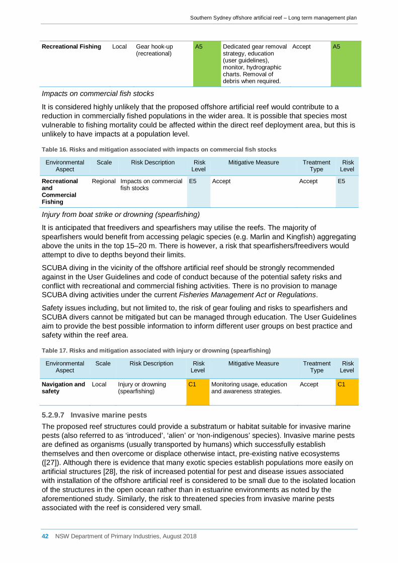
Southern Sydney offshore artificial reef – Long term management plan
Recreational Fishing Local Gear hook-up (recreational)
A5 Dedicated gear removal strategy, education (user guidelines), monitor, hydrographic charts. Removal of debris when required.
Accept A5
Impacts on commercial fish stocks
It is considered highly unlikely that the proposed offshore artificial reef would contribute to a reduction in commercially fished populations in the wider area. It is possible that species most vulnerable to fishing mortality could be affected within the direct reef deployment area, but this is unlikely to have impacts at a population level.
Table 16. Risks and mitigation associated with impacts on commercial fish stocks
Environmental Aspect
Scale Risk Description Risk Level
Mitigative Measure Treatment Type
Risk Level
Recreational and Commercial Fishing
Regional Impacts on commercial fish stocks
E5 Accept Accept E5
Injury from boat strike or drowning (spearfishing)
It is anticipated that freedivers and spearfishers may utilise the reefs. The majority of spearfishers would benefit from accessing pelagic species (e.g. Marlin and Kingfish) aggregating above the units in the top 15–20 m. There is however, a risk that spearfishers/freedivers would attempt to dive to depths beyond their limits.
SCUBA diving in the vicinity of the offshore artificial reef should be strongly recommended against in the User Guidelines and code of conduct because of the potential safety risks and conflict with recreational and commercial fishing activities. There is no provision to manage SCUBA diving activities under the current Fisheries Management Act or Regulations.
Safety issues including, but not limited to, the risk of gear fouling and risks to spearfishers and SCUBA divers cannot be mitigated but can be managed through education. The User Guidelines aim to provide the best possible information to inform different user groups on best practice and safety within the reef area.
Table 17. Risks and mitigation associated with injury or drowning (spearfishing)
Environmental Aspect
Scale Risk Description Risk Level
Mitigative Measure Treatment Type
Risk Level
Navigation and safety
Local Injury or drowning (spearfishing)
C1 Monitoring usage, education and awareness strategies.
Accept C1
5.2.9.7 Invasive marine pests The proposed reef structures could provide a substratum or habitat suitable for invasive marine pests (also referred to as ‘introduced’, ‘alien’ or ‘non-indigenous’ species). Invasive marine pests are defined as organisms (usually transported by humans) which successfully establish themselves and then overcome or displace otherwise intact, pre-existing native ecosystems ([27]). Although there is evidence that many exotic species establish populations more easily on artificial structures [28], the risk of increased potential for pest and disease issues associated with installation of the offshore artificial reef is considered to be small due to the isolated location of the structures in the open ocean rather than in estuarine environments as noted by the aforementioned study. Similarly, the risk to threatened species from invasive marine pests associated with the reef is considered very small.
42 NSW Department of Primary Industries, August 2018

Southern Sydney offshore artificial reef – Long term management plan
Comparison of video observations over a three month period following deployment of the Sydney OAR showed that the majority of the structure had been covered by encrusting organisms, including serpulid polychaetes, barnacles, filamentous algae, bryozoans and hydroids. No introduced marine pests or species that are protected under conservation legislation were observed ([29]).
Ships’ ballast water is a major vector for introduced species. Fouling of ships’ hulls, aquaculture, the aquarium industry and bait industries are also potential vectors. Major ports and estuaries are potential hotspots for invasive species. Whilst the proposed artificial reef site is potentially at risk from colonisation by invasive marine pests, the scale of the potential impact is small and would be unlikely to have any significant impact on the marine environment.
The reef structures will be monitored for colonisation by marine pests. In the event that invasive (introduced) marine pests are identified on reef unit(s), the extent of the pest incursions will be defined noting affected area, species type, abundance and potential for further spread. Requirements for removal of marine pests (according to Biosecurity NSW) would depend on the extent and nature of the incursion but is likely to involve manual removal by divers in the first instance.
Table 18. Risks and mitigation associated with invasive marine pests
Environmental Aspect
Scale Risk Description Risk Level
Mitigative Measure Treatment Type
Risk Level
Invasive Marine Pests
Local Colonisation by invasive (noxious) marine pests
C3 Implementation of a monitoring plan. Requirements for removal of marine pests (according to Biosecurity NSW) would depend on the extent and nature of the incursion but is likely to involve manual removal by divers in the first instance. Surveillance as part of other monitoring and adaptive management
Reduce consequence
C4
5.2.9.8 Endangered, rare or migratory species Threatened and protected species, populations and endangered ecological communities
Threatened and protected species, populations and endangered ecological communities listed under relevant schedules of the Commonwealth EPBC Act, New South Wales TSC Act and the FM Act were identified using the EPBC Act Protected Matters Reporting Tool ([30]), the Bionet Database ([31]) and the Atlas of Living Australia, as well as literature relevant to the southern Sydney area in November 2016. A list of all threatened and protected species, populations and endangered ecological communities that have previously been recorded within the search areas are provided (Table 3). It is important to note that data in the searches comes from a number of different sources, may contain errors and omissions and should therefore be treated as indicative only.
Only threatened species (from the initial search) that were known or considered likely to occur in the wider southern Sydney region (based on general species distribution databases) and/or known to utilise habitat in the area, were considered for further Assessment of Significance. These species were assessed according to OEH and DPI threatened species assessment guidelines ([22, 23]). It should be noted that this does not include ‘protected’ or ‘conservation dependent’ species, which do not require an Assessment of Significance. All seabirds were assessed collectively.
43 NSW Department of Primary Industries, August 2018

Southern Sydney offshore artificial reef – Long term management plan
Assessments of significance (State)
Individual species assessments are given in Appendix 5 of the EA. Overall, 6 species of fish, 3 species of marine turtle, 4 species of cetacean, 1 sirenian and 2 pinnipeds were assessed according to OEH and DPI threatened species assessment guidelines.
Fish
The proposal was not considered to have a significant impact on any of the species identified in Table 3, hence Species Impact Statements (SIS) were not required.
Management of fishing related actives in NSW includes the implementation of a range of bag and size limits aimed at ensuring fisheries resources are managed in a consistent and sustainable manner state-wide. Current Fisheries Regulations make provisions for the exclusion of the harming or taking of protected or threatened species. Proper management of these regulations by compliance activities in the southern Sydney region will ensure these regulations are adhered to by fishers. It is therefore unlikely that the artificial reef would pose an inflated threat to listed threatened and protected species.
Fish species considered most at risk from fishing related activities such as incidental capture including the Great White Shark (Carcharodon carcharias), Greynurse Shark (C. taurus) and Southern Bluefin Tuna (Thunnus maccoyii) are highly migratory and the transient nature of these species means that although they may pass in the vicinity of the reef they are unlikely to remain on the reef long enough to be vulnerable to the potential fishing related impacts identified. Passive and active monitoring of the reef through baited video, acoustic tagging and/or diver census will give adequate resolution by which the occurrence of these species will be identified. The reporting register for threatened and protected species provided to the DPI Threatened Species Unit at 6 monthly intervals will ensure assessment of numbers of threatened species are evaluated independently outside of the DPI Recreational and Indigenous Fisheries Unit. In addition, any serious incidents involving threatened and protected seabird, mammal or reptile species will be reported to the NSW Office of Environment and Heritage (OEH).
The Greynurse Shark is known to aggregate at discrete locations within the wider area. The nearest aggregation area to the study area is Magic Point at Maroubra, 18 km from the proposed OAR deployment site. Given the distance from known aggregation areas, the proposal would not directly affect Greynurse Shark habitat. It is, however, possible that individuals could occasionally forage within the direct reef area. Although this species is most frequently sighted in or near sand-bottomed gutters or rocky caves, Greynurse Sharks are migratory along the NSW coast and may occasionally forage outside of aggregation sites over open sandy habitat ([32]). This considered, it is possible that individual Greynurse Shark could be at risk of incidental capture as a result of the proposal. Even if the sharks are returned to the water, capture related injuries can lead to early mortality due to infection and/or by affecting feeding efficiency. Given that the sharks are only likely to forage within any of the direct study areas on occasion, it is unlikely that potential impacts associated with the reef would affect the life cycle of a viable local population to such an extent that the species is placed at the risk of extinction. Furthermore, providing that fishing activities in the direct reef area are properly managed and monitored, potential risks would be minimised or addressed before they become problematic.
The offshore artificial reef could represent foraging habitat for juvenile or adult breeding female Scalloped Hammerhead Sharks due to the expected increase in fish numbers in the vicinity. However, it is considered unlikely that the artificial reef would disrupt the species life cycle or place any local population at risk of extinction.
While there were no official records available for the Great Hammerhead Shark within the Sutherland LGA, the species was assessed due to a sighting to the south within the Wollongong LGA in 1977 and a sighting to the north in the Waverley LGA in 2000. The artificial reef site could represent foraging habitat for Great Hammerheads on occasions, however, based on the
44 NSW Department of Primary Industries, August 2018

Southern Sydney offshore artificial reef – Long term management plan
rarity of the species in the region, it is considered highly unlikely that the artificial reef would disrupt the species’ life cycle or place any local population at risk of extinction.
The Black Rockcod inhabits coastal and estuarine rocky reefs throughout the NSW coastline. While adult Black Rockcod are territorial and unlikely to utilise the new artificial reef habitat, the pelagic dispersal of eggs and larvae may lead to juveniles recruiting on the reef structures and there is a subsequent risk of incidental capture of individuals. However, it is considered unlikely that the potential impacts associated with the artificial reef would affect a viable population to the extent that it would be placed at risk of extinction.
The Offshore Artificial Reef User Guide (Appendix 7 of EA) contains information on how to identify and report sightings of threatened or protected species and how to properly release unwanted fish species safely and with as little impact on the individual as possible.
Marine Turtles
For the species identified, the proposal was not considered to have a significant impact such that a Species Impact Statement (SIS) would be required. This was mainly due to the transient nature of the species and absence of important nesting, mating or feeding areas within the wider study area.
Cetaceans
The proposal was not considered to have a significant impact on any species of cetacean, such that a SIS would be required. This was mainly due to the transient nature of the species and the absence of important nesting, mating, feeding or resting areas within the wider study area.
Pinnipeds and Sirenians
Although pinnipeds and sirenians (particularly seals) could forage within the wider southern Sydney area, the proposal was not considered to have a significant impact such that a SIS would be necessary.
Possible hazards facing pinnipeds and sirenians include incidental capture, boat strike, acoustic disturbance and interruption to movement corridors. Based on the known distribution of these animals and the results from the Sydney offshore artificial reef monitored in detail between October 2011 and October 2014, the level of these threats is likely be of low to very low risk. No negative interaction with either pinnipeds or sirenians were recorded with only one identified pinniped being found on the reef over the three year monitoring period on a single monitoring day in March 2013.
Human activities in the ocean can affect seals by competing with them for prey, by entanglement (i.e. with fishing gear) and through noise. The threat to seals from the proposal comes from the expected increase in boating activity whereby there is potential for collision, entanglement in discarded fishing gear and increased noise disturbance. Australian Fur-seals may use the reef area for occasional foraging, although the disturbance to the seals is considered to be relatively minor and unlikely to disrupt the life cycle of this species such that a viable local population of the species is placed at risk. The reef was not considered to represent a significant threat to the Australian Fur-seal as there are no significant seal colonies in the proposed area and provided that management measures such as marine debris removal is adopted the level of risk presented to pinnipeds by the reef is very low.
In addition, existing restrictions on the distances of approach and interaction with marine mammals are regulated under the NSW National Parks and Wildlife Regulation (2009).
Seabirds
The proposal was not considered to have a significant impact on any species of seabird, such that a SIS would be necessary.
45 NSW Department of Primary Industries, August 2018

Southern Sydney offshore artificial reef – Long term management plan
Matters of national environmental significance (Commonwealth legislation)
Listed Threatened and Protected Species
The Department of the Environment EPBC Act Protected Matters Reporting Tool ([30]), the NSW government ‘BioNet’ database ([31]) and the Atlas of Living Australia were searched for listed threatened and migratory species, populations and communities listed in relevant Schedules of the EPBC Act that are likely or predicted to occur in the southern Sydney region. Note that threatened species assessed under the EPBC Act include only those listed as ‘extinct in the wild’, ‘critically endangered’, ‘endangered’, ‘vulnerable’ or ‘migratory’.
Note that a species may be classed as both a ‘cetacean’ and a ‘migratory species’ in addition to its protected status, e.g. the Southern Right Whale (Eubalaena australis) which is listed as ‘endangered’, but is also protected as a ‘migratory cetacean’ is only assessed once in Appendix 6 of the EA.
Searches were carried out for seabirds likely to forage offshore and in the direct area of the proposed reef. Intertidal and wading birds such as sandpipers, curlews and plovers and birds of prey (except for Eastern Osprey) were excluded from the assessment as they are unlikely to be affected by the proposal. The main groups of seabirds found to occur in the study region were albatrosses, petrels, shearwaters, terns, skuas, prions, gulls and gannets. In the southern Sydney area, 1 species was listed as critically endangered, 2 species listed as ‘endangered’, 7 species listed as ‘endangered’ and ‘migratory’, 8 species listed as ‘vulnerable’, 19 species listed as ‘vulnerable’ and ‘migratory’, and 30 species listed as ‘migratory’ under the EPBC Act (Table 3).
Only threatened species that were known or considered likely to occur in the wider study area (on the basis of their geographical distributions) and/or known to utilise habitat in the study area, were considered for further impact assessment. Impact assessments are contained within Appendix 6 of the EA.
No critically endangered or endangered ecological communities are known to occur within the proposed study areas.
The Commonwealth Marine Area
The Commonwealth marine area is any part of the sea, including the waters, seabed, and airspace, within Australia's exclusive economic zone and/or over the continental shelf of Australia, that is not State or Northern Territory waters. The Commonwealth marine area stretches from 3–200 nautical miles from the coast.
The proposed southern Sydney offshore artificial reef is proposed to be located within State waters approximately 4.7 km (2.5 nm) west of the 3 nm limit.
Key threatening processes
The following Key Threatening Processes (KTPs) have been identified as potentially relevant to the proposal:
• Entanglement or ingestion of anthropogenic debris in marine and estuarine environments (TSC Act); and
• Injury and fatality to vertebrate marine life caused by ingestion of, or entanglement in, harmful marine debris (EPBC Act).
• Hook and line fishing in areas important for the survival of threatened fish species (FM Act). Entanglement or Ingestion of Anthropogenic Debris in Marine and Estuarine Environments (TSC Act)
The NSW Scientific Committee has declared entanglement in or ingestion of anthropogenic debris in marine and estuarine environments to be a 'key threatening process' in NSW. Marine
46 NSW Department of Primary Industries, August 2018

Southern Sydney offshore artificial reef – Long term management plan
debris is mostly comprised of fishing gear, packaging materials, convenience items and raw plastics. The major sources of marine debris are from ship waste, recreational activities, aquaculture industry and both urban and rural discharges into rivers, estuaries and coastal areas ([33]). Marine debris, particularly plastics, can become entangled around or be ingested by marine animals. This can lead to a number of lethal or detrimental impacts such as:
• strangulation; • increased drag; • potential poisoning by polychlorinated biphenyls (PCBs); • blockage and/or perforation of an individual's digestive system; • wounds caused by line or net and subsequent infection; and • gastric impaction by plastic bodies. Even sub-lethal effects of entanglement or ingestion of marine debris may reduce an individual's fitness and ability to successfully reproduce, catch prey and avoid predation. Records kept by the NSW National Parks & Wildlife Service and Taronga Zoo databases show that entanglement in monofilament line, presence of hooks in the mouth and/or gut, net/line wounds and gastric impaction of plastic bodies are the main reasons for injury or mortality in marine wildlife ([34]).
A number of threatened marine species (including marine turtles, seals and cetaceans) and a number of marine birds have been found to have ingested or become entangled in marine debris.
Injury and Fatality to Vertebrate Marine Life Caused by Ingestion Of, or Entanglement In, Harmful Marine Debris (EPBC Act)
This KTP is similar to the above KTP, but applies to vertebrate marine life protected under Commonwealth legislation ([34]). Department of the Environment has developed a draft Threat Abatement Plan to address the impacts of this KTP ([35]).
Hook and Line Fishing in Areas Important for the Survival of Threatened Fish Species (FM Act)
Hook and line fishing refers to the use of a combination of lines and hooks for catching fish, including lines composed of microfilament, wire and cord, with attached lures, hooks and jigs. Hand-lines, set lines, rod and reel fishing, trolling, lure fishing and fly fishing are all included in the activities identified as a key threatening process. This definition includes catch and release, not just the ‘taking’ of fish ([36]). Areas that are used for feeding and breeding are considered important for the survival of a threatened species and with the exception of Greynurse Shark, such areas are poorly defined, if at all, for the majority of threatened species considered in these assessments. Following identification, some of these areas may be declared as critical habitat, such as nine of the Greynurse Shark aggregation sites along the NSW coast. The Greynurse Shark and Black Rockcod are considered particularly vulnerable to this KTP ([36]). Even when accidentally captured, hooks caught in fishes’ mouths can result in damage that can impact on feeding behaviour and success. The effects of fish hooks can be more serious over a longer time if retained in the mouth, throat and stomach of fishes and sharks, and ultimately can lead to death ([36]). It is recognised that listing all hook and line fishing throughout NSW waters as a KTP would be unpractical and unwarranted. However, where known aggregation sites, spawning areas, important juvenile habitats and feeding areas are concerned, activities that could kill or adversely affect threatened fish species should be considered a threatening process and managed accordingly. A threat abatement plan is yet to be developed for this KTP.
The majority of impacts identified are relevant to threatened or protected species only if they were to move and/or recruit into the direct study area. Threatened or protected species, populations or endangered ecological communities that are most likely to be affected by the deployment of the reef are those that would compete directly with the target fish or crustaceans
47 NSW Department of Primary Industries, August 2018
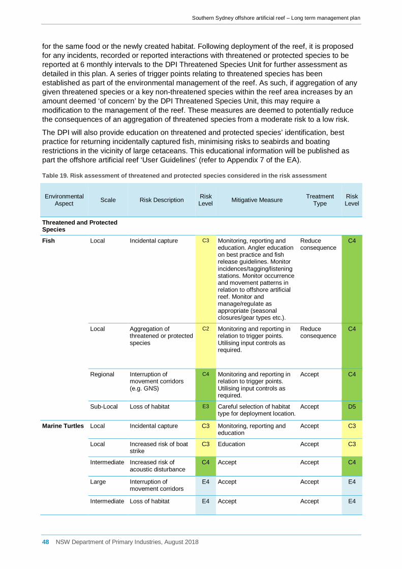
Southern Sydney offshore artificial reef – Long term management plan
for the same food or the newly created habitat. Following deployment of the reef, it is proposed for any incidents, recorded or reported interactions with threatened or protected species to be reported at 6 monthly intervals to the DPI Threatened Species Unit for further assessment as detailed in this plan. A series of trigger points relating to threatened species has been established as part of the environmental management of the reef. As such, if aggregation of any given threatened species or a key non-threatened species within the reef area increases by an amount deemed ‘of concern’ by the DPI Threatened Species Unit, this may require a modification to the management of the reef. These measures are deemed to potentially reduce the consequences of an aggregation of threatened species from a moderate risk to a low risk.
The DPI will also provide education on threatened and protected species’ identification, best practice for returning incidentally captured fish, minimising risks to seabirds and boating restrictions in the vicinity of large cetaceans. This educational information will be published as part the offshore artificial reef ‘User Guidelines’ (refer to Appendix 7 of the EA).
Table 19. Risk assessment of threatened and protected species considered in the risk assessment
Environmental Aspect Scale Risk Description Risk
Level Mitigative Measure Treatment Type
Risk Level
Threatened and Protected Species
Fish Local Incidental capture C3 Monitoring, reporting and education. Angler education on best practice and fish release guidelines. Monitor incidences/tagging/listening stations. Monitor occurrence and movement patterns in relation to offshore artificial reef. Monitor and manage/regulate as appropriate (seasonal closures/gear types etc.).
Reduce consequence
C4
Local Aggregation of threatened or protected species
C2 Monitoring and reporting in relation to trigger points. Utilising input controls as required.
Reduce consequence
C4
Regional Interruption of movement corridors (e.g. GNS)
C4 Monitoring and reporting in relation to trigger points. Utilising input controls as required.
Accept
C4
Sub-Local Loss of habitat E3 Careful selection of habitat type for deployment location.
Accept D5
Marine Turtles Local Incidental capture C3 Monitoring, reporting and education
Accept C3
Local Increased risk of boat strike
C3 Education Accept C3
Intermediate Increased risk of acoustic disturbance
C4 Accept Accept C4
Large Interruption of movement corridors
E4 Accept Accept E4
Intermediate Loss of habitat E4 Accept Accept E4
48 NSW Department of Primary Industries, August 2018

Southern Sydney offshore artificial reef – Long term management plan
Cetaceans Local Increased risk of boat strike
C3 Education regarding acceptable approach distances to cetaceans. Monitoring, reporting and education of existing regulations, adaptive management.
Accept D3
Intermediate Increased risk of acoustic disturbance from boat traffic
C4 Follow national guidelines for whale and dolphin watching.
Accept D5
Large Interruption of movement corridors
D5 Accept Accept D5
Pinnipeds and Sirenians
Sub-Local Incidental capture/entanglement from marine debris
D3 Monitor marine debris and remove as per Long Term Management Plan
Reduce likelihood
E3
Local Boat strike (sirenians only)
E3 Accept Accept E3
Intermediate Increased risk of acoustic disturbance from boat traffic
D4 Accept Accept D4
Large Interruption of movement corridors
E5 Accept Accept E5
Seabirds Local Incidental capture D4 Monitoring, reporting and education. Encourage reporting to WIRES.
Accept D4
KTPs Intermediate Harm from marine debris and pollution (KTPs)
C3 Monitor for fouled gear and remove as necessary. Monitoring, reporting and education, adaptive management.
Reduce consequence
C4
5.2.9.9 Areas of conservation significance For the purpose of this assessment, areas of conservation significance include areas declared as critical habitats under the NSW FM and TSC Acts and Marine Protected Areas (which include Marine Parks, Aquatic Reserves and Nature Reserves). Distances of areas of conservation significance in relation to the proposed artificial reef are listed in Table 20 and shown in Figure 16.
Table 20. Distances of proposed offshore artificial reef to areas of conservation significance
Area of conservation significance Designation Distance to the proposed reef (km)
Royal National Park National Park 0.8
Shiprock Aquatic Reserve Aquatic Reserve 5.1
Boat Harbour Aquatic Reserve Aquatic Reserve 5.2
Towra Point Nature Reserve Nature Reserve 6.4
Botany Bay National Park National Park 6.5
Towra Point Aquatic Reserve Aquatic Reserve 6.7
Cape Banks Aquatic Reserve Aquatic Reserve 11.8
Nature reserves are areas of predominantly untouched land in a natural condition and are considered to have high conservation value. Their primary purpose is to protect and conserve outstanding, unique or representative ecosystems, native plant and animal species or natural phenomena ([37]). Nature reserves are generally terrestrial, but there are some with associated marine components.
49 NSW Department of Primary Industries, August 2018

Southern Sydney offshore artificial reef – Long term management plan
National parks are areas of land protected due to their unspoilt landscapes, outstanding or representative ecosystems, native plants and animals, and places of natural or cultural significance. National parks provide opportunities for public nature appreciation, well-being, enjoyment and scientific research in addition to their role in conservation ([38]).
Aquatic reserves are marine areas managed to conserve marine biodiversity and support marine science, recreation and education. All aquatic reserves provide for boating, SCUBA diving, snorkelling and swimming. Some types of fishing are permitted in some aquatic reserves provided invertebrates and cunjevoi are not collected or killed (e.g. Boat Harbour, Cape Banks Aquatic Reserves), while fishing is prohibited in all or part of other aquatic reserves to conserve all types of marine life in that area (e.g. Shiprock Aquatic Reserve, the sanctuary zone of Towra Point Aquatic Reserve). The offshore boundary for some, but not all, aquatic reserves in the Sydney region is 100 m from the mean low water mark.
Within the wider southern Sydney region, there is one nature reserve and Ramsar site at Towra Point within Botany Bay, two national parks and four aquatic reserves considered relevant to the proposal.
Figure 16. Location of areas of conservation significance in relation to the proposed southern Sydney offshore artificial reef
The Hawkesbury Shelf Marine Bioregion encompasses the coastline, estuaries, coastal lakes and lagoons, beaches and ocean waters to 3 nm offshore between Stockton near Newcastle and Shellharbour and includes the proposed OAR deployment area. The Marine Estate Management Authority (MEMA) has been developing options to enhance marine biodiversity conservation within the Hawkesbury Shelf marine bioregion while achieving balanced outcomes including recreational and commercial opportunities for fishing, boating and other marine activities. Comprehensive community engagement has been undertaken and feedback from all
50 NSW Department of Primary Industries, August 2018

Southern Sydney offshore artificial reef – Long term management plan
stakeholders is currently being carefully considered to help inform MEMA’s advice to the NSW Government on future management initiatives.
While there has been no indication that a marine park will be created off southern Sydney as a management initiative following the Hawkesbury Shelf marine bioregion assessment, artificial reefs may be installed within some zone types of marine parks subject to a range of policy considerations. Regardless, the southern Sydney OAR complex is likely to be deployed prior to the declaration of any new marine protected areas in the Hawkesbury Shelf marine bioregion and would be factored into management arrangements and as with other existing features.
5.2.10 Ocean currents, tides and prevailing weather conditions The existing environment in relation to coastal processes is described in detail in Section 6.1.1 of the EA and includes the local wind and wave climate, prevailing currents, water levels and processes that affect sediment transport. Impacts relating to coastal processes are listed and discussed below. Overall though, the outcomes of the coastal processes study demonstrated that the proposed reef structure deployment would be sustainable in terms of coastal processes and cause no identifiable changes, other than in the immediate vicinity of each structure.
5.2.10.1 Inshore wave climate In order to investigate the wave climate at the site and assess the potential impacts of the proposed reef on the nearshore wave conditions, a wave model was established using the industry standard Simulating WAves Nearshore (SWAN) wave model software (Technical Report C).
A nearshore wave climate change assessment was undertaken for pre- and post- reef placement scenarios in order to directly compare the pre- and post- OAR cases on beaches that lie landward of the OAR complex. The potential main influence on nearshore wave conditions is the reef modules that may act to impose a directional shift on the inshore waves and changes in wave heights. The comparison was made by considering the potential change in weighted mean wave direction and consequent net longshore transport along sandy beaches. Experience at other sites suggests little or no change in inshore wave height would occur.
The model layouts prepared ensured that any changes occurring at the reefs and propagating shoreward would be resolved adequately and was set up with variable resolution grid systems with an offshore wave grid of 100 x 100 m resolution and a finer 10 x 10 m resolution at the OAR complex where better definition of seabed form and depth are needed. The model was forced with recorded offshore wave data collected from waverider buoys at Long Reef and off Botany Bay which were combined for the purposes of the analysis.
A full suite of offshore wave heights, periods and directions were used in the SWAN model including significant wave heights (Hs) of up to 10 m, peak wave periods (Tp) ranging from 4 to 20 seconds, wave directions from north, clockwise through to southwest at 11.25o intervals and tidal levels of LAT, AHD and HAT.
Using time-series results from the wave climate assessments, the comparison of pre and post-deployment conditions shows that the placement of the OAR structures will have no discernible influence on the inshore wave climate along the nearby Royal National Park shoreline that lies landward of the OAR complex. Weighted mean wave direction for pre- and post-OAR installation at 11 nominated output locations between the cliffs of the Royal National Park north-west of the proposed OAR deployment site and south of Marley Beach are presented in Figure 17.
51 NSW Department of Primary Industries, August 2018

Southern Sydney offshore artificial reef – Long term management plan
Figure 17. Pre and post deployment weighted mean wave direction along the Royal National Park shoreline (Technical Report C)
Table 21. Risks and mitigation associated with inshore wave climate and change to beach erosion/deposition
Environmental Aspect
Scale Risk Description Initial Risk Level
Mitigative Measure Treatment Type Residual Risk Level
Nearshore coastal
Large Inshore wave climate C3 Detailed coastal processes assessment to be undertaken. Avoid placement where there is risk of impacts to coastal processes.
Reduce likelihood and consequence
E5
Nearshore coastal
Large Change to beach erosion/deposition
C3 Detailed coastal processes assessment to be undertaken. Avoid placement where there is risk of impacts to coastal processes.
Reduce likelihood and consequence
E5
5.2.10.2 Wind Wind affects both the wave and current climates at the study site. Wind-driven currents diminish with depth. Because wind forcing is applied at the water surface, the relative effect is greater in shallow water where there is less water column volume per unit plan area. Wind-driven currents are therefore greater in more shallow areas. Maximum surface current speed is in the order of 1–3% of the wind speed, depending on water depth. Wind driven currents, particularly from extreme offshore weather systems, are likely to be the most important at the proposed OAR site in terms of impacts on the artificial reef modules and surrounds once installed.
52 NSW Department of Primary Industries, August 2018
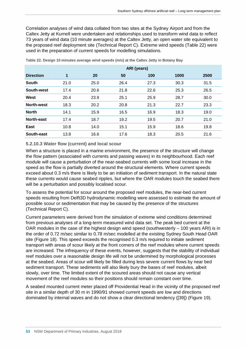
Southern Sydney offshore artificial reef – Long term management plan
Correlation analyses of wind data collated from two sites at the Sydney Airport and from the Caltex Jetty at Kurnell were undertaken and relationships used to transform wind data to reflect 73 years of wind data (10 minute averages) at the Caltex Jetty, an open water site equivalent to the proposed reef deployment site (Technical Report C). Extreme wind speeds (Table 22) were used in the preparation of current speeds for modelling simulations.
Table 22. Design 10 minutes average wind speeds (m/s) at the Caltex Jetty in Botany Bay
ARI (years) Direction 1 20 50 100 1000 2500 South 21.0 25.0 26.4 27.3 30.3 31.5
South-west 17.4 20.6 21.8 22.6 25.3 26.5
West 20.4 23.9 25.1 25.9 28.7 30.0
North-west 18.3 20.2 20.8 21.3 22.7 23.3
North 14.1 15.9 16.5 16.9 18.3 19.0
North-east 17.4 18.7 19.2 19.5 20.7 21.0
East 10.8 14.0 15.1 15.9 18.6 19.8
South-east 13.8 16.6 17.6 18.3 20.5 21.6
5.2.10.3 Water flow (current) and local scour When a structure is placed in a marine environment, the presence of the structure will change the flow pattern (associated with currents and passing waves) in its neighbourhood. Each reef module will cause a perturbation of the near-seabed currents with some local increase in the speed as the flow is partially diverted around the structural elements. Where current speeds exceed about 0.3 m/s there is likely to be an initiation of sediment transport. In the natural state these currents would cause seabed ripples, but where the OAR modules touch the seabed there will be a perturbation and possibly localised scour.
To assess the potential for scour around the proposed reef modules, the near-bed current speeds resulting from Delft3D hydrodynamic modelling were assessed to estimate the amount of possible scour or sedimentation that may be caused by the presence of the structures (Technical Report C).
Current parameters were derived from the simulation of extreme wind conditions determined from previous analyses of a long-term measured wind data set. The peak bed current at the OAR modules in the case of the highest design wind speed (southwesterly – 100 years ARI) is in the order of 0.72 m/sec similar to 0.78 m/sec modelled at the existing Sydney South Head OAR site (Figure 18). This speed exceeds the recognised 0.3 m/s required to initiate sediment transport with areas of scour likely at the front corners of the reef modules where current speeds are increased. The infrequency of these events, however, suggests that the stability of individual reef modules over a reasonable design life will not be undermined by morphological processes at the seabed. Areas of scour will likely be filled during less severe current flows by near bed sediment transport. These sediments will also likely bury the bases of reef modules, albeit slowly, over time. The limited extent of the scoured areas should not cause any vertical movement of the reef modules so their positions should remain constant over time.
A seabed mounted current meter placed off Providential Head in the vicinity of the proposed reef site in a similar depth of 30 m in 1990/91 showed current speeds are low and directions dominated by internal waves and do not show a clear directional tendency ([39]) (Figure 19).
53 NSW Department of Primary Industries, August 2018

Southern Sydney offshore artificial reef – Long term management plan
Figure 18. Impacts of reef structures on peak near-bed current speed and near-bed change during 100 year ARI event (southwesterly wind direction) at peak bed current of 0.78 m/sec at Sydney OAR site (Technical Report C)
54 NSW Department of Primary Industries, August 2018

Southern Sydney offshore artificial reef – Long term management plan
Figure 19. Providential Head near-bed current rose (top) and probability of exceedance (top) from a depth of 30 m [39]
55 NSW Department of Primary Industries, August 2018

Southern Sydney offshore artificial reef – Long term management plan
The East Australian Current (EAC) is generally strongest in summer, peaking in February, and weakest, by as much as half the flow, in winter ([40]). While the EAC is generally strongest and most persistent offshore of northern NSW, the proposed OAR deployment site is affected by the EAC although its influence typically decreases in a shoreward direction at this latitude. The Australian Hydrographic Service charts (AUS808 and AUS197) available for the study area indicate that the EAC can reach up to 4 knots (2.1 m/s) in the greater Sydney region. Current magnitudes decrease with increasing depth and model testing has indicated that higher maximum current magnitudes occur near the seabed due to wind-driven currents rather than the EAC. However, the site may be affected by the EAC which should be considered by the installation contractor when planning for the installation of the reef modules.
Table 23. Risks and mitigation associated with local scouring/deposition around units
Environmental Aspect
Scale Risk Description Initial Risk Level
Mitigative Measure Treatment Type
Residual Risk Level
Local seabed Sub-Local
Local scouring/deposition around units
B4 Detailed coastal processes assessment to be undertaken. Avoid placement where there is risk of impacts to coastal processes.
Reduce consequence
B5
5.2.10.4 Tides The main factor that contributes to still water level movement offshore of the Sydney region is astronomical tide. Tides along the NSW coastline are semi-diurnal with significant diurnal inequality in NSW coast tides, i.e. a difference in height of the two high waters or the two low waters of each tidal day. Tidal planes to datum lowest astronomical tide (LAT) are presented in Table 24 from the Australian National Tide Tables 2015. Barometric pressure changes also affect oceanic water levels amongst other oceanographic effects and water levels may vary day-to-day from predicted tide levels by up to 0.2 m.
Table 24. Tidal planes at the proposed OAR deployment site (m LAT)
Tidal Plane Height (m LAT)
Highest Astronomical Tide (HAT) 2.1
Mean High Water Springs (MHWS) 1.6
Mean High Water Neaps (MHWN) 1.4
Mean Sea Level (MSL) 1.0
Mean Low Water Neaps (MLWN) 0.6
Mean Low Water Springs (MLWS) 0.3
5.2.11 Summary of the reasons for selection of proposed site Constraints analysis was undertaken to assist in identifying zones within the study area likely to be most suitable for artificial reef deployment in a preferred depth of 30-50 m (Technical Report A). Following the review of existing information and mapping of key characteristics of the area and surrounds, a ‘potential OAR deployment area’ was mapped (Figure 20). This is the area where, based on existing information, artificial reef deployment would be suitable and unlikely to conflict with the physical, biological and regulatory constraints investigated. However, further consultation with commercial fishers revealed that their activities could be impacted upon by reef
56 NSW Department of Primary Industries, August 2018

Southern Sydney offshore artificial reef – Long term management plan
deployment in that depth range and an alternative site located immediately adjacent to the potential OAR deployment area in a depth of 29-30 m was identified, investigated and chosen as the location for deployment.
Figure 20. Potential deployment area identified through constraints analysis (Technical Report A)
57 NSW Department of Primary Industries, August 2018

Southern Sydney offshore artificial reef – Long term management plan
6 Scope, duration and timeframes for monitoring This section describes research and monitoring aspects related to the southern Sydney offshore artificial reef that are designed to provide information that will lead to continuous improvements in the way the reef is managed and future reefs deployed. Development of a monitoring strategy to meet objectives relating to interaction with threatened and protected species and quantifying the impact of the reef system with the broader ecological community requires a time frame that is consistent with the rate of recruitment to the artificial reef system and the ecological factors which drive this process. Previous work associated with both estuarine and offshore reef systems has indicated that the fish communities remain dynamic over the first 2-3 year period post deployment. A three year monitoring program will provide an adequate time frame to understand longer term trends in the nature of the fish assemblages associated with artificial reef systems (including interactions with threatened and protected species), physical forces acting on the structural integrity and stability of the reef while providing insight into the level of variation between seasons and years.
The duration of the initial detailed monitoring at quarterly intervals for 3 years was considered sufficient based on the results of past and existing artificial reef research projects undertaken by the DPI. In addition, this was the time period previously stipulated by the Department of the Environment when approval was granted for the Sydney Offshore artificial reef project (SD2008/882), Shoalhaven offshore artificial reef (SD2014/2842) and Port Macquarie offshore artificial reef (SD2015/3142) projects.
6.1 Priorities The research priorities for the southern Sydney offshore artificial reef (outlined in Table 25), are categorised into two levels depending on the relevance to the risks identified in the EA and information required to support the objectives of the reef:
Level 1 (initial monitoring): Commencement scheduled upon installation of the reef and reviewed within three years of commencement.
Level 2 (supportive monitoring): Commencement scheduled for within three years of the installation of the reef.
Table 25. Research priorities and description
Research Topic Priority Short description of research project and expected outcomes
1. Colonisation of the reef & community development: BRUV/ROV*
Level 1 BRUVs and/or unbaited ROV cameras will be deployed on the reef a minimum of 4 times a year. This would allow the monitoring of fish assemblages and the documentation of the development of the fish community.
2. Threatened species, fish residency and connectivity: ROV/BRUV; acoustic listening station
Level 1 An acoustic listening station would be placed on the reef (Figure 21) which would allow for the monitoring of fish assemblages, threatened species, and pelagic species with acoustic tags. Data collected would again be incorporated into DPI databases where relevant and is likely to provide information regarding the interaction with natural reefs and the potential risks associated with draw down effects. Data collected by remote video (e.g. BRUVs, ROV) will be used to supplement this data set. Any threatened species information will be incorporated in to the DPI Threatened Species Unit’s database.
3. Reef stability & structural integrity: ROV
Level 1 ROV camera surveys would be conducted by staff a minimum of 4 times a year; these surveys will allow a visual inspection of the reef to document reef stability and structural integrity. The results of the survey would be included in DPI databases where relevant.
4. Benthic assemblages (including pest identification): ROV/BRUV
Level 2 A quarterly visual record of benthic development on the reef will be recorded by BRUV, surface deployed camera, diver surveys & photographic record for a period of 3 years.
5. Accumulation of marine debris: ROV/BRUV
Level 1 The level of gear hook up will be assessed using ROV cameras; if there is a build-up of marine debris on the reef structures which poses an entanglement
58 NSW Department of Primary Industries, August 2018
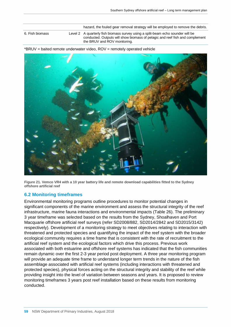
Southern Sydney offshore artificial reef – Long term management plan
hazard, the fouled gear removal strategy will be employed to remove the debris.
6. Fish biomass Level 2 A quarterly fish biomass survey using a split-beam echo sounder will be conducted. Outputs will show biomass of pelagic and reef fish and complement the BRUV and ROV monitoring.
*BRUV = baited remote underwater video, ROV = remotely operated vehicle
Figure 21. Vemco VR4 with a 10 year battery life and remote download capabilities fitted to the Sydney offshore artificial reef
6.2 Monitoring timeframes Environmental monitoring programs outline procedures to monitor potential changes in significant components of the marine environment and assess the structural integrity of the reef infrastructure, marine fauna interactions and environmental impacts (Table 26). The preliminary 3 year timeframe was selected based on the results from the Sydney, Shoalhaven and Port Macquarie offshore artificial reef surveys (refer SD2008/882, SD2014/2842 and SD2015/3142) respectively). Development of a monitoring strategy to meet objectives relating to interaction with threatened and protected species and quantifying the impact of the reef system with the broader ecological community requires a time frame that is consistent with the rate of recruitment to the artificial reef system and the ecological factors which drive this process. Previous work associated with both estuarine and offshore reef systems has indicated that the fish communities remain dynamic over the first 2-3 year period post deployment. A three year monitoring program will provide an adequate time frame to understand longer term trends in the nature of the fish assemblage associated with artificial reef systems (including interactions with threatened and protected species), physical forces acting on the structural integrity and stability of the reef while providing insight into the level of variation between seasons and years. It is proposed to review monitoring timeframes 3 years post reef installation based on these results from monitoring conducted.
59 NSW Department of Primary Industries, August 2018

Southern Sydney offshore artificial reef – Long term management plan
Table 26. Environmental monitoring and timeframes proposed on the southern Sydney offshore artificial reef
Issue Monitoring Actions Frequency Responsibility
Colonisation of the reef & community development
Before reef installation, monitoring was conducted at the proposed southern Sydney reef site using BRUVs (August 2016). BRUVs and/or ROV cameras will be deployed on the reef a minimum of 4 times a year post reef installation to monitor fish assemblages and colonisation of the reef community; presence of threatened species; allow for potential identification of pest species and will be compared with nearby natural reef control locations. Biomass surveys will be conducted at least 4 times a year to monitor the abundance of fish utilising the structures.
Quarterly every 12 months • for 3 consecutive years
and then will be reviewed
DPI
Marine fauna interactions including threatened species interactions
Record all observations of marine fauna and threatened species interactions with infrastructure and vessels during installation; and, Record potential ongoing interactions with threatened & protected species, boat strikes, behavioural changes, entanglements etc.
During the installation phase and then on a biannual basis thereafter – ongoing for the design life of the reef (≤ 30 years)
DPI, successful tenderer and reef users
Structural integrity and stability of infrastructure
Inspections and maintenance of reef infrastructure e.g. faults, damage. Monitor the effectiveness and suitability of the reef design.
Regular scheduled inspections & maintenance annually: • quarterly every 12 months
for 3 consecutive years post installation, then;
• a minimum of every 5 years for the remainder of the reef design life or following large storm events which produce a significant wave height ≥ 4.1 m)
DPI
Marine debris Removal of debris build up in a timely manner (dependant on water conditions)
Regular scheduled inspections & debris removal when required: • annually for 3 consecutive
years, then reviewed based on needs from results of preliminary 3 consecutive year post installation surveys for the design life of the reef – ≤ 30 years.
DPI
Benthic fouling including invasive pest identification
Regular inspections of reef for pests to ensure early detection. Record pests - contribute to the species inventory for NSW waters.
Quarterly visual inspections of reef every 12 months for 3 consecutive years and then will be reviewed.
DPI
6.2.1 Structural integrity and stability monitoring The structural integrity and stability monitoring will be used to undertake inspections of the reef infrastructure to determine its structural integrity and stability. Evidence of faults, damage, and excessive debris build-up will be the focus of the inspections which will be followed by appropriate maintenance. Inspections will be particularly important after a large storm event which produce waves in excess of 4.1 m (Hs), and the cleaning of infrastructure in order to minimise marine fauna entanglements. Routine visual inspections will be undertaken quarterly every 12 months for 3 years (then reviewed) with a minimum inspection period of every 5 years for the remainder of the reef design life or following severe storm events which produce a significant wave height ≥ 4.1 m.
The inspection checklist includes:
60 NSW Department of Primary Industries, August 2018

Southern Sydney offshore artificial reef – Long term management plan
• Date and type of observation conducted (diver vs. camera); • Location and description of faults identified including: significant scouring or sedimentation;
module damage including cracks, splits or breakages and the location (GPS coordinate) of the module;
• a list of proposed actions to be undertaken (if any) including the contracting of third part assessment.
The structural integrity and stability monitoring will assess the effectiveness and suitability of the module design, such as whether it adequately withstands the sea conditions offshore of the southern Sydney coastline as designed.
An intense East Coast low hit the NSW coast between April 20-23 2015 which produced gale force winds (>45 knots) and huge seas, with the most extreme effects felt along the Hunter-Sydney coast with strong winds, flooding rains and massive seas. The largest wave recorded at 3 pm on 21 April was 15 m, approximately the height of a 5 story building. The waves also exceeded 6 m for 30 hours, the longest duration of such high waves since 1987. Post storm inspections of both the Sydney and Shoalhaven artificial reefs were carried in May 2015 in line with inspection conditions of respective sea dumping permits (SD2008/882 & SD2014/2842). DPI used surface deployed cameras to undertake the inspections. No damage was identified to either the single large Sydney reef unit or any of the 20 multiple modules which form the Shoalhaven reef. In addition, no significant scour or deposition was identified in the vicinity of either reef (Figure 22).
Figure 22. Inspections of the Sydney (upper image - 7 May 2015) and Shoalhaven (lower image - 18 May 2015) OARs following an intense east coast low that produced waves up to 15 m (Hmax)
61 NSW Department of Primary Industries, August 2018
Southern Sydney offshore artificial reef – Long term management plan
6.3 Performance monitoring and review
6.3.1 Performance indicators Performance indicators provide the most appropriate indication of whether the offshore artificial reef is meeting its objectives. A number of monitoring programs and existing DPI programs are to be used in conjunction with each other to gather information to measure performance indicators.
With the implementation of the new research, advisory and information management programs for the reef, a broader information base relating to the activity and its impacts will enable more precise performance indicators to be developed over time if required.
6.3.2 External drivers External drivers are factors that are known to potentially impact on the performance of the reef but which are outside of the control of DPI (e.g. environmental conditions, social changes etc.). Any external influences that may contribute to a trigger being breached will be identified during monitoring of the reef and, if necessary, referred to any relevant managing agency for action. A number of external influences may contribute to trigger points being reached. For example, the NSW Office of Environment and Heritage (OEH) administer interactions with marine mammals under the NSW National Parks and Wildlife Regulation (2009) and the NSW National Parks and Wildlife Amendment (Marine Mammals) Regulation 2006, introduced to protect marine mammals such as whales and dolphins while allowing people to appreciate them in the wild. These existing regulations specify the distances of approach and interaction with marine mammals. If interactions between reef users and cetaceans, pinnipeds, etc. were found to increase significantly post installation of the reef, then in addition to the DPI TSU being notified of these interactions, the NSW OEH would also be independently briefed. Management actions would require a combined approach from both the DPI and OEH to ensure a consistent method to address the issue. A passive approach such as increased education and an awareness campaign coordinated between the two agencies may suffice. However, if impacts continue to escalate, increased monitoring and compliance patrols combined with temporal exclusions zones may require consideration.
Build-up of marine debris identified during the monitoring of the reef to be as a result of purposeful dumping of material on or adjacent to the reef site is another external influence. If increased marine debris is entering the marine environment in the vicinity of the proposed artificial reef which is of a deliberate nature (i.e. intentional dumping of waste from vessels) then the NSW Roads and Maritime Service (RMS) would be notified and action taken under the Marine Pollution Regulation 2006. As current Fisheries Management Regulations do not manage this activity, an appropriate management response would be for DPI to administer a combined on-water operations with the RMS Boating Service Officers (BSOs) to target offenders and enforce these regulations.
6.3.3 Trigger points Trigger points specify when a performance indicator has reached a level that suggests there is a problem with the activity and a review is required. Table 27 establishes the performance indicators and trigger points that will be used to measure whether each of the mitigation measures described in Chapter 9 of the EA are being attained. No numbers for interactions with threatened species have been defined; instead a threshold for 'of concern' will be implemented. The reasoning behind this is that the types of threatened species and degree to which they are threatened is highly variable in regard to the operation of the reef. This has been determined in consultation with the DPI TSU.
By not defining a set point/number at which management measures would be imposed upon the operation of the reef, it allows the TSU to assess not only numbers of interactions with
62 NSW Department of Primary Industries, August 2018
Southern Sydney offshore artificial reef – Long term management plan
threatened species on the reef, but other aspects of threatened species management which may be relevant such as:
• the level of the threat that is or has occurred;
• the type of interaction;
• the frequency of the interactions;
• the season that the interaction is occurring (breeding/calving);
• any potential change in the threatened status;
• how much harm as a result of the interaction was occurring;
• sightings vs. hookings/entanglements; and
• if the species is recovering and numbers are increasing.
Without imposing numbers/thresholds on the interactions with threatened species the LTMP is more fluid and is more in line with current impact assessment that is being undertaken. Numbers are not used when assessing the level of impact on matters of National Environmental Significance but rather the process relies on professional judgement.
The 6 month reporting schedule and involvement of the DPI TSU (which is independent of DPI Recreational Fisheries Management) allows for an independent judgement of these levels of interaction. Also any significant interaction such as mortality would immediately be reported to the TSU.
If the level of interaction was to become 'of concern', potential management measures which could be imposed upon the reefs may include gear restrictions, closed seasons, fishing times, a restricted fishery and restrictions on the type of fishing. DPI as an agency would need to come up with an appropriate management response in relation to the interaction. Again, as the threshold is not quantifiable due to so many variables, it is important to deal with the interactions appropriately as they arise based on professional judgement.
Harm from Marine Debris: The proposal is likely to result in the concentration of, and increase in, recreational fishing activity in the direct reef area. This potentially increases the risk of lost fishing gear and harmful marine debris entering the marine environment in the vicinity of the proposed recreational fishing reefs. Threatened marine species, particularly marine turtles, pinnipeds, small cetaceans and seabirds, can ingest or become entangled in marine debris, such as plastics. Potential harm to marine animals from build-up of marine debris such as lost fishing tackle, anchor lines and other pollution is being monitored quarterly each year over the first 3 years post reef installation.
A commitment has been made by DPI that periodic inspection of marine debris will be maintained on the reef for its design life of 30 years. The ongoing regularity of inspections will be based on a needs basis following a review of the scheduled quarterly monitoring over each of first 3 years. Annual debris removal has been scheduled over 3 years (i.e. the first debris removal will be conducted within 12 months of the reef being installed and annually thereafter for a period of up to 3 years). This is deemed to be an appropriate management response and mitigative measure based on the unknown level of build-up. If an obvious entanglement hazard is identified outside scheduled maintenance and debris removal (including but not limited to free floating rope [discarded anchor lines]), removal by DPI or contracted commercial divers will be facilitated as soon as practical.
In order to further reduce the impact of this KTP, education using the reef user guidelines and existing DPI education programs would be provided on the potential impacts of harmful marine debris on marine life and the responsible disposal of litter and discarded fishing gear.
63 NSW Department of Primary Industries, August 2018

Southern Sydney offshore artificial reef – Long term management plan
Invasive Marine Pests: The proposed reef structures could provide a substratum or habitat suitable for invasive marine pests (also referred to as ‘introduced’, ‘alien’ or ‘non-indigenous’ species). Although there is evidence that many exotic species establish populations more easily on artificial structures, the risk of increased potential for disease associated with biota at the artificial reefs is considered to be extremely small due to their isolation in the open ocean rather than in estuarine environments. Similarly, the risk to threatened species from invasive marine pests associated with the reef is considered very small.
Invasive marine pest species including the Japanese and yellowfin gobies and New Zealand screw shell are generally associated with soft or unconsolidated sediments in bays and estuaries and would be unlikely to occur offshore. Therefore they are unlikely to be of concern, primarily due to the location of the proposed Port Botany offshore artificial reefs. While Japanese gobies have been detected in Sydney Harbour and yellowfin gobies in Sydney Harbour and Botany, their preference for estuarine habitats is likely to preclude establishment on the artificial reefs. CSIRO modelling of the potential range of NZ screwshell (based on temperature tolerance) indicates it is very unlikely to survive north of Merimbula in southern NSW.
Whilst the proposed reef site is potentially at risk from colonisation by invasive marine pests, the scale of the potential impact is small and would be unlikely to have any significant impact on the marine environment. Depending on the species identified a variety of management responses may be required. In the first instance, reef user groups would be informed of boating guidelines to minimise the spread of marine pests and a revised monitoring plan would need to be implemented in order to better document the extent of the incursion. Requirements for removal of marine pests (according to National Introduced Marine Pest Information System - NIMPIS) would depend on the extent and nature of the incursion but is likely to involve manual removal by divers in the first instance. This would be facilitated by the DPI upon advice from the DPI Biosecurity Unit.
Table 27. Trigger points
Incidental capture of threatened species
Risk description Trigger point Justification/comments
Incidental capture from recreational fishing gear could potentially affect threatened fish, pinnipeds and seabirds that forage in the surface waters
Increases of incidental capture of threatened species or key non threatened species within reef area increases by an amount deemed ‘of concern’ by the DPI Threatened Species Unit (TSU) following reporting of the incident as specified in the project reporting section.
Increased incidences of capture of threatened species or key non threatened species within the reef area may indicate a change in species interactions or species interactions with the reef. This may require a modification to the management of the reef.
Data required Availability/monitoring programs
Incidences of threatened species capture within the reef area
Information on threatened species or key non threatened species is available from DPI and other government agencies (e.g. OEH) and through the Bionet database as well as through the ROV and BRUV surveys and through the angler advisory campaigns. This information would be sent to the DPI TSU every six months for review.
Aggregation of threatened or protected species
Risk description Trigger point Justification/comments
Aggregation of threatened or protected species
Aggregation of threatened species or key non threatened species within reef area increases by an amount deemed ‘of concern’ by the DPI TSU.
Increased aggregations of threatened species or key non threatened species within the reef area may indicate a change in species interactions. This may require a modification to the management of the reef. Data required Availability/monitoring programs
64 NSW Department of Primary Industries, August 2018

Southern Sydney offshore artificial reef – Long term management plan
Information on the residency of threatened and protected species within the reef area.
Information on threatened species or key non threatened species is available from DPI and other government agencies (e.g. OEH) and through the Bionet database as well as through the ROV and BRUV surveys, acoustic telemetry and through the angler advisory campaigns. This information would be sent to the DPI TSU every six months for review.
Alteration/interruption of movement corridors
Risk Description Trigger point Justification/comments
Cetaceans and some species of fish, such as the Greynurse Shark, that undertake migrations along the NSW coastline, could alter their migratory behaviour in response to the presence of the offshore artificial reefs.
Movement corridors of threatened species or key non threatened species within reef area alters by an amount deemed ‘of concern’ by the DPI TSU or other relevant government agency.
Changes in movement patterns and corridors of threatened species or key non threatened species within the reef area may indicate a change in species interactions and behavioural patterns. This may require a modification to the management of the reef.
Data required Availability/monitoring programs
Information on the migration routes and patterns of threatened and protected species within the reef area.
Information on threatened species or key non threatened species is available from DPI and other government agencies (e.g. OEH) and through the Bionet database as well as through the ROV and BRUV surveys, acoustic telemetry and through the angler advisory campaigns. This information would be sent to the DPI TSU every six months for review.
Harm from marine debris and pollution (KTPs) / Gear hook up
Risk Description Trigger point Justification/comments
Increased risk of lost fishing gear and harmful marine debris entering the marine environment in the vicinity of the proposed offshore artificial reefs.
Debris build up on the reef by an amount that the DPI Recreational Fisheries Unit believes is ‘of concern’
Ongoing build-up of marine debris on the reef may require a modification to the management of the reef.
Data required Availability/monitoring programs
ROV inspection of the reef to assess the debris build up.
Annual reef monitoring and observance program and other DPI research projects/programs operating within the reef area.
Invasive Marine Pests
Risk Description Trigger point Justification/comments
The proposed reef structures could provide a substratum or habitat suitable for invasive marine pests (also referred to as’ introduced’, ‘alien’ or ‘non-indigenous’ species).
An incidence of a novel disease or pest within the reef area
Pests and diseases can pose significant risks to the environment. This indicator ensures that the reef and its management are appropriately responding to pest and disease issues. There are potential external drivers in this trigger point such as the introduction of pests and diseases through other aquatic or land based activities
Data required Availability/monitoring programs
65 NSW Department of Primary Industries, August 2018

Southern Sydney offshore artificial reef – Long term management plan
Ongoing monitoring of the reef area, pests and records of responses to pest or disease incursions
Disease and pest notification procedures (in line with DAFF) and DPI Biosecurity
7 Environmental management The following provides an overview of the proposed environmental management developed to provide guidelines for the operation of the offshore artificial reef.
7.1 Environmental reporting Environmental reporting requirements for the southern Sydney offshore artificial reef will include the following:
• Colonisation and community development; • Inspections of reef infrastructure , structural integrity and stability (conducted annually); • Observations of marine fauna interactions (from the Marine Fauna Interaction Register); • Threatened species interactions Checklists will be maintained by DPI for environmental inspections and environmental audits.
7.1.1 Logs and registers A number of registers will be maintained by DPI as part of the operation of the reef. A summary of the matters within the registers will be included in environmental management reports. The registers will include but are not limited to the following:
Complaints register
A complaints register will be maintained by DPI. The register will list information such as the following for each complaint:
• Date; • Person/s receiving the complaint; • Name, address and contact phone number of person/s making the complaint; • Specific details of the nature of the complaint; and • Action undertaken in response to the complaint. Marine fauna interaction register
The marine fauna interaction register will list information such as the following:
• Date; • Time; • Fauna species (if known); • Number of individuals; • Approximate size; • Nature of interaction; • Description of displayed behaviour; • Management issue; and • Management actions.
66 NSW Department of Primary Industries, August 2018

Southern Sydney offshore artificial reef – Long term management plan
7.2 Offshore artificial reef user education and awareness guidelines Offshore artificial reef user education and awareness guidelines have been produced to form the basis of the offshore artificial reefs advisory/education (Appendix 7 of the EA). The guidelines provide information important for user groups to ensure minimal environmental impact and promote safety within the reef management area.
These guidelines are available via the DPI website and in print as required for distribution to relevant recreational fishing associations and clubs.
7.3 Fouled gear (debris) removal strategy The installation of the southern Sydney offshore artificial reef will result in the concentration of, and increase in, recreational fishing activity in the immediate vicinity of the reef. This may potentially increase the risk of lost fishing gear and harmful marine debris entering the marine environment in the vicinity of the proposed reef. Threatened marine species, particularly marine turtles, pinnipeds, small cetaceans and seabirds, can ingest or become entangled in marine debris, such as plastics. This fouled gear removal strategy aims to ensure marine debris which poses an entanglement hazard is removed.
A commitment has been made by DPI that periodic inspection of marine debris will be maintained on the reef for its design life (up to 30 years) based on the outcome of the first 3 years of monitoring.
7.3.1 Inspection timing Twelve scheduled inspections will be conducted over the first 3 years post reef installation to document the accumulation of any fishing or non-fishing related marine debris. The first inspection will be conducted within 3 months of the reefs installation being completed and the first debris removal will be conducted within 12 months of the reef being installed if required and annually thereafter for a period of up to 3 years.
At the conclusion of this initial 3 year assessment period, the results will be used to identify a suitable level of assessment required to identify and respond to marine debris accumulation. For example if debris build-up remains consistent over the first 3 years, annual removal and inspections may be required to be maintained. However, if limited debris is recorded with a trend towards a reduction in debris, inspections may be further reduced to 3-5 year intervals for the remaining design life of the reef (up to 30 years).
7.3.2 Inspection A combination of diver survey and remotely operated vehicle (ROV) video will be used to provide an ongoing debris log. This log will be maintained by DPI and will include the following detail:
• date • type of material identified (e.g. fishing line [mono or braid], anchor line, trap or net); • approximate amount seen (length and diameter of lines) and distance the material extends (i)
vertically; and, (ii) laterally from the reef; • location of the debris (including GPS coordinates [where possible] and reef patch group); • proposed removal methods (diver, barge/winch, other); • threat presented by the debris.
7.3.3 Debris removal triggers If the build-up of marine debris on the reef structures is identified to pose an entanglement hazard or if ‘free floating’ lines (i.e. tethered to the reef which extend into the upper water column above the structures) are identified this removal strategy will be implemented. Although commercial fishing is not expected to be undertaken on the reef, in the event of a net or fish trap
67 NSW Department of Primary Industries, August 2018

Southern Sydney offshore artificial reef – Long term management plan
being identified on the reef a team will immediately be mobilised to assess and remove the objects(s) in question.
7.3.4 Debris removal If the amount of material identified can be safely removed by divers using a single knife only, a DPI commercial dive team (2815.1 qualified in accordance with minimum standards set by AS/NZ2299.1 Commercial Diving Standard) may be used to remove the hazard (note: special permission from the DPI – Fisheries NSW Occupational Diving Officer will be required).
If the hazard poses an entanglement or entrapment hazard to divers, DPI will contract an external commercial diving contractor with surface-supply capacity (as per AS/NZ2299.1) to complete the removal.
If the hazard cannot be safely retrieved by divers (e.g. commercial trawl net or large commercial fish trap), suitably experienced and qualified salvage contractors are to be sought by DPI to provide salvage advice.
Significant entanglement hazards which pose an immediate threat to marine mammals are to be reported to the NSW Office of Environment and Heritage (OEH) under the NSW National Parks and Wildlife Regulation (2009).
7.4 Contingency measures In addition to the circumstances outlined above, the Deputy Director General DPI Fisheries NSW may order a review and/or make a modification to the southern Sydney offshore artificial reef in circumstances declared by the Minister as requiring contingency action, or upon the recommendation of DPI staff.
These circumstances may include (but are not limited to) food safety events, environmental events, and results of research programs or unpredictable changes on or around the reef over time. Notwithstanding the above, the Deputy Director General DPI Fisheries NSW may also make amendments to the operation of the southern Sydney offshore artificial reef that the Deputy Director General DPI Fisheries NSW considers to be minor in nature at any time.
7.5 Emergency contacts and response If at any time during the deployment or operation of the reef an environmental risk/incident occurs, the DPI will immediately implement measures to mitigate the risk or the impact. The situation will be reported in writing within 24 hours to Department of the Environment and Energy (and any other relevant Government Agency or Authority), with a full report detailing:
i) the environmental incident that occurred and/or ‘non-compliance’ detected; ii) the mitigation measures taken, and; iii) The success of these measures in addressing the environmental incident that occurred
and/or ‘non-compliance’ detected and any additional measures that are proposed to be taken.
Emergency contacts:
1) Manager Fisheries Enhancement – DPI Ph: (02) 6691 9673 (office hrs), 1300 550 474 (24hrs) Email: [email protected] Other relevant emergency contacts include:
i) ORRCA Whale and Dolphin Rescue – Ph: (02) 9415 3333 ii) Fisheries Watch - for reporting illegal fishing – Ph: 1800 043 536 iii) For ALL other emergencies (NSW Police, Maritime, Fire, Ambulance) – Ph: 000
68 NSW Department of Primary Industries, August 2018

Southern Sydney offshore artificial reef – Long term management plan
7.6 Decommissioning The nominal operational lifespan of the southern Sydney artificial reef is estimated to be 30 years. It is likely, however, that the structures would remain operational for longer than this. Whether the units are removed intact or dismantled would depend on the outcome of structural inspections prior to removal. The following options for decommissioning would be considered:
• Option A – Provided the structures are verified to be structurally sound for removal, the units would be lifted intact by crane to a barge and transported to a waterside location, where the units would be cleaned, dismantled and disposed of at an appropriate land-based facility;
• Option B – If it is not feasible for the units to be removed intact, then the units would be dismantled by commercial divers in-situ, sections craned onto a barge and transported to a waterside facility where the pieces would be cleaned and disposed of at an appropriate land-based facility;
• Option C – Structures would remain in-situ on the sea-bed and be allowed to gradually break-down over time. Monitoring of the structures would continue.
These options would provide a contingency for decommissioning at any stage during the operational life of the reef if required, although the option of removing the units intact is unlikely to be feasible towards the end of the operational lifespan. In the event that unacceptable impacts to the environment were detected during monitoring of the reef then ‘Option A’ would be the most likely method of decommissioning. It is likely that the main impact of removing the structures (options A or B) would be a significant loss of attached flora and fauna and a loss of fish habitat, however, the overall environmental impact would depend on which option for decommissioning was considered most appropriate and the length of time the units had been in place. Removal of the units (Options A or B) would therefore be subject to a separate environmental assessment of their removal.
7.7 Project reporting Updates on the southern Sydney offshore artificial reef will be placed on the DPI offshore artificial reefs webpage (www.fisheries.nsw.gov.au), via social media (e.g. Facebook) and will be reported as required to other statutory agencies and departments.
Within 10 working days from completion of the reef installation, the DPI will provide a report that:
• details the date and time of the placement of the southern Sydney offshore artificial reef; • confirmation of the placement site boundaries to two decimal places of a minute (WGS84); • the estimated maximum depth over the southern Sydney reef units (LAT), and the date and
time of the observation; and confirmed that the highest point of the reef is no less than 20 m below sea level (LAT);
• details of inspection dive and any items removed or hazards rectified; • proof of written notification to the Australian Hydrographic Office and NSW Maritime. A report can be provided to relevant consenting authority(s) as requested addressing, but not limited to the following:
• identify the standards and performance measures of the project; • describe all works carried out over the previous 12 months; • a summary of complaints and a comparison to previous years; • records of maintenance checks and activities; • a summary of post deployment monitoring activities and preliminary results; • ‘non-compliance’ and/or environmental incidents recorded or responded to in the previous
year; including those that specifically involved threatened and/or migratory species (including sightings and/or incidental captures;
69 NSW Department of Primary Industries, August 2018

Southern Sydney offshore artificial reef – Long term management plan
7.8 Long term management plan review Review of this plan will be conducted as required from the date of approval and is the responsibility of the DPI Recreational Fisheries Management team. Issues relating to the operation and implementation of the plan will be collated by the DPI Manager Fisheries Enhancement for review and reporting and approval.
70 NSW Department of Primary Industries, August 2018

Southern Sydney offshore artificial reef – Long term management plan
References 1. Department of Environment, C.C.a.W., Due Diligence Code of Practice for the Protection of
Aboriginal Objects in New South Wales. 2010, Department of Environment, Climate Change and Water: Sydney, NSW.
2. Fletcher, W., The application of qualitative risk assessment methodology to prioritize issues for fisheries management. ICES Journal of Marine Science: Journal du Conseil, 2005. 62(8): p. 1576-1587.
3. West, L.D., et al., Survey of Recreational Fishing in New South Wales and the ACT, 2013/14, in Fisheries Final Report Series No 149. 2016. p. 150.
4. Industries, N.D.o.P. Recreational Fishing. 2015; Available from: http://www.dpi.nsw.gov.au/fisheries/recreational/info/rfh.
5. McIlgorm, A. and J. Pepperell, Developing a cost effective state wide expenditure survey method to measure the economic contribution of the recreational fishing sector in NSW. 2013.
6. Keller, K., et al., Monitoring boat-based recreational fishing effort at a nearshore artificial reef with a shore-based camera. Fisheries Research, 2016. 181: p. 84–92.
7. Seaman Jr, W. Does the level of design influence success of an artificial reef. In European Artificial Reef Research. Proceedings of the 1st EARRN conference. 1996. Ancona, Italy, March 1996.
8. Bohnsack, J.A., et al., Effects of reef size on colonization and assemblage structure of fishes at artificial reefs off southeastern Florida, USA. Bulletin of Marine Science, 55, 1994. 2(3): p. 796-823.
9. Lindberg, W.J., et al., Density-dependent habitat selection and performance by a large mobile reef fish. Ecological Applications, 2006. 16(2): p. 731-746.
10. Anderson, T.W., E.E. DeMartini, and D.A. Roberts, The relationship between habitat structure, body size and distribution of fishes at a temperate artificial reef. Bulletin of Marine Science, 1989. 44(2): p. 681-697.
11. Charbonnel, E., et al., Effects of increased habitat complexity on fish assemblages associated with large artificial reef units (French Mediterranean coast). ICES Journal of Marine Science, 2002. 59(suppl): p. S208.
12. Belmaker, J., N. Shashar, and Y. Ziv, Effects of small-scale isolation and predation on fish diversity on experimental reefs. Marine Ecology Progress Series, 2005. 289: p. 273-283.
13. Borntrager, J.F. and T.M. Farrell, The effect of artificial reef size on species richness and diversity in a Florida estuary. Florida Scientist, 1992. 55(4): p. 229-235.
14. Pickering, H. and D. Whitmarsh, Artificial reefs and fisheries exploitation: a review of the ‘attraction versus production’debate, the influence of design and its significance for policy. Fisheries Research, 1997. 31(1-2): p. 39-59.
15. Ambrose, R.F. and S.L. Swarbrick, Comparison of fish assemblages on artificial and natural reefs off the coast of southern California. Bulletin of Marine Science, 1989. 44(2): p. 718-733.
16. Burchmore, J.J., et al., An ecological comparison of artificial and natural rocky reef fish communities in Botany Bay, New South Wales, Australia. Bulletin of Marine Science, 1985. 37(1): p. 70-85.
17. Ramos, J., et al., Stakeholder perceptions regarding the environmental and socio-economic impacts of the Algarve artificial reefs. Hydrobiologia, 2007. 580(1): p. 181-191.
18. O'Leary, E., T. Hubbard, and D. O'Leary, Artificial Reefs Feasibility Study. The Marine Institute. Coastal Resources Centre National University of Ireland Cork. ISSN 1393. . Marine Resource Series, No. 20,, 2001: p. 48 pp.
19. Sutton, S.G. and S.L. Bushnell, Socio-economic aspects of artificial reefs: Considerations for the Great Barrier Reef Marine Park. Ocean and Coastal Management, 2007. 50(10): p. 829-846.
71 NSW Department of Primary Industries, August 2018
Southern Sydney offshore artificial reef – Long term management plan
20. Jordan, A., et al., Seabed Habitat Mapping of the Continental Shelf of NSW. 2010, Department of Environment, Climate Change and Water NSW
21. Connell, S.D. and M.P. Lincoln-Smith, Depth and the Structure of Assemblages of Demersal Fish: Experimental Trawling Along a Temperate Coast. Estuarine, Coastal and Shelf Science, 1999. 48(4): p. 483-495.
22. Conservation, D.o.E.a., Threatened Biodiversity Survey and Assessment: Guidelines for Developments and Activities (Working Draft) 2004, Department of Environment and Conservation: Hurstville.
23. Change, D.o.E.a.C., Threatened Species Assessment Guidelines – The Assessment of Significance. 2007, Department of Environment and Climate Change: Sydney.
24. Environment, N.O.o. Key threatening processes | Threatened species | NSW Environment & Heritage. 2014; Available from: http://www.environment.nsw.gov.au/threatenedspecies/keythreateningprocesses.htm.
25. Zakharov, J., A review of Aboriginal cultural factors for the Jervis Bay area, New South Wales. Wetlands (Australia), 1987. 6(2).
26. Environment, D.o.t. Australian national shipwreck database. 2014; Available from: http://www.environment.gov.au/topics/heritage/historic-shipwrecks/australian-national-shipwreck-database.
27. Connell, S.D. and B. Gillanders, Marine Ecology. 2007: Oxford University Press. 28. Glasby, T.C., S. Holloway, M. Hewitt, C., Nonindigenous biota on artificial structures: could
habitat creation facilitate biological invasions? Marine Biology, 2007. 151(3). 29. Industries, N.D.o.P., Sydney Offshore Artificial Reef, Annual Environmental Monitoring
Report 2012-13 2013, NSW Department of Primary Industries. 30. Energy, D.o.t.E.a. Protected Matters Search Tool - EPBC Act. [Index Page] 2013 2016;
Available from: http://www.environment.gov.au/epbc/pmst/. 31. Heritage, O.o.E. NSW BioNet. 2016; Available from: http://www.bionet.nsw.gov.au/. 32. Smale, M.J., The diet of the ragged-tooth shark Carcharias taurus Rafinesque 1810 in the
Eastern Cape, South Africa. African Journal of Marine Science, 2005. 27(1): p. 331-335. 33. Heritage, O.o.E.a. Entanglement in or ingestion of anthropogenic debris in marine and
estuarine environments - key threatening process listing | NSW Environment & Heritage. 2014; Available from: http://www.environment.nsw.gov.au/determinations/MarineDebrisKtpDeclaration.htm.
34. Environment, D.o. Harmful marine debris. 2004 2004-11-23T00:00+11:00; Available from: http://www.environment.gov.au/resource/harmful-marine-debris.
35. Department of the Environment, W., Heritage and the Arts, Draft Threat Abatement Plan for the impacts of harmful marine debris on vertebrate marine life 2008, Department of the Environment, Water, Heritage and the Arts: Canberra.
36. Committee, N.F.S., Final Recommendation, Key Threatening Process – Hook and Line Fishing in Areas Important for the Survival of Threatened Species N.D.o.P. Industries, Editor. 2003.
37. Heritage, N.O.o.E.a. Reserve types in NSW - Nature reserve | NSW National Parks. Info available; Available from: http://www.environment.nsw.gov.au/nationalparks/parktypes.aspx?type=naturereserve.
38. Service, N.N.P.a.W. List of national parks | NSW National Parks. 2016; Available from: http://www.nationalparks.nsw.gov.au/conservation-and-heritage/national-parks.
39. Treloar, L., Marine Aggregate Proposal – An Assessment of Sediment Plumes. Prepared for Metromix Pty Ltd. 1993.
40. Research, C.M., The East Australian Current.
72 NSW Department of Primary Industries, August 2018