south watuppa pond, fall river - massachusetts
TRANSCRIPT

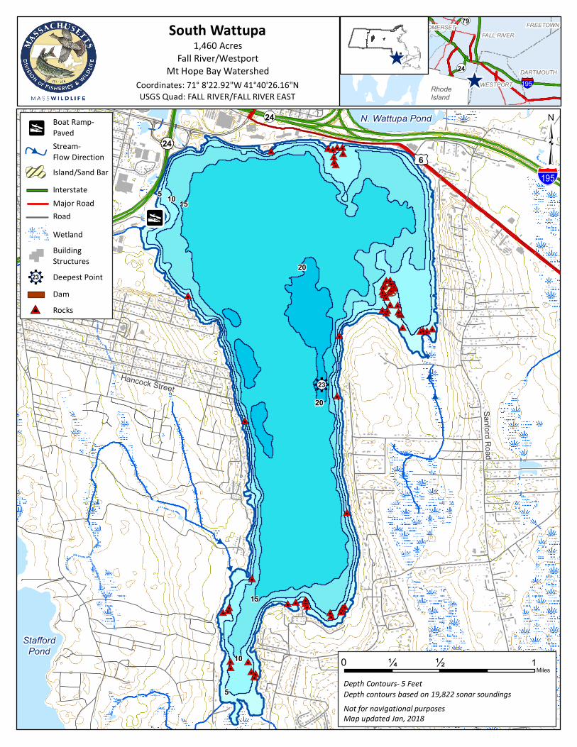
South Watuppa Pond, Fall River
General Information South Watuppa Pond is a 1,460-acre enlarged great pond, which has an average depth of 14.5 feet and a maximum depth of 23 feet. The pond receives water from several small streams draining swampy areas, from North Watuppa Pond, from Sawdy Pond via Stony Brook and from Stafford Pond in Rhode Island via Sucker Brook and the Bleachery Ponds. The pond's outlet is the Quequechan River which feeds into the Taunton River and Mount Hope Bay. Transparency is low at three feet and aquatic vegetation is scant. Algae blooms in the summer often color the water green while the rest of the year the water is tea colored. The bottom is composed of rubble, rock and muck, and there are numerous rubble-strewn shoals. Roughly a third of the 10 miles of shoreline is wooded or riprapped and accessible to anglers on foot, the rest of the shoreline is composed of residential and commercial development. Recreational Access Access to South Watuppa Pond is provided by a paved boat ramp managed by the City of Fall River (71° 8'22.92"W 41°40'26.16"N). The large paved parking area can accommodate approximately 50 vehicles. It is located at the end of Jefferson Street. Fish Populations The following fish species were found during MassWildlife surveys: Smallmouth Bass, Largemouth Bass, Chain Pickerel, White Perch, Yellow Perch, Brown Bullheads, Bluegill, Pumpkinseed, Black Crappie, Golden Shiner, and White Sucker. South Watuppa has been stocked with Northern Pike and Tiger Muskellunge. Please check the MassWildlife Northern Pike and Tiger Muskellunge stocking page online for stocking dates. Fishing South Watuppa Pond is a popular site for bass tournaments and contains large populations of both Smallmouth Bass and Largemouth Bass. The large size, abundant structure and moderate fertility of this pond make it excellent Smallmouth Bass habitat. Most of the pond’s productivity is tied up in White Perch but due to its high fertility there is an abundance of Yellow Perch, Black Crappie and Bluegill and Pumpkinseed sunfish for the panfisherman. South Watuppa has produced Tiger Muskie, Chain Pickerel, Brown Bullhead, Black Crappie, and Sunfish that meet minimum sizes for recognition by the Sportfishing Awards Program.
Useful Links: Get your Fishing License
Freshwater Fishing
Trout Stocking Information Freshwater Sportfishing Awards Program Learn more: Mass.gov/MassWildlife Connect with us: Facebook.com/MassWildlife Your local MassWildlife office: 195 Bournedale Road Buzzards Bay, MA 02532 (508) 759-3406
STOP AQUATIC HITCHIKERS! Prevent the transport of nuisance species. Clean all recreational equipment. ProtectYourWaters.net Updated: 2018
#0#0#0#0#0#0#0#0
#0#0#0#0#0
#0#0#0#0#0#0
#0
#0#0#0#0#0#0#0#0#0#0#0#0#0#0#0
#0
#0
#0
#0
#0#0#0#0#0#0#0#0#0#0
#0
#0
#0#0#0
#0
#0
#0#0
#0#0#0
#0
#0
£¤6
!(24
§̈¦195
South Wattupa1,460 Acres
Fall River/WestportMt Hope Bay Watershed
FALL RIVER
DARTMOUTHWESTPORT
SOMERSETSWANSEA FREETOWNSWANSEA
!(79
!(24
^^
Coordinates: 71° 8'22.92"W 41°40'26.16"NUSGS Quad: FALL RIVER/FALL RIVER EAST
³
Not for navigational purposes
Depth Contours- 5 Feet
Map updated Jan, 2018
Depth contours based on 19,822 sonar soundings
WetlandBuildingStructures
Road
Stream- Flow Direction#
Deepest Point
Major RoadInterstate
Dam
Island/Sand Bar
pBoat Ramp-Paved
#
#
#
#p
#V Rocks
24
r23
¼ ½Miles
0 1
§̈¦195RhodeIsland
15
20
105
r23
N. Wattupa Pond
StaffordPond
Sanford Road
Hancock Street
15
20
10
5