south oxfordshire core strategy examination · considered as confirmed by catherine darnton...
TRANSCRIPT

1
South Oxfordshire Core Strategy Examination
OVERALL STRATEGY
C.S ENGBERS
2
Examination of deliverability of land for housing within the locations identified in the Core Strategy
My statement relates to the overall strategy sub-matters A, E and F. In terms of sub matter (A), allocation of 2,884 homes to Rest of District including 1,154 to be allocated in SADPD for Larger Villages is supported. However, the number of Larger Villages has not been increased to ensure that these homes can be delivered during the plan period. Provision of this additional housing in the same number of locations indicates a problem with the deliverability of the Core Strategy. In terms of sub matter (F), I have reviewed a large number of the sites in the Larger Villages set out in the SHLAA in detail and I do not consider that there is sufficient evidence to provide any confidence that that the SADPD will be able to identify land for these 1,154 dwellings. The Core Strategy is therefore not flexible, as it will not allow the Site Allocations DPD to adapt to changing circumstances in the future. On reviewing the SHLAA it has also become apparent to me that the constraints affecting Henley will severely limit development there and that the Council has in no way demonstrated that any of the sites identified for Henley are deliverable. As such in terms of sub matter (E) I do not consider that the distribution of housing between the towns adequately recognises the constraints affecting Henley. A suitable alternative is to make the Core Strategy more justified would be to maintain the level of housing proposed and the split in the towns but increase the number of Larger Villages. This would increase the effectiveness of the Core Strategy and provide more certainty that the housing figures can be delivered allowing the SADPD to be able to adapt to changing circumstances. This would ensure that the development was compliant with PPS3 in delivering a flexible supply of land for housing. In my review of the sites in the SHLAA, I used paragraph 54 of PPS3 which identifies how sites should be considered as deliverable for Local Planning Authorities in establishing their supply of housing land (Appendix G2). The South Oxfordshire SHLAA 2011 identifies 284 hectares of land as suitable in principle for housing in the larger villages together with 63 hectares of land on sites around Henley (which includes Gillotts School and Highlands Farm). This document looks at a number of sites contained within the SHLAA in the identified locations for growth within the Core Strategy (namely Henley and the Larger Villages) and assesses whether they are likely to be deliverable. In summary I have found that many sites are in the AONB, have legally protected species in residence, have multiple owners, are Grade II agricultural land, have areas of SSSI on the site or adjoining or are in flood zone. This informs my position that not enough broad locations for growth have been identified to deliver the requited 1,154 dwellings in the Larger Villages. Furthermore, having reviewed the sites in detail it is apparent that the deliverability of sites for 400 units in Henley is also very questionable, which further intensifies the need to identify more broad locations for growth. The Appendix details the locations of the sites and an assessment as to why many sites deemed suitable in the SHLAA are in fact, unsuitable.
3
Larger Villages In total I have assessed 70 sites within the SHLAA which are identified in the Larger Villages (see appendix). I consider all these sites to be unsuitable for development and together they amount to 411.68 hectares of land. Essentially a large proportion of the villages are constrained. The Green Belt severely limits development around Berinsfield and Wheatley, whilst Crowmarsh Gifford, Cholsey, Benson and Watlington are partially constrained by the Chilterns AONB and Nettlebed, Sonning Common, Woodcote and Goring are all entirely constrained by the AONB. Consequently, none of the sites in Nettlebed are deliverable, only 1 out of 8 sites identified in Benson are potentially deliverable, and only 2 of 6 sites in Berinsfield are potentially deliverable. There are also severe constraints on development in Crowmarsh Gifford and Wheatley reflected in my assessment of the SHLAA sites. This severely undermines confidence that the SADPD will be able to deliver the necessary land allocations for 1154 dwellings. Consequently, I consider that there is insufficient evidence in the SHLAA that the SADPD will be able to deliver the required amount of housing and no other evidence has been put forward to substantiate the Council‟s position that it can. As such I believe that the answer to sub matter (F) is no.
Henley Henley is identified as a location for 400 new dwellings although the Council have not been able to identify any sites within the Core Strategy despite extensive consultation and press coverage. In reviewing the sites identified for the Larger Villages I have also reviewed the sites identified for Henley. I have only briefly had the opportunity to review the Council‟s latest document entitled Henley Site Capacity Assessment 30 September 2011. SODC is focusing on 6 sites in and around Henley. Generally, finding suitable sites within Henley has proved extremely difficult owing to the constraints imposed by the river and AONB. Furthermore, all sites on the periphery of the town suffer from severely constrained access. Site HEN1 (Drawback Hill) is located in a prominent position where redevelopment would harm the AONB. It is also severely constrained in terms of access by road and the options to improve access do not seem viable. Site HEN2 (Gillotts School) is not available for development and the playing fields are not being considered as confirmed by Catherine Darnton Headteacher who made the following comment „would not be built on our playing fields’ (see appendix HEN2). To conclude,
the school is still required and the playing fields are unsuitable. Site HEN5 (Highlands Farm) is situated within the AONB and currently in employment use such that it would be unsuitable. Sites HEN3 and HEN14 suffer from unsuitable access and are within the AONB. Site HEN13 lies within a Conservation Area and AONB where development would be constrained. Full details of my assessment of sites in Henley are set out in my Appendix. As such in terms of sub matter (E) I do not consider that the distribution of housing between the towns is soundly based as it appears that the delivery of housing around Henley is severely questionable.
4
Appropriate Changes Doubt concerning the delivery/suitability of some of SODC‟s considered sites in the Larger Villages or Henley, whether in AONB, Availability, or Flood Plain grounds indicates that a more flexible approach is required if housing targets are to be met. This could bring into play additional sites which could satisfy many of the Core Strategies‟ criteria sites which up to now have been excluded on grounds of village categorisation – even when the categorisation has been based on inaccurate data. Shiplake is a village that could provide the much needed sites for additional locations to accommodate the housing, providing greater flexibility during work on the Site Allocations DPD and greater certainty and deliverability in the Core Strategy. It could also accommodate some of Henleys housing needs. However SODC have classified Shiplake village as „small‟ and therefore available and suitable sites are not considered and are dismissed. A full assessment of Shiplake‟s potential to act as a Larger Village is set out in my Shiplake Report June 2008; (including letters and enclosure dated 28th April 2009; 3rd July 2009; 22nd September 2009), which were submitted with my Publication Stage Representation Form. The evidence including statements from village spokes persons confirms that Lower Shiplake and Shiplake Cross is one village (Appendix HEN2-H2):-. „As far as the school is concerned, Lower Shiplake and Shiplake Cross form part of the same village and we have never heard of it being otherwise – indeed the schools postal address is
‘Shiplake.’ Bursar, Shiplake CE School
‘You are correct the village do ‘operate’ as one large village’ Clerk to the Council, Shiplake Parish Council
Less than 4km from Henley, linked by rail and river, Shiplake is an ideal location to support Henley‟s housing needs. Shiplake is a poly focal village made up of Lower Shiplake and Shiplake Cross – there are sites in the village that could support Henley‟s housing needs that are available, suitable and accessible. Despite many past submissions with supporting evidence, as to its communal, retail, leisure and sporting facilities, SODC refuse to correctly classify Shiplake as a Large Village and recognise the two Shiplakes as one village/settlement. This village classification was determined by the Local Plan in 2006 following the Inspectors Public Enquiry. But both the Plan and Enquiry were undermined by inaccurate data and one outstanding omission, Shiplake Railway Station. Shiplake Station was not part of SODCs „evidence base‟ when the Plan was drawn up and the Enquiry concluded. This 19
th
century station was nowhere to be seen in the documentation. The railway station was not documented until the 2008 Annual Monitoring Report. There are only two Villages in South Oxfordshire with a railway station – a rail link is a key facility and „unlocks‟ a village – it should not be lost in a general transport (bus) data section of the AMR. How could the Local Plan be „robust and sound‟ when it omitted a major facility for tackling stated key policies areas – Environment and Transport? Shiplake Station processes 312 passenger trains a week, 50 each weekday and contributes to traffic reduction in Henley and Reading. Shiplake, is linked to Henley and Reading by rail.

5
The reason for categorising Shiplake as two settlements was initially based on a separation argument. The claimed distance between them was challenged and altered twice and then moved from the edges to the centres of the settlements – wherever located. A further questioning „robustness and soundness‟ of the database and hence Plan. The argument now forwarded is that the settlements are separated by „green fields‟ – based on SODCs own methodology this is simply not the case. The Settlement Assessment Document explains that the Oxfordshire Data Observatory is the source of the demographic data used by SODC in defining settlements. Two such output areas are used in defining Shiplake Cross. One of these areas (UDHH0011) which covers the Church and Shiplake College contains 128 households most of which border the households of Lower Shiplake. Hence far from being separated around 50% of the household population of Shiplake Cross is living alongside Lower Shiplake residents. In fact some of the Shiplake Cross residents have to travel through Lower Shiplake to get to the facilities at the Cross.(appendix G5) A suitable alternative to solve the problems identified with sub matters (A), (E) and (F) to make the Core Strategy more justified would be to maintain the level of housing proposed in sub matter (A) but increase the number of Larger Villages. This would increase the effectiveness of the Core Strategy and provide more certainty that the housing figures can be delivered allowing the SADPD to be able to adapt to changing circumstances. This would ensure that the development was compliant with PPS3 in delivering a flexible supply of land for housing. Inclusion of Shiplake as one of the Larger Villages in the Core Strategy would provide for additional locations to accommodate the housing, providing greater flexibility during work on the SADPD and greater certainty and deliverability in the Core Strategy. It would address a perceived weakness highlighted in sub matter (F) providing more confidence that the SADPD will be able to identify effective land for 1154 dwellings, and would allow Shiplake to accommodate some of Henley‟s housing need as a fallback position should the questionable sites identified by the Council not come forward.

6
South Oxfordshire Core Strategy Examination
OVERALL STRATEGY
APPENDICES
C.S ENGBERS

7
APPENDIX G1 The landowner(s) has/have not submitted the site(s) for consideration as (a) potential site(s) for housing despite the Council issuing a call for sites for their (currently on hold) Site Allocations DPD, and extensive public consultation on the Core Strategy. As such this/these site(s) is/are not available for development as there is no indication at all that it/they would come forward through the Site Allocations DPD process. No reliance whatsoever can be placed on this land coming forward for housing. APPENDIX G2 Paragraph 54 of PPS3 identifies how sites should be considered as deliverable for Local Planning Authorities in establishing their supply of housing land it states that “Drawing on information from the Strategic Housing Land Availability Assessment and or other relevant evidence, Local Planning Authorities should identify sufficient specific deliverable sites to deliver housing in the first five years. To be considered deliverable, sites should, at the point of adoption of the relevant Local Development Document:” Be Available – the site is available now. Be Suitable – the site offers a suitable location for development now and would contribute to the creation of sustainable, mixed communities. Be Achievable – there is a reasonable prospect that housing will be delivered on the site within five years.”

8
G5 OUTPUT MAP SHIPLAKE REFER TO HARD COPY DOCUMENT

9
HENLEY-ON-THAMES SITE ANALYSIS HEN1 Lucy‟s Farm HEN1 8.25 hectares of land – located in a prominent position on top of a hill, Drawback Hill. The site is highly visible from an area of AONB (Harpsden Woods Appendix H1). There are TPOs on the site. Drawback Hill is a vantage point, steeply sloped. The hedging on the site is located at the bottom of the hill and is sporadic. Due to the gradient of the site, the hedging would not reduce the impact on the AONB. This site is inaccessible - to achieve access it has been suggested that properties are purchased in Blandy Road, Peppard Lane or Rotherfield Road - there is no guarantee this could be achieved. Furthermore, none of the access roads listed are suitable. Rotherfield Road is a premier residential road, Peppard Lane a narrow country lane and Blandy Road a densely populated residential road. Access cannot be achieved from either the Harpsden Road or Gillotts Lane (indeed permission in 1989 was refused for this reason – as this would involve right of way across other land, both of these roads are narrow and heavily congested. This site is not a viable option – it is unsuitable for development and is unsustainable.
10
HEN2 Gillotts School HEN2 2.55 hectares. There are NO plans to redevelop the school or to reduce the amount of playing fields (Appendix H3). There is currently a discussion regarding Gillotts School becoming an academy – this will increase the pressure for places at Gillotts School. Gillotts School needs to expand not contract. Redevelopment of the playing fields is unacceptable and would attract opposition from residents and Sport England in accordance with their published guidance (“A Sporting Future for the Playing Fields of England: Policy on planning applications for development on playing fields”). As such, this site cannot be considered as „suitable‟ (a stance confirmed by the Head Mistress Catherine Darnton. Gillotts School is located on a narrow congested lane – other access points through Blandy Road (a heavily populated residential road) would involve purchasing properties – there is no guarantee of this being achieved. Gillotts is located by AONB, any development would have a detrimental impact on this area. Legally protected Common Pipistrelle (39795) is present on the site(reference SHLAA July 2011) This site is not suitable for development and is unachievable for the reasons outlined above.

11
HEN5 Highland Farm H 5 8.2 hectares. Highlands Farm is situated in the AONB with an area of SSSI running across the site (Appendix H4). Highlands is divorced from Henley, within a 50 mile an hour area. There are no public footpaths. The site is largely in employment use, but also features a playing field. Policy CSEM 4 would apply to any redevelopment proposals for the site, which would set a presumption against its allocation in the Site Allocations DPD as a residential site. Comprehensive redevelopment of the site for housing would have an adverse impact on the AONB. Development of the Highlands Site is unsuitable and unsustainable for the reasons detailed above.

12
HEN3 Treetops land opposite Gillotts School HEN 3 2.5 hectares in AONB and adjacent to a town green. Access could only be achieved from Gillotts lane (Appendix H5) – a narrow lane which reduces to single track. Gillotts Lane is already heavily congested with traffic to/ from the school. This site is unsuitable due to impact on AONB and access/egress limitations.
13
HEN13 Fairmile HEN 13 3.7 hectares in Conservation Area. Permission was refused on this site for this reason (Appendix H8). The site is adjacent to AONB – any development would impact the AONB and Conservation Area. There is a listed building in the SE edge. 0.5 Hectares within the flood zone 2 and 3 (Appendix H7). Flooding is predicted to increase in future years (Appendix G4). There are legally protected slow worms present on the site (reference SHLAA July 2011). This site is unsuitable for development for reasons above.
14
HEN14 Empstead Works HEN 14 0.5 hectares centrally located. Henley is constrained and suffers from traffic congestion. Traffic routes in and out of Henley are unlikely to be improved; they are severely restricted due to the river crossing, conservation areas and AONB. Further development located centrally can only exacerbate this situation. For this reason this site is unsuitable.

15
LARGER VILLAGE SITE ANALYSIS Benson The sites outlined below are ALL Grade II Agricultural Land. BEN1 Land adjacent to Littleworth Road, Benson BEN2 Land north of Sunnyside BEN3 Land to the East and South of Port Hill Road BEN4 Land to North West of Watlington Road BEN6 Land south of Braze Lane BEN7 Land adjacent to St Helen‟s Avenue BEN8 Land adjacent to Benson airfield BEN1 24.8 hectares. 46% is in flood zone 2 /3 i.e. 5.9 hectares (Appendix B1) the rest is flood zone 1 i.e. 18.9 hectares (Appendix G4) development on any flood zone site is to be avoided where possible. Legally protected Eurasian Badgers are present on the site. The Western part of the site is covered by HSE hazard zones from the two Gas pipelines running to the west ((reference SHLAA July 2011). This site is not suitable for development. BEN2, BEN3, BEN6 18.2 hectares of land. None of these sites have been submitted by the landowners for consideration (Appendix G1). BEN4 8.3 hectares. Legally protected Redwing and Fieldfare present on the site (reference SHLAA July 2011) . BEN7, BEN8 12.4 hectares of mainly Grade II Agricultural Land. On both sites there is an archaeological restraint DX15888 - (reference SHLAA July 2011). The sites are in multi ownership with no guarantee that future agreements can be reached. These sites are therefore not suitable or possibly available.

16
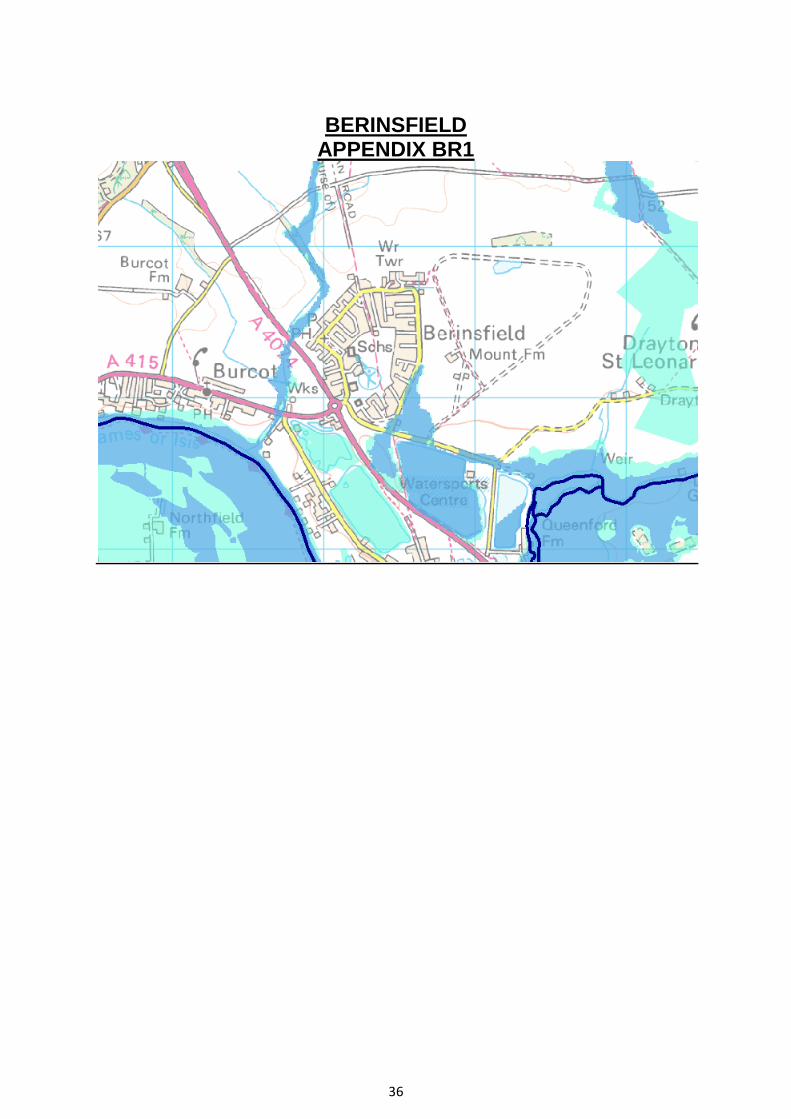
Berinsfield All the sites detailed below are Grade II Agricultural Land BER1 Land West of Berinsfield and A4074 BER4 Land East of Berinsfield BER5 Land North of Berinsfield BER6 Land North West of Berinsfield BER2, BER5 5 hectares - within the Green Belt. They have not been submitted by the landowners (Appendix G1). BER4 22.7 hectares – within the Green Belt. 5.3 hectares is within flood zone 2 & 3 (Appendix BR1 & G4). The site has a cemetery and burial ground. This site is not suitable for development for these reasons. BER6 2.5 hectares. A portion of the site is within flood zone 2 & 3 (Appendix G4). This site has not been submitted (Appendix G1). This site is not suitable for development and may not be available.

17
Cholsey All sites being considered in Cholsey are Grade II Agricultural Land CHOL2 Land opposite Fairmile Hospital CHOL6 Land to the rear of properties on the West side of Wallingford Road CHOL7 Land south of Blackall‟s Farm CHOL8 Land at Blackhalls Farm CHOL6 3.4 hectares within a mineral consultation zone. The landowner has not submitted the site (Appendix G1). CHOL7, CHOL8 9.28 hectares within mineral consultation zone. There is no agreed access – with no indication this can be resolved. This land cannot be relied on and should therefore be dismissed. CHOL2 29 hectares and within a mineral consultation zone.
18
Crowmarsh Gifford CRO1 Land off Lane End CRO2 Land between Benson Lane and A4074 CRO4 Land to rear of Institute of Hydrology, Benson Lane CRO5 Land to the rear of Newnham Green CRO6 Land at the Murrens, Old Reading Road CRO7 Land South of Newnham Manor CRO8 Land between Portway and Cox‟s Lane CRO9 The Lime Pit, Old Crowmarsh Hill CR01, CRO5, CR06, CR07, CR08, CRO9 The above sites are all unsuitable; all are located in the AONB CRO2 24.1 hectares. TPOs located centrally and to the north of the site. The site has the presence of legally protected Barn Owls and Adders (reference SHLAA July 2011). This site should not be developed for reasons outlined above. CR04 2.6 hectares. Western part of the site is covered by flood zone 2. Legally protected Osprey habitating the site site (reference SHLAA July 2011). This site for the above reasons is not suitable for development.

19
Wheatley WHE1 Land to rear of Wheatley garden centre WHE2 Land at London Road Wheatley WHE3 Land North of London Road, Wheatley WHE4 Land West of Wheatley Primary School WHE5 Land at Littleworth Wheatley WHE7 Land east of Gidley Way WHE15 Land at London Road, Wheatley WHE16 Land adjacent to builders yard on London Road WHE1, WHE2 ,WHE4, WHE5 20 hectares within Green Belt. These sites, either due to the sloping of the sites and/or flood zone areas are considered unsuitable. WHE3 2 hectares within green belt - TPOs on the site. As such the site is considered unsuitable. WHE6 4.1 hectares green belt land with area of flood zone 2/3 on the site. As such the site is considered unsuitable. WHE7 3.9 hectares within green belt. It has not been submitted by the landowner. (Appendix G1) WHE15, WHE16 9.2 hectares within green belt and part of site WHE16 is covered by flood zone 2/3. The access is within the flood zone. The sites only partly submitted. For these reasons these sites are unsuitable for development.

20
Chalgrove The sites that are considered suitable within the SHLAA are detailed below. CHAL6 Land south of The Grange, Berrick Road CHAL7 Land south east of Farm Close and Chiltern Close CHAL1 2.1 hectares. The landowner has not submitted the site (Appendix G1) CHAL6 0.7 hectares. It borders flood zone, has an area within the site of flood zone. Legally protected water voles on the site (reference SHLAA July 2011) The landowner has not submitted the site (Appendix G1). CHAL7 6.3 hectares. This site borders flood zone 2/3 - some of the site is within the flood zone. It is a green field site.

21
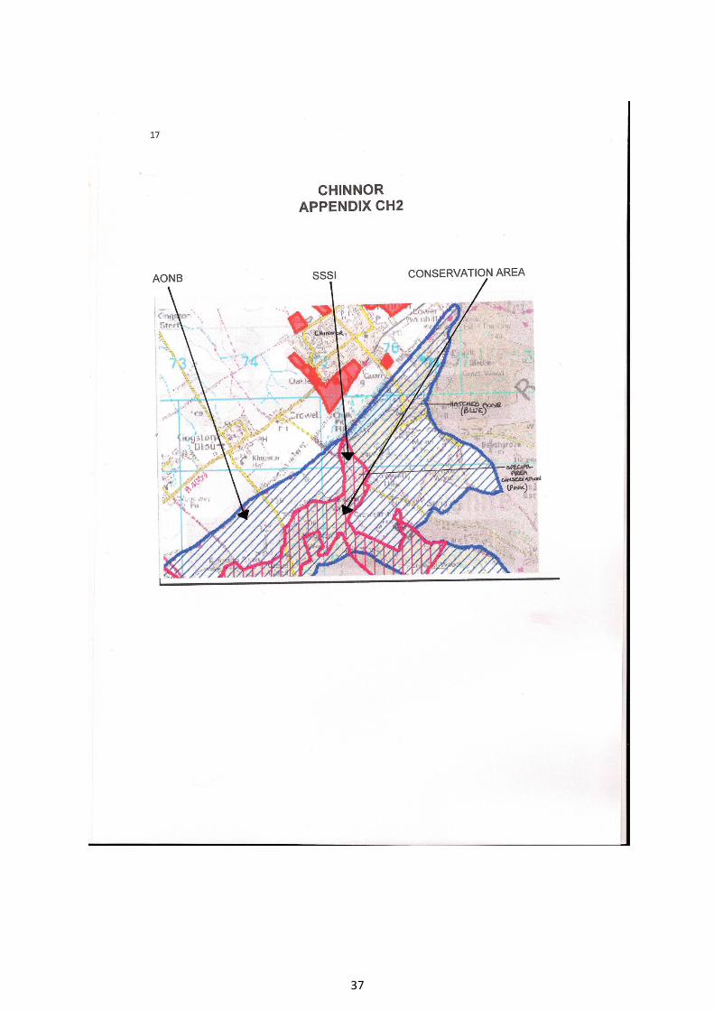
Chinnor All the sites submitted in Chinnor at Grade II Agricultural Land. CHI1 Crowell End Farm CHI3 Land to rear of Lower farm CHI5 Land to rear of Middle Turn CHI6 Land to rear of Middle Farm CHI11 Area north of Leyburne Gardens CHI12 Land at Lane Farm CHI13 Land north of Lower Icknield Way CHI15 Land at Lower Icknield Way CHI18 Land east of Wykeham Rise CHI19 Land off Golden Hills CHI20 Land adjacent to Chinnor cement works CHI21 Land adjacent to Chinnor cement works Chinnor has a flood zone area and areas of SSSI and AONB to be taken into consideration (Appendix CH2). For these reasons and additional factors as outlined below these sites should not be developed. CH1 10.1 hectares and has pylons on the site. It is also close to an area of AONB and an SSSI area (Appendix CH2). The site is also within a Mineral Consultation area. For these reasons the site is unsuitable. CH3 This site is multi ownership and there is no guarantee that this will become available. CHI5 , CHI6, CHI11, CHI12, CHI13, CHI15, CHI18 66 hectares. The landowners have not submitted the sites (Appendix G1) CH18 is within AONB, has a railway line, a bridleway and footpath on site. Not in single ownership. For these reasons the sites cannot be relied on may be unachievable and unsuitable. CHI 20, CHI 21, CHI19 8.9 hectares. In close proximity to AONB and area of SSSI (Appendix CH2) and CHI20 and CHI21 are within a mineral consultation zone. For these reasons the sites are unachievable and unsuitable.

22
Nettlebed All the sites are within AONB and are therefore not sustainable. None of the sites have been submitted by the landowners (Appendix G1). These factors mean that the sites are not suitable and may not be available.

23
Sonning Common SON5 Land at Kennylands Road SON6 Land to the South West of Kennylands Road SON8 The Dorian centre, Bird Court Road SON5 2.1 hectares, adjacent to AONB (reason for refusal for previous application). Electrical pylon on the site. SON6 2.1 hectares. It has not been submitted by the landowner (Appendix G1). SON8 0.8 hectares there is a lease in place that would need to be addressed and access arrangement would need to be resolved.

24
Watlington WAT3 Land West of Chiltern Farm WAT4 Land North of Hill Road WAT5 Land east of Shirburn Street, WAT9 Land to the west of Pyrton Lane Watlington has a flood zone area (Appendix WT1) and to the Eastern side AONB and an area of SSSI. These factors and the additional reasons outlined below make a number of the sites in Watlington unsuitable for development. WAT3 6 hectares. The site is partially covered by flood zone 2&3. The AONB borders the Eastern side of the site. WAT4 3.2 hectares. AONB borders the site on the Eastern side. It has not been submitted by the landowner (Appendix G1). WAT5 3.8 hectares. 0.25 hectares is within a conservation area. This site has not been submitted by the landowner (Appendix G1). WAT9 4.6 hectares. TPOs on the site and 20% of the site is in flood zone 3. Also in multi ownership with no guarantee it will become available - it is unsuitable.
25
Woodcote Woodcote is in AONB. All the sites are within AONB – this coupled with additional reasons outlined below deem the sites as unsuitable. W001 Chiltern Rise, Stable cottage and surrounding land WOO2 Woodcote Garden Centre WOO5 Land to north of Red Lane Bungalow WOO7 Land to north of Beech Lane WOO14 Land to south east of Nightingales WOO1 2 hectares. Legally protected mouse ear bats on the site. WOO2 0.5 hectares and a site of employment - development would be contrary to PE6. WOO5 4.9 hectares. On the Eastern Edge there are oil pipes. WOO7 and WOO14 3.8 hectares. The landowners have not submitted these sites (Appendix G1)

26
GORING Goring is in the AONB - all the sites are within the AONB. For this reason and additional factors outlined below these sites should not be developed. GOR2 Area between Icknield Way and B4009 GOR5 Land between Icknield Road and Elevendon Road GOR6 Land to rear of 98 – 108 Elvendon Road GOR7 Area to east of Fairfield Road GOR8 Area between playing field and Burntwood Hall GOR9 Area off Gatehampton Road GOR10 Area between Gatehampton Road and Railway GOR2, GOR5, GOR6, GOR7, GOR8, GOR9, GOR10 49.6 hectares. 29.5 hectares is Grade II Agricultural Land. Sites GOR4 and GOR5 have TPOs within the sites. None of the landowners have submitted these sites (Appendix G1)

27
APPENDIX G4
ENVIRONMENTAL AGENCY How has the likelihood of flooding been calculated and does it take account of climate change? The likelihood of flooding has been calculated using predicted water levels and taking the location, type and condition of any flood defences into account, whether or not they are currently shown on the Flood Map. NaFRA is an assessment of flood risk based on information last updated in 2008. It shows the likelihood and consequences of flooding that could happen now. It does consider climate changes that have already happened but it does not show how the risks will increase in the future due to climate change. However, we are planning to develop and use this method to determine how flood likelihood may change in the future with climate change. It is worth bearing in mind that the potential extent of an extreme flood shown on the Flood Map might in future become more 'normal' as a result of climate change.

28
THAMES APPENDIX H2

29
HENLEY-ON-THAMES APPENDIX H2

30
HENLEY-ON-THAMES APPENDIX H3
FROM GILLOTTS SCHOOL HEADTEACHER Date: Mon, 26 Sep 2011 19:44:52 We, unfortunately, have no idea when we might achieve the funds to rebuild the school. Given the current economic climate, it is almost impossible to believe that there will be any large scale school building projects in the lifetime of this parliament. It also seems unlikely to me that the economic recovery promised will come quickly. So building work on our site is likely to be in the medium to long term. The reason that the outline plan is for a whole new school, behind the current school, is that the building site would be completely self contained and this would also keep the building time to a minimum. I cannot see the planners allowing housing on the site unless a way is found to improve access on Gillotts Lane. As I said before, the housing could only be where the existing school footprint is now - it would not be built on our playing fields. Wherever housing is placed in Henley, there will be difficulties. The present position is just that the planners have identified our site as one where there might be potential for housing - investigations into the suitability are still ongoing. I hope this reassures you. Headteacher

31

32

33
HENLEY-ON-THAMES APPENDIX 8 - H8
PO7 E1555 Refusal of Planning Permission on 4th March 2008
Conditions / Refusal Reasons
That the loss of the employment land would be detrimental to the balance of employment and housing uses within the area,
undermining the objective of sustainable communities, contrary to Polices G1, E6 and D5 of the approved South Oxfordshire Local
Plan. Although some employment use will remain, the application does not demonstrate adequately that alternative employment or
different mixes of uses have been explored.
That, having regard to the excessive scale, mass, bulk and extent of built development (both the proposed housing and industrial
building), together with the lack of landscape framework, inadequate space for landscaping and amenity space, and the inappropriate
design details, the proposed development would be cramped, intrusive and out of character in relation to the surrounding area and
within the site. The proposal fails to reinforce local distinctiveness and will result in a cramped environment and an overdevelopment of
the site detrimental to the character and visual amenities of the area. The proposal is therefore contrary to South Oxfordshire Local Plan
Policies G2, G6, D1, D2, D3, D4, D5, H4, H8 and E5 and the South Oxfordshire Design Guide.
The site lies adjacent to the Henley Main Conservation Area and buildings which are included on the Statutory List of Buildings of
Special Architectural or Historic Interest and, having regard to the excessive scale bulk and massing of the residential buildings relative
to the size of the site, the development would detract from the character, appearance and setting of the Conservation Area and listed
buildings, contrary to Policies CON5 and CON7 of the adopted South Oxfordshire Local Plan.
That the development does not demonstrate and incorporate a high standard of sustainable design, either through its landscaping,
building design, use of materials, layout and orientation of buildings, contrary to policies G1, G2 and D8 of the adopted South
Oxfordshire Local Plan.
That the design does not incorporate a landscape structure or strategy that assists in defining the character and quality of design, or
provides opportunities for amenity, biodiversity, and the need to take account climate change, contrary to Policies G2, C6, D1 and D8 of
the adopted South Oxfordshire Local Plan.
That the development fails to make provision for affordable housing in accordance with Policy H9 of the adopted SOLP. Whilst some
affordable housing is proposed it fails to provide a 'pepperpotted' distribution of affordable housing throughout the site and a design that
makes the affordable housing indistinguishable from other housing. In any event, there is currently no agreement in place to secure
proper provision of such housing.
That the development fails to make provision for essential off site services and infrastructure contrary to Policies D11 and R2 of the
adopted South Oxfordshire Local Plan.
That the development fails to provide a strategy for a Sustainable Urban Drainage System contrary to Policy EP6 of the adopted South
Oxfordshire Local Plan.
That having regard to the location of the dwellings relative to the industrial building, in the absence of any information to the contrary,
the Council are not satisfied that the uses can be undertaken in manner which would not cause noise and disturbance to occupiers of
the dwellings, contrary to Policy EP2 and E5 of the adopted South Oxfordshire Local Plan.
That inadequate information accompanies the application to demonstrate that waste can be collected from the site contrary to Policy
D10 of the adopted South Oxfordshire Local Plan.
That, having regard to its height relative to existing surrounding development and to its location relative to the boundaries of the site, the
proposals would overlook and be oppressive to existing residential property, contrary to Policies G2, D4 and H4 of the adopted South
Oxfordshire Local Plan.
That insufficient information accompanies the application to demonstrate that the scale of the proposed usage of the private road is no
greater than at present. Any increase in usage, having regard to the requirements for rubbish collection and access for emergency
vehicles, and deficiencies in the parking layout and lack of adequate cycle parking, of an unsatisfactory access would be detrimental to
the safety and convenience of users of the access, contrary to policies T1 and T2 of the adopted South Oxfordshire Local Plan.
Appeal
Appeal Dismissed on 20 October 2008
Appeal Case Officer
Miss S Green
Telephone: (01491) 823740 (01491) 823740
Email:

34
BENSON

35
APPENDIX B1
36
BERINSFIELD APPENDIX BR1
37

38