south canoe wind power project 2012 - nova scotia · south canoe wind power project 2012 79 ......
TRANSCRIPT

SouthCanoeWindPowerProject 2012
79
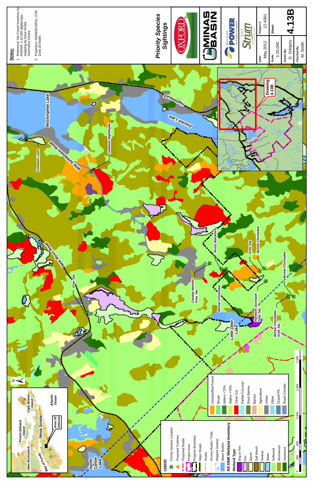
4.7.1.3 Discussion of Results Flight Path Corridors Based on observed sightings of migrant waterfowl in Falls Lake, Mockinghee Lake, Big Otter Lake, Long Bay and Card Lake, waterfowl migration appears to occur east of the Project Area, moving in a southward direction from Falls Lake to Card Lake (Drawing 4.12A). Breeding pairs and family groups of Common Loon were observed in Lewis Lake, South Canoe Lake, North Canoe Lake and Long Bay during the surveys, suggesting that family groups fly between these lakes (Drawing 4.12A). Local waterfowl movements for American Black Duck and Mallard (Anas platyrhynchos) were observed between South Canoe Lake and North Canoe Lake. Similar sized groups of American Black Duck were also observed on multiple occasions within Falls Lake and Mockinghee Lake. An important migratory corridor for passerines was noted along the Wile Settlement Road, outside of the Project Area, where mixed flocks of birds were observed on multiple occasions. A woods road located east of the Property Boundary is also used as a migratory corridor for passerine birds (Drawing 4.12B). Conditions in these two areas are favourable for migrating passerines as the bird species have a tendency to follow man-made structures such as roads and power line corridors. Nocturnal surveys revealed the general movement of night migrants is in a southwest direction. Although the routes of travel are not known, similar southern flight paths were noted for day migrating passerines Based on passage migration surveys conducted within the Property Boundary, the flight paths of birds of prey occur predominantly along ridges in a south/southeast direction. Osprey (Pandion haliaetus) and Bald Eagle exhibit local flight paths between Clearwater Lake and South Canoe Lake (Drawing 4.12B). Priority Species Sightings of priority species during the winter and fall bird surveys are shown in Drawings 4.13A – 4.13F. These drawings indicate the location of each species with respect to proximity to the Project Area and related infrastructure, as well as habitat cover. Boreal Chickadee, Gray Jay, Bobolink and Common Loon were identified within the Project Area, predominantly within softwood habitats. In addition to these species, the following species were identified in the vicinity of the Property Boundary: Peregrine Falcon, Rusty Blackbird, Eastern Bluebird, Northern Goshawk, Canada Warbler, Common Nighthawk and Bicknell’s Thrush. The majority of these species were sighted in softwood or mixed woodlands, with the exception of Peregrine Falcon and Northern Goshawk, which were sighted in a clear-cut.

# *
# *
# *
# * # * # * # *# *
# *
# *
# *
# * # *
# *
# *
# *
# *
# *
# * # *
# *
# *
# *
# *
# *
# *
# *# *
# * # *
# *
# *
# *
# *
# *
# *
# *
# *
# *
# *
# *
# *
# *
# *
# *
# *
# *
# *
# *
# *
Ch
eck
ed
By
:
M. S
mith
Dra
wn
By
:
G. G
rego
ry
Sh
eet
:
4.12
A
1:55
,000
Sc
ale
:
May
201
2D
ate
:P
roje
ct #
:
12-4
361
Co
mm
on
Lo
on
and
Wat
erfo
wl
Flig
ht
Pat
hs
No
tes
:
1. R
efer
ence
: Nov
a S
cotia
Pro
perty
R
ecor
ds.
1:10
,000
dig
ital t
opo
m
appi
ng b
y N
ova
Sco
tia
Geo
mat
ics
Cen
tre.
Nov
a S
cotia
D
epar
tmen
t of N
atur
al R
esro
uces
(
NS
DN
R) F
ores
t Inv
ento
ry.
2. P
roje
ctio
n: N
AD
83(C
SR
S),
UTM
Z
one
20 N
orth
.
Are
a O
fIn
tere
st
No
va S
co
tia
New
Bru
nsw
ick
Atl
anti
cO
cea
n
Pri
nc
e E
dw
ard
Isla
nd
Bay
of
Fun
dy
Cap
e B
reto
nIs
lan
d
Highway 14
Dam Bay
Lo
ng
Bay
Car
dL
ake
Bo
gL
ake
Joe
Lo
ng
Lak
e
Big
Ott
er
Lak
e
Mu
dL
ake
Lit
tle
Ott
er
Lak
e
So
uth
Can
oe
Lak
e
No
rth
Can
oe
Lak
e
New
Ros
s R
oad
Avon River
Highway 14
± 01,
250
2,50
03,
750
5,00
062
5M
etre
s
Lak
eL
ewis
Zwicker Lake
Leg
end
: Loca
l Wat
erfo
wl M
ovem
ents
Wat
erfo
wl M
igra
tion
Com
mon
Loo
n Fl
ight
path
s
# *P
ropo
sed
Turb
ines
Pro
pose
d R
oads
Pro
ject
Are
a
Pro
pery
Bou
ndar
y!
!!
!!
Cou
nty
Bou
ndar
y
XY
XY
XY
Maj
or R
oads
Roa
ds
Acc
ess
Roa
ds /
Trai
ls
Larg
e B
uild
ings
Map
ped
Stre
am
Inde
finat
e S
tream
Map
ped
Sw
amp
Wat
er B
odie
s
Mockingee Lake
Fal
ls L
ake
Wallaback Lake
Cle
arw
ate
rL
ake
Long Lake
Mu
dd
y L
ake
Co
on
eyL
ake
Armstrong Lake
Ha
nts
Co
un
ty
Ha
lifa
x C
ou
nty
Lu
ne
nb
urg
Co
un
ty
Ind
ian
Lak
e
Ro
un
dL
ake
Wh
ale
nL
ake
Ho
rses
ho
eL
ake

# *
# *
# *
# * # * # * # *# *
# *
# *
# *
# * # *
# *
# *
# *
# *
# *
# * # *
# *
# *
# *
# *
# *
# *
# *# *
# * # *
# *
# *
# *
# *
# *
# *
# *
# *
# *
# *
# *
# *
# *
# *
# *
# *
# *
# *
# *
# *
Ch
eck
ed
By
:
M. S
mith
Dra
wn
By
:
G. G
rego
ry
Sh
eet
:
4.12
B
1:55
,000
Sc
ale
:
May
201
2D
ate
:P
roje
ct #
:
12-4
361
Flo
ckin
g S
pec
ies
and
Bir
ds
of
Pre
yF
ligh
t P
ath
s
No
tes
:
1. R
efer
ence
: Nov
a S
cotia
Pro
perty
R
ecor
ds.
1:10
,000
dig
ital t
opo
m
appi
ng b
y N
ova
Sco
tia
Geo
mat
ics
Cen
tre.
Nov
a S
cotia
D
epar
tmen
t of N
atur
al R
esro
uces
(
NS
DN
R) F
ores
t Inv
ento
ry.
2. P
roje
ctio
n: N
AD
83(C
SR
S),
UTM
Z
one
20 N
orth
.
Are
a O
fIn
tere
st
No
va
Sc
oti
a
New
Bru
nsw
ick
Atl
anti
cO
cea
n
Pri
nc
e E
dw
ard
Isla
nd
Bay
of
Fun
dy
Cap
e B
reto
nIs
lan
d
Highway 14
Dam Bay
Lo
ng
Bay
Car
dL
ake
Bo
gL
ake
Joe
Lo
ng
Lak
e
Big
Ott
er
Lak
e
Mu
dL
ake
Lit
tle
Ott
er
Lak
e
So
uth
Can
oe
Lak
e
No
rth
Can
oe
Lak
e
New
Ros
s R
oad
Avon River
Highway 14
±
01,
250
2,50
03,
750
5,00
062
5M
etre
s
Zwicker Lake
Le
ge
nd
:
Floc
king
Spe
cies
Mig
ratio
n Fl
yway
Bird
s of
Pre
y Lo
cal F
light
Pat
hs
# *P
ropo
sed
Turb
ines
Pro
pose
d R
oads
Pro
ject
Are
a
Pro
pery
Bou
ndar
y!
!!
!
Cou
nty
Bou
ndar
y
XY
XY
Maj
or R
oads
Roa
ds
Acc
ess
Roa
ds /
Trai
ls
Larg
e B
uild
ings
Map
ped
Stre
am
Inde
finat
e S
tream
Map
ped
Sw
amp
Wat
er B
odie
s
Mockingee Lake
Fal
ls L
ake
Wh
ale
nL
ake
Ind
ian
Lak
e
Ro
un
dL
ake
Cle
arw
ate
rL
ake
Long Lake
Lak
eL
ewis
Co
on
eyL
ake
Armstrong Lake
Ha
nts
Co
un
ty
Ha
lifa
x C
ou
nty
Lu
ne
nb
urg
Co
un
ty

[_
[_ [_
[_
[_
[_
[_
[_
[_
[_[_ [_
[_
[_
[_
[_
[_[_
[_
[_
[_[_
[_
# *
# *
# *
# *
# * # * # *# *
# *
# *
# *
# * # *
# *
# *
# *
# *
# *
# *
# *
# *
# *
# *
# *
# * # *
Ch
eck
ed
By
:
M. S
mith
Dra
wn
By
:
G. G
rego
ry
Sh
eet
:
4.13
A
1:20
,000
Sc
ale
:
May
201
2D
ate
:P
roje
ct #
:
12-4
361
Pri
ori
ty S
pec
ies
Sig
hti
ng
s
050
01,
000
1,50
02,
000
250
Met
res
±
Are
a O
fIn
tere
st
No
va
Sc
oti
a
New
Bru
nsw
ick
Atl
anti
cO
cea
n
Pri
nc
e E
dw
ard
Isla
nd
Bay
of
Fun
dy
Cap
e B
reto
nIs
lan
d
No
tes
:
1. R
efer
ence
: NS
For
est I
nven
tory
by
N
SD
NR
. 1:1
0,00
0 di
gita
l top
o
map
ping
by
Nov
a S
cotia
G
eom
atic
s C
entre
.
2. P
roje
ctio
n: N
AD
83(C
SR
S),
UTM
Z
one
20 N
orth
.
XYXY
XY
XY
XY
XY
XY
XYXYXY
XY
XY
XY
XYXY
XY
XY
XY
XY
XY
XYXYXY
XY
XY
XY
XY
XY
XYXY
XY
XY
XYXYXY
XY
XY
XY
XY
XY
XY
XY
XY
XY
XY
XYXY
XY
XY
XY
XY
XY
XY
XY
XY
XY
XYXY
XY
XY
XY
XYXY
XY
XY
XY
XY
XYXY
XY
XY
XY
XY
XY
XY
XY
XY
XY
XY
XY
Per
egri
ne
Fal
co
nR
ust
y B
lack
bir
dE
aste
rn B
lueb
ird
Co
mm
on
Lo
on
Gra
y J
ay
Bo
real
Ch
icka
de
e
Gra
y J
ay
Gra
y J
ayB
ore
al C
hic
kad
ee
Bo
real
Ch
icka
de
eB
ob
olin
k
Bo
real
Ch
icka
de
eC
om
mo
n L
oo
n
Bo
real
Ch
icka
de
e
Bo
real
Ch
icka
de
e
Bo
real
Ch
icka
de
eC
om
mo
n L
oo
nG
ray
Jay
Co
mm
on
Lo
on
Co
mm
on
Lo
on
Ru
sty
Bla
ckb
ird
Co
mm
on
Lo
on
Co
mm
on
Lo
on
Lak
eL
ewis
So
uth
C
ano
e L
ake
Co
on
ey
L
ake
New
Ro
ss
Ro
ad
Unc
lass
ified
For
est
Brus
h
Alde
rs <
75%
Alde
rs >
75%
Cle
ar C
ut
Parti
al C
ut-o
ver
Roc
k B
arre
n
Barre
n
Agric
ultu
re
Urb
an
Oth
er
Gra
vel P
it
Roa
d C
orrid
or
Dra
win
g4.
13A
Leg
end
:
[_P
riorit
y S
peci
es L
ocat
ion
# *P
ropo
sed
Turb
ines
Pro
pose
d R
oads
Pro
ject
Are
a
Pro
perty
Bou
ndar
y
XY
XY
XY
Maj
or R
oads
Roa
ds
Acc
ess
Roa
ds /
Trai
ls
Map
ped
Sw
amp
Wat
er B
odie
s
NS
DN
R W
etla
nd
Inve
nto
ry
Wet
lan
d T
ype
Bog
or F
en
Fen
Mar
sh
Sal
t Mar
sh
Sw
amp
Wat
er
Sof
twoo
d
Mix
edw
ood
Har
dwoo
d
[_ [_
[_ [_
[_
[_
[_[_
[_
[_[_
[_
[_
[_
# *
# *
# *
# *
# *
# *
# *
Ch
eck
ed
By
:
M. S
mith
Dra
wn
By
:
G. G
rego
ry
Sh
eet
:
4.13
B
1:20
,000
Sc
ale
:
May
201
2D
ate
:P
roje
ct #
:
12-4
361
Pri
ori
ty S
pec
ies
Sig
hti
ng
s
±
Are
a O
fIn
tere
st
No
va
Sc
oti
a
New
Bru
nsw
ick
Atl
anti
cO
cea
n
Pri
nc
e E
dw
ard
Isla
nd
Bay
of
Fun
dy
Cap
e B
reto
nIs
lan
d
No
tes
:
1. R
efer
ence
: NS
For
est I
nven
tory
by
N
SD
NR
. 1:1
0,00
0 di
gita
l top
o
map
ping
by
Nov
a S
cotia
G
eom
atic
s C
entre
.
2. P
roje
ctio
n: N
AD
83(C
SR
S),
UTM
Z
one
20 N
orth
.
XYXY
XY
XY
XY
XY
XY
XY
XY
XYXYXY
XY
XY
XY
XYXY
XY
XY
XY
XY
XY
XYXYXY
XY
XY
XY
XY
XY
XY
XY
XY
XYXY
XY
XY
XYXYXY
XY
XY
XY
XY
XY
XY
XY
XY
XYXY
XY
XY
XY
XY
XY
XY
XY
XY
XY
XY
XY
XYXY
XY
XY
XY
XYXY
XY
XY
XY
XY
XY
XYXY
XY
XY
XY
XY
XY
XY
XY
XY
XY
XY
XY
Gra
y J
ay
No
rth
ern
Go
sh
aw
kG
ray
Jay
Gra
y J
ay
Can
ada
War
ble
rG
ray
Jay
Co
mm
on
Nig
hth
awk
Co
mm
on
Lo
on
No
rth
C
ano
eL
ake
New
Ros
s R
oad
Ru
sty
Bla
ckb
ird
Bo
real
Ch
icka
de
e
Bo
real
Ch
icka
de
e
Bo
real
Ch
icka
de
eG
ray
Jay
Bo
real
Ch
icka
de
e
Wile
Set
tlem
ent R
oad
Mo
ck
ing
he
e L
ak
e
Zwicker Lake
Highway 14
Lit
tle
Ott
er
Lak
e
Dra
win
g4.
13
B
050
01,
000
1,50
02,
000
250
Met
res
Unc
lass
ified
For
est
Brus
h
Alde
rs <
75%
Alde
rs >
75%
Cle
ar C
ut
Parti
al C
ut-o
ver
Roc
k B
arre
n
Barre
n
Agric
ultu
re
Urb
an
Oth
er
Gra
vel P
it
Roa
d C
orrid
or
Leg
end
:
# *P
ropo
sed
Turb
ines
Pro
pose
d R
oads
Pro
ject
Are
a
Pro
perty
Bou
ndar
y
XY
XY
XY
Maj
or R
oads
Roa
ds
Acc
ess
Roa
ds /
Trai
ls
Map
ped
Sw
amp
Wat
er B
odie
s
NS
DN
R W
etla
nd
In
ven
tory
Wet
lan
d T
ype
Bog
or F
en
Fen
Mar
sh
Sal
t Mar
sh
Sw
amp
Wat
er
Sof
twoo
d
Mix
edw
ood
Har
dwoo
d
[_P
riorit
y S
peci
es L
ocat
ion