south america
DESCRIPTION
Transboundary aquifers inventoryTRANSCRIPT

Sou
th A
mer
ica
135
SOUTH AMERICA: Aquifers details
Darien National Park, Panama© UNESCO/Kudo Fubomichi
Colombia-Panama
■ Humid climate.
■ Mean annual rainfall: 3,500 mm.
■ Rainforest area with low impact ofhuman activities (fishery, subsistenceagriculture).
Choco-Darién1S

2S Táchira-Pamplonita
Canaima National Park, Venezuela© UNESCO
Colombia-Venezuela
■ Extent: ~ 80 km2.
■ Mean annual rainfall: 740 mm.
■ Two superposed aquifers aged between Cretaceous and Quaternaryperiod.
■ Dynamic region between the two countries.
■ Exploitation without sustainabilitystrategy.
Reg
ion
al a
nd
loca
l inv
ento
ries
136

Sou
th A
mer
ica
137
3S La Guajira
Colombia -Venezuela
■ Coastal plain, elevations from 0 to 20 m.a.s.l., arid climate, mean temperatureabove 28° C.
■ Annual rainfall below 500 mm.
■ Aquifer system including shallow and deep aquifers.
■ Non confined, intensively used aquifer.
■ Salinization problems.
Los Tiatos National Park, Colombia © UNESCO/J.C. Segura

Reg
ion
al a
nd
loca
l inv
ento
ries
138
4S Grupo Roraima
Brazil-Guyana-Venezuela
■ Extent: ~ 70,000 km2.
■ Altitude higher than 1,000 m.
■ Mean annual rainfall: 1,200–2,400 mm.
■ Tropical rainy climate.
■ Larger part of aquifer system in Brazil.
Guyana Jungle, Amazonia.© SXC
Sou
th A
mer
ica
139
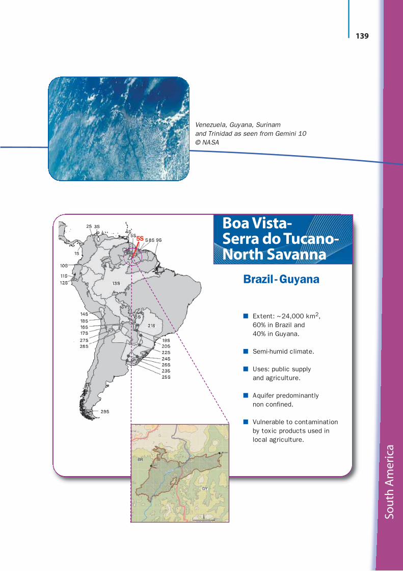
5S
Boa Vista-Serra do Tucano-North Savanna
Brazil - Guyana
■ Extent: ~24,000 km2, 60% in Brazil and 40% in Guyana.
■ Semi-humid climate.
■ Uses: public supply and agriculture.
■ Aquifer predominantly non confined.
■ Vulnerable to contaminationby toxic products used inlocal agriculture.
Venezuela, Guyana, Surinam and Trinidad as seen from Gemini 10© NASA

Reg
ion
al a
nd
loca
l inv
ento
ries
140
6S 7S 8SZanderijCoesewijneA-Sand/B-Sand
Suriname -Guyana■ The three aquifers are
mainly located along the coastal strip of both countries. Total extent:~200,000 km2.
■ Tropical climate, meanannual rainfall: 2,000 mm.
■ Main uses: domestic andpublic supply, main sourceof drinking water.
■ Hydrogeology of the threeaquifers is well known. A-Sand aquifer has suppliedwater to Paramaribo formore than 50 years. Hydro-geological investigationswith international supportcontinue in both countries.

Sou
th A
mer
ica
141
9S
Costeiro
Brazil-French Guyana
■ Extent: ~27.000 km2, with 2/3 inBrazil and 1/3 in French Guyana.
■ Aquifer predominantly non confined.
■ Equatorial humid climate; meanannual rainfall: 2,500 mm.
■ Mean temperature: 25–27° C.
River at Maués, Amazonia, Brazil© UNESCO/Luis Alberto
Reg
ion
al a
nd
loca
l inv
ento
ries
142
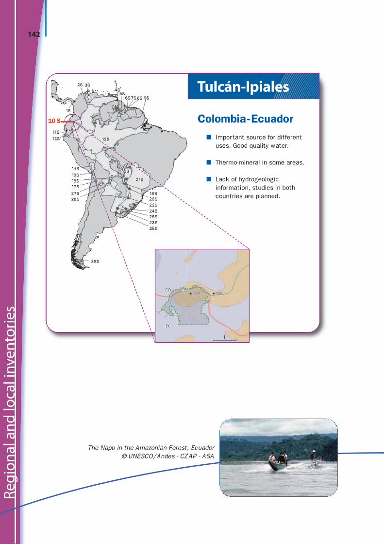
10 S
Tulcán-Ipiales
Colombia-Ecuador■ Important source for different
uses. Good quality water.
■ Thermo-mineral in some areas.
■ Lack of hydrogeologic information, studies in both countries are planned.
The Napo in the Amazonian Forest, Ecuador© UNESCO/Andes - CZAP - ASA
Sou
th A
mer
ica
143
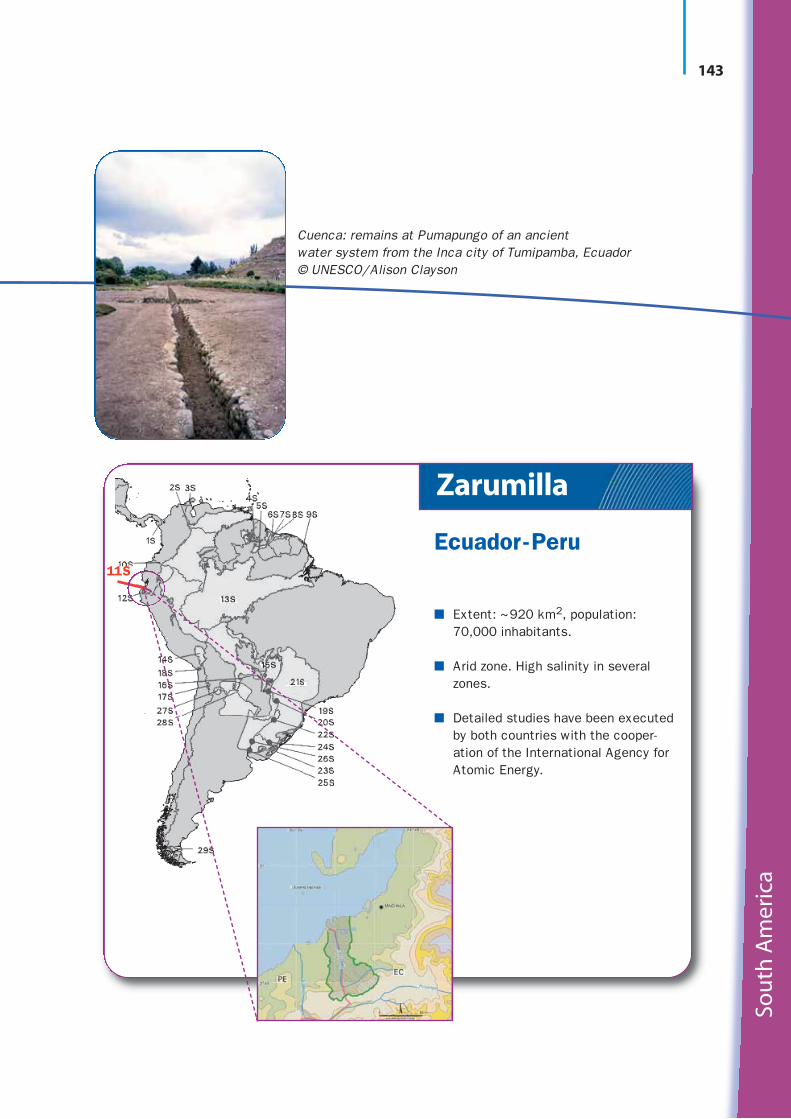
11S
Zarumilla
Ecuador-Peru
■ Extent: ~920 km2, population:70,000 inhabitants.
■ Arid zone. High salinity in severalzones.
■ Detailed studies have been executed by both countries with the cooper -ation of the International Agency for Atomic Energy.
Cuenca: remains at Pumapungo of an ancient water system from the Inca city of Tumipamba, Ecuador© UNESCO/Alison Clayson

Reg
ion
al a
nd
loca
l inv
ento
ries
144
12 S
Puyango-Tumbes-Catamayo- Chira
Ecuador-Peru■ Main local activities: agriculture
and stockbreeding.
■ Lack of information on its hydro-geology.
■ Groundwater could be used because current water supply is not sufficient.
■ Peru is currently executing detailed studies in Tumbes Valley.In other valleys both countriesare planning geologic and hydro-geologic studies.
Ancient water management technology,Machu Picchu, Peru
© UNESCO/Karen Stoltz

Sou
th A
mer
ica
145
Amazonas
Bolivia -Brazil - Colombia-Ecuador,Peru-Venezuela
■ Extent: ~3,950,000 km2
■ Climate: Humid, up to 3 dry months,mean temperature above 18º C.
■ Good yield and good water quality.
■ Lack of studies because most of the aquifer is located in zones with few inhabitants and whereaccess is difficult.
■ Important for several communitiesliving beside rivers because theaquifer is the only alternative to con-taminated surface waters.
13S
Amazonia, Brazil© SXC

Reg
ion
al a
nd
loca
l inv
ento
ries
146
14 S
Fishermen and reed boats on Lake Titicaca, Bolivia
© UNESCO/P. Kruithof
Titicaca
Bolivia-Peru■ Located above 4,000 m.a.s.l.,
located in a fragile ecosystem.
■ Extent: 120,000 km2.
■ Geology: Quaternary sediments.
■ Aquifers confined and non confined.
■ Cold and dry climate.
■ Scattered population: ~1,000,000 inhabitants.
■ Used for drinking water supply, livestock breeding and agriculture.

Sou
th A
mer
ica
147
Pantanal
Bolivia-Brazil -Paraguay
■ Extent: above 130,000 km2, 80% located in Brazil, on the Pantanal Plain.
■ Multilayered system, phreatic, composed of tertio-quaternary sediments, consolidated and nonconsolidated, predominantly sandy.
■ Mean rainfall: 1,000–1,500 mm.
■ Highly vulnerable to contamination.
■ The three countries have recognizedthe important role of the aquifer forthe ecosystem of the Pantanal wet-land.
■ A GEF/UNEP/OAS/UNESCO pilotproject will focus on the protectionof the aquifer and its dependent ecosystem.
15S
Pantanal salt bay, Brazil© SXC

Reg
ion
al a
nd
loca
l inv
ento
ries
148
16 S
Agriculture on the Chaco Plain, Paraguay© NASA
Agua Dulce
Bolivia-Paraguay■ Located in the Chaco plain,
extent: ~30,000 km2.
■ Aquifer system with Carboniferousand Cretaceous aquifers. Mineralizedand thermal Paleozoic confined units.
■ Humid tropical climate.
■ Mean annual rainfall: 1,450 mm.
■ Scattered population.

Sou
th A
mer
ica
149
Ollagüe-Pastos Grandes
Bolivia-Chile
■ Located in the Cordillera Occidentalde los Andes.
■ Extent: ~4,350 km2.
■ High mountain arid and cold climate.
■ Aquifers non confined to confined,tertiary fractured rocks and quater-nary sediments.
■ Scattered population.
■ Located in a fragile ecosystem.
17S
Landscape of a lagunebetween Chile and Bolivia© SXC

Reg
ion
al a
nd
loca
l inv
ento
ries
150
18 S
Fauna in Chilean countryside© UNESCO/Thierry Jolly
Concordia /Escritos-Caplina
Chile-Peru■ Arid and dry zone.
■ Hydrogeological informa-tion available.
■ Intensive use from bothcountries due to shortageof surface water.
■ On the Peruvian side, overexploitation is causing contamination(marine intrusion andmineralization).
■ Peru carried out detailedstudies of the CaplinaAquifer.

Sou
th A
mer
ica
151
Aquidauana-Aquidabán
Brazil -Paraguay
■ Extent: 27,000 km2.
■ Rainfall: 1,000–1,500 mm/year,mostly in summer.
■ Semi-confined aquifer.
■ Lack of hydrogeologic informationbut important for development of agriculture and stockbreeding in the region.
■ Uses: human and livestock supply.
19S
Matogrosso, Brazil© Morguefile
Reg
ion
al a
nd
loca
l inv
ento
ries
152
Uyuni, Bolivia© SXC
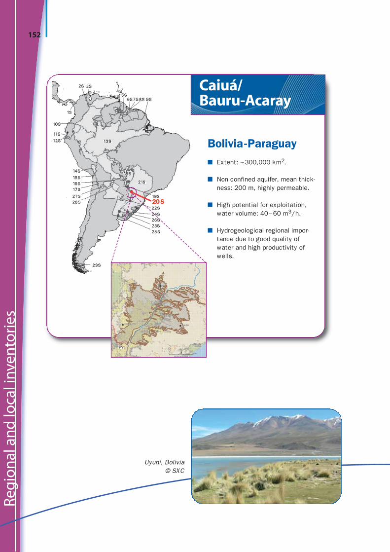
Caiuá/Bauru-Acaray
Bolivia-Paraguay■ Extent: ~300,000 km2.
■ Non confined aquifer, mean thick-ness: 200 m, highly permeable.
■ High potential for exploitation,water volume: 40–60 m3/h.
■ Hydrogeological regional impor-tance due to good quality ofwater and high productivity ofwells.
20S
Sou
th A
mer
ica
153
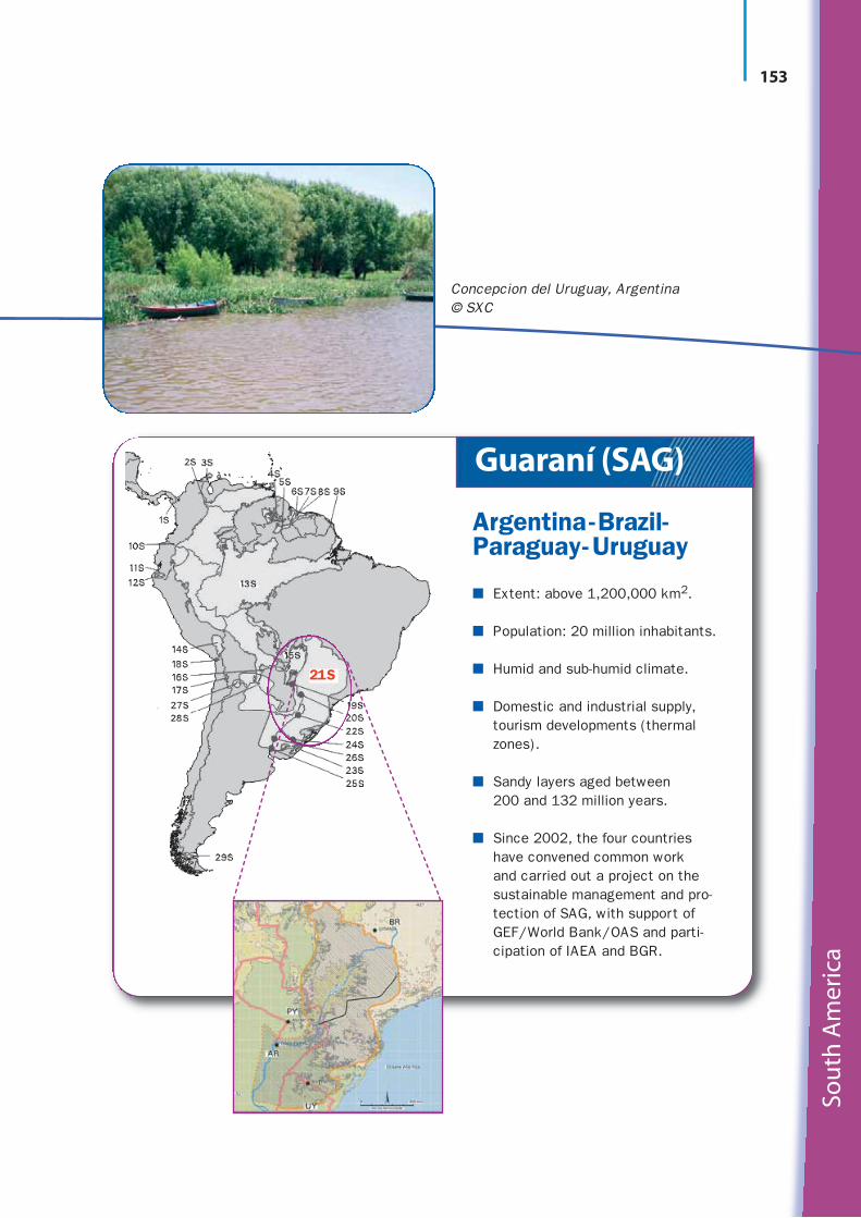
Guaraní (SAG)
Argentina-Brazil-Paraguay-Uruguay
■ Extent: above 1,200,000 km2.
■ Population: 20 million inhabitants.
■ Humid and sub-humid climate.
■ Domestic and industrial supply,tourism developments (thermalzones).
■ Sandy layers aged between 200 and 132 million years.
■ Since 2002, the four countrieshave convened common work and carried out a project on thesustainable management and pro-tection of SAG, with support ofGEF/World Bank/OAS and par ti-cipation of IAEA and BGR.
21S
Concepcion del Uruguay, Argentina© SXC

Reg
ion
al a
nd
loca
l inv
ento
ries
154
22 S
Parana River, Argentina© SXC
Serra Geral
Argentina-Brazil -Paraguay-Uruguay
■ Extent: 540,000 km2; covers, with its volcanic rocks, part ofthe Guarani aquifer system.
■ Located in the Rio de la PlataBasin.
■ Main uses: domestic, industry, irrigation.
■ Largely explored, but rechargemechanism unknown.
■ Intensively used across theregion.
■ Intensively exploited via deepwells (depth varying 80–100 m).

Sou
th A
mer
ica
155
Litoráneo-Chuy
Brazil - Uruguay
■ Extent: ~41,000 km2, 80% in Brazil.
■ Temperate humid climate.
■ Shallow, non confined, porous, inter-granular, non consolidated.
■ Important source of supply for localpopulation.
■ Includes a series of lakes importantto the ecosystem balance.
23S
Laguna Negra, Rocha, Uruguay© UNESCO/Cornelia Holdereger

Reg
ion
al a
nd
loca
l inv
ento
ries
156
24 S
Near Uruguay-Brazil border© SXC
Permo-Carbonífero
Brazil -Uruguay■ Extent: 41,000 km2.
■ Located in the hydrographicbasin of the Uruguay River.
■ Intergranular, porous, non con -solidated and consolidated.
■ Could be important for domestic supply on both sides of the border.

Sou
th A
mer
ica
157
Litoral Cretácico
Argentina-Uruguay
■ Plain region, mean annualrainfall: 1,200 mm.
■ Extent: 40,000 km2, 60% in Uruguay.
■ Population: 500,000 inhab i-tants.
■ Main uses: domestic, stock-breeding, irrigation.
■ Importance of this resource: growing demand related to economic development.
25S
Uruguay River, from the Argentine Bank© SXC

Reg
ion
al a
nd
loca
l inv
ento
ries
158
26 S
Arapey River, Uruguay
Salto-Salto Chico
Argentina-Uruguay■ Extent: 32,000 km2.
■ Humid climate; mean annualrainfall: 1,200 mm.
■ Population: 500,000 inhabi-tants.
■ Growing demand in particularfor rice irrigation inArgentina and citrus irriga-tion in Uruguay.
■ Good quality water.

Sou
th A
mer
ica
159
Puneños
Argentina-Bolivia
■ Extent: 16,000 km2, located at a high altitude (3,000–4,500 m.a.s.l.) in Andean altiplano.
■ Rainfall: below 100 mm/year.
■ Vital source of supply for severalcommunities in one of the mostarid zones of the world.
27S
Llamas in Bolivia© SXC

Reg
ion
al a
nd
loca
l inv
ento
ries
160
28 S
Cordoba, Argentina© SXC
Yrendá-Toba –Tarijeño
Argentina -Bolivia-Paraguay■ Extent: 600,000 to
1,000,000 km2.
■ Multi-layered system.
■ Semi-arid climate; popu-lation: 400,000 inhabitants.
■ GEF/UNEP/OAS/UNESCOpilot project to be developedin the framework of the Programa Marco de laCuenca del Plata focusing onintegrated water resourcesmana gement, leading toadaptation to climatechanges and avoidance ofdesertification.

Sou
th A
mer
ica
161
El Cóndor-Cañadóndel Cóndor
Argentina-Chile
■ Extent: ~5,500 km2, located at southern end of South America.
■ Two aquifers included in the systemare fed by glaciers.
■ Oil industry and local communitiesuse for stockbreeding and domesticuse.
■ More detailed studies needed.
29S
Dalcahue Town, Chiloé Big Island, Chile© UNESCO/Gilles Cavaletto

Reg
ion
al a
nd
loca
l inv
ento
ries
162
Out of nine possible transboundary aquifers case studies proposed by the countries dur-ing the Montevideo Workshop (2003), three initially started and three more were addedin the 2006 workshop in San Salvador:
1. Yrenda-Toba-Tarijeño aquifer (Paraguay-Argentina-Bolivia), representativefor semi-arid areas of South America,
2. Artibonito and Massacre aquifers (Haiti -Dominican Republic), representative for intra-mountainous and coastal zones,
3. Pantanal aquifer (Bolivia-Brazil -Paraguay), representative for wetlands,
4. Hueco del Bolsón (Mexico-USA), representative for urban zones,
5. Ostua-Metapan aquifer (El Salvador-Guatemala),
6. Estero Real-Rio Negro aquifer (Honduras-Nicaragua),
7. Zarumilla Aquifer (Peru-Ecuador).
In addition to these pilot studies, a project was added since 2003: ‘Protection of the envi-ronment and sustainable development of the Guaraní Aquifer’, co-financed by the GEF(Global Environment Facility). The project concerns the large Guaraní aquifer, which isshared by Argentina, Brazil, Paraguay and Uruguay.
AMERICASCase studies

Sou
th A
mer
ica
163
Yrenda-Toba-Tarijeño Aquifer (Paraguay-Argentina-Bolivia)
The Yrenda-Toba-Tarijeño aquifer system occu-pies about 250,000 km2, located mostly in theGran Chaco Americano region. Its recharge zone,located in Argentina and Bolivia, determines
groundwater flow towards the east andcrosses national boundaries, emerging in low-lying lands and draining into aseries of streams that discharge into theParaguayan-Argentine Chaco and even-tually into the Parana River in Paraguay.
The livelihood of the 1 million indigenouspeople in the region is closely linked tothe aquifer’s surface area. Increasingpressure on scarce water resources, poorland quality and soil degradation is caus-ing alarm. The natural water quality tran-sition (fresh in Bolivia, to brackish and
saline in Paraguay and Argentina) may bechanging. There are many pressures on the land in the region, which have arisen from theexpansion of poorly planned mechanized agriculture, which has in turn led to land degra-dation, the decline of wetlands and the deterioration of water quality.

164
Increased rain intensity from anticipated climatechange could trigger erosion, and resedimenta-tion in recharge zones could inhibit aquifer infil-tration from stream beds. Due to poor awarenessand divergent regulations, current aquifer man-agement by institutions in the sharing countriesis inadequate. Therefore, coordination for thelong-term management and protection of therecharge zones, as well as the discharge zones,is lacking.
The case study’s activitiesfocus on raising awarenessof the aquifer system, aswell as ensuring the sustain-ability of its resources, the
lifeline of the local population and the aquifer-dependent environment. The projectwill help further develop engaged and strengthened institutions that practise soundaquifer management and offer educational and technical support to the com munity.
HIGHLIGHTS
■ The Case Study commenced under the ISARMProgramme has several objectives – it will beconducted in close coordination with the PlataBasin Agency and will coordinate with the GEFfunded Programme.
■ The activities will include a diagnosis of the keyissues for the improved management of theaquifer system, and its role in support of humanneeds and in providing continued environmentalsustainability.
■ The outcome of the Case Study will include toolsto strengthen the institutions concerned withgroundwater management, provide training andeducate the community. The end outcome shouldbe an integrated water management programme.
At present there is limited management of the aquifers by the sharing countries
because of differing water laws and regulations. Many of the decisions on the use of the waterin the aquifers are taken at municipality level
and thus there is limited coordination in the long termmanagement and protection of the recharge zones
as well as the recharge zones.
165
Sou
th A
mer
ica
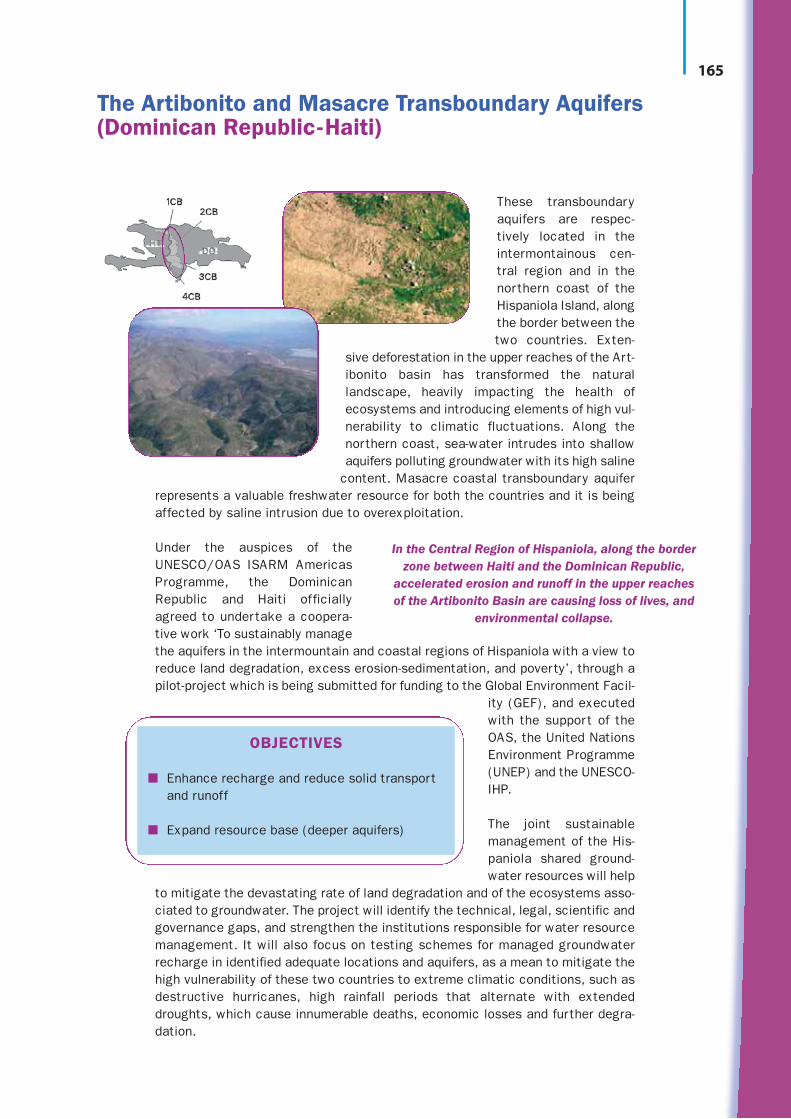
These transboundaryaquifers are respec-tively located in theintermontainous cen-tral region and in thenorthern coast of theHispaniola Island, alongthe border between thetwo countries. Exten-
sive deforestation in the upper reaches of the Art-ibonito basin has transformed the naturallandscape, heavily impacting the health ofecosystems and introducing elements of high vul-nerability to climatic fluctuations. Along thenorthern coast, sea-water intrudes into shallowaquifers polluting groundwater with its high saline
content. Masacre coastal transboundary aquiferrepresents a valuable freshwater resource for both the countries and it is beingaffected by saline intrusion due to overexploitation.
Under the auspices of theUNESCO/OAS ISARM AmericasProgramme, the DominicanRepublic and Haiti officiallyagreed to undertake a coopera-tive work ‘To sustainably managethe aquifers in the intermountain and coastal regions of Hispaniola with a view toreduce land degradation, excess erosion-sedimentation, and poverty’, through apilot-project which is being submitted for funding to the Global Environment Facil-
ity (GEF), and executedwith the support of theOAS, the United NationsEnvironment Programme(UNEP) and the UNESCO-IHP.
The joint sustainablemanagement of the His-paniola shared ground-water resources will help
to mitigate the devastating rate of land degradation and of the ecosystems asso-ciated to groundwater. The project will identify the technical, legal, scientific andgovernance gaps, and strengthen the institutions responsible for water resourcemanagement. It will also focus on testing schemes for managed groundwaterrecharge in identified adequate locations and aquifers, as a mean to mitigate thehigh vulnerability of these two countries to extreme climatic conditions, such asdestructive hurricanes, high rainfall periods that alternate with extendeddroughts, which cause innumerable deaths, economic losses and further degra-dation.
The Artibonito and Masacre Transboundary Aquifers(Dominican Republic-Haiti)
OBJECTIVES
■ Enhance recharge and reduce solid transportand runoff
■ Expand resource base (deeper aquifers)
In the Central Region of Hispaniola, along the borderzone between Haiti and the Dominican Republic,
accelerated erosion and runoff in the upper reachesof the Artibonito Basin are causing loss of lives, and
environmental collapse.

166
Reg
ion
al a
nd
loca
l inv
ento
ries
The Upper Paraguay River Basin is part of the Paraguay RiverBasin. It covers an area of approximately 600,000 km2 andconcerns the borders of Bolivia, Brazil and Paraguay. It hasa high importance in the strategic context of hydrologicalresources administration because it includes the Pantanalarea, one of the largest wetland areas on the planet
(147,574 km2), declared Brazilian Natural HeritageArea and designed Ramsar protected Area and Bios-phere Reserve.
The importance of the Pantanal Transboundary AquiferSystem lies on its role in the preservation of Pantanalwetland ecosystem, the natural regulation of rainfallpattern and the supply of local communities and indige-nous populatons.
The three riparian countries havejointly identifed the need for a sus-tainable management of the trans-boundary aquifer system, based on theunderstanding of hydraulic interac-tions between wetland and aquifer,and on the recognition of dependenceof wetland as an ecosystem depend-ent on groundwater.
The ‘Integrated watershed Management Practices for the Pantanal and Upper Paraguay RiverBasin Project’ was developed from 1998 to 2006 with resources from the GEF and the partic-ipation, among others, of UNEP, OAS and ANA (National Water Agency of Brazil). Next phaseof the Project consists in the execution of the Strategic Action Plan.
Pantanal Aquifer: the Pantanal/Upper Paraguay Project (Bolivia-Brazil-Paraguay)
Groundwater of the Pantanal Aquifer interacts with surface water creating the conditions for theexistence and survival of the Pantanal Wetland. Its high vulnerability to contamination, excess siltation and over-exploitation had led to jointactions by the countries sharing the aquifer.
PROJECT COMPONENTS AND RESULTS
I. Water Quality and Environment Protection: Sound Scientific and TechnicalBasis for the basin management
II. Conservation of the Pantanal: Preserving the natural habitat through Con-servation Units and Sustainable Tourism
III. Land Degradation: Rehabilitating Critical Areas
IV. Stakeholder Involvement and Sustainable Development: Including People, Municipalities, and the Private Sector in Developing Solutions
V. Organizational Structure: Improving Institutional and Staffing Capabilities for Integrated Water Management
VI. Strategic Action Program for the Integrated Management of the Upper Paraguay River Basin

167
Sou
th A
mer
ica
The Bolsón del Hueco-Valle de Juárez TransboundaryAquifer System is shared by Mexico (State of Chihuahua)and the USA (State of Texas). It is located in an aridregion with annual rain fall less than 200 mm/a and apotential evaporation over 2,000 mm/a.
The aquifer consists of alluvial and basin deposits, several hundred meters thick in Mexico and over1,000 m in the territory of the USA. Its horizontal extentis about 8,000 km2, with 80% of it in the USA. It isunconfined, with medium to low permeability and highstorage capacity . At shallow depths it contains freshwater (TDS <1,000 ppm), particularly in the riverine belt
of the Rio Bravo/Grande. At intermediate depths and in its lower part it containsbrackish and saline groundwater, respectively.
The aquifer system is of great importance, since it is located in an arid regionwith high water demands. In Mexico it is the primary source of water supply toCiudad Suarez and the Valle de Juárez irrigation district, with the Río Bravo/Grande as a supplementary source. The latter river is in the USA the main sourceof water supply to El Paso city and the Bolsón del Hueco irrigation zone, while theaquifer serves as a complementary source. The population of the zone covered bythis aquifer system was almost 2 million in 2005, but it is growing rapidly andexpected to rise to 3.5 million by 2010.
Groundwater abstraction is presently around 310 million m3/a, most of which isabstracted in the USA. The high concentration of wells in the neighbouring urbanzones of Ciudad Juárez and El Paso has caused considerable decline of the ground-water levels in the southwestern portion of the Bolsón. There, groundwater levels have declined several tens of metres during the last 30 years. There are alsonumerous wells in the irrigation district of the Valle de Juárez, where a large volume of groundwater is pumped for agricultural purposes.
The decline of groundwater levels not only depletes groundwater storage, but alsoinduces a gradual migration of saline or brackish water into the shallower freshportions of the aquifer, resulting in a gradual deterioration of groundwater quality.In Mexico, the urban population growth concentrated in Ciudad Juárez hasprompted a gradual transfer of water from agriculture to the urban sector. In theUSA, groundwater pumping from Bolsón del Hueco aquifer peaked in 1989, but ten years earlier it was already concluded that groundwater abstraction at thatrate was not sustainable. Increased conservation efforts and doubling the city’sannual amount of treated surface water reduced groundwater pumping rates tohalf by 2002. In the new treatment-recharge-reuse system, municipal wastewaterof the city of El Paso is taken to a tertiary level treatment plant; subsequently itreceives a natural treatment underground after passing through injection wells,and then it is recovered at some distance in down-flow direction to serve againthe city.
Hueco del Bolsón Aquifer(Mexico-USA)

Reg
ion
al a
nd
loca
l inv
ento
ries
168
Given the importance of this aquifer and the observed sustainability problems,information exchange between the two countries is taking place already sincethe 1960s, through the International Border Water Commission (Comisión Inter-nacional de Límites y Aguas). Cooperation between water related institutions inUSA and Mexico has resulted at the end of the 1990s in a binational report on theshared groundwater resources of this aquifer system. In the same context, ground-water flow models were developed for better understanding of the aquifer and toserve institutions at both sides of the boundary in their endeavours to managegroundwater properly.
At both sides of the international border, projects for formulating an integratedwater resources management plan are underway. One of the current concerns ishow to ensure compatibility between these plans.
In the context of ISARM Americas, this case study was chosen as an example ofhighly urbanised areas.
Views and cooperation between USA and Mexicoin relation to the Hueco del Bolsón-Valle de Juárez
transboundary aquifer system■ Groundwater of this aquifer system is of paramount importance for
the region, but storage depletion and salinization are threatening its sustainable use. Population growth and climate change mayaggravate these problems.
■ Both Mexico and USA are actively seeking alternative watersources, encouraging per capita water use reduction and applyingor planning technical methods such as artificial recharge, wastewater treatment and desalination.
■ Transboundary co-operation – with emphasis on exchange of infor-mation is taking place already since the 1960s, long before ISARMcame into being.
■ An important institution to facilitate this cooperation is the Inter-national Border Water Commission (IBWC) or Comisión Interna-cional de Límites y Aguas (CILA).
■ Attention is paid not only to hydrogeological aspects, but also tolegal, institutional, socio-economic, environmental and managementissues.
■ A major challenge for the near future is to harmonize waterresources management plans and their implementation across theinternational border.

Sou
th A
mer
ica
169
The Transboundary Aquifer System Ostua-Metapán isshared by El Salvador (municipality of Metapán) andGuatemala (departments of Jutiapa, Jalapa and Chiqui-mula). It is located in the Upper Río Lempa basin. Predominant physiographic features are the Tertiary
volcanic chain, with elevations up to 2,700 metresabove mean sea level. The prevailing climate is semi-arid, with annual rainfall of 800 to 1,100 mm concentrated in the period May toOctober, and with average annual temperature of24 to 26°C. The zone corresponding to theshared aquifer has approximately 600,000 inhab-itants, of which the majority (500,000) lives inGuatemala. Around 28% of the total populationis urban.
The aquifer system covers an area of 800 km2. It is an unconfined to confined multi-layeraquifer system (unconfined being the predominant condition), with a maximum depth of 20 m for the shallow aquifer beds and 100 to 200 m for the deeper ones. There ishydraulic connection between rivers, lakes and aquifers. The general flow direction is fromnorthwest to southeast, i.e. from Guatemala to El Salvador. The aquifer system is partlyporous and partly fissured, and consists of sediments in the Quaternary alluvial valleys,basaltic lavas and metamorphosed limestones. The annual abstraction is approximately200 million m3. By the mid-1990s, an annual volume of approximately 60 million m3/yearwas abstracted from the aquifer system for domestic water supply only.
Demand for water in the area is for human con-sumption, irrigation, animal consumption,tourism and ecotourism industry. In recent years these demands have increased signifi-cantly and therefore cannot be met completely any more.
The aquifer is highly vulne-rable and exposed to pollutionby household and industrialactivities, in particular nearthe border. Furthermore, it isthreatened by overexploitationand reduction of rechargezones caused by urban devel-opment and deforestation.
To ensure continuous and sus-tainable use of groundwater inthe border region of Guatemala and El Salvador, there is a need for coordinated regionaland local aquifer management between the two countries, in order to exploit theresource in a more rational way, to protect it and to mitigate current and future nega-tive impacts of groundwater development. This has motivated the countries to agree in2006 on the execution of a case study in the framework of ISARM-Americas activities.It is complemented by a UNESCO-PCCP project building on the existing political will forco-operation between countries, for peace building and for the development of a sharedvision on joint water resources management.
Ostua-Metapan Aquifer(El Salvador-Guatemala)
Ostua-Metapán transboundary aquifer system
● It forms part of the Upper Río Lempa basin.
● It provides water for agriculture and domestic use.
● It is highly vulnerable to contamination and isexposed to pollution sources.
● It is threatened by over-exploitation and anthro-pogenic pollution sources.
170
Reg
ion
al a
nd
loca
l inv
ento
ries
The Transboundary Aquifer SystemEstero Real-Río Negro is located inCentral America, in south-eastern Hon-duras and north-eastern Nicaragua.The climate is tropical, with averageannual temperatures between 27°Cand 32°C.
The aquifer Estero Real-Río Negro isunconfined, with depth to groundwaterlevel varying between 5 and 60 metres.The aquifer consists of volcanic rocks,alluvial and fluvio-colluvial deposits and is recharged by precipitation and inflows from the Río Negro. The greatest potential for groundwater
abstraction is located in the sedimentary zones. Groundwater flows from south-east tonorth-east. Aquifer thickness is in the order of 100 to 150 m.
Groundwater of this aquifer is characterized by good quality and has a very good poten-tial for sustainable resource development to supply the population, agriculture and live-stock. However, human activity has caused pollution by agrochemicals used in producinggrains and cotton since the 1970s, in addition to nitrate pollution generated by livestockranching and by the lack of adequate basic sanitation.
The aquifer is of vital importance inHonduras and Nicaragua to meetwater demands for human con-sumption in rural communitieswhere no piped water services arepresent. In addition, water isneeded for agriculture as well as forindustry and livestock. Protectionof the aquifer is necessary, giventhe increasing pollution problemsand the high vulnerability of the aquifer inherent to its hydrogeological characteristics.Immediate action is required for protection and preservation in view of contaminationthreats in the area.
Both countries are implementing measures for the integrated management of surfacewater of the Río Negro basin. The focus should be amplified by including groundwater asa component of integrated water resources management. The ISARM case study agreedupon by the countries in 2006 may be highly supportive to achieve this goal.
Estero Real -Río Negro Aquifer (Honduras-Nicaragua)
Estero Real - Rio Negro transboundary aquifer system
● It is the only source of safe drinking water in thisborder zone.
● It also sustains livelihoods and coastal ecosystems
● It threatened by agricultural and domestic pollu-tion sources.

171
Sou
th A
mer
ica
The Transboundary Zarumilla Aquifer System can beassociated with the Zarumilla river basin, shared byPeru and Ecuador and covers an area of some 920 km2.The climate is arid in the flat parts of the basin and trop-ical- monsoonal in the mountainous zone. The averageannual temperature varies from 25°C in the plains to22 °C in the mountainous zone.
The Zarumilla aquifer consists of permeable alluvial, col-luvial and other deposits of Quaternary age and non-deformed Neogene sediments, intercalated by silt andclay layers. The sediments are underlain and surroundedby strongly folded and metamorphosed rocks. The gen-eral groundwater flow direction is from southeast tonorthwest, nearly parallel to the international boundary.Groundwater characterized by high salinity is not rare.
The population of the Zarumilla aquifer region includes approximately 70,000 people, mostlyin urban centres. Approximately two-thirds of them live in Ecuador. The area is economicallyvery weak, hence there is a need to raise the standard of living of the population and to pro-vide elementary services. Water supply and joint sustainable water resources managementare expected to contribute to achieving these goals.
Before 1988, only very limited efforts were spent on investigating water resources in the bor-der zone between Ecuador and Peru. In that year, however, an important Agreement betweenboth countries was signed (Acuerdo Amplio Ecuatoriano Peruano de Integración Fronteriza),which paved the way for bi-national cooperation on their shared water resources. One of theprojects, embarked upon with support of international partners such as OAS and IAEA, is astudy to characterize the transboundary Zarumilla aquifer.
The rationale behind the project is the need to define and implement sustainable solutionsfor current water shortage problems in the zone. Surface water is only available during a few months a year, because the area has a semi-arid climate with rainfall usually from December to May. Domestic water supply therefore is fully based on groundwater, but
Zarumilla Aquifer (Peru-Ecuador)
Zarumilla transboundary aquifer system
● It is the main source of water in this region during thedry season.
● Hydrogeological aspects are relatively well known
● Groundwater salinity is a problem.
● Groundwater management as well as protective meas-ures are lacking.

172
Reg
ion
al a
nd
loca
l inv
ento
ries
GENERAL OBJECTIVES OF THE ZARUMILLA TRANSBOUNDARY AQUIFER STUDY
■ Efficient groundwater use, supported by isotope techniques.
■ Strengthening national institutions in the use of isotope techniques inwater resources management.
■ Stimulating cooperation between countries in the region.
SPECIFIC OBJECTIVES OF THE ZARUMILLA TRANSBOUNDARY AQUIFER STUDY
■ Characterization of the Zarumilla aquifer to enable its sustainable use.
■ Determining the aquifer’s properties, state and ongoing processes.
■ Developing a mathematical model to support rational and sustainablegroundwater exploitation in the boundary zone.
■ Improving the quality of life of the local population.
apparently there are serious doubts on the efficiency and sustainability of groundwaterresources exploitation. The Zarumilla Aquifer study pays particular attention to the useof isotopes in support of aquifer management and to the development of capacity inboth countries for successfully using this technology.
The Zarumilla aquifer has recently been added to ISARM-Americas’ list of case studies.
173
Sou
th A
mer
ica
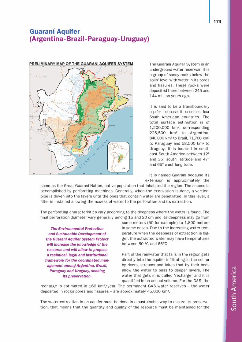
The Guarani Aquifer System is anunderground water reservoir. It isa group of sandy rocks below thesoils' level with water in its poresand fissures. These rocks weredeposited there between 245 and144 million years ago.
It is said to be a transboundaryaquifer because it underlies fourSouth American countries. Thetotal surface estimation is of1,200,000 km², corresponding225,500 km² to Argentina,840,000 km² to Brazil, 71,700 km²to Paraguay and 58,500 km² toUruguay. It is located in southeast South America between 12ºand 35º south latitude and 47ºand 65º west longitude.
It is named Guarani because itsextension is approximately the
same as the Great Guarani Nation, native population that inhabited the region. The access isaccomplished by perforating machines. Generally, when the excavation is done, a verticalpipe is driven into the layers until the ones that contain water are penetrated. In this level, afilter is installed allowing the access of water to the perforation and its extraction.
The perforating characteristics vary according to the deepness where the water is found. Thefinal perforation diameter vary generally among 15 and 20 cm and its deepness may go from
some meters (50 for example) to 1,800 metersin some cases. Due to the increasing water tem-perature when the deepness of extraction is big-ger, the extracted water may have temperaturesbetween 50 ºC and 65ºC.
Part of the rainwater that falls in the region getsdirectly into the aquifer infiltrating in the soil orby rivers, streams and lakes that by their bedsallow the water to pass to deeper layers. Thewater that gets in is called ‘recharge’ and it isquantified in an annual volume. For the GAS, the
recharge is estimated in 166 km³/year. The permanent GAS water reserves -- the waterdeposited in rocks pores and fissures – are approximately 45,000 km³.
The water extraction in an aquifer must be done in a sustainable way to assure its preserva-tion, that means that the quantity and quality of the resource must be maintained for the
Pat
osLa
ke
Mirim
Lake
15º
20º
25º
30º
35º
70º 65º 60º 55º 50º 45º
15º
20º
25º
30º
35º
65º 60º 55º 50º 45º
MontevideoBuenos Aires
Santa FeParanáCórdoba
U R U G U A Y
SaltoRivera
Chiquita
Mar
del Estero
Resistencia Corrientes Posadas
Formosa
Tucumán
Salta
Jujuy
A R G E N T I N A
Encarnación(Itapúa)
Santiago
Cuiabá
B O L I V I A
P A R A G U A Y
Goiânia
Brasília
São Paulo
Curitiba
Florianópolis
Campo Grande
Ribeirão PretoRibeirão Preto
Porto Alegre
Catamarca
CH
IL
E
Belo Horizonte
70º 65º 60º 55º 50º 45º
PRELIMINARY MAP OF THE GUARANI AQUIFER SYSTEM
U
ru
gu
ay
r i ve r
Pa
ra
ná
riv
er
I g u aç
u r i v e r
T i et ê
ri v
er
Ar
ag
ua
ia
ri
ve
r
AT
LA
NT
I C
OC
EA
N
G
L E G E N D
Concordia
Asunción
Santana doLivramento
B R A Z I L
The Environmental Protection and Sustainable Development of
the Guarani Aquifer System Projectwill increase the knowledge of theresource and will allow to propose a technical, legal and institutional
framework for the coordinated man-agement among Argentina, Brazil,
Paraguay and Uruguay, seeking its preservation.
Guaraní Aquifer (Argentina-Brazil-Paraguay-Uruguay)

current and future generations. In this sense, the water volume that can be extracted should besmaller than the recharge and should consider the maintenance of systems that depend on ground-water, for example, rivers and wetlands.
In reference to the quality preservation, adequate protection measures must be taken in order tocontrol the effects of potentially contaminating activities (solid waste dumping, agrochemicalexcess, among others).
PROJECT SUMMARY
The long-term objective of the process that started with the Project is to achieve the mana -gement and sustain able use of the Guarani Aquifer System (GAS). The GAS is located in the east-ern and south-central portions of South America, and underlies parts of Argentina, Brazil,Paraguay and Uruguay. This project is a first step towards achieving the long term objective. Itspurpose is to support the four countries in the joint elaboration and implementation of a commoninstitutional, legal and technical framework for the management and preservation of the GAS forcurrent and future generations.
The Project is structured in seven components:
■ Expansion and consolidation of the current scientific and technical knowledge base regard-ing the Guarani Aquifer System;
■ Joint development and implementation of a Guarani Aquifer System Management Framework,based upon an agreed Strategic Program of Action;
■ Enhancement of public and stakeholder participation, social communication and environ-mental education;
■ Evaluation and monitoring of the project and dissemination of project results;
■ Development of regionally-appropriate groundwater management and mitigation measures inidentified critical areas (‘hot spots’);
■ Consideration of the potential to use the Guarani Aquifer System's ‘clean’ geothermal energy;
■ Project coordination and management.
The project has been executed between March 2003 and January 2009.
Reg
ion
al a
nd
loca
l inv
ento
ries
174