soil resources in the congo basin: their properties and
TRANSCRIPT
Soil Resources in the Congo Basin: Their properties and constraints
for food production
Michel NGONGO (a), Emery KASONGO(a), Bazile MUZINYA(a), Geert BAERT(c), Eric VAN RANST(b)
a Department of General Agricultural Sciences, Laboratory of Soil Science, University of Lubumbashi, P.O. Box 1825,
Lubumbashi, The Democratic Republic of the Congo
b Department of Geology and Soil Science (WE13), Laboratory of Soil Science, Ghent University, Krijgslaan 281/S8, B-
9000 Gent, Belgium
c Faculty of Bioscience Engineering, Department of Applied Biosciences, Valentin Vaerwyckweg 1, B-9000 Gent, Belgium
Abstract.
The Congo basin, with a total area of about 3 822 000 km2 and a population exceeding 90 million
people, has generally lagged behind in agricultural development. The purpose of this paper is to
describe the different soil types in the Congo basin, their major constraints, the actual utilization
types, their management and the impact of land use on food production. Agriculture in countries of the
Congo basin has a dualistic character, with on the one hand the traditional smallholder agriculture in
forested areas based on shifting cultivation, with almost no use of external inputs and characterized by
low productivity, and on the other hand, large commercial perennial crop plantations of oil palm,
rubber, Robusta coffee and cocoa. To increase community resilience and to ensure food security,
agriculture must move from shifting cultivation to permanent agriculture that relies on agroforestry
practices, a good knowledge of the soils and the integrated land use management. However, in most
countries, farm-level information and detailed soil maps are non-existent. When this is coupled to
other socio-economic constraints, it provides one explanation for the lack of progress in ensuring food
security. Proper utilization of soils is essential to sustainable agricultural production and economic
development. In the Congo basin, 65 % of the population lives in rural areas and the majority is
directly involved in agriculture. Food production requires suitable soils for crop cultivation, however
suitable soils for agricultural production are limited in the Congo basin. Sustainable food production in
the Congo basin can partly be attained if soil characteristics and constraints are well understood.
Key words: Congo basin, soil properties, soil constraints, food production
1. INTRODUCTION
Congo Basin forests support the livelihoods of more than 90 million people. Even today, a
large portion of the population living in the Congo Basin forest is indigenous. In addition to those
inhabitants, many others directly or indirectly rely on the forest for fuel, food, medicines, and other
non-timber products. For the Congo Basin’s population, the forest is a major source of food. The
contribution of forests to food security is very often overlooked, but rural communities in the Basin
get a significant portion of protein and fats in their diets.

Land use changes influence the fertility of the soil. Land use changes mostly focused on
deforestation, cropland expansion, dry land degradation, urbanization, pasture expansion and
agricultural intensification. In tropical regions, forest is cleared for the expansion of cropland, wood
extraction or infrastructure expansion. Croplands expanded by 50% during the 20th century, from
roughly 1200 million ha in 1900 to 1800 million ha in 1990. There are several interacting drivers for
land cover change but the exponential growth in human population is important. Currently, 95% of the
population growth takes place in tropical regions and soil fertility in tropical regions is affected by
rapid land use changes. The effects of deforestation and grassland conversions as well as agricultural
intensification have been fairly well-documented but the spatial and temporal effects of soil fertility
change and its interaction with land use change remains to be investigated;
2. CONGO BASIN CHARACTERISTICS
Although agriculture is the main economic activity in the tropical regions, the proportion of cultivated
land is virtually the same as in the temperate region: about 10 percent. There is a tremendous potential
for expanding agricultural output in the tropics by bringing new lands into production with a reasonable
degree of expected success. One of the factors presently limiting the utilization of tropical areas suited
for crop production is inadequate knowledge of how to manage the highly weathered soils presently
under rainforest or savanna vegetation.
The proper management of soils in the tropics Congo Basin is considered one of the critical
components in the worldwide race between food production and population growth. In spite of the
voluminous literature, comprehensive knowledge of the characteristics of soils in Congo Basin (the
tropics) is still quite limited (Nachtergaele and Van Ranst, 2003). One of the reasons for this lack of
integrated knowledge has been the development of strong local biases by full-time tropical soil
scientists working only in a specific area or country. The lack of a common language has thus impeded
the transfer of many important management findings from one area to another.
3. SOIL INFORMATION IN AFRICA
With the exception of a few countries such as Kenya, detailed information on the soil resource base is
generally inadequate for most developmental purposes. In most countries, farm-level information and
detailed soil maps are non-existent. When this is coupled to other socioeconomic constraints,
including land titling and availability of capital for land management investments, it provides one
explanation for the lack of progress in poverty alleviation and food security (Cleaver and Schreiber,
1994). Large gaps in soil information persist in many African countries.
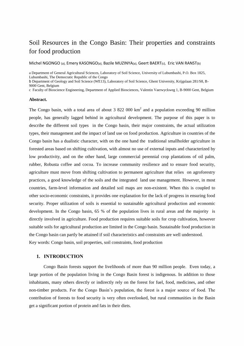
Table 1. National soil survey coverage in Africa (%) :
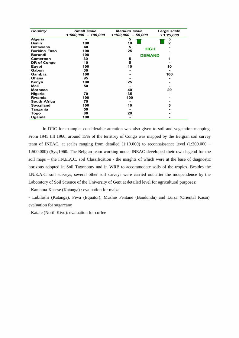
In DRC for example, considerable attention was also given to soil and vegetation mapping.
From 1945 till 1960, around 15% of the territory of Congo was mapped by the Belgian soil survey
team of INEAC, at scales ranging from detailed (1:10.000) to reconnaissance level (1:200.000 –
1:500.000) (Sys,1960. The Belgian team working under INEAC developed their own legend for the
soil maps – the I.N.E.A.C. soil Classification - the insights of which were at the base of diagnostic
horizons adopted in Soil Taxonomy and in WRB to accommodate soils of the tropics. Besides the
I.N.E.A.C. soil surveys, several other soil surveys were carried out after the independence by the
Laboratory of Soil Science of the University of Gent at detailed level for agricultural purposes:
- Kaniama-Kasese (Katanga) : evaluation for maize
- Lubilashi (Katanga), Fiwa (Equator), Mushie Pentane (Bandundu) and Luiza (Oriental Kasai):
evaluation for sugarcane
- Katale (North Kivu): evaluation for coffee
National coverage (16,5%)/1/200.000,
1/500.000
Figure 1. Mapped area Figure 2. Soil map of DRC
The Soil and Terrrain database of Central Africa (SOTERCAF, version 1.0) was compiled at scale 1:2
million for the Democratic Republic of Congo and at scale 1:1 million for Rwanda and Burundi. The
SOTERCAF compilation has been a joint collaboration of the Soil Science Laboratory of the
University of Ghent, Belgium and ISRIC - World Soil Information, Wageningen under contract with
the Food and Agriculture Organisation of the United Nations. Further assistance is provided by the
Department BIOT of the Hogeschool Gent, the Royal Museum for Central Africa (Tervuren) and data
holders in the Democratic Republic Congo, Burundi and Rwanda. The project started in September
2005 by deriving physiographic units from SRTM grid data based on SOTER landform definitions.
The database was completed in July 2006 after combining the physiographic layer with the lithology
and soils layer. The border harmonization with the SOTERSAF database was finalized November
2006. (Van Engelen et al.2006)
According to SOTERCAF, the main FAO soil groups are Ferralsols, Acrisols, Cambisols, Arenosols,
Gleysols, Histosols, Lixisols and Nitisols, covering some 99% of the region. The main soil units are
haplic Ferralsols (FRh, about 29%), haplic Acrisols (ACh, ~23%), xanthic Ferralsols (FRx,~16%),
umbric Ferralsols (~5%), eutric Gleysols (~4%), ferralic Cambisols (CMo, ~3%), haplic Lixisols
(LXh, ~3%), ferralic Arenosols (ARo, ~2%) , dystric Cambisols (CMd, ~2%), rhodic Ferralsols (FRr,
~2%), and haplic Arenosols (ARh, ~2%); these units cover over 90% of CAF.
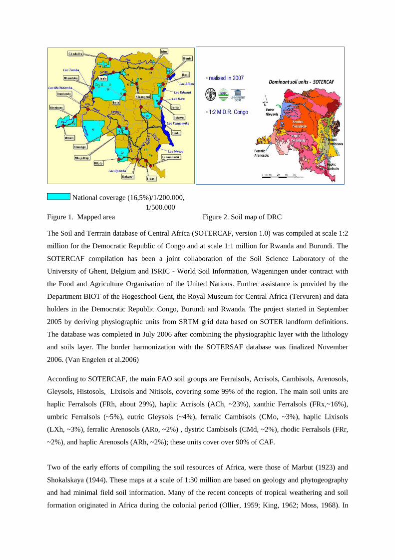
Two of the early efforts of compiling the soil resources of Africa, were those of Marbut (1923) and
Shokalskaya (1944). These maps at a scale of 1:30 million are based on geology and phytogeography
and had minimal field soil information. Many of the recent concepts of tropical weathering and soil
formation originated in Africa during the colonial period (Ollier, 1959; King, 1962; Moss, 1968). In
1953 an Interafrican Pedological Service was created with its Administrative Headquarters at
Yangambi, Belgian Congo (Zaire). The Council of this Service decided in 1955 to make a soil map of
the continent which was eventually realized in 1964 (D'Hoore, 1964). This soil map and
accompanying report was perhaps the last effort in Africa until the FAO-UNESCO Soil Map of the
World was published a decade later (Eswaran et al. 1996).
The FAO soil map of Africa at a scale of 1: 5 million has over 6,000 polygons. The FAO soil unit
designator for each polygon is systematically converted to WRB reference group and for this process,
only the dominant unit in the association is considered
Figure 3. Soil map of Africa (WRB reference groups)
4. MAJOR SOILS TYPES IN CONGO BASIN
From the study of the tropical environment, it is obvious that the soils of the tropics show
considerable diversity as a result of major differences in moisture regime, lithology, and age,
degree of weathering of parent materials, relief, and elevation above sea level (Van Wambeke
1989).
Figure 3 illustrates the distribution of soil Orders in Congo Basin.
http://eusoils.jrc.ec.europa.eu/library/maps/africa_atlas/
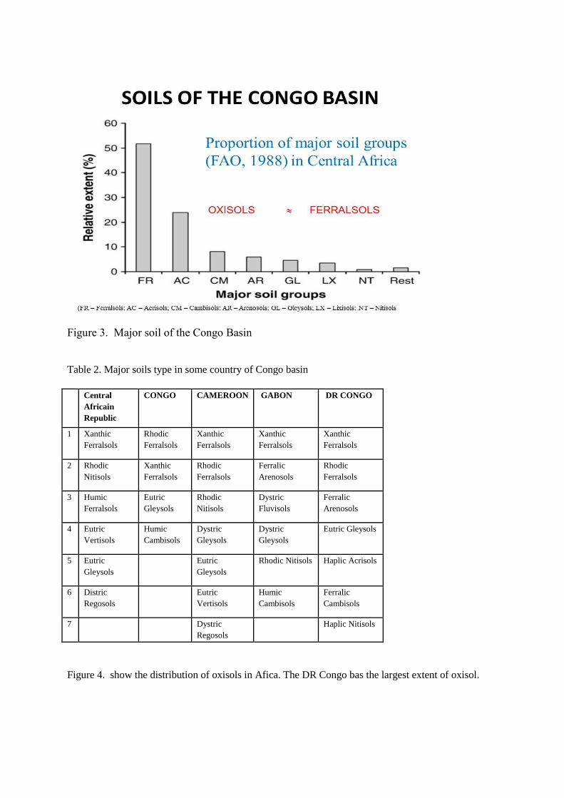
Figure 3. Major soil of the Congo Basin
Table 2. Major soils type in some country of Congo basin
Central
Africain
Republic
CONGO CAMEROON GABON DR CONGO
1 Xanthic
Ferralsols
Rhodic
Ferralsols
Xanthic
Ferralsols
Xanthic
Ferralsols
Xanthic
Ferralsols
2 Rhodic
Nitisols
Xanthic
Ferralsols
Rhodic
Ferralsols
Ferralic
Arenosols
Rhodic
Ferralsols
3 Humic
Ferralsols
Eutric
Gleysols
Rhodic
Nitisols
Dystric
Fluvisols
Ferralic
Arenosols
4 Eutric
Vertisols
Humic
Cambisols
Dystric
Gleysols
Dystric
Gleysols
Eutric Gleysols
5 Eutric
Gleysols
Eutric
Gleysols
Rhodic Nitisols Haplic Acrisols
6 Distric
Regosols
Eutric
Vertisols
Humic
Cambisols
Ferralic
Cambisols
7 Dystric
Regosols
Haplic Nitisols
Figure 4. show the distribution of oxisols in Afica. The DR Congo bas the largest extent of oxisol.

Figure 4. Distribution of oxisols in Africa
Figure 5. Oxisol profile
4.1. Physical properties
a. Particle size distribution
Texture of HWS (Highly weathered soisl) is closely related to the nature of the parent rock and may
vary from sandy clay loam on sandstones and quartzites to heavy clay on shales and basic rocks.
Characteristics: red or yellow in colour old and strongly leached deep finely textured traces of weatherable minerals low activity clays no (<5%) recognizable rock structure gradual soil boundaries goot permeability to water and air easily trafficable (strong aggregation). weak macrostructure renders the soils
prone to compaction but rapid recovered with appropriate
tillage management strong cohesion of microaggregates complicates determination of particle
size distribution

Sandy loam and loamy sand occur normally on transported materials. A common characteristic is the
low silt content.
b. Porosity and soil aggregation
Total porosity decreases slightly with depth (5 to 20 percent). This is due to a decrease of the
macroporosity following the decrease in the organic matter content. Prolongated cultivation of
annuals does not cause an important change of total pores but may be at the origin of a
decrease of the macroporosity in the topsoil due to a decline in the organic matter content.
This decrease in macroporosity may reduce root penetration. The stable microporosity can be
explained by the formation of strong micro-aggregates (negatively charged clay surfaces
combine with positively charged sesquioxide surfaces).
Micro-aggregation helps to explain the well-known fact that many HWS of the tropics have
better physical properties than might be suggested by the high clay content
c. Soil-water relationship
Two type of moisture regimes: the continuously humid rainforest areas with udic moisture
regime and the seasonally rainy tropics with ustic moisture regime.
All HWS have good permeability and high percolation rate. The average permeability of Tropical
Oxisols was observed to be about 14 cm/h in the surface layers and 6.5 cm/h in the subsoil. Oxisols
and other soils dominated by LAC have a low available water content compared with soils
characterized by HAC. This may represent serious limitations especially under seasonally dry
climates. An important feature is that under ustic climatic conditions annual crops have to start their
growth cycle when the soil has little or no moisture reserve. Therefore crops are very sensitive to
erratic rainfall and to drought stress.
4.2. Chemical properties
a. Organic Matter
Organic matter is the most important product of the forest and savannah vegetation. The
amount of organic matter immobilized in a rainforest varies from 150 to 300 tonnes of dry
material per hectare containing 1.5 to 2 tonnes of mineral salts.
The annual gain at the soil surface is estimated at about 15 tonnes dry material per hectare
containing approximately 200 kg of nitrogen, 250 kg of mineral salts and 250 kg of silica.

The organic matter content of a soil under rainforest is about 110 tonnes per ha, which is 7
times more than the annual gain.
Organic matter is the most important product of the forest and savannah vegetation.
The amount of nutrients stored in soils of the Congo Basin is mainly related to the organic
matter content and the production of organic matter by the vegetation (Table 3). Under
natural vegetation, the development of the humiferous topsoil is a general expression of the
soil fertility.
Soil organic C is predicted to decrease from 43 to 25 t/ha in 15 years, with continuing inputs
of 2 t/ha instead of 11 t/ha of C per year. These levels correspond approximately to humid
tropical conditions changing from forest cover to arable crop production. Loss of organic
matter through oxidation when the soils are cultivated or through erosion reduces the ability
to supply N, P and S for crops. Also it reduces the abiliy to retain cations in an available form
(Van Ranst, 2004).
From the analytical point of view the organic matter content is best evaluated in the upper 15
cm :
- > 2.5% O.C : high
- 2.5-1.0% O.C : medium
- < 1.0% O.C : low
Organic matter (pH0 around 3.5-4) develops negative charges that contribute to the cation
retention of the soil. It has been estimated that the CEC of soils in the humid tropics is around
260 cmol(+) kg-1
C at pH 7 and 35 cmol(+)kg-1
C at pH 4.5.
Table3. Immobilization of mineral elements by a forest fallow at Yangambi (Sys, 1979

b. Nitrogen
The nitrogen in soil organic matter (SOM) remains the most important source of nitrogen for crop
production in the humid tropics. The annual addition of fresh organic matter is about 15 tonnes per ha
under a tropical rainforest, but may vary, according to the development stage of secondary forest
regrowth, from 3 to 15 tonnes.
Under savannah, the annual addition may vary from 0.5 to 1.5 tonnes per ha of dry material.
The annual decomposition rate of SOM varies from 2 to 5 percent (average 4%) under rainforest and is
estimated at 1.2 percent under savannah. (Sys, 1979).
An annual legume crop in rotation may provide 10 to 70 kg/ha of nitrogen. A perennial legume
crop, after two or more years, may furnish from 50 to 150 kg/ha of nitrogen to the crop that
follows. Management and effect of cultivation have an important influence on the
decomposition rate (Table 3 ).
c. Phosphorus
Total phosphorus has no practical importance but it is an indication of the degree of weathering. It has
been stated that with increasing weathering the total P content of the soil decreases:
- Young soils : 2,000-3,000 ppm P
- Ultisols : around 500 ppm P
- Oxisols : around 200 ppm P (between 20 and 300 ppm)
Organic phosphorus
(Year) Dry material
(t/ha)
Immobilization of minerals (kg/ha)
N P K
2 20 190 22 160
5 112 570 32 420
8 153 580 35 670
18 173 700 108 820

Organic P can be mineralized during the breakdown of the organic matter and becomes easily available
for uptake by plants. Therefore the ratio C/P or N/P or the organic matter is a good parameter for the
availability of P. C/P should be around 100-120 and N/P around 10. In strongly weathered tropical soils
these ratios are respectively around 200-250 and 20-25.
Increasing the mineralization of organic matter, e.g. by liming, may therefore improve the yield of crops.
On the other hand, maintaining organic matter by regular addition of organic material increases the
availability of P for plants. It is obvious that organic P is especially important in areas where P fertilizers
are not available.
Table 4. Effect of cultivation on decomposition rate of OM
Inorganic phosphorus
Inorganic P is bound to Ca, Fe or Al, but the exact nature of these compounds is not very well known. In
HWS, containing high amounts of free Fe and/or Al, the fraction of P which has not been leached out is
included mostly inside these compounds
d. Effect of cultivation on decomposition rate of OM
Shifting cultivation occurs in almost half of the tropical world in both forested and savanna areas. These
are usually the least developed areas, where farmers cut and burn a small area, plant several crops in the
same field, and abandon the fields when native soil fertility, weeds, or other factors decrease yields.
Shifting cultivation is most widespread in Congo Basin under udic and ustic regimes. It is also very
common in the Amazon Basin, Central America, and the hill country of Southeast Asia and the Pacific
(Table 4).
(Year) Dry material
(t/ha)
Immobilization of minerals (kg/ha)
N P K
2 20 190 22 160
5 112 570 32 420
8 153 580 35 670
18 173 700 108 820

Table 5. Immobilization of mineral elements by a forest fallow at Yangambi (Congo)
e. Effects of exchangeable Al
The amount of acidity which may be present in HWS strongly depends on the stage of evolution and
the subsequently mineralogy, as well as on their ZPNC. The processes necessary to develop acidity are
: accumulation of organic matter, breakdown of primary minerals and leaching of soluble constituents
:
The effect of exchangeable Al is diverse:

1. Exchangeable Al affects the normal activity of the soil micro-organisms; in the first place
Rhizobium is affected
2. Aluminium has also an effect on plant physiology. As all mineral elements, Al is
indispensable for plant growth; in weak concentrations it has a benefic effect.
3. At the level of the cell membrane exchangeable Al presents antagonism with Ca and Cu and
prevents these elements to penetrate the cells. On the other hand Al favours uptake of Mn and
may therefore indirectly induce Mn toxicity stated in some tea plantations.
4. Resistance to Al depends on plant species: rubber, tea, cassava and rice are resistant; cotton,
cocoa and tobacco are sensitive.
f. Trace elements
Trace elements are seldom limiting factors under extensive systems of agriculture in tropical
areas where yields are low. However, with more intensive management the demand for
micronutrients increases above the supply level of virgin soils. This is particularly true in acid
soils under intensive cultivation and receiving large amounts of nitrogen and phosphorus.
5. SUITABILITY FOR CROP PRODUCTION
Soil properties, including soil climate, provide some preliminary information to address soil quality.
Soil quality is used here to indicate the ability of the soil to perform its function of sustaining
agriculture under the current low-input system of agriculture. Low-input implies that large-scale
irrigation is absent, use of fertilizers, and pest and weed control is minimal, and soil management does
not require high energy mechanized equipment. The low potential lands have several major constraints
which are not easily corrected through management. The unsustainable class of lands are those which
are considered to be fragile, easily degraded through management, and in general are not productive or
do not respond well to management. They are generally highly erodible and generally require very
high investments for any kind of agriculture
High potential lands are those with some minor limitations. The medium and low potential lands have
major constraints for low-input agriculture. Resource poor farmers who live on these lands have high
risks and generally, the probability of crop failure is high to very high. The constraints include surface
soil crusting, impermeable layers, soil acidity and specifically subsoil acidity, and high risks water
erosion.
The soil proprieties analysis and the evaluation provide a first assessment of crops suitabily.
Much of the land within the Congo basin is biophysically capable of supporting some type of
sustainable agriculture system. Much of their sustainability is dependent on the extent of inputs to

maintain soil quality. In many countries of Congo Basin, though application of costly inputs in order
to achieve sustainability is not realistic, expansion of low-input agriculture systems on these soils is
likely to result in soil degradation and loss of productivity. There is thus an urgent need to provide
alternate options for a more equitable use of the soil resources until some form of capital intensive
systems can be implemented. Food security is becoming or is already of paramount concern in many
of the African nations. Traditional agriculture systems and declining 'aid' imports may not supply the
needs of a region which has some of the highest birth rates (Kesseba, 1993. A declining resource base
will eventually contribute to civil unrest due to uncertain food supplies;
As the population growth and the demand for suitable agricultural land increases, there is need for a
planned assessment of agricultural potential in Africa. Thus, soil resources, especially using small
scale regional maps and more detailed national and local assessments can provide better information
for crop suitability. With socioeconomic and other data layers, realistic national assessments and
appropriate strategic plans can be developed.
In this study eleven types of soils were taken as the basis for evaluation. Soils characteristics (table 6)
and qualities of those soils were compared with crop requirement (Tables,7,8,9,10) of 5 major crops
(maize, rice, banana, cassava, oil palm), grown under rainfed conditions in Congo basin. Estimates
were made, at congo basin level, of the suitability of soil for rainfed crop production, for each crop,
divided into five classes (tab ….) : very suitable (S), suitable (S1), moderately suitable (S2), marginal
(S3), and not suitable (N). Except for S1 and N, all classes were subdivided in subclasses depending
of the type of limitation (m= water limitation, n = nutrients limitation, h= relative humidity limitation,
w= flooding, u= insolation, r=root depth limitation= erosion risk).
As a result, suitability classes have been defined that fall into the soil properties of fertility, depth,
drainage, nutriment, acidity, moisture regime, temperature regime etc.. (Tab 11 Figure 6 )
Table 6. Soil characteristics
Soil type
pH
C
(%)
N
(%)
K ca CEC Al P (bray)
ppm
Depth(cm)
Haplic Acrisol 5,2 0,87 0,6 0,1 1,2 8,2 >100 OR5
Xanthic
Ferralsol
4,9 0,6 0,3 0,05 0,4 4,1 0,8 1,5 >100 Y4
Gleyic
Arenosol
4,3 0,31 0,02 0,07 0,35 3,8 1,2 2,1 >100 Y5
Haplic
Ferralsol
5,9 0,7 0,12 0,25 2,2 4,5 >100 NU8
Eutric regosol 4,7 0,8 0,2 0,1 1,9 3,1 =< 40 BP7

Haplic lixisol 5,9 1,8 0,2 0,5 5,3 6,7 >100 AL1
Eutric
Cambisol
6,1 2,3 0,23 0,9 7,2 10,8 =< 60 NU11
Rhodic
Ferralsol
5,7 0,25 0,03 0,09 0,9 3 >100 SU1
Haplic
Arenosol
5,3 0,4 0,02 0,2 0,6 2,5 >100 SU8
Plintic
Ferralsol
4,6 0,9 0,07 0,08 1,2 5 =<90 SU14
Gleyic Acrisol 5,9 0,22 0,06 0,12 3,5 5?8 >100(gleyic OR1
Table 7. Banana requirement
Suitability class S1 S2 S3 N
Water disponibility(%) >90 95-85 85-75 75 - 55 <55
-CEC meq/l00g of soil >10 10 - 8 8 - 6 <4
-Ca meq/l00g of soil >3.8 4 - 2.6 2.6 - 1.5 <1.4
- Mg meq/l00g of soil >0.9 0.9-0.6 0.6-0.4 <0.4
- K meq/l00g of soil >0.4 0.4-0.25 0.25-0.14 <0.14
-pH >5.8 5.8-5.5 5.5-5.2 5.2-4.5 <4.5
Organic matter >1.5 1.5-1.2 1.2-0.6 <0.6
Soil depth >100 100-75 75-50 50-25 <25
Temperature Régime (Moy)
……………………….. (Min) >25 25-7.2 22-20 20-18 <18
>20 20-12 18-16 16-14 <14
Table 8: Maize requirement
Suitability class S1 S2 S3 N
Water disponibility(%) >90 95-85 85-75 75-55 <55
-CEC meq/l00g of soil >10 10 - 8 8-6 6-2 <2
-Ca meq/l00g of soil >4 4-2.5 2.5-1.5 <1.5
- Mg meq/l00g of soil >1 1-0.6 0.6-0.4 <0.4
- K meq/l00g of soil >0.5 0.5-0.25 0.25-0.1 <0.1
-pH >5.8 5.8-5.5 5.5-5.2 <5.2
Organic matter >1.5 1.5-1.2 1.2-0.8 <0.8
Soil depth >100 100-75 75-50 50-20 <20
Temperature Régime (Moy)
……………………….. (Min) >22 22-18 18-16 16-14
16-18 18-20 >20
Table 9: Rice requirement
Suitability class S1 S2 S3 N

Water disponibility(%) >85 85-75 75-60 60-45 <45
-CEC meq/l00g of soil >10 10-8 8-4 <4
-Ca meq/l00g of soil >2.6 2.6-1.9 1.5-1.1 <1.1
- Mg meq/l00g of soil >0.6 0.6-0.5 0.4-0.3 <0.3
- K meq/l00g of soil >0.25 0.25-0.18 0.14-0.1 <0.1
-pH >5.5 5.5-5.3 5.3-5 <5
Organic matter >1.2 1.2-0.8 <0.8
Soil dept >120 120-90 90-50 50-20 <20
Temperature Régime (Moy)
……………………….. (Min) 24-31 31-38 38-42 42-45 <45
24-18 18-10 <10
Table 10. Cassava requirement
Suitability class S1 S2 S3 N
Water disponibility(%) >75 75-70 70-50 50-40 <40
-CEC meq/l00g de soil >8 41402 <5
-Ca meq/l00g of soil >2.1 2.1-1.2 <1.2
- Mg meq/l00g of soil >0.5 0.5-0.29 <0.29
- K meq/l00g of soil >0.2 0.2-0.11 <0.11
-pH >5.5 5.5-5.2 5.2-4.5 <4.5
Organic matter >1.2 1.2-0.8 <0.8
Soil depth >100 100-75 75-50 50-30 <30
Temperature Régime (Moy)
……………………….. (Min) >23 23-20 20-18 18-16 <16
>18 18-16 16-14 14-12 <12
Table 11. Soil suitability classes
Soil Name Maize Rice Banana cassava Oil Palm Coffee
Haplic Acrisol OR5
Xanthic Ferralsol S3,nhu S3,un S3,n S2,ne S2,nu S2, n Y4
Gleyic Arenosol N1,nwhu S3,wnu S3nw N1,wn S3wnu S3wn Y5
Haplic Ferralsol S3,wn S3,wu S3wn S3w S2nw S2w NU8
Eutric regosol S3nhur S2/S3uwn S3nw S3wnu S2nuw S3wn BP7
Haplic lixisol S2/S3nh S2/S3nu S2n S2n S2nur S2n AL1
Eutric Cambisol S2nhr S3run S2rn S2r S2rn S2r NU11
Rhodic Ferralsol S3nh S2/S3 nu S3n S2n S3nw S2n SU1
Haplic Arenosol S3nh S2/S3nu S3n S2n S2/S3nu S2n SU8
Plintic Ferralsol S2/S3nc S2un S2n S2n S2/S3nu S2n SU14
Gleyic Acrisol S3nhc S3uer S2rS2r S2r S2/S3ru Sér OR1

Figure 6. Influence of each group of characteristics on the suitability class
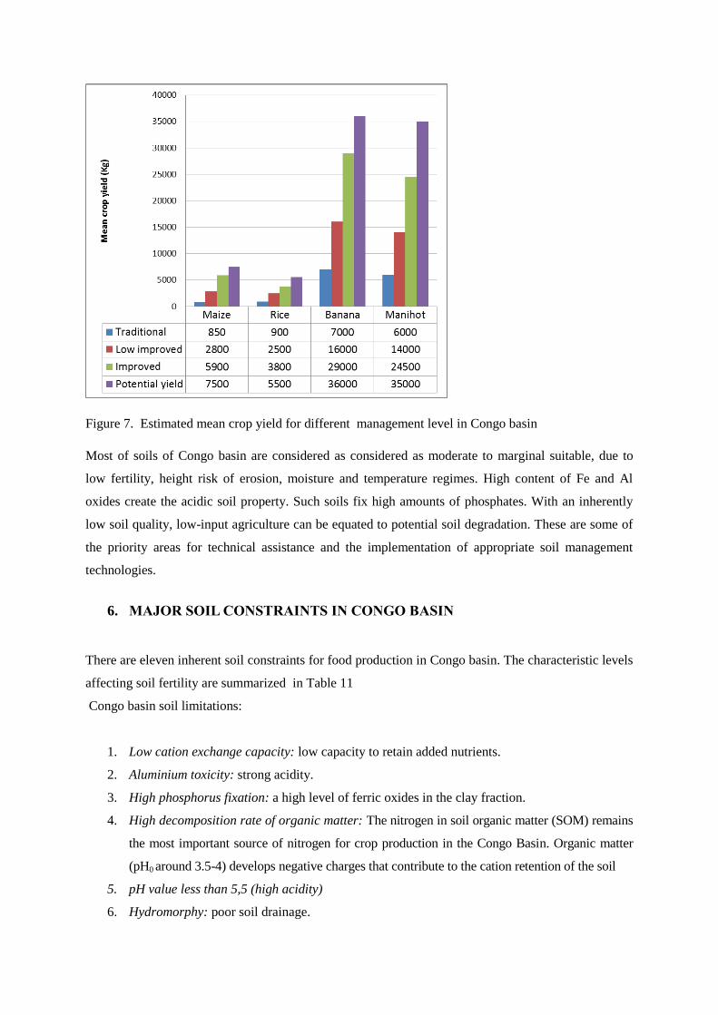
Figure 7. Estimated mean crop yield for different management level in Congo basin
Most of soils of Congo basin are considered as considered as moderate to marginal suitable, due to
low fertility, height risk of erosion, moisture and temperature regimes. High content of Fe and Al
oxides create the acidic soil property. Such soils fix high amounts of phosphates. With an inherently
low soil quality, low-input agriculture can be equated to potential soil degradation. These are some of
the priority areas for technical assistance and the implementation of appropriate soil management
technologies.
6. MAJOR SOIL CONSTRAINTS IN CONGO BASIN
There are eleven inherent soil constraints for food production in Congo basin. The characteristic levels
affecting soil fertility are summarized in Table 11
Congo basin soil limitations:
1. Low cation exchange capacity: low capacity to retain added nutrients.
2. Aluminium toxicity: strong acidity.
3. High phosphorus fixation: a high level of ferric oxides in the clay fraction.
4. High decomposition rate of organic matter: The nitrogen in soil organic matter (SOM) remains
the most important source of nitrogen for crop production in the Congo Basin. Organic matter
(pH0 around 3.5-4) develops negative charges that contribute to the cation retention of the soil
5. pH value less than 5,5 (high acidity)
6. Hydromorphy: poor soil drainage.

7. Soil-water relationship : Oxisols and other soils dominated by LAC have a low available water
content compared with soils characterized by HAC. This may represent serious limitations
especially under seasonally dry climates
8. Low silt content ( texture)
9. Porosity : Prolongated cultivation of annuals does not cause an important change of total pores
but may be at the origin of a decrease of the macroporosity in the topsoil due to a decline in
the organic matter content. This decrease in macroporosity may reduce root penetration.
10. Shallowness: rock or a rock-like horizon close to the soil surface.
11. Erosion hazard: a high risk of soil erosion, caused by steep slopes, or moderate slopes in
association with erosion-prone soils.
Table 12. Characteristic levels affecting soil fertility
Depth of
Horizon
Moisture
conditions
Plant
nutrients Reaction
Organic
Matter
Maiz
e
Ric
e
Cass
ava
Maiz
e
Ric
e
Cass
ava
Maiz
e
Ric
e
Cass
ava
Maiz
e
Ric
e
Cass
ava
Maiz
e
Ric
e
Cass
ava
Xanthic Ferralsol L L L L L L H H H H H H H H H
Haplic Acrisol L L L L L L H H H H M M H H H
Haplic Arenosol L L L L L L H H H H H H H H H
Eutric Cambisol L L L L L L H H H H M M H H H
Gleyic Acrisol M M M M M M H H H H M M H H H
Legend
H = High
M = Medium
L= Low
AGRICULTURAL VALUE AND LAND USE
The Congo Basin is marked by a dominance of highly weathered soils (HWS), having an oxic or a
kandic (argillic) horizon. According to Soil Taxonomy, Oxisols and Ultisols are the most common soil
resource.
In their natural state, these HWS often maintain highly productive and diverse ecosystems that are
dependent on efficient resource utilization. A characteristic of these systems is their reliance on SOM to
cycle nutrients from the soil through the plant and hence back to the soil through plant debris. Soil
organic matter (SOM) effectively acts as a slow release nutrient delivery system that mediates the
cycling of nutrients and chemical attributes of soils. However, when these ecosystems are disturbed

through continuous cultivation, the productivity of many HWS often declines rapidly due to a loss of
SOM, accelerated soil acidification, and a reduction in the CEC thereby limiting the ability of the soil to
hold basic cations (nutrients), which are rapidly lost through leaching.
It has however, been shown that intensive continuous cropping with annuals is possible with adequate
use of fertilizers after annulation of the phosphorus fixation capacity and Al-saturation.
1. ROLE OF FALLOW IN SHIFTING CULTIVATION SYSTEMS
Shifting cultivation is by far the most widespread tropical soil management system.
The role of fallow in humid tropical areas is Regeneration of soil organic matter;
Immobilization of mineral elements;and elimination of weeds.
2. FOREST FALLOW
The efficiency of a forest fallow depends mostly on its ability to create in a short time a
vegetation which protects the soil against erosion. The regeneration of the soil in organic matter
is quite rapid. A forest fallow is able to rebuilt the original organic matter level is about 10
years. The most essential function of the fallow, the accumulation of mineral elements in the the
aerial parts of the plants, is also gradual but achieved in a later stage (Table 3).
The length of the fallow period depends on the quality of the soil and the fertility status at the
moment the field was abandoned. In the Congo basin, 12-14 years fallow was necessary on a
Hapludox to regenerate the soil after a 2-3 years rotation including maize, rice, cassava and
bananas (Sys, 1979).
On better soils the length of fallow remains similar but the cropping period may be longer (5-6
years).
A major practical problem in the humid tropics is to find liming materials of sufficient
fineness and purity. Fineness is crucial because of the reactivity.
The purpose of liming is primarily to neutralize the exchangeable Al, and this is normally
accomplished by raising the pH to 5.5. When Mn toxicity is suspected, the pH should be raised
to 6.0 (Mn is very soluble at pH values lower than 5.5. If this element is present in sufficient
amounts, Mn toxicity can occur along with Al toxicity at pH values up to about 5.5 to 6.0).
However, in order to increase the soil pH to 6, large inputs of lime are required which is
inefficient because of the high buffering capacity in these HWS and may result in micronutrient
deficiencies (Noble et al., 2000).
The well-established practice of liming to neutrality is not effective in most of the HWS of the
tropics. More often than not, liming to pH 7 causes more harm than good. Most plants grow

well within a pH range of 5.5-6.5 and therefore a liming programme should be aimed at
maintaining the pH in this range (Bolan et al., 2003; Paul et al., 2003).
Kamprath (1971) reviewed the consequences of overliming in tropics are : yield reduction; soil
structure deterioration; and decreased availability of phosphorus, boron, zinc and manganese.
Increasing the organic matter content is difficult to achieve under warm and humid conditions
when the soil is regularly cultivated.
Even if increasing the actual CEC is not feasible, current levels of exchangeable cations should
be closely monitored to ensure there is no further decline as a result of decreasing organic
matter levels under increasing cropping intensity or diversification into more demanding crops.
In the tropical soil, the behavior of P fertilizers is very complex, because it is influenced by the
solubility of different possible constituents and the pH.
CONCLUSION
As population for Congo basin increases and demand for food rises, there will be increasing demand
for suitable agricultural land to provide the agricultural products. Farmers will have to decide if they
are more concerned with short-term yields or long-term sustainability and soil management. Their
decisions are very critical as recent research has shown that the conversion of tropical forests to
sustainable agriculture may be detrimental to preventing global climate change.
In order to translate soil characteristics into agronomic constraints and land use suitability we
need detailed information from soil maps. There are some substantial data limitations to the
sources used. The reliability of some of the maps and data is known to be relatively low.
Soil degradation and in particular the decline of soil chemical fertility is major concern in relation to
food production and the sustainable management of land of Congo Basin.
Conserving soil nutrients and organic matter are practices that must be followed if sustainable
agriculture is to continue to meet increasing global demand

References
Bolan, N.S., Naidu, R., Syers, J.K. and Tillman, R.W. 1999. Surface charge and solute
interactions in soils. Adv. Agron., 67:87-140.
Bolan, N.S., Adriano, D.C. and Curtin, D. 2003. Soil acidification and liming interactions
with nutrient and heavy metal transformation and bioavailability. Adv. Agron., 78:215-272
Cleaver, K.M. and G.A. Schreiber. 1994. Reversing the Spiral: The population, agriculture,
and environment Nexus in Sub-Saharan Africa. The World Bank, Washington D. C.
293 pp.
D'Hoore, J.L. 1964. Soil Map of Africa, Scale 1:5,000,000. Joint Project No. 11. Commission
for Technical Cooperation in Africa Publ. Ceuterick, Louvain, Belgium, 205 pp.
Eswaran, H., Almaraz, R., van den Berg, E., and Reich, P. 1966. An Assessment of the Soil
Resources of Africa in Relation to Productivity. World Soil Resources, Soil Survey
Division, USDA Natural Resources Conservation Service,
FAO-Unesco-ISRIC, 1988. Soil Map of the World, Revised Legend. World Soil Resources
Report n° 60, FAO, Rome, 119 pp.
FAO, ISRIC et UGent 2007. Soil and terrain database for central Africa. Land and Water
Digital Media Series, 33. FAO, Rome.
Kamprath, E.J. 1971. Potential detrimental effects from liming highly weathered soils to
neutrality. Proc. Soil Crop Sci. Soc. Fla., 31 : 200-203.
Kesseba, A.M. 1993. Strategies for developing a viable and sustainable agriculture sector in
sub-Saharan Africa: Some issues and options. In: J. Ragland and R. Lal (ed.),
Technologies for Sustainable Agriculture in the Tropics. Publ. Amer. Soc. Agron.
Madison, WI., ASA Special Publ. 56:211-244.
King, L.C. 1962. Morphology of the Earth. Publ. Oliver and Boyd, Edinburgh.

Marbut, C.F. 1923. The vegetation and soils of Africa. American Geographical Society.
Nachtergaele, F. and Van Ranst, E. 2003. Qualitative and Quantitative Aspects of Soil
Databases in Tropical Countries. In : Evolution of Tropical Soil Science : Past and
Future (Workshop, Brussels, 6 March 2002), Royal Academy of Overseas Sciences :
107-126.
Noble, A.D., Gillman, G.P., Nath, S. and Srivastava, R.J. 2000. A cation exchange index for
assessing degradation of acid soil by further acidification under permanent agriculture in
the tropics. Eur. J. Soil Sci., 51:233-243.
Ollier, C.D. 1959. A two-cycle theory of tropical pedology. J. Soil Sci. 10:137-148.
Paul, K.J., Black, A.S. and Conyers, M.K. 2003. Development of acidic subsurface layers of
soil under various management systems. Adv. Agron., 78:189-213.
Shokalskaya, Z.V. 1944. A new soil map of Africa. Pochvovodenye, 9:424
Sys C. 1960. Carte des sols du Congo Belge et du Ruanda-Urundi. Notice explicative de la carte
des sols. INEAC, Bruxelles, Belgique.
Sys, C. 1979. Regional Pedology. Tropical soils. Part II. International Training Centre for Post-
graduate Soil Scientists. Lecture notes. State University of Ghent.
Van Engelen V., Verdoodt A., Dijkshoorn K. et Van Ranst E. 2006. Soil and Terrain Database
of Central Africa - DR Congo, Burundi and Rwanda. SOTERCAF, Version 1.0. ISRIC-
UGent-FAO.
Van Ranst E. 2004. Properties and management of soils of the tropics. Intern. Course Program
"Physical Land Resources", Ghent University, Belgium
Van Wambeke A., 1989. Tropical Soils and Soil Classification Updates. Advances in Soil
Science 10:171-193. Springer Verlag, New York Inc.
