soil impact assessment and rehabilitation study …...soil impact assessment and rehabilitation...
TRANSCRIPT

Booyong Forest Science
Booyong Fo
Soil Impact Assessment and Rehabilitation study for the PNG LNG Project: Portion 152 LNG Facility For Coffey Natural Systems December 2008
rest Science Pty Ltd

Soils and rehabilitation assessment for the LNG Facility
Booyong Forest Science Pty Ltd
tt t
This report has been prepared solely for the benefit of Coffey Natural Sys ems. Booyong Forest Science accepts no liability for the use or interpretation of any information contained in this report for any o her purpose o her than intended, or for its use by any party other than the above named Client.
Document Summary
Company: Booyong Forest Science Pty Ltd
Project Manager: Howard Rogers
Title: Soil Impact Assessment and Rehabilitation study for the PNG LNG Project: Portion 152 LNG Facility
Author/s: Howard Rogers
Client: Coffey Natural Systems
Client Contact: Robert Meagher
Date of Issue: 7 January 2009
Version Final
Project Number CNS803
File Name BooyongFS_CNS803_LNG Facility_Soils Rehab_2008_FINAL
Delivery Format: Word and PDF
Contact: Howard Rogers: email: [email protected], (T) + 61 (0)7 5543 4173
(M) + 61 (0)412 013 217
Booyong Forest Science Pty Ltd ABN: 47 117 077 808 PO Box 98 Canungra, Qld 4275
Page ii
Soils and rehabilitation assessment for the LNG Facility
SUMMARY
This report presents the findings of the soil impact assessment and rehabilitation study for the PNG LNG Project for the proposed LNG facility at Portion 152 in the Central Province of Papua New Guinea. The study is based on a site assessment and desk based studies undertaken in April and May 2008.
The study focuses on (A), the identification of significant landform features and problematic soils, (B), assessing the potential impacts on landforms, soils and vegetation associated with the project activities, and (C), providing recommendations on measures to avoid, reduce or mitigate adverse impacts on landform, soils and vegetation during project construction and operation, including suitable rehabilitation techniques for the areas to be disturbed.
The proposed site of the LNG facility is located on the coast approximately 20 km northwest of Port Moresby in Central Province, within Portion 152. The site was previously used as a cattle grazing property known as Fairfax Station and is presumed to have been heavily modified from its original condition. The site comprises a coastal strip of mangroves 100 to 200 m width, behind which are beach ridges supporting monsoonal forest patches and grassland, and associated swamps which are subject to tidal inundation. Behind the swamps the land rises gently into savanna grassland vegetation. Further inland open eucalypt woodland occurs on low lying hills.
The construction of the LNG facility will result in the clearance of at least 810 ha of land for construction purposes. The majority of the area cleared will be confined to modified grassland on cracking clay plains. Other land to be cleared includes mangroves, monsoonal forest and grassland on beach ridges, and eucalypt savanna. The exact area of these other vegetation types to be impacted is not clear but is likely to be in the order of 10s of hectares in total. The majority of the cleared areas will be used for the construction of the LNG facility components and therefore not require rehabilitation. Smaller areas that have been temporarily cleared or modified are likely to require rehabilitation. It is not yet possible to determine the exact areas that will require rehabilitation.
The grasslands are associated with potentially dispersive black cracking clay soils. Working with these hight plasticity and potentially dispersive soils may be problematic in the rainy season. Other potentially problematic features include monsoonal forest on beach ridges, mangroves and associated back swamps. The monsoonal forest has thin and fragile topsoil which will be sensitive to disturbance. The mangroves occur on soils with acid sulfate soil (ASS) properties, which if exposed to the air may result in the production of sulphuric acid. However the acidity should be neutralised by the high calcium carbonate in the soil and further buffered by the seawater. An ASS management plan should be developed to manage and control potential impacts. A range of other mitigation and rehabilitation measures are presented in this report specific to the range of landform, soil and vegetation complexes.
A clear and concise statement of what the projects mitigation and rehabilitation objectives are will be required to determine what mitigation and rehabilitation measures are implemented. Rehabilitation objectives need to be defined by completion criteria, and a series of indicators by which completion can be assessed. This approach will help determine what is compliant, what is practicable, what is technically feasible and what has been successful.
Booyong Forest Science Pty Ltd Page ii
Soils and rehabilitation assessment for the LNG Facility TABLE OF CONTENTS
SUMMARY........................................................................................................................... II 1 INTRODUCTION ....................................................................................................... 1 1.1 PNG LNG PROJECT BACKGROUND ............................................................................................. 1 2 OBJECTIVES ............................................................................................................. 2 3 LIMITATIONS........................................................................................................... 2 4 APPROACH ............................................................................................................... 2 5 FIELD ASSESSMENT ................................................................................................. 6 5.1 VEGETATION..................................................................................................................... 6 5.2 SOILS.............................................................................................................................. 6 6 LNG FACILITY SITE CHARACTERISTICS .................................................................. 7 7 FIELD FINDINGS...................................................................................................... 8 7.1 VEGETATION..................................................................................................................... 8 7.2 SOILS.............................................................................................................................. 8 8 IMPACTS ................................................................................................................ 15 8.1 TEMPORARY CLEARANCE OF VEGETATION ................................................................................. 15 8.2 COMPLETE REMOVAL OF VEGETATION ..................................................................................... 15 8.3 COMPLETE REMOVAL OF VEGETATION AND TOPSOIL .................................................................... 16 8.4 DISTURBANCE OF ACID SULFATE SOILS ................................................................................... 16 9 RECOMMENDATIONS FOR MITIGATION AND REHABILITATION.......................... 17 9.1 SIGNIFICANT FEATURES ..................................................................................................... 17 10 IMPACT SIGNIFICANCE ......................................................................................... 18 10.1 IMPACT ASSESSMENT METHOD............................................................................................. 18 10.1.1 Magnitude of impact ..................................................................................................... 18 10.1.2 Sensitivity of the resource/receptor ................................................................................ 18 10.1.3 Temporal scale of residual impact: ................................................................................. 18 10.1.4 Spatial scale of residual impact: ..................................................................................... 19 10.1.5 Overall magnitude of impact.......................................................................................... 19 10.1.6 Assessment of significance ............................................................................................ 19 11 CONCLUSIONS ....................................................................................................... 23 12 RECOMMENDATIONS ............................................................................................. 23 13 REFERENCES .......................................................................................................... 24
APPENDICES
Appendix A Representative site description sheets...................................................................... 25 Appendix B Soil analysis results ................................................................................................ 32
Booyong Forest Science Pty Ltd Page iii
Soils and rehabilitation assessment for the LNG Facility FIGURES
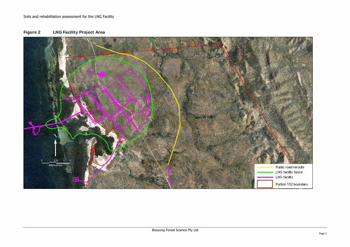
Figure 1 Project Overview – New and Existing........................................................................ 4 Figure 2 LNG Facility Project Area ......................................................................................... 5 Figure 3 Vegetation and soil sampling sites.......................................................................... 12 Figure 4 Distribution of potential acid sulfate soils within the LNG facility perimeter................. 14
TABLES
Table 5-1 Soil stability assessment .......................................................................................... 7 Table 6-1 Summary of the sample site characteristics............................................................. 13 Table 9-1 Assessment of significance matrix .......................................................................... 19 Table 9-2 Assessment of significance of impacts .................................................................... 20
PLATES
Plate 1 Seaward mangroves ............................................................................................. 10 Plate 2 Avicennia marina (mangrove) fringing associated (back) swamp............................... 10 Plate 3 Monsoonal forest on a beach ridge......................................................................... 11 Plate 4 Grassland with mangrove zones in the distance....................................................... 11 Plate 5 Surface crusting on a dispersive clay soil ................................................................ 16
Booyong Forest Science Pty Ltd Page iv

Soils and rehabilitation assessment for the LNG Facility 1 INTRODUCTION
This report presents the findings of the soil impact assessment and rehabilitation study for the Papua New Guinea Liquefied Natural Gas Project for Portion 152, near Port Moresby in Central Province. The study is based on a site assessment and desk based studies undertaken in April and May 2008.
1.1 PNG LNG PROJECT BACKGROUND
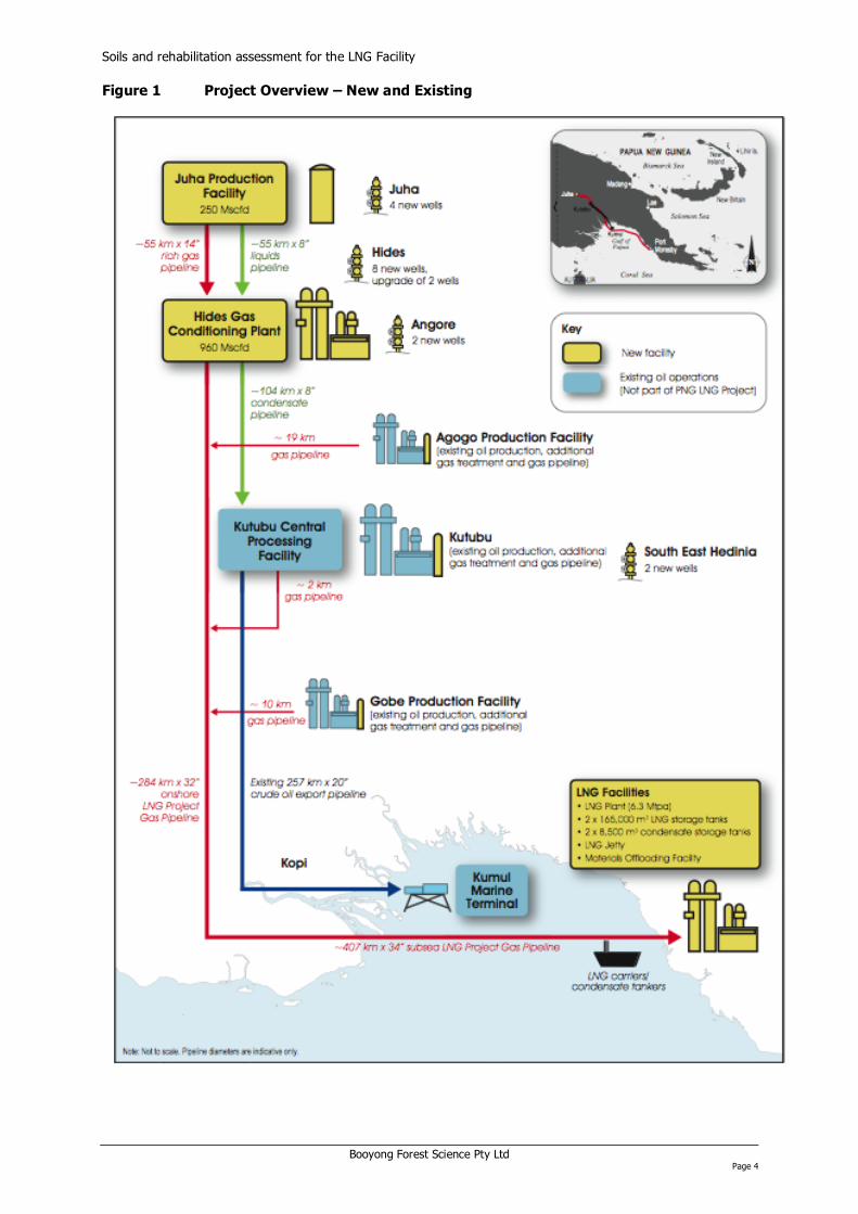
The Papua New Guinea Liquefied Natural Gas (PNG LNG) Project involves the development of a number of gas fields and facilities in a series of development phases to produce liquefied natural gas (LNG) for export. The development will also produce condensate. The development of the Hides, Angore, and Juha gas fields and blowdown of the gas caps at the existing Kutubu, Agogo and Gobe oil fields will supply the gas resources. An extensive onshore and offshore pipeline network will enable transportation of the gas to a new LNG Plant near Port Moresby and stabilised condensate to the existing oil processing and storage, and offloading facilities at the Kutubu Central Processing Facility and Kumul Marine Terminal respectively. Small amounts of condensate are also produced at the LNG Facilities site.
Esso Highlands Limited (Esso), a Papua New Guinea subsidiary of the Exxon Mobil Corporation (ExxonMobil), is the operator of the PNG LNG Project. The PNG LNG Project will be developed in five phases over a period of 10 years to ensure reliability and consistent quality of supply of LNG for over the 30 year life of the project.
A list of the proposed developments is provided below, and Figure 1 shows a schematic of facilities and pipelines:
Upstream Development Components:
• Hides gas field development:
⎯ Seven wellpads with a total of eight new wells and re-completion of two existing wells; ⎯ Hides gathering system including gas flowlines from new and re-completed Hides wells; ⎯ Hides spineline and mono-ethylene glycol (MEG) Pipeline in the same right of way (ROW); ⎯ Hides Gas Conditioning Plant; and ⎯ Hides–Kutubu Condensate Pipeline in the same ROW as the LNG Project Gas Pipeline.
• Juha gas field development:
⎯ Three new wellpads with four new wells; ⎯ Juha gathering system including gas flowlines from new Juha wells; ⎯ Juha spinelines and MEG Pipeline in the same ROWs; ⎯ Juha Production Facility; and ⎯ Juha–Hides pipelines right of way (ROW) containing three pipelines including Juha–Hides Rich
Gas Pipeline, Juha–Hides Liquids Pipeline and Hides–Juha MEG Pipeline.
• Angore gas field development:
⎯ Two new wellpads with two new wells; ⎯ Angore gathering system including gas flowlines from new Angore wells; and ⎯ Angore spineline and Angore MEG Pipeline to Hides Gas Conditioning Plant, both in the same
ROW.
• Gas from existing fields:
⎯ Gas treatment at the Agogo Production Facility and a new Agogo Gas Pipeline from the Agogo Production Facility to LNG Project Gas Pipeline;
⎯ Gas treatment at the Gobe Production Facility and a new Gobe Gas Pipeline from the Gobe Production Facility to LNG Project Gas Pipeline;
⎯ Gas treatment at the Kutubu Central Processing Facility and a new Kutubu Gas Pipeline from the Kutubu Central Processing Facility to the LNG Project Gas Pipeline; and
⎯ South East Hedinia gas field development: one new wellpad and two new wells; new gathering system including gas flow lines from the South East Hedinia new wells to the Kutubu Central Processing Facility in the same ROW as the Kutubu Gas Pipeline.
• Kopi scraper station.
Booyong Forest Science Pty Ltd Page 1

Soils and rehabilitation assessment for the LNG Facility
• LNG Project Gas Pipeline:
⎯ Onshore: from Hides Gas Conditioning Plant to Omati River Landfall; and ⎯ Offshore: Omati River Landfall to Caution Bay Landfall.
LNG Facilities Development Components:
• Onshore LNG Plant including gas processing and liquefaction trains, storage tanks, flare system and utilities; and
• Marine facilities including jetty, LNG and condensate export berths, materials offloading facility and tug moorage.
Supporting Facilities and Infrastructure:
In addition to the principal gas production, processing and transport, and LNG production and export facilities, the project will involve the following permanent infrastructure and facilities:
• New roads and upgrade of existing roads; • New bridges and upgrade of existing bridges; • Upgrade of two existing airfields (upstream at Komo and Tari); • New helipads (multiple); • New wharf and an upgrade of the existing Kopi roll-on, roll-off facility; • Water supply systems and pipelines, wastewater and waste management facilities; and • Operations Camps (at Hides, Juha and Tari).
A series of temporary works and access roads will also be required during the construction phase, including:
• Construction camps (multiple); and • Material/pipe laydown areas.
2 OBJECTIVES
Within the terms of engagement with Coffey Natural Systems, the scope of this study focuses on the area proposed for construction of the LNG facility at Portion 152 (Figure 2).
The objectives of this study are:
• Review existing information (reports, geological maps, aerial photography, databases etc.) to characterise landform, soils and vegetation in the study area;
• Conduct a field survey to identify significant landform features, vegetation types and problematic soils;
• Assess the potential impacts on landforms, soils and vegetation associated with the project activities; and
• Provide advice on measures to avoid, reduce or mitigate adverse impacts on landform, soils and vegetation during project construction and operation, including suitable rehabilitation techniques for the areas to be disturbed.
3 LIMITATIONS
The findings throughout this report are based on a restricted field sampling program. At the time of survey the site was being checked for UXO’s (Unexploded Ordnance) and clearance to access the majority of the LNG facility site was not available. Consequently, sampling was primarily conducted adjacent to the LNG facility site along a transect of comparable landforms, soils and associated vegetation.
4 APPROACH
To characterise the soils, landforms, and vegetation and to determine the best strategy for rehabilitation the following tasks were undertaken:
Booyong Forest Science Pty Ltd Page 2

Soils and rehabilitation assessment for the LNG Facility
• Field survey and a desk based study to identify and characterise landform features, soils and associated vegetation, and their response to disturbance for the LNG facility site; and
• Development of mitigation and rehabilitation recommendations based on the specific characteristics of the landforms, soils and vegetation of the LNG facility site.
Booyong Forest Science Pty Ltd Page 3
Soils and rehabilitation assessment for the LNG Facility
Booyong Forest Science Pty Ltd Page 4
Figure 1 Project Overview – New and Existing
on assessment for the LNG Facility
Booyong Forest Science Pty Ltd Page 5
Figure 2 LNG Facility Project Area
Soils and rehabilitati
Soils and rehabilitation assessment for the LNG Facility 5 FIELD ASSESSMENT
To determine the LNG facility site’s baseline characteristics, in April 2008 representative landforms, soils, and vegetation were assessed. Sampling was stratified based on aerial imagery, the existing geomorphology and vegetation mapping (Loffler 1974; Saunders 1993), and geotechnical studies (Golder 2007). Based on these information sources the following landforms were used as the primary basis to stratify the sampling.
• Seaward swamp (mangroves);
• Beach ridge;
• Back swamp;
• Clay plains; and
• Small hills/terraces.
5.1 VEGETATION
For each landform representative areas of the vegetation were sampled. If different vegetation types occurred across a particular landform each major vegetation type was sampled. For each sample site a brief description was made of the main plant species from the ground layer to canopy trees, if present.
5.2 SOILS
The soil assessment involved soil profile descriptions, analysis of selected soils for baseline fertility properties, testing for acid sulfate soils (ASS) for selected coastal swamps, and soil stability testing. At each of the vegetation sample sites soil profile descriptions were made based on extracting an auger core to up to 1 m depth in 20 cm increments. A brief profile description was made describing the horizons, field texture, and field pH. This data was compiled into representative site description and soil profile data sheets.
For each sample point soil samples were collected for laboratory analysis of baseline fertility properties. An Edelman Auger was used to collect soil samples from eight locations from a site within approximately 5 m of the soil profile description sample point. Each composite sample was thoroughly mixed in a clean 20 litre bucket, having removed any surface plant litter. A sub sample of approximately 0.5 kg was collected. Soil samples were dried at 80oC for 48 hours prior to dispatch for analysis. The soil samples were analysed for the following baseline properties at Southern Cross University Environmental Analysis Laboratory: (pH water (1:5 w/v), total phosphorous (P), total nitrogen (N) (Kjehldahl), total carbon C (Walkley-Black), exchangeable bases Calcium (Ca), Magnesium (Mg), Potassium (K), Sodium (Na), cation exchange capacity (CEC) (NH4Oac pH 7), available nutrients (Ca, Mg, K) (Morgan 1 extract), available P ( Morgan 1 extract, Bray 1, Bray 2), and the micronutrients Zinc (Zn), Manganese (Mn), Iron (Fe), Copper (Cu) and Boron (B).
The ASS samples were collected from areas with high ASS potential1 in two separate sampling trips. Soils were sampled to 2 m depth or until refusal, with samples taken every 50 cm from each core at 40-60 cm, 90-100 cm etc. Samples were placed in an esky with freezer packs to keep cool and then frozen in a domestic freezer within a few hours of sampling. Samples from the first collection were dried at 80oC for 48 hours before dispatch to the Southern Cross University Environmental Analysis laboratory. Samples from the second batch were freighted frozen for analysis by the ALS Laboratory Group in Stafford, Queensland.
An important procedure for sampling ASS is to ensure that the soil samples are not exposed to oxidising conditions while wet. Cooling the samples followed by freezing prevents oxidation provided soils are frozen within a few hours of field sampling. Both sets of samples was analysed by SPOCAS method 23 (i.e., Suspension Peroxide Oxidation Combined Acidity & sulfate) and 'Chromium Reducible Sulphur' technique (Ahern, McElnea et al. 2004).
Soil stability was assessed using the Aggregate Stability in Water Test (ASWAT). This test provides an indication of which soils may be most susceptible to erosion by assessing the stability of natural soil
1 Areas with high ASS potential typically occur in low lying and waterlogged areas (estuaries and mangrove soils) < 5 m above sea level. The anaerobic conditions result in a reducing environment ideal for the build up of the mineral iron pyrite FeS2. ASS can also occur at higher altitudes in waterlogged soils where sulphur and iron are available to reducing bacteria.
Booyong Forest Science Pty Ltd Page 6
Soils and rehabilitation assessment for the LNG Facility fragments to rapid wetting (Tongway and Hindley 2004). Small fragments (approximately 1 cm diameter) of representative soils horizons were air dried and then gently lowered into a dish of rain water. The stability of each fragment was then scored based on the descriptions in Table 5-1.
Table 5-1 Soil stability assessment
Observed behaviour Class Interpretation
0 No coherent fragments available e.g. sand
Very unstable 1 Fragment collapses in less then 5 seconds
Unstable 2 Fragment substantially collapses 5-10 seconds; a thin surface crust remains.
> 50% of the sub-crust material slumps
Moderately stable 3 Surface crust remains intact with some slumping of the sub-crust but less then 50%
Very stable 4 Whole fragment remains intact with no swelling
6 LNG FACILITY SITE CHARACTERISTICS
This section presents a review of the LNG facility site characteristics based on a review of literature, aerial imagery and mapping. The proposed site of the LNG plant is located on the coast approximately 20 km north-west of Port Moresby in Central Province, within Portion 152. The main impact area is approximately 810 ha which is the area bounded by the LNG facility fence line in Figure 2. The site was previously used as a cattle grazing property known as Fairfax Station and is presumed to have been heavily modified from its original condition (e.g., vegetation cover). The physiography of the site comprises a coastal strip of mangroves 100 to 200 m width. The mangroves appear to follow the Vaihua River for about 1500 m eastwards into the site. Immediately behind the mangroves are beach ridges and associated swamps which are subject to tidal inundation. Behind the swamps the land rises gently into savanna grassland vegetation. Further inland eucalypt savanna (open woodland) occurs on low lying hills.
The seaward mangroves and associated swamps are underlain by limestone associated with reef flats. There is some uncertainty over the geology of the interior of the site, however the inland portion of the site is either underlain by the Siro Conglomerate which is part of the Mt Cameron Volcanic Complex, or comprises the Fairfax unit of the Port Moresby Beds. The Fairfax unit is described as tuffaceous sandstone, micrite and bioclastic calcarentite of Middle Miocene age (Golder 2007).
The coastal strip comprises littoral (coastal) and fluviatile (transported by water) deposits comprising gravel, sand, silt and clay. The coastal mangrove soils are continuously waterlogged, consisting of silt or clay rich sedimentary layers with a high content of finely dispersed organic matter commonly intermixed with thin organic layers. Upon drying, whether by natural processes or drainage, these soils are expected to become strongly acidified (pH 3.5 or less) due to the oxidation of sulphides present in the sediment (Bleeker 1983). The sandy soils of the beach ridge comprise thick, poorly graded sands containing shell fragments. On stable surfaces they can have a thick dark topsoil (Bleeker 1983). The soils of the inland are predominantly formed from the deposition of slope wash resulting in black cracking clays over much of the site. Black cracking clay plains are prevalent in the north-west of the site.
The vegetation of the site has been mapped by Paijmans (1975) and then remapped using the same imagery by Saunders (1993). The original mapping describes the area as eucalypt savanna and grassland (Paijmans 1975), but does not identify the fringing mangroves. Eucalypt savanna in PNG is defined as moderately dense trees over a ground layer of grasses that occurs on a variety of landforms, mainly in low rainfall areas with a marked dry season (Paijmans 1975). Grasslands in PNG occur on permanently dry to periodically inundated terrain over a wide range of land forms, soils and climatic conditions. They are largely man-made and maintained by regular burning (Paijmans 1975). The later mapping reclassified the area as mangrove and non-forested area (Saunders 1993).
The climate of the Port Moresby area is seasonal with a dry season from May to October when the southeast trade winds prevail, with wet monsoonal winds from December to March (McAlpine, Keig et
Booyong Forest Science Pty Ltd Page 7

Soils and rehabilitation assessment for the LNG Facility al. 1983). The highest rainfall occurs in January, February and March (192, 140 and 189 mm respectively). Port Moresby has a mean annual rainfall of 1214 mm, which can drop below 1000 m in a drought year. The coolest month is July when the mean daily maximum and minimum are 22.9 oC and 22.4oC respectively. The warmest month is November when the mean daily maximum and minimum are 32.5 oC and 23.6oC respectively (WMO 2008).
7 FIELD FINDINGS
The site characteristics identified from the existing mapping and aerial images were verified during the field visit based on several sample points (Figure 3). Representative site descriptions for each sample point are provided in Appendix A. Notable features of the coastal fringe were the mangroves, beach ridges, a narrow band of monsoonal forest (< 50 m width), and associated swamps. Eastwards from the coastal strip the site was dominated by grasslands with remnant eucalypt savanna, and occasional isolated trees that may represent monsoonal forest remnants in the wetter areas. Representative site descriptions for each sample site are provided in Appendix B, and a summary is provided in Table 7-1.
7.1 VEGETATION
The following vegetation types were verified during the field visit:
• Seaward mangroves dominated by Rhizophora sp. and Bruguiera sp.(Plate 1);
• Back swamp mangroves dominated by Avicennia marina (Plate 2); • Grasslands of the beach ridge;
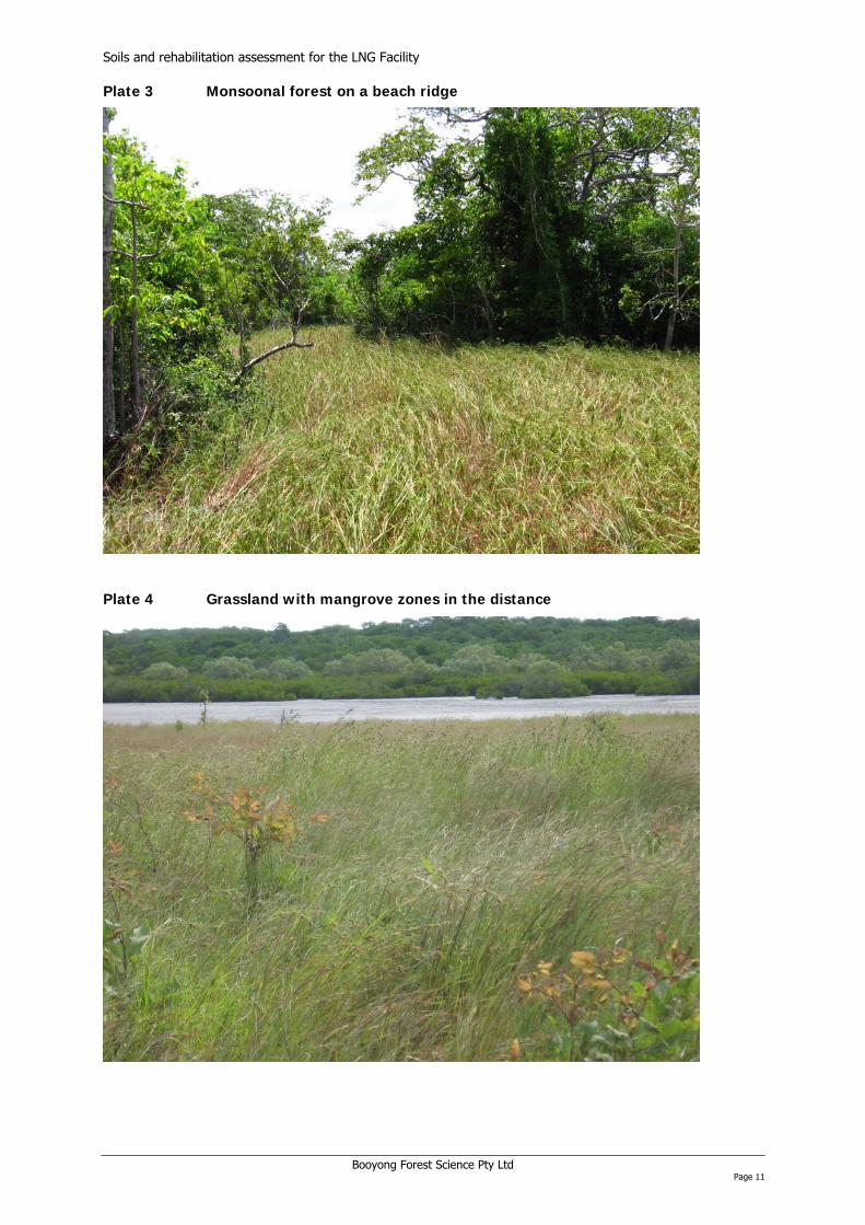
• Monsoonal forest on beach ridges (Plate 3);
• Riparian vegetation areas;
• Grasslands(Plate 4); and
• Remnant eucalypt savanna.
The mangroves showed a distinct zonation, with different species occupying different areas of the coastal swamp environment. The zonation is controlled by the interaction of tidal flooding, salinity of the soil and the drainage of the soil (Percival and Womersley 1975), which typically varies from site to site. The most seaward mangroves were dominated by mature stilt-root mangrove (Rhizophora sp.) and to a lesser extent B uguiera sp. Rhizophora species are more tolerant of salt water, while Bruguiera species generally prefer less saline conditions and are more common on the margins.
r
The swamp fringes are generally dominated by the Grey Mangrove (Avicennia marina). This species is a pioneering species which colonises new mud banks and the most seaward margin, but also typically establishes on stable sites as a narrow strip along creek fringes.
Behind the mangroves on the narrow beach ridge a strip of fragmented monsoonal forest interspersed with grasslands occurs. Monsoonal forest is typical of areas with a markedly seasonal climate and is characterised by a number of deciduous species. Typical dominant tree genera may include Bombax, Erythrina, Pterygota, Tetrameles, Garuga, Albizia and Terminalia. Monsoonal forest is considered susceptible to fire in areas with less than 2600 mm annual rainfall and several consecutive months of less than 100 mm (Paijmans 1976), which may explain its patchy distribution along the beach ridge and the occurrence of the associated grasslands. The grassy patches on the beach ridges were dominated by kangaroo grass (Themeda sp).
Inland the vegetation was dominated by grasslands with extensive swards of black spear grass (Heteropogon contortus) with patches of kangaroo grass widespread. The grasslands are subject to annual burning. These areas may have been previously dominated by eucalypt savanna prior to cattle grazing and the annual fire regime. Occasional remnant Eucalyptus species occur, particularly on hilly terrain towards the east. Common Eucalyptus species that may occur on the hills include E. alba, E. confertiflora, Corymbia papuana, and E. teteticornis (Paijmans 1976).
7.2 SOILS
The soils across the site comprise two main soil orders, Entisols and Vertisols. Entisols form in the swamps and beach areas and are typically very young soils, with little or no profile except for a thin humic surface horizon. Vertisols, which occur away from the coastal strip are characteristic of areas with low and very seasonal rainfall and are usually found on calcareous rocks such as limestone and shale, and alluvial or colluvial deposits (Bleeker 1983). They are uniformly textured soils with high
Booyong Forest Science Pty Ltd Page 8

Soils and rehabilitation assessment for the LNG Facility clay content and very slow permeability, shrinking and cracking on a seasonal cycle associated with wetting and drying. They are often known as black cracking clays.
Booyong Forest Science Pty Ltd Page 9

Soils and rehabilitation assessment for the LNG Facility Plate 1 Seaward mangroves
Plate 2 Avicennia marina (mangrove) fringing associated (back) swamp
Booyong Forest Science Pty Ltd Page 10
Soils and rehabilitation assessment for the LNG Facility
Booyong Forest Science Pty Ltd Page 11
Plate 4 Grassland with mangrove zones in the distance
Plate 3 Monsoonal forest on a beach ridge

on assessment for the LNG Facility
Booyong Forest Science Pty Ltd Page 12
Figure 3 Vegetation and soil sampling sites
Soils and rehabilitati

Soils and rehabilitation assessment for the LNG Facility
Booyong Forest Science Pty Ltd Page 13
Based on the ASWAT test, all of the soils tested were unstable suggesting they are susceptible to erosion if exposed to high rainfall events. However, the sandy soils will have a high porosity reducing their susceptibility to erosion. The black cracking clays may also be dispersive2, which can be eroded rapidly if exposed, even by relatively slow moving water. These clays typically have a high proportion of their cation exchange sites occupied by sodium (sodic soils) causing the clays to swell and disperse, although sample P8 taken from a clay plain did not have exceptionally high sodium (Appendix B). Black cracking clays are regarded as having the highest erodibility risk of all PNG soils (Bleeker 1983).
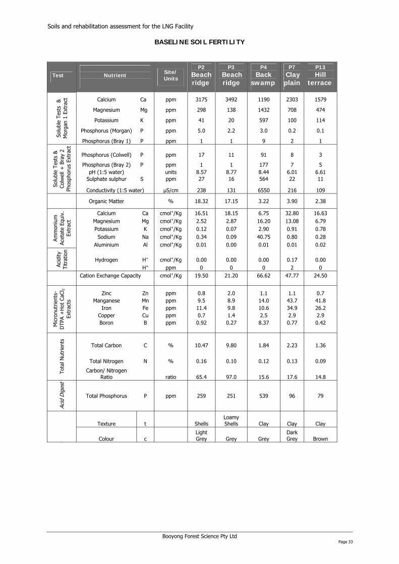
The baseline soil fertility results (Appendix B) highlighted differences in nutrient concentrations between soils, particularly between the sandy soils along the beach ridge and the clay soils further inland. For example the cation exchange capacity, which is partly a measure of soil fertility was much higher for the clay plain soil compared to the sandy soils. Conversely available phosphorous which is an important plant nutrient was higher in the sandy soils (P2 and P3). The sandy soils and in particular the back swamp soil (P4) had much higher levels of calcium reflecting the presence of shell fragments and limestone from coral in the surface horizon (top 20 cm). Levels of micronutrients also varied, with higher levels in the clay and swamp soils. The variation in baseline soil fertility amongst the soils reflects differences in the parent material, soil formation processes and the ages of the soils.
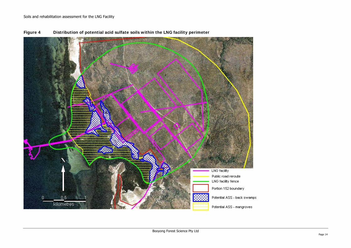
Other potentially problematic soils were the mangrove and back swamp soils (Entisols). Laboratory analysis confirmed that these soils were acid sulfate soils3 having high levels of chromium reducible sulphur, however, the soils also had a very high acid neutralising capacity (Appendix B) because of the high calcium carbonate content. The high neutralising capacity results in no net acidity, therefore the presence of ASS may not present a major constraint. The potential distribution of ASS soils associated with mangroves and back swamps within the LNG facility perimeter fence are mapped in Figure 4. It is also possible that ASS soils occur further inland, associated with permanently waterlogged areas and creeks, however soil samples BH4 and BH5 which were taken from inland sites did not meet the criteria for ASS based on the analysis results (Appendix B).
Table 7-1 Summary of the sample site characteristics
Site Location Landform Topo. Soil order Texture
Field pH Vegetation
Height ASL (m)
Topsoil depth Stability
P1 Coast Seaward swamp Flat Entisol - -
Rhizophera and Bruguiera mangroves
0 20 -
P2 Coast Beach ridge
Gentle slope Entisol Sand 8.5 Monsoonal
forest/grass 0 2 Unstable
P3 Coast Beach ridge
Gentle slope Entisol Sand 8.5 Grassland < 2 30 Unstable
P4 Inland Back swamp Flat Entisol Silty clay
9.0 - 9.5
Avicennia mangrove
< 1 40 Unstable
P7 Inland Cracking clay plain
Gentle slope Vertisol Clay 6.5 Grassland 9 10 Unstable
P13 Inland Hill/terrace Flat Vertisol Clay 7 Eucalypt savanna
8 8 Unstable
BH4 Inland Wet clay plain Flat Vertisol Clay - Grassland < 2 - -
BH5 Inland Wet clay plain Flat Vertisol Clay - Grassland < 2 - -
BH6 Inland Back swamp Flat Entisol Clay - None < 2 - -
- = not sampled/tested
2 Dispersive soils are soils that are structurally unstable and disperse in water into basic particles i.e. sand, silt and clay. Dispersible soils tend to be highly erodible and present problems for successfully managing earth works. 3 Classification of potential acid sulfate material is based on the level of chromium reducible sulphur (Scr) for different soil textures: coarse texture Scr≥ 0.03%S or 19mole H+/t; medium texture Scr ≥0.06%S or 37mole H+/t; fine texture Scr ≥0.1%S or 62mole H+/t).
on assessment for the LNG Facility
Booyong Forest Science Pty Ltd Page 14
Figure 4 Distribution of potential acid sulfate soils within the LNG facility perimeter
Soils and rehabilitati
Soils and rehabilitation assessment for the LNG Facility 8 IMPACTS
The potential impacts of construction will depend on a range of factors including the type, frequency and intensity of disturbance, the properties of the soils impacted (e.g. stability, porosity, ASS properties), the vegetation type impacted and its ability to naturally regenerate once disturbed, landscape position, the rainfall pattern, and the season. The potential impacts of the project are summarised in section 10. Characteristic types of impacts may include:
• Temporary clearance of vegetation;
• Clearance of all vegetation cover;
• Complete removal of vegetation and topsoil;
• Introduction of weeds; and
• Disturbance of acid sulfate soils.
These different types of impacts are discussed below.
8.1 TEMPORARY CLEARANCE OF VEGETATION
The potential impacts and response to temporary clearing of woody vegetation for the different vegetation types include:
Grasslands: The impact will depend on the method of clearance. A reduction in ground cover would be expected which will expose soils to erosion in the wet season. Weed invasion may also occur. Impacts may be higher on sloping ground where exposed potentially dispersive clay soils will be more susceptible to erosion. Soil compaction may also occur reducing infiltration and promoting runoff.
Eucalypt savanna: The impact will depend on the method of clearance. Trees felled with a chainsaw may regenerate from suckers or lignotubers. Bulldozing may also stimulate suckering depending on the species, but may result in permanent loss of remnant Eucalyptus species if roots are removed. The ability of Eucalyptus species in Australia to re-establish from suckers is well known (Florence 1996), and although there is a lack of information about PNG Eucalyptus species it is likely that they will exhibit the same response. No erosion of the soil will occur provided the grass layer ground cover remains intact. However, soil compaction may occur. If the grass layer is also impacted impacts noted above may occur.
Mangroves: Temporarily clearing mangroves may stimulate growth of established seedlings in response to the opening up of the canopy. Little erosion will occur unless the mangrove sediments are disturbed and the roots removed.
Beach ridge grasslands: Disturbance to the beach ridge is likely to damage the unstable topsoil. The original vegetation may be slow to re-establish where topsoil has been lost or heavily disturbed.
Monsoonal forest: Monsoonal forests are likely to be sensitive to disturbance because of the sandy and thin topsoil which may be readily lost if exposed to erosive rainfall events. If the fertile topsoil is lost the vegetation is unlikely to recover without active rehabilitation.
8.2 COMPLETE REMOVAL OF VEGETATION
The impacts of the complete removal of vegetation will partly depend on the season, and are likely to be greater in the wet season where soils are exposed to erosive rainfall. The potential impacts and response to the complete removal of vegetation, including the ground layer for the different vegetation types include:
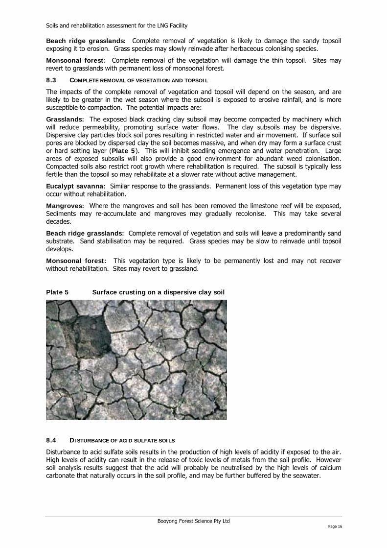
Grasslands: Erosion of the black cracking clays is likely in the wet season, particularly if they are dispersive. Dispersive clay particles block soil pores resulting in restricted water and air movement. If surface soil pores are blocked by dispersed clay, the soil becomes massive and when dry may form a surface crust or hard setting layer (Plate 5). Erosion will also result in the loss of topsoil and reduced fertility. The exposed soil may be recolonised by weeds impeding the reestablishment of the original vegetation cover. On sloping sites high rates of runoff may cause increased erosion. .
Eucalypt savanna: Similar response to the grasslands, but the Eucalyptus species may be permanently lost without active rehabilitation.
Mangroves: Cleared mangroves may regenerate from established seedlings and new seed. It may take several decades for the mangroves to return to their pre disturbance state.
Booyong Forest Science Pty Ltd Page 15
Soils and rehabilitation assessment for the LNG Facility Beach ridge grasslands: Complete removal of vegetation is likely to damage the sandy topsoil exposing it to erosion. Grass species may slowly reinvade after herbaceous colonising species.
Monsoonal forest: Complete removal of the vegetation will damage the thin topsoil. Sites may revert to grasslands with permanent loss of monsoonal forest.
8.3 COMPLETE REMOVAL OF VEGETATION AND TOPSOIL
The impacts of the complete removal of vegetation and topsoil will depend on the season, and are likely to be greater in the wet season where the subsoil is exposed to erosive rainfall, and is more susceptible to compaction. The potential impacts are:
Grasslands: The exposed black cracking clay subsoil may become compacted by machinery which will reduce permeability, promoting surface water flows. The clay subsoils may be dispersive. Dispersive clay particles block soil pores resulting in restricted water and air movement. If surface soil pores are blocked by dispersed clay the soil becomes massive, and when dry may form a surface crust or hard setting layer (Plate 5). This will inhibit seedling emergence and water penetration. Large areas of exposed subsoils will also provide a good environment for abundant weed colonisation. Compacted soils also restrict root growth where rehabilitation is required. The subsoil is typically less fertile than the topsoil so may rehabilitate at a slower rate without active management.
Eucalypt savanna: Similar response to the grasslands. Permanent loss of this vegetation type may occur without rehabilitation.
Mangroves: Where the mangroves and soil has been removed the limestone reef will be exposed, Sediments may re-accumulate and mangroves may gradually recolonise. This may take several decades.
Beach ridge grasslands: Complete removal of vegetation and soils will leave a predominantly sand substrate. Sand stabilisation may be required. Grass species may be slow to reinvade until topsoil develops.
Monsoonal forest: This vegetation type is likely to be permanently lost and may not recover without rehabilitation. Sites may revert to grassland.
Plate 5 Surface crusting on a dispersive clay soil
8.4 DISTURBANCE OF ACID SULFATE SOILS
Disturbance to acid sulfate soils results in the production of high levels of acidity if exposed to the air. High levels of acidity can result in the release of toxic levels of metals from the soil profile. However soil analysis results suggest that the acid will probably be neutralised by the high levels of calcium carbonate that naturally occurs in the soil profile, and may be further buffered by the seawater.
Booyong Forest Science Pty Ltd Page 16
Soils and rehabilitation assessment for the LNG Facility 9 RECOMMENDATIONS FOR MITIGATION AND REHABILITATION
For all areas potentially impacted the main mitigation recommendation is to minimise the area to be disturbed, where feasible. This will reduce the immediate impact, increase the possibility of successful and rapid rehabilitation and reduce residual impacts. A weed management plan incorporating the use of a wash down facility to mitigate potential weed impacts should also be considered since weeds can be a major impediment. Careful planning and good control of activities to designated construction areas only will also be required to minimise impacts.
For areas that require rehabilitation it is important to have a clear statement of the rehabilitation objectives prior to implementation. The objectives will determine the technical requirements of the rehabilitation and its feasibility for the various landform soil and vegetation complexes across the site. Typically the primary objective of rehabilitation programs is to return a site to a floristic diversity and structure similar or comparable to the undisturbed site, where different ecosystem components are functioning in a manner that will self-sustain the system (e.g. nutrient cycling, seed dispersal, and regeneration etc.). This may be applicable to areas which have been temporarily disturbed and/or cleared.
9.1 SIGNIFICANT FEATURES
A rehabilitation plan will be required specific to each vegetation community and soil type. It is important that generic rehabilitation procedures are not applied because of the marked differences across the site.
Grasslands and eucalypt savanna
The main mitigation measure is to minimise damage to top soil by reducing vehicle tracks and lay down area impacts outside of the main construction sites. For rehabilitation, procedures for rehabilitating grass land communities on black cracking clays have been developed for coal spoil areas in Central Queensland, Australia. Key components of the procedure include stripping topsoil and subsoil which are stored separately. The layers are then replaced in sequence. It is critical that subsoil is not mixed with the topsoil. Rehabilitation failure may result if this occurs. Both the stripping and the replacement of the soil layers should ideally be undertaken in the dry season. Handling stripped soils in the wet season can result in damage to the soil structure and compaction, which will reduce infiltration and deplete the soil seed bank. High plasticity clays will be especially difficult to work when wet. Ripping may be required where soil compaction has occurred.
Seed should also be harvested from Eucalyptus species local to the area for revegetation programs. These can be used to propagate new seedlings and or used in direct seeding programs together with native grass seed. Eucalyptus seed requires careful handling, and storage in a cold room to maintain seed viability. The use of a fast growing sterile hybrid to quickly establish a ground cover also warrants consideration for rehabilitation areas. Exotic seed other than sterile hybrids should not be used.
A fire management plan may be needed for rehabilitation areas of the eucalypt savanna until it has successfully established. Although Eucalyptus species are adapted to fire, seedlings can be killed by fire until they are taller than the fire flame height.
Monsoonal forest/vine thicket
The key component to rehabilitate the monsoonal forest patches will be to protect the fragile and skeletal topsoil so that species can regenerate from the soil seed bank. Where cleared, the topsoil should be salvaged and reapplied. Planting, weed control, and mulching with a sterile medium may be required to promote a rapid canopy cover of native species.
Mangroves
Apart from the clearing of vegetation for the construction of the causeway the impacts may be relatively minor. The proposed causeway crosses mudflats, a relatively narrow mangrove fringe, and a fringing reef. The direction of the causeway is unlikely to cause major erosion unless there are strong currents parallel to the shoreline. However some erosion may occur adjacent to the solid earthen causeway where it passes through the mangroves. If erosion occurs mangroves may be permanently lost adjacent to the causeway, given the relatively thin veneer of fine sediments (0.5 – 2 m deep). Where mangroves are temporarily cleared natural regeneration may occur. If widely spaced seed trees can be left natural regeneration may be more rapid. Where natural regeneration is
Booyong Forest Science Pty Ltd Page 17

Soils and rehabilitation assessment for the LNG Facility inadequate replanting should occur. Mangroves may take decades to mature because of slow growth rates.
10 IMPACT SIGNIFICANCE
10.1 IMPACT ASSESSMENT METHOD
Assessment of the significance of the impacts is based on an adaptation of the approach used for the PNG Gas Project. The assessment presumes the implementation of the recommended mitigation and rehabilitation measures. The final assessment of significance focuses on the impact on soils and vegetation which is primarily related to their ability to be rehabilitated, the inputs required and the time that a rehabilitated area may take to return to a state similar to its baseline condition. The assessment does not consider biodiversity issues or other regional values. Criteria for the assessment of the significance of impacts are as follows:
10.1.1 Magnitude of impact
This considers the degree of change from the existing situation as a result of the impact and the ability of the site to be rehabilitated. A vegetation type that could not be readily rehabilitated without high inputs would rate as a High impact.
Low:
• Small change from the existing situation. E.g. temporary clearance of vegetation that will rapidly recover by natural processes. Low risk of soil erosion.
Medium:
• Large change from the pre disturbance state but can be readily rehabilitated with low to moderate inputs. Medium risk of soil erosion due to the presence of unstable or dispersive soils.
High:
• Major change in the environment that will potentially require significant mitigation and rehabilitation inputs. Problematic soils may occur which require careful management, e.g., erosion prone soils in a climate with high rainfall erosivity.
10.1.2 Sensitivity of the resource/receptor
Low:
• Vegetation can recover relatively rapidly from disturbance by natural processes (e.g., regeneration) or by limited rehabilitation measures; and
• Soils are not erosion prone if exposed and have no major adverse properties.
Medium:
• Vegetation has some capacity to regenerate if severely disturbed, e.g. from established seedlings or seed rain. Vegetation is not restricted in its distribution. Recovery may take decades; and
• Skeletal soils that may be unstable and relatively easily disturbed. E.g., sandy soils of beach ridges.
High:
• Vegetation is sensitive to disturbance, has a limited capacity to regenerate from a soil seed bank, and may be naturally confined to a narrow niche (restricted habitat). Recovery may take decades. Sensitive to other disturbances such as fire and invasive weeds; and
• Soils have adverse properties if disturbed e.g. problematic ASS properties, unstable soils and or dispersive soils.
10.1.3 Temporal scale of residual impact:
• Very short : Residual impacts lasting < 3 years;
• Short term: Residual impacts lasting between3 and 7 years;
Booyong Forest Science Pty Ltd Page 18
Soils and rehabilitation assessment for the LNG Facility
Booyong Forest Science Pty Ltd Page 19
• Medium term: Residual impacts lasting between 7 years and 25 years; and
• Long term: Residual impacts lasting more than 25 years.
10.1.4 Spatial scale of residual impact:
• Very limited: Restricted to immediate environs of an impact location, and extending to a radius of less than 200 m;
• Limited: Immediate environs of an impact location and extending to a radius of between 200 m and 2 km;
• Local: Generally occurring within a radius of between 2 and 10 km from an impact location and
• Regional: Generally occurring over a large area that extends to a radius of more than 10 km from the impact location.
10.1.5 Overall magnitude of impact
The overall magnitude of the impact considers the intensity, scale and time frame for an impacted area to recover. In addition the magnitude of impact may be increased because of either a problematic soil type or a vegetation type that may be difficult to rehabilitate. If present, these features are noted in the table of assessment of significance of impacts.
• Very High (VH): Impact likely to have large impact on vegetation and soils and will be difficult to rehabilitate. Impacts are large scale (1000s ha) or impacts a vegetation type with a restricted distribution. Recovery, if possible, is likely to take more than 25 years;
• High (H): Effect likely to have severe negative impact on vegetation and soils requiring high inputs to rehabilitate. Impacts occur over 100s ha. Recovery, if possible may take up to 25 years;
• Medium (M): Effect will be detectable but not severe. Impacts occur over 10s – 100s of ha, or smaller if a vegetation type with a restricted distribution is impacted (e.g., mangroves and monsoonal forest. Low inputs are required for rehabilitation. Recovery time takes up to 15 years;
• Low (L): Effect may be detectable but is small and highly unlikely to have any significance. Rapid recovery will occur from natural processes such as natural regeneration. Effects immediate surrounds of impact. Recovery is short term, up to 3 years;
• Negligible (N): Impact unlikely to be detectable; and
• Positive (P): Change is likely to benefit the population, community or ecosystem.
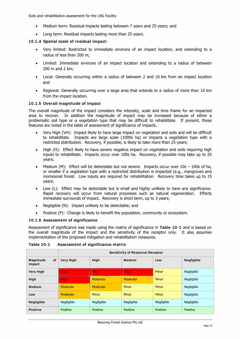
10.1.6 Assessment of significance
Assessment of significance was made using the matrix of significance in Table 10-1 and is based on the overall magnitude of the impact and the sensitivity of the receptor only. It also assumes implementation of the proposed mitigation and rehabilitation measures.
Table 10-1 Assessment of significance matrix
Sensitivity of Resource/Receptor
Magnitude of impact
Very High High Medium Low Negligible
Very High Major Major Major Minor Negligible
High Major Moderate Moderate Minor Negligible
Medium Moderate Moderate Minor Minor Negligible
Low Moderate Minor Minor Minor Negligible
Negligible Negligible Negligible Negligible Negligible Negligible
Positive Positive Positive Positive Positive Positive

Soils and rehabilitation assessment for the LNG Facility
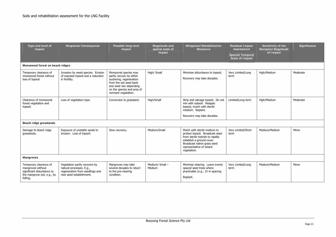
Table 10-2 Assessment of significance of impacts
Type and level of impact
Response/Consequence Possible long term impact
Magnitude and spatial scale of
impact
Mitigation/Rehabilitation Measures
Residual Impact Assessment
Spatial/Temporal Scale of Impact
Sensitivity of the Receptor/Magnitude
of Impact
Significance
Grasslands and eucalypt savanna on black cracking clays
Temporary clearance of grassland for construction.
Loss of ground cover.
Invasion by weed species.
Erosion of potentially dispersive clay soils, blocking soil pores and forming a surface crust. Loss of topsoil and fertility. Compaction of topsoil and reduced fertility. Patchy recovery of grasslands.
Increased weeds. Reduced ground cover and exposure to erosion.
Patchy recovery of grasslands. Long term degradation and erosion.
Low/Medium Minimise damage to topsoil. Broadcast native seed or sterile exotic seed.
Mulch with sterile medium to protect topsoil.
Confine disturbance to dry season where possible.
Very Limited/Short term
Low-Medium/Low Minor-Moderate
The potential occurrence of dispersive clays increases the rating to moderate.
Temporary clearance of eucalypt savanna.
Loss of ground cover.
Invasion by weed species.
Erosion of potentially dispersive clay soils, blocking soil pores and forming a surface crust. Compaction of topsoil. Patchy recovery of grasslands. Eucalyptus species may recover by suckering if stems have been cut rather than grubbed out.
Grasslands may become dominant. Recovery of Eucalyptus species may take a few decades to return to the pre clearing state.
Medium/Medium If Eucalyptus species do not recover from suckering, collect seed from local trees, propagate seed and replant.
Protect any trees planted from fire for first few years.
Very Limited/Long term
Medium-High/Low-Medium
Minor-Moderate
The potential occurrence of dispersive clays and the time taken for Eucalyptus species to reach the pre clearing condition increases the rating to moderate.
Clearance of grassland/eucalypt savanna and topsoil.
Loss of vegetation cover. Exposure of potentially dispersive clay subsoil. Erosion of potentially dispersive clay soils, blocking soil pores and forming a surface crust. Reduction in fertility. Compaction of subsoil.
Patchy recovery of grasslands. Loss of Eucalyptus species without planting or seed input. Long term exposure of subsoil to erosion. Eucalyptus species may take a few decades to return to the pre clearing state.
Medium/Medium Strip and salvage topsoil. Do not mix with subsoil. Reapply topsoil with native seed mix, including Eucalyptus seed. Replant.
Compaction relief may be required.
Protect any trees planted from fire for first few years.
Very Limited/Long term
Medium-High/Medium Minor-Moderate
The potential occurrence of dispersive clays and the time taken for Eucalyptus species to reach the pre clearing condition increases the rating to moderate.
Booyong Forest Science Pty Ltd Page 20
Soils and rehabilitation assessment for the LNG Facility
Type and level of impact
Response/Consequence Possible long term impact
Magnitude and spatial scale of
impact
Mitigation/Rehabilitation Measures
Residual Impact Assessment
Spatial/Temporal Scale of Impact
Sensitivity of the Receptor/Magnitude
of Impact
Significance
Monsoonal forest on beach ridges
Temporary clearance of monsoonal forest without loss of topsoil.
Invasion by weed species. Erosion of exposed topsoil and a reduction in fertility.
Monsoonal species may partly recover by either suckering, regeneration from the soil seed bank and seed rain depending on the species and area of remnant vegetation.
High/ Small Minimise disturbance to topsoil.
Recovery may take decades.
Very Limited/Long term
High/Medium Moderate
Clearance of monsoonal forest vegetation and topsoil.
Loss of vegetation type. Conversion to grassland. High/Small Strip and salvage topsoil. Do not mix with subsoil. Reapply topsoil, mulch with sterile medium. Replant.
Recovery may take decades.
Limited/Long term High/Medium Moderate
Beach ridge grasslands
Damage to beach ridge grasslands.
Exposure of unstable sands to erosion. Loss of topsoil.
Slow recovery. Medium/Small Mulch with sterile medium to protect topsoil. Broadcast seed from sterile hybrids to rapidly establish a ground cover. Broadcast native grass seed representative of extant vegetation.
Very Limited/Short term
Medium/Medium Minor
Mangroves
Temporary clearance of mangroves without significant disturbance to the mangrove soil, e.g., by felling.
Vegetation partly recovers by natural processes. E.g., regeneration from seedlings and new seed establishment.
Mangroves may take several decades to return to the pre-clearing condition.
Medium/ Small – Medium
Minimise clearing. Leave evenly spaced seed trees where practicable (e.g., 15 m spacing.
Replant.
Very Limited/Long term
Medium/Medium Minor
Booyong Forest Science Pty Ltd Page 21
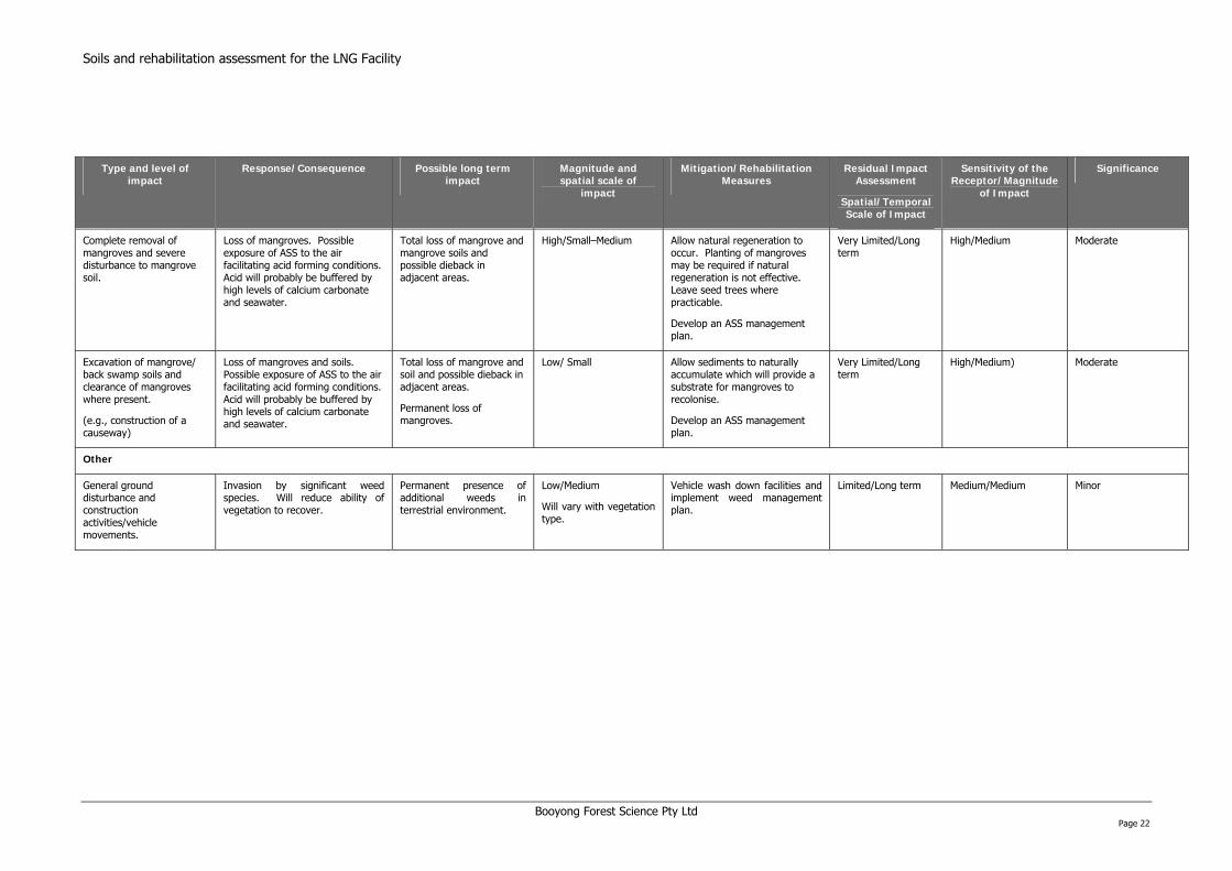
on assessment for the LNG Facility
Booyong Forest Science Pty Ltd Page 22
Type and level of impact
Response/Consequence Possible long term impact
Magnitude and spatial scale of
impact
Mitigation/Rehabilitation Measures
Residual Impact Assessment
Spatial/Temporal Scale of Impact
Sensitivity of the Receptor/Magnitude
of Impact
Significance
Complete removal of mangroves and severe disturbance to mangrove soil.
Loss of mangroves. Possible exposure of ASS to the air facilitating acid forming conditions. Acid will probably be buffered by high levels of calcium carbonate and seawater.
Total loss of mangrove and mangrove soils and possible dieback in adjacent areas.
High/Small–Medium Allow natural regeneration to occur. Planting of mangroves may be required if natural regeneration is not effective. Leave seed trees where practicable.
Develop an ASS management plan.
Very Limited/Long term
High/Medium Moderate
Excavation of mangrove/ back swamp soils and clearance of mangroves where present.
(e.g., construction of a causeway)
Loss of mangroves and soils. Possible exposure of ASS to the air facilitating acid forming conditions. Acid will probably be buffered by high levels of calcium carbonate and seawater.
Total loss of mangrove and soil and possible dieback in adjacent areas.
Permanent loss of mangroves.
Low/ Small Allow sediments to naturally accumulate which will provide a substrate for mangroves to recolonise.
Develop an ASS management plan.
Very Limited/Long term
High/Medium) Moderate
Other
General ground disturbance and construction activities/vehicle movements.
Invasion by significant weed species. Will reduce ability of vegetation to recover.
Permanent presence of additional weeds in terrestrial environment.
Low/Medium
Will vary with vegetation type.
Vehicle wash down facilities and implement weed management plan.
Limited/Long term Medium/Medium Minor
Soils and rehabilitati

Soils and rehabilitation assessment for the LNG Facility 11 CONCLUSIONS
The construction of the LNG facility will result in the clearance of at least 810 ha of land for construction purposes. The majority of the area impacted will be confined to modified grassland on cracking clay plains. Other land to be cleared includes mangroves, monsoonal forest and grassland on beach ridges, and eucalypt savanna. The exact area of these vegetation types to be impacted is not clear but is likely to be in the order of 10s of hectares in total. The majority of the cleared areas will be used for the construction of the LNG facility components and therefore not require rehabilitation. Smaller areas that have been temporarily cleared or modified are likely to require rehabilitation. It is not yet possible to determine the exact areas that will require rehabilitation.
The potentiation significance of the construction impacts ranges from minor to moderate, which reflects the ability of disturbed sites to be rehabilitated. Moderate impacts will potentially occur because of problematic soils (potentially dispersive clay, ASS soils, and fragile sandy soils), and sensitive woody vegetation types (e.g., mangroves, eucalypt savanna and monsoonal forest) which may require active rehabilitation, and may take decades to return to the baseline condition. The residual impacts on soils should be shorter lived provided exposed soils are protected from erosion, temporarily disturbed sites are rehabilitated promptly, and disturbance to ASS is managed according to an ASS management plan.
A clear and concise statement of what the projects mitigation and rehabilitation objectives are will be required to determine what mitigation and rehabilitation measures should be implemented. Rehabilitation objectives need to be defined by completion criteria, and a series of indicators by which completion can be assessed. This approach will help determine what is compliant, what is practicable, what is technically feasible and what has been successful.
12 RECOMMENDATIONS
The following presents a summary of the main recommendations:
• Clearly define the objectives of the rehabilitation;
• Rehabilitation prescriptions need to be targeted based on the characteristics of the soils and vegetation of the different landforms;
• Develop a landscaping plan which would include as a priority the regeneration of natural vegetation communities, as close to natural levels as possible through seed collection and/or use of topsoil as a seed resource;
• Where practicable confine land clearing to the dry season so that impacts on the terrestrial environment are reduced;
• Where practicable top soil should be stripped and salvaged and the original landform and vegetation type recorded;
• Stripped topsoil must be kept separate from subsoil and should be used in the landscaping plan;
• Where practicable exposed subsoils (primarily in the monsoonal forest strip) should be mulched with a sterile medium to protect the soil seed bank resource;
• Where sub soils have been compacted compaction relief should be applied for the purposes of rehabilitation;
• Any areas replanted with woody vegetation need to be protected from fire for the first few years;
• Cleared mangroves should be replanted where possible;
• Sand stabilisation measures should be implemented where the beach ridge zone is impacted;
• The development of an acid sulphate soil management plan warrants consideration; and
• The development of a weed management plan incorporating wash down facilities warrants consideration.
Booyong Forest Science Pty Ltd Page 23
Soils and rehabilitation assessment for the LNG Facility 13 REFERENCES
Ahern, C. R., A. E. McElnea, and Sullivan, L.A. (2004). Acid Sulfate Soils Laboratory Methods Guidelines. DNRME. Bleeker, P. (1983). Soils of Papua New Guinea. Canberra, Australian National University Press. Florence, R. G. (1996). Ecology and silviculture of eucalypt forests. Collingwood, CSIRO. Golder (2007). Preliminary geotechnical evaluation of candidate site at State Portion 152, Central Province, Papua New Guinea. Perth, Golder Associates. McAlpine, J. R., G. Keig, and Falls, R. (1983). Climatic tables for Papua New Guinea. Canberra, Australian National University Press. Paijmans, K. (1975). Explanatory notes to the vegetation of Papua New Guinea. Land research series No. 35. Melbourne, CSIRO. Paijmans, K. (1976). New Guinea Vegetation. Canberra, Australian National University Press. Percival, M. and J. S. Womersley (1975). Floristics and ecology of the mangrove vegetation of Papua New Guinea. Lae, Papua New Guinea National Herbarium, Department of Forests. Saunders, J. C. (1993). Forest resources of Papua New Guinea: [map with explanatory notes to map]. Scale 1:1000000. PNGRIS Publication No. 2. Canberra, AIDAB. Tongway, D. and N. L. Hindley (2004). Landscape function analysis: Procedures for monitoring and assessing landscapes. Canberra, CSIRO. WMO. (2008). "World Weather." Retrieved 19/6/2008, 1998, from: http://www.worldweather.org/077/c01246.htm.
Booyong Forest Science Pty Ltd Page 24

Soils and rehabilitation assessment for the LNG Facility
APPENDIX A
REPRESENTATIVE SITE DESCRIPTION SHEETS
Booyong Forest Science Pty Ltd Page 25
Soils and rehabilitation assessment for the LNG Facility
Representative Site Description and Soil Profile
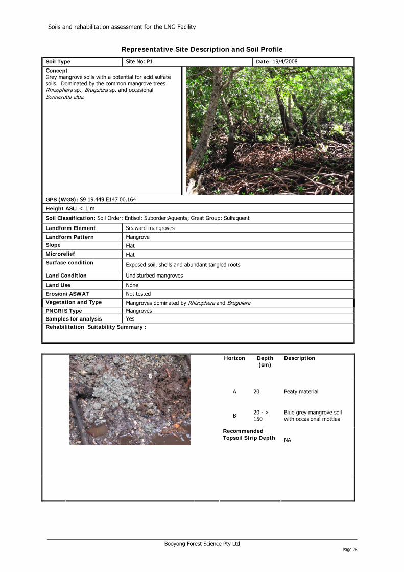
Soil Type Site No: P1 Date: 19/4/2008
Concept Grey mangrove soils with a potential for acid sulfate soils. Dominated by the common mangrove trees Rhizophera sp., Bruguiera sp. and occasional Sonneratia alba.
GPS (WGS): S9 19.449 E147 00.164 Height ASL: < 1 m
Soil Classification: Soil Order: Entisol; Suborder:Aquents; Great Group: Sulfaquent Landform Element Seaward mangroves
Landform Pattern Mangrove Slope Flat Microrelief Flat Surface condition Exposed soil, shells and abundant tangled roots
Land Condition Undisturbed mangroves
Land Use None
Erosion/ASWAT Not tested Vegetation and Type Mangroves dominated by Rhizophera and Bruguiera PNGRIS Type Mangroves Samples for analysis Yes Rehabilitation Suitability Summary :
Horizon Depth
(cm) Description
A 20 Peaty material
B 20 - > 150
Blue grey mangrove soil with occasional mottles
Recommended Topsoil Strip Depth NA
Booyong Forest Science Pty Ltd Page 26
Soils and rehabilitation assessment for the LNG Facility
Representative Site Description and Soil Profile
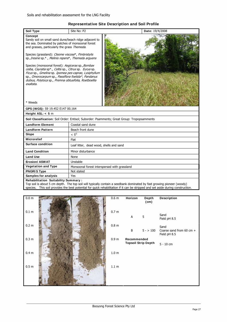
Soil Type Site No: P2 Date: 19/4/2008
Concept Sandy soil on small sand dune/beach ridge adjacent to the sea. Dominated by patches of monsoonal forest and grasses, particularly the grass Themeda. Species (grassland): Cleome viscose*, Fimb is ylis sp.,Iresine sp.* , Melinis repens*, Themeda arguens
r t
t-
tt
Species (monsoonal forest): Aegiceras sp.,Bombax ceiba, Cayra ia sp*., Celtis sp., Citrus sp. Eurya sp. Ficus sp., Gmelina sp. Ipomea pes caprae, Lysiphyllum sp., Omorocarpum sp., Passiflora foe ida*, Pandanus dubius, Polytoca sp., Premna obtusifolia, Roe boellia exaltata. * Weeds
GPS (WGS): S9 19.452 E147 00.164
Height ASL: < 5 m
Soil Classification: Soil Order: Entisol; Suborder: Psamments; Great Group: Tropopsamments Landform Element Coastal sand dune
Landform Pattern Beach front dune Slope < 5O Microrelief Flat Surface condition Leaf litter, dead wood, shells and sand
Land Condition Minor disturbance
Land Use None
Erosion/ASWAT Unstable Vegetation and Type Monsoonal forest interspersed with grassland PNGRIS Type Not stated Samples for analysis Yes Rehabilitation Suitability Summary : Top soil is about 5 cm depth. The top soil will typically contain a seedbank dominated by fast growing pioneer (woody) species. This soil provides the best potential for quick rehabilitation if it can be stripped and set aside during construction.
0.0 m
0.6 m Horizon Depth (cm)
Description
0.1 m 0.7 m
A 5 Sand Field pH 8.5
0.2 m 0.8 m
B 5 - > 100 Sand Coarse sand from 60 cm + Field pH 8.5
0.3 m 0.9 m Recommended Topsoil Strip Depth 5 - 10 cm
0.4 m 1.0 m
0.5 m
1.1 m
Booyong Forest Science Pty Ltd Page 27
Soils and rehabilitation assessment for the LNG Facility
Representative Site Description and Soil Profile
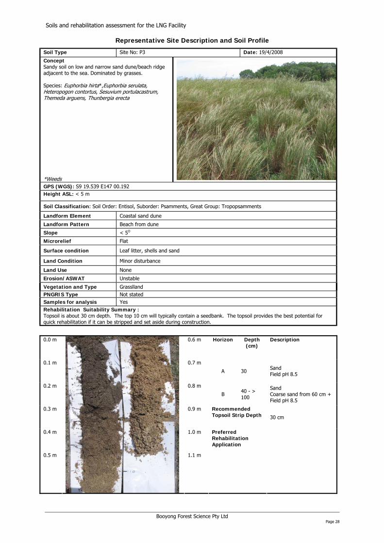
Soil Type Site No: P3 Date: 19/4/2008
Concept Sandy soil on low and narrow sand dune/beach ridge adjacent to the sea. Dominated by grasses. Species: Euphorbia hi ta*,Euphorbia serulata, Heteropogon contortus, Sesuvium portulacastrum, Themeda arguens, Thunbergia erecta
r
*Weeds GPS (WGS): S9 19.539 E147 00.192 Height ASL: < 5 m
Soil Classification: Soil Order: Entisol, Suborder: Psamments, Great Group: Tropopsamments Landform Element Coastal sand dune
Landform Pattern Beach from dune
Slope < 5O
Microrelief Flat
Surface condition Leaf litter, shells and sand
Land Condition Minor disturbance
Land Use None
Erosion/ASWAT Unstable
Vegetation and Type Grasslland PNGRIS Type Not stated Samples for analysis Yes Rehabilitation Suitability Summary : Topsoil is about 30 cm depth. The top 10 cm will typically contain a seedbank. The topsoil provides the best potential for quick rehabilitation if it can be stripped and set aside during construction.
0.0 m
0.6 m Horizon Depth (cm)
Description
0.1 m 0.7 m
A 30 Sand Field pH 8.5
0.2 m 0.8 m
B 40 - > 100
Sand Coarse sand from 60 cm + Field pH 8.5
0.3 m 0.9 m Recommended Topsoil Strip Depth 30 cm
0.4 m 1.0 m
0.5 m
1.1 m
Preferred Rehabilitation Application
Booyong Forest Science Pty Ltd Page 28
Soils and rehabilitation assessment for the LNG Facility
Representative Site Description and Soil Profile
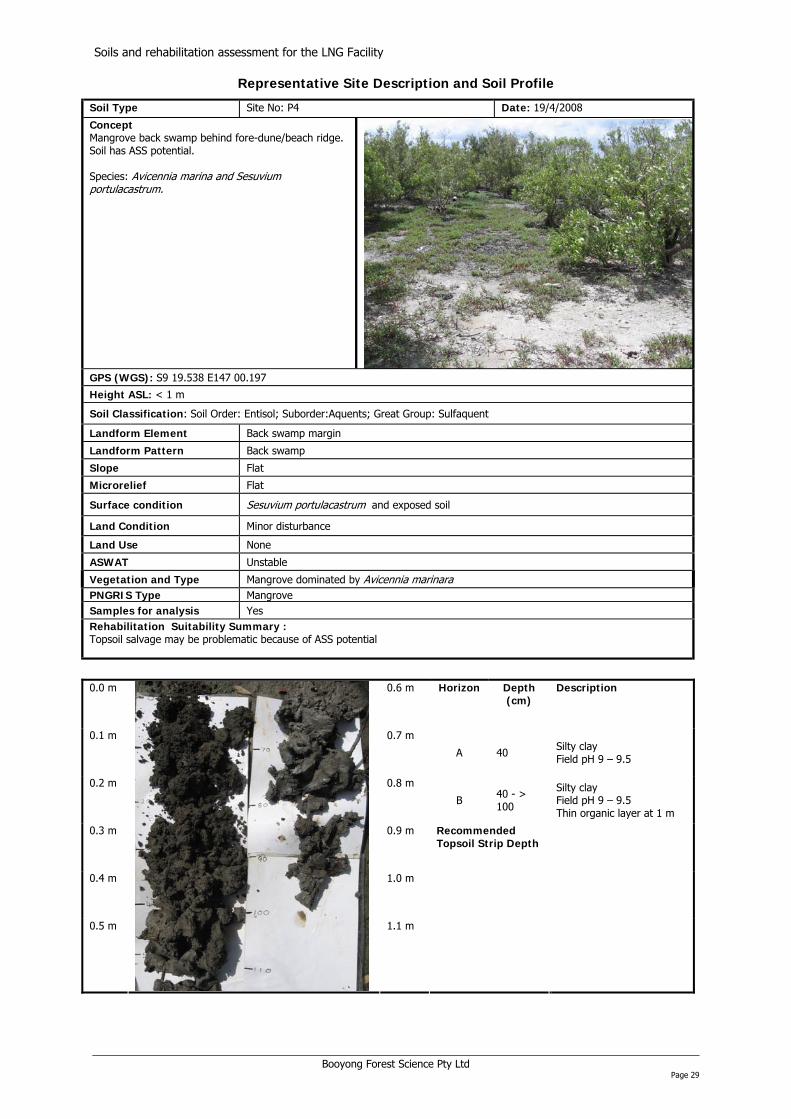
Soil Type Site No: P4 Date: 19/4/2008
Concept Mangrove back swamp behind fore-dune/beach ridge. Soil has ASS potential. Species: Avicennia marina and Sesuvium portulacas rum. t
GPS (WGS): S9 19.538 E147 00.197
Height ASL: < 1 m
Soil Classification: Soil Order: Entisol; Suborder:Aquents; Great Group: Sulfaquent Landform Element Back swamp margin
Landform Pattern Back swamp
Slope Flat
Microrelief Flat
Surface condition Sesuvium portulacastrum and exposed soil
Land Condition Minor disturbance
Land Use None
ASWAT Unstable
Vegetation and Type Mangrove dominated by Avicennia marinara PNGRIS Type Mangrove Samples for analysis Yes Rehabilitation Suitability Summary : Topsoil salvage may be problematic because of ASS potential
0.0 m
0.6 m Horizon Depth (cm)
Description
0.1 m 0.7 m
A 40 Silty clay Field pH 9 – 9.5
0.2 m 0.8 m
B 40 - > 100
Silty clay Field pH 9 – 9.5 Thin organic layer at 1 m
0.3 m 0.9 m Recommended Topsoil Strip Depth
0.4 m 1.0 m
0.5 m
1.1 m
Booyong Forest Science Pty Ltd Page 29
Soils and rehabilitation assessment for the LNG Facility
Representative Site Description and Soil Profile
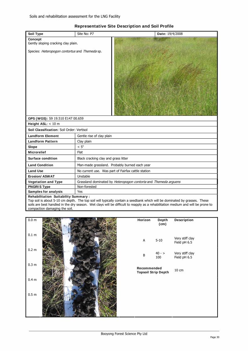
Soil Type Site No: P7 Date: 19/4/2008
Concept Gently sloping cracking clay plain. Species: Heteropogon contortus and Themeda sp.
GPS (WGS): S9 19.510 E147 00.659
Height ASL: < 10 m
Soil Classification: Soil Order: Vertisol Landform Element Gentle rise of clay plain
Landform Pattern Clay plain
Slope < 5o
Microrelief Flat
Surface condition Black cracking clay and grass litter
Land Condition Man-made grassland. Probably burned each year
Land Use No current use. Was part of Fairfax cattle station
Erosion/ASWAT Unstable
Vegetation and Type Grassland dominated by Heteropogon contor a and Themeda arguens tPNGRIS Type Non-forested Samples for analysis Yes Rehabilitation Suitability Summary : Top soil is about 5-10 cm depth. The top soil will typically contain a seedbank which will be dominated by grasses. These soils are best handled in the dry season. Wet clays will be difficult to reapply as a rehabilitation medium and will be prone to compaction damaging the soil.
0.0 m
Horizon Depth (cm)
Description
0.1 m
A 5-10 Very stiff clay Field pH 6.5
0.2 m
B 40 - > 100
Very stiff clay Field pH 6.5
0.3 m Recommended Topsoil Strip Depth 10 cm
0.4 m
0.5 m
Booyong Forest Science Pty Ltd Page 30

Soils and rehabilitation assessment for the LNG Facility
Representative Site Description and Soil Profile
Soil Type Site No: P13 Date: 19/4/2008
Concept Limestone hill/terrace overlain by clay supporting eucalypt savanna and grasslands. Species: Crotalaria sp., Glorchidion sp., Desmodium sp. Heteropogon contor us, Eucalyptus teriticornis, Mimosa sp., and Themeda sp.
t
GPS (WGS): S9 21.143 E147 01.368
Height ASL: 8 m
Soil Classification: Soil Order: Vertisol Landform Element Raised clay plain
Landform Pattern Terrace
Slope Flat
Microrelief Flat
Surface condition Cracking clay and grass litter with occasional limestone outcrops
Land Condition Man-made grassland. Probably burned each year
Land Use No current use. Was part of Fairfax cattle station
ASWAT Unstable
Vegetation and Type Eucalypt savanna with a grassland groundlayer dominated by Heteropogon conto ta rPNGRIS Type Non-forested Samples for analysis Yes Rehabilitation Suitability Summary : Top soil is about 8 cm depth. The top soil will typically contain a seedbank which will be dominated by grasses. These soils are best handled in the dry season. Wet clays will be difficult to reapply as a rehabilitation medium and will be prone to compaction damaging the soil.
0.0 m
Horizon Depth (cm)
Description
0.1 m
A 8 Very stiff dark brown clay Field pH 7
0.2 m
B 8 - 40
Very stiff dark orange brown clay with limestone fragments Field pH 7 – 7.5 Limestone at 40 – 60 cm
0.3 m Recommended Topsoil Strip Depth 10 cm
0.4 m
0.5 m
Booyong Forest Science Pty Ltd Page 31

Soils and rehabilitation assessment for the LNG Facility
APPENDIX B
SOIL ANALYSIS RESULTS
Booyong Forest Science Pty Ltd Page 32
Soils and rehabilitation assessment for the LNG Facility
Booyong Forest Science Pty Ltd Page 33
BASELINE SOIL FERTILITY
Test
Nutrient
Site/ Units
P2 Beach ridge
P3 Beach ridge
P4 Back
swamp
P7 Clay plain
P13 Hill
terrace
Calcium Ca ppm 3175 3492 1190 2303 1579
Magnesium Mg ppm 298 138 1432 708 474
Potassium K ppm 41 20 597 100 114
Phosphorus (Morgan) P ppm 5.0 2.2 3.0 0.2 0.1
Solu
ble
Test
s &
M
orga
n 1
Extr
act
Phosphorus (Bray 1) P ppm 1 1 9 2 1
Phosphorus (Colwell) P ppm 17 11 91 8 3
Phosphorus (Bray 2) P ppm 1 1 177 7 5 pH (1:5 water) units 8.57 8.77 8.44 6.01 6.61
Sulphate sulphur S ppm 27 16 564 22 11
Solu
ble
Test
s &
Co
lwel
l + B
ray
2 Ph
osph
orus
Ext
ract
Conductivity (1:5 water) µS/cm 238 131 6550 216 109
Organic Matter % 18.32 17.15 3.22 3.90 2.38
Calcium Ca cmol+/Kg 16.51 18.15 6.75 32.80 16.63 Magnesium Mg cmol+/Kg 2.52 2.87 16.20 13.08 6.79 Potassium K cmol+/Kg 0.12 0.07 2.90 0.91 0.78 Sodium Na cmol+/Kg 0.34 0.09 40.75 0.80 0.28 Am
mon
ium
Ac
etat
e Eq
uiv.
Ex
trac
t
Aluminium Al cmol+/Kg 0.01 0.00 0.01 0.01 0.02
Hydrogen H+ cmol+/Kg 0.00 0.00 0.00 0.17 0.00
Acid
ity
Titr
atio
n
H+ ppm 0 0 0 2 0 Cation Exchange Capacity cmol+/Kg 19.50 21.20 66.62 47.77 24.50
Zinc Zn ppm 0.8 2.0 1.1 1.1 0.7 Manganese Mn ppm 9.5 8.9 14.0 43.7 41.8
Iron Fe ppm 11.4 9.8 10.6 34.9 26.2 Copper Cu ppm 0.7 1.4 2.5 2.9 2.9 Boron B ppm 0.92 0.27 8.37 0.77 0.42 M
icro
nutr
ient
s-
DTP
A +
Hot
CaC
l 2 Ex
trac
ts
Total Carbon C % 10.47 9.80 1.84 2.23 1.36
Total Nitrogen N % 0.16 0.10 0.12 0.13 0.09
Tota
l Nut
rient
s
Carbon/ Nitrogen Ratio ratio 65.4 97.0 15.6 17.6 14.8
Acid
Dig
est
Total Phosphorus P ppm 259 251 539 96 79
Texture t Shells Loamy Shells Clay Clay Clay
Colour c Light Grey Grey Grey
Dark Grey Brown

Soils and rehabilitation assessment for the LNG Facility
ACID SULPHATE SOIL ANALYSIS RESULTS
Sample
Site
Depth (cm)
TAA pHkcl
Titratable Actual
Acidity (TAA) mole H+/tonne
(to pH 6.5)
Reduced Inorganic Sulfur
(% chromium reducible S) (%Scr) (note 2)
Reduced Inorganic
Sulfur (Scr) mole
H+/tonne
%
ANCBT %CaCO3
a-ANCBT
mole H+/tonne
NET ACIDITY Chromium Suite mole H+/tonne
(based on %Scrs)
LIME CALCULATION Chromium Suite
kg CaCO3/tonne DW (includes 1.5 safety
Factor)
Method No. 23A 23F 22B a- 22B 19A2 a-19A2 note 5 note 5
P8 40-60 7.48 0 0.058 36 7.98 1594 -1027 0P8 90-110 8.39 0 0.449 280 57.04 11397 -7318 0P8 140-160 8.63 0 0.311 194 52.32 10454 -6775 0
P10 40-60 8.66 0 0.010 6 24.92 4979 -3313 0P10 90-110 8.59 0 0.314 196 47.99 9588 -6196 0P10 140-160 8.60 0 0.252 157 53.18 10625 -6926 0
P11 40-60 8.04 0 0.606 378 33.68 6729 -4108 0P11 90-110 8.58 0 0.407 254 56.10 11209 -7219 0P11 140-160 8.55 0 0.407 254 57.55 11498 -7412 0
P12 40-60 8.60 0 0.152 95 78.54 15692 -10367 0P12 90-110 8.86 0 0.114 71 79.82 15948 -10561 0P12 140-160 8.83 0 0.117 73 79.27 15838 -10486 0
BH4 30-40 7.80 0 < 0.02 < 10 0.98 196 < 0.02 < 1 BH5 70-80 8.70 0 < 0.02 < 10 25.20 5040 < 0.02 < 1 BH6 30-40 8.70 0 < 0.02 < 10 10.30 2060 < 0.02 < 1
P samples: analysed by Southern Cross University Environmental Analysis Laboratory. BH samples: analysed by the ALS Laboratory Group Stafford. 1 - All analysis is Dry Weight (DW) - samples dried and ground immediately upon arrival (unless supplied dried and ground) 2 - Samples analysed by SPOCAS method 23 (i.e., Suspension Peroxide Oxidation Combined Acidity & sulfate) and 'Chromium Reducible Sulfur' technique (Scr - Method 22B) 3 - Methods from Ahern, CR, McElnea AE , Sullivan LA (2004). Acid Sulfate Soils Laboratory Methods Guidelines. QLD DNRME. 4 - Bulk density was determined immediately on arrival to laboratory (insitu bulk density is preferred) 5 - ABA Equation: Net Acidity = Potential Sulfidic Acidity (ie. Scrs or Sox) + Actual Acidity + Retained Acidity - measured ANC/FF 6 - For Texture: coarse = sands to loamy sands; medium = sandy loams to light clays; fine = medium to heavy clays and silty clays 7 - Denotes not requested or required 8 - CRS, TAA and ANC are NATA certified but other SPOCAS segments are currently not NATA certification 9 - Results at of below detection limits are replaced with '0' for calculation purposes. CRS detection limit is 0.005%S. 10 - Projects that disturb >1000 tonnes of soil, the ≥0.03% S classification guideline would apply. 11 - Classification of potential acid sulfate material if: coarse Scr≥0.03%S or 19mole H+/t; medium Scr≥0.06%S or 37mole H+/t; fine Scr≥0.1%S or 62mole H+/t
Booyong Forest Science Pty Ltd Page 34