software design description - mattkingit.commattkingit.com/wp-content/uploads/2013/04/sdd.pdf ·...
TRANSCRIPT

Software Design Description Senior Project Matthew King 6/25/2010

Hillsborough County Historical Mapping Version: 1.2
Software Project Management Plan Date: 02 November 2010
Revision History Date Version Description Author
25 June 2010 1.0 Software Design Document for
Hillsborough County Historical Mapping
Matthew King
16 July 2010 1.1 Software Design Document for
Hillsborough County Historical Mapping
Matthew King

Table of Content s
1. Introduction ............................................................................................................................................. 4
1.1. Purpose ............................................................................................................................................ 4
1.2. Project Scope ................................................................................................................................... 4
1.3. Definitions, acronyms, and abbreviations ...................................................................................... 4
1.4. References ....................................................................................................................................... 4
1.5. Overview .......................................................................................................................................... 4
2. Design Considerations ............................................................................................................................. 4
2.1. Assumptions .................................................................................................................................... 4
2.2. General Constraints ......................................................................................................................... 5
2.3. System environment ....................................................................................................................... 5
3. Architectural Design ................................................................................................................................ 5
3.1. Web Architecture ............................................................................................................................ 5
3.2. Block Diagram .................................................................................................................................. 6
3.3. Data Design ...................................................................................................................................... 6
3.3.1. Data Description ...................................................................................................................... 6
3.3.2. Maps Database ........................................................................................................................ 6
3.3.3. Data Dictionary of Maps table ................................................................................................ 7
3.3.4. Blog Database .......................................................................................................................... 9
3.3.5. Data Dictionary of Blog table ................................................................................................ 11
4. User Interface Design ............................................................................................................................ 12
4.1. Section Overview ........................................................................................................................... 12
4.2. Web Pages ..................................................................................................................................... 12
4.2.1. Home Page ............................................................................................................................. 12
4.2.2. Maps Page ............................................................................................................................. 13
4.2.3. Blog (Web Log) Page .............................................................................................................. 14
4.2.4. Book Page .............................................................................................................................. 16
5. Glossary ................................................................................................................................................. 18
5.1. Acronyms and Abbreviations ........................................................................................................ 18
5.2. Definitions ..................................................................................................................................... 18
Introduction
The project is to create an interactive Google ® map to view historical information in Hillsborough
County.
1.1. Purpose
The primary purpose of this document is to present a detailed description of the design elements
of the Hillsborough County Historic Maps. This will guide me in the design of the application
1.2. Project Scope
This document will provide details on the design of the various pages of the web application, in particular
the Maps page and the Blog page which interact with the MySQL relational database using various scripts.
User will have the ability to view Hillsborough County and interact with various aspect of its
history. The user will be able to view historical overlay maps from various years, photos and
historical notes. Users will also be able to view Blogs within the application as well as participating
and signing up with the Wordpress ® Blog by linking to it external.
1.3. Definitions, acronyms, and abbreviations
Definitions, Acronyms and Abbreviations are defined in the Glossary, see Section 7.
1.4. References
IEEE Standard 1016‐2009, IEEE Standard for Information Technology – Systems Design – Software
Design Description, IEEE Computer Society, 2009.
Google® Maps API for Flash ‐ http://code.google.com/apis/maps/documentation/flash/, Google®
2009.
1.5. Overview
This document will go over the design of various aspects of the project including architectural, software
components, interface, and database design.
2. Design Considerations
2.1. Assumptions
The user of the web application will have the Adobe® Flash plug‐in installed along with a current
multi‐media web browser to view the application.

2.2. General Constraints
The application will be completed using the Adobe Flex® architecture and a MySQL relational
database. The developer of the application requires Adobe Flex® 3.0, a local web server for
testing to include Apache Web Server 2.0, PHP 5.0 and MySQL 5.1 and WordPress database
installed. The designer will also need a vector and/or raster image editor such as Adobe®
Illustrator/InkScape or Adobe® Photoshop/GIMP. For publishing the application the provider
must have Apache Web Server 2.0, PHP 5.0, and MySQL 5.1 or higher and have the ability to
include WordPress® Blog.
2.3. System environment
The application is designed to work on all operating systems that can support a current media
enabled web browser and the Adobe® Flash plug‐in.
3. Architectural Design
3.1. Web Architecture
The Hillsborough County Historic Mapping application will run on a client‐server system
architecture where the client will connect to a web server using a current internet browser and
TCP/IP connection. The web server will be hosted by GoDaddy® with a Yahoo® web server as
backup. The web server is maintained by the Apache® web server software on a Linux operating
system. The web server will communicate with a MySQL database and interact with Google®
Maps API using client and server side scripting.
Figure 1

3.2. Block Diagram
Figure 2
3.3. Data Design
3.3.1. Data Description
MySQL database connects with Adobe® Flex ODBC connection using PHP Scripts installed
on the local web server.
3.3.2. Maps Database
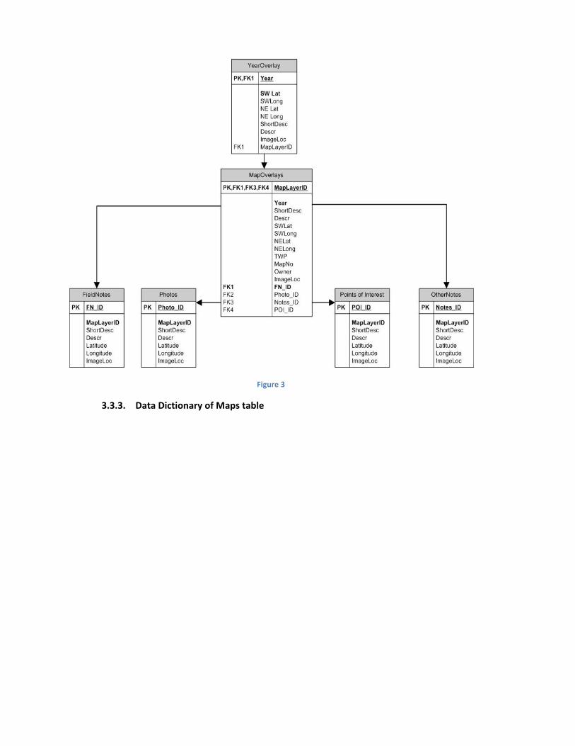
Figure 3
3.3.3. Data Dictionary of Maps table

3.3.3.1. Year
3.3.3.1.1. Year
3.3.3.1.2. Year of Overall Map
3.3.3.1.3. Integer
3.3.3.1.4. 4 digits
3.3.3.1.5. 1500 – Current year
3.3.3.2. Latitude/Longitude
3.3.3.2.1. SWLat, SWLong, SELat, SELong, NWLat, NWLong, NELat, NELong
3.3.3.2.2. Corresponding Latitude and Longitude for point
3.3.3.2.3. Double/Float
3.3.3.2.4. 10 digits (4,6)
3.3.3.2.5. Latitude (‐90.000000 – 90.000000)
Longitude (‐180.000000 – 180.000000)
3.3.3.3. Short Description
3.3.3.3.1. ShortDesc
3.3.3.3.2. Short name for item
3.3.3.3.3. Varchar/Text
3.3.3.3.4. 50 characters
3.3.3.3.5. 0‐50 characters
3.3.3.4. Long Description
3.3.3.4.1. Descr
3.3.3.4.2. Long description of item
3.3.3.4.3. Varchar/Text
3.3.3.4.4. 255 characters
3.3.3.4.5. 0‐255 characters
3.3.3.5. Image Location
3.3.3.5.1. ImageLoc
3.3.3.5.2. Location of image on web server
3.3.3.5.3. Varchar/Text
3.3.3.5.4. 255 characters
3.3.3.5.5. 0‐255 characters
3.3.3.6. Map Layer ID
3.3.3.6.1. MapLayerID
3.3.3.6.2. Index of the Map Layer (Non‐Null)
3.3.3.6.3. Integer
3.3.3.6.4. 6 digits (TWP and MapNo)
3.3.3.6.5. 000000‐999999
3.3.3.7. Township
3.3.3.7.1. TWP
3.3.3.7.2. Township Number
3.3.3.7.3. Integer
3.3.3.7.4. 4 digits

3.3.3.7.5. 0000‐9999
3.3.3.8. Map Number
3.3.3.8.1. MapNo
3.3.3.8.2. Map Number within Township
3.3.3.8.3. Integer
3.3.3.8.4. 2 digits
3.3.3.8.5. 00‐99
3.3.3.9. Owner
3.3.3.9.1. Owner
3.3.3.9.2. User who updated the database
3.3.3.9.3. Varchar/Text
3.3.3.9.4. 25 characters
3.3.3.9.5. 0‐25 characters
3.3.3.10. Field Note ID
3.3.3.10.1. FN_ID
3.3.3.10.2. Auto Number Field Note ID
3.3.3.10.3. Integer
3.3.3.10.4. 4 digits
3.3.3.10.5. 0000‐9999
3.3.3.11. Photo ID
3.3.3.11.1. Photo_ID
3.3.3.11.2. Auto Number Photo ID
3.3.3.11.3. Integer
3.3.3.11.4. 4 digits
3.3.3.11.5. 0000‐9999
3.3.3.12. POI ID
3.3.3.12.1. POI_ID
3.3.3.12.2. Auto Number Point of Interest ID
3.3.3.12.3. Integer
3.3.3.12.4. 4 digits
3.3.3.12.5. 0000‐9999
3.3.3.13. Notes ID
3.3.3.13.1. Notes_ID
3.3.3.13.2. Auto Number Note ID
3.3.3.13.3. Integer
3.3.3.13.4. 4 digits
3.3.3.13.5. 0000‐9999
3.3.4. Blog Database
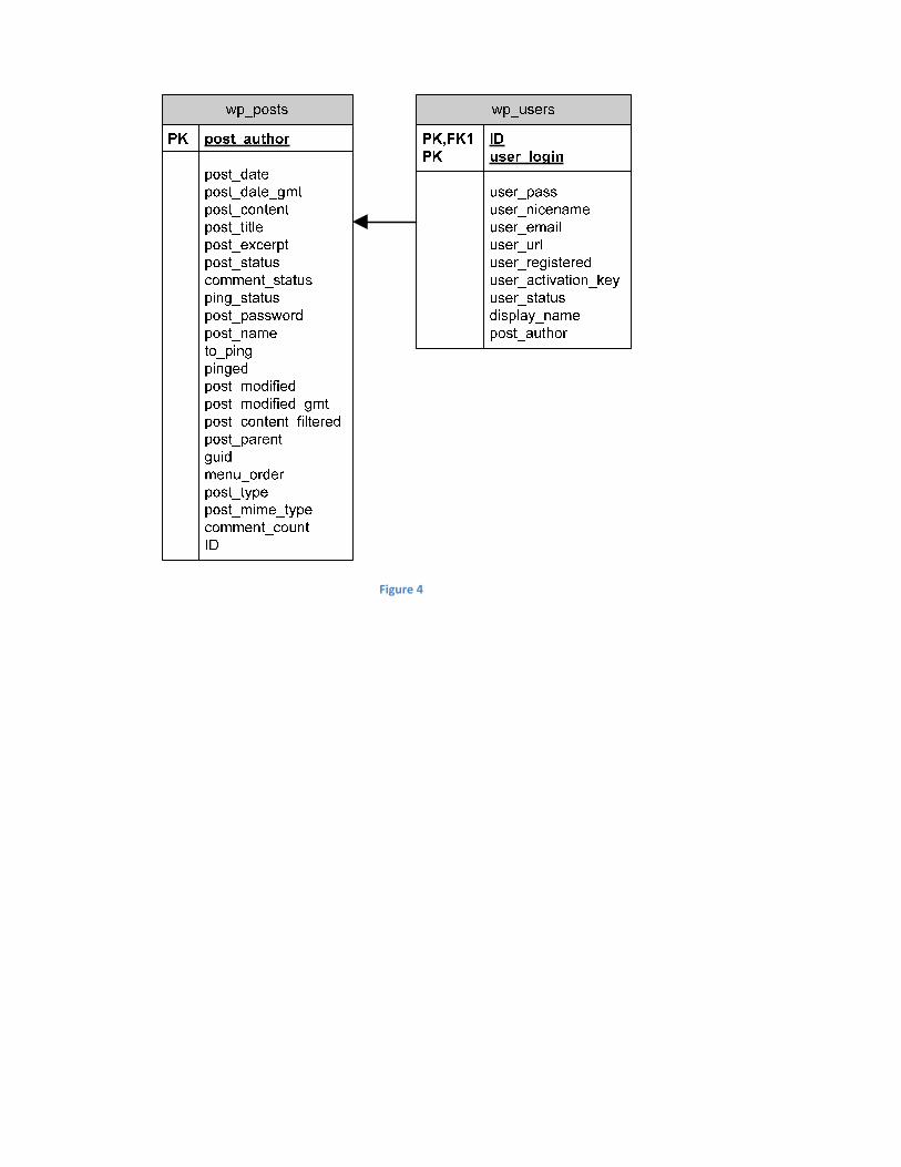
Figure 4

3.3.5. Data Dictionary of Blog table
3.3.5.1. ID
3.3.5.1.1. ID
3.3.5.1.2. Auto Number ID of Post
3.3.5.1.3. Integer
3.3.5.1.4. 20 digits
3.3.5.1.5. 0‐99999999999999999999
3.3.5.2. Author
3.3.5.2.1. post_author
3.3.5.2.2. Author of Post ID (from UserId in ps_users table)
3.3.5.2.3. Integer
3.3.5.2.4. 20 digits
3.3.5.2.5. 0‐99999999999999999999
3.3.5.3. Post Date
3.3.5.3.1. post_date
3.3.5.3.2. Date of posting
3.3.5.3.3. DateTime
3.3.5.3.4. YYYY‐MM‐DD HH:MM:SS
3.3.5.3.5. 0000‐00‐00 00:00:00
3.3.5.4. Post content
3.3.5.4.1. post_content
3.3.5.4.2. Content of the Post
3.3.5.4.3. Varchar/Text
3.3.5.4.4. 255 characters
3.3.5.4.5. 0‐255 characters
3.3.5.5. Post Title
3.3.5.5.1. post_title
3.3.5.5.2. Title of Post
3.3.5.5.3. Varchar/Text
3.3.5.5.4. 50 characters
3.3.5.5.5. 0‐50 characters
3.3.5.6. Post Status
3.3.5.6.1. post_status
3.3.5.6.2. Status of Post
3.3.5.6.3. Varchar/Text
3.3.5.6.4. 20 characters
3.3.5.6.5. 0‐20 characters
3.3.5.7. Post Name
3.3.5.7.1. post_name
3.3.5.7.2. Name of Post
3.3.5.7.3. Varchar/Text

3.3.5.7.4. 200 characters
3.3.5.7.5. 0‐200 characters
3.3.5.8. Post Modified
3.3.5.8.1. post_modified
3.3.5.8.2. Date post modified
3.3.5.8.3. DateTime
3.3.5.8.4. YYYY‐MM‐DD HH:MM:SS
3.3.5.8.5. 0000‐00‐00 00:00:00
4. User Interface Design
4.1. Section Overview
This section provides an example of what the interface will look like for each web page to the user.
4.2. Web Pages
4.2.1. Home Page
Figure 5
4.2.1.1. Description

The Home page provides you with links to all the other pages within the web
application and displays an overview of what is expected of the application.
4.2.2. Maps Page
Figure 6
4.2.2.1. Description
The Maps page is the meat of the application. It provides an interactive
Google® map to the left and options to be displayed on the map on the
right side of the page. Features to display on the map include a year
overlay, field notes, points of interest, photos and other information
related to that year.
The Google® map is displayed by using the Google® map API provided by
Google® for Flash application development.
4.2.2.2. Data members
Year – Selecting the Year will display an overall map for that particular
year sectioned off by grids based on Township, Range and MapNo (2919‐
01 is equivalent to Township 29, Range 19, Map No 01) and will be
displayed in the Map Overlays section of the form.

Map Overlay – Selecting a particular grid on the map or in the form will
provide you with the field notes, points of interest, photos and other
notes related to that overlay.
Field Notes – Available field notes will display in the form for the overlay
selected and as green thumbtacks on the Google® map.
Points of Interest – Available points of interest, if there are any, will be
displayed in the form and on the map as a blue thumbtack.
Photos – Available photos will be displayed on the form for selection and
on the map as yellow thumbtacks.
Other Info – If there are other info that do not apply above it will be
displayed on the map as an orange thumbtack and displayed on the
form.
4.2.2.3. Methods
Year Select – When a year is selected a PHP script will connect to the
database and display the image on the map with the available overlays
displayed in the form.
Overlay Select – When an overlay grid is selected on either the map or
the form a PHP script connects to the database and retrieves all related
field notes, points of interests, photos and/or other notes.
Opacity Slider – Another feature will allow the user to control the opacity
of the overlay image on the map. When the slider is moved a PHP scripts
updates the opacity by manipulating the XML related to that image.
4.2.3. Blog (Web Log) Page
4.2.3.1. Recent Blogs
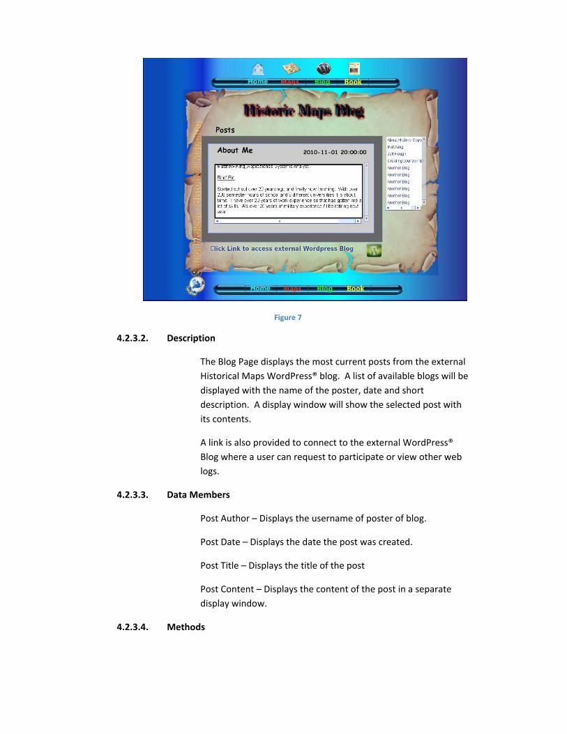
Figure 7
4.2.3.2. Description
The Blog Page displays the most current posts from the external
Historical Maps WordPress® blog. A list of available blogs will be
displayed with the name of the poster, date and short
description. A display window will show the selected post with
its contents.
A link is also provided to connect to the external WordPress®
Blog where a user can request to participate or view other web
logs.
4.2.3.3. Data Members
Post Author – Displays the username of poster of blog.
Post Date – Displays the date the post was created.
Post Title – Displays the title of the post
Post Content – Displays the content of the post in a separate
display window.
4.2.3.4. Methods

Post Select – Selecting a specific post in the selection window calls a PHP
script which pulls the post content from the database and displays in the
post window.
4.2.3.5. External Website
4.2.3.5.1. Description
This is the linked external website created with WordPress® and installed
on the web server. The administrator can access and administer the Blog
from this website, approve users, and update posts as needed.
4.2.4. Book Page

4.2.4.1. Purchase Book
4.2.4.1.1. Description
The Purchase Book (left) section of this page allows a user to link
to Amazon to purchase the text ‘The Fort King Road Then and
Now’ by Jerry Morris and Jeff Hough. A link is also provided to e‐
mail one of the authors of the book.
4.2.4.1.2. Methods
Selecting the Amazon icon or the text will link you to an external
Amazon website for purchasing the text.
Selecting the e‐mail link will bring up the users default e‐mail
program allowing the user to e‐mail one of the authors of the
book.
4.2.4.2. About Us
4.2.4.2.1. Description
The About Us (right) section of this page allows a user to view
information about one of the author’s, as well as, the developer
of the site/application.
4.2.4.2.2. Methods

Selecting the e‐mail link will bring up the users default e‐mail
program allowing contact with the developer.
5. Glossary
5.1. Acronyms and Abbreviations
AJAX Asynchronous JavaScript and XML
API Application Programming Interface
Blog Web log
CSS Cascading Style Sheet
DOM Document Object Model
FPU Floating Point Unit
HTML Hypertext Markup Language
KML Keyhole Markup Language
MXML Macromedia Extensible Markup Language
PHP PHP Hypertext Preprocessor
QA Quality Assurance
RDBMS Relational Database Management System
RIA Rich Internet Application
SDK Software Development Kit
XHTML Extensible Hypertext Markup Language
XML Extensible Markup Language
XSLT Extensible Stylesheet Language
5.2. Definitions
Action Script
A scripting language, similar to JavaScript, used primarily for developing Adobe® Flash
applications.
Apache Web Server

Web server software that allows the publishing of web sites.
Application Programmer Interface
Programming interface that enables one software interface to interact with another.
Asynchronous Java Script and XML
A way of developing web applications using a combination of XHTML, CSS, DOM, XML, XSLT,
Asynchronous data retrieval via XMLHttpRequest, and JavaScript.
Cascading Style Sheet
Style sheet language that allows for formatting and layout of web sites.
Document Object Model
A web interface that provides a way for programs and/or scripts to update the content, structure,
and style of web documents dynamically.
Flash
A development environment created by Adobe used to create and view animation programs for
the internet.
Flex
A development environment created by Adobe used to great Flash based applications from a
programmer (vs. designer) perspective using MXML and Action Script.
Hypertext Markup Language
A set of tags and rules used to publish and format websites.
Java
A programming language designed for multi‐platform development based on C++.
JavaScript
A web scripting language used to make web pages more dynamic based on the Java language.
Keyhole Markup Language
A language created to express geographic information used with various applications including
Google® maps and Google® Earth based on the Extensible Markup Language.
Macromedia Extensible Markup Language

A language created by Macromedia based on the Extensible Markup Language used for
developing Flash Applications.
MySQL
A relational database management system owned by Sun Microsystems® and used on the
Apache Web Server.
Object‐Oriented
A programming paradigm based on objects and data.
Open‐Source
Technology in which source code is freely available for use.
PHP
A scripting language used to interact with a web server to provide an interactive, dynamic web
experience.
Python
An interpreted, object‐oriented programming language.
Rich Internet Application
An application similar to a desktop application but for use with the web and web technologies.
Ruby
An open‐source object oriented programming language that can be used on multiple platforms.
Ruby on Rails
An open‐source web application framework used to develop for the web based on the Ruby
language.
Software Development Kit
Development tools used to create various software packages.
Web Log
A way for individuals to provide information, similar to a journal, to the public via the web.
XMLHttpRequest
An application programming interface that transfers data between a client and server.

XML
Language used to represent data in a standard format.
XSLT
A web technology used to add styles to XML and other marked up text.