smp2 part b policy statements lydney-glos only_final
TRANSCRIPT

The above provides the local details in respect of the SMP-wide policy presented in the preceding sections of this Plan document. These details must be read in the context of the wider-scales issues and policy implications, as reported therein.
Severn Estuary SMP2 Review – Final Report
1
LYDNEY TO GLOUCESTER
This Theme area contains the Policy Units GLO 1, GLO 2, GLO 3, GLO 4, GLO 5, GLO 6, GLO 7 and GLO 8.
It starts at the mouth of Lydney Harbour (east) and ends at the drain from Long Brook.
The Key Policy Drivers in this area are:
• International nature conservation sites – Severn Estuary SAC, SPA and Ramsar sites, Walmore Common Ramsar site;
• Critical infrastructure – railway line, electricity transmission network, Blakeney sewage treatment works, A48, A40.

The above provides the local details in respect of the SMP-wide policy presented in the preceding sections of this Plan document. These details must be read in the context of the wider-scales issues and policy implications, as reported therein.
Severn Estuary SMP2 Review – Final Report
2

The above provides the local details in respect of the SMP-wide policy presented in the preceding sections of this Plan document. These details must be read in the context of the wider-scales issues and policy implications, as reported therein.
Severn Estuary SMP2 Review – Final Report
3
Policy Unit: GLO 1 – Lydney Harbour to Brims Pill (west bank of the Severn)

The above provides the local details in respect of the SMP-wide policy presented in the preceding sections of this Plan document. These details must be read in the context of the wider-scales issues and policy implications, as reported therein.
Severn Estuary SMP2 Review – Final Report
4
Preferred Policies to Implement the Plan:
Epoch Preferred Policy Comments
0 to 20 years (2025)
NAI
The Short Term policy for this unit is No Active Intervention.
There are no built defences in this Policy Unit. There is limited flood and erosion risk. This is expected to continue. NAI will allow the Lydney Cliff (SSSI) to evolve naturally. This unit is influenced by both river-driven and tidal processes.
The shoreline should be monitored to ensure there is no increased risk to H&S under NAI, impact on the linked Policy Unit (GLO 2) or adversely affect the CFMP policy - continue to manage flood risk at the current level (see Section 3.4 on SMP2-CFMP interactions).
20 to 50 years (2055)
NAI
The medium term policy for this unit is No Active Intervention.
There are no built defences in this Policy Unit. There is limited flood and erosion risk. This is expected to continue. NAI will allow the Lydney Cliff (SSSI) to evolve naturally. This unit is influenced by both river-driven and tidal processes.
The shoreline should be monitored to ensure there is no increased risk to H&S under NAI, impact on the linked Policy Unit (GLO 2) or adversely affect the CFMP policy - continue to manage flood risk at the current level (see Section 3.4 on SMP2-CFMP interactions).
50 to 100 years (2105)
NAI
The long term policy for this unit is No Active Intervention.
There are no built defences in this Policy Unit. There is limited flood and erosion risk. This is expected to continue. NAI will allow the Lydney Cliff (SSSI) to evolve naturally. This unit is influenced by both river-driven and tidal processes.
The railway line runs close to the shoreline around Wellhouse Bay and Purton. There is also a water treatment facility in the area. Risks to this infrastructure are considered to be low but the shoreline should be monitored in this area to confirm this. Relocation of the water treatment facility could be considered as and when it needs to be replaced / upgraded, if flooding or erosion risks increase.
The shoreline should be monitored to ensure there is no increased risk to H&S under NAI, impact on the linked Policy Unit (GLO 2) or adversely affect the CFMP policy - continue to manage flood risk at the current level (see Section 3.4 on SMP2-CFMP interactions).

The above provides the local details in respect of the SMP-wide policy presented in the preceding sections of this Plan document. These details must be read in the context of the wider-scales issues and policy implications, as reported therein.
Severn Estuary SMP2 Review – Final Report
5
Economics
Policy Unit
Existing SMP1 Policy
Time Period (epoch) SMP2 Assessment
0-20
20-50
50-100
Preferred Plan Present Value Damages
Preferred Plan Present Value Defence Costs
GLO1 Do
Nothing / HTL
NAI NAI NAI Minimal (GLO1-2 total)
£1m (GLO1-2 total)
The preferred policy has no economic impact in this Policy Unit. The preferred policy is economically viable for the linked Policy Units of GLO 1, and GLO 2. The costs of the preferred policy in the table above relate to actions taken in the linked policy unit (GLO 2), not in GLO 1.

The above provides the local details in respect of the SMP-wide policy presented in the preceding sections of this Plan document. These details must be read in the context of the wider-scales issues and policy implications, as reported therein.
Severn Estuary SMP2 Review – Final Report
6
Predicted Implication of the Preferred Plan for the GLO 1 Policy Unit
Time Period Management Activities Property, Land Use and
Human Health
Nature Conservation – including Earth Heritage, Geology and Biodiversity
Landscape Character and Visual Amenity Historic Environment Amenity and
Recreational Use
0 – 20 years
The mudstone cliffs will remain stable in this period, and as a result management activities will be very limited.
Limited erosion and flood risk will not impact on existing property, land use or human health.
A NAI policy will allow natural processes to dominate. There will be continued exposure of Lydney Cliffs SSSI.
Limited erosion and flood risk will not impact on existing landscape and visual amenity
Limited erosion and flood risk will not impact on the historic environment
Limited erosion and flood risk will not impact on the amenity value of the land or recreational use.
20 – 50 years
The mudstone cliffs will undergo limited erosion within this period, and as a result management activities will be very limited.
Limited erosion and flood risk will not impact on existing property, land use or human health.
A NAI policy will allow habitats to roll back so intertidal habitats and features will be maintained. However there may be loss of terrestrial habitats as intertidal habitats roll back. There will be continued exposure of Lydney Cliffs SSSI.
Limited erosion and flood risk will not impact on existing landscape and visual amenity
Limited erosion and flood risk will not impact on the historic environment
Limited erosion and flood risk will not impact on the amenity value of the land or recreational use.
50 – 100 years
The mudstone cliffs will undergo limited erosion within this period, and as a result management activities will be very limited. Due to the close proximity of the railway line, should erosion due to sea level rise increase, erosion protection measures should be considered.
The railway and STW are at risk from erosion in this epoch.
A NAI policy will allow habitats to roll back so intertidal habitats and features will be maintained. However there may be loss of terrestrial habitats as intertidal habitats roll back. There will be continued exposure of Lydney Cliffs SSSI.
Limited erosion and flood risk will not impact on existing landscape and visual amenity
Limited erosion and flood risk will not impact on the historic environment
Limited erosion and flood risk will not impact on the amenity value of the land or recreational use.
The above provides the local details in respect of the SMP-wide policy presented in the preceding sections of this Plan document. These details must be read in the context of the wider-scales issues and policy implications, as reported therein.
Severn Estuary SMP2 Review – Final Report
7
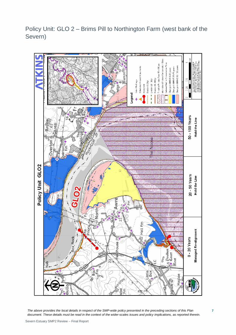
Policy Unit: GLO 2 – Brims Pill to Northington Farm (west bank of the Severn)
The above provides the local details in respect of the SMP-wide policy presented in the preceding sections of this Plan document. These details must be read in the context of the wider-scales issues and policy implications, as reported therein.
Severn Estuary SMP2 Review – Final Report
8
Preferred Policies to Implement the Plan:
Epoch Preferred Policy Comments
0 to 20 years (2025)
MR
The short term policy for this unit is Managed Realignment.
In the short term the existing defences will remain in place but are likely to come to the end of their serviceable life in the next epoch. A new realigned defence will enable new intertidal habitat to be created and manage the risk of impacts from flooding and erosion to assets behind new defences. There is an area of low laying ground backed by higher ground, along which a new line of defence could be created. The position, size and materials of new defences should be considered in detail to ensure MR does not impact on the risk of flooding to developed areas, internal drainage or the linked Policy Unit (GLO 1).
MR in this Policy Unit may allow short lengths of existing defence to be maintained and a NAI policy along other undefended lengths to allow the shoreline to evolve naturally. The precise location and type of defence should be determined by the SEFRMS. This should also determine if the existing defences can be allowed to erode naturally or should be breached. Any defences allowed to erode should be monitored to ensure they do not pose a risk to H&S. New, set back defences and other defences in the policy unit should be maintained.
Land, nature conservation and historic environment features in front of the new line of defences or in areas of NAI will be at increased risk of flooding and erosion. Adaptation actions should be considered and implemented. The habitat created in this policy unit will help compensate for areas lost elsewhere in the estuary and help maintain/improve the condition of the European protected sites.
MR does not guarantee funding to build or maintain new realigned defences.
20 to 50 years (2055)
HTL
The medium Term policy for this unit is Hold The Line.
New, set back defences and other defences in the policy unit should be maintained.
HTL does not guarantee funding to build or maintain current or future defences or to counter sea level rise.
50 to 100 years (2105)
HTL
The long term policy for this unit is Hold The Line.
This policy is most likely to involve maintaining the realigned defences.
HTL does not guarantee funding to build or maintain current or future defences or to counter sea level rise.

The above provides the local details in respect of the SMP-wide policy presented in the preceding sections of this Plan document. These details must be read in the context of the wider-scales issues and policy implications, as reported therein.
Severn Estuary SMP2 Review – Final Report
9
Economics
Policy Unit
Existing SMP1 Policy
Time Period (epoch) SMP2 Assessment
0-20
20-50
50-100
Preferred Plan Present Value Damages
Preferred Plan Present Value Defence Costs
GLO2 HTL (or Realignment) MR HTL HTL Minimal
(GLO1-2 total) £1.4m
(GLO1-2 total)
The preferred policy is economically viable for the linked Policy Units of GLO 1, and GLO 2. The costs and damages of the preferred policy in the table above relate to actions taken in all linked policy units.

The above provides the local details in respect of the SMP-wide policy presented in the preceding sections of this Plan document. These details must be read in the context of the wider-scales issues and policy implications, as reported therein.
Severn Estuary SMP2 Review – Final Report
10
Predicted Implication of the Preferred Plan for the GLO 2 Policy Unit
Time Period
Management Activities
Property, Land Use and Human Health
Nature Conservation – including Earth Heritage, Geology and Biodiversity
Landscape Character and Visual Amenity Historic Environment Amenity and
Recreational Use
0 – 20 years
The existing defence line will be maintained until a new set back defence is created.
The existing flood defences will continue to reduce the risk of impacts to properties and land in this epoch. The new realigned defence will provide a more sustainable defence, reducing the risk of impacts to land and properties. Properties and land on the landward side of the new defences will be at risk of flooding and erosion and will gradually become intertidal habitat.
A MR policy will allow the creation of approximately 153 Ha of additional intertidal habitat. However there may be loss of terrestrial habitats as intertidal habitats roll back. Works should take account of possible environmental impacts and the need for an EIA.
The creation of additional habitat will replace agricultural land. As a result the landscape will alter.
Defences will manage the risk of flooding on the historic environment. Historic assets in front of realigned defences will be at risk from inundation. Impacts on historic environment and mitigation actions will need to be considered in determining realignment of defences.
Some recreational/amenity areas may be lost/altered as a result of MR.
20 – 50 years
The new defence line should be maintained.
The new defence line will be maintained and continue to reduce the risk of flooding to properties and land.
A MR policy will allow the creation of approximately 153 Ha of additional intertidal habitat. However there may be loss of terrestrial habitats as intertidal habitats roll back. Works should take account of possible environmental impacts and the need for an EIA.
The intertidal area will continue to evolve. As a result the landscape will alter.
Defences will manage the risk of flooding on the historic environment
Some recreational/amenity areas may be lost/altered as a result of MR and the evolving intertidal area.
50 – 100 years
The new defence line should be maintained.
The new defence line will be maintained and continue to reduce the risk of flooding to properties and land.
A MR policy will allow the creation of approximately 153 Ha of additional intertidal habitat. However there may be loss of terrestrial habitats as intertidal habitats roll back. Works should take account of possible environmental impacts and the need for an EIA.
The intertidal area will continue to evolve. As a result the landscape will alter. In the longer term sea level rise will result in more frequent flooding of undefended areas.
Defences will manage the risk of flooding on the historic environment
Some recreational/amenity areas may be lost/altered as a result of MR and the evolving intertidal area

The above provides the local details in respect of the SMP-wide policy presented in the preceding sections of this Plan document. These details must be read in the context of the wider-scales issues and policy implications, as reported therein.
Severn Estuary SMP2 Review – Final Report
11
Policy Unit: GLO 3 – Northington Farm to Newnham Church (west bank of the Severn)

The above provides the local details in respect of the SMP-wide policy presented in the preceding sections of this Plan document. These details must be read in the context of the wider-scales issues and policy implications, as reported therein.
Severn Estuary SMP2 Review – Final Report
12
Preferred Policies to Implement the Plan:
Epoch Preferred Policy Comments
0 to 20 years (2025)
NAI
The short term policy for this unit is No Active Intervention.
High ground and hard geology limit the risk from coastal flooding and erosion.
20 to 50 years (2055)
NAI
The medium term policy for this unit is No Active Intervention.
High ground and hard geology limit the risk from coastal flooding and erosion.
50 to 100 years (2105)
NAI
The long term policy for this unit is No Active Intervention.
High ground and hard geology limit the risk from coastal flooding and erosion. Long term rates of erosion are unclear and should be monitored.
Economics
Policy Unit
Existing SMP1 Policy
Time Period (epoch) SMP2 Assessment
0-20
20-50
50-100
Preferred Plan Present Value Damages
Preferred Plan Present Value Defence Costs
GLO3 Do Nothing /
HTL (or Realignment)
NAI NAI NAI £124m (GLO3-5, SHAR3-7 total)
£23m (GLO3-5, SHAR3-7 total)
The preferred policy has no economic impact within this Policy Unit. The preferred policy is economically viable for the linked Policy Units of GLO 3, GLO 4, GLO 5, SHAR 3, SHAR 4, SHAR 5, SHAR 6 and SHAR 7. The costs of the preferred policy in the table above relate to actions taken in linked policy units, not in GLO 3.

The above provides the local details in respect of the SMP-wide policy presented in the preceding sections of this Plan document. These details must be read in the context of the wider-scales issues and policy implications, as reported therein.
Severn Estuary SMP2 Review – Final Report
13
Predicted Implication of the Preferred Plan for the GLO 3 Policy Unit
Time Period Management Activities Property, Land Use and
Human Health
Nature Conservation – including Earth Heritage, Geology and Biodiversity
Landscape Character and Visual Amenity Historic Environment Amenity and
Recreational Use
0 – 20 years
The shoreline will remain stable in this period, and as a result management activities will be very limited.
Limited erosion and flood risk will not impact on existing property, land use or human health.
A NAI policy will not significantly impact on nature conservation sites.
Limited erosion and flood risk will not impact on existing landscape and visual amenity
Limited erosion and flood risk will not impact on the historic environment
Limited erosion and flood risk will not impact on the amenity value of the land or recreational use.
20 – 50 years
The shoreline will remain stable in this period, and as a result management activities will be very limited.
Limited erosion and flood risk will not impact on existing property, land use or human health.
A NAI policy will not significantly impact on nature conservation sites.
Limited erosion and flood risk will not impact on existing landscape and visual amenity
Limited erosion and flood risk will not impact on the historic environment
Limited erosion and flood risk will not impact on the amenity value of the land or recreational use.
50 – 100 years
The shoreline will undergo limited erosion within this period, and as a result management activities will be very limited e.g. where railway line passes very close to the shoreline.
Limited erosion and flood risk will not impact on existing property, land use or human health.
A NAI policy will not significantly impact on nature conservation sites.
Limited erosion and flood risk will not impact on existing landscape and visual amenity
Limited erosion and flood risk will not impact on the historic environment
Limited erosion and flood risk will not impact on the amenity value of the land or recreational use.

The above provides the local details in respect of the SMP-wide policy presented in the preceding sections of this Plan document. These details must be read in the context of the wider-scales issues and policy implications, as reported therein.
Severn Estuary SMP2 Review – Final Report
14
Policy Unit: GLO 4 – Newnham Church to the farm north of Broadoak (west bank of the Severn)

The above provides the local details in respect of the SMP-wide policy presented in the preceding sections of this Plan document. These details must be read in the context of the wider-scales issues and policy implications, as reported therein.
Severn Estuary SMP2 Review – Final Report
15
Preferred Policies to Implement the Plan:
Epoch Preferred Policy Comments
0 to 20 years (2025)
HTL
The short term policy for this unit is Hold the Line.
High ground and hard geology limit the risk from coastal flooding and erosion. There is a risk of some isolated flooding around Newnham where assets are very close to the top of the cliff. In this epoch, HTL is likely to involve only minimum management activities. HTL manages the risk of impacts from flooding and erosion to Newnham.
HTL does not guarantee funding to build or maintain current or future defences or to counter sea level rise.
20 to 50 years (2055)
HTL
The medium term policy for this unit is Hold the Line.
Defences are likely to require repairs in this epoch and will need to be replaced in this (or the next) epoch. The position, size and materials of new defences should be considered in detail by the SEFRMS. HTL manages the risk of impacts from flooding and erosion to Newnham.
HTL does not guarantee funding to build or maintain current or future defences or to counter sea level rise.
50 to 100 years (2105)
HTL
The long term policy for this unit is Hold the Line.
HTL recommends that defences are replaced in this (or the previous) epoch. The position, size and materials of new defences should be considered in detail by the SEFRMS. New defences should be maintained. HTL manages the risk of impacts from flooding and erosion to Newnham.
HTL does not guarantee funding to build or maintain current or future defences or to counter sea level rise.
Economics
Policy Unit
Existing SMP1 Policy
Time Period (epoch) SMP2 Assessment
0-20
20-50
50-100
Preferred Plan Present Value Damages
Preferred Plan Present Value Defence Costs
GLO4 HTL HTL HTL HTL £124m (GLO3-5, SHAR3-7 total)
£23m (GLO3-5, SHAR3-7 total)
The preferred policy is economically viable for this unit. The preferred policy is economically viable for the linked Policy Units of GLO 3, GLO 4, GLO 5, SHAR 3, SHAR 4, SHAR 5, SHAR 6 and SHAR 7.
The above provides the local details in respect of the SMP-wide policy presented in the preceding sections of this Plan document. These details must be read in the context of the wider-scales issues and policy implications, as reported therein.
Severn Estuary SMP2 Review – Final Report
16
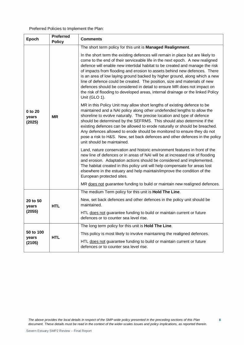
Predicted Implication of the Preferred Plan for the GLO 4 Policy Unit
Time Period Management Activities Property, Land Use and
Human Health
Nature Conservation – including Earth Heritage, Geology and Biodiversity
Landscape Character and Visual Amenity Historic Environment Amenity and
Recreational Use
0 – 20 years
The shoreline will remain stable and constrained flooding in this period will result in minimal management activities.
Limited erosion and flood risk will not impact on existing property, land use or human health.
A HTL policy will not significantly impact on nature conservation sites. Works should take account of possible environmental impacts and the need for an EIA.
Limited erosion and flood risk will not impact on existing landscape and visual amenity
Limited erosion and flood risk will not impact on the historic environment
Limited erosion and flood risk will not impact on the amenity value of the land or recreational use.
20 – 50 years
The current defences are expected to come to the end of their serviceable life during this period, requiring more active management. Reconstruction/replacement may be required in this epoch or the next.
Defences will manage the risk of impacts from flooding on property, land use and human health.
Coastal squeeze may occur which will result in loss of intertidal habitats. Works should take account of possible environmental impacts and the need for an EIA.
Defences are likely to come to the end of their serviceable life and require reconstruction in this (or the next) epoch. Increased height of defences or change in defence construction materials will affect local landscape - increasing presence in the landscape and disrupting views.
Defences will manage the risk of impacts from flooding on the historic environment
Defences will protect the amenity value of the land or recreational use.
50 – 100 years
Reconstruction/replacement of defences or maintenance of new defences (built in previous epoch) will be required. Monitoring of shoreline erosion will be needed.
Defences will manage the risk of impacts from flooding on property, land use and human health.
Coastal squeeze may occur which will result in loss of intertidal habitats. Works should take account of possible environmental impacts and the need for an EIA.
Defences are likely to come to the end of their serviceable life and require reconstruction in this (or the previous) epoch. Increased height of defences or change in defence construction materials will affect local landscape - increasing presence in the landscape and disrupting views.
Defences will manage the risk of impacts from flooding on the historic environment
Defences will protect the amenity value of the land or recreational use.
The above provides the local details in respect of the SMP-wide policy presented in the preceding sections of this Plan document. These details must be read in the context of the wider-scales issues and policy implications, as reported therein.
Severn Estuary SMP2 Review – Final Report
17
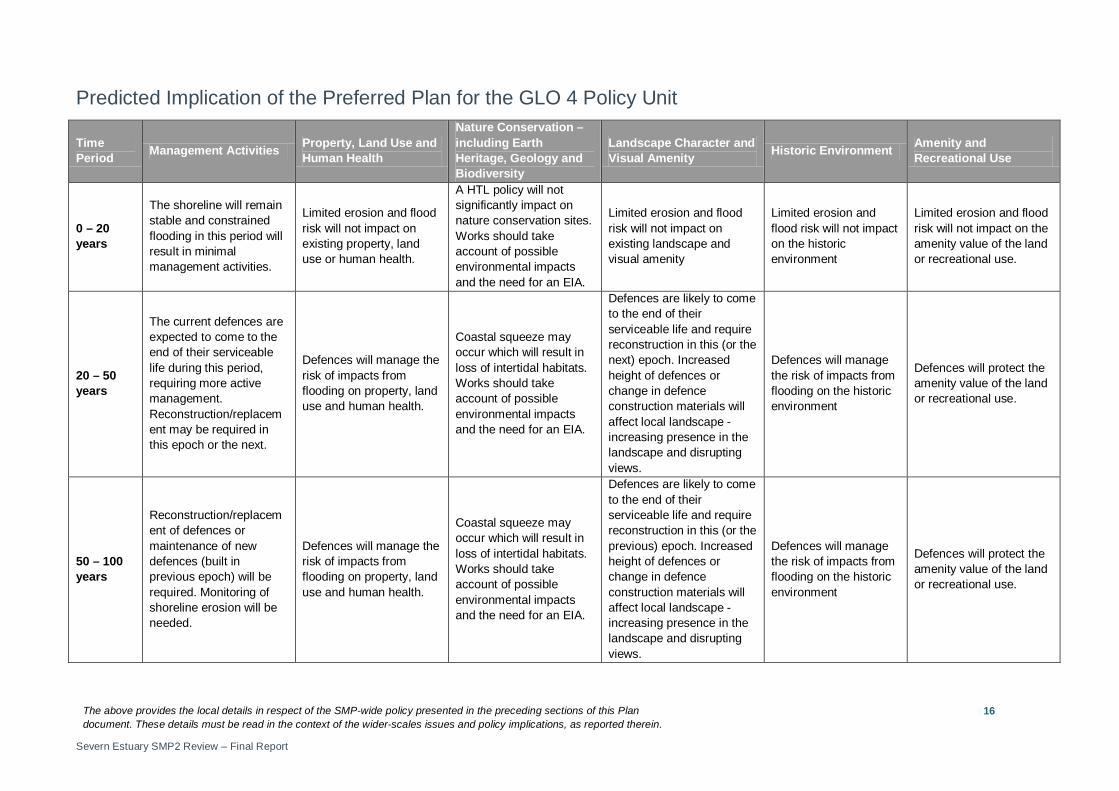
Policy Unit: GLO 5 – the farm to the north of Broadoak to Hill Farm, Rodley (west bank of the Severn)

The above provides the local details in respect of the SMP-wide policy presented in the preceding sections of this Plan document. These details must be read in the context of the wider-scales issues and policy implications, as reported therein.
Severn Estuary SMP2 Review – Final Report
18
Preferred Policies to Implement the Plan:
Epoch Preferred Policy Comments
0 to 20 years (2025)
HTL
The short term policy for this unit is Hold the Line.
The defences are expected to limit the risk of flooding in this epoch. HTL is likely to involve minimum management activities along most of the shoreline. Activities should focus on areas of risk where there existing defences are in place.
HTL should aim to manage the Garden Cliff SSSI to enable natural processes to continue here. HTL manages the risk of impacts from flooding and erosion. NAI is not appropriate due to the low lying land in the area.
HTL does not guarantee funding to build or maintain current or future defences or to counter sea level rise.
20 to 50 years (2055)
HTL
The medium term policy for this unit is Hold the Line.
The existing defences will come to the end of their serviceable life in this epoch. HTL recommends that defences are replaced in this epoch. HTL manages the risk of impacts from flooding and erosion. NAI is not appropriate due to the low lying land in the area.
Where there is a risk of flooding (in areas of low lying ground), the position, size and materials of new defences should be considered in detail by the SEFRMS. Actions to manage the risk of salt-water flooding to Westbury Court Gardens should be considered.
HTL does not guarantee funding to build or maintain current or future defences or to counter sea level rise.
50 to 100 years (2105)
HTL
The long term policy for this unit is Hold the Line.
New defences should be maintained. HTL manages the risk of impacts from flooding and erosion. NAI is not appropriate due to the low lying land in the area.
HTL does not guarantee funding to build or maintain current or future defences or to counter sea level rise.
Economics
Policy Unit
Existing SMP1 Policy
Time Period (epoch) SMP2 Assessment
0-20
20-50
50-100
Preferred Plan Present Value Damages
Preferred Plan Present Value Defence Costs
GLO5 Do
Nothing / HTL
HTL HTL HTL £124m (GLO3-5, SHAR3-7 total)
£23m (GLO3-5, SHAR3-7 total)
The preferred policy is economically viable for this unit. The preferred policy is economically viable for the linked Policy Units of GLO 3, GLO 4, GLO 5, SHAR 3, SHAR 4, SHAR 5, SHAR 6 and SHAR 7.
The above provides the local details in respect of the SMP-wide policy presented in the preceding sections of this Plan document. These details must be read in the context of the wider-scales issues and policy implications, as reported therein.
Severn Estuary SMP2 Review – Final Report
19
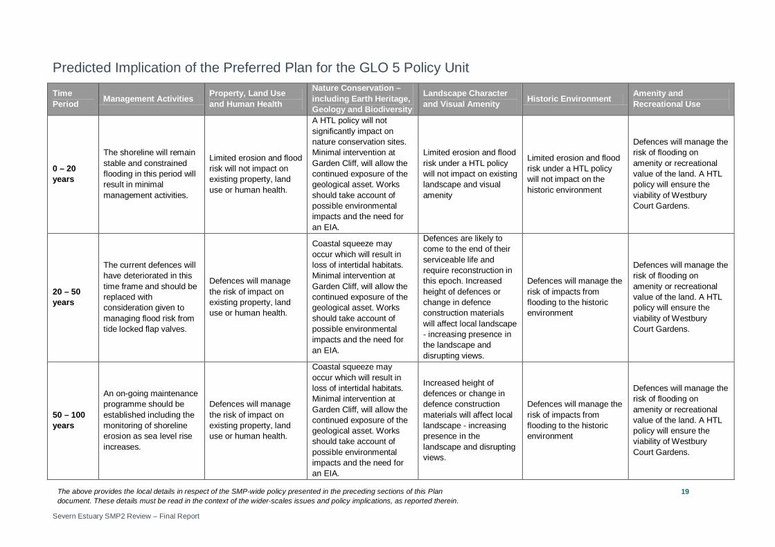
Predicted Implication of the Preferred Plan for the GLO 5 Policy Unit
Time Period Management Activities Property, Land Use
and Human Health
Nature Conservation – including Earth Heritage, Geology and Biodiversity
Landscape Character and Visual Amenity Historic Environment Amenity and
Recreational Use
0 – 20 years
The shoreline will remain stable and constrained flooding in this period will result in minimal management activities.
Limited erosion and flood risk will not impact on existing property, land use or human health.
A HTL policy will not significantly impact on nature conservation sites. Minimal intervention at Garden Cliff, will allow the continued exposure of the geological asset. Works should take account of possible environmental impacts and the need for an EIA.
Limited erosion and flood risk under a HTL policy will not impact on existing landscape and visual amenity
Limited erosion and flood risk under a HTL policy will not impact on the historic environment
Defences will manage the risk of flooding on amenity or recreational value of the land. A HTL policy will ensure the viability of Westbury Court Gardens.
20 – 50 years
The current defences will have deteriorated in this time frame and should be replaced with consideration given to managing flood risk from tide locked flap valves.
Defences will manage the risk of impact on existing property, land use or human health.
Coastal squeeze may occur which will result in loss of intertidal habitats. Minimal intervention at Garden Cliff, will allow the continued exposure of the geological asset. Works should take account of possible environmental impacts and the need for an EIA.
Defences are likely to come to the end of their serviceable life and require reconstruction in this epoch. Increased height of defences or change in defence construction materials will affect local landscape - increasing presence in the landscape and disrupting views.
Defences will manage the risk of impacts from flooding to the historic environment
Defences will manage the risk of flooding on amenity or recreational value of the land. A HTL policy will ensure the viability of Westbury Court Gardens.
50 – 100 years
An on-going maintenance programme should be established including the monitoring of shoreline erosion as sea level rise increases.
Defences will manage the risk of impact on existing property, land use or human health.
Coastal squeeze may occur which will result in loss of intertidal habitats. Minimal intervention at Garden Cliff, will allow the continued exposure of the geological asset. Works should take account of possible environmental impacts and the need for an EIA.
Increased height of defences or change in defence construction materials will affect local landscape - increasing presence in the landscape and disrupting views.
Defences will manage the risk of impacts from flooding to the historic environment
Defences will manage the risk of flooding on amenity or recreational value of the land. A HTL policy will ensure the viability of Westbury Court Gardens.
The above provides the local details in respect of the SMP-wide policy presented in the preceding sections of this Plan document. These details must be read in the context of the wider-scales issues and policy implications, as reported therein.
Severn Estuary SMP2 Review – Final Report
20
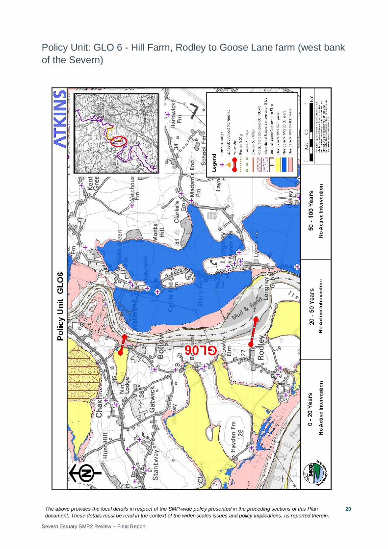
Policy Unit: GLO 6 - Hill Farm, Rodley to Goose Lane farm (west bank of the Severn)

The above provides the local details in respect of the SMP-wide policy presented in the preceding sections of this Plan document. These details must be read in the context of the wider-scales issues and policy implications, as reported therein.
Severn Estuary SMP2 Review – Final Report
21
Preferred Policies to Implement the Plan:
Epoch Preferred Policy Comments
0 to 20 years (2025)
NAI
The short term policy for this unit is No Active Intervention.
High ground and hard geology limit the risk from coastal flooding and erosion.
20 to 50 years (2055)
NAI
The medium term policy for this unit is No Active Intervention.
High ground and hard geology limit the risk from coastal flooding and erosion.
50 to 100 years (2105)
NAI
The long term policy for this unit is No Active Intervention.
High ground and hard geology limit the risk from coastal flooding and erosion. Long term rates of erosion are unclear and should be monitored.
Economics
Policy Unit
Existing SMP1 Policy
Time Period (epoch) SMP2 Assessment
0-20
20-50
50-100
Preferred Plan Present Value Damages
Preferred Plan Present Value Defence Costs
GLO6 HTL NAI NAI NAI £24m (GLO6-8, SHAR1-2 total)
£10m (GLO6-8, SHAR1-2 total)
The preferred policy has no economic impact in this Policy Unit. The preferred policy is economically viable for the linked Policy Units of GLO 6, GLO 7, GLO 8, SHAR 1, and SHAR 2, but the benefit-cost ratio (BCR) is low. Where the BCR is low, schemes may be less likely to receive public funding and it may be necessary to find funding from other sources. The costs of the preferred policy in the table above relate to actions taken in linked policy units, not in GLO 6.
The above provides the local details in respect of the SMP-wide policy presented in the preceding sections of this Plan document. These details must be read in the context of the wider-scales issues and policy implications, as reported therein.
Severn Estuary SMP2 Review – Final Report
22
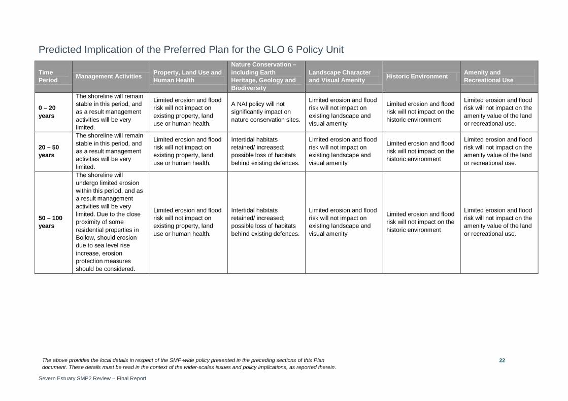
Predicted Implication of the Preferred Plan for the GLO 6 Policy Unit
Time Period Management Activities Property, Land Use and
Human Health
Nature Conservation – including Earth Heritage, Geology and Biodiversity
Landscape Character and Visual Amenity Historic Environment Amenity and
Recreational Use
0 – 20 years
The shoreline will remain stable in this period, and as a result management activities will be very limited.
Limited erosion and flood risk will not impact on existing property, land use or human health.
A NAI policy will not significantly impact on nature conservation sites.
Limited erosion and flood risk will not impact on existing landscape and visual amenity
Limited erosion and flood risk will not impact on the historic environment
Limited erosion and flood risk will not impact on the amenity value of the land or recreational use.
20 – 50 years
The shoreline will remain stable in this period, and as a result management activities will be very limited.
Limited erosion and flood risk will not impact on existing property, land use or human health.
Intertidal habitats retained/ increased; possible loss of habitats behind existing defences.
Limited erosion and flood risk will not impact on existing landscape and visual amenity
Limited erosion and flood risk will not impact on the historic environment
Limited erosion and flood risk will not impact on the amenity value of the land or recreational use.
50 – 100 years
The shoreline will undergo limited erosion within this period, and as a result management activities will be very limited. Due to the close proximity of some residential properties in Bollow, should erosion due to sea level rise increase, erosion protection measures should be considered.
Limited erosion and flood risk will not impact on existing property, land use or human health.
Intertidal habitats retained/ increased; possible loss of habitats behind existing defences.
Limited erosion and flood risk will not impact on existing landscape and visual amenity
Limited erosion and flood risk will not impact on the historic environment
Limited erosion and flood risk will not impact on the amenity value of the land or recreational use.

The above provides the local details in respect of the SMP-wide policy presented in the preceding sections of this Plan document. These details must be read in the context of the wider-scales issues and policy implications, as reported therein.
Severn Estuary SMP2 Review – Final Report
23
Policy Unit: GLO 7 – Goose Lane farm to Ley Road (west bank of the Severn)

The above provides the local details in respect of the SMP-wide policy presented in the preceding sections of this Plan document. These details must be read in the context of the wider-scales issues and policy implications, as reported therein.
Severn Estuary SMP2 Review – Final Report
24
Preferred Policies to Implement the Plan:
Epoch Preferred Policy Comments
0 to 20 years (2025)
HTL
The short term policy for this unit is Hold the Line.
The defences are expected to limit the risk of impacts from flooding in this epoch. HTL will involve on-going maintenance activities.
HTL does not guarantee funding to build or maintain current or future defences or to counter sea level rise.
20 to 50 years (2055)
HTL
The Medium Term policy for this unit is Hold the Line.
The existing defences will come to the end of their serviceable life in this epoch. HTL recommends that defences are replaced. A HTL policy will manage the risk of impacts from flooding to Walmore Common (Ramsar site) and other assets. The position, size and materials of new defences should be considered in detail by the SEFRMS – in some areas high ground limits the risk from coastal flooding.
HTL does not guarantee funding to build or maintain current or future defences or to counter sea level rise.
50 to 100 years (2105)
HTL
The Long Term policy for this unit is Hold the Line.
New defences should be maintained to limit the risk of impacts from flooding in this epoch.
HTL does not guarantee funding to build or maintain current or future defences or to counter sea level rise.
Economics
Policy Unit
Existing SMP1 Policy
Time Period (epoch) SMP2 Assessment
0-20
20-50
50-100
Preferred Plan Present Value Damages
Preferred Plan Present Value Defence Costs
GLO7 HTL HTL HTL HTL £24m (GLO6-8, SHAR1-2 total)
£10m (GLO6-8, SHAR1-2 total)
The preferred policy is economically viable for this unit. The preferred policy is economically viable for the linked Policy Units of GLO 6, GLO 7, GLO 8, SHAR 1, and SHAR 2, but the benefit-cost ratio (BCR) is low. Where the BCR is low, schemes may be less likely to receive public funding and it may be necessary to find funding from other sources. The costs and damages of the preferred policy in the table above relate to actions taken in all linked policy units.
The above provides the local details in respect of the SMP-wide policy presented in the preceding sections of this Plan document. These details must be read in the context of the wider-scales issues and policy implications, as reported therein.
Severn Estuary SMP2 Review – Final Report
25
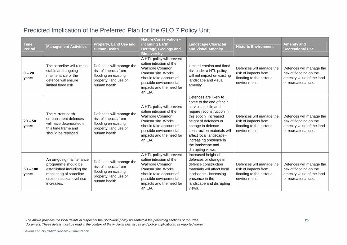
Predicted Implication of the Preferred Plan for the GLO 7 Policy Unit
Time Period Management Activities Property, Land Use and
Human Health
Nature Conservation – including Earth Heritage, Geology and Biodiversity
Landscape Character and Visual Amenity Historic Environment Amenity and
Recreational Use
0 – 20 years
The shoreline will remain stable and ongoing maintenance of the defence will ensure limited flood risk
Defences will manage the risk of impacts from flooding on existing property, land use or human health.
A HTL policy will prevent saline intrusion of the Walmore Common Ramsar site. Works should take account of possible environmental impacts and the need for an EIA.
Limited erosion and flood risk under a HTL policy will not impact on existing landscape and visual amenity.
Defences will manage the risk of impacts from flooding to the historic environment
Defences will manage the risk of flooding on the amenity value of the land or recreational use.
20 – 50 years
The current earth embankment defences will have deteriorated in this time frame and should be replaced.
Defences will manage the risk of impacts from flooding on existing property, land use or human health.
A HTL policy will prevent saline intrusion of the Walmore Common Ramsar site. Works should take account of possible environmental impacts and the need for an EIA.
Defences are likely to come to the end of their serviceable life and require reconstruction in this epoch. Increased height of defences or change in defence construction materials will affect local landscape - increasing presence in the landscape and disrupting views.
Defences will manage the risk of impacts from flooding to the historic environment
Defences will manage the risk of flooding on the amenity value of the land or recreational use.
50 – 100 years
An on-going maintenance programme should be established including the monitoring of shoreline erosion as sea level rise increases.
Defences will manage the risk of impacts from flooding on existing property, land use or human health.
A HTL policy will prevent saline intrusion of the Walmore Common Ramsar site. Works should take account of possible environmental impacts and the need for an EIA.
Increased height of defences or change in defence construction materials will affect local landscape - increasing presence in the landscape and disrupting views.
Defences will manage the risk of impacts from flooding to the historic environment
Defences will manage the risk of flooding on the amenity value of the land or recreational use.
The above provides the local details in respect of the SMP-wide policy presented in the preceding sections of this Plan document. These details must be read in the context of the wider-scales issues and policy implications, as reported therein.
Severn Estuary SMP2 Review – Final Report
26
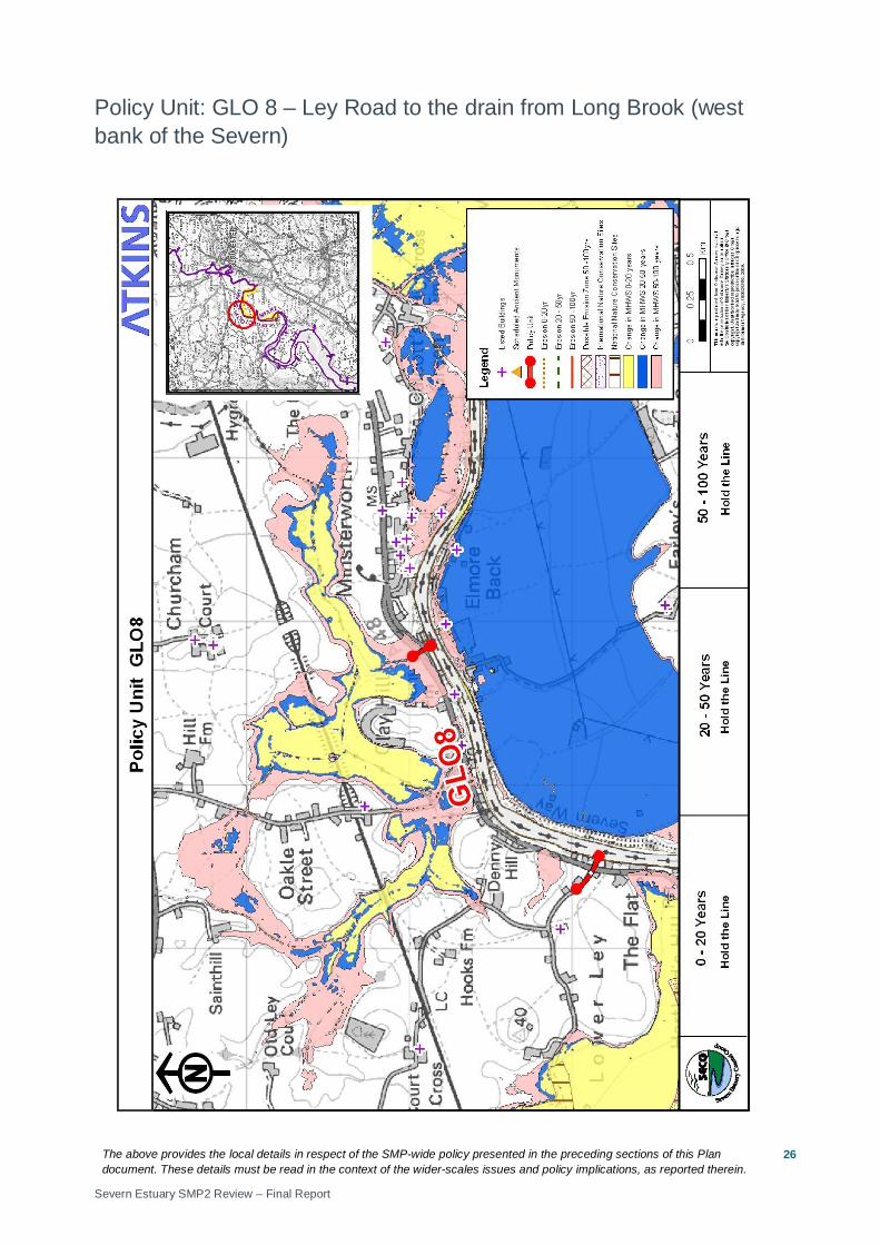
Policy Unit: GLO 8 – Ley Road to the drain from Long Brook (west bank of the Severn)

The above provides the local details in respect of the SMP-wide policy presented in the preceding sections of this Plan document. These details must be read in the context of the wider-scales issues and policy implications, as reported therein.
Severn Estuary SMP2 Review – Final Report
27
Preferred Policies to Implement the Plan:
Epoch Preferred Policy Comments
0 to 20 years (2025)
HTL
The short term policy for this unit is Hold the Line.
The existing defences will come to the end of their serviceable life in this epoch. HTL recommends that defences are replaced. The position, size and materials of new defences should be considered in detail by the SEFRMS – in some areas high ground limits the risk from coastal flooding. HTL manages the risk of impacts from flooding and erosion.
HTL does not guarantee funding to build or maintain current or future defences or to counter sea level rise.
20 to 50 years (2055)
HTL
The medium term policy for this unit is Hold the Line.
New defences should be maintained. HTL manages the risk of impacts from flooding and erosion.
HTL does not guarantee funding to build or maintain current or future defences or to counter sea level rise.
50 to 100 years (2105)
HTL
The long term policy for this unit is Hold the Line.
New defences should be maintained. HTL manages the risk of impacts from flooding and erosion.
HTL does not guarantee funding to build or maintain current or future defences or to counter sea level rise.
Economics
Policy Unit
Existing SMP1 Policy
Time Period (epoch) SMP2 Assessment
0-20
20-50
50-100
Preferred Plan Present Value Damages
Preferred Plan Present Value Defence Costs
GLO8 HTL HTL HTL HTL £24m (GLO6-8, SHAR1-2 total)
£10m (GLO6-8, SHAR1-2 total)
The preferred policy is economically viable for this unit. The preferred policy is economically viable for the linked Policy Units of GLO 6, GLO 7, GLO 8, SHAR 1, and SHAR 2, but the benefit-cost ratio (BCR) is low. Where the BCR is low, schemes may be less likely to receive public funding and it may be necessary to find funding from other sources.
The above provides the local details in respect of the SMP-wide policy presented in the preceding sections of this Plan document. These details must be read in the context of the wider-scales issues and policy implications, as reported therein.
Severn Estuary SMP2 Review – Final Report
28
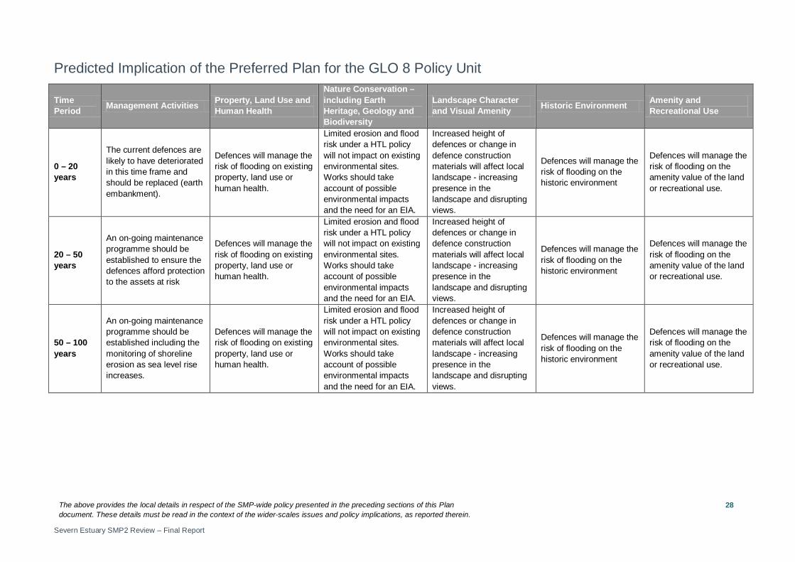
Predicted Implication of the Preferred Plan for the GLO 8 Policy Unit
Time Period Management Activities Property, Land Use and
Human Health
Nature Conservation – including Earth Heritage, Geology and Biodiversity
Landscape Character and Visual Amenity Historic Environment Amenity and
Recreational Use
0 – 20 years
The current defences are likely to have deteriorated in this time frame and should be replaced (earth embankment).
Defences will manage the risk of flooding on existing property, land use or human health.
Limited erosion and flood risk under a HTL policy will not impact on existing environmental sites. Works should take account of possible environmental impacts and the need for an EIA.
Increased height of defences or change in defence construction materials will affect local landscape - increasing presence in the landscape and disrupting views.
Defences will manage the risk of flooding on the historic environment
Defences will manage the risk of flooding on the amenity value of the land or recreational use.
20 – 50 years
An on-going maintenance programme should be established to ensure the defences afford protection to the assets at risk
Defences will manage the risk of flooding on existing property, land use or human health.
Limited erosion and flood risk under a HTL policy will not impact on existing environmental sites. Works should take account of possible environmental impacts and the need for an EIA.
Increased height of defences or change in defence construction materials will affect local landscape - increasing presence in the landscape and disrupting views.
Defences will manage the risk of flooding on the historic environment
Defences will manage the risk of flooding on the amenity value of the land or recreational use.
50 – 100 years
An on-going maintenance programme should be established including the monitoring of shoreline erosion as sea level rise increases.
Defences will manage the risk of flooding on existing property, land use or human health.
Limited erosion and flood risk under a HTL policy will not impact on existing environmental sites. Works should take account of possible environmental impacts and the need for an EIA.
Increased height of defences or change in defence construction materials will affect local landscape - increasing presence in the landscape and disrupting views.
Defences will manage the risk of flooding on the historic environment
Defences will manage the risk of flooding on the amenity value of the land or recreational use.