skysat imagery - assets.planet.com...this document is designed as a general guideline for customers...
TRANSCRIPT

TerraBella_Paris_s103_20170822 Cape Town, South Africa • SkySat
SKYSAT IMAGERY PRODUCT SPECIFICATION
PLANET.COM JANUARY 2020

Skysat Imagery Product Specification
TABLE OF CONTENTS COLLECTION TYPES 3
STANDARD IMAGE 3
VIDEO 3
PRODUCT TYPES 4
SCENES 4
Basic 5
Ortho 6
Scene Metadata 11
COLLECTS 16
Ortho 16
Ortho Metadata 17
BASEMAP MOSAIC TILES 18
VIDEO 19
© Planet 2020. All rights reserved. This document is designed as a general guideline for customers interested in acquiring Planet imagery products and services. Planet takes an agile and iterative approach to its technology, and therefore may make changes to the product(s) described in this document.
© Planet Labs Inc. 2020 2

Skysat Imagery Product Specification
COLLECTION TYPES STANDARD IMAGE
Figure 1: A single “site,” or a standard SkySat image deliverable. Image width varies with satellite and collection angle; 6.6 km represents the minimum width.
VIDEO
Full motion videos are collected between 30 and 120 seconds by a single camera from any of the active SkySats. Videos are collected using only the Panchromatic half of the camera, hence all videos are PAN only.
Videos are packaged and delivered with a video mpeg-4 file, plus all image frames with accompanying video metadata and a frame index file (reference Product Types below).
© Planet Labs Inc. 2020 3
Skysat Imagery Product Specification
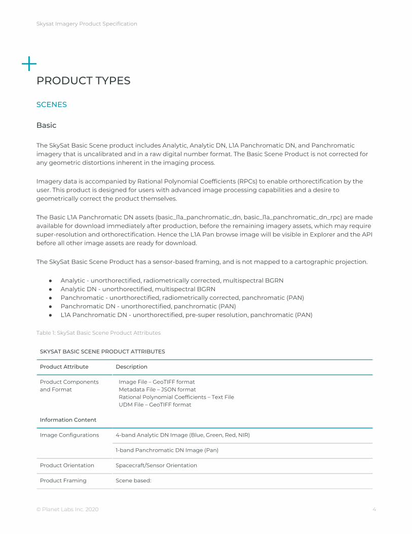
PRODUCT TYPES SCENES
Basic
The SkySat Basic Scene product includes Analytic, Analytic DN, L1A Panchromatic DN, and Panchromatic imagery that is uncalibrated and in a raw digital number format. The Basic Scene Product is not corrected for any geometric distortions inherent in the imaging process.
Imagery data is accompanied by Rational Polynomial Coefficients (RPCs) to enable orthorectification by the user. This product is designed for users with advanced image processing capabilities and a desire to geometrically correct the product themselves.
The Basic L1A Panchromatic DN assets (basic_l1a_panchromatic_dn, basic_l1a_panchromatic_dn_rpc) are made available for download immediately after production, before the remaining imagery assets, which may require super-resolution and orthorectification. Hence the L1A Pan browse image will be visible in Explorer and the API before all other image assets are ready for download.
The SkySat Basic Scene Product has a sensor-based framing, and is not mapped to a cartographic projection.
● Analytic - unorthorectified, radiometrically corrected, multispectral BGRN ● Analytic DN - unorthorectified, multispectral BGRN ● Panchromatic - unorthorectified, radiometrically corrected, panchromatic (PAN) ● Panchromatic DN - unorthorectified, panchromatic (PAN) ● L1A Panchromatic DN - unorthorectified, pre-super resolution, panchromatic (PAN)
Table 1: SkySat Basic Scene Product Attributes
SKYSAT BASIC SCENE PRODUCT ATTRIBUTES
Product Attribute Description
Product Components and Format
Image File – GeoTIFF format Metadata File – JSON format Rational Polynomial Coefficients – Text File UDM File – GeoTIFF format
Information Content
Image Configurations 4-band Analytic DN Image (Blue, Green, Red, NIR)
1-band Panchromatic DN Image (Pan)
Product Orientation Spacecraft/Sensor Orientation
Product Framing Scene based:
© Planet Labs Inc. 2020 4

Skysat Imagery Product Specification
SkySat Satellites have three cameras per satellite, which capture overlapping strips. Each of these strips contain overlapping scenes. One scene is approximately 2560px x 1080px.
Sensor Type CMOS Frame Camera with Panchromatic and Multispectral halves
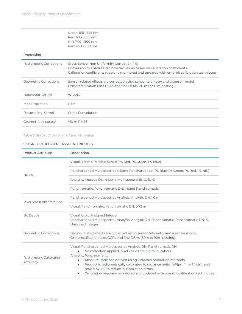
Spectral Bands Blue: 450 - 515 nm Green: 515 - 595 nm Red: 605 - 695 nm NIR: 740 - 900 nm Pan: 450 - 900 nm
Processing Basic Scene
Radiometric Corrections Cross-Sensor Non Uniformity Correction (1%) Conversion to absolute radiometric values based on calibration coefficients Calibration coefficients regularly monitored and updated with on-orbit calibration techniques
Geometric Corrections Idealized sensor model and Rational Polynomial Coefficients (RPC) Bands are co-registered
Horizontal Datum WGS84
Map Projection N/A
Resampling Kernel Resampling of Analytic Multispectral Data to > 1.0m GSD
Ground Sample Distance [SkySat-1, SkySat-2] Panchromatic: 0.86m Multispectral: 1.0m
[SkySat-3 - SkySat-13] Panchromatic: 0.72m Multispectral: 1.0m
Geometric Accuracy <50m RMSE
© Planet Labs Inc. 2020 5

Skysat Imagery Product Specification
Ortho
The SkySat Ortho Scene product includes Visual, Analytic DN, Analytic, Panchromatic, and Pansharpened Multispectral imagery. The Ortho Scene product is sensor- and geometrically-corrected, and is projected to a cartographic map projection. The geometric correction uses fine Digital Elevation Models (DEMs) with a post spacing of between 30 and 90 meters.
Ground Control Points (GCPs) are used in the creation of every image and the accuracy of the product will vary from region to region based on available GCPs. Also note, ortho accuracy is not guaranteed for collections with view angle greater than 30 degrees.
● Visual - orthorectified, pansharpened, and color-corrected (using a color curve) 3-band RGB Imagery ● Pansharpened Multispectral - orthorectified, pansharpened 4-band BGRN Imagery ● Analytic - orthorectified, multispectral BGRN. Radiometric corrections applied to correct for any sensor
artifacts and transformation to top-of-atmosphere radiance ● Analytic DN - orthorectified, multispectral BGRN, uncalibrated digital number imagery product
Radiometric corrections applied to correct for any sensor artifacts ● Panchromatic - orthorectified, radiometrically correct, panchromatic (PAN) ● Panchromatic DN - orthorectified, panchromatic (PAN), uncalibrated digital number imagery product
Table 2: SkySat Ortho Scene Product Attributes
SKYSAT ORTHO SCENE PRODUCT ATTRIBUTES
Product Attribute Description
Product Components and Format
Image File – GeoTIFF format Metadata File – JSON format Rational Polynomial Coefficients – Text File UDM File – GeoTIFF format
Information Content
Product Framing Scene Based:
SkySat Satellites have three cameras per satellite, which capture overlapping strips. Each of these strips contain overlapping scenes. One scene is approximately 2560px x 1080px.
Sensor Type CMOS Frame Camera with Panchromatic and Multispectral halves
Spectral Bands Blue: 450 - 515 nm
© Planet Labs Inc. 2020 6
Skysat Imagery Product Specification
Green: 515 - 595 nm Red: 605 - 695 nm NIR: 740 - 900 nm Pan: 450 - 900 nm
Processing
Radiometric Corrections Cross-Sensor Non Uniformity Correction (1%) Conversion to absolute radiometric values based on calibration coefficients Calibration coefficients regularly monitored and updated with on-orbit calibration techniques
Geometric Corrections Sensor-related effects are corrected using sensor telemetry and a sensor model. Orthorectification uses GCPs and fine DEMs (30 m to 90 m posting).
Horizontal Datum WGS84
Map Projection UTM
Resampling Kernel Cubic Convolution
Geometric Accuracy <10 m RMSE
Table 3: SkySat Ortho Scene Asset Attributes
SKYSAT ORTHO SCENE ASSET ATTRIBUTES
Product Attribute Description
Bands
Visual: 3-band Pansharpened (PS Red, PS Green, PS Blue)
Pansharpened Multispectral: 4-band Pansharpened (PS Blue, PS Green, PS Red, PS NIR)
Analytic, Analytic DN: 4-band Multispectral (B, G, R, N)
Panchromatic, Panchromatic DN: 1-band Panchromatic
Pixel Size (Orthorectified) Pansharpened Multispectral, Analytic, Analytic DN: 1.0 m
Visual, Panchromatic, Panchromatic DN: 0.72 m
Bit Depth Visual: 8-bit Unsigned Integer Pansharpened Multispectral, Analytic, Analytic DN, Panchromatic, Panchromatic DN: 16 Unsigned Integer
Geometric Corrections Sensor-related effects are corrected using sensor telemetry and a sensor model. Orthorectification uses GCPs and fine DEMs (30m to 90m posting).
Radiometric Calibration Accuracy
Visual, Pansharpened Multispectral, Analytic DN, Panchromatic DN: ● No correction applied, pixel values are digital numbers
Analytic, Panchromatic: ● Absolute Radiance derived using vicarious calibration methods ● Product is radiometrically calibrated to radiance units [W/(µm * m^2 * str)], and
scaled by 100 to reduce quantization errors ● Calibration regularly monitored and updated with on-orbit calibration techniques.
© Planet Labs Inc. 2020 7

Skysat Imagery Product Specification
Radiometric Accuracy (Analytic, Panchromatic)
+/- 5% Relative accuracy at < 10 degrees off-nadir angle
Color Enhancements (Visual)
Enhanced for visual use
VIDEO
The SkySat Video products include a video mpeg-4 file, with all captured frames used to produce the video as L1A panchromatic DN scenes.
● 1A Panchromatic DN - unorthorectified, pre-super resolution, panchromatic (PAN)
Table 4: SkySat Video Scene Product Attributes
SKYSAT VIDEO SCENE PRODUCT ATTRIBUTES
Product Attribute Description
Product Components and Format
Video file - MP4 Video frames - folder
- Image Frame File – TIFF format - Rational Polynomial Coefficients – Text File - Frame Index - CSV File
Metadata File – JSON format
Information Content
Image Configurations 1-band L1A Panchromatic DN Image (Pan)
Product Orientation Spacecraft/Sensor Orientation
Sensor Type CMOS Frame Camera with Panchromatic and Multispectral halves
Spectral Bands Pan: 450 - 900 nm
Video Duration 30 - 120 seconds
Processing Basic Video Scene
Bit Depth 16 Unsigned Integer
Radiometric Corrections Cross-Sensor Non Uniformity Correction (1%)
Geometric Corrections Idealized sensor model and Rational Polynomial Coefficients (RPC)
Horizontal Datum WGS84
Map Projection N/A
Resampling Kernel N/A
Ground Sample Distance [SkySat-3 - SkySat-13]
© Planet Labs Inc. 2020 8

Skysat Imagery Product Specification
Panchromatic: 0.86m
Geometric Accuracy <50m RMSE
Scene Metadata
Basic Scene GeoJSON metadata
Table 5: Skysat Basic Scene Geojson Metadata Schema
SKYSAT BASIC SCENE GEOJSON METADATA SCHEMA
Parameter Description Type
acquired The RFC 3339 acquisition time of the image. string
camera_id The specific detector used to capture the scene.
String (e.g. “d1”, “d2”)
cloud_cover The estimated percentage of the scene covered by clouds.
number (0-100)
ground_control If the image meets the positional accuracy specifications this value will be true. If the image has uncertain positional accuracy, this value will be false.
boolean
gsd The ground sampling distance of the image acquisition.
number
item_type The name of the item type that models shared imagery data schema.
string (e.g. “PSScene3Band”, ”SkySatScene”)
provider Name of the imagery provider. string ("planetscope","rapideye", “skysat”)
published The RFC 3339 timestamp at which this item was added to the API.
string
quality_category Metric for image quality. To qualify for “standard” image quality an image must meet a variety of quality standards, for example: PAN motion blur less than 1.15 pixels, compression bits per pixel less than 3. If the image does not meet these criteria it is considered “test” quality.
string (“standard”, “test”)
satellite_azimuth Angle from true north to the satellite vector at the time of imaging, projected on the horizontal plane in degrees.
number (0 - 360)
© Planet Labs Inc. 2020 9

Skysat Imagery Product Specification
satellite_id Globally unique identifier of the satellite that acquired the underlying imagery.
string
strip_id Globally unique identifier of the image strip this scene was collected against
string
sun_azimuth Angle from true north to the sun vector projected on the horizontal plane in degrees.
number (0 - 360)
sun_elevation Elevation angle of the sun in degrees. number (0 - 90)
updated The RFC 3339 timestamp at which this item was updated in the API.
string
view_angle Spacecraft across-track off-nadir viewing angle used for imaging, in degrees with + being east and - being west.
number (-90 - +90)
Basic Scene RPC metadata
Table 6: Skysat Basic Scene Text file Metadata Schema
Parameter Description Sample
LINE_OFF Row offset of center point 534.896219421794
SAMP_OFF Column offset of center point 1267.3960612691
LAT_OFF Latitude coordinate of center point -18.1132
LONG_OFF Longitude coordinate of center point 178.4441
HEIGHT_OFF Altitude of center point 123
LINE_SCALE Scaling factor for row coordinate 534.896219421794
SAMP_SCALE Scaling factor for column coordinate 1267.39606126914
LAT_SCALE Scaling factor for latitude coordinates -0.0264
LONG_SCALE Scaling factor for longitude coordinates 0.0331
HEIGHT_SCALE Scaling factor for altitude coordinates 77
LINE_NUM_COEFF_ Numerator coefficient in row RPC equation (1-20) 4.27902854674
LINE_DEN_COEFF_ Denominator Coefficient in row RPC equation(1-20) 0.00174493132019
SAMP_NUM_COEFF_ Numerator coefficient in column RPC equation(1-20)
0.0110620153979
SAMP_DEN_COEFF_ Denominator coefficient in column RPC equation (1-20)
0.00174477677906
© Planet Labs Inc. 2020 10

Skysat Imagery Product Specification
Ortho Scene GeoJSON metadata
Table 7: Skysat Ortho Scene Geojson Metadata Schema
SKYSAT ORTHO SCENE GEOJSON METADATA SCHEMA
Parameter Description Type
acquired The RFC 3339 acquisition time of the image. string
camera_id The specific detector used to capture the scene.
String (e.g. “d1”, “d2”)
cloud_cover The estimated percentage of the scene covered by clouds.
number (0-100)
ground_control If the image meets the positional accuracy specifications this value will be true. If the image has uncertain positional accuracy, this value will be false.
boolean
gsd The ground sampling distance of the image acquisition.
number
item_type The name of the item type that models shared imagery data schema.
string (e.g. “PSScene3Band”, ”SkySatScene”)
provider Name of the imagery provider. string ("planetscope","rapideye", “skysat”)
published The RFC 3339 timestamp at which this item was added to the API.
string
quality_category Metric for image quality. To qualify for “standard” image quality an image must meet a variety of quality standards, for example: PAN motion blur less than 1.15 pixels, compression bits per pixel less than 3. If the image does not meet these criteria it is considered “test” quality.
string (“standard”, “test”)
satellite_azimuth Angle from true north to the satellite vector at the time of imaging, projected on the horizontal plane in degrees.
number (0 - 360)
satellite_id Globally unique identifier of the satellite that acquired the underlying imagery.
string
strip_id Globally unique identifier of the image strip this scene was collected against
string
© Planet Labs Inc. 2020 11

Skysat Imagery Product Specification
sun_azimuth Angle from true north to the sun vector projected on the horizontal plane in degrees.
number (0 - 360)
sun_elevation Elevation angle of the sun in degrees. number (0 - 90)
updated The RFC 3339 timestamp at which this item was updated in the API.
string
view_angle Spacecraft across-track off-nadir viewing angle used for imaging, in degrees with + being east and - being west.
number (-90 - +90)
Video Metadata
Video GeoJSON metadata
Table 8: Skysat Video Geojson Metadata Schema
SKYSAT BASIC SCENE GEOJSON METADATA SCHEMA
Parameter Description Type
acquired The RFC 3339 acquisition time of the image. string
camera_id The specific detector used to capture the scene.
String (e.g. “d1”, “d2”)
item_type The name of the item type that models shared imagery data schema.
string (e.g. “PSScene3Band”, ”SkySatScene”)
provider Name of the imagery provider. string ("planetscope","rapideye", “skysat”)
published The RFC 3339 timestamp at which this item was added to the API.
string
quality_category Metric for image quality. To qualify for “standard” image quality an image must meet a variety of quality standards, for example: PAN motion blur less than 1.15 pixels, compression bits per pixel less than 3. If the image does not meet these criteria it is considered “test” quality.
string (“standard”, “test”)
satellite_azimuth Angle from true north to the satellite vector at the time of imaging, projected on the horizontal plane in degrees.
number (0 - 360)
satellite_id Globally unique identifier of the satellite that acquired the underlying imagery.
string
© Planet Labs Inc. 2020 12

Skysat Imagery Product Specification
strip_id Globally unique identifier of the image strip this scene was collected against
string
sun_azimuth Angle from true north to the sun vector projected on the horizontal plane in degrees.
number (0 - 360)
sun_elevation Elevation angle of the sun in degrees. number (0 - 90)
updated The RFC 3339 timestamp at which this item was updated in the API.
string
view_angle Spacecraft across-track off-nadir viewing angle used for imaging, in degrees with + being east and - being west.
number (-90 - +90)
Video Scene metadata
Table 9: Skysat Video JSON file Metadata Schema
VIDEO PRODUCT METADATA
FIeld Value Sample
Satellite Satellite ID 00110
Camera Camera used for imaging 2
Geometry Composite of the geospatial extent of all frames in the video GeoJson Polygon
Time
Start Start time of video capture 2018-04-10T21:43:07
End End time of video capture 2018-04-10T21:44:07
Duration (s) Duration of video in seconds 59.976592063903809
Angle
Start Satellite collection elevation of first frame in video 55.476973516035933
End Satellite collection elevation of last frame in video 61.410026752389307
Convergence Convergence angle between first and last frames 5.9330532363533734
Azimuth
Start Satellite azimuth angle of first frame in video 48.316762122631033
End Satellite azimuth angle of last frame in video 143.12580513942621
Delta Difference between start and end satellite azimuth angle 94.809043016795172
© Planet Labs Inc. 2020 13

Skysat Imagery Product Specification
Exposure
Panchromatic Gain Sensor amplification of the signal 1.0, 10.0, or 30.0
Panchromatic Integration Time
Integration time, in ms 433.59375
Compression Ratio The ratio comparing an image's true size to its size on the file system 4.0
Scan Rate Kms The ground speed at which the SkySat captures image frames 433.59375
© Planet Labs Inc. 2020 14
Skysat Imagery Product Specification
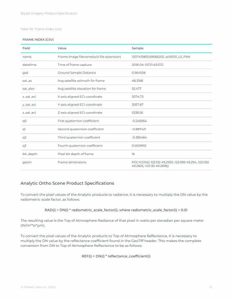
Table 10: Frame Index (csv)
FRAME INDEX (CSV)
Field Value Sample
name Frame image filename(w/o file extension) 1207431805.69566202_sc00110_c2_PAN
datetime Time of frame capture 2018-04-10T21:43:07Z
gsd Ground Sample Distance 0.964506
sat_az Avg satellite azimuth for frame 48.3168
sat_elev Avg satellite elevation for frame 55.477
x_sat_eci X-axis aligned ECI coordinate 3074.73
y_sat_eci Y-axis aligned ECI coordinate 3057.87
z_sat_eci Z-axis aligned ECI coordinate 5338.56
q0 First quaternion coefficient -0.246954
q1 Second quaternion coefficient -0.887421
q2 Third quaternion coefficient -0.385464
q3 Fourth quaternion coefficient 0.0539912
bit_depth Pixel bit depth of frame 16
geom Frame dimensions POLYGON((-123.132 49.2933,-123.089 49.294,-123.092 49.2825,-123.135 49.2818))
Analytic Ortho Scene Product Specifications
To convert the pixel values of the Analytic products to radiance, it is necessary to multiply the DN value by the radiometric scale factor, as follows:
RAD(i) = DN(i) * radiometric_scale_factor(i), where radiometric_scale_factor(i) = 0.01
The resulting value is the Top of Atmosphere Radiance of that pixel in watts per steradian per square meter (W/m²*sr*μm).
To convert the pixel values of the Analytic products to Top of Atmosphere Reflectance, it is necessary to multiply the DN value by the reflectance coefficient found in the GeoTiff header. This makes the complete conversion from DN to Top of Atmosphere Reflectance to be as follows:
REF(i) = DN(i) * reflectance_coefficient(i)
© Planet Labs Inc. 2020 15

Skysat Imagery Product Specification
Alternatively, the customer may perform the TOA Reflectance conversion on their own using the following equation, with the ESUN values given below in Table 3.
OART = (π × Radiance × d )2
ESUN × cos(90−sun elevation)
Earth to sun distance in astronomical units d =
Table 11: Skysat Analytic Ortho Scene ESUN values, resampled from Thuillier irradiance spectra
PAN BLUE GREEN RED NIR
SkySat-1 1587.94 1984.85 1812.88 1565.83 1127
SkySat-2 1587.94 1984.85 1812.88 1565.83 1127
SkySat-3 1585.89 2000.7 1821.8 1584.13 1120.33
SkySat-4 1585.89 2000.7 1821.8 1584.13 1120.33
SkySat-5 1573.42 2009.23 1820.33 1584.84 1104.96
SkySat-6 1573.42 2009.23 1820.33 1584.84 1104.96
SkySat-7 1573.42 2009.23 1820.33 1584.84 1104.96
SkySat-8 1582.79 2009.28 1820.25 1583.3 1114.22
SkySat-9 1583.61 2009.29 1821.04 1583.83 1109.44
SkySat-10 1583.88 2008.61 1820.87 1583.5 1112.3
SkySat-11 1586.89 2009.26 1821.14 1583.66 1113.77
SkySat-12 1581.65 2009.5 1821.24 1584.91 1109.01
SkySat-13 1580.89 2009.43 1821.7 1583.77 1108.74
SkySat-14 1581.65 2009.5 1821.24 1584.91 1109.01
SkySat-15 1580.89 2009.43 1821.7 1583.77 1108.74
SkySat Analytic Scene GeoTIFF Properties
Table 12: Properties included in the GeoTIFF Header, under ‘TIFFTAG_IMAGEDESCRIPTION’
Field Value Sample
radiometric_scale_factor Provides the parameter to convert the scaled radiance pixel value to radiance. Multiplying the scaled radiance pixel values by the scale factor, derives the Top of Atmosphere Radiance product. This value is a constant, set to 0.01
0.01
reflectance_coefficients The value is a multiplicative, when multiplied with the DN values, provides the Top of Atmosphere Reflectance values, in watts per steradian per square meter (W/m²*sr*μm)
[0.0019093447035360626, 0.0021074819723268657, 0.002420630889355243, 0.003471901841411239]
© Planet Labs Inc. 2020 16

Skysat Imagery Product Specification
satellite_azimuth Angle from true north to the satellite vector at the time of imaging, projected on the horizontal plane in degrees.
103.22169693
satellite_elevation Angle between the satellite pointing direction and the local horizontal plane in degrees.
61.32334041
sun_azimuth Angle from true north to the sun vector projected on the horizontal plane in degrees.
136.7200917
sun_elevation Elevation angle of the sun in degrees. 56.98039498
COLLECTS
Ortho
The Ortho Collect product is created by composing SkySat Ortho Scenes along an imaging strip into segments typically unifying ~60 SkySat Ortho Scenes. The product may contain artifacts resulting from the composing process, particular offsets in areas of stitched source scenes. In a next version artifacts caused by scene misalignment will be hidden by cutlines. This is particularly important for the appearance of objects in built-up areas and their accurate extraction.
● Visual - pansharpened, orthorectified, color corrected RGB ● Pansharpened Multispectral - pansharpened, orthorectified, color corrected BGRN ● Analytic - orthorectified, radiometrically corrected, multispectral BGRN ● Analytic DN - orthorectified, multispectral BGRN ● Panchromatic - orthorectified, radiometrically correct, panchromatic (PAN) ● Panchromatic DN - orthorectified, panchromatic (PAN)
*Asset attributes match those of the Scene counterparts listed above
Table 13: Skysat Ortho Collect Attributes
SKYSAT ORTHO COLLECT ATTRIBUTES
Attribute Description
Product Framing Strip Based
© Planet Labs Inc. 2020 17

Skysat Imagery Product Specification
SkySat Satellites have three cameras per satellite, which capture overlapping strips. Each of these strips contain overlapping scenes. One Collect product composes up to 60 scenes (up to 20 per camera) and is approximately 20km x 6.6km.
Assets Visual: 3-band Pansharpened Image (8-bit Unsigned Integer) Multispectral: 4-band Pansharpened Image (16-bit Unsigned Integer) 4-band Analytic DN Image (B, G, R, N) (16-bit Unsigned Integer) 1-band Panchromatic Image (16-bit Unsigned Integer)
Projection UTM WGS84
Geometric Corrections Sensor-related effects are corrected using sensor telemetry and a sensor model. Orthorectification uses GCPs and fine DEMs (30m to 90m posting).
Positional Accuracy Less than 10 m RMSE
Radiometric Corrections Cross-Sensor Non Uniformity Correction (1%) Conversion to absolute radiometric values based on calibration coefficients Calibration coefficients regularly monitored and updated with on-orbit calibration techniques
Collect Metadata
Ortho Collect GeoJSON metadata
Table 14: Skysat Ortho Collect Geojson Metadata Schema
SKYSAT ORTHO COLLECT GEOJSON METADATA SCHEMA
Parameter Description Type
acquired The RFC 3339 acquisition time of the image. string
camera_id The specific detector used to capture the scene.
String (e.g. “d1”, “d2”)
cloud_cover The estimated percentage of the scene covered by clouds.
number (0-100)
ground_control If the image meets the positional accuracy specifications this value will be true. If the
boolean
© Planet Labs Inc. 2020 18

Skysat Imagery Product Specification
image has uncertain positional accuracy, this value will be false.
gsd The ground sampling distance of the image acquisition.
number
item_type The name of the item type that models shared imagery data schema.
string (e.g. “PSScene3Band”, ”SkySatCollect”)
provider Name of the imagery provider. string ("planetscope","rapideye", “skysat”)
published The RFC 3339 timestamp at which this item was added to the API.
string
quality_category Metric for image quality. To qualify for “standard” image quality an image must meet a variety of quality standards, for example: PAN motion blur less than 1.15 pixels, compression bits per pixel less than 3. If the image does not meet these criteria it is considered “test” quality.
string (“standard”, “test”)
satellite_azimuth Angle from true north to the satellite vector at the time of imaging, projected on the horizontal plane in degrees.
number (0 - 360)
satellite_id Globally unique identifier of the satellite that acquired the underlying imagery.
string
strip_id Globally unique identifier of the image strip this scene was collected against
string
sun_azimuth Angle from true north to the sun vector projected on the horizontal plane in degrees.
number (0 - 360)
sun_elevation Elevation angle of the sun in degrees. number (0 - 90)
updated The RFC 3339 timestamp at which this item was updated in the API.
string
view_angle Spacecraft across-track off-nadir viewing angle used for imaging, in degrees with + being east and - being west.
number (-90 - +90)
© Planet Labs Inc. 2020 19

Skysat Imagery Product Specification
BASEMAP
All basemaps can be viewed at full resolution within the Planet graphical user interface (up to Zoom Level 18 in the Web Mercator Projection), giving a resolution of 0.597 m at the Equator. The projection used in Planet basemaps has been selected to match what is typically used in web mapping applications. The resolution improves at higher and lower latitudes. The Alpha Mask indicates areas of the quad where there is no imagery data available.
Table 15: Individual Quad Specifications
INDIVIDUAL QUAD SPECIFICATIONS
Attribute Description
Sensors SkySat
Pixel Size (resolution) .597m
Image Bit Depth 8 bits per pixel
Bands Red, Green, Blue
Projection WGS84 Web Mercator (EPSG:3857)
Size 4096 x 4096 pixels
Processing Pansharpened. Geometrically aligned. Seam lines are minimized with tonal balancing. Cutlines to minimize visual breaks
© Planet Labs Inc. 2020 20