on-orbit calibration activities and image quality of skysat-1 · on-orbit calibration activities...
TRANSCRIPT

www.skyboximaging.com
On-Orbit Calibration Activities and Image Quality of SkySat-1
Dr. Byron Smiley ([email protected]) Josh Levine
Dr. Alexandra Chau
27 Mar 2014
1

www.skyboximaging.com
CAMERA MODEL, IMAGE FRAMES (L1B) PRODUCT
part 1
2

www.skyboximaging.com
recall SkySat-1 collects raw pixels like this
3
focal plane shown as projected to
the ground!
detector 1
PAN blue
green red NIR
detector 3
PAN blue
green red NIR
detector 2
PAN blue
green red NIR
scan direction

www.skyboximaging.com
sample collection in northern hemisphere
color overlays
added for emphasis
P
B G R N 4
airplane
frame period
extended x10 to
prevent nausea

www.skyboximaging.com
2
SkySat-1 image collection occurs like this
5
3 1
north of the sub-solar point,
• door is down
• detector 2 is on top

www.skyboximaging.com
the imaging event can be animated
6
• Aix-en-Provence, France
• north-to-south Strip collection
• first frame time: 2014-03-08T10:48:03Z
• 440 frames @ 40 Hz
• frame rate of animation set to 40 Hz
⇒ real time animation
collection: col_20140308_0155_GCP_Aix-en-
Provence_France_20140308_104249_991000

www.skyboximaging.com
Skybox delivers Image Frames products
7
MS registered to PAN by our
production process
detector 1
PAN/MS
detector 3
PAN/MS
detector 2
PAN/MS
scan direction
Image Frames (L1B) product aspect ratio of product
determined by dimensions of the upper half

www.skyboximaging.com
RELATIVE GEOLOCATION ACCURACY part 2
8

www.skyboximaging.com
relative accuracy is most important • world has been mapped
– base layers ubiquitous
– GCPs readily obtainable
• ground processing is far cheaper than star trackers
– registration can be automated, part of ground system
– algorithms can easily remove 10s to 100s meters of pointing error
• ground processing fixes pointing error, so…
– relative geolocation accuracy is what limits product geometric accuracy
– relative geometric calibration most relevant
9

www.skyboximaging.com
step 1 - calibration
10

www.skyboximaging.com
we use reference images for relative calibration
11
• in theory, the camera could be calibrated with GCPs, but they are ill-suited to the task – can’t guarantee coverage
– can’t ensure uniform sampling
• it’s far more efficient and effective to use tie points against a reference image from another satellite with equal or better GSD and a bigger swath width – coverage guaranteed
– complete control over sampling
not a SkySat-1 image
non-ideal control distribution
ideal control distribution

www.skyboximaging.com
I do relative geometric calibration like this
12
SkySat-1 image of a camera calibration site
Pléiades-1A reference image of a camera
calibration site
DEM of a camera calibration site
tie point generation
initial camera model
parameters
orthorectification
with MATLAB
orthorectified candidate image
orthorectified reference image
relativegeolocation error
low?
final camera model
parameters
least squares fit to minimize relative geolocation error
yesno
orthorectification
with ERDAS
Imagine

www.skyboximaging.com
We are using Airbus references for CalVal
9.440416°N, 48.414754°E
finely patterned ground cover
13
medium annual cloud cover, cloudy 45.16 % of the year
Somalia1 a 10 km x 10 km reference image from Pléiades-1A

www.skyboximaging.com
both satellites image the same wilderness area
different GSD, orientation of Pléiades-1A and SkySat-1 raw
images are corrected with orthorectification
14
SkySat-1
Somalia1 satellite
product GSD at nadir
(meters)
swath width (km)
Pléiades-1A/1B 0.50 20
SkySat-1 0.87 8

www.skyboximaging.com
all images are orthorectified for use
15
Somalia1
one snapshot of time
a single frame from SkySat-1, orthorectified, displayed
concurrently with a Pléiades-1A reference
image, also orthorectified
SRTM3 DEM used
one frame is all that’s needed to fix the camera

www.skyboximaging.com
a grid of tie points is found with registration
16
17 rows
17 x 17 x 3 = 867 total points
17 columns

www.skyboximaging.com
before adjustment, absolute error dominates
17
90th percentile of interior error = lots of nadir-projected meters
scale unimportant, CalVal ongoing

www.skyboximaging.com
the bias is removed by adjusting the attitude
18
90th percentile of interior error = 19.28 nadir-projected meters
a least squares fit on the three orientation
angles (roll, pitch, yaw) removes the
pointing error, revealing this interior
error
www.skyboximaging.com
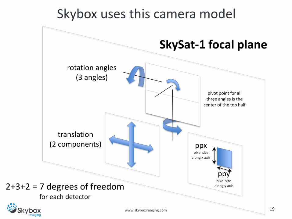
Skybox uses this camera model
19
SkySat-1 focal plane
translation (2 components) ppx
pixel size along x axis
ppy pixel size
along y axis
rotation angles (3 angles)
2+3+2 = 7 degrees of freedom for each detector
pivot point for all three angles is the
center of the top half

www.skyboximaging.com
not fitting the pixel size leaves error
20
90th percentile of interior error = 2.67 nadir-projected meters
not sub-pixel recall pixel = 1.083, so it’s 2.46 nadir-projected pixels
fitting only the position and
rotation of the detectors will leave
some residual interior error (!)
ppx pixel size
along x axis
ppy pixel size
along y axis

www.skyboximaging.com 21
90th percentile of interior error = 0.69 nadir-projected meters
fitting all camera parameters works best
sub-pixel recall pixel = 1.083, so it’s 0.64 nadir-projected pixels
translation, rotation, ppx, ppy are fit for all three detector arrays
Δ(translation) = 1-10 pixels Δ(rotation) = a few degrees Δ(pixel size) = a few nm out
of 6.5 μm

www.skyboximaging.com
step 2 - verification
22

www.skyboximaging.com
verification uses a different reference image
31.615263°N, 107.167326°W
23
medium annual cloud cover, cloudy 38.94 % of the year
nMexico0 a 10 km x 10 km reference image from Pléiades-1A
mesmerizing sage brush patterns

www.skyboximaging.com
nMexico0 imagery is orthorectified for use
24
nMexico0
another snapshot in time
a second Pléiades-1A reference image is used to
verify the new SkySat-1 camera model
a SkySat-1 frame over nMexico0 was
orthorectified using the better camera model
derived from the Somalia1 image (SRTM3 DEM used)

www.skyboximaging.com 25
90th percentile of interior error = 0.953 nadir-projected meters
new SkySat-1 camera model holds up well
sub-pixel! recall pixel = 1.083, so it’s
0.880 nadir-projected pixels
SkySat-1 imagery, orthorectified using the new camera model and tie points as control, has
very little geolocation error

www.skyboximaging.com
WHAT ABOUT OUR IMAGE QUALITY?
part 4
26

www.skyboximaging.com
Skybox cares about image quality
27
Port Jeddah

www.skyboximaging.com
Skybox cares about image quality
28
Port Jeddah

www.skyboximaging.com
We flat field with clouds
LUT Corrected Pixel Responses, based on ~1100 polar cloud images
29
uniformity in the PAN band (red)

www.skyboximaging.com
before we apply a flat field correction
30
Fairbanks, Alaska... we swear. Remember, it’s cloudy.
detector 1, PAN

www.skyboximaging.com
we compute a flat field correction map
31
telescope spider structure (~0.5% dimmer)
contaminant donuts (~1-2%
dimmer)
per-pixel variations from camera manufacturing

www.skyboximaging.com
after we apply a flat field correction
32
no donuts make Homer go something, something…
detector 1, PAN

www.skyboximaging.com
MTF part 5
33

www.skyboximaging.com
clouds interfered with our MTF measurements
34 NASA Stennis Space Center
• we cleaned, repainted MTF target at Stennis
• we have cloudy images so far
• better luck next year

www.skyboximaging.com
CONCLUSIONS
35

www.skyboximaging.com
Skybox draws these conclusions
• due to camera calibration, sub-pixel geometric accuracy should be expected when using control
• Skybox works with nature! Much of CalVal was accomplished using 100% natural images of:
– deserts for geometric calibration
– polar clouds for flat fielding
36

www.skyboximaging.com
these CalVal efforts are ongoing
• uncloudy MTF measurements
• further radiometric calibration activities
– relative trending
– absolute calibration factor (DN to radiance)
• absolute geometric accuracy as measured with GCPs
37