site investigation report · site investigation report old upper mountain road site, town of...
TRANSCRIPT

Department of Environmental Conservation
Division of Environmental Remediation
Site Investigation Report
Old Upper Mountain Road Site,Town of Lockport,
Niagara County, New York
December 2007
New York State Department of Environmental ConservationRegion 9
270 Michigan AvenueBuffalo, New York 14203

Site Investigation Report
Old Upper Mountain Road Site,Town of Lockport,
Niagara County, New York
Prepared by:
New York State Department of Environmental ConservationDivision of Environmental Remediation
270 Michigan Ave Buffalo, New York 14203
Glenn M. May, CPGEngineering Geologist II

OLD UPPER MOUNTAIN ROAD SITE, SITE NO. 932112 DECEMBER 2007SITE INVESTIGATION REPORT PAGE i
TABLE OF CONTENTS
SECTION PAGE
1.0 EXECUTIVE SUMMARY . . . . . . . . . . . . . . . . . . . . . . . . . . . . . . . . . . . . . . . . . . . . . . . . . . . . . . 1
2.0 INTRODUCTION . . . . . . . . . . . . . . . . . . . . . . . . . . . . . . . . . . . . . . . . . . . . . . . . . . . . . . . . . . . . 6
3.0 SITE HISTORY AND BACKGROUND . . . . . . . . . . . . . . . . . . . . . . . . . . . . . . . . . . . . . . . . . . . 83.1 Site Description . . . . . . . . . . . . . . . . . . . . . . . . . . . . . . . . . . . . . . . . . . . . . . . . . . . . . . . . 83.2 Site History . . . . . . . . . . . . . . . . . . . . . . . . . . . . . . . . . . . . . . . . . . . . . . . . . . . . . . . . . . . 8
3.2.1 Site Discovery . . . . . . . . . . . . . . . . . . . . . . . . . . . . . . . . . . . . . . . . . . . . . . . . . . . 83.2.2 Operation History . . . . . . . . . . . . . . . . . . . . . . . . . . . . . . . . . . . . . . . . . . . . . . . . 83.2.3 Previous Investigations . . . . . . . . . . . . . . . . . . . . . . . . . . . . . . . . . . . . . . . . . . . . 9
4.0 STUDY OBJECTIVES AND SCOPE OF WORK . . . . . . . . . . . . . . . . . . . . . . . . . . . . . . . . . . . 114.1 Objectives . . . . . . . . . . . . . . . . . . . . . . . . . . . . . . . . . . . . . . . . . . . . . . . . . . . . . . . . . . . 114.2 Scope of Work . . . . . . . . . . . . . . . . . . . . . . . . . . . . . . . . . . . . . . . . . . . . . . . . . . . . . . . . 11
4.2.1 Soil Boring Program . . . . . . . . . . . . . . . . . . . . . . . . . . . . . . . . . . . . . . . . . . . . . 114.2.2 Waste Pit Sampling Program . . . . . . . . . . . . . . . . . . . . . . . . . . . . . . . . . . . . . . 114.2.3 Micro-Wells . . . . . . . . . . . . . . . . . . . . . . . . . . . . . . . . . . . . . . . . . . . . . . . . . . . . 124.2.4 Sample Collection and Analysis . . . . . . . . . . . . . . . . . . . . . . . . . . . . . . . . . . . . 124.2.5 Surveying and Mapping . . . . . . . . . . . . . . . . . . . . . . . . . . . . . . . . . . . . . . . . . . 124.2.6 Report Preparation . . . . . . . . . . . . . . . . . . . . . . . . . . . . . . . . . . . . . . . . . . . . . . 12
5.0 GEOLOGY AND HYDROGEOLOGY . . . . . . . . . . . . . . . . . . . . . . . . . . . . . . . . . . . . . . . . . . . 135.1 Regional Geology . . . . . . . . . . . . . . . . . . . . . . . . . . . . . . . . . . . . . . . . . . . . . . . . . . . . . 13
5.1.1 Surficial Geology . . . . . . . . . . . . . . . . . . . . . . . . . . . . . . . . . . . . . . . . . . . . . . . 135.1.2 Bedrock Geology . . . . . . . . . . . . . . . . . . . . . . . . . . . . . . . . . . . . . . . . . . . . . . . . 14
5.2 Site Geology . . . . . . . . . . . . . . . . . . . . . . . . . . . . . . . . . . . . . . . . . . . . . . . . . . . . . . . . . 155.2.1 Non-Native Deposits . . . . . . . . . . . . . . . . . . . . . . . . . . . . . . . . . . . . . . . . . . . . . 155.2.2 Glaciolacustrine Deposit . . . . . . . . . . . . . . . . . . . . . . . . . . . . . . . . . . . . . . . . . 155.2.3 Guelph Dolostone . . . . . . . . . . . . . . . . . . . . . . . . . . . . . . . . . . . . . . . . . . . . . . . 15
5.3 Regional Hydrogeology . . . . . . . . . . . . . . . . . . . . . . . . . . . . . . . . . . . . . . . . . . . . . . . . . 165.3.1 Regional Groundwater Flow . . . . . . . . . . . . . . . . . . . . . . . . . . . . . . . . . . . . . . 17
5.4 Site Hydrogeology . . . . . . . . . . . . . . . . . . . . . . . . . . . . . . . . . . . . . . . . . . . . . . . . . . . . . 18
6.0 INVESTIGATION RESULTS . . . . . . . . . . . . . . . . . . . . . . . . . . . . . . . . . . . . . . . . . . . . . . . . . . 196.1 General Observations . . . . . . . . . . . . . . . . . . . . . . . . . . . . . . . . . . . . . . . . . . . . . . . . . . . 206.2 Surface Soil . . . . . . . . . . . . . . . . . . . . . . . . . . . . . . . . . . . . . . . . . . . . . . . . . . . . . . . . . . 216.3 Waste . . . . . . . . . . . . . . . . . . . . . . . . . . . . . . . . . . . . . . . . . . . . . . . . . . . . . . . . . . . . . . . 226.4 Surface Water . . . . . . . . . . . . . . . . . . . . . . . . . . . . . . . . . . . . . . . . . . . . . . . . . . . . . . . . . 256.5 Sediment . . . . . . . . . . . . . . . . . . . . . . . . . . . . . . . . . . . . . . . . . . . . . . . . . . . . . . . . . . . . 266.6 Groundwater . . . . . . . . . . . . . . . . . . . . . . . . . . . . . . . . . . . . . . . . . . . . . . . . . . . . . . . . . 27
7.0 DISCUSSION AND RECOMMENDATION . . . . . . . . . . . . . . . . . . . . . . . . . . . . . . . . . . . . . . 287.1 Discussion . . . . . . . . . . . . . . . . . . . . . . . . . . . . . . . . . . . . . . . . . . . . . . . . . . . . . . . . . . . 28
7.1.1 Hazardous Waste Characteristics . . . . . . . . . . . . . . . . . . . . . . . . . . . . . . . . . . . 287.1.2 Volatile Organic Compounds (VOCs) . . . . . . . . . . . . . . . . . . . . . . . . . . . . . . . 287.1.3 Semivolatile Organic Compounds (SVOCs) . . . . . . . . . . . . . . . . . . . . . . . . . . . 30

OLD UPPER MOUNTAIN ROAD SITE, SITE NO. 932112 DECEMBER 2007SITE INVESTIGATION REPORT PAGE ii
7.1.4 Pesticides . . . . . . . . . . . . . . . . . . . . . . . . . . . . . . . . . . . . . . . . . . . . . . . . . . . . . 327.1.5 Polychlorinated Biphenyls (PCBs) . . . . . . . . . . . . . . . . . . . . . . . . . . . . . . . . . . 337.1.6 Metals . . . . . . . . . . . . . . . . . . . . . . . . . . . . . . . . . . . . . . . . . . . . . . . . . . . . . . . . 34
7.2 Recommendation . . . . . . . . . . . . . . . . . . . . . . . . . . . . . . . . . . . . . . . . . . . . . . . . . . . . . . 35
8.0 REFERENCES . . . . . . . . . . . . . . . . . . . . . . . . . . . . . . . . . . . . . . . . . . . . . . . . . . . . . . . . . . . . . . 37

OLD UPPER MOUNTAIN ROAD SITE, SITE NO. 932112 DECEMBER 2007SITE INVESTIGATION REPORT PAGE iii
LIST OF FIGURES(Following Text)
Figure 1-1 Site Location Map
Figure 3-1 Historic Sample Location Map
Figure 4-1 Soil Boring Location Map
Figure 4-2 Sample Location Map
Figure 5-1 Lockport Area Map
Figure 5-2 Regional Groundwater Flow Contour Map
Figure 6-1 Photograph of the Heavy Vegetation in the Ravine Portion of the Site
Figure 6-2 Aerial Photograph of the Old Upper Mountain Road Site
Figure 6-3 Photograph of the Vegetation Across the Plateau Portion of the Site
Figure 6-4 Photograph of the Vegetation Across the Plateau Portion of the Site
Figure 6-5 Photograph of the Vegetation and an On-Site Roadway Across the Plateau Portion of the Site
Figure 6-6 Photograph of the Vegetation and an On-Site Roadway Across the Plateau Portion of the Site
Figure 6-7 Photograph of the Main On-Site Roadway Across the Plateau Portion of the Site
Figure 6-8 Photograph of the Construction Debris on the Western Plateau Portion of the Site
Figure 6-9 Photograph of the Recently Burned Trash on the Eastern Plateau Portion of the Site
Figure 6-10 Photograph of the ATV Tracks on the Western Plateau Portion of the Site
Figure 6-11 Photograph of the Tires from the Former Junk Auto Operation on the Plateau Portion of theSite
Figure 6-12 Photograph of a Pit Excavated into the Ash
Figure 6-13 Closeup Photograph of a Pit Excavated into the Ash
Figure 6-14A Arsenic Concentrations with Depth in Soil Boring SB-2
Figure 6-14B Barium Concentrations with Depth in Soil Boring SB-2
Figure 6-14C Cadmium Concentrations with Depth in Soil Boring SB-2

OLD UPPER MOUNTAIN ROAD SITE, SITE NO. 932112 DECEMBER 2007SITE INVESTIGATION REPORT PAGE iv
LIST OF FIGURES(Continued)
Figure 6-14D Chromium Concentrations with Depth in Soil Boring SB-2
Figure 6-14E Lead Concentrations with Depth in Soil Boring SB-2
Figure 6-14F Mercury Concentrations with Depth in Soil Boring SB-2
Figure 7-1 TCLP Exceedance Map
LIST OF TABLES(Following Text)
Table 3-1 Summary Key for Historic Samples Collected from the Site
Table 3-2 Analytical Results for Historic Soil and Waste Samples Collected from the Site
Table 3-3 Analytical Results for Historic Surface Water Samples Collected from the Site
Table 3-4 Analytical Results for Historic Sediment Samples Collected from the Site
Table 4-1 Summary Key for Samples Collected During the Site Investigation
Table 5-1 Stratigraphic Sequence of the Western New York Area
Table 5-2 Stratigraphic Summary of Borings Completed During the Site Investigation
Table 6-1 Analytical Results for Surface Soil Samples Collected During the Site Investigation
Table 6-2 TCLP Results for Samples Collected During the Site Investigation
Table 6-3 Analytical Results for Waste Samples Collected During the Site Investigation
Table 6-4 Analytical Results for Surface Water Samples Collected During the Site Investigation
Table 6-5 Analytical Results for Sediment Samples Collected During the Site Investigation
APPENDICES
Appendix A Stratigraphic Logs
Appendix B Soil Boring Completion Summary
Appendix C Analytical Data

OLD UPPER MOUNTAIN ROAD SITE, SITE NO. 932112 DECEMBER 2007SITE INVESTIGATION REPORT PAGE 1
1.0 EXECUTIVE SUMMARY
The Old Upper Mountain Road Site consists of seven parcels near the intersection of NY State Routes
31 and 93 in the Town of Lockport, Niagara County, New York (Figure 1-1). The total area of the site is
approximately 7 acres in a mixed residential/commercial/industrial neighborhood. The site is bounded on
the west by Old Upper Mountain Road, on the south and east by the Somerset Railroad, and on the north by
private property and a ravine approximately eighty feet deep known as the Gulf (Figure 1-1). A narrow
stream flows along the bottom of the ravine and forms one of the headwaters of the East Branch of Gulf
Creek. Gulf Creek flows in a northerly direction from the site and eventually discharges into Eighteenmile
Creek approximately one mile to the north. The majority of the site is located on a relatively flat-lying
plateau (Figure 1-1).
The Old Upper Mountain Road Site was reportedly operated as a municipal dump by the City of
Lockport from 1921 through the 1950's. Access to the landfill at that time was from a viaduct under the
railroad track just north of Old Upper Mountain Road (now Otto Place Road; Figure 1-1). In later years, a
gate was placed at the viaduct to control unauthorized dumping. Garbage and other wastes were apparently
dumped at the landfill, burned, and then pushed into the ravine. Clientele reportedly included Harrison
Radiator, VanDeMark Chemical, Milward Alloys, Vanchlor, Upson, and Cotton Batting. Different areas of
the dump were reportedly assigned to different companies. Neighboring residents often referred to the
Harrison Dump, Upson Dump, etc.
On November 5, 1997 New York State Department of Environmental Conservation (NYSDEC) staff
conducted a sampling event at the site. One surface water, one sediment and thirteen waste samples were
collected from throughout the site. All thirteen waste samples contained volatile and semivolatile organic
compounds, with the concentrations of trichloroethene (1 sample), tetrachloroethene (1 sample),
benzo(a)anthracene (1 sample), benzo(a)pyrene (1 sample), benzo(b)fluoranthene (1 sample),
benzo(k)fluoranthene (1 sample), chrysene (1 sample), dibenzo(a,h)anthracene (1 sample) and indeno(1,2,3-
cd)pyrene (1 sample) exceeding the NYSDEC soil cleanup objectives. Pesticides and PCBs were also
detected in several samples, but none of the concentrations exceeded the NYSDEC soil cleanup objectives.
Twenty metals were detected in the waste samples collected by the NYSDEC, with eleven of them
being USEPA priority pollutant metals. The priority pollutant metals exceeding the soil cleanup objectives
included antimony (10 samples), arsenic (7 samples), cadmium (10 samples), chromium (8 samples), copper
(10 samples), lead (12 samples), mercury (5 samples), nickel (4 samples), silver (3 samples), thallium (3
samples) and zinc (6 samples).

OLD UPPER MOUNTAIN ROAD SITE, SITE NO. 932112 DECEMBER 2007SITE INVESTIGATION REPORT PAGE 2
The surface water sample contained three volatile organic compounds (1,2-dichloroethene,
trichloroethene and tetrachloroethene) at concentrations that exceeded the NYSDEC surface water standards
or guidance values. The sediment sample collected from the same location contained one volatile (1,2-
dichloroethene), six semivolatile (benzo(a)anthracene, benzo(a)pyrene, benzo(b)fluoranthene,
benzo(k)fluoranthene, chrysene and indeno(1,2,3-cd)pyrene) and eleven metals (antimony, arsenic, barium,
cadmium, chromium, copper, iron, lead, nickel, silver and zinc) at concentrations that exceeded the NYSDEC
sediment criteria.
On October 20, 1998 the NYSDOH collected one surface water and five surface soil samples from
the site. The surface water sample contained seven volatile organic compounds, with the concentrations of
1,2-dichloroethene, trichloroethene, tetrachloroethene and vinyl chloride exceeding the NYSDEC surface
water standards or guidance values. The surface soil samples were only analyzed for metals. Seventeen
metals were detected in the these samples, with the concentrations of thirteen metals exceeding the NYSDEC
soil cleanup objectives. Eight of these metals were USEPA priority pollutant metals. The priority pollutant
metals exceeding the soil cleanup objectives included arsenic (1 sample), cadmium (5 samples), chromium
(4 samples), copper (5 samples), lead (5 samples); mercury (1 sample), nickel (3 samples) and zinc (4
samples).
Between June and October 2007 the NYSDEC conducted a Site Investigation at the site to obtain
information sufficient to determine if the Old Upper Mountain Road Site should be included in the Registry
of Inactive Hazardous Waste Sites, and if so, what the appropriate site classification should be. The specific
objectives of this investigation were to (1) evaluate the site to determine if hazardous wastes or substances
were present, and if present, to determine if there was a consequential amount; and (2) determine the degree
to which historical waste disposal has contaminated environmental media at and near the site. These
objectives were determined through the analysis of surface soil, waste, surface water and sediment samples
collected during the Site Investigation.
The stratigraphy of the site was evaluated by examining the stratigraphic logs completed during the
Site Investigation. With increasing depth, the geologic units encountered include clean fill, waste and
glaciolacustrine silty clays and clayey silts. Clean fill consists predominantly of imported native soil, while
the waste material consists predominantly of multi-colored, layered ash. The bedrock underlying the site is
the Guelph Dolostone of the Lockport Group.

OLD UPPER MOUNTAIN ROAD SITE, SITE NO. 932112 DECEMBER 2007SITE INVESTIGATION REPORT PAGE 3
Saturated soil/waste was not encountered at thicknesses sufficient to justify the installation of
micro-wells. As a result, micro-wells were not installed during the Site Investigation, so site hydrogeology
could not be evaluated. Based upon a regional groundwater flow map for the area, it is suspected that
groundwater under the Old Upper Mountain Road Site flows to the north towards the Gulf.
The results of the Site Investigation indicate that surface soil at the Old Upper Mountain Road Site
contains semivolatile organic compounds, pesticides, polychlorinated biphenyls and metals. The
concentrations of benzo(a)anthracene (2 samples), benzo(a)pyrene (3 samples), benzo(b)fluoranthene (2
samples), chrysene (2 samples), 4-chloro-3-methylphenol (2 samples), dibenzo(a,h)anthracene (2 samples),
indeno(1,2,3-cd)pyrene (2 samples), dieldrin (1 sample), and the USEPA priority pollutant metals antimony
(2 samples), arsenic (4 samples), cadmium (3 samples), chromium (5 samples), copper (3 samples), lead (3
samples), mercury (1 sample), nickel (1 sample), silver (1 sample) and zinc (1 sample) exceeded the
NYSDEC Part 375 or TAGM 4046 soil cleanup objectives. Of these contaminants, the concentrations of 4-
chloro-3-methylphenol (2 samples), antimony (2 samples), cadmium (1 sample), chromium (1 sample),
copper (2 samples), lead (3 samples), nickel (1 sample) and zinc (1 sample) significantly exceeded (by a
factor of four or more) the soil cleanup objectives. These results are consistent with the historic surface soil
samples collected from the site. In addition, some surface soil at the Old Upper Mountain Road Site is a
characteristic hazardous waste for lead (D008).
Waste underlying the Old Upper Mountain Road Site contains volatile organic compounds,
semivolatile organic compounds, pesticides, polychlorinated biphenyls and metals. The concentrations of
tetrachloroethene (2 samples), trichloroethene (2 samples), benzo(a)anthracene (4 samples), benzo(a)pyrene
(3 samples), benzo(b)fluoranthene (3 samples), benzo(k)fluoranthene (1 sample), chrysene (3 samples),
dibenzo(a,h)anthracene (3 samples), indeno(1,2,3-cd)pyrene (3 samples), pentachlorophenol (1 sample), and
the USEPA priority pollutant metals antimony (6 samples), arsenic (11 samples), cadmium (17 samples),
chromium (12 samples), copper (15 samples), lead (18 samples), mercury (7 samples), nickel (3 samples) and
zinc (9 samples) exceeded the NYSDEC Part 375 or TAGM 4046 soil cleanup objectives. Of these
contaminants, the concentrations of tetrachloroethene (2 samples), trichloroethene (2 samples),
benzo(a)anthracene (1 sample), benzo(b)fluoranthene (1 sample), chrysene (1 sample), indeno(1,2,3-
cd)pyrene (1 sample), antimony (6 samples), cadmium (1 sample), chromium (2 samples), copper (7 samples),
lead (14 samples), mercury (2 samples) and zinc (1 sample) significantly exceeded (by a factor of four or
more) the soil cleanup objectives. These results are consistent with the historic waste samples collected from
the site. In addition, some waste at the Old Upper Mountain Road Site is a characteristic hazardous waste
for lead (D008).

OLD UPPER MOUNTAIN ROAD SITE, SITE NO. 932112 DECEMBER 2007SITE INVESTIGATION REPORT PAGE 4
The results of the Site Investigation further indicate that surface water at the Old Upper Mountain
Road Site contains volatile organic compounds, semivolatile organic compounds, pesticides, polychlorinated
biphenyls and metals. The concentrations of chloroform (1 sample), dichloroethene (1 sample),
tetrachloroethene (1 sample), trichloroethene (2 samples), benzo(a)anthracene (1 sample), bis(2-
ethylhexyl)phthalate (1 sample), heptachlor epoxide (1 sample), and the USEPA priority pollutant metal lead
(1 sample) exceeded the NYSDEC surface water standards or guidance values. Of these contaminants, the
concentrations of tetrachloroethene (1 sample), benzo(a)anthracene (1 sample) and heptachlor epoxide (1
sample) significantly exceeded (by a factor of four or more) the surface water standards or guidance values.
These results are consistent with the historic surface water samples collected from the site.
Sediment at the Old Upper Mountain Road Site contains volatile organic compounds, semivolatile
organic compounds, pesticides, polychlorinated biphenyls and metals. The concentrations of dichloroethene
(2 samples), benzo(a)anthracene (2 samples), benzo(a)pyrene (2 samples), benzo(b)fluoranthene (2 samples),
benzo(k)fluoranthene (2 samples), chrysene (2 samples), indeno(1,2,3-cd)pyrene (2 samples), DDE (1
sample), DDT (1 sample), aldrin (1 sample), BHC (1 sample), dieldrin (1 sample), and the USEPA priority
pollutant metals arsenic (1 sample), cadmium (2 samples), chromium (2 samples), copper (2 samples), lead
(2 samples), mercury (1 sample), nickel (2 samples) and zinc (2 samples) exceeded the NYSDEC sediment
criteria. Of these contaminants, the concentrations of dichloroethene (2 samples), benzo(a)anthracene (2
samples), benzo(a)pyrene (2 samples), benzo(b)fluoranthene (2 samples), benzo(k)fluoranthene (2 samples),
chrysene (2 samples), indeno(1,2,3-cd)pyrene (2 samples), DDE (1 sample), arsenic (1 sample), cadmium (1
sample), chromium (1 sample), copper (1 sample), lead (1 sample), nickel (1 sample) and zinc (1 sample)
significantly exceeded (by a factor of four or more) the sediment criteria. These results are consistent with
the historic sediment samples collected from the site.
In summary, contaminated surface soil and waste at the Old Upper Mountain Road Site have
adversely impacted surface water and sediment in Gulf Creek adjacent to the site. Surface soil and waste at
the site contain individual volatile organic compounds, semivolatile organic compounds and metals at
concentrations that exceed the NYSDEC Part 375 soil cleanup objectives. The concentrations of some of
these contaminants exceed the soil cleanup objectives by a factor of four or more. These same contaminants
have been detected in surface water and/or sediment at concentrations that exceed the respective standards,
criteria and guidance values (SCGs). Eighteenmile Creek, which receives water from Gulf Creek, has been
identified by the International Joint Commission as one of the 43 Areas of Concern in the Great Lakes Basin.
The NYSDEC has issued a Remedial Action Plan for this creek. The data collected during the Site
Investigation suggests that the Old Upper Mountain Road Site is a contaminant contributor to Eighteenmile
OLD UPPER MOUNTAIN ROAD SITE, SITE NO. 932112 DECEMBER 2007SITE INVESTIGATION REPORT PAGE 5
Creek.
It should also be stressed that the presence of volatile organic compounds and pesticides in the
upstream surface water sample suggests that an upstream source of these contaminants exists in this area of
Lockport. This source was not identified during the Site Investigation, although an attempt was made to
identify the origin of the storm sewer that discharges into Gulf Creek.
The Site Investigation conducted at the Old Upper Mountain Road Site revealed that consequential
amounts of hazardous wastes (D008 - lead) are present at this site. These hazardous wastes have adversely
impacted surface water and sediment in Gulf Creek adjacent to the site. In addition, the presence of exposed
ash throughout the site may also pose a public health risk due to the high concentrations of contaminants in
this waste. As a result, it is recommended that the site be listed in the NYSDEC Registry of Inactive
Hazardous Waste Disposal Sites in New York State as a Class 2 site.

OLD UPPER MOUNTAIN ROAD SITE, SITE NO. 932112 DECEMBER 2007SITE INVESTIGATION REPORT PAGE 6
2.0 INTRODUCTION
Between June and October 2007 the New York State Department of Environmental Conservation
(NYSDEC) conducted a Site Investigation at the Old Upper Mountain Road Site in the Town of Lockport,
Niagara County, New York (Figure 1-1). The Old Upper Mountain Road Site, located near the intersection
of NY State Routes 31 and 93, occupies a total area of approximately 7 acres in a mixed
residential/commercial/industrial neighborhood (Figure 1-1). Although the site is not listed in the Registry
of Inactive Hazardous Waste Disposal Sites in New York State (Registry), it is included in the NYSDEC’s
Hazardous Substance Site study. As a result, the Division of Environmental Remediation (DER) conducted
a Site Investigation at the site to determine if hazardous wastes or substances were present, and if present, to
determine if there was a consequential amount. The Site Investigation was also conducted to determine the
degree to which historic waste disposal has contaminated environmental media at and near the site. The study
results will be utilized to determine whether the Old Upper Mountain Road Site should be included in the
Registry, and if so, what classification the site should be assigned.
This report summarizes the findings of the Site Investigation. The remaining sections of this report
are organized as follows:
# Section 3.0, Site History and Background: Section 3.0 describes the site, and discusses
the disposal history and previous investigations completed at the site;
# Section 4.0, Study Objectives and Scope of Work: Section 4.0 describes the objectives
of the Site Investigation and the activities that were completed during the Site Investigation;
# Section 5.0, Geology and Hydrogeology: Section 5.0 describes the regional and site
geology and hydrogeology. The characteristics, areal extent and hydrogeologic properties
of the strata are discussed;
# Section 6.0, Investigation Results: Section 6.0 describes the findings of the Site
Investigation, including general observations and a summary of the analytical results
obtained from various environmental media (i.e., surface soil, subsurface soil, surface water
and sediment);
# Section 7.0, Discussion and Recommendation: Section 7.0 summarizes the findings of the
Site Investigation as they relate to the objectives presented in Section 4.0.
OLD UPPER MOUNTAIN ROAD SITE, SITE NO. 932112 DECEMBER 2007SITE INVESTIGATION REPORT PAGE 7
Recommendations for future activities regarding the site are also discussed; and
# Section 8.0, References: Section 8.0 contains a list of references utilized or cited in the
report.
Figures, tables and appendices, in that order, follow Section 8.0.

OLD UPPER MOUNTAIN ROAD SITE, SITE NO. 932112 DECEMBER 2007SITE INVESTIGATION REPORT PAGE 8
3.0 SITE HISTORY AND BACKGROUND
3.1 Site Description
The Old Upper Mountain Road Site consists of seven parcels near the intersection of NY State Routes
31 and 93 in the Town of Lockport, Niagara County, New York (Figure 1-1). The site occupies an area of
approximately 7 acres in a mixed residential/commercial/industrial neighborhood, and is heavily vegetated
with weeds, small bushes and trees. The site is bounded on the west by Old Upper Mountain Road, on the
south and east by the Somerset Railroad, and on the north by private property and a ravine approximately
eighty feet deep known as the Gulf (Figure 1-1). A narrow stream flows along the bottom of the ravine and
forms one of the headwaters of the East Branch of Gulf Creek. Gulf Creek flows in a northerly direction from
the site and eventually discharges into Eighteenmile Creek approximately one mile to the north. The majority
of the site is located on a relatively flat-lying plateau (Figure 1-1). Evidence of disposal at the site, such as
ash, glass, tires, junk autos and boats, and construction and demolition debris was observed during a site
reconnaissance in June 2007.
The surface topography of the Old Upper Mountain Road Site is relatively flat-lying, with elevations
ranging from approximately 590 to 598 feet above mean sea level (amsl) based upon USGS topographic
mapping of the area. North of the plateau the property slopes steeply downward into the Gulf (Figure 1-1).
The surface elevation at the bottom of the ravine is approximately 520 ft amsl. From the Gulf the property
slopes steeply upward before forming another plateau northwest of the site. Surface elevations in the this area
range from approximately 590 to 593 feet amsl.
3.2 Site History
3.2.1 Site Discovery
The site was initially discovered in 1993 during a routine inspection of the Lockport City Landfill
(NYSDEC Site No. 932010) located north of the Old Upper Mountain Road Site (Figure 1-1). Evidence of
ash and glass debris was noted throughout the top portion of the landfill, while recent dumping of
trash/rubbish/tires was noted at the southern portion of the site. It also appeared that a significant quantity
of waste was pushed over the embankment into the ravine.
3.2.2 Operation History
The Old Upper Mountain Road Site was reportedly rented from Mr. Clapsattle and operated as a
municipal dump by the City of Lockport from 1921 through the 1950's. Access to the landfill at that time
was from a viaduct under the railroad track just north of Old Upper Mountain Road (now Otto Place Road;
Figure 1-1). In later years, a gate was placed at the viaduct to control unauthorized dumping. The gate,

OLD UPPER MOUNTAIN ROAD SITE, SITE NO. 932112 DECEMBER 2007SITE INVESTIGATION REPORT PAGE 9
however, was apparently left unlocked and anyone could push it open. Garbage and other wastes were
apparently dumped at the landfill, burned, and then pushed into the ravine. The City of Lockport moved its
dumping operations in the 1950's to the area known today as the Lockport City Landfill, on property which
it reportedly repossessed on taxes.
The Old Upper Mountain Road Site was reportedly used by the same clientele as the City of Lockport
Landfill as there was only a shift in location between the two landfills. Clientele reportedly included Harrison
Radiator, VanDeMark Chemical, Milward Alloys, Vanchlor, Upson, and Cotton Batting. Different areas of
the dump were reportedly assigned to different companies. Neighboring residents often referred to the
Harrison Dump, Upson Dump, etc. Several tin shack squatters were observed living at the site salvaging
glass, rags and scrap metal.
3.2.3 Previous Investigations
On November 5, 1997 NYSDEC Central Office Division of Hazardous Site Control staff conducted
a sampling event at the Old Upper Mountain Road Site. This investigation was intended to serve as the initial
step of a Preliminary Site Assessment (PSA) as described in an August 26, 1996 letter to the City of Lockport
Mayor. Specifically, the purpose of this field sampling was to determine the level of overall chemical
contamination at the site.
One surface water, one sediment and thirteen waste samples were collected from three general areas
of the site: the plateau at the top of the bluff surrounding the headwaters area, the eastern precipice of the
plateau, and Gulf Creek and its stream banks (Figure 3-1). Five samples were collected from the plateau area,
four from the eastern precipice, and five from the Gulf Creek area. The surface water and sediment samples
were collected from Gulf Creek. Detailed information concerning sample collection and analysis is given
in Table 3-1.
All thirteen waste samples contained volatile organic compounds, with the concentrations of
trichloroethene and tetrachloroethene in one sample exceeding the NYSDEC soil cleanup objectives (Table
3-2). All thirteen waste samples also contained semivolatile organic compounds, with the concentrations of
benzo(a)anthracene, benzo(a)pyrene, benzo(b)fluoranthene, benzo(k)fluoranthene, chrysene,
dibenzo(a,h)anthracene and indeno(1,2,3-cd)pyrene in one sample exceeding the NYSDEC soil cleanup
objectives (Table 3-2). Pesticides and PCBs were also detected in several samples, but none of the
concentrations exceeded the NYSDEC soil cleanup objectives (Table 3-2).

OLD UPPER MOUNTAIN ROAD SITE, SITE NO. 932112 DECEMBER 2007SITE INVESTIGATION REPORT PAGE 10
Twenty metals were detected in the waste samples collected from the site (Table 3-2). Of these
compounds, sixteen were detected at concentrations that exceeded the NYSDEC soil cleanup objectives
(Table 3-2), with eleven of these metals being USEPA priority pollutant metals. USEPA priority pollutant
metals are toxic metals for which technology-based effluent limitations and guidelines are required by Federal
law. The priority pollutant metals exceeding the soil cleanup objectives (with the number of exceedances and
maximum concentrations) included antimony (10 samples; 415 mg/kg); arsenic (7 samples; 35.6 mg/kg),
cadmium (10 samples; 29.2 mg/kg), chromium (8 samples; 148 mg/kg), copper (10 samples; 26,800 mg/kg),
lead (12 samples; 56,900 mg/kg); mercury (5 samples; 19.3 mg/kg), nickel (4 samples; 348 mg/kg), silver
(3 samples; 147 mg/kg), thallium (3 samples; 5.2 mg/kg) and zinc (6 samples; 6,510 mg/kg).
The surface water sample contained three volatile organic compounds (1,2-dichloroethene,
trichloroethene and tetrachloroethene) at concentrations that exceeded the NYSDEC surface water standards
or guidance values (Table 3-3). The sediment sample collected from the same location contained one volatile
(1,2-dichloroethene), six semivolatile (benzo(a)anthracene, benzo(a)pyrene, benzo(b)fluoranthene,
benzo(k)fluoranthene, chrysene and indeno(1,2,3-cd)pyrene) and eleven metals (antimony, arsenic, barium,
cadmium, chromium, copper, iron, lead, nickel, silver and zinc) at concentrations that exceeded the NYSDEC
sediment criteria (Table 3-4).
On October 20, 1998 the NYSDOH collected one surface water and five surface soil samples from
the site. Detailed information concerning sample collection and analysis is given in Table 3-1. The surface
water sample was collected upstream of the surface water sample collected by the NYSDEC the previous
year, and analyzed only for volatile organic compounds. This sample contained seven volatile organic
compounds, with the concentrations of four compounds (1,2-dichloroethene, trichloroethene,
tetrachloroethene and vinyl chloride) exceeding the NYSDEC surface water standards or guidance values
(Table 3-3).
The surface soil samples were only analyzed for metals. Seventeen metals were detected in these
samples, with the concentrations of thirteen metals exceeding the NYSDEC soil cleanup objectives (Table
3-2). Eight of these metals were USEPA priority pollutant metals. The priority pollutant metals exceeding
the soil cleanup objectives (with the number of exceedances and maximum concentrations) included arsenic
(1 sample; 18.0 mg/kg), cadmium (5 samples; 62.0 mg/kg), chromium (4 samples; 974 mg/kg), copper (5
samples; 88,700 mg/kg), lead (5 samples; 36,600 mg/kg); mercury (1 sample; 2.0 mg/kg), nickel (3 samples;
995 mg/kg) and zinc (4 samples; 29,600 mg/kg).

OLD UPPER MOUNTAIN ROAD SITE, SITE NO. 932112 DECEMBER 2007SITE INVESTIGATION REPORT PAGE 11
4.0 STUDY OBJECTIVES AND SCOPE OF WORK
4.1 Objectives
The overall objective of the Site Investigation was to obtain information sufficient to determine if
the Old Upper Mountain Road Site should be included in the Registry of Inactive Hazardous Waste Sites, and
if so, what the appropriate Site classification should be. The specific objectives of this investigation were to:
# evaluate the site to determine if hazardous wastes or substances were present, and if present,
to determine if there was a consequential amount; and
# determine the degree to which historic waste disposal has contaminated environmental media
at and near the site.
These objectives were determined through the analysis of surface soil, waste, surface water and sediment
samples collected during the Site Investigation.
4.2 Scope of Work
To meet the study objectives, the following activities were completed during the Site Investigation:
(1) a soil boring program, (2) a waste pit sampling program, (3) collection of environmental samples for
chemical analysis, and (4) preparation of a site map. These activities are briefly described in the following
sections. All field work was conducted in level D personal protective equipment, while air monitoring for
organic vapors was completed during intrusive activities by NYSDEC personnel. The direct push vehicle
and sampling equipment were deconed prior to the implementation of field activities, with the sampling
equipment decontaminated between samples.
4.2.1 Soil Boring Program
During the Site Investigation, sixteen soil borings (SB-1 thru SB-16) were completed throughout the
site to evaluate the historic disposal area and to facilitate the collection of subsurface waste samples. The
locations of these borings are shown on Figure 4-1. Continuous macro core samples were collected at each
location with discrete samples collected for chemical analysis (see Section 4.2.4 below).
4.2.2 Waste Pit Sampling Program
Prior to the start of the soil boring program, five waste samples were collected from pits located
throughout the site. The locations of these samples are shown on Figure 4-2. These pits have been dug into
the waste by individuals scavenging for antique bottles and other items.
OLD UPPER MOUNTAIN ROAD SITE, SITE NO. 932112 DECEMBER 2007SITE INVESTIGATION REPORT PAGE 12
4.2.3 Micro-Wells
It was originally planned to convert four soil borings (SB-2, SB-8, SB-13 and SB-16) into micro-
wells to evaluate groundwater flow patterns across the site and to determine whether contamination is
migrating from the former disposal area. During implementation of the soil boring program, however,
saturated soil/waste was not encountered at thicknesses sufficient to justify the installation of micro-wells.
As a result, micro-wells were not installed during the Site Investigation.
4.2.4 Sample Collection and Analysis
With the exception of the macro core samples collected during the soil boring program, all samples
were collected by NYSDEC personnel. During the Site Investigation six surface soil samples (Figure 4-2),
thirty-three waste samples from five pits and fourteen soil borings (Figure 4-2), two surface water samples
(Figure 4-2) and two sediment samples (Figure 4-2) were collected and submitted to Severn Trent
Laboratories, Inc. (STL) in Amherst, New York for chemical analysis. Information concerning sample
collection and analysis is given in Table 4-1. Groundwater samples were not collected during the Site
Investigation because micro-wells were not installed.
4.2.5 Surveying and Mapping
A map of the Old Upper Mountain Road Site was prepared by the NYSDEC as part of the Site
Investigation. This map was prepared by digitizing and overlaying Niagara County tax maps, USGS
topographic maps and aerial photographs. The final map includes the site boundaries; property boundaries;
the ravine; tributaries and streams on and near the site; nearby roadways; all soil boring locations; the
locations of historic samples collected at the site; and the locations of all samples collected as part of the Site
Investigation. In addition, the latitude, longitude and ground surface elevation at each boring location was
surveyed using a handheld Magellan Meridian GPS unit. The coordinates for each boring are given in
Appendix B, while the ground surface elevations are given in Table 5-2 and Appendix A.
4.2.6 Report Preparation
This report was prepared to describe the activities completed during the Site Investigation of the Old
Upper Mountain Road Site; present the analytical results of the samples collected during the investigation;
discuss the results as they relate to the objectives of the investigation; and present recommendations for future
activities at the site.

OLD UPPER MOUNTAIN ROAD SITE, SITE NO. 932112 DECEMBER 2007SITE INVESTIGATION REPORT PAGE 13
5.0 GEOLOGY AND HYDROGEOLOGY
Site Investigation activities were undertaken, in part, to determine the characteristics, areal extent and
hydrogeologic properties of the geologic strata underlying the Old Upper Mountain Road Site. This is
important as these attributes of the geologic strata govern the occurrence and flow of groundwater across the
site. These attributes also govern the potential for contaminant migration from the site, and determine the
rate and extent of this migration. As a result, a detailed evaluation of the geology at the Old Upper Mountain
Road Site is essential. Before completing such a detailed evaluation, however, it is important to first describe
the regional geologic history of the western New York area as a general knowledge of this history is critical
to a complete understanding of the complex interrelationships between the various geologic strata and their
hydrogeologic properties.
5.1 Regional Geology
5.1.1 Surficial Geology
Geologic evidence suggests that at least four major glacial episodes covered parts of North America
during the Pleistocene Epoch (Buehler and Tesmer, 1963). In western New York, however, there is evidence
of only two such episodes. The last glacial event in the area, the Wisconsin, eroded and modified the earlier
glacial deposits to such an extent that little evidence of their existence remains. These glacial events widened
the preexisting valleys and basins, and led to the development of the present day drainage system in western
New York (La Sala, 1968).
A complex sequence of proglacial lakes that formed during the final retreat of the Wisconsin ice sheet
inundated an extensive area of western New York. This succession originated in the Erie-Huron Basin prior
to 14,000 years ago as the ice sheet retreated from the basin. Further retreat produced Lake Arkona about
13,600 years ago (Hough, 1958); a readvance of the ice sheet followed about 13,000 years ago and resulted
in a water level increase to the Lake Whittlesey stage. A series of advances and retreats over the next 300
years produced, from latest to earliest, lakes Warren, Wayne, Lowest Warren, Grassmere, Lundy and
Tonawanda, the last forming about 9,800 years ago (Calkins and Brett, 1978). To the north, Lake Iroquois
occupied the Ontario Basin at this time. This lake sequence was responsible for the deposition of stratified
lacustrine clays, silts, sands and gravels that now cover much of western New York.
The Pleistocene Epoch presented a variety of environments that resulted in the deposition of
unconsolidated deposits. In the Lockport area these deposits include the following (GZA, 1987; Smith,
1990; Ecology and Environment, 1991):

OLD UPPER MOUNTAIN ROAD SITE, SITE NO. 932112 DECEMBER 2007SITE INVESTIGATION REPORT PAGE 14
# Glacial till, consisting of a non-sorted, non-stratified mixture of sand, silt, clay, gravel and
rock fragments deposited directly from glacial ice;
# Glaciolacustrine deposits, consisting primarily of silt, sand and clay deposited in lakes that
formed during melting of the ice sheets; and
# Glaciofluvial deposits, consisting of sand and gravel deposited either by glacial meltwater
streams or by the reworking of till and other glacial deposits along the shore of former
glacial lakes.
The thickness of these deposits in the Lockport Area varies considerably, ranging from less than 2 feet near
the Niagara Escarpment to approximately 45 feet at the Frontier Pendleton Quarry Site approximately 5 miles
southwest of the Old Upper Mountain Road Site (Golder, 1989).
5.1.2 Bedrock Geology
The bedrock underlying western New York is characterized as a thick sequence of shales, sandstones,
limestones and dolostones deposited in ancient seas during the Silurian and Devonian Periods (Buehler and
Tesmer, 1963). This stratigraphic sequence is summarized in Table 5-1. Bedrock bedding generally strikes
in an east-west direction, approximately paralleling the Niagara and Onondaga Escarpments, and dips to the
south at approximately 30 to 40 feet per mile (Johnson, 1964; La Sala, 1968; Yager and Kappel, 1987).
Erosion and weathering, however, have produced local differences in the bedrock surface configuration
(Snyder Engineering, 1987).
The uppermost bedrock formation underlying the Old Upper Mountain Road Site is the Guelph
Dolostone of the Lockport Group (Table 5-1), which was deposited in a shallow sea environment during the
Middle Silurian Period (439-408 million years ago) (Brett et al., 1995). The Lockport Group varies in
thickness from 20 to 175 feet (Johnson, 1964; Brett et al., 1995); in the vicinity of the Old Upper Mountain
Road Site the thickness of the Lockport Group ranges from 35 to 62 feet. Brett et al (1995, page 45) describe
the Lockport Group as a “massive- to medium-bedded, argillaceous dolomite with minor amounts of dolomite
and shale.” The upper 10 to 25 feet of the Lockport Group contains abundant bedding planes and vertical
fractures enlarged by dissolution and glacial scour (Miller and Kappel, 1987).

OLD UPPER MOUNTAIN ROAD SITE, SITE NO. 932112 DECEMBER 2007SITE INVESTIGATION REPORT PAGE 15
5.2 Site Geology
Sixteen soil borings (Figure 4-1) were completed during the Site Investigation to evaluate the
stratigraphy of the Old Upper Mountain Road Site. Fourteen of these borings were completed to refusal,
while the remaining two borings were completed to a depth of 36 feet (the maximum depth possible with the
drilling equipment available). The stratigraphic logs for these borings are given in Appendix A, while a
stratigraphic summary of these logs is given in Table 5-2.
5.2.1 Non-Native Deposits
Subsurface soil and waste samples were collected continuously from the ground surface to refusal
(or 36 feet bgs) at all soil boring locations completed during the Site Investigation. These samples indicate
that two non-native deposits underlie the Old Upper Mountain Road Site. These units consist of clean fill
(topsoil or imported native soils) and waste material. Clean fill was encountered in thirteen borings
completed at the site, and ranged in thickness from 0.1 to 5.1 feet (Table 5-2).
Waste material was encountered in all sixteen borings, and consisted predominantly of multi-colored,
layered ash containing glass, rock, ceramic, coal, brick and/or coke, with layers of foundry sand encountered
in several borings. Where completely penetrated, the waste material ranged in thickness from 6.0 to 21.2 feet
(Table 5-2). The two deep borings penetrated over 33 feet of waste (Table 5-2).
5.2.2 Glaciolacustrine Deposit
A relatively thin, glaciolacustrine deposit was encountered in nine of the sixteen borings completed
during the Site Investigation, and directly underlies the waste (Table 5-2). This deposit consisted primarily
of gray to brown silty clays and clayey silts containing numerous rock fragments, and ranged in thickness
from 0.2 to 2.6 feet (Table 5-2). The glaciolacustrine deposit directly overlies a thin veneer of sapprolitic
(weathered) bedrock.
5.2.3 Guelph Dolostone
The uppermost bedrock formation underlying the Old Upper Mountain Road Site is the Guelph
Dolostone of the Lockport Group. Bedrock was encountered with certainty in eight borings completed during
the Site Investigation. None of these borings, however, penetrated the formation to any significant depth.
As a result, the best description of the Lockport Dolostone for this area of Niagara County comes from
stratigraphic logs for monitoring wells completed at the nearby Delphi Thermal Site. At this site, the
Lockport Dolostone was described as a grey dolomitic limestone that is typically hard and fine grained, and
contains vertical and horizontal bedding plane fractures. The thickness of this formation beneath the Delphi

OLD UPPER MOUNTAIN ROAD SITE, SITE NO. 932112 DECEMBER 2007SITE INVESTIGATION REPORT PAGE 16
Thermal Site is approximately 40 to 45 feet, but does not have a sharp contact with the underlying Rochester
Shale. Depth to bedrock at the Old Upper Mountain Road Site ranged from 12.7 to 22.0 feet (Table 5-2).
5.3 Regional Hydrogeology
Water bearing zones in the Lockport area include unconsolidated glacial deposits and bedrock of the
Lockport Group and Rochester Shale (Johnson, 1964; GZA, 1981; EHC, 1989). Most of the unconsolidated
deposits in the area consist of fine grained glacial deposits with hydraulic conductivities roughly 10-7 cm/s
or less (Earth Dimensions, 1980). These deposits, however, often contain horizontal laminations and sand
lenses that can produce perched water table conditions, or if areally extensive, can be utilized as sources of
water (La Sala, 1968). Because the unconsolidated deposits in the southwestern Lockport area are relatively
thin, and horizontal laminations and sand lenses are not common, groundwater yields from these deposits
would be too low for domestic or industrial purposes. Overburden groundwater flow in the area, therefore,
is expected to be highly localized and discontinuous, with an overall flow toward the Gulf and Eighteenmile
Creek.
The Lockport Group consists predominantly of dolostone; however, thin beds of limestone and shaly
dolostone, and small irregularly shaped masses of gypsum are common. These thin beds and masses are
subject to dissolution by groundwater, resulting in the enlargement of fractures and the formation of migration
pathways that can transmit large quantities of groundwater. Groundwater wells completed in the Lockport
Group have yields commonly ranging from 10 to 100 gpm (Miller and Kappel, 1987), with yields up to 950
gpm reported (Yager and Kappel, 1987). Groundwater in the Lockport Group is typically either a calcium-
sulfate or calcium-bicarbonate water, is very hard, and is highly mineralized; calcium, bicarbonate,
magnesium, sulfate and chloride are present in significant concentrations (Johnson, 1964; La Sala, 1968;
NYSDEC, 1997). Due to this poor water quality and the nearby presence of the Niagara River, an important
source of municipal drinking water throughout Western New York, bedrock groundwater is not extensively
utilized as a domestic water source in the Lockport area. Because of the significant well yields, however,
groundwater is commonly utilized for industrial purposes (i.e., non-contact cooling; quarry washing
operations).
Most recharge to the Lockport Group results from infiltration of rainfall, snowmelt, and surface water
through the overburden deposits; subsurface flow of groundwater from areas of higher elevation (e.g., the
Niagara Escarpment) also recharges the bedrock aquifer (Johnson, 1964; La Sala, 1968; Miller and Kappel,
1987; Yager and Kappel, 1987). The blocky structure of the native glacial deposits in the southwestern
Lockport area likely permits rapid recharge of the upper bedrock aquifer by infiltration. Recharge of deeper

OLD UPPER MOUNTAIN ROAD SITE, SITE NO. 932112 DECEMBER 2007SITE INVESTIGATION REPORT PAGE 17
bedrock aquifers by infiltration through the floor of the nearby quarry and Erie Barge Canal is also expected
to be rapid.
Groundwater occurs primarily within the Lockport Group in the following types of openings: (1)
weathered surface fractures, (2) bedding joints, (3) vertical joints, and (4) small cavities and vugs. The
principal control on bedrock groundwater flow, however, is the vertical and horizontal bedding plane
fractures. The latter are expected to be the primary groundwater flow pathways in the Lockport Group,
especially in the upper unit, which is extensively fractured. Johnson (1964) identified seven such zones in
the Niagara Falls area. Similar zones are likely to be found in the Lockport area but have not been
extensively studied, nor correlated with those in Niagara Falls. Some horizontal groundwater flow, however,
could also occur through small cavities and vugs (Woodward-Clyde and Conestoga-Rovers & Associates,
1992). Vertical movement of groundwater also occurs, especially in the upper 10 to 25 feet of rock where
vertical fractures, created by stress relief from tectonic events, glacial rebound (Gross and Engelder, 1991),
and quarrying operations (GZA, 1981) have been enlarged by dissolution and/or glacial scour. The extent
of vertical groundwater movement within the Lockport Group in the Lockport area, however, is unknown.
Where horizontal and vertical fractures intersect, the water bearing capacity of the bedrock is substantially
increased. Although such areas have been identified in the Niagara Falls area, little investigation has been
conducted to identify such areas in the Lockport area.
5.3.1 Regional Groundwater Flow
There are several natural features and man-made structures that greatly influence bedrock
groundwater flow in the southwestern Lockport area, including the Niagara Escarpment and Gulf, the former
Frontier Stone Products quarry, and the Erie Barge Canal (Figure 5-1). Prior to the initiation of quarrying
operations, little information regarding regional groundwater flow in the upper Lockport Group bedrock is
available. It is suspected, however, that historic regional groundwater flow in the southwestern portion of
Lockport was largely toward the Gulf, with more localized flow toward the Erie Barge Canal. The initiation
of quarrying operations, however, has altered this flow. Water levels measured in area wells indicate that
upper bedrock groundwater flows from a roughly north-south trending groundwater divide centered over the
Guterl Specialty Steel Corporation Landfill (Figure 5-2). From this divide, groundwater flows west toward
the former Frontier Stone Products quarry, while groundwater under the Diamond Shamrock Site and Guterl
Excised Area flows east toward the Erie Barge Canal (Figure 5-2). To the north, groundwater under the
Delphi Thermal facility flows east toward the Gulf, while groundwater under the Lockport City Landfill flow
west toward the Gulf (Figure 5-2).

OLD UPPER MOUNTAIN ROAD SITE, SITE NO. 932112 DECEMBER 2007SITE INVESTIGATION REPORT PAGE 18
5.4 Site Hydrogeology
As stated in Section 4.2.3, saturated soil/waste was not encountered at thicknesses sufficient to justify
the installation of micro-wells. As a result, the hydrogeology of the Old Upper Mountain Road Site cannot
be evaluated. Based upon the regional groundwater flow in the area (Figure 5-2), however, it is suspected
that site groundwater flows to the north towards the Gulf.

OLD UPPER MOUNTAIN ROAD SITE, SITE NO. 932112 DECEMBER 2007SITE INVESTIGATION REPORT PAGE 19
6.0 INVESTIGATION RESULTS
A brief description of the activities completed during the Site Investigation of the Old Upper
Mountain Road Site was presented in Section 4.0. In this section, a detailed evaluation of the observations
made during the investigation and the analytical results obtained from the samples are presented. Analytical
results are summarized by environmental media (e.g., surface soil, waste, surface water, sediment and
groundwater).
For this report, analytical results for surface soil and waste were evaluated against the residential soil
cleanup objectives of Table 375-6.8(b) contained in the December 2006 NYSDEC publication entitled
“6NYCRR Part 375: Environmental Remediation Programs”. For contaminants not included in Part 375, the
soil cleanup objectives identified in the October 1995 NYSDEC publication entitled “Technical and
Administrative Guidance Memorandum (TAGM) 4046: Determination of Soil Cleanup Objectives and
Cleanup Levels” were utilized. When utilized, the soil cleanup objectives for individual semivolatile organic
compounds were taken directly from Table 2 of the TAGM, while the soil cleanup objective for pesticides
were taken directly from Table 3. For metals, TAGM 4046 allows the use of background concentrations so
long as the background samples are collected from areas not impacted by the site and any other source of
contaminants. Background samples, however, were not collected during the Site Investigation of the Old
Upper Mountain Road Site. As a result, the background metals concentrations determined during the Site
Investigation of the Former Flintkote Plant Site in the City of Lockport, Niagara County, New York (TVGA,
2005) were utilized in this report. This site is located approximately 2.0 miles northeast of the Old Upper
Mountain Road Site. The regulatory limits for the hazardous waste characteristics were obtained from the
January 1995 NYSDEC publication entitled “6 NYCRR Part 371: Identification and Listing of Hazardous
Wastes”.
Analytical results for water samples were evaluated against the water quality standards and guidance
values contained in the June 1998 NYSDEC publication entitled “Technical and Operational Guidance Series
(TOGS) 1.1.1: Ambient Water Quality Standards and Guidance Values and Groundwater Effluent
Limitations”. The surface water standards and guidance values for individual contaminants were taken
directly from Table 1.
Sediment criteria were developed from the January 1999 NYSDEC publication entitled “Technical
Guidance for Screening Contaminated Sediments”. This document contains guidance values for several
levels of protection including: (1) human health bioaccumulation, (2) wildlife bioaccumulation, (3) acute
toxicity to benthic aquatic life, and (4) chronic toxicity to benthic aquatic life. These guidance values are

OLD UPPER MOUNTAIN ROAD SITE, SITE NO. 932112 DECEMBER 2007SITE INVESTIGATION REPORT PAGE 20
derived using equilibrium partitioning methodology and are calculated as a function of the organic carbon
content of the sediment being evaluated. The sediment analytical results evaluated during the Site
Investigation, however, did not include total organic carbon. As a result, the mean total organic carbon
content of 3.14% that was determined during the Remedial Investigation of the Eighteenmile Creek Corridor
Site in the City of Lockport, Niagara County, New York (NYSDEC, 2006) was utilized in this report. This
site is located approximately 2.0 miles northeast of the Old Upper Mountain Road Site.
For screening purposes, the sediment criteria to protect benthic aquatic life from chronic toxicity were
utilized. When these criteria were not available for a particular contaminant, the sediment criteria for human
health bioaccumulation were utilized, and if these criteria were not available, the NYSDEC Part 375 soil
cleanup objectives for the protection of ecological resources were used. For metals, the lowest effect levels
from Table 2 of the Technical Guidance for Screening Contaminated Sediments” were utilized. When these
criteria were not available for a particular metal, the NYSDEC Part 375 soil cleanup objectives for the
protection of ecological resources were utilized, and if these criteria were not available, the NYSDEC TAGM
4046 soil cleanup objectives were utilized, which include the site background values obtained during the
Flintkote Site Investigation.
6.1 General Observations
The ravine portion of the Old Upper Mountain Road Site is heavily vegetated and contains steep
slopes (Figures 6-1 and 6-2) that make travel around this portion of the site extremely difficult and
exacerbates the ability to easily inspect the area. Portions of the plateau area of the Old Upper Mountain
Road Site are also heavily vegetated with weeds, small bushes and trees (Figures 6-3 thru 6-6). The plateau
area of the site, however, contains roadways from a former junk auto operation (Figures 6-4 thru 6-7), so
travel around this area was relatively easy, and provided access for the Geoprobe rig to the boring locations.
No buildings where observed on the site. While individuals were not observed on site during any
of the Site Investigation activities, evidence of trespassing was observed (e.g., dumping, ATV tracks; Figures
6-8 thru 6-10). Tires from the former junk auto operation also remain on-site (Figure 6-11).
During the site reconnaissance, waste material (primarily ash) was observed at the surface throughout
the site (both the plateau and ravine areas). On the plateau portion of the site, pits have been dug into the ash
by individuals scavenging for antique bottles and other items (Figures 6-12 thru 6-13). Samples of this ash
were collected during the Site Investigation and submitted to Severn Trent Laboratories for chemical analysis.
The results of these analyses are described in Sections 6.2 (surface soil) and 6.3 (waste) below.
OLD UPPER MOUNTAIN ROAD SITE, SITE NO. 932112 DECEMBER 2007SITE INVESTIGATION REPORT PAGE 21
6.2 Surface Soil
Six surface soil samples from the Old Upper Mountain Road Site were collected during the Site
Investigation. The locations of these samples are shown on Figure 4-2. All samples consisted of native soil
or fill, and were collected to evaluate the nature of surface soil contamination at the site. All samples were
submitted to Severn Trent Laboratories for chemical analysis of Target Analyte List (TAL) metals, with five
of these samples also analyzed for Target Compound List (TCL) semivolatile organic compounds (SVOCs),
TCL pesticides and TCL polychlorinated biphenyls (PCBs). Three surface soil samples were also analyzed
for hazardous waste characteristics using the Toxicity Characteristic Leaching Procedure (TCLP). The
analytical results for these samples are summarized in Tables 6-1 and 6-2, while information concerning
sample collection and analysis is given in Table 4-1.
Twenty-two semivolatile organic compounds were detected in the surface soil samples with seventeen
of these constituents being polycyclic aromatic hydrocarbons (PAHs). PAHs are a group of over 100
different chemicals that are ubiquitous in the environment. Sources of PAHs include incomplete combustion
of coal, oil, gasoline, garbage, wood from stoves, automobiles and incinerators. PAHs are also found in coal
tar, crude oil, creosote, roofing tar, medicines, dyes, plastics and pesticides. The presence of PAHs in surface
soil at the Old Upper Mountain Road Site was not unexpected due to the large quantities of ash found
throughout the site. Of these compounds, only benzo(a)anthracene (2 samples), benzo(a)pyrene (3 samples),
benzo(b)fluoranthene (2 samples), chrysene (2 samples), dibenzo(a,h)anthracene (2 samples) and
indeno(1,2,3-cd)pyrene (2 samples) were detected at concentrations that exceeded the NYSDEC Part 375 soil
cleanup objectives (Table 6-1). All of these concentrations, however, were estimated due to their relatively
low values.
Phthalates [bis(2-ethylhexyl)phthalate and di-n-octylphthalate] were detected in two of the surface
soil samples collected from the site (Table 6-1). None of the concentrations, however, exceeded the
NYSDEC TAGM 4046 soil cleanup objectives. There are no NYSDEC Part 375 soil cleanup objectives for
these contaminants. Carbazole (2 samples), 4-chloro-3-methylphenol (2 samples) and dibenzofuran (2
samples) were also detected in the surface soil samples with the concentration of 4-chloro-3-methylphenol
in two samples exceeding the NYSDEC TAGM 4046 soil cleanup objective for this contaminant (Table 6-1).
There is no NYSDEC Part 375 soil cleanup objective for this contaminant, nor are there any soil cleanup
objectives for carbazole.
The surface soil samples collected from the Old Upper Mountain Road Site were also analyzed for
PCBs and pesticides (Table 6-1). PCBs were only detected in one sample, but at a concentration below the
OLD UPPER MOUNTAIN ROAD SITE, SITE NO. 932112 DECEMBER 2007SITE INVESTIGATION REPORT PAGE 22
NYSDEC Part 375 soil cleanup objective. Thirteen pesticides were detected in the surface soil samples
collected from the site with only the concentration of dieldrin (1 sample) exceeding the NYSDEC Part 375
soil cleanup objectives (Table 6-1).
Seventeen metals were detected in the surface soil samples collected from the Old Upper Mountain
Road Site (Table 6-1). Of these compounds, thirteen were detected at concentrations that exceeded the
NYSDEC Part 375 or TAGM 4046 soil cleanup objectives, with ten of these metals being USEPA priority
pollutant metals. USEPA priority pollutant metals are toxic metals for which technology-based effluent
limitations and guidelines are required by Federal law. The priority pollutant metals exceeding the soil
cleanup objectives (with the number of exceedances and maximum concentrations) include: antimony (2
samples; 269 mg/kg), arsenic (4 samples; 37.3 mg/kg), cadmium (3 samples; 55.4 mg/kg), chromium (5
samples; 297 mg/kg), copper (3 samples; 22,300 mg/kg), lead (3 samples; 24,300 mg/kg), mercury (1 sample;
1.9 mg/kg), nickel (1 sample; 1,070 mg/kg), silver (1 sample; 114 mg/kg) and zinc (1 sample; 13,400 mg/kg).
Following a review of the TAL metal results, three surface soil samples were further analyzed for
hazardous waste characteristics using the Toxicity Characteristic Leaching Procedure (TCLP). The TCLP
results for these samples are summarized in Table 6-2. This table shows that one of the surface soil samples
collected from the Old Upper Mountain Road Site failed the TCLP Regulatory Limit for lead, confirming that
some surface soil at the site is a characteristic hazardous waste (D008). Table 6-2 also shows that cadmium
and chromium can leach from surface soil but at non-hazardous concentrations.
6.3 Waste
Thirty-four waste samples from the Old Upper Mountain Road Site were collected during the Site
Investigation. Twenty-nine samples were collected from the borings, four samples were collected from the
pits located throughout the site, and one sample was collected near the base of the ravine. The locations of
these samples are shown on Figure 4-2. All samples were submitted to Severn Trent Laboratories for
chemical analysis; thirty of these samples were analyzed for TAL or RCRA metals, with ten of these samples
also analyzed for TCL semivolatile organic compounds, TCL pesticides and TCL PCBs. One of these
samples was additionally analyzed for TCL volatile organic compounds. Two samples not analyzed for
metals were analyzed for TCL semivolatile organic compounds, TCL pesticides and TCL PCBs. Two
additional samples were analyzed for TCL volatile organic compounds only. Following a review of the TAL
and RCRA metal results, twenty-three waste samples were further analyzed for hazardous waste
characteristics using the Toxicity Characteristic Leaching Procedure (TCLP). These samples were also re-
analyzed for total lead for comparison to the initial lead results. The analytical results for these samples are

OLD UPPER MOUNTAIN ROAD SITE, SITE NO. 932112 DECEMBER 2007SITE INVESTIGATION REPORT PAGE 23
summarized in Tables 6-2 and 6-3, while information concerning sample collection and analysis is given in
Table 4-1.
The results of the organic analyses reveal that both volatile and semivolatile organic compounds were
detected in the waste samples collected from the Old Upper Mountain Road Site (Table 6-3). Volatile organic
compounds detected in the waste included acetone (1 sample), dichloroethane (2 samples), dichloroethene
(2 samples), methylene chloride (3 samples), tetrachloroethene (3 samples), toluene (3 samples),
trichloroethane (3 samples) and trichloroethene (3 samples). Of these compounds, only tetrachloroethene (2
samples) and trichloroethene (2 samples) were detected at concentrations that exceeded the NYSDEC Part
375 soil cleanup objectives (Table 6-3).
Twenty-seven semivolatile organic compounds were detected in the waste samples collected from
the Old Upper Mountain Road Site (Table 6-3) with seventeen of these constituents being polycyclic aromatic
hydrocarbons. Of these compounds, only benzo(a)anthracene (4 samples), benzo(a)pyrene (3 samples),
benzo(b)fluoranthene (3 samples), benzo(k)fluoranthene (1 sample), chrysene (3 samples),
dibenzo(a,h)anthracene (3 samples) and indeno(1,2,3-cd)pyrene (3 samples) were detected at concentrations
that exceeded the NYSDEC Part 375 soil cleanup objectives (Table 6-3).
Phthalates [bis(2-ethylhexyl)phthalate and di-n-octylphthalate] were also detected in the waste
samples collected from the site (Table 6-3). None of the concentrations, however, exceeded the NYSDEC
TAGM 4046 soil cleanup objectives. There are no NYSDEC Part 375 soil cleanup objectives for these
contaminants. Benzaldehyde (1 sample), biphenyl (1 sample), carbazole (6 samples), dibenzofuran (2
samples), hexachlorobenzene (1 sample), 4-methylphenol (1 sample), pentachlorophenol (1 sample) and
phenol (1 sample) were also detected in the waste samples with the concentration of pentachlorophenol in
one sample exceeding the NYSDEC Part 375 soil cleanup objective for this contaminant (Table 6-3).
The waste samples collected from the Old Upper Mountain Road Site were also analyzed for PCBs
and pesticides (Table 6-3). PCBs were detected in only three samples, and at concentrations below the
NYSDEC Part 375 soil cleanup objective. Thirteen pesticides were detected in the waste samples collected
from the site (Table 6-3). None of the concentrations, however, exceeded the NYSDEC soil cleanup
objectives (Table 6-3).
Eighteen metals were detected in the waste samples collected from the Old Upper Mountain Road
Site (Table 6-3). Of these compounds, twelve were detected at concentrations that exceeded the NYSDEC

OLD UPPER MOUNTAIN ROAD SITE, SITE NO. 932112 DECEMBER 2007SITE INVESTIGATION REPORT PAGE 24
Part 375 or TAGM 4046 soil cleanup objectives, with nine of these metals being USEPA priority pollutant
metals. The priority pollutant metals exceeding the soil cleanup objectives (with the number of exceedances
and maximum concentrations) include: antimony (6 samples; 276 mg/kg), arsenic (11 samples; 50.8 mg/kg),
cadmium (17 samples; 20.9 mg/kg), chromium (12 samples; 238 mg/kg), copper (15 samples; 13,400 mg/kg),
lead (18 samples; 77,300 mg/kg), mercury (7 samples; 5.8 mg/kg), nickel (3 samples; 336 mg/kg) and zinc
(9 samples; 14,900 mg/kg). The results of the duplicate analyses indicate that precision, expressed in terms
of relative percent difference, ranged from 3% to 139%. The RPD for thirteen of the twenty samples,
however, was less than 50%. The higher RPDs are likely related to the variable nature of the waste, rather
than to field and/or laboratory handling procedures.
Waste at the Old Upper Mountain Road Site is layered, supporting the idea that garbage and other
wastes were dumped at the landfill, burned, and then pushed into the ravine. In an effort to better understand
the distribution of metals in the waste with depth, and hence time, nine discrete samples from soil boring SB-2
were submitted to Severn Trent Laboratories for chemical analysis of RCRA metals. Figures 6-14A thru F
graphically show the results from these analyses for the six metals (arsenic, barium, cadmium, chromium, lead
and mercury) detected in every sample. These figures reveal that concentrations vary with depth for each of
the metals. These figures further reveal that none of the concentrations within the upper 12 feet of waste, with
the exception of lead, exceeded the NYSDEC Part 375 soil cleanup objectives. From 12.0 to 16.0 feet depth,
only the concentrations of arsenic, barium, and lead exceeded the NYSDEC Part 375 soil cleanup objectives.
From 16.0 to 20.0 feet depth, however, all of the concentrations, with the exception of chromium, exceeded
the NYSDEC Part 375 soil cleanup objectives. From 20.0 to 36.0 feet depth, concentrations of arsenic ( 2
samples), cadmium (2 samples), chromium (1 sample) and lead (4 samples) exceeded the NYSDEC Part 375
soil cleanup objectives. Lead exceeded the NYSDEC Part 375 soil cleanup objective for every sample except
the one collected from 4.0 to 8.0 feet depth (Figure 6-14E), while the sample collected from 32.0 to 36.0 feet
depth was the only sample to exceed the NYSDEC Part 375 soil cleanup objective for chromium (Figure 6-
14D).
Following a review of the TAL and RCRA metal results, twenty-three waste samples were further
analyzed for hazardous waste characteristics using the Toxicity Characteristic Leaching Procedure (TCLP).
The TCLP results for these samples are summarized in Table 6-2. This table shows that thirteen waste
samples collected from the Old Upper Mountain Road Site failed the TCLP Regulatory Limit for lead,
confirming that some waste at the site is a characteristic hazardous waste (D008).
OLD UPPER MOUNTAIN ROAD SITE, SITE NO. 932112 DECEMBER 2007SITE INVESTIGATION REPORT PAGE 25
6.4 Surface Water
Two surface water samples from the Old Upper Mountain Road Site were collected during the Site
Investigation. One sample was collected from a discharge pipe near Old Upper Mountain Road (upstream
sample), while the second sample was collected from the base of the ravine near the location of the surface
water sample collected by the NYSDOH in 1998 (downstream sample). The locations of these samples are
shown on Figure 4-2. These samples were collected to evaluate the nature of surface water contamination
entering, and being potentially impacted by, the site. Both samples were submitted to Severn Trent
Laboratories for chemical analysis of TCL volatile organic compounds, TCL semivolatile organic
compounds, TCL pesticides, TCL PCBs and TAL metals. The analytical results for these samples are
summarized in Table 6-4, while information concerning sample collection and analysis is given in Table 4-1.
The results of the organic analyses reveal the presence of both volatile and semivolatile organic
compounds in the surface water samples collected from the Old Upper Mountain Road Site (Table 6-4). Eight
volatile organic compounds were detected in the surface water samples including bromodichloromethane (1
sample), bromoform (1 sample), chloroform (2 samples), dichloroethene (1 sample), dibromochloromethane
(1 sample), tetrachloroethene (1 sample), trichloroethane (1 sample) and trichloroethene (2 samples). Of these
compounds, chloroform (1 sample), dichloroethene (1 sample), tetrachloroethene (1 sample) and
trichloroethene (2 samples) were detected at concentrations that exceeded the NYSDEC surface water
standards or guidance values (Table 6-4).
Eight semivolatile organic compounds were also detected in the surface water samples with five of
these constituents being polycyclic aromatic hydrocarbons. Of these compounds, only benzo(a)anthracene
(1 sample) was detected at a concentration that exceeded the NYSDEC surface water standards or guidance
values (Table 6-4). Three phthalates, including bis(2-ethylhexyl)phthalate (2 samples), butylbenzylphthalate
(2 samples) and di-n-octylphthalate (2 samples), were also detected in the surface water samples. Only the
concentration of bis(2-ethylhexyl)phthalate in one sample, however, exceeded the NYSDEC surface water
standards or guidance values (Table 6-4). This contaminant, however, was also detected in the blank.
The surface water samples collected from the Old Upper Mountain Road Site were also analyzed for
PCBs and pesticides (Table 6-4). PCBs were not detected in either sample. Six pesticides were detected in
the surface water samples collected from the site with only the concentration of heptachlor epoxide in the
upstream sample exceeding the NYSDEC surface water standards or guidance values (Table 6-4).
Eight metals were detected in the surface water samples collected from the Old Upper Mountain Road
OLD UPPER MOUNTAIN ROAD SITE, SITE NO. 932112 DECEMBER 2007SITE INVESTIGATION REPORT PAGE 26
Site (Table 6-4). Of these compounds, only aluminum, iron and lead in the downstream sample were detected
at concentrations that exceeded the NYSDEC surface water standards or guidance values, with lead being an
EPA priority pollutant metal.
6.5 Sediment
Two sediment samples from the Old Upper Mountain Road Site were collected during the Site
Investigation. One sample was collected from the SW-1 location (upstream sample), while the second sample
was collected from the SW-2 location (downstream sample). The locations of these samples are shown on
Figure 4-2. These samples were collected to evaluate the nature of sediment contamination at the site. Both
samples were submitted to Severn Trent Laboratories for chemical analysis of TCL volatile organic
compounds, TCL semivolatile organic compounds, TCL pesticides, TCL PCBs and TAL metals. One of the
sediment samples was also analyzed for TCLP lead. The analytical results for these samples are summarized
in Tables 6-2 and 6-5, while information concerning sample collection and analysis is given in Table 4-1.
The results of the organic analyses reveal the presence of both volatile and semivolatile organic
compounds in the sediment samples collected from the Old Upper Mountain Road Site (Table 6-5). Five
volatile organic compounds were detected in the sediment samples including acetone (2 samples), carbon
disulfide (2 samples), dichloroethene (2 samples), tetrachloroethene (1 sample) and trichlorofluoromethane
(2 samples). Of these compounds, only dichloroethene (2 samples) was detected at concentrations that
exceeded the NYSDEC sediment criteria (Table 6-5).
Ten semivolatile organic compounds were detected in the sediment samples with all ten of these
constituents being polycyclic aromatic hydrocarbons. Of these compounds, benzo(a)anthracene (2 samples),
benzo(a)pyrene (2 samples), benzo(b)fluoranthene (2 samples), benzo(k)fluoranthene (2 samples), chrysene
(2 samples) and indeno(1,2,3-cd)pyrene (2 samples) were detected at concentrations that exceeded the
NYSDEC sediment criteria (Table 6-5).
The sediment samples collected from the Old Upper Mountain Road Site were also analyzed for
PCBs and pesticides (Table 6-5). PCBs were detected in one sample, but at a concentration below the
NYSDEC sediment criteria. Five pesticides were detected in the sediment samples collected from the site
with the concentrations of all five pesticides exceeding the NYSDEC sediment criteria (Table 6-5).
Fifteen metals were detected in the sediment samples collected from the Old Upper Mountain Road
Site (Table 6-5). Of these compounds, eleven were detected at concentrations that exceeded the NYSDEC

OLD UPPER MOUNTAIN ROAD SITE, SITE NO. 932112 DECEMBER 2007SITE INVESTIGATION REPORT PAGE 27
sediment criteria. Eight of these metals are EPA priority pollutant metals. The priority pollutant metals
exceeding the sediment criteria (with the number of exceedances and maximum concentrations) include:
arsenic (1 sample; 64.7 mg/kg), cadmium (2 samples; 4.5 mg/kg), chromium (2 samples; 131 mg/kg), copper
(2 samples; 562 mg/kg), lead (2 samples; 1,230 mg/kg), mercury (1 sample; 0.166 mg/kg), nickel (2 samples;
180 mg/kg) and zinc (2 samples; 8,170 mg/kg).
Following a review of the TAL metal results, one sediment sample was further analyzed for
hazardous waste characteristics using the Toxicity Characteristic Leaching Procedure (TCLP). The TCLP
results for this sample are summarized in Table 6-2. This table shows that sediment at the Old Upper
Mountain Road Site is not a characteristic hazardous waste, although lead can leach from this sediment at low
concentrations.
6.6 Groundwater
Saturated soil/waste was not encountered at thicknesses sufficient to justify the installation of
micro-wells. As a result, groundwater samples were not collected during the Site Investigation.

OLD UPPER MOUNTAIN ROAD SITE, SITE NO. 932112 DECEMBER 2007SITE INVESTIGATION REPORT PAGE 28
7.0 DISCUSSION AND RECOMMENDATION
7.1 Discussion
The overall objective of the Site Investigation was to obtain information sufficient to determine if
the Old Upper Mountain Road Site should be included in the Registry of Inactive Hazardous Waste Sites, and
if so, what the appropriate site classification should be. The specific objectives of this investigation were to:
(1) evaluate the site to determine if hazardous wastes or substances were present, and if present, to determine
if there was a consequential amount, and (2) to determine the degree to which historic waste disposal has
contaminated environmental media at and near the site. These objectives were evaluated through the analysis
of surface soil, waste, surface water and sediment samples obtained during the Site Investigation. This
section discusses the analytical results presented in Section 6.0 as they relate to these objectives.
7.1.1 Hazardous Waste Characteristics
The results of the Site Investigation indicate that one surface soil sample and twelve waste samples
collected from the Old Upper Mountain Road Site failed the TCLP Regulatory Limit for lead (Table 6-2 and
Figure 7-1), indicating that characteristic hazardous waste (D008) is present at the site. Although not all
samples failed TCLP, the areal distribution (Figure 7-1) and variable depth (Table 6-2 and Figure 7-1) of
TCLP failures suggest that a consequential amount of hazardous waste is present at the site. In addition, the
lead concentrations (28,000 mg/kg to 56,900 mg/kg; Table 3-2) in three historic samples collected from the
site may also have failed the TCLP Regulatory Limit for lead had these samples been analyzed by the TCLP
test.
7.1.2 Volatile Organic Compounds (VOCs)
The surface soil samples collected from the Old Upper Mountain Road Site during the Site
Investigation were not analyzed for volatile organic compounds because these contaminants are generally
absent or at low concentrations in surface soil due to volatilization. Two historic surface soil samples,
however, were analyzed for volatile organic compounds. Volatile organic compounds detected in these
samples including tetrachloroethene (1 sample), trichloroethane (2 samples) and trichloroethene (1 sample).
None of the concentrations exceeded the NYSDEC Part 375 soil cleanup objectives (Table 3-2).
Three waste samples were analyzed for volatile organic compounds based upon PID readings
detected during the soil boring program. Volatile organic compounds detected in the waste included acetone
(1 sample), dichloroethane (2 samples), dichloroethene (2 samples), methylene chloride (3 samples),
tetrachloroethene (3 samples), toluene (3 samples), trichloroethane (3 samples) and trichloroethene (3
samples). Of these compounds, only tetrachloroethene (2 samples) and trichloroethene (2 samples) were

OLD UPPER MOUNTAIN ROAD SITE, SITE NO. 932112 DECEMBER 2007SITE INVESTIGATION REPORT PAGE 29
detected at concentrations that exceeded the NYSDEC Part 375 soil cleanup objectives (Table 6-3). The
concentration of both contaminants exceeded the soil cleanup objectives by a factor of four or more.
Dichloroethane (3 samples), tetrachloroethene (10 samples), toluene (3 samples), trichloroethane (11
samples), trichloroethene (9 samples) and xylenes (1 sample) have historically been detected in waste samples
collected from the site with concentrations of tetrachloroethene (1 sample) and trichloroethene (1 sample)
having exceeded the NYSDEC Part 375 soil cleanup objectives (Table 3-2). The concentration of
tetrachloroethene exceeded the soil cleanup objectives by a factor of four or more.
Eight volatile organic compounds were detected in the surface water samples collected during the
Site Investigation at the Old Upper Mountain Road Site including bromodichloromethane (1 sample),
bromoform (1 sample), chloroform (2 samples), dichloroethene (1 sample), dibromochloromethane (1
sample), tetrachloroethene (1 sample), trichloroethane (1 sample) and trichloroethene (2 samples). Of these
compounds, chloroform (1 sample), dichloroethene (1 sample), tetrachloroethene (1 sample) and
trichloroethene (2 samples) were detected at concentrations that exceeded the NYSDEC surface water
standards or guidance values (Table 6-4). Chloroform (1 sample), dichloroethane (1 sample), dichloroethene
(2 samples), tetrachloroethene (2 samples), trichloroethane (1 sample), trichloroethene (2 samples) and vinyl
chloride (1 sample) have historically been detected in surface water at the site with concentrations of
dichloroethene (2 samples), tetrachloroethene (2 samples), trichloroethene (2 samples) and vinyl chloride (1
sample) having exceeded the NYSDEC surface water standards or guidance values (Table 3-3). The
concentrations of individual volatile organic compounds detected in the surface water samples collected
during the Site Investigation were similar to those detected in 1997, but substantially lower than the
concentrations detected in 1998 (compare Table 3-3 to Table 6-4). The exact cause of this discrepancy is
unknown, but may be related to variable flow rates in Gulf Creek.
Five volatile organic compounds were detected in the sediment samples collected during the Site
Investigation at the Old Upper Mountain Road Site including acetone (2 samples), carbon disulfide (2
samples), dichloroethene (2 samples), tetrachloroethene (1 sample) and trichlorofluoromethane (2 samples).
Of these compounds, only dichloroethene (2 samples) was detected at a concentration that exceeded the
NYSDEC sediment criteria (Table 6-5). Dichloroethene (1 sample) and trichloroethene (1 sample) have
historically been detected in sediment from the site with concentrations of dichloroethene (1 sample) having
exceeded the NYSDEC sediment criteria (Table 3-3).
In conclusion, volatile organic compounds were detected in waste samples collected from the Old
Upper Mountain Road Site at concentrations that exceeded standards, criteria and guidance values (SCGs).

OLD UPPER MOUNTAIN ROAD SITE, SITE NO. 932112 DECEMBER 2007SITE INVESTIGATION REPORT PAGE 30
Although limited in extent, volatiles organic compounds in the waste have the potential to adversely impact
other environmental media at and near the site due to the significant concentrations of tetrachloroethene and
trichloroethene (Tables 3-2 and 6-3). This potential appears to be best borne out by the results obtained on
surface water samples collected from the site; both contaminants were detected at concentrations that
exceeded the NYSDEC surface water standards or guidance values (Tables 3-3 and 6-4). Other volatile
organic compounds detected in the waste samples (e.g., dichloroethene) have also been detected in the surface
water samples at concentrations that exceeded the NYSDEC surface water standards or guidance values
(Tables 3-3 and 6-4). The presence of volatile organic compounds in the upstream surface water sample
suggests, however, that an upstream source of volatile organic compounds exists in this area of Lockport.
This source was not identified during the Site Investigation, although an attempt was made to identify the
origin of the storm sewer that discharges to Gulf Creek.
Dichloroethene (3 samples) was the only volatile organic compound detected in sediment at
concentrations that exceeded the NYSDEC sediment criteria (Tables 3-4 and 6-5). The sediment criterion
utilized for this contaminant is for the protection of human health bioaccumulation. As a result, the presence
of volatile organic compounds in sediment at the Old Upper Mountain Road Site may present a public health
risk to fishermen and other recreational users at and near the site.
7.1.3 Semivolatile Organic Compounds (SVOCs)
Twenty-two semivolatile organic compounds were detected in the surface soil samples collected
during the Site Investigation at the Old Upper Mountain Road Site. The majority of the these contaminants
were polycyclic aromatic hydrocarbons. Of these compounds, only benzo(a)anthracene (2 samples),
benzo(a)pyrene (3 samples), benzo(b)fluoranthene (2 samples), chrysene (2 samples), dibenzo(a,h)anthracene
(2 samples) and indeno(1,2,3-cd)pyrene (2 samples) were detected at concentrations that exceeded the
NYSDEC Part 375 soil cleanup objectives (Table 6-1). Chrysene was the only PAH detected in the historic
surface soil samples collected from the site but at a concentration that did not exceed the NYSDEC Part 375
soil cleanup objective (Table 3-2).
Bis(2-ethylhexyl)phthalate (2 samples), di-n-octylphthalate (2 samples), carbazole (2 samples), 4-
chloro-3-methylphenol (2 samples) and dibenzofuran (2 samples) were also detected in the surface soil
samples collected during the Site Investigation (Table 6-1). Of these compounds, only 4-chloro-3-
methylphenol (2 samples) was detected at concentrations that exceeded the NYSDEC TAGM 4046 soil
cleanup objective. The concentration of this contaminant in both samples exceeded the soil cleanup objective
by a factor of four or more. There is no NYSDEC Part 375 soil cleanup objective for this contaminant.

OLD UPPER MOUNTAIN ROAD SITE, SITE NO. 932112 DECEMBER 2007SITE INVESTIGATION REPORT PAGE 31
Bis(2-ethylhexyl)phthalate was also detected in both surface soil samples collected in 1997 but at
concentrations that did not exceed the NYSDEC soil cleanup objective (Table 3-2).
Twenty-seven semivolatile organic compounds were detected in the waste samples collected during
the Site Investigation at the Old Upper Mountain Road Site. The majority of the these contaminants were
polycyclic aromatic hydrocarbons. Of these compounds, only benzo(a)anthracene (4 samples),
benzo(a)pyrene (3 samples), benzo(b)fluoranthene (3 samples), benzo(k)fluoranthene (1 sample), chrysene
(3 samples), dibenzo(a,h)anthracene (3 samples) and indeno(1,2,3-cd)pyrene (3 samples) were detected at
concentrations that exceeded the NYSDEC Part 375 soil cleanup objectives (Table 6-3). The concentrations
of benzo(a)anthracene (1 sample), benzo(b)fluoranthene (1 sample), chrysene (1 sample) and indeno(1,2,3-
cd)pyrene (1 sample) exceeded the soil cleanup objectives by a factor of four or more. Semivolatile organic
compounds were also detected in the historic waste samples collected from the site with the concentrations
of benzo(a)anthracene (1 sample), benzo(a)pyrene (1 sample), benzo(b)fluoranthene (1 sample),
benzo(k)fluoranthene (1 sample), chrysene (1 sample), dibenzo(a,h)anthracene (1 sample) and indeno(1,2,3-
cd)pyrene (1 sample) detected at concentrations that exceeded the NYSDEC Part 375 soil cleanup objectives
(Table 3-2). All of these concentrations, with the exception of dibenzo(a,h)anthracene, exceeded the soil
cleanup objectives by a factor of four or more.
Bis(2-ethylhexyl)phthalate (5 samples), di-n-octylphthalate (2 samples), benzaldehyde (1 sample),
biphenyl (1 sample), carbazole (6 samples), dibenzofuran (2 samples), hexachlorobenzene (1 sample), 4-
methylphenol (1 sample), pentachlorophenol (1 sample) and phenol (1 sample) were also detected in the
waste samples collected during the Site Investigation (Table 6-3). Of these compounds, only
pentachlorophenol (1 sample) was detected at a concentration that exceeded the NYSDEC Part 375 soil
cleanup objectives (Tables 6-3). Bis(2-ethylhexyl)phthalate (9 samples) and carbazole (3 samples) were also
detected in the waste samples collected in 1997 but at concentrations that did not exceed the NYSDEC Part
375 or TAGM 4046 soil cleanup objective (Table 3-2).
Eight semivolatile organic compounds were detected in the surface water samples collected during
the Site Investigation including benzo(a)anthracene (1 sample), bis(2-ethylhexyl)phthalate (2 samples),
butylbenzylphthalate (2 samples), di-n-octylphthalate (2 samples), fluoranthene (1 sample), naphthalene (1
sample), phenanthrene (1 sample) and pyrene (1 sample). Of these compounds, only benzo(a)anthracene (1
sample) and bis(2-ethylhexyl)phthalate (1 sample) were detected at concentrations that exceeded the
NYSDEC surface water standards or guidance values (Table 6-4). The concentration of benzo(a)anthracene
exceeded the surface water guidance value by a factor of four or more. Semivolatile organic compounds were

OLD UPPER MOUNTAIN ROAD SITE, SITE NO. 932112 DECEMBER 2007SITE INVESTIGATION REPORT PAGE 32
not detected in the surface water sample collected in 1997 (Table 3-3); the 1998 sample was not analyzed for
these contaminants.
Ten semivolatile organic compounds were detected in the sediment samples collected during the Site
Investigation with all ten of these constituents being polycyclic aromatic hydrocarbons. Of these compounds,
benzo(a)anthracene (2 samples), benzo(a)pyrene (2 samples), benzo(b)fluoranthene (2 samples),
benzo(k)fluoranthene (2 samples), chrysene (2 samples) and indeno(1,2,3-cd)pyrene (2 samples) were
detected at concentrations that exceeded the NYSDEC sediment criteria (Table 6-5), with all concentrations
exceeding the sediment criteria by a factor of four or more. These contaminants were also detected in the
sediment sample collected in 1997 at concentrations that exceeded the NYSDEC sediment criteria (Table 3-
3).
In conclusion, semivolatile organic compounds were detected in surface soil and waste samples
collected from the Old Upper Mountain Road Site at concentrations that exceeded SCGs. Several of these
contaminants exceeded the soil cleanup objectives by a factor of four or more, suggesting that surface soil
and waste have the potential to adversely impact other environmental media at and near the site. This
potential appears to be best borne out by the results obtained on sediment samples collected from the site; the
individual semivolatile organic compounds that significantly exceed (by a factor of four or more) the
sediment criteria are the same contaminants that significantly exceeded the soil cleanup objectives in surface
soil and waste samples collected from the site. The concentrations of the individual contaminants are also
similar (compare Tables 6-1 and 6-3 with Table 6-5). The presence of semivolatile organic compounds in
surface soil and waste, however, does not appear to have significantly impacted surface water at the site. This
is not surprising as PAHs are not very water soluble. The presence of exposed ash throughout the site may
also pose a public health risk due to the high concentrations of semivolatile organic compounds in this waste.
7.1.4 Pesticides
Thirteen pesticides were detected in the surface soil and waste samples collected during the Site
Investigation of the Old Upper Mountain Road Site including aldrin (8 samples), BHC (9 samples), chlordane
(6 samples), DDD (2 samples), DDE (7 samples), DDT (13 samples), dieldrin (6 samples), endosulfan II (4
samples), endosulfan sulfate (4 samples), endrin (1 sample), endrin aldehyde (3 samples), endrin ketone (1
sample) and methoxychlor (4 samples). Only the concentration of dieldrin in one surface soil sample,
however, exceeded the NYSDEC soil cleanup objectives (Tables 6-1 and 6-3). These results are consistent
with the historic surface soil and waste samples collected from the site; the only pesticides detected were
DDD (2 samples) and DDT (5 samples) with none of the concentrations exceeding the Part 375 soil cleanup

OLD UPPER MOUNTAIN ROAD SITE, SITE NO. 932112 DECEMBER 2007SITE INVESTIGATION REPORT PAGE 33
objectives for these contaminants (Table 3-2).
Six pesticides were detected in the surface water samples collected during the Site Investigation
including BHC (1 sample), chlordane (1 sample), DDT (1 sample), dieldrin (1 sample), endrin (1 sample) and
heptachlor epoxide (1 sample). Of these compounds, only heptachlor epoxide in the upstream sample was
detected at a concentration that exceeded the NYSDEC surface water standards or guidance values (Table
6-4). Pesticides were not detected in the surface water sample collected from the site in 1997 (Table 3-3);
the 1998 sample was not analyzed for these contaminants.
Five pesticides were detected in the sediment samples collected during the Site Investigation
including aldrin (1 sample), BHC (1 sample), DDE (1 sample), DDT (1 sample) and dieldrin (2 samples).
The concentrations of all five pesticides exceeded the NYSDEC sediment criteria (Table 6-5), with the
concentration of DDE exceeding the soil cleanup objectives by a factor of four or more. Pesticides were not
detected in the sediment sample collected from the site in 1997 (Table 3-4).
In conclusion, pesticides were detected in the surface soil, waste, surface water and sediment samples
collected from the Old Upper Mountain Road Site. Dieldrin (1 sample), however, was the only pesticide in
surface soil and waste that exceeded the NYSDEC soil cleanup objectives (Tables 6-1 and 6-3). As a result,
the presence of pesticides in surface soil and waste does not appear to be the source of pesticides in surface
water and sediment in Gulf Creek. In addition, the presence of pesticides in the upstream surface water
sample suggests that an upstream source of these contaminants exists in this area of Lockport. This source
was not identified during the Site Investigation, although an attempt was made to identify the origin of the
storm sewer that discharges to Gulf Creek.
7.1.5 Polychlorinated Biphenyls (PCBs)
PCBs were detected in the surface soil, waste and sediment samples collected from the Old Upper
Mountain Road Site during the Site Investigation (Tables 6-1, 6-3 and 6-5). None of the concentrations,
however, exceeded SCGs. PCBs were also detected in the historic surface soil and waste samples collected
from the site, but none of the concentrations exceeded the NYSDEC Part 375 soil cleanup objective (Table
3-2). PCBs were not detected in the surface water samples collected during the Site Investigation (Table 6-4),
nor were they detected in the 1997 sample (Table 3-3); the 1998 sample was not analyzed for these
contaminants. As a result, PCBs at the Old Upper Mountain Road Site do not pose an environmental concern
or a public health risk.

OLD UPPER MOUNTAIN ROAD SITE, SITE NO. 932112 DECEMBER 2007SITE INVESTIGATION REPORT PAGE 34
7.1.6 Metals
Seventeen metals were detected in the surface soil samples collected during the Site Investigation at
the Old Upper Mountain Road Site (Table 6-1). Of these compounds, thirteen were detected at concentrations
that exceeded the NYSDEC Part 375 or TAGM 4046 soil cleanup objectives, with ten of these metals being
USEPA priority pollutant metals (Table 6-1). The priority pollutant metals exceeding the soil cleanup
objectives include antimony (2 samples), arsenic (4 samples), cadmium (3 samples), chromium (5 samples),
copper (3 samples), lead (3 samples), mercury (1 sample), nickel (1 sample), silver (1 sample) and zinc (1
sample). The concentrations of antimony (2 samples), cadmium (1 sample), chromium (1 sample), copper
(2 samples), lead (3 samples), nickel (1 sample) and zinc (1 sample) exceeded the soil cleanup objectives by
a factor of four or more. Metals were also detected in the historic surface soil samples collected from the site
(Table 3-2). The priority pollutant metals exceeding the soil cleanup objectives in these samples include
cadmium (6 samples), chromium (5 samples), copper (6 samples), lead (6 samples), mercury (1 sample),
nickel (4 samples) and zinc (4 samples). The concentrations of cadmium (3 samples), chromium (1 sample),
copper (5 samples), lead (4 samples), nickel (4 samples) and zinc (1 sample) exceeded the soil cleanup
objectives by a factor of four or more.
Eighteen metals were detected in the waste samples collected during the Site Investigation (Table 6-
3). Of these compounds, twelve were detected at concentrations that exceeded the NYSDEC Part 375 or
TAGM 4046 soil cleanup objectives, with nine of these metals being USEPA priority pollutant metals. The
priority pollutant metals exceeding the soil cleanup objectives include antimony (6 samples), arsenic (11
samples), cadmium (17 samples), chromium (12 samples), copper (15 samples), lead (18 samples), mercury
(7 samples), nickel (3 samples) and zinc (9 samples). The concentrations of antimony (6 samples), cadmium
(1 sample), chromium (2 samples), copper (7 samples), lead (14 samples), mercury (2 samples) and zinc (1
sample) exceeded the soil cleanup objectives by a factor of four or more. Metals were also detected in the
historic waste samples collected from the site (Table 3-2). The priority pollutant metals exceeding the soil
cleanup objectives in these samples include antimony (10 samples), arsenic (7 samples), cadmium (9
samples), chromium (7 samples), copper (9 samples), lead (11 samples), mercury (5 samples), nickel (3
samples), silver (3 samples), thallium (3 samples) and zinc (6 samples). The concentrations of antimony (8
samples), cadmium (6 samples), chromium (1 sample), copper (6 samples), lead (8 samples), mercury (1
sample) and silver (1 sample) exceeded the soil cleanup objectives by a factor of four or more.
Eight metals were detected in the surface water samples collected during the Site Investigation (Table
6-4). Of these compounds, only aluminum (1 sample), iron (1 sample) and lead (1 sample) were detected at
concentrations that exceeded the NYSDEC surface water standards or guidance values. Lead is an EPA

OLD UPPER MOUNTAIN ROAD SITE, SITE NO. 932112 DECEMBER 2007SITE INVESTIGATION REPORT PAGE 35
priority pollutant metal. Metals were also detected in the historic surface water samples collected from the
site. None of the concentrations, however, exceeded the NYSDEC surface water standards or guidance values
(Table 3-3).
Fifteen metals were detected in the sediment samples collected during the Site Investigation with
eleven of these compounds detected at concentrations that exceeded the NYSDEC sediment criteria. Eight
of these metals are EPA priority pollutant metals. The priority pollutant metals exceeding the sediment
criteria include arsenic (1 sample), cadmium (2 samples), chromium (2 samples), copper (2 samples), lead
(2 samples), mercury (1 sample), nickel (2 samples) and zinc (2 samples). The concentrations of arsenic (1
sample), cadmium (1 sample), chromium (1 sample), copper (1 sample), lead (1 sample), nickel (1 sample)
and zinc (1 sample) exceeded the sediment criteria by a factor of four or more. Metals were also detected in
the historic sediment sample collected from the site (Table 3-4). The priority pollutant metals exceeding the
sediment criteria in this sample include antimony, arsenic, cadmium, chromium, copper, lead, nickel, silver
and zinc. The concentrations of antimony, cadmium, copper, lead, silver and zinc exceeded the soil cleanup
objectives by a factor of four or more.
In conclusion, metals were detected in the surface soil and waste samples collected from the Old
Upper Mountain Road Site at concentrations that exceeded SCGs. Several metals exceeded the soil cleanup
objectives by a factor of four or more, suggesting that surface soil and waste have the potential to adversely
impact other environmental media at and near the site. This potential appears to be best borne out by the
results obtained on sediment samples collected from the site; the individual metals that significantly exceed
(by a factor of four or more) the sediment criteria are the same metals that significantly exceed the soil
cleanup objectives in surface soil and waste samples collected from the site. In addition, all of the significant
metal exceedances in sediment occurred in the downgradient samples. The presence of metals in these
samples likely results from the erosion of waste material from the ravine into the creek below. The presence
of metals in surface soil and waste, however, does not appear to have significantly impacted surface water
at the site. The presence of exposed ash throughout the site may also pose a public health risk due to the high
concentrations of metals in this waste.
7.2 Recommendation
Characteristic hazardous waste (D008 - lead) has been documented at the Old Upper Mountain Road
Site. Although not all samples failed TCLP, the areal distribution (Figure 7-1) and variable depth (Table 6-2
and Figure 7-1) of TCLP failures suggest that a consequential amount of hazardous waste is present at the
site. This waste also contains volatile organic compounds, semivolatile organic compounds and other metals

OLD UPPER MOUNTAIN ROAD SITE, SITE NO. 932112 DECEMBER 2007SITE INVESTIGATION REPORT PAGE 36
at concentrations that exceed the NYSDEC Part 375 or TAGM 4046 soil cleanup objectives. The
concentrations of many of these contaminants exceeded the soil cleanup objectives by a factor of four or
more. Similar contaminants have also been detected in surface water and/or sediment in Gulf Creek adjacent
to the site, suggesting that contaminated surface soil and waste has adversely impacted these environmental
media. Eighteenmile Creek, which receives water from Gulf Creek, has been identified by the International
Joint Commission as one of the 43 Areas of Concern in the Great Lakes Basin. The NYSDEC has issued a
Remedial Action Plan for this creek. The data collected during the Site Investigation suggests that the Old
Upper Mountain Road Site is a contaminant contributor to Eighteenmile Creek. As a result, it is
recommended that the Old Upper Mountain Road Site be listed in the NYSDEC Registry of Inactive
Hazardous Waste Disposal Sites in New York State as a Class 2 site.

OLD UPPER MOUNTAIN ROAD SITE, SITE NO. 932112 DECEMBER 2007SITE INVESTIGATION REPORT PAGE 37
8.0 REFERENCES
Brett, C.E., Tepper, D.H., Goodman, W.M., LoDuca, S.T., and Eckert, B.Y, 1995, Revised Stratigraphy andCorrelations of the Niagaran Provincial Series (Medina, Clinton, and Lockport Groups) in the TypeArea of Western New York: U.S. Geological Survey Bulletin 2086, 66p.
Buehler, E.J., and Tesmer, I.H., 1963, Geology of Erie County, New York: Buffalo Society of NaturalSciences Bulletin, v. 21, no. 3, 118p.
Calkins, P.E., and Brett, C.E., 1978, Ancestral Niagara River Drainage: Stratigraphic and PaleontologicSetting: Geological Society of America Bulletin, v. 89, p. 1140-1154.
Earth Dimensions, 1980, Soils Report, Guterl Special Steel, Lockport, N.Y.: Earth Dimensions, Inc., EastAurora, New York.
Ecology and Environment, 1991, Engineering Investigations at Inactive Hazardous Waste Sites in the Stateof New York, Preliminary Site Assessment, Diamond Shamrock Site, Site Number 932071, Townof Lockport, Niagara County: Ecology and Environment Engineering, P.C., Lancaster, New York.
EHC, 1989, Environmental Site assessment, Former Niagara Materials Site, NYSDEC Inactive HazardousWaste Disposal Site No. 932073, Frontier Stone, Lockport, New York: Environmental HydrogeologyCorporation, Clifton Park, New York.
Golder, 1989, Hydrogeologic Investigation, Pendleton Quarry Lake, Pendleton, New York: GolderAssociates, Mississauga, Ontario, Canada.
Gross, M.R., and Engelder, T., 1991, a Case for Neotectonic Joints along the Niagara Escarpment:Tectonics, v. 10, no. 3, p 631-641.
GZA, 1981, Hydrogeologic Studies at the Niagara County Landfill: Goldberg-Zoino Associates of NewYork, Buffalo, New York.
GZA, 1987, Hydrogeologic Studies at the NCRDD Sanitary Landfill, Lockport, New York: Goldberg-ZoinoAssociates of New York, Buffalo, New York.
Hough, J., 1958, Geology of the Great Lakes: Illinois University Press, Urbana, Illinois, 313p.
Johnson, R.H., 1964, Ground Water in the Niagara Falls Area, New York: State of New York WaterResources Commission Bulletin GW 53, 93p.
La Sala, A.M., Jr., 1968, Ground-Water Resources of the Erie-Niagara Basin, New York: Water ResourcesCommission, Basin Planning Report ENB-3, New York State Conservation Department, Albany,New York, 114p.
Miller, T.S., and Kappel, W.M., 1987, Effect of Niagara Power Plant Project on Ground-Water Flow in theUpper Part of the Lockport Dolomite, Niagara Falls Area, New York: U.S. Geological Survey Water-Resources Investigation Report 86-4130, 31p.
NYSDEC, 1995, Determination of Soil Cleanup Objectives and Cleanup Levels: New York State Departmentof Environmental Conservation, Division of Environmental Remediation Technical andAdministrative Guidance Memorandum # HWR-95-4046, Albany, New York.

OLD UPPER MOUNTAIN ROAD SITE, SITE NO. 932112 DECEMBER 2007SITE INVESTIGATION REPORT PAGE 38
NYSDEC, 1995, Identification and Listing of Hazardous Wastes, New York State Codes, Rules andRegulations Title 6, Part 371: New York State Department of Environmental Conservation, Divisionof Hazardous Substances Regulation, Albany, New York.
NYSDEC, 1997, Immediate Investigative Work Assignment, Vanadium Corporation of America Site, Townof Niagara, Niagara County, Site Number 9-32-001: New York State Department of EnvironmentalConservation, Division of Environmental Remediation, Buffalo, New York.
NYSDEC, 1997, Eighteenmile Creek Remedial Action Plan: New York State Department of EnvironmentalConservation, Division of Water, Albany, New York.
NYSDEC, 1998, Ambient Water Quality Standards and Guidance Values and Groundwater EffluentLimitations: New York State Department of Environmental Conservation, Division of WaterTechnical and Operational Guidance Series (1.1.1), Albany, New York.
NYSDEC, 1999, Technical Guidance for Screening Contaminated Sediments: New York State Departmentof Environmental Conservation, Division of Fish, Wildlife and Marine Resources, Albany, NewYork.
NYSDEC, 2006, 6 NYCRR Part 375: Environmental Remediation Programs, Restricted Residential SoilCleanup Objectives: New York State Department of Environmental Conservation, Division ofEnvironmental Remediation, Albany, New York.
Smith, A., 1990, Glacial Stratigraphy of Niagara County, New York: Master’s Thesis, State University ofNew York at Buffalo, 159p.
Snyder Engineering, 1987, Support Documentation for an Application to Construct and Operate CellNumber Three at the SKW Alloys, Inc. Witmer Road Solid Waste Management Facility: SnyderEngineering, Grand Island, New York.
Woodward-Clyde Consultants and Conestoga Rovers and Associates, 1992, Niagara Falls RegionalGround-Water Assessment: Conestoga Rovers and Associates, Niagara Falls, New York, 126 p. plusappendices.
Yager, R.M., and Kappel, W.M., 1987, Characterization of Fractures in the Lockport Dolomite, NiagaraCounty, New York, in Khanbilvardi, R.M., and Fillos, J., (eds.), Pollution, Risk Assessment andRemediation in Groundwater Systems: Washington, D.C., Scientific Publications Co., p. 149-195.

FIGURES
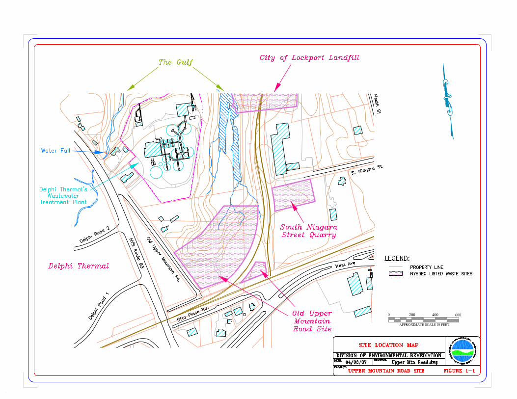


Figure 6-1. Photograph of the heavy vegetation in the ravine portion of the OldUpper Mountain Road Site. View looking northeast. Photograph taken by BrianSadowski on June 5, 2007.
Figure 6-2. Aerial photograph of the Old Upper Mountain Road Site showingthe steep slopes of the ravine, the junk automobiles and site roadways. Viewlooking northeast. Photograph downloaded from Google Earth on May 22, 2007.

Figure 6-3. Photograph of the vegetation across the plateau portion of the OldUpper Mountain Road Site. View looking northeast. Photograph taken byGlenn May on October 1, 2007.
Figure 6-4. Photograph of the vegetation across the plateau portion of the OldUpper Mountain Road Site. An on-site roadway is in the foreground. Viewlooking southwest. Photograph taken by Glenn May on October 1, 2007.

Figure 6-5. Photograph of the vegetation and an on-site roadway across theplateau portion of the Old Upper Mountain Road Site. View looking northeast.Photograph taken by Glenn May on October 1, 2007.
Figure 6-6. Photograph of the vegetation and an on-site roadway across theplateau portion of the Old Upper Mountain Road Site. View looking east.Photograph taken by Glenn May on October 1, 2007.

Figure 6-7. Photograph of the main on-site roadway across the plateau portionof the Old Upper Mountain Road Site. View looking south. Photograph takenby Glenn May on October 1, 2007.
Figure 6-8. Photograph of construction debris observed on the western plateauportion of the Old Upper Mountain Road Site. View looking west. Photographtaken by Glenn May on October 1, 2007.
Figure 6-9. Photograph of recently burned trash observed on the eastern plateauportion of the Old Upper Mountain Road Site. View looking southwest.Photograph taken by Glenn May on October 1, 2007.
Figure 6-10. Photograph of ATV tracks observed on the western plateau portionof the Old Upper Mountain Road Site. View looking east. Photograph taken byBrian Sadowski on June 1, 2006.
Figure 6-11. Photograph of the tires from the former junk auto operation on theplateau portion of the Old Upper Mountain Road Site. View looking southeast.Photograph taken by Glenn May on October 1, 2007.
Figure 6-12. Photograph of a pit excavated into the ash by individualsapparently scavenging for antique bottles and other items. View looking west.Photograph taken by Glenn May on October 1, 2007.

Figure 6-13. Closeup photograph of a pit excavated into the ash. View lookingwest. Photograph taken by Brian Sadowski on June 1, 2006.

Figures 6-14A & B. Arsenic and barium concentrations with depth in soil boring SB-2. The results are plotted at the midpoint of the zone sampled (e.g., a sample collected from 28.0 to 32.0 feet depth is plotted at 32.0 feet).
Figure 6-14A. Arsenic Concentration with Depth
7.6
11.5
9.7
22.8
29.6
12.0
26.4
15.2
25.0
0
4
8
12
16
20
24
28
32
360.0 10.0 20.0 30.0 40.0
Concentration (ppm)
Dep
th (f
t)
Soil Cleanup Objective
Figure 6-14B. Barium Concentration with Depth
114.0
113.0
90.6
375.0
457.0
158.0
156.0
170.0
169.0
0
4
8
12
16
20
24
28
32
360.0 100.0 200.0 300.0 400.0 500.0
Concentration (ppm)
Dep
th (f
t)
Soil Cleanup Objective

Figures 6-14C & D. Cadmium and chromium concentrations with depth in soil boring SB-2. The results are again plotted at the midpoint of the zone sampled.
Figure 6-14C. Cadmium Concentration with Depth
2.4
0.33
0.82
2.0
14.3
4.4
1.6
2.8
1.3
0
4
8
12
16
20
24
28
32
360.0 5.0 10.0 15.0 20.0
Concentration (ppm)
Dep
th (f
t)
Soil Cleanup Objective
Figure 6-14D. Chromium Concentration with Depth
10.0
9.2
10.3
21.8
25.5
13.6
21.1
22.0
44.1
0
4
8
12
16
20
24
28
32
360.0 10.0 20.0 30.0 40.0 50.0
Concentration (ppm)
Dep
th (f
t)
Soil Cleanup Objective

Figures 6-14E & F. Lead and mercury concentrations with depth in soil boring SB-2. The results are again plotted at the midpoint of the zone sampled.
Figure 6-14E. Lead Concentration with Depth
1,340
107.0
654.0
1,440
1,180
4,260
1,380
4,250
902.0
0
4
8
12
16
20
24
28
32
360.0 1,000.0 2,000.0 3,000.0 4,000.0 5,000.0
Concentration (ppm)
Dep
th (f
t)
Soil Cleanup Objective
Figure 6-14F. Mercury Concentration with Depth
0.131
0.043
0.303
0.739
2.0
0.484
0.547
0.408
0.051
0
4
8
12
16
20
24
28
32
360.0 0.5 1.0 1.5 2.0 2.5
Concentration (ppm)
Dep
th (f
t)
Soil Cleanup Objective


TABLES

Page 1 of 2
Table 3-1.Summary Key for Historic Samples Collected from the Old Upper Mountain Road Site, Site No. 932112.
Lab ID SampleID
DateSampled
TimeSampled
IntervalSampled*
AnalyticalParameters Comments Table
Reference
Soil Samples
S-1 S-1 10/20/98 unknown 0.0' - 0.17' Metals washout area Table 3-2
Waste Samples
UPMT-03 UPMT-03 11/05/97 1002 1.0' - 1.5' VOCs, SVOCs, PCBs, Pesticides,Metals, cyanide cinders & grit Table 3-2
UPMT-04 UPMT-04 11/05/97 1025 1.5' VOCs, SVOCs, PCBs, Pesticides,Metals, cyanide soil mixed with cinders & grit Table 3-2
UPMT-05 UPMT-05 11/05/97 1040 2.0' VOCs, SVOCs, PCBs, Pesticides,Metals, cyanide
brownish/gray soil with grit and someslag Table 3-2
UPMT-06 UPMT-06 11/05/97 1050 2.0' VOCs, SVOCs, PCBs, Pesticides,Metals, cyanide ground up “scrap” mixed with soil Table 3-2
UPMT-07 UPMT-07 11/05/97 1105 1.5' VOCs, SVOCs, PCBs, Pesticides,Metals, cyanide deep brown soil that is gritty Table 3-2
UPMT-08 UPMT-08 11/05/97 1118 unknown VOCs, SVOCs, PCBs, Pesticides,Metals, cyanide
dirty white, somewhat crystalline andcrumbly waste Table 3-2
UPMT-09 UPMT-09 11/05/97 1120 2.5' VOCs, SVOCs, PCBs, Pesticides,Metals, cyanide reddish brown and gritty, like kitty litter Table 3-2
UPMT-10 UPMT-10 11/05/97 1130 1.5' VOCs, SVOCs, PCBs, Pesticides,Metals, cyanide C&D waste, incinerator waste, old bottles Table 3-2
UPMT-11 UPMT-11 11/05/97 1155 0.0' - 0.17' VOCs, SVOCs, PCBs, Pesticides,Metals, cyanide green “dirt” Table 3-2
UPMT-13 UPMT-13 11/05/97 1238 0.0' - 0.17' VOCs, SVOCs, PCBs, Pesticides,Metals, cyanide tannish red, gritty, hard and dry material Table 3-2
UPMT-14 UPMT-14 11/05/97 1240 1.0' VOCs, SVOCs, PCBs, Pesticides,Metals, cyanide incinerator grit Table 3-2
UPMT-15 UPMT-15 11/05/97 1245 unknown VOCs, SVOCs, PCBs, Pesticides,Metals, cyanide gritty mix of soil and some incinerator ash Table 3-2
UPMT-16 UPMT-16 11/05/97 1250 unknown VOCs, SVOCs, PCBs, Pesticides,Metals, cyanide
greenish colored, gritty excrement mixedwith soil Table 3-2

Page 2 of 2
Table 3-1 (Continued).Summary Key for Historic Samples Collected from the Old Upper Mountain Road Site, Site No. 932112.
Lab ID SampleID
DateSampled
TimeSampled
IntervalSampled*
AnalyticalParameters Comments Table
Reference
Waste Samples (Continued)
S-2 S-2 10/20/98 unknown 0.0' - 0.17' Metals shiny silver surface debris Table 3-2
S-3 S-3 10/20/98 unknown 0.0' - 0.17' Metals mixture of gray-green sandy material andblack sandy material Table 3-2
S-4 S-4 10/20/98 unknown 0.0' - 0.17' Metals ash material Table 3-2
S-5 S-5 10/20/98 unknown 0.0' - 0.17' Metals, TCLP Lead mixture of tan sandy material and a rustystained material Table 3-2
Sediment Samples
UPMT-12 UPMT-12 11/05/97 1225 0.0' - 0.17' VOCs, SVOCs, PCBs, Pesticides,Metals, cyanide sediment mixed with incinerator waste Table 3-3
Water Samples
UPMT-01 UPMT-01 11/05/97 1228 N/A VOCs, SVOCs, PCBs, Pesticides,Metals, cyanide clear and cold, no surface sheen or odor Table 3-4
W-1 W-1 10/20/98 unknown N/A VOCs headwaters for the Gulf creek Table 3-4

Page 1 of 10
Table 3-2.Analytical Results for Historic Soil and Waste Samples Collected from the Old Upper Mountain Road Site.
Sample NumberDate SampledSample DepthSample Type
Part 375Soil CleanupObjective *
UPMT-0311/05/971.0' - 1.5'
Cinders & Grit
UPMT-0411/05/97
1.5'Cinders & Grit
UPMT-0511/05/97
2.0'Grit & Slag
UPMT-0611/05/97
2.0'Soil with “Scrap”
UPMT-0711/05/97
1.5'Gritty Soil
UPMT-0811/05/97
UnknownCrystalline Waste
Volatile Organic Compounds (µg/kg or ppb)
1,1-Dichloroethane 19,000 9 J 9 J
1,1,1-Trichloroethane 100,000 15 J 24.0 41,000 160.0 99.0 27.0
Trichloroethene 10,000 3 J 6 J 22,000 J 20.0 8 J
Tetrachloroethene 5,500 14 J 28.0 600,000 99.0 24.0 5 J
Toluene 100,000 4 J 5,500 J 6 J
Xylene (Total) 100,000 19,000 J
Semivolatile Organic Compounds (µg/kg or ppb)
Acenaphthene 100,000 24 J 32 J
Acenaphthylene 100,000
Anthracene 100,000 34 J 120 J
Benzo(a)pyrene 1,000 130 J 230 J 220 J 570.0
Benzo(a)anthracene 1,000 130 J 150 J 200 J 640.0
Benzo(b)fluoranthene 1,000 130 J 180 J 250 J 260 J 640.0
Benzo(g,h,i)perylene 100,000 100 J 230 J 170 J 290 J
Benzo(k)fluoranthene 1,000 160 J 240 J 290 J 570.0
Bis(2-ethylhexyl)phthalate 50,000 + 97 JB 2,900 B 290 JB 320 JB 85 JB
Carbazole NS 62 J
Chrysene 1,000 140 J 170 J 240 J 630.0
Dibenzo(a,h)anthracene 330.0 92 J
Dibenzofuran 14,000

Page 2 of 10
Table 3-2 (Continued).Analytical Results for Historic Soil and Waste Samples Collected from the Old Upper Mountain Road Site.
Sample NumberDate SampledSample DepthSample Type
Part 375Soil CleanupObjective *
UPMT-0311/05/971.0' - 1.5'
Cinders & Grit
UPMT-0411/05/97
1.5'Cinders & Grit
UPMT-0511/05/97
2.0'Grit & Slag
UPMT-0611/05/97
2.0'Soil with “Scrap”
UPMT-0711/05/97
1.5'Gritty Soil
UPMT-0811/05/97
UnknownCrystalline Waste
Semivolatile Organic Compounds (Continued)
Di-n-butylphthalate 8,100 + 40 J 52 J 170 J 38 J 160 J 28 J
Fluoranthene 100,000 33 J 200 J 130 J 170 J 1,100
Fluorene 100,000 31 J
Hexachlorobenzene 410.0 + 280 J
Indeno(1,2,3-cd)pyrene 500.0 82 J 210 J 160 J 310 J
2-Methylnaphthalene 36,400 +
Naphthalene 100,000 25 J
Phenanthrene 100,000 150 J 110 J 68 J 490 J
Pyrene 100,000 31 J 240 J 200 J 280 J 320 J 1,300
Total SVOCs NS 104.0 1,669 3,450 2,633 2,578 6,990
Pesticides (µg/kg or ppb)
4,4'-DDD 2,600 23 P
4,4'-DDT 1,700 74 P 38.0
PCBs (µg/kg or ppb)
Aroclor-1254 ----- 690.0
Aroclor-1260 -----
Total PCBs 1,000 690.0
Inorganic Compounds (mg/kg or ppm)
Aluminum SB (11,670) 8,310 4,860 5,580 10,400 6,840 668.0
Antimony SB (1.8) 2.1 B 7.0 B 415.0 225.0 18.5

Page 3 of 10
Table 3-2 (Continued).Analytical Results for Historic Soil and Waste Samples Collected from the Old Upper Mountain Road Site.
Sample NumberDate SampledSample DepthSample Type
Part 375Soil CleanupObjective *
UPMT-0311/05/971.0' - 1.5'
Cinders & Grit
UPMT-0411/05/97
1.5'Cinders & Grit
UPMT-0511/05/97
2.0'Grit & Slag
UPMT-0611/05/97
2.0'Soil with “Scrap”
UPMT-0711/05/97
1.5'Gritty Soil
UPMT-0811/05/97
UnknownCrystalline Waste
Inorganic Compounds (Continued)
Arsenic 16.0 16.5 10.8 12.5 20.2 24.2 2.0 B
Barium 350.0 321.0 524.0 576.0 6,110 1,930 125.0
Beryllium 14.0 0.91 B 0.52 B 0.68 B 0.19 B 0.39 B 0.20 B
Cadmium 2.5 1.8 6.0 12.3 14.1 29.2 0.35 B
Chromium 36.0 18.3 20.5 53.6 148.0 121.0 4.5
Cobalt 30.0 + 9.5 B 6.0 B 8.8 B 22.0 28.9 1.1 B
Copper 270.0 135 N 655 N 2,060 N 7,050 N 2,690 N 96.0 N
Cyanide 27.0 0.39 B 0.68 3.6 1.4 2.1
Iron SB (17,300) 17,700 11,800 17,200 52,600 160,000 2,130
Lead 400.0 417 N 593 N 3,450 N 56,900 N 28,000 N 643 N
Manganese 2,000 370.0 405.0 448.0 563.0 1,090 46.1
Mercury 0.81 0.10 B 0.35 0.21 1.6 1.4
Nickel 140.0 31.0 44.4 96.1 162.0 123.0 7.4 B
Selenium 36.0 3.8 1.5 2.0 3.9 4.1
Silver 36.0 5.1 13.9 91.3 147.0 0.48 B
Thallium SB (2.6) 1.5 B 3.4 3.3
Vanadium 150.0 + 40.7 17.2 21.7 23.6 52.7 2.0 B
Zinc 2,200 1,960 1,010 2,340 1,100 6,510 253.0

Page 4 of 10
Table 3-2 (Continued).Analytical Results for Historic Soil and Waste Samples Collected from the Old Upper Mountain Road Site.
Sample NumberDate SampledSample DepthSample Type
Part 375Soil CleanupObjective *
UPMT-0911/05/97
2.5'Gritty Waste
UPMT-1011/05/97
1.5'Incinerator Waste
UPMT-1111/05/97
0.0' - 0.17'Green Dirt
UPMT-1311/05/97
0.0' - 0.17'Gritty Waste
UPMT-1411/05/97
1.0'Incinerator Grit
UPMT-1511/05/97
UnknownGritty Soil
Volatile Organic Compounds (µg/kg or ppb)
1,1-Dichloroethane 19,000
1,1,1-Trichloroethane 100,000 7 J 11 J 22.0 8 J 8 J 16.0
Trichloroethene 10,000 12 J 5 J 2 J 19.0
Tetrachloroethene 5,500 36.0 4 J 8 J 82.0
Toluene 100,000
Xylene (Total) 100,000
Semivolatile Organic Compounds (µg/kg or ppb)
Acenaphthene 100,000 100 J
Acenaphthylene 100,000
Anthracene 100,000 930 J 24 J
Benzo(a)pyrene 1,000 5,100 150 J 110 J
Benzo(a)anthracene 1,000 4,600 130 J 94 J
Benzo(b)fluoranthene 1,000 4,500 150 J 130 J
Benzo(g,h,i)perylene 100,000 2,900 89 J 75 J
Benzo(k)fluoranthene 1,000 4,700 210 J 170 J
Bis(2-ethylhexyl)phthalate 50,000 + 200 JB 1,100 JB 370 JB 360 JB 170 JB
Carbazole NS 330 J
Chrysene 1,000 4,900 120 J 220 J 180 J 130 J
Dibenzo(a,h)anthracene 330.0 960 J
Dibenzofuran 14,000 96 J

Page 5 of 10
Table 3-2 (Continued).Analytical Results for Historic Soil and Waste Samples Collected from the Old Upper Mountain Road Site.
Sample NumberDate SampledSample DepthSample Type
Part 375Soil CleanupObjective *
UPMT-0911/05/97
2.5'Gritty Waste
UPMT-1011/05/97
1.5'Incinerator Waste
UPMT-1111/05/97
0.0' - 0.17'Green Dirt
UPMT-1311/05/97
0.0' - 0.17'Gritty Waste
UPMT-1411/05/97
1.0'Incinerator Grit
UPMT-1511/05/97
UnknownGritty Soil
Semivolatile Organic Compounds (Continued)
Di-n-butylphthalate 8,100 + 280 J 31 J
Fluoranthene 100,000 6,300 320 J 190 J
Fluorene 100,000 140 J
Hexachlorobenzene 410.0 +
Indeno(1,2,3-cd)pyrene 500.0 2,900 97 J 79 J
2-Methylnaphthalene 36,400 +
Naphthalene 100,000 160 J
Phenanthrene 100,000 3,000 160 J 110 J
Pyrene 100,000 6,200 290 J 210 J
Total SVOCs NS 48,096 320.0 1,320 370.0 2,160 1,499
Pesticides (µg/kg or ppb)
4,4'-DDD 2,600 14 P
4,4'-DDT 1,700 54 P 16.0
PCBs (µg/kg or ppb)
Aroclor-1254 ----- 690.0
Aroclor-1260 ----- 350.0
Total PCBs 1,000 350.0 690.0
Inorganic Compounds (mg/kg or ppm)
Aluminum SB (11,670) 8,380 7,120 3,860 8,010 3,470 8,690
Antimony SB (1.8) 40.1 80.3 0.75 B 14.1 B 111.0
Page 6 of 10
Table 3-2 (Continued).Analytical Results for Historic Soil and Waste Samples Collected from the Old Upper Mountain Road Site.
Sample NumberDate SampledSample DepthSample Type
Part 375Soil CleanupObjective *
UPMT-0911/05/97
2.5'Gritty Waste
UPMT-1011/05/97
1.5'Incinerator Waste
UPMT-1111/05/97
0.0' - 0.17'Green Dirt
UPMT-1311/05/97
0.0' - 0.17'Gritty Waste
UPMT-1411/05/97
1.0'Incinerator Grit
UPMT-1511/05/97
UnknownGritty Soil
Inorganic Compounds (Continued)
Arsenic 16.0 26.5 29.9 6.7 6.7 12.4 35.6
Barium 350.0 1,160 1,800 127.0 169.0 2,870 1,400
Beryllium 14.0 0.42 B 0.62 B 0.29 B 0.71 B 0.46 B 0.72 B
Cadmium 2.5 8.3 15.7 7.7 5.7 17.7
Chromium 36.0 132.0 138.0 56.8 4.6 34.4 81.1
Cobalt 30.0 + 18.9 24.1 5.4 B 3.2 B 9.4 B 13.5 B
Copper 270.0 1,290 N 5,930 N 26,800 N 45.4 N 295 N 815 N
Cyanide 27.0 2.9 2.8 0.82 1.3 1.2
Iron SB (17,300) 80,300 114,000 17,700 3,090 38,400 49,900
Lead 400.0 7,310 N 3,990 N 1,030 N 26.0 N 2,370 N 7,190 N
Manganese 2,000 893.0 1,090 173.0 51.3 438.0 1,430
Mercury 0.81 1.8 19.3 0.24 1.2
Nickel 140.0 111.0 148.0 348.0 10.0 B 29.2 92.5
Selenium 36.0 3.0 2.2 1.4 3.0 5.8
Silver 36.0 9.1 10.3 11.8 3.4 44.2
Thallium SB (2.6) 1.6 B 1.9 B 1.4 B 2.2 B 5.2
Vanadium 150.0 + 28.3 33.3 12.9 9.0 B 18.7 44.6
Zinc 2,200 3,340 3,700 2,080 27.6 2,150 6,110

Page 7 of 10
Table 3-2 (Continued).Analytical Results for Historic Soil and Waste Samples Collected from the Old Upper Mountain Road Site.
Sample NumberDate SampledSample DepthSample Type
Part 375Soil CleanupObjective *
UPMT-1611/05/97
UnknownGritty Waste
S-110/20/98
0.0' - 0.17'Soil
S-210/20/98
0.0' - 0.17'Silver Debris
S-310/20/98
0.0' - 0.17'Sandy Material
S-410/20/98
0.0' - 0.17'Ash Material
S-510/20/98
0.0' - 0.17'Sandy Material
Volatile Organic Compounds (µg/kg or ppb)
1,1-Dichloroethane 19,000 10 J N/A N/A N/A N/A N/A
1,1,1-Trichloroethane 100,000 230.0 O O O O O
Trichloroethene 10,000 10 J O O O O O
Tetrachloroethene 5,500 40.0 O O O O O
Toluene 100,000 O O O O O
Xylene (Total) 100,000 O O O O O
Semivolatile Organic Compounds (µg/kg or ppb)
Acenaphthene 100,000 N/A N/A N/A N/A N/A
Acenaphthylene 100,000 74 J O O O O O
Anthracene 100,000 150 J O O O O O
Benzo(a)pyrene 1,000 570.0 O O O O O
Benzo(a)anthracene 1,000 670.0 O O O O O
Benzo(b)fluoranthene 1,000 630.0 O O O O O
Benzo(g,h,i)perylene 100,000 470.0 O O O O O
Benzo(k)fluoranthene 1,000 550.0 O O O O O
Bis(2-ethylhexyl)phthalate 50,000 + 160 JB O O O O O
Carbazole NS 80 J O O O O O
Chrysene 1,000 760.0 O O O O O
Dibenzo(a,h)anthracene 330.0 150 J O O O O O
Dibenzofuran 14,000 O O O O O

Page 8 of 10
Table 3-2 (Continued).Analytical Results for Historic Soil and Waste Samples Collected from the Old Upper Mountain Road Site.
Sample NumberDate SampledSample DepthSample Type
Part 375Soil CleanupObjective *
UPMT-1611/05/97
UnknownGritty Waste
S-110/20/98
0.0' - 0.17'Soil
S-210/20/98
0.0' - 0.17'Silver Debris
S-310/20/98
0.0' - 0.17'Sandy Material
S-410/20/98
0.0' - 0.17'Ash Material
S-510/20/98
0.0' - 0.17'Sandy Material
Semivolatile Organic Compounds (Continued)
Di-n-butylphthalate 8,100 + 110 J N/A N/A N/A N/A N/A
Fluoranthene 100,000 1,100 O O O O O
Fluorene 100,000 32 J O O O O O
Hexachlorobenzene 410.0 + O O O O O
Indeno(1,2,3-cd)pyrene 500.0 380 J O O O O O
2-Methylnaphthalene 36,400 + 43 J O O O O O
Naphthalene 100,000 70 J O O O O O
Phenanthrene 100,000 680.0 O O O O O
Pyrene 100,000 1,100 O O O O O
Total SVOCs NS 7,779 O O O O O
Pesticides (µg/kg or ppb)
4,4'-DDD 2,600 N/A N/A N/A N/A N/A
4,4'-DDT 1,700 24 P O O O O O
PCBs (µg/kg or ppb)
Aroclor-1254 ----- N/A N/A N/A N/A N/A
Aroclor-1260 ----- O O O O O
Total PCBs 1,000 O O O O O
Inorganic Compounds (mg/kg or ppm)
Aluminum SB (11,670) 10,800 9,750 25,200 5,590 12,700 13,600
Antimony SB (1.8) 11.0 B
Page 9 of 10
Table 3-2 (Continued).Analytical Results for Historic Soil and Waste Samples Collected from the Old Upper Mountain Road Site.
Sample NumberDate SampledSample DepthSample Type
Part 375Soil CleanupObjective *
UPMT-1611/05/97
UnknownGritty Waste
S-110/20/98
0.0' - 0.17'Soil
S-210/20/98
0.0' - 0.17'Silver Debris
S-310/20/98
0.0' - 0.17'Sandy Material
S-410/20/98
0.0' - 0.17'Ash Material
S-510/20/98
0.0' - 0.17'Sandy Material
Inorganic Compounds (Continued)
Arsenic 16.0 24.8 18.0 7.7 7.9 12.0
Barium 350.0 1,030 741.0 595.0 180.0 464.0 3,880
Beryllium 14.0 0.54 B 1.1 0.6 0.7 1.2
Cadmium 2.5 11.7 13.0 22.0 8.0 6.0 62.0
Chromium 36.0 121.0 75.0 130.0 31.0 109.0 974.0
Cobalt 30.0 + 14.0 B 12.0 10.0 11.0 10.0 27.0
Copper 270.0 1,860 N 442.0 1,770 88,700 2,040 11,800
Cyanide 27.0 6.6 N/A N/A N/A N/A N/A
Iron SB (17,300) 122,000 98,000 32,900 11,200 20,400 85,000
Lead 400.0 2,370 N 1,750 3,440 2,080 1,240 36,600
Manganese 2,000 1,610 793.0 1,050 132.0 313.0 981.0
Mercury 0.81 0.50 2.0 0.5 0.3 0.4 0.3
Nickel 140.0 155.0 70.0 206.0 858.0 101.0 995.0
Selenium 36.0 2.3 3.1 0.6 0.7
Silver 36.0 7.1 8.0 6.0 13.0
Thallium SB (2.6)
Vanadium 150.0 + 32.6 26.0 33.0 9.0 31.0 29.0
Zinc 2,200 6,120 3,990 4,090 5,090 1,550 29,600

Page 10 of 10
Table 3-2 (Continued).Analytical Results for Historic Soil and Waste Samples Collected from the Old Upper Mountain Road Site.
* 6 NYCRR Part 375: Environmental Remediation Programs, Residential Soil Cleanup Objectives, NYSDEC, 2006.+ NYSDEC Technical and Guidance Memorandum (TAGM) 4046: Determination of Soil Cleanup Objectives and Cleanup Levels, 1995.B Analyte detected in the associated blank, as well as in the sample (organics) or the value is greater than or equal to the instrument detection limit, but less than
the contract required detection limit (inorganics).J Compound reported at an estimated concentration below the sample quantitation limit.N Spike sample recovery or spike analysis is not within quality control limits (inorganics).NA Not analyzed.NS No standard or guidance value available.P >25% difference between the analytical results on two GC columns. The lower value is reported.SB Site background concentration as determined during the Site Investigation of the Former Flintkote Plant Site (TVGA, 2005).
Blanks indicate that the sample was analyzed for the associated compound but it was not detected.Shaded values equal or exceed the Part 375 or TAGM 4046 soil cleanup objectives.

Page 1 of 2
Table 3-3.Analytical Results for Historic Surface Water Samples Collected from the
Old Upper Mountain Road Site.
Sample NumberDate SampledSample Location
Surface Water
Standard *
UPMT-0111/05/97
Downstream
W-110/20/98
Downstream
Volatile Organic Compounds (µg/L or ppb)
Chloroform 7.0 5.8
1,1-Dichloroethane 5.0 0.5
1,2-Dichloroethene (total) 5.0 9 J 220.7
Tetrachloroethene 0.7 G 4 J 15.0
1,1,1-Trichloroethane 5.0 2.8
Trichloroethene 5.0 9 J 79.0
Vinyl Chloride 0.3 G 0.5
Inorganic Compounds (µg/L or ppb)
Aluminum 100.0 52.5 B N/A
Antimony 3.0 O
Arsenic 50.0 O
Barium 1,000 47.5 B O
Beryllium 3.0 G O
Cadmium 5.0 0.46 B O
Chromium 50.0 O
Cobalt 5.0 O
Copper 200.0 16.0 B O
Cyanide 200.0 O
Iron 300.0 49.9 B O
Lead 50.0 4.2 O
Manganese 300.0 4.0 B O
Mercury 0.7 O
Nickel 100.0 4.4 B O
Selenium 10.0 O
Silver 50.0 O
Thallium 0.5 G O
Vanadium 14.0 O
Zinc 2,000 G 231.0 O

Page 2 of 2
Table 3-3 (Continued).Analytical Results for Historic Surface Water Samples Collected from the
Old Upper Mountain Road Site.
* NYSDEC Ambient Water Quality Standards and Guidance Values, June 1998.B Value greater than or equal to the instrument detection limit, but less than the contract
required detection limit (inorganics).G Guidance value.J Compound reported at an estimated concentration below the reporting limit.NA Not analyzed.
Blanks indicate that the sample was analyzed for the associated compound but it was notdetected.Shaded values equal or exceed the NYSDEC surface water standards or guidancevalues.

Page 1 of 2
Table 3-4.Analytical Results for Historic Sediment Samples Collected from the
Old Upper Mountain Road Site.
Sample NumberDate SampledSample DepthSample Type
NYSDECSedimentCriteria *
UPMT-1211/05/97
0.0' - 0.17'Sediment +
Volatile Organic Compounds (µg/kg or ppb)
1,2-Dichloroethene 0.8 ! 6 J
Trichloroethene 67.3 ! 2 J
Semivolatile Organic Compounds (µg/kg or ppb)
Acenaphthene 4,396 180 J
Anthracene 3,363 290 J
Benzo(a)pyrene 41.3 ! 360 J
Benzo(a)anthracene 383.8 560.0
Benzo(b)fluoranthene 41.3 ! 570.0
Benzo(g,h,i)perylene NS 220 J
Benzo(k)fluoranthene 41.3 ! 360 J
Bis(2-ethylhexyl)phthalate 3,759 770 B
Carbazole NS 140 J
Chrysene 41.3 ! 530.0
Dibenzofuran NS 100 J
Di-n-butylphthalate NS 24 J
Fluoranthene 32,028 1,100
Fluorene 256.6 170 J
Indeno(1,2,3-cd)pyrene 41.3 ! 220 J
2-Methylnaphthalene 1,069 48 J
Naphthalene 957 160 J
Phenanthrene 3,768 1,200
Pyrene 30,178 1,100
Inorganic Compounds (mg/kg or ppm)
Aluminum SB (11,670) ++ 3,920
Antimony 2.0 20.9
Arsenic 6.0 16.8
Barium 433 ** 2,260
Beryllium 10 ** 0.47 B

Page 2 of 2
Table 3-4 (Continued).Analytical Results for Historic Sediment Samples Collected from the
Old Upper Mountain Road Site.
Sample NumberDate SampledSample DepthSample Type
NYSDECSedimentCriteria *
UPMT-1211/05/97
0.0' - 0.17'Sediment +
Inorganic Compounds (Continued)
Cadmium 0.6 3.7
Chromium 26.0 31.7
Cobalt 30.0 ++ 7.5 B
Copper 16.0 2,420 N
Cyanide NS 0.67
Iron 20,000 54,800
Lead 31.0 3,190 N
Manganese 460.0 277.0
Mercury 0.15
Nickel 16.0 49.4
Selenium 3.9 ** 2.5
Silver 1.0 7.5
Thallium SB (2.6) ++
Vanadium 150.0 ++ 20.3
Zinc 120.0 1,530
* NYSDEC Technical Guidance for Screening Contaminated Sediments, January 1999. Sediment criteria calculated using a total organic carbon content of 3.14%. Sedimentcriteria given are for the protection of benthic aquatic life from chronic toxicity(organics) and the lowest effect level (metals) unless otherwise noted.
! Sediment criteria for the protection of human health bioaccumulation. + Sediment mixed with incinerator waste.** 6 NYCRR Part 375: Environmental Remediation Programs, Soil Cleanup Objectives for
the Protection of Ecological Resources, NYSDEC, 2006.++ NYSDEC Technical and Guidance Memorandum (TAGM) 4046: Determination of Soil
Cleanup Objectives and Cleanup Levels, 1995.B Analyte detected in the associated blank, as well as in the sample (organics) or the value
is greater than or equal to the instrument detection limit, but less than the contractrequired detection limit (inorganics).
J Compound reported at an estimated concentration below the sample quantitation limit.N Spike sample recovery or spike analysis is not within quality control limits (inorganics).NS No standard or guidance value available.SB Site background concentration as determined during the Site Investigation of the
Former Flintkote Plant Site (TVGA, 2005).Blanks indicate that the sample was analyzed for the associated compound but it was notdetected.Shaded values equal or exceed the NYSDEC sediment criteria, Part 375 soil cleanupobjectives, or TAGM 4046 soil cleanup objectives.

Page 1 of 3
Table 4-1.Summary Key for Samples Collected During the Site Investigation of the Old Upper Mountain Road Site.
Lab ID SampleID
DateSampled
TimeSampled
IntervalSampled*
AnalyticalParameters Comments Table
Reference
Surface Soil Samples
SS-1 SS-1 06/07/07 1340 0.0' - 0.17' SVOCs, PCBs, Pesticides, Metals,TCLP lead
Surface soil collected at soil boring locationSB-1; peat
Table 6-1 &Table 6-2
SS-2 SS-2 06/07/07 1355 0.0' - 0.17' SVOCs, PCBs, Pesticides, Metals,TCLP cadmium, chromium & lead
Surface soil collected at soil boring locationSB-3; topsoil & fill
Table 6-1 &Table 6-2
SS-3 SS-3 06/07/07 1405 0.0' - 0.17' Metals Surface soil collected at soil boring locationSB-5; soil Table 6-2
SS-4 SS-4 06/07/07 1415 0.0' - 0.17' SVOCs, PCBs, Pesticides, Metals Surface soil collected at soil boring locationSB-8; ash Table 6-2
SS-5 SS-5 06/07/07 1430 0.0' - 0.17' SVOCs, PCBs, Pesticides, Metals Surface soil collected at proposed location ofsoil boring SB-14; ash Table 6-2
SS-6 SS-6 06/08/07 1300 0.2' - 0.3' SVOCs, PCBs, Pesticides, Metals,TCLP lead
Surface soil collected at soil boring locationSB-16; ash
Table 6-1 &Table 6-2
Waste Samples
WS-1 WS-1 06/08/07 1315 1.8' - 2.0' SVOCs, PCBs, Pesticides, Metals,TCLP lead
Ash sample collected from a small pit 19 ftnorth of soil boring SB-16
Table 6-1 &Table 6-3
WS-2 WS-2 06/08/07 1340 1.5' SVOCs, PCBs, Pesticides, Metals,TCLP lead
Ash sample collected from a pit between soilborings SB-15 and SB-16
Table 6-1 &Table 6-3
WS-3 WS-3 06/11/07 1040 1.5' - 2.0' SVOCs, PCBs, Pesticides, Metals Ash sample collected from a pit 17.5 ft east ofsoil boring SB-8 Table 6-3
WS-4 WS-4 06/11/07 1115 5.0' SVOCs, PCBs, Pesticides, Metals Ash sample collected from a pit near Old UpperMountain Road Table 6-3
WS-5 WS-5 06/13/07 0950 0.0' - 0.25' SVOCs, PCBs, Pesticides, Metals,TCLP lead
Ash sample collected near the base of theembankment in the ravine
Table 6-1 &Table 6-3
SB-1A SB-1A 09/25/07 1100 0.0' - 4.0' VOCs, SVOCs, PCBs, Pesticides,Metals, TCLP lead Ash sample collected from soil boring SB-1 Table 6-1 &
Table 6-3
SB-1B SB-1B 09/25/07 1120 16.0' - 20.0' Metals, TCLP lead Ash sample collected from soil boring SB-1 Table 6-1 &Table 6-3
SB-2A SB-2A 09/25/07 1300 0.0' - 4.0' RCRA Metals, TCLP lead Waste sample collected from soil boring SB-2 Table 6-1 &Table 6-3
SB-2B SB-2B 09/25/07 1310 4.0' - 8.0' RCRA Metals Ash sample collected from soil boring SB-2 Table 6-3

Page 2 of 3
Table 4-1 (continued).Summary Key for Samples Collected During the Site Investigation of the Old Upper Mountain Road Site.
Lab ID SampleID
DateSampled
TimeSampled
IntervalSampled*
AnalyticalParameters Comments Table
Reference
Waste Samples (Continued)
SB-2C SB-2C 09/25/07 1315 8.0' - 12.0' RCRA Metals Ash sample collected from soil boring SB-1 Table 6-3
SB-2D SB-2D 09/25/07 1325 12.0' - 16.0' RCRA Metals, TCLP lead Ash sample collected from soil boring SB-2 Table 6-1 &Table 6-3
SB-2E SB-2E 09/25/07 1340 16.0' - 20.0' RCRA Metals, TCLP lead Ash sample collected from soil boring SB-2 Table 6-1 &Table 6-3
SB-2F SB-2F 09/25/07 1350 20.0' - 24.0' RCRA Metals, TCLP lead Waste sample collected from soil boring SB-2 Table 6-1 &Table 6-3
SB-2G SB-2G 09/25/07 1415 24.0' - 28.0' RCRA Metals, TCLP lead Waste sample collected from soil boring SB-2 Table 6-1 &Table 6-3
SB-2H SB-2H 09/25/07 1430 28.0' - 32.0' RCRA Metals, TCLP lead Ash sample collected from soil boring SB-2 Table 6-1 &Table 6-3
SB-2I SB-2I 09/25/07 1500 32.0' - 36.0' RCRA Metals Waste sample collected from soil boring SB-2 Table 6-3
SB-3A SB-3A 09/26/07 1325 0.0' - 4.0' VOCs Waste sample collected from soil boring SB-3 Table 6-3
SB-3B SB-3B 09/26/07 1330 4.0' - 8.0' VOCs Ash sample collected from soil boring SB-3 Table 6-3
SB-3 SB-3 09/26/07 1350 12.0' - 16.0' SVOCs, PCBs, Pesticides, Metals,TCLP lead Ash sample collected from soil boring SB-3 Table 6-1 &
Table 6-3
SB-4 SB-4 09/26/07 1230 8.0' - 12.0' Metals, TCLP lead Ash sample collected from soil boring SB-4 Table 6-1 &Table 6-3
SB-5 SB-5 09/26/07 0920 4.0' - 8.0' SVOCs, PCBs, Pesticides, Metals,TCLP lead Waste sample collected from soil boring SB-5 Table 6-1 &
Table 6-3
SB-6 SB-6 09/25/07 1600 4.0' - 8.0' SVOCs, PCBs, Pesticides, Metals,TCLP lead Ash sample collected from soil boring SB-6 Table 6-1 &
Table 6-3
SB-7B SB-7B 09/26/07 0850 4.0' - 5.6' Metals Ash sample collected from soil boring SB-7 Table 6-3
SB-8 SB-8 09/26/07 1010 8.0' - 10.1' Metals, TCLP lead Waste sample collected from soil boring SB-8 Table 6-1 &Table 6-3
SB-9A SB-9A 09/26/07 1050 4.0' - 8.0' SVOCs, PCBs, Pesticides Waste sample collected from soil boring SB-9 Table 6-3
SB-9B SB-9B 09/26/07 1115 12.0' - 16.0' Metals, TCLP lead Waste sample collected from soil boring SB-9 Table 6-1 &Table 6-3

Page 3 of 3
Table 4-1 (continued).Summary Key for Samples Collected During the Site Investigation of the Old Upper Mountain Road Site.
Lab ID SampleID
DateSampled
TimeSampled
IntervalSampled*
AnalyticalParameters Comments Table
Reference
Waste Samples (Continued)
SB-10A SB-10A 09/26/07 1425 0.0' - 4.0' SVOCs, PCBs, Pesticides, Metals,TCLP lead
Foundry sand sample collected from soil boringSB-10 Table 6-3
SB-10B SB-10B 09/26/07 1455 12.0' - 16.0' Metals, TCLP lead Waste sample collected from soil boring SB-10 Table 6-1 &Table 6-3
SB-11 SB-11 09/27/07 0850 4.0' - 8.0' Metals, TCLP lead Ash sample collected from soil boring SB-11 Table 6-1 &Table 6-3
SB-11B SB-11B 09/27/07 1740 32.0' - 36.0' Metals, TCLP lead Ash sample collected from soil boring SB-11 Table 6-1 &Table 6-3
SB-12 SB-12 09/27/07 1505 16.0' - 20.0' SVOCs, PCBs, Pesticides Ash sample collected from soil boring SB-12 Table 6-3
SB-12B SB-12B 09/27/07 1515 20.0' - 24.0' Metals, TCLP lead Ash sample collected from soil boring SB-12 Table 6-1 &Table 6-3
SB-13 SB-13 09/28/07 0835 12.0' - 16.0' Metals, TCLP lead Ash sample collected from soil boring SB-13 Table 6-1 &Table 6-3
SB-14 SB-14 09/28/07 0930 8.0' - 12.0' Metals Ash sample collected from soil boring SB-14 Table 6-3
Surface Water Samples
SW-1 SW-1 06/11/07 1145 N/A VOCs, SVOCs, PCBs, Pesticides,Metals
Discharge pipe near Old Upper Mountain Road;upgradient Table 6-4
SW-2 SW-2 06/13/07 1030 N/A VOCs, SVOCs, PCBs, Pesticides,Metals
Base of ravine near 1998 surface water sample;downgradient Table 6-4
Sediment Samples
SED-1 SED-1 06/11/07 1145 0.0' - 0.17' VOCs, SVOCs, PCBs, Pesticides,Metals
Sediment collected at surface water locationSW-1 Table 6-5
SED-2 SED-2 06/13/07 1030 0.0' - 0.17' VOCs, SVOCs, PCBs, Pesticides,Metals, TCLP lead
Sediment collected at surface water locationSW-2
Table 6-1 &Table 6-5

Table 5-1.Stratigraphic Sequence of the Western New York Area.
Compiled from Buehler and Tesmer (1963) and Brett et al. (1995).
Epoch Group Formation Member
Middle Devonian
Hamilton
Moscow Shale Windom ShaleKashong Shale
Ludlowville Formation
Tichenor LimestoneWanakah ShaleLedyard ShaleCenterfield Limestone
Skaneateles Formation Levanna ShaleStafford Limestone
Marcellus Shale Oatka Creek Shale
Onondaga Limestone
Seneca LimestoneMorehouse LimestoneNedrow LimestoneClarence LimestoneEdgecliff Limestone
Late Silurian Salina
Akron Dolostone
Bertie Dolostone
Williamsville DolostoneScajaquada DolostoneFalkirk DolostoneOatka Dolostone
Camillus ShaleSyracuse FormationVernon Shale
Middle Silurian
Lockport
Guelph DolostoneEramosa Dolostone
Goat Island DolostoneVinemount DolostoneAncaster DolostoneNiagara Falls Dolostone
Gasport Limestone Pekin DolostoneGothic Hill Limestone
Clinton
Decew Dolostone
Rochester Shale Burleigh Hill ShaleLewiston Shale
Irondequoit LimestoneRockway DolostoneWilliamson ShaleMerritton LimestoneReynales Limestone Hickory Corners LimestoneNeahga Shale
Early Silurian Medina
Kodak SandstoneCambria ShaleThorold SandstoneGrimsby FormationDevils Hole ShalePower Glen ShaleWhirlpool Sandstone
Late Ordovician Richmond Queenston ShaleOswego Sandstone

Table 5-2.Stratigraphic Summary of Borings Completed During the Site Investigation of the Old Upper Mountain Road Site.
All Depths and Elevations are Measured in Feet.
BoringNumber
GroundSurface
Elevation
Topsoil or Clean Fill Waste Native Silty Clay Bedrock
Depth SurfaceElevation Thickness Depth Surface
Elevation Thickness Depth SurfaceElevation Thickness Depth Surface
Elevation
SB-1 572.0 0.0 572.0 0.3 0.3 571.7 18.1 18.4 553.6 1.6 20.0 552.0
SB-2 588.0 0.0 588.0 > 36.0
SB-3 585.0 0.0 585.0 > 16.4
SB-4 587.0 0.0 587.0 0.3 0.3 586.7 13.5 13.8 573.2 0.7 14.5 572.5
SB-5 583.0 0.0 583.0 2.7 2.7 580.3 10.4 13.1 569.9 1.4 14.5 568.5
SB-6 590.0 0.0 590.0 4.5 4.5 585.5 7.5 12.0 578.0 1.6 13.6 576.4
SB-7 592.0 0.0 592.0 2.2 2.2 589.8 > 3.4
SB-8 592.0 0.0 592.0 0.4 0.4 591.6 9.7 10.1 581.9 2.6 12.7 579.3
SB-9 588.0 0.0 588.0 1.1 1.1 586.9 15.1 16.0 572.0 0.2 16.2 571.8
SB-10 593.0 0.0 593.0 0.4 0.4 592.6 > 18.4
SB-11 578.0 0.0 578.0 2.2 2.2 575.8 > 33.8
SB-12 578.0 0.0 578.0 5.1 5.1 572.9 > 23.9
SB-13 575.0 0.0 575.0 0.1 0.1 574.9 21.2 21.3 553.7 0.7 22.0 553.0
SB-14 582.0 0.0 582.0 12.0 12.0 570.0 0.7 12.7 569.3
SB-15 598.0 0.0 598.0 0.9 0.9 597.1 > 0.7
SB-16 595.0 0.0 595.0 0.6 0.6 594.4 6.0 6.6 588.4 > 1.4

Page 1 of 4
Table 6-1.Analytical Results for Surface Soil Samples Collected from the Old Upper Mountain Road Site.
Sample NumberDate SampledSample DepthSample Type
Part 375Soil CleanupObjective *
SS-106/07/07
0.0' -0.17'Peat
SS-206/07/07
0.0' -0.17'Topsoil & Fill
SS-306/07/07
0.0' -0.17'Soil
SS-406/07/07
0.0' -0.17'Ash
SS-506/07/07
0.0' -0.17'Ash
SS-606/08/07
0.0' -0.17'Ash
Semivolatile Organic Compounds (µg/kg or ppb)
Acenaphthene 100,000 NA 11 J 110 J
Acenaphthylene 100,000 240 J O 110 J 350 J
Anthracene 100,000 220 J O 160 J 580 J
Benzo(a)anthracene 1,000 640 J 1,000 J O 20 J 550.0 1,900 J
Benzo(a)pyrene 1,000 1,100 J 1,100 J O 22 J 460.0 1,700 J
Benzo(b)fluoranthene 1,000 920 J 1,800 J O 48 J 690.0 2,600
Benzo(g,h,i)perylene 100,000 400 J 1,200 J O 20 J 270.0 980 J
Benzo(k)fluoranthene 1,000 470 J 610 J O 210.0 940 J
Bis(2-ethylhexyl)phthalate 50,000 + O 110 BJ 76 BJ
Carbazole NS O 73 J 330 J
Chrysene 1,000 470 J 1,200 J O 16 J 500.0 1,800 J
4-Chloro-3-methylphenol 240.0 + 3,800 1,100 J O
Dibenzo(a,h)anthracene 330.0 480 J O 83 J 350 J
Dibenzofuran 14,000 O 27 J 98 J
Di-n-octylphthalate 50,000 + O 19 BJ 17 BJ
Fluoranthene 100,000 1,400 J 1,100 J O 21 J 940.0 4,000
Fluorene 100,000 O 11 J
Indeno(1,2,3-cd)pyrene 500.0 300 J 1,100 J O 16 J 250.0 930 J
2-Methylnaphthalene 36,400 + 160 J O 40 J 87 J
Naphthalene 100,000 O 29 J 180 J

Page 2 of 4
Table 6-1 (Continued).Analytical Results for Surface Soil Samples Collected from the Old Upper Mountain Road Site.
Sample NumberDate SampledSample DepthSample Type
Part 375Soil CleanupObjective *
SS-106/07/07
0.0' -0.17'Peat
SS-206/07/07
0.0' -0.17'Topsoil & Fill
SS-306/07/07
0.0' -0.17'Soil
SS-406/07/07
0.0' -0.17'Ash
SS-506/07/07
0.0' -0.17'Ash
SS-606/08/07
0.0' -0.17'Ash
Semivolatile Organic Compounds (Continued)
Phenanthrene 100,000 720 J 580 J NA 15 J 530.0 2,200
Pyrene 100,000 660 J 1,100 J O 14 J 630.0 2,600
Pesticides (µg/kg or ppb)
4,4-DDE 1,800 NA 9.8 26.0
4,4'-DDT 1,700 120 B 160 B O 2.1 BJ 25 B 57 B
Aldrin 19.0 O 2.2 J 6.4 J
alpha-BHC 97.0 34 J 38 J O 8.9 J
alpha-Chlordane 910.0 O 2.8 J 11 J
delta-BHC 100,000 O 1.1 J
Dieldrin 39.0 32 J 40 J O 1.4 J
Endosulfan II 4,800 49 J O
Endosulfan Sulfate 4,800 O 3.9 J
Endrin Aldehyde NS O 1.2 J 23.0
Endrin Ketone NS 34 J O
gamma-Chlordane 540.0 + O 0.9 BJ 3.1 BJ
Methoxychlor NS 120.0 O
PCBs (µg/kg or ppb)
Aroclor-1254 ----- N/A
Aroclor-1260 ----- 270.0 O
Total PCBs 1,000 270.0 O

Page 3 of 4
Table 6-1 (Continued).Analytical Results for Surface Soil Samples Collected from the Old Upper Mountain Road Site.
Sample NumberDate SampledSample DepthSample Type
Part 375Soil CleanupObjective *
SS-106/07/07
0.0' -0.17'Peat
SS-206/07/07
0.0' -0.17'Topsoil & Fill
SS-306/07/07
0.0' -0.17'Soil
SS-406/07/07
0.0' -0.17'Ash
SS-506/07/07
0.0' -0.17'Ash
SS-606/08/07
0.0' -0.17'Ash
Inorganic Compounds (mg/kg or ppm)
Aluminum SB (11,670) 8,250 12,200 5,350 16,400 5,960 6,770
Antimony SB (1.8) 135.0 269.0
Arsenic 16.0 21.4 16.0 3.7 37.3 23.6 20.3
Barium 350.0 705.0 1,570 65.1 230.0 265.0 449.0
Beryllium 14.0 1.2 1.3 0.3 0.67 0.59 0.55
Cadmium 2.5 4.4 55.4 1.6 0.5 0.7 5.1
Chromium 36.0 56.2 297.0 12.8 37.7 43.1 42.5
Cobalt 30.0 + 13.6 27.4 5.4 6.9 10.8 11.1
Copper 270.0 277.0 22,300 160.0 85.7 224.0 1,230
Iron SB (17,300) 40,800 61,500 12,600 24,100 80,300 30,100
Lead 400.0 1,310 24,300 216.0 186.0 376.0 3,280
Manganese 2,000 177.0 573.0 534.0 809.0 434.0 533.0
Mercury 0.81 0.756 1.9 0.042 0.108 0.411
Nickel 140.0 134.0 1,070 26.1 25.0 89.1 84.3
Selenium 36.0
Silver 36.0 1.1 114.0 1.0 0.94 3.0
Thallium SB (2.6)
Vanadium 150.0 + 22.2 25.6 13.1 31.4 22.8 34.1
Zinc 2,200 688.0 13,400 507.0 599.0 381.0 1,630
Page 4 of 4
Table 6-1 (Continued).Analytical Results for Surface Soil Samples Collected from the Old Upper Mountain Road Site.
* 6 NYCRR Part 375: Environmental Remediation Programs, Residential Soil Cleanup Objectives, NYSDEC, 2006.+ NYSDEC Technical and Guidance Memorandum (TAGM) 4046: Determination of Soil Cleanup Objectives and Cleanup Levels, 1995.B Analyte detected in the associated blank, as well as in the sample (organics).J Compound reported at an estimated concentration below the sample quantitation limit.NA Not analyzed.NS No standard or guidance value available.SB Site background concentration as determined during the Site Investigation of the Former Flintkote Plant Site (TVGA, 2005).
Blanks indicate that the sample was analyzed for the associated compound but it was not detected.Shaded values equal or exceed the Part 375 or TAGM 4046 soil cleanup objectives.

Page 1 of 5
Table 6-2.TCLP Results for Samples Collected from the Old Upper Mountain Road Site.
Sample NumberDate SampledSample DepthSample Type
RegulatoryLevel *
SS-106/07/07
0.0' - 0.17'Peat
SS-206/07/07
0.0' - 0.17'Topsoil & Fill
SS-606/08/07
0.0' - 0.17'Ash
WS-106/08/071.8' - 2.0'
Ash
WS-206/08/07
1.5'Ash
WS-506/13/07
0.0' - 0.25'Ash
Inorganic Compounds (mg/L or ppm)
Arsenic 5.0 NA NA NA NA NA NA
Barium 100.0 O O O O O O
Cadmium 1.0 O 0.597 O O O O
Chromium 5.0 O 0.0135 O O O O
Lead 5.0 0.809 272.0 0.948 0.639 2.51 15.8
Mercury 0.2 NA NA NA NA NA NA
Selenium 1.0 O O O O O O
Silver 5.0 O O O O O O
* 6 NYCRR Part 371: Identification and Listing of Hazardous Wastes, NYSDEC, 1995.NA Not analyzed.
Samples W3 and W4 were also analyzed for TCLP volatiles, semivolatiles and pesticides. None of these compounds were detected.Exceedances are shaded.

Page 2 of 5
Table 6-2 (Continued).TCLP Results for Samples Collected from the Old Upper Mountain Road Site.
Sample NumberDate SampledSample DepthSample Type
RegulatoryLevel *
SB-1A09/25/070.0' - 4.0'
Ash
SB-1B09/25/07
16.0' - 20.0'Ash
SB-2A09/25/070.0' - 4.0'
Waste
SB-2D09/25/07
12.0' - 16.0'Ash
SB-2E09/25/07
16.0' - 20.0'Ash
SB-2F09/25/07
20.0' - 24.0'Waste
Inorganic Compounds (mg/L or ppm)
Arsenic 5.0 NA NA NA NA NA NA
Barium 100.0 O O O O O O
Cadmium 1.0 O O O O O O
Chromium 5.0 O O O O O O
Lead 5.0 101.0 7.4 31.0 1.0 2.8 76.9
Mercury 0.2 NA NA NA NA NA NA
Selenium 1.0 O O O O O O
Silver 5.0 O O O O O O
* 6 NYCRR Part 371: Identification and Listing of Hazardous Wastes, NYSDEC, 1995.NA Not analyzed.
Exceedances are shaded.

Page 3 of 5
Table 6-2 (Continued).TCLP Results for Samples Collected from the Old Upper Mountain Road Site.
Sample NumberDate SampledSample DepthSample Type
RegulatoryLevel *
SB-2G09/25/07
24.0' - 28.0'Waste
SB-2H09/25/07
28.0' - 32.0'Ash
SB-309/26/07
12.0' - 16.0'Ash
SB-409/26/07
8.0' - 12.0'Ash
SB-509/26/074.0' - 8.0'
Waste
SB-609/25/074.0' - 8.0'
Ash
Inorganic Compounds (mg/L or ppm)
Arsenic 5.0 NA NA NA NA NA NA
Barium 100.0 O O O O O O
Cadmium 1.0 O O O O O O
Chromium 5.0 O O O O O O
Lead 5.0 2.8 16.1 9.1 0.024 23.4 2.2
Mercury 0.2 NA NA NA NA NA NA
Selenium 1.0 O O O O O O
Silver 5.0 O O O O O O
* 6 NYCRR Part 371: Identification and Listing of Hazardous Wastes, NYSDEC, 1995.NA Not analyzed.
Exceedances are shaded.

Page 4 of 5
Table 6-2 (Continued).TCLP Results for Samples Collected from the Old Upper Mountain Road Site.
Sample NumberDate SampledSample DepthSample Type
RegulatoryLevel *
SB-809/26/07
8.0' - 10.1'Waste
SB-9B09/26/07
12.0' - 16.0'Waste
SB-10A09/26/070.0' - 4.0'
Foundry Sand
SB-10B09/26/07
12.0' - 16.0'Waste
SB-1109/27/074.0' - 8.0'
Ash
SB-11B09/27/07
32.0' - 36.0'Ash
Inorganic Compounds (mg/L or ppm)
Arsenic 5.0 NA NA NA NA NA NA
Barium 100.0 O O O O O O
Cadmium 1.0 O O O O O O
Chromium 5.0 O O O O O O
Lead 5.0 0.33 3.1 31.8 7.2 25.9 27.0
Mercury 0.2 NA NA NA NA NA NA
Selenium 1.0 O O O O O O
Silver 5.0 O O O O O O
* 6 NYCRR Part 371: Identification and Listing of Hazardous Wastes, NYSDEC, 1995.NA Not analyzed.
Exceedances are shaded.

Page 5 of 5
Table 6-2 (Continued).TCLP Results for Samples Collected from the Old Upper Mountain Road Site.
Sample NumberDate SampledSample DepthSample Type
RegulatoryLevel *
SB-12B09/27/07
20.0' - 24.0'Ash
SB-1309/28/07
12.0' - 16.0'Ash
SED-206/13/07
0.0' - 0.17'Sediment
Inorganic Compounds (mg/L or ppm)
Arsenic 5.0 NA NA NA
Barium 100.0 O O O
Cadmium 1.0 O O O
Chromium 5.0 O O O
Lead 5.0 1.6 0.83 0.810
Mercury 0.2 NA NA NA
Selenium 1.0 O O O
Silver 5.0 O O O
* 6 NYCRR Part 371: Identification and Listing of Hazardous Wastes, NYSDEC, 1995.NA Not analyzed.
Exceedances are shaded.

Page 1 of 21
Table 6-3.Analytical Results for Waste Samples Collected from the Old Upper Mountain Road Site.
Sample NumberDate SampledSample DepthSample Type
Part 375Soil CleanupObjective *
WS-106/08/071.8' - 2.0'
Ash
WS-206/08/07
1.5'Ash
WS-306/11/071.5' - 2.0'
Ash
WS-406/11/07
5.0'Ash
WS-506/13/07
0.0' - 0.25'Ash
Volatile Organic Compounds (µg/kg or ppb)
Acetone 100,000 NA NA NA NA NA
cis-1,2-Dichloroethene 59,000 O O O O O
1,1-Dichloroethane 19,000 O O O O O
Methylene Chloride 51,000 O O O O O
Tetrachloroethene 5,500 O O O O O
Toluene 100,000 O O O O O
trans-1,2-Dichloroethene 100,000 O O O O O
1,1,1-Trichloroethane 100,000 O O O O O
1,1,2-Trichloroethane NS O O O O O
Trichloroethene 10,000 O O O O O
Semivolatile Organic Compounds (µg/kg or ppb)
Acenaphthene 100,000 420.0
Acenaphthylene 100,000 20 J 250.0
Anthracene 100,000 26 J 980.0 14 J
Benzaldehyde NS 620.0
Benzo(a)anthracene 1,000 110 J 2,300 52 J 50 J 230 J
Benzo(a)pyrene 1,000 110 J 2,000 49 J 42 J
Benzo(b)fluoranthene 1,000 190 J 2,800 86 J 78 J
Benzo(g,h,i)perylene 100,000 160 J 1,100 35 J 34 J

Page 2 of 21
Table 6-3 (Continued).Analytical Results for Waste Samples Collected from the Old Upper Mountain Road Site.
Sample NumberDate SampledSample DepthSample Type
Part 375Soil CleanupObjective *
WS-106/08/071.8' - 2.0'
Ash
WS-206/08/07
1.5'Ash
WS-306/11/071.5' - 2.0'
Ash
WS-406/11/07
5.0'Ash
WS-506/13/07
0.0' - 0.25'Ash
Semivolatile Organic Compounds (Continued)
Benzo(k)fluoranthene 1,000 72 J 950.0 18 J 32 J
Biphenyl NS 45 J
Bis(2-ethylhexyl)phthalate 50,000 + 170 BJ 94 BJ 94 BJ 110 BJ
Carbazole NS 14 J 300.0
Chrysene 1,000 120 J 2,400 49 J 60 J
Dibenzo(a,h)anthracene 330.0 38 J 360.0 16 J 12 J
Dibenzofuran 14,000 120 J
Di-n-octylphthalate 50,000 + 11 BJ 19 BJ
Fluoranthene 100,000 210.0 4,500 68 J 63 J
Fluorene 100,000 350.0
Hexachlorobenzene 410.0 +
Indeno(1,2,3-cd)pyrene 500.0 110 J 990.0 31 J 36 J
2-Methylnaphthalene 36,400 + 270 J
4-Methylphenol 34,000 19 J
Naphthalene 100,000 250.0
Pentachlorophenol 2,400 5,600 J
Phenanthrene 100,000 93 J 3,600 38 J 22 J
Phenol 100,000 43 J
Pyrene 100,000 140 J 3,200 48 J 41 J

Page 3 of 21
Table 6-3 (Continued).Analytical Results for Waste Samples Collected from the Old Upper Mountain Road Site.
Sample NumberDate SampledSample DepthSample Type
Part 375Soil CleanupObjective *
WS-106/08/071.8' - 2.0'
Ash
WS-206/08/07
1.5'Ash
WS-306/11/071.5' - 2.0'
Ash
WS-406/11/07
5.0'Ash
WS-506/13/07
0.0' - 0.25'Ash
Pesticides (µg/kg or ppb)
4,4-DDD 2600 0.70 J 7.4 J
4,4-DDE 1,800 1.9 J 25.0 2.9 11 J
4,4'-DDT 1,700 3.3 B 55 B 1.8 BJ 10 B 110.0
Aldrin 19.0 0.85 J 8.5 J 0.99 J 0.70 J
alpha-BHC 97.0 0.76 J 9.0 J 7.4 J
delta-BHC 100,000 0.68 J 0.67 J 0.57 J
Dieldrin 39.0 0.72 J 1.0 J
Endosulfan II 4,800 4.8 J
Endosulfan Sulfate 4,800 0.80 J 1.6 J
Endrin 2,200
Endrin Aldehyde NS
gamma-Chlordane 540.0 + 0.84 BJ 5.2 J
Methoxychlor NS 9.4 69.0
PCBs (µg/kg or ppb)
Aroclor-1248 -----
Aroclor-1254 -----
Aroclor-1260 ----- 71.0
Total PCBs 1,000 71.0

Page 4 of 21
Table 6-3 (Continued).Analytical Results for Waste Samples Collected from the Old Upper Mountain Road Site.
Sample NumberDate SampledSample DepthSample Type
Part 375Soil CleanupObjective *
WS-106/08/071.8' - 2.0'
Ash
WS-206/08/07
1.5'Ash
WS-306/11/071.5' - 2.0'
Ash
WS-406/11/07
5.0'Ash
WS-506/13/07
0.0' - 0.25'Ash
Inorganic Compounds (mg/kg or ppm)
Aluminum SB (11,670) 5,080 8,750 7,500 5,930 7,470
Antimony SB (1.8) 31.7
Arsenic 16.0 50.8 18.9 14.7 8.4 22.8
Barium 350.0 225.0 464.0 446.0 198.0 688.0
Beryllium 14.0 0.40 0.77 0.77 0.60 0.57
Cadmium 2.5 2.5 3.6 1.0 8.5
Chromium 36.0 12.5 34.2 22.7 9.7 82.9
Cobalt 30.0 + 5.7 9.8 9.2 6.4 9.0
Copper 270.0 42.1 1,310 95.0 65.3 566.0
Iron SB (17,300) 16,000 34,200 42,900 9,720 52,500
Lead 400.0 1,700 1,740 539.0 35.9 2,380
Manganese 2,000 389.0 528.0 320.0 77.7 396.0
Mercury 0.81 2.3 0.280 0.063 0.076 1.6
Nickel 140.0 16.5 64.3 27.6 15.4 47.3
Selenium 36.0 30.2
Silver 36.0 5.1 1.8 12.5
Thallium SB (2.6)
Vanadium 150.0 + 25.3 27.5 27.4 22.1 22.9
Zinc 2,200 945.0 2,030 422.0 76.0 2,510

Page 5 of 21
Table 6-3 (Continued).Analytical Results for Waste Samples Collected from the Old Upper Mountain Road Site.
Sample NumberDate SampledSample DepthSample Type
Part 375Soil CleanupObjective *
SB-1A09/25/070.0' - 4.0'
Ash
SB-1B09/25/07
16.0' - 20.0'Ash
SB-3A09/26/070.0' - 4.0'
Waste
SB-3B09/26/074.0' - 8.0'
Ash
SB-309/26/07
12.0' - 16.0'Ash
Volatile Organic Compounds (µg/kg or ppb)
Acetone 100,000 NA 8 J NA
cis-1,2-Dichloroethene 59,000 O 2 J 2 J O
1,1-Dichloroethane 19,000 O 1 J 1 J O
Methylene Chloride 51,000 18 B O 170 B (15,000 B) 95 B (7,300 B) O
Tetrachloroethene 5,500 27.0 O 2,000 E (190,000) 1,300 E (91,000) O
Toluene 100,000 2 J O 4 J 4 J O
trans-1,2-Dichloroethene 100,000 O 1 J O
1,1,1-Trichloroethane 100,000 12.0 O 24.0 (3,800 J) 15.0 (2,100 J) O
1,1,2-Trichloroethane NS O 2,000 J O
Trichloroethene 10,000 98.0 O 840 E (48,000) 570 E (67,000) O
Semivolatile Organic Compounds (µg/kg or ppb)
Acenaphthene 100,000 NA NA NA
Acenaphthylene 100,000 O O O 140 J
Anthracene 100,000 O O O 260 J
Benzaldehyde NS O O O
Benzo(a)anthracene 1,000 1,800 J O O O 4,000
Benzo(a)pyrene 1,000 O O O 2,400
Benzo(b)fluoranthene 1,000 O O O 4,800
Benzo(g,h,i)perylene 100,000 O O O 2,800

Page 6 of 21
Table 6-3 (Continued).Analytical Results for Waste Samples Collected from the Old Upper Mountain Road Site.
Sample NumberDate SampledSample DepthSample Type
Part 375Soil CleanupObjective *
SB-1A09/25/070.0' - 4.0'
Ash
SB-1B09/25/07
16.0' - 20.0'Ash
SB-3A09/26/070.0' - 4.0'
Waste
SB-3B09/26/074.0' - 8.0'
Ash
SB-309/26/07
12.0' - 16.0'Ash
Semivolatile Organic Compounds (Continued)
Benzo(k)fluoranthene 1,000 O O O 1,600 J
Biphenyl NS O O O
Bis(2-ethylhexyl)phthalate 50,000 + 13,000 O O O
Carbazole NS O O O 100 J
Chrysene 1,000 O O O 4,700
Dibenzo(a,h)anthracene 330.0 O O O 840 J
Dibenzofuran 14,000 O O O
Di-n-octylphthalate 50,000 + O O O
Fluoranthene 100,000 O O O 5,100
Fluorene 100,000 O O O
Hexachlorobenzene 410.0 + O O O
Indeno(1,2,3-cd)pyrene 500.0 O O O 2,200
2-Methylnaphthalene 36,400 + O O O
4-Methylphenol 34,000 O O O
Naphthalene 100,000 O O O
Pentachlorophenol 2,400 O O O
Phenanthrene 100,000 O O O 560 J
Phenol 100,000 O O O
Pyrene 100,000 O O O 4,700

Page 7 of 21
Table 6-3 (Continued).Analytical Results for Waste Samples Collected from the Old Upper Mountain Road Site.
Sample NumberDate SampledSample DepthSample Type
Part 375Soil CleanupObjective *
SB-1A09/25/070.0' - 4.0'
Ash
SB-1B09/25/07
16.0' - 20.0'Ash
SB-3A09/26/070.0' - 4.0'
Waste
SB-3B09/26/074.0' - 8.0'
Ash
SB-309/26/07
12.0' - 16.0'Ash
Pesticides (µg/kg or ppb)
4,4-DDD 2600 NA NA NA
4,4-DDE 1,800 21.0 O O O
4,4'-DDT 1,700 70.0 O O O
Aldrin 19.0 O O O
alpha-BHC 97.0 O O O
delta-BHC 100,000 O O O
Dieldrin 39.0 O O O
Endosulfan II 4,800 46.0 O O O
Endosulfan Sulfate 4,800 10 J O O O
Endrin 2,200 11 J O O O
Endrin Aldehyde NS 44.0 O O O
gamma-Chlordane 540.0 + 16 J O O O
Methoxychlor NS O O O
PCBs (µg/kg or ppb)
Aroclor-1248 ----- NA NA NA
Aroclor-1254 ----- 520.0 O O O
Aroclor-1260 ----- O O O
Total PCBs 1,000 520.0 O O O

Page 8 of 21
Table 6-3 (Continued).Analytical Results for Waste Samples Collected from the Old Upper Mountain Road Site.
Sample NumberDate SampledSample DepthSample Type
Part 375Soil CleanupObjective *
SB-1A09/25/070.0' - 4.0'
Ash
SB-1B09/25/07
16.0' - 20.0'Ash
SB-3A09/26/070.0' - 4.0'
Waste
SB-3B09/26/074.0' - 8.0'
Ash
SB-309/26/07
12.0' - 16.0'Ash
Inorganic Compounds (mg/kg or ppm)
Aluminum SB (11,670) 5,840 8,600 NA NA 6,830
Antimony SB (1.8) 42.7 N O O
Arsenic 16.0 12.4 N 19.5 N O O 13.4 N
Barium 350.0 274.0 420.0 O O 336.0
Beryllium 14.0 0.54 0.64 O O 0.69
Cadmium 2.5 5.3 4.7 O O 3.3
Chromium 36.0 51.6 N 52.9 N O O 49.1 N
Cobalt 30.0 + 7.2 11.1 O O 9.2
Copper 270.0 1,430 398.0 O O 608.0
Iron SB (17,300) 21,100 127,000 O O 26,100
Lead 400.0 10,500 (7,560) 2,380 (1,180) O O 2,500 (2,620)
Manganese 2,000 152.0 694.0 O O 303.0
Mercury 0.81 0.141 0.052 O O 0.356
Nickel 140.0 104.0 81.1 O O 46.5
Selenium 36.0 O O
Silver 36.0 9.3 18.0 O O 4.7
Thallium SB (2.6) O O
Vanadium 150.0 + 23.4 32.8 O O 20.7
Zinc 2,200 3,210 1,000 O O 938.0

Page 9 of 21
Table 6-3 (Continued).Analytical Results for Waste Samples Collected from the Old Upper Mountain Road Site.
Sample NumberDate SampledSample DepthSample Type
Part 375Soil CleanupObjective *
SB-409/26/07
8.0' - 12.0'Ash
SB-509/26/074.0' - 8.0'
Waste
SB-609/25/074.0' - 8.0'
Ash
SB-7B09/26/074.0' - 5.6'
Ash
SB-809/26/07
8.0' - 10.1'Waste
Volatile Organic Compounds (µg/kg or ppb)
Acetone 100,000 NA NA NA NA NA
cis-1,2-Dichloroethene 59,000 O O O O O
1,1-Dichloroethane 19,000 O O O O O
Methylene Chloride 51,000 O O O O O
Tetrachloroethene 5,500 O O O O O
Toluene 100,000 O O O O O
trans-1,2-Dichloroethene 100,000 O O O O O
1,1,1-Trichloroethane 100,000 O O O O O
1,1,2-Trichloroethane NS O O O O O
Trichloroethene 10,000 O O O O O
Semivolatile Organic Compounds (µg/kg or ppb)
Acenaphthene 100,000 NA NA NA
Acenaphthylene 100,000 O O O
Anthracene 100,000 O O O
Benzaldehyde NS O O O
Benzo(a)anthracene 1,000 O 230 J 470 J O O
Benzo(a)pyrene 1,000 O 96 J 480 J O O
Benzo(b)fluoranthene 1,000 O 420 J 440 J O O
Benzo(g,h,i)perylene 100,000 O 200 J 320 J O O

Page 10 of 21
Table 6-3 (Continued).Analytical Results for Waste Samples Collected from the Old Upper Mountain Road Site.
Sample NumberDate SampledSample DepthSample Type
Part 375Soil CleanupObjective *
SB-409/26/07
8.0' - 12.0'Ash
SB-509/26/074.0' - 8.0'
Waste
SB-609/25/074.0' - 8.0'
Ash
SB-7B09/26/074.0' - 5.6'
Ash
SB-809/26/07
8.0' - 10.1'Waste
Semivolatile Organic Compounds (Continued)
Benzo(k)fluoranthene 1,000 O O O
Biphenyl NS O O O
Bis(2-ethylhexyl)phthalate 50,000 + O O O
Carbazole NS O O O
Chrysene 1,000 O 280 J 360 J O O
Dibenzo(a,h)anthracene 330.0 O 54 J O O
Dibenzofuran 14,000 O O O
Di-n-octylphthalate 50,000 + O O O
Fluoranthene 100,000 O 280 J 500 J O O
Fluorene 100,000 O O O
Hexachlorobenzene 410.0 + O 220 J O O
Indeno(1,2,3-cd)pyrene 500.0 O 150 J 340 J O O
2-Methylnaphthalene 36,400 + O 46 J O O
4-Methylphenol 34,000 O O O
Naphthalene 100,000 O 58 J O O
Pentachlorophenol 2,400 O O O
Phenanthrene 100,000 O 130 J 410 J O O
Phenol 100,000 O O O
Pyrene 100,000 O 280 J 540 J O O

Page 11 of 21
Table 6-3 (Continued).Analytical Results for Waste Samples Collected from the Old Upper Mountain Road Site.
Sample NumberDate SampledSample DepthSample Type
Part 375Soil CleanupObjective *
SB-409/26/07
8.0' - 12.0'Ash
SB-509/26/074.0' - 8.0'
Waste
SB-609/25/074.0' - 8.0'
Ash
SB-7B09/26/074.0' - 5.6'
Ash
SB-809/26/07
8.0' - 10.1'Waste
Pesticides (µg/kg or ppb)
4,4-DDD 2600 NA NA NA
4,4-DDE 1,800 O O O
4,4'-DDT 1,700 O 37.0 O O
Aldrin 19.0 O 7.6 J 8.0 J O O
alpha-BHC 97.0 O O O
delta-BHC 100,000 O O O
Dieldrin 39.0 O 5.6 J O O
Endosulfan II 4,800 O O O
Endosulfan Sulfate 4,800 O O O
Endrin 2,200 O O O
Endrin Aldehyde NS O O O
gamma-Chlordane 540.0 + O O O
Methoxychlor NS O 61.0 O O
PCBs (µg/kg or ppb)
Aroclor-1248 ----- NA NA NA
Aroclor-1254 ----- O O O
Aroclor-1260 ----- O O O
Total PCBs 1,000 O O O

Page 12 of 21
Table 6-3 (Continued).Analytical Results for Waste Samples Collected from the Old Upper Mountain Road Site.
Sample NumberDate SampledSample DepthSample Type
Part 375Soil CleanupObjective *
SB-409/26/07
8.0' - 12.0'Ash
SB-509/26/074.0' - 8.0'
Waste
SB-609/25/074.0' - 8.0'
Ash
SB-7B09/26/074.0' - 5.6'
Ash
SB-809/26/07
8.0' - 10.1'Waste
Inorganic Compounds (mg/kg or ppm)
Aluminum SB (11,670) 7,660 3,040 6,940 7,300 10,100
Antimony SB (1.8) 36.1 N 276 N 26.5 N 33.2 N
Arsenic 16.0 33.3 N 47.9 N 42.7 N 15.4 N 44.5 N
Barium 350.0 904.0 1,650 752.0 287.0 1,810
Beryllium 14.0 0.76 0.25 0.68 0.63 0.49
Cadmium 2.5 3.8 13.7 10.0 1.2 4.9
Chromium 36.0 35.9 N 113 N 54.0 N 20.8 N 120 N
Cobalt 30.0 + 10.1 10.7 8.1 8.6 19.7
Copper 270.0 494.0 13,400 670.0 208.0 1,220
Iron SB (17,300) 45,200 115,000 40,200 36,400 157,000
Lead 400.0 3,060 (1,660) 77,300 (13,900) 2,170 (2,490) 385.0 2,110 (1,360)
Manganese 2,000 651.0 610.0 495.0 432.0 851.0
Mercury 0.81 0.370 0.105 0.765 0.097 0.430
Nickel 140.0 60.7 336.0 55.1 24.6 248.0
Selenium 36.0 5.5
Silver 36.0 3.5 8.6 6.7 7.8
Thallium SB (2.6)
Vanadium 150.0 + 20.3 16.4 23.0 23.5 23.3
Zinc 2,200 1,980 14,900 3,550 573.0 3,980

Page 13 of 21
Table 6-3 (Continued).Analytical Results for Waste Samples Collected from the Old Upper Mountain Road Site.
Sample NumberDate SampledSample DepthSample Type
Part 375Soil CleanupObjective *
SB-9A09/26/074.0' - 8.0'
Waste
SB-9B09/26/07
12.0' - 16.0'Waste
SB-10A09/26/070.0' - 4.0'
Foundry Sand
SB-10B09/26/07
12.0' - 16.0'Waste
SB-1109/27/074.0' - 8.0'
Ash
Volatile Organic Compounds (µg/kg or ppb)
Acetone 100,000 NA NA NA NA NA
cis-1,2-Dichloroethene 59,000 O O O O O
1,1-Dichloroethane 19,000 O O O O O
Methylene Chloride 51,000 O O O O O
Tetrachloroethene 5,500 O O O O O
Toluene 100,000 O O O O O
trans-1,2-Dichloroethene 100,000 O O O O O
1,1,1-Trichloroethane 100,000 O O O O O
1,1,2-Trichloroethane NS O O O O
Trichloroethene 10,000 O O O O O
Semivolatile Organic Compounds (µg/kg or ppb)
Acenaphthene 100,000 NA NA NA
Acenaphthylene 100,000 O O O
Anthracene 100,000 76 J O 39 J O O
Benzaldehyde NS O O O
Benzo(a)anthracene 1,000 450 J O 440 J O O
Benzo(a)pyrene 1,000 360 J O 440 J O O
Benzo(b)fluoranthene 1,000 700 J O 800 J O O
Benzo(g,h,i)perylene 100,000 350 J O 480 J O O

Page 14 of 21
Table 6-3 (Continued).Analytical Results for Waste Samples Collected from the Old Upper Mountain Road Site.
Sample NumberDate SampledSample DepthSample Type
Part 375Soil CleanupObjective *
SB-9A09/26/074.0' - 8.0'
Waste
SB-9B09/26/07
12.0' - 16.0'Waste
SB-10A09/26/070.0' - 4.0'
Foundry Sand
SB-10B09/26/07
12.0' - 16.0'Waste
SB-1109/27/074.0' - 8.0'
Ash
Semivolatile Organic Compounds (Continued)
Benzo(k)fluoranthene 1,000 O 220 J O O
Biphenyl NS O O O
Bis(2-ethylhexyl)phthalate 50,000 + O O O
Carbazole NS 43 J O 49 J O O
Chrysene 1,000 440 J O 500 J O O
Dibenzo(a,h)anthracene 330.0 77 J O 110 J O O
Dibenzofuran 14,000 O O O
Di-n-octylphthalate 50,000 + O O O
Fluoranthene 100,000 730 J O 750 J O O
Fluorene 100,000 O O O
Hexachlorobenzene 410.0 + O O O
Indeno(1,2,3-cd)pyrene 500.0 250 J O 390 J O O
2-Methylnaphthalene 36,400 + O O O
4-Methylphenol 34,000 O O O
Naphthalene 100,000 O O O
Pentachlorophenol 2,400 O O O
Phenanthrene 100,000 370 J O 270 J O O
Phenol 100,000 O O O
Pyrene 100,000 650 J O 730 J O O

Page 15 of 21
Table 6-3 (Continued).Analytical Results for Waste Samples Collected from the Old Upper Mountain Road Site.
Sample NumberDate SampledSample DepthSample Type
Part 375Soil CleanupObjective *
SB-9A09/26/074.0' - 8.0'
Waste
SB-9B09/26/07
12.0' - 16.0'Waste
SB-10A09/26/070.0' - 4.0'
Foundry Sand
SB-10B09/26/07
12.0' - 16.0'Waste
SB-1109/27/074.0' - 8.0'
Ash
Pesticides (µg/kg or ppb)
4,4-DDD 2600 NA NA NA
4,4-DDE 1,800 O O O
4,4'-DDT 1,700 17 J O O O
Aldrin 19.0 O O O
alpha-BHC 97.0 O O O
delta-BHC 100,000 O O O
Dieldrin 39.0 O O O
Endosulfan II 4,800 O O O
Endosulfan Sulfate 4,800 O O O
Endrin 2,200 O O O
Endrin Aldehyde NS O O O
gamma-Chlordane 540.0 + O O O
Methoxychlor NS O O O
PCBs (µg/kg or ppb)
Aroclor-1248 ----- NA NA NA
Aroclor-1254 ----- O O O
Aroclor-1260 ----- O O O
Total PCBs 1,000 O O O

Page 16 of 21
Table 6-3 (Continued).Analytical Results for Waste Samples Collected from the Old Upper Mountain Road Site.
Sample NumberDate SampledSample DepthSample Type
Part 375Soil CleanupObjective *
SB-9A09/26/074.0' - 8.0'
Waste
SB-9B09/26/07
12.0' - 16.0'Waste
SB-10A09/26/070.0' - 4.0'
Foundry Sand
SB-10B09/26/07
12.0' - 16.0'Waste
SB-1109/27/074.0' - 8.0'
Ash
Inorganic Compounds (mg/kg or ppm)
Aluminum SB (11,670) NA 8,020 5,110 7,420 4,900
Antimony SB (1.8) O
Arsenic 16.0 O 29.1 N 5.6 N 37.0 N 5.2
Barium 350.0 O 353.0 149.0 720.0 677.0
Beryllium 14.0 O 0.74 0.25 0.46 0.31
Cadmium 2.5 O 5.2 5.0 4.8 20.9
Chromium 36.0 O 27.2 N 29.5 N 51.7 N 238.0
Cobalt 30.0 + O 6.9 5.1 12.4 32.3
Copper 270.0 O 192.0 9,290 1,060 3,910
Iron SB (17,300) O 39,700 19,200 67,600 20,600
Lead 400.0 O 1,870 (3,350) 1,160 (1,100) 1,540 (1,120) 6,070 (9,310)
Manganese 2,000 O 405.0 177.0 582.0 336.0
Mercury 0.81 O 1.3 0.117 5.1 5.8
Nickel 140.0 O 23.0 87.5 171.0 103.0
Selenium 36.0 O 4.5
Silver 36.0 O 0.66 6.4 3.3 17.4
Thallium SB (2.6) O
Vanadium 150.0 + O 24.7 13.0 16.5 15.3
Zinc 2,200 O 1,070 2,710 1,810 6,740

Page 17 of 21
Table 6-3 (Continued).Analytical Results for Waste Samples Collected from the Old Upper Mountain Road Site.
Sample NumberDate SampledSample DepthSample Type
Part 375Soil CleanupObjective *
SB-11B09/27/07
32.0' - 36.0'Ash
SB-1209/27/07
16.0' - 20.0'Ash
SB-12B09/27/07
20.0' - 24.0'Ash
SB-1309/28/07
12.0' - 16.0'Ash
SB-1409/28/07
8.0' - 12.0'Ash
Volatile Organic Compounds (µg/kg or ppb)
Acetone 100,000 NA NA NA NA NA
cis-1,2-Dichloroethene 59,000 O O O O O
1,1-Dichloroethane 19,000 O O O O O
Methylene Chloride 51,000 O O O O O
Tetrachloroethene 5,500 O O O O O
Toluene 100,000 O O O O O
trans-1,2-Dichloroethene 100,000 O O O O O
1,1,1-Trichloroethane 100,000 O O O O O
1,1,2-Trichloroethane NS O O O O O
Trichloroethene 10,000 O O O O O
Semivolatile Organic Compounds (µg/kg or ppb)
Acenaphthene 100,000 NA 180 J NA NA NA
Acenaphthylene 100,000 O 45 J O O O
Anthracene 100,000 O 440 J O O O
Benzaldehyde NS O O O O
Benzo(a)anthracene 1,000 O 1,200 O O O
Benzo(a)pyrene 1,000 O 1,400 O O O
Benzo(b)fluoranthene 1,000 O 2,400 O O O
Benzo(g,h,i)perylene 100,000 O 1,200 O O O

Page 18 of 21
Table 6-3 (Continued).Analytical Results for Waste Samples Collected from the Old Upper Mountain Road Site.
Sample NumberDate SampledSample DepthSample Type
Part 375Soil CleanupObjective *
SB-11B09/27/07
32.0' - 36.0'Ash
SB-1209/27/07
16.0' - 20.0'Ash
SB-12B09/27/07
20.0' - 24.0'Ash
SB-1309/28/07
12.0' - 16.0'Ash
SB-1409/28/07
8.0' - 12.0'Ash
Semivolatile Organic Compounds (Continued)
Benzo(k)fluoranthene 1,000 O O O O
Biphenyl NS O O O O
Bis(2-ethylhexyl)phthalate 50,000 + O O O O
Carbazole NS O 150 J O O O
Chrysene 1,000 O 1,100 O O O
Dibenzo(a,h)anthracene 330.0 O 340 J O O O
Dibenzofuran 14,000 O 110 J O O O
Di-n-octylphthalate 50,000 + O O O O
Fluoranthene 100,000 O 2,000 O O O
Fluorene 100,000 O 160 J O O O
Hexachlorobenzene 410.0 + O O O O
Indeno(1,2,3-cd)pyrene 500.0 O 980.0 O O O
2-Methylnaphthalene 36,400 + O 71 J O O O
4-Methylphenol 34,000 O O O O
Naphthalene 100,000 O 170 J O O O
Pentachlorophenol 2,400 O O O O
Phenanthrene 100,000 O 1,500 B O O O
Phenol 100,000 O O O O
Pyrene 100,000 O 1,600 O O O

Page 19 of 21
Table 6-3 (Continued).Analytical Results for Waste Samples Collected from the Old Upper Mountain Road Site.
Sample NumberDate SampledSample DepthSample Type
Part 375Soil CleanupObjective *
SB-11B09/27/07
32.0' - 36.0'Ash
SB-1209/27/07
16.0' - 20.0'Ash
SB-12B09/27/07
20.0' - 24.0'Ash
SB-1309/28/07
12.0' - 16.0'Ash
SB-1409/28/07
8.0' - 12.0'Ash
Pesticides (µg/kg or ppb)
4,4-DDD 2600 NA NA NA NA
4,4-DDE 1,800 O O O O
4,4'-DDT 1,700 O O O O
Aldrin 19.0 O O O O
alpha-BHC 97.0 O O O O
delta-BHC 100,000 O O O O
Dieldrin 39.0 O O O O
Endosulfan II 4,800 O 3.8 J O O O
Endosulfan Sulfate 4,800 O O O O
Endrin 2,200 O O O O
Endrin Aldehyde NS O O O O
gamma-Chlordane 540.0 + O O O O
Methoxychlor NS O O O O
PCBs (µg/kg or ppb)
Aroclor-1248 ----- NA 36.0 NA NA NA
Aroclor-1254 ----- O 36.0 O O O
Aroclor-1260 ----- O O O O
Total PCBs 1,000 O 72.0 O O O

Page 20 of 21
Table 6-3 (Continued).Analytical Results for Waste Samples Collected from the Old Upper Mountain Road Site.
Sample NumberDate SampledSample DepthSample Type
Part 375Soil CleanupObjective *
SB-11B09/27/07
32.0' - 36.0'Ash
SB-1209/27/07
16.0' - 20.0'Ash
SB-12B09/27/07
20.0' - 24.0'Ash
SB-1309/28/07
12.0' - 16.0'Ash
SB-1409/28/07
8.0' - 12.0'Ash
Inorganic Compounds (mg/kg or ppm)
Aluminum SB (11,670) 7,230 NA 8,700 10,200 5,370
Antimony SB (1.8) O
Arsenic 16.0 13.6 O 12.9 32.1 10.4
Barium 350.0 772.0 O 919.0 1,560 290.0
Beryllium 14.0 0.71 O 0.43 0.77 0.49
Cadmium 2.5 6.4 O 2.7 5.2 0.52
Chromium 36.0 220.0 O 41.7 28.1 8.8
Cobalt 30.0 + 15.6 O 8.9 9.0 4.4
Copper 270.0 1,230 O 709.0 359.0 125.0
Iron SB (17,300) 26,600 O 30,000 17,800 5,150
Lead 400.0 3,920 (6,180) O 1,650 (2,280) 1,540 (2,180) 150.0
Manganese 2,000 391.0 O 523.0 1,480 91.2
Mercury 0.81 2.6 O 0.898 0.175 0.321
Nickel 140.0 76.6 O 48.6 25.6 28.9
Selenium 36.0 O
Silver 36.0 10.6 O 4.3 1.7
Thallium SB (2.6) O
Vanadium 150.0 + 21.2 O 18.9 31.9 22.2
Zinc 2,200 3,610 O 2,190 2,910 649.0

Page 21 of 21
Table 6-3 (Continued).Analytical Results for Waste Samples Collected from the Old Upper Mountain Road Site.
* 6 NYCRR Part 375: Environmental Remediation Programs, Residential Soil Cleanup Objectives, NYSDEC, 2006.+ NYSDEC Technical and Guidance Memorandum (TAGM) 4046: Determination of Soil Cleanup Objectives and Cleanup Levels, 1995.B Analyte detected in the associated blank, as well as in the sample (organics).J Compound reported at an estimated concentration below the sample quantitation limit.N Spike sample recovery is not within control limits.NA Not analyzed.NS No standard or guidance value available.SB Site background concentration as determined during the Site Investigation of the Former Flintkote Plant Site (TVGA, 2005).( ) Results of a duplicate analysis.
Blanks indicate that the sample was analyzed for the associated compound but it was not detected.Shaded values equal or exceed the Part 375 or TAGM 4046 soil cleanup objectives.

Page 1 of 2
Table 6-4.Analytical Results for Surface Water Samples Collected from the
Old Upper Mountain Road Site.
Sample NumberDate SampledSample Location
Surface Water
Standard *
SW-106/11/07
Upstream
SW-206/13/07
Downstream
Volatile Organic Compounds (µg/L or ppb)
Bromodichloromethane 50 G 2.9
Bromoform 50 G 0.30 J
Chloroform 7.0 11.0 1.9
1,2-Dichloroethene (total) 5.0 5.0
Dibromochloromethane 50 G 1.3
Tetrachloroethene 0.7 G 5.8
1,1,1-Trichloroethane 5.0 1.3
Trichloroethene 5.0 20.0 12.0
Semivolatile Organic Compounds (µg/L or ppb)
Benzo(a)anthracene 0.002 G 0.3 J
Bis(2-ethylhexyl)phthalate 5.0 4 BJ 5 B
Butylbenzylphthalate 50 G 2 J 2 BJ
Di-n-octylphthalate 50 G 4 J 4 BJ
Fluoranthene 50 G 0.4 J
Naphthalene 13 G 0.2 J
Phenanthrene 50 G 0.2 J
Pyrene 50 G 0.3 J
Pesticides (µg/L or ppb)
4,4'-DDT 0.2 0.039 J
Dieldrin 0.004 0.021 J
Endrin 0.2 0.014 J
gamma-BHC (Lindane) 0.05 0.016 J
gamma-Chlordane 0.05 0.013 J
Heptachlor Epoxide 0.03 0.16
Inorganic Compounds (µg/L or ppb)
Aluminum 100.0 1,870
Antimony 3.0
Arsenic 50.0

Page 2 of 2
Table 6-4 (Continued).Analytical Results for Surface Water Samples Collected from the
Old Upper Mountain Road Site.
Sample NumberDate SampledSample Location
Surface Water
Standard *
SW-106/11/07
Upstream
SW-206/13/07
Downstream
Inorganic Compounds (Continued)
Barium 1,000 57.9 77.7
Beryllium 3.0 G
Cadmium 5.0
Chromium 50.0 5.2
Cobalt 5.0
Copper 200.0 87.9
Iron 300.0 99.2 2,700
Lead 50.0 57.2
Manganese 300.0 5.6 76.4
Mercury 0.7
Nickel 100.0
Selenium 10.0
Silver 50.0
Thallium 0.5 G
Vanadium 14.0
Zinc 2,000 G 11.1 272.0
* NYSDEC Ambient Water Quality Standards and Guidance Values, June 1998.B Value greater than or equal to the instrument detection limit, but less than the contract
required detection limit (inorganics).G Guidance value.J Compound reported at an estimated concentration below the reporting limit.NA Not analyzed.
Blanks indicate that the sample was analyzed for the associated compound but it was notdetected.Shaded values equal or exceed the NYSDEC surface water standards or guidancevalues.

Page 1 of 2
Table 6-5.Analytical Results for Sediment Samples Collected from the
Old Upper Mountain Road Site.
Sample NumberDate SampledSample DepthSample Type
NYSDECSedimentCriteria *
SED-106/11/07
0.0' - 0.17'Sediment
SED-206/13/07
0.0' - 0.17'Sediment
Volatile Organic Compounds (µg/kg or ppb)
Acetone 2,200 ** 17 J 60 BJ
Carbon Disulfide NS 2 J 6 J
1,2-Dichloroethene 0.8 ! 6 J 7 J
Tetrachloroethene 23.8 ! 6 J
Trichlorofluoromethane NS 2 J 4 J
Semivolatile Organic Compounds (µg/kg or ppb)
Benzo(a)pyrene 41.3 ! 2,300 J 1,300 J
Benzo(a)anthracene 383.8 2,500 J 1,600 J
Benzo(b)fluoranthene 41.3 ! 3,500 J 1,700 J
Benzo(g,h,i)perylene NS 1,300 J 1,300 J
Benzo(k)fluoranthene 41.3 ! 960 J 750 J
Chrysene 41.3 ! 1,800 J 1,200 J
Fluoranthene 32,028 5,700 J 2,600 J
Indeno(1,2,3-cd)pyrene 41.3 ! 1,200 J 1,200 J
Phenanthrene 3,768 3,200 J 1,200 J
Pyrene 30,178 3,100 J 2,100 J
Pesticides (µg/kg or ppb)
4,4'-DDE 0.3 ! 6.8 J
4,4'-DDT 31.4 74 BJ
Aldrin 3.1 ! 6.4 J
alpha-BHC 2.0 7.2 J
Dieldrin 24.2 60 J 7.6 J
PCBs (µg/kg or ppb)
Aroclor-1260 606.8 63.0
Inorganic Compounds (mg/kg or ppm)
Aluminum SB (11,670) ++ 2,470 7,420
Antimony 2.0
Arsenic 6.0 3.2 64.7

Page 2 of 2
Table 6-5 (Continued).Analytical Results for Sediment Samples Collected from the
Old Upper Mountain Road Site.
Sample NumberDate SampledSample DepthSample Type
NYSDECSedimentCriteria *
SED-106/11/07
0.0' - 0.17'Sediment
SED-206/13/07
0.0' - 0.17'Sediment
Inorganic Compounds (Continued)
Barium 433 ** 18.5 215.0
Beryllium 10 ** 0.51
Cadmium 0.6 0.60 4.5
Chromium 26.0 63.9 131.0
Cobalt 30.0 ++ 2.6 36.7
Copper 16.0 33.1 562.0
Iron 20,000 17,100 417,000
Lead 31.0 70.1 1,230
Manganese 460.0 652.0 1,370
Mercury 0.15 0.166
Nickel 16.0 11.6 180.0
Selenium 3.9 **
Silver 1.0
Thallium SB (2.6) ++
Vanadium 150.0 ++ 8.9 17.5
Zinc 120.0 165.0 8,170
* NYSDEC Technical Guidance for Screening Contaminated Sediments, January 1999. Sediment criteria calculated using a total organic carbon content of 3.14%. Sedimentcriteria given are for the protection of benthic aquatic life from chronic toxicity(organics) and the lowest effect level (metals) unless otherwise noted.
! Sediment criteria for the protection of human health bioaccumulation.** 6 NYCRR Part 375: Environmental Remediation Programs, Soil Cleanup Objectives for
the Protection of Ecological Resources, NYSDEC, 2006.++ NYSDEC Technical and Guidance Memorandum (TAGM) 4046: Determination of Soil
Cleanup Objectives and Cleanup Levels, 1995.B Analyte detected in the associated blank, as well as in the sample (organics) or the value
is greater than or equal to the instrument detection limit, but less than the contractrequired detection limit (inorganics).
J Compound reported at an estimated concentration below the sample quantitation limit.N Spike sample recovery or spike analysis is not within quality control limits (inorganics).NS No standard or guidance value available.SB Site background concentration as determined during the Site Investigation of the
Former Flintkote Plant Site (TVGA, 2005).Blanks indicate that the sample was analyzed for the associated compound but it was notdetected.Shaded values equal or exceed the NYSDEC sediment criteria, Part 375 soil cleanupobjectives, or TAGM 4046 soil cleanup objectives.

APPENDICES

APPENDIX A
STRATIGRAPHIC LOGS

NYSDEC - Region 9 - Division of Environmental RemediationStratigraphic Log (Overburden)
Project Name:Site Number:Location:Logged By:Total Depth:
Old Upper Mountain Road932112Lockport, New YorkGlenn M. May20.0 feet
Hole Designation:Date Completed:Drilling Company:Drilling Method:Sampling Method:
SB-109/25/07SJB Services, Inc.Direct PushMacro Core
Depth(ft bgs) Stratigraphic Description & Remarks Elevation
(ft amsl)
SampleNUMBER
COUNT
N
VALUE
HNU
Ground Surface 572.0
0.0
4.0
8.0
12.0
16.0
20.0
2.6' recovery
0.0'-0.3': Topsoil with rootlets and a few rock fragments.
0.3'-4.0': Multi-colored, layered ash with slag, brick andsilty clay. Foundry sand also observed in a 0.8' layer. Dry.FILL.
1.5' recovery
4.0'-8.0': Sample same as above with coal, glass and nofoundry sand. Dry. FILL.
1.9' recovery
8.0'-12.0': Sample same as above with coal, concrete androck. Moist. FILL.
2.5' recovery
12.0'-16.0': Sample same as above with concrete. Moist.FILL.
2.9' recovery
16.0'-18.4': Sample same as above with brick, rock andglass. Very moist. FILL.
18.4'-20.0' Brownish red silty clay with a white crystallinematerial and dolostone rock fragments. Moist. NATIVE.
20.0': Refusal. BEDROCK.
BOH=20.0' bgs.
572.0
571.7
553.6
552.0
1
2
3
4
5
10.7
1.8
1.4
0.0
0.0
Notes: Measuring Point Elevations May Change: Refer to Current Elevation Table
Grain Size ± Water Found Ï Static Level –
NYSDEC - Region 9 - Division of Environmental RemediationStratigraphic Log (Overburden)
Project Name:Site Number:Location:Logged By:Total Depth:
Old Upper Mountain Road932112Lockport, New YorkGlenn M. May36.0 feet
Hole Designation:Date Completed:Drilling Company:Drilling Method:Sampling Method:
SB-209/25/07SJB Services, Inc.Direct PushMacro Core
Depth(ft bgs) Stratigraphic Description & Remarks Elevation
(ft amsl)
SampleNUMBER
COUNT
N
VALUE
HNU
Ground Surface 588.0
0.0
4.0
8.0
12.0
16.0
20.0
1.6' recovery
0.0'-0.6': Fine-grained, black and brown foundry sand. Dry.FILL.
0.6'-0.8': Red brown silty clay with dolostone rockfragments. Dry. FILL.
0.8'-4.0': Multi-colored, layered ash with a trace of wood,coal and rock. Dry. FILL.
1.8' recovery with 0.4' of fall-in
4.0'-8.0': Sample same as above. Dry. FILL.
1.6' recovery
8.0'-12.0': Gray ash with coal and rock. Moist. FILL.
1.7' recovery with 0.2' of fall-in
12.0'-16.0': Sample same as above with coal. Glass and atrace of brick in bottom 0.8' of sample. Moist. FILL.
2.6' recovery with 0.8' of fall-in
16.0'-20.0': Brown to gray ash with glass, coal, concrete andceramic. Moist. FILL.
2.4' recovery
20.0'-24.0': Fine-grained, foundry sand with rock, coke anda trace of concrete. Coal and glass in bottom 0.7' of sample.Moist. FILL.
588.0
587.4
587.2
568.0
1
2
3
4
5
6
0.0
0.0
0.0
0.0
0.0
0.0
Notes: Measuring Point Elevations May Change: Refer to Current Elevation Table
Grain Size ± Water Found Ï Static Level –

NYSDEC - Region 9 - Division of Environmental RemediationStratigraphic Log (Overburden)
Project Name:Site Number:Location:Logged By:Total Depth:
Old Upper Mountain Road932112Lockport, New YorkGlenn M. May36.0 feet
Hole Designation:Date Completed:Drilling Company:Drilling Method:Sampling Method:
SB-2 cont.09/25/07SJB Services, Inc.Direct PushMacro Core
Depth(ft bgs) Stratigraphic Description & Remarks Elevation
(ft amsl)
SampleNUMBER
COUNT
N
VALUE
HNU
Ground Surface 588.0
24.0
28.0
32.0
36.0
4.0' recovery
24.0'-25.0': Sample same as above with a trace of coke,ceramic and slag. Dry. FILL.
25.0'-26.1': Whitish gray ash with coal, slag and rock. Dry.FILL.
26.1'-26.4': Fine-grained, black foundry sand. Dry. FILL.
26.4'-26.7': Whitish gray ash. Moist. FILL.
26.7'-27.9': Fine-grained, black foundry sand. Moist.FILL.
27.9'-28.0': Whitish gray ash. Moist. FILL.
4.0' recovery
28.0'-31.7': Multi-colored, layered ash with slag, brick androck. Moist. FILL.
31.7'-32.0': Brownish red silty clay. Moist. FILL.
4.0' recovery with 1.9' of fall-in
32.0'-32.9': Sample same as above. Moist. FILL.
32.9'-33.2': Rust colored foundry sand. Moist. FILL.
33.2'-36.0': Black foundry sand with glass. Moist. FILL.
BOH=36.0' bgs.
563.0
561.9
561.6
561.3
560.1
556.3
555.1
7
8
9
0.3
0.8
0.0
Notes: Measuring Point Elevations May Change: Refer to Current Elevation Table
Grain Size ± Water Found Ï Static Level –
NYSDEC - Region 9 - Division of Environmental RemediationStratigraphic Log (Overburden)
Project Name:Site Number:Location:Logged By:Total Depth:
Old Upper Mountain Road932112Lockport, New YorkGlenn M. May16.4 feet
Hole Designation:Date Completed:Drilling Company:Drilling Method:Sampling Method:
SB-309/26/07SJB Services, Inc.Direct PushMacro Core
Depth(ft bgs) Stratigraphic Description & Remarks Elevation
(ft amsl)
SampleNUMBER
COUNT
N
VALUE
HNU
Ground Surface 585.0
0.0
4.0
8.0
12.0
16.0
16.4
2.7' recovery
0.0'-0.8': Fine-grained, dark brown foundry sand with atrace of rock. Dry. FILL.
0.8'-4.0': Multi-colored, layered ash with coal and a trace ofbrick. Dry. FILL.
2.5' recovery
4.0'-8.0': Sample same as above. Dry. FILL.
2.3' recovery
8.0'-12.0': Sample same as above. Dry. FILL.
2.3' recovery
12.0'-16.0': Sample same as above with coal, slag and glass.Dry. FILL.
0.9' recovery with 0.5' of fall-in
16.0'-16.4': Gray ash with glass and rock. Dry. FILL.
BOH=16.4' bgs.
585.0
584.2
1
2
3
4
5
85.0
29.0
22.6
NM
13.7
Notes: Measuring Point Elevations May Change: Refer to Current Elevation Table
Grain Size ± Water Found Ï Static Level –

NYSDEC - Region 9 - Division of Environmental RemediationStratigraphic Log (Overburden)
Project Name:Site Number:Location:Logged By:Total Depth:
Old Upper Mountain Road932112Lockport, New YorkGlenn M. May14.5 feet
Hole Designation:Date Completed:Drilling Company:Drilling Method:Sampling Method:
SB-409/26/07SJB Services, Inc.Direct PushMacro Core
Depth(ft bgs) Stratigraphic Description & Remarks Elevation
(ft amsl)
SampleNUMBER
COUNT
N
VALUE
HNU
Ground Surface 587.0
0.0
4.0
8.0
12.0
14.5
1.9' recovery
0.0'-0.3': Topsoil with rootlets and rock. Moist.
0.3'-4.0': Multi-colored, layered ash with rock, brick andcoal. Dry. FILL.
1.2' recovery
4.0'-8.0': Sample same as above. Dry to moist. FILL.
1.4' recovery
8.0'-12.0': Sample same as above with a trace of coal, glass,rock and metal. The bottom 0.3' of sample is red andcontains a white crystalline material. Moist. FILL.
2.2' recovery
12.0'-13.8': Sample same as above with coal, brick, rock,glass and metal. Moist. FILL.
13.8'-14.5': Brown silty clay with dolostone rock fragments.Saturated. NATIVE.
14.5': Refusal. BEDROCK.
BOH=14.5' bgs.
587.0
586.7
573.2
572.5
1
2
3
4
0.8
0.0
0.0
1.5
Notes: Measuring Point Elevations May Change: Refer to Current Elevation Table
Grain Size ± Water Found Ï Static Level –

NYSDEC - Region 9 - Division of Environmental RemediationStratigraphic Log (Overburden)
Project Name:Site Number:Location:Logged By:Total Depth:
Old Upper Mountain Road932112Lockport, New YorkGlenn M. May14.5 feet
Hole Designation:Date Completed:Drilling Company:Drilling Method:Sampling Method:
SB-509/26/07SJB Services, Inc.Direct PushMacro Core
Depth(ft bgs) Stratigraphic Description & Remarks Elevation
(ft amsl)
SampleNUMBER
COUNT
N
VALUE
HNU
Ground Surface 583.0
0.0
4.0
8.0
12.0
14.5
3.8' recovery
0.0'-2.7': Brown silty clay with rock and rootlets in theupper 0.4' of sample. Dry. FILL.
2.7'-4.0': Multi-colored, layered foundry sand with slag andbrick. Dry. FILL.
2.1' recovery
4.0'-4.7': Sample same as above. Dry. FILL.
4.7'-8.0': Multi-colored, layered ash with a trace of glass,slag and coke in bottom 0.7' of sample. Dry. FILL.
2.0' recovery
8.0'-12.0': Sample same as above with glass and coal, andbrick near the bottom of the sample. Dry. FILL.
2.6' recovery
12.0'-13.1': Sample same as above with glass, slag andmetal. Dry. FILL.
13.1'-14.5': Brown red silty clay with dolostone rockfragments. Moist. NATIVE.
14.5': Refusal. BEDROCK.
BOH=14.5' bgs.
583.0
580.3
578.3
569.9
568.5
1
2
3
4
0.8
0.0
0.0
0.0
Notes: Measuring Point Elevations May Change: Refer to Current Elevation Table
Grain Size ± Water Found Ï Static Level –

NYSDEC - Region 9 - Division of Environmental RemediationStratigraphic Log (Overburden)
Project Name:Site Number:Location:Logged By:Total Depth:
Old Upper Mountain Road932112Lockport, New YorkGlenn M. May13.6 feet
Hole Designation:Date Completed:Drilling Company:Drilling Method:Sampling Method:
SB-609/25/07SJB Services, Inc.Direct PushMacro Core
Depth(ft bgs) Stratigraphic Description & Remarks Elevation
(ft amsl)
SampleNUMBER
COUNT
N
VALUE
HNU
Ground Surface 590.0
0.0
4.0
8.0
12.0
13.6
1.7' recovery
0.0'-4.0': Brown silty clay with rock. Dry. FILL.
2.3' recovery
4.0'-4.5': Sample same as above. Dry. FILL.
4.5'-8.0': Multi-colored, layered ash with metal, slag, rubberand brick. Dry. FILL.
2.7' recovery
8.0'-8.6': Sample same as above. Dry. FILL.
8.6'-10.0': Wood and wood fiber mixed with soil. Somerootlets. Moist. FILL.
10.0'-10.3': Concrete. FILL.
10.3'-12.0': Grayish brown ash with rock and some rootlets.Moist. FILL.
3.2' recovery with 1.6' of fall-in
12.0'-13.6': Brown silty clay with white staining, rustcolored mottling and some rootlets. Moist. NATIVE.
13.6': Refusal. BEDROCK.
BOH=13.6' bgs.
590.0
585.5
581.4
580.0
579.7
578.0
576.4
1
2
3
4
0.0
NM
0.0
0.0
Notes: Measuring Point Elevations May Change: Refer to Current Elevation Table
Grain Size ± Water Found Ï Static Level –

NYSDEC - Region 9 - Division of Environmental RemediationStratigraphic Log (Overburden)
Project Name:Site Number:Location:Logged By:Total Depth:
Old Upper Mountain Road932112Lockport, New YorkGlenn M. May5.6 feet
Hole Designation:Date Completed:Drilling Company:Drilling Method:Sampling Method:
SB-709/26/07SJB Services, Inc.Direct PushMacro Core
Depth(ft bgs) Stratigraphic Description & Remarks Elevation
(ft amsl)
SampleNUMBER
COUNT
N
VALUE
HNU
Ground Surface 592.0
0.0
4.0
5.6
3.0' recovery
0.0'-2.2': Brown silty clay with rock and rootlets in theupper 0.3' of sample. Dry. FILL.
2.2'-4.0': Gray ash with a trace of coal and fibrous material(laminate?). Dry. FILL.
1.1' recovery
4.0'-5.6': Sample same as above with coal. Dry. FILL.
BOH=5.6' bgs.
592.0
589.8
1
2
0.0
0.0
Notes: Measuring Point Elevations May Change: Refer to Current Elevation Table
Grain Size ± Water Found Ï Static Level –

NYSDEC - Region 9 - Division of Environmental RemediationStratigraphic Log (Overburden)
Project Name:Site Number:Location:Logged By:Total Depth:
Old Upper Mountain Road932112Lockport, New YorkGlenn M. May12.7 feet
Hole Designation:Date Completed:Drilling Company:Drilling Method:Sampling Method:
SB-809/26/07SJB Services, Inc.Direct PushMacro Core
Depth(ft bgs) Stratigraphic Description & Remarks Elevation
(ft amsl)
SampleNUMBER
COUNT
N
VALUE
HNU
Ground Surface 592.0
0.0
4.0
8.0
12.0
12.7
1.6' recovery
0.0'-0.4': Brown silty clay with rock and rootlets. Moist.FILL.
0.4'-4.0': Multi-colored, layered ash with glass, ceramic,rock and brick. Dry. FILL.
3.0' recovery
4.0'-4.7': Sample same as above. Dry. FILL.
4.7'-5.4': Rust colored foundry sand. Dry. FILL.
5.4'-8.0': Multi-colored, layered ash with coal, slag and atrace of glass. Moist. FILL.
4.0' recovery
8.0'-9.8': Sample same as above with more glass. Dry.FILL.
9.8'-10.1': Rust colored slag with glass in bottom of sample.Very moist. FILL.
10.1'-12.0': Brown silty clay with rust colored mottling anddolostone rock fragments. Moist. NATIVE.
2.1' recovery with 1.4' of fall-in
12.0'-12.7': Sample same as above. Very moist. NATIVE.
12.7': Refusal. BEDROCK.BOH=12.7' bgs.
592.0
591.6
587.3
586.6
582.2
581.9
579.3
1
2
3
4
0.0
1.3
0.0
0.0
Notes: Measuring Point Elevations May Change: Refer to Current Elevation Table
Grain Size ± Water Found Ï Static Level –

NYSDEC - Region 9 - Division of Environmental RemediationStratigraphic Log (Overburden)
Project Name:Site Number:Location:Logged By:Total Depth:
Old Upper Mountain Road932112Lockport, New YorkGlenn M. May16.2 feet
Hole Designation:Date Completed:Drilling Company:Drilling Method:Sampling Method:
SB-909/26/07SJB Services, Inc.Direct PushMacro Core
Depth(ft bgs) Stratigraphic Description & Remarks Elevation
(ft amsl)
SampleNUMBER
COUNT
N
VALUE
HNU
Ground Surface 588.0
0.0
4.0
8.0
12.0
2.7' recovery
0.0'-1.1': Brown silty clay with rock and rootlets in theupper 0.2' of sample. Dry. FILL.
1.1'-2.1': Multi-colored, layered ash with rock, metal andcoke. Dry. FILL.
2.1'-4.0': Light to dark brown foundry sand, rust colored atbottom of sample. Trace of rock and metal. Dry. FILL.
1.7' recovery
4.0'-4.6': Sample same as above. Dry. FILL.
4.6'-4.9': White and gray ash with glass. Dry. FILL.
4.9'-5.2': Orange to brown silty clay with rock. Dry. FILL.
5.2'-8.0': Multi-colored, layered ash with coal and rock.Dry. FILL.
2.0' recovery with 0.9' of fall-in
8.0'-8.4': Sample same as above. Dry. FILL.
8.4'-9.0': Brown silty clay with rock. Moist. FILL.
9.0'-12.0': Rust colored ash with rock. Moist. FILL.
2.8' recovery with 0.4' of fall-in
12.0'-16.0': Multi-colored, layered ash with rock, coal,concrete and metal. Dry. FILL.
588.0
586.9
585.9
583.4
583.1
582.8
579.6
579.0
1
2
3
4
0.0
0.0
1.8
0.0
Notes: Measuring Point Elevations May Change: Refer to Current Elevation Table
Grain Size ± Water Found Ï Static Level –

NYSDEC - Region 9 - Division of Environmental RemediationStratigraphic Log (Overburden)
Project Name:Site Number:Location:Logged By:Total Depth:
Old Upper Mountain Road932112Lockport, New YorkGlenn M. May16.2 feet
Hole Designation:Date Completed:Drilling Company:Drilling Method:Sampling Method:
SB-9 cont.09/26/07SJB Services, Inc.Direct PushMacro Core
Depth(ft bgs) Stratigraphic Description & Remarks Elevation
(ft amsl)
SampleNUMBER
COUNT
N
VALUE
HNU
Ground Surface 588.0
16.0
16.2
0.2' recovery
16.0'-16.2': Dolostone rock fragments. NATIVE?
16.2': Refusal. BEDROCK?
BOH=16.2' bgs.
572.0
571.8
5 NM
Notes: Measuring Point Elevations May Change: Refer to Current Elevation Table
Grain Size ± Water Found Ï Static Level –
NYSDEC - Region 9 - Division of Environmental RemediationStratigraphic Log (Overburden)
Project Name:Site Number:Location:Logged By:Total Depth:
Old Upper Mountain Road932112Lockport, New YorkGlenn M. May18.8 feet
Hole Designation:Date Completed:Drilling Company:Drilling Method:Sampling Method:
SB-1009/26/07SJB Services, Inc.Direct PushMacro Core
Depth(ft bgs) Stratigraphic Description & Remarks Elevation
(ft amsl)
SampleNUMBER
COUNT
N
VALUE
HNU
Ground Surface 593.0
0.0
4.0
8.0
12.0
16.0
18.8
2.4' recovery
0.0'-0.4': Brown silty clay with rock and rootlets. Moist.FILL.
0.4'-4.0': Multi-colored, foundry sand with slag and rock.Dry. FILL.
2.2' recovery
4.0'-8.0': Multi-colored, layered ash with coal, slag and atrace of glass. Moist. FILL.
1.7' recovery
8.0'-12.0': Sample same as above. Moist. FILL.
2.2' recovery
12.0'-13.9': Brown ash with glass, slag, brick, rock and coal.Moist. FILL.
13.9'-16.0': Fine-grained, brown foundry sand with a traceof rock. Moist. FILL.
1.1' recovery
16.0'-18.8': Brown and white ash with coal. Very moist.FILL.
18.8': Refusal.
BOH=18.8' bgs.
593.0
592.6
589.0
579.1
577.0
1
2
3
4
5
1.3
0.0
0.0
0.0
0.0
Notes: Measuring Point Elevations May Change: Refer to Current Elevation Table
Grain Size ± Water Found Ï Static Level –

NYSDEC - Region 9 - Division of Environmental RemediationStratigraphic Log (Overburden)
Project Name:Site Number:Location:Logged By:Total Depth:
Old Upper Mountain Road932112Lockport, New YorkGlenn M. May36.0 feet
Hole Designation:Date Completed:Drilling Company:Drilling Method:Sampling Method:
SB-1109/27/07SJB Services, Inc.Direct PushMacro Core
Depth(ft bgs) Stratigraphic Description & Remarks Elevation
(ft amsl)
SampleNUMBER
COUNT
N
VALUE
HNU
Ground Surface 578.0
0.0
4.0
8.0
12.0
16.0
20.0
2.9' recovery
0.0'-2.2': Brown silty clay with rock. Upper 0.15' is darkerbrown and contains rootlets. Dry. FILL.
2.2'-4.0': Brown ash with coal and rock. Tar in shoe ofsampler. Dry. FILL.
1.5' recovery with 0.8' of fall-in
4.0'-8.0': Black ash with rock and a trace of a whitecrystalline material. Moist. FILL.
1.8' recovery with 0.6' of fall-in
8.0'-12.0': Multi-colored, layered ash with brick, ceramic,glass and rock. Moist. FILL.
1.5' recovery
12.0'-16.0': Sample same as above with coal. Glass contentincreases near bottom of sample. A concrete fragment wasin the shoe of the sampler. Moist. FILL.
2.7' recovery
16.0'-20.0': Sample same as above with slag, ceramic, rock,glass and coke. Moist. FILL.
3.3' recovery
16.0'-20.0': Sample same as above with brick, rock, glassand coal. Moist. FILL.
578.0
575.8
1
2
3
4
5
6
0.0
NM
0.0
0.0
0.0
0.0
Notes: Measuring Point Elevations May Change: Refer to Current Elevation Table
Grain Size ± Water Found Ï Static Level –

NYSDEC - Region 9 - Division of Environmental RemediationStratigraphic Log (Overburden)
Project Name:Site Number:Location:Logged By:Total Depth:
Old Upper Mountain Road932112Lockport, New YorkGlenn M. May36.0 feet
Hole Designation:Date Completed:Drilling Company:Drilling Method:Sampling Method:
SB-11 cont.09/27/07SJB Services, Inc.Direct PushMacro Core
Depth(ft bgs) Stratigraphic Description & Remarks Elevation
(ft amsl)
SampleNUMBER
COUNT
N
VALUE
HNU
Ground Surface 578.0
24.0
28.0
32.0
36.0
2.2' recovery
24.0'-28.0': Brown to black ash with rock, slag, brick, cokeand coal. Moist. FILL.
2.2' recovery
28.0'-32.0': Multi-colored, layered ash with glass, coal, slagand brick. A 0.1' layer of brown foundry sand near bottomof sample. Moist. FILL.
2.5' recovery
32.0'-36.0': Sample same as above. Moist. FILL.
BOH=36.0' bgs.
7
8
9
0.0
0.0
0.0
Notes: Measuring Point Elevations May Change: Refer to Current Elevation Table
Grain Size ± Water Found Ï Static Level –

NYSDEC - Region 9 - Division of Environmental RemediationStratigraphic Log (Overburden)
Project Name:Site Number:Location:Logged By:Total Depth:
Old Upper Mountain Road932112Lockport, New YorkGlenn M. May29.0 feet
Hole Designation:Date Completed:Drilling Company:Drilling Method:Sampling Method:
SB-1209/27/07SJB Services, Inc.Direct PushMacro Core
Depth(ft bgs) Stratigraphic Description & Remarks Elevation
(ft amsl)
SampleNUMBER
COUNT
N
VALUE
HNU
Ground Surface 578.0
0.0
4.0
8.0
12.0
16.0
20.0
2.7' recovery
0.0'-4.0': Brown silty clay with brick and rock. Dry. FILL.
1.8' recovery
4.0'-5.1': Sample same as above. Dry. FILL.
5.1'-8.0': Brown ash with brick and brown silty clay. Tar inshoe of sampler. Moist. FILL.
1.7' recovery
8.0'-8.9': Sample same as above, layered. Moist. FILL.
8.9'-12.0': Dark brown ash with glass and rock. Moist.FILL.
2.4' recovery with 0.9' of fall-in
12.0'-16.0': Multi-colored, layered ash with brick, glass andslag. Moist. FILL.
2.8' recovery
16.0'-20.0': Sample same as above with coal, glass, brickand coke. One 0.4' layer of a white, crystalline materialnear bottom of sample. Moist. FILL.
1.4' recovery
20.0'-24.0': Brown ash with brick, glass and a trace ofhardened rubber. White ash in shoe of sampler with glassand coal. Moist. FILL.
578.0
572.9
1
2
3
4
5
6
0.0
0.0
0.0
0.0
0.0
NM
Notes: Measuring Point Elevations May Change: Refer to Current Elevation Table
Grain Size ± Water Found Ï Static Level –

NYSDEC - Region 9 - Division of Environmental RemediationStratigraphic Log (Overburden)
Project Name:Site Number:Location:Logged By:Total Depth:
Old Upper Mountain Road932112Lockport, New YorkGlenn M. May29.0 feet
Hole Designation:Date Completed:Drilling Company:Drilling Method:Sampling Method:
SB-12 cont.09/27/07SJB Services, Inc.Direct PushMacro Core
Depth(ft bgs) Stratigraphic Description & Remarks Elevation
(ft amsl)
SampleNUMBER
COUNT
N
VALUE
HNU
Ground Surface 578.0
24.0
28.0
29.0
2.7' recovery
24.0'-28.0': Multi-colored, layered ash, silty clay and brick.The ash contains coal, rock and glass. Moist. FILL.
2.4' recovery with 1.4' of fall-in
28.0'-29.0': Brown ash with metal, coal and glass. Moist.FILL.
29.0': Refusal.
BOH=29.0' bgs.
7
8
0.0
0.0
Notes: Measuring Point Elevations May Change: Refer to Current Elevation Table
Grain Size ± Water Found Ï Static Level –
NYSDEC - Region 9 - Division of Environmental RemediationStratigraphic Log (Overburden)
Project Name:Site Number:Location:Logged By:Total Depth:
Old Upper Mountain Road932112Lockport, New YorkGlenn M. May22.0 feet
Hole Designation:Date Completed:Drilling Company:Drilling Method:Sampling Method:
SB-1309/28/07SJB Services, Inc.Direct PushMacro Core
Depth(ft bgs) Stratigraphic Description & Remarks Elevation
(ft amsl)
SampleNUMBER
COUNT
N
VALUE
HNU
Ground Surface 575.0
0.0
4.0
8.0
12.0
16.0
20.0
2.9' recovery
0.0'-0.1': Dark brown silty clay with rootlets. Moist. FILL.
0.1'-0.5': Slag. FILL.
0.5'-4.0': Whitish gray ash with coal, rock and glass. Somerust colored ash near bottom of sample. Dry. FILL.
1.5' recovery
4.0'-8.0': Sample same as above with metal and slag, and athin layer of black ash. One piece of firebrick in shoe ofsampler. Dry to moist. FILL.
1.8' recovery
8.0'-12.0': Multi-colored, layered ash with concrete, brick,glass and coal. Dry. FILL.
2.4' recovery
12.0'-16.0': Sample same as above with a white crystallinematerial in shoe of sampler. Moist. FILL.
2.2' recovery
16.0'-20.0': Gray to brown, layered ash with concrete, glass,coal and a trace of metal. Moist. FILL.
3.3' recovery with 1.3' of fall-in
20.0'-21.3': Multi-colored, layered ash and foundry sandwith glass, coal, rock and a trace of a white crystalline
575.0
574.9
574.5
1
2
3
4
5
6
0.0
0.0
NM
0.0
NM
0.0
Notes: Measuring Point Elevations May Change: Refer to Current Elevation Table
Grain Size ± Water Found Ï Static Level –

NYSDEC - Region 9 - Division of Environmental RemediationStratigraphic Log (Overburden)
Project Name:Site Number:Location:Logged By:Total Depth:
Old Upper Mountain Road932112Lockport, New YorkGlenn M. May22.0 feet
Hole Designation:Date Completed:Drilling Company:Drilling Method:Sampling Method:
SB-13 cont.09/28/07SJB Services, Inc.Direct PushMacro Core
Depth(ft bgs) Stratigraphic Description & Remarks Elevation
(ft amsl)
SampleNUMBER
COUNT
N
VALUE
HNU
Ground Surface 575.0
22.0
material. Moist. FILL.
21.3'-22.0': Brown clayey silt with dolostone rockfragments. Saturated. NATIVE.
22.0': Refusal. BEDROCK
BOH=22.0' bgs.
553.7
553.0
Notes: Measuring Point Elevations May Change: Refer to Current Elevation Table
Grain Size ± Water Found Ï Static Level –

NYSDEC - Region 9 - Division of Environmental RemediationStratigraphic Log (Overburden)
Project Name:Site Number:Location:Logged By:Total Depth:
Old Upper Mountain Road932112Lockport, New YorkGlenn M. May12.7 feet
Hole Designation:Date Completed:Drilling Company:Drilling Method:Sampling Method:
SB-1409/28/07SJB Services, Inc.Direct PushMacro Core
Depth(ft bgs) Stratigraphic Description & Remarks Elevation
(ft amsl)
SampleNUMBER
COUNT
N
VALUE
HNU
Ground Surface 582.0
0.0
4.0
8.0
12.0
12.7
1.3' recovery
0.0'-4.0': White and gray, layered ash with glass and coal.Powdery. Dry. FILL.
1.3' recovery
4.0'-8.0': Whitish gray ash with glass, ceramic and a traceof coal. Powdery. Dry. FILL.
1.4' recovery
8.0'-12.0': Sample same as above with glass. Ash stillpowdery but more granular. Solidified ash in shoe ofsampler. Dry. FILL.
1.3' recovery with 0.6' of fall-in
12.0'-12.7': Brown clayey silt with dolostone rockfragments. Saturated. NATIVE.
12.7': Refusal. BEDROCK
BOH=12.7' bgs.
582.0
570.0
569.3
1
2
3
4
0.0
0.0
0.0
0.0
Notes: Measuring Point Elevations May Change: Refer to Current Elevation Table
Grain Size ± Water Found Ï Static Level –

NYSDEC - Region 9 - Division of Environmental RemediationStratigraphic Log (Overburden)
Project Name:Site Number:Location:Logged By:Total Depth:
Old Upper Mountain Road932112Lockport, New YorkGlenn M. May1.6 feet
Hole Designation:Date Completed:Drilling Company:Drilling Method:Sampling Method:
SB-1510/05/07SJB Services, Inc.Drop HammerSplit Spoon
Depth(ft bgs) Stratigraphic Description & Remarks Elevation
(ft amsl)
SampleNUMBER
COUNT
N
VALUE
HNU
Ground Surface 598.0
0.0
1.6
1.5' recovery
0.0'-0.9': Brown clayey silt with rock and rootlets in theupper 0.3' of sample. Trace of coal and brick. Moist.FILL.
0.9'-1.3': Sample same as above with rock, slag, ash andcoal. Moist. FILL.
1.3'-1.6': Black ash with a large percentage of coal. Moist.FILL.
1.6': Refusal.
BOH=1.6' bgs.
598.0
597.1
1 61848
50/166
NM
Notes: Measuring Point Elevations May Change: Refer to Current Elevation Table
Grain Size ± Water Found Ï Static Level –

NYSDEC - Region 9 - Division of Environmental RemediationStratigraphic Log (Overburden)
Project Name:Site Number:Location:Logged By:Total Depth:
Old Upper Mountain Road932112Lockport, New YorkGlenn M. May8.0 feet
Hole Designation:Date Completed:Drilling Company:Drilling Method:Sampling Method:
SB-1610/05/07SJB Services, Inc.Drop HammerSplit Spoon
Depth(ft bgs) Stratigraphic Description & Remarks Elevation
(ft amsl)
SampleNUMBER
COUNT
N
VALUE
HNU
Ground Surface 595.0
0.0
2.0
4.0
6.0
8.0
0.6' recovery
0.0'-0.6': Brown, peat-like material with coal, rock andbrick. Dry. FILL.
0.6'-2.0': No recovery. Probably ash based upon anobservation of pits in the general vicinity. FILL.
0.0' recovery
2.0'-4.0': No recovery. Probably ash based upon anobservation of pits in the general vicinity. FILL.
0.6' recovery with 0.3' of fall-in
4.0'-6.0': Multi-colored, layered ash with plastic, rock andbrick. Dry. FILL.
2.0' recovery
6.0'-6.6': Sample same as above with brick, glass, rock anda trace of wood. Dry. FILL.
6.6'-8.0': Brown clayey silt with a trace of mottling androotlets. Dry. NATIVE.
BOH=8.0' bgs.
595.0
594.4
588.4
1
2
3
4
12131016
71196
437
11
11212118
23
20
10
42
NM
NM
NM
NM
Notes: Measuring Point Elevations May Change: Refer to Current Elevation Table
Grain Size ± Water Found Ï Static Level –

APPENDIX B
SOIL BORING COMPLETIONSUMMARY

OLD UPPER MOUNTAIN ROAD SITE, SITE NO. 932112 OCTOBER 2007SITE INVESTIGATION REPORT - APPENDIX B PAGE 1
Table B-1.Summary of Borings Completed at the Old Upper Mountain Road Site.
Soil Boring/Well Number
DateCompleted
Total BoringDepth
NAD 83 CoordinatesLatitude Longitude
SB-1 09/25/07 20.0 43o 9.911 N 78o 43.481 WSB-2 09/25/07 36.0 43o 9.918 N 78o 43.465 WSB-3 09/26/07 16.4 43o 9.929 N 78o 43.448 WSB-4 09/26/07 14.5 43o 9.946 N 78o 43.436 WSB-5 09/26/07 14.5 43o 9.971 N 78o 43.410 WSB-6 09/25/07 13.6 43o 9.981 N 78o 43.420 WSB-7 09/26/07 5.6 43o 9.982 N 78o 43.434 WSB-8 09/26/07 12.7 43o 9.967 N 78o 43.428 WSB-9 09/26/07 16.2 43o 9.959 N 78o 43.451 W
SB-10 09/26/07 18.8 43o 9.934 N 78o 43.474 WSB-11 09/27/07 36.0 43o 9.949 N 78o 43.475 WSB-12 09/27/07 29.0 43o 9.955 N 78o 43.499 WSB-13 09/28/07 22.0 43o 9.937 N 78o 43.502 WSB-14 09/28/07 12.7 43o 9.942 N 78o 43.523 WSB-15 10/05/07 1.6 43o 9.929 N 78o 43.408 WSB-16 10/05/07 8.0 43o 9.938 N 78o 43.395 W

APPENDIX C
ANALYTICAL DATA