sinosteel midwest corporation blue hils additional …. sre... · sinosteel midwest corporation...
TRANSCRIPT
DECEMBER 2011
SINOSTEEL MIDWEST CORPORATION
BLUE HILS ADDITIONAL SHORT‐RANGE ENDEMIC INVERTEBRATE SURVEY

This page has been left blank intentionally

SINOSTEEL MIDWEST CORPORATION
BLUE HILLS ADDITIONAL
SHORT‐RANGE ENDEMIC INVERTEBRATE SURVEY
[Insert client logo]
Sinosteel Midwest Corporation
Blue Hills Additional Short‐Range Endemic Invertebrate Survey
December 2011
i
Document Status
Approved for Issue Rev Author Reviewer/s Date
Name Distributed To Date
A L.Quinn N.Thompson 20/10/2011
1 N.Thompson M. Davis 5/12/2011 M. Davis W. Ennor 5/12/2011
ecologia Environment (2011). Reproduction of this report in whole or in part by electronic, mechanical or chemical means including photocopying, recording or by any information storage and retrieval system, in any language, is strictly prohibited without the express approval of Sinosteel Midwest Corportation and/or ecologia Environment.
Restrictions on Use
This report has been prepared specifically for Sinosteel Midwest Corporation. Neither the report nor its contents may be referred to or quoted in any statement, study, report, application, prospectus, loan, or other agreement document, without the express approval of Sinosteel Midwest Corporation and/or ecologia Environment.
ecologia Environment
1025 Wellington Street
WEST PERTH WA 6005
Phone: 08 9322 1944
Fax: 08 9322 1599
Email: [email protected]

Sinosteel Midwest Corporation
Blue Hills Additional Short‐Range Endemic Invertebrate Survey
December 2011
ii
TABLE OF CONTENTS
EXECUTIVE SUMMARY ...................................................................................................................VI
1 INTRODUCTION ................................................................................................................ 1
1.1 PROJECT OVERVIEW..................................................................................................................1
1.2 SURVEY OBJECTIVES..................................................................................................................1
1.3 LEGISLATIVE FRAMEWORK .......................................................................................................1
1.4 CONSERVATION SIGNIFICANT FAUNA ......................................................................................2
1.5 SHORT‐RANGE ENDEMIC FAUNA: A REVIEW...........................................................................6
2 BIOPHYSICAL ENVIRONMENT.......................................................................................... 11
2.1 CLIMATE ..................................................................................................................................11
2.2 BIOGEOGRAPHY ......................................................................................................................12
2.3 LAND SYSTEMS........................................................................................................................12
2.4 VEGETATION COMMUNITIES ..................................................................................................13
3 METHODS....................................................................................................................... 19
3.1 SURVEY TIMING AND SITE SELECTION....................................................................................19
3.2 SAMPLING METHODS .............................................................................................................21
3.3 EXTRACTION METHODS ..........................................................................................................22
3.4 LABORATORY SORTING AND SPECIMEN IDENTIFICATION......................................................22
3.5 FIELD TEAM.............................................................................................................................23
3.6 SRE STATUS .............................................................................................................................23
3.7 DATA ANALYSIS .......................................................................................................................23
4 RESULTS.......................................................................................................................... 25
4.1 SPECIMENS COLLECTED ..........................................................................................................25
4.2 ARACHNIDA.............................................................................................................................25
4.3 CRUSTACEA .............................................................................................................................28
4.4 MOLLUSCA ..............................................................................................................................29
4.5 MYRIAPODA ............................................................................................................................30
4.6 SURVEY ADEQUACY ................................................................................................................34
4.7 HABITAT ANALYSIS..................................................................................................................35
5 DISCUSSION.................................................................................................................... 37
6 CONCLUSIONS ................................................................................................................ 39
7 ACKNOWLEDGEMENTS ................................................................................................... 41
Sinosteel Midwest Corporation
Blue Hills Additional Short‐Range Endemic Invertebrate Survey
December 2011
iii
8 REFERENCES ................................................................................................................... 43
TABLES
Table 1.1 – EPBC Act Categories...............................................................................................................3
Table 1.2 – Wildlife Conservation Act 1950 (Specially Protected Fauna) Notice 2010 ............................3
Table 1.3 – DEC Priority Fauna Categories ...............................................................................................4
Table 1.4 – Potential SRE Species Previously Collected from the Blue Hills Area ....................................8
Table 1.5 – Potential SRE Species Recorded from around the Blue Hills Area (WAM Database)............9
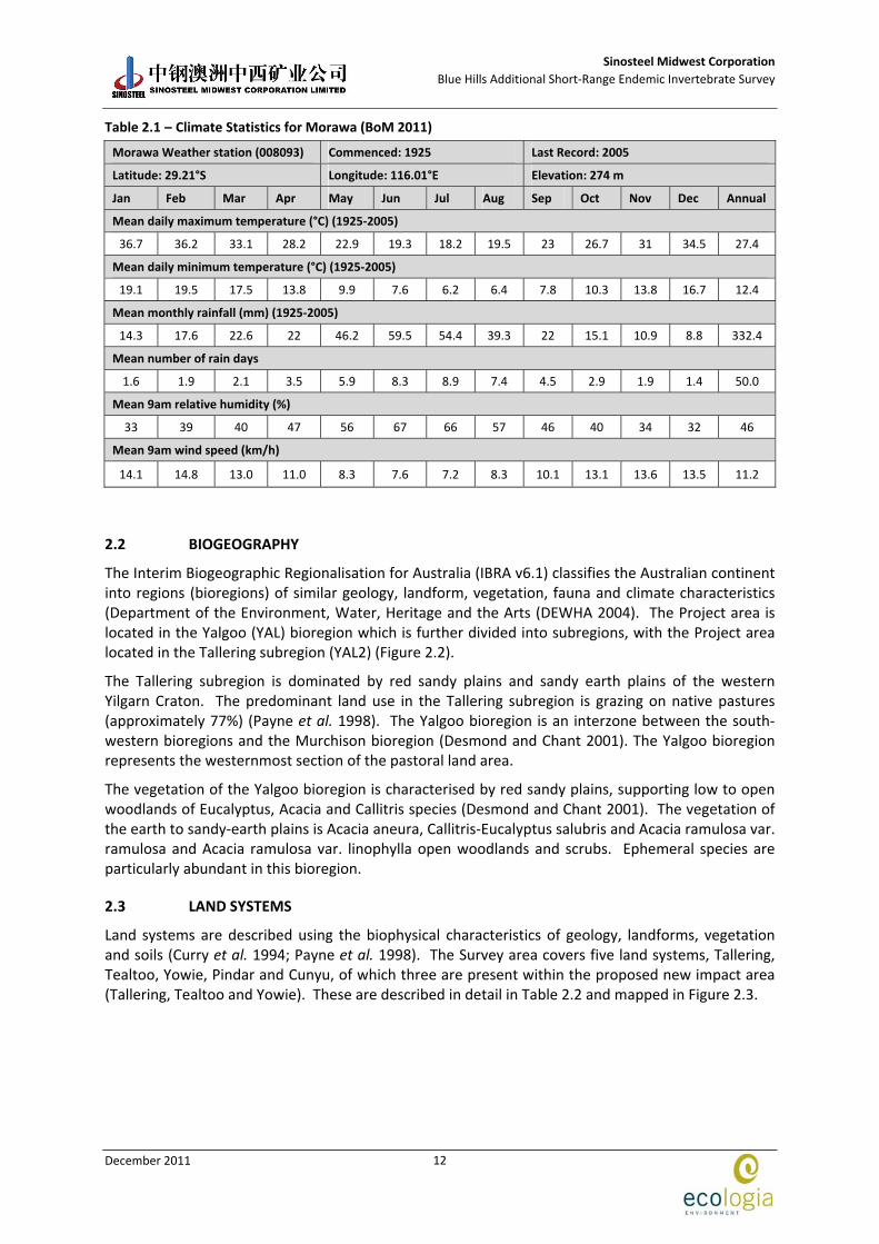
Table 2.1 – Climate Statistics for Morawa (BoM 2011)..........................................................................12
Table 2.2 – Land Systems of the Project Area........................................................................................13
Table 2.3 – Broad Scale Vegetation Associations within the Project Area ............................................13
Table 2.4 – Ecologia Vegetation Communities Recorded within the Project Area................................14
Table 3.1 – Summary of SRE Survey Sites ..............................................................................................19
Table 3.2 – Taxonomic Experts used to Identify Potential SRE Taxa Found During the Survey.............22
Table 3.3 – ecologia Staff Involved with Survey.....................................................................................23
Table 4.1 – Summary of Specimens Collected at Blue Hills ...................................................................31
Table 4.2 – Mean Estimates of Total Species Richness of the SRE Assemblage at Blue Hills Based on 50 Randomisations .................................................................................................................34
Table 4.3 – Habitat Assessment Summary .............................................................................................35
Table 5.1 – Summary of SRE Species Recorded, SRE Status and Assessment of Impact .......................38
FIGURES
Figure 1.1 – Project Location....................................................................................................................5
Figure 2.1 – Climate Statistics for Morawa (BOM 2010)........................................................................11
Figure 2.2 – Biogeographic Regions of the Project Area........................................................................15
Figure 2.3 – Land Systems of the Project Area.......................................................................................16
Figure 2.4 – Vegetation Associations of the Project Area......................................................................17
Figure 2.5 – Vegetation of the Project Area...........................................................................................18
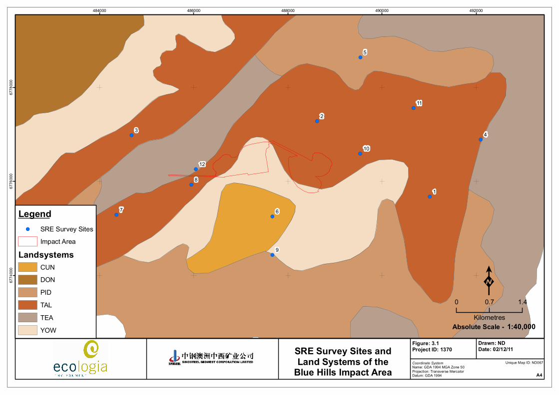
Figure 3.1 – SRE Survey Sites and Land Systems of the Blue Hills Impact Area .....................................20
Figure 3.2 – Wet Pitfall Traps .................................................................................................................21
Figure 3.3 – Example of the Leaf‐Litter Reducer and Tullgren Funnels .................................................22
Figure 4.1 – Aname ‘sp. juv.’ Specimen Collected from Site S3 .............................................................25
Figure 4.2 – Austrohorus Specimen Collected from Site S4 ...................................................................27
Figure 4.3 – Specimen of Beierolpium ‘sp. 8/2’ Collected from Site S9 .................................................27
Figure 4.4 – Specimen of Beierolpium ‘sp. 8/4’ large Collected from Site S5 ........................................28
Figure 4.5 – Specimen of Beierolpium ‘sp. 8/3’ Collected from Site S8.................................................28
Figure 4.6 – Location of SREs within the Project area............................................................................33
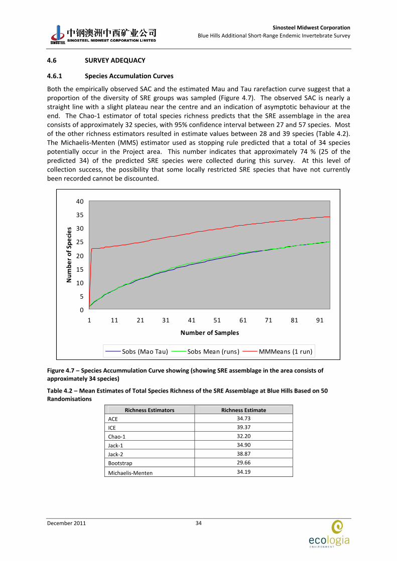
Figure 4.7 – Species Accummulation Curve showing (showing SRE assemblage in the area consists of approximately 34 species) .................................................................................................34

Sinosteel Midwest Corporation
Blue Hills Additional Short‐Range Endemic Invertebrate Survey
December 2011
iv
APPENDICES
APPENDIX 1 Site Descriptions ...............................................................................................................45
Sinosteel Midwest Corporation
Blue Hills Additional Short‐Range Endemic Invertebrate Survey
December 2011
v
ACRONYMS
List all acronyms used in the report here. Format alphabetically as follows:
ACE Abundance‐based Coverage Estimator
ANOVA Analysis of Variance
ANOSIM Analysis of Similarities
DEC Department of Environment and Conservation
EPA Environmental Protection Authority
EPBC Environment Protection and Biodiversity Conservation Act 1999
SAC Species Accumulation Curve
SRE Short‐Range Endemic
WAM Western Australian Museum
WC Act Wildlife Conservation Act 1950
Sinosteel Midwest Corporation
Blue Hills Additional Short‐Range Endemic Invertebrate Survey
December 2011
vi
EXECUTIVE SUMMARY
Sinosteel Midwest Corporation’s (SMC) Koolanooka / Blue Hills (Mungada) Direct Shipping Iron Ore (DSO) Project commenced operations in early 2010. The project involves the mining, crushing, screening and transport of iron ore from three existing pits in the Koolanooka and Blue Hills region, to the Geraldton Port.
As part of the approvals process in 2006, ecologia Environment conducted a base‐line Short‐Range Endemic invertebrate survey, which yielded several SRE species including two mygalomorph spiders, a snail and a pseudoscorpion. In addition, two protected species, Idiosoma nigrum and Aganippe castellum, were recorded from nearby areas. A more extensive follow‐up survey targeting SRE invertebrates, both inside and outside the proposed impact areas, was requested by the Environmental Protection Authority and undertaken in July 2010. Several SRE species were identified during this survey, including the spider Idiosoma ‘MYG018’ (a confirmed SRE) and three pseudoscorpions, Tyrannochthonius ‘sp.nov. Blue Hills’ (potential SRE), Beierolpium ‘sp.8/4’, and Austrohorus sp. (unknown SREs).
Due to the planned expansion of the Blue Hills Project area and associated developments, an additional base‐line Short‐Range Endemic invertebrate survey was required. The survey was completed in August 2011 and is detailed in this report.
A total of 12 wet‐pitfall trap sites were sampled during the survey, spread acrross Mungada East and West areas. The methodology used followed the principles outlined in EPA Guidance statement 20: Sampling of Short‐Range Endemic Invertebrate Fauna for Environmental Impact Assessment in Western Australia (EPA 2009). The survey design was based on the original impact area boundary supplied by SMC in early 2011, which included location selection of all sites. According to the original design, three SRE survey sites were located inside the direct impact area, with the rest of the sites outside the impact area. However, the impact area has been reduced by the SMC since, resulting in all three inside survey sites becoming outside sites. Consequently, no survey sites were located inside the area of proposed direct impact. Specimens collected were sent to the Western Australian Museum for formal identification.
A total of 178 invertebrate specimens from SRE groups were collected during the survey. These were represented by six orders, 15 families, 18 genera and 25 species, of which two species were potential SREs (Aname sp. juv. and Trichorina sp.), and five species had SRE status unknown (Austrohorus, Beierolpium ‘sp. 8/2’, Beierolpium ‘sp. 8/3’, Beierolpium ‘sp. 8/4’ large, and specimens from the family Mecistocephalidae).
All potential and unknown SREs collected during the survey were collected from outside the impact area where they will not be at direct threat from mining activities.
Species previously collected during 2006 and 2011 surveys with a confirmed, potential and unknown SREs included two unidentified spiders from the family Barychelidae, pseudoscorpions Tyrannochthonius ‘sp. nov. Blue Hills’ and Synsphyronus sp., a Bothriembryon snail, a spider Idiosoma ‘MYG018’, and pseudoscorpions Beierolpium ‘sp. 8/4’ and Austrohorus. All were located outside the impact area.
The main conclusions of the survey were:
Six invertebrate species listed as conservation significant were found during the database searches of the nearby areas.
No listed invertebrate species of conservation significance were recorded during the current survey, or the previous surveys in 2006 and 2011.
Sinosteel Midwest Corporation
Blue Hills Additional Short‐Range Endemic Invertebrate Survey
December 2011
vii
The survey methods were consistent with the EPA Guidance Statement 20 to sample for SRE fauna. Nevertheless, due to the alteration of the impact area boundary after the survey had already been undertaken, no SRE survey sites were located inside the impact area.
Species estimators suggested that approximately 74 % of the predicted SRE species were collected during the survey.
A total of 25 species from SRE groups were collected, of which two species were considered to represent potential SREs, and five species had unknown SRE status. No confirmed SREs were recorded.
All potential and unknown SREs were collected outside the impact area where they will not be affected by mining activities.
Previous surveys in 2006 and 2010 recorded eight confirmed, potential or unknown SREs of which all were located outside the impact area, with the exception of Idiosoma ‘MYG018’ which was recorded both inside and outside the impact area.
None of the habitats in which the confirmed, potential and/or unknown SRE species were located are considered unique to the Survey area and all extend beyond the limits of the Project area.
Sinosteel Midwest Corporation
Blue Hills Additional Short‐Range Endemic Invertebrate Survey
December 2011
1
1 INTRODUCTION
1.1 PROJECT OVERVIEW
Sinosteel Midwest Corporation’s (SMC) Koolanooka / Blue Hills (Mungada) Direct Shipping Iron Ore (DSO) Project commenced operations in early 2010. The sites are located approximately 160 km south east of Geraldton. The Koolanooka site is located 20 km east of Morawa, and the Mungada East and Mungada West mine sites are located 60 km to the east of Koolanooka (Figure 1.1). The project involves the mining, crushing, screening and transport of iron ore from three existing pits in the Koolanooka and Blue Hills region, to the Geraldton Port. Changes to the Project include expansion of the Mungada west and east pits, relocation of the processing facilities and expansion of waste stockpiles and ore stockpiles (impact areas), for which SMC is seeking approvals.
As part of the approvals process in 2006, ecologia Environment (ecologia) conducted a base‐line Short‐Range Endemic (SRE) invertebrate survey, which yielded several SRE species. As a result, a more extensive follow‐up survey targeting SRE invertebrates was requested by the Environmental Protection Authority (Minister for Environment 2009) and completed in July 2010. The survey identified two of the previously collected SREs outside the impact area, and further four SRE species that had not been collected previously.
Due to the expansion of the Project and the proposed new impact areas, SMC commissioned ecologia to undertake an additional baseline Short‐Range Endemic (SRE) invertebrate survey as part of the environmental approval process.
1.2 SURVEY OBJECTIVES
The primary objective of the SRE survey was to provide the EPA with more accurate reference data on the diversity of invertebrate communities and their habitats both inside and outside the proposed impact area, complementing the 2006 and 2010 survey work.
The Environmental Protection Authority’s (EPA) objectives with regards to fauna management are to:
maintain the abundance, species diversity and geographical distribution of terrestrial invertebrate fauna; and
protect Specially Protected (Threatened) fauna, consistent with the provisions of the Wildlife Conservation Act 1950 (WC Act).
Specifically, the objectives were to undertake a survey that satisfies the requirements documented in EPA’s Guidance Statement 20 (EPA 2009), thus providing:
a review of background information (including literature and database searches);
an inventory of SRE fauna species occurring in the project area, incorporating recent published and unpublished records;
an inventory of species of biological and conservation significance recorded or likely to occur within the project area and surrounds; and
an assessment of likely habitats that could support SREs and potential impacts from the Project.
1.3 LEGISLATIVE FRAMEWORK
Federal and State legislation applicable to the conservation of native fauna include, but are not limited to, the Environment Protection and Biodiversity Conservation Act 1999 (EPBC Act), the WC Act, and the Environmental Protection Act 1986 (EP Act). Section 4a of the Environmental Protection
Sinosteel Midwest Corporation
Blue Hills Additional Short‐Range Endemic Invertebrate Survey
December 2011
2
Act 1986 requires that developments take into account the following principles applicable to native fauna:
The Precautionary Principle
Where there are threats of serious or irreversible damage, a lack of full scientific certainty should not be used as a reason for postponing measures to prevent environmental degradation.
The Principles of Intergenerational Equity
The present generation should ensure that the health, diversity and productivity of the environment is maintained or enhanced for the benefit of future generations.
The Principle of the Conservation of Biological Diversity and Ecological Integrity
Conservation of biological diversity and ecological integrity should be a fundamental consideration.
The document was constructed with a view to satisfy the requirements of the following guidelines and requirements:
The EPA Guidance Statement No. 56: Terrestrial Fauna Surveys for Environmental Impact Assessment in Western Australia (EPA 2004);
Statement No. 20: Sampling of Short‐Range Endemic Invertebrate Fauna for Environmental Impact Assessment in Western Australia (EPA 2009); and
the requirements of the Ministerial Statement 811 (Minister for Environment 2009).
Some better known SRE species have been listed as threatened or endangered under State or Commonwealth legislation in the WC Act and/or EPBC Act, but the majority have not. Often the lack of knowledge about these species precludes their consideration for listing as threatened or endangered. Listing under legislation should therefore not be the only conservation consideration in environmental impact assessment.
The State is committed to the principles and objectives for the protection of biodiversity as outlined in The National Strategy for the Conservation of Australia's Biological Diversity (Commonwealth Government 1996). The EPA expects that environmental impact assessment will consider impacts on conservation of SREs (EPA 2004).
1.4 CONSERVATION SIGNIFICANT FAUNA
Fauna species that have been formally recognised as rare, threatened with extinction or having high conservation value are protected by law under Commonwealth and State legislation. At the national level, fauna are protected under the Environment Protection and Biodiversity Conservation Act 1999 (EPBC Act). Within Western Australia (WA), rare fauna are listed under the WC Act: Wildlife Conservation (Specially Protected Fauna) Notice 2010.
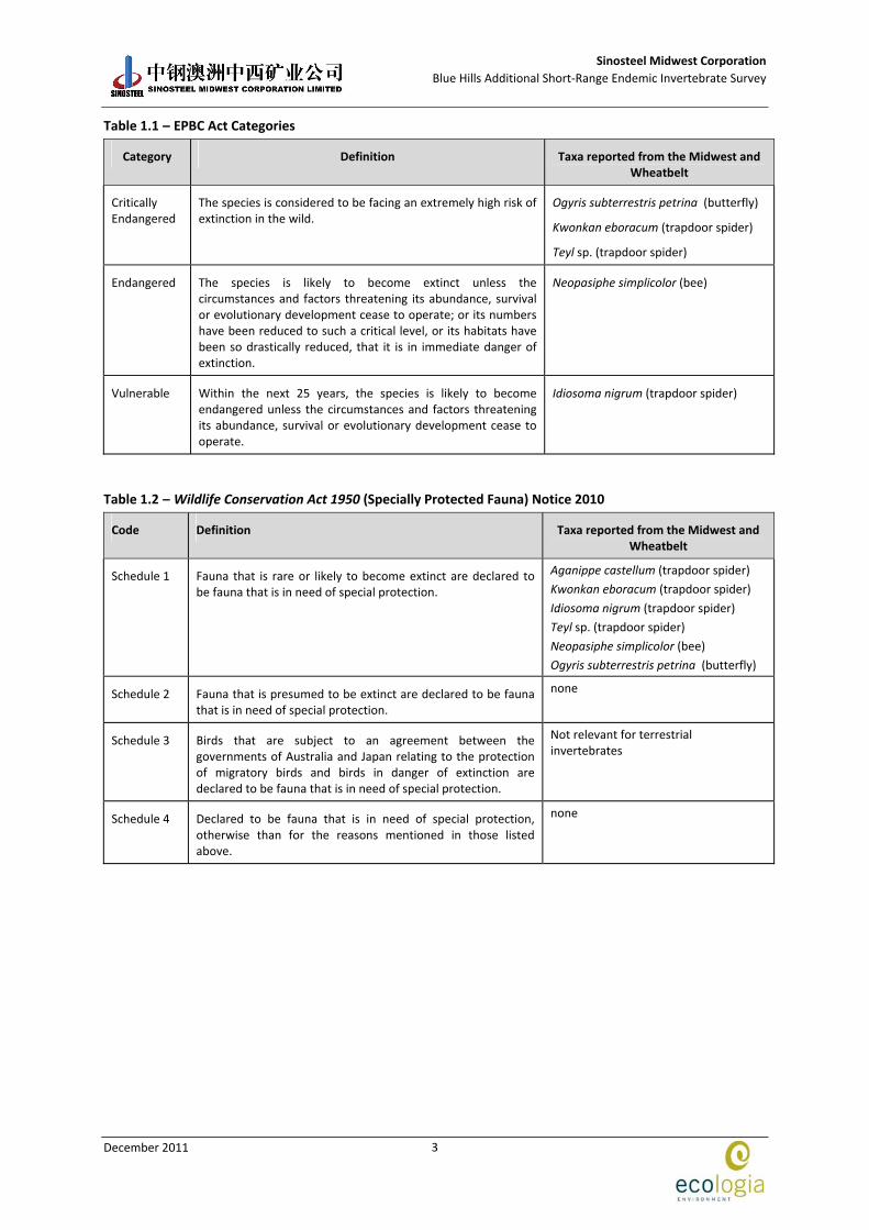
Schedule 1 of the Commonwealth EPBC Act 1999 contains a list of species that are considered Critically Endangered, Endangered, Vulnerable, Extinct, Extinct in the wild and Conservation Dependent. Definitions of categories relevant to fauna occurring or potentially occurring in the project area are provided in Table 1.1.
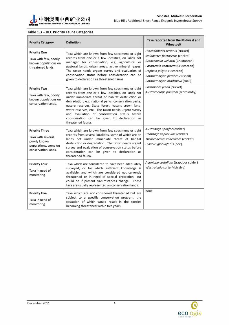
Classification of rare and endangered fauna under the WA Wildlife Conservation (Specially Protected Fauna) Notice 2010 of the WC Act recognises four distinct schedules, as listed in Table 1.2. In addition, Department of Environment and Conservation (DEC) maintains a Priority Fauna list, which includes those removed from the WC Act and other species known from only a few populations or, are in need of monitoring. Five Priority Codes are recognised, as detailed in Table 1.3.
Sinosteel Midwest Corporation
Blue Hills Additional Short‐Range Endemic Invertebrate Survey
December 2011
3
Table 1.1 – EPBC Act Categories
Category Definition Taxa reported from the Midwest and Wheatbelt
Critically Endangered
The species is considered to be facing an extremely high risk of extinction in the wild.
Ogyris subterrestris petrina (butterfly)
Kwonkan eboracum (trapdoor spider)
Teyl sp. (trapdoor spider)
Endangered The species is likely to become extinct unless the circumstances and factors threatening its abundance, survival or evolutionary development cease to operate; or its numbers have been reduced to such a critical level, or its habitats have been so drastically reduced, that it is in immediate danger of extinction.
Neopasiphe simplicolor (bee)
Vulnerable Within the next 25 years, the species is likely to become endangered unless the circumstances and factors threatening its abundance, survival or evolutionary development cease to operate.
Idiosoma nigrum (trapdoor spider)
Table 1.2 – Wildlife Conservation Act 1950 (Specially Protected Fauna) Notice 2010
Code Definition Taxa reported from the Midwest and Wheatbelt
Schedule 1 Fauna that is rare or likely to become extinct are declared to be fauna that is in need of special protection.
Aganippe castellum (trapdoor spider)
Kwonkan eboracum (trapdoor spider)
Idiosoma nigrum (trapdoor spider)
Teyl sp. (trapdoor spider)
Neopasiphe simplicolor (bee)
Ogyris subterrestris petrina (butterfly)
Schedule 2 Fauna that is presumed to be extinct are declared to be fauna that is in need of special protection.
none
Schedule 3 Birds that are subject to an agreement between the governments of Australia and Japan relating to the protection of migratory birds and birds in danger of extinction are declared to be fauna that is in need of special protection.
Not relevant for terrestrial invertebrates
Schedule 4 Declared to be fauna that is in need of special protection, otherwise than for the reasons mentioned in those listed above.
none
Sinosteel Midwest Corporation
Blue Hills Additional Short‐Range Endemic Invertebrate Survey
December 2011
4
Table 1.3 – DEC Priority Fauna Categories
Priority Category Definition Taxa reported from the Midwest and
Wheatbelt
Priority One
Taxa with few, poorly known populations on threatened lands.
Taxa which are known from few specimens or sight records from one or a few localities, on lands not managed for conservation, e.g. agricultural or pastoral lands, urban areas, active mineral leases. The taxon needs urgent survey and evaluation of conservation status before consideration can be given to declaration as threatened fauna.
Psacadonotus seriatus (cricket)
Ixalodectes flectocerus (cricket)
Branchinella wellardi (Crustacean)
Parartemia contracta (Crustacean)
Daphnia jollyi (Crustacean)
Bothriembryon perobesus (snail)
Bothriembryon bradshawi (snail)
Priority Two
Taxa with few, poorly known populations on conservation lands.
Taxa which are known from few specimens or sight records from one or a few localities, on lands not under immediate threat of habitat destruction or degradation, e.g. national parks, conservation parks, nature reserves, State forest, vacant crown land, water reserves, etc. The taxon needs urgent survey and evaluation of conservation status before consideration can be given to declaration as threatened fauna.
Phasmodes jeeba (cricket)
Austromerope poultoni (scorpionfly)
Priority Three
Taxa with several, poorly known populations, some on conservation lands.
Taxa which are known from few specimens or sight records from several localities, some of which are on lands not under immediate threat of habitat destruction or degradation. The taxon needs urgent survey and evaluation of conservation status before consideration can be given to declaration as threatened fauna.
Austrosaga spinifer (cricket)
Hemisaga vepreculae (cricket)
Throscodectes xederoides (cricket)
Hylaeus globuliferus (bee)
Priority Four
Taxa in need of monitoring
Taxa which are considered to have been adequately surveyed, or for which sufficient knowledge is available, and which are considered not currently threatened or in need of special protection, but could be if present circumstances change. These taxa are usually represented on conservation lands.
Aganippe castellum (trapdoor spider)
Westralunio carteri (bivalve)
Priority Five
Taxa in need of monitoring
Taxa which are not considered threatened but are subject to a specific conservation program, the cessation of which would result in the species becoming threatened within five years.
none
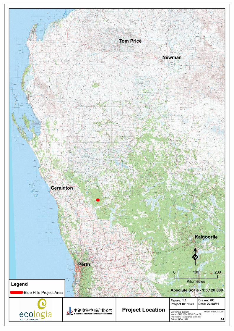
Perth
Newman
Tom Price
Geraldton
Kalgoorlie
Coordinate SystemName: GDA 1994 MGA Zone 50Projection: Transverse MercatorDatum: GDA 1994
Figure: 1.1Project ID: 1370
Drawn: KCDate: 22/08/11
Project LocationA4
K0 100 200
Kilometres1:5,120,000Absolute Scale -
LegendBlue Hills Project Area
Unique Map ID: KC061
Sinosteel Midwest Corporation
Blue Hills Additional Short‐Range Endemic Invertebrate Survey
December 2011
6
1.5 SHORT‐RANGE ENDEMIC FAUNA: A REVIEW
The decline in biodiversity of terrestrial communities has already been observed both nationally and state‐wide (CALM 2004). There is also an increasing shift in environmental protection from species based conservation to biodiversity based conservation (Chessman 1995; Burbidge et al. 2000; McKenzie et al. 2000) and one of the important considerations involved in this is the presence of endemic species.
Endemism refers to the restriction of species to a particular area, whether it is at the continental, national or local level (Allen et al. 2002). This review focuses on SREs, outlines the major paths to Short‐Range Endemism, the current knowledge of Short‐Range Endemism in Australia and the conservation significance of such species. It is important to note that the individual taxa and broader groups discussed are not an exhaustive list of all SRE. This is due to the fact that SRE are dominated by invertebrate species, which are historically understudied and in many cases lack formal descriptions. An extensive, reliable taxonomic evaluation of these species has begun only relatively recently and thus the availability of literature relevant to SREs is relatively scarce.
1.5.1 Processes Promoting Short‐Range Endemism
Short‐Range Endemism is influenced by numerous processes, which generally contribute to the isolation of a species. A number of factors, including the ability and opportunity to disperse, life history, physiology, habitat requirements, habitat availability, biotic and abiotic interactions, and historical conditions, influence not only the distribution of a taxon, but also the tendency for differentiation and speciation (Ponder and Colgan 2002).
Isolated populations of plants and animals tend to differentiate both morphologically and genetically as they are influenced by different selective pressures over time. Additionally, a combination of novel mutations and genetic drift promote the accumulation of genetic differences between isolated populations. Conversely, the maintenance of genetic similarity is promoted by a lack of isolation through migration between the populations, repeated mutation and balancing selection (Wright 1943). The level of differentiation and speciation between populations is determined by the relative magnitude of these factors, with the extent of migration generally being the strongest determinant. Migration is hindered by the poor dispersal ability of the taxon as well as geographical barriers to impede dispersal. Thus, in summary, those taxa that exhibit Short‐Range Endemism are generally characterised by poor dispersal, low growth rates, low fecundity and reliance on habitat types that are discontinuous (Harvey 2002).
The historical connections between habitats are also important in determining species distributions and often explain patterns that are otherwise inexplicable by current conditions. Many SREs are considered to be relictual taxa (remnants of species that have become extinct elsewhere) and are confined to certain habitats, and in some cases, single geographic areas (Main 1996). Relictual taxa include extremely old species that can be traced back to the Gondwanan periods (180‐65 million years ago) and have a very restrictive biology (Harvey 2002).
In Western Australia, relictual taxa generally occur in fragmented populations, from lineages reaching back to historically wetter periods. For example, during the Miocene period (from 25 million to 13 million years ago), the aridification of Australia resulted in the contraction of many areas of moist habitat and the fragmentation of populations of fauna occurring in these areas (Hill 1994). With the onset of progressively dryer and more seasonal climatic conditions since this time, suitable habitats have become increasingly fragmented. Relictual species now generally persist in habitats characterised by permanent moisture and shade, maintained by high rainfall and/or prevalence of fog. This may be induced by topography or coastal proximity, or areas associated with freshwater courses (e.g. swamps or swampy headwater of river systems), caves, or microhabitats associated with southern slopes of hills and ranges, rocky outcrops, deep litter beds, or various
Sinosteel Midwest Corporation
Blue Hills Additional Short‐Range Endemic Invertebrate Survey
December 2011
7
combinations of these features (Main 1996; Main 1999). As a result, these habitats support only small, spatially isolated populations, which are further restricted by their low dispersal powers typical for all SRE species.
1.5.2 Taxonomic Groups Likely to Support Short‐Range Endemism
1.5.2.1 Arachnids (Phylum: Arthropoda, Sub Class: Arachnida)
Four orders of arachnids can exhibit Short‐Range Endemism: Pseudoscorpiones (false scorpions), Scorpiones (true scorpions), Schizomida (short‐tailed whip spiders) and Araneae (i.e. Infraorder: Mygalomorphae or trap‐door spiders). Many mygalomorph trap‐door spider species are vulnerable to disturbance and exhibit Short‐Range Endemism due to their limited ability to disperse. These spiders also have extreme longevity and the long‐term persistence of females in a single burrow (Raven 1982). Mygalomorph spiders are largely considered ‘old world’ spiders and, as such, are generally adapted to past climatic regimes making them vulnerable to desiccation in arid environments. They use a variety of behavioral techniques to avoid desiccation, the most obvious of which is their burrow, which may reach up to 70 cm in depth (Main 1982). Mygalomorph groups are thus capable of surviving on the periphery of the great central desert region and minor habitats within the general arid regions of the continent.
Another member of the arachnid class, the Schizomida, is comprised entirely of SREs, with most recorded from single localities (Harvey 2002). Forty‐six schizomid species have been described in northern Australia. Most are known to occur in the entrances to and inside caves, while the remainder occur in nearby habitats (Harvey 2002). None are known to occur in the Midwest region of Western Australia.
Scorpions (Scorpionida: Urodacus sp.) and pseudoscorpions (Pseudoscorpiones) also exhibit high degrees of endemism (Koch 1981; Harvey 1996). Scorpions are popularly thought of as desert animals although they can be found in most of Australia’s climatic zones.
1.5.2.2 Millipedes and Centipedes (Phylum Arthropoda, Class Myriapoda)
Despite millipedes being highly abundant in soil and leaf litter, and highly diverse at the order level, they are inadequately studied and relatively little is known of their biogeography (Harvey 2002).
Centipedes (Chilopoda) are not listed by Harvey (2002) as SRE species; however they have been shown to be endemic to small areas on the east coast (Edgecombe et al. 2002). Examination of the distributions of species featured in the CSIRO centipede webpage also reveals disjunct and isolated occurrences of many species. A number of genera have Pangaean and Gondwanan affinities (Edgecombe et al. 2002). In general, these animals have a relatively cryptic biology, preferring moist habitats in deep litter accumulations, under rocks and in rotting logs, and they have relatively poor dispersal abilities (Lewis 1981). This suggests that they are potential candidates for designation as SREs.
1.5.2.3 Molluscs (Phylum: Mollusca)
Numerous species of freshwater and terrestrial molluscs belonging to many genera have been identified in Australia, with most being SREs (Harvey 2002). Restricted ranges of the terrestrial molluscs of the drier northern and Western Australia were noted for a vast number of species (Solem 1997). Among these were seven endemic species of Rhagada from the Dampier Archipelago, five of which were found to occur sympatrically on one island. However, in a recent genetic study conducted on Rhagada (Johnson et al. 2004), allozyme analysis revealed little variation between taxa. Such a finding could indicate that there is merely high morphological diversity within one or a few species. It is also possible however, that there is a number of highly endemic species and that morphological diversity has taken place rapidly with little genetic change (Johnson et al. 2004).
Sinosteel Midwest Corporation
Blue Hills Additional Short‐Range Endemic Invertebrate Survey
December 2011
8
1.5.2.4 Worms (Phylum: Annelida & Onychophora)
The taxonomic status of the earthworm family, Megascolecidae, in Western Australia was revised by Jamieson in 1971. As a result of this study, it was concluded that most of the earthworm genera are made up almost entirely of Short‐Range Endemics (Harvey 2002). This is also the case with the velvet worms (Onychophorans). Due to several taxonomic revisions that have been conducted (see references within Harvey, 2002), the number of onychophoran species has expanded from six to over 70 species, and a number of species still remain undescribed (Harvey 2002). Very few of these
species exceed ranges of 200 km2 and some are restricted to single localities and have high genetic
differentiation, indicating very little mobility and dependence on their permanently moist habitats (Harvey 2002).
1.5.2.5 Isopods (subphylum: Crustacea, Class malacostraca)
There are currently around 10,215 described species of isopod classified into 11 suborders: however, little understanding of the taxonomy of Australian genera exists to date (Judd, Horwitz et al.; Brusca and Brusca 2003). Numerous species of terrestrial and subterranean isopods belonging to several different genera have been identified in Western Australia with several genera containing known and potential SREs including Pseudolaureola, Buddenlundia, Cubaris and Platyarthridae (Judd 2009; Judd 2010; Judd 2011). SRE isopods have been collected from the Pilbara and Kimberley regions of Western Australia (Judd, Horwitz et al. 2008), Judd 2011). Many species have Gondwanan affinities suggesting that relictual habitats originating from much wetter climate periods persist across the State (Main 1987). Due to a lack of taxonomic knowledge and paucity of data, the precise distributions of each species is unknown and more taxonomic work at species level is required before the status of individual populations can be ascertained.
1.5.3 Current Knowledge of Short‐Range Endemic Species in the Blue Hills Area
SREs are common among the invertebrates. Many species are confined to topographically or geographically restricted areas and specialised microhabitats because of their small size and often specialised behaviour, typical for relict species. These microhabitats provide areas of Short‐Range Endemism and are vulnerable to artificial disturbances imposed by agriculture and other rural and urban disruptions to the landscape, for instance roads and other human constructions (Main 1996).
The previous surveys at Koolanooka and Blue Hills (2006, 2010) found several species with the potential to be SREs including three mygalomorph spiders – two from the family Barychelidae and Idiosoma ‘MYG018’; a snail species of the genus Bothriembryon and pseudoscorpions from the genus Synsphyronus, Tyrannochthonius, Beierolpium and Austrohorus (Table 1.4).
Table 1.4 – Potential SRE Species Previously Collected from the Blue Hills Area
Class (Order) Family Genus Species
Arachnida (Aranae)
Barychelidae unknown sp. A
unknown sp. B
Idiopidae Idiosoma ‘MYG018’
Arachnida (Pseudoscorpiones)
Garypidae Synsphyronus sp.
Chthoniidae Tyrannochthonius ‘sp.nov. Blue Hills’
Olpiidae Beierolpium ‘sp.8/4’
Austrohorus sp.
Gastropoda (Snails)
Bulimulidae Bothriembryon sp.
Sinosteel Midwest Corporation
Blue Hills Additional Short‐Range Endemic Invertebrate Survey
December 2011
9
A search of the Western Australian Museum (WAM) arachnid and mollusc databases showed records of several potential SRE species occurring nearby including mygalomorph spiders and millipedes (Table 1.5).
In addition, two mygalomorph spiders (Idiosoma nigrum and Aganippe castellum) were both listed under state legislation and have been recorded near the Project area.
Table 1.5 – Potential SRE Species Recorded from around the Blue Hills Area (WAM Database)
Class (Order) Family Genus Species Location
Barychelidae Synothele sp. Mt Gibson
Nemesiidae Aname sp. Blue Hills, Weelhamby Lake
Kwonkan sp. Weelhamby Lake
Yilgarnia sp. Weelhamby Lake
Teyl sp. Lochada
Idiopidae Euoplos sp. Lochada
Idiosoma nigrum Karara
Dipluridae Cethegus sp. Karara
Paradoxosomatidae Antichirpous karara' Karara, Blue Hills
Diplopoda
Arachnida (Aranae)

Sinosteel Midwest Corporation
Blue Hills Additional Short‐Range Endemic Invertebrate Survey
December 2011
10
This page has been left blank intentionally
Sinosteel Midwest Corporation
Blue Hills Additional Short‐Range Endemic Invertebrate Survey
December 2011
11
2 BIOPHYSICAL ENVIRONMENT
2.1 CLIMATE
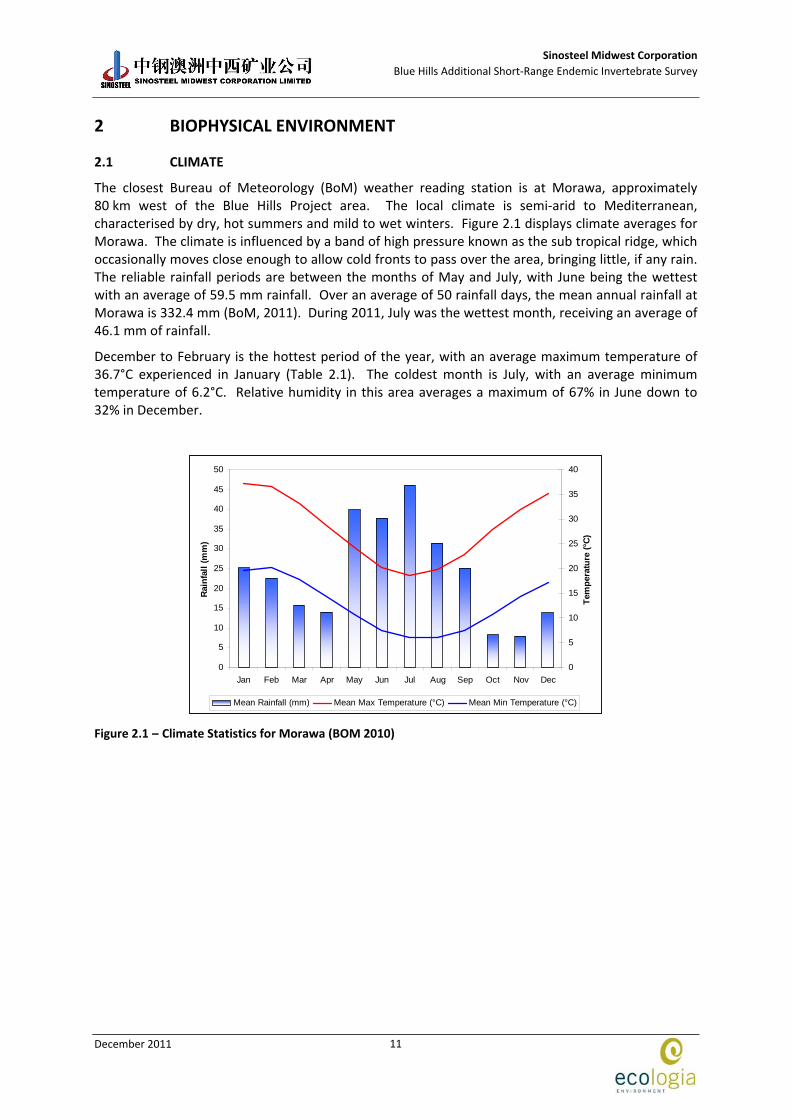
The closest Bureau of Meteorology (BoM) weather reading station is at Morawa, approximately 80 km west of the Blue Hills Project area. The local climate is semi‐arid to Mediterranean, characterised by dry, hot summers and mild to wet winters. Figure 2.1 displays climate averages for Morawa. The climate is influenced by a band of high pressure known as the sub tropical ridge, which occasionally moves close enough to allow cold fronts to pass over the area, bringing little, if any rain. The reliable rainfall periods are between the months of May and July, with June being the wettest with an average of 59.5 mm rainfall. Over an average of 50 rainfall days, the mean annual rainfall at Morawa is 332.4 mm (BoM, 2011). During 2011, July was the wettest month, receiving an average of 46.1 mm of rainfall.
December to February is the hottest period of the year, with an average maximum temperature of 36.7°C experienced in January (Table 2.1). The coldest month is July, with an average minimum temperature of 6.2°C. Relative humidity in this area averages a maximum of 67% in June down to 32% in December.
0
5
10
15
20
25
30
35
40
45
50
Jan Feb Mar Apr May Jun Jul Aug Sep Oct Nov Dec
Rai
nfa
ll (
mm
)
0
5
10
15
20
25
30
35
40
Tem
per
atu
re (
°C)
Mean Rainfall (mm) Mean Max Temperature (°C) Mean Min Temperature (°C)
Figure 2.1 – Climate Statistics for Morawa (BOM 2010)
Sinosteel Midwest Corporation
Blue Hills Additional Short‐Range Endemic Invertebrate Survey
December 2011
12
Table 2.1 – Climate Statistics for Morawa (BoM 2011)
Morawa Weather station (008093) Commenced: 1925 Last Record: 2005
Latitude: 29.21°S Longitude: 116.01°E Elevation: 274 m
Jan Feb Mar Apr May Jun Jul Aug Sep Oct Nov Dec Annual
Mean daily maximum temperature (°C) (1925‐2005)
36.7 36.2 33.1 28.2 22.9 19.3 18.2 19.5 23 26.7 31 34.5 27.4
Mean daily minimum temperature (°C) (1925‐2005)
19.1 19.5 17.5 13.8 9.9 7.6 6.2 6.4 7.8 10.3 13.8 16.7 12.4
Mean monthly rainfall (mm) (1925‐2005)
14.3 17.6 22.6 22 46.2 59.5 54.4 39.3 22 15.1 10.9 8.8 332.4
Mean number of rain days
1.6 1.9 2.1 3.5 5.9 8.3 8.9 7.4 4.5 2.9 1.9 1.4 50.0
Mean 9am relative humidity (%)
33 39 40 47 56 67 66 57 46 40 34 32 46
Mean 9am wind speed (km/h)
14.1 14.8 13.0 11.0 8.3 7.6 7.2 8.3 10.1 13.1 13.6 13.5 11.2
2.2 BIOGEOGRAPHY
The Interim Biogeographic Regionalisation for Australia (IBRA v6.1) classifies the Australian continent into regions (bioregions) of similar geology, landform, vegetation, fauna and climate characteristics (Department of the Environment, Water, Heritage and the Arts (DEWHA 2004). The Project area is located in the Yalgoo (YAL) bioregion which is further divided into subregions, with the Project area located in the Tallering subregion (YAL2) (Figure 2.2).
The Tallering subregion is dominated by red sandy plains and sandy earth plains of the western Yilgarn Craton. The predominant land use in the Tallering subregion is grazing on native pastures (approximately 77%) (Payne et al. 1998). The Yalgoo bioregion is an interzone between the south‐western bioregions and the Murchison bioregion (Desmond and Chant 2001). The Yalgoo bioregion represents the westernmost section of the pastoral land area.
The vegetation of the Yalgoo bioregion is characterised by red sandy plains, supporting low to open woodlands of Eucalyptus, Acacia and Callitris species (Desmond and Chant 2001). The vegetation of the earth to sandy‐earth plains is Acacia aneura, Callitris‐Eucalyptus salubris and Acacia ramulosa var. ramulosa and Acacia ramulosa var. linophylla open woodlands and scrubs. Ephemeral species are particularly abundant in this bioregion.
2.3 LAND SYSTEMS
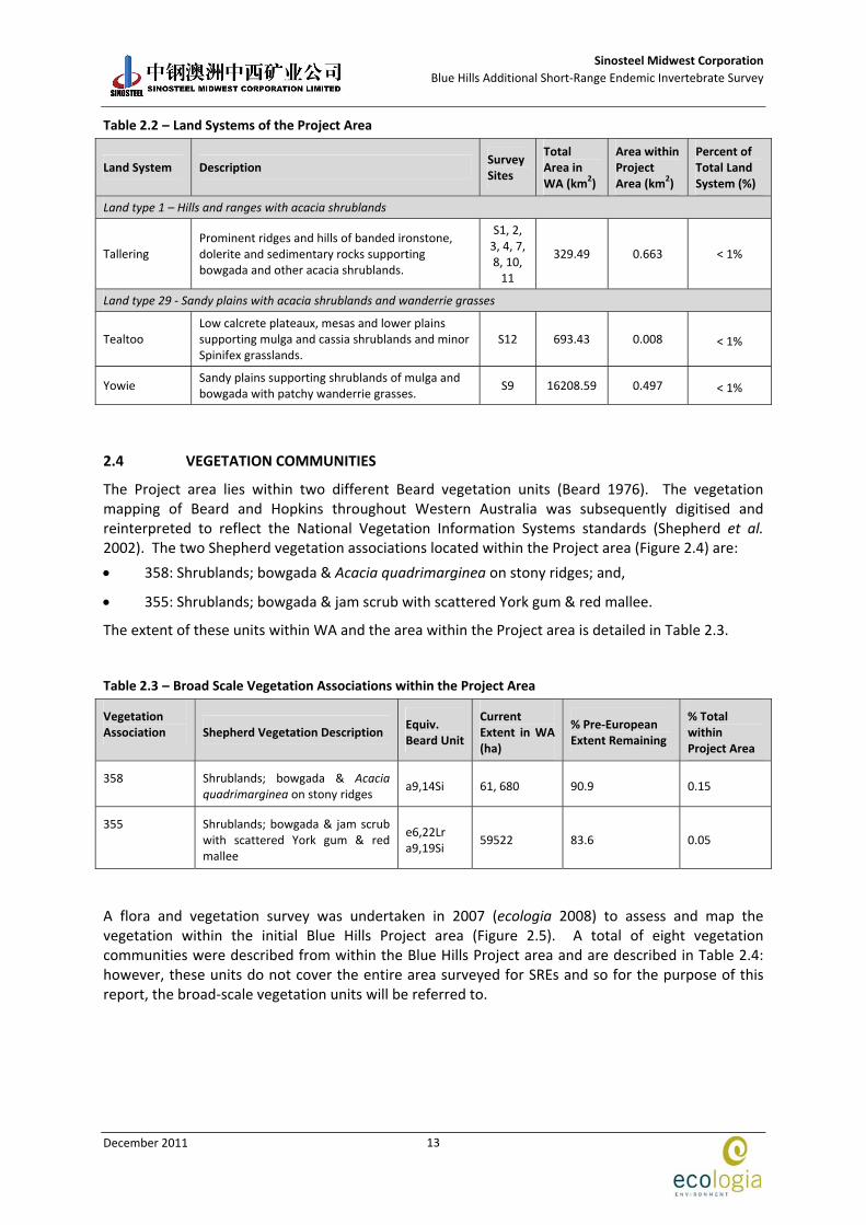
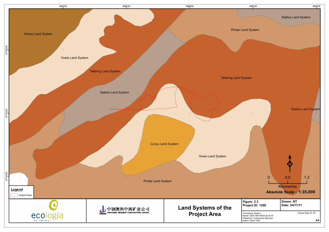
Land systems are described using the biophysical characteristics of geology, landforms, vegetation and soils (Curry et al. 1994; Payne et al. 1998). The Survey area covers five land systems, Tallering, Tealtoo, Yowie, Pindar and Cunyu, of which three are present within the proposed new impact area (Tallering, Tealtoo and Yowie). These are described in detail in Table 2.2 and mapped in Figure 2.3.
Sinosteel Midwest Corporation
Blue Hills Additional Short‐Range Endemic Invertebrate Survey
December 2011
13
Table 2.2 – Land Systems of the Project Area
Land System Description Survey Sites
Total Area in WA (km2)
Area within Project Area (km2)
Percent of Total Land System (%)
Land type 1 – Hills and ranges with acacia shrublands
Tallering Prominent ridges and hills of banded ironstone, dolerite and sedimentary rocks supporting bowgada and other acacia shrublands.
S1, 2, 3, 4, 7, 8, 10, 11
329.49 0.663 < 1%
Land type 29 ‐ Sandy plains with acacia shrublands and wanderrie grasses
Tealtoo Low calcrete plateaux, mesas and lower plains supporting mulga and cassia shrublands and minor Spinifex grasslands.
S12 693.43 0.008 < 1%
Yowie Sandy plains supporting shrublands of mulga and bowgada with patchy wanderrie grasses.
S9 16208.59 0.497 < 1%
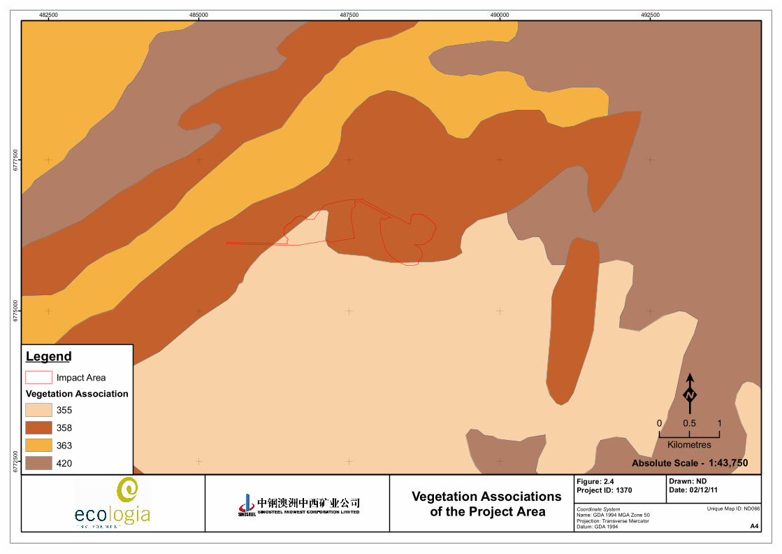
2.4 VEGETATION COMMUNITIES
The Project area lies within two different Beard vegetation units (Beard 1976). The vegetation mapping of Beard and Hopkins throughout Western Australia was subsequently digitised and reinterpreted to reflect the National Vegetation Information Systems standards (Shepherd et al. 2002). The two Shepherd vegetation associations located within the Project area (Figure 2.4) are:
358: Shrublands; bowgada & Acacia quadrimarginea on stony ridges; and,
355: Shrublands; bowgada & jam scrub with scattered York gum & red mallee.
The extent of these units within WA and the area within the Project area is detailed in Table 2.3.
Table 2.3 – Broad Scale Vegetation Associations within the Project Area
Vegetation Association Shepherd Vegetation Description
Equiv. Beard Unit
Current Extent in WA (ha)
% Pre‐European Extent Remaining
% Total within Project Area
358 Shrublands; bowgada & Acacia quadrimarginea on stony ridges
a9,14Si 61, 680 90.9 0.15
355 Shrublands; bowgada & jam scrub with scattered York gum & red mallee
e6,22Lr a9,19Si
59522 83.6 0.05
A flora and vegetation survey was undertaken in 2007 (ecologia 2008) to assess and map the vegetation within the initial Blue Hills Project area (Figure 2.5). A total of eight vegetation communities were described from within the Blue Hills Project area and are described in Table 2.4: however, these units do not cover the entire area surveyed for SREs and so for the purpose of this report, the broad‐scale vegetation units will be referred to.
Sinosteel Midwest Corporation
Blue Hills Additional Short‐Range Endemic Invertebrate Survey
December 2011
14
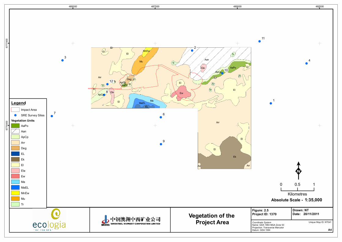
Table 2.4 – Ecologia Vegetation Communities Recorded within the Project Area
Vegetation Unit Vegetation Description
Arr Tall shrubland of Acacia species typically dominated by Acacia ramulosa subsp. ramulosa over a low open shrubland dominated by Philotheca sericea over an open herbland of annual daisies and/or bare ground
Aan Tall open scrub of mixed Acacia species including Acacia aneura over a low open shrubland dominated by Philotheca saricea and a herbland with large areas of bare ground
ApCp Tall open scrub of mixed species typically Allocasuarina acutivalvis subsp. prinsepiana, Calycopeplus pauciflorus, Malaleuca nematophylla and Acacia species over a very open herbland/grassland or BIF rocks
AaPo Tall open scrubland of mixed species typically Acacia assimilis var. assimilis and Melaleuca nematophylla over a low open shrubland to open low heath of Ptilotus obovatus var. obovatus over a herbland of annual daisies
Deg Degraded areas, mined previously
El Tall shrubland of Acacia ramulosa, Acacia burkittii, Melaleuca leiocarpa and Melaleuca uncinata over a herbland of annual daisies and/or bare ground
Ew Open shrub mallee of Eucalyptus ewartiana over a tall open scrub of Acacia ramulosa subsp. ramulosa over an open herbland of annual daisies and/or bare ground
Mu Tall shrubland of Acacia ramulosa, Acacia burkitii, Melaleuca leicarps and Melaleuca uncinata over an open herbland of annual daisies, leaf litter and bare rocks
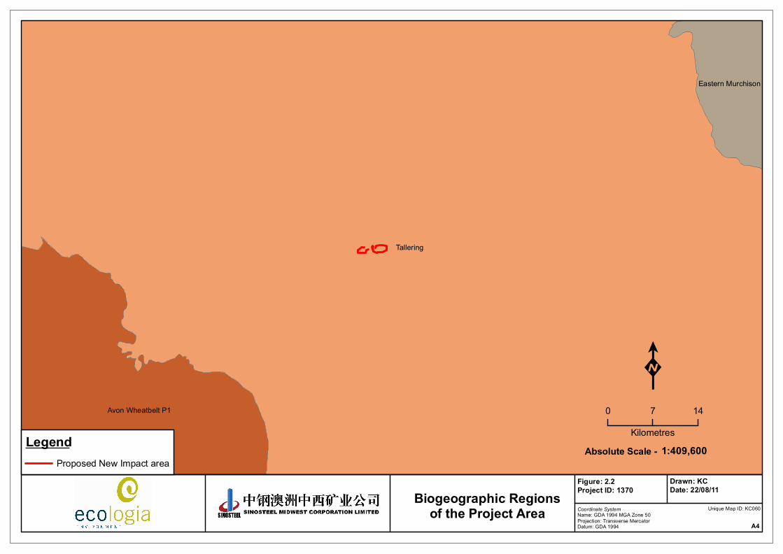
Tallering
Avon Wheatbelt P1
Eastern Murchison
LegendProposed New Impact area
Coordinate SystemName: GDA 1994 MGA Zone 50Projection: Transverse MercatorDatum: GDA 1994 A4
Figure: 2.2Project ID: 1370
Drawn: KCDate: 22/08/11
K0 7 14
Kilometres1:409,600Absolute Scale -
Unique Map ID: KC060Biogeographic Regions
of the Project Area
Tallering Land System
Pindar Land System
Yowie Land System
Yowie Land System
Tallering Land System
Pindar Land System
Tealtoo Land System
Doney Land System
Cunyu Land System
Tealtoo Land System
Tealtoo Land System
484000 486000 488000 490000 49200067
7400
067
7600
067
7800
0
LegendImpact Area
Coordinate SystemName: GDA 1994 MGA Zone 50Projection: Transverse MercatorDatum: GDA 1994 A4
Figure: 2.3Project ID: 1369
Drawn: NTDate: 24/11/11
K0 0.6 1.2
Kilometres1:35,000Absolute Scale -
Unique Map ID: NTLand Systems of the
Project Area
482500 485000 487500 490000 49250067
7250
067
7500
067
7750
0
LegendImpact Area
Vegetation Association355358363420
Coordinate SystemName: GDA 1994 MGA Zone 50Projection: Transverse MercatorDatum: GDA 1994 A4
Figure: 2.4Project ID: 1370
Drawn: NDDate: 02/12/11
K0 0.5 1
Kilometres1:43,750Absolute Scale -
Unique Map ID: ND066Vegetation Associations
of the Project Area
!(
!(
!(!(
!(!(
!(
!(
!(
!(
!(
9
8
7 6
43
2
1
12
11
10Arr
Arr
El
Ek
AanEl
El
Mu
MaEl
El
Ew
AaPo
ElEl
MaEL
ApCp
EL
Ele
El
Arr
El
ElEle
Deg
Tr
ApCp
MnEwTr
Tr
Arr
ElTr
TrTr
Tr
AaPo
ElApCp
El
485000 487500 490000 49250067
7500
067
7750
0
LegendImpact Area
!( SRE Survey SitesVegetation Units
AaPoAanApCpArrDegELEkElEleEwMaMaELMnEwMuTr
Coordinate SystemName: GDA 1994 MGA Zone 50Projection: Transverse MercatorDatum: GDA 1994 A4
Figure: 2.5Project ID: 1370
Drawn: NTDate: 20/11/2011
K0 0.5 1
Kilometres1:35,000Absolute Scale -
Unique Map ID: NT041
Vegetation of the Project Area
Sinosteel Midwest Corporation
Blue Hills Additional Short‐Range Endemic Invertebrate Survey
December 2011
19
3 METHODS
The methodology used was based on the principles outlined in EPA Guidance statement 20: Sampling of Short‐Range Endemic Invertebrate Fauna for Environmental Impact Assessment in Western Australia (EPA 2009). The methodology developed for the survey is compliant with these requirements and in accordance with the guidance received from the DEC throughout the survey period.
The survey design outlined in this section was based on the original impact area boundary supplied by SMC. The original survey included three SRE survey sites located inside the impact area (sites 8, 10 and 12). However, the impact area has been reduced in late 2011 after the field survey had been already conducted, resulting in the three inside survey sites becoming outside sites. Consequently, none of the survey sites were located inside the proposed impact area.
3.1 SURVEY TIMING AND SITE SELECTION
Survey site locations were selected primarily based on those habitats with vegetation communities likely to support SRE invertebrates. Microhabitats likely to maintain higher moisture levels and ‘island’ habitats were targeted. A total of twelve wet‐pitfall trap sites were sampled during the survey (Table 3.1). The sites were spread throughout the extension of Mungada East and West (Figure 3.1). Vegetation and habitat descriptions for each site can be found in (Appendix 1).
Table 3.1 – Summary of SRE Survey Sites
Location
Site Easting Northing
Land System
Vegetation Community
01 491016 6775676 Tallering Shrublands; bowgada & jam scrub with scattered York gum & red mallee
02 488623 6777283 Tallering Shrublands; bowgada & Acacia quadrimarginea on stony ridges
03 484681 6776982 Tallering Shrublands; bowgada & Acacia quadrimarginea on stony ridges
04 492099 6776890 Tallering Shrublands; bowgada & jam scrub
05 489541 6778640 Pindar Shrublands; bowgada scrub with scattered cypress pine
06 487672 6775253 Cunyu Shrublands; bowgada & jam scrub with scattered York gum & red mallee
07 484359 6775291 Tallering Shrublands; bowgada & Acacia quadrimarginea on stony ridges
08 485949 6775933 Tallering Shrublands; bowgada & Acacia quadrimarginea on stony ridges
09 487673 6774438 Yowie Shrublands; bowgada & jam scrub with scattered York gum & red mallee
10 489539 6776593 Tallering Shrublands; bowgada & Acacia quadrimarginea on stony ridges
11 490671 6777560 Tallering Shrublands; bowgada & Acacia quadrimarginea on stony ridges
12 486048 6776259 Tealtoo Shrublands; bowgada & Acacia quadrimarginea on stony ridges
Datum:GDA94 Zone: 50J
!(
!(
!(!(
!(
!(!(
!(
!(
!(
!(
!(
9
8
7 6
5
43
2
1
12
11
10
484000 486000 488000 490000 49200067
7400
067
7600
067
7800
0
Legend!( SRE Survey Sites
Impact AreaLandsystems
CUNDONPIDTALTEAYOW
Coordinate SystemName: GDA 1994 MGA Zone 50Projection: Transverse MercatorDatum: GDA 1994 A4
Figure: 3.1Project ID: 1370
Drawn: NDDate: 02/12/11
K0 0.7 1.4
Kilometres1:40,000Absolute Scale -
Unique Map ID: ND067
SRE Survey Sites andLand Systems of the
Blue Hills Impact Area
Sinosteel Midwest Corporation
Blue Hills Additional Short‐Range Endemic Invertebrate Survey
December 2011
21
3.2 SAMPLING METHODS
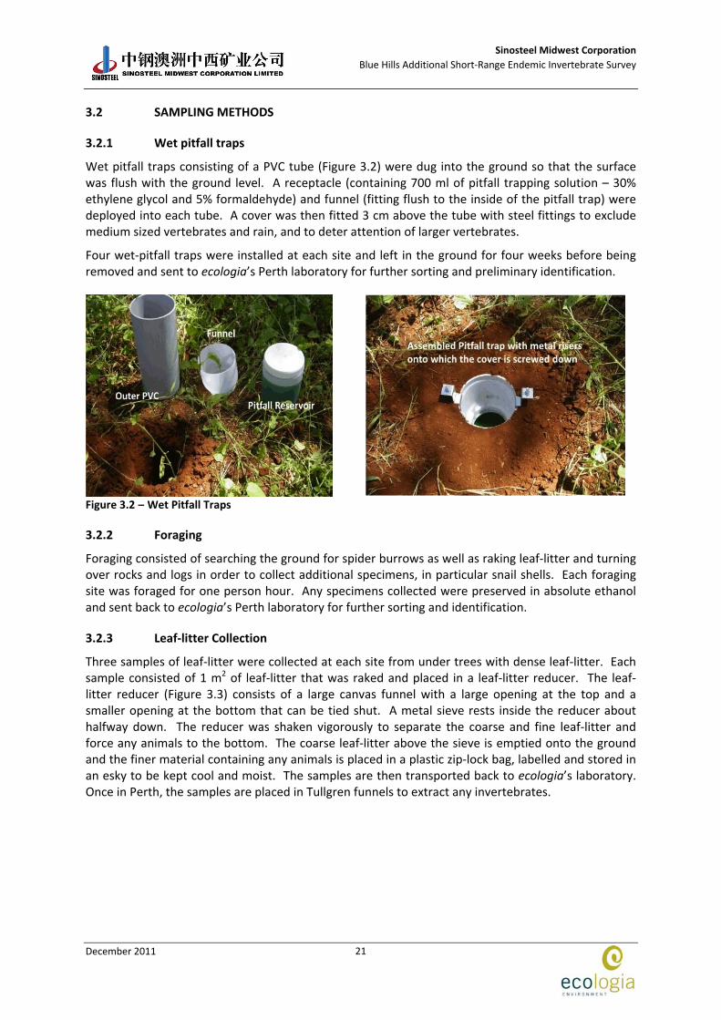
3.2.1 Wet pitfall traps
Wet pitfall traps consisting of a PVC tube (Figure 3.2) were dug into the ground so that the surface was flush with the ground level. A receptacle (containing 700 ml of pitfall trapping solution – 30% ethylene glycol and 5% formaldehyde) and funnel (fitting flush to the inside of the pitfall trap) were deployed into each tube. A cover was then fitted 3 cm above the tube with steel fittings to exclude medium sized vertebrates and rain, and to deter attention of larger vertebrates.
Four wet‐pitfall traps were installed at each site and left in the ground for four weeks before being removed and sent to ecologia’s Perth laboratory for further sorting and preliminary identification.
Figure 3.2 – Wet Pitfall Traps
3.2.2 Foraging
Foraging consisted of searching the ground for spider burrows as well as raking leaf‐litter and turning over rocks and logs in order to collect additional specimens, in particular snail shells. Each foraging site was foraged for one person hour. Any specimens collected were preserved in absolute ethanol and sent back to ecologia’s Perth laboratory for further sorting and identification.
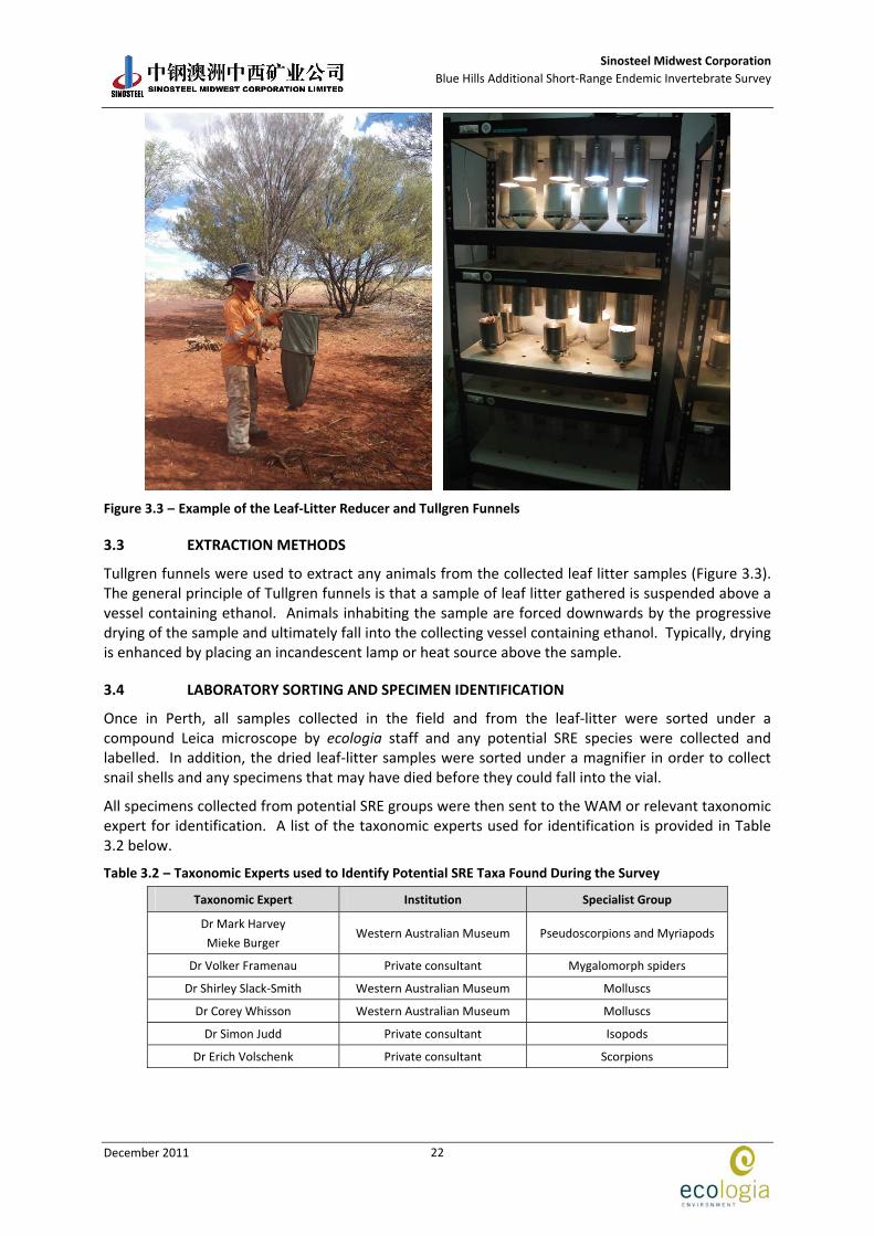
3.2.3 Leaf‐litter Collection
Three samples of leaf‐litter were collected at each site from under trees with dense leaf‐litter. Each sample consisted of 1 m2 of leaf‐litter that was raked and placed in a leaf‐litter reducer. The leaf‐litter reducer (Figure 3.3) consists of a large canvas funnel with a large opening at the top and a smaller opening at the bottom that can be tied shut. A metal sieve rests inside the reducer about halfway down. The reducer was shaken vigorously to separate the coarse and fine leaf‐litter and force any animals to the bottom. The coarse leaf‐litter above the sieve is emptied onto the ground and the finer material containing any animals is placed in a plastic zip‐lock bag, labelled and stored in an esky to be kept cool and moist. The samples are then transported back to ecologia’s laboratory. Once in Perth, the samples are placed in Tullgren funnels to extract any invertebrates.
Sinosteel Midwest Corporation
Blue Hills Additional Short‐Range Endemic Invertebrate Survey
December 2011
22
Figure 3.3 – Example of the Leaf‐Litter Reducer and Tullgren Funnels
3.3 EXTRACTION METHODS
Tullgren funnels were used to extract any animals from the collected leaf litter samples (Figure 3.3). The general principle of Tullgren funnels is that a sample of leaf litter gathered is suspended above a vessel containing ethanol. Animals inhabiting the sample are forced downwards by the progressive drying of the sample and ultimately fall into the collecting vessel containing ethanol. Typically, drying is enhanced by placing an incandescent lamp or heat source above the sample.
3.4 LABORATORY SORTING AND SPECIMEN IDENTIFICATION
Once in Perth, all samples collected in the field and from the leaf‐litter were sorted under a compound Leica microscope by ecologia staff and any potential SRE species were collected and labelled. In addition, the dried leaf‐litter samples were sorted under a magnifier in order to collect snail shells and any specimens that may have died before they could fall into the vial.
All specimens collected from potential SRE groups were then sent to the WAM or relevant taxonomic expert for identification. A list of the taxonomic experts used for identification is provided in Table 3.2 below.
Table 3.2 – Taxonomic Experts used to Identify Potential SRE Taxa Found During the Survey
Taxonomic Expert Institution Specialist Group
Dr Mark Harvey
Mieke Burger Western Australian Museum Pseudoscorpions and Myriapods
Dr Volker Framenau Private consultant Mygalomorph spiders
Dr Shirley Slack‐Smith Western Australian Museum Molluscs
Dr Corey Whisson Western Australian Museum Molluscs
Dr Simon Judd Private consultant Isopods
Dr Erich Volschenk Private consultant Scorpions

Sinosteel Midwest Corporation
Blue Hills Additional Short‐Range Endemic Invertebrate Survey
December 2011
23
3.5 FIELD TEAM
Field survey team members are listed in Table 3.3. The survey was conducted under DEC Regulation 17 Licence SF008104.
Table 3.3 – ecologia Staff Involved with Survey
Name Qualification Relevant Experience
Laura Quinn MSc 4 years experience with SRE invertebrates
Sean White Bsc 7 years experience with invertebrates
3.6 SRE STATUS
The likelihood of the invertebrate species to be considered a SRE or not a SRE was determined by expert taxonomists (Mark Harvey, Department of Terrestrial Invertebrates, WAM; Shirley Slack‐Smith and Corey Whisson, Department of Malacology; Erich Volschenk, Volker Framenau and Simon Judd, private consultants) based on the current knowledge of the distribution and biology of each species, as follows:
No – Not considered a SRE
Confirmed ‐ Current knowledge confirms that this species is a SRE
Likely – Current knowledge suggests this species is probably a SRE. However, further research is required to confirm status
Potential – Current knowledge of this species or group is very limited however, there is the potential for this species to represent a SRE. Further research is required to confirm status
Unknown – No comment can be made regarding SRE status, usually due to uncertainty over species level due to life stage/sex, and/or lack of taxonomic knowledge.
All likely, potential and unknown SREs should be treated as confirmed SREs under the precautionary principle (Section 4a of the EP Act 1986).
3.7 DATA ANALYSIS
3.7.1 Survey Adequacy
There are three general methods of estimating species richness from sample data: extrapolating species‐accumulation curves (SAC), fitting parametric models of relative abundance, and using non‐parametric estimators (Bunge and Fitzpatrick 1993; Colwell and Coddington 1994; Gaston 1996). In this report, the level of survey adequacy was estimated using species accumulation curves (SACs) as computed by Mao Tao. A SAC is a plot of the accumulated number of species found during the leaf‐litter collection with respect to the number of units of effort. The curve, as a function of effort, monotonically increases and typically approaches an asymptote, which is the total number of species. In addition, a Michaelis‐Menten enzyme kinetic curve was calculated and used as a stopping rule technique.
3.7.2 Habitat Analysis
Effective invertebrate conservation cannot rely on conventional single species approach adopted for the conservation of vertebrates and plants (Clark and Spier‐Ashcroft 2003). The focus of modern invertebrate conservation has changed to a more community and landscape scale approach with a primary emphasis on habitat conservation. Invertebrate conservation should be promoted more effectively by habitat preservation and management rather than single species‐initiatives (Lewinsohn, Lucci Freitas et al. 2005).
Sinosteel Midwest Corporation
Blue Hills Additional Short‐Range Endemic Invertebrate Survey
December 2011
24
Habitat types play an important role in SRE invertebrate diversity as variability of habitats has been strongly linked with invertebrate species richness and diversity. All survey sites were assessed for their suitability for supporting SREs in terms of moisture, shade, suitable microhabitat and geographical isolation. The area surveyed for SREs covers five land systems, and four vegetation associations: however, the impact area only covers three land systems and two vegetation associations. All five land systems and four vegetation types were sampled for SREs.
The five land systems present in the Survey area were Tallering, Tealtoo, Yowie, Pindar and Cunyu (Table 2.2). The four Shepherd vegetation associations located within the Survey area (Figure 2.4) were:
358: Shrublands; bowgada & Acacia quadrimarginea on stony ridges;
420: Shrublands; bowgada & jam scrub;
363: Shrublands; bowgada scrub with scattered cypress pine; and,
355: Shrublands; bowgada & jam scrub with scattered York gum & red mallee.
An analysis of the preferred habitat of SRE and potential SRE species collected was made by mapping each species against the broad scale vegetation communities (Shepherd et al. 2002). The percentage of each vegetation community that would be directly impacted by the proposed development was calculated to determine the potential impact on each species. Habitat connectivity was also examined.
Sinosteel Midwest Corporation
Blue Hills Additional Short‐Range Endemic Invertebrate Survey
December 2011
25
4 RESULTS
4.1 SPECIMENS COLLECTED
A total of 178 invertebrate specimens were collected during the survey, representing six orders, 15 families, 18 genera and 25 species (Table 4.1). Two potential SRE species and five unknown SRE species were collected during the survey and the distributions of these specimens are shown in Figure 4.6.
4.2 ARACHNIDA
4.2.1 Mygalomorpha: Trapdoor Spiders
Family Nemesiidae
Aname tepperi
One specimen was collected from site S9. Aname tepperi is widespread throughout Western Australia and into south Australia. It is not considered a SRE.
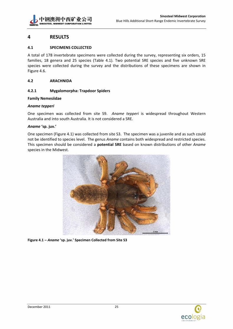
Aname ‘sp. juv.’
One specimen (Figure 4.1) was collected from site S3. The specimen was a juvenile and as such could not be identified to species level. The genus Aname contains both widespread and restricted species. This specimen should be considered a potential SRE based on known distributions of other Aname species in the Midwest.
Figure 4.1 – Aname ‘sp. juv.’ Specimen Collected from Site S3
Sinosteel Midwest Corporation
Blue Hills Additional Short‐Range Endemic Invertebrate Survey
December 2011
26
4.2.2 Scorpiones: Scorpions
Family Bothriuridae
Cercophonius michaelseni
One specimen was collected from site S12. Species from the genus Cercophonius are usually found in the south west of Western Australia, and south east Queensland. They are rarely found in more arid parts of Australia. This species does not represent a SRE.
4.2.3 Pseudoscorpionida: Pseudoscorpions
Family Chernetidae
‘Genus indet.’ ‘sp. juv’
One specimen was collected from site S4. The specimen was a juvenile and could not be identified to genus or species level: however, it does not represent a SRE.
Family Chthoniidae
Austrochthonius (various species, IDs pending)
Fifty‐two specimens representing at least three different species were collected during the survey from sites S1, S2, S3, S4, S8, S9, S10, S111 and S12. Experts at WAM are currently working on a manuscript to help ID this genus more accurately and further results are currently pending: however, none of these specimens represent SREs.
Family Garypidae
Synsphyronus ‘sp. juv.’
Four specimens were collected from sites S3 and S9. Many species of Synsphyronus may represent SREs, in particular in ground habitats such as under rocks. However, these specimens do not represent SREs.
Synsphyronus mimulus
One specimen was collected from site S3. Many species of Synsphyronus may represent SREs, in particular in ground habitats such as under rocks. However, this species was previously collected during the 2010 survey, it is widespread and occurs in all Australian mainland states, therefore it does not represent a SRE.
Family Olpiidae
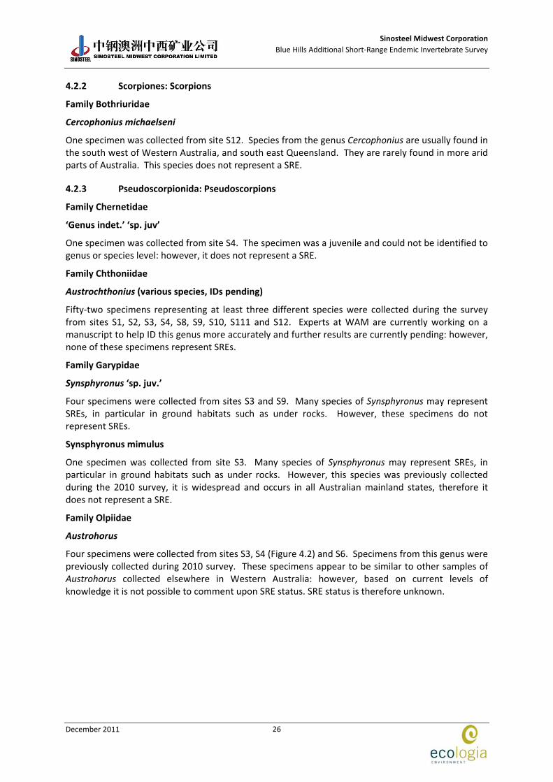
Austrohorus
Four specimens were collected from sites S3, S4 (Figure 4.2) and S6. Specimens from this genus were previously collected during 2010 survey. These specimens appear to be similar to other samples of Austrohorus collected elsewhere in Western Australia: however, based on current levels of knowledge it is not possible to comment upon SRE status. SRE status is therefore unknown.
Sinosteel Midwest Corporation
Blue Hills Additional Short‐Range Endemic Invertebrate Survey
December 2011
27
Figure 4.2 – Austrohorus Specimen Collected from Site S4
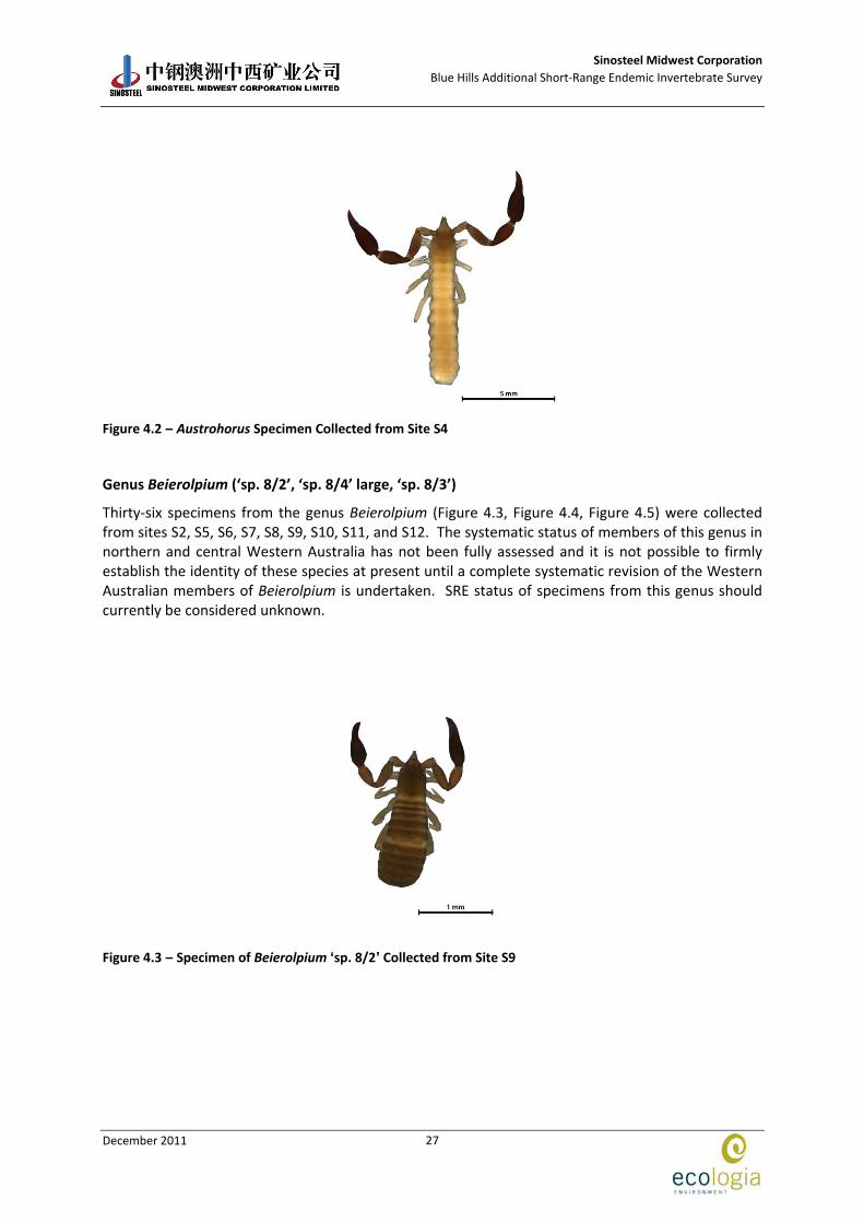
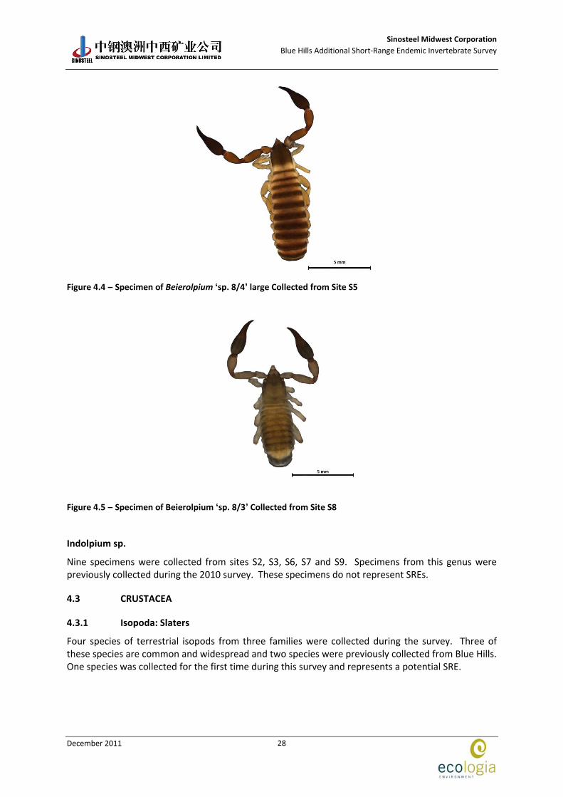
Genus Beierolpium (‘sp. 8/2’, ‘sp. 8/4’ large, ‘sp. 8/3’)
Thirty‐six specimens from the genus Beierolpium (Figure 4.3, Figure 4.4, Figure 4.5) were collected from sites S2, S5, S6, S7, S8, S9, S10, S11, and S12. The systematic status of members of this genus in northern and central Western Australia has not been fully assessed and it is not possible to firmly establish the identity of these species at present until a complete systematic revision of the Western Australian members of Beierolpium is undertaken. SRE status of specimens from this genus should currently be considered unknown.
Figure 4.3 – Specimen of Beierolpium ‘sp. 8/2’ Collected from Site S9
Sinosteel Midwest Corporation
Blue Hills Additional Short‐Range Endemic Invertebrate Survey
December 2011
28
Figure 4.4 – Specimen of Beierolpium ‘sp. 8/4’ large Collected from Site S5
Figure 4.5 – Specimen of Beierolpium ‘sp. 8/3’ Collected from Site S8
Indolpium sp.
Nine specimens were collected from sites S2, S3, S6, S7 and S9. Specimens from this genus were previously collected during the 2010 survey. These specimens do not represent SREs.
4.3 CRUSTACEA
4.3.1 Isopoda: Slaters
Four species of terrestrial isopods from three families were collected during the survey. Three of these species are common and widespread and two species were previously collected from Blue Hills. One species was collected for the first time during this survey and represents a potential SRE.
Sinosteel Midwest Corporation
Blue Hills Additional Short‐Range Endemic Invertebrate Survey
December 2011
29
Family Armadillidae
Buddelundia sulcata
Seven specimens were collected from sites S1, S2 and S4. This species is a common semi‐arid form of Buddelundia and is found in the Mid‐west and Wheatbelt. The species is widespread and there are slight differences between specimens from different areas. This species does not represent a SRE.
“Acanthodillo” sp. nov. 2
Twenty‐nine specimens were collected from sites S1, S3, S5, S8, S9, S10, S11 and S12. This species was previously identified as Spherillo? sp. 4 in the previous survey at Blue Hills. This identification was made on a single female specimen, whereas much more material was collected during this survey allowing for a more accurate ID. Isopods of this type are currently being allocated temporarily to the genus Acanthodillo, however, a review of the Australian Armadillidae is needed. Although Acanthodillo is used because it reflects the current state of taxonomy, these specimens almost certainly belong to another genus. This appears to be a species that has been previously collected in the drier northern parts of the jarrah forest bioregion and is probably also found in the Wheatbelt. This species does not represent a SRE.
Family Platyarthridae
Trichorhina sp.
Ten specimens were collected from sites S3 and S9. There is currently only one described species of Trichorhina from WA, but many more worldwide. There are likely many more species in WA that are widely distributed but barely collected due to their small and cryptic nature. Many of the Trichorhina are now part of the Trichorhinidae, but the WA species have yet to be revised. This is an ancient group and these specimens are different from other specimens collected elsewhere in WA. This species should be considered a potential SRE species.
Family Philosciidae
Laevophiloscia yalgoonensis
Two specimens were collected from sites 3 and 10. The specimens are typical of Philosciids collected in the drier areas of WA and are likely to be Laevophiloscia. This is the typical form found in the Mid‐west and does not represent a SRE.
4.4 MOLLUSCA
4.4.1 Gastropoda: Snails
A total of nine snail specimens representing three families (Pupillidae, Camaenidae and Punctidae) were collected during the survey. All species collected are native to Australia and none are considered to be SREs.
Family: Pupillidae
Gastrocopta cf. margaretae
Six specimens of Gastrocopta cf. margaretae were collected from sites S5 and S10. This species has a wide geographic distribution, being found along the western and southern coastal areas of Western Australia, the southern regions of South Australia and the area near Alice Springs in the Northern Territory. This species is not considered to be a SRE.
Sinosteel Midwest Corporation
Blue Hills Additional Short‐Range Endemic Invertebrate Survey
December 2011
30
Family Camaenidae
Sinumelon cf. vagente
Two specimens of Sinumelon cf. vagente were collected from site S9. The known geographic range of this species extends from Bindoo Hill (east of Geraldton) in an ESE direction to the vicinity of Mt Jackson (Solem 1997). These specimens were collected from within this range and as such are not considered SRE species.
Family Punctidae
Westralaoma aprica
Four specimens were collected from site S10. This species is described from specimens taken in the Nangeenan area and have recently been found to be sympatric over a fairly wide area of the Eastern Goldfields. The occurrence of W. aprica during this survey presents an evidence that the distribution of this species extends to the northern Wheatbelt of Western Australia. This species is not considered a SRE.
4.5 MYRIAPODA
4.5.1 Chilopoda: Centipedes
Order Geophilida
Family Mecistocephalidae
Five specimens of geophilid centipedes belonging to the family Mecistocephalidae were collected from sites S3 and S4. It is possible that some geophilid species in Western Australia represent SREs, but this can only be determined after a full taxonomic treatment has been undertaken. The specimens could not be identified to genus or species level and current SRE status should be considered unknown.
Family Chilenophilidae
Two specimens were collected from sites S7 and S8. The specimens could not be identified to species level but do not represent SREs.
Family Scolopendridae
Cormocephalus sp. indet.
One specimen belonging to the scolopendrid centipedes was collected from site S9. Species from this genus tend to be widespread and as such this species does not represent a SRE.

Sinosteel Midwest Corporation
Blue Hills Additional Short‐Range Endemic Invertebrate Survey
December 2011
31
Table 4.1 – Summary of Specimens Collected at Blue Hills
Dry Pitfall Trap and Foraging Sites
Class / Order/Family
Genus
Species
SRE 1 2 3 4 5 6 7 8 9 10 11 12
Arachnida (Spiders)
Nemesiidae Aname sp. juv.' Potential 1
Nemesiidae Aname tepperi No 1
Arachnida (Scorpions)
Bothriuridae Cercophonius michaelseni No 1
Arachnida (Pseudoscorpions)
Chernetidae genus indet.' sp. juv.' No 1
Chthoniidae Austrochthonius similis No 2 5
Chthoniidae Austrochthonius sp.nov. 8' No 2 5
Chthoniidae Austrochthonius sp. juv.' No 1 1
Chthoniidae Austrochthonius No 4 2 7 6 5 2 9 1
Garypidae Synsphyronus sp. juv.' No 1 3
Garypidae Synsphyronus mimulus No 1
Olpiidae Austrohorus Unknown 2 1 1
Olpiidae Beierolpium sp. 8/2' Unknown 4 1 3 2 1 15 2 5 1
Olpiidae Beierolpium sp. 8/4' large Unknown 1
Olpiidae Beierolpium sp. 8/3' Unknown 1
Olpiidae Indolpium No 2 3 1 2 1
Isopoda (Slaters)
Armadillidae Buddelundia sulcata No 2 2 3
Armadillidae Acanthodillo sp. nov. 2 No 3 3 14 1 1 4 2 1
Platyarthridae Trichorhina sp. Potential 1 9
Philosciidae Laevophiloscia yalgoonensis No 1 1
Gastropoda (Snails)
Pupillidae Gastrocopta cf. margaretae No 3 3
Camaenidae Sinumelon cf. vagente No 2
Punctidae Westralaoma aprica No 4
Sinosteel Midwest Corporation
Blue Hills Additional Short‐Range Endemic Invertebrate Survey
December 2011
32
Dry Pitfall Trap and Foraging Sites
Class / Order/Family
Genus
Species
SRE 1 2 3 4 5 6 7 8 9 10 11 12
Chilopoda (Centipedes)
Mecistocephalidae Unknown 2 3
Chilenophilidae No 1 1
Scolopendridae Cormocephalus `sp. indet` No 1
#*
!(#*̂_!(!( #*!(!(
#*#*!(
#*#*#*
#*$+
#*̂_
#*
#*
#*
355
358
420
363
420
358
363
358
482500 485000 487500 490000 49250067
7500
067
7750
0
LegendPotential and Unknown SREs!( Aname 'sp. juv.'!( Austrohorus sp.#* Beierolpium 'sp. 8/2'$+ Beierolpium 'sp. 8/3'#* Beierolpium 'sp. 8/4' large!( Mecistocephalidae_̂ Trichorhina sp.
Impact Area
Coordinate SystemName: GDA 1994 MGA Zone 50Projection: Transverse MercatorDatum: GDA 1994 A4
Figure: 4.6Project ID: 1370
Drawn: NTDate:24/11/11
K0 0.3 0.6Kilometres
1:40,000Absolute Scale -
Unique Map ID: NT
Location of SREs within the Project Area
Sinosteel Midwest Corporation
Blue Hills Additional Short‐Range Endemic Invertebrate Survey
December 2011
34
4.6 SURVEY ADEQUACY
4.6.1 Species Accumulation Curves
Both the empirically observed SAC and the estimated Mau and Tau rarefaction curve suggest that a proportion of the diversity of SRE groups was sampled (Figure 4.7). The observed SAC is nearly a straight line with a slight plateau near the centre and an indication of asymptotic behaviour at the end. The Chao‐1 estimator of total species richness predicts that the SRE assemblage in the area consists of approximately 32 species, with 95% confidence interval between 27 and 57 species. Most of the other richness estimators resulted in estimate values between 28 and 39 species (Table 4.2). The Michaelis‐Menten (MMS) estimator used as stopping rule predicted that a total of 34 species potentially occur in the Project area. This number indicates that approximately 74 % (25 of the predicted 34) of the predicted SRE species were collected during this survey. At this level of collection success, the possibility that some locally restricted SRE species that have not currently been recorded cannot be discounted.
0
5
10
15
20
25
30
35
40
1 11 21 31 41 51 61 71 81 91
Number of Samples
Number of Species
Sobs (Mao Tau) Sobs Mean (runs) MMMeans (1 run)
Figure 4.7 – Species Accummulation Curve showing (showing SRE assemblage in the area consists of approximately 34 species)
Table 4.2 – Mean Estimates of Total Species Richness of the SRE Assemblage at Blue Hills Based on 50 Randomisations
Richness Estimators Richness Estimate
ACE 34.73
ICE 39.37
Chao‐1 32.20
Jack‐1 34.90
Jack‐2 38.87
Bootstrap 29.66
Michaelis‐Menten 34.19
Sinosteel Midwest Corporation
Blue Hills Additional Short‐Range Endemic Invertebrate Survey
December 2011
35
4.7 HABITAT ANALYSIS
The results of the habitat analysis indicate that the vegetation association 358: Shrublands; bowgada & Acacia quadrimarginea on stony ridges (21 species, six potential or unknown SRE species and 147 specimens) is the most species rich and diverse habitat followed by vegetation association 355: Shrublands; bowgada & jam scrub with scattered York gum & red mallee (15 species, four SRE species and 74 specimens). Both of these habitat types are present inside the impact area and extend beyond the Project boundary.
Table 4.3 – Habitat Assessment Summary
Site Vegetation Type Habitat Type SRE Habitat Traits SREs Collected
S1 Shrublands; bowgada & jam scrub with scattered York gum & red mallee
Mulga woodland on Clay soil, Midslope
Moisture
Shade
Suitable micro‐habitat (i.e deep leaf litter)
None
S2 Shrublands; bowgada & Acacia quadrimarginea on stony ridges
Mulga woodland on Clay soil, Midslope
Moisture
Shade
Suitable micro‐habitat (i.e deep leaf litter)
Beierolpium ‘sp. 8/2’
S3 Shrublands; bowgada & Acacia quadrimarginea on stony ridges
Mulga woodland on sandy soil, Undulating Plain
Moisture
Shade
Suitable micro‐habitat (i.e deep leaf litter)
Aname ‘sp. juv.’
Trichorhina sp.
Austrohorus
Mecistocephalidae
S4 Shrublands; bowgada & jam scrub Mulga woodland on sandy soil, Undulating Plain
Moisture
Shade
Suitable micro‐habitat (i.e deep leaf litter)
Austrohorus
Mecistocephalidae
S5 Shrublands; bowgada scrub with scattered cypress pine
Mulga woodland on sandy soil, Undulating Plain
Moisture
Shade
Suitable micro‐habitat (i.e deep leaf litter)
Beierolpium ‘sp. 8/2'
Beierolpium ‘sp. 8/4' large
S6 Shrublands; bowgada & jam scrub with scattered York gum & red mallee
Acacia/Eucalyptus mixed woodland on sandy soil, Plain
Moisture
Shade
Suitable micro‐habitat (i.e deep leaf litter)
Austrohorus
Beierolpium ‘sp. 8/2'
S7 Shrublands; bowgada & Acacia quadrimarginea on stony ridges
Mulga woodland on Clay soil, Plain
Moisture
Shade
Suitable micro‐habitat (i.e deep leaf litter)
Beierolpium ‘sp. 8/2'
S8 Shrublands; bowgada & Acacia quadrimarginea on stony ridges
Mulga woodland on stony plain, Footslope
Moisture
Shade
Suitable micro‐habitat (i.e deep leaf litter)
Beierolpium ‘sp. 8/2'
Beierolpium ‘sp. 8/3'
S9 Shrublands; bowgada & jam scrub with scattered York gum & red mallee
Mulga woodland on clay soil, Plain
Moisture
Shade
Suitable micro‐habitat (i.e deep leaf litter)
Trichorhina sp.
Beierolpium ‘sp. 8/2'
S10 Shrublands; bowgada & Acacia quadrimarginea on stony ridges
Mulga woodland on clay soil, Footslope
Moisture
Shade
Beierolpium ‘sp. 8/2'
S11 Shrublands; bowgada & Acacia quadrimarginea on stony ridges
Mulga woodland on clay soil, Midslope
Moisture
Shade
Beierolpium ‘sp. 8/2'

Sinosteel Midwest Corporation
Blue Hills Additional Short‐Range Endemic Invertebrate Survey
December 2011
36
Site Vegetation Type Habitat Type SRE Habitat Traits SREs Collected
Suitable micro‐habitat (i.e deep leaf litter)
S12 Shrublands; bowgada & Acacia quadrimarginea on stony ridges
Mulga woodland on clay soil, Plain
Moisture
Shade
Suitable micro‐habitat (i.e deep leaf litter)
Beierolpium ‘sp. 8/2'
Sinosteel Midwest Corporation
Blue Hills Additional Short‐Range Endemic Invertebrate Survey
December 2011
37
5 DISCUSSION
The survey design outlined in the methodology section was based on the original impact area boundary supplied by SMC in early 2011. The original survey comprised three SRE survey sites (S8, S10 and S12) inside the impact area. However, the impact area boundaries were reduced in late 2011 after the survey had been already completed, resulting in all SRE survey sites being located outside the impact area.
Two potential and five unknown SRE species were collected during the survey at Blue Hills, including an isopod (Trichorhina sp.), a mygalomorph spider (Aname sp. juv.), four pseudoscorpions (Austrohorus, Beierolpium ‘sp. 8/2’, Beierolpium ‘sp. 8/3’, Beierolpium ‘sp. 8/4’ large) and one centipede species from the family Mecistocephalidae. All these species were collected from areas outside the impact area where they will not be directly affected by mining activities. Nevertheless, whilst these populations may not be directly at threat from the Project, they may still be affected by indirect impacts such as vegetation clearing or dust from vehicles. Management recommendations should be put in place to reduce any potential indirect impacts on SRE species.
Previously collected potential SREs included two unidentified spiders from the family Barychelidae, pseudoscorpions Tyrannochthonius ‘sp. nov. Blue Hills’ and Synsphyronus sp., a Bothriembryon snail and a spider Idiosoma ‘MYG018’. None of the potential SRE species previously collected during the 2006 and 2010 surveys were re‐collected during this survey. Of these, only the spider Idiosoma ‘MYG018’ was located at sites inside the impact area where it may be at threat from the Project: however, it was also located outside the impact area and any impacts from mining activities are therefore expected to be low.
Two unknown SREs (Beierolpium ‘sp. 8/4’ and Austrohorus), which were previously collected during 2010, were both re‐collected during this survey. Both species were located at several sites outside the impact area where they will not be affected by mining activities.
Effective invertebrate conservation cannot rely on conventional single species approach adopted for the conservation of vertebrates and plants (Clark and Spier‐Ashcroft 2003). The focus of modern invertebrate conservation has changed to a more community and landscape scale approach with a primary emphasis on habitat conservation. Invertebrate conservation should be promoted more effectively by habitat preservation and management rather than single species‐initiatives (Lewinsohn, Lucci Freitas et al. 2005). Land system and vegetation types reflect underlying geology, soil, surface hydrology and position in the landscape, and provide a reasonable surrogate of habitat parameters in respect to SREs. The 12 survey sites were located over five land system types and four vegetation types, all with the potential to support SREs due to moderate levels of shade, moisture and/or suitable microhabitat (e.g. moderately deep leaf litter beds).
Of the four vegetation associations and five landsystems, only two vegetation associations and three land systems were found inside the impact area. All of these extended beyond the boundary of the impact area and the boundary of the Survey area, and none were found to be restricted to either of those.
In summary (Table 5.1), a total of 13 confirmed, potential and/or unknown SRE species have been recorded from the Blue Hills Project Area. With the exception of Idiosoma ‘MYG018’, all species were collected outside the impact area where they will not be directly impacted by the Project. Any indirect impacts to these species are expected to be low. Idiosoma ‘MYG018’ will be partially impacted but these impacts are expected to be low.

Sinosteel Midwest Corporation
Blue Hills Additional Short‐Range Endemic Invertebrate Survey
December 2011
38
Table 5.1 – Summary of SRE Species Recorded, SRE Status and Assessment of Impact
Species Year SRE
Status Assessment of Impact from Proposal
Significance of Impacts
Trichorina sp. 2011 Potential Will not be impacted. Only recorded from outside the Project Area
Low
Aname sp.juv. 2011 Potential Will not be impacted. Only recorded from outside the Project Area
Low
Beierolpium ‘sp. 8/2’ 2011 Unkonwn Only recorded outside the impact area. Low
Beierolpium ‘sp. 8/3’ 2011 Unkonwn Indirectly impacted. Only recorded from one site, located close to impact area but still outside.
Low
Mecistocephalidae 2011 Unknown Only recorded from one site, located far from impact area.
Low
Austrohorus sp. 2010/2011 Unknown Recorded from site close to the pit boundary and sites outside impact area. Indirectly impacted. Not habitat restricted.
Low
Beierolpium ‘sp.8/4’ 2010/2011 Unknown Partially impacted. Has been recorded both within and well outside proposed impact areas.
Low
Idiosoma ‘MYG018’ 2010 Yes Partially impacted. Has been recorded both within and outside proposed impact areas. Not restricted by habitat.
Partial
Tyrannochthonius 2010 Potential Indirectly impacted. Recorded from site close to the pit boundary
Low
Barychellidae Unknown sp.A 2006 Yes Will not be impacted. Only recorded from outside the Project Area
Low
Barychellidae Unknown sp.B 2006 Yes Will not be impacted. Only recorded from outside the Project Area
Low
Synsphyronus sp. 2006 Potential Will not be impacted. Only recorded from outside the Project Area
Low
Bothriembryon 2006 Potential Will not be impacted. Only recorded from outside the Project Area
Low
Sinosteel Midwest Corporation
Blue Hills Additional Short‐Range Endemic Invertebrate Survey
December 2011
39
6 CONCLUSIONS
The main conclusions of the survey were:
Six invertebrate species of conservation significance were found during the database searches of the nearby areas.
No invertebrate species of conservation significance were recorded during the survey, or previous surveys.
The survey methods were consistent with the EPA Guidance Statement 20 to sample for SRE fauna. Nevertheless, due to the alteration of the impact area boundary after the survey had already been undertaken, no SRE survey sites were located inside the impact area.
Species estimators found that approximately 74 % of the predicted SRE species were collected during the survey.
A total of 25 species from SRE groups were collected, of which two species were considered to represent potential SREs, and five species had unknown SRE status. No confirmed SREs were recorded.
All potential and unknown SREs were collected outside the impact area where they will not be affected by mining activities.
Previous surveys in 2006 and 2010 recorded eight confirmed, potential or unknown SREs of which all were located outside the impact area, with the exception of Idiosoma ‘MYG018’ which was recorded both inside and outside the impact area.
None of the habitats in which the potential and/or unknown SRE species were located are considered unique to the Survey area and all extend beyond the limits of the Project area.

Sinosteel Midwest Corporation
Blue Hills Additional Short‐Range Endemic Invertebrate Survey
December 2011
40
This page has been left blank intentionally
Sinosteel Midwest Corporation
Blue Hills Additional Short‐Range Endemic Invertebrate Survey
December 2011
41
7 ACKNOWLEDGEMENTS
The Blue Hills SRE invertebrate assessment described in this document was planned, coordinated, and executed by:
ecologia Environment
1025 Wellington Street
WEST PERTH WA 6005
Project Staff:
Dr. Lazaro Roque‐Albelo BSc, MSc, PhD, Principal Zoologist
Dr. Magdalena Davis BSc, MSc, PhD, Manager Invertebrate Sciences
Laura Quinn BSc, MSc, Invertebrate Zoologist
Nicki Thompson BSc, Invertebrate Zoologist
Sean White BSc, Invertebrate Zoologist
Special Thanks:
Dr Mark Harvey and Dr Mieke Burger, Department of Terrestrial Invertebrates, Western Australian Museum; Ms Shirley Slack‐Smith and Mr Corey Whisson, Department of Malacology, Western Australian Museum; Dr Erich Volschenk, Dr Volker Framenau and Dr Simon Judd for database searches and species identification.

Sinosteel Midwest Corporation
Blue Hills Additional Short‐Range Endemic Invertebrate Survey
December 2011
42
This page has been left blank intentionally
Sinosteel Midwest Corporation
Blue Hills Additional Short‐Range Endemic Invertebrate Survey
December 2011
43
8 REFERENCES
Allen, G. R., Midgley, S. H., and Allen, M. 2002. Field Guide to the Freshwater Fishes of Australia. CSIRO Publishing, Melbourne, VIC.
BOM. 2010. Bureau of Meteorology. Accessed http://www.bom.gov.au.
Bunge, J. and Fitzpatrick, M. 1993. Estimating the number of species: A review. Journal of the American Statistical Association. 88:364‐373.
Burbidge, A. H., Harvey, M. S., and McKenzie, N. L. 2000. Biodiversity in the southern Carnarvon Basin. Records of the Western Australian Museum. Supp. 61:1 ‐ 595.
Department of Conservation and Land Management,. 2004. Towards a biodiversity conservation strategy for Western Australia ‐ discussion paper.
Chessman, B. C. 1995. Rapid assessment of rivers using macroinvertebrates: A procedure based on habitat‐specific sampling, family level identification and a biotic index. Australian Journal of Ecology. 20:122 ‐ 129.
Colwell, R. K. 2009. EstimateS: Statistical estimation of species richness and shared species from samples. Version 8.
Colwell, R. K. and Coddington, J. A. 1994. Estimating terrestrial biodiversity through extrapolation. Philosophical Transactions of the Royal Society (Series B). 345:101‐118.
Commonwealth Government. 1996. The Natural Strategy for the conservation of Australia's Biological Diversity. in Department of the Environment, S. a. T., ed. Commonweath of Australia, canberra.
Curry, P. J., Payne, A. L., Leighton, K. A., Hennig, P., and Blood, D. A. 1994. An inventory and condition survey of the Murchison River Catchment, Western Australia. Technical Bulletin No. 84. Department of Agriculture, Western Australia.
Desmond, A. and Chant, A. 2001. Yalgoo. A Biodiversity Audit of Western Australia's 53 Biogeographic Subregions 2002. CALM, Perth, WA.
ecologia Environment. 2007. Koolanooka/Blue Hills DSO Mining Project Short‐Range Endemic Biological Assessment. Report Prepared for Midwest Corporation.
ecologia Environment. 2008. Koolanooka Hills / Blue Hills Flora and Vegetation Survey. Report Prepared for Midwest Corporation.
Edgecombe, G. D., Giribet, G., and Wheeler, W. C. 2002. Phylogeny of Henicopidae (Chilopoda: Lithobiomorpha): a combined analysis of morphology and five molecular loci. Systematic Entomology. 27:31‐64.
Environmental Protection Authority. 2004. Guidance for the Assessment of Environmental Factors No. 56: Terrestrial Fauna Surveys for Environmental Impact Assessment in Western Australia. 28 June 2004
Environmental Protection Authority. 2009. Guidance for the Assessment of Environmental Factors, Statement No 20: Sampling of Short‐Range Endemic Invertebrate Fauna for Environmental Impact Assessment in Western Australia.
Framenau, V. W. and Harvey, M. S. 2010. The Short‐Range Endemic Invertebrate Fauna of Blue Hills (Ecologia Project 1233) (Western Australia). Report Prepared for Ecologia Environment. Western Australian Museum.
Sinosteel Midwest Corporation
Blue Hills Additional Short‐Range Endemic Invertebrate Survey
December 2011
44
Gaston, K. J. 1996. Species richness: measure and measurement. In: Biodiversity, a biology of number and difference. Blackwell Science, Cambridge.
Government Gazette. 2010. Wildlife Conservation (Specially Protected Fauna) Notice 2010. Government Gazette, WA; Wildlife Conservation Act 1950.
Harvey, M. S. 1996. The Biogeography of Gondwanan pseudoscorpions (Arachnida). Revue Suisse de Zoologie. 1:255 ‐ 264.
Harvey, M. S. 2002. Short‐Range Endemism among the Australian fauna: some examples from non‐marine environments. Invertebrate Systematics. 16:555 ‐ 570.
Hill, R. S. E. 1994. History of Australian Vegetation: Cretaceous to Recent. Cambridge University Press, Cambridge, UK.
Johnson, M. S., Hamilton, Z. R., Murphy, C. E., MacLeay, C. A., Roberts, B., and Kendrick, P. 2004. Evolutionary genetics of island and mainland species of Rhagada (Gastropoda: Pulmonata) in the Pilbara Region, Western Australia. Australian Journal of Zoology. 52:341 ‐ 355.
Koch, L. E. 1981. The scorpions of Australia: aspects of their ecology and zoogeography. pp. 875‐884 in A., K., ed. Ecological Biogeography of Australia. Monogr. Biol. 41 (2).
Lewis, J. G. E. 1981. The Biology of Centipedes. Cambridge University Press, Cambridge.
Main, B. Y. 1982. Adaptations to arid habitats by mygalomorph spiders in Barker, W. R., and Greenslade, P. J. M., eds. Evolution of the Flora and Fauna of Arid Australia. Peacock Publications.
Main, B. Y. 1996. Terrestrial invertebrates in south‐west Australian forests: the role of relict species and habitats in reserve design. Journal of the Royal Society of Western Australia. 79:277 ‐ 280.
Main, B. Y. 1999. Biological anachronisms among trapdoor spiders reflect Australias environmental changes since the Mesozoic in Ponder, W., and Lunney, D., eds. The Other 99%. Transactions of the Royal Zoological Society of New South Wales, Mosman 2088.
McKenzie, N. L., Halse, S. A., and Gibson, N. 2000. Some gaps in the reserve system of the southern Carnarvon Basin, Western Australia. Records of the Western Australian Museum. Supp. 61.
Minister for Environment. 2009. Statement that a proposal may be implemented (pursuant to the provisions of the Environmental Protection Act 1986). Koolanooka/Blue Hills Direct Shipping Ore Mining Project. Shires of Morowa and Perenjori. Statement No. 811.
Payne, A. L., Van Vreeswyk, A. M. E., Pringle, H. J. R., Leighton, K. A., and Hennig, P. 1998. An inventory and condition survey of the Sandstone‐Yalgoo‐Paynes Find area, Western Australia. Technical Bulletin No. 90. Agriculture Western Australia, Perth.
Raven, R. J. 1982. Systematics of the Australian mygalomorph spider genus Ixamatus Simon (Diplurinae: Dipluridae: Chelicerata). Australian Journal of Zoology. 30.
Slack‐Smith, S. and Whisson, C. 2010. Land Snails from the area of the Blue Hills, Western Australia (Project 1233). Report Prepared for ecologia Environment. Western Australian Museum, Perth.
Solem, A. 1997. Camaenid land snails from Western and Central Ausrtalia (Mollusca: Pulmonata: Camaenidae). VII. Taxa from Dampierland through the Nullabor. Records of the Western Australian Museum, Supplement. 50.:1461 ‐ 1906.
Wright, S. 1943. Isolation by distance. Genetics. 28:114 ‐ 138.

Sinosteel Midwest Corporation
Blue Hills Additional Short‐Range Endemic Invertebrate Survey
December 2011
45
APPENDIX 1 Site Descriptions
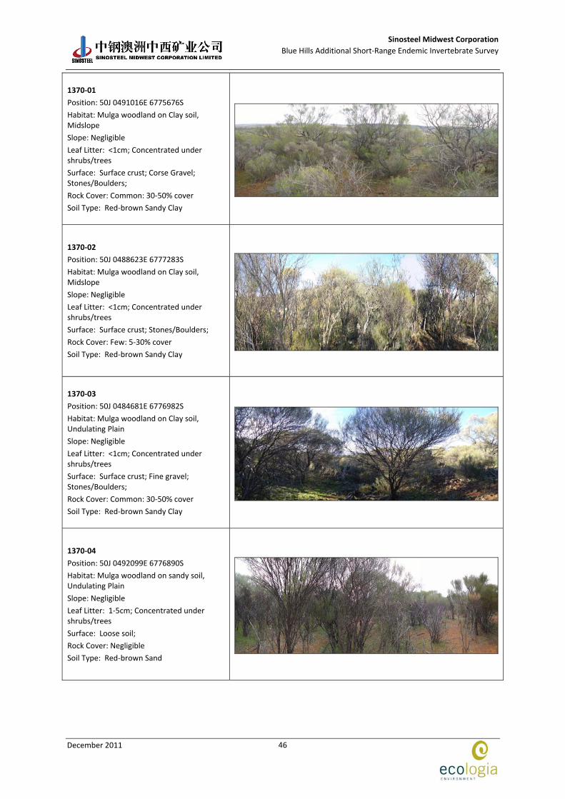
Sinosteel Midwest Corporation
Blue Hills Additional Short‐Range Endemic Invertebrate Survey
December 2011
46
1370‐01
Position: 50J 0491016E 6775676S
Habitat: Mulga woodland on Clay soil, Midslope
Slope: Negligible
Leaf Litter: <1cm; Concentrated under shrubs/trees
Surface: Surface crust; Corse Gravel; Stones/Boulders;
Rock Cover: Common: 30‐50% cover
Soil Type: Red‐brown Sandy Clay
1370‐02
Position: 50J 0488623E 6777283S
Habitat: Mulga woodland on Clay soil, Midslope
Slope: Negligible
Leaf Litter: <1cm; Concentrated under shrubs/trees
Surface: Surface crust; Stones/Boulders;
Rock Cover: Few: 5‐30% cover
Soil Type: Red‐brown Sandy Clay
1370‐03
Position: 50J 0484681E 6776982S
Habitat: Mulga woodland on Clay soil, Undulating Plain
Slope: Negligible
Leaf Litter: <1cm; Concentrated under shrubs/trees
Surface: Surface crust; Fine gravel; Stones/Boulders;
Rock Cover: Common: 30‐50% cover
Soil Type: Red‐brown Sandy Clay
1370‐04
Position: 50J 0492099E 6776890S
Habitat: Mulga woodland on sandy soil, Undulating Plain
Slope: Negligible
Leaf Litter: 1‐5cm; Concentrated under shrubs/trees
Surface: Loose soil;
Rock Cover: Negligible
Soil Type: Red‐brown Sand
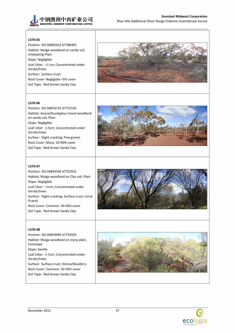
Sinosteel Midwest Corporation
Blue Hills Additional Short‐Range Endemic Invertebrate Survey
December 2011
47
1370‐05
Position: 50J 0489541E 6778640S
Habitat: Mulga woodland on sandy soil, Undulating Plain
Slope: Negligible
Leaf Litter: <1 cm; Concentrated under shrubs/trees
Surface: Surface crust;
Rock Cover: Negligible <5% cover
Soil Type: Red‐brown Sandy Clay
1370‐06
Position: 50J 0487672E 6775253S
Habitat: Acacia/Eucalyptus mixed woodland on sandy soil, Plain
Slope: Negligible
Leaf Litter: 1‐5cm; Concentrated under shrubs/trees
Surface: Slight cracking; Fine gravel;
Rock Cover: Many: 50‐90% cover
Soil Type: Red‐brown Sandy Clay
1370‐07
Position: 50J 0484359E 6775291S
Habitat: Mulga woodland on Clay soil, Plain
Slope: Negligible
Leaf Litter: <1cm; Concentrated under shrubs/trees
Surface: Slight cracking; Surface crust; Corse Gravel;
Rock Cover: Common: 30‐50% cover
Soil Type: Red‐brown Sandy Clay
1370‐08
Position: 50J 0485949E 6775933S
Habitat: Mulga woodland on stony plain, Footslope
Slope: Gentle
Leaf Litter: 1‐5cm; Concentrated under shrubs/trees
Surface: Surface crust; Stones/Boulders;
Rock Cover: Common: 30‐50% cover
Soil Type: Red‐brown Sandy Clay
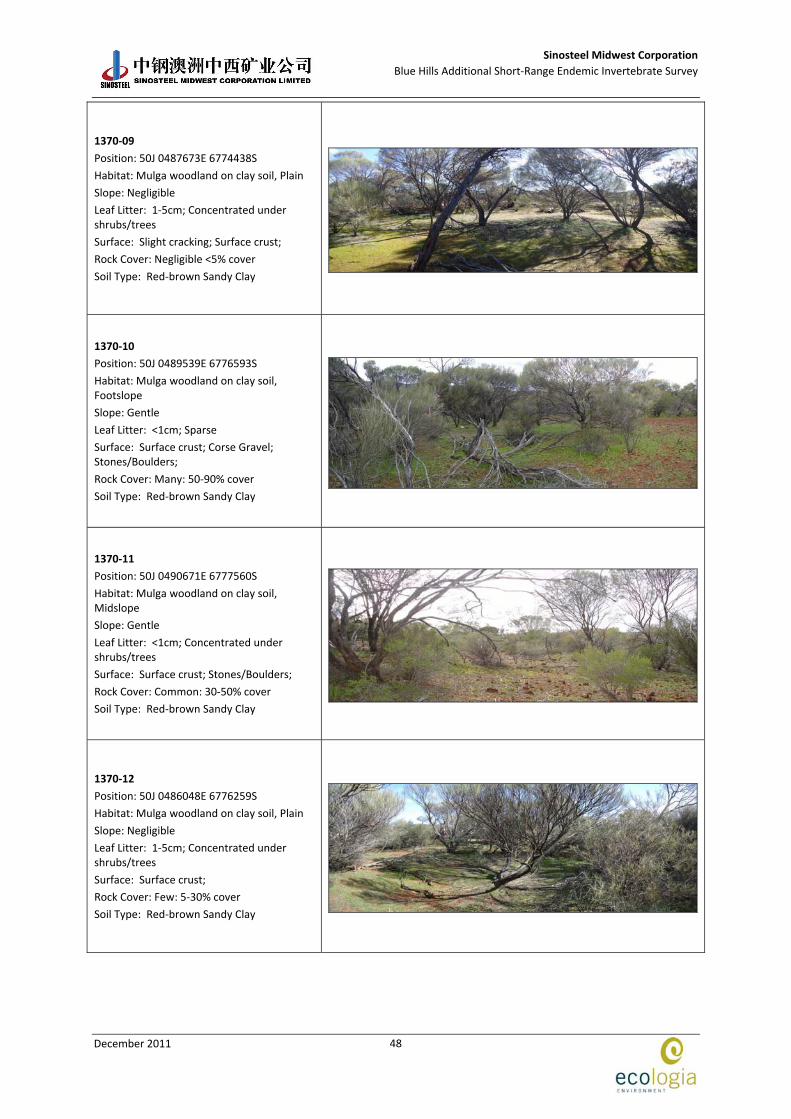
Sinosteel Midwest Corporation
Blue Hills Additional Short‐Range Endemic Invertebrate Survey
December 2011
48
1370‐09
Position: 50J 0487673E 6774438S
Habitat: Mulga woodland on clay soil, Plain
Slope: Negligible
Leaf Litter: 1‐5cm; Concentrated under shrubs/trees
Surface: Slight cracking; Surface crust;
Rock Cover: Negligible <5% cover
Soil Type: Red‐brown Sandy Clay
1370‐10
Position: 50J 0489539E 6776593S
Habitat: Mulga woodland on clay soil, Footslope
Slope: Gentle
Leaf Litter: <1cm; Sparse
Surface: Surface crust; Corse Gravel; Stones/Boulders;
Rock Cover: Many: 50‐90% cover
Soil Type: Red‐brown Sandy Clay
1370‐11
Position: 50J 0490671E 6777560S
Habitat: Mulga woodland on clay soil, Midslope
Slope: Gentle
Leaf Litter: <1cm; Concentrated under shrubs/trees
Surface: Surface crust; Stones/Boulders;
Rock Cover: Common: 30‐50% cover
Soil Type: Red‐brown Sandy Clay
1370‐12
Position: 50J 0486048E 6776259S
Habitat: Mulga woodland on clay soil, Plain
Slope: Negligible
Leaf Litter: 1‐5cm; Concentrated under shrubs/trees
Surface: Surface crust;
Rock Cover: Few: 5‐30% cover
Soil Type: Red‐brown Sandy Clay