shire of boyup brook - department of planning, … planning...shire of boyup brook town planning...
TRANSCRIPT
GO TO CONTENTS PAGE
SHIRE OF BOYUP BROOK
Town Planning Scheme No. 2
Updated to include AMD 16 GG 13/04/2018
Prepared by the Department of Planning, Lands and Heritage
Original Town Planning Scheme Gazettal
7 November 1997
Disclaimer This is a copy of the Local Planning Scheme produced from an electronic version of the Scheme held and maintained by the Department of Planning, Lands and Heritage. Whilst all care has been taken to accurately portray the current Scheme provisions, no responsibility shall be taken for any omissions or errors in this documentation. Consultation with the respective Local Government Authority should be made to view a legal version of the Scheme. Please advise the Department of Planning, Lands and Heritage of any errors or omissions in this document.
Department of Planning, Lands and Heritage Gordon Stephenson House 140 William Street Perth WA 6000
Locked Bag 2506 Perth WA 6001
website: www.dplh.wa.gov.au email: [email protected]
tel: 08 6551 9000 fax: 08 6551 9001 National Relay Service: 13 36 77 infoline: 1800 626 477
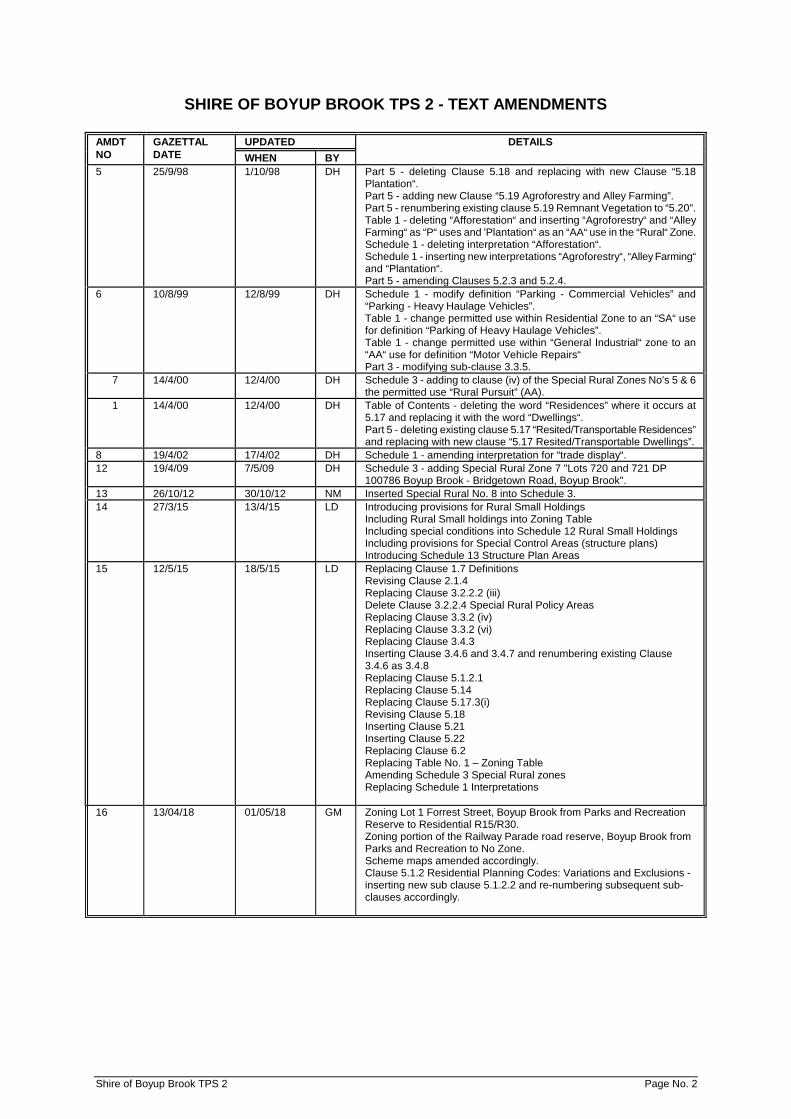
SHIRE OF BOYUP BROOK TPS 2 - TEXT AMENDMENTS
AMDT NO
GAZETTAL DATE
UPDATED DETAILS WHEN BY
5 25/9/98 1/10/98 DH Part 5 - deleting Clause 5.18 and replacing with new Clause “5.18 Plantation“. Part 5 - adding new Clause “5.19 Agroforestry and Alley Farming”. Part 5 - renumbering existing clause 5.19 Remnant Vegetation to “5.20". Table 1 - deleting “Afforestation“ and inserting “Agroforestry“ and “Alley Farming“ as “P“ uses and 'Plantation“ as an “AA“ use in the “Rural“ Zone. Schedule 1 - deleting interpretation “Afforestation“. Schedule 1 - inserting new interpretations “Agroforestry“, “Alley Farming“ and “Plantation“. Part 5 - amending Clauses 5.2.3 and 5.2.4.
6 10/8/99 12/8/99 DH Schedule 1 - modify definition “Parking - Commercial Vehicles” and “Parking - Heavy Haulage Vehicles”. Table 1 - change permitted use within Residential Zone to an “SA“ use for definition “Parking of Heavy Haulage Vehicles”. Table 1 - change permitted use within “General Industrial“ zone to an “AA“ use for definition “Motor Vehicle Repairs“ Part 3 - modifying sub-clause 3.3.5.
7 14/4/00 12/4/00 DH Schedule 3 - adding to clause (iv) of the Special Rural Zones No's 5 & 6 the permitted use “Rural Pursuit” (AA).
1 14/4/00 12/4/00 DH Table of Contents - deleting the word “Residences” where it occurs at 5.17 and replacing it with the word “Dwellings“. Part 5 - deleting existing clause 5.17 “Resited/Transportable Residences” and replacing with new clause “5.17 Resited/Transportable Dwellings”.
8 19/4/02 17/4/02 DH Schedule 1 - amending interpretation for “trade display“. 12 19/4/09 7/5/09 DH Schedule 3 - adding Special Rural Zone 7 "Lots 720 and 721 DP
100786 Boyup Brook - Bridgetown Road, Boyup Brook". 13 26/10/12 30/10/12 NM Inserted Special Rural No. 8 into Schedule 3. 14 27/3/15 13/4/15 LD Introducing provisions for Rural Small Holdings
Including Rural Small holdings into Zoning Table Including special conditions into Schedule 12 Rural Small Holdings Including provisions for Special Control Areas (structure plans) Introducing Schedule 13 Structure Plan Areas
15 12/5/15 18/5/15 LD Replacing Clause 1.7 Definitions Revising Clause 2.1.4 Replacing Clause 3.2.2.2 (iii) Delete Clause 3.2.2.4 Special Rural Policy Areas Replacing Clause 3.3.2 (iv) Replacing Clause 3.3.2 (vi) Replacing Clause 3.4.3 Inserting Clause 3.4.6 and 3.4.7 and renumbering existing Clause 3.4.6 as 3.4.8 Replacing Clause 5.1.2.1 Replacing Clause 5.14 Replacing Clause 5.17.3(i) Revising Clause 5.18 Inserting Clause 5.21 Inserting Clause 5.22 Replacing Clause 6.2 Replacing Table No. 1 – Zoning Table Amending Schedule 3 Special Rural zones Replacing Schedule 1 Interpretations
16 13/04/18 01/05/18 GM Zoning Lot 1 Forrest Street, Boyup Brook from Parks and Recreation Reserve to Residential R15/R30. Zoning portion of the Railway Parade road reserve, Boyup Brook from Parks and Recreation to No Zone. Scheme maps amended accordingly. Clause 5.1.2 Residential Planning Codes: Variations and Exclusions - inserting new sub clause 5.1.2.2 and re-numbering subsequent sub-clauses accordingly.
Shire of Boyup Brook TPS 2 Page No. 2

SHIRE OF BOYUP BROOK
Town Planning Scheme No. 2 The Boyup Brook Shire Council, under and by virtue of the powers conferred upon it in that behalf by the
Town Planning and Development Act, 1928 (as amended), hereby makes the following Town Planning
Scheme for the purpose of:
(a) reserving land required for public purposes (b) zoning the balance of the land within the Scheme Area for the various purposes described in the
Scheme; (c) providing development controls for the purpose of securing and maintaining an orderly and
properly planned use and development of land within the Scheme Area; (d) introducing measures by which places of natural beauty and places of historic or scientific interest
may be conserved; and (e) making provision for other matters authorised by the enabling Act.
.......................................................... Shire Clerk
.......................................................... Date 16 DECEMBER 1994
Shire of Boyup Brook TPS 2 Page No. 3
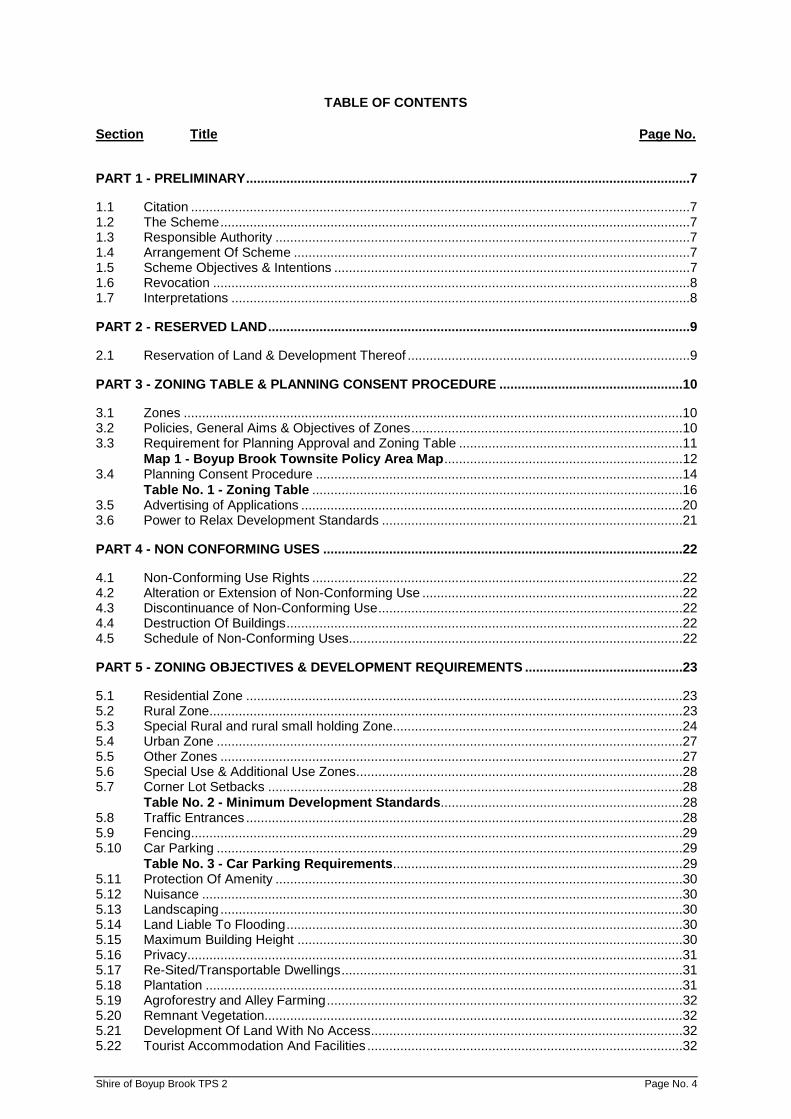
TABLE OF CONTENTS Section Title Page No.
PART 1 - PRELIMINARY .........................................................................................................................7
1.1 Citation ........................................................................................................................................7 1.2 The Scheme ................................................................................................................................7 1.3 Responsible Authority .................................................................................................................7 1.4 Arrangement Of Scheme ............................................................................................................7 1.5 Scheme Objectives & Intentions .................................................................................................7 1.6 Revocation ..................................................................................................................................8 1.7 Interpretations .............................................................................................................................8
PART 2 - RESERVED LAND ...................................................................................................................9
2.1 Reservation of Land & Development Thereof .............................................................................9
PART 3 - ZONING TABLE & PLANNING CONSENT PROCEDURE ..................................................10
3.1 Zones ........................................................................................................................................10 3.2 Policies, General Aims & Objectives of Zones ..........................................................................10 3.3 Requirement for Planning Approval and Zoning Table .............................................................11
Map 1 - Boyup Brook Townsite Policy Area Map .................................................................12 3.4 Planning Consent Procedure ....................................................................................................14
Table No. 1 - Zoning Table .....................................................................................................16 3.5 Advertising of Applications ........................................................................................................20 3.6 Power to Relax Development Standards ..................................................................................21
PART 4 - NON CONFORMING USES ..................................................................................................22
4.1 Non-Conforming Use Rights .....................................................................................................22 4.2 Alteration or Extension of Non-Conforming Use .......................................................................22 4.3 Discontinuance of Non-Conforming Use ...................................................................................22 4.4 Destruction Of Buildings ............................................................................................................22 4.5 Schedule of Non-Conforming Uses...........................................................................................22
PART 5 - ZONING OBJECTIVES & DEVELOPMENT REQUIREMENTS ...........................................23
5.1 Residential Zone .......................................................................................................................23 5.2 Rural Zone .................................................................................................................................23 5.3 Special Rural and rural small holding Zone...............................................................................24 5.4 Urban Zone ...............................................................................................................................27 5.5 Other Zones ..............................................................................................................................27 5.6 Special Use & Additional Use Zones .........................................................................................28 5.7 Corner Lot Setbacks .................................................................................................................28
Table No. 2 - Minimum Development Standards..................................................................28 5.8 Traffic Entrances .......................................................................................................................28 5.9 Fencing ......................................................................................................................................29 5.10 Car Parking ...............................................................................................................................29
Table No. 3 - Car Parking Requirements ...............................................................................29 5.11 Protection Of Amenity ...............................................................................................................30 5.12 Nuisance ...................................................................................................................................30 5.13 Landscaping ..............................................................................................................................30 5.14 Land Liable To Flooding ............................................................................................................30 5.15 Maximum Building Height .........................................................................................................30 5.16 Privacy .......................................................................................................................................31 5.17 Re-Sited/Transportable Dwellings .............................................................................................31 5.18 Plantation ..................................................................................................................................31 5.19 Agroforestry and Alley Farming .................................................................................................32 5.20 Remnant Vegetation..................................................................................................................32 5.21 Development Of Land With No Access .....................................................................................32 5.22 Tourist Accommodation And Facilities ......................................................................................32 Shire of Boyup Brook TPS 2 Page No. 4

PART 6 - HERITAGE – PRECINCTS AND PLACES OF CULTURAL SIGNIFICANCE ......................33
6.1 Purpose and Intent ....................................................................................................................33 6.2 Heritage List ..............................................................................................................................33 6.3 Designation of Heritage Precincts .............................................................................................34 6.4 Applications For Planning Approval ..........................................................................................34 6.5 Formalities Of Application .........................................................................................................35 6.6 Variations To Scheme Provisions .............................................................................................35
PART 7 - GUIDED DEVELOPMENT AREA ..........................................................................................36
7.1 The Subject Land ......................................................................................................................36 7.2 General Objectives ....................................................................................................................36 7.3 Method by Which Objectives Are to be Achieved .....................................................................36
Map 2 - Guided Development Area ........................................................................................38 7.4 Development Plan Costs ...........................................................................................................40 7.5 Payment Of Plan Costs .............................................................................................................41 7.6 Estimate Of Plan Costs .............................................................................................................42 7.7 Development Standard..............................................................................................................42
PART 8 - CONTROL OF ADVERTISEMENTS .....................................................................................43
8.1 Power To Control Advertising ....................................................................................................43 8.2 Existing Advertisements ............................................................................................................43 8.3 Consideration Of Applications ...................................................................................................43 8.4 Exemptions From the Requirement to Obtain Consent ............................................................43 8.5 Discontinuance ..........................................................................................................................43 8.6 Derelict Or Poorly Maintained Signs .........................................................................................44 8.7 Notices ......................................................................................................................................44 8.8 Scheme to Prevail .....................................................................................................................44 8.9 Enforcement and Penalties .......................................................................................................44
PART 9 - ADMINISTRATION ................................................................................................................45
9.1 Powers Of The Scheme ............................................................................................................45 9.2 Offences ....................................................................................................................................45 9.3 Compensation ...........................................................................................................................45 9.4 Election To Purchase and Valuation .........................................................................................46 9.5 Right of review ...........................................................................................................................46 9.6 Planning Policies .......................................................................................................................46 9.7 Delegation .................................................................................................................................47 9.8 Amendments to the Scheme .....................................................................................................48 9.9 Notice for Removal of Certain Buildings ...................................................................................48 9.10 Powers & Authority of Council - Guided Development Area .....................................................48
PART 10 – SPECIAL CONTROL AREAS .............................................................................................50
10.1 Structure Plan Areas .................................................................................................................50
SCHEDULES .........................................................................................................................................57
Schedule 1 – Interpretations ..................................................................................................................57 1. General Definitions ....................................................................................................57 2. Land Use Definitions .................................................................................................59
Schedule 2 - Non-Conforming Uses ......................................................................................................66 Schedule 3 - Special Rural Zones ..........................................................................................................67 Schedule 4 - Special Use Zone ..............................................................................................................81 Schedule 5 - Additional Use Zone ..........................................................................................................82 Schedule 6 - Car Parking Layout ...........................................................................................................83 Schedule 7 - Land Ownership - Guided Development Area ..................................................................84 Schedule 8 - Control Of Advertisements – Additional Information Sheet For Advertisement Approval .85 Schedule 9 - Exempted Advertisements Pursuant To Clause 8.4 .........................................................86 Schedule 10 - Application For Approval .................................................................................................89 Schedule 11 - Notice Of Public Advertisement Of Planning Proposal ...................................................91
Shire of Boyup Brook TPS 2 Page No. 5

Schedule 12 – Rural Small Holdings Zones ...........................................................................................92 Schedule 13 – Structure Plan Areas ......................................................................................................94 Adoption .................................................................................................................................................96
TABLES Table No. 1 - Zoning Table ....................................................................................................................16 Table No. 2 - Minimum Development Standards ...................................................................................28 Table No. 3 - Car Parking Requirements ...............................................................................................29
MAPS
Map 1 - Boyup Brook Townsite Policy Area Map ...................................................................................12 Map 2 - Guided Development Area ........................................................................................................38
Shire of Boyup Brook TPS 2 Page No. 6
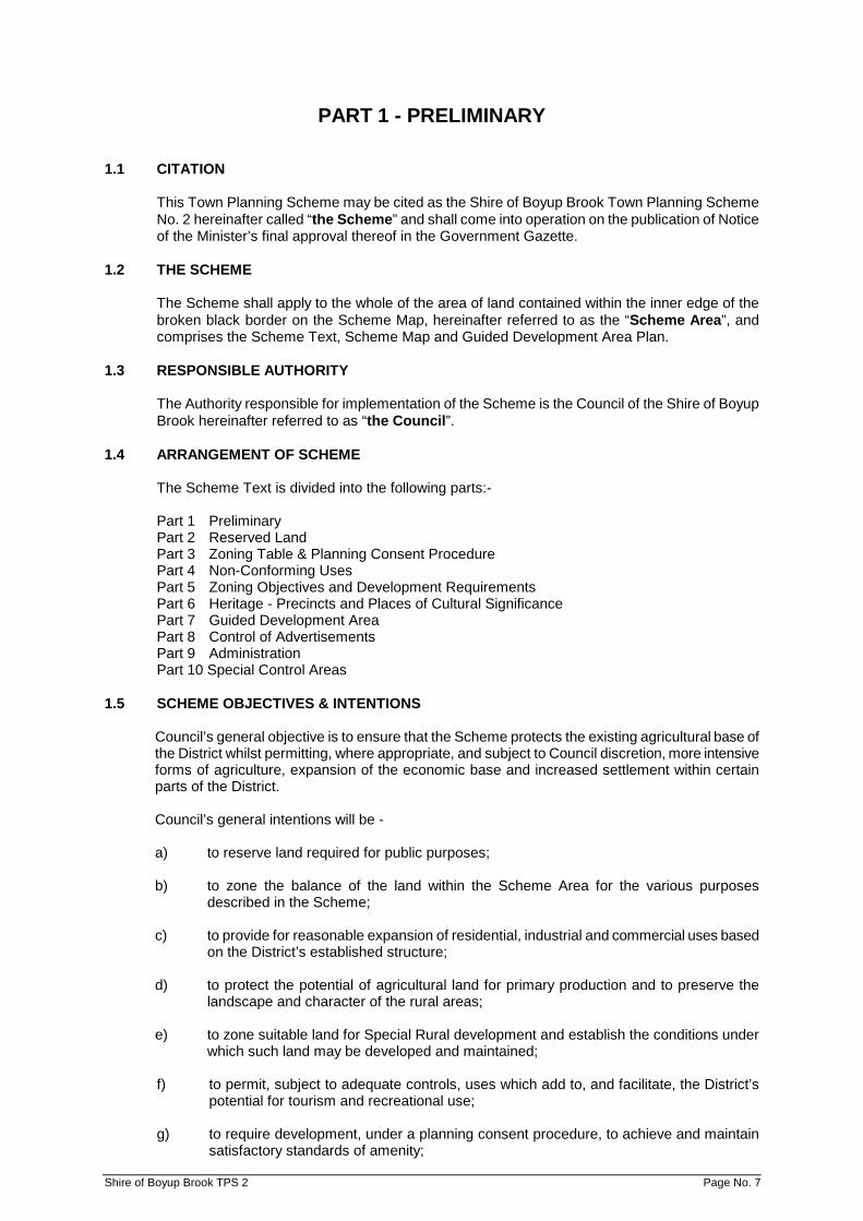
PART 1 - PRELIMINARY 1.1 CITATION
This Town Planning Scheme may be cited as the Shire of Boyup Brook Town Planning Scheme No. 2 hereinafter called “the Scheme” and shall come into operation on the publication of Notice of the Minister’s final approval thereof in the Government Gazette.
1.2 THE SCHEME
The Scheme shall apply to the whole of the area of land contained within the inner edge of the broken black border on the Scheme Map, hereinafter referred to as the “Scheme Area”, and comprises the Scheme Text, Scheme Map and Guided Development Area Plan.
1.3 RESPONSIBLE AUTHORITY
The Authority responsible for implementation of the Scheme is the Council of the Shire of Boyup Brook hereinafter referred to as “the Council”.
1.4 ARRANGEMENT OF SCHEME
The Scheme Text is divided into the following parts:-
Part 1 Preliminary Part 2 Reserved Land Part 3 Zoning Table & Planning Consent Procedure Part 4 Non-Conforming Uses Part 5 Zoning Objectives and Development Requirements Part 6 Heritage - Precincts and Places of Cultural Significance Part 7 Guided Development Area Part 8 Control of Advertisements Part 9 Administration Part 10 Special Control Areas
1.5 SCHEME OBJECTIVES & INTENTIONS
Council’s general objective is to ensure that the Scheme protects the existing agricultural base of the District whilst permitting, where appropriate, and subject to Council discretion, more intensive forms of agriculture, expansion of the economic base and increased settlement within certain parts of the District.
Council’s general intentions will be -
a) to reserve land required for public purposes;
b) to zone the balance of the land within the Scheme Area for the various purposes
described in the Scheme;
c) to provide for reasonable expansion of residential, industrial and commercial uses based on the District’s established structure;
d) to protect the potential of agricultural land for primary production and to preserve the
landscape and character of the rural areas;
e) to zone suitable land for Special Rural development and establish the conditions under which such land may be developed and maintained;
f) to permit, subject to adequate controls, uses which add to, and facilitate, the District’s
potential for tourism and recreational use;
g) to require development, under a planning consent procedure, to achieve and maintain satisfactory standards of amenity;
Shire of Boyup Brook TPS 2 Page No. 7

h) to provide for the coordination and progressive subdivision of that land generally comprised of Lots 185 and 186 and adjoining land in Knapp Street, Bridge Road, Terry Road and Gibbs Street (zoned for ‘Residential’ purposes in this Scheme), by maintaining a Guided Development Area Plan and supporting clauses in the Scheme Text which provide for:
(a) the subdivision of the land generally in accordance with a design shown on the
Guided Development Area Plan.
(b) the designation of an area of Public Open Space equivalent in size to 10% of the area of the Plan or alternatively, a cash-in-lieu contribution equivalent to such 10% contribution with arrangements being made for an equitable contribution to that Public Open Space (or such cash-in-lieu contribution) by each land owner concerned.
(c) the equitable distribution of costs related to the extension of roads and public
services to the land concerned.
(d) other powers associated with the implementation of the Guided Development Area Plan.
i) to make provision for other matters authorised by the enabling Act;
j) to introduce measures by which places of natural beauty and places of historic or
scientific interest may be conserved. 1.6 REVOCATION
The Shire of Boyup Brook Town Planning Scheme No. 1, hereinafter referred to as the “Revoked Scheme,” which came into operation by publication in the Government Gazette on the 5th October, 1984, is hereby revoked.
1.7 INTERPRETATIONS AMD 15 GG 12/5/15
1.7.1 Unless the context otherwise requires, words and expressions used in the Scheme have the same meaning as they have –
(a) in the Planning and Development Act; or
(b) if they are not defined in that Act –
(i) in the Dictionary of defined words and expressions in Schedule 1; or (ii) in the Residential Design Codes.
1.7.2 If there is a conflict between the meaning of a word or expression in the Dictionary of
defined words and expressions in Schedule 1 and the meaning of that word or expression in the Residential Design Codes –
(a) in the case of a residential development, the definition in the Residential Design
Codes prevails; and
(b) in any other case the definition in the Dictionary prevails.
1.7.3 Notes, and instructions printed in italics, are not part of the Scheme.
Shire of Boyup Brook TPS 2 Page No. 8

PART 2 - RESERVED LAND 2.1 RESERVATION OF LAND & DEVELOPMENT THEREOF
2.1.1 Parts of the Scheme Area are included in Reserves as set out hereunder:
Parks & Recreation Public Purposes (as denoted on the Scheme Map) Communications:
- Railway Reserve - Major Highway - Important Local Road; and
State Forest.
2.1.2 Land set aside under this Scheme for the purpose of a reservation is deemed to be reserved for the purpose indicated on the Scheme Map.
2.1.3 Except as otherwise provided in this Part, a person shall not carry out any development
on land reserved under this Scheme other than the erection of a boundary fence, without first applying for, and obtaining, the written approval of the Council.
2.1.4 In considering any application, the Council shall have regard to Clause 3.4.3, the ultimate
purpose intended for the Reserve and shall, in the case of land reserved for the purpose of a public authority, confer with that authority before giving its approval. AMD 15 GG 12/5/15
‘Note: Under Section 6 of the Planning and Development Act, the Crown, statutory
authorities and local governments undertaking, constructing or providing public works are exempt from the requirements to obtain planning approval but are required to consult with the local government and to have regard to the intent of the Scheme and local amenity.’
2.1.5 No provision of this Part shall prevent the continued use of land for the purpose for which
it was being lawfully used immediately prior to the Scheme having the force of law, or the repair and maintenance for which the prior consent in writing of the Council has been obtained, of buildings or works lawfully existing on the land.
2.1.6 Where the Council refuses planning approval for the carrying out of development on
reserved land or, grants approval subject to conditions that are unacceptable to the applicant, the owner of the land may, if the land is injuriously affected thereby, claim compensation for such injurious affection. Claims for such compensation shall be lodged in writing at the office of the Council not later than six (6) months after the date of Council’s decision. In lieu of paying compensation, the Council may purchase the land affected by its decision at a price representing the unaffected value of the land at the time of the Council’s decision.
Shire of Boyup Brook TPS 2 Page No. 9

PART 3 - ZONING TABLE & PLANNING CONSENT PROCEDURE 3.1 ZONES
3.1.1 The Scheme Area is classified and divided into 10 zones set out hereunder:
1. Residential 2. Commercial 3. Light Industrial 4. General Industrial 5. Rural 6. Urban 7. Special Rural 8. Additional Use 9. Special Use 10. Rural Small Holdings
3.1.2 The zones are delineated and coloured on the Scheme Map according to the legend
thereon. 3.2 POLICIES, GENERAL AIMS & OBJECTIVES OF ZONES
The Scheme Area is divided into Policy Areas and Zones. Each Policy Area is the subject of policy statements relating to the predominant use and strategy for future development of the Policy Area.
3.2.1 Rezoning
Where, in the opinion of the Council, a proposal for rezoning of land is inconsistent with the policy or policies or the strategy for future development of the area, the Council shall:
(a) not proceed with the rezoning on the grounds that it is inconsistent with policy; or
(b) resolve to amend the Scheme in respect of the Policy Area after reviewing the
implications and desirability of such rezoning.
3.2.2 Policies
The following statements of planning policy relate to the Policy Areas shown on the Scheme Maps and Map 1 (the Boyup Brook Townsite Policy Area Map) forming part of this Scheme.
3.2.2.1 Boyup Brook Townsite - Central
Whereas this area contains the town centre and the majority of the older urban development, the following planning policy shall apply:
(i) The town centre shall be predominantly located within the bounds of, and
including those properties fronting Inglis Street, Railway Parade, Dickson Street and Forrest Street.
(ii) Consolidation and enhancement of the town centre (as defined at
paragraph (i) above) shall be promoted and Council shall not generally support proposals for commercial and/or office development within the Shire outside of that area except where it considers such proposals as appropriate within the Urban zone.
(iii) Residential and commercial development shall be the predominant uses
associated with this Policy Area.
Shire of Boyup Brook TPS 2 Page No. 10
3.2.2.2 Boyup Brook Townsite - West
Whereas this area has been partly settled as a residential area and whereas industrial uses have established here and whereas Abel Street and Jayes Road will remain as important local roads, the following planning policy shall apply:
(i) Residential development shall be the predominant use in the area. (ii) Light industrial uses shall be secondary to the predominant use and shall
comply with standards consistent with the amenity of the nearby residential area.
(iii) Proposals for Special Rural rezoning and subdivision within the area
shall accord with the Rural Strategy. AMD 15 GG 12/5/15
3.2.2.3 Boyup Brook Townsite - South
Whereas this area contains the pre-primary, primary and district high schools and the hospital and whereas further residential development could take place within this area, the following planning policy shall apply:
(i) Residential development shall be the predominant use in the area.
3.3 REQUIREMENT FOR PLANNING APPROVAL AND ZONING TABLE
3.3.1 In order to give full effect to the provisions and objectives of this Scheme, all development, including a change in the use of land, except as otherwise provided, requires the prior approval of the Council in each case. Accordingly, no person shall commence or carry out any development, including a change in the use of any land, without first having applied for and obtained the planning approval of the Council pursuant to the provisions of this Part.
Shire of Boyup Brook TPS 2 Page No. 11

MAP 1 - BOYUP BROOK TOWNSITE POLICY AREA MAP
Shire of Boyup Brook TPS 2 Page No. 12
3.3.2 The Planning approval of the Council is not required for the following development of land:
(a) The use of land in a reserve, where such land is held by the Council or vested in
a public authority;
(i) for the purpose for which the land is reserved under the Scheme; or
(ii) in the case of land vested in a public authority, for any purpose for which such land may be lawfully used by that authority.
(b) The use of land which is a permitted (“P”) use in the zone in which that land is
situated provided it does not involve the carrying out of any building or other works.
(c) The erection of a boundary fence except as otherwise required by the Scheme.
(d) The erection on a lot of a single dwelling house, including ancillary outbuildings,
in a zone where the proposed use is designated with the symbol “P” in the cross reference to that zone in the Zoning Table, except where –
(i) the proposal requires the exercise of a discretion by the local
government under the Scheme to vary the provisions of the Residential Design Codes;
(ii) the development will be located in a heritage area designated under the Scheme; or
(iii) approval is required under Clause 5.21 for lots without legal road frontage and or constructed road access. AMD 15 GG 12/5/15
(e) The carrying out of any works on, in, over or under a street or road by a public
authority acting pursuant to the provisions of any Act.
(f) The carrying out of works for the maintenance, improvement or other alteration of any building, being works which affect only the interior of the building or which do not materially affect the external appearance of the building except where the building is:
(i) located in a place that has been entered in the Register of Heritage
Places under the Heritage of Western Australia Act 1990;
(ii) the subject of an order under Part 6 of the Heritage of Western Australia Act 1990; or
(iii) included on the Heritage List under Clause 6.2 of the Scheme. AMD 15 GG 12/5/15
(g) The carrying out of works urgently necessary in the public safety or for the safety
or security of plant or equipment or for the maintenance of essential services. (h) The demolition of any building or structure except where the building or structure
is –
(i) located in a place that has been entered in the Register of Places under the Heritage of Western Australia Act 1990;
(ii) the subject of an order under Part 6 of the Heritage of Western Australia Act 1990;
(iii) included on the Heritage List under Clause 6.2 of the Scheme; or
(iv) located within a heritage area designated under the Scheme. AMD 15 GG 12/5/15
Shire of Boyup Brook TPS 2 Page No. 13

(i) A home office. AMD 15 GG 12/5/15 (j) Any of the exempted classes of advertisements listed in Schedule 9 except in
respect of a place included in the Heritage List or in a heritage area. AMD 15 GG 12/5/15
3.3.3 The Zoning Table indicates, subject to the provisions of the Scheme, the uses permitted in the various zones with such uses being determined by cross reference between the use classes on the left hand side of the table and the zones at the top of the table.
3.3.4 The symbols used in the Zoning Table have the following meanings:-
‘P’ A use that is permitted subject to compliance with all requirements of this
Scheme.
‘AA’ A use which Council, in exercising the discretionary powers available to it, may approve under this Scheme.
‘SA’ A use that is not permitted unless the Council has granted planning approval
after giving notice in accordance with Clause 3.5.
‘IP’ A use that is not permitted unless such use is shown to be incidental to the predominant use of the land as may be determined by Council.
‘-‘ A use that is not permitted under this Scheme.
3.3.5 Notwithstanding that uses may be acceptable pursuant to the provisions of Clause 3.3.4
and the Zoning Table, nothing in this section shall prevent the Council from granting planning consent subject to conditions, whether in principle or otherwise, in relation to the layout, design, height, siting or general appearance of the development or such other matters as Council deems relevant.
3.3.6 Where in the Zoning Table a particular use is listed, it is deemed to be excluded from any
other use class which, by its more general terms, might otherwise include such particular use.
3.3.7 In respect of uses and development which are not specifically mentioned in the Zoning
Table, and which could not be reasonably determined as falling within the interpretations of one of the use classes listed, the Council may:-
(a) determine that the use is consistent with the objectives and purposes of the
Zone and thereafter follow the ‘SA’ procedures of Clause 3.5 in considering an application for planning approval.
(b) determine that the use is not consistent with the objectives and purposes of the
Zone and is therefore not permitted. 3.4 PLANNING CONSENT PROCEDURE
3.4.1 Every application for planning approval shall be made in the form prescribed in Schedule 10 to the Scheme and shall be accompanied by such plans and other information as is required by the Scheme.
3.4.2 Unless Council waives any particular requirement every application for planning approval
shall be accompanied by:
(a) a plan or plans to a scale of not less than 1:500 showing:
(i) street names, Lot number(s), north point and the dimensions of the site;
(ii) the location and proposed use of the site, including any existing building to be retained and proposed buildings to be erected on the site;
Shire of Boyup Brook TPS 2 Page No. 14

(iii) the existing and proposed means of access for pedestrians and vehicles to and from the site;
(iv) the location, number, dimensions and layout of all car parking spaces
intended to be provided;
(v) the location and dimensions of any area proposed to be provided for the loading and unloading of vehicles carrying goods or commodities to and from the site and the means of access to and from those areas;
(vi) the location, dimensions, and design of any open storage or trade
display area and particulars of the manner in which it is proposed to develop the same; and
(vii) the nature and extent of any open space and landscaping proposed for
the site.
(b) plans, elevations and sections of any building proposed to be erected or altered and of any building it is intended to retain; and
(c) any other plan or information that the Council may reasonably require to enable
the application to be determined.
Shire of Boyup Brook TPS 2 Page No. 15

TABLE NO. 1 - ZONING TABLE AMD 15 GG 12/5/15
ZONES: 1. Residential 6. Urban 2. Commercial 7. Special Rural 3. Light Industrial 8. Special Use 4. General Industrial 9. Additional Use 5. Rural 10. Rural Small Holdings
ZONES
LAND USE 1 2 3 4 5 6 7 8 9 10
1 Agriculture – extensive - - - - P -
REF
ER T
O S
CH
EDU
LE 3
REF
ER T
O S
CH
EDU
LE 4
REF
ER T
O S
CH
EDU
LE 5
AA
2 Agriculture – intensive - - - - AA - SA
3 Agroforestry - - - - P - AA
4 Alley Farming - - - - P - AA
5 Amusement Parlour - AA - - - - -
6 Ancillary Accommodation - IP - - IP IP IP
7 Animal Establishment - - SA - SA - -
8 Animal Husbandry Intensive - - - - AA - -
9 Art Gallery AA P - - IP AA -
10 Bed and Breakfast SA - - - AA AA AA
11 Betting Agency - AA - - - - -
12 Cabin - - - - AA AA AA
13 Camping Ground - - - - AA AA -
14 Caravan Park - - - - AA AA -
15 Caretaker’s Dwelling - IP IP IP - AA -
16 Carpark - AA AA AA AA AA -
17 Chalet - - - - AA AA AA
18 Child Care Service SA AA AA - SA AA -
19 Cinema/theatre - AA - - - - -
20 Civic Use AA P - - AA P -
21 Club Premises - P AA - AA AA -
22 Community Purpose AA AA - - AA - -
23 Consulting Rooms SA AA AA - IP AA -
24 Convenience Store - P - - - - -
25 Corrective Institution - - - - SA - -
26 Dry Cleaning Premises - AA AA - - AA -
27 Eco Tourist Facility - - - - AA - -
28 Educational Establishment AA AA AA - AA AA -
29 Entertainment Centre - AA - - SA - -
30 Exhibition Centre - AA - - - - -
31 Family Day Care SA - - - AA - -
32 Farm Stay - - - - AA - AA
33 Farm Worker’s Accommodation
- - - - AA - -
Shire of Boyup Brook TPS 2 Page No. 16
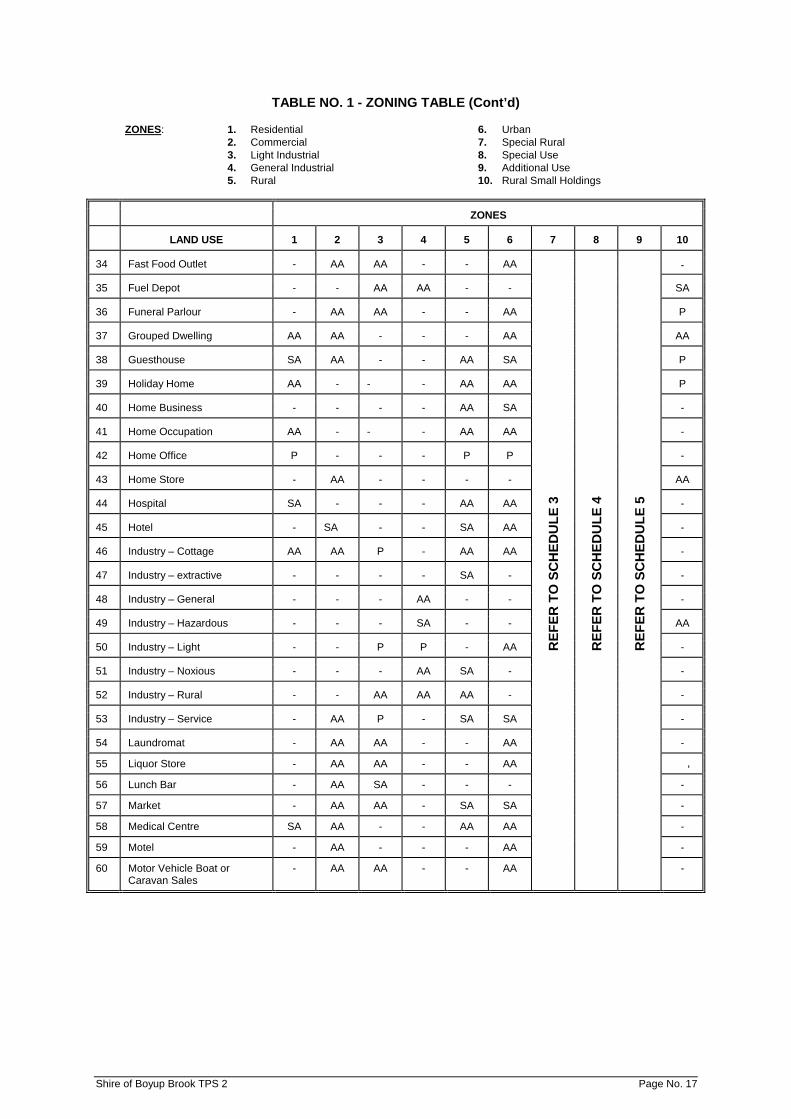
TABLE NO. 1 - ZONING TABLE (Cont’d) ZONES: 1. Residential 6. Urban
2. Commercial 7. Special Rural 3. Light Industrial 8. Special Use 4. General Industrial 9. Additional Use 5. Rural 10. Rural Small Holdings
ZONES
LAND USE 1 2 3 4 5 6 7 8 9 10
34 Fast Food Outlet - AA AA - - AA
REF
ER T
O S
CH
EDU
LE 3
REF
ER T
O S
CH
EDU
LE 4
REF
ER T
O S
CH
EDU
LE 5
-
35 Fuel Depot - - AA AA - - SA
36 Funeral Parlour - AA AA - - AA P
37 Grouped Dwelling AA AA - - - AA AA
38 Guesthouse SA AA - - AA SA P
39 Holiday Home AA - - - AA AA P
40 Home Business - - - - AA SA -
41 Home Occupation AA - - - AA AA -
42 Home Office P - - - P P -
43 Home Store - AA - - - - AA
44 Hospital SA - - - AA AA -
45 Hotel - SA - - SA AA -
46 Industry – Cottage AA AA P - AA AA -
47 Industry – extractive - - - - SA - -
48 Industry – General - - - AA - - -
49 Industry – Hazardous - - - SA - - AA
50 Industry – Light - - P P - AA -
51 Industry – Noxious - - - AA SA - -
52 Industry – Rural - - AA AA AA - -
53 Industry – Service - AA P - SA SA -
54 Laundromat - AA AA - - AA -
55 Liquor Store - AA AA - - AA -
56 Lunch Bar - AA SA - - - -
57 Market - AA AA - SA SA -
58 Medical Centre SA AA - - AA AA -
59 Motel - AA - - - AA -
60 Motor Vehicle Boat or Caravan Sales
- AA AA - - AA -
Shire of Boyup Brook TPS 2 Page No. 17

TABLE NO. 1 - ZONING TABLE (Cont’d) ZONES: 1. Residential 6. Urban
2. Commercial 7. Special Rural 3. Light Industrial 8. Special Use 4. General Industrial 9. Additional Use 5. Rural 10. Rural Small Holdings
ZONES
LAND USE 1 2 3 4 5 6 7 8 9 10
61 Motor Vehicle Repair - AA AA AA AA AA
REF
ER T
O S
CH
EDU
LE 3
REF
ER T
O S
CH
EDU
LE 4
REF
ER T
O S
CH
EDU
LE 5
-
62 Motor Vehicle Wash - SA AA AA - - -
63 Motor Vehicle Wrecking - - AA AA SA AA -
64 Multiple Dwelling SA - - - - - -
65 Museum - AA - - AA AA -
66 Night Club - SA - - - - -
67 Nursery - AA AA - AA AA -
68 Office - P IP IP - AA IP
69 Park Home Park - - - - AA - -
70 Parking – Commercial Vehicles
SA IP P P IP AA AA
71 Parking – Heavy Haulage Vehicles
SA IP P P IP AA SA
72 Place of Public Assembly AA AA - - AA AA -
73 Place of Worship AA AA - - AA AA -
74 Plantation - - - - AA - AA
75 Public Amusement - P AA - AA AA -
76 Reception Centre - AA - - SA - -
77 Recreation – Private - AA AA - AA AA -
78 Residential Building SA AA - - AA AA -
79 Restaurant - P - - AA AA AA
80 Restricted Premises - - SA - - - -
81 Rural Home Business - - - - - - SA
82 Rural Pursuit - - - - P - SA
83 Service Station - AA SA - SA AA -
84 Serviced Apartment SA AA - - SA - -
85 Shop - P - - - AA -
86 Showroom - AA AA - - AA -
87 Single House P AA - - P P P
88 Storage - - P P AA - -
89 Tavern - P SA - - AA -
90 Telecommunications Infrastructure
AA AA AA AA AA AA AA
91 Trade Display - AA AA IP - AA -
92 Transport Depot - - AA AA P AA SA
93 Veterinary Centre - AA AA - AA AA SA
94 Warehouse - P P P AA AA -
95 Wayside Stall - AA - - AA AA AA
96 Winery - - AA AA AA - -
97 Woodyard - - P P AA AA AA
Shire of Boyup Brook TPS 2 Page No. 18
3.4.3 The Council in considering an application for planning approval is to have due regard to such of the following matters as are in the opinion of the local government relevant to the use or development the subject of the application – AMD 15 GG 12/5/15
(a) the aims of provisions of the Scheme;
(b) the requirements of orderly and proper planning including any relevant proposed
new town planning scheme or amendment, or region scheme or amendment, which has been granted consent for public submissions to be sought;
(c) any approved state planning policy of the Commission;
(d) any approved environmental protection policy under the Environmental Protection Act 1986;
(e) any relevant policy or strategy of the Commission and any relevant policy adopted by the Government of the State;
(f) any Local Planning Policy adopted by the local government under Clause 9.6, any heritage policy statement for a designated heritage area adopted under Clause 6.3, and any other plan or guideline adopted by the local government under the Scheme;
(g) in the case of land reserved under the Scheme, the ultimate purpose intended for the reserve;
(h) the conservation of any place that has been entered in the Register within the meaning of the Heritage of Western Australia Act 1990, or which is included in the Heritage List under Clause 6.2, and the effect of the proposal on the character or appearance of a heritage area;
(i) the compatibility of a use or development with its setting;
(j) any social issues that have an effect on the amenity of the locality;
(k) the cultural significance an any place or area affected by the development;
(l) the likely effect of the proposal on the natural environment and any means that are proposed to protect or to mitigate impacts on the natural environment;
(m) whether the land to which the application relates is unsuitable for the proposal by reason of it being, or being likely to be, subject to flooding, tidal inundation, subsidence, landslip, bush fire, site contamination, acid sulphate soils and possibly salinity or any other risk;
(n) the preservation of the amenity of the locality;
(o) the relationship of the proposal to development on adjoining land or on other land in the locality including but not limited to, the likely effect of the height, bulk, scale, orientation and appearance of the proposal;
(p) whether the proposed means of access to and egress from the site are adequate and whether adequate provision has been made for the loading, unloading, manoeuvring and parking of vehicles;
(q) the amount of traffic likely to be generated by the proposal, particularly in relation to the capacity of the road system in the locality and the probable effect on traffic flow and safety;
(r) whether public transport services are necessary and, if so, whether they are available and adequate for the proposal;
(s) whether public utility services are available and adequate for the proposal; Shire of Boyup Brook TPS 2 Page No. 19

(t) whether adequate provision has been made for access for pedestrians and cyclists (including end of trip storage, toilet and shower facilities);
(u) whether adequate provision has been made for access by disabled persons;
(v) whether adequate provision has been made for the landscaping of the land to which the application relates and whether any trees or other vegetation on the land should be preserved;
(w) whether the proposal is likely to cause soil erosion or land degradation;
(x) the potential loss of any community service or benefit resulting from the planning approval;
(y) any relevant submissions received on the application;
(z) the comments or submissions received from any authority; and
(za) any other planning consideration the local government considers relevant. 3.4.4 The Council may approve or refuse applications for planning consent. In granting its
approval, the Council may impose any condition(s) it thinks fit including a time limit whereafter the approval shall lapse if development has not been completed and the Council has not granted an extension of such time limit.
3.4.5 If the Council has not determined an application submitted in terms of Clause 3.4.2 within
sixty days of the receipt of such application or any extension of time granted in writing by the Applicant, the application is deemed to have been refused.
3.4.6 An application for planning approval which is the subject of a notice under Clause 3.5 is
deemed to be refused where a determination in respect of that application is not conveyed to the applicant by the local government within 90 days of receipt of the application by the local government, or within such a further time as is agreed in writing between the applicant and the local government. AMD 15 GG 12/5/15
3.4.7 Despite an application for planning approval being deemed to have been refused, the
local government may issue a determination in respect of the application at any time after the expiry of the period specified in Clause 3.4.5 or 3.4.6, as the case requires, and that determination is as valid and effective from the date of determination as if it had been made before the period expired. AMD 15 GG 12/5/15
3.4.8 Where Council does not impose a specific time limit on planning consent that consent
shall be deemed to have a time limit of two years from the date of Council’s decision. 3.5 ADVERTISING OF APPLICATIONS
3.5.1 Where an application is made for planning approval to commence or carry out development which involves an ‘SA’ use, the Council shall not grant approval to that application unless notice of the application is first given in accordance with the provisions of sub-clause 3.5.3.
3.5.2 Where an application is made for planning approval to commence or carry out
development which involves an ‘AA’ use, or any other development which requires the planning approval of the Council, the Council may give notice of the application in accordance with the provisions of sub-clause 3.5.3.
3.5.3 Where the Council is required or decides to give notice of an application for planning
approval the Council shall cause one or more of the following to be carried out:
(a) Notice of the proposed development to be served on the owners and occupiers as likely to be affected by the granting of planning approval stating that submissions may be made to the Council within twenty-one days of the service of such notice.
Shire of Boyup Brook TPS 2 Page No. 20

(b) Notice of the proposed development to be published in a newspaper circulating in the Scheme area stating that submissions may be made to the Council within twenty-one days from the publication thereof.
(c) A sign or signs displaying notice of the proposed development to be erected in a
conspicuous position on the land for a period of twenty-one days from the date of publication of the notice referred to in paragraph b) of this sub-clause.
3.5.4 The notice referred to in sub-clause 3.5.3 (a) and (b) shall be in the form contained in
Schedule 11 with such modifications as circumstances require.
3.5.5 After expiration of twenty-one days from the serving of notice of the proposed development, the publication of notice or the erection of a sign or signs, whichever is the later, the Council shall consider and determine the application.
3.6 POWER TO RELAX DEVELOPMENT STANDARDS
3.6.1 Except for development in respect of which the Residential Planning Codes apply under this Scheme, if a development the subject of an application for Planning Consent does not comply with a standard prescribed by the Scheme with respect to minimum lot sizes, building height, set backs, site coverage, car parking, landscaping and related matters, the Council may, notwithstanding that non-compliance, approve the application unconditionally or subject to such conditions as the Council thinks fit. The power conferred by this clause may only be exercised if the Council is satisfied that:
(a) approval of the proposed development would be consistent with the orderly and
proper planning of the district and the preservation of the amenity of the district;
(b) the non-compliance will not have any adverse effect upon the occupiers or users of the development or the general population of the district, and
(c) the spirit and purpose of the standard or requirement will not be unreasonably
departed from.
Shire of Boyup Brook TPS 2 Page No. 21

PART 4 - NON CONFORMING USES 4.1 NON-CONFORMING USE RIGHTS
No provision of the Scheme shall prevent:-
4.1.1 the continued use of premises or land for the purpose(s) for which they were being lawfully used at the Gazettal Date of the Scheme; or
4.1.2 the carrying out of any development for which, immediately prior to that time, a permit or
permits required under the Act and any other law authorising the development to be carried out have been duly obtained and are current.
4.2 ALTERATION OR EXTENSION OF NON-CONFORMING USE
4.2.1 A person shall not alter or extend a non-conforming use or erect, alter or extend a building used in conjunction with a non-conforming use without first having applied for, and obtained, Council’s Planning Consent and unless in conformity with any other provisions and requirements contained in the Scheme.
4.2.2 Subject to approval being granted by Council in accordance with sub-clause 4.2.1,
buildings may be extended by a maximum of 10% of the floor area of the building extant at the time of gazettal of this Scheme.
4.2.3 Notwithstanding the provisions of sub-clause 4.2.2, Council may approve an extension in
excess of 10% of the floor area for business premises where it is satisfied that such extension will not impact upon the amenity of adjoining land.
4.3 DISCONTINUANCE OF NON-CONFORMING USE
4.3.1 When a non-conforming use of premises has been discontinued for a period of six months or more the premises shall not thereafter be used otherwise than in conformity with the Scheme.
4.3.2 The Council may effect the discontinuance of a non-conforming use by the purchase of
the affected premises, or by the payment of compensation to the owner or the occupier or both, and may enter into an agreement with the owner for that purpose.
4.4 DESTRUCTION OF BUILDINGS
If any building being used for a non-conforming use is destroyed or damaged to an extent of 75% or more of its value, the premises shall not thereafter be used otherwise than in conformity with the Scheme, and the buildings shall not be repaired or rebuilt, altered or added to for the purpose of a non-conforming use or in a manner or position not permitted by the Scheme.
4.5 SCHEDULE OF NON-CONFORMING USES
All non-conforming uses resulting from the Scheme are recorded in Schedule 2.
Shire of Boyup Brook TPS 2 Page No. 22

PART 5 - ZONING OBJECTIVES & DEVELOPMENT REQUIREMENTS 5.1 RESIDENTIAL ZONE
The Residential Zone is intended primarily for residential development in an environment where high standards of amenity and safety predominate to ensure the health and welfare of the population. All other uses approved within this zone under the provisions of this Scheme shall be compatible with this basic objective.
5.1.1 Residential Development: Residential Planning Codes
5.1.1.1 For the purpose of this Scheme “Residential Planning Codes” means the
Residential Planning Codes of Western Australia as set out in Appendices 2 and 3 to the Statement of Planning Policy No. 1 together with any amendments thereto.
5.1.1.2 Unless otherwise provided for in the Scheme the development of land for
any of the residential purposes dealt with by the Residential Planning Codes shall conform to the provisions of those Codes.
5.1.1.3 Residential densities for the purposes of the Residential Planning Codes are
illustrated on the Scheme Map.
5.1.2 Residential Planning Codes: Variations and Exclusions
5.1.2.1 Unless otherwise shown on the Scheme Maps, the R15 coding applies within the Residential zone. AMD 15 GG 12/5/15
5.1.2.2 Where a lot has dual density coding R15/30, the local government may
approve residential development at a higher code where development is connected to a Septic Tank Effluent Disposal (STED) community scheme. AMD 16 GG 13/04/18
5.1.2.3 For the development of not more than two grouped dwellings Council may,
in a particular case, but only where such dwellings are connected to an approved Aerobic Treatment Unit to the satisfaction of Council, modify the development standards to the R17.5 Residential Planning Code.
5.1.2.4 The minimum number of car parking spaces for each dwelling unit shall be
two.
5.1.3 No cattle, horses, sheep, goats or other fauna considered by Council to be more appropriate to the Rural and Special Rural Zones shall be kept in the Residential Zone unless Council approves otherwise.
5.2 RURAL ZONE
The Rural Zone is intended primarily for the preservation of agriculturally significant land. Land within the Scheme Area is capable of high levels of agricultural production and is therefore a valuable resource worthy of protection. Council shall therefore seek to ensure that no action is taken to jeopardise that potential.
5.2.1 In considering applications for subdivision, rezoning and planning consent in the Rural
zone, Council shall have regard to:
(a) the need to protect the agricultural practices of the Rural zone in light of its importance to the District’s economy;
(b) the need to protect the area from uses which will reduce the amount of land
available for agriculture; (c) the need to preserve the rural character and rural appearance of the area; and
Shire of Boyup Brook TPS 2 Page No. 23
(d) where rural land is being subdivided for closer development, the proposal should be supported with evidence outlining the land’s suitability and capability for further development.
5.2.2 Council shall encourage the continued use of land within the Rural Zone for the entire
spectrum of broadacre and intensive rural activities except in close proximity to the town where such activities, by their very nature, may detract from the residential and environmental quality within the town.
5.2.3 Council, in considering the granting of approval to plantations in the Rural Zone will take
into account the landscape and amenity of the area, and may refuse to grant approval for the planting of tree species which it does not consider to be appropriate for the area. AMD 5 GG 25/9/98
5.2.4 With a view to protecting the agricultural base of the District, Council shall discourage
the wholesale planting of broadacre rural holdings for plantations and shall instead, encourage the diversification of rural activities. AMD 5 GG 25/9/98
5.2.5 No building development shall be located within 10 metres of any boundary of a lot in
the Rural Zone.
5.2.6 Not more than one single dwelling house may be erected and occupied on a lot within the Rural Zone except where Council is satisfied that an additional house is necessary or desirable for the continuation of bona fide agricultural activity.
5.3 SPECIAL RURAL AND RURAL SMALL HOLDING ZONE AMD 14 GG 27/3/15
5.3.1 Objectives The Special Rural Zone is intended primarily to accommodate lots generally of 1 – 4 ha
where the primary use is for residential purposes in a rural setting. The Rural Small Holdings zone is intended to accommodate lots generally of 4 – 40 ha
where the land is used for a dwelling with minor rural pursuits, hobby farm, conservation lots or alternative residential life style purposes.
Council’s objective is to permit the progressive rezoning for Special Rural and Rural
Smallholdings zones and subdivision of land included within the Structure Plan Areas as defined in Schedule 13 of the Scheme and the associated Structure Plan Area as shown on the Scheme Map.
5.3.2 Structure Plan (a) Before making provision for a Special Rural or Rural Small Holdings zone the
Council will prepare or require the owner(s) of the land to prepare a structure plan in accordance with Clause 10.1.
(b) All subdivision and development shall be in accordance with the endorsed
Structure Plan. 5.3.3 Special Conditions (a) Subdivision and Development shall comply with the provisions applicable to each
relevant area as set out in Schedule 3 (Special Rural zones) and 12 (Rural Small Holdings).
(b) In the event that there is any inconsistency between the provisions of the
Scheme and those laid down in Schedule 3 or 12, the provisions relating to the specific land in Schedule 3 or 12 shall prevail.
Shire of Boyup Brook TPS 2 Page No. 24

5.3.4 Consideration of Applications
In considering any planning application in the Special Rural and Rural Small Holdings zones the Council shall have regard to:
(a) the objectives of the zone;
(b) the potential impact of the proposed use on the existing character of the area; (c) the retention of existing remnant vegetation; (d) proposed water supplies; (e) potential bush fire hazards; (f) the capability of the land for the proposed use including stocking rates; and (g) the relevant provisions of Clause 3.4.4 5.3.5 Setbacks, Building Envelopes and Building Exclusion Areas (a) Unless approved by the Council no building or development shall be located
within: (i) 15 metres of the front boundary and within 10 metres of any other
boundary for any Special Rural lot; or (ii) 20 metres of the front boundary and within 10 metres of any other
boundary for any Rural Small Holdings lot.
(b) Where a building envelope is defined for a lot on a structure plan, the dwelling and any outbuilding(s) shall be confined to that envelope. The Council may permit:
(i) a variation of the location of the building envelope; and/or (ii) minor outbuildings and shelters to be located outside of the building
envelope
if it is satisfied that such a variation is desirable and will not detrimentally affect the objective for the zone or the amenity of the area.
(c) Where a building exclusion area is defined for a lot on a structure plan, the
dwelling and any outbuilding(s) shall be excluded from that area. The Council may permit:
(i) a variation of the location of the building exclusion area; and/or (ii) minor outbuildings and shelters to be located inside the building exclusion
area if it is satisfied that such variation is desirable and will not detrimentally affect the objective for the zone or the amenity of the area.
(d) Any application to amend the approved building envelope or building exclusion
area shall be advertised in accordance with Clause 3.5.
5.3.6 Single Dwelling Only one dwelling will be permitted on any lots unless provided for in Schedule 3 or 12
or an endorsed Structure Plan.
Shire of Boyup Brook TPS 2 Page No. 25
5.3.7 Caretaker Dwelling or Ancillary Accommodation The Council may permit a caretaker dwelling or ancillary accommodation is: (a) appropriately justified by the applicant and addresses relevant planning
consideration; and (b) it is located within a defined building envelope area or building exclusion area on
a structure plan or the immediate curtilage of the primary dwelling where a building envelope is not defined, and complies with the criteria applicable to an ‘Ancillary dwelling’ in the Residential Design Codes and the local government’s Local Planning Policy.
Approval however is not considered to be justification for subdivision of the land
under the Act or the Strata Title Act 1985. 5.3.8 Non-residential Development Development for non-residential uses will not be granted planning approval on any lot
within the Rural Small Holdings zone, unless a single dwelling exists on the lot, or is to be constructed as the first stage of the development proposal unless appropriately justified by the applicant and agreed to by the Council.
5.3.9 Water Supply Except where a reticulated water supply is provided, a person shall not construct a
dwelling unless a roof water storage tank of minimum capacity of 92,000 litres or other type of domestic water supply approved by the Council is incorporated in the approved plans and constructed at the same time as the dwelling. No dwelling shall be considered fit for human habitation unless a tank has been installed and is operating.
5.3.10 Building Appearance Notwithstanding that a building or works may conform in all respects to the provisions of
this Scheme, the Council may require alterations to the proposed building if it considers that the proposed building or works would be likely to seriously impact upon the amenity or the visual appearance of the area.
5.3.11 Fencing The minimum standard of fencing in the Special Rural and Rural Small Holdings zones
shall be 1.4 metre post and 4 strand wire or such similar materials as approved by the Council. Fencing design and materials shall not be inconsistent with the rural character of the area as defined by the Council.
5.3.12 Bush Fire Management Prior to any subdivision a fire management plan shall be approved by Council. This plan
shall be prepared in accordance with the Planning for Bush Fire Protection Guidelines (as amended) and shall define:
(a) bush fore prone areas; and (b) associated Bushfire Attack Levels. 5.3.13 Stream Protection Areas Within any Stream Protection Area identified in an endorsed Structure Plan, the
following provisions shall apply: (a) Vegetation is to be maintained in accordance with any approved landscape or
management plan;
Shire of Boyup Brook TPS 2 Page No. 26

(b) A person shall not, without the prior consent of the Council, remove, cut down, lop or damage a tree or shrub on a lot unless:
(i) The vegetation is dead, diseased or dangerous; (ii) The clearing is for the purpose of a firebreak or for approved fuel
reduction purposes; or (iii) The clearing is required for any approved development or works. (c) No new dams, artificial retention of flow, pumping, diversion of water or
modification of stream course, bed or banks shall occur without approval of the Council.
(d) Land uses including stock are to be controlled to prevent erosion, pollution,
vegetation degradation and shall not adversely affect a water course or the water quality within that water course. AMD 14 GG 27/3/15
5.4 URBAN ZONE
5.4.1 Council’s objective within the Urban zone is to provide for, and encourage, urban development within each of the satellite towns distributed throughout the Shire so zoned. Council’s primary objective for the zone is to encourage and foster development while protecting the residential environment from conflicting uses. In considering applications for the development of land within this zone Council, in exercising its discretion, shall:
(a) Seek to ensure the separation of incompatible land uses.
(b) Ensure the capacity of existing services, facilities and infrastructure (including
water supply) to accommodate such development.
(c) Determine within which land use class the proposed form of development shall be classified and apply the development standards applicable to that use or any other development standard Council may consider appropriate.
5.4.2 Residential development within the Urban zone shall be subject to the standards
applicable to the R15 density code and the provisions of Clauses 5.1.2 and 5.1.3 shall apply to residential development within the Urban zone.
5.4.3 Where proposed lots are less than 2000m2 in area, Council shall require that the land be
connected to a reticulated water supply. Where a reticulated water supply is not available, nor in reasonable prospect to service proposed lots, Council shall require each dwelling to be provided with a supply of potable water from an underground bore or a rainwater storage tank with a minimum capacity of 92,000 litres to Council’s satisfaction.
5.5 OTHER ZONES
Council’s general objectives are set out hereunder for the following zones:
a) Commercial Zone. b) Light Industrial Zone. c) General Industrial Zone.
The minimum development standards set out in Table 2 of this Scheme shall apply to all development within these zones.
Shire of Boyup Brook TPS 2 Page No. 27

5.5.1 Commercial Zone - The Commercial Zone is intended primarily to ensure that the Town Centre continues to function effectively as the location of the District’s commercial and civic activity, that the uses approved therein will be compatible with the objectives and function, and with enhancement of the Centre’s activity, appearance and movement systems.
5.5.2 Light Industrial Zone - The Light Industrial Zone is intended primarily for a wide range of
industrial activities that are not of a scale or intensity that would be regarded as General Industry. Light Industrial activities are those which would not be detrimental to the local amenity of the area and which would not cause nuisance by way of noise, smell, dust, vibration or unsightliness.
5.5.3 General Industrial Zone - The General Industrial Zone is intended primarily to provide for
industrial development which would be obtrusive in, or detrimental to the amenity of, the Light Industrial Zone.
5.6 SPECIAL USE & ADDITIONAL USE ZONES
5.6.1 Special Use Zone
The portions of the Scheme Area specified in Schedule 4 are classified as being within the Special Use zone for the uses or purposes set against such land therein. Land included within Schedule 4 shall be delineated on the Scheme Maps as being within the Special Use zone in accordance with the Scheme Map legend.
5.6.2 Additional Use Zone
The portions of the Scheme Area specified in Schedule 5 are classified as Additional Use zones.
5.6.2.1 Notwithstanding that a parcel of land described in Schedule 5 is within
another zone, the land or any building or structure thereon may be used for the purpose set against that parcel of land in Schedule 5 in addition to the other uses permitted in the zone in which the land is situated.
5.7 CORNER LOT SETBACKS
Except where the provisions of the Residential Planning Codes apply, where a site has more than one street frontage the Council may determine which shall be regarded as the front for the purpose of the setbacks prescribed in Table No. 2 and may permit the observance of setbacks of one half of those specified in respect of the other street frontages.
TABLE NO. 2 - MINIMUM DEVELOPMENT STANDARDS
OTHER ZONES (CLAUSE 5.5)
ZONE MINIMUM
LOT SIZE
MINIMUM FRONTAGE
MINIMUM SETBACKS
FRONT SIDE REAR
REMARKS
Commercial - 5m Nil Nil Nil Setbacks as per Building Code of Australia
Light Industrial 1,000m2 5 3 3 Fencing and Land-scaping as per Council’s requirements
General Industrial 2,000m2 11 10 5 Fencing and Land-scaping as per Council’s requirements
5.8 TRAFFIC ENTRANCES
The Council, where it considers it desirable, and in the interests of traffic safety, may direct the owner of any lot to provide such additional access as it requires.
Shire of Boyup Brook TPS 2 Page No. 28
5.9 FENCING
In instances where lots have a common boundary with public open space or other public places, the Council will require uniform fencing treatment constructed of a 1.5 metre high super six sheeting unless, in respect of a group of lots, some alternative type of fencing is proposed by the owners and approved by the Council.
5.10 CAR PARKING
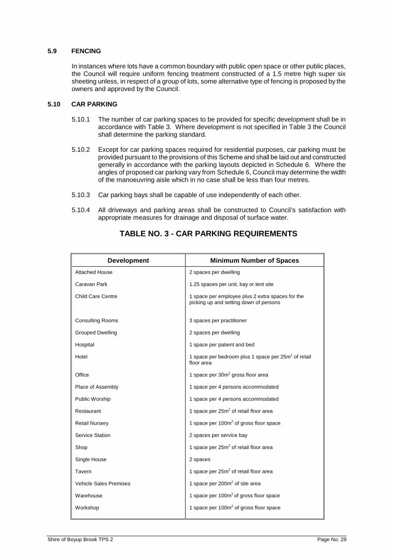
5.10.1 The number of car parking spaces to be provided for specific development shall be in accordance with Table 3. Where development is not specified in Table 3 the Council shall determine the parking standard.
5.10.2 Except for car parking spaces required for residential purposes, car parking must be
provided pursuant to the provisions of this Scheme and shall be laid out and constructed generally in accordance with the parking layouts depicted in Schedule 6. Where the angles of proposed car parking vary from Schedule 6, Council may determine the width of the manoeuvring aisle which in no case shall be less than four metres.
5.10.3 Car parking bays shall be capable of use independently of each other.
5.10.4 All driveways and parking areas shall be constructed to Council’s satisfaction with
appropriate measures for drainage and disposal of surface water.
TABLE NO. 3 - CAR PARKING REQUIREMENTS
Development Minimum Number of Spaces Attached House Caravan Park Child Care Centre Consulting Rooms Grouped Dwelling Hospital Hotel Office Place of Assembly Public Worship Restaurant Retail Nursery Service Station Shop Single House Tavern Vehicle Sales Premises Warehouse Workshop
2 spaces per dwelling 1.25 spaces per unit, bay or tent site 1 space per employee plus 2 extra spaces for the picking up and setting down of persons 3 spaces per practitioner 2 spaces per dwelling 1 space per patient and bed 1 space per bedroom plus 1 space per 25m2 of retail floor area 1 space per 30m2 gross floor area 1 space per 4 persons accommodated 1 space per 4 persons accommodated 1 space per 25m2 of retail floor area 1 space per 100m2 of gross floor space 2 spaces per service bay 1 space per 25m2 of retail floor area 2 spaces 1 space per 25m2 of retail floor area 1 space per 200m2 of site area 1 space per 100m2 of gross floor space 1 space per 100m2 of gross floor space
Shire of Boyup Brook TPS 2 Page No. 29
5.11 PROTECTION OF AMENITY
No building shall be so constructed, finished or left unfinished that its external appearance would, in the opinion of the Council, detract from the visual amenity of the locality or have the potential to depreciate the value of adjoining property. All land and buildings shall be used and maintained as to preserve the local amenity to the satisfaction of the Council.
5.12 NUISANCE
No land, building or appliance shall be used in such a manner as to permit the escape therefrom of smoke, dust, fumes, odour, noise, vibration or waste products in such quantity or extent, or in such a manner as, in the opinion of the Council, will create, or be a nuisance to, any inhabitant or to traffic or persons using roads in the vicinity.
5.13 LANDSCAPING
Landscaping shall be undertaken and maintained to Council’s satisfaction for all development unless, in the opinion of the Council, such landscaping is considered unnecessary. Such landscaping shall generally be located in such positions on a site or sites so as to enhance the appearance of any development or screen from view any parking area, open storage area, drying areas and any other space which, by virtue of its use, is likely to detract from the visual amenity of the surrounding area.
5.14 LAND LIABLE TO FLOODING AMD 15 GG 12/5/15 5.14.1 A person shall not carry out any development on land (or portion(s) thereof) identified as
flood prone land, unless:
(a) where no works have been carried out to protect the land from flooding, the floor of any dwelling or other habitable building is, or will be, raised a minimum of 50 centimetres above the 1 in 100 flood level, as determined by the local government, or where a 1 in 100 flood level has not been determined, above the maximum recorded flood level; or
(b) in any other case, the local government is satisfied that adequate measures have been taken to offset the likely effects of flooding on the development concerned.
5.14.2 In considering an application the local government shall have regard to:
(a) the effect of the proposed development on the efficiency and capacity of the floodway to carry and discharge flood water;
(b) the safety of the proposed development in time of flood; and
(c) whether the proposed development involves any possible risk to life, human safety or private property in time of flood.
5.14.3 For the purposes of sub-Clause 5.14.1 and 5.14.2, the local government may consult
with, and take into consideration, the advice of the Department of Health or the Department of Water, in relation to the delineation of floodways and flood prone land, the effect of the development on a floodway, and any other measures to offset the effects of flooding.
5.15 MAXIMUM BUILDING HEIGHT
No site shall be developed or building constructed to contain more than two storeys or exceed 10 metres in height measured to the highest proportion of the building from mean natural ground level, or such other ground level, as may be determined by Council.
Shire of Boyup Brook TPS 2 Page No. 30

Council may vary this requirement if it can be satisfied the development can comply with the development standards and:
a) Will not restrict light, sunshine and natural ventilation enjoyed by surrounding properties.
b) Will not intrude upon the privacy enjoyed by surrounding properties by virtue of
overview.
c) Will not diminish views or outlook available from surrounding properties.
d) Is sympathetic with the scale and character of the surrounding built environment. 5.16 PRIVACY
In considering a development proposal, Council shall have regard to its likely impact on privacy enjoyed by neighbouring developments and may impose conditions regarding the size, location and design of balconies, windows overlooking adjoining back yards or private spaces.
5.17 RE-SITED/TRANSPORTABLE DWELLINGS
AMD 1 GG 14/4/00
5.17.1 A relocated dwelling may not be transported to and placed on a lot within the district and thereafter occupied as a residential dwelling (whether in whole or in part) except with the approval of Council and in accordance with any conditions contained in such an approval.
5.17.2 In considering whether or not to grant approval for a relocated dwelling the Council shall
have special regard to:
(a) the appearance and external materials of the dwelling, and any proposed alterations thereto;
(b) the amenity of the locality;
(c) the visual prominence of the site;
(d) all applicable statutes, local laws and regulations relating to dwelling houses
applicable to both the relocated dwelling and the lot upon which it is to be located following transportation.
5.17.3 In granting an approval for a relocated dwelling the Council may impose conditions
including conditions which:
(a) require the applicant or owner to obtain a building license in accordance with Section 9 of the Building Act 2011; and/or AMD 15 GG 12/5/15
(b) require the applicant or owner to provide a bond or bank guarantee to Council as
surety for the completion of the relocated dwelling to a standard of presentation acceptable to Council within a specified time frame. Should Council require the provision of a bond, such monies so received shall be deposited in an Interest Bearing Trusts Account and upon the satisfactory completion of the necessary works, such monies owing shall be refunded.
5.18 PLANTATION
AMD 5 GG 25/9/98; AMD 15 GG 12/5/15
In addition to those other matters contained in Clause 5.2, Council shall, in considering applications for ‘Plantations’, have regard to – a) The Code of Practice for Timber Plantations in Western Australia;
b) Council’s Firebreak Order; and
c) FESA’s Guidelines for Plantation Fire Protection
Shire of Boyup Brook TPS 2 Page No. 31
5.19 AGROFORESTRY AND ALLEY FARMING AMD 5 GG 25/9/98
Agroforestry and Alley Farming as defined in Schedule 1 are permitted uses in the ‘Rural’ zone subject to compliance with all requirements of this Scheme.
5.20 REMNANT VEGETATION
Where, in the opinion of Council, and with the advice of the Department of Agriculture, land, the subject of an application to subdivide or commence development, is degraded, Council may require the land owner to undertake such measures to rehabilitate the land to a satisfactory standard and to protect it from further degradation.
5.21 DEVELOPMENT OF LAND WITH NO ACCESS AMD 15 GG 12/5/15 5.21.1 The approval of Council is required to use or develop land where:
(a) it abuts an unconstructed road reserve and no alternative means of access has been approved by Council; or
(b) it has no frontage to a road reserve and no alternative means of access has been approved by Council.
5.21.2 In considering such an application the Council may either:
(a) refuse the application; or (b) approve the application subject to a condition requiring the construction of the
road to the local government’s prescribed standard; or
(c) approve the application subject to a condition requiring such other arrangements to be made for permanent access to the land to the satisfaction of the Council.
5.22 TOURIST ACCOMMODATION AND FACILITIES AMD 15 GG 12/5/15 5.22.1 The use and development of land for a tourist resort may only occur on a lot which has
been included in either the Special Use or Additional Use zones. 5.22.2 That in considering an application for a tourist use the Council will have regard to:
(a) the objectives of the zone;
(b) the likely impact upon surrounding development;
(c) the scale and intensity of the development
(d) appropriate setbacks to existing or proposed agricultural uses;
(e) the effect that existing or proposed agricultural uses could have on the proposal;
(f) provision of services for the development including water supply, on site effluent disposal, solid waste disposal and electricity;
(g) access to and from the site;
(h) impact of the development upon landscape values;
(i) protection of remnant vegetation
(j) the impact on any rare and threatened flora and fauna; and
(k) fire management.
Shire of Boyup Brook TPS 2 Page No. 32

PART 6 - HERITAGE – PRECINCTS AND PLACES OF CULTURAL SIGNIFICANCE
6.1 PURPOSE AND INTENT
6.1.1 The purpose and intent of the heritage provisions are:
(a) to facilitate the conservation of places of heritage value;
(b) to ensure as far as possible that development occurs with due regard to heritage values.
6.2 HERITAGE LIST AMD 15 GG 12/5/15
6.2.1 The local government is to establish and maintain a Heritage List, to identify those places within the Scheme area which are of cultural heritage significance and worthy of conservation under the provisions of the Scheme, together with a description of each place and the reasons for its entry.
6.2.2 In preparation of the Heritage List the local government is to –
(a) have regard to the municipal inventory prepared by the local government under section 45 of the Heritage of Western Australia Act 1990;
(b) include on the Heritage List such of the entries on the municipal inventory as it
considers to be appropriate; and (c) until such time as Council has established a Heritage List, the Heritage List
means the municipal inventory prepared by Council pursuant to section 45 of the Heritage of Western Australia Act 1990.
6.2.3 In considering a proposal to include a place on the Heritage List the local government is
to –
(a) notify in writing the owner and occupier of the place and provide them with a copy of the description proposed to be used under Clause 6.2.1 and the reasons for the proposed entry;
(b) invite submissions in the proposal from the owner and occupier if the place
within 21 days of the day the notice is served; (c) carry out such other consultations as it thinks fit; and (d) consider any submissions made and resolve to enter the place the Heritage List
with or without modification or reject the proposal after consideration of the submissions.
6.2.4 Where a place is included on the Heritage List, the local government is to give notice of
the inclusion to the Commission, the Heritage Council of Western Australia and to the owner and occupier of the place.
6.2.5 The local government is to keep a copy of the Heritage List with the Scheme documents
for public inspection. 6.2.6 The local government may remove or modify the entry of a place on the Heritage List by
following the procedures set out in Clause 6.2.3.
Shire of Boyup Brook TPS 2 Page No. 33
6.3 DESIGNATION OF HERITAGE PRECINCTS
6.3.1 The Council may designate an area of land to be a heritage precinct where, in the opinion of the Council, special planning control is needed to conserve and enhance the heritage values and character of the area.
6.3.2 The Council shall adopt for each heritage precinct a policy statement which shall
comprise:
(a) a map showing the boundaries of the precinct;
(b) a list of places of heritage significance;
(c) objectives and guidelines for the conservation of the precinct.
6.3.3 The Council shall keep a copy of the policy statement for any designated heritage precinct with the Scheme documents for public inspection during normal office hours.
6.3.4 The procedure to be followed by the Council in designating a heritage precinct shall be
as follows:
(a) the Council shall notify in writing each owner of land affected by the proposal;
(b) the Council shall advertise the proposal by way of a notice in a newspaper circulating in the district, by the erection of a sign in a prominent location in the area affected by the designation, and by such other methods as the Council consider necessary to ensure widespread notice of the proposal, describing the area subject of the proposed designation and where the policy statement which applies to the precinct may be inspected;
(c) the Council shall invite submissions on the proposal within 28 days of the date
specified in the notice referred to immediately above;
(d) the Council shall carry out such other consultations as it thinks fit;
(e) the Council shall consider any submissions made and resolve to designate the heritage precinct with or without modification or reject the proposal after consideration of submissions;
(f) the Council shall forward notice of its decision to the Heritage Council of WA and
Western Australian Planning Commission.
6.3.5 The Council may modify or may cancel a heritage precinct or any policy statement which relates to it by following the procedure set out in sub-clause 6.3.4 above.
6.4 APPLICATIONS FOR PLANNING APPROVAL
6.4.1 In dealing with any matters which may affect a heritage precinct or individual entry on the Heritage List, including any application for planning approval, Council shall have regard to any heritage policy of the Council.
6.4.2 The Council may, in considering any application that may affect a heritage precinct or
individual entry on the Heritage List, solicit the views of the Heritage Council of WA and any other relevant bodies, and take those views into account when determining the application.
6.4.3 Notwithstanding any existing assessment on record, Council may require a heritage
assessment to be carried out prior to the approval for any development proposed in a heritage precinct or individual entry listed on the Heritage List.
Shire of Boyup Brook TPS 2 Page No. 34
6.4.4 For the purposes of clause 6.1 of the Scheme the term ‘development’ shall have the meaning as set out in the Town Planning and Development Act 1928 (as amended) but shall also include, in relation to any place entered in the Heritage List or contained within a heritage precinct, any act or thing that is likely to significantly change the external character of the building, object, structure or place.
6.5 FORMALITIES OF APPLICATION
6.5.1 In addition to the application formalities prescribed in clause 6.4 and any formalities or requirements associated with applications for planning approval contained in any other provision of the Scheme, the Council may require an applicant for planning approval, where the proposed development may affect a place of cultural heritage significance or a heritage precinct, to provide one or more of the following to assist the Council in its determination of the application:
(a) street elevations drawn to a scale not smaller than 1:100 showing the proposed
development and the whole of the existing development on each lot immediately adjoining the land the subject of the application, and drawn as one continuous elevation;
(b) in addition to a site plan, a plan of the proposed development site showing
existing and proposed ground levels over the whole of the land the subject of the application, and the location, type and height of all existing structures and of all existing vegetation exceeding two metres in height, and marking any existing structures and vegetation proposed to be removed; such plan shall be drawn to the same scale as the site plan;
(c) a detailed schedule of all finishes, including materials and colours of the
proposed development and, unless the Council exempts the applicant from the requirement or any part of it, the finishes of the existing developments on the subject lot and on each lot immediately adjoining the subject lot; and
(d) any other information which the Council indicates that it considers relevant.
6.6 VARIATIONS TO SCHEME PROVISIONS
6.6.1 Where desirable to facilitate the conservation of a heritage place or to enhance or preserve heritage values, the Council may vary any provision of the Scheme provided that, where in the Council’s opinion the variation of a provision is likely to affect any owners or occupiers in the general locality or adjoining the site which is the subject of consideration for variation, the Council shall:
(a) consult the affected parties by following one or more of the provisions dealing
with advertising uses pursuant to clause 3.5; and
(b) have regard to any expressed views prior to making its decision to grant the variation.
6.6.2 In granting variations under sub-clause 6.6.1 the Council may enter into a heritage
agreement under Part 4 of the Heritage of Western Australia Act 1990 with an owner who would benefit from the variation. The agreement may specify the owner’s obligations and contain memorials noted on relevant Certificates of Title.
Shire of Boyup Brook TPS 2 Page No. 35

PART 7 - GUIDED DEVELOPMENT AREA 7.1 THE SUBJECT LAND
The provisions of this Part relate to the area (hereinafter referred to as the ‘Development Area’) shown upon the Guided Development Area Plan (hereinafter referred to as the ‘Development Plan’ and included as Map 2 forming part of this Scheme) and in respect of which land Council will coordinate and guide future subdivision and development.
7.2 GENERAL OBJECTIVES
a) To facilitate, coordinate and promote the progressive subdivision of the land within the Development Area.
b) To indicate a pattern of subdivision which the Council will pursue unless an alternative or
modified design is proposed and approved by Council pursuant to the following provisions of this Part.
c) To set aside land for Public Open Space and vesting the same in the Crown as a
Reserve for Recreation.
d) To provide for the sharing of the costs of the Development Plan among land owners.
e) To provide for the proper drainage of those parts of the Development Area that require drainage, including the provision of satisfactory connections to other drainage systems outside the Development Area.
f) To provide the Council with the power to resume land where necessary to achieve the
objectives of the Development Plan. 7.3 METHOD BY WHICH OBJECTIVES ARE TO BE ACHIEVED
7.3.1 Subdivision
In general, the Council will not seek to compel an owner to subdivide his land unless the failure to do so would, in the Council’s view, impede the progressive implementation of the Development Plan.
Subdivision and development of land within the Development Area shall be carried out generally in accordance with the plan of subdivision shown on the Development Plan or in accordance with an alternative plan of subdivision which may be approved by the Western Australian Planning Commission as a Structure Plan in accordance with Clause 10.1.5, provided that any such approval is given: AMD 14 GG 27/3/15
(a) where the Western Australian Planning Commission, following consultation with
the Council, is satisfied that the objectives of the Development Plan will still be capable of achievement;
(b) where it can be demonstrated that the alternative form of subdivision will not
prejudice the proper and/or orderly subdivision of the remainder of the land within the Development Area, in accordance with a revised overall plan indicating the manner on which coordinated subdivision may be achieved, together with the provision of services, and in particular, surface water drainage. Subdivision and Development pursuant to this Clause may be carried out:
(i) by the owners of the land;
(ii) by groups of owners of the land;
(iii) by the Council, being an owner of land within the Development Area acquired pursuant to the provisions of this Scheme; or
Shire of Boyup Brook TPS 2 Page No. 36
(iv) by any body or corporation appointed by the owners of land within the Development Area of the Council for the purpose of developing that land.
7.3.2 Roads and Footways
(a) Upon the grant by the Western Australian Planning Commission of its final
approval to a plan of subdivision, any owner of land within the Development Area, when subdividing his/her land shall:
(i) make available all land necessary for all roads, rights of way, footways
and pedestrian access ways, and (ii) subject to the following clauses, carry out all work necessary for the
survey, construction, paving and drainage of all roads, rights of way and pedestrian access ways, or
(iii) pay the Council the cost of all or part of such work he/she may request
the Council to carry out on his/her behalf. (iv) In cases where existing lots have frontage to Terry Road and Gibbs
Street, pay to the Council one half (1/2) of the cost of constructing these roads to the same standard as those new roads within the Development Area.
(b) Where work involving the survey, construction, paving and drainage of any road,
right of way, footway, or pedestrian access way is carried out by an owner on his/her land, but such work serves or benefits other land within the Development Area, then the owners of the land so served or benefited shall contribute to the cost of such works in such proportions as the Council may, at its discretion, determine. In the event that the owners of the land and the Council are unable to agree upon the proportion of the costs payable by each of them, the amount (if any) payable by each owner shall be determined by arbitration in the manner hereinafter provided.
(c) The Council may survey, construct, pave and drain any new roads and footways
within the Development Area and acquire the land necessary for that purpose. If the Council does so prior to the subdivision of the land adjoining such road or footway, the costs of the survey, construction, paving and drainage of the said road or footway and all compensation and other costs consequent upon the acquisition of the land shall be paid to the Council by owners of the land adjoining the road or footway in accordance with the foregoing provisions prior to the grant by the Western Australian Planning Commission of final approval to the subdivision of this land or at such later date as may be agreed in writing between the subdivider and the Council.
(d) If any owner subdivides his/her land and if he/she or any predecessor in title, has
claimed, or has been paid compensation for a new road or footway within the Development Area, he/she shall, before the final approval by the Western Australian Planning Commission to his/her plan of subdivision, release the Council from the compensation paid by it to him/her, to his/her predecessors in title as the case may be.
Shire of Boyup Brook TPS 2 Page No. 37
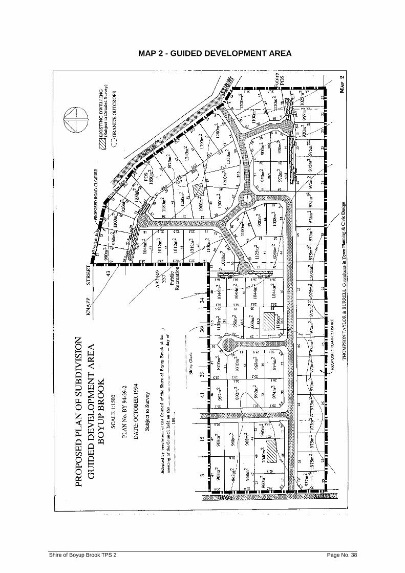
MAP 2 - GUIDED DEVELOPMENT AREA
Shire of Boyup Brook TPS 2 Page No. 38

7.3.3 Public Open Space
(a) It is intended that the land shown as ‘Public Open Space’ on the Development Plan shall be vested in the Crown as a Reserve for Recreation.
(b) The Council may, as and when it deems fit, acquire the said land shown as
Public Open Space, or any parts thereof, either by purchase or resumption or partly by one another.
(c) When land set aside for Public Open Space pursuant to this Development Plan
has been acquired by Council and the surrounding subdivision has been completed, Council shall vest such Public Open Space in the Crown as a Reserve for Recreation.
(d) Each owner of land, upon final approval by the Western Australian Planning
Commission to the Diagram or Plan of Survey giving effect to the subdivision of his/her land or any part thereof, and subject to the ensuing provisions of this part shall:
(i) Vest in the Crown as Reserves for Recreation all of the land as shown
as being set aside for Public Open Space on the Development Plan. (ii) Where no Public Open Space is shown affecting a landowner’s present
holding, transfer to the Council an area of land equal to ten per centum (10%) of the gross area of that land holding.
(iii) Where an area of less than ten per centum (10%) of Public Open Space
is shown affecting an owner’s present land holding, transfer to the Council, following compliance with Sub-clause (i), an area of land equal to the amount by which the Public Open Space falls short of the said ten per centum of the gross area of that land holding.
(e) If within an owner’s land, more than the said ten per centum is required by the
Council for Public Open Space, the owner shall, upon the subdivision of his/her land or any part thereof, vest in the Crown as a Reserve for Recreation the land required for that purpose and the Council shall pay to the owner, by way of compensation, the value of the land exceeding the said one tenth. If the Council and the owner so agree, the Council may transfer to the said owner other land acquired by it for that purpose to compensate him/her for the land in excess of the said one tenth required by the Council in which case the amount of compensation payable by the Council to that owner shall be reduced accordingly.
(f) If, pursuant to Sub-Clause (d) (ii), it is not possible for an owner to transfer an
area of land exactly equal to one tenth of the gross area being subdivided, he/she shall transfer to the Council land as nearly as possible equal to the said one tenth of the gross area being subdivided and the Council shall pay to, or receive from, the owner a cash adjustment representing the value of the area of land by which the area transferred exceeds or is less than the said one tenth or the Council may agree on a cash payment in lieu of the transfer of any land.
(g) Land to be transferred to the Council pursuant to Clause (d) shall not include any
land which is, or is intended to be, a road or part of a road created by the subdivision or a pedestrian access way or drainage reserve unless in the latter the land can serve a dual function.
(h) The Council may sell or otherwise dispose of any land transferred to it under the
preceding clauses and, as required by it for Public Open Space purposes, provided that all monies received by the Council in respect of such sales shall, after making all necessary payments to owners under the foregoing clauses and, after payment to it of the cost of land (if any) acquired for transfer to owners under the Clause (e), be expended by the Council in the acquisition or improvement of land for Public Open Space within the Development Area.
Shire of Boyup Brook TPS 2 Page No. 39

(i) If the Council resumes land for Public Open Space, roads, footways or recreation or community uses or drainage purposes, it shall be reimbursed for all the compensation and costs of monies received from the sale of land under the preceding clauses.
(j) If the Council resumes land for Public Open Space, roads, footways or for
drainage purposes, the amount and value of the said one tenth of an owner’s land shall be assessed on the basis that such land has not been resumed.
(k) For the purpose of the foregoing clauses, the valuations shall be made on the
basis that the whole of the owner’s land is offered for sale taking into account that the subdivision can be approved but not on the basis of the total of the values of the individual lots in the subdivision.
(l) If an owner of land subdivides his/her land and if he/she or any predecessor in
title has claimed or has been paid compensation by reason of the resumption by the Council of land for Public Open Space within the Development Area, the amount of compensation paid shall be taken into account in assessing the payments to, or by, an owner in accordance with the foregoing Clauses and if no compensation has then been paid the owner shall release the Council from the payment of any such compensation.
(m) Council shall exercise its powers under this section of the Scheme in accordance
with the provisions of Section 20C(2) of the Town Planning and Development Act 1928.
7.3.4 Drainage
The Council shall, at the appropriate time or times, carry out such drainage works as, in its opinion, are necessary for the proper drainage of the Development Area where such works by virtue of their size and location cannot be undertaken by the subdividers or individual land holders within the Development Area. The Council may undertake such works and may acquire all necessary easements for drainage purposes both within and outside the Development Area. The costs of providing drainage facilities and works, except those required to be met by each land owner to service his land, and the cost of acquiring land and easements within, or outside the Development Area, shall be borne by the Council as a Development Plan Cost.
7.3.5 Water Supply
A reticulated water supply service is to be made available in the Development Area and each subdividing owner shall be responsible for the cost of the reticulation of that service throughout the land owned by him/her.
If water supply head works are required to enable the service to be provided, then the cost thereof shall be borne by the owners in the same proportions set out hereunder in Clause 7.5.1
7.4 DEVELOPMENT PLAN COSTS
7.4.1 For the purpose of this Part, Development Plan Costs (hereinafter called Plan Costs) are as follows:
(a) the costs of an incidental to the preparation, administration and implementation
of the Development Plan including amounts to reimburse Council for:
(i) All administration costs incurred in the preparation of the Development Area by Council’s officers, agents or servants.
(ii) All administration costs incurred in the implementation and supervision of
the effective operation of the Plan by Council’s officers, agents or servants.
Shire of Boyup Brook TPS 2 Page No. 40
(iii) All legal costs, planning costs, payment to planning consultants and other professional consultants and valuation costs.
(b) The cost of any survey carried out by Council in the Development Area except
those surveys carried out by or for the Council acting as a land owner.
(c) The cost of any drainage works necessary for the proper drainage of the Development Area and acquisition of lands or easements for that purpose, both within and outside the Development Area, excluding those costs to be paid by subdividers as subdivision costs.
(d) The cost of supplying water to and throughout the Development Area, as
provided for in Clause 7.3.5.
(e) The costs (if any) of the resumption or other acquisition of Public Open Space within the Development Area.
(f) All compensation payable and all costs and expenses incurred in determining
and settling compensation.
(g) All interest accruing from time to time on monies borrowed by Council for the purpose of the Development Plan.
(h) All other costs and expenses which the Council shall be required to meet or
consider to be necessary to implement and complete the Development Area which are not recoverable by virtue of the other provisions of this Plan.
7.4.2 Costs and expenses not referred to in the foregoing Clause are deemed to be
subdivision costs and shall be borne by the subdivider in each case. 7.5 PAYMENT OF PLAN COSTS
7.5.1 An owner’s proportion of Plan Costs is the proportion which the nett subdivisible area of his/her land bears to the whole of the nett subdivisible area of land in the Development area.
7.5.2 Schedule No. 7 shows land ownership as at the date of the Scheme and the appropriate
land area together with calculations of nett subdivisible areas prepared from the Development Plan. The figures in this Schedule may be adjusted by Council in the light of survey information and any alteration to the Plan may be approved pursuant to this Scheme.
7.5.3 Each owner shall, prior to the final approval of the Western Australian Planning
Commission to the subdivision of his/her land, pay to the Council the owner’s proportion of the Plan Costs, but the Council shall not demand nor seek to enforce payment before the day upon which the owner makes application to the Commission for that final approval, unless the owner has agreed to pay his/her proportion of the Plan costs before that date.
7.5.4 The Council may accept the transfer to it of subdivided, serviced lots or other land within
the Development Area in satisfaction or partial satisfaction of an owner’s liability to pay his/her proportion of Plan Costs.
7.5.5 In the event of a dispute arising between the Council and a land owner about the
payment of and/or calculation of Plan Costs the matter shall be referred, either by the owner of the land or Council, for determination by an arbitrator under the Commercial Arbitration Act 1985.
Shire of Boyup Brook TPS 2 Page No. 41

7.6 ESTIMATE OF PLAN COSTS
If any of the items of Plan Costs have not been paid or ascertained at the time of the subdivision of a parcel of land at the time of the giving of a notice by the Council as aforesaid, the Council may estimate the cost of such items of Plan Costs. An estimate may be revised from time to time.
7.6.1 Prior to the commencement of any subdivision and associated development within the
Guided Development Area, Council shall prepare a Schedule setting out Plan Costs and the obligations of all relevant parties in so far as that subdivision and associated development are concerned, and give notice of the preparation of this Schedule on all relevant land owners within the Guided Development Area.
7.7 DEVELOPMENT STANDARD
For the purpose of Parts 3 and 5 of this Scheme Text, Council, in making its decisions upon applications for planning approval, will endeavour, within the Development Area, to set and maintain a high standard of building design, construction and appearance by requiring that:
a) all new buildings be constructed of brick, stone or masonry or similar material giving a
pleasing external appearance with tiled or simulated roofs, or
b) buildings constructed of materials not mentioned in Clause a) above be finished externally with supplementary site works to ensure harmony with the quality of residential development normally encountered in areas where large residential brick and tiled buildings have been constructed.
c) No relocated dwellings constructed of second hand building materials may be erected in
the Development Area.
Shire of Boyup Brook TPS 2 Page No. 42
PART 8 - CONTROL OF ADVERTISEMENTS 8.1 POWER TO CONTROL ADVERTISING
8.1.1 For the purpose of this Scheme, the erection, placement and display of advertisements and the use of land or buildings for that purpose in development within the definition of the Act requires, except as otherwise provided, the prior approval of the Council. Such planning consent is required in addition to any licence pursuant to Council’s Signs, Hoarding and Bill Posting Bylaws.
8.1.2 Application for Council’s consent pursuant to this Part shall be submitted in accordance
with the provisions of Clause 3.4 of the Scheme and shall be accompanied by a completed Additional Information Sheet in the form set out at Schedule 8 giving details of the advertisement(s) to be erected, placed or displayed on the land.
8.2 EXISTING ADVERTISEMENTS
Advertisements which:-
a) were lawfully erected, placed or displayed prior to the approval of this Scheme; or
b) may be erected, placed or displayed pursuant to a licence or other approval granted by the Council prior to the approval of this Scheme, hereinafter in this part referred to as ‘existing advertisements’;
may, except as otherwise provided, continue to be displayed or be erected and displayed in accordance with the licence or approval as appropriate.
8.3 CONSIDERATION OF APPLICATIONS
Without limiting the generality of the matters which may be taken into account when making a decision upon an application for consent to erect, place or display an advertisement, Council shall examine each such application in the light of the objectives of the Scheme and with particular reference to the character and amenity of the locality within which it is to be displayed, including its historic or landscape significance and traffic safety, and the amenity of adjacent areas which may be affected.
8.4 EXEMPTIONS FROM THE REQUIREMENT TO OBTAIN CONSENT
Subject to the provisions of the Main Roads (Control of Signs) Regulations, 1983 and notwithstanding the provisions of Clause 8.1.1, the Council’s prior consent is not required in respect of those advertisements listed in Schedule 9 which, for the purpose of this Part, are referred to as ‘exempted advertisements’. The exemptions listed in Schedule 9 do not apply to places, buildings, conservation areas or landscape protection zones which are either:
a) listed by the National Trust; b) listed in the register of the National Estate; c) listed in the Heritage List referred to in Part 6 of this Scheme.
8.5 DISCONTINUANCE
Notwithstanding the Scheme objectives and Clause 8.4, where the Council can demonstrate exceptional circumstances which can cause an exempted or existing advertisement to seriously conflict with the objectives of this Part, it may, by notice in writing (giving clear reasons), require the advertiser to remove, relocate, adapt, or otherwise modify the advertisement within a period of time specified in the notice.
Shire of Boyup Brook TPS 2 Page No. 43
8.6 DERELICT OR POORLY MAINTAINED SIGNS
Where, in the opinion of the Council, an advertisement has been permitted to deteriorate to a point where it conflicts with the objectives of the Scheme or it ceases to be effective for the purpose for which it was erected or displayed, Council may, by notice in writing, require the advertiser to:
a) repair, repaint or otherwise restore the advertisement to a standard specified by Council
in the notice, or b) remove the advertisement.
8.7 NOTICES
8.7.1 ‘The advertiser’ shall be interpreted as any one or any group comprised of the land owner, occupier or licensee.
8.7.2 Any notice served in exceptional circumstances pursuant to Clause 8.5 or pursuant to
Clause 8.6 shall be serviced upon the advertiser and shall specify:
(a) the advertisement(s) the subject of the notice;
(b) full details of the action or alternative courses of action to be taken by the advertiser to comply with the notice;
(c) the period, not being less than 60 days, within which the action specified shall be
completed by the advertiser.
8.7.3 Any person upon which or whom a notice is served pursuant to this Part may within a period of 60 days from the date of the notice appeal to the Hon. Minister for Planning or the Town Planning Appeal Tribunal in accordance with Part V of the Act, and where any such appeal is lodged the effect of the notice shall be suspended until the decision to uphold, quash or vary the notice is known and shall thereafter have effect according to that decision.
8.8 SCHEME TO PREVAIL
Where the provisions of this Part are found to be at variance with the provisions of the Council’s Signs, Hoardings and Bill Posting Bylaws, the provisions of the Scheme shall prevail.
8.9 ENFORCEMENT AND PENALTIES
The offences and penalties provisions specified in Clause 9.2 of the Scheme apply to the advertiser in this Part.
Shire of Boyup Brook TPS 2 Page No. 44
PART 9 - ADMINISTRATION 9.1 POWERS OF THE SCHEME
9.1.1 The Council in implementing the Scheme has, in addition to all other powers vested in it, the following powers:
(a) The Council may enter into any agreement with any owner, occupier or other
person having an interest in land affected by the provisions of the Scheme in respect of any matters pertaining to the Scheme.
(b) The Council may acquire any land or buildings within the district pursuant to the
provisions of the Scheme or the Act. The Council may deal with, or dispose of, any land which it has acquired pursuant to the provisions of the Scheme or the Act in accordance with the law and for such purpose may make such agreements with other owners as it considers fit.
(c) An officer of the Council, authorised by the Council for the purpose, may at all
reasonable times and with such assistance as may be required, enter any building or land for the purpose of ascertaining whether the provisions of the Scheme are being observed.
9.2 OFFENCES
9.2.1 No person shall depart from or permit or suffer any departure from the requirements and provisions of the Scheme, nor shall any person use or suffer or permit the use of any land or building or undertake or suffer or permit the undertaking of any development within the Scheme Area:
(a) otherwise than in accordance with the provisions of the Scheme;
(b) unless all approvals required by the Scheme have been granted and issued;
(c) unless all conditions imposed upon the grant and issue of any approval required
by the Scheme have been and continue to be complied with;
(d) unless all standards laid down and all requirements prescribed by the Scheme or determined by the Council pursuant to the Scheme with respect to that building or that use of that part have been and continue to be complied with.
9.2.2 Any person who fails to comply with any of the provisions of the Scheme is guilty of an
offence and without prejudice to any other remedy given herein is liable to such penalties as are prescribed by Section 10 of the Act.
9.3 COMPENSATION
9.3.1 Except as otherwise provided, the time limit for the making of claims for compensation for injurious affection pursuant to Section 11 of the Act resultant from the making of, or the making of an amendment to, the Scheme is six (6) months from the date of publication of the Scheme or the Scheme Amendment in the Government Gazette.
9.3.2 Where, in respect of any application for planning approval to commence and carry out
development on land reserved under this Scheme, the Council, or any appellate body thereafter, refuses or grants approval subject to conditions such that the effect of the decision is to permit the land to be used or developed for no purpose other than a public purpose, the owner of the land may, within six (6) months of the date of the relevant decision, claim compensation from the Council for injurious affection.
Shire of Boyup Brook TPS 2 Page No. 45
9.4 ELECTION TO PURCHASE AND VALUATION
9.4.1 Where compensation for injurious affection is claimed pursuant to either sub-clauses 9.3.1 or 9.3.2, the Council may, at its option elect to acquire the land so affected instead of paying compensation.
9.4.2 Where the Council elects to acquire the land in respect of which a claim for
compensation for injurious affection is made, the Council shall give notice of that election to the claimant by notice in writing within three (3) months of the claim for compensation being made.
9.4.3 Where the Council elects to acquire land as provided in sub-clause 9.4.1, if the Council
and the owner of the land are unable to agree as to the price to be paid for the land by the Council, the price at which the land may be acquired by the Council shall be the value of the land as determined in accordance with sub-clause 9.4.4.
9.4.4 The value of the land referred to in sub-clause 9.4.3 shall be the value thereof on the
date that the Council elects to acquire the land and that value shall be determined:
(a) by arbitration in accordance with the Commercial Arbitration Act 1985; or
(b) by some other method agreed upon by the Council and the owner of the land,
and the value shall be determined without regard to any increase or decrease, if any, in value attributable wholly or in part to this Scheme.
9.4.5 The Council may deal with or dispose of land acquired for a Local Reserve or pursuant
to the preceding sub-clause 9.4.4 upon such terms and conditions as it thinks fit provided the land is used for, or preserved for, a use compatible with the use for which it was reserved.
9.5 RIGHT OF REVIEW
An applicant aggrieved by a determination of the Council in respect of the exercise of a discretionary power under the Scheme may apply for review to the State Administrative Tribunal in accordance with Part 14 of the Act.
9.6 PLANNING POLICIES
9.6.1 The Council may prepare a planning policy (hereinafter called “a Policy”) which may make a provision for any matter related to the planning or development of the Scheme Area and which may be prepared so as to apply:
(a) generally or in a particular class of matter or in particular classes of matters; and
(b) throughout the Scheme Area or in one or more parts of the Scheme Area
and may amend or add to or rescind a Policy so prepared.
9.6.2 A Policy shall become operative only after the following procedures have been
completed: (a) The Council having prepared and adopted a draft Policy shall publish a notice
once a week for two consecutive weeks in a local newspaper circulating within the Scheme Area giving details of where the draft Policy may be inspected, and in what form and during what period (being not less than 21 days) submissions may be made.
(b) Policies which the Council considers may be inconsistent with other provisions of
the Scheme or with State and regional planning policies are to be submitted to the Commission for consideration and advice.
Shire of Boyup Brook TPS 2 Page No. 46
(c) The Council shall review the draft Policy in the light of any submissions made and advice received and shall then resolve either to finally adopt the draft Policy with or without modification, or not to proceed with the draft Policy.
(d) Following final adoption of a Policy, notification of the final adoption shall be
published once in a newspaper circulating within the Scheme Area.
9.6.3 The Council shall keep copies of any Policy with the Scheme documents for public inspection during normal office hours.
9.6.4 An amendment or addition to a Policy may be made after the Policy has become
operative and shall be made in the same manner as provided for the making of a Policy in sub-clause 9.6.2.
9.6.5 A Policy may be rescinded by:
(a) preparation or final adoption of a new Policy pursuant to this clause, specifically
worded to supersede an existing Policy; and
(b) publication of a formal notice of rescission by the Council twice in a local newspaper circulating in the district.
9.6.6 A Policy shall not bind the Council in respect of any application for planning approval but
the Council shall have due regard to the provisions of the Policy and the objectives which the Policy is designed to achieve before making its decision.
9.6.7 Any policy prepared under this clause shall be consistent with the Scheme and where
any inconsistency arises the Scheme shall prevail. 9.7 DELEGATION
9.7.1 The Council may, either generally or in a particular case or cases, by resolution passed by an absolute majority of the Council, delegate to the following eligible persons the authority to deal with an application for Planning Approval made under this Scheme:
(a) a member of the Council being the Chairman of the committee required at the
direction of Council to consider and report upon all applications for planning approval within its municipal district, and being qualified by experience with the work of any such committee; and/or
(b) that officer of the Council, holding or eligible to hold a Municipal Town Planners
Certificate, appointed to the position of Town Planner for the purpose of the Local Government Act with overall responsibility for the planning functions of the Council or appointed by the Council to supervise the development control functions of the Council or, in the absence of such an officer, the Chief Executive Officer,
or those persons who from time to time occupy the positions referred to in (a) and (b) above.
9.7.2 Any delegation made under sub-clause 9.7.1 shall have effect for the period of twelve
(12) months following the resolution unless the Council stipulates a lesser or greater period in the resolution.
9.7.3 A delegation of authority pursuant to the provisions of this clause has effect and may be
exercised according to its tenor, but is revocable at the will of the Council and does not preclude the Council from exercising the power.
9.7.4 The performance of the function by a delegate under sub-clause 9.7.1 shall be deemed
to be the performance of the function by the Council in all circumstances where the Council is able to delegate its powers.
Shire of Boyup Brook TPS 2 Page No. 47
9.7.5 Without affecting the generality of the provisions of this clause, where in the exercise of any power under this Scheme the Council is required to form any opinion or view or have any state of mind or to consider to have due regard to any matter, then that requirement shall be satisfied if a person exercising delegated authority in respect of that power performs the function.
9.7.6 A resolution to revoke or amend a delegation under this clause may be passed by a
simple majority.
9.7.7 An officer or member exercising the power delegated pursuant to the provisions of this clause shall comply with the provisions of the Scheme governing the exercise of the power by the Council, insofar as such provisions are reasonably applicable.
9.7.8 A person who is or has been a delegate of the Council is not personally liable for
anything done or omitted in good faith in, or in connection with, the exercise or purported exercise of any powers conferred, or the carrying out of any duty imposed on the Council by this Scheme.
9.8 AMENDMENTS TO THE SCHEME
9.8.1 The Council shall keep the Scheme under constant review and where appropriate carry out investigations and study with a view to maintaining the Scheme as an up-to-date and efficient means for pursuing community objectives regarding development and land use.
9.8.2 The Council may, from time to time, initiate an amendment to the Scheme in
accordance with the Act and Regulations and shall give consideration to any application to have the Scheme amended.
9.8.3 In the case of a proposed amendment to the zoning of land other than requested by the
owner, the Council shall, before initiating any amendment to the Scheme, invite comment from the owner of the land concerned.
9.8.4 Council shall take into consideration any comments or submissions received in respect
of a proposed amendment to the Scheme and shall only proceed with the amendment where it is satisfied the amendment would be consistent with the objectives of the Scheme and would not be contrary to the public interest.
9.9 NOTICE FOR REMOVAL OF CERTAIN BUILDINGS
9.9.1 Twenty eight (28) days written notice is hereby prescribed as the notice to be given pursuant to section 10 of the Act for the removal of certain buildings.
9.9.2 Council may recover expenses under section 10(2) of the Act in a court of competent
jurisdiction. 9.10 POWERS & AUTHORITY OF COUNCIL - GUIDED DEVELOPMENT AREA
In addition to the power and authorities of Council referred to in Part 7, the Council shall have the following powers and authorities:
a) To resume any land within the Development Area for the purpose of a road, right of way,
footway, pedestrian access way or for public open space, educational establishments, community use, or for drainage or for any other purpose necessary for the effective implementation of the Plan.
b) If any owner of land within the Development Area does not proceed with the subdivision
or development of his/her land in accordance with the Plan or by reason of the nature of his/her land, he/she is unable to subdivide or develop and his/her failure to do so in the opinion of the Council will unduly delay the subdivision and development of the Development Area, the Council may resume or purchase the land of such owner of any part or parts thereof and proceed with the subdivision and development of the said land in accordance with the provisions of the plan.
Shire of Boyup Brook TPS 2 Page No. 48

c) In the event of the Council exercising its powers under Clause b) it shall have the powers of an owner in the subdivision, development and disposal of the said land. If land shall have been resumed and if the owner shall not have been paid compensation by reason of the resumption, the Council before selling the new land so subdivided and developed, shall offer the new lots to the original owner upon paying to the Council all Plan Costs involving all costs and expenses consequent upon the resumption, subdivision or development of the said land and upon his/her releasing the Council from all claims for compensation in respect of such resumption. The said offer shall be made in writing and if not accepted within one calendar month of the service thereof, the Council may proceed with the sale of the subdivided lots. All monies received by it from such sale shall be applied firstly in payment of all costs and expenses consequent upon such subdivision and secondly in payment of all compensation in respect of the resumption of the land. The balance, if any, of such moneys may be retained by the Council and shall be applied to the development of Public Open Space within the Development Area.
d) If the offer mentioned in Sub-Clause c) hereof be not accepted, the Council may retain
all or any part of the said land. If it does so it shall be responsible to pay such costs of subdivision of the land and compensation for its resumption as are then unpaid.
e) To dispose of any lots to which it becomes entitled whether under Sub-Clause b) hereof
or otherwise upon such terms and conditions as it may think fit and without limiting the generality of the foregoing, the Council may sell the lots singly or in groups and on the condition that buildings of a specific character with specified parking or other facilities shall, within a limited period, be constructed thereon or that the land and buildings be used for a specific purpose.
f) To extend the time within which payments are to be made to the Council and agree to
the securing of such payments.
g) To transfer any land owned by it or acquired by it and pursuant to the Scheme as compensation or part compensation and to enter into agreements relative to the determination and settling of compensation.
Shire of Boyup Brook TPS 2 Page No. 49
PART 10 – SPECIAL CONTROL AREAS AMD 14 GG 27/3/15 10.1 STRUCTURE PLAN AREAS 10.1.1 Map Designation and Interpretation 10.1.1.1 Structure Plan Areas are shown on the Scheme Map as SPA with an
associated number. A Schedule of these areas is set out at Schedule 13. 10.1.1.2 Clause 10.1, unless the context otherwise requires:
‘Proponent’ means any owner or owners of land to which the Proposed Structure Plan relates that has or have submitted that Proposed Structure Plan;
‘Proposed Structure Plan’ means a structure plan, which may apply to either
a local area or a district, that has been prepared in accordance with Clause 10.1.4; and
‘Structure Plan’ means a Proposed Structure Plan that has been approved
by both the Commission and adopted by the Council under Clause 10.1.5. 10.1.2 Purpose (a) To identify areas requiring comprehensive planning prior to subdivision and
development; (b) To coordinate subdivision, land use and development in areas requiring
comprehensive planning. 10.1.3 Planning Requirements 10.1.3.1 The provisions of Clause 10.1 apply to land in a Structure Plan Area, in
addition to the provisions applying to any underlying zone or reserve or any general provisions contained within Schedule 13.
10.1.3.2 The Council requires a Structure Plan for a Structure Plan Area, or any part
or parts of a Structure Plan Area, before recommending subdivision or approving development of land within the Structure Plan Area.
10.1.3.3 The Council may require a Structure Plan to be prepared for any land not
within a Structure Plan Area where it can be demonstrated that the land requires substantial pre-planning before decisions are made with respect to its use, subdivision or development and the provisions of the foregoing clauses shall apply as relevant to the preparation of any such plan.
10.1.3.4 Notwithstanding Clause 10.1.3.2, the Council may approve a development
or support a subdivision of the land in a manner that is consistent with the objectives of the underlying zone without requiring such a Structure Plan where, in its opinion, the proposal is of a minor nature, will not adversely affect the future subdivision or development of the land and where it can be demonstrated that it does not conflict with the future land use expectation of the Structure Plan Area.
10.1.3.5 Where a Structure Plan exists, the subdivision and development of land is to
generally be in accordance with the Structure Plan and any associated provisions contained in Schedules 3 or 12 as applicable and 13.
Shire of Boyup Brook TPS 2 Page No. 50
10.1.3.6 The Council or the Commission may, as a condition of adopting or approving a Proposed Structure Plan, require a more detailed Structure Plan in future if the Council or the Commission considers that it will be necessary to provide additional detail to the proposals contained in the Proposed Structure Plan.
10.1.3.7 Schedule 13 describes the Structure Plan Areas in more detail and sets out
the land use expectations and matters to be addressed in the preparation of Structure Plans.
10.1.4 Preparation of Structure Plans 10.1.4.1 A Structure Plan may include plans and other documents
10.1.4.2 A Structure Plan may, with the agreement of the local government, be prepared and implemented in stages, unless specified elsewhere in the Scheme.
10.1.4.3 In considering a Proposed Structure Plan for part only of a Structure Plan
Area, the Council may require the Proponent to demonstrate how planning for the subject land may be integrated with planning for the balance of the Structure Plan Area, including how broad land uses, essential services, main movement systems and major conservation and recreation areas are to be coordinated and the arrangements for implementation of the Structure Plan.
10.1.4.4 A Proposed Structure Plan shall contain information required by the Council
to satisfy the planning requirements of the Structure Plan Area, including the requirements specified in Schedule 13, and without limiting the generality of the foregoing, may include the following details:
(i) the area to which the Structure Plan applies; (ii) key opportunities and constraints of the Structure Plan Area including
landform, topography, hydrology, landscape, vegetation, soils, conservation and heritage values, ownership, land use, roads and public transport, and services;
(iii) the planning context for the Structure Plan Area including the regional
and neighbourhood structure, relevant strategies, Scheme provisions and policies and where appropriate, indicating how the Proposed Structure Plan is to be integrated into the surrounding area;
(iv) proposed major land uses, in particular, residential areas, public open
space, school sites, civic and community uses, commercial uses (including the location and hierarchy of commercial centres), mixed use, industrial and mixed business uses;
(v) the proposed indicative subdivision pattern, lot yields, lot sizes, and
general location of any major buildings; (vi) estimates of future population, and employment; (vii) provision for major infrastructure, including main drainage, sewerage,
water supply and other key infrastructure services; (viii) the proposed road network and hierarchy, public transport services,
and bicycle and pedestrian networks; (ix) the timeframe and staging of subdivision and development, and the
method of implementation, including any proposals for funding by development contributions;
Shire of Boyup Brook TPS 2 Page No. 51
(x) details as appropriate relating to: i) vehicular access and parking; ii) the location, orientation and design of buildings and the
space between buildings; iii) conservation areas; iv) heritage places; v) special development control provisions. 10.1.4.5 In considering a Proposed Structure Plan, the Council may require the
proponent to demonstrate how planning for the subject land may be integrated with planning for the Boyup Brook town site and surrounding area, including how broad land uses, essential services, main movement systems and major conservation and recreation areas are to be integrated and provide information on the arrangements for implementation.
10.1.5 Adoption and Approval of Structure Plans
10.1.5.1 A Proposed Structure Plan may be prepared by a proponent or the local
government. Where prepared by a proponent, the Proposed Structure Plan is to be submitted to the local government.
10.1.5.2 Upon receiving a Proposed Structure Plan, the Council is to either:
(i) determine that the Proposed Structure Plan is satisfactory for
advertising; (ii) determine that the Proposed Structure Plan is not to be advertised
until further details have been provided or modifications undertaken; or
(iii) determine that the Proposed Structure Plan is not satisfactory for
advertising and give reasons for this to the Proponent.
10.1.5.3 If within 60 days of receiving a Proposed Structure Plan for approval for advertising, or such longer period as may be agreed in writing between the Proponent and the local government, the Council has not made one of the determinations referred to in Clause 10.1.5.2, the Council is deemed to have determined that the Proposed Structure Plan is not satisfactory for advertising.
10.1.5.4 (i) Where the Proponent is aggrieved by a determination for the Council
under Clause 10.1.5.2 (ii), or (iii) or Clause 10.1.5.3, the Proponent may request the Council by notice in writing to forward the Proposed Structure Plan to the Commission.
(ii) Within 21 days of receiving a notice from the Proponent under Clause
10.1.5.4(i), the Council is to forward to the Commission: i) a copy of the Proposed Structure Plan; ii) details of the local government’s determination including any
modifications to the Proposed Structure Plan required by the local government; and
iii) any other information the Council considers maybe relevant to
the Commission’s consideration of approval of the Proposed Structure Plan for advertising.
Shire of Boyup Brook TPS 2 Page No. 52
(iii) Upon receiving a Proposed Structure Plan in accordance with Clause 10.1.5.4(ii), the Commission is to make one of the determinations referred to in Clause 10.1.5.2 and advise the Council and the Proponent accordingly.
(iv) If the Commission requires modifications to the Proposed Structure
Plan, the Commission is to consult with the Council prior to making its determination under Clause 10.1.5.4(iii).
(v) If within 60 days of receiving a Proposed Structure Plan under Clause
10.1.5.4(ii), or such longer period as may be agreed in writing between the Proponent and the Commission, the Commission has not made one of the determinations referred to in Clause 10.1.5.2, the Commission is deemed to have determined that the Proposed Structure Plan is not satisfactory for advertising.
10.1.5.5 Where the local government, or the Commission under Clause 10.1.5.4, has
determined that the Proposed Structure Plan is satisfactory for advertising, the Council is to:
(i) advertise, or require the Proponent to advertise, the Proposed
Structure Plan for public inspection by one or more of the methods of advertising proposals for development as set out in Clause 3.5 of the Scheme; and
(ii) give notice or require the Proponent to give notice in writing to: i) all landowners affected by the Proposed Structure Plan; and ii) such public authorities and other persons as the Council
nominates, and such advertisement and notice are to explain the scope and purpose of the Proposed Structure Plan, when and where it may be inspected, and invite submissions to the Council by a specified date being at least 21 days from the date of the notice and advertisement.
10.1.5.6 Within 14 days of determining that a Proposed Structure Plan is satisfactory
for advertising, the Council is to forward a copy of the Proposed Structure Plan to the Commission.
10.1.5.7 The Council is to consider all submissions received and within 60 days of
the latest date specified in the notice under Clause 10.1.5.5 is to either: (i) adopt the Proposed Structure Plan with or without modifications; or (ii) refuse to adopt the Proposed Structure Plan and give reasons for this
to the Proponent.
10.1.5.8 If within the 60 day period, or such further time as may be agreed in writing between the Proponent and the local government, the Council has not made one of the determinations referred to in Clause 10.1.5.7, the Council is deemed to have refused to adopt the Proposed Structure Plan.
10.1.5.9 Within 21 days of the Council making its determination under Clause
10.1.5.7, or deemed refusal under Clause 10.1.5.8, the Council is to forward to the Commission:
(i) a summary of all submissions and comments received by the Council
in respect of the Proposed Structure Plan, and the local government’s decisions or comments in relation to these;
Shire of Boyup Brook TPS 2 Page No. 53
(ii) the local government’s recommendation to the Commission to approve, modify or refuse to approve the Proposed Structure Plan; and
(iii) any other information the Council considers may be relevant to the
Commission’s consideration of the Proposed Structure Plan.
10.1.5.10 The Commission is to either: (i) approve the Proposed Structure Plan with or without modifications; or (ii) refuse to approve the Proposed Structure Plan and give reasons for
its decision to the Proponent and the local government.
10.1.5.11 If within 60 days of receiving the information referred to in Clause 10.1.5.9, or such further time as may be agreed in writing between the Proponent and the Commission, the Commission has not made one of the determinations referred to in Clause 10.1.5.10, the Commission is deemed to have refused to approve the Proposed Structure Plan.
10.1.5.12 If the Commission approves the Proposed Structure Plan, it is to notify the
Council and the Proponent of its decision within 14 days of the date of the Commission’s decision.
10.1.5.13 If the Commission requires modifications to the Proposed Structure Plan,
the Commission is to consult with the Council prior to approving the Proposed Structure Plan under Clause 10.1.5.10.
10.1.5.14 If the local government, following consultation with the Commission, is of the
opinion that any modifications to the Proposed Structure Plan is substantial, the Council may:
(i) readvertise the Proposed Structure Plan; or (ii) require the Proponent to readvertise the Proposed Structure Plan
and, thereafter, the procedures set out in Clause 10.1.5.5 onwards are to apply.
10.1.5.15 As soon as practicable after receiving notice of the approval of the
Proposed Structure Plan by the Commission, the Council is to adopt the Proposed Structure Plan and forward a copy of the Structure Plan to:
(i) the Proponent; (ii) the Commission; and (iii) any other appropriate person or public authority which the Council
thinks fit.
10.1.5.16 A Structure Plan is to be kept at the local government’s administrative offices, and is to be made available for inspection by any member of the public during office hours.
10.1.6 Change or Departure from Structure Plan
10.1.6.1 The Council may adopt a minor change to or departure from a Structure
Plan if, in the opinion of the local government, the change or departure does not materially alter the intent of the Structure Plan.
10.1.6.2 (i) The Council is to forward a copy of the minor change or departure to
the Commission within 14 days from the date of adopting the minor change or departure.
Shire of Boyup Brook TPS 2 Page No. 54
(ii) If the Commission considers that the change or departure adopted by the Council under Clause 10.1.6.1 materially alters the intent of the Structure Plan, then the Commission:
i) may require the Council to follow the procedures set out in
Clause 10.1.5 in relation to the change or departure; and ii) is to notify the Council of this requirement within 14 days.
10.1.6.3 Any change or departure from a Structure Plan that is not within Clause 10.1.6.1 is to follow the procedures set out in Clause 10.1.5.
10.1.7 Operation of Structure Plan
10.1.7.1 A Structure Plan commences operation on the date it is adopted by the
Council pursuant to Clause 10.1.5.15. 10.1.7.2 Subject to Clause 10.1.7.4, if a Structure Plan imposes a classification on
the land included in it by reference to reserves, zones, or Residential Design Codes then:
(i) the provisions of the Structure Plan apply to the land as if its
provisions were incorporated into the Scheme and it is binding and enforceable in the same way as corresponding provisions incorporated in the Scheme; and
(ii) provisions in the Scheme applicable to land in those classifications
under the Scheme apply to the Development Area.
10.1.7.3 Without limiting the generality of Clause 10.1.7.2, under a Structure Plan: (i) in the areas designated as zones, the permissibility of uses is to be
the same as set out in the Zoning Table as if those areas were zones under the Scheme having the same designation;
(ii) the standards and requirements applicable to the zones and
Residential Design Codes under the Scheme apply to the areas having correspondence designations under the Structure Plan:
(iii) the planning approval procedures including the procedures for the
approval of uses and developments under the Scheme are to apply as if the land were correspondingly zoned or reserved under the Scheme;
(iv) where land is classified as a local reserve, the rights, provisions and
procedures, and the obligations of the Council in regard to compensation set out in clauses 9.3 and 9.4 inclusive apply as if the land were correspondingly reserved under the Scheme; and
(v) any other provision, standard or requirement in the Structure Plan is
to be given the same force and effect as if it were a provision, standard or requirement of the Scheme.
10.1.7.4 A Structure Plan may distinguish between the provisions, requirements or
standards which are intended to have effect as if included in the Scheme, and any provisions, requirements, or standards which are only for guidance or such other purposes as stipulated in the Structure Plan.
10.1.7.5 If a provision of a Structure Plan which imposes a classification on the land
included in it by reference to reserves, zones or Residential Design Codes is inconsistent with a provision of the Scheme, then the provision of the Scheme prevails to the extent of any inconsistency.
Shire of Boyup Brook TPS 2 Page No. 55
10.1.8 Right of Review
10.1.8.1 The Proponent may seek a review, in accordance with Part 14 of the Act for any:
(i) determination or decision made by the Commission; (ii) requirement imposed by or modification sought by the Commission;
or (iii) determinations deemed to have been made by the Commission
under Clauses 10.1.5.4 or 10.1.5.11 in the exercise of the Commission’s powers under Clause 10.1.
10.1.8.2 The Proponent may seek a review, in accordance with Part 14 of the Act,
any decision made by the Council under Clause 10.1.6.1.
10.1.9 Transitional Provisions relating to Structure Plans and Subdivision Guide Plans
10.1.9.1 Subdivision Guide Plans and Structure Plans prepared, adopted and in operation under the provisions of this Scheme or any revoked Scheme continue in operation under the Scheme and shall be applied to the relevant land as if they were prepared, adopted and approved pursuant to the provisions of the Scheme.
10.1.9.2 Subdivision Guide Plans prepared and adopted for the purpose of guiding
the subdivision and development of land under a revoked Scheme with continued relevance for the purpose of implementing the Scheme shall continue to have force and effect.
Shire of Boyup Brook TPS 2 Page No. 56

SCHEDULES
SCHEDULE 1 – INTERPRETATIONS 1. GENERAL DEFINITIONS
AMD 15 GG 12/5/15 In the Scheme – "Act" means the Planning and Development Act 2005; “absolute majority” has the same meaning given to the term in the Local Government Act 1995; "advertisement" means any word, letter, model, sign, placard, board, notice, device or representation,
whether illuminated or not, in the nature of, and employed wholly or partly for the purposes of, advertisement, announcement or direction, and includes any hoarding or similar structure used, or adapted for use, for the display of advertisements/ The term includes any airborne device anchored to any land or building and any vehicle or trailer or other similar object placed or located so as to serve the purpose of advertising;
“amenity” means all those factors which combine to form the character of an area and shall include the
present and likely future amenity; “Building Code of Australia” means the Building Code of Australia 1996; “building envelope” means an area of land within a lot marked on a plan approved by the responsible
authority within which all buildings and effluent disposal facilities on the lot must be contained; “commercial vehicle” Any vehicle which council considers to be used for, or engaged in, commerce; “Commission” means the Western Australian Planning Commission established under Section 7 of the
Act; “conservation” has the same meaning given as in the Heritage of Western Australia Act 1990; “council” means the Council of the Shire of Boyup Brook; “cultural heritage significance” has the same meaning as in the Heritage of Western Australia Act
1990; “development” has the same meaning given to the term in the Act; “district” has the same meaning given to the term in the Act; “floor area” has the same meaning as in the Building Code of Australia 1996 published by the Australian
Building Codes board; “frontage”, when used in relation to a building that is used for –
a) residential purposes, has the same meaning as in the Residential Design Codes; and b) purposes other than residential purposes, means the road alignment at the front of a lot
and, if a lot abuts 2 or more roads, the one to which the building or proposed building faces;
“gazettal date”, in relation to a Scheme, means the date on which the Scheme is published in the
Gazette under section 87(3) of the Act; “heavy haulage vehicle” Any vehicle normally associated with the transportation of goods, livestock or
other uses (and includes buses) which Council considers to be of a commercial nature which, due to its size or load, is unable to be completely housed in a domestic garage or domestic outbuilding having a maximum floor area of 45m2 and in which no horizontal dimension is more than 15 metres;
Shire of Boyup Brook TPS 2 Page No. 57
“height” when used in relation to a building that is used for –
a) residential purposes, has the same meaning as in the Residential Design Codes; or b) purposes other than residential purposes, means the maximum vertical distance between
the ground level and the finished roof height directly above; “incidental use” means a use of premises which is ancillary and subordinate to the predominant use; “land” has the same meaning given to the term in the Act; “local government” means the Shire of Boyup Brook; “lot” has the same meaning as in the Act but does not include a strata or survey strata lot; “minerals” has the same meaning as in the Mining Act 1978; “Minister” means the Minister for Planning; “net lettable area (nla)” means the area of all floors within the internal finished surfaces of permanent
walls but excludes the following areas –
a) all stairs, toilets, cleaner’s cupboards, lift shafts and motor rooms, escalators, tea rooms and plant rooms, and other service areas;
b) lobbies between lifts facing other lifts serving the same floor; c) areas set aside as public open space or thoroughfares and not for the exclusive use of
occupiers of the floor or building; d) areas set aside for the provision of facilities or services to the floor or building where such
facilities are not for the exclusive use of occupiers of the floor or building; “non-conforming use” has the same meaning as it has in section 172 of the Act; “owner”, in relation to any land, includes the Crown and every person who jointly or severally whether at
law or in equity –
a) is entitled to the land for an estate in fee simple in possession; b) is a person to whom the Crown has lawfully contracted to grant the fee simple of that land; c) is a lessor or licensee from the Crown; or d) is entitled to receive or is in receipt of, or if the land were let to a tenant, would be entitled
to receive, the rents and profits from the land, whether as a beneficial owner, trustee, mortgagee in possession or otherwise;
“place”, in Part 7 (Heritage Protection) has the same meaning as it has in the Heritage of Western
Australia Act 1990; “Planning and Development Act” means the Act; “plot ratio” in the case of residential dwellings has the same meaning as in the Residential Design
Codes; “precinct” means a definable area where particular planning policies, guidelines or standards apply; “predominant use” means the primary use of premises to which all other uses carried out on the
premises are subordinate, incidental or ancillary; “premises” means land or buildings; “public authority” shall have the same meaning given to term in the Act; “Residential Design Codes” means the Residential Design Codes in Appendix 2 to the Western
Australian Planning Commission Statement of Planning Policy No 1, as amended from time to time;
“retail” means the sale or hire of goods or services to the public; Shire of Boyup Brook TPS 2 Page No. 58

“rural strategy” means the Local Rural Strategy, as endorsed by the Commission 24th May 2010 and any amendments thereto;
“schedule” means a schedule to a Scheme; “shire” Means the Shire of Boyup Brook; “substantially commenced” means that work or development the subject of a planning approval has
been begun by the performance of some substantial part of that work or development; “wholesale” means the sale of goods or materials to be sold by others; “zone” means a portion of the Scheme area shown on the map by distinctive colouring, patterns,
symbols, hatching or edging for the purpose of indicating the restrictions imposed by the Scheme on the use and development of land, but does not include a reserve or special control area.
2. LAND USE DEFINITIONS In the Scheme – “agriculture – extensive” means premises used for the raising of stock or crops but does not include
agriculture – intensive or animal husbandry – intensive; “agriculture – intensive” means premises used for trade or commercial purposes, including outbuildings
and earthworks, associated with the following –
a) the production of grapes, vegetables, flowers, exotic and native plants, or fruit or nuts; b) the establishment and operation of plant and fruit nurseries; c) the development of land for irrigated fodder production and irrigated pasture (including
turf farms); or d) aquaculture;
“agroforestry” means any planting of trees in farms where there is some degree of planned integration
of commercial tree production and conventional agriculture, consisting of belts, small blocks or widely dispersed trees;
“alley farming” means a form of agroforestry where trees are arranged in belts with conventional
agriculture in the ‘alley’ between trees; “amusement parlour” means premises open to the public, where the predominant use is for amusement
by means of amusement machines and where there are more than 2 amusement machines operating within the premises;
“ancillary accommodation” has the same meaning given to the term ancillary dwelling in the Residential
Design Codes; “ancillary dwelling” has the same meaning given to the term in the Residential Design Codes; “animal establishment” means premises used for the breeding, boarding, training or caring of animals
for commercial purposes but does not include animal husbandry – intensive or veterinary centre; “animal husbandry – intensive” means premises used for keeping, rearing or fattening of pigs, poultry
(for either egg or meat production), rabbits (for either meat or fur production) and other livestock in feedlots;
“art gallery” means premises used for the showing of works of art; “bed and breakfast” means a dwelling, used by a resident of the dwelling, to provide accommodation for
persons away from their normal place of residence on a short-term commercial basis and includes the provision of breakfast;
“betting agency” means an office or totalisator agency established under the Racing and Wagering
Western Australia Act 2003; Shire of Boyup Brook TPS 2 Page No. 59

“cabin” means an individual self-contained unit similar to chalet but may lack ensuite facilities and may comprise only one room and is designed for short-stay guests, forming part of a tourism facility and where occupation by any person is limited to a maximum of three months in any 12-month period;
“camping ground” has the same meaning as in the Caravan Parks and Camping Grounds Act 1995; “caravan park” has the same meaning as in the Caravan Parks and Camping Grounds Act 1995; “caretaker’s dwelling” means a dwelling on the same site as a building, operation, or plant, and
occupied by a supervisor of that building, operation or plant; “carpark” means premises used primarily for parking vehicles whether open to the public or not but does
not include any part of a public road used for parking or for a taxi rank, or any premises in which cars are displayed for sale;
“chalet” means an individual self-contained unit usually comprising cooking facilities, ensuite, living area
and one or more bedrooms designed to accommodate short-stay guests, forming part of a tourism facility and where occupation by any person is limited to a maximum of three months in any 12-month period;
“child care service” has the same meaning as in the Child Care Services Act 2007; “cinema/theatre” means premises where the public may view a motion picture or theatrical production; “civic use” means premises used by a government department, an instrumentality of the Crown, or the
local government, for administrative, recreational or other purposes; “club premises” means premises used by a legally constituted cub or association or other body of
persons united by a common interest; “community purpose” means the use of premises designed or adapted primarily for the provision of
educational, social or recreational facilities or services by organisations involved in activities for community benefit;
“consulting rooms” means premises used by no more than 2 health consultants for the investigation or
treatment of human injuries or ailments and for general outpatient care; “convenience store” means premises –
a) used for the retail sale of convenience goods commonly sold in supermarkets, delicatessens and newsagents, or the retail sale of petrol and those convenience goods;
b) operate during hours which include, but may extend beyond, normal trading hours; c) which provide associated parking; and d) the floor area of which does not exceed 300m2 net lettable area;
“corrective institution” means premises used to hold and reform persons committed to it by a court,
such as a prison and other type of detention facility; “dry cleaning premises” means commercial premises used for the cleaning of garments and other
fabrics by chemical processes; “dwelling” has the same meaning given to the term in the Residential Design Codes; “eco-tourist facility” means a form of tourist accommodation that is designed, constructed, operated
and of a scale so as not to destroy the natural resources and qualities that attract tourists to the location. The development should utilise sustainable power, have a low energy demand through incorporation of passive solar design, provide for low water consumption, ecologically sensitive waste processing and disposal with no pollutant product;
“educational establishment” means premises used for the purposes of education and includes a
school, tertiary institution, business college, academy or other educational centre; Shire of Boyup Brook TPS 2 Page No. 60
“entertainment centre” means land and buildings used for the amusement and entertainment of the public and includes amusement parlour, club premises, cinema/theatre, and reception centre;
“exhibition centre” means premises used for he display, or display and sale, of materials of an artistic,
cultural or historical nature, and includes a museum or art gallery; “family day care” has the same meaning as in the Child Care Services Act 2007; “farm stay” means a residential building, bed and breakfast, chalet or similar accommodation unit used
to accommodate short-stay guests on a farm or rural property and where occupation by any person is limited to a maximum of three months in any 12-month period;
“farm workers’ accommodation” means accommodation for persons involved in the operation of an
agricultural enterprise; “fast food outlet” means a premises used for the preparation, sale and serving of food to customers in a
form ready to be eaten without further preparation, primarily off the premises, but does not include a lunch bar;
“fuel depot” means premises used for the storage and sale in bulk of solid or liquid or gaseous fuel, but
does not include a service station and specifically excludes the sale by retail into a vehicle for final use of such fuel from the premises;
“funeral parlour” means a premises used to prepare and store bodies for burial or cremation; “guesthouse” means integrated premises for short-stay guests comprising serviced accommodation
units and on-site tourism facilities such as reception, centralised dining, and management, and where occupation by any person is limited to a maximum of three months in any 12-month period;
“grouped dwelling” has the same meaning given to the term in the Residential Design Codes; “holiday home” means a residential building used to provide accommodation for short-stay guests,
rather than permanent residency, and excluding those uses more specifically defined elsewhere; “home business” means a business, service or profession carried out in a dwelling or on land or in
buildings around a dwelling by an occupier of the dwelling which –
a) does not employ more than 2 people not members of the occupier’s household; b) will not cause injury to or adversely affect the amenity of the neighbourhood; c) does not occupy an area greater than 50m2; d) does not involve the retail sale, display or hire of goods of any nature; e) in relation to vehicles and parking, will not result in traffic difficulties as a result of the
inadequacy of parking or an increase in traffic volumes in the neighbourhood, and does not involve the presence, use or calling of a vehicle more than 3.5 tonnes tare weight; and
f) does not involve the use of an essential service of greater capacity than normally required in the zone;
“home occupation” means an occupation carried out in a dwelling or on land around a dwelling by an
occupier of the dwelling which –
a) does not employ any person not a member of the occupier’s household; b) will not cause injury to or adversely affect the amenity of the neighbourhood; c) does not occupy an area greater than 20m2; d) does not display a sign exceeding 0.2m2; e) does not involve the retail sale, display or hire of goods of any nature; f) in relation to vehicles and parking, does not result in the requirement for a greater number
of parking facilities than normally required for a single dwelling or an increase in traffic volume in the neighbourhood, does not involve the presence, use or calling of a vehicle more than 2 tonnes tare weight, and does not include provision for the fuelling, repair or maintenance of motor vehicles; and
g) does not involve the use of an essential service of greater capacity than normally required in the zone;
Shire of Boyup Brook TPS 2 Page No. 61
“home office” means a home occupation limited to a business carried out solely within a dwelling by a resident of the dwelling but which does not –
a) entail clients or customers travelling to and from the dwelling; b) involve any advertising signs on the premises; or c) require any external change to the appearance of the dwelling;
“home store” means any shop with a net lettable area not exceeding 100m2 attached to a dwelling and
which is operated by a person resident in the dwelling; “hospital” means a premises in which persons are admitted and lodged for medical treatment or care
and includes a maternity hospital; “hotel” means premises providing accommodation the subject of a hotel licence under the Liquor Control
Act 1988, and may include a betting agency on those premises, but does not include a tavern or motel;
“industry” means premises used for the manufacturing, dismantling, processing, assembly, treating,
testing, servicing, maintenance and repairing of goods, products, articles, materials or substances and includes premises on the same land used for –
a) the storage of goods; b) the work of administration or accounting; c) the selling of goods by wholesale or retail; or d) the provision of amenities for employees,
incidental to any of those industrial operations; “industry – cottage” means a trade or light industry producing arts and crafts goods which does not fall
within the definition of a home occupation and which:
a) does not cause injury to or adversely affect the amenity of the neighbourhood; b) where operated in a residential zone, does not employ any person other than a member
of the occupier’s household; c) is conducted in an out-building which is compatible within the principle uses to which land
in the zone in which it is located may be put; d) does not occupy an area in excess of 50m2; and e) does not display a sign exceeding 0.2m2 in area;
“industry-extractive” means an industry which involves the extraction, quarrying or removal of sand,
gravel, clay, hard rock, stone or similar materials from the land and includes the treatment and storage of those materials, or the manufacture of products from those materials on, or adjacent to, the land from which the materials are extracted, but does not include industry – mining;
“industry – general” means an industry other than a cottage, extractive, light, mining, rural or service
industry; “industry – hazardous” means an industry which by reason of the process involved or the methods of
manufacture, or the nature of the materials used or produced, requires isolation from other buildings;
“industry – light” means an industry –
a) in which the processes carried on, the machinery used, and the goods and commodities carried to and from the premises do not cause any injury to or adversely affect the amenity of the locality;
b) the establishment or conduct of which does not, or will not, impose an undue load on any existing or proposed service for the supply or provision of essential services;
“industry – mining” means land used commercially to extract minerals from the land; Shire of Boyup Brook TPS 2 Page No. 62
“industry – noxious” means an industry in which the processes involved constitute an offensive trade within the meaning of the Health Act. 1911 (as amended), but does not include a fish shop, dry cleaning premises, Laundromat, piggery or poultry farm;
“industry – rural” means –
a) an industry handling, treating, processing or packing rural products; or b) a workshop servicing plant or equipment used for rural purposes;
“industry – service” means –
a) an industry – light carried out from premises which may have a retail shop front and from which goods manufactured on the premises may be sold; or
b) premises having a retail shop from and used as a depot for receiving goods to be serviced;
“laundromat” means a building open to the public, in which coin-operated or other washing machines,
with or without provision for drying clothes, are available for use; “liquor store” means any land or buildings the subject of a Store License granted under the provisions of
the Liquor Control Act 1988 (as amended); “lodge” – see “guesthouse”; “lunch bar” means premises or part of premises used for the sale of takeaway food (in a form ready to
be consumed without further preparation) within industrial or commercial areas; “market” means premises used for the display and sale of goods from stalls from independent vendors; “medical centre” means premises, other than a hospital, used by one or more health consultant(s) for
the investigation or treatment of human injuries or ailments and for general outpatient care (including preventative care, diagnosis, medical and surgical treatments, and counselling);
“motel” means premises used to accommodate patrons in a manner similar to a hotel but in which
specific provision is made for the accommodation of patrons with motor vehicles and may comprise premises licenced under the Liquor Control Act 1988;
“motor vehicle, boat or caravan sales” means premises used to sell or hire motor vehicles, boats or
caravans; “motor vehicle repair” means premises used for or in connection with –
a) electrical and mechanical repairs, or overhauls to vehicles; b) repairs to tyres;
but does not include premises used for recapping or retreading of tyres, panel beating, spray
painting or chassis reshaping; “motor vehicle wrecking” means land and buildings used for the storage, breaking up or dismantling of
motor vehicles and includes the sale of second-hand motor vehicle accessories and spare parts; “multiple dwelling” has the same meaning given to the term in the Residential Design Codes; “museum” means land and buildings used for storing and exhibiting objects illustrative of antiquities,
natural history, art, nature and curiosities; “night club” means premises –
a) used for entertainment with or without eating facilities; and b) licensed under the Liquor Control Act 1988;
“nursery” means any land or building used for the propagation, rearing and sale of plants and the
storage and sale of products associated with horticultural and garden activities; Shire of Boyup Brook TPS 2 Page No. 63

“office” means premises used for administration, clerical, technical, professional or other like business activities;
“park home park” shall have the same meaning as in the Caravan Parks and Camping Grounds
Regulations 1997; “parking – commercial vehicles” means the use of a site or building for the parking or temporary
storage of commercial vehicles (as defined above) but does not include any part of a public road used for parking of such vehicles or any land or buildings in which such vehicles are displayed for sale and does not include the undertaking of any repairs to such vehicles;
“parking – heavy haulage vehicles” means the use of a site or building for the parking or temporary
storage of heavy haulage vehicles (as defined above) but does not include any part of a public road used for parking of such vehicles or any land or buildings in which such vehicles are displayed for sale and does not include the undertaking of any repairs to such vehicles;
“place of public assembly” means land and buildings used as a special place of assembly including
grounds for athletics, all sporting grounds with spectator provision, race courses, trotting tracks, studio or showgrounds;
“place of worship” means premises used for religious activities such as a church, chapel, mosque,
synagogue or temple; “plantation” has the same meaning as in the Code of Practice for Timber Plantations in Western
Australia (2006) published by the Department of Conservation and Land Management and the Australian Forest Growers;
“public amusement” means land and buildings used for the amusement or entertainment of the public,
with or without charge; “reception centre” means premises used for functions on formal or ceremonial occasions but not for
unhosted use for general entertainment purposes; “recreation – private” means premises used for indoor or outdoor leisure, recreation or sport which are
not usually open to the public without charge; “residence – resited or transportable” means a building intended for residential use which has been
constructed and inhabited in a completed form in a different location prior to establishment on a lot;
“residential building” has the same meaning as in the Residential Design Codes; “restaurant” means premises where the predominant use is the sale and consumption of food and drinks
on the premises and where seating is provided for patrons, and includes a restaurant licensed under the Liquor Control Act 1988;
“restricted premises” means premises used for the sale by retail or wholesale, or the offer for hire, loan
or exchange, or the exhibition, display or delivery of –
a) publications that are classified as restricted under the Classification (Publications, Film and Computer Games) Enforcement Act 1996;
b) materials, compounds preparations or articles which are used or intended to be used primarily in or in connection with any form of sexual behaviour or activity;
“rural pursuit” means any premises used for –
a) the rearing or agistment of animals; b) the stabling, agistment or training of horses; c) the growing of trees, plants, shrubs, or flowers for replanting in domestic, commercial or
industrial gardens; d) the sale of produce grown solely on the lot;
but does not include agriculture – extensive or agriculture – intensive; Shire of Boyup Brook TPS 2 Page No. 64

“serviced apartment” means a complex where all units or apartments provide for self-contained accommodation for short stay guests and where integrated reception and recreation facilities may be provided and where occupation by any person is limited to a maximum of 3 months in any 12-month period;
“service station” means premises used for –
a) the retail sale of petroleum products, motor vehicle accessories and goods of an incidental/convenience retail nature; and
b) the carrying out of greasing, tyre repairs and minor mechanical repairs to motor vehicles;
but does not include premises used for a transport depot, panel beating, spray painting, major repairs or wrecking;
“shop” means premises used to sell goods by retail, hire goods, or provide services of a personal nature (including a hairdresser and beauty therapist) but does not include a showroom or fast food outlet;
“showroom” means premises used to display, sell by wholesale or retail, or hire, automotive parts and
accessories, camping equipment, electrical light fittings, equestrian supplies, floor coverings, furnishings, furniture, household appliances, party supplies, swimming pools or goods of a bulky nature;
“single house” has the same meaning as in the Residential Design Codes; “storage” means premises used for the storage of goods, equipment, plant or materials; “tavern” means premises licensed as a tavern under the Liquor Control Act 1988 and used to sell liquor
for consumption on the premises; “telecommunications infrastructure” means land used to accommodate any part of the infrastructure
of a telecommunications network and includes any line, equipment, apparatus, tower, antenna, tunnel, duct, hole, pit or other structure used, or for use in or in connection with, a telecommunications network;
“tourist resort” means integrated, purpose-built luxury or experiential premises for short-stay guests
comprising accommodation units and on-site tourism facilities such as reception, restaurant and leisure facilities like swimming pool, gymnasium, tennis courts, and where occupation by any person is limited to a maximum of three moths in any 12-month period;
“trade display” means premises used for the display of trade goods and equipment for the purpose of
advertisement; “transport depot” means land or a building or buildings used for the parking or garaging of motor
vehicles which are used or intended to be used for the carriage of passengers or goods on a communal basis, or land or a building or buildings used for the transfer of goods from one such motor vehicle to another of such motor vehicles and included the maintenance and repair of such vehicles;
“veterinary centre” means premises used to diagnose animal disease or disorders, to surgically or
medically treat animals, or for the prevention of animal diseases or disorders and includes the accommodation of such animals.
“warehouse” means premises used to store or display goods and may include sale by wholesale; “wayside stall” means a building situated on private land which offers for sale to the general public
produce or any commodity which is produced on the land upon which the buildings are located; “winery” means premises used for the production of viticultural produce and may include the sale of the
produce; “woodyard” means land used for the purpose of storing firewood and includes the retailing of that
firewood. Shire of Boyup Brook TPS 2 Page No. 65
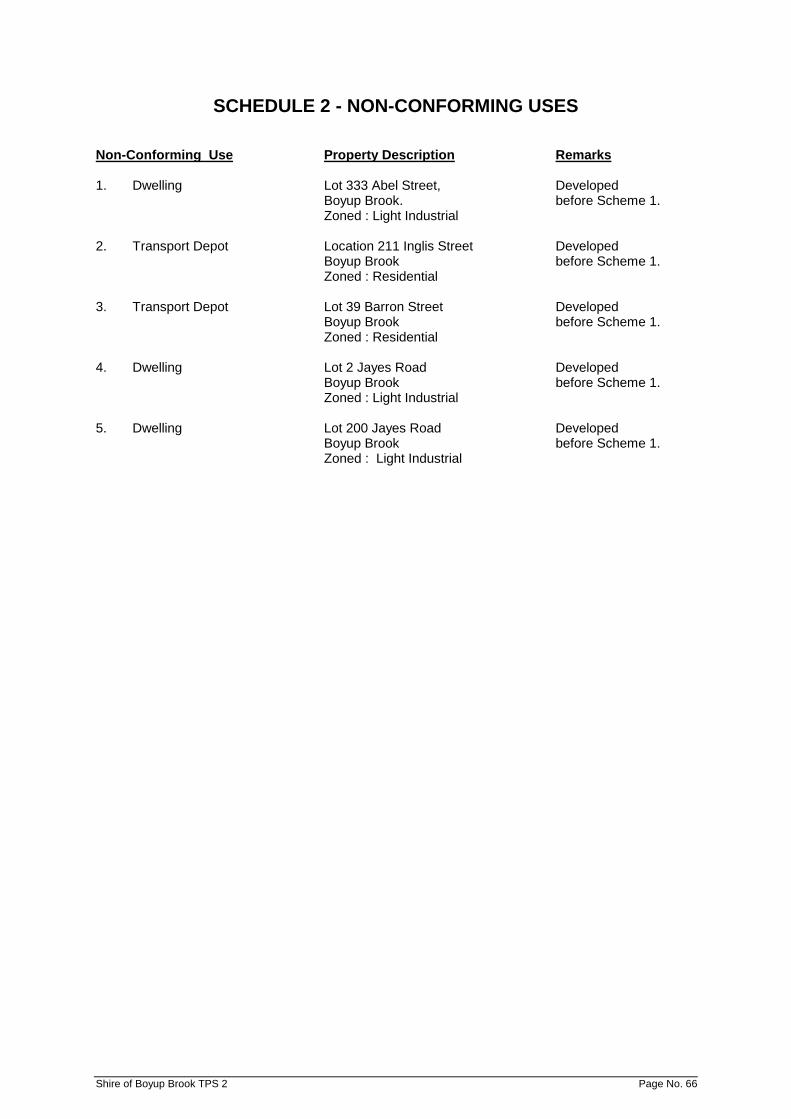
SCHEDULE 2 - NON-CONFORMING USES Non-Conforming Use Property Description Remarks 1. Dwelling Lot 333 Abel Street, Developed
Boyup Brook. before Scheme 1. Zoned : Light Industrial
2. Transport Depot Location 211 Inglis Street Developed
Boyup Brook before Scheme 1. Zoned : Residential
3. Transport Depot Lot 39 Barron Street Developed
Boyup Brook before Scheme 1. Zoned : Residential
4. Dwelling Lot 2 Jayes Road Developed
Boyup Brook before Scheme 1. Zoned : Light Industrial
5. Dwelling Lot 200 Jayes Road Developed
Boyup Brook before Scheme 1. Zoned : Light Industrial
Shire of Boyup Brook TPS 2 Page No. 66
SCHEDULE 3 - SPECIAL RURAL ZONES
SPECIAL PROVISION
LOCATION OF ZONE PERMITTED USES AND CONDITIONS OF DEVELOPMENT
Special Rural Zone No. 1 Lots 15, 16, 158 & 160 Doust Street, Lots 148-151 (inclusive) and Lots 154 - 157 (inclusive) Jayes Road and Lots 152, 153 & 212 Ritson Street and land north of Witham Street having frontage to Jayes Road, Boyup Brook
i) Subdivision to be generally in accordance with the Subdivision Guide Plan adopted for Special Rural Zone No 1 by the Council.
ii) The minimum lot size that shall be recommended shall
be 2Ha. iii) No further fragmentation of lots shall be recommended. iv) Uses permitted within the zone are:- AMD 15 GG 12/5/15
Ancillary Accommodation (P) Bed & Breakfast (P) Cabin (P) Chalet (AA) Guesthouse (AA) Holiday Home (AA) Home Business (SA) Home Occupation (SA) Home Office (SA) Industry - Cottage (SA) Industry – Light (SA)
Industry – Rural (SA) Public Recreation (P) Rural Pursuit (AA) Single House (P) Transport Depot (SA) Woodyard (SA)
All other uses are not permitted. v) Notwithstanding the requirements of Table No. 2, no
building shall be erected closer that 15m to any street or road boundary or 7.5m in respect of any other boundary.
Special Rural Zone No. 2 Part Nelson Locations 1005 & 799 Bridgetown - Boyup Brook Road, Boyup Brook
i) Subdivision to be generally in accordance with the Subdivision Guide Plan adopted for Special Rural Zone No 2 by the Council.
ii) the minimum lot size that shall be recommended shall
be 2ha. iii) No further fragmentation of lots shall be recommended. iv) Uses permitted within the zone are: AMD 15 GG 12/5/15
Ancillary Accommodation (P) Bed & Breakfast (AA) Cabin (AA) Chalet (SA) Guesthouse (SA) Holiday Home (P) Home Business (AA) Home Occupation (AA) Home Office (P) Industry – Cottage (AA) Public Recreation (P) Rural Pursuit (AA) Single House (P)
All other uses are not permitted. v) No other trees or substantial vegetation shall be felled or
removed from the site except where -
a) required for approved development works; b) required for fire protection purposes by regulation or
bylaw; or c) trees are diseased, dead or dangerous.
Shire of Boyup Brook TPS 2 Page No. 67
LOCATION OF ZONE PERMITTED USES AND CONDITIONS OF DEVELOPMENT vi) In order to protect soil erosion, Council may specify
stocking rates where it deems appropriate. If, in the opinion of Council or the Department of Agriculture, the activities of livestock on any lot are contributing to erosion, pollution or the degradation of vegetation, the landowner may be required to erect and maintain a fence of satisfactory standard in order to protect the area and exclude livestock therefrom. Alternatively, the land-owner may be required to remove, or Council may, at the expense of the landowner, remove livestock from the lot.
LOCATION OF ZONE PERMITTED USES AND CONDITIONS OF DEVELOPMENT
Special Rural Zone No. 3 Nelson Locations 711 & 695 & Part Location 8391 Terry Road, Boyup Brook
i) Subdivision to be generally in accordance with the Subdivision Guide Plan adopted for Special Rural Zone No. 3 by the Council.
ii) The minimum lot size that shall be recommended shall
be 2ha. iii) No further fragmentation of lots shall be recommended. iv) Uses permitted within the zone are:- AMD 15 GG 12/5/15
Ancillary Accommodation (P) Bed & Breakfast (AA) Cabin (AA) Chalet (SA) Guesthouse (SA) Holiday Home (P) Home Business (AA) Home Occupation (AA) Home Office (P) Industry – Cottage (AA) Public Recreation (P) Rural Pursuit (AA) Single House (P)
All other uses are not permitted.
v) No trees or substantial vegetation shall be felled or
removed from the site except where -
a) required for approved development works; b) required for approved development works; c) trees are diseased, dead or dangerous.
vi) In order to protect the natural environment and to
prevent soil erosion Council may specify stocking rates where it deems appropriate. If, in the opinion of Council or the Department of Agriculture, the activities of livestock on any lot are contributing to erosion, pollution or the degradation of vegetation, the landowner may be required to erect and maintain a fence of satisfactory standard in order to protect the area and exclude livestock therefrom. Alternatively, the landowner may be required to remove, or Council may, at the expense of the landowner, remove livestock from the lot.
vii) As a condition of planning consent on lots created,
Council shall require the planting and maintenance of thirty (30) native trees capable of growing to at least 3 metres in height on each lot significantly denuded of vegetation. The planting shall be concentrated around the proposed buildings and within the front setback.
viii) The subdivider will contribute to the provision of bush
fire fighting facilities to the specification and satisfaction of the Bush Fires Board and Council at the time of Subdivision.
Special Rural Zone No. 4 Lot 1 of Nelson Location 1302 Abels Road, Boyup Brook
i) Subdivision to be generally in accordance with the Subdivision Guide Plan adopted for Special Rural Zone No. 4 by the Council.
Shire of Boyup Brook TPS 2 Page No. 68
SCHEDULE 3 – SPECIAL RURAL ZONES (Continued) LOCATION OF ZONE PERMITTED USES AND CONDITIONS OF
DEVELOPMENT
ii) The minimum lot size that shall be recommended shall be 7ha.
iii) No further fragmentation of lots shall be recommended. iv) Uses permitted within the zone are:- AMD 15 GG 12/5/15
Ancillary Accommodation (P) Bed & Breakfast (AA) Cabin (AA) Chalet (SA) Guesthouse (SA) Holiday Home (P) Home Business (AA) Home Occupation (AA) Home Office (P) Industry – Cottage (AA) Public Recreation (P) Rural Pursuit (AA) Single House (P)
All other uses are not permitted
Special Rural Zone No. 4 Lot 1 of Nelson Location 1302 Abels Road, Boyup Brook (Cont'd)
v) In order to protect the natural environment and to prevent soil erosion Council may specify stocking rates where it deems appropriate. If, in the opinion of Council or the Department of Agriculture, the activities of livestock on any lot are contributing to erosion, pollution or the degradation of vegetation, the landowner may be required to erect and maintain a fence of satisfactory standard in order to protect the area and exclude livestock therefrom. Alternatively, the landowner may be required to remove, or Council at the expense of the landowner, remove livestock from the lot.
vi) No dwelling house, outbuilding or structure shall be
constructed unless it is within a building envelope defined on the Subdivision Guide Plan.
vii) Where, for the purpose of retaining natural flora, sound
environmental reasons or the physical constraints of a site dictate, Council may set an alternative building envelope.
viii) As a condition of planning consent on lots created, Council shall require the planting and maintenance of thirty (30) native trees capable of growing to at least 3 metres in height on each lot significantly denuded of vegetation. The planting shall be concentrated around the proposed buildings and between the street alignment and the building setback line unless otherwise stipulated by Council.
ix) The subdivider shall make arrangements to the
satisfaction of Council to ensure prospective purchasers are advised of the special provisions which apply to this Special Rural Zone and such other provisions of the Scheme that may affect it.
x) No trees or substantial vegetation shall be felled or
removed from the site except where -
a) required for approved development works; b) required for fire prevention purposes by regulation or
by-law; or c) trees are diseased, dead or dangerous.
xi) All buildings constructed shall, by virtue of materials and
design, be reasonably fire resistant. The Council shall from time to time specify its standards for fire resistant buildings.
Shire of Boyup Brook TPS 2 Page No. 69
SCHEDULE 3 – SPECIAL RURAL ZONES (Continued) LOCATION OF ZONE PERMITTED USES AND CONDITIONS OF
DEVELOPMENT
xii) The minimum vertical clearance between the bottom of any approved on-site effluent disposal system and the highest known ground water table or bedrock shall be 2.0 metres.
xiii) Notwithstanding the requirements of Table No. 2, no
building or outbuilding shall be erected closer than 20 metres to any street or road boundary or 15 metres in respect of any other boundary.
Shire of Boyup Brook TPS 2 Page No. 70
SCHEDULE 3 – SPECIAL RURAL ZONES (Continued) LOCATION OF ZONE PERMITTED USES AND CONDITIONS OF
DEVELOPMENT
Special Rural Zone No 5 Nelson Location 1044 Banks Road, Boyup Brook AMD 7 GG 14/4/00
i) Subdivision to be generally in accordance with the Subdivision Guide Plan adopted for Special Rural Zone No 5 by the Council.
ii) The minimum lot size that shall be recommended shall
be 3 ha. iii) No further fragmentation of lots shall be recommended. iv) Uses permitted within this zone are:- AMD 15 GG 12/5/15
Ancillary Accommodation (P) Bed & Breakfast (AA) Cabin (AA) Caretaker’s House (IP) Chalet (SA) Guesthouse (SA) Holiday Home (P) Home Business (AA) Home Occupation (IP) Home Office (P) Industry – Cottage (AA) Market Gardens (AA) Rural Pursuit (AA) Single House (P) Veterinary Centre (SA)
All other uses are not permitted.
v) In order to protect the natural environment and to
prevent soil erosion Council may specify stocking rates where it deems appropriate. If, in the opinion of the Council or Agriculture Western Australia, the activities of livestock on any lot are contributing to erosion, pollution or the degradation of vegetation, the landowner may be required to erect and maintain a fence of satisfactory standard in order to protect the area and exclude livestock therefrom. Alternatively the landowner may be required to remove, or Council may, at the expense of the landowner, remove livestock from the lot.
vi) The siting of any dwelling house, outbuilding or structure
on lots created will be subject to Council approval. Council shall take into account the factors of outlook, screening by existing vegetation, practicalities of building, privacy and conservation or existing vegetation when considering approval for such siting.
vii) As a condition of development approval Council may
require the developer to plant and maintain thirty (30) native trees capable of growing to at least 3 metres in height on each lot significantly denuded of vegetation. The planting shall be concentrated around the proposed buildings and between the street alignment and the building setback line unless stipulated by Council.
viii) No trees or substantial vegetation shall be felled or
removed from the site except where -
a) required for approved development works; b) required for fire prevention purposes by regulation or
by-law; or c) trees are diseased, dead or dangerous.
ix) Notwithstanding the provisions of Clause 5.3, no
building, outbuilding or fence shall be constructed of materials or be of a colour which, in the opinion of the Council is detrimental to the character of the natural landscape of the locality.
Shire of Boyup Brook TPS 2 Page No. 71
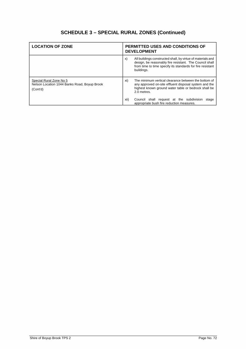
SCHEDULE 3 – SPECIAL RURAL ZONES (Continued) LOCATION OF ZONE PERMITTED USES AND CONDITIONS OF
DEVELOPMENT
x) All buildings constructed shall, by virtue of materials and design, be reasonably fire resistant. The Council shall from time to time specify its standards for fire resistant buildings.
Special Rural Zone No 5 Nelson Location 1044 Banks Road, Boyup Brook (Cont'd)
xi) The minimum vertical clearance between the bottom of any approved on-site effluent disposal system and the highest known ground water table or bedrock shall be 2.0 metres.
xii) Council shall request at the subdivision stage
appropriate bush fire reduction measures.
Shire of Boyup Brook TPS 2 Page No. 72
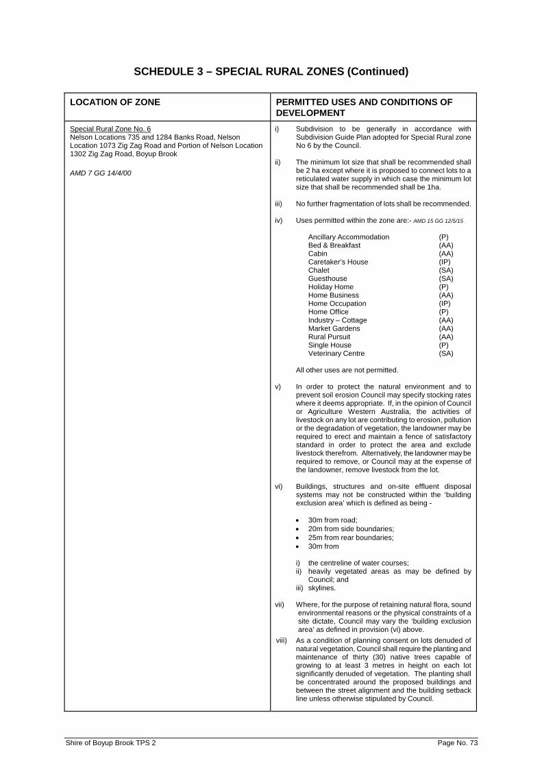
SCHEDULE 3 – SPECIAL RURAL ZONES (Continued) LOCATION OF ZONE PERMITTED USES AND CONDITIONS OF
DEVELOPMENT
Special Rural Zone No. 6 Nelson Locations 735 and 1284 Banks Road, Nelson Location 1073 Zig Zag Road and Portion of Nelson Location 1302 Zig Zag Road, Boyup Brook AMD 7 GG 14/4/00
i) Subdivision to be generally in accordance with Subdivision Guide Plan adopted for Special Rural zone No 6 by the Council.
ii) The minimum lot size that shall be recommended shall
be 2 ha except where it is proposed to connect lots to a reticulated water supply in which case the minimum lot size that shall be recommended shall be 1ha.
iii) No further fragmentation of lots shall be recommended. iv) Uses permitted within the zone are:- AMD 15 GG 12/5/15
Ancillary Accommodation (P) Bed & Breakfast (AA) Cabin (AA) Caretaker’s House (IP) Chalet (SA) Guesthouse (SA) Holiday Home (P) Home Business (AA) Home Occupation (IP) Home Office (P) Industry – Cottage (AA) Market Gardens (AA) Rural Pursuit (AA) Single House (P) Veterinary Centre (SA)
All other uses are not permitted.
v) In order to protect the natural environment and to
prevent soil erosion Council may specify stocking rates where it deems appropriate. If, in the opinion of Council or Agriculture Western Australia, the activities of livestock on any lot are contributing to erosion, pollution or the degradation of vegetation, the landowner may be required to erect and maintain a fence of satisfactory standard in order to protect the area and exclude livestock therefrom. Alternatively, the landowner may be required to remove, or Council may at the expense of the landowner, remove livestock from the lot.
vi) Buildings, structures and on-site effluent disposal
systems may not be constructed within the ‘building exclusion area’ which is defined as being -
• 30m from road; • 20m from side boundaries; • 25m from rear boundaries; • 30m from
i) the centreline of water courses; ii) heavily vegetated areas as may be defined by
Council; and iii) skylines.
vii) Where, for the purpose of retaining natural flora, sound
environmental reasons or the physical constraints of a site dictate, Council may vary the ‘building exclusion area’ as defined in provision (vi) above.
viii) As a condition of planning consent on lots denuded of natural vegetation, Council shall require the planting and maintenance of thirty (30) native trees capable of growing to at least 3 metres in height on each lot significantly denuded of vegetation. The planting shall be concentrated around the proposed buildings and between the street alignment and the building setback line unless otherwise stipulated by Council.
Shire of Boyup Brook TPS 2 Page No. 73

SCHEDULE 3 – SPECIAL RURAL ZONES (Continued) LOCATION OF ZONE PERMITTED USES AND CONDITIONS OF
DEVELOPMENT
Special Rural Zone No. 6 Nelson Locations 735 and 1284 Banks Road, Nelson Location 1073 Zig Zag Road and Portion of Nelson Location 1302 Zig Zag Road, Boyup Brook (Cont'd)
ix) No trees or substantial vegetation shall be felled or removed from the site except where -
a) required for approved development works; b) required for fire prevention purposes by regulation or
by-law; or c) trees are diseased, dead or dangerous.
x) Notwithstanding the provisions of Clause 5.3, no
building, outbuilding or fence shall be constructed of materials or be of a colour, which in the opinion of the Council, is detrimental to the character of the natural landscape of the locality.
xi) All buildings constructed shall, by virtue of materials and
design, be reasonably fire resistant. The Council shall from time to time specify its standards for fire resistant buildings.
xii) The minimum vertical clearance between the bottom of
any approved on-site effluent disposal system and the highest known ground water table or bedrock shall be 2.0 metres.
xiii) On-site disposal of effluent shall be to the specification
and satisfaction of Council and the Health Department of Western Australia.
Shire of Boyup Brook TPS 2 Page No. 74
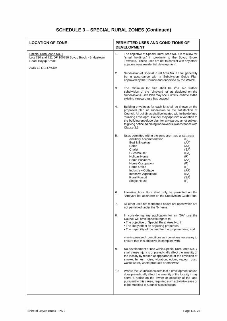
SCHEDULE 3 – SPECIAL RURAL ZONES (Continued) LOCATION OF ZONE PERMITTED USES AND CONDITIONS OF
DEVELOPMENT
Special Rural Zone No. 7 Lots 720 and 721 DP 100786 Boyup Brook - Bridgetown Road, Boyup Brook. AMD 12 GG 17/4/09
1. The objective of Special Rural Area No. 7 is to allow for "small holdings" in proximity to the Boyup Brook Townsite. These uses are not to conflict with any other adjacent rural residential development.
2. Subdivision of Special Rural Area No. 7 shall generally
be in accordance with a Subdivision Guide Plan approved by the Council and endorsed by the WAPC.
3. The minimum lot size shall be 2ha. No further subdivision of the “vineyard lot’ as depicted on the Subdivision Guide Plan may occur until such time as the existing vineyard use has ceased.
4. Building envelopes for each lot shall be shown on the proposed plan of subdivision to the satisfaction of Council. All buildings shall be located within the defined ‘building envelope”. Council may approve a variation to the building envelope plan for any particular lot subject to giving notice adjoining landowners in accordance with Clause 3.5.
5. Uses permitted within the zone are:- AMD 15 GG 12/5/15 Ancillary Accommodation (P) Bed & Breakfast (AA) Cabin (AA) Chalet (SA) Guesthouse (SA) Holiday Home (P) Home Business (AA) Home Occupation (P) Home Office (P) Industry – Cottage (AA) Intensive Agriculture (SA) Rural Pursuit (SA) Single House (P)
6. Intensive Agriculture shall only be permitted on the “vineyard lot” as shown on the Subdivision Guide Plan
7. All other uses not mentioned above are uses which are not permitted under the Scheme.
8. In considering any application for an “SA” use the Council will have specific regard to: • The objective of Special Rural Area No. 7; • The likely effect on adjoining properties; • The capability of the land for the proposed use; and
may impose such conditions as it considers necessary to ensure that this objective is complied with.
9. No development or use within Special Rural Area No. 7 shall cause injury to or prejudicially affect the amenity of the locality by reason of appearance or the emission of smoke, fumes, noise, vibration, odour, vapour, dust, waste water, waste products or otherwise.
10. Where the Council considers that a development or use does prejudicially affect the amenity of the locality it may serve a notice on the owner or occupier of the land pursuant to this cause, requiring such activity to cease or to be modified to Council’s satisfaction.
Shire of Boyup Brook TPS 2 Page No. 75

SCHEDULE 3 – SPECIAL RURAL ZONES (Continued) LOCATION OF ZONE PERMITTED USES AND CONDITIONS OF
DEVELOPMENT
Special Rural Zone No. 7 Lots 720 and 721 DP 100786 Boyup Brook - Bridgetown Road, Boyup Brook. AMD 12 GG 17/4/09
11. In order to protect the natural environment and to prevent soil erosion Council may specify stocking rates where it deems appropriate. If, in the opinion of Council or Agriculture Western Australia, the activities of livestock on any lot are contributing to erosion, pollution or the degradation of vegetation, the landowner may be required to erect and maintain a fence of satisfactory standard in order to protect the area and exclude livestock there from. Alternatively, the landowner may be required to remove, or Council may at the expense of the landowner, remove livestock from the lot.
12. Notwithstanding the provisions of Clause 5.3, no building, outbuilding or fence shall be constructed of materials or be of a colour, which in the opinion of the Council, is detrimental to the character of the natural landscape of the locality.
13. The landscaping areas shown on the Subdivision Guide Plan shall be established, enhanced and managed in accordance with a Landscaping Plan approved by the Council and the Department of Water and Department of Environment. The landscaping shall be established by the subdivider, to the satisfaction of the Council prior to the clearance of the subdivision being given.
14. No indigenous tree or substantial vegetation located outside of an approved building envelope may be felled or removed without the prior approval of Council. In considering an application Council will have regard to whether: • The trees are dead, diseased or dangerous; • The clearing is for the purpose of a firebreak or for
fuel reduction purposes; and • The clearing is required for any approved
development works.
15. A Fire Management Plan shall be prepared and implemented in accordance with ‘Planning for Bush Fire Protection’, to the satisfaction of the Council and Fire and Emergency Services of Western Australia. It shall include provision of, and access to, a strategic water supply for fire fighting, and implementation of appropriate Building Protection zones. Driveways longer than 50 metres in length shall be constructed to the satisfaction of Council to allow for access by fire service vehicles.
16. Driveways longer than 50m in length shall be constructed to the satisfaction of Council to allow for access by fire service vehicles.
17. On-site disposal of effluent shall be to the specification and satisfaction of Council and the Department of Health.
18. No subdivided lots shall be permitted to have direct
vehicular access to the Boyup Brook—Bridgetown Road. This does not apply to the existing access points for the house and vineyard pending the subdivision of these areas in accordance with the Guide Plan.
Shire of Boyup Brook TPS 2 Page No. 76
SCHEDULE 3 – SPECIAL RURAL ZONES (Continued) LOCATION OF ZONE PERMITTED USES AND CONDITIONS OF
DEVELOPMENT
Special Rural Zone No. 7 Lots 720 and 721 DP 100786 Boyup Brook - Bridgetown Road, Boyup Brook. AMD 12 GG 17/4/09
19. Council may request, to the Western Australian Planning Commission, that any subdivision approval include a requirement for a notification to be placed on the Certificates of Title of the proposed lots, pursuant to Section 70A of the Transfer of Lands Act 1893 (as amended) advising of the operation of the existing vineyard and that rural activity may have a nuisance effect on amenity.
20. Battle-axe access ways are to be constructed to the requirements and satisfaction of the Council.
Special Rural Zone No. 8 Lots 734 Banks Road, Boyup Brook AMD 13 GG 26/10/12
1. Plan of Subdivision
(a) Subdivision of ‘Special Rural No. 8’ shall be generally in accordance with an approved Structure Plan approved by Council and endorsed by the WAPC.
(b) The minimum lot size shall be not less than 2 hectares.
2. Objectives of Zone
(a) The objectives of the ‘Special Rural No. 8’ zone are to –
• Provide for rural residential lifestyle opportunities in close proximity to Boyup Brook town centre;
• Provide for the further subdivision of the land in a manner that respects the site’s characteristics, constraints and opportunities;
• Provide for development in accord with the objectives of the Local Rural Strategy; and
• Minimize the visual impact of development and further subdivision.
3. Structure Plan
(a) A Structure Plan is to be submitted to and approved by the Shire of Boyup Brook and endorsed by the WAPC prior to the subdivision or development of the land.
(b) The Structure Plan is to have regard to the following
issues –
• The proposed road layout and impacts on the district and local road network;
• Proposed road connections for district purposes; • The remnant vegetation protection areas; • Topographic conditions, particularly drainage
implications; • Traffic and other connections and distribution of
land uses; • Bushfire hazard and proposed fire management
measures; • Building envelopes; and • Landscaping areas.
4. Permissibility of Uses AMD 15 GG 12/5/15
Uses permitted within the zone are:- Ancillary Accommodation (P) Bed & Breakfast (AA) Cabin (AA) Chalet (SA) Guesthouse (SA) Holiday Home (P) Home Business (AA) Home Occupation (P) Home Office (P) Industry – Cottage (AA) Single House (P)
(a) All other uses not mentioned above are uses which are
not permitted under the Scheme. (b) In considering any application for an ‘SA’ use the Council
will have specific regard to –
• The objective of the ‘Special Rural Zone No. 8’; • The likely effect on adjoining properties; • The capability of the land for the proposed use;
Shire of Boyup Brook TPS 2 Page No. 77
SCHEDULE 3 – SPECIAL RURAL ZONES (Continued) LOCATION OF ZONE PERMITTED USES AND CONDITIONS OF
DEVELOPMENT
And may impose such conditions as it considers necessary to ensure that this objective is complied with.
5. Keeping of Livestock/Animals
(a) Intensive agricultural pursuits such as piggeries are not permitted. The keeping of livestock for domestic purposes shall be restricted to fenced pastured areas of a lot. The owner shall be responsible for the construction and maintenance of stock proof fencing to protect remnant vegetation and revegetation areas. Animal numbers shall not exceed the stocking rates recommended by the Department of Agriculture. The keeping of animals shall not result in the removal or damage of vegetation or trees and/or result in soil degradation and/or dust nuisance.
(b) Where in the opinion of Council the continued
presence of animals on any portion of land is likely to contribute, or is contributing to dust nuisance and/or soil degradation, notice may be served on the owner of the land requiring immediate removal of those animals specified in the notice.
(c) Where notice has been served on an owner in
accordance with this Clause the Council may also require the land to be rehabilitated to its satisfaction within 90 days of serving the notice.
(d) In the event that such action is not undertaken, Council
may carry out the works as deemed necessary, with all costs being borne by the owner.
6. Location of Buildings and Structures
(a) All buildings shall be located within the defined “building envelope”. Council may approve a variation to the building envelope plan for any particular lot subject to giving notice to adjoining landowners in accordance with Clause 3.5.
(b) All buildings and structures shall be located outside of
the ‘Remnant Vegetation Protection’ areas marked on an approved Structure Plan.
(c) All buildings are to be setback a minimum of 15
metres from Banks Road and 30 metres from all other lot boundaries, unless depicted otherwise on an approved Structure Plan.
7. Building Design, Materials and Colour
(a) Dwellings and outbuildings shall be designed and constructed of materials, which allow them to blend into the landscape of the site. Walls and roofs shall not be constructed of reflective materials such as unpainted ‘zincalume’ and ‘offwhite’ colours. Council will be supportive of walls and roofs with green, brown or red toning in keeping with the amenity of the area.
(b) Water tanks shall be painted or coloured an
appropriate shade to blend into the landscape or suitably screened with vegetation to the satisfaction of Council.
8. Vegetation Protection and Revegetation
(a) Vegetation in the “Remnant Vegetation Protection” areas may be cleared where –
• The trees are dead, diseased or dangerous; • The clearing is for the purpose of a firebreak or for
fuel reduction purposes; and • The clearing is for the purpose of a firebreak or for
fuel reduction purposes; and
(b) The landscaping areas shown on the Structure Plan shall be established, enhanced and managed in accordance with a Landscaping plan approved by the
Shire of Boyup Brook TPS 2 Page No. 78
SCHEDULE 3 – SPECIAL RURAL ZONES (Continued) LOCATION OF ZONE PERMITTED USES AND CONDITIONS OF
DEVELOPMENT Council and the Department of Water and Department of Environment and Conservation.
9. Effluent Disposal
(a) The disposal of liquid and/or solid wastes shall be carried out with an effluent disposal system approved by Council and the Health Department of WA. Systems shall be designed and located to minimise nutrient export and/or release into any waterway or groundwater. Effluent disposal areas for new dwellings shall be setback a minimum of 50 metres from a natural watercourse. A reduced setback will only be acceptable where it can be demonstrated that the characteristics of the site (i.e. soil type, vegetation, topography, habitat, etc) will provide sufficient nutrient absorption to allow for a reduced setback.
(b) Council shall require the use of amended soil type effluent disposal systems, such as ATU Systems where a 100 metre setback from the edge of the creek line cannot be achieved.
(c) At subdivision a geotechnical report shall be provided to demonstrate that the areas where septic tank systems are proposed to be used are capable of disposing of effluent within each lot.
10. Access
(a) All driveways and underground infrastructure shall be designed and constructed so as to avoid erosion impacts and storm water runoff to the satisfaction of Council.
11. Fire Management
(a) A fire management plan is to be prepared and implemented to the satisfaction of the Shire of Boyup Brook and FESA.
(b) A Fire Management Plan is to be prepared in conjunction with a Landscaping Plan.
(c) To provide appropriate fire management the existing plantation, or parts thereof, shall be harvested prior to the subdivision of the land.
(d) All dwellings shall be constructed in accordance with Australian Standard AS3959 (2009) as amended.
12. Notification of Prospective Owners
(a) Council may require the subdivider to make arrangements satisfactory to Council to ensure prospective purchasers of land within Special Rural No. 8 are given a copy of these Special Provisions prior to entering into an agreement to acquire any property.
13. Battleaxe lots
(a) Battleaxe access ways are to be constructed to the requirements and satisfaction of the Council.
14. Banks Road Upgrade
(a) Council may request the Western Australian Planning Commission that any subdivision approval include a requirement that the applicant is to contribute to the upgrading of Banks Road to a sealed standard to access the subdivision, consistent with the Council W.07 Road Contribution policy.
Shire of Boyup Brook TPS 2 Page No. 79

SCHEDULE 3 – SPECIAL RURAL ZONES (Continued)
Shire of Boyup Brook TPS 2 Page No. 80
SCHEDULE 4 - SPECIAL USE ZONE Street Particulars of Land Only Use Permitted Barron Street Part Nelson Location 336 Flax Mill Site:
- Caravan Park - Camping Ground - Holiday Accommodation - Special Events as approved by Council. Conditions Uses to be contained wholly within the former Flax Mill site.
Shire of Boyup Brook TPS 2 Page No. 81
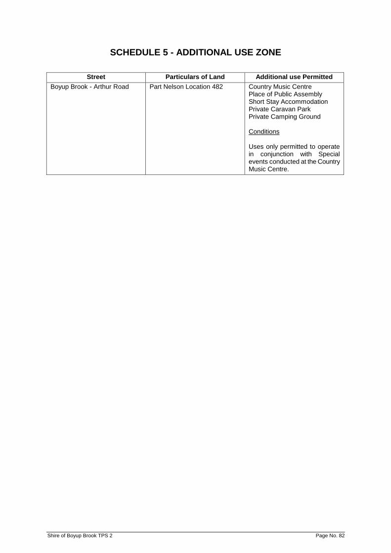
SCHEDULE 5 - ADDITIONAL USE ZONE
Street Particulars of Land Additional use Permitted Boyup Brook - Arthur Road Part Nelson Location 482 Country Music Centre
Place of Public Assembly Short Stay Accommodation Private Caravan Park Private Camping Ground Conditions Uses only permitted to operate in conjunction with Special events conducted at the Country Music Centre.
Shire of Boyup Brook TPS 2 Page No. 82

SCHEDULE 6 - CAR PARKING LAYOUT
Shire of Boyup Brook TPS 2 Page No. 83
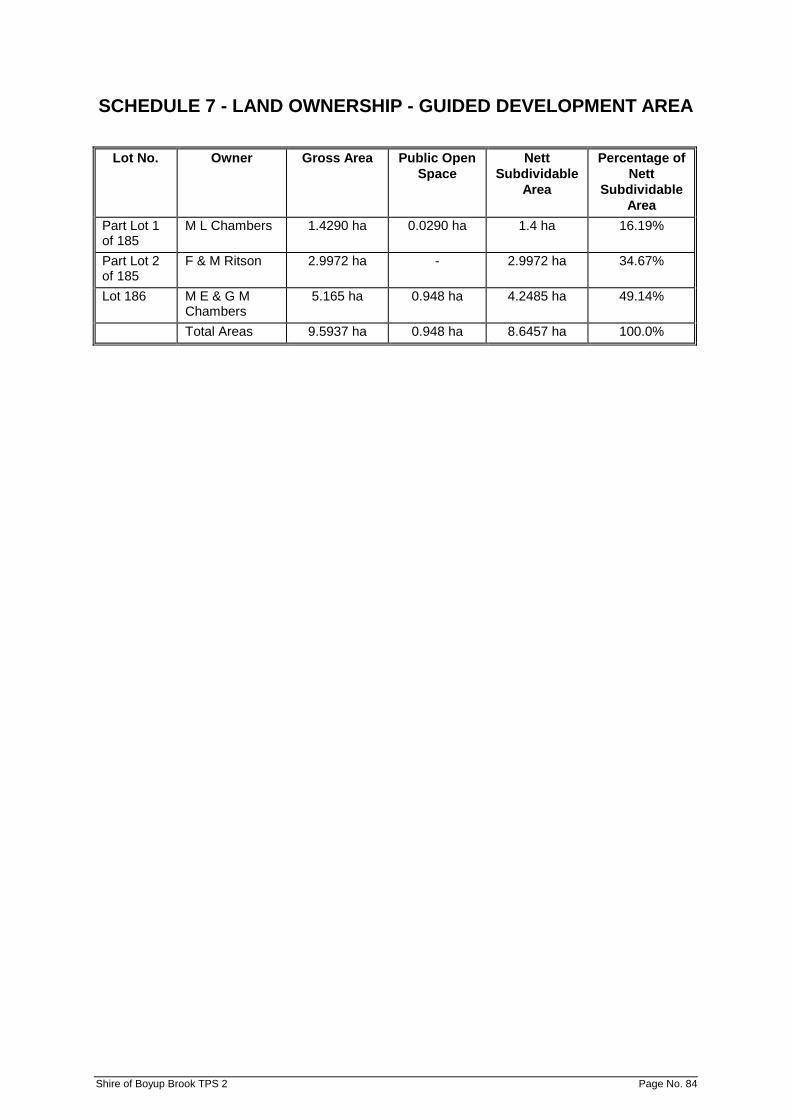
SCHEDULE 7 - LAND OWNERSHIP - GUIDED DEVELOPMENT AREA
Lot No. Owner Gross Area Public Open Space
Nett Subdividable
Area
Percentage of Nett
Subdividable Area
Part Lot 1 of 185
M L Chambers 1.4290 ha 0.0290 ha 1.4 ha 16.19%
Part Lot 2 of 185
F & M Ritson 2.9972 ha - 2.9972 ha 34.67%
Lot 186 M E & G M Chambers
5.165 ha 0.948 ha 4.2485 ha 49.14%
Total Areas 9.5937 ha 0.948 ha 8.6457 ha 100.0%
Shire of Boyup Brook TPS 2 Page No. 84

SCHEDULE 8 - CONTROL OF ADVERTISEMENTS – ADDITIONAL INFORMATION SHEET FOR ADVERTISEMENT APPROVAL
ADDITIONAL INFORMATION SHEET FOR ADVERTISEMENT APPROVAL
(to be completed in Additional or Approval to Commence Development Form 1)
1. Name of Advertiser (if different from owner):
......................................................................................................................................................
2. Address in full:
......................................................................................................................................................
3. Description of Property upon which advertisement is to be displayed including full details of its proposed position within that property:
......................................................................................................................................................
......................................................................................................................................................
4. Details of proposed sign:
Height: ......................................... Width: ........................................ Depth ...................................
Colours to be used: ......................................................................................................................
Height above ground level (to top of Advertisement): .......................................................
(to underside: .......................................................
Materials to be used:
......................................................................................................................................................
Illuminated: Yes/No
- If yes, state whether steady, moving, flashing, alternating,
digital, animated or scintillating, etc:
...............................................................................................................................................
- If Yes, state intensity of light source: ....................................................................................
5. State period of time for which advertisement is required:
......................................................................................................................................................
6. Details of signs, if any, to be removed if this application is approved:
......................................................................................................................................................
......................................................................................................................................................
NB. Application should be supported by a photograph of photographs of the premises showing
superimposed thereon the proposed position for the advertisement and those advertisements to
be removed detailed in 6 above.
Signature of Advertiser(s):
(if different from land owners) Date: ..........................................
Shire of Boyup Brook TPS 2 Page No. 85
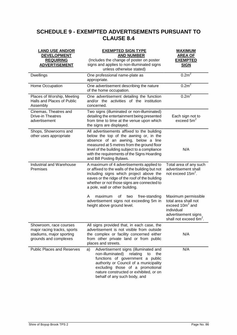
SCHEDULE 9 - EXEMPTED ADVERTISEMENTS PURSUANT TO CLAUSE 8.4
LAND USE AND/OR DEVELOPMENT
REQUIRING ADVERTISEMENT
EXEMPTED SIGN TYPE AND NUMBER
(Includes the change of poster on poster signs and applies to non-illuminated signs
unless otherwise stated)
MAXIMUM AREA OF
EXEMPTED SIGN
Dwellings One professional name-plate as appropriate.
0.2m2
Home Occupation One advertisement describing the nature of the home occupation.
0.2m2
Places of Worship, Meeting Halls and Places of Public Assembly
One advertisement detailing the function and/or the activities of the institution concerned.
0.2m2
Cinemas, Theatres and Drive-in Theatres advertisement
Two signs (illuminated or non-illuminated) detailing the entertainment being presented from time to time at the venue upon which the signs are displayed.
Each sign not to
exceed 5m2
Shops, Showrooms and other uses appropriate
All advertisements affixed to the building below the top of the awning or, in the absence of an awning, below a line measured at 5 metres from the ground floor level of the building subject to a compliance with the requirements of the Signs Hoarding and Bill Posting Bylaws.
N/A
Industrial and Warehouse Premises
A maximum of 4 advertisements applied to or affixed to the walls of the building but not including signs which project above the eaves or the ridge of the roof of the building whether or not those signs are connected to a pole, wall or other building. A maximum of two free-standing advertisement signs not exceeding 5m in height above ground level.
Total area of any such advertisement shall not exceed 15m2. Maximum permissible total area shall not exceed 10m2 and individual advertisement signs shall not exceed 6m2.
Showroom, race courses major racing tracks, sports stadiums, major sporting grounds and complexes
All signs provided that, in each case, the advertisement is not visible from outside the complex or facility concerned either from other private land or from public places and streets.
N/A
Public Places and Reserves a) Advertisement signs (illuminated and non-illuminated) relating to the functions of government a public authority or Council of a municipality excluding those of a promotional nature constructed or exhibited, or on behalf of any such body, and
N/A
Shire of Boyup Brook TPS 2 Page No. 86

SCHEDULE 9 - EXEMPTED ADVERTISEMENTS PURSUANT TO CLAUSE 8.4 (Cont’d)
LAND USE AND/OR
DEVELOPMENT REQUIRING
ADVERTISEMENT
EXEMPTED SIGN TYPE AND NUMBER
(Includes the change of poster on poster signs and applies to non-illuminated signs
unless otherwise stated)
MAXIMUM AREA OF
EXEMPTED SIGN
b) Advertisement signs (illuminated and non-illuminated) required for the management or control of traffic on any public road, car park, cycleway, railway or waterway where such advertisement has been constructed or exhibited by or at the direction of a Government department, public authority or the Council of a municipality, and
c) Advertisement signs (illuminated and
non-illuminated) required to be exhibited by or pursuant to any statute or regulation or the like made pursuant to powers contained within a Statute provided that any such advertisement is constructed and/or exhibited strictly in accordance with the requirements specified therein.
N/A
N/A
Railway Property and Reserves
Advertisement signs exhibited on such land provided that each such advertisement is directed only at or upon a railway station.
No sign shall exceed 2m2 in area
Advertisements within Buildings
All advertisements placed or displayed within buildings which cannot ordinarily be seen by a person outside of those buildings.
N/A
All classes of buildings other than single family dwellings
One advertisement sign containing the name, number and address of the building, the purpose for which the building is used or the name and address of the managing agent thereof.
0.2m2
Building Construction Sites (advertisement signs displayed only for the duration of the construction as follows): i) Dwellings ii) Multiple Dwellings,
Shop, Commercial and Industrial projects
One advertisement per street frontage containing details of the project and the contractors undertaking the construction work. One sign as for (i) above.
2m2
5m2
Shire of Boyup Brook TPS 2 Page No. 87
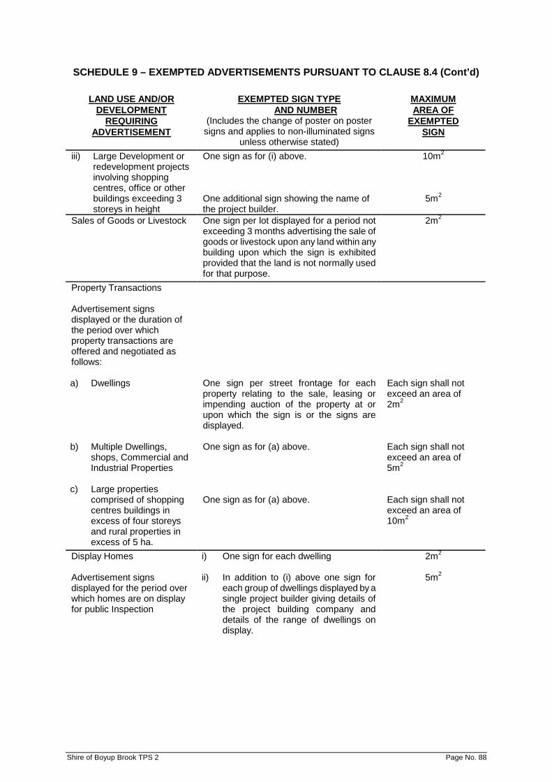
SCHEDULE 9 – EXEMPTED ADVERTISEMENTS PURSUANT TO CLAUSE 8.4 (Cont’d)
LAND USE AND/OR
DEVELOPMENT REQUIRING
ADVERTISEMENT
EXEMPTED SIGN TYPE AND NUMBER
(Includes the change of poster on poster signs and applies to non-illuminated signs
unless otherwise stated)
MAXIMUM AREA OF
EXEMPTED SIGN
iii) Large Development or redevelopment projects involving shopping centres, office or other buildings exceeding 3 storeys in height
One sign as for (i) above. One additional sign showing the name of the project builder.
10m2
5m2
Sales of Goods or Livestock One sign per lot displayed for a period not exceeding 3 months advertising the sale of goods or livestock upon any land within any building upon which the sign is exhibited provided that the land is not normally used for that purpose.
2m2
Property Transactions Advertisement signs displayed or the duration of the period over which property transactions are offered and negotiated as follows: a) Dwellings b) Multiple Dwellings,
shops, Commercial and Industrial Properties
c) Large properties
comprised of shopping centres buildings in excess of four storeys and rural properties in excess of 5 ha.
One sign per street frontage for each property relating to the sale, leasing or impending auction of the property at or upon which the sign is or the signs are displayed. One sign as for (a) above. One sign as for (a) above.
Each sign shall not exceed an area of 2m2 Each sign shall not exceed an area of 5m2 Each sign shall not exceed an area of 10m2
Display Homes Advertisement signs displayed for the period over which homes are on display for public Inspection
i) One sign for each dwelling ii) In addition to (i) above one sign for
each group of dwellings displayed by a single project builder giving details of the project building company and details of the range of dwellings on display.
2m2
5m2
Shire of Boyup Brook TPS 2 Page No. 88
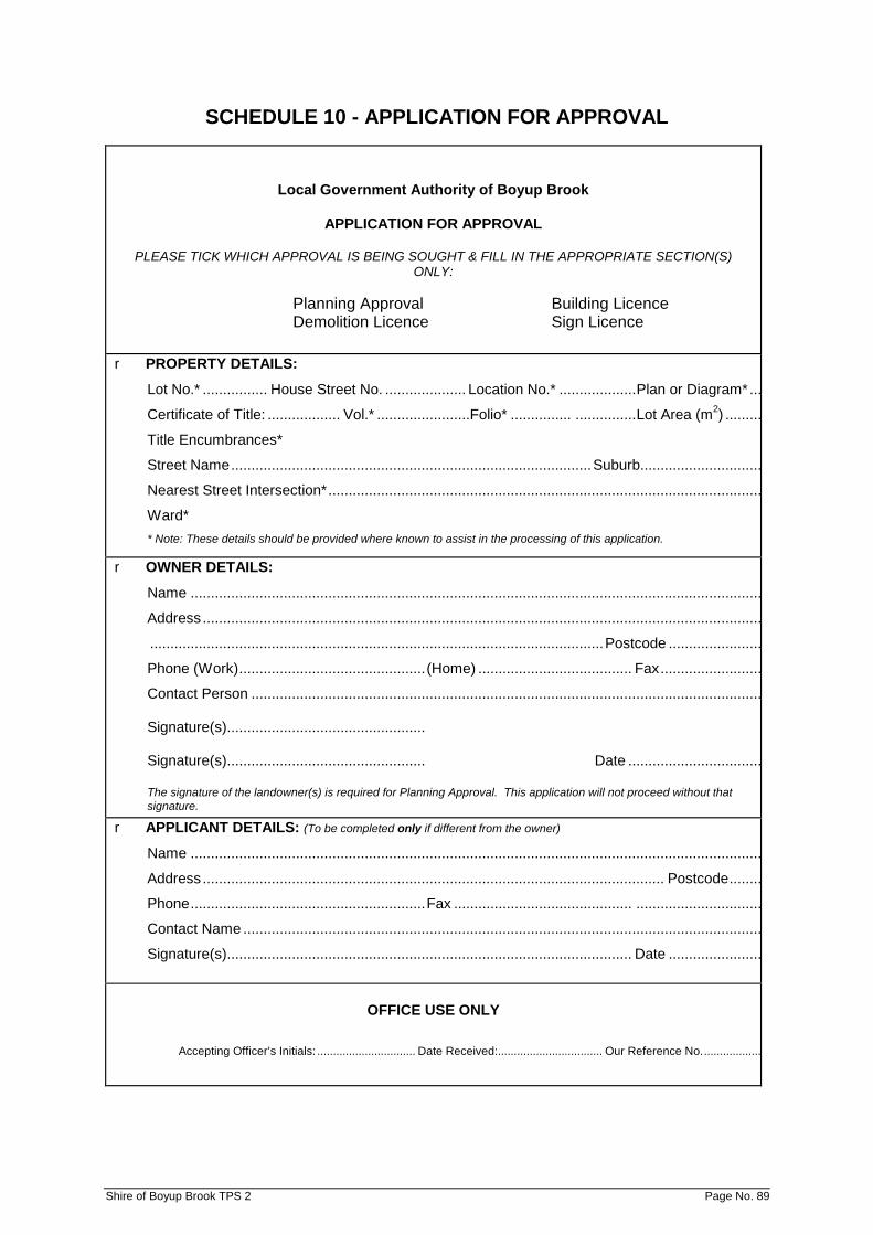
SCHEDULE 10 - APPLICATION FOR APPROVAL
Local Government Authority of Boyup Brook
APPLICATION FOR APPROVAL
PLEASE TICK WHICH APPROVAL IS BEING SOUGHT & FILL IN THE APPROPRIATE SECTION(S) ONLY:
Planning Approval Building Licence Demolition Licence Sign Licence
r PROPERTY DETAILS:
Lot No.* ................ House Street No. .................... Location No.* ................... Plan or Diagram* ...
Certificate of Title: .................. Vol.* .......................Folio* ............... ............... Lot Area (m2) .........
Title Encumbrances*
Street Name ......................................................................................... Suburb..............................
Nearest Street Intersection* ...........................................................................................................
Ward* * Note: These details should be provided where known to assist in the processing of this application.
r OWNER DETAILS:
Name .............................................................................................................................................
Address ..........................................................................................................................................
................................................................................................................ Postcode .......................
Phone (Work) .............................................. (Home) ...................................... Fax .........................
Contact Person ..............................................................................................................................
Signature(s).................................................
Signature(s)................................................. Date .................................
The signature of the landowner(s) is required for Planning Approval. This application will not proceed without that signature.
r APPLICANT DETAILS: (To be completed only if different from the owner)
Name .............................................................................................................................................
Address .................................................................................................................. Postcode ........
Phone .......................................................... Fax ............................................ ...............................
Contact Name ................................................................................................................................
Signature(s).................................................................................................... Date .......................
OFFICE USE ONLY Accepting Officer’s Initials: ............................... Date Received: ................................. Our Reference No. ..................
Shire of Boyup Brook TPS 2 Page No. 89

Schedule 10 – APPPLICATION FOR APPROVAL (Cont’d)
r PLANNING APPROVAL:
Existing Building/Land Use: Approx. Cost of Development: $ Est. Date of Completion: Description of Development/or Proposed Use:
r BUILDING LICENCE: Type of Work: New Buildings Alterations/Internal Additions Outbuildings
1A New Building 2A Habitable 9A Habitable 1B Display Home 2B Internal Additions 9B Workshop 1C Preliminary Application 2C Garage 9C Carport
Other (specify) 2D Carport 9D Above Ground Pool
2E Verandah 9E Below Ground Pool
Other (specify) 9I Garage 9J Garden Shed
Other
(specify)
Type of Building: House Multi-Residential Other
11 New Building 21 Single Storey Other Specify 12 Display Home 22 2 or more storey 19 Preliminary Application 23 1 or 2 storey flat/units
Other (specify)
Type of Building: Walls Floor Roof 11A Double Brick 20A Concrete - 85mm 10 Tiles 12 Brick Veneer 20B Concrete - Other 60A ‘Colorbond’ 11B Thermalite interior 10 Timber 60B ‘Zincalume’ 60A Colorbond’ Walls Other (specify) Other
(specify) 60B ‘Zincalume’ Walls 60C Steel Columns 60D Timber Posts 50A Fibreglass (pools) 50A Other (specify)
Builder: Name Address Registration No. Phone Fax Building Details: Area (m2) Outbuildings Area (m2) Contract Value $ Building Height Signature
r DEMOLITION LICENCE: Type of Building/Structure Number of Storeys Rat Bait Certificate issued Yes No. Type/Date Laid Whole or Part Demolition - Details Demolition Contractor: Name
Address Phone Fax Signature
r SIGN LICENCE: Type of Sign Position Dimensions Materials Illumination - Internal/External Wording/Illustration (Plan/Design attached)
Shire of Boyup Brook TPS 2 Page No. 90
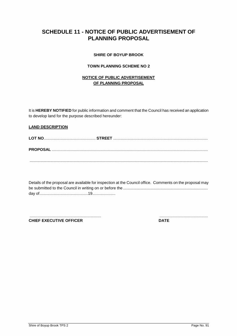
SCHEDULE 11 - NOTICE OF PUBLIC ADVERTISEMENT OF PLANNING PROPOSAL
SHIRE OF BOYUP BROOK
TOWN PLANNING SCHEME NO 2
NOTICE OF PUBLIC ADVERTISEMENT OF PLANNING PROPOSAL
It is HEREBY NOTIFIED for public information and comment that the Council has received an application to develop land for the purpose described hereunder: LAND DESCRIPTION LOT NO ............................................... STREET ...................................................................................... PROPOSAL .............................................................................................................................................. .................................................................................................................................................................. Details of the proposal are available for inspection at the Council office. Comments on the proposal may be submitted to the Council in writing on or before the ............................................................................. day of ............................................19..................... ................................................................. ............................................ CHIEF EXECUTIVE OFFICER DATE
Shire of Boyup Brook TPS 2 Page No. 91

SCHEDULE 12 – RURAL SMALL HOLDINGS ZONES
Location of Zone Permitted Uses and Conditions of Development Rural Small Holdings Zone 1 (RSH 1) Lot 8 and 9 Boyup Brook-Kojonup Road, Boyup Brook AMD 14 GG 27/3/15
a) The objective of the RSH 1 zone is to primarily provide for residential development in a rural setting and secondly for rural pursuits, home based business and minor tourist users. b) A Structure Plan is to be submitted to and
approved by the Shire of Boyup Brook and endorsed by the WAPC prior to subdivision or development of the land.
c) The Structure Plan is to address the matters in Schedule 12 and
• The recommendations of any approved district structure plan for SPA4 identified on the Scheme Map.
• The standard of the intersection with Kojonup Road for the ultimate development in SPA4 and any associated land requirements for this;
• Building envelopes/exclusion areas; and
• The setback of effluent disposal systems from the river; and
• Landscaping and stream protection including any rehabilitation works.
d) Subdivision and Development shall generally be in accordance with the endorsed Structure Plan. The minimum lot sizes shall be 4ha. e) Landscaping and/or revegetation/rehabilitation areas shown on the Structure Plan shall be established and maintained in perpetuity in accordance with a Landscaping Plan approved by Council. f) Water management and drainage designs should incorporate the principles of water sensitive urban design and give due regard to water reuse and efficiency measures. g) The onsite disposal of effluent shall be approved by Council and the Health Department of WA. Effluent systems shall be designed and located to minimise nutrient export and/or release into any waterway or groundwater. Any subdivision application shall be accompanied by a geotechnical report to demonstrate that the areas where septic tank systems are proposed to be used are capable of disposing of effluent within each lot. h) Council may require the subdivider to make arrangements satisfactory to Council to ensure prospective purchasers of land within RSH 1 are given a copy of these Special Provisions prior to entering into an agreement to acquire any property. i) No lots shall be permitted to have direct vehicular access to the Boyup Brook-Kojonup Road unless it is required for emergency access as recommended in a fore management plan.
Shire of Boyup Brook TPS 2 Page No. 92
j) No development or use within RSH 1 shall cause injury to or prejudicially affect the amenity of the locality by reason of appearance or the emission of smoke, fumes, noise, vibration, odour, vapour, dust, waste water, waste products or otherwise. k) The intersection of the new subdivision access road with Boyup Brook-Kojonup Road will be required to be located, designed and constructed to the specification and satisfaction of Main Roads WA. Also, any road reserve widening which may be required for construction of the subdivision road intersection will be required to be ceded free of cost to the crown by the subdivider.
Shire of Boyup Brook TPS 2 Page No. 93
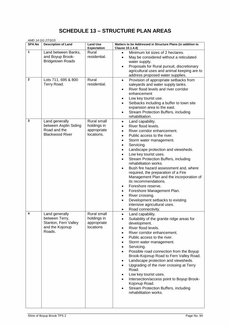
SCHEDULE 13 – STRUCTURE PLAN AREAS
AMD 14 GG 27/3/15 SPA No Description of Land Land Use
Expectation Matters to be Addressed in Structure Plans (in addition to Clause 10.1.4.4)
1 Land between Banks, and Boyup Brook-Bridgetown Roads
Rural residential.
• Minimum lot sizes of 2 hectares. • May be considered without a reticulated
water supply. • Proposals for Rural pursuit, discretionary
agricultural uses and animal keeping are to address proposed water supplies.
2 Lots 711, 695 & 800 Terry Road.
Rural residential.
• Provision of appropriate setbacks from saleyards and water supply tanks.
• River flood levels and river corridor enhancement
• Low key tourist use. • Setbacks including a buffer to town site
expansion area to the east. • Stream Protection Buffers, including
rehabilitation. 3 Land generally
between Asplin Siding Road and the Blackwood River
Rural small holdings in appropriate locations.
• Land capability. • River flood levels. • River corridor enhancement. • Public access to the river. • Storm water management. • Servicing. • Landscape protection and viewsheds. • Low key tourist uses. • Stream Protection Buffers, including
rehabilitation works. • Bush fire hazard assessment and, where
required, the preparation of a Fire Management Plan and the incorporation of its recommendations.
• Foreshore reserve. • Foreshore Management Plan. • River crossing. • Development setbacks to existing
intensive agricultural uses. • Road connectivity.
4 Land generally between Terry, Stanton, Fern Valley and the Kojonup Roads.
Rural small holdings in appropriate locations
• Land capability. • Suitability of the granite ridge areas for
development. • River flood levels. • River corridor enhancement. • Public access to the river. • Storm water management. • Servicing. • Possible road connection from the Boyup
Brook-Kojonup Road to Fern Valley Road. • Landscape protection and viewsheds. • Upgrading of the river crossing at Terry
Road. • Low key tourist uses. • Intersection/access point to Boyup Brook-
Kojonup Road. • Stream Protection Buffers, including
rehabilitation works.
Shire of Boyup Brook TPS 2 Page No. 94

• Bush fire hazard assessment and, where
required, the preparation and implementation of a Fire Management Plan and the incorporation of its recommendations.
• Public access point to river. • Foreshore reserve. • Foreshore Management Plan.
Shire of Boyup Brook TPS 2 Page No. 95
ADOPTION
Adopted by resolution of the Council of the Shire of Boyup Brook at the Ordinary meeting of the Council held on the 16th day of December 1994. ....................................................... Shire President ....................................................... Shire Clerk FINAL APPROVAL Adopted for final approval by resolution of the Shire of Boyup Brook at the Ordinary meeting of the Council held on the 15th day of August 1997.
....................................................... Shire President
....................................................... Shire Clerk
Recommended/Submitted for Final Approval
.............................................................. Chairperson of the Western Australian
Planning Commission .......................................... Date Final Approval Granted ............................................................
Minister for Planning ............................................................ Date 22 September 1997
Shire of Boyup Brook TPS 2 Page No. 96