shelf–slope sedimentation during the late quaternary on the southwestern kuril forearc margin,...
TRANSCRIPT

Sedimentary Geology 232 (2010) 35–51
Contents lists available at ScienceDirect
Sedimentary Geology
j ourna l homepage: www.e lsev ie r.com/ locate /sedgeo
Shelf–slope sedimentation during the late Quaternary on the southwestern Kurilforearc margin, northern Japan
Atsushi Noda ⁎, Taqumi TuZinoGeological Survey of Japan, National Institute of Advanced Industrial Science and Technology, Central 7, 1-1-1, Higashi, Tsukuba, Ibaraki, 305-8567, Japan
⁎ Corresponding author. Tel.: +81 29 861 3976; fax:E-mail address: [email protected] (A. Noda).
0037-0738/$ – see front matter © 2010 Elsevier B.V. Aldoi:10.1016/j.sedgeo.2010.09.008
a b s t r a c t
a r t i c l e i n f oArticle history:Received 2 June 2010Received in revised form 14 September 2010Accepted 24 September 2010Available online 18 October 2010
Editor: M.R. Bennett
Keywords:ForearcShelfSlopeSedimentationJapan
We studied an active forearc margin off eastern Hokkaido, northern Japan, to identify the main influences onstratigraphic development from the last glacial to the present highstand. This paper presents new data on theenvironment, texture, and sedimentation rates of forearc shelf–slope sediments, based on more than 300samples of seafloor sediments and densely gridded sub-bottom profiling records. Lowstand sedimentarywedges developed upon the shelf margins in areas with a large sediment supply and without incisingcanyons. The transgressive and highstand deposits formed on the shelf in extensive, low-gradient, andtopographically low areas. The narrow shelf is covered by sandy sediments, where winnowed fines are likelyto have escaped to the slope via gravity-driven across-shelf transport or ocean-current-induced along-shelftransport. The slope has a mid-slopemud belt at water depths of 700–1600 m. The sedimentation rates on theslope subsequent to 15 ka (the late transgressive to highstand stage) were just 10–70% of the rates prior tothis period. These changes in sedimentation rates are ascribed to spatially variable topography. Highsedimentation rates were maintained at topographically low and gently sloping areas even during highstandperiods, due to concentrations of nepheloid layers or deposition via sediment gravity flows. On the otherhand, low sedimentation rates were recognized on topographic highs of interfluves on the upper slope or onaxes of anticlines, where main flows or overspills of turbidity currents decreased as sealevel rose. Theseresults suggest that sedimentologic and stratigraphic variations are tied to variations in the physicalconfiguration of the shelf/slope system being influenced by the local topography in addition to the climaticand oceanographic processes.
+81 29 861 3653.
l rights reserved.
© 2010 Elsevier B.V. All rights reserved.
1. Introduction
The distribution of sediment in basins is fundamentally controlledby accommodation space and sediment supply controlled by theinteraction of eustasy, climate, and tectonic uplift/subsidence (e.g.Sloss, 1962; Pitman, 1978; Swift et al., 1991). At passive marginscharacterized by relatively stable topography and sediment supply,sediment deposition is mainly controlled by eustatic sealevel change(e.g. Vail et al., 1977; Posamentier and Vail, 1988; van Wagoner et al.,1988). In contrast, at active forearc/foreland margins, patterns ofsediment dispersal and transport reflect the combined influences ofeustacy and local uplift/subsidence that act to alter the accommoda-tion space in the basin and terrestrial sediment yields (e.g. Burbank etal., 1996; Allen and Densmore, 2000; Paola, 2000). Although regionalinvestigations of oceanography and sedimentology at modern forearcmargins are important in understanding sediment dispersal andbasin-filling processes, few such regions have been studied in detail;
e.g., California (e.g. Nittrouer et al., 2007; Lee and Normark, 2009) andNew Zealand (Barnes, 1995; Orpin et al., 2006; Paquet et al., 2009;Carter et al., 2010).
One such example of an intensively studied region is northernCalifornia, where the shelf and slope are located on an activemargin (e.g.Nittrouer et al., 2007). At short time-scales (decades andcenturies)underthe present sealevel, the sediment dispersal system is influenced bystormwaves andoceanic currents (Walsh andNittrouer, 2009). Here, theshelf and upper slope (∼800 m water depth) are able to trap less thanone third of modern sediment discharge: the remainder is exported todeeper water (Alexander and Simoneau, 1999; Sommerfield andNittrouer, 1999). At longer time-scales (millennia), the accumulationpatternon the shelf is also related to tectonic structures, suchas anticlinesand synclines, which influence sedimentation at shorter time-scales, asreported from the northern and southern Californiamargin (Spinelli andField, 2003; Bohannon et al., 2004; Hogarth et al., 2007; Sommerfield etal., 2007). The low trapping efficiency at the Eel margin is attributed tothe narrow width of the shelf, as well as direct bypassing to the EelCanyon, the occurrence of hyperpycnal plumes of fluvial input, and theresuspension and redistribution of shelf sediments by waves andcurrents (Sommerfield and Nittrouer, 1999). These studies have shown
36 A. Noda, T. TuZino / Sedimentary Geology 232 (2010) 35–51
that sediment transport and deposition at the active margin arecontrolled by neotectonics, and that more than half of the suppliedmaterial is transported to the slope. This finding is contrary to traditionalsequence stratigraphic models that established for passive margins,which presumes predominantly shelf deposition during transgressiveand highstand periods (e.g. van Wagoner et al., 1988). It is thereforepossible for active margins that deep-water environments receive moresediment from land than assumed in previous models.
Several studies have investigated processes of sediment distribu-tion in shelf–slope areas on the Pacific side of the Japanese Islands,which is a typical subduction-related forearc margin (Boggs, 1984;Blum and Okamura, 1992; Saito, 1994; Noda and TuZino, 2007). Thearea off eastern Hokkaido is an active forearc marginwhere the PacificPlate is being obliquely subducted along the Kuril Trench (Fig. 1).Collision of the Kuril forearc sliver (e.g. (Kimura, 1986)) caused rapiduplift of the Hidaka Mountains and long-lived subsidence in theforearc slope (Tokachi-oki forearc basin). In this region, shelf–slopesedimentary processes are potentially influenced by a variety offactors, including tsunamis, storms and currents, earthquakes,subsurface gas, basement uplift or subsidence, and the developmentof submarine channels (Noda et al., 2007; Noda and TuZino, 2007;TuZino and Noda, 2007; Noda et al., 2008a,b; TuZino and Noda, 2010).Despite the advances made in these previous studies, it remainsunclear how sediment dispersal and depositional processes havevaried, both temporally and spatially, during the period between thelast glacial and the present highstand.
The aims of this study are to estimate sediment dispersal andaccumulation across the shelf–slope environment in consideration oftopography, and to discuss how the sedimentologic and stratigraphicvariations were caused from the last glacial to the present highstandcondition at a regional scale. This paper presents new data on theenvironment, texture, and sedimentation rates of sediments upon theshelf–slope, based on more than 300 samples of seafloor sedimentsand densely gridded sub-bottom profiling (SBP) records. Theobservations reported in this study will serve as a useful tool inunderstanding the interactions among the supply, redistribution, andaccumulation of sediments along tectonically active forearc margins.
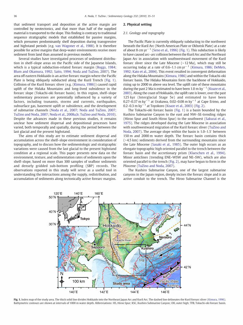
Fig. 1. Indexmap of the study area. The thick solid line divides Hokkaido into the Northeast JaBathymetric contours are shown at intervals of 1000 mwater depth. Abbreviations: HS, Hiro
2. Physical setting
2.1. Geology and topography
The Pacific Plate is currently obliquely subducting to the northwestbeneath the Kuril Arc (North American Plate or Okhotsk Plate) at a rateof about 8 cm yr−1 (Seno et al., 1996) (Fig. 1). This subduction is likelyto have caused arc–arc collisionbetween theKuril Arc and theNortheastJapan Arc in association with southwestward movement of the Kurilforearc sliver since the Late Miocene (∼12 Ma), which may still beoccurring today at a rate of 0.6–1.1 cm yr−1 (Kimura, 1986; DeMets,1992; Kato et al., 2004). This event resulted in convergent deformationalong the HidakaMountains (Kimura, 1986) andwithin the Tokachi-okiforearc basin. The Hidaka Mountains form the backbone of Hokkaido,rising up to 2000 m above sea level. The uplift rate of these mountainsduring the past 2 Ma is estimated to have been 1.0 m ky−1 (Koaze et al.,2003). Along the coast of Hokkaido, the uplift rate is lower, over the past125 kyr (Interglacial Stage 5e) and estimated to have been0.27–0.37 m ky−1 at Urakawa, 0.02–0.08 m ky−1 at Cape Erimo, and0.2–0.3 m ky−1 at Toyokoro (Koaze et al., 2003) (Fig. 2).
The Tokachi-oki forearc basin (Fig. 1) is a basin bounded by theKushiro Submarine Canyon to the east and NW–SE-trending ridges(Hiroo Spur and South Hiroo Spur) to the southwest (Sakurai et al.,1975). The ridges developed during the Late Miocene in associationwith southwestward migration of the Kuril forearc sliver (TuZino andNoda, 2007). The average slope within the basin is 1.0–1.5∘ between150 m and 2000 m water depth. The forearc basin contains thick(N4.5 km) sediments derived from the surrounding mountains sincethe Late Miocene (Sasaki et al., 1985). The outer high occurs as anelongate topographic high oriented parallel to the trench between theforearc basin and the accretionary prism (Klaeschen et al., 1994).Minor anticlines (trending ENE–WSW and NE–SW), which are alsooriented parallel to the trench (Fig. 2), may have begun to form in thePliocene (TuZino and Noda, 2007).
The Kushiro Submarine Canyon, one of the largest submarinecanyons in the Japan region, deeply incises the forearc slope and is anactive conduit to the trench. The Hiroo Submarine Channel is the
pan Arc and Kuril Arc. The dashed line delineates the Kuril forearc sliver (Kimura, 1996).o Spur; KSC, Kushiro Submarine Canyon; OH, outer high; TFB, Tokachi-oki forearc basin.

Fig. 2. Locations of surface samples (circles) and core samples (triangles). Solid circles (A–D) and triangles indicate the localities corresponding to the X-radiographs shown in Fig. 6and the descriptions in Fig. 7, respectively. The locations of core samples are listed in Table 2. Other lines are for depth transects of turbidity in Fig. 4 and SBP records in Figs. 10–13.Abbreviations: EB, Erimo Bank; ESC, Erimo Submarine Canyon; HS, Hiroo Spur; HSC, Hiroo Submarine Channel; KB, Kushikachi branch; KSC, Kushiro Submarine Canyon; OH, outerhigh; SD, shelf edge depression; SHS, South Hiroo Spur; TD, Tokachi-oki dome; TSCs, Tokachi Submarine Channels.
37A. Noda, T. TuZino / Sedimentary Geology 232 (2010) 35–51
longest tributary of the Kushiro Submarine Canyon, merging with thecanyon at a water depth of 4800 m (Fig. 2). The channel is anaggradational, with several tributaries to the northwest, making it apotentially major conduit for sediments derived to the Tokachi-okiforearc basin (TuZino and Noda, 2007). The channel heads occur at awater depth of 300 m, without incising the shelf edge.
Large (NM8) earthquakes associated with subduction of the PacificPlate have the potential to frequently generate turbidity currents in andaround this area (Noda et al., 2008a,b). EasternHokkaido is a seismicallyactive region inwhich large interplate earthquakes have occurred every72.2 years during the past 160 years along the southern Kurilsubduction zone (Earthquake Research Committee, 2004). Frequentturbidite deposition (76-yr intervals) in the Kushiro Submarine Canyonsuggests active seismicity during the Holocene (Noda et al., 2008a).
Similarly, a submarine fan off Nemuro, east of Kushiro (Fig. 1), containsmany turbidite beds, indicating a ca.110-year recurrence interval forturbidite deposition (Noda et al., 2008b).
Based on topographic criteria, the shelf in the study area can bedivided into three types: (A) a narrowwidth (10–15 km), high-gradient(∼0.4∘), and canyon-indented shelf off Kushiro; (B) a moderately wide(20–25 km), intermediate-gradient (∼0.25∘), and subdued-relief shelfoff Shiranuka to Hiroo; and (C) a wide (∼35 km), low-gradient(0.15∘–0.23∘), and cliff-backed shelf off Hiroo to Urakawa. The head oftheKushiro SubmarineCanyon is situatedoff theKushiroRivermouth inwater depths of up to 70 m. The bathymetry of the shelf off Shiranuka toHiroo is generally smooth, whereas the shelf edge off Cape Erimo isirregularly incised. Several ridges occur on the shelf off Cape Erimo,extending to the area southeast of the Hidaka Mountains.
38 A. Noda, T. TuZino / Sedimentary Geology 232 (2010) 35–51
2.2. Modern climate and hydraulic regime
The study area has a temperate to subpolar climate at present.Vegetation in the central and eastern Hokkaido is characterized by‘Pan-mixed’ forest, that is the transition from cool temperate forest toboreal forest (Igarashi, 1994). Modern meteorological condition ispunctuated by typhoons in summer–autumn and deep depressions inwinter–spring. The typhoons, of subtropical origin, generate strongwinds, intense rain, and flooding. The winter depressions generallydrive strong northwesterly winds in the area. Mean wind speeds atKushiro (data archives of Japan Meteorological Agency, 1970–2000)are 5.0–6.0 m s−1 in winter (November–March) and 3.5–4.4 m s−1 insummer (May–September). Thewinds at Cape Erimo are considerablystronger, with mean speeds of around 10 m s−1 in winter. Meanannual precipitation is around 1000 mm. The Kushiro and Tokachirivers have mean discharges of 60 and 256 m3 s−1, respectively, withpeaks in April–June due to snowmelt (300–450 m3 s−1 for the TokachiRiver). During extreme flood events, such as that associated with atyphoon in August 2003, the maximum discharge of the Tokachi Riverexceeds 5900 m3 s−1 (Water Information System maintained by theMinistry of Land, Infrastructure and Transport, Japan).
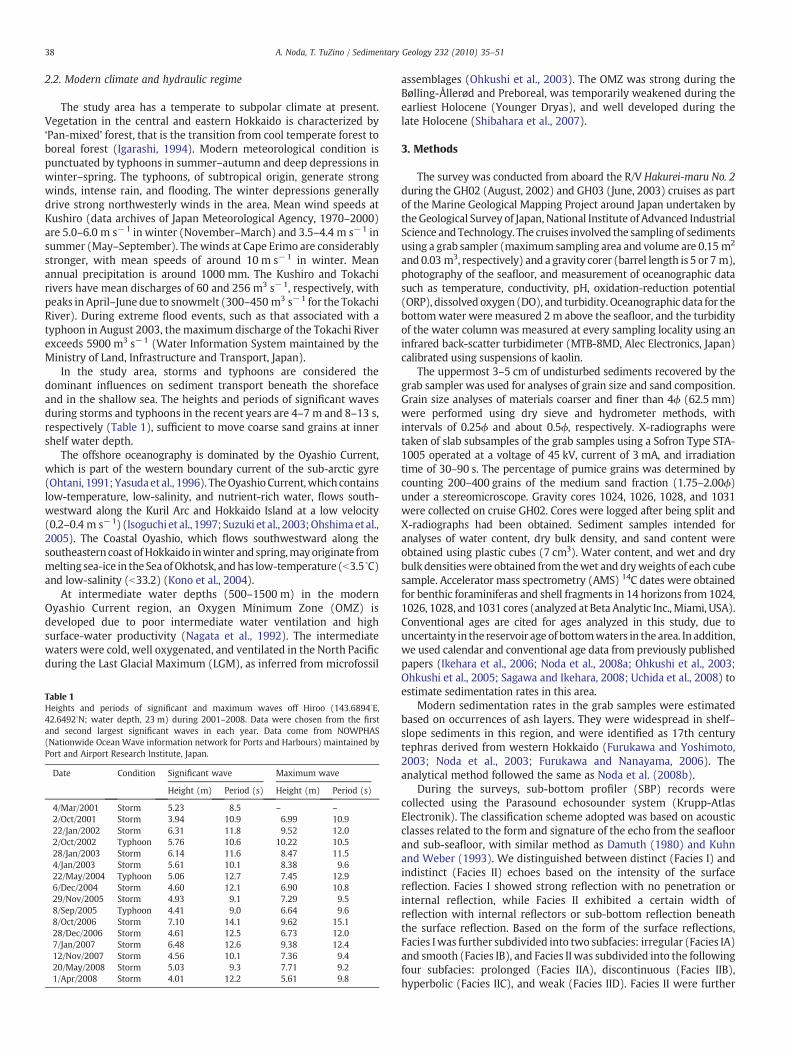
In the study area, storms and typhoons are considered thedominant influences on sediment transport beneath the shorefaceand in the shallow sea. The heights and periods of significant wavesduring storms and typhoons in the recent years are 4–7 m and 8–13 s,respectively (Table 1), sufficient to move coarse sand grains at innershelf water depth.
The offshore oceanography is dominated by the Oyashio Current,which is part of the western boundary current of the sub-arctic gyre(Ohtani, 1991;Yasudaet al., 1996). TheOyashio Current,which containslow-temperature, low-salinity, and nutrient-rich water, flows south-westward along the Kuril Arc and Hokkaido Island at a low velocity(0.2–0.4 m s−1) (Isoguchi et al., 1997; Suzuki et al., 2003;Ohshimaet al.,2005). The Coastal Oyashio, which flows southwestward along thesoutheastern coast ofHokkaido inwinter and spring,mayoriginate frommelting sea-ice in the SeaofOkhotsk, andhas low-temperature (b3.5 ∘C)and low-salinity (b33.2) (Kono et al., 2004).
At intermediate water depths (500–1500 m) in the modernOyashio Current region, an Oxygen Minimum Zone (OMZ) isdeveloped due to poor intermediate water ventilation and highsurface-water productivity (Nagata et al., 1992). The intermediatewaters were cold, well oxygenated, and ventilated in the North Pacificduring the Last Glacial Maximum (LGM), as inferred from microfossil
Table 1Heights and periods of significant and maximum waves off Hiroo (143.6894∘E,42.6492∘N; water depth, 23 m) during 2001–2008. Data were chosen from the firstand second largest significant waves in each year. Data come from NOWPHAS(Nationwide Ocean Wave information network for Ports and Harbours) maintained byPort and Airport Research Institute, Japan.
Date Condition Significant wave Maximum wave
Height (m) Period (s) Height (m) Period (s)
4/Mar/2001 Storm 5.23 8.5 – –
2/Oct/2001 Storm 3.94 10.9 6.99 10.922/Jan/2002 Storm 6.31 11.8 9.52 12.02/Oct/2002 Typhoon 5.76 10.6 10.22 10.528/Jan/2003 Storm 6.14 11.6 8.47 11.54/Jan/2003 Storm 5.61 10.1 8.38 9.622/May/2004 Typhoon 5.06 12.7 7.45 12.96/Dec/2004 Storm 4.60 12.1 6.90 10.829/Nov/2005 Storm 4.93 9.1 7.29 9.58/Sep/2005 Typhoon 4.41 9.0 6.64 9.68/Oct/2006 Storm 7.10 14.1 9.62 15.128/Dec/2006 Storm 4.61 12.5 6.73 12.07/Jan/2007 Storm 6.48 12.6 9.38 12.412/Nov/2007 Storm 4.56 10.1 7.36 9.420/May/2008 Storm 5.03 9.3 7.71 9.21/Apr/2008 Storm 4.01 12.2 5.61 9.8
assemblages (Ohkushi et al., 2003). The OMZ was strong during theBølling-Ållerød and Preboreal, was temporarily weakened during theearliest Holocene (Younger Dryas), and well developed during thelate Holocene (Shibahara et al., 2007).
3. Methods
The survey was conducted from aboard the R/V Hakurei-maru No. 2during the GH02 (August, 2002) and GH03 (June, 2003) cruises as partof the Marine Geological Mapping Project around Japan undertaken bytheGeological Survey of Japan, National Institute of Advanced IndustrialScience andTechnology. The cruises involved the sampling of sedimentsusing a grab sampler (maximum sampling area and volume are 0.15 m2
and 0.03 m3, respectively) and a gravity corer (barrel length is 5 or 7 m),photography of the seafloor, and measurement of oceanographic datasuch as temperature, conductivity, pH, oxidation-reduction potential(ORP), dissolved oxygen (DO), and turbidity. Oceanographic data for thebottomwater were measured 2 m above the seafloor, and the turbidityof the water column was measured at every sampling locality using aninfrared back-scatter turbidimeter (MTB-8MD, Alec Electronics, Japan)calibrated using suspensions of kaolin.
The uppermost 3–5 cm of undisturbed sediments recovered by thegrab sampler was used for analyses of grain size and sand composition.Grain size analyses of materials coarser and finer than 4ϕ (62.5 mm)were performed using dry sieve and hydrometer methods, withintervals of 0.25ϕ and about 0.5ϕ, respectively. X-radiographs weretaken of slab subsamples of the grab samples using a Sofron Type STA-1005 operated at a voltage of 45 kV, current of 3 mA, and irradiationtime of 30–90 s. The percentage of pumice grains was determined bycounting 200–400 grains of the medium sand fraction (1.75–2.00ϕ)under a stereomicroscope. Gravity cores 1024, 1026, 1028, and 1031were collected on cruise GH02. Cores were logged after being split andX-radiographs had been obtained. Sediment samples intended foranalyses of water content, dry bulk density, and sand content wereobtained using plastic cubes (7 cm3). Water content, and wet and drybulk densitieswere obtained from thewet and dryweights of each cubesample. Accelerator mass spectrometry (AMS) 14C dates were obtainedfor benthic foraminiferas and shell fragments in 14 horizons from 1024,1026, 1028, and 1031 cores (analyzed at Beta Analytic Inc., Miami, USA).Conventional ages are cited for ages analyzed in this study, due touncertainty in the reservoir age of bottomwaters in the area. In addition,we used calendar and conventional age data from previously publishedpapers (Ikehara et al., 2006; Noda et al., 2008a; Ohkushi et al., 2003;Ohkushi et al., 2005; Sagawa and Ikehara, 2008; Uchida et al., 2008) toestimate sedimentation rates in this area.
Modern sedimentation rates in the grab samples were estimatedbased on occurrences of ash layers. They were widespread in shelf–slope sediments in this region, and were identified as 17th centurytephras derived from western Hokkaido (Furukawa and Yoshimoto,2003; Noda et al., 2003; Furukawa and Nanayama, 2006). Theanalytical method followed the same as Noda et al. (2008b).
During the surveys, sub-bottom profiler (SBP) records werecollected using the Parasound echosounder system (Krupp-AtlasElectronik). The classification scheme adopted was based on acousticclasses related to the form and signature of the echo from the seafloorand sub-seafloor, with similar method as Damuth (1980) and Kuhnand Weber (1993). We distinguished between distinct (Facies I) andindistinct (Facies II) echoes based on the intensity of the surfacereflection. Facies I showed strong reflection with no penetration orinternal reflection, while Facies II exhibited a certain width ofreflection with internal reflectors or sub-bottom reflection beneaththe surface reflection. Based on the form of the surface reflections,Facies Iwas further subdivided into two subfacies: irregular (Facies IA)and smooth (Facies IB), and Facies II was subdivided into the followingfour subfacies: prolonged (Facies IIA), discontinuous (Facies IIB),hyperbolic (Facies IIC), and weak (Facies IID). Facies II were further

39A. Noda, T. TuZino / Sedimentary Geology 232 (2010) 35–51
subdivided in turn into the following five classes based on theobserved internal reflection patterns: (a) no internal or sub-bottomreflectors, (b) sub-bottom but not internal reflectors, (c) severalcontinuous stratified reflectors, (d) several discontinuous reflectors,and (e) several weak reflectors. Maximum penetration depth was upto 80 m below seafloor in the records.
4. Results
4.1. Modern oceanographic and sedimentary environment
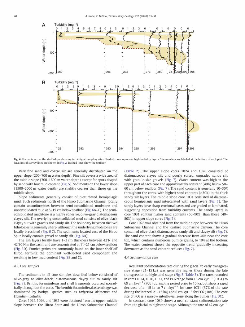
Turbidity of the bottom water (2 m above the seafloor) wasgenerally high on the shelf (N2.0 mg l−1), especially off Hiroo andCape Erimo (Fig. 3A), but low (b1.0 mg l−1) at slope water depthsexceeding 700 m. Turbidity was also high at the mouth of the KushiroRiver, but low near the mouth of the Tokachi River.
Areas of high turbidity near the seafloor can be traced from theinner shelf off east of Cape Erimo to the outer shelf off south ofUrakawa. Depth transects of turbidity reveal bottom and intermediatenepheloid layers (BNLs and INLs) (Fig. 4). The BNLs arewell developedacross the shelf and extend to the upper slope (b1500 m). The highturbidity of the BNLs on the shelf is in sharp contrast to the lowturbidity of the intermediate water minimum. At some stations (e.g.,
Fig. 3. Spatial distributions of (A) turbidity (mg l−1) of bottom water (2 m above seafloor), (sand fraction (1.75–2.0ϕ) in the surface sediments (∼3–5 cm below seafloor), and depths (cmdata points for mapping. Arrows in (A) indicate the flow directions of oceanic currents of t
stations 266 and 272 in Fig. 4B), turbidity in thewater column showedan upward increase, indicating horizontal advection of the BNLs fromshallower parts of the shelf. From the shelf edge to the upper slope,the INLs detached from the BNLs (Fig. 4A). The INLs were up to 70 mthick, and commonly disappeared at 10–20 km offshore from the shelfbreak.
4.2. Sediment texture
Rock outcrops occur at topographic highs east of Cape Erimo and atthe Erimo Bank (Fig. 5). Glauconite grains and sessile organisms (e.g.,bryozoa and sponge) were found at these sites. Gravels (coarser than−2 Mdϕ) were obtained from several points on the shelf off Ombetsuand off Cape Erimo. Gravelly sand (N1 wt.% gravel) is distributed onthe outer shelf off east of Kushiro, the canyon head of the KushiroSubmarine Canyon, off southeast of Cape Erimo, the Erimo Bank, andthe inner shelf and shelf edge off Erimo to Urakawa. Fine to very finesand occurs widely across the shelf off south of Kushiro to Cape Erimo.The sediments on the inner shelf off Hiroo are well to moderatelysorted (Fig. 3B). Medium to coarse silt is limited to the middle shelfeast of Hiroo and the outer shelf off Erimo to Urakawa, which alsocorrespond to high turbidity areas (Fig. 3A).
B) sorting value, (C) mud content (wt.%), (D) contents of pumice grains in the medium) below the seafloor of pumice-rich layers of the 17th century tephras. Open circles are
he Coastal Oyashio (CO) and Oyashio Current (OC).
A
B
−300
−200
−100
00 1 2 3
291
0 1 2 3 4
292
0 1 2
293
0 1 2
294
0 1 2
295
0 1 2 3 4
296
0 1
297
0 1
298
Turbidity (mg l-1)
Wat
er d
epth
(m
)
−200
−100
00 1 2 3 4 5 6 7 8
260
0 1 2
266
0 1 2 3
272
0 1
273
0 1
280
0
281
0
290
0
299
0 1
308
Turbidity (mg l-1)
Wat
er d
epth
(m
)
Fig. 4. Transects across the shelf–slope showing turbidity at sampling sites. Shaded zones represent high turbidity layers. Site numbers are labeled at the bottom of each plot. Thelocations of survey lines are shown in Fig. 2. Dashed lines show the seafloor.
40 A. Noda, T. TuZino / Sedimentary Geology 232 (2010) 35–51
Very fine sand and coarse silt are generally distributed on theupper slope (200–700 m water depth). Fine silt covers a wide area ofthe middle slope (700–1600 m water depth) except for spurs drapedby sand with low mud content (Fig. 5). Sediments on the lower slope(1500–2000 m water depth) are slightly coarser than those on themiddle slope.
Slope sediments generally consist of bioturbated hemipelagicmud. Such sediments north of the Hiroo Submarine Channel locallycontain unconformities between semi-consolidated mudstone andunconsolidated mud at 5–15 cm below seafloor (Fig. 6A–C). The semi-consolidated mudstone is a highly cohesive, olive-gray diatomaceousclayey silt. The overlying unconsolidated mud consists of olive-blackclayey silt with gravels and sandy silt. The boundary between the twolithologies is generally sharp, although the underlying mudstones arelocally brecciated (Fig. 6 C). The sediments located east of the HirooSpur locally contain gravel or sandy silt (Fig. 6D).
The ash layers locally have 1–3 cm thickness between 42∘N and42∘30′N in the basin, and are concentrated at 11–21 cm below seafloor(Fig. 3D). Pumice grains are commonly found on the inner shelf offHiroo, forming the dominant well-sorted sand component andresulting in low mud content (Fig. 3B and C).
4.3. Core samples
The sediments in all core samples described below consisted ofolive-gray to olive-black, diatomaceous clayey silt to sandy silt(Fig. 7). Benthic foraminiferas and shell fragments occurred sporad-ically throughout the cores. The benthic foraminiferal assemblage wasdominated by bathyal species such as Uvigerina akitaensis andElphidium batialis.
Cores 1024, 1026, and 1031 were obtained from the upper–middleslope between the Hiroo Spur and the Hiroo Submarine Channel
(Table 2). The upper slope cores 1024 and 1026 consisted ofdiatomaceous clayey silt and poorly sorted, ungraded sandy siltwith granule-size gravels (Fig. 7). Water content was high in theupper part of each core and approximately constant (40%) below 50–60 cm below seafloor (Fig. 7). The sand content is generally 10–30%throughout the cores, with highest sand contents (N30%) in the thicksandy silt layers. The middle slope core 1031 consisted of diatoma-ceous hemipelagic mud intercalated with sand layers (Fig. 7). Thesandy layers have sharp erosional bases and are graded or laminated,suggesting deposition from turbidity currents. The sandy layers incore 1031 contain higher sand contents (50–90%) than those (40–50%) in upper slope cores (Fig. 7).
Core 1028 was obtained from the middle slope between the HirooSubmarine Channel and the Kushiro Submarine Canyon. The corecontained olive-black diatomaceous sandy silt and clayey silt (Fig. 7).The sand content shows a gradual decrease from 40% near the coretop, which contains numerous pumice grains, to 10% at the bottom.The water content shows the opposite trend, gradually increasingdowncore as the sand content reduces (Fig. 7).
4.4. Sedimentation rate
Resultant sedimentation rate during the glacial to early transgres-sive stage (21–15 ka) was generally higher those during the latetransgression to highstand stage (Fig. 8; Table 3). The rates recordedin cores 1024, 1026, 1031, and PC6 range from 18 cm kyr−1 (1031) to69 cm kyr−1 (PC6) during the period prior to 15 ka, but show a rapiddecrease after 15 ka to 7 cm kyr−1 for core 1031 (37% of the rateduring the interval 21–15 ka) and 6 cm kyr−1 for PC6 (10%). The coresite of PC6 is a narrow interfluvial zone along the gullies (Fig. 3C).
In contrast, core 1030 shows a near-constant sedimentation ratefrom the glacial to highstand stage. Although the rate of 42 cm kyr−1
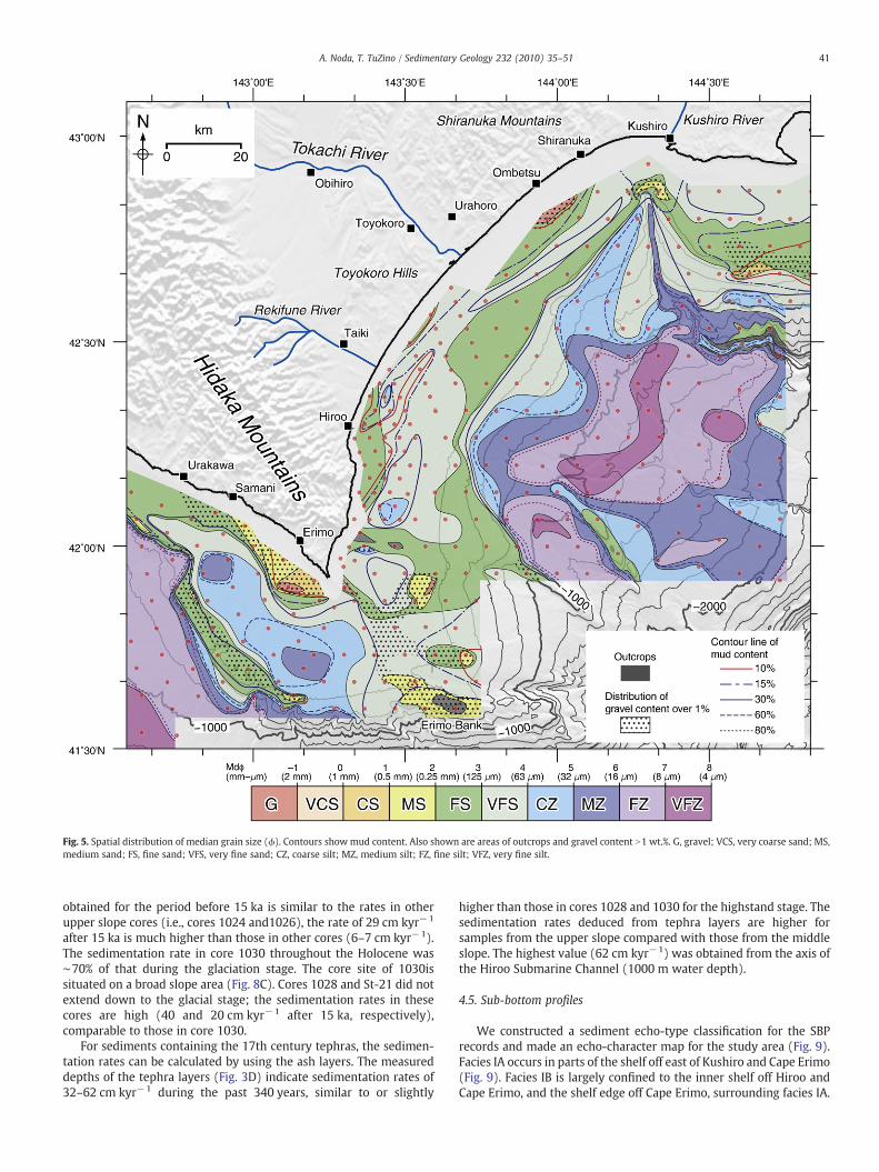
Fig. 5. Spatial distribution of median grain size (ϕ). Contours show mud content. Also shown are areas of outcrops and gravel content N1 wt.%. G, gravel; VCS, very coarse sand; MS,medium sand; FS, fine sand; VFS, very fine sand; CZ, coarse silt; MZ, medium silt; FZ, fine silt; VFZ, very fine silt.
41A. Noda, T. TuZino / Sedimentary Geology 232 (2010) 35–51
obtained for the period before 15 ka is similar to the rates in otherupper slope cores (i.e., cores 1024 and1026), the rate of 29 cm kyr−1
after 15 ka is much higher than those in other cores (6–7 cm kyr−1).The sedimentation rate in core 1030 throughout the Holocene was∼70% of that during the glaciation stage. The core site of 1030issituated on a broad slope area (Fig. 8C). Cores 1028 and St-21 did notextend down to the glacial stage; the sedimentation rates in thesecores are high (40 and 20 cm kyr−1 after 15 ka, respectively),comparable to those in core 1030.
For sediments containing the 17th century tephras, the sedimen-tation rates can be calculated by using the ash layers. The measureddepths of the tephra layers (Fig. 3D) indicate sedimentation rates of32–62 cm kyr−1 during the past 340 years, similar to or slightly
higher than those in cores 1028 and 1030 for the highstand stage. Thesedimentation rates deduced from tephra layers are higher forsamples from the upper slope compared with those from the middleslope. The highest value (62 cm kyr−1) was obtained from the axis ofthe Hiroo Submarine Channel (1000 m water depth).
4.5. Sub-bottom profiles
We constructed a sediment echo-type classification for the SBPrecords and made an echo-character map for the study area (Fig. 9).Facies IA occurs in parts of the shelf off east of Kushiro and Cape Erimo(Fig. 9). Facies IB is largely confined to the inner shelf off Hiroo andCape Erimo, and the shelf edge off Cape Erimo, surrounding facies IA.
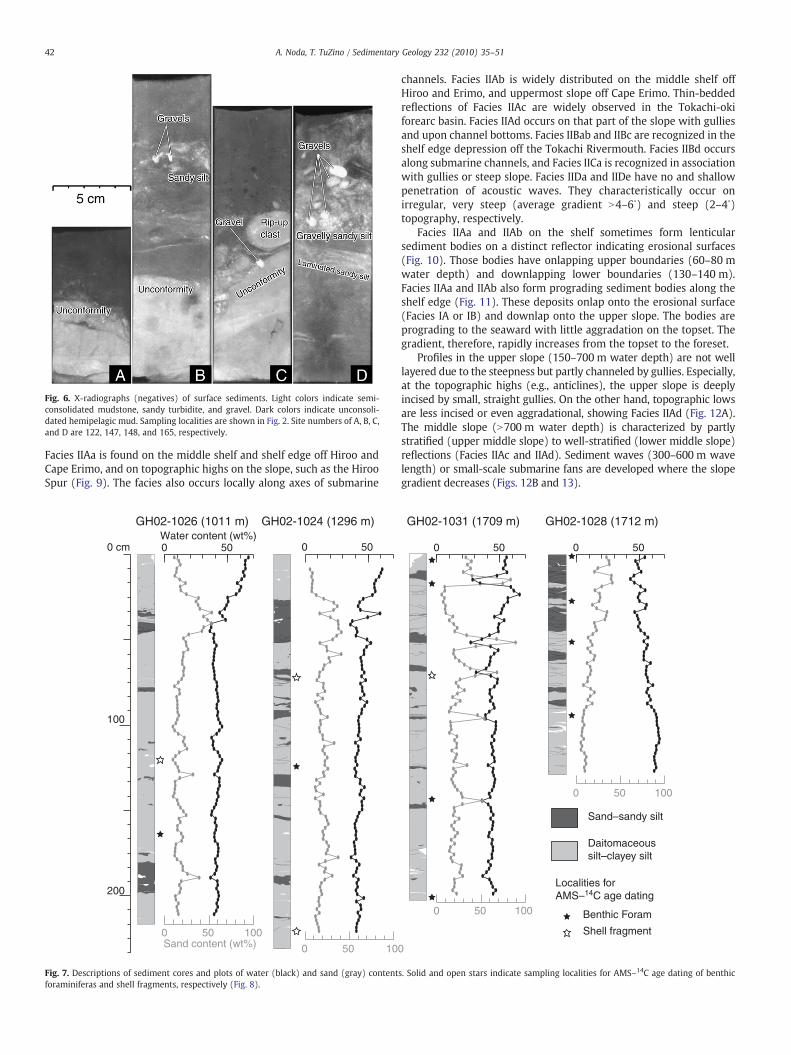
Fig. 6. X-radiographs (negatives) of surface sediments. Light colors indicate semi-consolidated mudstone, sandy turbidite, and gravel. Dark colors indicate unconsoli-dated hemipelagic mud. Sampling localities are shown in Fig. 2. Site numbers of A, B, C,and D are 122, 147, 148, and 165, respectively.
42 A. Noda, T. TuZino / Sedimentary Geology 232 (2010) 35–51
Facies IIAa is found on the middle shelf and shelf edge off Hiroo andCape Erimo, and on topographic highs on the slope, such as the HirooSpur (Fig. 9). The facies also occurs locally along axes of submarine
0 500 50Water content (wt%)
Sand content (wt%)0
0
50
50 10
100
GH02-1026 (1011 m) GH02-1024 (1296 m)
0 cm
100
200
Fig. 7. Descriptions of sediment cores and plots of water (black) and sand (gray) contentforaminiferas and shell fragments, respectively (Fig. 8).
channels. Facies IIAb is widely distributed on the middle shelf offHiroo and Erimo, and uppermost slope off Cape Erimo. Thin-beddedreflections of Facies IIAc are widely observed in the Tokachi-okiforearc basin. Facies IIAd occurs on that part of the slope with gulliesand upon channel bottoms. Facies IIBab and IIBc are recognized in theshelf edge depression off the Tokachi Rivermouth. Facies IIBd occursalong submarine channels, and Facies IICa is recognized in associationwith gullies or steep slope. Facies IIDa and IIDe have no and shallowpenetration of acoustic waves. They characteristically occur onirregular, very steep (average gradient N4–6∘) and steep (2–4∘)topography, respectively.
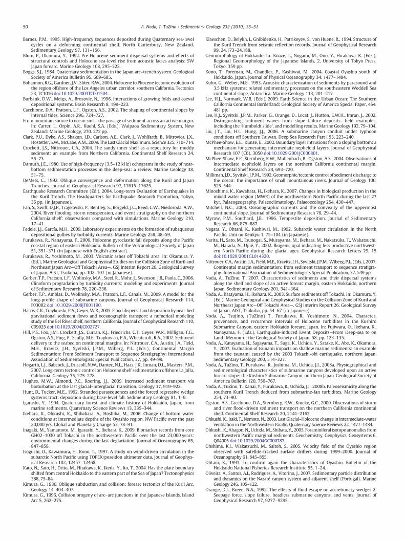
Facies IIAa and IIAb on the shelf sometimes form lenticularsediment bodies on a distinct reflector indicating erosional surfaces(Fig. 10). Those bodies have onlapping upper boundaries (60–80 mwater depth) and downlapping lower boundaries (130–140 m).Facies IIAa and IIAb also form prograding sediment bodies along theshelf edge (Fig. 11). These deposits onlap onto the erosional surface(Facies IA or IB) and downlap onto the upper slope. The bodies areprograding to the seaward with little aggradation on the topset. Thegradient, therefore, rapidly increases from the topset to the foreset.
Profiles in the upper slope (150–700 m water depth) are not welllayered due to the steepness but partly channeled by gullies. Especially,at the topographic highs (e.g., anticlines), the upper slope is deeplyincised by small, straight gullies. On the other hand, topographic lowsare less incised or even aggradational, showing Facies IIAd (Fig. 12A).The middle slope (N700 m water depth) is characterized by partlystratified (upper middle slope) to well-stratified (lower middle slope)reflections (Facies IIAc and IIAd). Sediment waves (300–600 m wavelength) or small-scale submarine fans are developed where the slopegradient decreases (Figs. 12B and 13).
0 500 50
0 50 100
0 50
0
100
Sand–sandy silt
Daitomaceoussilt–clayey silt
GH02-1031 (1709 m) GH02-1028 (1712 m)
Localities for AMS–14C age dating
Benthic Foram
Shell fragment
s. Solid and open stars indicate sampling localities for AMS–14C age dating of benthic
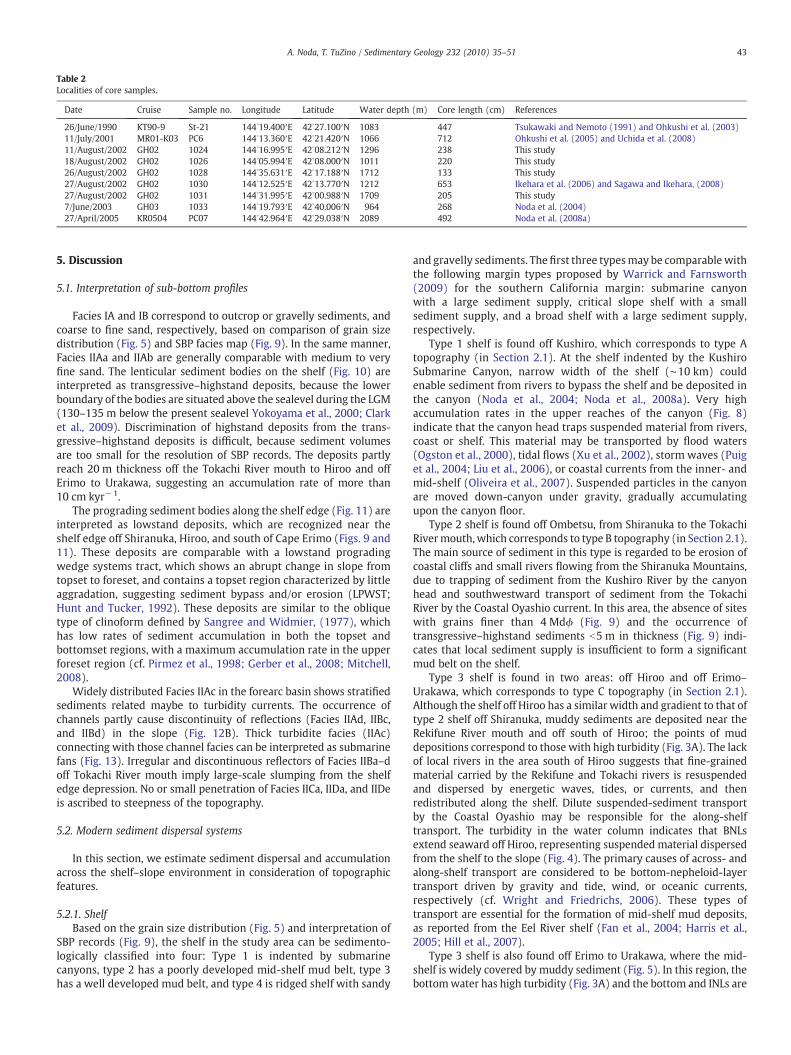
Table 2Localities of core samples.
Date Cruise Sample no. Longitude Latitude Water depth (m) Core length (cm) References
26/June/1990 KT90-9 St-21 144∘19.400′E 42∘27.100′N 1083 447 Tsukawaki and Nemoto (1991) and Ohkushi et al. (2003)11/July/2001 MR01-K03 PC6 144∘13.360′E 42∘21.420′N 1066 712 Ohkushi et al. (2005) and Uchida et al. (2008)11/August/2002 GH02 1024 144∘16.995′E 42∘08.212′N 1296 238 This study18/August/2002 GH02 1026 144∘05.994′E 42∘08.000′N 1011 220 This study26/August/2002 GH02 1028 144∘35.631′E 42∘17.188′N 1712 133 This study27/August/2002 GH02 1030 144∘12.525′E 42∘13.770′N 1212 653 Ikehara et al. (2006) and Sagawa and Ikehara, (2008)27/August/2002 GH02 1031 144∘31.995′E 42∘00.988′N 1709 205 This study7/June/2003 GH03 1033 144∘19.793′E 42∘40.006′N 964 268 Noda et al. (2004)27/April/2005 KR0504 PC07 144∘42.964′E 42∘29.038′N 2089 492 Noda et al. (2008a)
43A. Noda, T. TuZino / Sedimentary Geology 232 (2010) 35–51
5. Discussion
5.1. Interpretation of sub-bottom profiles
Facies IA and IB correspond to outcrop or gravelly sediments, andcoarse to fine sand, respectively, based on comparison of grain sizedistribution (Fig. 5) and SBP facies map (Fig. 9). In the same manner,Facies IIAa and IIAb are generally comparable with medium to veryfine sand. The lenticular sediment bodies on the shelf (Fig. 10) areinterpreted as transgressive–highstand deposits, because the lowerboundary of the bodies are situated above the sealevel during the LGM(130–135 m below the present sealevel Yokoyama et al., 2000; Clarket al., 2009). Discrimination of highstand deposits from the trans-gressive–highstand deposits is difficult, because sediment volumesare too small for the resolution of SBP records. The deposits partlyreach 20 m thickness off the Tokachi River mouth to Hiroo and offErimo to Urakawa, suggesting an accumulation rate of more than10 cm kyr−1.
The prograding sediment bodies along the shelf edge (Fig. 11) areinterpreted as lowstand deposits, which are recognized near theshelf edge off Shiranuka, Hiroo, and south of Cape Erimo (Figs. 9 and11). These deposits are comparable with a lowstand progradingwedge systems tract, which shows an abrupt change in slope fromtopset to foreset, and contains a topset region characterized by littleaggradation, suggesting sediment bypass and/or erosion (LPWST;Hunt and Tucker, 1992). These deposits are similar to the obliquetype of clinoform defined by Sangree and Widmier, (1977), whichhas low rates of sediment accumulation in both the topset andbottomset regions, with a maximum accumulation rate in the upperforeset region (cf. Pirmez et al., 1998; Gerber et al., 2008; Mitchell,2008).
Widely distributed Facies IIAc in the forearc basin shows stratifiedsediments related maybe to turbidity currents. The occurrence ofchannels partly cause discontinuity of reflections (Facies IIAd, IIBc,and IIBd) in the slope (Fig. 12B). Thick turbidite facies (IIAc)connecting with those channel facies can be interpreted as submarinefans (Fig. 13). Irregular and discontinuous reflectors of Facies IIBa–doff Tokachi River mouth imply large-scale slumping from the shelfedge depression. No or small penetration of Facies IICa, IIDa, and IIDeis ascribed to steepness of the topography.
5.2. Modern sediment dispersal systems
In this section, we estimate sediment dispersal and accumulationacross the shelf–slope environment in consideration of topographicfeatures.
5.2.1. ShelfBased on the grain size distribution (Fig. 5) and interpretation of
SBP records (Fig. 9), the shelf in the study area can be sedimento-logically classified into four: Type 1 is indented by submarinecanyons, type 2 has a poorly developed mid-shelf mud belt, type 3has a well developed mud belt, and type 4 is ridged shelf with sandy
and gravelly sediments. The first three typesmay be comparable withthe following margin types proposed by Warrick and Farnsworth(2009) for the southern California margin: submarine canyonwith a large sediment supply, critical slope shelf with a smallsediment supply, and a broad shelf with a large sediment supply,respectively.
Type 1 shelf is found off Kushiro, which corresponds to type Atopography (in Section 2.1). At the shelf indented by the KushiroSubmarine Canyon, narrow width of the shelf (∼10 km) couldenable sediment from rivers to bypass the shelf and be deposited inthe canyon (Noda et al., 2004; Noda et al., 2008a). Very highaccumulation rates in the upper reaches of the canyon (Fig. 8)indicate that the canyon head traps suspended material from rivers,coast or shelf. This material may be transported by flood waters(Ogston et al., 2000), tidal flows (Xu et al., 2002), storm waves (Puiget al., 2004; Liu et al., 2006), or coastal currents from the inner- andmid-shelf (Oliveira et al., 2007). Suspended particles in the canyonare moved down-canyon under gravity, gradually accumulatingupon the canyon floor.
Type 2 shelf is found off Ombetsu, from Shiranuka to the TokachiRivermouth, which corresponds to type B topography (in Section 2.1).The main source of sediment in this type is regarded to be erosion ofcoastal cliffs and small rivers flowing from the Shiranuka Mountains,due to trapping of sediment from the Kushiro River by the canyonhead and southwestward transport of sediment from the TokachiRiver by the Coastal Oyashio current. In this area, the absence of siteswith grains finer than 4 Mdϕ (Fig. 9) and the occurrence oftransgressive–highstand sediments b5 m in thickness (Fig. 9) indi-cates that local sediment supply is insufficient to form a significantmud belt on the shelf.
Type 3 shelf is found in two areas: off Hiroo and off Erimo–Urakawa, which corresponds to type C topography (in Section 2.1).Although the shelf off Hiroo has a similar width and gradient to that oftype 2 shelf off Shiranuka, muddy sediments are deposited near theRekifune River mouth and off south of Hiroo; the points of muddepositions correspond to those with high turbidity (Fig. 3A). The lackof local rivers in the area south of Hiroo suggests that fine-grainedmaterial carried by the Rekifune and Tokachi rivers is resuspendedand dispersed by energetic waves, tides, or currents, and thenredistributed along the shelf. Dilute suspended-sediment transportby the Coastal Oyashio may be responsible for the along-shelftransport. The turbidity in the water column indicates that BNLsextend seaward off Hiroo, representing suspended material dispersedfrom the shelf to the slope (Fig. 4). The primary causes of across- andalong-shelf transport are considered to be bottom-nepheloid-layertransport driven by gravity and tide, wind, or oceanic currents,respectively (cf. Wright and Friedrichs, 2006). These types oftransport are essential for the formation of mid-shelf mud deposits,as reported from the Eel River shelf (Fan et al., 2004; Harris et al.,2005; Hill et al., 2007).
Type 3 shelf is also found off Erimo to Urakawa, where the mid-shelf is widely covered by muddy sediment (Fig. 5). In this region, thebottomwater has high turbidity (Fig. 3A) and the bottom and INLs are

Fig. 8. (A) Plots of depth versus age for sediment cores from the Tokachi-oki forearc basin. Age data for cores St-21, 1030, and PC6 are from (Ohkushi et al., 2003), (Sagawa andIkehara, 2008), and (Ohkushi et al., 2005), respectively. Sedimentation rates in the Kushiro Submarine Canyon (cores 1033 and PC07) are based on (Noda et al., 2004; Noda et al.,2008a). (B) Spatial distribution of sedimentation rates during 21–15 ka and 15–0 ka. Locations of cores are listed in Table 2. (C) Detailed bathymetry for core sites of PC6 (left) and1030 (right).
44 A. Noda, T. TuZino / Sedimentary Geology 232 (2010) 35–51
well developed (Fig. 4). Similar with the shelf off Hiroo, no large riversdischarge directly onto the shelf in this area; therefore suspendedtransport by the coastal currents would be important. In addition tothe along-shore flows, small rivers draining the Hidaka Mountainsand slope failures on coastal cliff would derive a large amount ofsediment in this area (Yanai and Igarashi, 1990). Intensive coastalerosion along the face of the Hidaka Mountains may also provide alarge amount of fine-grained detritus to the area between Hiroo andCape Erimo. Quantitative estimation of the sediment input from theland area is currently difficult because of a lack of data. Short-reachmountainous rivers can provide a large amount of detritus (cf.Milliman and Syvitski, 1992), sufficient to form a thick mid-shelf mudbelt. Mud deposited in nearshore areas is winnowed by storm waves(cf. Crockett and Nittrouer, 2004), leaving residual gravelly sandsupon the inner shelf (Fig. 5). An adequate supply of sediment andsuitable wave conditions could produce wave-supported sedimentgravity flows and deliver sediment from the inner to middle shelf.Given the inversions in turbidity that occur within the water column
(Fig. 4A), ocean-current-driven transport may also be important inthis regard. Higher values of bottom water turbidity are aligned fromNE to SW off Cape Erimo, indicating the concentration of suspendedmaterial at topographic highs (due to shallowing of the water depth)and advection of the material to the southwest (Fig. 3A). It is possiblethat the majority of suspended particles in the BNLs are trapped in thewide, gently sloping mid-shelf basin (Figs. 2 and 5).
Type 4 shelf is found off Hiroo to Cape Erimo. Although it alsocorresponds to type C topography (in Section 2.1), it is dominated bygravelly sediments (Fig. 5). Lacks of transgressive sediments ormid-shelfmud deposits (Fig. 9) indicate that the shelf is not an accommodationregime but a non-sedimentation regime, suggesting that the gravels arerelict sediments. This finding may reflect uplift of the ridges that extendfrom the Hidaka Mountains, which reduces the amount of accommoda-tion space and increases topographic irregularity. Here, coastal currentsgenerally show an increase in velocity at topographic highs and winnowaway the fine-grained sediments, leaving coarse-grained lag deposits(cf. Swift et al., 1991).
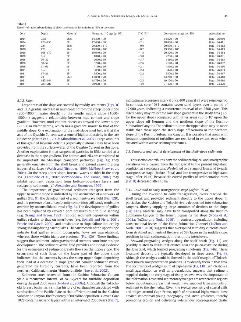
Table 3Results of radiocarbon dating of shells and benthic foraminiferas (BF) in the cores.
Core Depth Material Measured 14C age (yr BP) δ13C (‰) Conventional age (yr BP) Accession no.
1024 75.5 Shell 14,370±90 2.7 14,820±90 Beta-176,0601024 129–130 BF 17,680±60 −2.1 18,060±60 Beta-174,4111024 224 Shell 20,290±110 −0.9 20,690±110 Beta-174,4121026 123 Shell 18,980±100 −0.2 19,390±100 Beta-174,4131026 168–170 BF 19,940±70 −1.8 20,320±70 Beta-174,4141028 0–2 BF 1870±40 −3.0 2230±40 Beta-176,0611028 30–32 BF 3060±50 −3.7 3410±50 Beta-174,4151028 50–52 BF 3770±40 −2.6 4140±40 Beta-176,0621028 91–93 BF 4150±50 −2.1 4530±50 Beta-174,4161031 0–2 BF 3050±40 −2.4 3420±40 Beta-176,0631031 17–21 BF 5500±50 −2.2 5870±50 Beta-174,4171031 73 Shell 13,850±70 −1.1 14,240±80 Beta-174,4181031 142–144 BF 18,730±70 −2.3 19,100±70 Beta-174,4191031 200–202 BF 20,970±90 −3.9 21,320±90 Beta-174,420
45A. Noda, T. TuZino / Sedimentary Geology 232 (2010) 35–51
5.2.2. SlopeLarge areas of the slope are covered by muddy sediments (Figs. 3C
and 5). A gradual increase in mud content from the steep upper slope(200–1000 m water depth) to the gentle middle slope (1000–1500 m) suggests a relationship between mud content and slopegradient. However, mud content decreases toward the lower slope(N1500 m water depth), which has a gradient similar to that of themiddle slope. One explanation of the mid-slope mud belt is that theaxis of the Oyashio Current was a zone of high productivity in the lateHolocene (Narita et al., 2002; Minoshima et al., 2007). Large amountsof fine-grained biogenic detritus (especially diatoms) may have beenprovided from the surface-water of the Oyashio Current in this zone.Another explanation is that suspended particles in BNLs settled at adecrease in the slope gradient. The bottom and INLs are considered tobe important shelf-to-slope transport pathways (Fig. 4); theygenerally emanate from the shelf break and extend seaward alongisopycnal surfaces (Walsh and Nittrouer, 1999; McPhee-Shaw et al.,2004). On the steep upper slope, internal waves or tides in the deepsea (Cacchione et al., 2002; McPhee-Shaw and Kunze, 2002) mayinhibit sediment deposition from bottom-boundary layers andresuspend sediments (cf. Alexander and Simoneau, 1999).
The importance of gravitational sediment transport from theupper to middle slope is indicated by the occurrence of a network ofgullies (Fig. 9), the development of a sediment-wave field (Fig. 12B),and the presence of an unconformity comprising stiff sandymudstoneoverlain by unconsolidated mud (Fig. 6). The development of gullieshas been explained by elevated pore pressures due to fluid sapping(e.g. Orange and Breen, 1992), reduced sediment deposition withingullies relative to that on interfluves (e.g. Spinelli and Field, 2001;Fedele and García, 2009), and erosion due to slope failure induced bystrong shaking during earthquakes. The SBP records of the upper slopeindicate that gullies within topographic lows are aggradational,whereas those within highs are erosional (Fig. 12A). These findingssuggest that sediment-laden gravitational currents contribute to slopedevelopment. The sediment-wave field provides additional evidencefor the occurrence of sediment gravity flows on the upper slope. Theoccurrence of such flows on the lower part of the upper slopeindicates that the currents bypass the steep upper slope, depositingtheir load at a decrease in slope gradient. Similar sediment waves,generated by turbidity currents, have been reported from thenorthern California margin ‘Humboldt Slide’ (Lee et al., 2002).
Sediment cores recovered from the Kushiro Submarine Canyonyield a recurrence interval of ca.76 years for turbidite depositionduring the past 2300 years (Noda et al., 2008a). Although the Tokachi-oki forearc basin has a similar history of earthquakes associated withsubduction of the Pacific Plate to that off Nemuro and in the KushiroSubmarine Canyon, the frequency of turbidite deposition is lower. Core1028 contains six sand layers within an interval of 2330 years (Fig. 7),
indicating a recurrence interval of ca.400 years if all were seismogenic.In contrast, core 1031 contains seven sand layers over a period of17,900 years, indicating a recurrence interval of ca.2500 years. Thisdiscrepancy may reflect the low slope gradient in the study area (1.5∘
for the upper slope) compared with other areas (up to 10∘ upon theupper slope off Nemuro and the northern slope of the KushiroSubmarine Canyon). The sediments upon the upper slopemaybemorestable than those upon the steep slope off Nemuro or the northernslope of the Kushiro Submarine Canyon. It is possible that areas withfrequent deposition of turbidites are restricted in extent, even whensituated within active seismogenic zones.
5.3. Temporal and spatial development of the shelf–slope sediments
This section contributes how the sedimentological and stratigraphicvariations were caused from the last glacial to the present highstandcondition at a regional scale.We defined two stages of lowstand to earlytransgressive stage (before 15 ka) and late transgressive to highstandstage (after 15 ka), because the curved profiles of sedimentation rates(Fig. 8) decreased after 15 ka.
5.3.1. Lowstand to early transgressive stage (before 15 ka)During the lowstand to early transgression, rivers reached the
shelf break and provided sediment directly to the upper slope. Inparticular, the Kushiro and Tokachi rivers debouched into submarinecanyons, directly supplying large amounts of detritus to the slope(Fig. 14A). Material may have been transported along the KushiroSubmarine Canyon to the trench, bypassing the slope (Noda et al.,2008a; TuZino and Noda, 2010). In contrast, aggradation includingconstructional levees of the Hiroo Submarine Channel (TuZino andNoda, 2007, 2010) suggests that overspilled turbidity currents couldform stratified sediments of the layered SBP facies in themiddle slope,resulting in high sedimentation rates in the interfluves.
Seaward-prograding wedges along the shelf break (Fig. 11) arepossibly related to deltas that existed near the paleo-coastline duringthe lowstand, which formed prograding clinoforms (Fig. 14A). Theselowstand deposits are typically developed in three areas (Fig. 9).Although the wedges could be formed in the shelf margin off TokachiRiver mouth, low penetration prohibits us to identify them in that area.The occurrence of wedges south of Cape Erimo (Fig. 11B), which show asmall aggradation as well as progradation, suggests that sedimentsupplied during the early stage of rising sealevel was also important totheir formation. Lowstand sedimentarywedges are restricted to regionsbelow mountainous areas that would have supplied large amounts ofsediment to the shelf edge. Given the typical geometry of coastal cliffsand ridges around Cape Erimo, uplift of structural highs would havecreated widespread young topography and steep gradients, therebypromoting erosion and delivering voluminous coarse-grained clastic
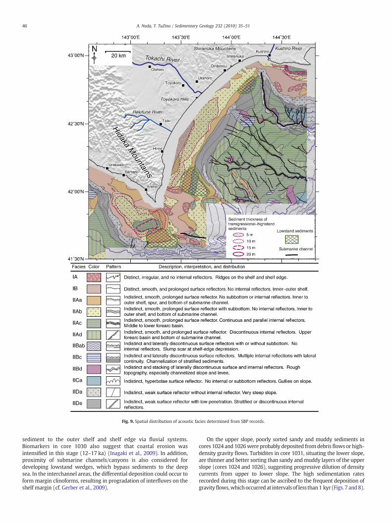
Fig. 9. Spatial distribution of acoustic facies determined from SBP records.
46 A. Noda, T. TuZino / Sedimentary Geology 232 (2010) 35–51
sediment to the outer shelf and shelf edge via fluvial systems.Biomarkers in core 1030 also suggest that coastal erosion wasintensified in this stage (12–17 ka) (Inagaki et al., 2009). In addition,proximity of submarine channels/canyons is also considered fordeveloping lowstand wedges, which bypass sediments to the deepsea. In the interchannel areas, the differential deposition could occur toform margin clinoforms, resulting in progradation of interfluves on theshelf margin (cf. Gerber et al., 2009).
On the upper slope, poorly sorted sandy and muddy sediments incores 1024 and 1026were probably deposited fromdebris flows or high-density gravity flows. Turbidites in core 1031, situating the lower slope,are thinner and better sorting than sandy andmuddy layers of the upperslope (cores 1024 and 1026), suggesting progressive dilution of densitycurrents from upper to lower slope. The high sedimentation ratesrecorded during this stage can be ascribed to the frequent deposition ofgravityflows,whichoccurredat intervals of less than1 kyr (Figs. 7 and8).
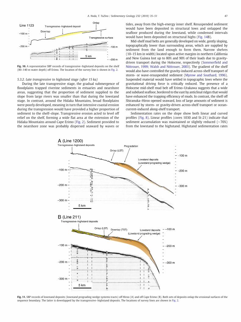
Fig. 10. A representative SBP records of transgressive–highstand deposits on the shelf(80–140 m water depth) off Erimo. The location of the survey line is shown in Fig. 2.
47A. Noda, T. TuZino / Sedimentary Geology 232 (2010) 35–51
5.3.2. Late transgressive to highstand stage (after 15 ka)During the late transgressive stage, the gradual submergence of
floodplains trapped riverine sediments in estuaries and nearshoreareas, suggesting that the proportion of sediment supplied to theslope from large rivers was smaller than that during the lowstandstage. In contrast, around the Hidaka Mountains, broad floodplainswere poorly developed, meaning in turn that intensive coastal erosionduring the transgression would have provided a higher proportion ofsediment to the shelf–slope. Transgressive erosion acted to level offrelief on the shelf, forming a wide flat area at the extension of theHidaka Mountains around Cape Erimo (Fig. 2). Sediment provided tothe nearshore zone was probably dispersed seaward by waves or
Fig. 11. SBP records of lowstand deposits (lowstand prograding wedge systems tracts) off Hisequence boundary. The latter is downlapped by the transgressive–highstand deposits. The
tides, away from the high-energy inner shelf. Resuspended sedimentwould have been deposited in structural lows and onlapped theseafloor produced during the lowstand, while condensed intervalswould have been deposited on structural highs (Fig. 14B).
Mid-shelf mud belts are generally developed onwide, gently sloping,topographically lower than surrounding areas, which are supplied bysediment from the land enough to form them. Narrow shelves(10–15 km in width) located upon active margins in northern Californiaand New Guinea lost up to 80% and 90% of their loads due to gravity-driven transport during the Holocene, respectively (Sommerfield andNittrouer, 1999; Walsh and Nittrouer, 2003). The gradient of the shelfwould also have controlled the gravity-induced across-shelf transport ofstorm- or wave-resuspended sediment (Myrow and Southard, 1996).Suspended material would have settled in topographic lows where thegravitational driving force is critically reduced. The presence of aHolocene mid-shelf mud belt off Erimo–Urakawa suggests that a wideand subdued seafloor, bordered to theeast by anticlinal ridges thatwouldhave enhanced the trapping efficiency of muds. In contrast, the shelf offShiranuka–Hiroo opened seaward, loss of large amounts of sediment isenhanced by storm- or gravity-driven across-shelf transport or ocean-current-induced along-shelf transport.
Sedimentation rates on the slope show both linear and curvedprofiles (Fig. 8). Linear profiles (cores 1030 and St-21) indicate thatsediment accumulation was maintained or slightly reduced (∼70%)from the lowstand to the highstand. Highstand sedimentation rates
roo (A) and off Cape Erimo (B). Both sets of deposits onlap the erosional surfaces of thelocations of survey lines are shown in Fig. 2.

Fig. 12. (A) Cross-slope profile from a SBP record shows deep incision on the topographic high of an axis of anticline and weak incision or even aggradation in areas of lowertopography. (B) Along-slope profile shows a shallow penetration on the upper slope and a sediment-wave field on the middle slope. Arrows indicate gullies that cut obliquely acrossthe slope. The locations of survey lines are shown in Fig. 2.
48 A. Noda, T. TuZino / Sedimentary Geology 232 (2010) 35–51
might be almost maintained at topographically low and gentle slopingareas even during the highstand, due to concentration of nepheloidlayers or deposition via sediment gravity flows. Curved profiles (coresPC6 and 1031) indicate that the rate of sediment deposition after15 ka decreased to just 10–37% of that during the lowstand. It could bebecause amounts of overflow sediments from gullies drasticallydecreased in the interfluvial zone of core PC6 (Fig. 8C) in thehighstand. At the southern California margin, the sediment accumu-lation rates at slope-basin sites were highest at ca.15–10 ka, anddecreased during the 12–9 ka transition from fluvial-estuarine to fullymarine conditions on the shelf. The rates decreased throughout theHolocene to 30%–75% of the values during the lowstand (Sommerfieldand Lee, 2004). Despite the similar rates of deceleration insedimentation, the greater reduction in the present study area maybe ascribed to topographic controls. For example, the Tokachi-oki
dome, which is incised by gullies (Figs. 2 and 12), is topographicallyhigher than surrounding areas, thereby inhibiting the settlement ofsediment; consequently, the sedimentation rate was very low (10% ofthat at PC6 in Fig. 8). Tectonic-related topography is, therefore, animportant control on sediment distribution and deposition on theslope.
Given that sediments are trapped on the floodplain and the shelfduring highstand periods, an enhanced sediment supply is required tomaintain the high sedimentation rate. It is possible that theproductivity of biogenic opal in the northwestern Pacific during thelate Holocene was higher than that during the last glacial age (Naritaet al., 2002). Another possibility is that the sediment yield was higherunder the humid andwarm conditions of the Holocene than under thedry and cold conditions of the glacial age (Hughes et al., 2009). Highsedimentation rates within core 1028 indicate that sediment gravity

Fig. 13. SBP record at the locations of grab sample A (Fig.6A) and core 1028 (Fig.7). Asmall-scale submarine fan is developed on the slope. The location of the survey line isshown in Fig. 2.
Fig. 14. Schematic diagrams showing sediment dispersal and deposition (A) during thelowstand to early transgression and (B) during the late transgression to highstand.
49A. Noda, T. TuZino / Sedimentary Geology 232 (2010) 35–51
flows remained active in the Holocene (Fig. 8). Unconformities withinupper slope sediments could be caused by frequent slope failure onthe steep slope, even during the highstand, presumably triggered bystrong shaking by earthquakes.
6. Conclusions
Sedimentological and oceanographic analyses of an active forearcmargin revealed spatial and temporal variability in shelf–slopesediments. That part of the shelf indented by the Kushiro SubmarineCanyon contains poorly developed lowstand, transgressive, andhighstand sediments because the sediment bypassed the narrowand steep shelf. The shelf fed by the Tokachi River is covered by fineand very fine sand (3–4 Mdϕ) and small depocenters contain muddysediments. Some of the suspended material is likely to have escapedto the slope by gravity-driven across-shelf transport or ocean-current-induced along-shelf transport during the highstand. The activelyuplifting shelf that extends from the HidakaMountains contains a thinmantle of relict sandy and gravelly sediment due to its irregular andrelatively high topography. The wide shelf with a gentle mid-shelf offErimo to Urakawa is covered by relatively thick mud deposits.
The slope in the study area contains a narrow and elongate mid-slope mud belt in water depths of 700–1600 m. The sedimentationrate on the slope in the late transgression to highstand stage (6–29 cm kyr− 1) was 10–70% of that during the glacial to earlytransgression stage (18–69 cm kyr−1). The concentration of nephe-loid layers or deposition by sediment gravity flows would havemaintained high sedimentation rates in areas of topographic lowswith gentle slopes, even under highstand conditions. The variablesedimentology and stratigraphy in this area could be caused by thespatially variable nature of topography, reflecting in turn the influenceof long-term tectonism, eustatic controls, and proximity to activecanyons.
Acknowledgements
We are indebted to the officers, crew, and research staff of cruisesGH02–GH06 for the collection of samples and oceanographic data.Wealso thank Hajime Katayama, Ken Ikehara, Yukinobu Okamura, andKohsaku Arai for assistance during the cruises. We are grateful toAzusa Nishizawa for providing bathymetric data collected by theHydrographic and Oceanographic Department of the Japan CoastGuard. We acknowledge Alan Orpin and anonymous reviewer and
Editor, Matthew Bennett whose constructive comments significanthelped us to improve the manuscript. This study was part of the“Marine Geological Mapping Project of the Continental ShelvesAround Japan” program supported by the Geological Survey ofJapan, National Institute of Advanced Industrial Science andTechnology.
References
Alexander, C.R., Simoneau, A.M., 1999. Spatial variability in sedimentary processes onthe Eel continental slope. Marine Geology 154, 243–254.
Allen, P.A., Densmore, A.L., 2000. Sediment flux from an uplifting fault block. BasinResearch 12, 367–380.
50 A. Noda, T. TuZino / Sedimentary Geology 232 (2010) 35–51
Barnes, P.M., 1995. High-frequency sequences deposited during Quaternary sea-levelcycles on a deforming continental shelf, North Canterbury, New Zealand.Sedimentary Geology 97, 131–156.
Blum, P., Okamura, Y., 1992. Pre-Holocene sediment dispersal systems and effects ofstructural controls and Holocene sea-level rise from acoustic facies analysis: SWJapan forearc. Marine Geology 108, 295–322.
Boggs, S.J., 1984. Quaternary sedimentation in the Japan arc–trench system. GeologicalSociety of America Bulletin 95, 669–685.
Bohannon, R.G., Gardner, J.V., Sliter, R.W., 2004. Holocene to Pliocene tectonic evolution ofthe region offshore of the Los Angeles urban corridor, southern California. Tectonics23, TC1016 doi:10.1029/2003TC001504.
Burbank, D.W., Meigs, A., Brozovic, N., 1996. Interactions of growing folds and coevaldepositional systems. Basin Research 8, 199–223.
Cacchione, D.A., Pratson, L.F., Ogston, A.S., 2002. The shaping of continental slopes byinternal tides. Science 296, 724–727.
From mountain source to ocean sink—the passage of sediment across an active margin.In: Carter, L., Orpin, A.R., Kuehl, S.A. (Eds.), Waipaoa Sedimentary System, NewZealand: Marine Geology, 270. 272 pp.
Clark, P.U., Dyke, A.S., Shakun, J.D., Carlson, A.E., Clark, J., Wohlfarth, B., Mitrovica, J.X.,Hostetler, S.W.,McCabe, A.M., 2009. The Last GlacialMaximum. Science 325, 710–714.
Crockett, J.S., Nittrouer, C.A., 2004. The sandy inner shelf as a repository for muddysediment: an example from Northern California. Continental Shelf Research 24,55–73.
Damuth, J.E., 1980. Use of high-frequency (3.5–12 kHz) echograms in the study of near-bottom sedimentation processes in the deep-sea: a review. Marine Geology 38,51–75.
DeMets, C., 1992. Oblique convergence and deformation along the Kuril and JapanTrenches. Journal of Geophysical Research 97, 17615–17625.
Earthquake Research Committee (Ed.), 2004. Long-term Evaluation of Earthquakes inthe Kuril Trench. The Headquarters for Earthquake Research Promotion, Tokyo,35 pp. (in Japanese).
Fan, S., Swift, D.J.P., Traykovski, P., Bentley, S., Borgeld, J.C., Reed, C.W., Niedoroda, A.W.,2004. River flooding, storm resuspension, and event stratigraphy on the northernCalifornia shelf: observations compared with simulations. Marine Geology 210,17–41.
Fedele, J.J., García, M.H., 2009. Laboratory experiments on the formation of subaqueousdepositional gullies by turbidity currents. Marine Geology 258, 48–59.
Furukawa, R., Nanayama, F., 2006. Holocene pyroclastic fall deposits along the Pacificcoastal region of eastern Hokkaido. Bulletin of the Volcanological Society of Japan51, 351–371 (in Japanese with English abstract).
Furukawa, R., Yoshimoto, M., 2003. Volcanic ashes off Tokachi area. In: Okamura, Y.(Ed.), Marine Geological and Geophysical Studies on the Collision Zone of Kuril andNortheast Japan Arc—Off Tokachi Area—. GSJ Interim Report 26. Geological Surveyof Japan, AIST, Tsukuba, pp. 102–107 (in Japanese).
Gerber, T.P., Pratson, L.F., Wolinsky, M.A., Steel, R., Mohr, J., Swenson, J.B., Paola, C., 2008.Clinoform progradation by turbidity currents: modeling and experiments. Journalof Sedimentary Research 78, 220–238.
Gerber, T.P., Amblas, D., Wolinsky, M.A., Pratson, L.F., Canals, M., 2009. A model for thelong-profile shape of submarine canyons. Journal of Geophysical Research 114,F03002 doi:10.1029/2008JF001190.
Harris, C.K., Traykovski, P.A., Geyer,W.R., 2005. Flood dispersal and deposition bynear-bedgravitational sediment flows and oceanographic transport: a numerical modelingstudy of the Eel River shelf, northern California. Journal of Geophysical Research 110,C09025 doi:10.1029/2004JC002727.
Hill, P.S., Fox, J.M., Crockett, J.S., Curran, K.J., Friedrichs, C.T., Geyer, W.R., Milligan, T.G.,Ogston, A.S., Puig, P., Scully, M.E., Traykovski, P.A., Wheatcroft, R.A., 2007. Sedimentdelivery to the seabed on continental margins. In: Nittrouer, C.A., Austin, J.A., Field,M.E., Kravitz, J.H., Syvitski, J.P.M., Wiberg, P.L. (Eds.), Continental MarginSedimentation: From Sediment Transport to Sequence Stratigraphy: InternationalAssociation of Sedimentologists Special Publication, 37, pp. 49–99.
Hogarth, L.J., Babcock, J., Driscoll, N.W., Dantec, N.L., Haas, J.K., Inman, D.L., Masters, P.M.,2007. Long-term tectonic control on Holocene shelf sedimentation offshore La Jolla,California. Geology 35, 275–278.
Hughes, M.W., Almond, P.C., Roering, J.J., 2009. Increased sediment transport viabioturbation at the last glacial–interglacial transition. Geology 37, 919–922.
Hunt, D., Tucker, M.E., 1992. Stranded parasequences and the forced regressive wedgesystems tract: deposition during base-level fall. Sedimentary Geology 81, 1–9.
Igarashi, Y., 1994. Quaternary forest and climate history of Hokkaido, Japan, frommarine sediments. Quaternary Science Reviews 13, 335–344.
Ikehara, K., Ohkushi, K., Shibahara, A., Hoshiba, M., 2006. Change of bottom waterconditions at intermediate depths of the Oyashio region, NW Pacific over the past20,000 yrs. Global and Planetary Change 53, 78–91.
Inagaki, M., Yamamoto, M., Igarashi, Y., Ikehara, K., 2009. Biomarker records from coreGH02–1030 off Tokachi in the northwestern Pacific over the last 23,000 years:environmental changes during the last deglaciation. Journal of Oceanography 65,847–858.
Isoguchi, O., Kawamura, H., Kono, T., 1997. A study on wind-driven circulation in thesubarctic North Pacific using TOPEX/poseidon altimeter data. Journal of Geophys-ical Research 102, 12457–12468.
Kato, N., Sato, H., Orito, M., Hirakawa, K., Ikeda, Y., Ito, T., 2004. Has the plate boundaryshifted from central Hokkaido to the eastern part of the Sea of Japan? Tectonophysics388, 75–84.
Kimura, G., 1986. Oblique subduction and collision: forearc tectonics of the Kuril Arc.Geology 14, 404–407.
Kimura, G., 1996. Collision orogeny of arc–arc junctions in the Japanese Islands. IslandArc 5, 262–275.
Klaeschen, D., Belykh, I., Gnibidenko, H., Patrikeyev, S., von Huene, R., 1994. Structure ofthe Kuril Trench from seismic reflection records. Journal of Geophysical Research99, 24,173–24,188.
Geomorphology of Hokkaido. In: Koaze, T., Nogami, M., Ono, Y., Hirakawa, K. (Eds.),Regional Geomorphology of the Japanese Islands, 2. University of Tokyo Press,Tokyo. 359 pp.
Kono, T., Foreman, M., Chandler, P., Kashiwai, M., 2004. Coastal Oyashio south ofHokkaido, Japan. Journal of Physical Oceanography 34, 1477–1494.
Kuhn, G., Weber, M.E., 1993. Acoustic characterization of sediments by parasound and3.5 kHz systems: related sedimentary processes on the southeastern Weddell Seacontinental slope, Antarctica. Marine Geology 113, 201–217.
Lee, H.J., Normark, W.R. (Eds.), 2009. Earth Science in the Urban Ocean: The SouthernCalifornia Continental Borderland: Geological Society of America Special Paper, 454.481 pp.
Lee, H.J., Syvitski, J.P.M., Parker, G., Orange, D., Locat, J., Hutton, E.W.H., Imran, J., 2002.Distinguishing sediment waves from slope failure deposits: field examples,including the ‘Humboldt slide’, andmodelling results. Marine Geology 192, 79–104.
Liu, J.T., Lin, H.L., Hung, J.J., 2006. A submarine canyon conduit under typhoonconditions off Southern Taiwan. Deep Sea Research Part I 53, 223–240.
McPhee-Shaw, E.E., Kunze, E., 2002. Boundary layer intrusions from a sloping bottom: amechanism for generating intermediate nepheloid layers. Journal of GeophysicalResearch 107 (C6), 3050 doi:10.1029/2001JC000801.
McPhee-Shaw, E.E., Sternberg, R.W., Mullenbach, B., Ogston, A.S., 2004. Observations ofintermediate nepheloid layers on the northern California continental margin.Continental Shelf Research 24, 693–720.
Milliman, J.D., Syvitski, J.P.M., 1992. Geomorphic/tectonic control of sediment discharge tothe ocean: the importance of small mountainous rivers. Journal of Geology 100,525–544.
Minoshima, K., Kawahata, H., Ikehara, K., 2007. Changes in biological production in themixed water region (MWR) of the northwestern North Pacific during the last 27kyr. Palaeogeography, Palaeoclimatology, Palaeoecology 254, 430–447.
Mitchell, N.C., 2008. Oceanographic currents and the convexity of the uppermostcontinental slope. Journal of Sedimentary Research 78, 29–44.
Myrow, P.M., Southard, J.B., 1996. Tempestite deposition. Journal of SedimentaryResearch 66, 875–887.
Nagata, Y., Ohtani, K., Kashiwai, M., 1992. Subarctic water circulation in the NorthPacific. Umi no Kenkyu 1, 75–104 (in Japanese).
Narita, H., Sato, M., Tsunogai, S., Murayama, M., Ikehara, M., Nakatsuka, T., Wakatsuchi,M., Harada, N., Ujiié, Y., 2002. Biogenic opal indicating less productive northwest-ern North Pacific during the glacial ages. Geophysical Research Letters 29, 15doi:10.1029/2001GL014320.
Nittrouer, C.A., Austin, J.A., Field,M.E., Kravitz, J.H., Syvitski, J.P.M.,Wiberg, P.L. (Eds.), 2007.Continental margin sedimentation: from sediment transport to sequence stratigra-phy: International Association of Sedimentologists Special Publication, 37. 549 pp.
Noda, A., TuZino, T., 2007. Characteristics of sediments and their dispersal systemsalong the shelf and slope of an active forearc margin, eastern Hokkaido, northernJapan. Sedimentary Geology 201, 341–364.
Noda, A., Katayama, H., Ikehara, K., 2003. Surface sediments off Tokachi. In: Okamura, Y.(Ed.), Marine Geological and Geophysical Studies on the Collision Zone of Kuril andNortheast Japan Arc—Off Tokachi Area—. GSJ Interim Report 26. Geological Surveyof Japan, AIST, Tsukuba, pp. 54–67 (in Japanese).
Noda, A., Tsujino, (TuZino) T., Furukawa, R., Yoshimoto, N., 2004. Character,provenance, and recurrence intervals of Holocene turbidites in the KushiroSubmarine Canyon, eastern Hokkaido forearc, Japan. In: Fujiwara, O., Ikehara, K.,Nanayama, F. (Eds.), Earthquake-induced Event Deposits—From Deep-sea to onLand: Memoir of the Geological Society of Japan, 58, pp. 123–135.
Noda, A., Katayama, H., Sagayama, T., Suga, K., Uchida, Y., Satake, K., Abe, K., Okamura,Y., 2007. Evaluation of tsunami impacts on shallow marine sediments: an examplefrom the tsunami caused by the 2003 Tokachi-oki earthquake, northern Japan.Sedimentary Geology 200, 314–327.
Noda, A., TuZino, T., Furukawa, R., Joshima, M., Uchida, J.I., 2008a. Physiographical andsedimentological characteristics of submarine canyons developed upon an activeforearc slope: the Kushiro Submarine Canyon, northern Japan. Geological Society ofAmerica Bulletin 120, 750–767.
Noda, A., TuZino, T., Kanai, Y., Furukawa, R., Uchida, J.I., 2008b. Paleoseismicity along thesouthern Kuril Trench deduced from submarine-fan turbidites. Marine Geology254, 73–90.
Ogston, A.S., Cacchione, D.A., Sternberg, R.W., Kineke, G.C., 2000. Observations of stormand river flood-driven sediment transport on the northern California continentalshelf. Continental Shelf Research 20, 2141–2162.
Ohkushi, K., Itaki, T., Nemoto, N., 2003. Last Glacial–Holocene change in intermediate-waterventilation in the Northwestern Pacific. Quaternary Science Reviews 22, 1477–1484.
Ohkushi, K., Ahagon,N., Uchida,M., Shibata, Y., 2005. Foraminiferal isotopeanomalies fromnorthwestern Pacific marginal sediments. Geochemistry, Geophysics, Geosystems 6,Q04005 doi:10.1029/2004GC000787.
Ohshima, K.I., Wakatsuchi, M., Saitoh, S., 2005. Velocity field of the Oyashio regionobserved with satellite-tracked surface drifters during 1999–2000. Journal ofOceanography 61, 845–855.
Ohtani, K., 1991. To confirm again the characteristics of Oyashio. Bulletin of theHokkaido National Fisheries Research Institute 55, 1–24.
Oliveira, A., Santos, A.I., Rodrigues, A., Vitorino, J., 2007. Sedimentary particle distributionand dynamics on the Nazaré canyon system and adjacent shelf (Portugal). MarineGeology 246, 105–122.
Orange, D.L., Breen, N.A., 1992. The effects of fluid escape on accretionary wedges 2.Seepage force, slope failure, headless submarine canyons, and vents. Journal ofGeophysical Research 97, 9277–9295.
51A. Noda, T. TuZino / Sedimentary Geology 232 (2010) 35–51
Orpin, A.R., Alexander, C., Carter, L., Kuehl, S., Walsh, J.P., 2006. Temporal and spatialcomplexity in post-glacial sedimentation on the tectonically active, Poverty Baycontinental margin of New Zealand. Continental Shelf Research 26, 2205–2224.
Paola, C., 2000. Quantitative models of sedimentary basin filling. Sedimentology 47,121–178.
Paquet, F., Proust, J.N., Barnes, P.M., Pettinga, J.R., 2009. Inner-forearc sequencearchitecture in response to climatic and tectonic forcing since 150 ka: Hawke's Bay,New Zealand. Journal of Sedimentary Research 79, 97–124.
Pirmez, C., Pratson, L.F., Steckler, M.S., 1998. Clinoform development by advection-diffusion of suspended sediment; modeling and comparison to natural systems.Journal of Geophysical Research 103, 24141–24157.
Pitman, W.C., 1978. Relationship between eustacy and stratigraphic sequences ofpassive margins. Geological Society of America Bulletin 89, 1389–1403.
Posamentier, H.W., Vail, P.R., 1988. Eustatic controls on clastic deposition: II, Sequenceand systems tract models. In: Wilgus, C.K., Hastings, B.S., Ross, C.A., Posamentier,H.W., Van Wagoner, J., Kendall, C.G.S.C. (Eds.), Sea-Level Changes: An IntegratedApproach: SEPM (Society of Economic Paleontologists and Mineralogists) SpecialPublication, 42, pp. 125–154.
Puig, P., Ogston, A.S., Mullenbach, B.L., Nittrouer, C.A., Parsons, J.D., Sternberg, R.W.,2004. Storm-induced sediment gravity flows at the head of the Eel submarinecanyon, northern California margin. Journal of Geophysical Research 109, C03019doi:10.1029/2003JC001918.
Sagawa, T., Ikehara, K., 2008. Intermediate water ventilation change in the subarcticnorthwest Pacific during the last deglaciation. Geophysical Research Letters 35,L24702 doi:10.1029/2008GL035133.
Saito, Y., 1994. Shelf sequence and characteristic bounding surfaces in a wave-dominated setting: latest Pleistocene–Holocene examples from Northeast Japan.Marine Geology 120, 105–127.
Sakurai, M., Nagano, M., Nagai, T., Katsura, T., Tozawa, M., Ikeda, K., 1975. Submarinegeology off the south coast of Hokkaido. Report of Hydrographic Researches 10,1–39 (in Japanese with English abstract).
Sangree, J.B., Widmier, J.M., 1977. Seismic stratigraphy and global changes of sea level:Part 9, Seismic interpretation of clastic depositional facies. In: Payton, C.E. (Ed.),Seismic Stratigraphy: Applications to Hydrocarbon Exploration: American Associ-ation of Petroleum Geologists Memoir, 26, pp. 165–184.
Sasaki, A., Kachi, T., Sasaoka, T., Iguchi, T., 1985. Stratigraphy of the Kisoshisui Tokachi-oki well—on the study of Miocene turbidite facies in eastern Hokkaido. Journal ofthe Japanese Association for Petroleum Technology 50, 53–63 (in Japanese withEnglish abstract).
Seno, T., Sakurai, T., Stein, S., 1996. Can the Okhotsk plate be discriminated from theNorth American plate? Journal of Geophysical Research 101, 11305–11315.
Shibahara, A., Ohkushi, K., Kennett, J.P., Ikehara, K., 2007. Late Quaternary changes inintermediate water oxygenation and oxygen minimum zone, northern Japan; abenthic foraminiferal perspective. Paleoceanography 22, PA3213 doi:10.1029/2005PA001234.
Vail, P.R., Mitchum, R.M.J., Thompson, S., 1977. Global cycles of relative changes of sealevel. In: Payton, C.E. (Ed.), Seismic Stratigraphy—Applications to HydrocarbonExploration: American Association of Petroleum Geologists Memoir, 26, pp. 83–97.
van Wagoner, J.C., Posamentier, H.W., Mitchum, R.M.J., Vail, P.R., Sarg, J.F., Loutit, T.S.,Hardenbol, J., 1988. An overview of the fundamentals of sequence stratigraphyand key definitions. In: Wilgus, C.K., Hastings, B.S., Ross, C.A., Posamentier, H.W.,Van Wagoner, J., Kendall, C.G.S.C. (Eds.), Sea-Level Changes: An IntegratedApproach: SEPM (Society of Economic Paleontologists and Mineralogists) SpecialPublication, 42, pp. 39–45.
Walsh, J.P., Nittrouer, C.A., 1999. Observations of sediment flux to the Eel continentalslope, northern California. Marine Geology 154, 55–68.
Walsh, J.P., Nittrouer, C.A., 2003. Contrasting styles of off-shelf sediment accumulationin New Guinea. Marine Geology 196, 105–125.
Walsh, J.P., Nittrouer, C.A., 2009. Understanding fine-grained river-sediment dispersalon continental margins. Marine Geology 263, 34–45.
Warrick, J.A., Farnsworth, K.L., 2009. Dispersal of river sediment in the SouthernCalifornia Bight. In: Lee, H.J., Normark, W.R. (Eds.), Earth Science in the UrbanOcean: The Southern California Continental Borderland: Geological Society ofAmerica Special Paper, 454, pp. 53–67.
Wright, L.D., Friedrichs, C.T., 2006. Gravity-driven sediment transport on continentalshelves: a status report. Continental Shelf Research 26, 2092–2107.
Xu, J.P., Noble, M., Eittreim, S.L., Rosenfeld, L.K., Schwing, F.B., Pilskaln, C.H., 2002.Distribution and transport of suspended particulate matter in Monterey Canyon,California. Marine Geology 181, 215–234.
Yanai, S., Igarashi, Y., 1990. History of the slope failure and paleoenvironment on themarine terrace of Hidaka district, central Hokkaido. The Quaternary Research(Daiyonki-Kenkyu) 29, 319–336 (in Japanese with English abstract).
Yasuda, I., Okuda, K., Shimizu, Y., 1996. Distribution and modification of North PacificIntermediate Water in the Kuroshio–Oyashio interfrontal zone. Journal of PhysicalOceanography 26, 448–465.
Yokoyama, Y., Lambeck, K., De Deckker, P., Johnston, P., Fifield, L.K., 2000. Timing of theLast Glacial Maximum from observed sea-level minima. Nature 406, 713–716.